Embed Size (px)
Citation preview
CONCEPT DESIGN REPORT
ELYRIA SWANSEA AT YORK
EAST/WEST CONNECTIVITY STUDY
December 2, 2016
DRAFT
Table of Contents
Table of Contents ....................................................................................................................................... 1
1. Executive Summary ................................................................................................................................. 1 1.1. Project Leadership and Organization ........................................................................................................... 1
2. Project Overview .................................................................................................................................... 2 2.1. Site Context .................................................................................................................................................. 2 2.2. Previous Studies ........................................................................................................................................... 2 2.3. Existing and Proposed Projects in the Area ................................................................................................. 4
3. Purpose and Need ................................................................................................................................... 6 3.1. Project Purpose ............................................................................................................................................ 6 3.2. Project Needs ............................................................................................................................................... 6
3.2.1. Connectivity ........................................................................................................................................... 6 3.2.2. Safety .................................................................................................................................................... 6 3.2.3. Access .................................................................................................................................................... 7
4. Outreach with Elyria & Swansea Neighborhoods ...................................................................................... 8
5. Alternatives Considered ........................................................................................................................ 10 Southwest Quadrant ..................................................................................................................................... 12 Southeast Quadrant ...................................................................................................................................... 12 Northwest Quadrant ..................................................................................................................................... 12 Northeast Quadrant ...................................................................................................................................... 12
5.1. Screening Process ....................................................................................................................................... 12
6. Recommended Alternative Design ......................................................................................................... 14 6.1. Design Overview ......................................................................................................................................... 14
6.1.1. Structure Overview .............................................................................................................................. 14 6.1.2. Stairway and Ramp Design ................................................................................................................. 15
6.2. Planning for All Modes of Travel ................................................................................................................ 16 6.3. Right of Way Needs .................................................................................................................................... 16 6.4. UPRR Impacts ............................................................................................................................................. 16 6.5. Utilities ....................................................................................................................................................... 16 6.6. Drainage Requirements .............................................................................................................................. 17 6.7. Safety/Security ........................................................................................................................................... 17 6.8. Environmental Resource Impacts ................................................................................................................. 17
6.8.1. Next Steps with Environmental Clearance ............................................................................................. 18 6.9. Placemaking ............................................................................................................................................... 19 6.10. Phasing and Schedule ............................................................................................................................... 20
6.10.1. 30% Design Phase ............................................................................................................................. 20 6.10.2. 100% Design Phase ........................................................................................................................... 20 6.10.3. Procurement ...................................................................................................................................... 20 6.10.4. Construction ...................................................................................................................................... 20
6.11. Cost ........................................................................................................................................................... 21 6.11.1. Preconstruction Costs ........................................................................................................................ 21
6.11.2. Construction Costs ............................................................................................................................. 21 6.11.3. Contingencies .................................................................................................................................... 21
7. Funding Availability ............................................................................................................................... 22 7.1. Local Sources .............................................................................................................................................. 22 7.2. State Sources .............................................................................................................................................. 22 7.3. Federal Sources .......................................................................................................................................... 22
8. Agency Coordination ............................................................................................................................. 23 8.1. Coordination with UPRR Railroad .............................................................................................................. 23 8.2. Coordination with Xcel Energy ................................................................................................................... 23 8.3. Coordination with Denver Water ............................................................................................................... 23
9. Summary .............................................................................................................................................. 24
Appendices
Appendix A: Design Options Evaluated
Appendix B: Utility Relocations and Matrix of Utility Providers
Appendix C: Environmental Resources
1
1. Executive Summary
The Elyria Swansea at York East/West Connectivity Study focus broadly on improving transportation in the Elyria and Swansea neighborhoods, with specific focus on designing a safe pedestrian and bicycle grade-separated crossing at 47th Avenue and York Street. The design and construction of this bridge has been, and continues to be, a top priority for the City and County of Denver (the City).
A number of previous studies, including the recent Elyria & Swansea Neighborhoods Plan (2015), identified the need to address this intersection, which the community uses to access Swansea Elementary School, The GrowHaus, the Perry Valdez Library, and a number of other neighborhood destinations. The construction of this project would provide a much-needed transportation connection for the community, a safe pedestrian and bicycle route east/west across the railroad, and access to public places, neighborhoods, and businesses.
A number of bridge locations, landings, and designs were evaluated as part of this project using a screening process based on criteria. These criteria included connectivity for pedestrians and bicycles, minimization of impacts to existing residential and commercial property, community support, utility relocation, cost, and other feasibility factors. The screening process resulted in a bridge design located at 47th Avenue and York Street utilizing a vacant parcel east of the railroad (south of 47th Avenue) and a small parcel currently owned by Xcel Energy on the west side of the railroad (south of 47th Avenue). These two parcels will provide sufficient space for the construction of the bridge as well as associated ramps and stairs. Coordination was conducted with the Colorado Department of Transportation (CDOT) to understand the right-of-way needs of the future Central 70 project and, in particular, the planned widening of York Street through this area.
The City is actively pursuing funding opportunities to construct this highly needed neighborhood improvement and is committed to working with all local agencies and other partners for potential funding sources. The City will proceed with preliminary design in the spring of 2017 as a continuation of this process.
1.1. Project Leadership and Organization
This study was managed by the CCD Department of Public Works. A Project Management Team (PMT) composed of staff from multiple departments [Community Planning and Development, Public Works, and Mayor’s Office of the North Denver Cornerstone Collaborative (NDCC)] provided regular input and guidance over the course of the project.
Updates concerning project progress were provided to a Technical Advisory Committee of City staff as well as the NDCC Steering Committee, which consists of CCD leadership from multiple departments. These entities provided input into the alternatives evaluated and the shape and form of the recommended alternative.
2
2. Project Overview
The area north of I-70 and south of 49th Avenue has very limited transportation connections, particularly for east/west travel across industrial areas and railroad tracks. Many of the streets do not connect and lack full sidewalks, lighting, and other utilities. This lack of infrastructure limits comfortable access to established residential neighborhoods, community destinations, and businesses. This mobility study evaluates the various alternatives for a pedestrian and bicycle crossing over the Union Pacific railroad (UPRR) in the Elyria and Swansea neighborhoods. Viability of a vehicular connection was reviewed at each existing crossing of the tracks as well. However, it was determined that near-term priority is the design of a safer pedestrian and bicycle crossing of the railroad tracks.
2.1. Site Context
The UPRR mainline bisects the Elyria and Swansea neighborhoods in northeast Denver, with
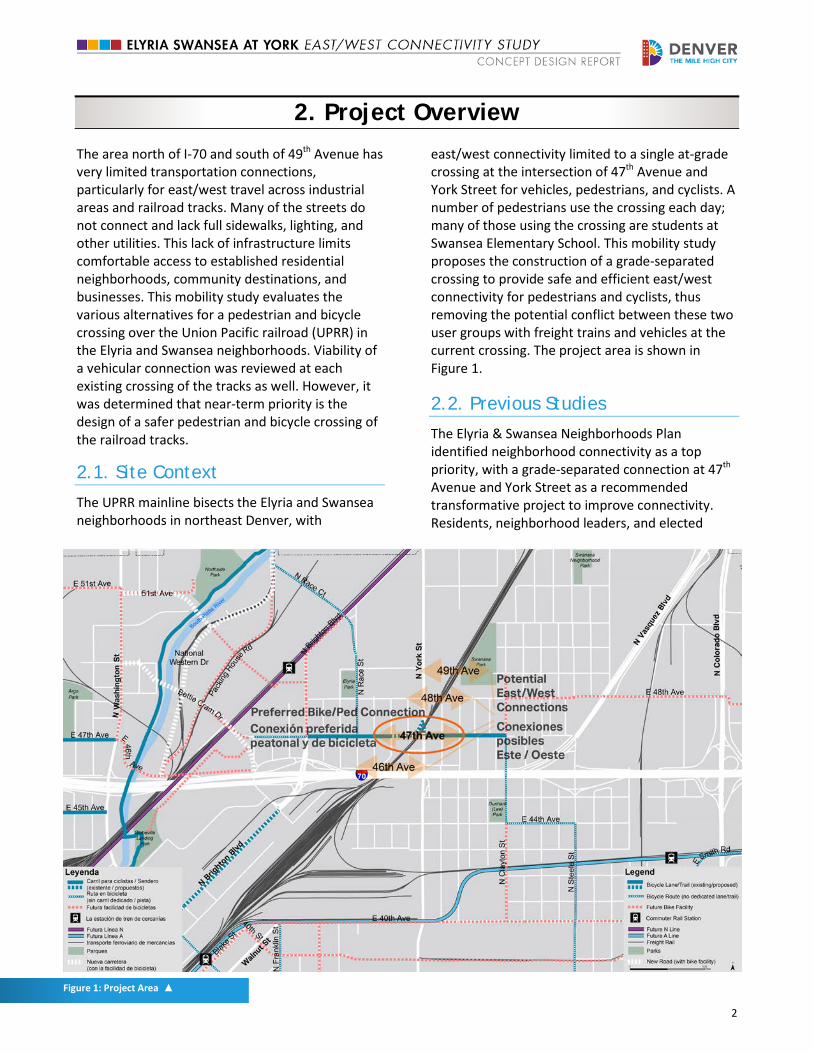
east/west connectivity limited to a single at-grade crossing at the intersection of 47th Avenue and York Street for vehicles, pedestrians, and cyclists. A number of pedestrians use the crossing each day; many of those using the crossing are students at Swansea Elementary School. This mobility study proposes the construction of a grade-separated crossing to provide safe and efficient east/west connectivity for pedestrians and cyclists, thus removing the potential conflict between these two user groups with freight trains and vehicles at the current crossing. The project area is shown in Figure 1.
2.2. Previous Studies
The Elyria & Swansea Neighborhoods Plan identified neighborhood connectivity as a top priority, with a grade-separated connection at 47th Avenue and York Street as a recommended transformative project to improve connectivity. Residents, neighborhood leaders, and elected
Figure 1: Project Area ▲
3
officials have been vocal for many years in requesting the current situation be addressed and improvements be made to the York Street crossing to decrease modal conflict between pedestrians, cyclists, vehicles, and trains for the benefit of pedestrians and cyclists crossing the UPRR main line. The proposed grade-separated crossing has been repeatedly identified as a priority in multiple strategic and environmental planning publications, pedestrian master plans, and neighborhood and community plans. These studies include: • Denver Comprehensive Plan (2000)
established a long term vision including increasing mobility choices in Denver neighborhoods.
• Blueprint Denver: an Integrated Land Use and Transportation Plan (2002) identified the area near 47th Avenue and York Street as an area of change.
• Pedestrian Master Plan (2004) recommended providing pedestrian/multiuse bridges and crossings over railroads, rivers, and other features that are major barriers.
• 47th Avenue and York Street Pedestrian-Train Crossing Study (2004) evaluated pedestrian crossing options at 47th Avenue and York Street.
• Strategic Transportation Plan (2008) identified 47th Avenue and York Street bicycle/pedestrian crossing of UPRR as a bicycle and pedestrian system gap.
• Denver Moves (2014) called for a buffered bike lane along 47th Avenue. This bike lane was implemented in October 2016 and extends from Brighton Boulevard to Clayton Street. A shared use symbol (known as a sharrow) was installed between Claude Court and Gaylord Street.
• Health Impact Assessment for Globeville and Elyria Swansea (2014) identified the need for a safe crossing at 47th Avenue and York Street for students at Swansea Elementary School.
• Globeville Neighborhood Plan (2014) recommended a walkable and bikeable Globeville neighborhood.
• National Western Center Master Plan (2015) called for improved pedestrian and bicycle
facilities throughout the area, including a neighborhood bicycle connection on 47th Avenue for east/west connectivity.
• Elyria & Swansea Neighborhoods Plan (2015) identified 47th Avenue and York Street as a top priority for improving connectivity.
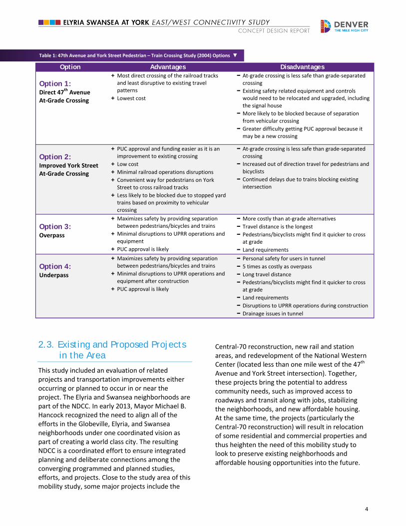
Most pertinent to this project are the 47th Avenue and York Pedestrian-Train Crossing Study (2004) and the Elyria & Swansea Neighborhoods Plan (2015). The Pedestrian-Train Crossing Study evaluated four design alternatives for the intersection summarized in Table 1, including an underpass, an overpass, an improved at-grade crossing at the existing location, and a more direct at-grade crossing. Public input on the alternatives helped to identify Option 2 - York Street At-Grade Crossing- as the best option at that time as it had the lowest estimated cost and a likelihood that it would be easier to gain approval from the Public Utilities Commission (PUC) since it was an improvement to an existing crossing.
In 2012, the City completed the at-grade crossing improvements, including fencing north and south of the crossing all the way down to the I-70 overpass, thereby preventing lateral crossing of the tracks. A formalization of the rail crossing in the form of a curb and bench on the southwestern side of the crossing was implemented concurrently with the introduction of the fencing. In addition, York Lane was converted from two-way to one-way travel, with a widened sidewalk parallel to the tracks (between York Lane and the railroad tracks). These safety improvements included the addition of crossing panels on the tracks to give pedestrians a full ten feet of designated crossing surface.
The Elyria & Swansea Neighborhoods Plan undertook multi-layered outreach and collaboration to engage the neighborhood in a visioning process focused on many topics including land use, transportation connections, and community health. The 47thAvenue and York Street crossing was highlighted as a transformative project and was recommended for future in-depth study. This mobility study is a direct outcome of the neighborhood plan and the connectivity priorities voiced by neighborhood residents.
4
Table 1: 47th Avenue and York Street Pedestrian – Train Crossing Study (2004) Options ▼
Option Advantages Disadvantages
Option 1: Direct 47th Avenue At-Grade Crossing
+ Most direct crossing of the railroad tracks and least disruptive to existing travel patterns
+ Lowest cost
− At-grade crossing is less safe than grade-separated crossing
− Existing safety related equipment and controls would need to be relocated and upgraded, including the signal house
− More likely to be blocked because of separation from vehicular crossing
− Greater difficulty getting PUC approval because it may be a new crossing
Option 2: Improved York Street At-Grade Crossing
+ PUC approval and funding easier as it is an improvement to existing crossing
+ Low cost + Minimal railroad operations disruptions + Convenient way for pedestrians on York
Street to cross railroad tracks + Less likely to be blocked due to stopped yard
trains based on proximity to vehicular crossing
− At-grade crossing is less safe than grade-separated crossing
− Increased out of direction travel for pedestrians and bicyclists
− Continued delays due to trains blocking existing intersection
Option 3: Overpass
+ Maximizes safety by providing separation between pedestrians/bicycles and trains
+ Minimal disruptions to UPRR operations and equipment
+ PUC approval is likely
− More costly than at-grade alternatives − Travel distance is the longest − Pedestrians/bicyclists might find it quicker to cross
at grade − Land requirements
Option 4: Underpass
+ Maximizes safety by providing separation between pedestrians/bicycles and trains
+ Minimal disruptions to UPRR operations and equipment after construction
+ PUC approval is likely
− Personal safety for users in tunnel − 5 times as costly as overpass − Long travel distance − Pedestrians/bicyclists might find it quicker to cross
at grade − Land requirements − Disruptions to UPRR operations during construction − Drainage issues in tunnel
2.3. Existing and Proposed Projects in the Area
This study included an evaluation of related projects and transportation improvements either occurring or planned to occur in or near the project. The Elyria and Swansea neighborhoods are part of the NDCC. In early 2013, Mayor Michael B. Hancock recognized the need to align all of the efforts in the Globeville, Elyria, and Swansea neighborhoods under one coordinated vision as part of creating a world class city. The resulting NDCC is a coordinated effort to ensure integrated planning and deliberate connections among the converging programmed and planned studies, efforts, and projects. Close to the study area of this mobility study, some major projects include the
Central-70 reconstruction, new rail and station areas, and redevelopment of the National Western Center (located less than one mile west of the 47th Avenue and York Street intersection). Together, these projects bring the potential to address community needs, such as improved access to roadways and transit along with jobs, stabilizing the neighborhoods, and new affordable housing. At the same time, the projects (particularly the Central-70 reconstruction) will result in relocation of some residential and commercial properties and thus heighten the need of this mobility study to look to preserve existing neighborhoods and affordable housing opportunities into the future.
5
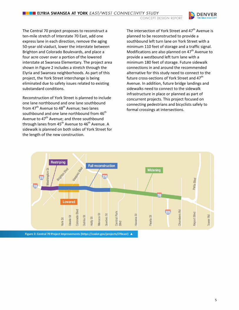
The Central 70 project proposes to reconstruct a ten-mile stretch of Interstate 70 East, add one express lane in each direction, remove the aging 50-year old viaduct, lower the interstate between Brighton and Colorado Boulevards, and place a four acre cover over a portion of the lowered interstate at Swansea Elementary. The project area shown in Figure 2 includes a stretch through the Elyria and Swansea neighborhoods. As part of this project, the York Street interchange is being eliminated due to safety issues related to existing substandard conditions.
Reconstruction of York Street is planned to include one lane northbound and one lane southbound from 47th Avenue to 48th Avenue; two lanes southbound and one lane northbound from 46th Avenue to 47th Avenue; and three southbound through lanes from 45th Avenue to 46th Avenue. A sidewalk is planned on both sides of York Street for the length of the new construction.
The intersection of York Street and 47th Avenue is planned to be reconstructed to provide a southbound left turn lane on York Street with a minimum 110 feet of storage and a traffic signal. Modifications are also planned on 47th Avenue to provide a westbound left turn lane with a minimum 180 feet of storage. Future sidewalk connections in and around the recommended alternative for this study need to connect to the future cross-sections of York Street and 47th Avenue. In addition, future bridge landings and sidewalks need to connect to the sidewalk infrastructure in place or planned as part of concurrent projects. This project focused on connecting pedestrians and bicyclists safely to formal crossings at intersections.
Figure 2: Central 70 Project Improvements (https://codot.gov/projects/i70east) ▲
6
3. Purpose and Need
Project development was initiated through the development of a purpose and need. The purpose and need helps define the overall goals of the project and brings together data, which help outline the individual needs of the project. The purpose and need was developed with the community and reviewed as a part of project outreach efforts.
3.1. Project Purpose
The primary purpose of this project is to improve east/west pedestrian and bicycle connectivity in the Elyria and Swansea neighborhoods. The needs of the project include providing transportation connections for the community, providing safe pedestrian and bicycle route(s) east to west across the railroad, and providing access to public places, neighborhoods, and businesses.
3.2. Project Needs
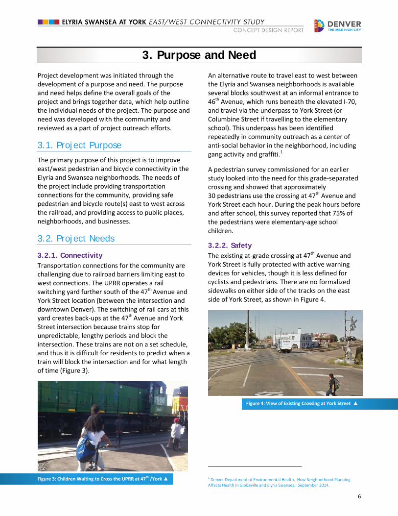
3.2.1. Connectivity Transportation connections for the community are challenging due to railroad barriers limiting east to west connections. The UPRR operates a rail switching yard further south of the 47th Avenue and York Street location (between the intersection and downtown Denver). The switching of rail cars at this yard creates back-ups at the 47th Avenue and York Street intersection because trains stop for unpredictable, lengthy periods and block the intersection. These trains are not on a set schedule, and thus it is difficult for residents to predict when a train will block the intersection and for what length of time (Figure 3).
Figure 3: Children Waiting to Cross the UPRR at 47th /York ▲
An alternative route to travel east to west between the Elyria and Swansea neighborhoods is available several blocks southwest at an informal entrance to 46th Avenue, which runs beneath the elevated I-70, and travel via the underpass to York Street (or Columbine Street if travelling to the elementary school). This underpass has been identified repeatedly in community outreach as a center of anti-social behavior in the neighborhood, including gang activity and graffiti.1
A pedestrian survey commissioned for an earlier study looked into the need for this grade-separated crossing and showed that approximately 30 pedestrians use the crossing at 47th Avenue and York Street each hour. During the peak hours before and after school, this survey reported that 75% of the pedestrians were elementary-age school children.
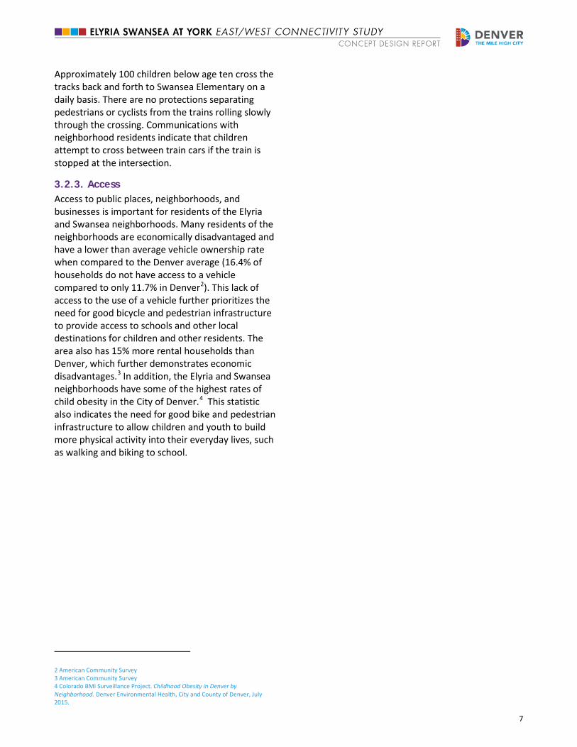
3.2.2. Safety The existing at-grade crossing at 47th Avenue and York Street is fully protected with active warning devices for vehicles, though it is less defined for cyclists and pedestrians. There are no formalized sidewalks on either side of the tracks on the east side of York Street, as shown in Figure 4.
Figure 4: View of Existing Crossing at York Street ▲
1 Denver Department of Environmental Health. How Neighborhood Planning Affects Health in Globeville and Elyria Swansea. September 2014.
7
Approximately 100 children below age ten cross the tracks back and forth to Swansea Elementary on a daily basis. There are no protections separating pedestrians or cyclists from the trains rolling slowly through the crossing. Communications with neighborhood residents indicate that children attempt to cross between train cars if the train is stopped at the intersection.
3.2.3. Access Access to public places, neighborhoods, and businesses is important for residents of the Elyria and Swansea neighborhoods. Many residents of the neighborhoods are economically disadvantaged and have a lower than average vehicle ownership rate when compared to the Denver average (16.4% of households do not have access to a vehicle compared to only 11.7% in Denver2). This lack of access to the use of a vehicle further prioritizes the need for good bicycle and pedestrian infrastructure to provide access to schools and other local destinations for children and other residents. The area also has 15% more rental households than Denver, which further demonstrates economic disadvantages.3 In addition, the Elyria and Swansea neighborhoods have some of the highest rates of child obesity in the City of Denver.4 This statistic also indicates the need for good bike and pedestrian infrastructure to allow children and youth to build more physical activity into their everyday lives, such as walking and biking to school.
2 American Community Survey 3 American Community Survey 4 Colorado BMI Surveillance Project. Childhood Obesity in Denver by Neighborhood. Denver Environmental Health, City and County of Denver, July 2015.
8
4. Outreach with Elyria & Swansea Neighborhoods
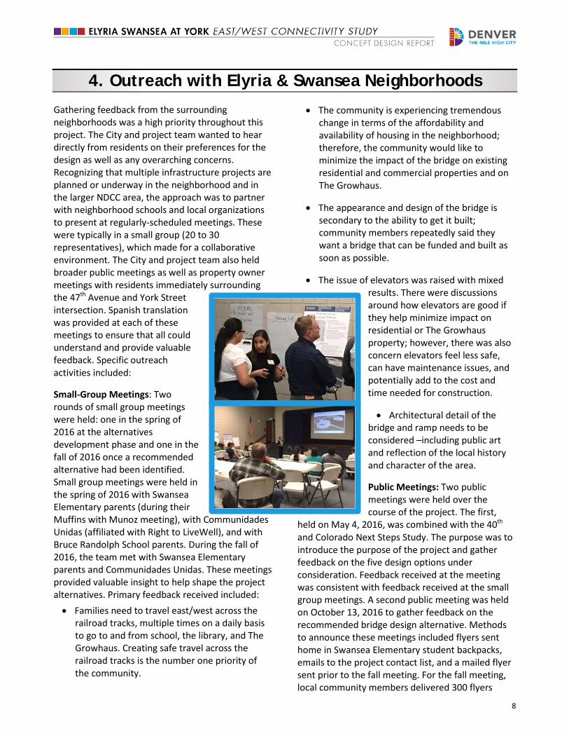
Gathering feedback from the surrounding neighborhoods was a high priority throughout this project. The City and project team wanted to hear directly from residents on their preferences for the design as well as any overarching concerns. Recognizing that multiple infrastructure projects are planned or underway in the neighborhood and in the larger NDCC area, the approach was to partner with neighborhood schools and local organizations to present at regularly-scheduled meetings. These were typically in a small group (20 to 30 representatives), which made for a collaborative environment. The City and project team also held broader public meetings as well as property owner meetings with residents immediately surrounding the 47th Avenue and York Street intersection. Spanish translation was provided at each of these meetings to ensure that all could understand and provide valuable feedback. Specific outreach activities included:
Small-Group Meetings: Two rounds of small group meetings were held: one in the spring of 2016 at the alternatives development phase and one in the fall of 2016 once a recommended alternative had been identified. Small group meetings were held in the spring of 2016 with Swansea Elementary parents (during their Muffins with Munoz meeting), with Communidades Unidas (affiliated with Right to LiveWell), and with Bruce Randolph School parents. During the fall of 2016, the team met with Swansea Elementary parents and Communidades Unidas. These meetings provided valuable insight to help shape the project alternatives. Primary feedback received included: • Families need to travel east/west across the
railroad tracks, multiple times on a daily basis to go to and from school, the library, and The Growhaus. Creating safe travel across the railroad tracks is the number one priority of the community.
• The community is experiencing tremendous change in terms of the affordability and availability of housing in the neighborhood; therefore, the community would like to minimize the impact of the bridge on existing residential and commercial properties and on The Growhaus.
• The appearance and design of the bridge is secondary to the ability to get it built; community members repeatedly said they want a bridge that can be funded and built as soon as possible.
• The issue of elevators was raised with mixed results. There were discussions around how elevators are good if they help minimize impact on residential or The Growhaus property; however, there was also concern elevators feel less safe, can have maintenance issues, and potentially add to the cost and time needed for construction.
• Architectural detail of the bridge and ramp needs to be considered –including public art and reflection of the local history and character of the area.
Public Meetings: Two public meetings were held over the course of the project. The first,
held on May 4, 2016, was combined with the 40th and Colorado Next Steps Study. The purpose was to introduce the purpose of the project and gather feedback on the five design options under consideration. Feedback received at the meeting was consistent with feedback received at the small group meetings. A second public meeting was held on October 13, 2016 to gather feedback on the recommended bridge design alternative. Methods to announce these meetings included flyers sent home in Swansea Elementary student backpacks, emails to the project contact list, and a mailed flyer sent prior to the fall meeting. For the fall meeting, local community members delivered 300 flyers
9
door-to-door and multiple texts, calls, and emails were made to the project contact list of community leaders and past attendees. The fall meeting outreach included 1,200 flyers sent to addresses adjacent to the study area and also promotion of the availability of dinner, child care, and Spanish-language interpretation. Feedback on the recommended alternative included:
• The attendees were supportive of the recommended design and moving the process forward.
• A property owner west of the railroad tracks and proposed westside bridge landing asked whether the ramps coming off of the bridge could be shifted east to provide a buffer from the property line. The concern was that trash could be thrown from the bridge onto the property owner’s land. In addition, the property owner asked for clarification concerning the column placement supporting the ramps. The concern was that access into the property under the ramps could be maintained. The City organized subsequent meetings with the property owner to discuss these concerns in detail. Continued discussions will occur in the next phase of preliminary design.
Property Owner Meetings: Meetings with property owners were held in the spring of 2016 to review the design concepts under consideration and to gather feedback. Invitees included residents of properties both north and south of 47th Avenue (west of the railroad tracks). Owners were invited via certified mail, along with follow-up phone calls in English and Spanish, and flyers placed on front doors. Primary feedback received included:
• Property owners north of 47th Avenue (west of the railroad tracks) preferred that York Lane remain open in the one-way travel configuration and that it provide continued access to garages and driveways along York Lane.
• Property owners north of 47th Avenue preferred design options that would minimize
impact to existing residential and commercial properties.
NDCC Town Hall Meeting: The project team provided feedback to the public through a station at the NDCC Town Hall Meeting held March 24, 2016. This meeting was open house style. The design options under consideration (as presented at the small group meetings held around the same time) were presented. Feedback received was consistent with the small group meeting feedback described on the previous page.
Written communications: A project webpage was created to provide project updates. Project-related materials were posted to this webpage.
10
5. Alternatives Considered
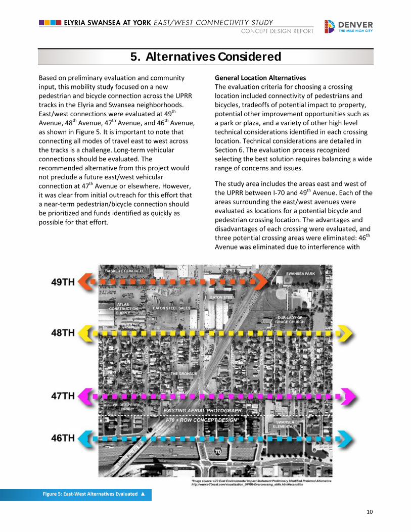
Based on preliminary evaluation and community input, this mobility study focused on a new pedestrian and bicycle connection across the UPRR tracks in the Elyria and Swansea neighborhoods. East/west connections were evaluated at 49th Avenue, 48th Avenue, 47th Avenue, and 46th Avenue, as shown in Figure 5. It is important to note that connecting all modes of travel east to west across the tracks is a challenge. Long-term vehicular connections should be evaluated. The recommended alternative from this project would not preclude a future east/west vehicular connection at 47th Avenue or elsewhere. However, it was clear from initial outreach for this effort that a near-term pedestrian/bicycle connection should be prioritized and funds identified as quickly as possible for that effort.
General Location Alternatives The evaluation criteria for choosing a crossing location included connectivity of pedestrians and bicycles, tradeoffs of potential impact to property, potential other improvement opportunities such as a park or plaza, and a variety of other high level technical considerations identified in each crossing location. Technical considerations are detailed in Section 6. The evaluation process recognized selecting the best solution requires balancing a wide range of concerns and issues.
The study area includes the areas east and west of the UPRR between I-70 and 49th Avenue. Each of the areas surrounding the east/west avenues were evaluated as locations for a potential bicycle and pedestrian crossing location. The advantages and disadvantages of each crossing were evaluated, and three potential crossing areas were eliminated: 46th Avenue was eliminated due to interference with
Figure 5: East-West Alternatives Evaluated ▲
11 Figure 6: Quadrant Locations at 47th Avenue and York Street ▲
Central 70, 48th Avenue was eliminated due to property impacts on large established businesses, and 49th Avenue was eliminated due to property impacts and forced out of direction travel. The location at 47th Avenue was identified as the recommended location for the pedestrian and bicycle connection for three reasons: 1) alignment with existing travel patterns, 2) least amount or no impact on surrounding properties, and 3) identification as the preferred location in previous planning efforts.
Crossing Type Alternatives A high level evaluation of all crossing options built upon the evaluation in the 47th Avenue and York Street Pedestrian-Train Crossing Study for the bridge, underpass, and at-grade crossing alternatives. A bridge design was selected to move forward in the screening process because it maximizes safety by providing separation between pedestrians/bicycles and trains when compared to an at-grade alternative and reduces personal safety issues as well as drainage concerns associated with
an underpass. Construction of a bridge is anticipated to be less expensive than an underpass.
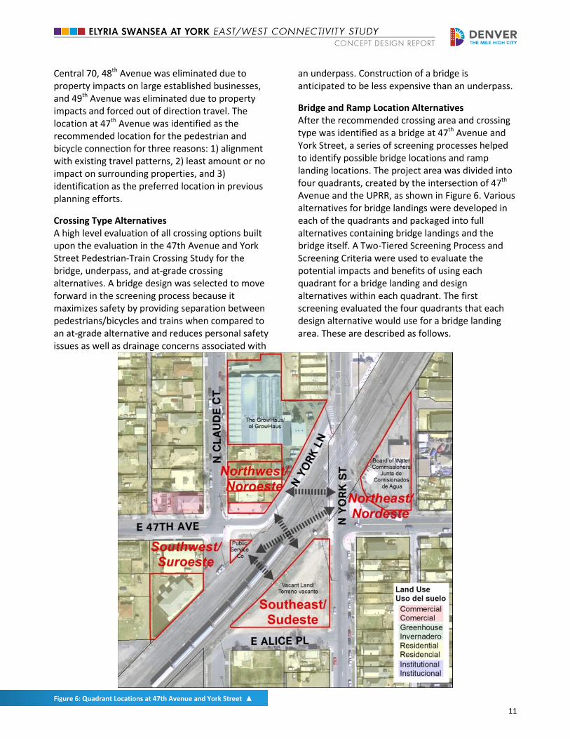
Bridge and Ramp Location Alternatives After the recommended crossing area and crossing type was identified as a bridge at 47th Avenue and York Street, a series of screening processes helped to identify possible bridge locations and ramp landing locations. The project area was divided into four quadrants, created by the intersection of 47th Avenue and the UPRR, as shown in Figure 6. Various alternatives for bridge landings were developed in each of the quadrants and packaged into full alternatives containing bridge landings and the bridge itself. A Two-Tiered Screening Process and Screening Criteria were used to evaluate the potential impacts and benefits of using each quadrant for a bridge landing and design alternatives within each quadrant. The first screening evaluated the four quadrants that each design alternative would use for a bridge landing area. These are described as follows.
12
Southwest Quadrant The southwest quadrant consists of a small triangular parcel owned by Xcel Energy (Public Service Company) and two multi-family residential buildings on one parcel. If the landing of an alternative were to be placed in this quadrant, the Xcel parcel and/or the residential parcel(s) would be affected. The impact to the Xcel parcel would require significant gas utility relocations. Some alternatives using this quadrant would impact the multi-family residential homes, but some alternatives could avoid this impact by keeping the landing footprint contained within the Xcel parcel.
Southeast Quadrant The southeast quadrant consists of one parcel, which is currently vacant. This parcel is currently under acquisition by CDOT as part of the Central 70 project and has opportunities and space for a ramp as well as other design features such as plazas and landscaping.
Northwest Quadrant The northwest quadrant contains 3 residential properties, one commercial property and The GrowHaus, a nonprofit indoor farm, marketplace and educational center. Alternative landings in this quadrant would require the relocation of residences or impact access and right of way on York Lane.
Northeast Quadrant The northeast quadrant consists of one parcel owned by the Board of Water Commissioners.
5.1. Screening Process
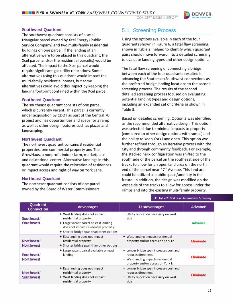
Using the options available in each of the four quadrants shown in Figure 6, a fatal flaw screening, shown in Table 2, helped to identify which quadrant pairs should move forward into a detailed screening to evaluate landing types and other design options.
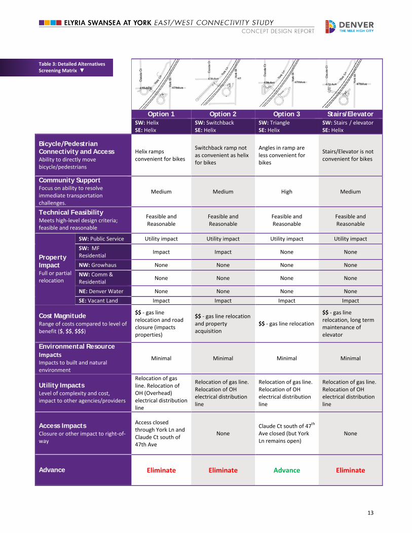
The fatal flaw screening of connecting a bridge between each of the four quadrants resulted in advancing the Southeast/Southwest connections as the preferred bridge landing locations to the second screening process. The results of the second detailed screening process focused on evaluating potential landing types and design options, including an expanded set of criteria as shown in Table 3.
Based on detailed screening, Option 3 was identified as the recommended alternative design. This option was selected due to minimal impacts to property (compared to other design options with ramps) and the ability to keep York Lane open. This option was further refined through an iterative process with the City and through community feedback. For example, the stacked helix configuration was shifted to the south side of the parcel on the southeast side of the tracks to allow for an open land area on the north end of the parcel near 47th Avenue. This land area could be utilized as public space/amenity in the future. In addition, the design was modified on the west side of the tracks to allow for access under the ramps and into the existing multi-family property.
▼ Table 2: First Level Alternatives Screening
Quadrant Connection Advantages Disadvantages Advance
Southeast/ Southwest
+ West landing does not impact residential property
+ Large vacant parcel on east landing does not impact residential property
+ Shorter bridge span than other options
− Utility relocation necessary on west side
Advance
Northeast/ Northwest
+ East landing does not impact residential property
+ Shorter bridge span than other options
− West landing impacts residential property and/or access on York Ln Eliminate
Southeast/ Northwest
+ Large vacant parcel available on east landing
− Longer bridge span increases cost and reduces directness
− West landing impacts residential property and/or access on York Ln
Eliminate
Northeast/ Southwest
+ East landing does not impact residential property
+ West landing does not impact residential property
− Longer bridge span increases cost and reduces directness
− Utility relocation necessary on west side
Eliminate
13
Table 3: Detailed Alternatives Screening Matrix ▼
Option 1 Option 2 Option 3 Stairs/Elevator SW: Helix SE: Helix
SW: Switchback SE: Helix
SW: Triangle SE: Helix
SW: Stairs / elevator SE: Helix
Bicycle/Pedestrian Connectivity and Access Ability to directly move bicycle/pedestrians
Helix ramps convenient for bikes
Switchback ramp not as convenient as helix for bikes
Angles in ramp are less convenient for bikes
Stairs/Elevator is not convenient for bikes
Community Support Focus on ability to resolve immediate transportation challenges.
Medium Medium High Medium
Technical Feasibility Meets high-level design criteria; feasible and reasonable
Feasible and Reasonable
Feasible and Reasonable
Feasible and Reasonable
Feasible and Reasonable
Property Impact Full or partial relocation
SW: Public Service Utility impact Utility impact Utility impact Utility impact SW: MF Residential Impact Impact None None
NW: Growhaus None None None None NW: Comm & Residential None None None None
NE: Denver Water None None None None SE: Vacant Land Impact Impact Impact Impact
Cost Magnitude Range of costs compared to level of benefit ($, $$, $$$)
$$ - gas line relocation and road closure (impacts properties)
$$ - gas line relocation and property acquisition
$$ - gas line relocation
$$ - gas line relocation, long term maintenance of elevator
Environmental Resource Impacts Impacts to built and natural environment
Minimal Minimal Minimal Minimal
Utility Impacts Level of complexity and cost, impact to other agencies/providers
Relocation of gas line. Relocation of OH (Overhead) electrical distribution line
Relocation of gas line. Relocation of OH electrical distribution line
Relocation of gas line. Relocation of OH electrical distribution line
Relocation of gas line. Relocation of OH electrical distribution line
Access Impacts Closure or other impact to right-of-way
Access closed through York Ln and Claude Ct south of 47th Ave
None Claude Ct south of 47th Ave closed (but York Ln remains open)
None
Advance Eliminate Eliminate Advance Eliminate
14
6. Recommended Alternative Design
6.1. Design Overview
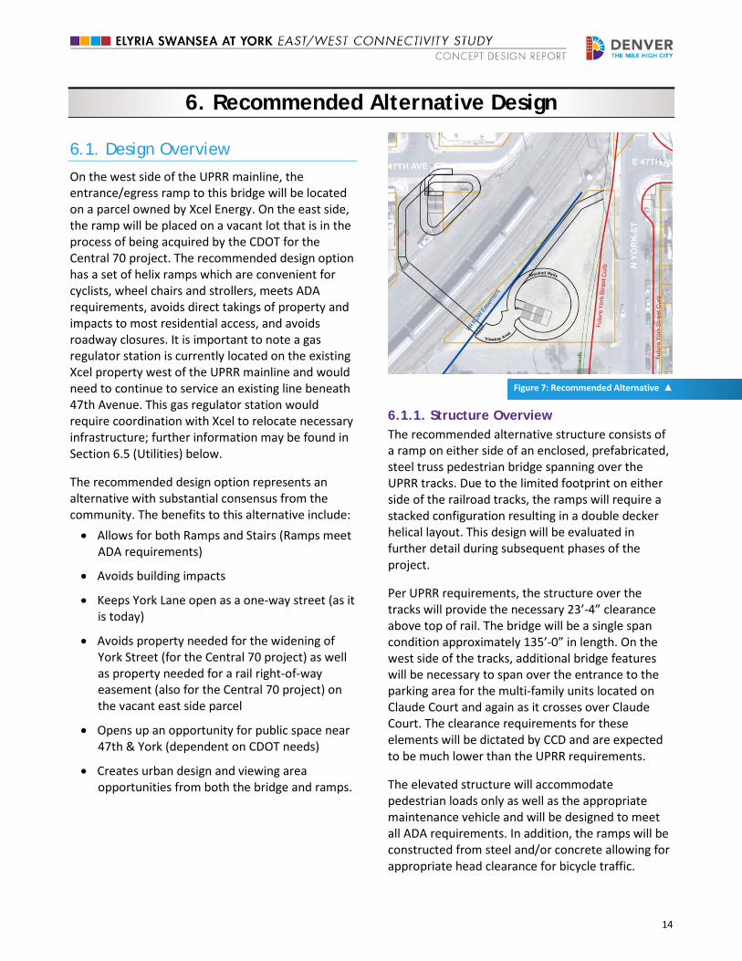
On the west side of the UPRR mainline, the entrance/egress ramp to this bridge will be located on a parcel owned by Xcel Energy. On the east side, the ramp will be placed on a vacant lot that is in the process of being acquired by the CDOT for the Central 70 project. The recommended design option has a set of helix ramps which are convenient for cyclists, wheel chairs and strollers, meets ADA requirements, avoids direct takings of property and impacts to most residential access, and avoids roadway closures. It is important to note a gas regulator station is currently located on the existing Xcel property west of the UPRR mainline and would need to continue to service an existing line beneath 47th Avenue. This gas regulator station would require coordination with Xcel to relocate necessary infrastructure; further information may be found in Section 6.5 (Utilities) below.
The recommended design option represents an alternative with substantial consensus from the community. The benefits to this alternative include: • Allows for both Ramps and Stairs (Ramps meet
ADA requirements)
• Avoids building impacts
• Keeps York Lane open as a one-way street (as it is today)
• Avoids property needed for the widening of York Street (for the Central 70 project) as well as property needed for a rail right-of-way easement (also for the Central 70 project) on the vacant east side parcel
• Opens up an opportunity for public space near 47th & York (dependent on CDOT needs)
• Creates urban design and viewing area opportunities from both the bridge and ramps.
Figure 7: Recommended Alternative ▲
6.1.1. Structure Overview The recommended alternative structure consists of a ramp on either side of an enclosed, prefabricated, steel truss pedestrian bridge spanning over the UPRR tracks. Due to the limited footprint on either side of the railroad tracks, the ramps will require a stacked configuration resulting in a double decker helical layout. This design will be evaluated in further detail during subsequent phases of the project.
Per UPRR requirements, the structure over the tracks will provide the necessary 23’-4” clearance above top of rail. The bridge will be a single span condition approximately 135’-0” in length. On the west side of the tracks, additional bridge features will be necessary to span over the entrance to the parking area for the multi-family units located on Claude Court and again as it crosses over Claude Court. The clearance requirements for these elements will be dictated by CCD and are expected to be much lower than the UPRR requirements.
The elevated structure will accommodate pedestrian loads only as well as the appropriate maintenance vehicle and will be designed to meet all ADA requirements. In addition, the ramps will be constructed from steel and/or concrete allowing for appropriate head clearance for bicycle traffic.
15
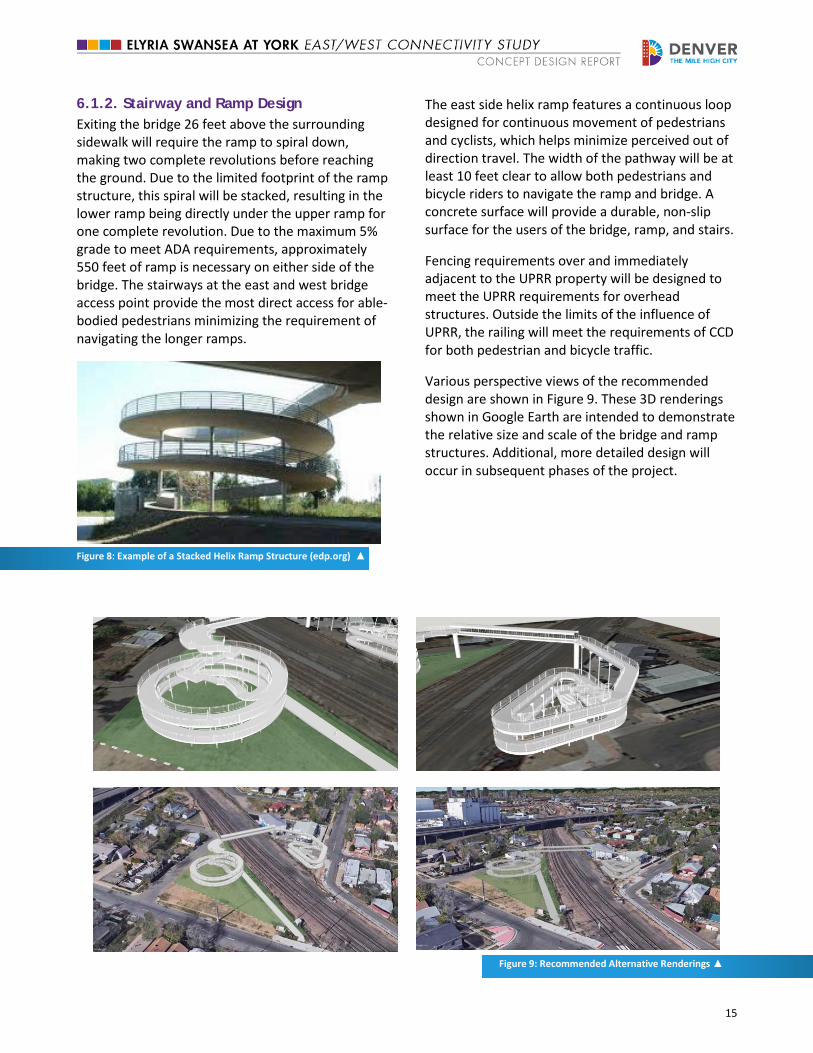
6.1.2. Stairway and Ramp Design Exiting the bridge 26 feet above the surrounding sidewalk will require the ramp to spiral down, making two complete revolutions before reaching the ground. Due to the limited footprint of the ramp structure, this spiral will be stacked, resulting in the lower ramp being directly under the upper ramp for one complete revolution. Due to the maximum 5% grade to meet ADA requirements, approximately 550 feet of ramp is necessary on either side of the bridge. The stairways at the east and west bridge access point provide the most direct access for able-bodied pedestrians minimizing the requirement of navigating the longer ramps.
Figure 8: Example of a Stacked Helix Ramp Structure (edp.org) ▲
The east side helix ramp features a continuous loop designed for continuous movement of pedestrians and cyclists, which helps minimize perceived out of direction travel. The width of the pathway will be at least 10 feet clear to allow both pedestrians and bicycle riders to navigate the ramp and bridge. A concrete surface will provide a durable, non-slip surface for the users of the bridge, ramp, and stairs.
Fencing requirements over and immediately adjacent to the UPRR property will be designed to meet the UPRR requirements for overhead structures. Outside the limits of the influence of UPRR, the railing will meet the requirements of CCD for both pedestrian and bicycle traffic.
Various perspective views of the recommended design are shown in Figure 9. These 3D renderings shown in Google Earth are intended to demonstrate the relative size and scale of the bridge and ramp structures. Additional, more detailed design will occur in subsequent phases of the project.
Figure 9: Recommended Alternative Renderings ▲

16
6.2. Planning for All Modes of Travel
The recommended design option provides the required Americans with Disabilities Act (ADA) access at this location to facilitate convenient access for wheelchair users, pedestrians with strollers, as well as pedestrians experiencing trouble negotiating stairs. A reasonable grade of the ramp connecting street level to the bridge is important for bicyclists, wheelchairs, and other mobility-impaired users. The ramps on the east and west sides and the bridge have a maximum grade of 5 percent (without requiring intermediate landings), which meets ADA design criteria.
In terms of bicycles, the approaches of the bridge and the bridge itself provide sufficient width to accommodate multiple users. The minimum recommended width for bicycle facilities recommended in the American Association of State Highway and Transportation Officials (AASHTO( Bicycle Facilities Guide is 8 feet when use is expected to be low and where frequent passing opportunities exist. The recommended design alternative assumes 10-foot width for ramps and sidewalks extending from the ramps.
6.3. Right of Way Needs
The recommended alternative will require acquisition of property on both the east and west sides of the railroad tracks (south of 47th Avenue). On the west side, acquisition of the triangular parcel currently owned by Xcel will be required (0.02 acres). On the east side of the tracks, a privately-owned parcel will be required to construct the bridge and landings. The anticipated acreage of the full parcel is 0.57 acres. CDOT plans to acquire the parcel for improvements needed as part of the Central 70 project. Thus, the City is working with CDOT on a non-preclusion agreement to help ensure that the parcel remainder (that not needed for Central 70) is preserved for this project. This coordination is ongoing and is part of the procurement process for Central 70.
6.4. UPRR Impacts
Train cars can be controlled remotely at this location. There are crossing gates north and south along York Street and a block signal immediately
south of the crossing. There may be another block signal further north of the crossing. Maintaining line-of-sight with the block signals is critical. The current block signal south of the crossing may have to be located on the pedestrian bridge as the proposed bridge pier support along the southeast track will restrict the sight lines of the existing block signal.
Figure 10: Xcel Utilities that Require Relocation ▲
6.5. Utilities
There are a number of existing utilities in the immediate vicinity of the recommended alternative as well as proposed utility work associated with the upcoming Central 70 project. A medium pressure 20” diameter Xcel Energy gas line runs east/west under 47th Avenue (see Figure 10), providing critical service to downtown Denver. The current alignment of the gas line runs directly under the proposed ramp location and does not allow for the necessary maintenance access required by Xcel. This conflict will likely require the 20” gas line be relocated. Accompanying this gas line is a regulator box providing service to the local community, which is located on the Xcel property at the southeast corner of 47th Avenue and Claude Court. The gas regulator station will also need to be relocated. Currently, the station, as it is in the existing location, no longer meets Xcel standards for enclosure and protection. Thus, the new relocated station will need a shed-sized structure to protect the facility as well as bollards surrounding it. Relocation of the gas regulator station is not dependent on seasonal
Xcel Regulator Station
47th
Ave Gas Line
17
restrictions and should be considered an early action item.
In early 2017, Xcel will have performed a utility location task for all underground utilities running east/west along 47th Avenue. Until this information has been gathered, two relocation schemes for the 20” gas line have been discussed. One option is to relocate the gas line just on the west side of the tracks in order to avoid the maintenance conflict that would exist with the ramp location. Another option is to shift the line to the north between York Street and a point west of Claude Court. This option would require a new boring under the UPRR tracks. Coordination with Xcel will be needed through the preliminary and final design processes.
This 20” gas line is the main feed for the entire downtown Denver customers. As a result, the relocation effort for the gas line can only be done when demand is low. Xcel limits construction on this line between the months of May and September. In addition, due to their internal design tasks and procurement for parts, the design will have to be initiated by Xcel by November of the season that precedes the following construction season.
In addition, along 47th Avenue, there is a 78” diameter storm line and an eight-inch diameter water line underground. As part of this project, a field investigation was performed to determine the depth to the invert of the 78” storm line. It was found that the line is approximately 17’-6” below the roadway surface. The storm line cannot be relocated, but it is expected that the eight-inch water line may need to be relocated between York Street and Claude Court to accommodate the 20” gas line relocation. A single sanitary line dead ends in the Xcel property on the west side and will need to be abandoned further north along York Lane.
Overhead along 47th Avenue, there are electrical distribution lines on utility poles along with additional assumed communication utilities. These lines are not in conflict with the bridge/ramp layout. There are smaller electrical distribution lines running north/south on both sides of the UPRR property that will need to be relocated. Running north/south along York Lane, there are electrical transmission lines, which are not in conflict with the bridge/ramp layout. Primarily within the UPRR right-
of-way, there are a number of underground fiber optic lines running parallel to the alignment of the tracks. A full utility matrix can be found in Appendix B. Appendix B also shows a graphic of the necessary utility relocations.
6.6. Drainage Requirements
Site drainage within the project limits will need to be delineated, designed, and collected into the City’s existing storm drainage system in accordance with the City’s Storm Drainage Design and Technical Criteria Manual. The design will also incorporate erosion control best management practices for the proposed improvements. The drainage for the pedestrian and bicycle bridge across the UPRR right-of-way will need to collected and directed off-site into City and County of Denver right-of-way. Water quality requirements will be determined in the next phase of design.
6.7. Safety/Security
To ensure safe pedestrian and bicycle travel on the bridge approaches and on the bridge, sufficient vertical clearance is needed between the travel surface and any overhead element. The AASHTO Bicycle Guide prescribes an eight-foot minimum vertical clearance with ten feet being desirable. This project incorporates a minimum of eight feet in the design.
A well-lit facility increases a sense of security for those using the bridge and ramps. Lighting would be provided on the bridge structure and on the east and west ramps and stairway access points. Additional coordination with Denver Police to integrate security cameras (HALO) will need to occur once preliminary design is underway, and Crime Prevention Through Environmental Design (CPTED) should be considered as the design proceeds.
6.8. Environmental Resource Impacts
Environmental resources within the study area were evaluated utilizing available desktop data. The I-70 Final Environmental Impact Statement (EIS) (2016) was also reviewed for resource information. A site reconnaissance (windshield survey) was performed by Pinyon Environmental, Inc. to obtain additional information regarding the condition of residential
18
and commercial building structures in the vicinity of the project. The purpose of the windshield survey was to determine whether buildings in the study area may be either on or eligible for the National Register of Historic Places (NRHP).
Based on analysis completed for this project, it was determined that historic resources and hazardous materials are the resources of most concern for this project. Air quality, noise, land use, prime and unique farmland, socio-economics, visual, archaeological resources, and paleontological resources were not evaluated in detail as part of this study.
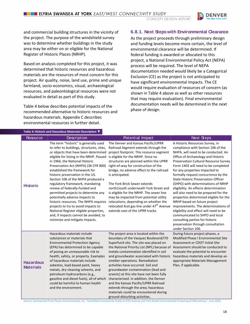
Table 4 below describes potential impacts of the recommended alternative to historic resources and hazardous materials. Appendix C describes environmental resources in further detail.
6.8.1. Next Steps with Environmental Clearance As the project proceeds through preliminary design and funding levels become more certain, the level of environmental clearance will be determined. If federal funding is awarded or allocated to this project, a National Environmental Policy Act (NEPA) process will be required. The level of NEPA documentation needed would likely be a Categorical Exclusion (CE) as the project is not anticipated to have significant environmental impacts. The CE would require evaluation of resources of concern (as shown in Table 4 above as well as other resources that may require evaluation). Final environmental documentation needs will be determined in the next phase of design.
Table 4: Historic and Hazardous Materials Description ▼
Resource Description Potential Impact Next Steps
Historic
The term “historic” is generally used to refer to buildings, structures, sites, or objects that have been determined eligible for listing in the NRHP. Passed in 1966, the National Historic Preservation Act (NHPA) (36 CFR 800) established the framework for historic preservation in the US. Section 106 of the NHPA produced a regulatory framework, mandating review of federally-funded and permitted projects to determine any potentially adverse impacts to historic resources. The NHPA requires projects to try to avoid impacts to National Register eligible properties, and, if impacts cannot be avoided, to minimize and mitigate impacts.
The Denver and Kansas Pacific/UPRR Railroad Segment extends through the project footprint. This resource segment is eligible for the NRHP. Since no structures are planned within the UPRR right-of-way for construction of the bridge, no adverse effect to the railroad is anticipated. The York Brick Sewer extends north/south underneath York Street and is eligible for the NRHP. The sewer line may be impacted from potential utility relocations, depending on whether the relocated Xcel gas line under 47th Avenue extends east of the UPRR tracks.
A Historic Resources Survey, in compliance with Section 106 of the NHPA, will need to be conducted. An Office of Archaeology and Historic Preservation Cultural Resource Survey Form 1403 will need to be completed for any properties impacted to formally request concurrence by the State Historic Preservation Officer (SHPO) with determinations of NRHP eligibility. An effects determination will also need to be prepared for the properties determined eligible for the NRHP based on future project improvements. The determinations of eligibility and effect will need to be communicated to SHPO and local consulting parties for historic preservation through consultation under Section 106.
Hazardous Materials
Hazardous materials include substances or materials that Environmental Protection Agency (EPA) has determined to be capable of posing an unreasonable risk to health, safety, or property. Examples of hazardous materials include asbestos, lead-based paint, heavy metals, dry-cleaning solvents, and petroleum hydrocarbons (e.g., gasoline and diesel fuels), all of which could be harmful to human health and the environment.
The project area is located within the boundary of the Vasquez Boulevard/I70 Superfund site. The site was placed on the National Priority List (NPL) because of metals contamination identified in soil and groundwater associated with historic smelter operations. Remediation activities have occurred. Soil and groundwater contamination (lead and arsenic) at this site have not been fully characterized. In addition, the Denver and the Kansas Pacific/UPRR Railroad extends through the area; hazardous materials could be encountered during ground-disturbing activities.
During future project phases, a Modified Phase I Environmental Site Assessment or CDOT Initial Site Assessment should be conducted to evaluate the potential to encounter hazardous materials and develop an appropriate Materials Management Plan, if applicable.
Source: Summarized from Pinyon Environmental, Inc. “East/West Connectivity Study at 47th Avenue and York Street Environmental Screening of Alternatives,” June 2016
19
6.9. Placemaking Placemaking and public space programming are essential considerations to ensure future success of the parcels and surrounding area. Although placemaking is important for both ramp landing areas (east and west of the tracks), this section focuses on opportunities for the parcel to the east of the UPRR tracks due to the size and configuration of the parcel. The opportunities discussed in this section assume the recommended alternative of a pedestrian bridge with helical ramp in the southwest corner of the site. This placement would maximize the amount of continuous space within the parcel and could provide an opportunity for an open space, plaza or other community amenity on the north end of the parcel closest to 47th Avenue. The intent is to preserve this area for potential community programming opportunity in the future as it is an important entry to the bridge landing area and area of heavy pedestrian activity.
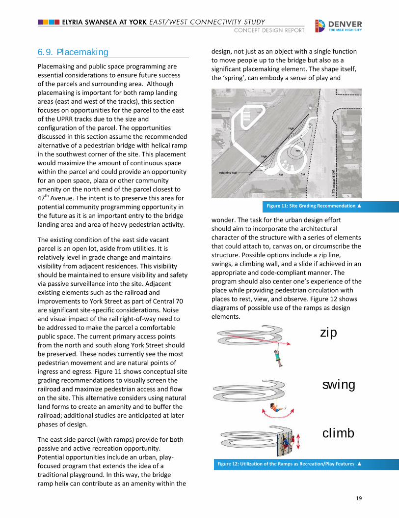
The existing condition of the east side vacant parcel is an open lot, aside from utilities. It is relatively level in grade change and maintains visibility from adjacent residences. This visibility should be maintained to ensure visibility and safety via passive surveillance into the site. Adjacent existing elements such as the railroad and improvements to York Street as part of Central 70 are significant site-specific considerations. Noise and visual impact of the rail right-of-way need to be addressed to make the parcel a comfortable public space. The current primary access points from the north and south along York Street should be preserved. These nodes currently see the most pedestrian movement and are natural points of ingress and egress. Figure 11 shows conceptual site grading recommendations to visually screen the railroad and maximize pedestrian access and flow on the site. This alternative considers using natural land forms to create an amenity and to buffer the railroad; additional studies are anticipated at later phases of design.
The east side parcel (with ramps) provide for both passive and active recreation opportunity. Potential opportunities include an urban, play-focused program that extends the idea of a traditional playground. In this way, the bridge ramp helix can contribute as an amenity within the
design, not just as an object with a single function to move people up to the bridge but also as a significant placemaking element. The shape itself, the ‘spring’, can embody a sense of play and
Figure 11: Site Grading Recommendation ▲
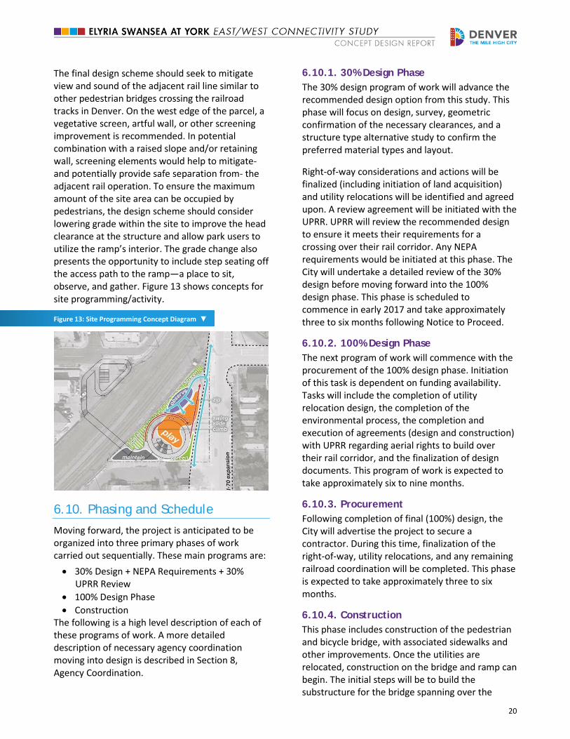
wonder. The task for the urban design effort should aim to incorporate the architectural character of the structure with a series of elements that could attach to, canvas on, or circumscribe the structure. Possible options include a zip line, swings, a climbing wall, and a slide if achieved in an appropriate and code-compliant manner. The program should also center one’s experience of the place while providing pedestrian circulation with places to rest, view, and observe. Figure 12 shows diagrams of possible use of the ramps as design elements.
Figure 12: Utilization of the Ramps as Recreation/Play Features ▲
zip
swing
climb
20
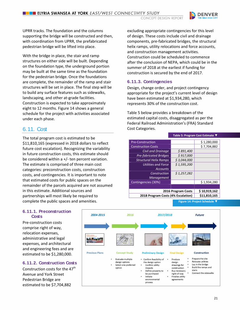
The final design scheme should seek to mitigate view and sound of the adjacent rail line similar to other pedestrian bridges crossing the railroad tracks in Denver. On the west edge of the parcel, a vegetative screen, artful wall, or other screening improvement is recommended. In potential combination with a raised slope and/or retaining wall, screening elements would help to mitigate- and potentially provide safe separation from- the adjacent rail operation. To ensure the maximum amount of the site area can be occupied by pedestrians, the design scheme should consider lowering grade within the site to improve the head clearance at the structure and allow park users to utilize the ramp’s interior. The grade change also presents the opportunity to include step seating off the access path to the ramp—a place to sit, observe, and gather. Figure 13 shows concepts for site programming/activity.
Figure 13: Site Programming Concept Diagram ▼
6.10. Phasing and Schedule
Moving forward, the project is anticipated to be organized into three primary phases of work carried out sequentially. These main programs are: • 30% Design + NEPA Requirements + 30%
UPRR Review • 100% Design Phase • Construction
The following is a high level description of each of these programs of work. A more detailed description of necessary agency coordination moving into design is described in Section 8, Agency Coordination.
6.10.1. 30% Design Phase The 30% design program of work will advance the recommended design option from this study. This phase will focus on design, survey, geometric confirmation of the necessary clearances, and a structure type alternative study to confirm the preferred material types and layout.
Right-of-way considerations and actions will be finalized (including initiation of land acquisition) and utility relocations will be identified and agreed upon. A review agreement will be initiated with the UPRR. UPRR will review the recommended design to ensure it meets their requirements for a crossing over their rail corridor. Any NEPA requirements would be initiated at this phase. The City will undertake a detailed review of the 30% design before moving forward into the 100% design phase. This phase is scheduled to commence in early 2017 and take approximately three to six months following Notice to Proceed.
6.10.2. 100% Design Phase The next program of work will commence with the procurement of the 100% design phase. Initiation of this task is dependent on funding availability. Tasks will include the completion of utility relocation design, the completion of the environmental process, the completion and execution of agreements (design and construction) with UPRR regarding aerial rights to build over their rail corridor, and the finalization of design documents. This program of work is expected to take approximately six to nine months.
6.10.3. Procurement Following completion of final (100%) design, the City will advertise the project to secure a contractor. During this time, finalization of the right-of-way, utility relocations, and any remaining railroad coordination will be completed. This phase is expected to take approximately three to six months.
6.10.4. Construction This phase includes construction of the pedestrian and bicycle bridge, with associated sidewalks and other improvements. Once the utilities are relocated, construction on the bridge and ramp can begin. The initial steps will be to build the substructure for the bridge spanning over the
21
UPRR tracks. The foundation and the columns supporting the bridge will be constructed and then, with coordination from UPRR, the prefabricated pedestrian bridge will be lifted into place.
With the bridge in place, the stair and ramp structures on either side will be built. Depending on the foundation type, the underground portion may be built at the same time as the foundation for the pedestrian bridge. Once the foundations are complete, the remainder of the ramp and stair structures will be set in place. The final step will be to build any surface features such as sidewalks, landscaping, and other at-grade facilities. Construction is expected to take approximately eight to 12 months. Figure 14 shows a general schedule for the project with activities associated under each phase.
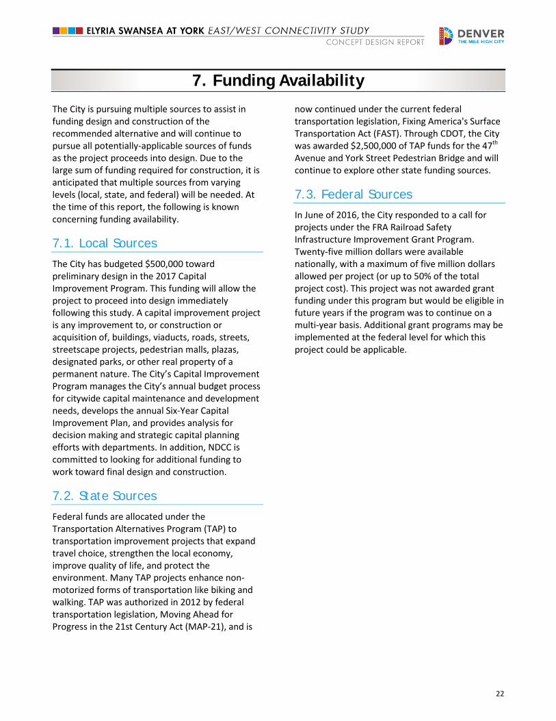
6.11. Cost
The total program cost is estimated to be $11,810,165 (expressed in 2018 dollars to reflect future cost escalation). Recognizing the variability in future construction costs, this estimate should be considered within a +/- ten percent variation. The estimate is comprised of three main cost categories: preconstruction costs, construction costs, and contingencies. It is important to note that estimated costs for public spaces on the remainder of the parcels acquired are not assumed in this estimate. Additional sources and partnerships will most likely be required to complete the public spaces and amenities.
6.11.1. Preconstruction Costs
Pre-construction costs comprise right of way, relocation expenses, administrative and legal expenses, and architectural and engineering fees and are estimated to be $1,280,000.
6.11.2. Construction Costs Construction costs for the 47th Avenue and York Street Pedestrian Bridge are estimated to be $7,704,882
excluding appropriate contingencies for this level of design. These costs include civil and drainage components, pre-fabricated bridges, the structural helix ramps, utility relocations and force accounts, and construction management activities. Construction could be scheduled to commence after the conclusion of NEPA, which could be in the summer of 2018 at the earliest if funding for construction is secured by the end of 2017.
6.11.3. Contingencies Design, change order, and project contingency appropriate for the project’s current level of design have been estimated at $1,934,280, which represents 30% of the construction cost.
Table 5 below provides a breakdown of the estimated capital costs, disaggregated as per the Federal Railroad Administration’s (FRA) Standard Cost Categories.
Table 5: Program Cost Estimate ▼
Pre-Construction $ 1,280,000 Construction Costs $ 7,704,882
Civil and Drainage $ 891,400 Pre-fabricated Bridges $ 917,000 Structural Helix Ramps $ 3,044,000
Utilities and Force Accounts
$ 1,595,200
Construction Management
$ 1,257,282
Contingencies (30%) $ 1,934,280
2016 Program Costs $ 10,919,162 2018 Program Costs (4% Escalation) $11,810,165
Figure 14: Project Schedule ▼
22
7. Funding Availability
The City is pursuing multiple sources to assist in funding design and construction of the recommended alternative and will continue to pursue all potentially-applicable sources of funds as the project proceeds into design. Due to the large sum of funding required for construction, it is anticipated that multiple sources from varying levels (local, state, and federal) will be needed. At the time of this report, the following is known concerning funding availability.
7.1. Local Sources
The City has budgeted $500,000 toward preliminary design in the 2017 Capital Improvement Program. This funding will allow the project to proceed into design immediately following this study. A capital improvement project is any improvement to, or construction or acquisition of, buildings, viaducts, roads, streets, streetscape projects, pedestrian malls, plazas, designated parks, or other real property of a permanent nature. The City’s Capital Improvement Program manages the City’s annual budget process for citywide capital maintenance and development needs, develops the annual Six-Year Capital Improvement Plan, and provides analysis for decision making and strategic capital planning efforts with departments. In addition, NDCC is committed to looking for additional funding to work toward final design and construction.
7.2. State Sources
Federal funds are allocated under the Transportation Alternatives Program (TAP) to transportation improvement projects that expand travel choice, strengthen the local economy, improve quality of life, and protect the environment. Many TAP projects enhance non-motorized forms of transportation like biking and walking. TAP was authorized in 2012 by federal transportation legislation, Moving Ahead for Progress in the 21st Century Act (MAP-21), and is
now continued under the current federal transportation legislation, Fixing America's Surface Transportation Act (FAST). Through CDOT, the City was awarded $2,500,000 of TAP funds for the 47th Avenue and York Street Pedestrian Bridge and will continue to explore other state funding sources.
7.3. Federal Sources
In June of 2016, the City responded to a call for projects under the FRA Railroad Safety Infrastructure Improvement Grant Program. Twenty-five million dollars were available nationally, with a maximum of five million dollars allowed per project (or up to 50% of the total project cost). This project was not awarded grant funding under this program but would be eligible in future years if the program was to continue on a multi-year basis. Additional grant programs may be implemented at the federal level for which this project could be applicable.
23
8. Agency Coordination
In an effort to both collect available data and review the recommended design option, the team coordinated multiple meetings with UPRR, Xcel Energy, and Denver Water.
8.1. Coordination with UPRR Railroad
A preliminary meeting that does not fall under the formal requirements by UPRR was held on August 2, 2016 to ascertain initial feedback from the railroad based on the current design. A formal approval was not granted at that time. However, no major design flaws were identified by UPRR at the meeting.
During the preliminary design phase, UPRR and the City will enter into an agreement identifying compensation for UPRR to review the 30% design. During the final design phase, UPRR will review the 100% design and enter into a construction and maintenance agreement with the City. Additional inter-agency coordination is likely to occur between Xcel and UPRR if a new boring under the railroad is required to relocate the 20” gas line. This timeframe for coordination is unknown but will need to be incorporated into the project schedule long-term.
The project will have to follow the “Guidelines for Railroad Grade Separation Projects” published by BNSF Railway and Union Pacific Railroad. This document identifies the required agreements needed between the railroad and the City as well as railroad review process, design criteria, and submittal schedule.
8.2. Coordination with Xcel Energy
Due to the sensitivity around the 20” line feeding downtown Denver and the inability to avoid a conflict with the recommended bridge design, several meetings were held with Xcel to discuss options for relocation/realignment. Xcel indicated that the bridge or ramp structure could not be located directly over the 20” line extending under
47th Avenue without requiring a relocation. Xcel requires maintenance access to their lines, which means any conflicts above ground would interfere. Two potential relocation options were identified but could not be confirmed by Xcel at this stage in the design. One option was to re-align the 20” gas line starting on the east side of the track and shifting it to the north to avoid the conflict with the ramp. This option would require a new boring under the UPRR property. Another option was to shift the line in the immediate vicinity of the conflict on the west side of the UPRR property. Either option will require ongoing coordination with Xcel. The existing franchise agreement between Xcel and the City would likely cover the cost for this relocation.
The conflict with the gas regulator located on the Xcel property at the south-east corner of 47th Avenue and Claude Court was also discussed during these meetings. An acceptable location was identified on a presently-vacant parcel at the intersection of Gaylord Street and 46th Avenue. Xcel would require ownership of this property prior to relocating the regulator station. The cost of this relocation would be carried by the project and would not fall under the franchise agreement.
8.3. Coordination with Denver Water
A single meeting with Denver Water and the City was conducted in the summer of 2016 to discuss the impact to all wet utilities. The impact to the water distribution lines was determined negligible, and it was determined that the lines could be relocated with relatively minimal effort. A single wastewater line was identified, and it was determined that it could be abandoned. The 78” RCP storm line running along 47th Avenue was the primary focus of the meeting because it could not be relocated. While there were no direct impacts to the project due to its location, it would need to be considered in the relocation of the gas line mentioned above.
24
9. Summary
Improving connectivity at the intersection of 47th Avenue and York Street was identified as a top priority and transformative concept in the 2015 Elyria & Swansea Neighborhoods Plan. This study builds upon that recommendation and has included outreach and communication with City staff, residents, business owners, and nearby schools to identify a recommended alternative for a grade-separated pedestrian and bicycle crossing. A strong need exists for a grade separation due to the large volume of trains that move back and forth through this intersection and the substantial number of residents, including schoolchildren, that use this crossing daily.
The recommended alternative included in this report would construct a bridge with stairs and ramps on properties south of 47th Avenue. Benefits of this configuration include enhanced connectivity, comfort, access to surrounding destinations, and overall quality of life. The next phase following this concept study is preliminary design, which will move forward in 2017.