Embed Size (px)
Citation preview
SizeScale
XREF
's:DA
TE P
LOTT
ED: 6
Octo
ber 2
017 9
:13 A
M BY
: AND
REW
HOP
E
A1
CAD
File:
H:\20
17\H
RP16
299 -
KUR
Wor
ld Ru
ral R
eside
ntial
Subd
ivisio
n\006
- Eq
uine T
ouris
m Fa
cility
Dra
fting\A
cad\H
RP16
299-
006-
FIG-
01 to
FIG
-09.d
wg
Date
Drawing Number Revision
© Cardno Limited All Rights Reserved.This document is produced by Cardno Limited solely for the
benefit of and use by the client in accordance with theterms of the retainer. Cardno Limited does not and shall not
assume any responsibility or liability whatsoever to anythird party arising out of any use or reliance by third party
on the content of this document.
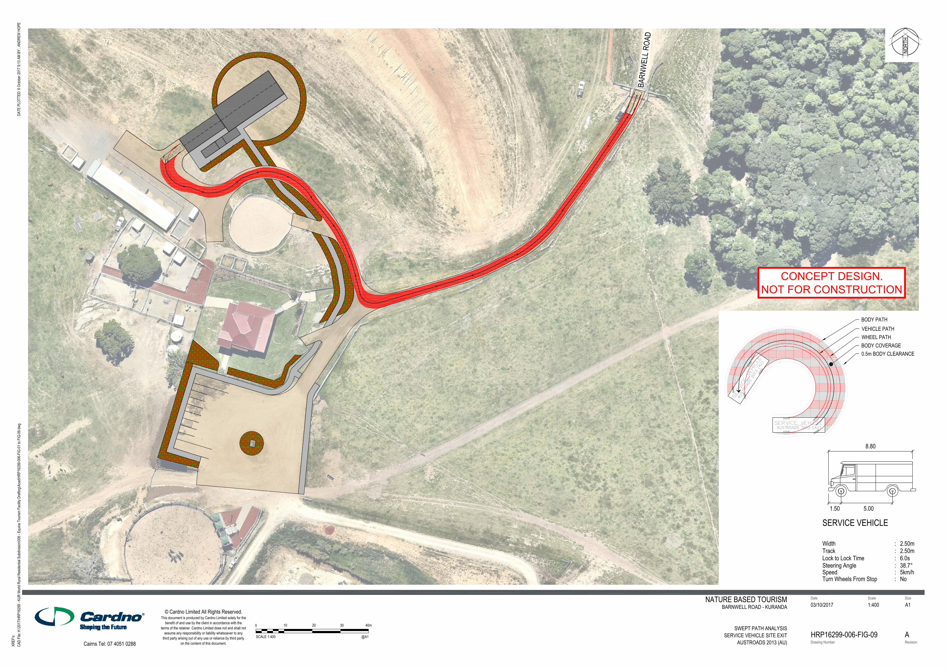
NATURE BASED TOURISMBARNWELL ROAD - KURANDA
SWEPT PATH ANALYSIS
SERVICE VEHICLE SITE EXITAUSTROADS 2013 (AU)
03/10/2017 1:400
HRP16299-006-FIG-09 A
®®®
Cairns Tel: 07 4051 0288
NORT
H
0 10
SCALE 1:400
20 30 40m
@A1
VEHICLE PATHWHEEL PATHBODY COVERAGE
BODY PATH
0.5m BODY CLEARANCE
Lock to Lock Time
SERVICE VEHICLE
WidthTrack
Steering Angle
1.50 5.00
::
2.50m2.50m
:38.7°:6.0s
8.80
Speed 5km/h:Turn Wheels From Stop No:
CONCEPT DESIGN.
NOT FOR CONSTRUCTION
BARN
WEL
L ROA
D
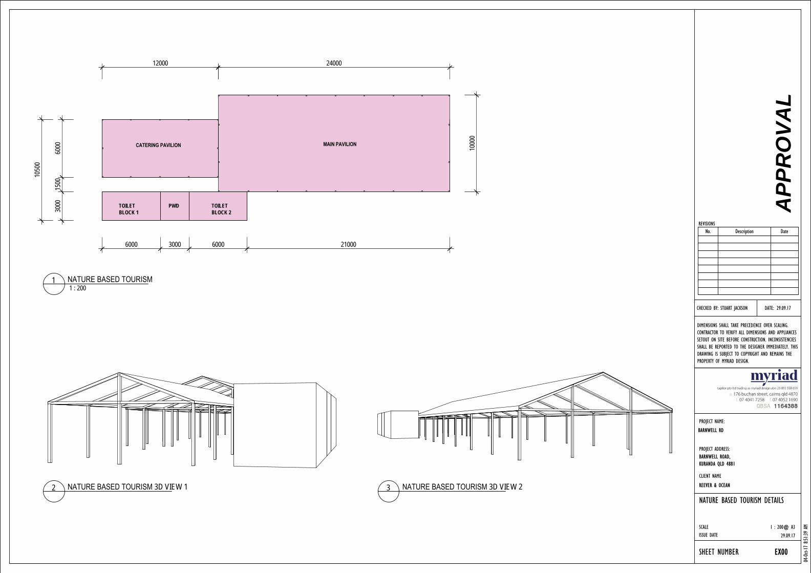
MAIN PAVILIONCATERING PAVILION
TOILET BLOCK 2
TOILET BLOCK 1
PWD 3000
1500
6000
6000 3000 6000 21000
12000
1050
0
1000
0
24000
SCALEISSUE DATE
DIMENSIONS SHALL TAKE PRECEDENCE OVER SCALING. CONTRACTOR TO VERIFY ALL DIMENSIONS AND APPLIANCES SETOUT ON SITE BEFORE CONSTRUCTION. INCONSISTENCIES SHALL BE REPORTED TO THE DESIGNER IMMEDIATELY. THIS DRAWING IS SUBJECT TO COPYRIGHT AND REMAINS THE PROPERTY OF MYRIAD DESIGN.
REVISIONS
SHEET NUMBER
PROJECT NAME:
CLIENT NAME
PROJECT ADDRESS:
CHECKED BY: STUART JACKSON DATE:
1 : 200@ A3
04-Oct-
17 8
:51:39
AM
NATURE BASED TOURISM DETAILS
REEVER & OCEAN
29.09.17
EX00
KUR-COW - BARNWELL RD
BARNWELL ROAD,KURANDA QLD 4881
29.09.17
APP
RO
VAL
No. Description Date
1 : 2001 NATURE BASED TOURISM
BARNWELL RD
2 NATURE BASED TOURISM 3D VIEW 1 3 NATURE BASED TOURISM 3D VIEW 2
24000
1000
0
2400
42
26
SCALEISSUE DATE
DIMENSIONS SHALL TAKE PRECEDENCE OVER SCALING. CONTRACTOR TO VERIFY ALL DIMENSIONS AND APPLIANCES SETOUT ON SITE BEFORE CONSTRUCTION. INCONSISTENCIES SHALL BE REPORTED TO THE DESIGNER IMMEDIATELY. THIS DRAWING IS SUBJECT TO COPYRIGHT AND REMAINS THE PROPERTY OF MYRIAD DESIGN.
REVISIONS
SHEET NUMBER
PROJECT NAME:
CLIENT NAME
PROJECT ADDRESS:
CHECKED BY: STUART JACKSON DATE:
1 : 100@ A3
04-Oct-
17 8
:51:40
AM
PAVILION DETAILS
REEVER & OCEAN
29.09.17
EX01
KUR-COW - BARNWELL RD
BARNWELL ROAD,KURANDA QLD 4881
29.09.17
APP
RO
VAL
No. Description Date
BARNWELL RD
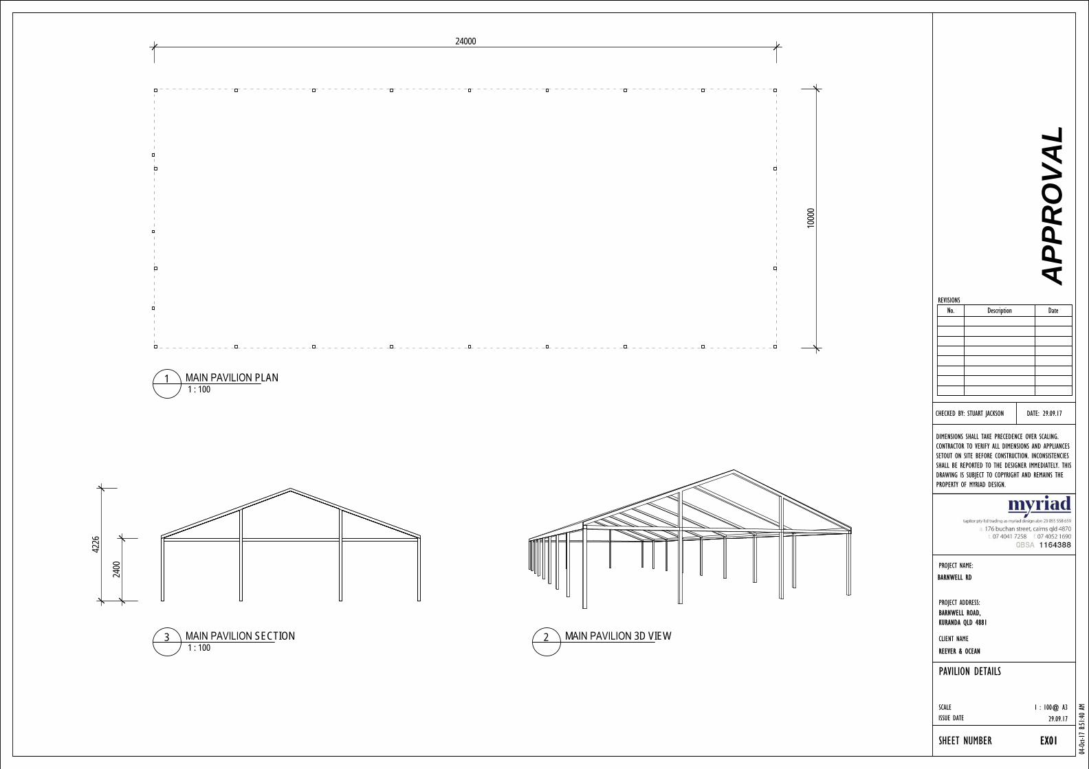
1 : 1001 MAIN PAVILION PLAN
2 MAIN PAVILION 3D VIEW1 : 100
3 MAIN PAVILION SECTION
240034
90
12000
6000
SCALEISSUE DATE
DIMENSIONS SHALL TAKE PRECEDENCE OVER SCALING. CONTRACTOR TO VERIFY ALL DIMENSIONS AND APPLIANCES SETOUT ON SITE BEFORE CONSTRUCTION. INCONSISTENCIES SHALL BE REPORTED TO THE DESIGNER IMMEDIATELY. THIS DRAWING IS SUBJECT TO COPYRIGHT AND REMAINS THE PROPERTY OF MYRIAD DESIGN.
REVISIONS
SHEET NUMBER
PROJECT NAME:
CLIENT NAME
PROJECT ADDRESS:
CHECKED BY: STUART JACKSON DATE:
1 : 100@ A3
04-Oct-
17 8
:51:40
AM
CATERING PAVILION DETAILS
REEVER & OCEAN
29.09.17
EX02
KUR-COW - BARNWELL RD
BARNWELL ROAD,KURANDA QLD 4881
29.09.17
APP
RO
VAL
No. Description Date
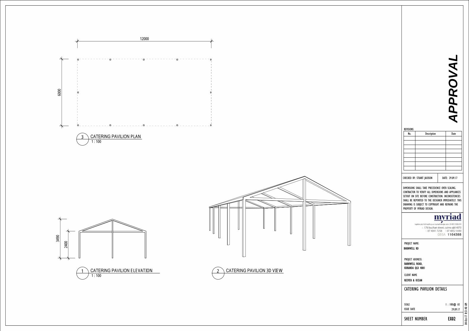
1 : 1001 CATERING PAVILION ELEVATION 2 CATERING PAVILION 3D VIEW
1 : 1003 CATERING PAVILION PLAN
BARNWELL RD
13
www.cardno.com
Attachment C Statement of Code Compliance

October 2017 Cardno
Statement of Code Compliance
Mareeba Shire Planning Scheme 2016
1 Rural Zone Code
2 Airport Environs Overlay Code
3 Environmental Significance Overlay Code
4 Parking and Access Code
5 Works, Services and Infrastructure Code
October 2017 Cardno 2
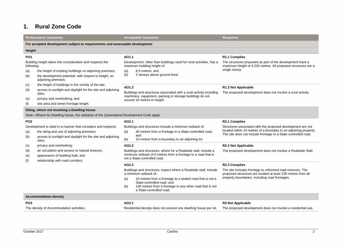
1. Rural Zone Code
Performance Outcomes Acceptable Outcomes Response
For accepted development subject to requirements and assessable development
Height
PO1
Building height takes into consideration and respects the following:
(a) the height of existing buildings on adjoining premises;
(b) the development potential, with respect to height, on adjoining premises;
(c) the height of buildings in the vicinity of the site;
(d) access to sunlight and daylight for the site and adjoining sites;
(e) privacy and overlooking; and
(f) site area and street frontage length.
AO1.1
Development, other than buildings used for rural activities, has a maximum building height of:
(a) 8.5 metres; and (b) 2 storeys above ground level.
R1.1 Complies
The structures proposed as part of the development have a maximum height of 4.226 metres. All proposed structures are a single storey.
AO1.2
Buildings and structures associated with a rural activity including machinery, equipment, packing or storage buildings do not exceed 10 metres in height.
R1.2 Not Applicable
The proposed development does not involve a rural activity.
Siting, where not involving a Dwelling house
Note—Where for Dwelling house, the setbacks of the Queensland Development Code apply.
PO2
Development is sited in a manner that considers and respects:
(a) the siting and use of adjoining premises;
(b) access to sunlight and daylight for the site and adjoining sites;
(c) privacy and overlooking;
(d) air circulation and access to natural breezes;
(e) appearance of building bulk; and
(f) relationship with road corridors.
AO2.1
Buildings and structures include a minimum setback of:
(a) 40 metres from a frontage to a State-controlled road; and
(b) 10 metres from a boundary to an adjoining lot.
R2.1 Complies
Structures associated with the proposed development are not located within 10 metres of a boundary to an adjoining property. The site does not include frontage to a State-controlled road.
AO2.2
Buildings and structures, where for a Roadside stall, include a minimum setback of 0 metres from a frontage to a road that is not a State-controlled road.
R2.2 Not Applicable
The proposed development does not involve a Roadside Stall.
AO2.3
Buildings and structures, expect where a Roadside stall, include a minimum setback of:
(a) 10 metres from a frontage to a sealed road that is not a State-controlled road; and
(b) 100 metres from a frontage to any other road that is not a State-controlled road;
R2.3 Complies
The site includes frontage to unformed road reserves. The proposed structures are located at least 100 metres from all property boundaries, including road frontages.
Accommodation density
PO3
The density of Accommodation activities:
AO3.1
Residential density does not exceed one dwelling house per lot.
R3 Not Applicable
The proposed development does not involve a residential use.
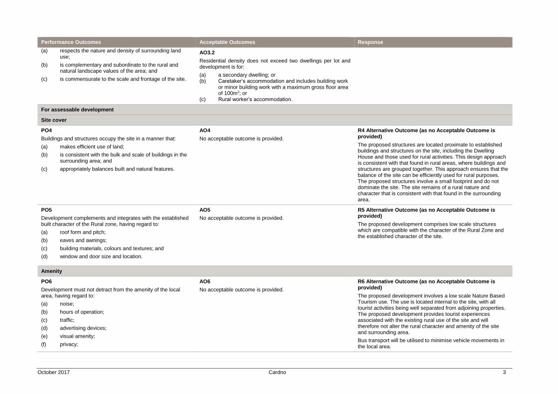
October 2017 Cardno 3
Performance Outcomes Acceptable Outcomes Response
(a) respects the nature and density of surrounding land use;
(b) is complementary and subordinate to the rural and natural landscape values of the area; and
(c) is commensurate to the scale and frontage of the site.
AO3.2
Residential density does not exceed two dwellings per lot and development is for:
(a) a secondary dwelling; or (b) Caretaker’s accommodation and includes building work
or minor building work with a maximum gross floor area of 100m2; or
(c) Rural worker’s accommodation.
For assessable development
Site cover
PO4
Buildings and structures occupy the site in a manner that:
(a) makes efficient use of land;
(b) is consistent with the bulk and scale of buildings in the surrounding area; and
(c) appropriately balances built and natural features.
AO4
No acceptable outcome is provided.
R4 Alternative Outcome (as no Acceptable Outcome is provided)
The proposed structures are located proximate to established buildings and structures on the site, including the Dwelling House and those used for rural activities. This design approach is consistent with that found in rural areas, where buildings and structures are grouped together. This approach ensures that the balance of the site can be efficiently used for rural purposes. The proposed structures involve a small footprint and do not dominate the site. The site remains of a rural nature and character that is consistent with that found in the surrounding area.
PO5
Development complements and integrates with the established built character of the Rural zone, having regard to:
(a) roof form and pitch;
(b) eaves and awnings;
(c) building materials, colours and textures; and
(d) window and door size and location.
AO5
No acceptable outcome is provided.
R5 Alternative Outcome (as no Acceptable Outcome is provided)
The proposed development comprises low scale structures which are compatible with the character of the Rural Zone and the established character of the site.
Amenity
PO6
Development must not detract from the amenity of the local area, having regard to:
(a) noise;
(b) hours of operation;
(c) traffic;
(d) advertising devices;
(e) visual amenity;
(f) privacy;
AO6
No acceptable outcome is provided.
R6 Alternative Outcome (as no Acceptable Outcome is provided)
The proposed development involves a low scale Nature Based Tourism use. The use is located internal to the site, with all tourist activities being well separated from adjoining properties. The proposed development provides tourist experiences associated with the existing rural use of the site and will therefore not alter the rural character and amenity of the site and surrounding area.
Bus transport will be utilised to minimise vehicle movements in the local area.
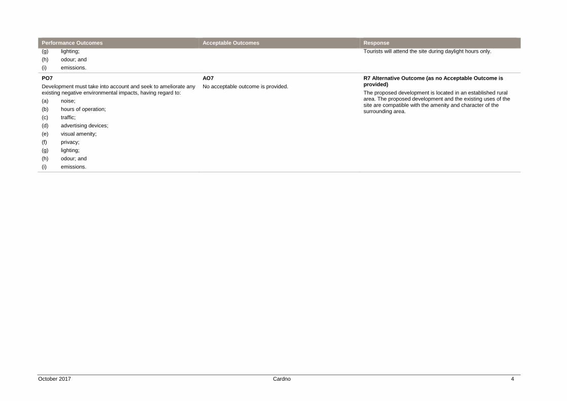
October 2017 Cardno 4
Performance Outcomes Acceptable Outcomes Response
(g) lighting;
(h) odour; and
(i) emissions.
Tourists will attend the site during daylight hours only.
PO7
Development must take into account and seek to ameliorate any existing negative environmental impacts, having regard to:
(a) noise;
(b) hours of operation;
(c) traffic;
(d) advertising devices;
(e) visual amenity;
(f) privacy;
(g) lighting;
(h) odour; and
(i) emissions.
AO7
No acceptable outcome is provided.
R7 Alternative Outcome (as no Acceptable Outcome is provided)
The proposed development is located in an established rural area. The proposed development and the existing uses of the site are compatible with the amenity and character of the surrounding area.
October 2017 Cardno 5
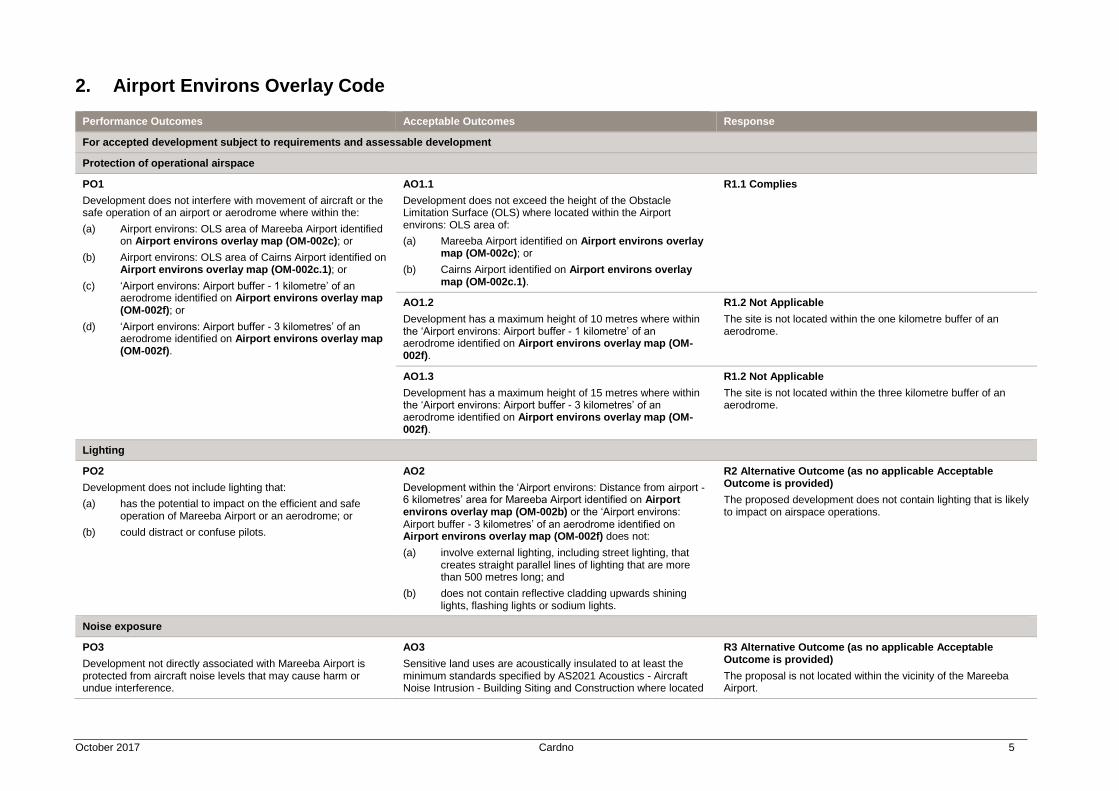
2. Airport Environs Overlay Code
Performance Outcomes Acceptable Outcomes Response
For accepted development subject to requirements and assessable development
Protection of operational airspace
PO1
Development does not interfere with movement of aircraft or the safe operation of an airport or aerodrome where within the:
(a) Airport environs: OLS area of Mareeba Airport identified on Airport environs overlay map (OM-002c); or
(b) Airport environs: OLS area of Cairns Airport identified on Airport environs overlay map (OM-002c.1); or
(c) ‘Airport environs: Airport buffer - 1 kilometre’ of an aerodrome identified on Airport environs overlay map (OM-002f); or
(d) ‘Airport environs: Airport buffer - 3 kilometres’ of an aerodrome identified on Airport environs overlay map (OM-002f).
AO1.1
Development does not exceed the height of the Obstacle Limitation Surface (OLS) where located within the Airport environs: OLS area of:
(a) Mareeba Airport identified on Airport environs overlay map (OM-002c); or
(b) Cairns Airport identified on Airport environs overlay map (OM-002c.1).
R1.1 Complies
AO1.2
Development has a maximum height of 10 metres where within the ‘Airport environs: Airport buffer - 1 kilometre’ of an aerodrome identified on Airport environs overlay map (OM-002f).
R1.2 Not Applicable
The site is not located within the one kilometre buffer of an aerodrome.
AO1.3
Development has a maximum height of 15 metres where within the ‘Airport environs: Airport buffer - 3 kilometres’ of an aerodrome identified on Airport environs overlay map (OM-002f).
R1.2 Not Applicable
The site is not located within the three kilometre buffer of an aerodrome.
Lighting
PO2
Development does not include lighting that:
(a) has the potential to impact on the efficient and safe operation of Mareeba Airport or an aerodrome; or
(b) could distract or confuse pilots.
AO2
Development within the ‘Airport environs: Distance from airport - 6 kilometres’ area for Mareeba Airport identified on Airport environs overlay map (OM-002b) or the ‘Airport environs: Airport buffer - 3 kilometres’ of an aerodrome identified on Airport environs overlay map (OM-002f) does not:
(a) involve external lighting, including street lighting, that creates straight parallel lines of lighting that are more than 500 metres long; and
(b) does not contain reflective cladding upwards shining lights, flashing lights or sodium lights.
R2 Alternative Outcome (as no applicable Acceptable Outcome is provided)
The proposed development does not contain lighting that is likely to impact on airspace operations.
Noise exposure
PO3
Development not directly associated with Mareeba Airport is protected from aircraft noise levels that may cause harm or undue interference.
AO3
Sensitive land uses are acoustically insulated to at least the minimum standards specified by AS2021 Acoustics - Aircraft Noise Intrusion - Building Siting and Construction where located
R3 Alternative Outcome (as no applicable Acceptable Outcome is provided)
The proposal is not located within the vicinity of the Mareeba Airport.
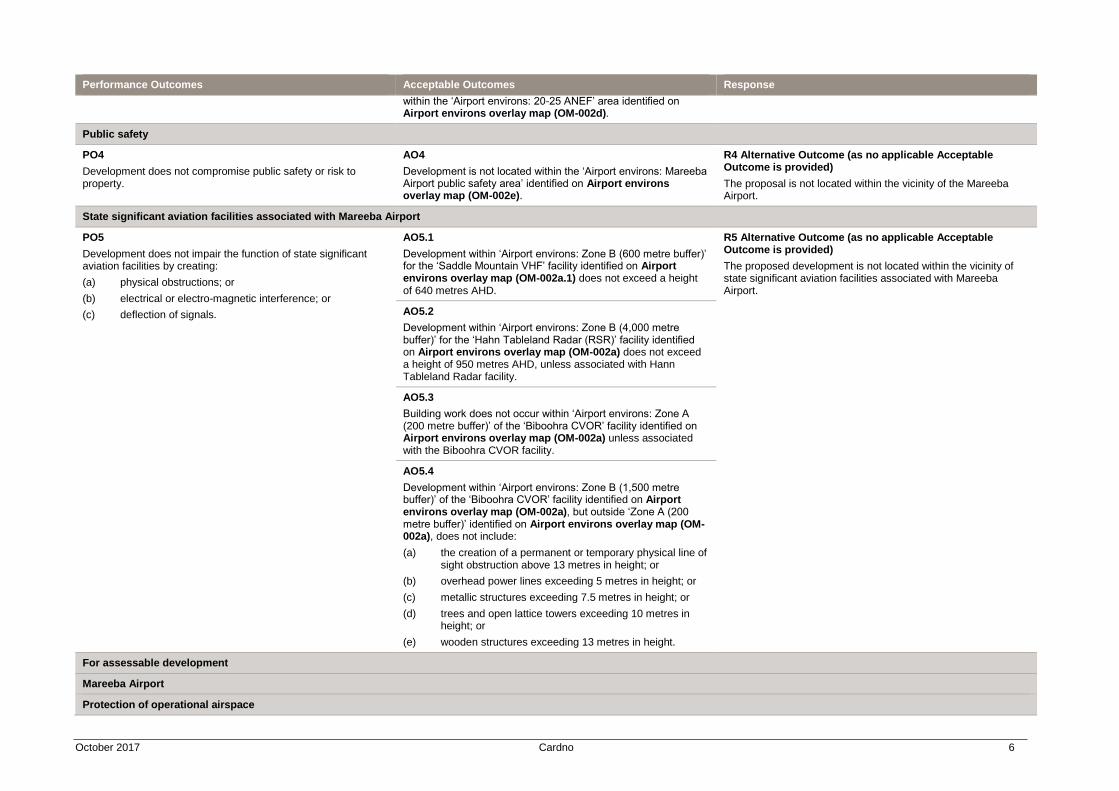
October 2017 Cardno 6
Performance Outcomes Acceptable Outcomes Response
within the ‘Airport environs: 20-25 ANEF’ area identified on Airport environs overlay map (OM-002d).
Public safety
PO4
Development does not compromise public safety or risk to property.
AO4
Development is not located within the ‘Airport environs: Mareeba Airport public safety area’ identified on Airport environs overlay map (OM-002e).
R4 Alternative Outcome (as no applicable Acceptable Outcome is provided)
The proposal is not located within the vicinity of the Mareeba Airport.
State significant aviation facilities associated with Mareeba Airport
PO5
Development does not impair the function of state significant aviation facilities by creating:
(a) physical obstructions; or
(b) electrical or electro-magnetic interference; or
(c) deflection of signals.
AO5.1
Development within ‘Airport environs: Zone B (600 metre buffer)’ for the ‘Saddle Mountain VHF’ facility identified on Airport environs overlay map (OM-002a.1) does not exceed a height of 640 metres AHD.
R5 Alternative Outcome (as no applicable Acceptable Outcome is provided)
The proposed development is not located within the vicinity of state significant aviation facilities associated with Mareeba Airport.
AO5.2
Development within ‘Airport environs: Zone B (4,000 metre buffer)’ for the ‘Hahn Tableland Radar (RSR)’ facility identified on Airport environs overlay map (OM-002a) does not exceed a height of 950 metres AHD, unless associated with Hann Tableland Radar facility.
AO5.3
Building work does not occur within ‘Airport environs: Zone A (200 metre buffer)’ of the ‘Biboohra CVOR’ facility identified on Airport environs overlay map (OM-002a) unless associated with the Biboohra CVOR facility.
AO5.4
Development within ‘Airport environs: Zone B (1,500 metre buffer)’ of the ‘Biboohra CVOR’ facility identified on Airport environs overlay map (OM-002a), but outside ‘Zone A (200 metre buffer)’ identified on Airport environs overlay map (OM-002a), does not include:
(a) the creation of a permanent or temporary physical line of sight obstruction above 13 metres in height; or
(b) overhead power lines exceeding 5 metres in height; or
(c) metallic structures exceeding 7.5 metres in height; or
(d) trees and open lattice towers exceeding 10 metres in height; or
(e) wooden structures exceeding 13 metres in height.
For assessable development
Mareeba Airport
Protection of operational airspace
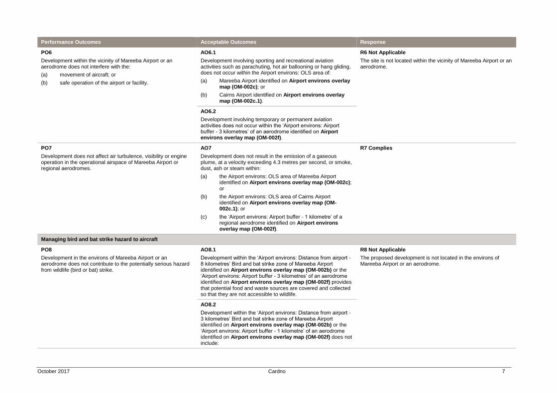
October 2017 Cardno 7
Performance Outcomes Acceptable Outcomes Response
PO6
Development within the vicinity of Mareeba Airport or an aerodrome does not interfere with the:
(a) movement of aircraft; or
(b) safe operation of the airport or facility.
AO6.1
Development involving sporting and recreational aviation activities such as parachuting, hot air ballooning or hang gliding, does not occur within the Airport environs: OLS area of:
(a) Mareeba Airport identified on Airport environs overlay map (OM-002c); or
(b) Cairns Airport identified on Airport environs overlay map (OM-002c.1).
R6 Not Applicable
The site is not located within the vicinity of Mareeba Airport or an aerodrome.
AO6.2
Development involving temporary or permanent aviation activities does not occur within the ‘Airport environs: Airport buffer - 3 kilometres’ of an aerodrome identified on Airport environs overlay map (OM-002f).
PO7
Development does not affect air turbulence, visibility or engine operation in the operational airspace of Mareeba Airport or regional aerodromes.
AO7
Development does not result in the emission of a gaseous plume, at a velocity exceeding 4.3 metres per second, or smoke, dust, ash or steam within:
(a) the Airport environs: OLS area of Mareeba Airport identified on Airport environs overlay map (OM-002c); or
(b) the Airport environs: OLS area of Cairns Airport identified on Airport environs overlay map (OM-002c.1); or
(c) the ‘Airport environs: Airport buffer - 1 kilometre’ of a regional aerodrome identified on Airport environs overlay map (OM-002f).
R7 Complies
Managing bird and bat strike hazard to aircraft
PO8
Development in the environs of Mareeba Airport or an aerodrome does not contribute to the potentially serious hazard from wildlife (bird or bat) strike.
AO8.1
Development within the ‘Airport environs: Distance from airport - 8 kilometres’ Bird and bat strike zone of Mareeba Airport identified on Airport environs overlay map (OM-002b) or the ‘Airport environs: Airport buffer - 3 kilometres’ of an aerodrome identified on Airport environs overlay map (OM-002f) provides that potential food and waste sources are covered and collected so that they are not accessible to wildlife.
R8 Not Applicable
The proposed development is not located in the environs of Mareeba Airport or an aerodrome.
AO8.2
Development within the ‘Airport environs: Distance from airport - 3 kilometres’ Bird and bat strike zone of Mareeba Airport identified on Airport environs overlay map (OM-002b) or the ‘Airport environs: Airport buffer - 1 kilometre’ of an aerodrome identified on Airport environs overlay map (OM-002f) does not include:
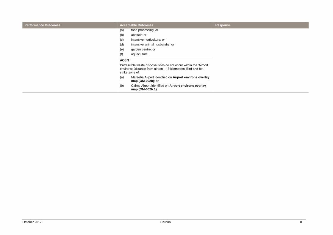
October 2017 Cardno 8
Performance Outcomes Acceptable Outcomes Response
(a) food processing; or
(b) abattoir; or
(c) intensive horticulture; or
(d) intensive animal husbandry; or
(e) garden centre; or
(f) aquaculture.
AO8.3
Putrescible waste disposal sites do not occur within the ‘Airport environs: Distance from airport - 13 kilometres’ Bird and bat strike zone of:
(a) Mareeba Airport identified on Airport environs overlay map (OM-002b); or
(b) Cairns Airport identified on Airport environs overlay map (OM-002b.1).
October 2017 Cardno 9
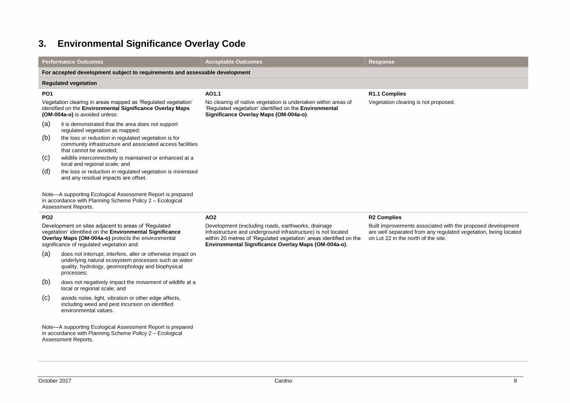
3. Environmental Significance Overlay Code
Performance Outcomes Acceptable Outcomes Response
For accepted development subject to requirements and assessable development
Regulated vegetation
PO1
Vegetation clearing in areas mapped as ‘Regulated vegetation’ identified on the Environmental Significance Overlay Maps (OM-004a-o) is avoided unless:
(a) it is demonstrated that the area does not support regulated vegetation as mapped;
(b) the loss or reduction in regulated vegetation is for community infrastructure and associated access facilities that cannot be avoided;
(c) wildlife interconnectivity is maintained or enhanced at a local and regional scale; and
(d) the loss or reduction in regulated vegetation is minimised and any residual impacts are offset.
Note—A supporting Ecological Assessment Report is prepared in accordance with Planning Scheme Policy 2 – Ecological Assessment Reports.
AO1.1
No clearing of native vegetation is undertaken within areas of ‘Regulated vegetation’ identified on the Environmental Significance Overlay Maps (OM-004a-o).
R1.1 Complies
Vegetation clearing is not proposed.
PO2
Development on sites adjacent to areas of ‘Regulated vegetation’ identified on the Environmental Significance Overlay Maps (OM-004a-o) protects the environmental significance of regulated vegetation and:
(a) does not interrupt, interfere, alter or otherwise impact on underlying natural ecosystem processes such as water quality, hydrology, geomorphology and biophysical processes;
(b) does not negatively impact the movement of wildlife at a local or regional scale; and
(c) avoids noise, light, vibration or other edge affects, including weed and pest incursion on identified environmental values.
Note—A supporting Ecological Assessment Report is prepared in accordance with Planning Scheme Policy 2 – Ecological Assessment Reports.
AO2
Development (excluding roads, earthworks, drainage infrastructure and underground infrastructure) is not located within 20 metres of ‘Regulated vegetation’ areas identified on the Environmental Significance Overlay Maps (OM-004a-o).
R2 Complies
Built improvements associated with the proposed development are well separated from any regulated vegetation, being located on Lot 22 in the north of the site.
October 2017 Cardno 10
Performance Outcomes Acceptable Outcomes Response
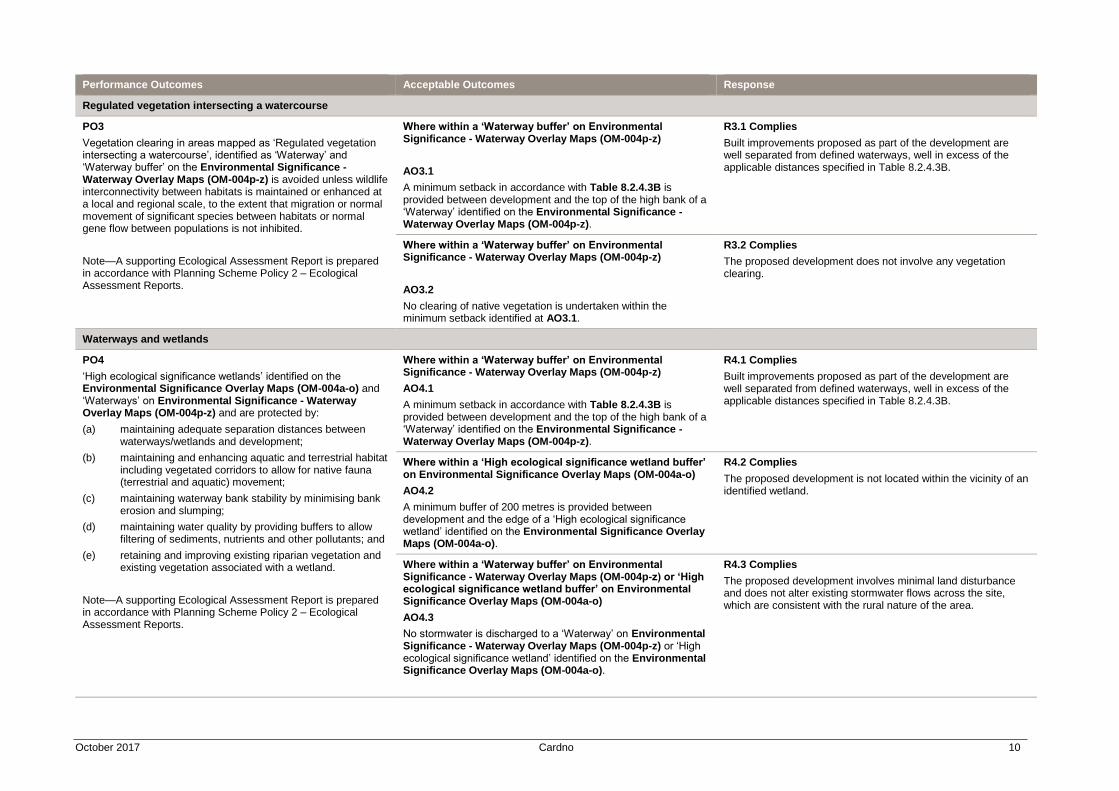
Regulated vegetation intersecting a watercourse
PO3
Vegetation clearing in areas mapped as ‘Regulated vegetation intersecting a watercourse’, identified as ‘Waterway’ and ‘Waterway buffer’ on the Environmental Significance - Waterway Overlay Maps (OM-004p-z) is avoided unless wildlife interconnectivity between habitats is maintained or enhanced at a local and regional scale, to the extent that migration or normal movement of significant species between habitats or normal gene flow between populations is not inhibited.
Note—A supporting Ecological Assessment Report is prepared in accordance with Planning Scheme Policy 2 – Ecological Assessment Reports.
Where within a ‘Waterway buffer’ on Environmental Significance - Waterway Overlay Maps (OM-004p-z)
AO3.1
A minimum setback in accordance with Table 8.2.4.3B is provided between development and the top of the high bank of a ‘Waterway’ identified on the Environmental Significance - Waterway Overlay Maps (OM-004p-z).
R3.1 Complies
Built improvements proposed as part of the development are well separated from defined waterways, well in excess of the applicable distances specified in Table 8.2.4.3B.
Where within a ‘Waterway buffer’ on Environmental Significance - Waterway Overlay Maps (OM-004p-z)
AO3.2
No clearing of native vegetation is undertaken within the minimum setback identified at AO3.1.
R3.2 Complies
The proposed development does not involve any vegetation clearing.
Waterways and wetlands
PO4
‘High ecological significance wetlands’ identified on the Environmental Significance Overlay Maps (OM-004a-o) and ‘Waterways’ on Environmental Significance - Waterway Overlay Maps (OM-004p-z) and are protected by:
(a) maintaining adequate separation distances between waterways/wetlands and development;
(b) maintaining and enhancing aquatic and terrestrial habitat including vegetated corridors to allow for native fauna (terrestrial and aquatic) movement;
(c) maintaining waterway bank stability by minimising bank erosion and slumping;
(d) maintaining water quality by providing buffers to allow filtering of sediments, nutrients and other pollutants; and
(e) retaining and improving existing riparian vegetation and existing vegetation associated with a wetland.
Note—A supporting Ecological Assessment Report is prepared in accordance with Planning Scheme Policy 2 – Ecological Assessment Reports.
Where within a ‘Waterway buffer’ on Environmental Significance - Waterway Overlay Maps (OM-004p-z)
AO4.1
A minimum setback in accordance with Table 8.2.4.3B is provided between development and the top of the high bank of a ‘Waterway’ identified on the Environmental Significance - Waterway Overlay Maps (OM-004p-z).
R4.1 Complies
Built improvements proposed as part of the development are well separated from defined waterways, well in excess of the applicable distances specified in Table 8.2.4.3B.
Where within a ‘High ecological significance wetland buffer’ on Environmental Significance Overlay Maps (OM-004a-o)
AO4.2
A minimum buffer of 200 metres is provided between development and the edge of a ‘High ecological significance wetland’ identified on the Environmental Significance Overlay Maps (OM-004a-o).
R4.2 Complies
The proposed development is not located within the vicinity of an identified wetland.
Where within a ‘Waterway buffer’ on Environmental Significance - Waterway Overlay Maps (OM-004p-z) or ‘High ecological significance wetland buffer’ on Environmental Significance Overlay Maps (OM-004a-o)
AO4.3
No stormwater is discharged to a ‘Waterway’ on Environmental Significance - Waterway Overlay Maps (OM-004p-z) or ‘High ecological significance wetland’ identified on the Environmental Significance Overlay Maps (OM-004a-o).
R4.3 Complies
The proposed development involves minimal land disturbance and does not alter existing stormwater flows across the site, which are consistent with the rural nature of the area.
October 2017 Cardno 11
Performance Outcomes Acceptable Outcomes Response
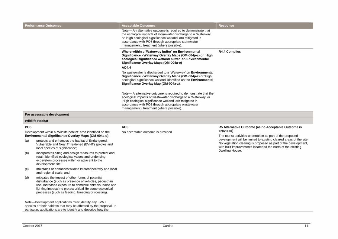
Note— An alternative outcome is required to demonstrate that the ecological impacts of stormwater discharge to a ‘Waterway’ or ‘High ecological significance wetland’ are mitigated in accordance with PO3 through appropriate stormwater management / treatment (where possible).
Where within a ‘Waterway buffer’ on Environmental Significance - Waterway Overlay Maps (OM-004p-z) or ‘High ecological significance wetland buffer’ on Environmental Significance Overlay Maps (OM-004a-o)
AO4.4
No wastewater is discharged to a ‘Waterway’ on Environmental Significance - Waterway Overlay Maps (OM-004p-z) or ‘High ecological significance wetland’ identified on the Environmental Significance Overlay Map (OM-004a-z).
Note— A alternative outcome is required to demonstrate that the ecological impacts of wastewater discharge to a ‘Waterway’ or ‘High ecological significance wetland’ are mitigated in accordance with PO3 through appropriate wastewater management / treatment (where possible).
R4.4 Complies
For assessable development
Wildlife Habitat
PO5
Development within a ‘Wildlife habitat’ area identified on the Environmental Significance Overlay Maps (OM-004a-o):
(a) protects and enhances the habitat of Endangered, Vulnerable and Near Threatened (EVNT) species and local species of significance;
(b) incorporates siting and design measures to protect and retain identified ecological values and underlying ecosystem processes within or adjacent to the development site;
(c) maintains or enhances wildlife interconnectivity at a local and regional scale; and
(d) mitigates the impact of other forms of potential disturbance (such as presence of vehicles, pedestrian use, increased exposure to domestic animals, noise and lighting impacts) to protect critical life stage ecological processes (such as feeding, breeding or roosting).
Note—Development applications must identify any EVNT species or their habitats that may be affected by the proposal. In particular, applications are to identify and describe how the
AO5
No acceptable outcome is provided
R5 Alternative Outcome (as no Acceptable Outcome is provided)
The tourist activities undertaken as part of the proposed development will be limited to existing cleared areas of the site. No vegetation clearing is proposed as part of the development, with built improvements located to the north of the existing Dwelling House.
October 2017 Cardno 12
Performance Outcomes Acceptable Outcomes Response
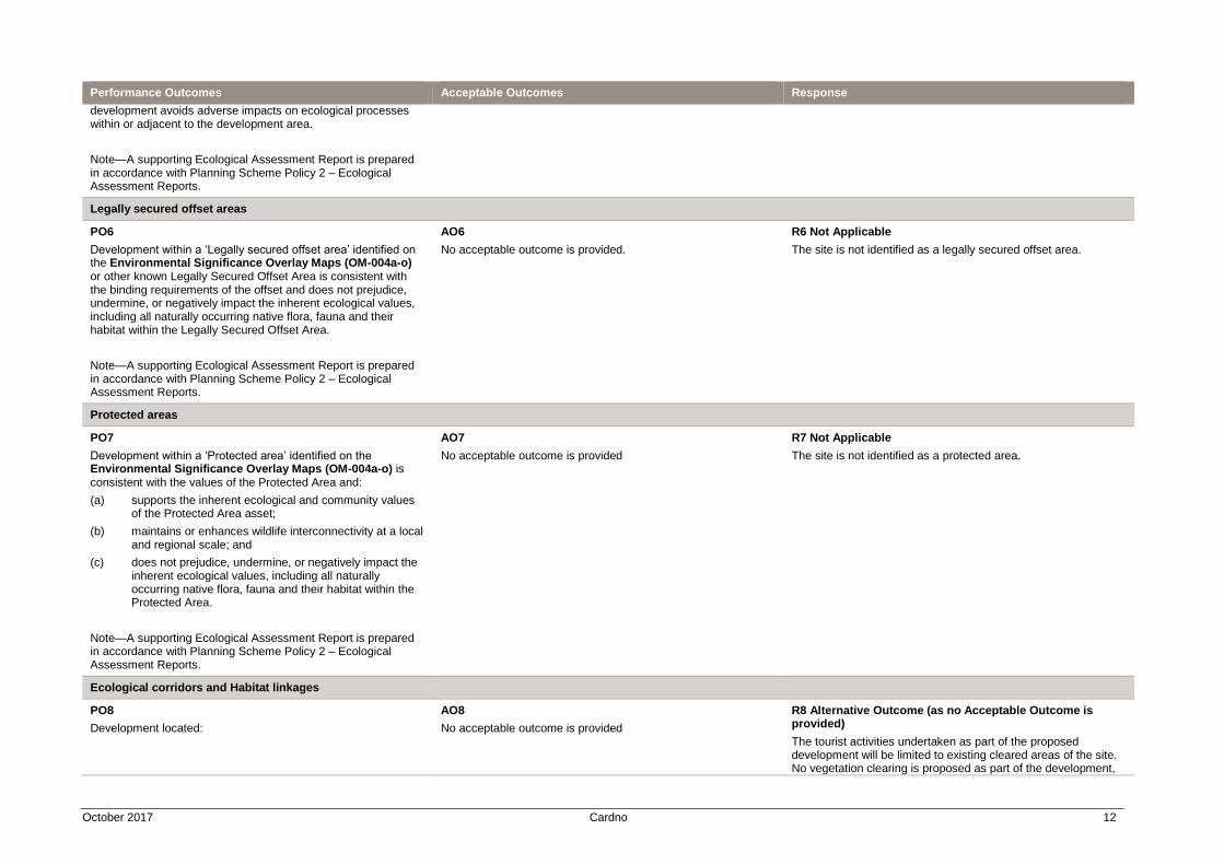
development avoids adverse impacts on ecological processes within or adjacent to the development area.
Note—A supporting Ecological Assessment Report is prepared in accordance with Planning Scheme Policy 2 – Ecological Assessment Reports.
Legally secured offset areas
PO6
Development within a ‘Legally secured offset area’ identified on the Environmental Significance Overlay Maps (OM-004a-o) or other known Legally Secured Offset Area is consistent with the binding requirements of the offset and does not prejudice, undermine, or negatively impact the inherent ecological values, including all naturally occurring native flora, fauna and their habitat within the Legally Secured Offset Area.
Note—A supporting Ecological Assessment Report is prepared in accordance with Planning Scheme Policy 2 – Ecological Assessment Reports.
AO6
No acceptable outcome is provided.
R6 Not Applicable
The site is not identified as a legally secured offset area.
Protected areas
PO7
Development within a ‘Protected area’ identified on the Environmental Significance Overlay Maps (OM-004a-o) is consistent with the values of the Protected Area and:
(a) supports the inherent ecological and community values of the Protected Area asset;
(b) maintains or enhances wildlife interconnectivity at a local and regional scale; and
(c) does not prejudice, undermine, or negatively impact the inherent ecological values, including all naturally occurring native flora, fauna and their habitat within the Protected Area.
Note—A supporting Ecological Assessment Report is prepared in accordance with Planning Scheme Policy 2 – Ecological Assessment Reports.
AO7
No acceptable outcome is provided
R7 Not Applicable
The site is not identified as a protected area.
Ecological corridors and Habitat linkages
PO8
Development located:
AO8
No acceptable outcome is provided
R8 Alternative Outcome (as no Acceptable Outcome is provided)
The tourist activities undertaken as part of the proposed development will be limited to existing cleared areas of the site. No vegetation clearing is proposed as part of the development,
October 2017 Cardno 13
Performance Outcomes Acceptable Outcomes Response
(a) in the Conservation zone, Emerging community zone, Recreation and open space zone, Rural zone or Rural residential zone; and
(b) within an ‘Ecological corridor’ or a ‘Habitat linkage’ identified on the Environmental Significance Overlay Maps (OM-004a-o)
does not compromise the provision of habitat connectivity of the corridor/linkage, having regard to:
(a) the environmental values of the area of the site identified in the ‘Ecological corridor’ or ‘Habitat linkage’;
(b) the environmental values of adjoining and nearby land within the ‘Ecological corridor’ or ‘Habitat linkage’;
(c) the extent of any modification proposed to the natural environment including (but not limited to) vegetation and topography;
(d) the location and design of proposed improvements that may impact on the functions of the ‘Ecological corridor’ or ‘Habitat linkage’ including (but not limited to) buildings, structures, fences, lighting, vehicle movement areas and infrastructure services; and
(e) the ability for the ‘Ecological corridor’ or ‘Habitat linkage’ to be enhanced to improve ecological connectivity.
Note—A supporting Ecological Assessment Report prepared in accordance with Planning Scheme Policy 2 – Ecological Assessment Reports may be appropriate to demonstrate compliance with PO8.
with built improvements located to the north of the existing Dwelling House.
The proposal retains the existing ecological corridors through the site, including a number of creeks, to promote wildlife movement and habitat protection.
October 2017 Cardno 14
4. Parking and Access Code
Performance Outcomes Acceptable Outcomes Response
For accepted development subject to requirements and assessable development
Car parking spaces
PO1
Development provides sufficient car parking to accommodate the demand likely to be generated by the use, having regard to the:
(a) nature of the use;
(b) location of the site;
(c) proximity of the use to public transport services;
(d) availability of active transport infrastructure; and
(e) accessibility of the use to all members of the community.
AO1
The number of car parking spaces provided for the use is in accordance with Table 9.4.3.3B.
Note—Car parking spaces provided for persons with a disability are to be considered in determining compliance with AO1.
R1 Alternative Outcome (as no applicable Acceptable Outcome is provided)
The proposed development involves a Nature Based Tourism use. The proposal does not comprise any tourist accommodation and therefore an applicable parking rate is not specified in Table 9.4.3.3B.
The proposed development involves the central provision of eight (8) car parking spaces, complemented by two bus parking bays. The proposed arrangements are considered appropriate noting that all tourists will be transported to the site by bus and the only demand for car parking spaces will be generated by staff.
Vehicle crossovers
PO2
Vehicle crossovers are provided to::
(a) ensure safe and efficient access between the road and premises;
(b) minimize interference with the function and operation of roads; and
(c) minimise pedestrian to vehicle conflict.
AO2.1
Vehicular access to/from Council roads is designed and constructed in accordance with the Standard drawings in Planning Scheme Policy 4 - FNQROC Regional Development Manual.
R2.1 Alternative Outcome
The proposed development will rely on existing access from Barnwell Road. This access is consistent with the rural nature of the location and the site and is sufficient for the low level of use (two buses and staff vehicles) resulting from the proposal.
AO2.2
Development on a site with two or more road frontages provides vehicular access from:
(a) the primary frontage where involving Community activities or Sport and recreation activities, unless the primary road frontage is a State-controlled road; or
(b) from the lowest order road in all other instances.
AO2.3
Vehicular access for particular uses is provided in accordance with Table 9.4.3.3E.
R2.3 Not Applicable
Table 9.4.3.3E does not specify any relevant requirements.
PO3
Access, manoeuvring and car parking areas include appropriate pavement treatments having regard to:
(a) the intensity of anticipated vehicle movements;
(b) the nature of the use that they service; and
(c) the character of the surrounding locality.
AO3
Access, manoeuvring and car parking areas include pavements that are constructed in accordance with Table 9.4.3.3C.
R3 Can Comply
The proposal will utilize existing gravel maneuvering areas throughout the site.
October 2017 Cardno 15
Performance Outcomes Acceptable Outcomes Response
For assessable development
Parking area location and design
PO4
Car parking areas are located and designed to:
(a) ensure safety and efficiency in operation; and
(b) be consistent with the character of the surrounding locality.
AO4.1
Car parking spaces, access and circulation areas have dimensions in accordance with AS/NZS 2890.1 Off-street car parking.
R4.1 Complies
AO4.2
Disabled access and car parking spaces are located and designed in accordance with AS/NZS 2890.6 Parking facilities - Off-street parking for people with disabilities.
R4.2 Not Applicable
Disabled parking spaces are not proposed.
AO4.3
The car parking area includes designated pedestrian routes that provide connections to building entrances.
R4.3 Complies
A network of pedestrian paths is proposed as part of the development, to connect the car park to key destinations throughout the site.
AO4.4
Parking and any set down areas are:
(a) wholly contained within the site;
(b) visible from the street where involving Commercial activities, Community activities, Industrial activities or a use in the Recreation and open space zone;
(c) are set back behind the main building line where involving a Dual occupancy, Multiple dwelling, Residential care facility or Retirement facility; and
(d) provided at the side or rear of a building in all other instances.
R4.4 Complies
The proposed parking area is appropriately located wholly within the site, being located toward the rear of the existing Dwelling House and proposed new structures.
Site access and manoeuvring
PO5
Access to, and manoeuvring within, the site is designed and located to:
(a) ensure the safety and efficiency of the external road network;
(b) ensure the safety of pedestrians;
(c) provide a functional and convenient layout; and
(d) accommodate all vehicles intended to use the site.
AO5.1
Access and manoeuvrability is in accordance with :
(a) AS28901 – Car Parking Facilities (Off Street Parking); and
(b) AS2890.2 – Parking Facilities (Off-street Parking) Commercial Vehicle Facilities.
Note—Proposal plans should include turning circles designed in accordance with AP34/95 (Austroads 1995) Design Vehicles and Turning Path Templates.
R5.1 Complies
AO5.2
Vehicular access has a minimum sight distance in accordance with Part 5 of AUSTROADS.
R5.2 Complies
Vehicular access to the site is located at the termination of the formed part of Barnwell Road.
October 2017 Cardno 16
Performance Outcomes Acceptable Outcomes Response
AO5.3
Vehicular access is located and designed so that all vehicles enter and exit the site in a forward gear.
R5.3 Complies
Vehicle access allows cars and buses to manoeuvre on site to enter and exit the site in a forward gear.
AO5.4
Pedestrian and cyclist access to the site:
(a) is clearly defined;
(b) easily identifiable; and
(c) provides a connection between the site frontage and the entrance to buildings and end of trip facilities (where provided).
R5.4 Alternative Outcome
The proposed development is located in a rural area where pedestrian and cyclist access is not necessary. Pedestrian safety on site will be maintained by way of a network of designated pedestrian pathways.
PO6
Development that involves an internal road network ensures that it’s design:
(a) ensure safety and efficiency in operation;
(b) does not impact on the amenity of residential uses on the site and on adjoining sites, having regard to matters of:
(i) hours of operation;
(ii) noise
(iii) light; and
(iv) odour;
(c) accommodates the nature and volume of vehicle movements anticipated to be generated by the use;
(d) allows for convenient access to key on-site features by pedestrians, cyclists and motor vehicles; and
(e) in the Rural zone, avoids environmental degradation.
AO6.1
Internal roads for a Tourist park have a minimum width of:
(a) 4 metres if one way; or
(b) 6 metres if two way.
R6.1 Not Applicable
The proposal does not involve a Tourist Park.
AO6.2
For a Tourist park, internal road design avoids the use of cul-de-sacs in favour of circulating roads, where unavoidable, cul-de-sacs provide a full turning circle for vehicles towing caravans having:
(a) a minimum approach and departure curve radius of 12 metres; and
(b) a minimum turning circle radius of 8 metres.
R6.2 Not Applicable
The proposal does not involve a Tourist Park.
AO6.3
Internal roads are imperviously sealed and drained, apart from those for an Energy and infrastructure activity or Rural activity.
R6.3 Alternative Outcome
A gravel surface treatment is proposed which is therefore alternative to AO6.3. The use of a gravel surface is considered appropriate as the site is located in a rural area where such a surface treatment is consistent with the established character of the area and the existing rural uses on site. The proposal will involve a low level of vehicle movements (noting the use of buses) and is well separated from adjoining properties. Appropriate maintenance will be employed to ensure environmental degradation does not occur. Internal roads will provide a low speed environment and therefore dust emissions will be minimal. Pedestrian movement will be separated from formed roads, through a defined pathway network.
AO6.4
Speed control devices are installed along all internal roads, apart from those for an Energy and infrastructure activity or Rural activity, in accordance with Complete Streets.
R6.4 Not Applicable
The site is located in a rural area.
AO6.5 R6.5 Not Applicable
The site is located in a rural area.
October 2017 Cardno 17
Performance Outcomes Acceptable Outcomes Response
Internal roads, apart from those for an Energy and infrastructure activity or Rural activity, are illuminated in accordance with AS 4282 (as amended) - Control of Obtrusive effects of outdoor lighting.
AO6.6
Where involving an accommodation activity, internal roads facilitate unobstructed access to every dwelling, accommodation unit, accommodation site and building by emergency services vehicles.
R6.6 Not Applicable
The proposal does not involve an accommodation activity.
AO6.7
For an Energy and infrastructure activity or Rural activity, internal road gradients:
(a) are no steeper than 1:5; or
(b) are steeper than 1:5 and are sealed.
R6.7 Not Applicable
The proposal does not involve an energy and infrastructure activity or rural activity.
Servicing
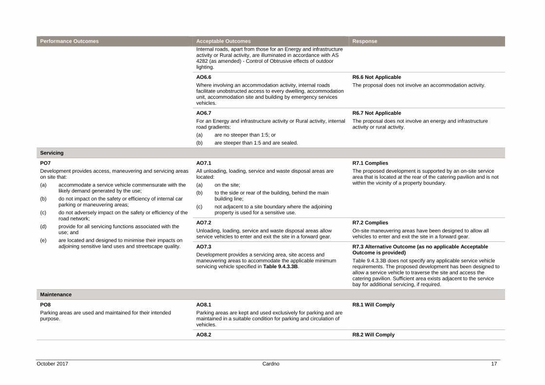
PO7
Development provides access, maneuvering and servicing areas on site that:
(a) accommodate a service vehicle commensurate with the likely demand generated by the use;
(b) do not impact on the safety or efficiency of internal car parking or maneuvering areas;
(c) do not adversely impact on the safety or efficiency of the road network;
(d) provide for all servicing functions associated with the use; and
(e) are located and designed to minimise their impacts on adjoining sensitive land uses and streetscape quality.
AO7.1
All unloading, loading, service and waste disposal areas are located:
(a) on the site;
(b) to the side or rear of the building, behind the main building line;
(c) not adjacent to a site boundary where the adjoining property is used for a sensitive use.
R7.1 Complies
The proposed development is supported by an on-site service area that is located at the rear of the catering pavilion and is not within the vicinity of a property boundary.
AO7.2
Unloading, loading, service and waste disposal areas allow service vehicles to enter and exit the site in a forward gear.
R7.2 Complies
On-site maneuvering areas have been designed to allow all vehicles to enter and exit the site in a forward gear.
AO7.3
Development provides a servicing area, site access and maneuvering areas to accommodate the applicable minimum servicing vehicle specified in Table 9.4.3.3B.
R7.3 Alternative Outcome (as no applicable Acceptable Outcome is provided)
Table 9.4.3.3B does not specify any applicable service vehicle requirements. The proposed development has been designed to allow a service vehicle to traverse the site and access the catering pavilion. Sufficient area exists adjacent to the service bay for additional servicing, if required.
Maintenance
PO8
Parking areas are used and maintained for their intended purpose.
AO8.1
Parking areas are kept and used exclusively for parking and are maintained in a suitable condition for parking and circulation of vehicles.
R8.1 Will Comply
AO8.2 R8.2 Will Comply
October 2017 Cardno 18
Performance Outcomes Acceptable Outcomes Response
All parking areas will be compacted, sealed, drained, line marked and maintained until such time as the development ceases.
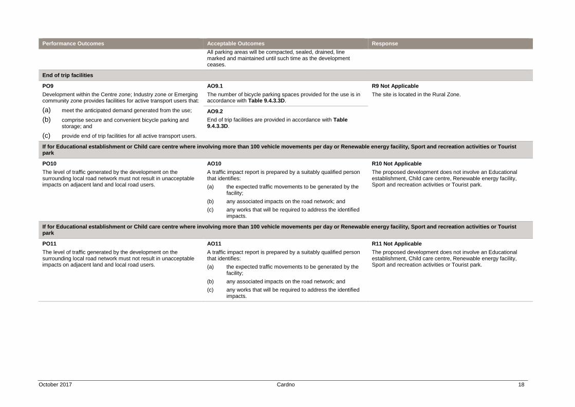
End of trip facilities
PO9
Development within the Centre zone; Industry zone or Emerging community zone provides facilities for active transport users that:
(a) meet the anticipated demand generated from the use;
(b) comprise secure and convenient bicycle parking and storage; and
(c) provide end of trip facilities for all active transport users.
AO9.1
The number of bicycle parking spaces provided for the use is in accordance with Table 9.4.3.3D.
R9 Not Applicable
The site is located in the Rural Zone.
AO9.2
End of trip facilities are provided in accordance with Table 9.4.3.3D.
If for Educational establishment or Child care centre where involving more than 100 vehicle movements per day or Renewable energy facility, Sport and recreation activities or Tourist park
PO10
The level of traffic generated by the development on the surrounding local road network must not result in unacceptable impacts on adjacent land and local road users.
AO10
A traffic impact report is prepared by a suitably qualified person that identifies:
(a) the expected traffic movements to be generated by the facility;
(b) any associated impacts on the road network; and
(c) any works that will be required to address the identified impacts.
R10 Not Applicable
The proposed development does not involve an Educational establishment, Child care centre, Renewable energy facility, Sport and recreation activities or Tourist park.
If for Educational establishment or Child care centre where involving more than 100 vehicle movements per day or Renewable energy facility, Sport and recreation activities or Tourist park
PO11
The level of traffic generated by the development on the surrounding local road network must not result in unacceptable impacts on adjacent land and local road users.
AO11
A traffic impact report is prepared by a suitably qualified person that identifies:
(a) the expected traffic movements to be generated by the facility;
(b) any associated impacts on the road network; and
(c) any works that will be required to address the identified impacts.
R11 Not Applicable
The proposed development does not involve an Educational establishment, Child care centre, Renewable energy facility, Sport and recreation activities or Tourist park.
October 2017 Cardno 19
5. Works, Services and Infrastructure Code
Performance Outcomes Acceptable Outcomes Response
For accepted development subject to requirements and assessable development
Water supply
PO1
Each lot has an adequate volume and supply of water that:
(a) meets the needs of users;
(b) is adequate for fire-fighting purposes;
(c) ensures the health, safety and convenience of the community; and
(d) minimises adverse impacts on the receiving environment.
AO1.1
Development is connected to a reticulated water supply system in accordance with the Design Guidelines and Specifications set out in the Planning Scheme Policy 4 – FNQROC Regional Development Manual other than where located:
(a) in the Conservation zone, Rural zone or Rural residential zone; and
(b) outside a reticulated water supply service area.
R1.1 Not Applicable
The site is located in the Rural Zone and outside a reticulated water supply service area.
AO1.2
Development, where located outside a reticulated water supply service area and in the Conservation zone, Rural zone or Rural residential zone is provided with:
(a) a bore or bores are provided in accordance with the Design Guidelines set out in the Planning Scheme Policy 4 – FNQROC Regional Development Manual; or
(b) on-site water storage tank/s:
(i) with a minimum capacity of 90,000L;
(ii) fitted with a 50mm ball valve with a camlock fitting; and
(iii) which are installed and connected prior to the occupation or use of the development.
R1.2 Can Comply
The site is presently provided with access to a water supply. Existing arrangements will be used.
Wastewater disposal
PO2
Each lot provides for the treatment and disposal of effluent and other waste water that:
(a) meets the needs of users;
(b) is adequate for fire-fighting purposes;
(c) ensures the health, safety and convenience of the community; and
(d) minimises adverse impacts on the receiving environment.
AO2.1
Development is connected to a reticulated sewerage system in accordance with the Design Guidelines and Specifications set out in the Planning Scheme Policy 4 – FNQROC Regional Development Manual other than where located:
(a) in the Conservation zone, Rural zone or Rural residential zone; and
(b) outside a reticulated sewerage service area.
R2.1 Not Applicable
The site is located in the Rural Zone and outside a reticulated sewerage service area.
AO2.2
An effluent disposal system is provided in accordance with ASNZ 1547 On-Site Domestic Wastewater Management (as amended) where development is located:
R2.2 Will Comply
Appropriate on-site sewerage treatment arrangements will be provided to service the development.
October 2017 Cardno 20
Performance Outcomes Acceptable Outcomes Response
(a) in the Conservation zone, Rural zone or Rural residential zone; and
(b) outside a reticulated sewerage service area.
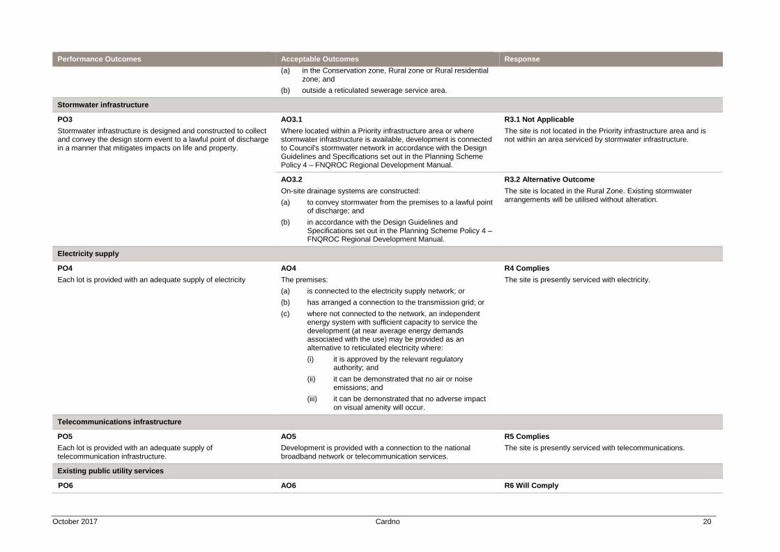
Stormwater infrastructure
PO3
Stormwater infrastructure is designed and constructed to collect and convey the design storm event to a lawful point of discharge in a manner that mitigates impacts on life and property.
AO3.1
Where located within a Priority infrastructure area or where stormwater infrastructure is available, development is connected to Council's stormwater network in accordance with the Design Guidelines and Specifications set out in the Planning Scheme Policy 4 – FNQROC Regional Development Manual.
R3.1 Not Applicable
The site is not located in the Priority infrastructure area and is not within an area serviced by stormwater infrastructure.
AO3.2
On-site drainage systems are constructed:
(a) to convey stormwater from the premises to a lawful point of discharge; and
(b) in accordance with the Design Guidelines and Specifications set out in the Planning Scheme Policy 4 – FNQROC Regional Development Manual.
R3.2 Alternative Outcome
The site is located in the Rural Zone. Existing stormwater arrangements will be utilised without alteration.
Electricity supply
PO4
Each lot is provided with an adequate supply of electricity
AO4
The premises:
(a) is connected to the electricity supply network; or
(b) has arranged a connection to the transmission grid; or
(c) where not connected to the network, an independent energy system with sufficient capacity to service the development (at near average energy demands associated with the use) may be provided as an alternative to reticulated electricity where:
(i) it is approved by the relevant regulatory authority; and
(ii) it can be demonstrated that no air or noise emissions; and
(iii) it can be demonstrated that no adverse impact on visual amenity will occur.
R4 Complies
The site is presently serviced with electricity.
Telecommunications infrastructure
PO5
Each lot is provided with an adequate supply of telecommunication infrastructure.
AO5
Development is provided with a connection to the national broadband network or telecommunication services.
R5 Complies
The site is presently serviced with telecommunications.
Existing public utility services
PO6 AO6 R6 Will Comply
October 2017 Cardno 21
Performance Outcomes Acceptable Outcomes Response
Development and associated works do not affect the efficient functioning of public utility mains, services or installations.
Public utility mains, services are relocated, altered or repaired in association with the works so that they continue to function and satisfy the relevant Design Guidelines and Specifications set out in the Planning Scheme Policy 4 – FNQROC Regional Development Manual.
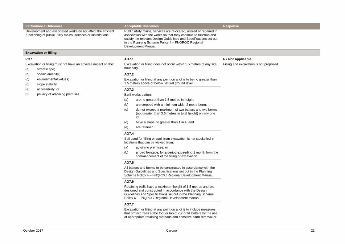
Excavation or filling
PO7
Excavation or filling must not have an adverse impact on the:
(a) streetscape;
(b) scenic amenity;
(c) environmental values;
(d) slope stability;
(e) accessibility; or
(f) privacy of adjoining premises.
AO7.1
Excavation or filling does not occur within 1.5 metres of any site boundary.
R7 Not Applicable
Filling and excavation is not proposed.
AO7.2
Excavation or filling at any point on a lot is to be no greater than 1.5 metres above or below natural ground level.
AO7.3
Earthworks batters:
(a) are no greater than 1.5 metres in height;
(b) are stepped with a minimum width 2 metre berm;
(c) do not exceed a maximum of two batters and two berms (not greater than 3.6 metres in total height) on any one lot;
(d) have a slope no greater than 1 in 4; and
(e) are retained.
AO7.4
Soil used for filling or spoil from excavation is not stockpiled in locations that can be viewed from:
(a) adjoining premises; or
(b) a road frontage, for a period exceeding 1 month from the commencement of the filling or excavation.
AO7.5
All batters and berms to be constructed in accordance with the Design Guidelines and Specifications set out in the Planning Scheme Policy 4 – FNQROC Regional Development Manual.
AO7.6
Retaining walls have a maximum height of 1.5 metres and are designed and constructed in accordance with the Design Guidelines and Specifications set out in the Planning Scheme Policy 4 – FNQROC Regional Development manual.
AO7.7
Excavation or filling at any point on a lot is to include measures that protect trees at the foot or top of cut or fill batters by the use of appropriate retaining methods and sensitive earth removal or
October 2017 Cardno 22
Performance Outcomes Acceptable Outcomes Response
placement and in accordance with the Design Guidelines and Specifications set out in the Planning Scheme Policy 4 – FNQROC Regional Development manual.
For assessable development
Transport network
PO8
The development has access to a transport network of adequate standard to provide for the safe and efficient movement of vehicles, pedestrians and cyclists.
AO8.1
Vehicle access, crossovers, road geometry, pavement, utilities and landscaping to the frontage/s of the site are designed and constructed in accordance with the Design Guidelines and Specifications set out in the Planning Scheme Policy 4 – FNQROC Regional Development manual.
R8.1 Alternative Outcome
The site’s existing access and circulation arrangements will be utilised. These arrangements are consistent with the nature of the use and the rural character of the area.
AO8.2
Development provides footpath pavement treatments in accordance with Planning Scheme Policy 9 – Footpath Paving.
R8.2 Not Applicable
The site is located in a rural area.
Public infrastructure
PO9
The design, construction and provision of any infrastructure that is to be dedicated to Council is cost effective over its life cycle and incorporates provisions to minimise adverse impacts.
AO9
Development is in accordance with the Design Guidelines and Specifications set out in the Planning Scheme Policy 4 – FNQROC Regional Development Manual.
R9 Not Applicable
Public infrastructure is not proposed.
Stormwater quality
PO10
Development has a non-worsening effect on the site and surrounding land and is designed to:
(a) optimise the interception, retention and removal of waterborne pollutants, prior to the discharge to receiving waters;
(b) protect the environmental values of waterbodies affected by the development, including upstream, on-site and downstream waterbodies;
(c) achieve specified water quality objectives;
(d) minimise flooding;
(e) maximise the use of natural channel design principles;
(f) maximise community benefit; and
(g) minimise risk to public safety.
AO10.1
The following reporting is prepared for all Material change of use or Reconfiguring a lot proposals:
(a) a Stormwater Management Plan and Report that meets or exceeds the standards of design and construction set out in the Queensland Urban Drainage Manual (QUDM) and the Design Guidelines and Specifications set out in the Planning Scheme Policy 4 – FNQROC Regional Development Manual; and
(b) an Erosion and Sediment Control Plan that meets or exceeds the Soil Erosion and Sedimentation Control Guidelines (Institute of Engineers Australia), including:
(i) drainage control;
(ii) erosion control;
(iii) sediment control; and
(iv) water quality outcomes.
R10 Alternative Outcome
The site is located in the Rural Zone. The proposed development involves a small scale tourist use with a minimal footprint. The proposed development is not considered to be of sufficient magnitude to alter existing stormwater flows.
AO10.2
For development on land greater than 2,500m2 or that result in more than 5 lots or more than 5 dwellings or accommodation units, a Stormwater Quality Management Plan and Report
October 2017 Cardno 23
Performance Outcomes Acceptable Outcomes Response
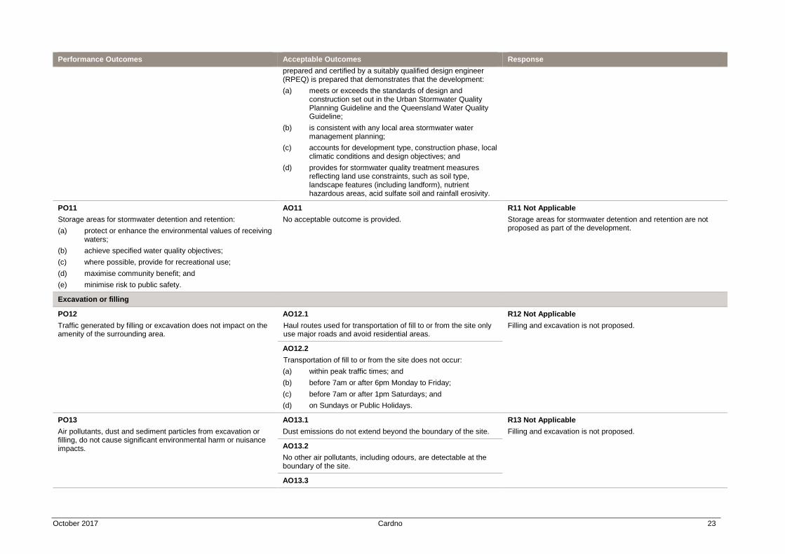
prepared and certified by a suitably qualified design engineer (RPEQ) is prepared that demonstrates that the development:
(a) meets or exceeds the standards of design and construction set out in the Urban Stormwater Quality Planning Guideline and the Queensland Water Quality Guideline;
(b) is consistent with any local area stormwater water management planning;
(c) accounts for development type, construction phase, local climatic conditions and design objectives; and
(d) provides for stormwater quality treatment measures reflecting land use constraints, such as soil type, landscape features (including landform), nutrient hazardous areas, acid sulfate soil and rainfall erosivity.
PO11
Storage areas for stormwater detention and retention:
(a) protect or enhance the environmental values of receiving waters;
(b) achieve specified water quality objectives;
(c) where possible, provide for recreational use;
(d) maximise community benefit; and
(e) minimise risk to public safety.
AO11
No acceptable outcome is provided.
R11 Not Applicable
Storage areas for stormwater detention and retention are not proposed as part of the development.
Excavation or filling
PO12
Traffic generated by filling or excavation does not impact on the amenity of the surrounding area.
AO12.1
Haul routes used for transportation of fill to or from the site only use major roads and avoid residential areas.
R12 Not Applicable
Filling and excavation is not proposed.
AO12.2
Transportation of fill to or from the site does not occur:
(a) within peak traffic times; and
(b) before 7am or after 6pm Monday to Friday;
(c) before 7am or after 1pm Saturdays; and
(d) on Sundays or Public Holidays.
PO13
Air pollutants, dust and sediment particles from excavation or filling, do not cause significant environmental harm or nuisance impacts.
AO13.1
Dust emissions do not extend beyond the boundary of the site.
R13 Not Applicable
Filling and excavation is not proposed.
AO13.2
No other air pollutants, including odours, are detectable at the boundary of the site.
AO13.3
October 2017 Cardno 24
Performance Outcomes Acceptable Outcomes Response
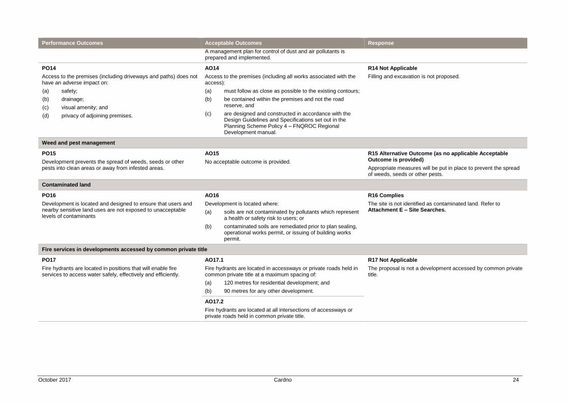
A management plan for control of dust and air pollutants is prepared and implemented.
PO14
Access to the premises (including driveways and paths) does not have an adverse impact on:
(a) safety;
(b) drainage;
(c) visual amenity; and
(d) privacy of adjoining premises.
AO14
Access to the premises (including all works associated with the access):
(a) must follow as close as possible to the existing contours;
(b) be contained within the premises and not the road reserve, and
(c) are designed and constructed in accordance with the Design Guidelines and Specifications set out in the Planning Scheme Policy 4 – FNQROC Regional Development manual.
R14 Not Applicable
Filling and excavation is not proposed.
Weed and pest management
PO15
Development prevents the spread of weeds, seeds or other pests into clean areas or away from infested areas.
AO15
No acceptable outcome is provided.
R15 Alternative Outcome (as no applicable Acceptable Outcome is provided)
Appropriate measures will be put in place to prevent the spread of weeds, seeds or other pests.
Contaminated land
PO16
Development is located and designed to ensure that users and nearby sensitive land uses are not exposed to unacceptable levels of contaminants
AO16
Development is located where:
(a) soils are not contaminated by pollutants which represent a health or safety risk to users; or
(b) contaminated soils are remediated prior to plan sealing, operational works permit, or issuing of building works permit.
R16 Complies
The site is not identified as contaminated land. Refer to Attachment E – Site Searches.
Fire services in developments accessed by common private title
PO17
Fire hydrants are located in positions that will enable fire services to access water safely, effectively and efficiently.
AO17.1
Fire hydrants are located in accessways or private roads held in common private title at a maximum spacing of:
(a) 120 metres for residential development; and
(b) 90 metres for any other development.
R17 Not Applicable
The proposal is not a development accessed by common private title.
AO17.2
Fire hydrants are located at all intersections of accessways or private roads held in common private title.
14
www.cardno.com
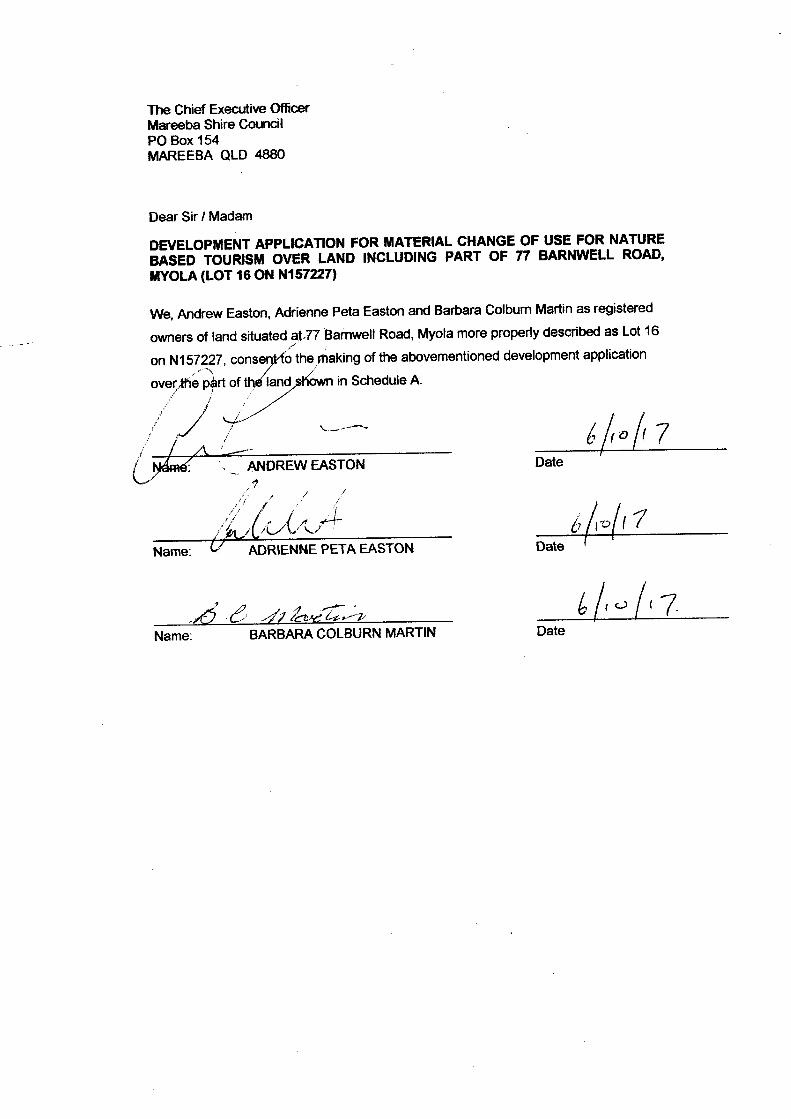
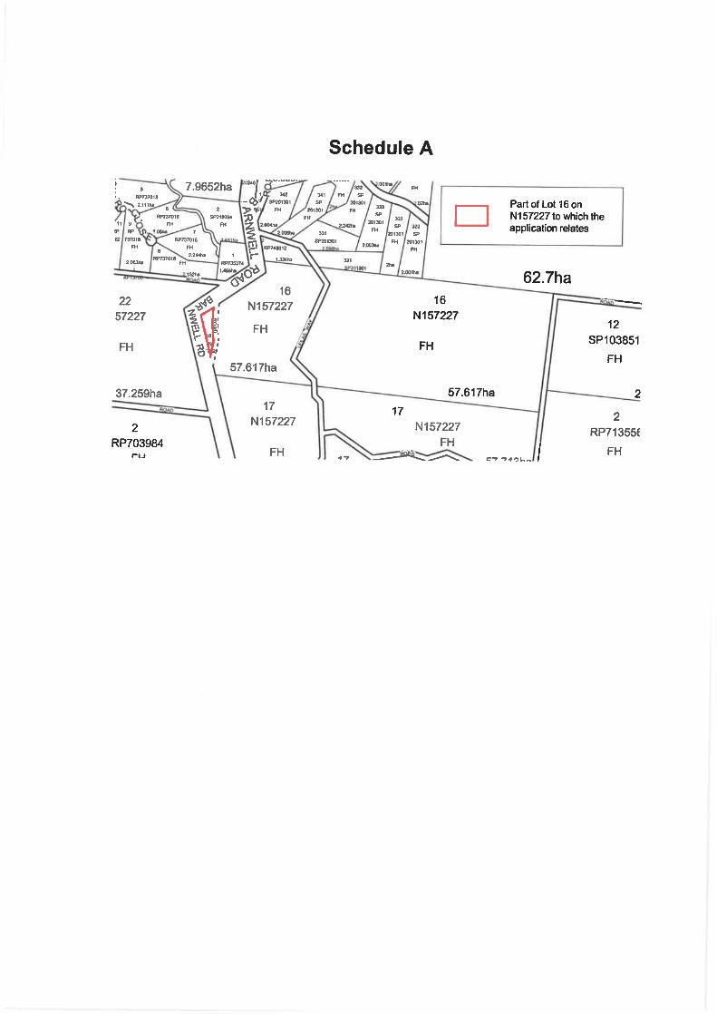
Attachment D Owner’s Consent
15
www.cardno.com
Attachment E Site Searches

CURRENT TITLE SEARCH DEPT OF NATURAL RESOURCES AND MINES, QUEENSLAND Request No: 26038687Search Date: 26/05/2017 11:39 Title Reference: 20125029 Date Created: 02/03/1901 Creating Dealing: 602724604 REGISTERED OWNER Dealing No: 715946552 11/08/2014
REEVER AND OCEAN PTY LTD A.C.N. 168 166 416 ESTATE AND LAND Estate in Fee Simple LOT 1 REGISTERED PLAN 703984 Local Government: MAREEBA EASEMENTS, ENCUMBRANCES AND INTERESTS 1. Rights and interests reserved to the Crown by Deed of Grant No. 20115003 (POR 21V) 2. MORTGAGE No 717992137 02/05/2017 at 10:10 KA HOU LOI ADMINISTRATIVE ADVICES - NILUNREGISTERED DEALINGS - NIL CERTIFICATE OF TITLE ISSUED - No
Caution - Charges do not necessarily appear in order of priority
** End of Current Title Search **
COPYRIGHT THE STATE OF QUEENSLAND (DEPT OF NATURAL RESOURCES AND MINES) [2017]Requested By: D-ENQ CITEC CONFIRM Page 1/1

Department of Environment and Heritage Protection (EHP)ABN 46 640 294 485
400 George St Brisbane, Queensland 4000GPO Box 2454 Brisbane QLD 4001 AUSTRALIA
www.ehp.qld.gov.au
SEARCH RESPONSEENVIRONMENTAL MANAGEMENT REGISTER (EMR)
CONTAMINATED LAND REGISTER (CLR)
Transaction ID: 50380671 EMR Site Id: 26 May 2017This response relates to a search request received for the site:
Lot: 1 Plan: RP703984
EMR RESULT
The above site is NOT included on the Environmental Management Register.
CLR RESULT
The above site is NOT included on the Contaminated Land Register.
ADDITIONAL ADVICE
All search responses include particulars of land listed in the EMR/CLR when the search was generated.The EMR/CLR does NOT include:-
1. land which is contaminated land (or a complete list of contamination) if EHP has not been notified2. land on which a notifiable activity is being or has been undertaken (or a complete list of activities)
if EHP has not been notified
If you have any queries in relation to this search please phone 13QGOV (13 74 68)
Administering Authority
Page 1 of 1
CURRENT TITLE SEARCH DEPT OF NATURAL RESOURCES AND MINES, QUEENSLAND Request No: 26038688Search Date: 26/05/2017 11:39 Title Reference: 20349230 Date Created: 28/06/1940 Previous Title: 20125028 REGISTERED OWNER Dealing No: 715946552 11/08/2014
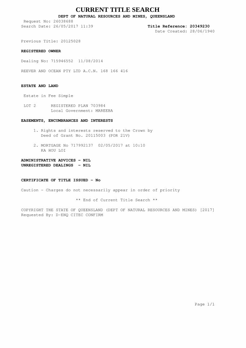
REEVER AND OCEAN PTY LTD A.C.N. 168 166 416 ESTATE AND LAND Estate in Fee Simple LOT 2 REGISTERED PLAN 703984 Local Government: MAREEBA EASEMENTS, ENCUMBRANCES AND INTERESTS 1. Rights and interests reserved to the Crown by Deed of Grant No. 20115003 (POR 21V) 2. MORTGAGE No 717992137 02/05/2017 at 10:10 KA HOU LOI ADMINISTRATIVE ADVICES - NILUNREGISTERED DEALINGS - NIL CERTIFICATE OF TITLE ISSUED - No
Caution - Charges do not necessarily appear in order of priority
** End of Current Title Search **
COPYRIGHT THE STATE OF QUEENSLAND (DEPT OF NATURAL RESOURCES AND MINES) [2017]Requested By: D-ENQ CITEC CONFIRM Page 1/1

Department of Environment and Heritage Protection (EHP)ABN 46 640 294 485
400 George St Brisbane, Queensland 4000GPO Box 2454 Brisbane QLD 4001 AUSTRALIA
www.ehp.qld.gov.au
SEARCH RESPONSEENVIRONMENTAL MANAGEMENT REGISTER (EMR)
CONTAMINATED LAND REGISTER (CLR)
Transaction ID: 50380672 EMR Site Id: 26 May 2017This response relates to a search request received for the site:
Lot: 2 Plan: RP703984
EMR RESULT
The above site is NOT included on the Environmental Management Register.
CLR RESULT
The above site is NOT included on the Contaminated Land Register.
ADDITIONAL ADVICE
All search responses include particulars of land listed in the EMR/CLR when the search was generated.The EMR/CLR does NOT include:-
1. land which is contaminated land (or a complete list of contamination) if EHP has not been notified2. land on which a notifiable activity is being or has been undertaken (or a complete list of activities)
if EHP has not been notified
If you have any queries in relation to this search please phone 13QGOV (13 74 68)
Administering Authority
Page 1 of 1
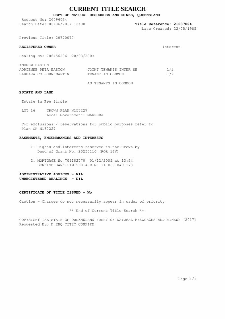
CURRENT TITLE SEARCH DEPT OF NATURAL RESOURCES AND MINES, QUEENSLAND Request No: 26096024Search Date: 02/06/2017 12:00 Title Reference: 21287024 Date Created: 23/05/1985 Previous Title: 20770077 REGISTERED OWNER Interest Dealing No: 706456206 20/03/2003
ANDREW EASTONADRIENNE PETA EASTON JOINT TENANTS INTER SE 1/2BARBARA COLBURN MARTIN TENANT IN COMMON 1/2 AS TENANTS IN COMMON ESTATE AND LAND Estate in Fee Simple LOT 16 CROWN PLAN N157227 Local Government: MAREEBA For exclusions / reservations for public purposes refer to Plan CP N157227 EASEMENTS, ENCUMBRANCES AND INTERESTS 1. Rights and interests reserved to the Crown by Deed of Grant No. 20250110 (POR 16V) 2. MORTGAGE No 709182770 01/12/2005 at 13:54 BENDIGO BANK LIMITED A.B.N. 11 068 049 178 ADMINISTRATIVE ADVICES - NILUNREGISTERED DEALINGS - NIL CERTIFICATE OF TITLE ISSUED - No
Caution - Charges do not necessarily appear in order of priority
** End of Current Title Search **
COPYRIGHT THE STATE OF QUEENSLAND (DEPT OF NATURAL RESOURCES AND MINES) [2017]Requested By: D-ENQ CITEC CONFIRM Page 1/1

Department of Environment and Heritage Protection (EHP)ABN 46 640 294 485
400 George St Brisbane, Queensland 4000GPO Box 2454 Brisbane QLD 4001 AUSTRALIA
www.ehp.qld.gov.au
SEARCH RESPONSEENVIRONMENTAL MANAGEMENT REGISTER (EMR)
CONTAMINATED LAND REGISTER (CLR)
Transaction ID: 50382433 EMR Site Id: 02 June 2017This response relates to a search request received for the site:
Lot: 16 Plan: N157227
EMR RESULT
The above site is NOT included on the Environmental Management Register.
CLR RESULT
The above site is NOT included on the Contaminated Land Register.
ADDITIONAL ADVICE
All search responses include particulars of land listed in the EMR/CLR when the search was generated.The EMR/CLR does NOT include:-
1. land which is contaminated land (or a complete list of contamination) if EHP has not been notified2. land on which a notifiable activity is being or has been undertaken (or a complete list of activities)
if EHP has not been notified
If you have any queries in relation to this search please phone 13QGOV (13 74 68)
Administering Authority
Page 1 of 1
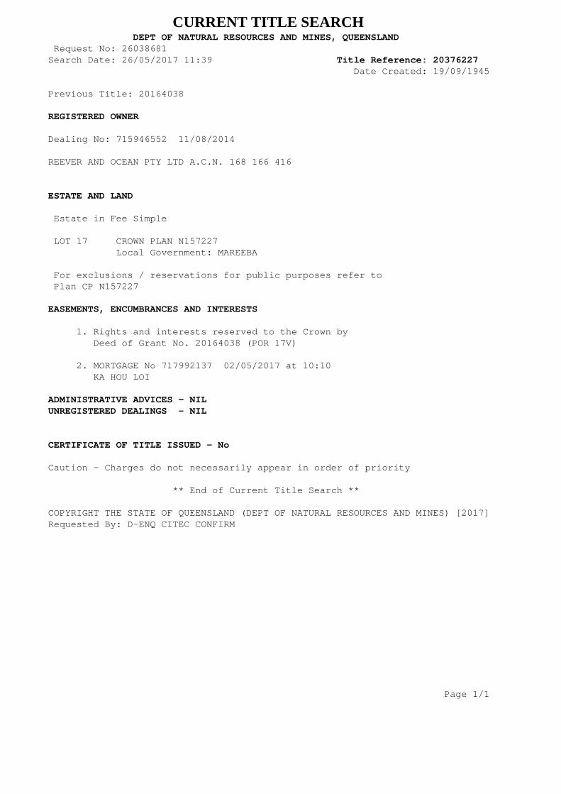
CURRENT TITLE SEARCH DEPT OF NATURAL RESOURCES AND MINES, QUEENSLAND Request No: 26038681Search Date: 26/05/2017 11:39 Title Reference: 20376227 Date Created: 19/09/1945 Previous Title: 20164038 REGISTERED OWNER Dealing No: 715946552 11/08/2014
REEVER AND OCEAN PTY LTD A.C.N. 168 166 416 ESTATE AND LAND Estate in Fee Simple LOT 17 CROWN PLAN N157227 Local Government: MAREEBA For exclusions / reservations for public purposes refer to Plan CP N157227 EASEMENTS, ENCUMBRANCES AND INTERESTS 1. Rights and interests reserved to the Crown by Deed of Grant No. 20164038 (POR 17V) 2. MORTGAGE No 717992137 02/05/2017 at 10:10 KA HOU LOI ADMINISTRATIVE ADVICES - NILUNREGISTERED DEALINGS - NIL CERTIFICATE OF TITLE ISSUED - No
Caution - Charges do not necessarily appear in order of priority
** End of Current Title Search **
COPYRIGHT THE STATE OF QUEENSLAND (DEPT OF NATURAL RESOURCES AND MINES) [2017]Requested By: D-ENQ CITEC CONFIRM Page 1/1
Department of Environment and Heritage Protection (EHP)ABN 46 640 294 485
400 George St Brisbane, Queensland 4000GPO Box 2454 Brisbane QLD 4001 AUSTRALIA
www.ehp.qld.gov.au
SEARCH RESPONSEENVIRONMENTAL MANAGEMENT REGISTER (EMR)
CONTAMINATED LAND REGISTER (CLR)
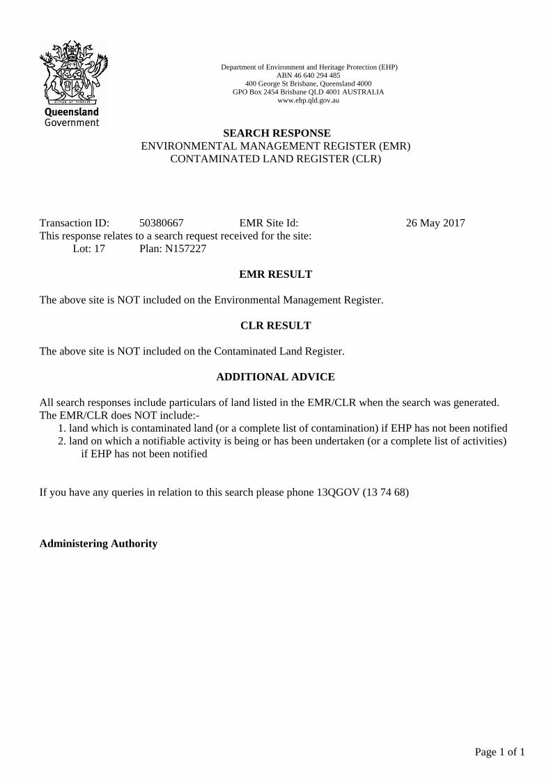
Transaction ID: 50380667 EMR Site Id: 26 May 2017This response relates to a search request received for the site:
Lot: 17 Plan: N157227
EMR RESULT
The above site is NOT included on the Environmental Management Register.
CLR RESULT
The above site is NOT included on the Contaminated Land Register.
ADDITIONAL ADVICE
All search responses include particulars of land listed in the EMR/CLR when the search was generated.The EMR/CLR does NOT include:-
1. land which is contaminated land (or a complete list of contamination) if EHP has not been notified2. land on which a notifiable activity is being or has been undertaken (or a complete list of activities)
if EHP has not been notified
If you have any queries in relation to this search please phone 13QGOV (13 74 68)
Administering Authority
Page 1 of 1

CURRENT TITLE SEARCH DEPT OF NATURAL RESOURCES AND MINES, QUEENSLAND Request No: 26038686Search Date: 26/05/2017 11:39 Title Reference: 20397130 Date Created: 07/07/1947 Previous Title: 20120036 REGISTERED OWNER Dealing No: 715946552 11/08/2014
REEVER AND OCEAN PTY LTD A.C.N. 168 166 416 ESTATE AND LAND Estate in Fee Simple LOT 18 CROWN PLAN N157227 Local Government: MAREEBA For exclusions / reservations for public purposes refer to Plan CP N157227 EASEMENTS, ENCUMBRANCES AND INTERESTS 1. Rights and interests reserved to the Crown by Deed of Grant No. 20120036 (POR 18V) 2. MORTGAGE No 717992137 02/05/2017 at 10:10 KA HOU LOI ADMINISTRATIVE ADVICES - NILUNREGISTERED DEALINGS - NIL CERTIFICATE OF TITLE ISSUED - No
Caution - Charges do not necessarily appear in order of priority
** End of Current Title Search **
COPYRIGHT THE STATE OF QUEENSLAND (DEPT OF NATURAL RESOURCES AND MINES) [2017]Requested By: D-ENQ CITEC CONFIRM Page 1/1

Department of Environment and Heritage Protection (EHP)ABN 46 640 294 485
400 George St Brisbane, Queensland 4000GPO Box 2454 Brisbane QLD 4001 AUSTRALIA
www.ehp.qld.gov.au
SEARCH RESPONSEENVIRONMENTAL MANAGEMENT REGISTER (EMR)
CONTAMINATED LAND REGISTER (CLR)
Transaction ID: 50380668 EMR Site Id: 26 May 2017This response relates to a search request received for the site:
Lot: 18 Plan: N157227
EMR RESULT
The above site is NOT included on the Environmental Management Register.
CLR RESULT
The above site is NOT included on the Contaminated Land Register.
ADDITIONAL ADVICE
All search responses include particulars of land listed in the EMR/CLR when the search was generated.The EMR/CLR does NOT include:-
1. land which is contaminated land (or a complete list of contamination) if EHP has not been notified2. land on which a notifiable activity is being or has been undertaken (or a complete list of activities)
if EHP has not been notified
If you have any queries in relation to this search please phone 13QGOV (13 74 68)
Administering Authority
Page 1 of 1
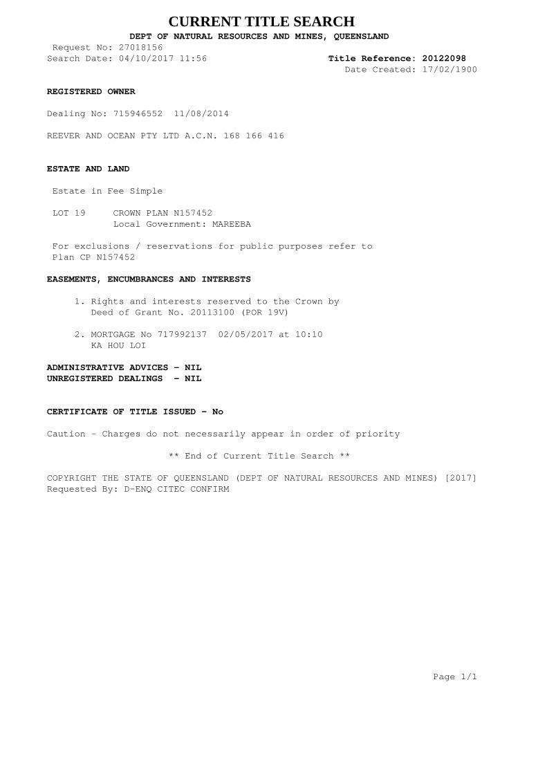
CURRENT TITLE SEARCH DEPT OF NATURAL RESOURCES AND MINES, QUEENSLAND Request No: 27018156Search Date: 04/10/2017 11:56 Title Reference: 20122098 Date Created: 17/02/1900 REGISTERED OWNER Dealing No: 715946552 11/08/2014
REEVER AND OCEAN PTY LTD A.C.N. 168 166 416 ESTATE AND LAND Estate in Fee Simple LOT 19 CROWN PLAN N157452 Local Government: MAREEBA For exclusions / reservations for public purposes refer to Plan CP N157452 EASEMENTS, ENCUMBRANCES AND INTERESTS 1. Rights and interests reserved to the Crown by Deed of Grant No. 20113100 (POR 19V) 2. MORTGAGE No 717992137 02/05/2017 at 10:10 KA HOU LOI ADMINISTRATIVE ADVICES - NILUNREGISTERED DEALINGS - NIL CERTIFICATE OF TITLE ISSUED - No
Caution - Charges do not necessarily appear in order of priority
** End of Current Title Search **
COPYRIGHT THE STATE OF QUEENSLAND (DEPT OF NATURAL RESOURCES AND MINES) [2017]Requested By: D-ENQ CITEC CONFIRM Page 1/1
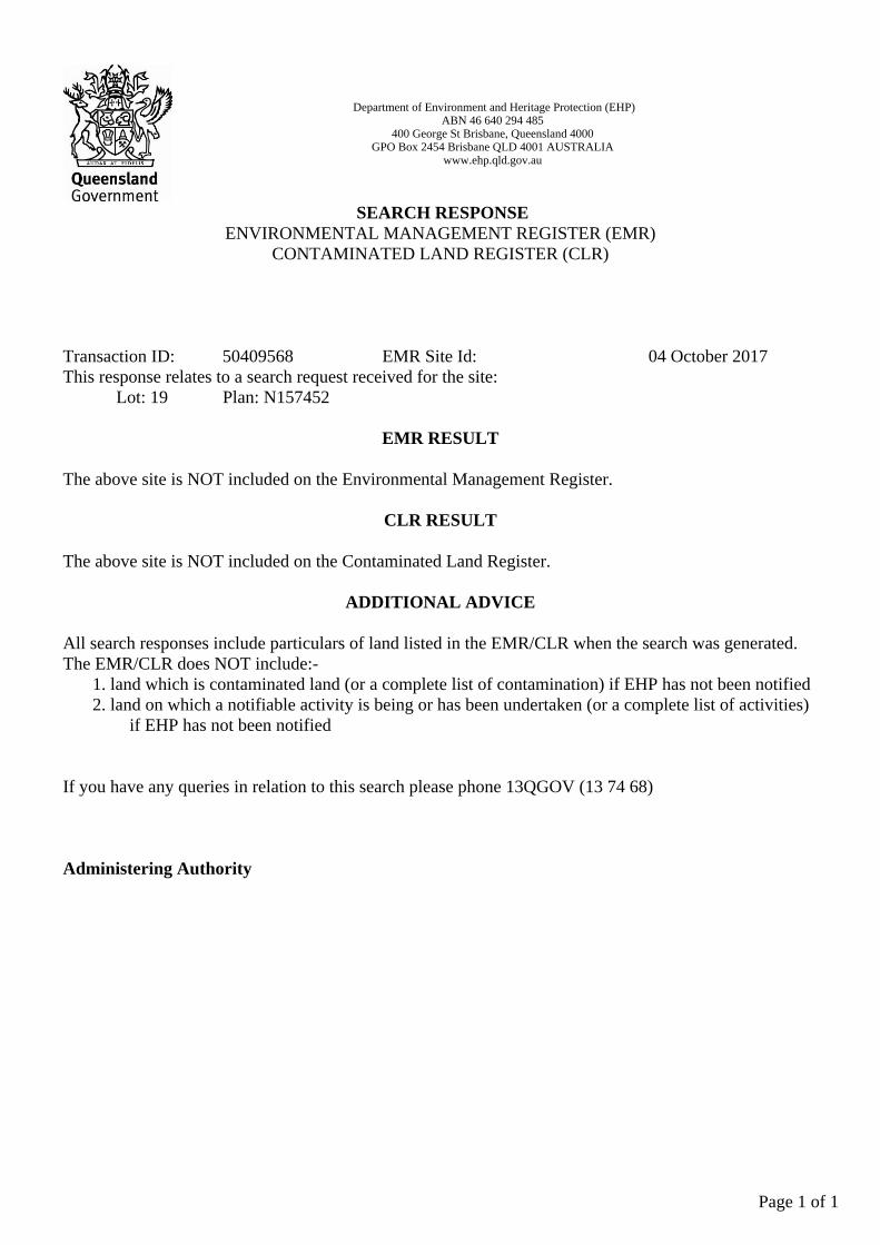
Department of Environment and Heritage Protection (EHP)ABN 46 640 294 485
400 George St Brisbane, Queensland 4000GPO Box 2454 Brisbane QLD 4001 AUSTRALIA
www.ehp.qld.gov.au
SEARCH RESPONSEENVIRONMENTAL MANAGEMENT REGISTER (EMR)
CONTAMINATED LAND REGISTER (CLR)
Transaction ID: 50409568 EMR Site Id: 04 October 2017This response relates to a search request received for the site:
Lot: 19 Plan: N157452
EMR RESULT
The above site is NOT included on the Environmental Management Register.
CLR RESULT
The above site is NOT included on the Contaminated Land Register.
ADDITIONAL ADVICE
All search responses include particulars of land listed in the EMR/CLR when the search was generated.The EMR/CLR does NOT include:-
1. land which is contaminated land (or a complete list of contamination) if EHP has not been notified2. land on which a notifiable activity is being or has been undertaken (or a complete list of activities)
if EHP has not been notified
If you have any queries in relation to this search please phone 13QGOV (13 74 68)
Administering Authority
Page 1 of 1

CURRENT TITLE SEARCH DEPT OF NATURAL RESOURCES AND MINES, QUEENSLAND Request No: 26038690Search Date: 26/05/2017 11:39 Title Reference: 20246064 Date Created: 18/02/1927 Previous Title: 20112035 REGISTERED OWNER Dealing No: 715946552 11/08/2014
REEVER AND OCEAN PTY LTD A.C.N. 168 166 416 ESTATE AND LAND Estate in Fee Simple LOT 22 CROWN PLAN N157227 Local Government: MAREEBA EASEMENTS, ENCUMBRANCES AND INTERESTS 1. Rights and interests reserved to the Crown by Deed of Grant No. 20112035 (POR 22V) 2. MORTGAGE No 717992137 02/05/2017 at 10:10 KA HOU LOI ADMINISTRATIVE ADVICES - NILUNREGISTERED DEALINGS - NIL CERTIFICATE OF TITLE ISSUED - No
Caution - Charges do not necessarily appear in order of priority
** End of Current Title Search **
COPYRIGHT THE STATE OF QUEENSLAND (DEPT OF NATURAL RESOURCES AND MINES) [2017]Requested By: D-ENQ CITEC CONFIRM Page 1/1

Department of Environment and Heritage Protection (EHP)ABN 46 640 294 485
400 George St Brisbane, Queensland 4000GPO Box 2454 Brisbane QLD 4001 AUSTRALIA
www.ehp.qld.gov.au
SEARCH RESPONSEENVIRONMENTAL MANAGEMENT REGISTER (EMR)
CONTAMINATED LAND REGISTER (CLR)
Transaction ID: 50380670 EMR Site Id: 26 May 2017This response relates to a search request received for the site:
Lot: 22 Plan: N157227
EMR RESULT
The above site is NOT included on the Environmental Management Register.
CLR RESULT
The above site is NOT included on the Contaminated Land Register.
ADDITIONAL ADVICE
All search responses include particulars of land listed in the EMR/CLR when the search was generated.The EMR/CLR does NOT include:-
1. land which is contaminated land (or a complete list of contamination) if EHP has not been notified2. land on which a notifiable activity is being or has been undertaken (or a complete list of activities)
if EHP has not been notified
If you have any queries in relation to this search please phone 13QGOV (13 74 68)
Administering Authority
Page 1 of 1
16
www.cardno.com
Attachment F State Planning Policy Response
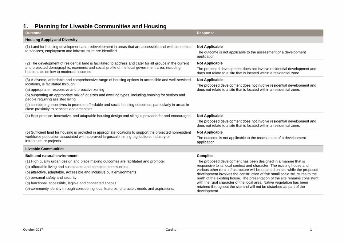
October 2017 Cardno 1
1. Planning for Liveable Communities and Housing Outcome Response
Housing Supply and Diversity
(1) Land for housing development and redevelopment in areas that are accessible and well-connected to services, employment and infrastructure are identified.
Not Applicable
The outcome is not applicable to the assessment of a development application.
(2) The development of residential land is facilitated to address and cater for all groups in the current and projected demographic, economic and social profile of the local government area, including households on low to moderate incomes
Not Applicable
The proposed development does not involve residential development and does not relate to a site that is located within a residential zone.
(3) A diverse, affordable and comprehensive range of housing options in accessible and well-serviced locations, is facilitated through:
(a) appropriate, responsive and proactive zoning
(b) supporting an appropriate mix of lot sizes and dwelling types, including housing for seniors and people requiring assisted living
(c) considering incentives to promote affordable and social housing outcomes, particularly in areas in close proximity to services and amenities.
Not Applicable
The proposed development does not involve residential development and does not relate to a site that is located within a residential zone.
(4) Best practice, innovative, and adaptable housing design and siting is provided for and encouraged. Not Applicable
The proposed development does not involve residential development and does not relate to a site that is located within a residential zone.
(5) Sufficient land for housing is provided in appropriate locations to support the projected nonresident workforce population associated with approved largescale mining, agriculture, industry or infrastructure projects.
Not Applicable
The outcome is not applicable to the assessment of a development application.
Liveable Communities
Built and natural environment:
(1) High quality urban design and place making outcomes are facilitated and promote:
(a) affordable living and sustainable and complete communities
(b) attractive, adaptable, accessible and inclusive built environments
(c) personal safety and security
(d) functional, accessible, legible and connected spaces
(e) community identity through considering local features, character, needs and aspirations.
Complies
The proposed development has been designed in a manner that is responsive to its local context and character. The existing house and various other rural infrastructure will be retained on site while the proposed development involves the construction of five small scale structures to the north of the existing house. The presentation of the site remains consistent with the rural character of the local area. Native vegetation has been retained throughout the site and will not be disturbed as part of the development.
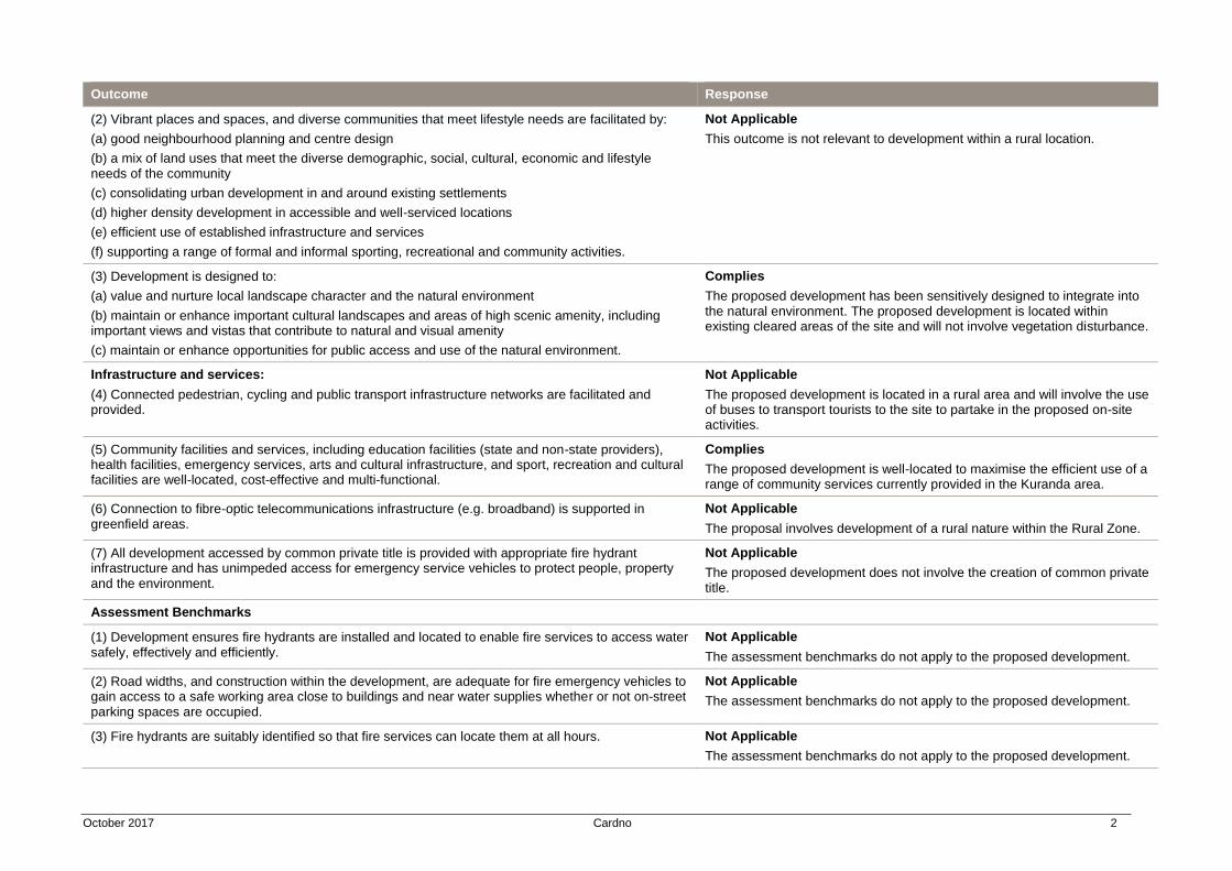
October 2017 Cardno 2
Outcome Response
(2) Vibrant places and spaces, and diverse communities that meet lifestyle needs are facilitated by:
(a) good neighbourhood planning and centre design
(b) a mix of land uses that meet the diverse demographic, social, cultural, economic and lifestyle needs of the community
(c) consolidating urban development in and around existing settlements
(d) higher density development in accessible and well-serviced locations
(e) efficient use of established infrastructure and services
(f) supporting a range of formal and informal sporting, recreational and community activities.
Not Applicable
This outcome is not relevant to development within a rural location.
(3) Development is designed to:
(a) value and nurture local landscape character and the natural environment
(b) maintain or enhance important cultural landscapes and areas of high scenic amenity, including important views and vistas that contribute to natural and visual amenity
(c) maintain or enhance opportunities for public access and use of the natural environment.
Complies
The proposed development has been sensitively designed to integrate into the natural environment. The proposed development is located within existing cleared areas of the site and will not involve vegetation disturbance.
Infrastructure and services:
(4) Connected pedestrian, cycling and public transport infrastructure networks are facilitated and provided.
Not Applicable
The proposed development is located in a rural area and will involve the use of buses to transport tourists to the site to partake in the proposed on-site activities.
(5) Community facilities and services, including education facilities (state and non-state providers), health facilities, emergency services, arts and cultural infrastructure, and sport, recreation and cultural facilities are well-located, cost-effective and multi-functional.
Complies
The proposed development is well-located to maximise the efficient use of a range of community services currently provided in the Kuranda area.
(6) Connection to fibre-optic telecommunications infrastructure (e.g. broadband) is supported in greenfield areas.
Not Applicable
The proposal involves development of a rural nature within the Rural Zone.
(7) All development accessed by common private title is provided with appropriate fire hydrant infrastructure and has unimpeded access for emergency service vehicles to protect people, property and the environment.
Not Applicable
The proposed development does not involve the creation of common private title.
Assessment Benchmarks
(1) Development ensures fire hydrants are installed and located to enable fire services to access water safely, effectively and efficiently.
Not Applicable
The assessment benchmarks do not apply to the proposed development.
(2) Road widths, and construction within the development, are adequate for fire emergency vehicles to gain access to a safe working area close to buildings and near water supplies whether or not on-street parking spaces are occupied.
Not Applicable
The assessment benchmarks do not apply to the proposed development.
(3) Fire hydrants are suitably identified so that fire services can locate them at all hours. Not Applicable
The assessment benchmarks do not apply to the proposed development.
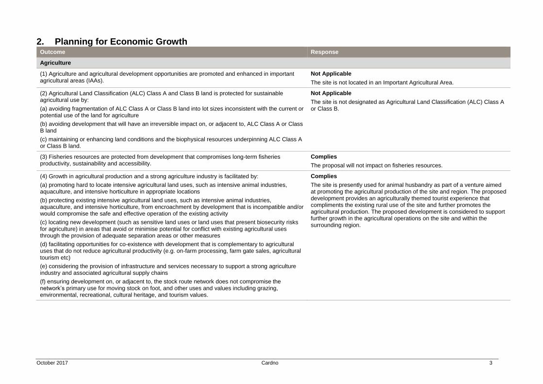
October 2017 Cardno 3
2. Planning for Economic Growth Outcome Response
Agriculture
(1) Agriculture and agricultural development opportunities are promoted and enhanced in important agricultural areas (IAAs).
Not Applicable
The site is not located in an Important Agricultural Area.
(2) Agricultural Land Classification (ALC) Class A and Class B land is protected for sustainable agricultural use by:
(a) avoiding fragmentation of ALC Class A or Class B land into lot sizes inconsistent with the current or potential use of the land for agriculture
(b) avoiding development that will have an irreversible impact on, or adjacent to, ALC Class A or Class B land
(c) maintaining or enhancing land conditions and the biophysical resources underpinning ALC Class A or Class B land.
Not Applicable
The site is not designated as Agricultural Land Classification (ALC) Class A or Class B.
(3) Fisheries resources are protected from development that compromises long-term fisheries productivity, sustainability and accessibility.
Complies
The proposal will not impact on fisheries resources.
(4) Growth in agricultural production and a strong agriculture industry is facilitated by:
(a) promoting hard to locate intensive agricultural land uses, such as intensive animal industries, aquaculture, and intensive horticulture in appropriate locations
(b) protecting existing intensive agricultural land uses, such as intensive animal industries, aquaculture, and intensive horticulture, from encroachment by development that is incompatible and/or would compromise the safe and effective operation of the existing activity
(c) locating new development (such as sensitive land uses or land uses that present biosecurity risks for agriculture) in areas that avoid or minimise potential for conflict with existing agricultural uses through the provision of adequate separation areas or other measures
(d) facilitating opportunities for co-existence with development that is complementary to agricultural uses that do not reduce agricultural productivity (e.g. on-farm processing, farm gate sales, agricultural tourism etc)
(e) considering the provision of infrastructure and services necessary to support a strong agriculture industry and associated agricultural supply chains
(f) ensuring development on, or adjacent to, the stock route network does not compromise the network’s primary use for moving stock on foot, and other uses and values including grazing, environmental, recreational, cultural heritage, and tourism values.
Complies
The site is presently used for animal husbandry as part of a venture aimed at promoting the agricultural production of the site and region. The proposed development provides an agriculturally themed tourist experience that compliments the existing rural use of the site and further promotes the agricultural production. The proposed development is considered to support further growth in the agricultural operations on the site and within the surrounding region.
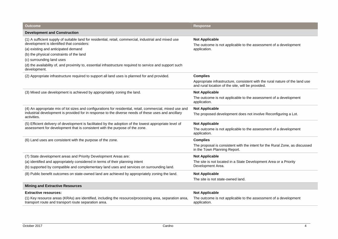
October 2017 Cardno 4
Outcome Response
Development and Construction
(1) A sufficient supply of suitable land for residential, retail, commercial, industrial and mixed use development is identified that considers:
(a) existing and anticipated demand
(b) the physical constraints of the land
(c) surrounding land uses
(d) the availability of, and proximity to, essential infrastructure required to service and support such development.
Not Applicable
The outcome is not applicable to the assessment of a development application.
(2) Appropriate infrastructure required to support all land uses is planned for and provided. Complies
Appropriate infrastructure, consistent with the rural nature of the land use and rural location of the site, will be provided.
(3) Mixed use development is achieved by appropriately zoning the land. Not Applicable
The outcome is not applicable to the assessment of a development application.
(4) An appropriate mix of lot sizes and configurations for residential, retail, commercial, mixed use and industrial development is provided for in response to the diverse needs of these uses and ancillary activities.
Not Applicable
The proposed development does not involve Reconfiguring a Lot.
(5) Efficient delivery of development is facilitated by the adoption of the lowest appropriate level of assessment for development that is consistent with the purpose of the zone.
Not Applicable
The outcome is not applicable to the assessment of a development application.
(6) Land uses are consistent with the purpose of the zone. Complies
The proposal is consistent with the intent for the Rural Zone, as discussed in the Town Planning Report.
(7) State development areas and Priority Development Areas are:
(a) identified and appropriately considered in terms of their planning intent
(b) supported by compatible and complementary land uses and services on surrounding land.
Not Applicable
The site is not located in a State Development Area or a Priority Development Area.
(8) Public benefit outcomes on state-owned land are achieved by appropriately zoning the land. Not Applicable
The site is not state-owned land.
Mining and Extractive Resources
Extractive resources:
(1) Key resource areas (KRAs) are identified, including the resource/processing area, separation area, transport route and transport route separation area.
Not Applicable
The outcome is not applicable to the assessment of a development application.
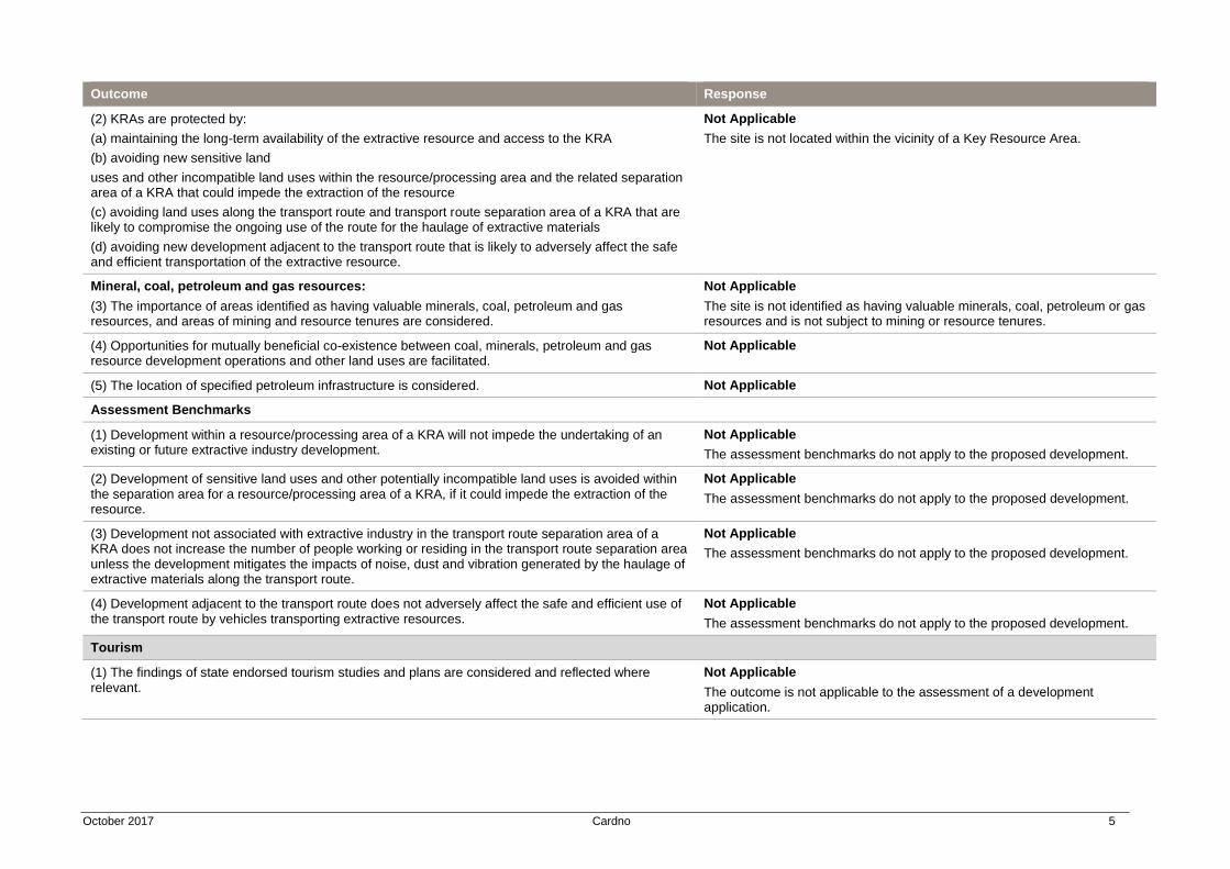
October 2017 Cardno 5
Outcome Response
(2) KRAs are protected by:
(a) maintaining the long-term availability of the extractive resource and access to the KRA
(b) avoiding new sensitive land
uses and other incompatible land uses within the resource/processing area and the related separation area of a KRA that could impede the extraction of the resource
(c) avoiding land uses along the transport route and transport route separation area of a KRA that are likely to compromise the ongoing use of the route for the haulage of extractive materials
(d) avoiding new development adjacent to the transport route that is likely to adversely affect the safe and efficient transportation of the extractive resource.
Not Applicable
The site is not located within the vicinity of a Key Resource Area.
Mineral, coal, petroleum and gas resources:
(3) The importance of areas identified as having valuable minerals, coal, petroleum and gas resources, and areas of mining and resource tenures are considered.
Not Applicable
The site is not identified as having valuable minerals, coal, petroleum or gas resources and is not subject to mining or resource tenures.
(4) Opportunities for mutually beneficial co-existence between coal, minerals, petroleum and gas resource development operations and other land uses are facilitated.
Not Applicable
(5) The location of specified petroleum infrastructure is considered. Not Applicable
Assessment Benchmarks
(1) Development within a resource/processing area of a KRA will not impede the undertaking of an existing or future extractive industry development.
Not Applicable
The assessment benchmarks do not apply to the proposed development.
(2) Development of sensitive land uses and other potentially incompatible land uses is avoided within the separation area for a resource/processing area of a KRA, if it could impede the extraction of the resource.
Not Applicable
The assessment benchmarks do not apply to the proposed development.
(3) Development not associated with extractive industry in the transport route separation area of a KRA does not increase the number of people working or residing in the transport route separation area unless the development mitigates the impacts of noise, dust and vibration generated by the haulage of extractive materials along the transport route.
Not Applicable
The assessment benchmarks do not apply to the proposed development.
(4) Development adjacent to the transport route does not adversely affect the safe and efficient use of the transport route by vehicles transporting extractive resources.
Not Applicable
The assessment benchmarks do not apply to the proposed development.
Tourism
(1) The findings of state endorsed tourism studies and plans are considered and reflected where relevant.
Not Applicable
The outcome is not applicable to the assessment of a development application.

October 2017 Cardno 6
Outcome Response
(2) Existing and potential opportunities, localities or areas appropriate for tourism development are identified and protected.
Complies
The proposal involves the development of a new tourist facility associated with the existing rural uses of the site. The site is located proximate to Kuranda township, which is an established centre for tourism in Far North Queensland. The proposed development intends to diversify the offering to tourists and local visitors.
(3) The delivery of sustainable tourism development is facilitated where it:
(a) is complementary to and compatible with other land uses, including sensitive land uses
(b) promotes the protection or enhancement of the character, landscape and visual amenity, and the economic, social, cultural and environmental values of the natural and built assets associated with the tourism development.
Complies
The proposed development involves a new tourist facility directly associated with the existing rural use of the site. The improvements required to support the development are rural in nature and consistent with the rural character of the site and surrounding area. The proposed development is limited to existing cleared areas of the site, allowing for the retention of the established natural environment and its preservation for appreciation by tourists.
(4) Appropriate infrastructure to support and enable tourism development is planned for. Complies
Appropriate infrastructure, consistent with the rural nature of the land use and rural location of the site, will be provided.
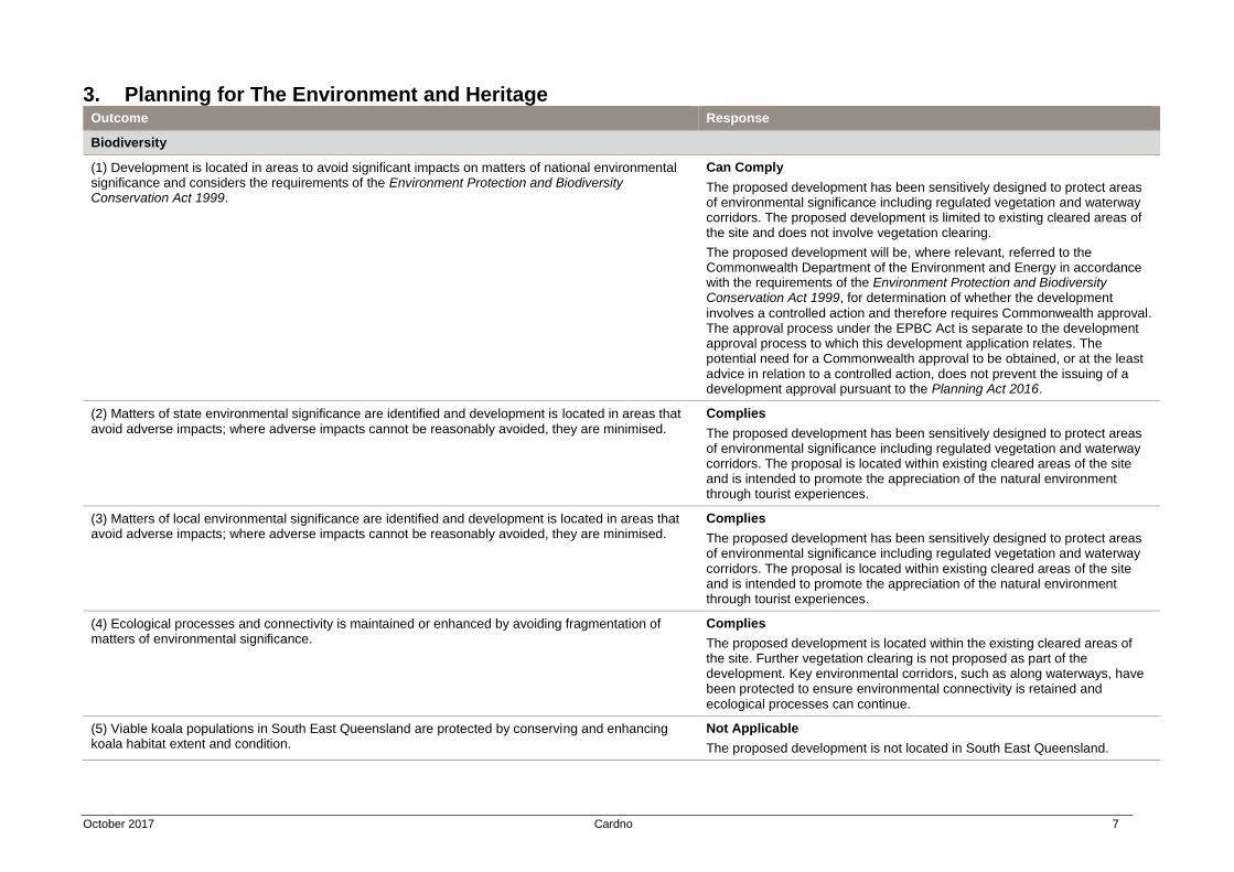
October 2017 Cardno 7
3. Planning for The Environment and Heritage Outcome Response
Biodiversity
(1) Development is located in areas to avoid significant impacts on matters of national environmental significance and considers the requirements of the Environment Protection and Biodiversity Conservation Act 1999.
Can Comply
The proposed development has been sensitively designed to protect areas of environmental significance including regulated vegetation and waterway corridors. The proposed development is limited to existing cleared areas of the site and does not involve vegetation clearing.
The proposed development will be, where relevant, referred to the Commonwealth Department of the Environment and Energy in accordance with the requirements of the Environment Protection and Biodiversity Conservation Act 1999, for determination of whether the development
involves a controlled action and therefore requires Commonwealth approval. The approval process under the EPBC Act is separate to the development approval process to which this development application relates. The potential need for a Commonwealth approval to be obtained, or at the least advice in relation to a controlled action, does not prevent the issuing of a development approval pursuant to the Planning Act 2016.
(2) Matters of state environmental significance are identified and development is located in areas that avoid adverse impacts; where adverse impacts cannot be reasonably avoided, they are minimised.
Complies
The proposed development has been sensitively designed to protect areas of environmental significance including regulated vegetation and waterway corridors. The proposal is located within existing cleared areas of the site and is intended to promote the appreciation of the natural environment through tourist experiences.
(3) Matters of local environmental significance are identified and development is located in areas that avoid adverse impacts; where adverse impacts cannot be reasonably avoided, they are minimised.
Complies
The proposed development has been sensitively designed to protect areas of environmental significance including regulated vegetation and waterway corridors. The proposal is located within existing cleared areas of the site and is intended to promote the appreciation of the natural environment through tourist experiences.
(4) Ecological processes and connectivity is maintained or enhanced by avoiding fragmentation of matters of environmental significance.
Complies
The proposed development is located within the existing cleared areas of the site. Further vegetation clearing is not proposed as part of the development. Key environmental corridors, such as along waterways, have been protected to ensure environmental connectivity is retained and ecological processes can continue.
(5) Viable koala populations in South East Queensland are protected by conserving and enhancing koala habitat extent and condition.
Not Applicable
The proposed development is not located in South East Queensland.

October 2017 Cardno 8
Outcome Response
Coastal Environment
Protection of the coastal environment:
(1) Coastal processes and coastal resources statewide, including in the Great Barrier Reef catchment, are protected by:
(a) concentrating future development in existing urban areas through infill and redevelopment
(b) conserving the natural state of landforms, wetlands and native vegetation in the coastal management district
(c) maintaining or enhancing the scenic amenity and aesthetic values of important natural coastal landscapes, views and vistas
Not Applicable
The proposed development is not located in the coastal environment.
(2) Development of canals, dry land marinas, artificial waterways or marine infrastructure avoids adverse impacts on coastal resources and processes.
Not Applicable
The proposed development is not located in the coastal environment.
(3) Reclamation of land under tidal water is avoided other than for the purpose of:
(a) coastal-dependent development, public marine development or community infrastructure, where there is no reasonable alternative; or
(b) strategic ports, priority ports, boat harbours or strategic airports and aviation facilities in accordance with a statutory land use plan, or statutory master plan; or
(c) coastal protection works or work necessary to protect coastal resources or coastal processes.
Not Applicable
The proposed development is not located in the coastal environment.
Development in the coastal environment:
(4) Coastal-dependent development in areas adjoining tidal water is facilitated in preference to other types of development.
Not Applicable
The proposed development is not located in the coastal environment.
(5) Opportunities for public use of and access to, and along, state coastal land is maintained or enhanced in a way that protects or enhances public safety and coastal resources.
Not Applicable
The proposed development is not located in the coastal environment.
Cultural Heritage
Aboriginal and Torres Strait Islander cultural heritage:
(1) Matters of Aboriginal cultural heritage and Torres Strait Islander cultural heritage are appropriately conserved and considered to support the requirements of the Aboriginal Cultural Heritage Act 2003 and the Torres Strait Islander Cultural Heritage Act 2003.
Can Comply
The proposed development will be operated in accordance with the obligations of the applicant under the Aboriginal Cultural Heritage Act 2003 and the Torres Strait Islander Cultural Heritage Act 2003.
World and national cultural heritage:
(2) Adverse impacts on the cultural heritage significance of world heritage properties and national heritage places prescribed under the Environment Protection and Biodiversity Conservation Act 1999
are avoided.
Complies
The proposed development is located wholly outside the Wet Tropics World Heritage Area.
State cultural heritage:
(3) Adverse impacts on the cultural heritage significance of state heritage places are avoided.
Complies
The site is not located within the vicinity of a Queensland Heritage Place.
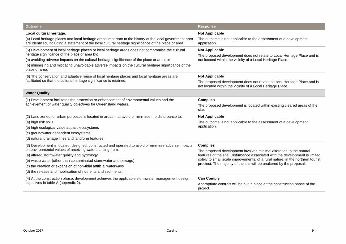
October 2017 Cardno 9
Outcome Response
Local cultural heritage:
(4) Local heritage places and local heritage areas important to the history of the local government area are identified, including a statement of the local cultural heritage significance of the place or area.
Not Applicable
The outcome is not applicable to the assessment of a development application.
(5) Development of local heritage places or local heritage areas does not compromise the cultural heritage significance of the place or area by:
(a) avoiding adverse impacts on the cultural heritage significance of the place or area; or
(b) minimising and mitigating unavoidable adverse impacts on the cultural heritage significance of the place or area.
Not Applicable
The proposed development does not relate to Local Heritage Place and is not located within the vicinity of a Local Heritage Place.
(6) The conservation and adaptive reuse of local heritage places and local heritage areas are facilitated so that the cultural heritage significance is retained.
Not Applicable
The proposed development does not relate to Local Heritage Place and is not located within the vicinity of a Local Heritage Place.
Water Quality
(1) Development facilitates the protection or enhancement of environmental values and the achievement of water quality objectives for Queensland waters.
Complies
The proposed development is located within existing cleared areas of the site.
(2) Land zoned for urban purposes is located in areas that avoid or minimise the disturbance to:
(a) high risk soils
(b) high ecological value aquatic ecosystems
(c) groundwater dependent ecosystems
(d) natural drainage lines and landform features.
Not Applicable
The outcome is not applicable to the assessment of a development application.
(3) Development is located, designed, constructed and operated to avoid or minimise adverse impacts on environmental values of receiving waters arising from:
(a) altered stormwater quality and hydrology
(b) waste water (other than contaminated stormwater and sewage)
(c) the creation or expansion of non-tidal artificial waterways
(d) the release and mobilisation of nutrients and sediments.
Complies
The proposed development involves minimal alteration to the natural features of the site. Disturbance associated with the development is limited solely to small scale improvements, of a rural nature, in the northern tourist precinct. The majority of the site will be unaltered by the proposal.
(4) At the construction phase, development achieves the applicable stormwater management design objectives in table A (appendix 2).
Can Comply
Appropriate controls will be put in place at the construction phase of the project.
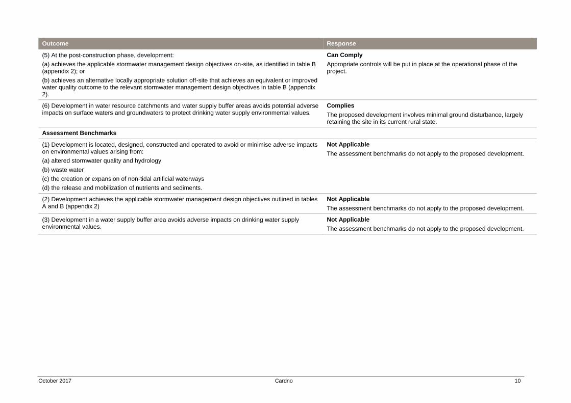
October 2017 Cardno 10
Outcome Response
(5) At the post-construction phase, development:
(a) achieves the applicable stormwater management design objectives on-site, as identified in table B (appendix 2); or
(b) achieves an alternative locally appropriate solution off-site that achieves an equivalent or improved water quality outcome to the relevant stormwater management design objectives in table B (appendix 2).
Can Comply
Appropriate controls will be put in place at the operational phase of the project.
(6) Development in water resource catchments and water supply buffer areas avoids potential adverse impacts on surface waters and groundwaters to protect drinking water supply environmental values.
Complies
The proposed development involves minimal ground disturbance, largely retaining the site in its current rural state.
Assessment Benchmarks
(1) Development is located, designed, constructed and operated to avoid or minimise adverse impacts on environmental values arising from:
(a) altered stormwater quality and hydrology
(b) waste water
(c) the creation or expansion of non-tidal artificial waterways
(d) the release and mobilization of nutrients and sediments.
Not Applicable
The assessment benchmarks do not apply to the proposed development.
(2) Development achieves the applicable stormwater management design objectives outlined in tables A and B (appendix 2)
Not Applicable
The assessment benchmarks do not apply to the proposed development.
(3) Development in a water supply buffer area avoids adverse impacts on drinking water supply environmental values.
Not Applicable
The assessment benchmarks do not apply to the proposed development.
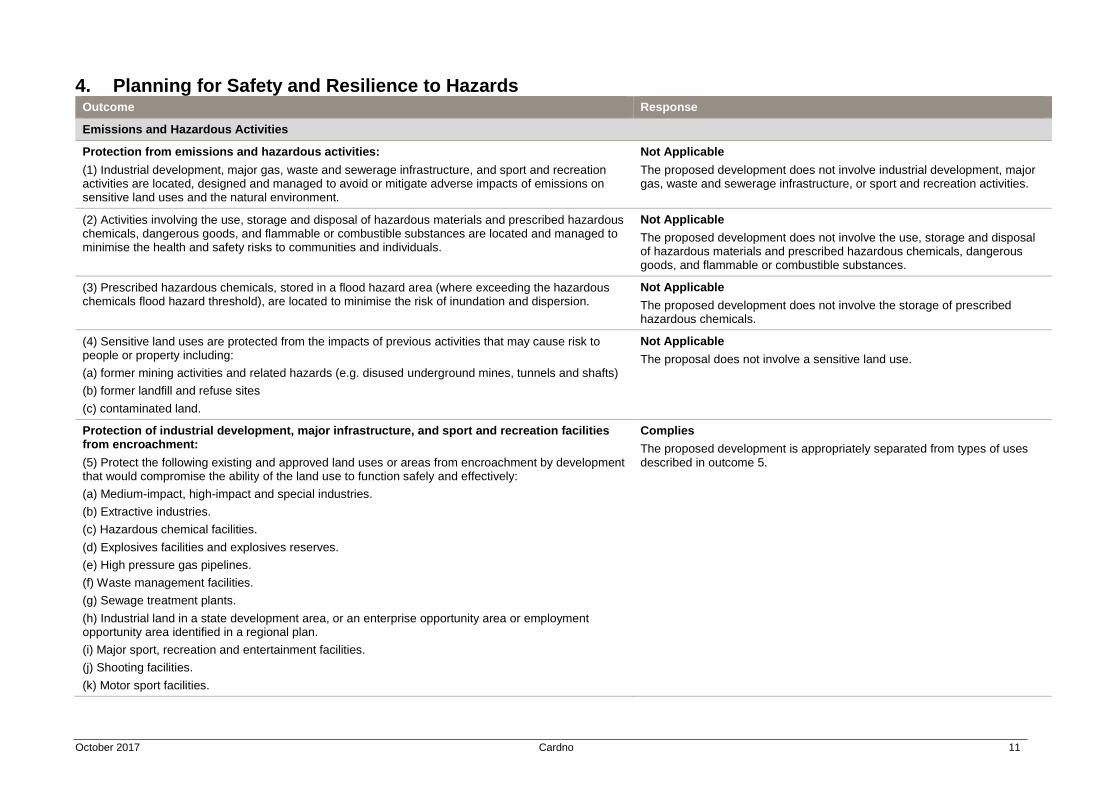
October 2017 Cardno 11
4. Planning for Safety and Resilience to Hazards Outcome Response
Emissions and Hazardous Activities
Protection from emissions and hazardous activities:
(1) Industrial development, major gas, waste and sewerage infrastructure, and sport and recreation activities are located, designed and managed to avoid or mitigate adverse impacts of emissions on sensitive land uses and the natural environment.
Not Applicable
The proposed development does not involve industrial development, major gas, waste and sewerage infrastructure, or sport and recreation activities.
(2) Activities involving the use, storage and disposal of hazardous materials and prescribed hazardous chemicals, dangerous goods, and flammable or combustible substances are located and managed to minimise the health and safety risks to communities and individuals.
Not Applicable
The proposed development does not involve the use, storage and disposal of hazardous materials and prescribed hazardous chemicals, dangerous goods, and flammable or combustible substances.
(3) Prescribed hazardous chemicals, stored in a flood hazard area (where exceeding the hazardous chemicals flood hazard threshold), are located to minimise the risk of inundation and dispersion.
Not Applicable
The proposed development does not involve the storage of prescribed hazardous chemicals.
(4) Sensitive land uses are protected from the impacts of previous activities that may cause risk to people or property including:
(a) former mining activities and related hazards (e.g. disused underground mines, tunnels and shafts)
(b) former landfill and refuse sites
(c) contaminated land.
Not Applicable
The proposal does not involve a sensitive land use.
Protection of industrial development, major infrastructure, and sport and recreation facilities from encroachment:
(5) Protect the following existing and approved land uses or areas from encroachment by development that would compromise the ability of the land use to function safely and effectively:
(a) Medium-impact, high-impact and special industries.
(b) Extractive industries.
(c) Hazardous chemical facilities.
(d) Explosives facilities and explosives reserves.
(e) High pressure gas pipelines.
(f) Waste management facilities.
(g) Sewage treatment plants.
(h) Industrial land in a state development area, or an enterprise opportunity area or employment opportunity area identified in a regional plan.
(i) Major sport, recreation and entertainment facilities.
(j) Shooting facilities.
(k) Motor sport facilities.
Complies
The proposed development is appropriately separated from types of uses described in outcome 5.
October 2017 Cardno 12
Outcome Response
Mitigation of adverse impacts from emissions and hazardous activities:
(6) Development that is incompatible with the existing and approved land uses or areas included in policy 5 above, is located to avoid adverse impacts of environmental emissions, or health and safety risks, and where the impacts cannot be practicably avoided, development is designed to minimise the impacts.
Complies
The proposed development is appropriately separated from types of uses described in outcome 5.
Acid sulfate soil affected areas:
(7) Protect the natural and built environment, and human health from potential adverse impacts of acid sulfate soils by:
(a) identifying areas with high probability of containing acid sulfate soils
(b) providing preference to land uses that will avoid, or where avoidance is not practicable, minimise the disturbance of acid sulfate soils
(c) including requirements for managing the disturbance of acid sulfate soils to avoid or minimise the mobilization and release of acid, iron or other contaminants.
Not Applicable
The site is not located in an Acid Sulfate Soil affected area.
Natural Hazards, Risk and Resilience
(1) Natural hazard areas are identified, including:
(a) bushfire prone areas
(b) flood hazard areas
(c) landslide hazard areas
(d) storm tide inundation areas
(e) erosion prone areas.
Not Applicable
The outcome is not applicable to the assessment of a development application.
(2) A fit-for-purpose risk assessment is undertaken to identify and achieve an acceptable or tolerable level of risk for personal safety and property in natural hazard areas.
Not Applicable
The proposed development is located outside natural hazard areas. The extent to which the site is located within a natural hazard area is limited to a small area in the west of the site that is identified as potential impact buffer (bushfire). The proposal is located wholly outside this area.
Bushfire, flood, landslide, storm tide inundation, and erosion prone areas:
(3) Land in an erosion prone area is not to be used for urban purposes,
unless the land is located in:
(a) an urban area in a planning scheme; or
(b) an urban footprint identified in a regional plan.
Not Applicable
The site is not located in an Erosion Prone Area.
(4) Development in bushfire, flood, landslide, storm tide inundation or erosion prone natural hazard areas:
(a) avoids the natural hazard area; or
(b) where it is not possible to avoid the natural hazard area, development mitigates the risks to people and property to an acceptable or tolerable level.
Complies
The proposed development is not located within a natural hazard area. The extent to which the site is located within a natural hazard area is limited to a small area in the west of the site that is identified as potential impact buffer (bushfire). The proposal is located wholly outside this area.
October 2017 Cardno 13
Outcome Response
(5) Development in natural hazard areas:
(a) supports, and does not hinder disaster management capacity and capabilities
(b) directly, indirectly and cumulatively avoids an increase in the exposure or severity of the natural hazard and the potential for damage on the site or to other properties
(c) avoids risks to public safety and the environment from the location of the storage of hazardous materials and the release of these materials as a result of a natural hazard
(d) maintains or enhances the protective function of landforms and vegetation that can mitigate risks associated with the natural hazard.
Not Applicable
The proposed development is not located in a natural hazard area.
(6) Community infrastructure is located and designed to maintain the required level of functionality during and immediately after a natural hazard event.
Not Applicable
The proposed development does not involve community infrastructure.
(7) Coastal protection work in an erosion prone area is undertaken only as a last resort where coastal erosion or inundation presents an imminent threat to public safety or existing buildings and structures, and all of the following apply:
(a) The building or structure cannot reasonably be relocated or abandoned.
(b) Any erosion control structure is located as far landward as practicable and on the lot containing the property to the maximum extent reasonable.
(c) Any increase in coastal hazard risk for adjacent areas from the coastal protection work is mitigated.
Not Applicable
The site not located in an Erosion Prone Area.
Erosion prone areas within a coastal management district:
(8) Development does not occur unless the development cannot feasibly be located elsewhere and is:
(a) coastal-dependent development; or
(b) temporary, readily relocatable or able to be abandoned development; or
(c) essential community infrastructure; or
(d) minor redevelopment6 of an existing permanent building or structure that cannot be relocated or abandoned.
Not Applicable
The site not located in an Erosion Prone Area of a Coastal Management District.
(9) Development permitted in policy 8 above, mitigates the risks to people and property to an acceptable or tolerable level.
Not Applicable
The site not located in an Erosion Prone Area of a Coastal Management District.
Assessment Benchmarks
Erosion prone areas within a coastal management district:
(1) Development does not occur in an erosion prone area within a coastal management district unless the development cannot feasibly be located elsewhere and is:
(a) coastal-dependent development; or
(b) temporary, readily relocatable or able to be abandoned development; or
(c) essential community infrastructure; or
Not Applicable
The site not located in an Erosion Prone Area of a Coastal Management District.
October 2017 Cardno 14
Outcome Response
(d) minor redevelopment9 of an existing permanent building or structure that cannot be relocated or abandoned.
(2) Development permitted in (1) above, mitigates the risks to people and property to an acceptable or tolerable level.
Not Applicable
The site not located in an Erosion Prone Area of a Coastal Management District.
Bushfire, flood, landslide, storm tide inundation, and erosion prone areas outside the coastal management district:
(3) Development other than that assessed against (1) above, avoids natural hazard areas, or where it is not possible to avoid the natural hazard area, development mitigates the risks to people and property to an acceptable or tolerable level.
Complies
The proposed development is not located in a natural hazard area.
All natural hazard areas:
(4) Development supports and does not hinder disaster management response or recovery capacity and capabilities.
Complies
The proposed development does not prevent responses to natural disasters. The proposal promotes access to various areas of the site.
(5) Development directly, indirectly and cumulatively avoids an increase in the severity of the natural hazard and the potential for damage on the site or to other properties.
Complies
The proposed development is not located in a natural hazard area.
(6) Risks to public safety and the environment from the location of hazardous materials and the release of these materials as a result of a natural hazard are avoided.
Not Applicable
The proposed development does not involve hazardous materials.
(7) The natural processes and the protective function of landforms and the vegetation that can mitigate risks associated with the natural hazard are maintained or enhanced.
Complies
October 2017 Cardno 15
5. Planning for Infrastructure Outcome Response
Energy and Water Supply
(1) Existing and approved future major electricity infrastructure locations and corridors (including easements and electricity substations), and bulk water supply infrastructure locations and corridors (including easements) are protected from development that would compromise the corridor integrity, and the efficient delivery and functioning of the infrastructure.
Complies
The proposed development does not compromise the corridor integrity, or the efficient delivery and functioning of any existing or future energy or water supply infrastructure.
(2) Major electricity infrastructure and bulk water supply infrastructure such as pump stations, water quality facilities and electricity substations, are protected from encroachment by sensitive land uses where practicable.
Complies
The proposed development is not located within the vicinity of major electricity infrastructure or bulk water supply infrastructure
(3) Development of major electricity infrastructure and bulk water supply infrastructure avoids or otherwise minimises adverse impacts on surrounding land uses and the natural environment.
Not Applicable
The proposed development does not relate to major electricity infrastructure or bulk water supply infrastructure.
(4) The development and supply of renewable energy at the regional, local and individual scale is enabled in appropriate locations.
Not Applicable
The outcome is not applicable to the assessment of a development application.
Infrastructure Integration
(1) The outcomes of significant infrastructure plans and initiatives by all levels of government are considered and reflected, where relevant.
Not Applicable
The outcome is not applicable to the assessment of a development application.
(2) Development achieves a high level of integration with infrastructure planning to:
(a) promote the most efficient, effective and flexible use of existing and planned infrastructure
(b) realise multiple economic, social and environmental benefits from infrastructure investment
(c) ensure consideration of future infrastructure needed to support infill and greenfield growth areas
(d) optimise the location of future infrastructure within communities to provide greater access to facilities and services and enable productivity improvements.
Complies
The proposal is appropriately located on the site, noting its connections to rural activities, and is able to be serviced by existing and expanded on-site infrastructure.
(3) Development occurs:
(a) in areas currently serviced by state and/or local infrastructure and associated services; or
(b) in a logical and orderly location, form and sequence to enable the cost effective delivery of state and local infrastructure to service development.
Complies
The proposal will utilise existing and expanded on-site infrastructure commensurate to the rural nature of the proposal and the rural location of the site.
(4) Existing and planned infrastructure is protected from development that would compromise the ability of infrastructure and associated services to operate safely and efficiently.
Complies
The proposed development will utilise private buses to transport tourists to the site. The level of traffic generated by the development is therefore considered to be minimal and not impact on the safety and efficiency of
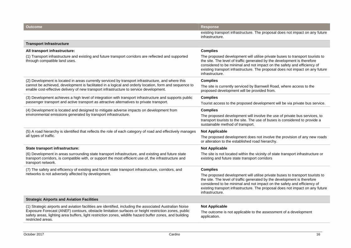
October 2017 Cardno 16
Outcome Response
existing transport infrastructure. The proposal does not impact on any future infrastructure.
Transport Infrastructure
All transport infrastructure:
(1) Transport infrastructure and existing and future transport corridors are reflected and supported through compatible land uses.
Complies
The proposed development will utilise private buses to transport tourists to the site. The level of traffic generated by the development is therefore considered to be minimal and not impact on the safety and efficiency of existing transport infrastructure. The proposal does not impact on any future infrastructure.
(2) Development is located in areas currently serviced by transport infrastructure, and where this cannot be achieved, development is facilitated in a logical and orderly location, form and sequence to enable cost-effective delivery of new transport infrastructure to service development.
Complies
The site is currently serviced by Barnwell Road, where access to the proposed development will be provided from.
(3) Development achieves a high level of integration with transport infrastructure and supports public passenger transport and active transport as attractive alternatives to private transport.
Complies
Tourist access to the proposed development will be via private bus service.
(4) Development is located and designed to mitigate adverse impacts on development from environmental emissions generated by transport infrastructure.
Complies
The proposed development will involve the use of private bus services, to transport tourists to the site. The use of buses is considered to provide a sustainable method of transport.
(5) A road hierarchy is identified that reflects the role of each category of road and effectively manages all types of traffic.
Not Applicable
The proposed development does not involve the provision of any new roads or alteration to the established road hierarchy.
State transport infrastructure:
(6) Development in areas surrounding state transport infrastructure, and existing and future state transport corridors, is compatible with, or support the most efficient use of, the infrastructure and transport network.
Not Applicable
The site is not located within the vicinity of state transport infrastructure or existing and future state transport corridors
(7) The safety and efficiency of existing and future state transport infrastructure, corridors, and networks is not adversely affected by development.
Complies
The proposed development will utilise private buses to transport tourists to the site. The level of traffic generated by the development is therefore considered to be minimal and not impact on the safety and efficiency of existing transport infrastructure. The proposal does not impact on any future infrastructure.
Strategic Airports and Aviation Facilities
(1) Strategic airports and aviation facilities are identified, including the associated Australian Noise Exposure Forecast (ANEF) contours, obstacle limitation surfaces or height restriction zones, public safety areas, lighting area buffers, light restriction zones, wildlife hazard buffer zones, and building restricted areas.
Not Applicable
The outcome is not applicable to the assessment of a development application.
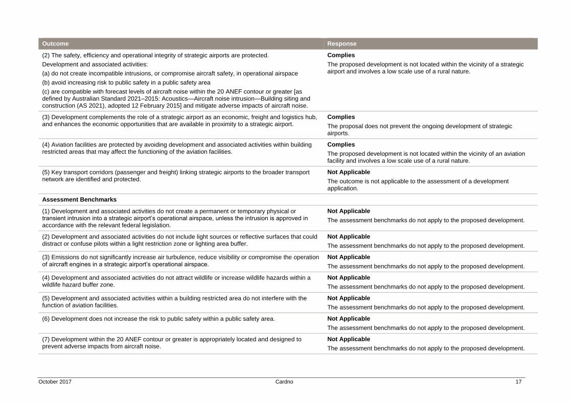
October 2017 Cardno 17
Outcome Response
(2) The safety, efficiency and operational integrity of strategic airports are protected.
Development and associated activities:
(a) do not create incompatible intrusions, or compromise aircraft safety, in operational airspace
(b) avoid increasing risk to public safety in a public safety area
(c) are compatible with forecast levels of aircraft noise within the 20 ANEF contour or greater [as defined by Australian Standard 2021–2015: Acoustics—Aircraft noise intrusion—Building siting and construction (AS 2021), adopted 12 February 2015] and mitigate adverse impacts of aircraft noise.
Complies
The proposed development is not located within the vicinity of a strategic airport and involves a low scale use of a rural nature.
(3) Development complements the role of a strategic airport as an economic, freight and logistics hub, and enhances the economic opportunities that are available in proximity to a strategic airport.
Complies
The proposal does not prevent the ongoing development of strategic airports.
(4) Aviation facilities are protected by avoiding development and associated activities within building restricted areas that may affect the functioning of the aviation facilities.
Complies
The proposed development is not located within the vicinity of an aviation facility and involves a low scale use of a rural nature.
(5) Key transport corridors (passenger and freight) linking strategic airports to the broader transport network are identified and protected.
Not Applicable
The outcome is not applicable to the assessment of a development application.
Assessment Benchmarks
(1) Development and associated activities do not create a permanent or temporary physical or transient intrusion into a strategic airport’s operational airspace, unless the intrusion is approved in accordance with the relevant federal legislation.
Not Applicable
The assessment benchmarks do not apply to the proposed development.
(2) Development and associated activities do not include light sources or reflective surfaces that could distract or confuse pilots within a light restriction zone or lighting area buffer.
Not Applicable
The assessment benchmarks do not apply to the proposed development.
(3) Emissions do not significantly increase air turbulence, reduce visibility or compromise the operation of aircraft engines in a strategic airport’s operational airspace.
Not Applicable
The assessment benchmarks do not apply to the proposed development.
(4) Development and associated activities do not attract wildlife or increase wildlife hazards within a wildlife hazard buffer zone.
Not Applicable
The assessment benchmarks do not apply to the proposed development.
(5) Development and associated activities within a building restricted area do not interfere with the function of aviation facilities.
Not Applicable
The assessment benchmarks do not apply to the proposed development.
(6) Development does not increase the risk to public safety within a public safety area. Not Applicable
The assessment benchmarks do not apply to the proposed development.
(7) Development within the 20 ANEF contour or greater is appropriately located and designed to prevent adverse impacts from aircraft noise.
Not Applicable
The assessment benchmarks do not apply to the proposed development.
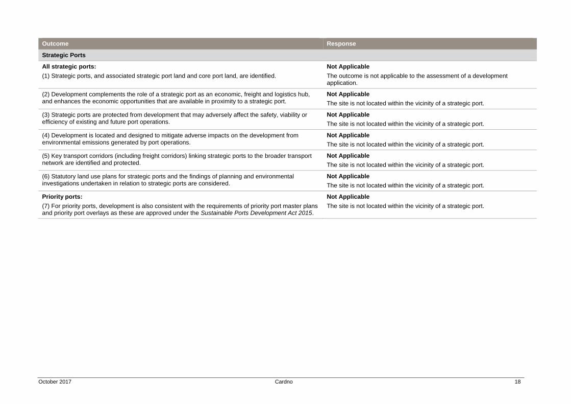
October 2017 Cardno 18
Outcome Response
Strategic Ports
All strategic ports:
(1) Strategic ports, and associated strategic port land and core port land, are identified.
Not Applicable
The outcome is not applicable to the assessment of a development application.
(2) Development complements the role of a strategic port as an economic, freight and logistics hub, and enhances the economic opportunities that are available in proximity to a strategic port.
Not Applicable
The site is not located within the vicinity of a strategic port.
(3) Strategic ports are protected from development that may adversely affect the safety, viability or efficiency of existing and future port operations.
Not Applicable
The site is not located within the vicinity of a strategic port.
(4) Development is located and designed to mitigate adverse impacts on the development from environmental emissions generated by port operations.
Not Applicable
The site is not located within the vicinity of a strategic port.
(5) Key transport corridors (including freight corridors) linking strategic ports to the broader transport network are identified and protected.
Not Applicable
The site is not located within the vicinity of a strategic port.
(6) Statutory land use plans for strategic ports and the findings of planning and environmental investigations undertaken in relation to strategic ports are considered.
Not Applicable
The site is not located within the vicinity of a strategic port.
Priority ports:
(7) For priority ports, development is also consistent with the requirements of priority port master plans and priority port overlays as these are approved under the Sustainable Ports Development Act 2015.
Not Applicable
The site is not located within the vicinity of a strategic port.