Embed Size (px)
Citation preview
Computers, Environment and Urban Systems 34 (2010) 264–277
Contents lists available at ScienceDirect
Computers, Environment and Urban Systems
journal homepage: www.elsevier .com/locate /compenvurbsys
Geospatial Cyberinfrastructure: Past, present and future
Chaowei Yang a,*, Robert Raskin b, Michael Goodchild c, Mark Gahegan d
a Joint Center for Intelligent Spatial Computing and Department of Geography and GeoInformation Science, George Mason University, Fairfax, VA 22030-4444, United Statesb NASA Jet Propulsion Laboratory, 4800 Oak Grove Drive Pasadena, CA 91109, United Statesc Department of Geography, University of California, Santa Barbara, 5707 Ellison Hall, Santa Barbara, CA 93106-4060, United Statesd Rm 554, Human Sciences Building, 10 Symonds Street, Auckland, School of Environment, The University of Auckland, Private Bag 92019, Auckland, New Zealand
a r t i c l e i n f o a b s t r a c t
Keywords:Cyberinfrastructure
Cloud computingVirtual organizationsGeospatial scienceSpatial computingSDI0198-9715/$ - see front matter � 2010 Elsevier Ltd. Adoi:10.1016/j.compenvurbsys.2010.04.001
* Corresponding author.E-mail address: [email protected] (C. Ya
A Cyberinfrastructure (CI) is a combination of data resources, network protocols, computing platforms,and computational services that brings people, information, and computational tools together to performscience or other data-rich applications in this information-driven world. Most science domains adoptintrinsic geospatial principles (such as spatial constraints in phenomena evolution) for large amountsof geospatial data processing (such as geospatial analysis, feature relationship calculations, geospatialmodeling, geovisualization, and geospatial decision support). Geospatial CI (GCI) refers to CI that utilizesgeospatial principles and geospatial information to transform how research, development, and educationare conducted within and across science domains (such as the environmental and Earth sciences). GCI isbased on recent advancements in geographic information science, information technology, computer net-works, sensor networks, Web computing, CI, and e-research/e-science. This paper reviews the research,development, education, and other efforts that have contributed to building GCI in terms of its history,objectives, architecture, supporting technologies, functions, application communities, and future researchdirections. Similar to how GIS transformed the procedures for geospatial sciences, GCI provides significantimprovements to how the sciences that need geospatial information will advance. The evolution of GCIwill produce platforms for geospatial science domains and communities to better conduct researchand development and to better collect data, access data, analyze data, model and simulate phenomena,visualize data and information, and produce knowledge. To achieve these transformative objectives, col-laborative research and federated developments are needed for the following reasons: (1) to address socialheterogeneity to identify geospatial problems encountered by relevant sciences and applications, (2) toanalyze data for information flows and processing needed to solve the identified problems, (3) to utilizeSemantic Web to support building knowledge and semantics into future GCI tools, (4) to develop geospa-tial middleware to provide functional and intermediate services and support service evolution for stake-holders, (5) to advance citizen-based sciences to reflect the fact that cyberspace is open to the public andcitizen participation will be essential, (6) to advance GCI to geospatial cloud computing to implement thetransparent and opaque platforms required for addressing fundamental science questions and applica-tion problems, and (7) to develop a research and development agenda that addresses these needs withgood federation and collaboration across GCI communities, such as government agencies, non-govern-ment organizations, industries, academia, and the public.
� 2010 Elsevier Ltd. All rights reserved.
1. Introduction history, origin, and status
Following the invention of electronic computers in the 1940s,scientists began to transform data from paper-based copies to elec-tronic forms, a trend that has transformed scientific research pro-cedures by allowing for easy shipping and sharing of informationamong colleagues (Lerner, 2001). The invention of computer net-works in the 1960s greatly simplified this sharing of electronic
ll rights reserved.
ng).
information, and the introduction of email, FTP, and other elec-tronic communication protocols made computer networks a phys-ical infrastructure that transformed how scientists, educators,government officials, and the public exchange ideas, conduct re-search, and share knowledge (Holzmann & Pehrson, 1994). Com-puter networks grew so fast that they became one of thedefining features of cyberspace (Smith & Kollock, 1999) by provid-ing important infrastructural support for our activities. The evolu-tion of cyberspace has resulted in an increasing number ofapplications to support research, development, and decision mak-ing (Smith & Kollock, 1999) and improved the rate of sharing of
C. Yang et al. / Computers, Environment and Urban Systems 34 (2010) 264–277 265
information from traditional mail-based time frames to Internet-based to real-time speeds associated with mobile devices (Murthy& Manimaran, 2001) such as Location Based Services (LBS, Kupper,2005). A vast number of functions have been developed that haverevolutionized how we conduct our daily work.
In 1998, the word Cyberinfrastructure (CI) was used in a WhiteHouse press briefing by Richard Clarke, then United States (US) na-tional coordinator for security, infrastructure protection, and coun-ter-terrorism, and Jeffrey Hunker, then US director of the criticalinfrastructure assurance office, referring to the infrastructureunderlying cyberspace. The US National Science Foundation (NSF)Computer & Information Science & Engineering (CISE) Directoratecalled for a review of this infrastructure and formed a blue ribbonreview team that used the term CI formally for their landmark At-kins report (NSF., 2003) and established an Office of CI (OCI) to ad-vance the research, development, and construction of CI.
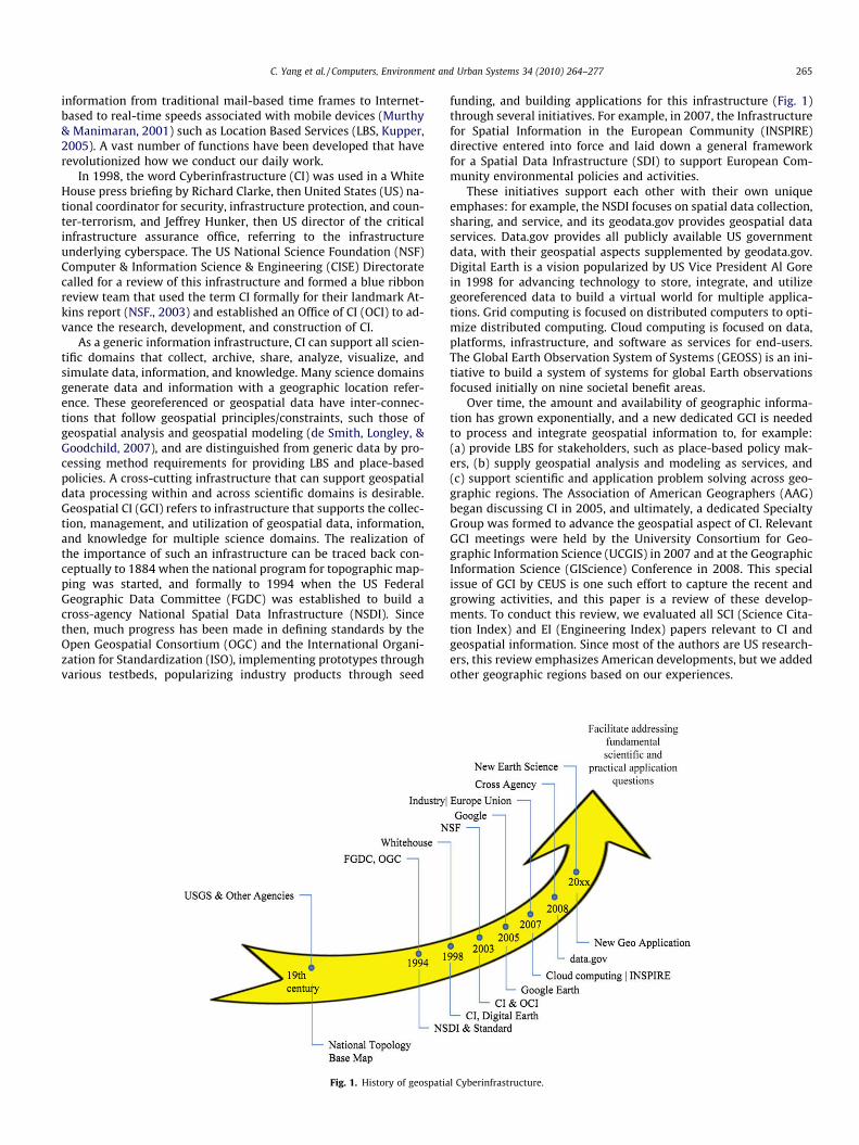
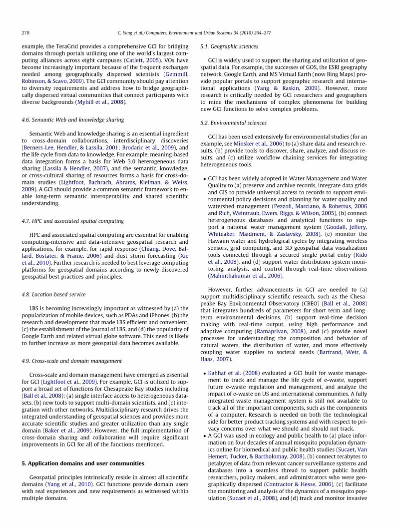
As a generic information infrastructure, CI can support all scien-tific domains that collect, archive, share, analyze, visualize, andsimulate data, information, and knowledge. Many science domainsgenerate data and information with a geographic location refer-ence. These georeferenced or geospatial data have inter-connec-tions that follow geospatial principles/constraints, such those ofgeospatial analysis and geospatial modeling (de Smith, Longley, &Goodchild, 2007), and are distinguished from generic data by pro-cessing method requirements for providing LBS and place-basedpolicies. A cross-cutting infrastructure that can support geospatialdata processing within and across scientific domains is desirable.Geospatial CI (GCI) refers to infrastructure that supports the collec-tion, management, and utilization of geospatial data, information,and knowledge for multiple science domains. The realization ofthe importance of such an infrastructure can be traced back con-ceptually to 1884 when the national program for topographic map-ping was started, and formally to 1994 when the US FederalGeographic Data Committee (FGDC) was established to build across-agency National Spatial Data Infrastructure (NSDI). Sincethen, much progress has been made in defining standards by theOpen Geospatial Consortium (OGC) and the International Organi-zation for Standardization (ISO), implementing prototypes throughvarious testbeds, popularizing industry products through seed
Fig. 1. History of geospatia
funding, and building applications for this infrastructure (Fig. 1)through several initiatives. For example, in 2007, the Infrastructurefor Spatial Information in the European Community (INSPIRE)directive entered into force and laid down a general frameworkfor a Spatial Data Infrastructure (SDI) to support European Com-munity environmental policies and activities.
These initiatives support each other with their own uniqueemphases: for example, the NSDI focuses on spatial data collection,sharing, and service, and its geodata.gov provides geospatial dataservices. Data.gov provides all publicly available US governmentdata, with their geospatial aspects supplemented by geodata.gov.Digital Earth is a vision popularized by US Vice President Al Gorein 1998 for advancing technology to store, integrate, and utilizegeoreferenced data to build a virtual world for multiple applica-tions. Grid computing is focused on distributed computers to opti-mize distributed computing. Cloud computing is focused on data,platforms, infrastructure, and software as services for end-users.The Global Earth Observation System of Systems (GEOSS) is an ini-tiative to build a system of systems for global Earth observationsfocused initially on nine societal benefit areas.
Over time, the amount and availability of geographic informa-tion has grown exponentially, and a new dedicated GCI is neededto process and integrate geospatial information to, for example:(a) provide LBS for stakeholders, such as place-based policy mak-ers, (b) supply geospatial analysis and modeling as services, and(c) support scientific and application problem solving across geo-graphic regions. The Association of American Geographers (AAG)began discussing CI in 2005, and ultimately, a dedicated SpecialtyGroup was formed to advance the geospatial aspect of CI. RelevantGCI meetings were held by the University Consortium for Geo-graphic Information Science (UCGIS) in 2007 and at the GeographicInformation Science (GIScience) Conference in 2008. This specialissue of GCI by CEUS is one such effort to capture the recent andgrowing activities, and this paper is a review of these develop-ments. To conduct this review, we evaluated all SCI (Science Cita-tion Index) and EI (Engineering Index) papers relevant to CI andgeospatial information. Since most of the authors are US research-ers, this review emphasizes American developments, but we addedother geographic regions based on our experiences.
l Cyberinfrastructure.

266 C. Yang et al. / Computers, Environment and Urban Systems 34 (2010) 264–277
GCI utilizes an integrated architecture that builds upon pastinvestments to share spatial data, information, and knowledge.These systems facilitate or advance the development, research,education, popularization, and advancement of geospatial sciencesand often enable functions that were not previously feasible, forexample, mashups that leverage petabytes of global geospatialinformation served through Google Earth and Bing Maps. NSF hasbeen a major driver in the development of CI. NSF has made signif-icant strategic investments in CI development (both before andafter the establishment of the OCI) in targeted domains, such asecology, hydrology, and social sciences. Each of these domains re-quires geospatial information in their research and developmentsthat enable research sharing and the collection of geospatial infor-mation to advance their objectives. GCI provides much neededinfrastructural support for these efforts.
A predecessor to the OCI program was the NSF National Mid-dleware Initiative (NMI), which generated many middlewareproducts that connect software components and applications.Other relevant early NSF initiatives were the large InformationTechnology Research (ITR) projects and the Grid initiative. NSF.(2007) later produced a landmark CI vision document thatemphasizes four strategic areas: (a) data and visualization, (b)High-Performance Computing, (c) virtual organizations, and (d)education and workforce training. All four components are funda-mental to the advancement of geospatial science research. Forexample, the NSDI focuses on data sharing and utilization. Geo-spatial visualization is a longstanding research endeavor to betterinterpret geospatial data and information, and high-performancegeospatial computing provides a driving technology to simulateand predict complex geospatial science phenomena (Yang, Li,Xie, & Zhou, 2008). Many organizations have become increasinglyimportant for driving the advancement of geospatial science inglobal and climate change applications. Education and workforcetraining has always been at the center of geospatial sciences. Cur-rent practices in geospatial science provide crosscutting geospa-tial analysis and modeling support to many scientific domainsincluding ecology, geosciences, Earth science, air quality, waterstudies, and atmospheric science.
Humanity in the 21st century faces great challenges to betterunderstand why and how the Earth is changing (http://nasa-science.nasa.gov) and to make better decisions at global to per-sonal levels (Lannotta, 2007). Representative challenges includestrategies to reduce energy consumption and stabilize atmosphericemissions so that the global temperature will not increase severaldegrees in the next century; choose a housing site that minimizesthe risks of forest fire, flooding, and other natural/man-made haz-ards; and more generally, improve the quality of life. These practi-cal questions require us to utilize most available geospatial data,information, and knowledge to produce scientifically sound deci-sion supporting information and require capabilities to achievethe following (Yang & Raskin, 2009): (1) integrate real-time andhistorical data resources, (2) leverage both traditional and fullyinteroperable and open resources, (3) interpret data and informa-tion that cross-domains, regions, and cultures, and (4) captureand utilize knowledge autonomously so that the most appropriateinputs can be utilized and the best decision supporting informationcan be generated. To answer complex questions, we must effec-tively utilize facilities, instruments, and other resources to pursuefundamental and transformational questions, unravel newly re-vealed mysteries, and expand our understanding of the Earth andthe universe (NSF., 2009). As a long-term objective, GCI will facili-tate answering these daunting questions and build the capacity toleverage existing geospatial knowledge and resources, transformhow we conduct research, pursue scientific and application ques-tions, and collaborate across geographic regions, cultural differ-ences, and domain turfs.
For a fast evolving, broad-based field such as GCI for which thegeospatial dimension cuts across domains and disciplines, a reviewcan not focus on any one aspect that might provide researcherswith a clear step-by-step research agenda. Instead, we provide anoverview of GCI from the perspectives of its history, current status,and future developments with a focus on aspects that are commonto all relevant domains. Our objectives are to introduce GCI to thefollowing groups: (1) scientists who could benefit from its end usecapabilities, (2) information scientists who could potentially ad-vance the leading-edge research frontiers, and (3) geospatial infor-mation scientists who desire a systematic view about GCI and itsfuture directions. We present views of GCI from five perspectives:logical frameworks, enabling technologies, geospatial functions,domain applications, and desired future research. These five per-spectives are presented in the next five sections, respectively.
2. Framework
2.1. GCI resources and logical framework
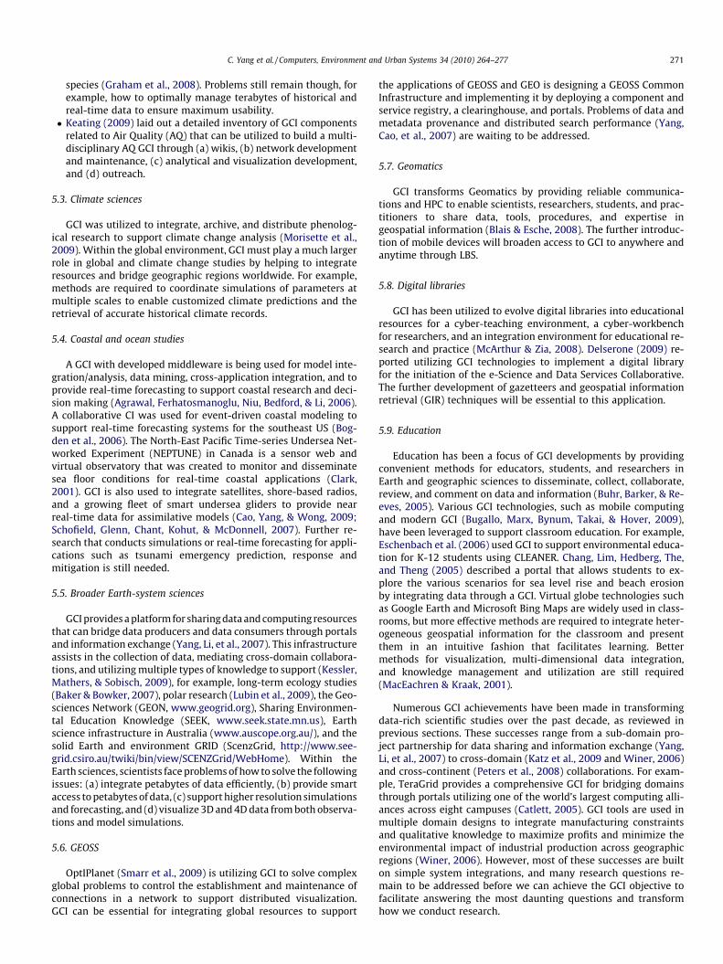
GCI includes multiple categories of resources within a flexible,scalable, and expandable framework cube (Fig. 2). This prototypicalGCI cube consists of the following three dimensions:
(1) Functions include both generic CI functions (computing, net-working, and hardware) and those that are geospatial-spe-cific. The GCI functions include the following: (a) amiddleware layer to bridge geospatial functions and resourcemanagement, monitoring, scheduling, and other system-levelfunctions, (b) a geospatial information integration layer tointegrate geospatial data, information, and knowledge flowas supported by observations, geospatial processing, andknowledge mining, and (c) geospatial functions to providevarious analytical functions for end-users.
(2) The community represents the virtual organizations and end-user interactions within specific communities including geo-graphic, environmental, Earth, and other science domains.This dimension also provides feedback channels for knowl-edge collection functions to leverage scientific communityand citizen participation.
(3) Enabling technologies provide technological support toinvent, mature, and maintain all GCI functions, such as col-lecting data through observations and collecting and utiliz-ing knowledge through a semantic web.
The geospatial information integration and the geospatial func-tions layers distinguish GCI from other generic CIs. GCI shouldleverage successes derived from enabling technologies (detailedin Section 3), functional components (detailed in Section 4), andcomprehensive solutions to community applications (detailed inSection 5). The Computing and Networking functions are not de-tailed because they are IT generic.
3. Enabling technologies
The architecture and integration of GCI benefit from numerousenabling technologies, many of which contributed to the birth ofGCI.
3.1. Earth observation and sensor networks
Earth observation and sensor networks provide data collectioncapabilities to feed petabytes of data into a GCI on a daily basis(Freudinger, 2009). Sensor networks also utilize GCI to supportthe evolution from passive logging systems to an intelligent sensornetworks that actively send data to servers, a capability that will
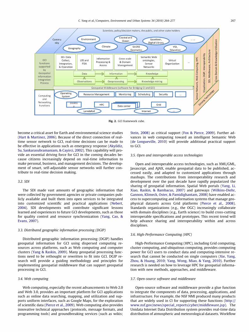
Fig. 2. GCI framework cube.
C. Yang et al. / Computers, Environment and Urban Systems 34 (2010) 264–277 267
become a critical asset for Earth and environmental science studies(Hart & Martinez, 2006). Because of the direct connection of real-time sensor network to GCI, real-time decisions can be made tobe effective in applications such as emergency response (Akyildiz,Su, Sankarasubramaniam, & Cayirci, 2002). This capability will pro-vide an essential driving force for GCI in the coming decades be-cause citizens increasingly depend on real-time information tomake personal, business, and management decisions. The develop-ment of smart, self-adjustable sensor networks will further con-tribute to real-time decision making.
3.2. SDI
The SDI made vast amounts of geographic information thatwere collected by government agencies or private companies pub-licly available and built them into open services to be integratedinto customized scientific and practical applications (Nebert,2004). SDI developments will contribute significant lessonslearned and experiences to future GCI developments, such as thosefor quality control and resource synchronization (Yang, Cao, &Evans, 2007).
3.3. Distributed geographic information processing (DGIP)
Distributed geographic information processing (DGIP) handlesgeospatial information for GCI using dispersed computing re-sources across platforms, such as Web computing and computerclusters (Yang & Raskin, 2009). Many geospatial processing func-tions need to be rethought or rewritten to fit into GCI. DGIP re-search will provide a guiding methodology and principles forimplementing geospatial middleware that can support geospatialprocessing in GCI.
3.4. Web computing
Web computing, especially the recent advancements to Web 2.0and Web 3.0, provides an important platform for GCI applicationssuch as online data searching, mapping, and utilization and sup-ports uniform interfaces, such as Google Maps, for the explorationof scientific data (Pierce et al., 2009). Web computing also providesinnovative technical approaches (protocols, message formats, andprogramming tools) and groundbreaking services (such as wikis;
Stein, 2008) as critical support (Fox & Pierce, 2009). Further ad-vances in web computing toward an intelligent Semantic Web(de Longueville, 2010) will provide additional practical supportto GCI.
3.5. Open and interoperable access technologies
Open and interoperable access technologies, such as XML/GML,Javascript, and AJAX, enable geospatial data to be published, ac-cessed easily, and adapted to customized applications throughmashups. The contributions from interoperability research anddevelopment over the past decade have rapidly popularized thesharing of geospatial information. Spatial Web portals (Yang, Li,Xiao, Raskin, & Bambacus, 2007) and gateways (Wilkins-Diehr,Gannon, Klimeck, Oster, & Pamidighantam, 2008) have enabled ac-cess to supercomputing and information systems that manage geo-physical datasets across Grid platforms (Pierce et al., 2008).Standards organizations (e.g., the OGC) increasingly collaboratewith domain disciplines (e.g., Earth science) to build cross-cuttinginteroperable specifications and prototypes. This recent trend willhelp advance sharing and interoperability within and acrossdisciplines.
3.6. High-Performance Computing (HPC)
High-Performance Computing (HPC), including Grid computing,cluster computing, and ubiquitous computing, provides computingpower for GCI users to conduct data and computing-intensive re-search that cannot be conducted on single computers (Xie, Yang,Zhou, & Huang, 2010; Yang, Wong, Miao, & Yang, 2010). Furtherresearch is needed on how to leverage HPC for geospatial informa-tion with new methods, approaches, and middleware.
3.7. Open-source software and middleware
Open-source software and middleware provide a glue functionto integrate the components of data, processing, applications, andinfrastructure. For example, the NSF NMI produced many productsthat are widely used in CI for supporting these functions (http://www.nsf.gov/news/special_reports/cyber/middleware.jsp). TheUnidata Internet Data Distribution system provides real-time datadistribution of atmospheric and meteorological datasets. Workflow
268 C. Yang et al. / Computers, Environment and Urban Systems 34 (2010) 264–277
(Papadopoulos & Linke, 2009) and distributed visualization (Smarr,Brown, & de Laat, 2009) middleware are often needed for complexscientific applications. For the development and maturation ofmiddleware, the Reuse Readiness Level (RRL, Marshall & Downs,2008) is an important indicator of middleware readiness. Experi-ences with middleware technology provide important hints forhow to adapt geospatial software to a GCI, but more research is re-quired on methods to distribute, synchronize, integrate, and bal-ance the processing within a distributed environment.
3.8. Data visualization needs in applied science
Solutions to data visualization needs in applied science made iteasy to engage end-users to utilize and contribute to a GCI. Geo-spatial information has a geographic connection that spans multi-ple domains; the FGDC framework datasets can be leveraged as aframework to facilitate the sharing of data, information, andknowledge within and across domains. How to best present dataand information from multiple resources and within applied sci-ence domains is a critical challenge.
3.9. Cross-domain sharing and collaborations
Cross-domain sharing and collaborations are essential to theability of a GCI to support and leverage expertise across user com-munities. The past decades’ efforts in multidisciplinary researchand development have helped us realize the importance of cross-domain collaboration and provided lessons and experiences thatcan be utilized for our subsequent benefit (MacEachren & Brewer,2004). A multi-domain perspective requires a GCI to be sufficientlyexpandable and flexible to support the easy plug-and-play of newfunctions through a service-oriented architecture (SOA) with stan-dards-based interoperable interfaces and open-source access. Fur-ther research using social sciences to help cross domains, cultures,and jurisdictional boundaries are important for thesecollaborations.
3.10. Knowledge capture and utilization
Knowledge capture and utilization provide for the smart dis-covery, integration, indexing, collection, and utilization of vastamounts of data, processing components, and other tools availablein a GCI. Research on the Semantic Web (Brodaric, Fox, & McGuin-ness, 2009) includes research on semantic understanding (such asEmbley, 2004), knowledge-based functions (Reynolds & Zhu,2001), ontology-based dynamic query rewriting for the semantictranslation of data, and other learning processes (Shimbo & Ishi-dab, 2003). Semantic interoperability is an important prerequisiteto information integration across domains, where vocabulary dif-ferences may be common. The geospatial Semantic Web is a vi-sion in which locations and LBS are fully understood bymachines (Egenhofer, 2002). Google Earth and other visual globetechnologies have provided the initial strides in this direction,which were based upon a common understanding of geospatialdimensions. An analogous understanding of features and attri-butes will help advance the future capabilities of GCI. Geospatialknowledge refers to a shared understanding of geospatial termsand the collective, expert intelligence it makes available (Raskin& Pan, 2005). As knowledge is inherently dynamic and expanding,a GCI must consider a constantly changing field of knowledge. Thegeospatial Semantic Web is a Web in which the browser, crawler,and other tools understand spatial content and can exploit thisknowledge on-the-fly (Maué & Schade, 2009; Roman & Klien,2007).
3.11. System integration architectures
Four major architectures have been widely researched andadopted for GCI system integration (Yang & Raskin, 2009).
� Multi-tier/layer organizations support and implement CI objec-tives through layers of functions with community-specificknowledge environments for research and education. The NSF(2003) Atkins report laid out a four-layer architecture empha-sizing the following: (a) core technologies, such as HPC, incor-porated into CI services, (b) CI supporting applications, (c)applications of IT to science and engineering research, and (d)science and engineering research activities. The NSF (2007) CIreport further emphasizes HPC, visualization and data/informa-tion/knowledge, virtual organizations, and education and work-force training. Zhang and Tsou (2009) and Wang and Liu (2009)described layered architectures for integrating geospatial com-ponents to support GCI. These layered views of GCI are in align-ment with those of the Federal Enterprise Architecture (FEA)and provide good guidance for the logic design of the compo-nents necessary to implement a GCI. Challenges remain in thisarchitecture; for example, how to utilize a knowledge-orientedlayered framework for integrating/interoperating multipleinfrastructures (Jabeur, McCarthy, Xing, & Graniero, 2009).� Mashup and plug-and-play leverage the achievements of geospa-
tial interoperability over the past few decades. Interoperabilitylays out a foundation for easily integrating heterogeneous com-ponents in a plug-and-play fashion or for mashup with minorscripting of the interfaces (Bambacus et al., 2007). This plug-and-play integration has become an ideal illustration of theachievements of interoperability and provides new system inte-gration methods that are envisioned to be critical to effective sys-tem integration in the coming decades (Nebert, 2004).� SOA is based on the assumption that all components can be
built as services and the SOA can facilitate service registration,discovery, and binding to form new functional and/or scientificapplications. For example, Hey and Trefethen (2005) describedhow the United Kingdom’s e-science program utilized SOA tocompose an e-Infrastructure or CI to support multiple sciencedomains. Bogden et al. (2006) described how an SOA was usedto design the Southeastern Universities Research Association(SURA) Coastal Ocean Observing and Prediction (SCOOP) pro-gram to support coastal real-time decision making. Zhang, Tsou,Qiao, and Xu (2006) discussed the need of GCI for the develop-ment of future geospatial information services based on Gridcomputing, Web services, and OGC standards.� Workflow chaining utilizes business logic in integrating applica-
tions to construct a GCI application and was popularized withOGC service proliferation within geospatial domains using BPEL,eBRIM, Kepler, and other generic- or geospatial-specific chainingengines and description languages. Minsker et al. (2006)described a workflow chaining service that integrates heteroge-neous tools to support environmental engineering and hydrolog-ical science communities to (a) share data and research throughinteractive provenance and (b) discover, share, analyze, and eval-uate research tools. Pennington et al. (2008) used workflowchaining to chain services that educate scientists to better lever-age resources in their scientific research. Workflow chaining alsoprovides an interesting architectural method for scientific exper-imentation (von Laszewski, Younge, Xi, Mahinthakumar, & Lizhe,2009). An important task in the workflow chaining process is tocompare the capabilities of the various available tools to composescientifically sound applications (Deelman, Gannon, Shields, &Taylor, 2009).
These four architectures are practical and popularly used to de-velop GCI systems or applications. They may be mixed in a real
C. Yang et al. / Computers, Environment and Urban Systems 34 (2010) 264–277 269
development scheme, but each emphasizes separate aspects of thesystem integration: (a) multi-tier organization focuses on businesslogic and is suitable for requirement analysis, (b) mashup andplug-and-play emphasize practical development within the cur-rent stage by leveraging public available resources, (c) SOA empha-sizes component interoperability if services are strictly conformedwith standards, and (d) work flow chaining emphasize semiauto-matic or automatic integration of applications. Further architec-tural improvements are needed and can be contributed fromfuture GCI research pursuits (detailed in Section 6), such as howto (a) maintain and discover service performance patterns (Li,Yang, & Yang, 2010), (b) optimize a framework, and (c) build inknowledge for automating work flow chaining (Li, Yang, & Raskin,2008).
4. GCI functions
The basic functional components within a GCI provide users ac-cess to geospatial data, information, knowledge, and processingtools.
4.1. Multi-dimensional data processing
The multidimensional nature of geospatial data and informa-tion forms an essential theoretical foundation for GCI (Li, Kim,Govindan, & Hong, 2003). For example, the inclusion of the timedimension leads to geospatial dynamics (Hornsby & Yuan, 2008).The vertical dimension is crucial in understanding the atmosphereand ocean. Other higher dimensions represent focused scientificparameters (e.g., a spectral band) that integrate domain knowledge(Yang, 2000). Research on multi-dimensional data has been ongo-ing for decades, but new technologies can help us to process datawith better resolution in three dimensional space, time, and spec-tral bands and to extract information hidden in data. Therefore,efficient multi-dimensional data processing represents a challeng-ing, driving GCI function.
4.2. Data collection and heterogeneous integration
Data collection and heterogeneous integration processes canintroduce petabytes of data into a GCI. For example, a tidal creekwatershed data management framework (White et al., 2009) inte-grates terabytes of environmental, demographic, and socioeco-nomic data using OGC/FGDC data sharing standards. Sensorwebs, Earth observations, ground surveying, and questionnaireshave produced a significant amount of geospatial information invarious forms, locations, and systems and served multiple pur-poses (Nittel et al., 2004). Data integration is essential to the abilityof a GCI to publish data (Horsburgh et al., 2009) and to feed datafrom sensors to users (Ledford, 2009). How to better organize thevast amounts of geospatial data across domains, resources, applica-tions, and cultural backgrounds represents a grand challenge ofGCI.
4.3. Data preservation and accessibility
Historical data are important to the understanding of dynamicprocesses (such as global change) and should be preserved and madeaccessible to users for perpetuity (Berman, 2008). For example, sci-entific breakthroughs or patents may be illuminated only in the con-text of subsequent related scientific resources (Clarkson, 2008;Jensen, Chen, & Murray, 2008). In the future, the processes associatedwith data, information, and knowledge transformations should bepreserved as data provenance (Simmhan, Plale, & Gannon, 2008),especially for global and climate studies and long-term policy mak-
ing (Morisette et al., 2009). These capabilities require a GCI to pro-vide sustainable and long-term data archival capability and easydiscovery, access, and utilization of historical datasets.
4.4. Supporting the life cycle from data to knowledge
A GCI should support the entire data life cycle, including theacquisition, verification, documentation for subsequent interpreta-tion, integration from multiple sources, analysis, and decision sup-port (Borgman, Wallis, Mayernik, & Pepe, 2007). For example, a GCIwas utilized to integrate informatics and intelligent systems tosupport decision making in chemical engineering for the entireproduct life cycle – from individual units to enterprise-level geo-graphically dispersed supply chains (Venkatasubramanian, 2009a,2009b). In a collaborative environment, GCI is widely needed tomanage data and serve as a tool for managers and practitionersto access, analyze, and determine data management needs (Carter& Green, 2009).
� Metadata are important for helping preserve understanding andbuilding new research environments for data sharing and repur-posing (Henry & Friedlander, 2008). Metadata also form the foun-dation for catalogs, Web portals, and other discovery services (deLongueville, 2010; Yang et al., 2007). Unique object identifiers pro-vide permanent names for archived data and for their inclusion injournal article references (Digital National Framework, 2007).Information extraction is made possible through data mining,knowledge reasoning, and other artificial intelligence processes(e.g., Li, Yang, & Sun, 2009). Targeted parameters of importanceto a science domain can be extracted to feed a model simulationor decision support system (Datcu et al., 2003), and geospatialdata mining typically requires geospatial analysis and modelingprinciples in the mining process.� Results representation and visualization are especially critical
when using semantic technology to interpret datasets and todevelop attractive end-user interfaces (Gahegan, Luo, Weaver,Pike, & Banchuen, 2009).� Services should be utilized and chained in response to rapid
application development, such as for emergency response(Friis-Christensen, Lucchi, Lutz, & Ostlinder, 2009).� Uniform access to data and information services: Web portals (de
Longueville, 2010; Maguire & Longley, 2005; Yang, Evans, et al.,2007) such as the Geospatial One Stop (GOS), provide a singleentry point to data, information, and knowledge. For example,Papadopoulos and Linke (2009) utilized Web portals to enabletheir seamless access and utilization of geospatial resources.Web portals are also used for integrating distributed generaliza-tion and geoprocessing (Wolf & Howe, 2009).
Many achievements have been made in integrating data, infor-mation, and knowledge management and access, but supportingthe automatic integration of a data life cycle requires a greaterunderstanding of the geospatial data life cycle.
4.5. Virtual Organizations (VO)
Virtual Organizations (VO) bring together distant users to formcollaborations across regions, domains, cultures, and scales(Myhill, Cogburn, Samant, Addom, & Blanck, 2008 and Bakeret al., 2009). A VO is a dynamic set of individuals and/or institu-tions defined by a set of resource-sharing rules and conditions.The individuals/institutions share some commonality in theirconcerns and requirements. While they may vary in scale, scope,duration, sociology, and structure and be dispersed geographicallyand institutionally, they can still function as a coherent unit(Cummings, Finholt, Foster, Kesselman, & Lawrence, 2008). For
270 C. Yang et al. / Computers, Environment and Urban Systems 34 (2010) 264–277
example, the TeraGrid provides a comprehensive GCI for bridgingdomains through portals utilizing one of the world’s largest com-puting alliances across eight campuses (Catlett, 2005). VOs havebecome increasingly important because of the frequent exchangesneeded among geographically dispersed scientists (Gemmill,Robinson, & Scavo, 2009). The GCI community should pay attentionto diversity requirements and address how to bridge geographi-cally dispersed virtual communities that connect participants withdiverse backgrounds (Myhill et al., 2008).
4.6. Semantic Web and knowledge sharing
Semantic Web and knowledge sharing is an essential ingredientto cross-domain collaborations, interdisciplinary discoveries(Berners-Lee, Hendler, & Lassila, 2001; Brodaric et al., 2009), andthe life cycle from data to knowledge. For example, meaning-baseddata integration forms a basis for Web 3.0 heterogeneous datasharing (Lassila & Hendler, 2007), and the semantic, knowledge,or cross-cultural sharing of resources forms a basis for cross-do-main studies (Lightfoot, Bachrach, Abrams, Kielman, & Weiss,2009). A GCI should provide a common semantic framework to en-able long-term semantic interoperability and shared scientificunderstanding.
4.7. HPC and associated spatial computing
HPC and associated spatial computing are essential for enablingcomputing-intensive and data-intensive geospatial research andapplications, for example, for rapid response (Chiang, Dove, Bal-lard, Bostater, & Frame, 2006) and dust storm forecasting (Xieet al., 2010). Further research is needed to best leverage computingplatforms for geospatial domains according to newly discoveredgeospatial best practices and principles.
4.8. Location based service
LBS is becoming increasingly important as witnessed by (a) thepopularization of mobile devices, such as PDAs and iPhones, (b) theresearch and development that made LBS efficient and convenient,(c) the establishment of the Journal of LBS, and (d) the popularity ofGoogle Earth and related virtual globe software. This need is likelyto further increase as more geospatial data becomes available.
4.9. Cross-scale and domain management
Cross-scale and domain management have emerged as essentialfor GCI (Lightfoot et al., 2009). For example, GCI is utilized to sup-port a broad set of functions for Chesapeake Bay studies including(Ball et al., 2008): (a) single interface access to heterogeneous data-sets, (b) new tools to support multi-domain scientists, and (c) inte-gration with other networks. Multidisciplinary research drives theintegrated understanding of geospatial sciences and provides moreaccurate scientific studies and greater utilization than any singledomain (Baker et al., 2009). However, the full implementation ofcross-domain sharing and collaboration will require significantimprovements in GCI for all of the functions mentioned.
5. Application domains and user communities
Geospatial principles intrinsically reside in almost all scientificdomains (Yang et al., 2010). GCI functions provide domain userswith real experiences and new requirements as witnessed withinmultiple domains.
5.1. Geographic sciences
GCI is widely used to support the sharing and utilization of geo-spatial data. For example, the successes of GOS, the ESRI geographynetwork, Google Earth, and MS Virtual Earth (now Bing Maps) pro-vide popular portals to support geographic research and interna-tional applications (Yang & Raskin, 2009). However, moreresearch is critically needed by GCI researchers and geographersto mine the mechanisms of complex phenomena for buildingnew GCI functions to solve complex problems.
5.2. Environmental sciences
GCI has been used extensively for environmental studies (for anexample, see Minsker et al., 2006) to (a) share data and research re-sults, (b) provide tools to discover, share, analyze, and discuss re-sults, and (c) utilize workflow chaining services for integratingheterogeneous tools.
� GCI has been widely adopted in Water Management and WaterQuality to (a) preserve and archive records, integrate data gridsand GIS to provide universal access to records to support envi-ronmental policy decisions and planning for water quality andwatershed management (Pezzoli, Marciano, & Robertus, 2006and Rich, Weintraub, Ewers, Riggs, & Wilson, 2005), (b) connectheterogeneous databases and analytical functions to sup-port a national water management system (Goodall, Jeffery,Whiteaker, Maidment, & Zaslavsky, 2008), (c) monitor theHawaiin water and hydrological cycles by integrating wirelesssensors, grid computing, and 3D geospatial data visualizationtools connected through a secured single portal entry (Kidoet al., 2008), and (d) support water distribution system moni-toring, analysis, and control through real-time observations(Mahinthakumar et al., 2006).
However, further advancements in GCI are needed to (a)support multidisciplinary scientific research, such as the Chesa-peake Bay Environmental Observatory (CBEO) (Ball et al., 2008)that integrates hundreds of parameters for short term and long-term environmental decisions, (b) support real-time decisionmaking with real-time output, using high performance andadaptive computing (Ramaprivan, 2008), and (c) provide novelprocesses for understanding the composition and behavior ofnatural waters, the distribution of water, and more effectivelycoupling water supplies to societal needs (Bartrand, Weir, &Haas, 2007).
� Kahhat et al. (2008) evaluated a GCI built for waste manage-ment to track and manage the life cycle of e-waste, supportfuture e-waste regulation and management, and analyze theimpact of e-waste on US and international communities. A fullyintegrated waste management system is still not available totrack all of the important components, such as the componentsof a computer. Research is needed on both the technologicalside for better product tracking systems and with respect to pri-vacy concerns over what we should and should not track.� A GCI was used in ecology and public health to (a) place infor-
mation on four decades of annual mosquito population dynam-ics online for biomedical and public health studies (Sucaet, VanHemert, Tucker, & Bartholomay, 2008), (b) connect terabytes topetabytes of data from relevant cancer surveillance systems anddatabases into a seamless thread to support public healthresearchers, policy makers, and administrators who were geo-graphically dispersed (Contractor & Hesse, 2006), (c) facilitatethe monitoring and analysis of the dynamics of a mosquito pop-ulation (Sucaet et al., 2008), and (d) track and monitor invasive
C. Yang et al. / Computers, Environment and Urban Systems 34 (2010) 264–277 271
species (Graham et al., 2008). Problems still remain though, forexample, how to optimally manage terabytes of historical andreal-time data to ensure maximum usability.� Keating (2009) laid out a detailed inventory of GCI components
related to Air Quality (AQ) that can be utilized to build a multi-disciplinary AQ GCI through (a) wikis, (b) network developmentand maintenance, (c) analytical and visualization development,and (d) outreach.
5.3. Climate sciences
GCI was utilized to integrate, archive, and distribute phenolog-ical research to support climate change analysis (Morisette et al.,2009). Within the global environment, GCI must play a much largerrole in global and climate change studies by helping to integrateresources and bridge geographic regions worldwide. For example,methods are required to coordinate simulations of parameters atmultiple scales to enable customized climate predictions and theretrieval of accurate historical climate records.
5.4. Coastal and ocean studies
A GCI with developed middleware is being used for model inte-gration/analysis, data mining, cross-application integration, and toprovide real-time forecasting to support coastal research and deci-sion making (Agrawal, Ferhatosmanoglu, Niu, Bedford, & Li, 2006).A collaborative CI was used for event-driven coastal modeling tosupport real-time forecasting systems for the southeast US (Bog-den et al., 2006). The North-East Pacific Time-series Undersea Net-worked Experiment (NEPTUNE) in Canada is a sensor web andvirtual observatory that was created to monitor and disseminatesea floor conditions for real-time coastal applications (Clark,2001). GCI is also used to integrate satellites, shore-based radios,and a growing fleet of smart undersea gliders to provide nearreal-time data for assimilative models (Cao, Yang, & Wong, 2009;Schofield, Glenn, Chant, Kohut, & McDonnell, 2007). Further re-search that conducts simulations or real-time forecasting for appli-cations such as tsunami emergency prediction, response andmitigation is still needed.
5.5. Broader Earth-system sciences
GCI provides a platform for sharing data and computing resourcesthat can bridge data producers and data consumers through portalsand information exchange (Yang, Li, et al., 2007). This infrastructureassists in the collection of data, mediating cross-domain collabora-tions, and utilizing multiple types of knowledge to support (Kessler,Mathers, & Sobisch, 2009), for example, long-term ecology studies(Baker & Bowker, 2007), polar research (Lubin et al., 2009), the Geo-sciences Network (GEON, www.geogrid.org), Sharing Environmen-tal Education Knowledge (SEEK, www.seek.state.mn.us), Earthscience infrastructure in Australia (www.auscope.org.au/), and thesolid Earth and environment GRID (ScenzGrid, http://www.see-grid.csiro.au/twiki/bin/view/SCENZGrid/WebHome). Within theEarth sciences, scientists face problems of how to solve the followingissues: (a) integrate petabytes of data efficiently, (b) provide smartaccess to petabytes of data, (c) support higher resolution simulationsand forecasting, and (d) visualize 3D and 4D data from both observa-tions and model simulations.
5.6. GEOSS
OptIPlanet (Smarr et al., 2009) is utilizing GCI to solve complexglobal problems to control the establishment and maintenance ofconnections in a network to support distributed visualization.GCI can be essential for integrating global resources to support
the applications of GEOSS and GEO is designing a GEOSS CommonInfrastructure and implementing it by deploying a component andservice registry, a clearinghouse, and portals. Problems of data andmetadata provenance and distributed search performance (Yang,Cao, et al., 2007) are waiting to be addressed.
5.7. Geomatics
GCI transforms Geomatics by providing reliable communica-tions and HPC to enable scientists, researchers, students, and prac-titioners to share data, tools, procedures, and expertise ingeospatial information (Blais & Esche, 2008). The further introduc-tion of mobile devices will broaden access to GCI to anywhere andanytime through LBS.
5.8. Digital libraries
GCI has been utilized to evolve digital libraries into educationalresources for a cyber-teaching environment, a cyber-workbenchfor researchers, and an integration environment for educational re-search and practice (McArthur & Zia, 2008). Delserone (2009) re-ported utilizing GCI technologies to implement a digital libraryfor the initiation of the e-Science and Data Services Collaborative.The further development of gazetteers and geospatial informationretrieval (GIR) techniques will be essential to this application.
5.9. Education
Education has been a focus of GCI developments by providingconvenient methods for educators, students, and researchers inEarth and geographic sciences to disseminate, collect, collaborate,review, and comment on data and information (Buhr, Barker, & Re-eves, 2005). Various GCI technologies, such as mobile computingand modern GCI (Bugallo, Marx, Bynum, Takai, & Hover, 2009),have been leveraged to support classroom education. For example,Eschenbach et al. (2006) used GCI to support environmental educa-tion for K-12 students using CLEANER. Chang, Lim, Hedberg, The,and Theng (2005) described a portal that allows students to ex-plore the various scenarios for sea level rise and beach erosionby integrating data through a GCI. Virtual globe technologies suchas Google Earth and Microsoft Bing Maps are widely used in class-rooms, but more effective methods are required to integrate heter-ogeneous geospatial information for the classroom and presentthem in an intuitive fashion that facilitates learning. Bettermethods for visualization, multi-dimensional data integration,and knowledge management and utilization are still required(MacEachren & Kraak, 2001).
Numerous GCI achievements have been made in transformingdata-rich scientific studies over the past decade, as reviewed inprevious sections. These successes range from a sub-domain pro-ject partnership for data sharing and information exchange (Yang,Li, et al., 2007) to cross-domain (Katz et al., 2009 and Winer, 2006)and cross-continent (Peters et al., 2008) collaborations. For exam-ple, TeraGrid provides a comprehensive GCI for bridging domainsthrough portals utilizing one of the world’s largest computing alli-ances across eight campuses (Catlett, 2005). GCI tools are used inmultiple domain designs to integrate manufacturing constraintsand qualitative knowledge to maximize profits and minimize theenvironmental impact of industrial production across geographicregions (Winer, 2006). However, most of these successes are builton simple system integrations, and many research questions re-main to be addressed before we can achieve the GCI objective tofacilitate answering the most daunting questions and transformhow we conduct research.
272 C. Yang et al. / Computers, Environment and Urban Systems 34 (2010) 264–277
6. Discussion and future strategies
To achieve the transformative function of GCI, we need to com-plete the following tasks: (1) research and develop a GCI-centeredresearch platform that enables discovery in multidisciplinary sci-ence (Elmagarmid, Samuel, & Ouzzani, 2008) and knowledge shar-ing, and fosters more meaningful analyses of data and thevisualization, modeling, and simulation of real-world phenomena,(2) change the focus from technology to humans for GCIs built toenable science and engineering discovery (Tsai et al., 2008) so thatscientists can focus on ideas and innovation and engineers can fo-cus on engineering development (Whey-Fone et al., 2008), and (3)develop new GCI technologies and tools to help answer fundamen-tal science questions and enable complex applications that benefithuman beings. However, to implement a GCI that transforms howscientists and the public pursue fundamental scientific questionsand complex application problems, we must leverage the currentsuccesses and potential problem solving capabilities of GCIs witha focus on sharing and collaboration, such as geocollaboration(MacEachren & Brewer, 2004). The future of GCI poses grand chal-lenges in many aspects including the integration of currently iso-lated CIs from multiple domains, the evolution of GCI from atechnology-centered to a human-centered paradigm, the advance-ment of GCI to support multiple science domains by simulatingcomplex phenomena in a virtual fashion, and the acceptance ofGCI by a broad range of stakeholders who use geospatial data. Withthe advancement of technologies, more study in social sciences isurgently needed to enable efficient collaboration among teammembers, communities, and domains. We believe at least seven as-pects need further research and development:
6.1. Studying social heterogeneity to identify geospatial problemsencountered by relevant sciences and applications in the context of GCI
GCI is targeted to provide solutions to complex scientific andapplication problems identified through initiatives such as DigitalEarth (Goodchild, 2008a) and GEOSS (Lannotta, 2007) by enablingscientists and decision makers to focus on ideas and innovationsand relieving them from considering technical details. This is avery complex task that starts with clearly identifying problemsthat cannot be solved without a GCI; its challenges are both tech-nological and social. The complexity of GCI itself originates withits contributions from broad technological areas, such as Grid,infrastructure, workflow, scheduling, resource discovery and allo-cation, security and algorithms (Chiu & Fox, 2009), business mod-els, domain knowledge frameworks, study methods, Web 2.0, andmulti-core computing (Fox & Pierce, 2009; Loudon, 2009). Theidentification of appropriate problems will require scientists withdifferent backgrounds to work together. Socially, the blending ofscientists across domains and geographically dispersed teams isa grand challenge as has been observed by various GCI projects,such as LEAD (Lawrence, Finholt, & Kim, 2007). Therefore, (a)the attitudes and needs of data curation in collection, representa-tion, and dissemination also pose challenges to both knowledgesharing and social complexities for the success of a GCI (Winget,2008), (b) how to design a GCI for diverse end-users is a challengeto cross-cultural participation (Fischer, 2009), (c) the collabora-tion among scientists for the next generation of GCI poses chal-lenges due to their heterogeneity in culture, geography, andscientific domain (Olson, 2009), (d) the openness among peopleand domains will take time to be implemented from public de-bate to public policy (Wunsch-Vincent, Reynolds, & Wyckoff,2008), and (e) how users view GCI and their willingness to con-tribute, take, and maintain a GCI will involve social dynamics(Ribes & Finholt, 2009).
Meyer and Schroeder (2009) argued that we need to establish anew sociology for e-Research based on GCI by developing a sociol-ogy of knowledge that is based on an understanding of how sciencehas been historically transformed and shifted into online media.The experiences of the Open Science Grid (OSG) (Avery, 2008)broadly illustrate the breadth and scale of the efforts that a diverse,evolving collaboration must undertake to build and sustain a large-scale, multidisciplinary GCI.
6.2. Analyzing the information flow from data to information and theprocessing needed for solving problems
� Progress in multidimensional sciences: geospatial phenomenatypically display characteristics that depend upon the selectedtime scale, spatial scale, and scientific domain. Therefore, a bet-ter understanding of the dynamic dimensions of scientific phe-nomena will help us design better adaptive computing tounderstand the principles driving scientific problems (Hornsbyand Yuan, 2008; Maguire, Goodchild, & Rhind, 1991) and pro-vide better technological solutions for scientific problem solv-ing. These advancements will also provide theoretical supportfor developing new sensor networks for more targeted multi-dimensional data collections.� To support place-based policy and other national and interna-
tional initiatives, various SDIs should be integrated into the Glo-bal SDI (Nebert, 2004) based on a seamless integration of data.Data provenance is essential in such a process for the followingtasks: (a) facilitate the sharing of geospatial datasets, (b) main-tain the information processed from raw data, and (c) validatethe knowledge obtained from the information. Interoperabilityis critical to the integration process and should be maintainedat the data, information, and knowledge levels to avoid buildingnon-sharable stove-piped data systems (Cruz, Sunna, Makar, &Bathala, 2007). A practical integration process should respectexisting resources and provide metadata harvesting or on-the-fly searching to distributed catalogs based on community con-sensus on a digital data rights management schema.� Quality assurance: the quality of information and resources
within a GCI is not yet easy to evaluate (Giersch, Leary, Palmer,& Recker, 2008), and it remains a daunting task to manage feder-ated virtual organizations (Gemmill et al., 2009). The uncertaintyintroduced in the process of a workflow within a complex deci-sion support system is a critical issue. Advancements in qualityrelated research within GCIs are urgently needed to better cate-gorize, locate, select, and utilize more proper geospatial resourcesthat address scientific and public problems.
6.3. Utilizing the Semantic Web to support building knowledge andsemantics
Utilizing the Semantic Web to support building knowledge andsemantics into the next generation of scientific tools will supportsmart processing of geospatial metadata, data, information, knowl-edge, and services for virtual communities and multiple scientificdomains (Hendler, 2003). How to capture, represent, and integrateknowledge within and across geospatial domains are all ongoingchallenges (Brodaric et al., 2009). Venkatasubramanian (2009a,2009b) found that, in a data-rich world, we must find a way toautomatically utilize knowledge acquired in the past to facilitatethe automatic identification, utilization, and integration of datasetsinto operational systems. A semantic (ontology) based frameworkthat is sensitive to the scale, richness, character, and heterogeneitywithin and across disciplines is desirable (Patterson, Faulwetter, &Shipunov, 2008). Transforming and integrating informal ontologiesinto formal community-accepted ontologies is a further challenge(Lumb, Freemantle, Lederman, & Aldridge, 2009). Multilingual
C. Yang et al. / Computers, Environment and Urban Systems 34 (2010) 264–277 273
ontologies present the challenge of matching the meanings of rel-evant terminologies within and across languages, such as thoseencountered in INSPIRE (Masser, 2007). Future research with GCIswill require us to collaborate with linguistics and translation pro-fessionals. Cross-domain ontologies will have similar benefits tomultidisciplinary pursuits.
6.4. Developing geospatial middleware to provide functional andintermediate services and support service evolution to stakeholders
The GCIs envisioned cannot be built overnight and require sus-tainable and long-term planning, coordination, and maintenance.Therefore, an iterative process will provide intermediate servicesthat benefit initial stakeholders and entice additional stakeholdersby revising and introducing more services. The involvement of newstakeholders will also provide potential solutions to the genericchallenge of maintaining a GCI after agency research or develop-ment funding is exhausted (Mackie, 2008). For example, the GOSnow provides services to a wide variety of communities (Good-child, Fu, & Rich, 2007). Google Earth and other popular mappingsystems broaden the stakeholders of these GCIs from traditionalgeospatial sciences to the general public (Flora, 2007). The contin-uing evolution and success of such GCI examples and services willadd more scientific research, models, and decision support analy-ses and provide concrete building blocks for future GCIs.
6.5. Advancing citizen sciences or public-based sciences
Advancing citizen sciences or public-based sciences will reflectthe fact that cyberspace is open to the public and citizen participa-tion will play vital roles, such as providing the following (Good-child, 2008b): (a) Volunteer Geographic Information (VGI), (b)ratings for the quality of data, information, and services, (c) end-users to operate and test a GCI and provide feedback, and (d) datafor the statistical analysis of a GCI. The full utilization of citizencontributions to control the quality of a GCI will require theactive involvement of both social and relevant domain scientists(de Longueville, 2010).
6.6. Advancing GCI to geospatial cloud computing will implementtransparent and opaque platforms
Advancing GCI to geospatial cloud computing will implementtransparent and opaque platforms for addressing fundamental sci-ence questions and application problems through advancements ininformation technology and computing sciences.
� Maturation of adaptive computing: it is desirable to have a newGCI framework in which remote and in situ atmospheric sen-sors, data acquisition and storage systems, assimilation and pre-diction codes, data mining and visualization engines, and the
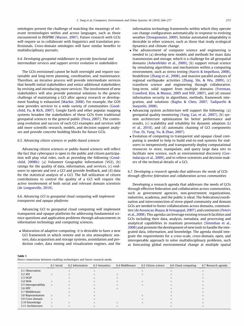
Table 1Direct connections between enabling technologies and future research needs.
6.1 Social 6.2 Information 6.3 Semantics 6.4 Midd
3.1 Observation � �3.2 SDI � � � �3.3 DGIP � � �3.4 Web � � � �3.5 Interoperability � � � �3.6 HPC � � �3.7 Middleware � �3.8 Representation � � �3.9 Cross domain � �3.10 Knowledge � � � �3.11 Architecture � � � �
information technology frameworks within which they operatecan change configuration automatically in response to evolvingweather (Droegemeier, 2009). Similar automated adaptability isdesirable in other sciences, such as those that study ecologicaldynamics and climate change.� The advancement of computer science and engineering is
needed to (a) develop new models and methods for mass datatransmission and storage, which is a challenge for all geospatialdomains (Ashenfelder et al., 2009), (b) support virtual scienceby simulating algorithms and mechanisms within a computingenvironment, such as stress testing (Harris & Impelluso, 2008),biodefense (Zhang et al., 2008), and massive parallel analyses ofregional earthquake activities (Zhang, Shi, & Wu, 2009), (c)transform science and engineering through collaborative,long-term, solid support from multiple domains (Freeman,Crawford, Kim, & Munoz, 2005 and NSF, 2007), and (d) ensureinformation security in algorithms, methods, framework inte-gration, and solutions (Raghu & Chen, 2007; Tadiparthi &Sueyoshi, 2008).� Advancing system architecture will support the following: (a)
geospatial quality monitoring (Yang, Cao, et al., 2007), (b) sys-tem architecture optimization for better performance andresults, (c) scalability and reliability for dynamic adoption (Liet al., 2010), and (d) automatic chaining of GCI components(Yue, Di, Yang, Yu, & Zhao, 2007).� Evolution of computing to transparent and opaque cloud com-
puting is needed to help to build end-to-end systems for end-users to inexpensively and transparently deploy computationalresources to store, manipulate, and query large data sets tofacilitate new science, such as environmental discovery (Gov-indaraju et al., 2009), and to relieve scientists and decision mak-ers of the technical details of a GCI.
6.7. Developing a research agenda that addresses the needs of GCIsthrough effective federation and collaboration across communities
Developing a research agenda that addresses the needs of GCIsthrough effective federation and collaboration across communities,such as government agencies, non-government organizations,industries, academia, and the public is ideal. The federation/coordi-nation and interconnection of stove-piped community and domainGCIs are needed to foster collaborations across domains, communi-ties (de Assuncao, Buyya, & Venugopal, 2007), and continents (Peterset al., 2008). This agenda can leverage existing research facilities andGCIs including their data, analysis, metadata, and processing andanalytical capabilities to maintain provenance (Simmhan et al.,2008) and promote the development of new tools to handle the inte-grated data, information, and knowledge. The agenda should inte-grate the requirements for a cross-scale, cross-domain, open, andinteroperable approach to solve multidisciplinary problems, suchas forecasting global environmental change at multiple spatial
leware 6.5 Citizen science 6.6 Cloud computing 6.7 Research agenda
� � �� � �
� �� � �� � �
� �� �
� � �� � �� � �
� �
Table 2Direct connections between GCI functions and future research needs.
6.1 Social 6.2 Information 6.3 Semantics 6.4 Middleware 6.5 Citizen science 6.6 Cloud computing 6.7 Research agenda
4.1 Data processing � � � � � �4.2 Data integration � � � � � � �4.3 Preservation and accessibility � � � � � � �4.4 Data life cycle � � � � � � �4.5 VO � � � � �4.6 Semantics � � � � � �4.7 HPC � � � �4.8 LBS � � � � � �4.9 Cross domain � � � � �
274 C. Yang et al. / Computers, Environment and Urban Systems 34 (2010) 264–277
scales (e.g., from local sites to regions and continents) and utilizingmulti-scale, multi-regional weather forecasting, land cover, and soiltype data for agricultural forecasting (Baker et al., 2009) as well as forecology (Jones, 2007) and biological sciences (Yu et al., 2008). Theagenda should also include cross-geographic and cross-culturalintegration and evolution of social, behavioral, and economicresearch within multiple contexts (Lightfoot et al., 2009).
The GCIs of the future will require a new generation of researchtools, techniques, and educational support (Schlager, Farooq, Fusco,Schank, & Dwyer, 2009), and a new generation of scientists andengineers who can support, learn, and collaborate with one an-other more effectively in cyber-enabled professional communities.This advancement is needed in a broad stream of science domains(Newman, Ellisman, & Orcutt, 2003) and will require all applicationdomains to provide requirements, tests, and maturation environ-ments for GCIs. The seven aspects described will benefit fromand drive the enabling technologies for future GCIs (Table 1) andprovide improved functions for GCI application domains (Table 2).More direct connections of an item with other items illustratebroader needs for the item.
Acknowledgements
The authors acknowledge the support of a variety of GCI pro-jects: a NASA interoperability project NNX07AD99G, an FGDC NSDIportal project G09AC00103, and a NASA HPC project SMD-08-0768.
References
Agrawal, G., Ferhatosmanoglu, H., Niu, X., Bedford, K., Li, R. (2006). A vision forcyberinfrastructure for coastal forecasting and change analysis. Lecture Notes inComputer Science (LNCS) 4540. In GeoSensor networks – second internationalconference, GSN 2006, October 1–3, 2006, Boston, MA, United States, 2008 (pp.151–174).
Akyildiz, I. F., Su, W., Sankarasubramaniam, Y., & Cayirci, E. (2002). IEEECommunications Magazine, 102–114.
Ashenfelder, M., Boyko, A., Mandelbaum, J., Minor, D., McDonald, R., & Moore, R.(2009). NDIIPP models for mass data transmission and storage. Library Trends,57(3), 541–555.
Avery, P. (2008). Open science grid: Building and sustaining generalcyberinfrastructure using a collaborative approach. First Monday, 12(6), 15.
Baker, K. S., & Bowker, G. C. (2007). Information ecology: Open system environmentfor data, memories, and knowing. Journal of Intelligent Information Systems:Integrating Artificial Intelligence and Database Technologies, 29(1), 127–144.
Baker, K., Stein, J., Wharton, P., Paz, J., Kirk, W. W., & Plale, B. (2009).Cyberinfrastructure challenges to multi-regional, multi-scale weatherforecasting for crop disease early warning systems. Phytopathology, 99(6), S7.
Ball, W. P., Brady, D. C., Brooks, M. T., Burns, R., Cuker, B. E., Di Toro, D. M., et al.(2008). Prototype system for multidisciplinary shared cyberinfrastructure:Chesapeake bay environmental observatory. Journal of Hydrologic Engineering,13(10), 960–970.
Bambacus, M., Yang, P., Evans, J., Cole, M., Alameh, N., & Marley, S. (2007). ESG: Aninteroperable portal for prototyping applications. URISA Journal, 19(2), 15–21.
Bartrand, T. A., Weir, M., & Haas, C. N. (2007). Advancing the quality of drinkingwater: Expert workshop to formulate a research agenda. EnvironmentalEngineering Science, 24(7), 863–872.
Berman, F. (2008). Got data? A guide to data preservation in the information age.Communications of the ACM, 51(12), 50–56.
Berners-Lee, T., Hendler, J., & Lassila, O. (2001). The Semantic Web: A new form ofWeb content that is meaningful to computers will unleash a revolution of newpossibilities. Scientific American.
Blais, J. A. R., & Esche, H. (2008). Geomatics and the new cyber-infrastructure.Geomatica, 62(1), 11–22.
Bogden, P., Allen, G., Creager, G., Graves, S., Luettich, R., Ramakrishnan, L. (2006).Designing a collaborative cyberinfrastructure for event-driven coastalmodeling. In Proceedings of the 2006 ACM/IEEE conference on supercomputing,SC’06, November 11–17, 2006, Tampa, FL, 2006 (p. 1188646).
Borgman, C. L., Wallis, J. C., Mayernik, M. S., Pepe, A. (2007). Drowning in data:Digital library architecture to support scientific use of embedded sensornetworks. In Proceedings of the 7th ACM/IEEE joint conference on digital libraries,JCDL 2007: Building and sustaining the digital environment, June 18–23, 2007,Vancouver, BC, 2007 (p. 269–277).
Brodaric, B., Fox, P., & McGuinness, D. L. (2009). Geoscience knowledgerepresentation in cyberinfrastructure. Computers and Geosciences, 35(4),697–699.
Bugallo, M. F., Marx, M., Bynum, D., Takai, H., Hover, J. (2009). Bringing science andengineering to the classroom using mobile computing and moderncyberinfrastructure. In CSEDU 2009 – Proceedings of the 1st internationalconference on computer supported education, (1) (pp. 206–209).
Buhr, S., Barker, L., Reeves, T. C. (2005). The DLESE evaluation services group: Aframework for evaluation within a digital library. In Proceedings of the 5th ACM/IEEE joint conference on digital libraries – digital libraries: Cyberinfrastructure forresearch and education, June 7–11, 2005, Denver, CO, IEEE, 2005 (p. 370).
Cao, Y., Yang, C., & Wong, D. (2009). An interoperable spatiotemporal weather radardata disseminating system. International Journal of Remote Sensing, 30,1313–1326.
Carter, P. E., & Green, G. (2009). Networks of contextualized data: A framework forcyberinfrastructure data management. Communications of the ACM, 52(2),105–109.
Catlett, C. E., (2005). TeraGrid: A foundation for US cyberinfrastructure. LectureNotes in Computer Science (including subseries Lecture Notes in ArtificialIntelligence and Lecture Notes in Bioinformatics), v 3779 LNCS. In Network andparallel computing – IFIP international conference, NPC 2005, proceedings,November 30–December 3, 2005, Beijing, China (p. 1).
Chang, C. H., Lim, E. P., Hedberg, J. G., The, T. S., Theng, Y. L., Goh, D. H. L. (2005).Evaluating G-Portal for geography learning and teaching. In Proceedings of the 5thACM/IEEE joint conference on digital libraries – digital libraries: Cyberinfrastructurefor research and education, June 7–11 2005, Denver, CO (p. 21–22).
Chiang, G. T., Dove, M., Ballard, S., Bostater, C., Frame, I. (2006). A Grid EnabledMonte Carlo Hyperspectral Synthetic Image Remote Sensing Model (GRID-MCHSIM) for coastal water quality algorithm. In Proceedings of SPIE – theinternational society for optical engineering, v 6360, remote sensing of the ocean,sea ice, and large water regions 2006, September 11–13, 2006, Stockholm,Sweden (p. 636009).
Chiu, K., & Fox, G. C. (2009). Special section: Third IEEE international conference one-science and grid computing. Future Generation Computer Systems, 25(4),444–445.
Clark, H. L. (2001). New sea floor observatory networks in support of ocean scienceresearch. In Proceedings of oceans 2001 MTS/IEEE conference, Honolulu, Hawaii,5�8 November 2001.
Clarkson, G. (2008). Cyberinfrastructure and patent thickets: Challenges andresponses. First Monday, 12(6), 18.
Contractor, N., Hesse, B. W. (2006). Cyberinfrastructure for public health. InProceedings of the 7th annual international conference on digital governmentresearch, May 21–24, 2006, San Diego, CA, 2006 (pp. 9–10).
Cruz, I. F., Sunna, W., Makar, N., & Bathala, S. (2007). A visual tool for ontologyalignment to enable geospatial interoperability. Journal of Visual Languages andComputing, 18(3), 230–254.
Cummings, J., Finholt, T., Foster, I., Kesselman, C., & Lawrence, K. A. (2008). Beyondbeing there: A blueprint for advancing the design, development, and evaluation ofvirtual organizations. Arlington, VA: National Science Foundation. 58 p.
Datcu, M., Daschiel, H., Pelizzari, A., Quartulli, M., Galoppo, A., Colapicchioni, A.,et al. (2003). Information mining in remote sensing image archives: Systemconcepts. IEEE Transactions on Geoscience and Remote Sensing, 41(12),2923–2936.
de Assuncao, M. D., Buyya, R., & Venugopal, S. (2007). InterGrid: A case forinternetworking islands of Grids. Concurrency and Computation – Practice andExperience, 20(8), 997–1024.
de Longueville, M. B. (2010). Community-based GeoPortals: The next generation?Concepts and methods for the geospatial web 2.0. Computers, Environment andUrban Systems, 34(4), 299–308.
C. Yang et al. / Computers, Environment and Urban Systems 34 (2010) 264–277 275
de Smith, M. J., Longley, P. A., & Goodchild, M. F. (2007). Geospatial analysis: Acomprehensive guide to principles, techniques and software tools. WinchelseaPress.
Deelman, E., Gannon, D., Shields, M., & Taylor, I. (2009). Workflows and e-Science:An overview of workflow system features and capabilities. Future GenerationComputer Systems, 25(5), 528–540.
Delserone, L. M. (2009). At the watershed: Preparing for research data managementand stewardship at the university of minnesota libraries. Library Trends, 57(2),202–210.
Digital National Framework, 2007. Unique Object Identifiers, 12 pp. <http://www.dnf.org/images/uploads/guides/DNF0011_v1-1_UniqueObjectIdentifiers.pdf>.
Droegemeier, K. K. (2009). Transforming the sensing and numerical prediction ofhigh-impact local weather through dynamic adaptation. PhilosophicalTransactions of the Royal Society A: Mathematical, Physical and EngineeringSciences, 367(1890), 885–904.
Egenhofer, M. J. (2002). Toward the Semantic Geospatial Web. In Proceedings of the10th ACM international symposium on advances in geographic informationsystems, McLean, Virginia.
Elmagarmid, A. K., Samuel, A., & Ouzzani, M. (2008). Community-cyberinfrastructure-enabled discovery in science and engineering. Computingin Science and Engineering, 10(5), 46–53.
Embley, D. W. (2004). Toward semantic understanding: An approach based oninformation extraction ontologies. In K. Schewe & H. Williams (Eds.),Proceedings of the 15th Australasian database conference – volume 27 (Dunedin,New Zealand). ACM International Conference Proceeding Series, vol. 52.Australian Computer Society, Darlinghurst, Australia (pp. 3–12).
Eschenbach, E. J., James, H., Brus, C., Carlson, P., Giammar, D., Grauer, B., Hotaling, L.,Oguntimein, G., Safferman, S., Wentling, T. (2006). Transforming K-12 educationvia the collaborative large-scale engineering analysis network forenvironmental research (CLEANER) project. In Proceeding of ASEE annualconference and exposition, conference proceedings, 2006 ASEE annual conferenceand exposition, June 18–21, 2006, Chicago, IL. 13 p.
Fischer, G. (2009). End-user development and meta-design: Foundations forcultures of participation. LNCS, 5435(3–14).
Flora, B. (2007). Google earth impact: Saving science dollars and illuminating geo-science. ECONTENT, 30(3), 12–13.
Fox, G., & Pierce, M. (2009). Grids challenged by a Web 2.0 and multicore sandwich.Concurrency Computation – Practice and Experience, 21(3), 265–280.
Freeman, P. A., Crawford, D. L., Kim, S., & Munoz, J. L. (2005). Cyberinfrastructure forscience and engineering: Promises and challenges. Proceedings of the IEEE, 93(3),682–691.
Freudinger, L.C. (2009). Cyberinfrastructure for Airborne Sensor Webs. NASA DrydenFlight Research Center Report: DFRC-927, 5p.
Friis-Christensen, A., Lucchi, R., Lutz, M., & Ostlinder, N. (2009). Service chainingarchitectures for applications implementing distributed geographic informationprocessing. IJGIS, 23(5), 561–580.
Gahegan, M., Luo, J., Weaver, S. D., Pike, W., & Banchuen, T. (2009). ConnectingGEON: Making sense of the myriad resources, researchers and concepts thatcomprise a geoscience cyberinfrastructure. Computers and Geosciences, 35(4),836–854.
Gemmill, J., Robinson, J. P., & Scavo, T. (2009). Cross-domain authorization forfederated virtual organizations using the my Vocs collaboration environment.Concurrency Computation – Practice and Experience, 21(4), 509–532.
Giersch, S., Leary, H., Palmer, B., Recker, M. (2008). Developing a review process foronline resources. In Joint Conference on Digital Libraries (JCDL 2008), June 15–19,2008, Austin, TX, 457.
Goodall, J. L., Jeffery, S., Whiteaker, T. L., Maidment, D. R., & Zaslavsky, I. (2008). Afirst approach to web services for the National Water Information System.Environmental Modelling and Software, 23(4), 404–411.
Goodchild, M. F. (2008a). The use cases of digital earth. International Journal ofDigital Earth, 1(1), 31–42.
Goodchild, M. F. (2008b). Commentary: Whither VGI? GeoJournal, 72, 239–244.Goodchild, M. F., Fu, P. D., & Rich, P. (2007). Sharing geographic information: An
assessment of the geospatial one-stop. Annals of the Association of AmericanGeographers, 97(2), 250–266.
Govindaraju, R. S., Engel, B., Ebert, D., Fossum, B., Huber, M., Jafvert, C., et al. (2009).Vision of cyberinfrastructure for end-to-end environmental explorations(C4E4). Journal of Hydrologic Engineering, 14(1), 53–64.
Graham, J., Simpson, A., Crall, A., Jarnevich, C., Newman, G., & Stohlgren, T. J. (2008).Vision of a cyberinfrastructure for nonnative, invasive species management.Bioscience, 58(3), 263–268.
Harris, R., & Impelluso, T. (2008). Virtual stress testing machine and the cyber-infrastructure. Engineering with Computers, 24(2), 107–117.
Hart, J. K., & Martinez, K. (2006). Environmental sensor networks: A revolution inthe earth system science? Earth–Science Reviews, 78(3–4), 177–191.
Hendler, J. (2003). Enhanced: Science and the semantic web. Science, 299(5606),520–521.
Henry, C. J., Friedlander, A. (2008). Cataloging hidden special collections andarchives: Building a new research environment. In Joint conference on digitallibraries (JCDL 2008), June 15–19, 2008, Austin, TX (p. 439).
Hey, T., & Trefethen, A. E. (2005). Cyberinfrastructure for e-Science. Science,308(5723), 817–821.
Holzmann, G. J., & Pehrson, B. (1994). The early history of data networks(perspectives). Wiley-IEEE Computer Society Press. 304 pp.
Horsburgh, J. S., Tarboton, D. G., Piasecki, M., Maidment, D. R., Zaslavsky, I.,Valentine, D., et al. (2009). An integrated system for publishing environ-mental observations data. Environmental Modelling and Software, 24(8),879–888.
Hornsby, S. K., & Yuan, M. (Eds.). (2008). Understanding dynamics of geographicdomains, New York, NY: CRC Press, 240p.
Jabeur, N., McCarthy, J. D., Xing, X., & Graniero, P. A. (2009). A knowledge-orientedmeta-framework for integrating sensor network infrastructures. Computers andGeosciences, 35(4), 809–819.
Jensen, K., Chen, J., & Murray, F. (2008). A simple method to improve life sciencespatent searches using the cyberinfrastructure at the National Institutes ofHealth. First Monday, 12(6), 7.
Jones, M. B. (2007). Meta-information systems and ontologies – A special featurefrom ISEI’06. Ecological Informatics, 2(3), 193–194.
Kahhat, R., Kim, J., Xu, M., Allenby, B., Williams, E., & Zhang, P. (2008). Exploring e-waste management systems in the United States. Resources, Conservation andRecycling, 52(7), 955–964.
Katz, D. S., Allen, G., Cortez, R., Cruz-Neira, C., Gottumukkala, R., Greenwood, Z. D.,et al. (2009). Louisiana: A model for advancing regional e-research throughcyberinfrastructure. Philosophical Transactions of the Royal Society A:Mathematical Physical and Engineering Sciences, 367(1897), 2459–2469.
Keating, T. (2009). Cyberinfrastructure for Air Quality Management, EPA internaldocument, 10.
Kessler, H., Mathers, S., & Sobisch, H. G. (2009). The capture and dissemination ofintegrated 3D geospatial knowledge at the British Geological Survey usingGSI3D software and methodology. Computers and Geosciences, 35(6),1311–1321.
Kido, M. H., Mundt, C. W., Montgomery, K. N., Asquith, A., Goodale, D. W., &Kaneshiro, K. Y. (2008). Integration of wireless sensor networks intocyberinfrastructure for monitoring Hawaiian ‘‘mountain-to-sea”environments. Environmental Management, 42(4), 658–666.
Kupper, A. (2005). Location-based Services: Fundamentals and Operation. Wiley. 386 p.Lannotta, B. (2007). GEOSS: A global view. Aerospace America, 45(8), 36–40.Lassila, O., & Hendler, J. (2007). Embracing ‘‘Web 3.0”. Internet Computing, 11(3),
90–93.Lawrence, K. A., Finholt, T. A., Kim, I. (2007). Warm fronts and high pressure systems:
Overcoming geographic dispersion in a meteorological cyberinfrastructureproject. In Proceedings of the 40th annual hawaii international conference onsystem sciences, 3–6 January 2007, Waikoloa, HI, USA, 10 pp.
Ledford, H. (2009). Cyberinfrastructure: Feed me data. Nature, 459(7250),1047–1049.
Lerner, F. A. (2001). The story of libraries: From the invention of writing to thecomputer age (2nd Ed.). Continuum International Publishing Group. 246 p.
Li, X., Kim, Y. J., Govindan, R., Hong, W. (2003). Multi-dimensional range queries insensor networks. In Proceedings of the 1st international conference on Embeddednetworked sensor systems, November 5, 2003, Los Angeles, California, USA (pp.63–75).
Li, W., Yang, C., and Raskin, R. (2008). A semantic enhanced model for searching inspatial web portals. In: Proceeding of AAAI/SSKI Spring Workshop, Palo Alto, CA(pp. 47–50).
Li, W., Yang, C., & Yang, C. (2010). An active crawler for discovering geospatial webservices and their distribution pattern – A case study of OGC Web Map Service.International Journal of Geographic Information Science. doi:10.1080/13658810903514172.
Li, W., Yang, C., & Sun, D. (2009). Mining the correlations and rules of geophysicalparameters’ contribution to tropical cyclones. Computers & Geosciences, 35(2),309–316.
Lightfoot, D. W., Bachrach, C., Abrams, D., Kielman, J., & Weiss, M. (2009). Social,behavioral and economic research in the federal context. National Science andTechnology Council. 65 p.
Loudon, T. V. (2009). Four interacting aspects of a geological survey knowledgesystem. Computers and Geosciences, 35(4), 700–705.
Lubin, D., Ayres, G., Hart, S., Lubin, D., Ayres, G., & Hart, S. (2009). Remote sensing ofpolar regions lessons and resources for the international polar year. Bulletin ofthe American Meteorological Society, 90(6), 825.
Lumb, L. I., Freemantle, J. R., Lederman, J. I., & Aldridge, K. D. (2009). Annotationmodeling with formal ontologies: Implications for informal ontologies.Computers and Geosciences, 35(4), 855–861.
MacEachren, A. M., & Brewer, I. (2004). Developing a conceptual framework forvisually-enabled geocollaboration. International Journal of GeographicalInformation Science, 18(1), 1–34.
MacEachren, A. M., & Kraak, M.-J. (2001). Research challenges in geovisualization.Cartography and Geographic Information Science, 28(1), 3–12.
Maguire, D. J., Goodchild, M. F., & Rhind, D. W. (Eds.). (1991). Geographicalinformation systems: Principles and applications (pp. 1056). New York: Wiley.
Mackie, C. J. (2008). Cyberinfrastructure, institutions, and sustainability. FirstMonday, 12(6), 15.
Maguire, D. J., & Longley, P. A. (2005). The emergence of geoportals and their role inspatial data infrastructures. Computer, Environment, and Urban Systems, 29(1),3–14.
Mahinthakumar, K., von Laszewski, G., Ranjithan, R., Brill, D., Uber, J., Harrison, K.,Sreepathi, S., Zechman, E. (2006). An adaptive cyberinfrastructure for threatmanagement in urban water distribution systems. In Proceedings ofcomputational science-ICCS 2006. Part III (lecture notes in computer science, vol.3993), May 2006, Reading (pp. 401–408).

276 C. Yang et al. / Computers, Environment and Urban Systems 34 (2010) 264–277
Marshall, J. J., Downs, R. R. (2008). Reuse readiness levels as a measure of softwarereusability. In 2008 IEEE international geoscience and remote sensing symposium –proceedings, vol. 3(1) (pp. III1414–III1417).
Masser, I. (2007). Building european spatial data infrastructures. ESRI Press (p. 91).Maué, P., & Schade, S. (2009). Data integration in the geospatial Semantic Web.
Journal of Cases on Information Technology, 11(4), 100–122.McArthur, D. J., Zia, L. L. (2008). From NSDL 1.0 to NSDL 2.0: Towards a
comprehensive cyberinfrastructure for teaching and learning. In Jointconference on digital libraries (JCDL 2008), June 15–19, 2008, Austin, TX (pp.66–69).
Meyer, E. T., & Schroeder, R. (2009). Untangling the Web of E-Research: Towards asociology of online knowledge. Journal of Informatics, 3(3), 246–260.
Minsker, B., Myers, J., Marikos, M., Wentling, T., Downey, S., Liu, Y., Bajcsy, P., Kooper,R., Marini, L., Contractor, N., Green, H. D., Futrelle, J. (2006). NCSA environmentalcyberinfrastructure demonstration project: Creating cyber environments forenvironmental engineering and hydrological science communities. In Proceedingsof the 2006 ACM/IEEE Conference on Supercomputing, SC’06, 2006, November 11–17, 2006, Tampa, FL, United States (p. 1188622).
Morisette, J. T., Richardson, A. D., Knapp, A. K., Fisher, J. I., Graham, E. A., Abatzoglou,J., et al. (2009). Tracking the rhythm of the seasons in the face of global change:Phenological research in the 21st century. Frontiers in Ecology and theEnvironment, 7(5), 253–260.
Murthy, C. S., Manimaran, G. (2001). Resource management in real-time systems andnetworks. The MIT Press, 464 p.
Myhill, W. N., Cogburn, D. L., Samant, D., Addom, B. K., & Blanck, P. (2008).Developing accessible cyberinfrastructure-enabled knowledge communities inthe national disability community: Theory, practice, and policy. AssistiveTechnology, 20(3), 157–174.
Nebert, D. (2004). GSDI Cook Book, Version 2.0. 171 p.Newman, H. B., Ellisman, M. H., & Orcutt, J. A. (2003). Data-intensive e-science
frontier research. Communications of the ACM, 46(11), 68–77.Nittel, S., Stefanidis, A., Cruz, I., Egenhofer, M., Goldin, D., Howard, A., et al. (2004).
Report from the first workshop on geo sensor networks. ACM SIGMOD Record,33(1), 141–144.
NSF. (2003). Revolutionizing science and engineering through cyberinfrastructure:Report of the national science foundation blue-ribbon advisory panel oncyberinfrastructure. NSF Panel reports. 84 pp.
NSF. (2007). Cyberinfrastructure vision for 21st century discovery. 64 pp.NSF. (2009). NSF-supported research infrastructure: Enabling discovery, innovation and
learning, NSF, NSF-09-13, 148 p.Olson, G. M. (2009). The next generation of science collaboratories. In 2009
International Symposium on Collaborative Technologies and Systems (CTS 2009)(pp. xv–xvi).
Papadopoulos, A. I., & Linke, P. (2009). A decision support grid for integratedmolecular solvent design and chemical process selection. Computers andChemical Engineering, 33(1), 72–87.
Patterson, D. J., Faulwetter, S., & Shipunov, A. (2008). Principles for a names-basedcyberinfrastructure to serve all of biology. Zootaxa, 1950, 153–163.
Pennington, D., Michener, D., William, K., Katz, S., Downey, L., & Schildhauer, M.(2008). Transforming scientists through technical education a view from thetrenches. Computing in Science and Engineering, 10(5), 28–33.
Peters, D. P. C., Groffman, P. M., Nadelhoffer, K. J., Grimm, N. B., Coffins, S. L.,Michener, W. K., et al. (2008). Living in an increasingly connected world: Aframework for continental-scale environmental science. Frontiers in Ecology andthe Environment, 6(5), 229–237.
Pezzoli, K., Marciano, R., Robertus, J. (2006). Regionalizing integrated watershedmanagement: A strategic vision. In ACM international conference proceedingseries – proceedings of the 7th annual international conference on digitalgovernment research, May 21–24, 2006, San Diego, CA (pp. 444–445).
Pierce, M. E., Fox, G. C., Aktas, M. S., Aydin, G., Gadgil, H., Qi, Z. G., et al. (2008). TheQuakeSim project: Web services for managing geophysical data andapplications. Pure and Applied Geophysics, 165(3–4), 635–651.
Pierce, M. E., Fox, G. C., Choi, J. Y., Guo, Z., Gao, X., & Ma, Y. (2009). Using Web 2.0 forscientific applications and scientific communities. Concurrency Computation –Practice and Experience, 21(5), 583–603.
Raghu, T. S., & Chen, H. (2007). Cyberinfrastructure for homeland security: Advancesin information sharing, data mining, and collaboration systems. DecisionSupport Systems, 43(5), 1321–1323.
Ramaprivan, H. K. (2008). NASA’s Earth Science Data Systems: A ‘Bit of History’ andObservations. National Science Foundation workshop, May 2008, 25 p.
Raskin, R., & Pan, M. (2005). representation in the semantic web for Earth andenvironmental terminology (SWEET). Computers and Geosciences, 31(9),1119–1125.
Reynolds, R. G., & Zhu, S. (2001). Knowledge-based function optimization usingfuzzy cultural algorithms with evolutionary programming. IEEE Transactions onSystems, Man, and Cybernetics, Part B: Cybernetics, 31(1), 1–18.
Ribes, D., & Finholt, T. A. (2009). The long now of technology infrastructure:Articulating tensions in development. Journal of the Association for InformationSystems, 10(5), 375–398.
Rich, P. M., Weintraub, L. H. Z., Ewers, M. E., Riggs, T. L., Wilson, C. J. (2005). Decisionsupport for water planning: The ZeroNet water-energy initiative. In Proceedingsof the 2005 World Water and Environmental Resources Congress, May 15–19,2005, Anchorage, AK (p. 468).
Roman, D., Klien, E. (2007). SWING – A semantic framework for geospatial services.In A. Scharl & K. Tochtermann (Eds.), The geospatial web: How geobrowsers, socialsoftware and the web 2.0 are shaping the network society (pp. 229–234).
Schlager, M. S., Farooq, U., Fusco, J., Schank, P., & Dwyer, N. (2009). Analyzing onlineteacher networks cyber networks require cyber research tools. Journal ofTeacher Education, 60(1), 86–100.
Schofield, O., Glenn, S., Chant, R., Kohut, J., McDonnell, J. (2007). Implementing anew paradigm in ocean observing: A view from the coolroom, OceansConference Record (IEEE). In Proceeding of oceans 2007 MTS/IEEE conference,September 29–October 4, 2007, Vancouver, BC (p. 4449209).
Shimbo, M., & Ishidab, T. (2003). Controlling the learning process of real-timeheuristic search. Artificial Intelligence, 146(1), 1–41.
Simmhan, Y. L., Plale, B., & Gannon, D. (2008). Query capabilities of the Karmaprovenance framework. Concurrency and Computation – Practice and Experience,20(5), 441–451.
Smarr, L., Brown, M., & de Laat, C. (2009). Special section: OptIPlanet – The OptIPuterglobal collaboratory. Future Generation Computer Systems, 25(2), 109–113.
Smith, M.A., Kollock, P. (1999). Communities in Cyberspace. Routledge Press (p.336).
Stein, L. D. (2008). Wiki features and commenting – Towards a cyberinfrastructurefor the biological sciences: Progress, visions and challenges. Nature ReviewsGenetics, 9(9), 678–688.
Sucaet, Y., Van Hemert, J., Tucker, B., & Bartholomay, L. (2008). A web-basedrelational database for monitoring and analyzing mosquito populationdynamics. Journal of Medical Entomology, 45(4), 775–784.
Tadiparthi, G. R., & Sueyoshi, T. (2008). A novel steganographic algorithm usinganimations as cover. Decision Support Systems, 45(4), 937–948.
Tsai, W. F., Huang, W. C., Lin, F. P., Hung, B., Wang, Y. T., Shiau, S., et al.(2008). The human-centered cyber infrasctructure for scientific andengineering grid applications. Journal of the Chinese Institute of Engineers,31(7), 1127–1139.
Venkatasubramanian, V. (2009a). Cyberinfrastructure, informatics, and intelligentsystems: Commentary on the new thematic area for Computers and Chemicalengineering. Computers and Chemical Engineering, 33(1), 2–3.
Venkatasubramanian, V. (2009b). Drowning in data: Informatics and modelingchallenges in a Data-Rich Networked World. Aiche Journal, 55(1), 2–8.
von Laszewski, G., Younge, A., Xi, H., Mahinthakumar, K., Lizhe, W. (2009).Experiment and workflow management using Cyberaide Shell. In 2009 9thIEEE/ACM international symposium on cluster computing and the grid (CCGrid2009) (pp. 568–573).
Wang, S. W., & Liu, Y. (2009). TeraGrid GIScience Gateway: Bridgingcyberinfrastructure and GIScience. International Journal of GeographicInformation Science, 23(5), 631–656.
Whey-Fone, T., Weicheng, H., Fang-Pang, L., Hung, B., Yao-Tsung, W., Shiau, S., et al.(2008). The human-centered cyberinfrastructure for scientific and engineeringgrid applications, vol. 31(7) (pp. 1127–1139).
White, D. L., Wolf, D., Porter, D. E., Sanger, D. M., Riekerk, G. H. M., DiDonato, G., et al.(2009). Development of a data management framework in support ofsoutheastern tidal creek research. Environmental Monitoring and Assessment,150(1–4), 323–331.
Wilkins-Diehr, N., Gannon, D., Klimeck, G., Oster, S., & Pamidighantam, S. (2008).TeraGrid science gateways and their impact on science. Computer, 41(11), 32–42.
Winer, E. H. (2006). Multidisciplinary design optimization. Aerospace America,44(12), 41.
Winget, M. (2008). The working scientist and the realities of data curation: Aqualitative study addressing attitudes and needs. In Joint Conference on DigitalLibraries (JCDL 2008), 474 p.
Wolf, E. B., Howe, K. (2009). Web-client based distributed generalization andgeoprocessing. In: Proceedings of the International Conference on AdvancedGeographic Information Systems and Web Services, GEOWS 2009 (pp. 123–128).
Wunsch-Vincent, S., Reynolds, T., & Wyckoff, A. (2008). Implementing openness: Aninternational institutional. First Monday, 12(6), 15.
Xie, J., Yang, C., Zhou, B., & Huang, Q. (2010). High-performance computing for thesimulation of dust storms. Computers Environment and Urban Systems, 34(4),278–290.
Yang, C. (2000). Theory, Techniques and implementation methods of WebGIS.Unpublished Ph.D. dissertation. Beijing: Peking University (in Chinese).
Yang, C., Cao, Y., & Evans, J. (2007). WMS performance and client designprinciples. The journal of GeoInformation Science and Remote Sensing, 44(4),320–333.
Yang, P., Evans, J., Cole, M., Alameh, N., Marley, S., & Bambacus, M. (2007). Theemerging concepts and applications of the spatial web portal. PE&RS, 73(6),691–698.
Yang, P., Li, W., Xiao, D., Raskin, R., Bambacus, M. (2007). Earth informationexchange - Sharing earth science information through interoperable approachand cyberinfrastructure. In Proceedings of SPIE - The International Society forOptical Engineering, v 6753, n PART 2, Geoinformatics 2007: Geospatial InformationScience, May 25–27, 2007, Nanjing, China (p. 675321).
Yang, C., Li, W., Xie, J., & Zhou, B. (2008). Distributed geospatial informationprocessing: Sharing earth science information to support Digital Earth.International Journal of Digital Earth, 1(3), 259–278.
Yang, C., & Raskin, R. (2009). Introduction to distributed geographic informationprocessing research. International Journal of Geographic Information Science,23(5), 553–560.
Yang, C., Wong, D., Miao, Q., & Yang, R. (2010). Advanced geoInformation science. CRCPress. 608p.
Yu, E. T., Hawkins, A., Kuntz, I. D., Rahn, L. A., Rothfuss, A., Sale, K., et al. (2008). TheCollaboratory for MS3D: A new cyberinfrastructure for the structuralelucidation of biological macromolecules and their assemblies using mass

C. Yang et al. / Computers, Environment and Urban Systems 34 (2010) 264–277 277
spectrometry-based approaches. Journal of Proteome Research, 7(11),4848–4857.
Yue, P., Di, L., Yang, W., Yu, G., & Zhao, P. (2007). Semantics-based automaticcomposition of geospatial Web service chains. Computers and Geosciences, 33(5),649–665.
Zhang, C., Crasta, O., Cammer, S., Will, R., Kenyo, R., Sullivan, D., et al. (2008). Anemerging cyberinfrastructure for biodefense pathogen and pathogen-host data.Nucleic Acids Research, 36, D884–D891.
Zhang, T., Tsou, M.H., Qiao, Q.H., Xu, L. (2006). Building an intelligent geospatialcyberinfrastructure: An analytical problem solving approach. In Proceedings of
SPIE - The International Society for Optical Engineering, v 6420, Geoinformatics2006: Geospatial Information Science, October 28–29 2006, Wuhan, China(p. 64200A).
Zhang, H., Shi, Y. L., & Wu, Z. L. (2009). A framework of massively parallel analysis ofregional earthquake activities. ACTA Geologica Sinica – English Edition, 83(4),786–800.
Zhang, T., & Tsou, M. H. (2009). Developing a grid-enabled spatial Web portal forInternet GIServices and geospatial cyberinfrastructure. International Journal ofGeographic Information Science, 23(5), 605–630.