Embed Size (px)
Citation preview
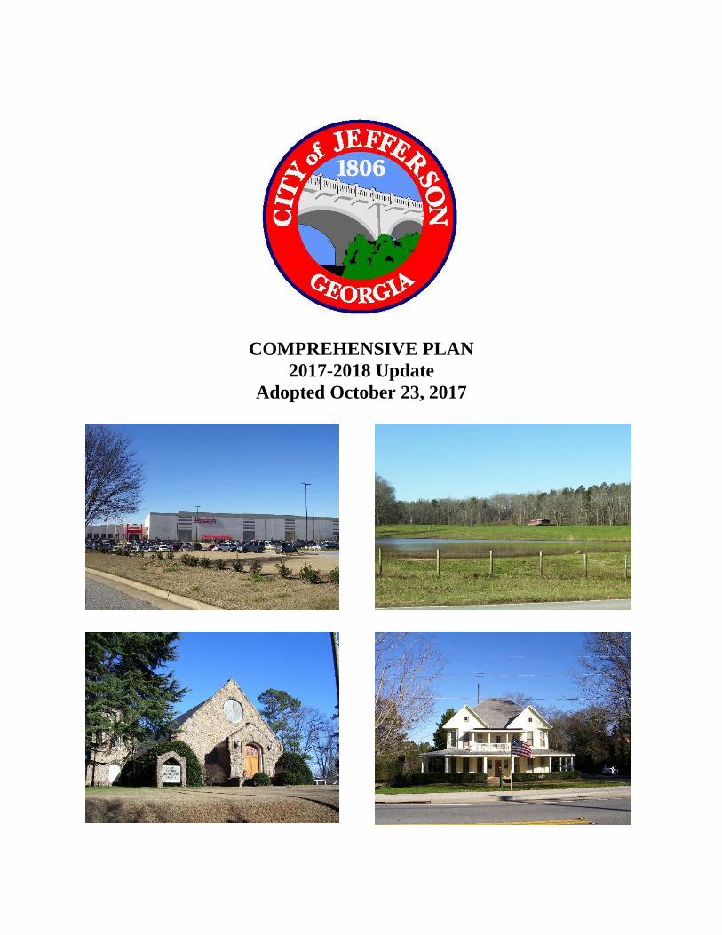
COMPREHENSIVE PLAN
2017-2018 Update
Adopted October 23, 2017
City of Jefferson, Comprehensive Plan, 2017-18 Update
2
Jefferson Mayor and City Council (2017)
Roy Plott, Mayor
Steve Kinney, District 1
Malcolm Gramley, District 2
Jon Howell, District 3
Mark Mobley, District 4
Don E. Kupis, District 5
Comprehensive Plan
Citizen Advisory Committee (2014)
Connie Bohanan
Dr. Doug Cleveland
Andy Garrison
Thomas Healan
Anita Jackson
Beth Jarrett
Linda Kirk
Samantha Loggins
Kristen Nations
Mark Starnes
Jefferson - Talmo Planning
Commission (2016)
Robert “Chip” McEver, III
Faye Griffin
Greg Laughinghouse
Brant McMullan
Robert Martin
Mark Starnes
Jefferson Historic Preservation Commission
Beth Jarrett
Hilda Johnson Smith
Len Strukie
Al Westmoreland
Traci Bledsoe
Jefferson Downtown
Development Authority
Terry Liles
Willie Hughey
Joel Harbin
Shawn Watson
Christine Dalton
Tracy Kerlin
Jefferson Industrial Development Authority
Ron Bond, Chairman
Steve Adams
Tommy Healan
Gus Johnson
Elizabeth Leigh
Roy Stowe
Ed Thompson
Jefferson Heritage Tree Council
Susan Russell
Sally Stites
Mary Dugan
Joseph A. Franco, III
Greg Pittman
Sam Ingram
Jean V. Ortowski
Joe S. Ortowski
City of Jefferson, Comprehensive Plan, 2017-18 Update
3
Jefferson Park and Recreation
Advisory Board
Brantley Porter
Chad Klinck
Tommy Knight
Tony Webb
Brandy Corbett
Kim Navas
Jefferson Housing Authority
Joni Patrick
Betty Shelton
J.T. Hughey
Jill Southerland
Joe Ogletree
Lisa Sluder
City of Jefferson Key Staff
Priscilla A. Murphy, City Manager
Danny Atkins, Planning and Zoning Administrator
Laura Gentle, Jefferson Public Library
Mark H. Duke, Fire Chief
Michele Head, Civic Center Manager
Jeff Killip, PE, Director of Public Works
Beth Laughinghouse, Director, Main Street Jefferson
Fenton Morris, Director, Parks and Recreation
Amie Pirkle, Director, Finance Department
Vicki Starnes, Director, Crawford Long Museum
Joe Wirthman, Police Chief
Northeast Georgia Regional Commission Staff
Justin Crighton, Planner
Kenny Gilbert, GIS Planner
Nina Kelly, AICP, Project Manager
Theresa Owen, Planner
Planning Consultant
Jerry Weitz, FAICP
Geographic Information Systems Support
Joel Logan, GISP
Jackson County GIS Department
City of Jefferson, Comprehensive Plan, 2017-18 Update
4
TABLE OF CONTENTS
CHAPTER 1. INTRODUCTION AND OVERVIEW 6
PLANNING HISTORY IN A NUTSHELL 6
PURPOSE 7
PLANNING REQUIREMENTS 7
Community Goals 8
Needs and Opportunities 8
Community Work Program 8
Capital Improvements Element 8
Land Use Element 8
Other Elements 8
PUBLIC INVOLVEMENT 9
Northeast Georgia Regional Commission’s Role 9
Public Input and Citizens Advisory Committee 9
PLANNING CONTEXT 10
CHAPTER 2. NEEDS AND OPPORTUNITIES 11
DOWNTOWN 11
PARKS AND GREENSPACE 12
INFRASTRUCTURE 12
NEW DEVELOPMENT 13
INFILL DEVELOPMENT 14
ADDITIONAL NEEDS 14
CHAPTER 3. VISION, GOALS, AND COMMUNITY POLICIES 18
VISION STATEMENT 18
GOALS AND IMPLEMENTATION TECHNIQUES 18
COMMUNITY POLICIES 20
Annexation 20
Natural Resources and the Environment 20
Economic Development 23
Housing 23
Community Facilities and Services 24
Transportation 25
Land Use 26
CHAPTER 4. LAND USE ELEMENT 29
SUMMARY OF EXISTING LAND USE AND ZONING ALLOCATION 29
REQUIREMENTS FOR LAND USE ELEMENTS 30
FUTURE LAND USE 31
Park/ Recreation/ Conservation 31
City of Jefferson, Comprehensive Plan, 2017-18 Update
5
Agriculture/ Forestry 31
Residential, Estate 33
Residential, Low Density 33
Residential, Medium Density 33
Residential, Multi-Family 33
Public Institutional 34
Office-Professional 34
Adaptive Reuse of Single-family Residence 34
Mixed-use Building 35
Commercial 35
Downtown Business District 35
Industrial 36
Transportation/ Communication/ Utilities 36
ENVIRONMENTAL OVERLAYS 36
Wetlands Protection 36
Groundwater Recharge Areas 36
Curry Creek Reservoir Protection 37
Protected River 37
OTHER OVERLAYS 37
Historic Districts 37
U.S. Highway 129 Overlay District 37
Redevelopment Subareas 40
ADDITIONAL SPECIAL AREAS 42
Proposed Parks Creek Reservoir and Watershed 42
Old Mill Village 43
Interstate 85 Exit 140 (SR 82/Dry Pond Road) 43
CHAPTER 5. COMMUNITY WORK PROGRAM 43
CHAPTER 6. CAPITAL IMPROVEMENTS ELEMENT FOR PARKS AND
RECREATION
47
SERVICE AREA 47
LAND USE ASSUMPTIONS 47
LEVEL OF SERVICE 48
Adopted Level of Service Standards 48
Inventory 48
Existing Levels of Service 49
PROJECTION OF NEEDS 50
SCHEDULE OF IMPROVEMENTS 51
EXEMPTIONS FROM PAYING IMPACT FEES 52
City of Jefferson, Comprehensive Plan, 2017-18 Update
6
CHAPTER 1
INTRODUCTION AND OVERVIEW
PLANNING HISTORY IN A NUTSHELL
The City of Jefferson was incorporated in
1806. The city’s original town plan consisted
of thirty lots plus the square and was modeled
after that of Sparta, Georgia. Early planning
efforts emphasized historic preservation. Prior
to the Georgia General Assembly’s passage of
the Georgia Planning Act of 1989, in 1986
Jefferson adopted a historic preservation
ordinance establishing a Historic Preservation
Commission pursuant to the Georgia Historic
Preservation Act. That same year, the City of
Jefferson became a Certified Local
Government (CLG), and in 1987 it adopted
ordinances designating six local historic
districts.
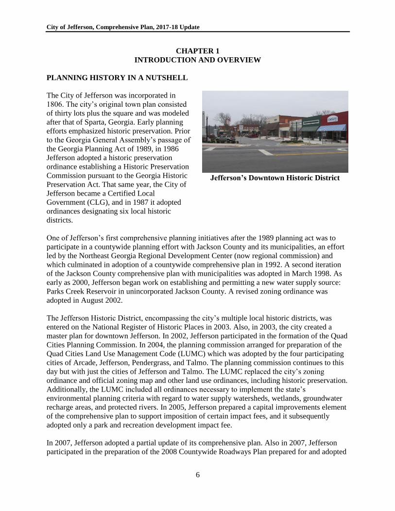
Jefferson’s Downtown Historic District
One of Jefferson’s first comprehensive planning initiatives after the 1989 planning act was to
participate in a countywide planning effort with Jackson County and its municipalities, an effort
led by the Northeast Georgia Regional Development Center (now regional commission) and
which culminated in adoption of a countywide comprehensive plan in 1992. A second iteration
of the Jackson County comprehensive plan with municipalities was adopted in March 1998. As
early as 2000, Jefferson began work on establishing and permitting a new water supply source:
Parks Creek Reservoir in unincorporated Jackson County. A revised zoning ordinance was
adopted in August 2002.
The Jefferson Historic District, encompassing the city’s multiple local historic districts, was
entered on the National Register of Historic Places in 2003. Also, in 2003, the city created a
master plan for downtown Jefferson. In 2002, Jefferson participated in the formation of the Quad
Cities Planning Commission. In 2004, the planning commission arranged for preparation of the
Quad Cities Land Use Management Code (LUMC) which was adopted by the four participating
cities of Arcade, Jefferson, Pendergrass, and Talmo. The planning commission continues to this
day but with just the cities of Jefferson and Talmo. The LUMC replaced the city’s zoning
ordinance and official zoning map and other land use ordinances, including historic preservation.
Additionally, the LUMC included all ordinances necessary to implement the state’s
environmental planning criteria with regard to water supply watersheds, wetlands, groundwater
recharge areas, and protected rivers. In 2005, Jefferson prepared a capital improvements element
of the comprehensive plan to support imposition of certain impact fees, and it subsequently
adopted only a park and recreation development impact fee.
In 2007, Jefferson adopted a partial update of its comprehensive plan. Also in 2007, Jefferson
participated in the preparation of the 2008 Countywide Roadways Plan prepared for and adopted
City of Jefferson, Comprehensive Plan, 2017-18 Update
7
by Jackson County. That roadway plan represents the most updated transportation planning
effort for the county as a whole, and includes projects in the city of Jefferson.
Jefferson adopted a stand-alone comprehensive plan (Community Agenda) in 2008, which
established both character areas and future land use categories to guide zoning decisions. In
August 2010, the future land use plan map and text was refined and readopted. Also that year, a
Sustainable Community Forest Master Plan was prepared for the city. In 2012, Jefferson engaged
in a “boomtown” planning effort, working with local stakeholders and staff of the Georgia
Department of Community Affairs to conceptualize the redevelopment of several properties. An
urban redevelopment plan (URP) was prepared and adopted November 26, 2012, and an
amendment to the URP was adopted on January 28, 2013. Adopting an urban redevelopment
plan pursuant to applicable state law is now a threshold criterion for accessing certain state
economic development incentives, and to be eligible for higher state job tax credits and more
competitive scoring on Community Development Block Grant (CDBG) applications. The Urban
Redevelopment Area (URA) includes three subareas: Downtown, Gateway Corridors, and
Industrial Zone. Opportunity Zone (OZ) designation was then sought for eligible areas within the
URA.
In 2014, the Northeast Georgia Regional Commission updated Jefferson’s comprehensive plan.
In 2016 and 2017, a strategic plan for the downtown was prepared.
PURPOSE
This comprehensive plan, initially updated for the City of Jefferson by the Northeast Georgia
Regional Commission in 2014, serves as a guide for local government officials and community
leaders for making decisions in support of the community’s stated vision. Based on input from
the public and a Citizens Advisory Committee, the plan identifies needs and opportunities for the
community, as well as goals for the city’s future, and policies that provide guidance and
direction for achieving these goals. The plan also offers insight into what types of land use and
development are appropriate in the City of Jefferson. A community work program is included
that specifies a route for working towards implementation of the plan. In addition, this
comprehensive plan includes a capital improvements element to qualify the City of Jefferson to
continue charging parks and recreation impact fees.
This comprehensive plan should be used as a guide by the local government for assessing land
development and subdivision proposals, rezoning and conditional use applications, and
redevelopment plans. Residents, business owners, and developers may consult the plan as well to
learn about appropriate land use, development, and the trajectory of growth for the City of
Jefferson. Essentially, the plan seeks to answer the questions: Where are we?, Where do we want
to be?, and, How will we get there?
PLANNING REQUIREMENTS
The Comprehensive Plan must comply with substantive and procedural requirements specified in
the Rules of the Georgia Department of Community Affairs (“DCA”), O.C.G.A. Chapter 110-
12-1, Minimum Standards and Procedures for Local Comprehensive Planning, effective March
City of Jefferson, Comprehensive Plan, 2017-18 Update
8
1, 2014. The following elements of the comprehensive plan are required for the City of
Jefferson:
Community Goals
Through public and committee meetings, the City’s vision, goals, and policies were developed to
determine the community’s future direction. As a part of this component, policies were identified
to assist in making decisions that are consistent with community goals. Additionally, focused
areas of planning with special conditions or needs were defined, which help determine those
parts of the community that are to be enhanced or preserved, and how to guide zoning and land
use policies in the future.
Needs and Opportunities
An analysis of the community’s needs and opportunities is required. This analysis assisted the
community in identifying the issues that it needs to address and the opportunities on which it can
capitalize.
Land Use Element
A land use element is required because the City of Jefferson has adopted zoning regulations.
Community Work Program
The Community Work Program provides specific actions for achieving the community’s goals
and implementing its plans. The work program includes a five-year (short term) work program
identifying specific actions needed to implement the city’s comprehensive plan.
Capital Improvements Element
A capital improvements element is required for the City of Jefferson because it has adopted a
park and recreation impact fee program. Accordingly, in addition to the local planning
requirements as revised and made effective January 1, 2014, this comprehensive plan update is
required to follow Rules of the Georgia Department of Community Affairs, Chapter 110-12-2,
Development Impact Fee Compliance Requirements, effective May 1, 1997.
Other Elements
Although not referred to as an “element” per se, local planning requirements require that, during
the process of preparing its comprehensive plan, each community must review the regional water
plan(s) covering its area and the Rules for Environmental Planning Criteria (established and
administered by the Department of Natural Resources pursuant to O.C.G.A. 12-2-8) to determine
if there is any need to adapt local implementation practices or development regulations to
address protection of these important natural resources. The community must certify that it has
considered both the regional water plan and the Rules for Environmental Planning Criteria when
it transmits the plan to the Regional Commission for review.
City of Jefferson, Comprehensive Plan, 2017-18 Update
9
Additional elements that may (but are not required to) be included in the comprehensive plan, at
the option of the local government, are a housing element, an economic development element,
and a transportation element.
PUBLIC INVOLVEMENT
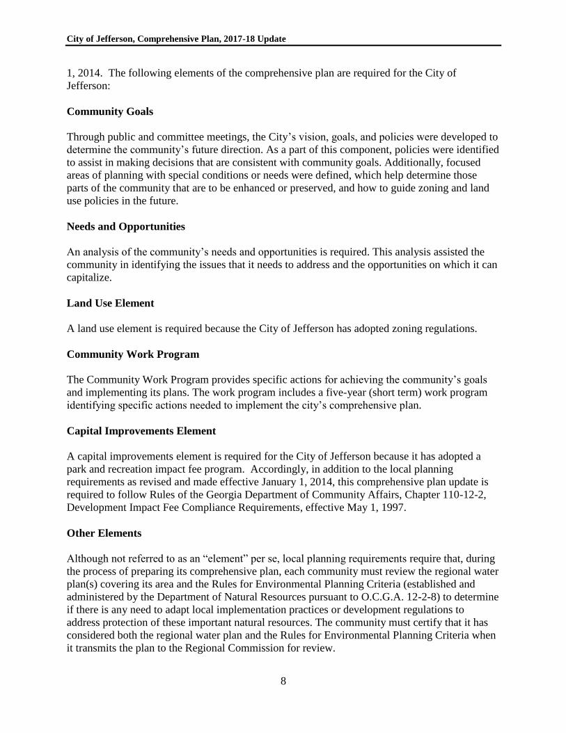
Northeast Georgia Regional Commission’s
Role
The Northeast Georgia Regional
Commission’s (NEGRC’s) planning and local
government services division facilitated the
2014 update of Jefferson’s plan. Leading
community input sessions and citizen advisory
committee meetings, the NEGRC team
gathered feedback and guidance from the
public and used that information to assemble
the comprehensive plan and make
recommendations that are reflective of the
community’s desires. The Mayor and City
Council hold ultimate responsibility and
authority to approve and direct the
implementation of the comprehensive plan.
Public Input was facilitated by Regional
Commission Staff (2014)
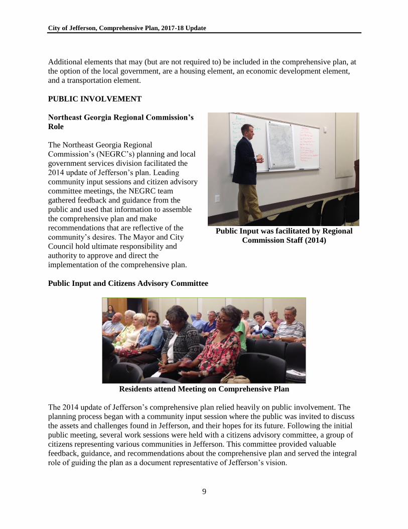
Public Input and Citizens Advisory Committee
Residents attend Meeting on Comprehensive Plan
The 2014 update of Jefferson’s comprehensive plan relied heavily on public involvement. The
planning process began with a community input session where the public was invited to discuss
the assets and challenges found in Jefferson, and their hopes for its future. Following the initial
public meeting, several work sessions were held with a citizens advisory committee, a group of
citizens representing various communities in Jefferson. This committee provided valuable
feedback, guidance, and recommendations about the comprehensive plan and served the integral
role of guiding the plan as a document representative of Jefferson’s vision.
City of Jefferson, Comprehensive Plan, 2017-18 Update
10
Public Input During the Downtown Planning Process
In 2016, Jefferson sought and received partial funding from the Renaissance Strategic Visioning
& Planning (RSVP) Program to prepare a downtown strategic plan for the city’s downtown. In
preparing the downtown plan, in 2016 and 2017, staff of the Carl Vinson Institute of
Government at the University of Georgia completed an extensive public participation effort,
including a questionnaire that received more than 800 responses, 14 focus groups, interviews
with more than 20 individuals, and a community-wide town hall meeting.
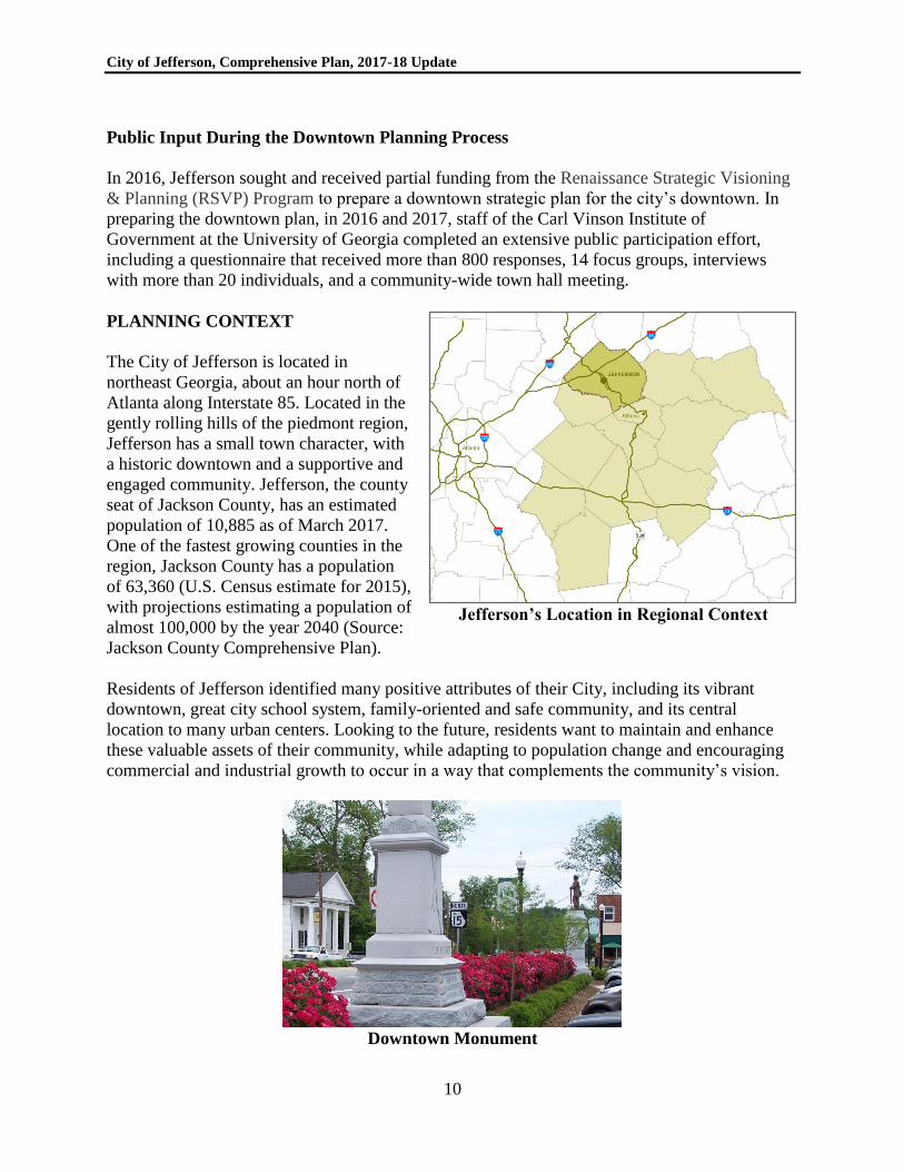
PLANNING CONTEXT
The City of Jefferson is located in
northeast Georgia, about an hour north of
Atlanta along Interstate 85. Located in the
gently rolling hills of the piedmont region,
Jefferson has a small town character, with
a historic downtown and a supportive and
engaged community. Jefferson, the county
seat of Jackson County, has an estimated
population of 10,885 as of March 2017.
One of the fastest growing counties in the
region, Jackson County has a population
of 63,360 (U.S. Census estimate for 2015),
with projections estimating a population of
almost 100,000 by the year 2040 (Source:
Jackson County Comprehensive Plan).
Jefferson’s Location in Regional Context
Residents of Jefferson identified many positive attributes of their City, including its vibrant
downtown, great city school system, family-oriented and safe community, and its central
location to many urban centers. Looking to the future, residents want to maintain and enhance
these valuable assets of their community, while adapting to population change and encouraging
commercial and industrial growth to occur in a way that complements the community’s vision.
Downtown Monument
City of Jefferson, Comprehensive Plan, 2017-18 Update
11
CHAPTER 2
NEEDS AND OPPORTUNITIES
The needs and opportunities presented in this chapter were prepared as part of the 2014
comprehensive plan update. They are divided into five categories: Downtown, Parks and
Greenspace, Infrastructure, New Development, and Infill and Redevelopment. The list was
compiled from needs and opportunities identified by the citizens advisory committee, during the
public input session, and from the 2008 Comprehensive Plan. The list was also supplemented
with additional needs identified in 2015 and 2016.
DOWNTOWN
Needs
a. Downtown needs a consistent design, with unifying elements that are attractive and
inviting to residents and visitors.
b. A pedestrian-friendly environment is needed downtown, especially in the square.
c. An increase in walkability between downtown and surrounding residential neighborhoods
is needed.
d. In order to attract people to live in downtown, housing opportunities and amenities are
needed to serve these potential residents. Amenities should include basic services and
businesses such as a hardware store and a drug store.
e. Tenants are needed to fill empty stores located downtown. A business recruitment and
retention strategy is needed. More variety of downtown retail options are needed.
f. Later hours (beyond 5:00 PM) are needed for businesses in downtown in order to attract
people with ongoing activity into the evening.
g. An outdoor music venue is needed downtown.
Opportunities
a. As the county seat, people are drawn to downtown Jefferson to conduct business or for
administrative and personal purposes. If these people felt inclined to linger downtown,
businesses would have the potential to capitalize on these visitors.
b. The Crawford W. Long Museum has the potential to offer a space for cultural activities,
events, and programs. With rotating exhibits, the museum could serve as a link to other
museums across the country.
c. The Opportunity Zone designation in downtown should be utilized as a tool for attracting
businesses.
d. Redevelopment of the old motel/post office block and 55 College Street offers an
opportunity.
e. A community event space could be developed on the lot rented by Regions Bank (one
block off of the downtown square) for music events and possibly a farmers’ market.
f. Jefferson’s community is supportive and engaged and there are active volunteer groups.
There is an opportunity to develop community pride and activism among new and
existing residents.
g. The County is camera-ready, meaning the support for film and TV production is in place.
City of Jefferson, Comprehensive Plan, 2017-18 Update
12
PARKS AND GREENSPACE
Needs
a. Dog parks are needed in Jefferson.
b. More opportunities for recreation, such as an aquatic center, are needed.
c. A strategy for ensuring that parks are a safe environment is needed, and should include
items such as surveillance and lighting.
d. Tree canopy in downtown and throughout Jefferson for shade and aesthetic value is
valued and planting of trees should continue.
e. Connectivity between park spaces is needed.
Opportunities
a. An expansion of the park in front of the Civic Center is possible and desirable.
b. There is space for a park near Regions Bank on Gordon Street. With its accessibility to
downtown, this could be a good space for an amphitheater.
c. The Club House Park, near the stadium, could provide a great community resource if
developed.
d. As a Tree City USA designation, Jefferson should take advantage of the incentives and
benefits that come with this program.
INFRASTRUCTURE
Needs
a. Rehabilitation of the sewer system and stormwater system is needed.
b. Wi-Fi is needed in downtown in order to serve the needs of residents, businesses, and
visitors. Jefferson’s limited internet connectivity makes it difficult to attract employers in
emerging sectors that require fast and reliable access. Attracting these employers is
critical to diversifying employment options for residents.
c. Jefferson needs to become “wired-in,” with wireline internet connectivity and better
internet speeds and capacity.
d. Multi-use trails are needed in Jefferson.
e. Sidewalks are needed to connect downtown and surrounding subdivisions.
f. Bike-specific facilities are needed in Jefferson.
g. A safe way to cross the bypass by foot is needed in Jefferson.
h. Traffic needs to be addressed, specifically in the east-west direction downtown and
around Jefferson’s schools during drop-off and pick-up times.
i. Improvement in intergovernmental coordination and communication to address
jurisdictional issues is needed.
j. People lack transportation choices for access to housing, jobs, services, goods, health care
and recreation. For most residents, the automobile is the only choice in Jefferson.
City of Jefferson, Comprehensive Plan, 2017-18 Update
13
Opportunities
a. A large cycling community is present in Jefferson.
b. The proximity of the Jackson County airport offers an opportunity to Jefferson.
c. While conducting utility work, Jefferson should consider a “Dig Once” policy, to
encourage the simultaneous placement of conduit/dark fiber.
d. By strengthening its technological resources, Jefferson can attract new business.
NEW DEVELOPMENT
Needs
a. A cultural arts center is needed in Jefferson.
b. A movie theatre is needed in Jefferson.
c. Overnight accommodation is needed in Jefferson.
d. A plan is needed for the 129 bypass that should include guidelines for development.
e. Housing for elderly and other niche groups that is accessible to downtown and amenities
is needed.
f. Guidelines are needed to help determine where large retail stores can be located.
g. Redevelopment at the Dry Pond Road exit is needed.
h. There is a need to address growth through design guidelines such as sign ordinances.
i. With new residential development impacting the rural environment and small town
appeal of Jefferson, an effort to support greenspace preservation is needed. Conservation
subdivisions, set-asides in new development, and other land conservation techniques can
help offset the negative impacts of growth.
j. Land use in the water supply watershed, including both the city and county, should be
subject to restrictions that protect the city’s water supply.
k. Additional growth in single family housing is expected over the next decade. It is
important to ensure a balanced mix of housing types as the City grows.
l. The City should update its design guidelines to ensure that new development is attractive,
enduring, and of high quality.
Opportunities
a. The Dry Pond Road exit (#140 Interstate 85 interchange) is currently under-developed
and offers an opportunity for new businesses. See discussion under “special areas” in
Chapter 4).
b. There is room for industrial development north of the 129 Bypass and south of
downtown.
c. Space is available for new residential development in many areas around Jefferson. With
a good school system and family-oriented community present in Jefferson, new residents
can be attracted.
City of Jefferson, Comprehensive Plan, 2017-18 Update
14
INFILL DEVELOPMENT
Needs
a. Mike’s Grill Restaurant space needs to be rehabilitated for reuse.
b. There are multiple redevelopment needs along Highway 11 near Crow’s Lake.
c. Areas at the intersection of Washington St. and Lee St. need to be rehabilitated and/or
redeveloped.
d. Gateway signage is needed to indicate the Jefferson City limits.
e. Façade improvements are needed in downtown.
Opportunities
a. There is an opportunity for mixed-use development at the old motel site in downtown.
b. Pendergrass House can be rehabilitated and reused.
c. There is an opportunity for infill and redevelopment in the mill village, similar to the
Boulevard neighborhood in Athens.
d. Jefferson’s established Main Street and Downtown Development Authority programs
offer an opportunity to assist with redevelopment of downtown structures.
e. The “renovate and sell” program through the Downtown Development Authority should
continue to be pursued.
f. Financial tools, such as the Downtown Development Revolving Loan Fund, are available
to assist with the redevelopment of downtown Jefferson.
g. Jefferson should promote the incentives offered by the designated Opportunity Zone to
attract employers in all sectors.
ADDITIONAL NEEDS
This section summarizes additional needs identified in 2015 and 2016:
a. Annexation Plan. Due in large part to the success and excellent reputation of Jefferson
city schools, residential developers are seeking annexation into the city. If annexations
continue to occur, the city school system may have difficulty providing school capacity.
The city may get pressured to annex properties further and further away from the center,
spreading other service demands over an ever-broadening service area. It is in the city’s
best interest to begin to define the outer edges of what may constitute the city’s ultimate
annexation area, so as to notify property owners the areas within which the city is likely
or unlikely to annex. Presently, the city’s focus should be on “filling in” unincorporated
areas within the existing extent of the city limits, rather than extending out further beyond
that existing extent.
b. Sanitary Sewer Capacity Monitoring. As new industrial developments and residential
subdivision proposals accelerate, it is becoming increasingly important for the city to
monitor available capacity in its sewage treatment plant, spray irrigation field, and the
City of Jefferson, Comprehensive Plan, 2017-18 Update
15
collection network, especially major interceptor sewer lines. The city will need to
program additional funding or engage staff in a study of these facilities and evaluate them
in light of anticipated developments which generate demands on the system.
c. Curry Creek Water Supply Watershed Monitoring. In 2007, the city solicited a study
by the University of Georgia River Basin Center (completed in 2008) on the amount of
impervious surface that may result in the Curry Creek water supply watershed under
buildout conditions. Because the watershed over the longer term, at buildout conditions,
is likely to meet or exceed the maximum limit of 25% impervious established by state
environmental planning criteria, periodic monitoring of watershed imperviousness is
needed.
d. Parks Creek Reservoir Management Plan. The city has acquired land for the Parks
Creek water supply reservoir in unincorporated Jackson County. Prior to operation the
city will need to prepare and adopt a reservoir management plan in accordance with
Georgia Administrative Rule 391-3-16-.01, Criteria for Water Supply Watersheds,
Section 8.
e. Parks Creek Reservoir Watershed Protection. Because the watershed of Parks Creek
Reservoir lies in unincorporated Jackson County, the city should seek Jackson County’s
adoption in its unified development code of watershed protection criteria as required by
Georgia Administrative Rule 391-3-16-.01, Criteria for Water Supply Watersheds.
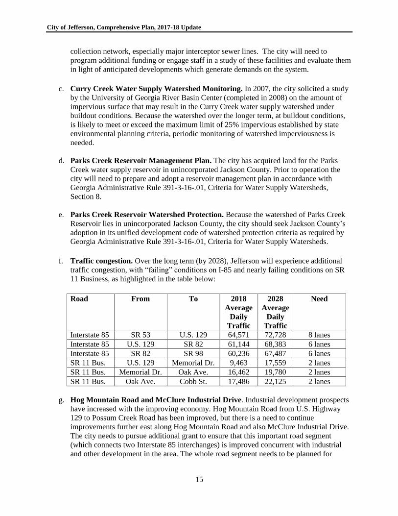
f. Traffic congestion. Over the long term (by 2028), Jefferson will experience additional
traffic congestion, with “failing” conditions on I-85 and nearly failing conditions on SR
11 Business, as highlighted in the table below:
Road From To 2018
Average
Daily
Traffic
2028
Average
Daily
Traffic
Need
Interstate 85 SR 53 U.S. 129 64,571 72,728 8 lanes
Interstate 85 U.S. 129 SR 82 61,144 68,383 6 lanes
Interstate 85 SR 82 SR 98 60,236 67,487 6 lanes
SR 11 Bus. U.S. 129 Memorial Dr. 9,463 17,559 2 lanes
SR 11 Bus. Memorial Dr. Oak Ave. 16,462 19,780 2 lanes
SR 11 Bus. Oak Ave. Cobb St. 17,486 22,125 2 lanes
g. Hog Mountain Road and McClure Industrial Drive. Industrial development prospects
have increased with the improving economy. Hog Mountain Road from U.S. Highway
129 to Possum Creek Road has been improved, but there is a need to continue
improvements further east along Hog Mountain Road and also McClure Industrial Drive.
The city needs to pursue additional grant to ensure that this important road segment
(which connects two Interstate 85 interchanges) is improved concurrent with industrial
and other development in the area. The whole road segment needs to be planned for

City of Jefferson, Comprehensive Plan, 2017-18 Update
16
improvement in conjunction with Jackson County, since part of the road lies outside the
city limits, and because Jackson County has been responsible for maintenance.
h. Jefferson East Bypass. The 2008-2028 Countywide Roadways Plan, prepared by
Moreland Altobelli Associates for Jackson County, calls for a proposed Jefferson East
Bypass as a potential roadway improvement to enhance connectivity. This project was
mentioned in focus groups several times during preparation of the roadways plan. The
plan also finds that as traffic congestion increases in Jefferson, it may be prudent to plan
and construct an east by-pass around Jefferson. According to the plan, the potential route
suggested by the City of Jefferson for an east by-pass was possibly beginning at Galilee
Church Road at its intersection with US 129 Business/SR 15, to Canter Way,
circumventing Jefferson’s wastewater treatment facility, crossing Brockton Road (SR
335) and connecting to SR 82. The length of that proposed new roadway on new location
would be 2.73 miles. The estimated cost of this project in 2008 dollars was $13.3 million.
It was considered the #3 priority in the plan’s list of new roadway projects.
i. Jackson County Airport Connector. Another major road project in the 2008-2028
Countywide Roadways Plan is the proposed road connecting Jackson County Airport to
the Interstate 85/SR 82 interchange. The roadways plan indicates that the Jackson County
Board of Commissioners established the 2008 Economic Development Bond Program
which included a proposed connector road providing access between the Jackson County
Airport and the existing I-85/SR 82 interchange. The two southern termini of the
proposed connector route would begin at both the SR 82/Lyle Field Road intersection and
the SR 82/Airport Road intersection and proceed northwesterly through the McClure
Industrial Park and intersecting with Dry Pond Road (Hog Mountain Road) at a new
intersection to be built just south of the current Dry Pond Road (Hog Mountain Road)/Jett
Roberts Road intersection. From that new intersection, the proposed Airport Connector
would continue northwesterly and tie into the existing SR 82 just south of the I-85
northbound off and on ramps. The length of the proposed Airport Connector would be
1.90 miles and with the proposed intersection and side road improvements would total
2.17 miles in length.
j. Implementation of the Sustainable Community Forest Master Plan. This plan,
developed in 2010, includes a detailed work program. The city needs to pursue
implementation of that plan.
k. Firewise Plan Implementation. Jefferson is pursuing becoming a “Firewise”
community. To that end, the Georgia Forestry Commission in January 2016 prepared a
Firewise Action Plan for wildfire mitigation and the protection against structural
ignitibility in the wildland-urban interface. The city needs to fully implement this plan,
including mitigating risks, providing public education, and establishing “defensible
space” around structures.
City of Jefferson, Comprehensive Plan, 2017-18 Update
17
CHAPTER 3
VISION, GOALS, AND COMMUNITY POLICIES
Per state administrative rules, the goals or policies established in the comprehensive plan are the
most important component. The community goals component of the comprehensive plan is
required to incorporate at least one of the following: general vision statement; list of community
goals; community policies; and character areas and defining narrative. After careful
consideration of these options, it was decided that the 2016 plan update should retain the general
vision statement developed for the 2008 comprehensive plan, include basic goals, and emphasize
community policies as an instrument to guide land use and investment policy in Jefferson. This
chapter contains a general vision statement, a set of general goals with implementation
techniques, and a detailed set of community policies divided into the following categories:
annexation; natural resources and the environment; economic development; housing; community
facilities and services; transportation; and land use.
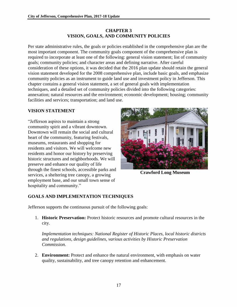
VISION STATEMENT
“Jefferson aspires to maintain a strong
community spirit and a vibrant downtown.
Downtown will remain the social and cultural
heart of the community, featuring festivals,
museums, restaurants and shopping for
residents and visitors. We will welcome new
residents and honor our history by preserving
historic structures and neighborhoods. We will
preserve and enhance our quality of life
through the finest schools, accessible parks and
services, a sheltering tree canopy, a growing
employment base, and our small town sense of
hospitality and community.”
Crawford Long Museum
GOALS AND IMPLEMENTATION TECHNIQUES
Jefferson supports the continuous pursuit of the following goals:
1. Historic Preservation: Protect historic resources and promote cultural resources in the
city.
Implementation techniques: National Register of Historic Places, local historic districts
and regulations, design guidelines, various activities by Historic Preservation
Commission.
2. Environment: Protect and enhance the natural environment, with emphasis on water
quality, sustainability, and tree canopy retention and enhancement.
City of Jefferson, Comprehensive Plan, 2017-18 Update
18
Implementation techniques: Environmental regulations, land development regulations,
critical area plans and regulations.
3. Housing: Protect neighborhoods and promote diverse and affordable housing that meets
the needs of existing and future city residents.
Implementation techniques: Residential zoning districts, subdivision regulations,
community development plans, neighborhood improvement plans and programs, housing
code enforcement.
4. Economic Development and Redevelopment: Grow the economy, increase local
employment, increase personal incomes, and reduce poverty.
Implementation techniques: Economic development planning, urban redevelopment
planning, business recruitment and retention strategies, inventories of available
properties and buildings, downtown development authority activities, main street
program, community development.
5. Community Facilities and Services: Accommodate existing and anticipated population
and employment with public facilities, including public schools, parks, roads, water,
sewer, public safety, that meet local level of service standards.
Implementation techniques: Public facility master plans, capital improvement
programming, facility requirements in land use regulations, monitoring of facility
capacities, and development impact fees.
6. Transportation: Provide mobility, safety, and connectivity via a multi-modal
transportation system, with emphasis on improving the pedestrian network, adding bike
lanes to the existing network, and developing multi-use trails.
Implementation techniques: Transportation planning, capital improvement programming,
access control and other transportation requirements in land use regulations.
7. Land Use: Promote and ensure efficient, functional and compatible land use patterns.
Implementation techniques: Zoning, subdivision, land development and other land use
controls, small area refinement plans, design guidelines.
8. Urban Design and Livability: Improve the functionality and attractiveness of
downtown, gateway corridors, and neighborhoods in the city.
Implementation techniques: Land use controls, small area refinement plans, design
guidelines.
9. Intergovernmental Coordination: Cooperate with all other levels of government in the
pursuit of shared goals, policies and objectives.
City of Jefferson, Comprehensive Plan, 2017-18 Update
19
Implementation techniques: Countywide service delivery strategy; annexation and land
use dispute resolution processes, intergovernmental agreements.
COMMUNITY POLICIES
Annexation
The following annexation policies should be evaluated and considered when the city receives an
annexation request:
1. City and county plan consistency. Annexation and subsequent development should be
in compliance with the county’s comprehensive plan and, to the extent it may be
addressed, the city’s comprehensive plan.
2. Development compliance. The land uses (existing or proposed) of the area to be
annexed should comply with the city’s land use management code. Existing and proposed
uses and development standards for areas considered for annexation should be consistent
with adopted city standards.
3. Facilities and services. The city should have the capacity to provide the full range of
urban services (public safety, water, sewer, schools, etc.) to newly annexed areas in a
timely and efficient manner without reducing the level of those services to other city
residents and businesses. This includes consideration of whether the area to be annexed is
within the city’s recognized water and sewer service area or is a logical, reasonable, and
efficient extension thereof. Consideration should be given to the availability of land
within the city for the uses which would be developed upon annexation, encouraging
infilling of existing undeveloped areas before extending services which allow similar
development in peripheral areas unless there is a benefit to the community at large. The
city should also consider the relative gain or cost to the city, if annexed, balanced in the
context of the gain to the property owner.
4. County requests denied. The request should not be the result of an applicant seeking
relief by the city due to the filing of a request with Jackson County which was denied by
the county.
Natural Resources and the Environment
1. Wetland Preservation and Mitigation. Preserve wetlands where they exist, or as a last
resort if they cannot be preserved on-site, mitigate wetland loss by increasing
ecologically equivalent wetlands on other appropriate sites (i.e., wetland mitigation
through wetland banking).
2. Wetland buffers. When a development proposal is located close to a wetland, it should
establish and maintain a minimum 50-foot wide protective buffer around the wetland.
City of Jefferson, Comprehensive Plan, 2017-18 Update
20
3. Wetlands – Review for Development Impacts. Any proposal for development
involving the alteration of, or an impact on, wetlands should be evaluated according to
the following (based on Ga. DNR Rule 391-3-16-.03):
Whether impacts to an area would adversely affect the public health, safety, welfare,
or the property of others.
Whether the area is unique or significant in the conservation of flora and fauna
including threatened, rare, or endangered species.
Whether alteration or impacts to wetlands will adversely affect the function, including
the flow or quality of water, cause erosion or shoaling, or impact navigation.
Whether impacts or modification by a project would adversely affect fishing or
recreational use of wetlands.
Whether an alteration or impact would be temporary in nature.
Whether the project contains significant State historical and archaeological resources,
defined as “Properties On or Eligible for the National Register of Historic Places.”
Whether alteration of wetlands would have measurable adverse impacts on adjacent
sensitive natural areas.
Where wetlands have been created for mitigation purposes under Section 404 of the
Clean Water Act, such wetlands shall be considered for protection.
4. Environmental Planning Criteria. Adopt and maintain zoning and land development
regulations that implement the Georgia Department of Natural Resources’ Rules for
Environmental Planning Criteria, including water supply watersheds, groundwater
recharge areas, and protected river corridors.
5. Floodways and Floodplains. Prohibit development within floodways and restrict or
prohibit development in flood plains. If development within flood plains is allowed, flood
plain storage should not be decreased from its present state. In no event should
development be permitted that inhibits the flow of floodwaters. Consider future
conditions floodplain data, where available or where it can be generated.
6. National Flood Insurance Program. Continue to participate in the National Flood
Insurance Program. Periodically amend the flood damage prevention/floodplain
management ordinance to comply with changes to ordinances specified by the Federal
Emergency Management Agency.
7. Minimize Water Quality Impacts. The location and intensity of development should be
arranged so as to minimize the negative effects of that development on water quality,
both during and after construction. Major considerations concerning water quality should
include: organic pollution from infiltration and surface runoff; erosion and sedimentation;
water temperature elevation; nutrients such as nitrogen and phosphorous; and toxic
materials.
8. Stormwater Management and Best Management Practices. The Georgia Stormwater
Management Manual is adopted to implement best practices for water pollution control
and stormwater management, including but not limited to “low impact development”
City of Jefferson, Comprehensive Plan, 2017-18 Update
21
techniques such as biofilters (vegetated swales/strips), wet ponds, and constructed
wetlands. Design man-made lakes and stormwater ponds for maximum habitat value and
which will serve as amenities for the development. Sites should be designed where
possible to drain to the rear or side, where detention ponds are more appropriately
located. Fenced detention ponds in front yards are strongly discouraged if not prohibited
altogether. When stormwater detention or drainage is placed adjacent to the right-of-way,
slopes should be gentle enough to avoid fencing requirements, and the area should be
attractively landscaped. New, major residential subdivisions should be required to ensure
that adequate funding is available for maintenance of any non-public on-site stormwater
detention facilities.
9. Steep Slopes. Steep slopes (25% or more) should be set aside as conservation areas. No
lot should be created with more than 50 percent of its area containing steep slopes, and
lot subdividers should demonstrate that each lot has a suitable building envelope outside
steeply sloping areas. If a building site must be created with steep slopes, all buildings
and structures on such building sites should have foundations which have been designed
by a civil engineer or other qualified professional. When development must occur within
steeply sloping areas, site designers are also encouraged to propose and apply innovative
concepts for slope and soil stabilization, and limitations on grading.
10. Landscape Ecology and Habitat Protection. Consider habitat information in the review
of large land developments and major subdivisions, including but not limited to the
database of the DNR Natural Heritage Program, USFWS County Listing of Threatened
and Endangered Species, and the DNR Listing of Locations of Special Concern Animals,
Plants, and Natural Communities. Promote and pursue principles of landscape ecology
when reviewing large developments and major subdivisions.
11. Tree Protection. Encourage or require the planting of street trees in subdivisions and
new land developments. Restrict the cutting of trees, and require the replacement of trees
with trees of like species and value, or apply a tree canopy replacement strategy in lieu of
conventional tree replacement regulations.
12. Water Conservation. Promote the conservation of water by residents, businesses,
industries, and institutions, to meet local, regional, and state objectives or directives.
Participate in private and public educational efforts that are designed to assist in water
conservation.
13. Energy Efficiency. Reduce energy consumption through comprehensive planning and
urban design, and promote energy-efficient development. Support programs to increase
energy efficiency and reduce life-cycle costs of all construction projects, including public
and institutional projects. Develop and encourage appropriate applications of renewable
energy. Encourage LEED (Leadership in Energy and Environmental Design) certified
buildings.
14. Historic and Cultural Resources. The traditional character of the city should be
maintained through preserving and revitalizing historic areas of the community,
City of Jefferson, Comprehensive Plan, 2017-18 Update
22
encouraging new development that is compatible with the traditional features of the
community, and protecting other scenic or natural features that are important to defining
the city’s character.
15. Land Conservation Methods. Preferred methods for the permanent protection of
conservation lands as open space include dedication to a public entity (if dedication is
acceptable locally) and/or a conservation easement with management by an approved
land trust.
Economic Development
1. Generally. Expand the city’s economic base and increase employment opportunities
while protecting environmental, historic, and community character.
2. Comprehensiveness. Prepare economic development strategies and plans that are
comprehensive in nature, such that all economic activities are addressed, including but
not limited to agriculture and agribusiness, tourism, heritage tourism, health care, retail,
services, material moving and warehousing, biotechnology, industrial and manufacturing,
research and development, and small business/home occupations.
3. Infrastructure readiness. Provide and maintain sanitary sewer capacity and road
capacity in order to attract new industry and manufacturing and commercial activities.
Reserve such capacity for the types of industries and businesses that need the
infrastructure.
4. Business Climate. Create and maintain a positive climate for business in the city.
5. Balance of Interests. Balance the need to regulate the design and appearance of
commercial and other properties with a positive regulatory environment that is sensitive
to the need for businesses to be competitive in the marketplace.
Housing
1. Housing Opportunities. Quality housing and a range of housing size, cost, and density
should be provided in the city.
2. Life Cycle and Mixed Generation Communities. Encourage “life cycle” or “mixed
generation” communities that provide for persons of different age groups (including
seniors) to live in the same community as they age.
3. Housing for Persons with Disabilities. Avoid regulations and practices that would
discourage the provision of housing for persons with disabilities.
4. Design and Location of Senior and Disabled Housing. Houses should be made
available for seniors and disabled persons that contain a single-level with no-step
City of Jefferson, Comprehensive Plan, 2017-18 Update
23
entrances and wide doorways. Senior housing should be located in close proximity or
with appropriate access to health care services.
5. Substandard Housing. Require that substandard or dilapidated housing be brought up to
applicable codes or demolished if code compliance is not feasible.
6. Housing and Property Standards Codes. Allocate appropriate resources to enforce
housing and property maintenance codes.
7. State and Federal Housing and Community Development Programs. Pursue federal
and state financial assistance programs to improve areas of substandard housing and
improve low- and moderate-income neighborhoods.
Community Facilities and Services
1. Level of Service Standards. Establish and maintain level-of-service and/or performance
standards for the major community facilities and services provided by the county. Unless
specified by facility-specific master plans and adopted as superseding policy, the city
should strive to maintain the minimum level of service standards in Jackson County’s
2015 Comprehensive Plan, as adopted and as may be amended.
2. Long-term Water Supply. Continue to pursue plans for additional long-term sources of
water supplies, including the Parks Creek reservoir.
3. Contingency Plans for Water System. Contingency plans should be prepared for
dealing with major water line breaks, loss of water sources during drought, and other
possible damages to the water system such as flooding.
4. Sanitary Sewer. Manage water-borne waste by operating, maintaining, expanding, and
replacing components of the wastewater system to ensure uninterrupted collection,
transport, processing, and treatment. Convey all sanitary wastewater flows to the
treatment plant or site without bypassing flows into receiving waters and without causing
waste backups that store sanitary sewage on private properties.
5. Water and Sewer Service Areas. Delineate and adopt, and revise periodically as
appropriate as a part of the county’s service delivery strategy, water and sewer service
areas for the city as a municipal service provider. Revise service area boundaries when
necessary to account for municipal annexations.
6. Standard Construction Details and Specifications. Maintain and periodically update
standard construction specifications and standard drawings for water and sewer systems.
7. Emergency Preparedness. Periodically conduct, or participate in countywide efforts to
complete, community hazard vulnerability analyses to identify the types of environmental
extremes (e.g., floods, tornadoes, hurricanes, earthquakes), technological accidents (e.g.,
toxic chemical releases,), and deliberate incidents (e.g., sabotage or terrorist attack
City of Jefferson, Comprehensive Plan, 2017-18 Update
24
involving chemical, biological, radiological/ nuclear, or explosive/flammable materials)
to which the city may be exposed. Periodically review and revise the disaster
preparedness and emergency management plans based on such vulnerability analyses and
update them as appropriate. Seek improvements and pursue programs that will make the
city more resilient to natural and man-made disasters.
8. Schools. Consider the impacts of residential development on the city school system.
Where impacts are evident, seek to mitigate the impact of residential development on the
public school system.
Transportation
1. Modes. Promote development that serves the long-term cycling and walking needs of
residents of the city and that provides an appropriate amount of bicycle and pedestrian
infrastructure. Strong consideration will be given to proposals that provide integrated and
connected multi-modal transportation facilities.
2. Funding. Secure federal and state funding for transportation, where available, and
maximize the use of available financial resources to fund needed transportation
improvements.
3. Connectivity. All new roadways except low volume, local residential subdivision streets,
should connect at both termini with the existing road network. Local streets should be
planned where possible with more than one connection to the existing public road
network. Street stubs should be provided to ensure connectivity with future subdivisions
on abutting lands.
4. Context Sensitivity. Design planned roadway improvements in a way that is context
sensitive, preserves or creates a sense of place for the areas in vicinity of the
improvements, and that enhances community aesthetics. Add dedicated bike lanes to road
improvements where possible.
5. Traffic Routing. Ensure that vehicular traffic, especially truck traffic, will not be routed
into residential neighborhoods, so as to preserve the peace and quiet of residential
neighborhoods.
6. Access Management. Adopt and apply access management standards to control the
connections and access points of driveways and roads to public roadways.
7. Encroachment Prevention. Protect existing and future rights-of-way from building
encroachment.
8. Speed Limits. Establish posted speed limits for all city roadways and periodically
reevaluate and revise speed limits as may be needed based on existing road conditions,
such as functional classification, shoulder condition, road grade, adjacent land uses,
City of Jefferson, Comprehensive Plan, 2017-18 Update
25
frequency of driveway accesses, building setbacks, sight distances, geometric features of
the roadway, pedestrian activity, and historical crash data.
9. Land Development and Transportation. When development occurs it should be the
responsibility of developer to improve road and multi-modal transportation facilities
along the public street frontages and internal to the development.
10. Sidewalk Installation. New subdivisions need to provide sidewalks along streets internal
to the subdivision, and all subdivisions and land developments should provide sidewalks
within the right-of-way of public roadways abutting or fronting the subdivision or land
development.
11. On-site Circulation. Adopt and apply standards that ensure the safe and convenient flow
of vehicles, pedestrians, and where appropriate bicyclists, on development sites.
12. Commercial Development. New commercial areas need to have public road access at
the proper functional classification. Big box businesses should be required to study traffic
impacts and prior to land development approval propose mitigation measures that will
minimize capacity and safety issues and to reduce conflicts among pedestrians, bicyclists,
vehicles, and trucks. Encourage the installation of grid street patterns in commercial
nodes. Require parcel-to-parcel connectivity in non-residential areas (where compatible)
using cross-access easements, to ensure that drivers can directly access abutting non-
residential uses without having to use the road or street.
Land Use
1. Residential Neighborhoods. Maintain and preserve quiet, stable neighborhoods of
residences at low (or current) densities. Preserve and enhance the stability of existing
residential neighborhoods. Protect residential areas (whether rural, suburban, or urban)
from nuisances (e.g., excessive noise, odor, traffic and lighting) and from encroachment
by incompatible land uses. The consideration of the preservation of the integrity of
residential neighborhoods shall be considered to carry great weight in all rezoning
decisions.
2. Compatibility and Transitions in Land Use. Rezonings and planned community
developments, if approved, should result in land development that is suitable in view of
the use and development of adjacent and nearby property. Development should not
adversely affect the existing use or usability of adjacent or nearby property. Avoid harsh
or abrupt changes of land use, by encouraging a logical and compatible relationship of
land use, transitioning from one property development to another. The ideal progression
of land use compatibility is from residential (with gradations of density) to public-
institutional (including private office), to commercial, to industrial. If harsh or abrupt
changes in land use cannot be avoided, the transition should be better facilitated with
special design techniques, step downs in intensity or density, and/or conditions of
approval relating to building height, building setbacks, buffers, and limitations on
incompatible operating characteristics.
City of Jefferson, Comprehensive Plan, 2017-18 Update
26
3. Access to Conservation Lands. Residential subdivisions are strongly encouraged, if not
required, to provide pedestrian easements or fee-simple land dedications to public open
spaces and/or publicly designated conservation lands on all abutting properties.
Conservation lands should be accessible in multiple locations.
4. Conservation Subdivisions. Subdivisions are encouraged but not required, where
opportunities exist, to follow principles of conservation subdivision design.
5. Adequate Public Facilities. Development should not occur or be approved which will or
could cause an excessive or burdensome use of existing streets, transportation facilities,
utilities, public safety facilities, parks and recreation facilities, libraries, schools, or other
publicly-provided facilities and services. As a condition of approval, major subdivisions
(6 or more lots) and major land developments should be required to demonstrate
availability of public water, sanitary sewer, fire protection, law enforcement, roads,
stormwater management, and public school facilities. Residential development will
continue to be charged a park and recreation impact fee to ensure adequate park and
recreation facilities. Major subdivisions and major land developments that cannot
demonstrate all such facilities are available or planned at the time of development or
within a reasonable period of time thereafter may gain approval only if they mitigate the
lack of such facilities, through the dedication of land in the subdivision or off-site, on-site
and/or off-site improvements, payment of impact fees if imposed by the city, or payment
of in-lieu fees or other acceptable arrangements via development agreements.
6. U.S. Highway 129 Corridor. As the Damon Gause Parkway corridor develops, the
preferred strategy is to concentrate commercial development in “activity centers” at the
following key intersections of U.S. Highway 129 with: Old Pendergrass Road; SR
11/Winder Highway/ Lee Street; Galilee Church Road; and U.S. Highway 129 Business
(currently outside the city limits). Access points (new project entrances) onto U.S.
Highway 129 corridor are restricted by overlay district. When land development projects
occur within the corridor, they should show interparcel or new road access organized to
one or more of these key intersections. In addition, frontage roads paralleling the
highway should be planned and developed. Further, developments should facilitate multi-
use trail connections between the activity centers and surrounding neighborhoods.
7. Big-box Retail Development. Any development including or proposed to include a
single retail establishment with a gross floor area of 20,000 square feet or more should
incorporate plazas or gathering places, especially where building breaks occur, by
including design elements such as play areas, landscaping, street furniture, public art,
and/or other attractive features that improve functionality and introduce a pedestrian
orientation.
8. Commercial Corridor and Downtown Redevelopment. Per its adopted redevelopment
plan, the City of Jefferson encourages the upgrading and redevelopment for commercial
use of properties along identified gateway corridors and in the downtown. To ensure
redevelopment, the city recognizes the need for and is receptive to considering
City of Jefferson, Comprehensive Plan, 2017-18 Update
27
modifications and variances to zoning and development requirements that will facilitate
the desired commercial redevelopment.
9. Manufactured Housing. Except in rural and agricultural areas or zoning districts,
manufactured home parks, manufactured home subdivisions, and manufactured homes on
individual lots are strongly discouraged if not prohibited by city regulation.
10. Sewer. Land development and land subdivisions in urban and suburban parts of the city
should be connected to public sanitary sewer as a condition or prerequisite of
development approval.
11. Buffers and Screening. Screen negative views through site planning, architectural, and
landscape devices. Utilize buffers to separate potentially conflicting or incompatible land
uses.
12. Non-residential and Multi-Family Residential Site Plan Review. All non-residential
and multi-family residential developments should be reviewed with respect to the
following which should not be considered limiting: access, site design, landscaping,
parking, environmental protection, lighting, architectural characteristics of buildings, and
signage.
13. Industrial Land Use. Industrial developments serving more than one industry are
strongly encouraged to be developed within planned industrial parks which are designed
with campus-style layouts including generous building setbacks from exterior roads and
landscaping. New industrial operations should be limited to those that are not objectionable
by reason of the emission of noise, vibration, smoke, dust, gas, fumes, odors or radiation and
that do not create fire or explosion hazards or other objectionable conditions. However, in
areas designated for industry which are clearly removed from residential areas, heavy
manufacturing and heavy industrial uses, including those creating objectionable conditions,
may be considered appropriate depending on specific conditions.
14. Mixed Use. Within planned community developments, the vertical mixing of residential
with office and commercial land uses is desirable. Horizontal mixed use is also
encouraged.
City of Jefferson, Comprehensive Plan, 2017-18 Update
28
CHAPTER 4
LAND USE ELEMENT
This chapter summarizes existing land use patterns and provides descriptions of future land use
categories.
SUMMARY OF EXISTING LAND USE AND ZONING ALLOCATION
As of 2016 the city limits of Jefferson encompass more than 22 square miles, stretching
generally from north of Interstate 85 at two interchanges (U.S. Highway 129 and SR 82/Dry
Pond Road), to the North Oconee River and beyond on the west, to the City of Arcade on the
south, and to rural areas and farmland in unincorporated Jackson County on the east.
Commercial land uses exist in the historic downtown and along highways entering/exiting the
downtown: U.S. Highway 129 Business, Lee Street (SR 11), and Athens Street (U.S. Highway
129 Business). Commercial uses totaled approximately 365 acres in 2014, or 2.6% of total city
land area. The aging highway commercial corridors have been identified in the urban
redevelopment plan as having redevelopment potential. A highway-oriented commercial activity
center exists at U.S. Highway 129 and Interstate 85. The Damon Gause Parkway (U.S. Highway
129) is mostly undeveloped but also contains more recently developed commercial land uses at
Old Pendergrass Road, Panther Drive, and Winder Highway (SR 11). Commercial development
potential exists along Concord Road north of Interstate 85 and along portions of the U.S.
Highway 129 (Gause Parkway also referred to as “bypass”). Commercial zoning, especially the
highway commercial zoning category, encompasses more than 1,000 acres and approximately
8% of the city’s land area. There is therefore some undeveloped, commercially zoned land, with
more possible during the planning horizon in planned locations along Damon Gause Parkway
(U.S. Highway 129 Bypass), U.S. Highway 129 Business, and Interstate 85 Exit 140 (SR 82/Dry
Pond Road)
Industrial land use as of 2014 consists of approximately 1,080 acres and is concentrated
predominantly in the following locations: in the southern part of the city east and west of U.S.
Highway 129 Business; surrounding the commercial activity node at Interstate 85 and U.S.
Highway 129; surrounding (mostly south of) the Interstate 85 and SR 82/Dry Pond Road
interchange; and in the Apex Industrial Park near the Jackson County airport. Extensive vacant
land is available for light industrial development in Jefferson; approximately 3,750 acres or
about 27% of the city land area is zoned for light industry. Several large industrial sites are
available within McClure Industrial Park.
Jefferson is home to a number of institutional uses, especially county and city government
buildings, school facilities operated by the Jackson County and City of Jefferson Boards of
Education, Jackson Electric Membership Corporation, and numerous churches and institutions.
As the county seat, Jefferson hosts the County Government complex northeast of downtown
along Jackson Parkway. Office and institutional uses encompass approximately 430 acres or 3%
of total city land area. Office and institutional zoning encompasses more than 700 acres of land
and constitutes approximately 5% of the city’s land area.
City of Jefferson, Comprehensive Plan, 2017-18 Update
29
A wide variety of residential neighborhoods exist in Jefferson. At the lowest intensity, there are
rural-style, large-lot (“estate”) subdivisions of single-family homes, mostly at peripheral
locations. Suburban, single-family, detached neighborhoods exist in many locations in all
directions throughout the city limits, especially west of U.S. Highway 129 and east of the North
Oconee River. Total area developed as single-family residential is estimated in 2014 to be 3,300
acres, or approximately 23% of total city land area. The primary single-family zoning districts,
R-1, R-2, and PCD (Planned Community Development) encompass approximately 6,000 acres,
or approximately 44% of the total city land area. That figure generally includes the more
established, in-town residential neighborhoods that exist west, south, and north of downtown.
Extensive vacant land is available for single-family residential development in Greenfield
locations. Multi-family development is limited to a few locations (encompassing only about 66
acres), the principal concentration being along Gordon Street south of downtown. Total multi-
family zoning encompasses less than 200 acres and less than 2% of total city land area. Road
rights of ways encompass more than 1,000 acres and constitute approximately 7.5% of total city
land area. Parks, recreation, and conservation land uses constitute approximately 250 acres or
less than 2% of the total city land area. An estimated 1,424 acres of land in Jefferson are
vacant/undeveloped (10% of total city land area) and another roughly 40% of the city land area is
in agricultural/forestry uses.
REQUIREMENTS FOR LAND USE ELEMENTS
The state administrative rules for local comprehensive plans require that a local government
which implements zoning must adopt either character areas or a future land use map. The local
government is not precluded from adopting both character areas and a future land use plan map.
This 2016 update of the comprehensive plan utilizes the future land use plan map and does not
include a character map like the previous comprehensive plans. The reasons for that decision are
explained below.
A map of character areas was established as part of the 2014 plan update. The character areas in
2014 were based largely on those already identified in the 2008 comprehensive plan. To a large
extent, the established character areas (suburban residential, industrial, commercial activity
center, conservation area, etc.) resembled and overlapped with future land use categories.
Other character areas were based on the city’s historic districts, and yet others applied to
property outside the city limits (e.g., airport area). The character area map potentially conflicted
with the city’s own future land use map (providing potentially two different interpretations of
appropriate zoning). Further, the city’s map of character areas included in the 2014 plan update
therefore potentially conflicted with the county’s character area and future land use plan maps,
and the city does not have land use jurisdiction over those unincorporated areas.
Yet another reason to reconsider the utility of the character area approach is that the
implementation measures suggested for the character areas, such as historic district guidelines,
shared parking, access control, and additional design guidelines, have largely been accomplished
as part of the city’s adopted land use management code. For instance, the special implementation
measures needed for historic districts are already established via an overlay district which
requires review and approval by the Historic Preservation Commission of exterior material
City of Jefferson, Comprehensive Plan, 2017-18 Update
30
changes in appearance of developments. As another example, the U.S. Highway 129 bypass
corridor also has an overlay district established in the land use management code.
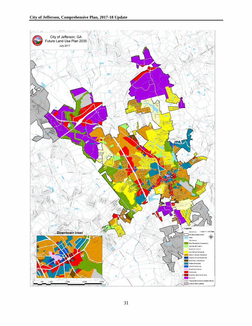
FUTURE LAND USE
A future land use plan map is included in this comprehensive plan. It is based on the plan map
amended in 2010, with selected additional updates including properties added via annexation.
The land use categories chosen by the city must be able to be grouped into the standard land use
categories described in the state’s administrative rules for local planning. For instance, the
general “residential” land use category in the state rules is further divided in the Jefferson land
use plan into four residential categories. The future land use plan map categories are described
below, which helps to explain how to interpret the map and each land use category. The city does
not utilize a separate vacant/undeveloped category in the future land use plan map, since all
properties should be assigned a reasonable economic use.
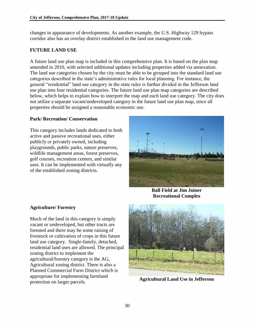
Park/ Recreation/ Conservation
This category includes lands dedicated to both
active and passive recreational uses, either
publicly or privately owned, including
playgrounds, public parks, nature preserves,
wildlife management areas, forest preserves,
golf courses, recreation centers, and similar
uses. It can be implemented with virtually any
of the established zoning districts.
Ball Field at Jim Joiner
Recreational Complex
Agriculture/ Forestry
Much of the land in this category is simply
vacant or undeveloped, but other tracts are
forested and there may be some raising of
livestock or cultivation of crops in this future
land use category. Single-family, detached,
residential land uses are allowed. The principal
zoning district to implement the
agricultural/forestry category is the AG,
Agricultural zoning district. There is also a
Planned Commercial Farm District which is
appropriate for implementing farmland
protection on larger parcels.
Agricultural Land Use in Jefferson
City of Jefferson, Comprehensive Plan, 2017-18 Update
31
City of Jefferson, Comprehensive Plan, 2017-18 Update
32
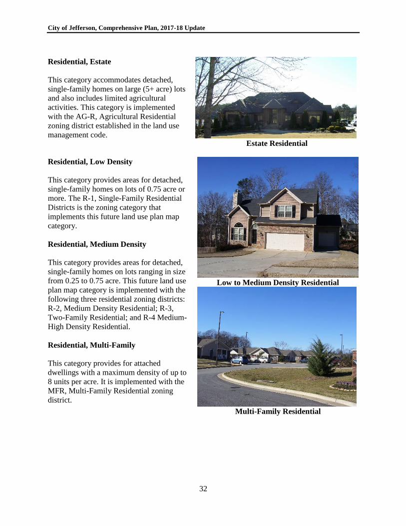
Residential, Estate
This category accommodates detached,
single-family homes on large (5+ acre) lots
and also includes limited agricultural
activities. This category is implemented
with the AG-R, Agricultural Residential
zoning district established in the land use
management code. Estate Residential
Residential, Low Density
This category provides areas for detached,
single-family homes on lots of 0.75 acre or
more. The R-1, Single-Family Residential
Districts is the zoning category that
implements this future land use plan map
category.
Residential, Medium Density
This category provides areas for detached,
single-family homes on lots ranging in size
from 0.25 to 0.75 acre. This future land use
plan map category is implemented with the
following three residential zoning districts:
R-2, Medium Density Residential; R-3,
Two-Family Residential; and R-4 Medium-
High Density Residential.
Residential, Multi-Family
This category provides for attached
dwellings with a maximum density of up to
8 units per acre. It is implemented with the
MFR, Multi-Family Residential zoning
district.
Low to Medium Density Residential
Multi-Family Residential
City of Jefferson, Comprehensive Plan, 2017-18 Update
33
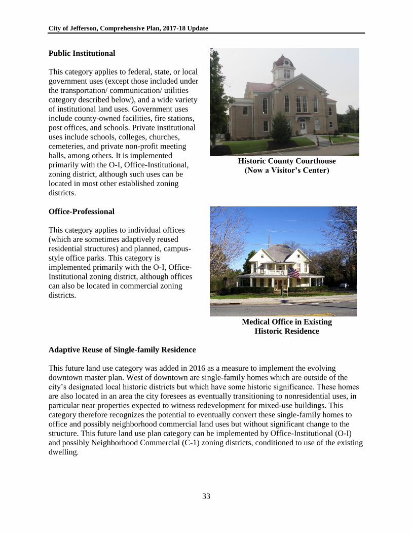
Public Institutional
This category applies to federal, state, or local
government uses (except those included under
the transportation/ communication/ utilities
category described below), and a wide variety
of institutional land uses. Government uses
include county-owned facilities, fire stations,
post offices, and schools. Private institutional
uses include schools, colleges, churches,
cemeteries, and private non-profit meeting
halls, among others. It is implemented
primarily with the O-I, Office-Institutional,
zoning district, although such uses can be
located in most other established zoning
districts.
Historic County Courthouse
(Now a Visitor’s Center)
Office-Professional
This category applies to individual offices
(which are sometimes adaptively reused
residential structures) and planned, campus-
style office parks. This category is
implemented primarily with the O-I, Office-
Institutional zoning district, although offices
can also be located in commercial zoning
districts.
Medical Office in Existing
Historic Residence
Adaptive Reuse of Single-family Residence
This future land use category was added in 2016 as a measure to implement the evolving
downtown master plan. West of downtown are single-family homes which are outside of the
city’s designated local historic districts but which have some historic significance. These homes
are also located in an area the city foresees as eventually transitioning to nonresidential uses, in
particular near properties expected to witness redevelopment for mixed-use buildings. This
category therefore recognizes the potential to eventually convert these single-family homes to
office and possibly neighborhood commercial land uses but without significant change to the
structure. This future land use plan category can be implemented by Office-Institutional (O-I)
and possibly Neighborhood Commercial (C-1) zoning districts, conditioned to use of the existing
dwelling.
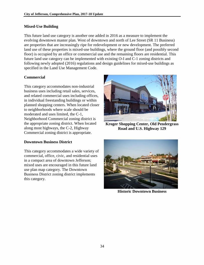
City of Jefferson, Comprehensive Plan, 2017-18 Update
34
Mixed-Use Building
This future land use category is another one added in 2016 as a measure to implement the
evolving downtown master plan. West of downtown and north of Lee Street (SR 11 Business)
are properties that are increasingly ripe for redevelopment or new development. The preferred
land use of these properties is mixed-use buildings, where the ground floor (and possibly second
floor) is occupied by an office or commercial use and the remaining floors are residential. This
future land use category can be implemented with existing O-I and C-1 zoning districts and
following newly adopted (2016) regulations and design guidelines for mixed-use buildings as
specified in the Land Use Management Code.
Commercial
This category accommodates non-industrial
business uses including retail sales, services,
and related commercial uses including offices,
in individual freestanding buildings or within
planned shopping centers. When located closer
to neighborhoods where scale should be
moderated and uses limited, the C-1,
Neighborhood Commercial zoning district is
the appropriate zoning district. When located
along most highways, the C-2, Highway
Commercial zoning district is appropriate.
Kroger Shopping Center, Old Pendergrass
Road and U.S. Highway 129
Downtown Business District
This category accommodates a wide variety of
commercial, office, civic, and residential uses
in a compact area of downtown Jefferson;
mixed uses are encouraged in this future land
use plan map category. The Downtown
Business District zoning district implements
this category.
Historic Downtown Business
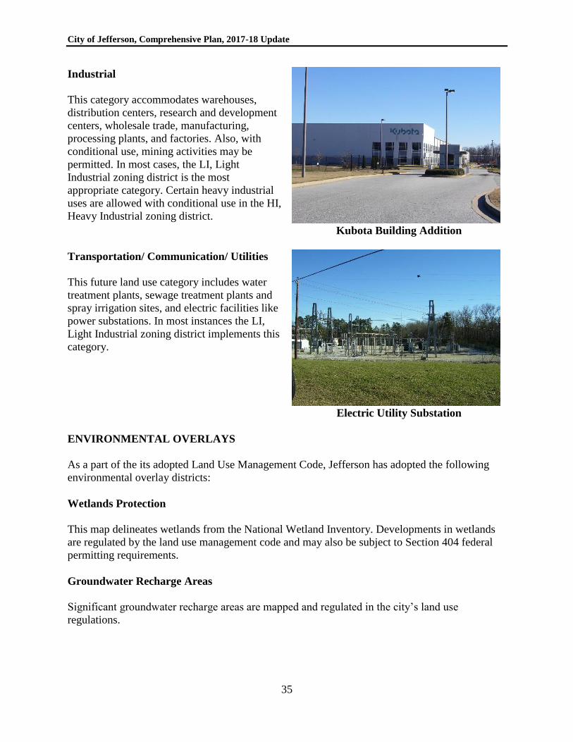
City of Jefferson, Comprehensive Plan, 2017-18 Update
35
Industrial
This category accommodates warehouses,
distribution centers, research and development
centers, wholesale trade, manufacturing,
processing plants, and factories. Also, with
conditional use, mining activities may be
permitted. In most cases, the LI, Light
Industrial zoning district is the most
appropriate category. Certain heavy industrial
uses are allowed with conditional use in the HI,
Heavy Industrial zoning district. Kubota Building Addition
Transportation/ Communication/ Utilities
This future land use category includes water
treatment plants, sewage treatment plants and
spray irrigation sites, and electric facilities like
power substations. In most instances the LI,
Light Industrial zoning district implements this
category.
Electric Utility Substation
ENVIRONMENTAL OVERLAYS
As a part of the its adopted Land Use Management Code, Jefferson has adopted the following
environmental overlay districts:
Wetlands Protection
This map delineates wetlands from the National Wetland Inventory. Developments in wetlands
are regulated by the land use management code and may also be subject to Section 404 federal
permitting requirements.
Groundwater Recharge Areas
Significant groundwater recharge areas are mapped and regulated in the city’s land use
regulations.
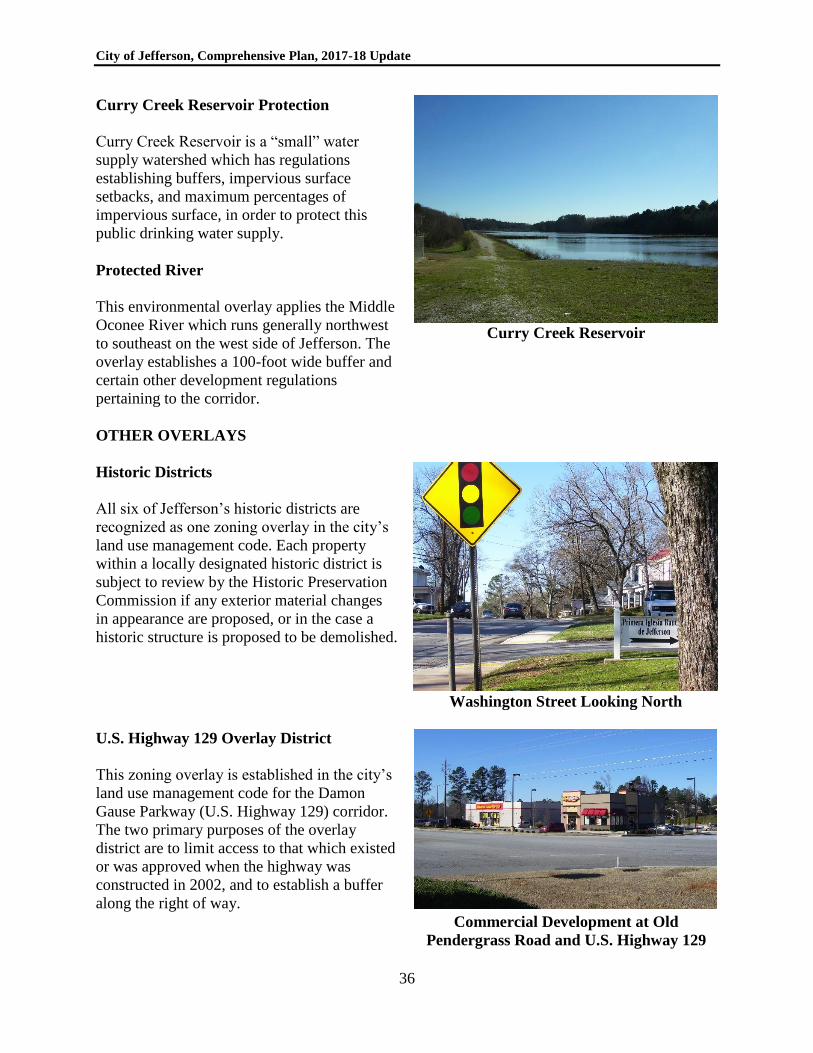
City of Jefferson, Comprehensive Plan, 2017-18 Update
36
Curry Creek Reservoir Protection
Curry Creek Reservoir is a “small” water
supply watershed which has regulations
establishing buffers, impervious surface
setbacks, and maximum percentages of
impervious surface, in order to protect this
public drinking water supply.
Protected River
This environmental overlay applies the Middle
Oconee River which runs generally northwest
to southeast on the west side of Jefferson. The
overlay establishes a 100-foot wide buffer and
certain other development regulations
pertaining to the corridor.
Curry Creek Reservoir
OTHER OVERLAYS
Historic Districts
All six of Jefferson’s historic districts are
recognized as one zoning overlay in the city’s
land use management code. Each property
within a locally designated historic district is
subject to review by the Historic Preservation
Commission if any exterior material changes
in appearance are proposed, or in the case a
historic structure is proposed to be demolished.
Washington Street Looking North
U.S. Highway 129 Overlay District
This zoning overlay is established in the city’s
land use management code for the Damon
Gause Parkway (U.S. Highway 129) corridor.
The two primary purposes of the overlay
district are to limit access to that which existed
or was approved when the highway was
constructed in 2002, and to establish a buffer
along the right of way. Commercial Development at Old
Pendergrass Road and U.S. Highway 129
City of Jefferson, Comprehensive Plan, 2017-18 Update
37
As development occurs in the corridor, additional road and pedestrian infrastructure will be
needed that ensures properties are connected with one another. It is important for the city to
ensure that as development occurs the right of way needed for new access roads or pedestrian
way is reserved. The land use management code anticipated this need (Chapter 26.5) and
provides a tool, called a “corridor map,” whereby the city can plan out future transportation
corridors and set forth a code requirement that prevents buildings and development that encroach
on those corridors. Adoption of the following corridor map was the first step toward that end; it
was followed by adoption of an amendment to the land use management code to formally adopt
the corridor map on July 25, 2016.
The corridor map provides for reservation of the following future road corridors from north to
south:
1. An 80-foot wide collector right of way on the southwest side of U.S. Highway 129
connecting U.S. Highway 129 to Holders Siding Road.
2. An 80-foot wide collector right of way on the northeast side of U.S. Highway 129
connecting U.S. Highway 129 to U.S. Highway 129 Business across from Blackstock
Road.
3. A 100-foot wide arterial right of way connecting Holders Siding Road to the proposed
collector right-of-way on the northeast side of U.S. Highway 129.
4. A 100-foot wide arterial right of way extending approximately 1,400 feet south of
Holders Siding Road on the east side of U.S. Highway 129.
5. An 80-foot wide collector right of way on the southwest side of U.S. Highway 129
connecting Old Swimming Pool Code to existing curb cuts on Faith Drive and U.S.
Highway 129.
6. A 50-foot wide local service road on the southwest side of U.S. Highway 129 connecting
Panther Drive to Old Swimming Pool Road.
In addition to these future roadways, the corridor map shows future greenways (pedestrian or
multi-use trails along stream corridors) on both sides of U.S. Highway 129 within the overlay
district.
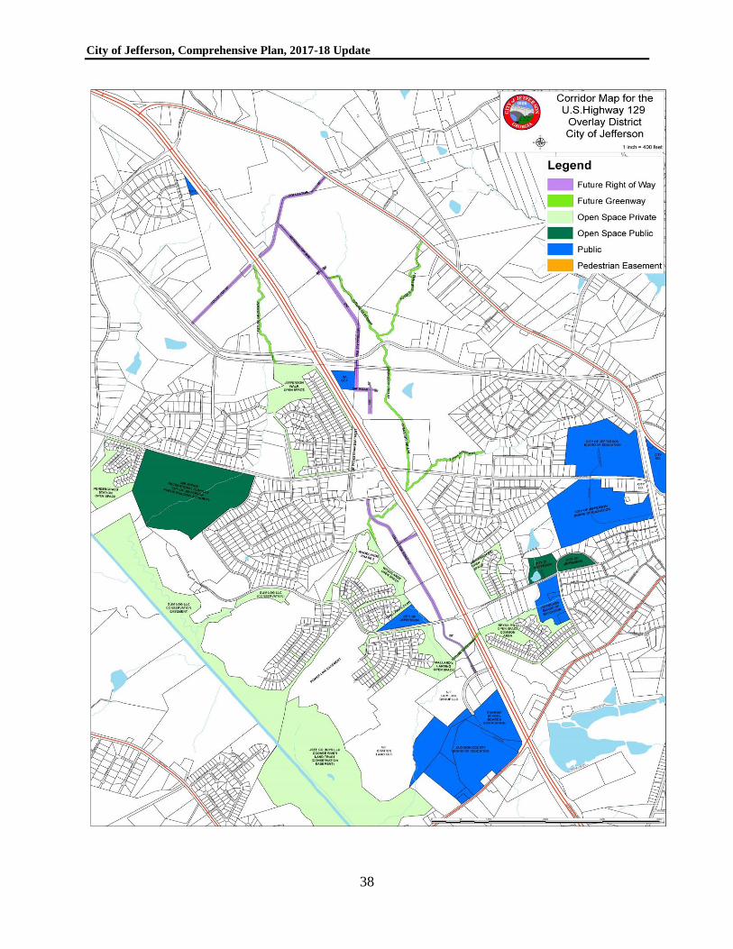
City of Jefferson, Comprehensive Plan, 2017-18 Update
38
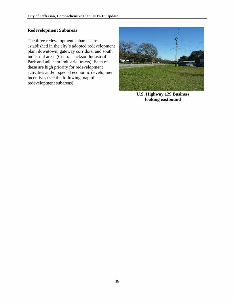
City of Jefferson, Comprehensive Plan, 2017-18 Update
39
Redevelopment Subareas
The three redevelopment subareas are
established in the city’s adopted redevelopment
plan: downtown, gateway corridors, and south
industrial areas (Central Jackson Industrial
Park and adjacent industrial tracts). Each of
these are high priority for redevelopment
activities and/or special economic development
incentives (see the following map of
redevelopment subareas).
U.S. Highway 129 Business
looking eastbound
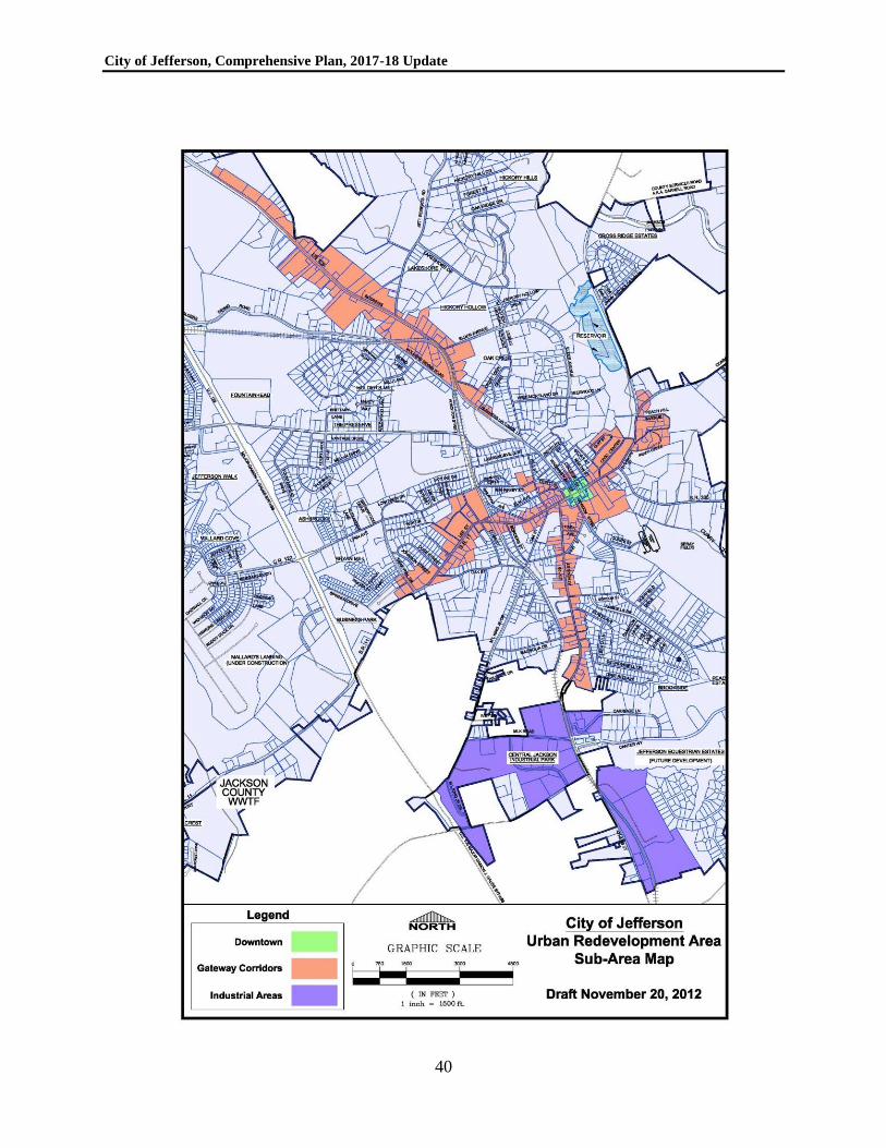
City of Jefferson, Comprehensive Plan, 2017-18 Update
40
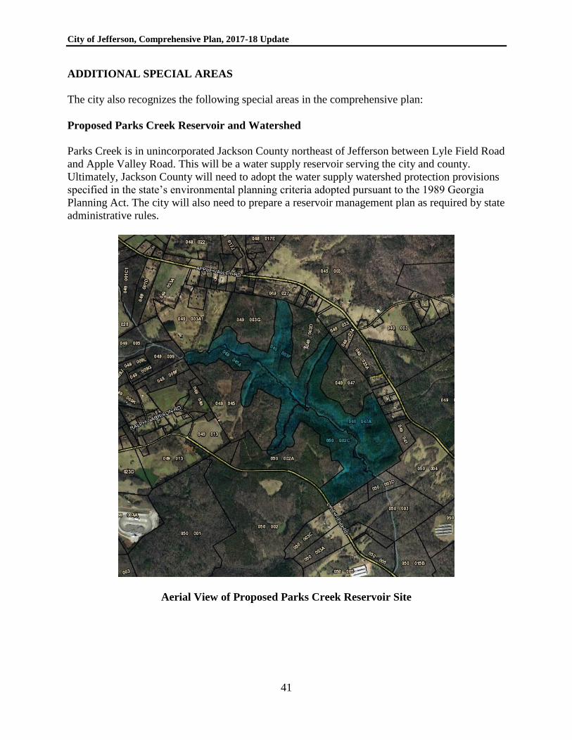
City of Jefferson, Comprehensive Plan, 2017-18 Update
41
ADDITIONAL SPECIAL AREAS
The city also recognizes the following special areas in the comprehensive plan:
Proposed Parks Creek Reservoir and Watershed
Parks Creek is in unincorporated Jackson County northeast of Jefferson between Lyle Field Road
and Apple Valley Road. This will be a water supply reservoir serving the city and county.
Ultimately, Jackson County will need to adopt the water supply watershed protection provisions
specified in the state’s environmental planning criteria adopted pursuant to the 1989 Georgia
Planning Act. The city will also need to prepare a reservoir management plan as required by state
administrative rules.
Aerial View of Proposed Parks Creek Reservoir Site
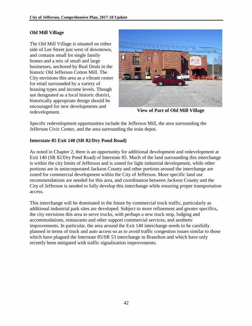
City of Jefferson, Comprehensive Plan, 2017-18 Update
42
Old Mill Village
The Old Mill Village is situated on either
side of Lee Street just west of downtown,
and contains small lot single family
homes and a mix of small and large
businesses, anchored by Real Deals in the
historic Old Jefferson Cotton Mill. The
City envisions this area as a vibrant center
for retail surrounded by a variety of
housing types and income levels. Though
not designated as a local historic district,
historically appropriate design should be
encouraged for new developments and
redevelopment.
View of Part of Old Mill Village
Specific redevelopment opportunities include the Jefferson Mill, the area surrounding the
Jefferson Civic Center, and the area surrounding the train depot.
Interstate 85 Exit 140 (SR 82/Dry Pond Road)
As noted in Chapter 2, there is an opportunity for additional development and redevelopment at
Exit 140 (SR 82/Dry Pond Road) of Interstate 85. Much of the land surrounding this interchange
is within the city limits of Jefferson and is zoned for light industrial development, while other
portions are in unincorporated Jackson County and other portions around the interchange are
zoned for commercial development within the City of Jefferson. More specific land use
recommendations are needed for this area, and coordination between Jackson County and the
City of Jefferson is needed to fully develop this interchange while ensuring proper transportation
access.
This interchange will be dominated in the future by commercial truck traffic, particularly as
additional industrial park sites are developed. Subject to more refinement and greater specifics,
the city envisions this area to serve trucks, with perhaps a new truck stop, lodging and
accommodations, restaurants and other support commercial services, and aesthetic
improvements. In particular, the area around the Exit 140 interchange needs to be carefully
planned in terms of truck and auto access so as to avoid traffic congestion issues similar to those
which have plagued the Interstate 85/SR 53 interchange in Braselton and which have only
recently been mitigated with traffic signalization improvements.
City of Jefferson, Comprehensive Plan, 2017-18 Update
43
CHAPTER 5
COMMUNITY WORK PROGRAM
As required by the state’s rules, Jefferson’s “community work program” must be revised
annually because it has a development impact fee program for parks and recreation. This chapter
presents the city’s community work program, updated in July 2017. In order to provide a more
formalized capital improvement program, the city decided to divide its community work
program into non-capital (program) (Table 5-1) and capital (Table 5-2) items. The capital
component of the community work program (Table 5-1) is separate and distinct from the
“schedule of improvements” (Table 6-7) provided in the “capital improvement element” for
parks and recreation impact fees (see Chapter 6). Further, any “long range” projects have been
separated into a table titled “long range projects” (Table 5-3).
City of Jefferson, Comprehensive Plan, 2017-18 Update
44
Table 5-1
Community Work Program
(Programmatic, Non-Capital, Non-Impact Fee Items)
City of Jefferson, 2018-2022
Department Description Year to Be Implemented Funding
Source 2018 2019 2020 2021 2022 Estimated
Cost ($)
Main Street Develop downtown development recruitment strategies and incentive package
X Staff function
Operating Budget
Main Street Develop a plan for providing Wi-Fi in
Downtown
X Operating
Budget
Main Street Initiate/revive “renovate and sell” program through the Downtown Development Authority
X Staff function
DDA
Main Street Implement downtown master plan X X TBD Operating and
Capital Budget
Civic Center Initiate development of a master plan for the
city’s civic center
X $20,000 Operating
Budget
Public Works Draft and adopt a “dig once” requirement
(Land Use Management Code) for data infrastructure
X $2,500 Planning
Budget
Public Works Monitor sanitary sewer capacity X X X X X Staff
function
Operating
Budget
Public Works Update engineering report for improvements to water and sanitary sewer systems
In process
$20,000 Water and Sewer Fund
Public Works Establish system development charge or impact
fee for Westside sewer
X $5,000 Water and
Sewer Fund
Streets Seek grant funding to design and construct
improvements to Hog Mountain Road/
McClure Industrial Drive
In
process
Per Grant
Consultant
Operating
Budget
Historic Preservation
Amend historic preservation ordinance (LUMC) to address demolition by neglect
X $1,000 Planning Budget
Administration Participate in creating strategy for city/county-
wide public involvement in economic development matters
X Staff
function
Operating
Budget
Administration Develop and implement a blight remediation
program focused on gateway corridors
X Staff
function
Operating
Budget
Administration Continue work with partnering agencies to redevelop potential projects identified in the
Urban Redevelopment Plan and BoomTown
planning processes
X X X X X Staff function
Operating Budget
Planning Develop annexation boundary; consider economic development annexations
X $5,000 Planning Budget
Planning Prepare bicycle and pedestrian system master
plan, including multi-use trails
X $20,000 Planning
Budget
Planning Seek Jackson County’s approval of water supply watershed protection measures for Parks
Creek Reservoir
X $2,500 Planning Budget
Communication Update website at frequent intervals X X X X Staff time Operating Budget
City Clerk Update code of ordinances including
MuniCode
X X X X X Staff time Operating
Budget
Communication Explore the utilization of social media options like Facebook and Twitter
X Staff time Operating Budget
Communication Explore potential publication of City
Newsletter
X Staff time Operating
Budget
Building Update technical codes (odd numbered years) X X X Staff time Operating Budget
City of Jefferson, Comprehensive Plan, 2017-18 Update
45
Table 5-2
Capital Improvement Program
(Non-Impact Fee Capital Items)
(Component of Community Work Program)
City of Jefferson, 2018-2022
Department Description Thousands of Dollars ($) Funding
Source 2018 2019 2020 2021 2022 Total
Museum Repair HVAC system 15 15 Capital Budget
Museum Replace/refurbish 22 windows in and repaint interior
and exterior of the Pendergrass store building
50 50 Capital Budget
Museum Build out basement of Stovall building for vault storage
20 20 Capital Budget
Main Street Install gateway signage downtown 50 50 100 Capital Budget
Main Street Install wayfinding signs, outside of downtown 75 75 150 Capital Budget
Main Street Plan for and install Wi-Fi downtown 25 25 Capital Budget
Civic Center Roof repair (current leaks, life of 5-6 years) 50 50 50 50 200 Capital Budget
Civic Center Sidewalks from parking area to porch area, and from
parking area to kitchen
8 8 Capital Budget
Streets Street system maintenance and repair projects
(including drainage structures, ditches, patching and street signs)
250 250 250 250 250 1,250 Capital Budget
Streets Resurfacing program (all city streets) 445 903 1,039 772 914 4,073 Capital Budget
Streets Pave Old Swimming Pool Road (unpaved portion
adjacent to recreational complex)
900 900 Capital Budget
Streets Sidewalk improvement and extension program (following completion of pedestrian plan)
200 200 200 200 800 Capital Budget
Water Water line improvements: Cobb Street, Epps Street,
Oak Street and Oak Avenue
300 300 CDBG &
Capital Budget
Water Academy Church Road 12”Water Line Loop (8,500 linear feet)
637 637 Capital Budget
Water Possum Creek Road 12” Water Line Loop (3,100
linear feet)
247 247 Capital Budget
Water Vandiver Road 12” Water Line Loop (1,100 linear feet)
132 132 Capital Budget
Water MLK Avenue 12” Water Line Loop (10,800 linear
feet)
755 755 Capital Budget
Water U.S. Highway 129 (Bypass) 12’ Water Line Loop
(7,250 linear feet)
702 702 Capital Budget
Water Construct water storage tank @ ML King Jr. Drive
(500,000 gallons)
1,000 1,000 Capital Budget
Water Construct water storage tank @ County Farm Road
(500,000 gallons)
1,100 1,100 Capital Budget
Water Parks Creek Reservoir – land acquisition 412 412 Capital Budget
Water Parks Creek Reservoir – dam design 20 20 Capital Budget
Water Maysville Road booster pump 25 25 Capital Budget
Water Raw water pumps 50 50 GEFA
Water Water system maintenance and repair projects (fire
hydrant and service line leak repairs, etc.),
50 50 50 50 50 250 Capital Budget
Water Storey Lane water main replacement 300 300 Capital Budget
Water Water meter replacement program 50 50 50 50 50 250 Capital Budget
Sewer Sewer system maintenance and repair projects 50 50 50 50 50 250 Capital Budget
Sewer Dickson Drive sanitary sewer line upgrade (12” @
4,500 linear feet)
1,200 1,200 Capital Budget
Sewer Westside pump station upgrade and force main (18” @ 18,000 linear feet)
939 939 Capital Budget
Sewer New lift station @ U.S. Highway 129; 2,900 linear
feet of 6” force main; upgrade lift station 12; relocate
550 feet of 12” gravity sewer (I-85 area)
939 939 Capital Budget
Sewer Replace 3,000 linear feet of 10” and 12” gravity
sewer with 24” gravity sewer (U.S. 129/I-85 area)
550 550 Capital Budget
Sewer 3,000 linear feet of 12” gravity sewer along Jett
Roberts Road
454 454 Capital Budget
Sewer I-85 wastewater treatment plant 2,000 4,000 4,000 10,000 GEFA
Rec. and Parks New HVAC system at recreational complex 75 75 Capital Budget
Rec. and Parks Replace three tennis courts 180 180 Capital Budget
City of Jefferson, Comprehensive Plan, 2017-18 Update
46
Department Description Thousands of Dollars ($) Funding
Source 2018 2019 2020 2021 2022 Total
Rec. and Parks Swimming pool repairs (shell, deck, pool pack) 150 150 Capital Budget
Rec. and Parks Light one soccer field at recreational complex 50 50 Capital Budget
Rec. and Parks Upgrade playgrounds at existing city parks 50 50 Grants
Rec. and Parks Design and construct trail at McKinney Hill
(approximately ½ mile)
15 65 80 Capital Budget
Rec. and Parks Design and construct additional parking at Clubhouse (approximately 18,000 square feet)
20 380 400 Capital Budget
Total, All Capital Improvements 5,477 5,775 6,376 5,896 5,564 29,088
Table 5-3
Long-Range Capital Projects
City of Jefferson
Department Description Cost Estimate
(Thousands of Dollars)
Funding Source
Streets East Jefferson Bypass $13,300 SPLOST
Streets Interstate 85 at Dry Pond Road to Jackson County Airport (connector) $6,000 SPLOST; private
Streets Widening of Hog Mountain Road/McClure Industrial Drive $2,800 (city share) Grant; SPLOST;
private
Water Expand and/or replace existing water mains (entire service area) 1,000
Water Expand existing water plant to increase filter capacity to 3.8 mgd 9,770
Water Parks Creek Reservoir – construction 4,200 SPLOST; Bond
Water Raw water pumping facility and line from river to reservoir 1,800
Water Raw water pumping facility and line from reservoir to plant 3,300
Rec. and Parks Gymnastics center at recreation complex; w/ attached walkway 1,000,000
Rec. and Parks Countywide aquatic facility TBD
Rec. and Parks Dog park TBD
Rec. and Parks Multi-use path construction per adopted plans TBD
TBD = To be determined
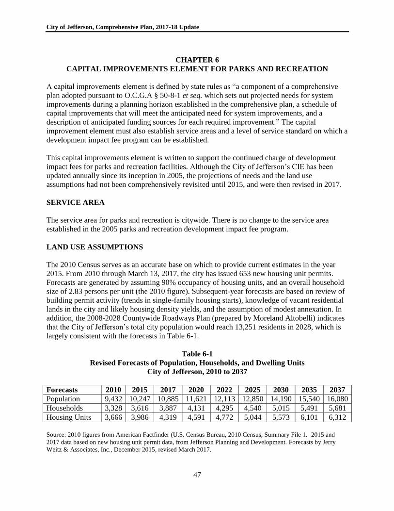
City of Jefferson, Comprehensive Plan, 2017-18 Update
47
CHAPTER 6
CAPITAL IMPROVEMENTS ELEMENT FOR PARKS AND RECREATION
A capital improvements element is defined by state rules as “a component of a comprehensive
plan adopted pursuant to O.C.G.A § 50-8-1 et seq. which sets out projected needs for system
improvements during a planning horizon established in the comprehensive plan, a schedule of
capital improvements that will meet the anticipated need for system improvements, and a
description of anticipated funding sources for each required improvement.” The capital
improvement element must also establish service areas and a level of service standard on which a
development impact fee program can be established.
This capital improvements element is written to support the continued charge of development
impact fees for parks and recreation facilities. Although the City of Jefferson’s CIE has been
updated annually since its inception in 2005, the projections of needs and the land use
assumptions had not been comprehensively revisited until 2015, and were then revised in 2017.
SERVICE AREA
The service area for parks and recreation is citywide. There is no change to the service area
established in the 2005 parks and recreation development impact fee program.
LAND USE ASSUMPTIONS
The 2010 Census serves as an accurate base on which to provide current estimates in the year
2015. From 2010 through March 13, 2017, the city has issued 653 new housing unit permits.
Forecasts are generated by assuming 90% occupancy of housing units, and an overall household
size of 2.83 persons per unit (the 2010 figure). Subsequent-year forecasts are based on review of
building permit activity (trends in single-family housing starts), knowledge of vacant residential
lands in the city and likely housing density yields, and the assumption of modest annexation. In
addition, the 2008-2028 Countywide Roadways Plan (prepared by Moreland Altobelli) indicates
that the City of Jefferson’s total city population would reach 13,251 residents in 2028, which is
largely consistent with the forecasts in Table 6-1.
Table 6-1
Revised Forecasts of Population, Households, and Dwelling Units
City of Jefferson, 2010 to 2037
Forecasts 2010 2015 2017 2020 2022 2025 2030 2035 2037
Population 9,432 10,247 10,885 11,621 12,113 12,850 14,190 15,540 16,080
Households 3,328 3,616 3,887 4,131 4,295 4,540 5,015 5,491 5,681
Housing Units 3,666 3,986 4,319 4,591 4,772 5,044 5,573 6,101 6,312
Source: 2010 figures from American Factfinder (U.S. Census Bureau, 2010 Census, Summary File 1. 2015 and
2017 data based on new housing unit permit data, from Jefferson Planning and Development. Forecasts by Jerry
Weitz & Associates, Inc., December 2015, revised March 2017.
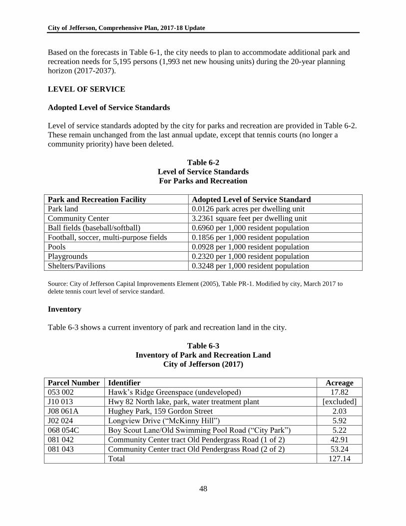
City of Jefferson, Comprehensive Plan, 2017-18 Update
48
Based on the forecasts in Table 6-1, the city needs to plan to accommodate additional park and
recreation needs for 5,195 persons (1,993 net new housing units) during the 20-year planning
horizon (2017-2037).
LEVEL OF SERVICE
Adopted Level of Service Standards
Level of service standards adopted by the city for parks and recreation are provided in Table 6-2.
These remain unchanged from the last annual update, except that tennis courts (no longer a
community priority) have been deleted.
Table 6-2
Level of Service Standards
For Parks and Recreation
Park and Recreation Facility Adopted Level of Service Standard
Park land 0.0126 park acres per dwelling unit
Community Center 3.2361 square feet per dwelling unit
Ball fields (baseball/softball) 0.6960 per 1,000 resident population
Football, soccer, multi-purpose fields 0.1856 per 1,000 resident population
Pools 0.0928 per 1,000 resident population
Playgrounds 0.2320 per 1,000 resident population
Shelters/Pavilions 0.3248 per 1,000 resident population
Source: City of Jefferson Capital Improvements Element (2005), Table PR-1. Modified by city, March 2017 to
delete tennis court level of service standard.
Inventory
Table 6-3 shows a current inventory of park and recreation land in the city.
Table 6-3
Inventory of Park and Recreation Land
City of Jefferson (2017)
Parcel Number Identifier Acreage
053 002 Hawk’s Ridge Greenspace (undeveloped) 17.82
J10 013 Hwy 82 North lake, park, water treatment plant [excluded]
J08 061A Hughey Park, 159 Gordon Street 2.03
J02 024 Longview Drive (“McKinny Hill”) 5.92
068 054C Boy Scout Lane/Old Swimming Pool Road (“City Park”) 5.22
081 042 Community Center tract Old Pendergrass Road (1 of 2) 42.91
081 043 Community Center tract Old Pendergrass Road (2 of 2) 53.24
Total 127.14
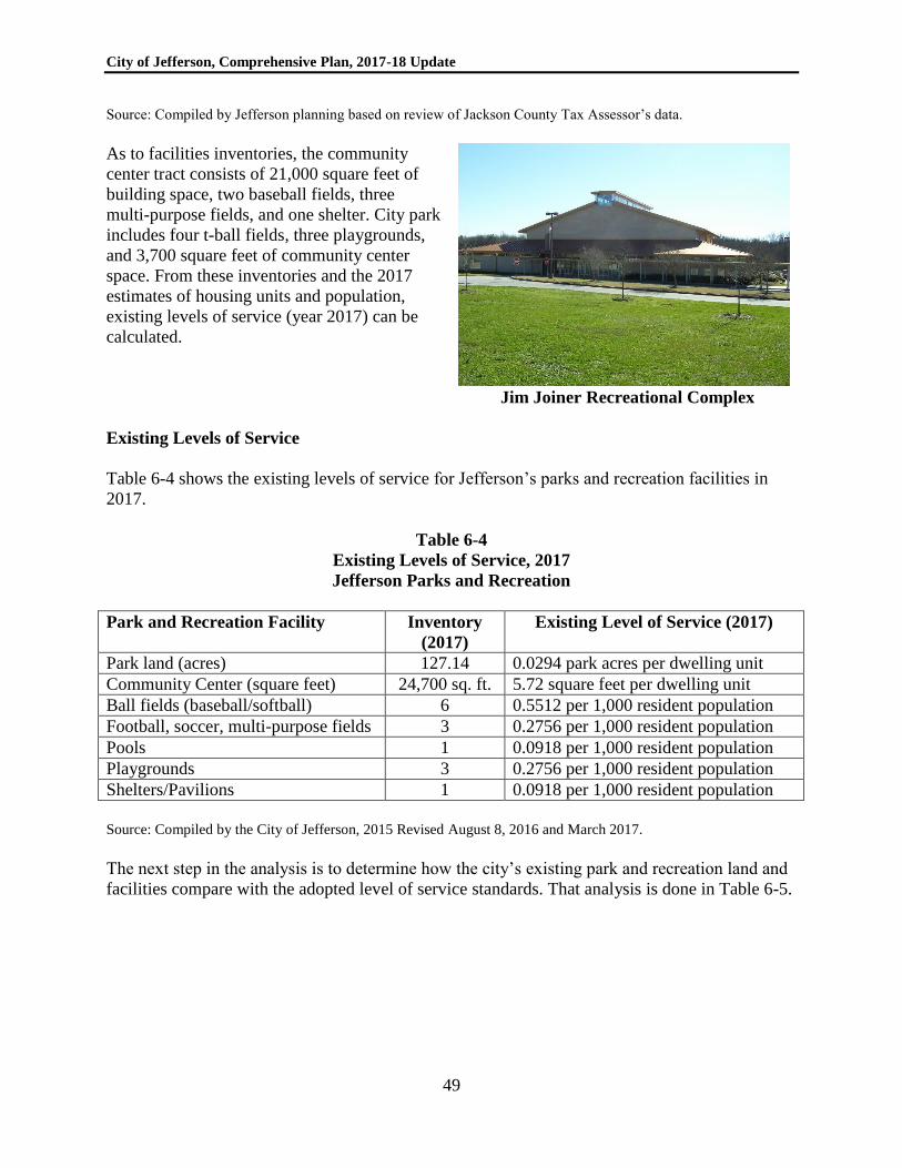
City of Jefferson, Comprehensive Plan, 2017-18 Update
49
Source: Compiled by Jefferson planning based on review of Jackson County Tax Assessor’s data.
As to facilities inventories, the community
center tract consists of 21,000 square feet of
building space, two baseball fields, three
multi-purpose fields, and one shelter. City park
includes four t-ball fields, three playgrounds,
and 3,700 square feet of community center
space. From these inventories and the 2017
estimates of housing units and population,
existing levels of service (year 2017) can be
calculated.
Jim Joiner Recreational Complex
Existing Levels of Service
Table 6-4 shows the existing levels of service for Jefferson’s parks and recreation facilities in
2017.
Table 6-4
Existing Levels of Service, 2017
Jefferson Parks and Recreation
Park and Recreation Facility Inventory
(2017)
Existing Level of Service (2017)
Park land (acres) 127.14 0.0294 park acres per dwelling unit
Community Center (square feet) 24,700 sq. ft. 5.72 square feet per dwelling unit
Ball fields (baseball/softball) 6 0.5512 per 1,000 resident population
Football, soccer, multi-purpose fields 3 0.2756 per 1,000 resident population
Pools 1 0.0918 per 1,000 resident population
Playgrounds 3 0.2756 per 1,000 resident population
Shelters/Pavilions 1 0.0918 per 1,000 resident population
Source: Compiled by the City of Jefferson, 2015 Revised August 8, 2016 and March 2017.
The next step in the analysis is to determine how the city’s existing park and recreation land and
facilities compare with the adopted level of service standards. That analysis is done in Table 6-5.

City of Jefferson, Comprehensive Plan, 2017-18 Update
50
Table 6-5
Comparison of Existing LOS (2017) and Adopted LOS Standards
Jefferson Parks and Recreation
Park and Recreation
Facility
Existing Standard Analysis
Park land (acres) 0.0294 park acres per
dwelling unit
0.0126 park acres
per dwelling unit
Excess parkland –
standard met
Community Center
(square feet)
5.72 square feet per
dwelling unit
3.2361 square feet
per dwelling unit
Excess space – standard
met
Ball fields
(baseball/softball)
0.5512 per 1,000
resident population
0.6960 per 1,000
resident population
7.57 needed; 6 provided;
deficiency of 1.57
Football, soccer,
multi-purpose fields
0.2756 per 1,000
resident population
0.1856 per 1,000
resident population
Excess facility –
standard met
Pools 0.0918 per 1,000
resident population
0.0928 per 1,000
resident population
1.01 needed – standard
met
Playgrounds 0.2756 per 1,000
resident population
0.2320 per 1,000
resident population
Excess facility –
standard met
Shelters/Pavilions 0.0918 per 1,000
resident population
0.3248 per 1,000
resident population
3.54 needed; 1 provided;
deficiency of 2.54
In terms of meeting the level of service standards as of 2017, the city has a current excess of
parkland, community center space, football/soccer/ multi-purpose fields, playgrounds, and multi-
use trails. The city has one swimming pool which meets the level of service standard. The city
has deficiencies with regard to baseball/softball fields, and shelters/pavilions.
PROJECTION OF NEEDS
Given the adopted level of service standards, Table 6-6 indicates a projection of needs for the
next five years as well as the next 20 years, consistent with requirements of the administrative
rules for capital improvements elements. It is important to note that the analysis must cover 20
years, but for purposes of scheduling improvements, only the next five years is considered. Even
with significant residential growth forecasted for the next 20 years in Jefferson, the city will have
more than enough park and recreation acreage to meet its level of service standard through the
year 2037. Similarly, community center space is also more than adequate through the year 2037
at the adopted level of service standard, and the city’s three multi-purpose fields are adequate to
meet the city’s adopted level of service standard through the year 2037.
City of Jefferson, Comprehensive Plan, 2017-18 Update
51
Table 6-6
Projection of Park and Recreation Facility Needs, 2017 to 2037
City of Jefferson
Park and Recreation Facility Existing
in 2017
Existing
Deficiency
Total
2022
Needed
5-year
Need
Attributed
to Growth
Total
2037
Needed
Park land (acres) 127.14 None 60.12 5.7 79.53
Community Center (sq. ft.) 24,700 None 15,443 1,466 20,426
Ball fields (baseball/ softball) 6 1.57 8.43 0.85 11.19
Football, soccer, multi-purpose
fields
3 None 2.25 0.22 2.98
Pools 1 None 1.12 0.11 1.49
Playgrounds 3 None 2.81 0.28 3.73
Shelters/Pavilions 1 2.54 3.93 0.3988 5.22
Ball Fields. By the year 2022, the city needs 8.43 ballfields to meet its established level of
service standard (i.e., an addition of 2+ fields). The city should plan to build two or three new
ball fields within the next five years, the estimated cost of a ballfield is $500,000, excluding land
acquisition if necessary.
Shelters/pavilions. With only one shelter/pavilion, the city is deficient according to its adopted
level of service standards. By 2022, the city will need 3.93 shelters/pavilions. The city should
plan to construct three new shelters/pavilions. The estimated cost of a picnic shelter/pavilion is
$10,000.
SCHEDULE OF IMPROVEMENTS
Jefferson’s park and recreation impact fee program was deliberately set up to correspond with
prior plans for the community center property (Jim Joiner Recreational Complex). The city via
its Public Development Authority borrowed funds, purchased land, and constructed facilities
intended to meet many of the long-term needs for parks and recreation in the city. It is entirely
appropriate for the city to adopt a “recoupment” strategy in an impact fee program, which is
what the city did. In other words, the city borrowed money, purchased land, and constructed
facilities that will meet the long-term needs of the city, and then has paid for that debt in part
with impact fee proceeds during the last decade. Because the city will continue to have an excess
acreage and community center space, as well as certain park facilities, a continuation of that
strategy is also appropriate.
The city elects to continue its prior longstanding practice of using impact fee funds to pay a
portion of the existing debt on parks and recreation facilities. Table 6-7 provides the schedule of
improvements.
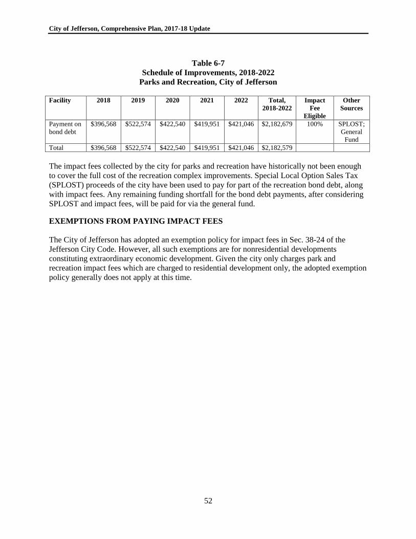
City of Jefferson, Comprehensive Plan, 2017-18 Update
52
Table 6-7
Schedule of Improvements, 2018-2022
Parks and Recreation, City of Jefferson
Facility 2018 2019 2020 2021 2022 Total,
2018-2022
Impact
Fee
Eligible
Other
Sources
Payment on
bond debt
$396,568 $522,574 $422,540 $419,951 $421,046 $2,182,679 100% SPLOST;
General
Fund
Total $396,568 $522,574 $422,540 $419,951 $421,046 $2,182,579
The impact fees collected by the city for parks and recreation have historically not been enough
to cover the full cost of the recreation complex improvements. Special Local Option Sales Tax
(SPLOST) proceeds of the city have been used to pay for part of the recreation bond debt, along
with impact fees. Any remaining funding shortfall for the bond debt payments, after considering
SPLOST and impact fees, will be paid for via the general fund.
EXEMPTIONS FROM PAYING IMPACT FEES
The City of Jefferson has adopted an exemption policy for impact fees in Sec. 38-24 of the
Jefferson City Code. However, all such exemptions are for nonresidential developments
constituting extraordinary economic development. Given the city only charges park and
recreation impact fees which are charged to residential development only, the adopted exemption
policy generally does not apply at this time.