Embed Size (px)
Citation preview
Department of Parks and Wildlife South Coast Region
Second Annual
COMPLIANCE
ASSESSMENT REPORT (Ministerial Statement 884)
22 December 2012 to 21 December 2013
Fitzgerald River National Park Coastal
Walk Trails from Point Ann to Fitzgerald Inlet and from Cave Point to Quoin
Head

TABLE OF CONTENTS
1. INTRODUCTION AND OVERVIEW OF PREVIOUS (FIRST) YEAR .................... 3
2. OVERVIEW OF SECOND YEAR AND CURRENT STATUS ............................... 3
3. STATEMENT OF COMPLIANCE.......................................................................... 5
4. DETAILS OF DECLARED COMPLIANCE STATUS ............................................. 5
4.1 Key Characteristics Table (Condition 1-1) .......................................................... 5
4.2 Protection of Wilderness Management Zone (Condition 5-1) ............................. 7
4.3 Environmental Management Plan (Conditions 6-1, 6-2 and 6-3) ........................ 8
4.4 Pre-construction Flora and Vegetation Surveys and Assessments (Conditions 7-1 and 7-2) ............................................................................................................... 17
4.5 Flora and Vegetation Monitoring Reference Sites (conditions 7-3 and 7-4) ..... 18
4.6 Dieback Risk Assessment and Management Plan (condition 8-1, 8-2 and 9-1 to 9-5) 26
4.7 Staging of Plans (Condition 10-1) ..................................................................... 26
5. PROPONENT DECLARATION ........................................................................... 27
6. APPENDICES ..................................................................................................... 28
APPENDIX 1 – AUDIT TABLE ...................................................................................... 29

Page 3 of 52
1. INTRODUCTION AND OVERVIEW OF PREVIOUS (FIRST) YEAR This Compliance Assessment Report has been prepared by the proponent, the Department of Parks and Wildlife , to meet condition 4-6 of Ministerial Statement 884 (Statement 884) issued on 22 December 2011 for the Coastal Walk Trail from Point Ann to Hamersley Inlet – Fitzgerald River National Park (the Project). This Compliance Assessment Report covers the second year of the Project from 22 December 2012 to 21 December 2013. During this year the former Department of Environment and Conservation (DEC) became a new Department of Parks and Wildlife (The department) on 1 July 2013. The former DEC applied (under Section 45C of the Environmental Protection Act 1986) to change the Proposal from a coastal walk trail from Point Ann to Hamersley Inlet in the Fitzgerald River National Park (FRNP) to two shorter trails, one from Point Ann to Fitzgerald Inlet (western alignment) and the other from Cave Point to Quoin Head (eastern alignment). This change was required to comply with Statement 884 condition 5-1 that the proponent should “not implement any aspect of the proposal within the Wilderness Management Zone”. The former DEC also applied for slight amendments to the boundary of the Wilderness Management Zone, which was inaccurately depicted in Statement 884. These changes were approved on 28 August 2012 (EPA ref: A524261: OEPA 2012/000437). The completion of the pre-construction conditions for this Project were staged (as per condition 10-1), with the pre-construction conditions for the western trail alignment completed on 30 August 2012 and on 21 November 2012 for the eastern alignment. The milestones and achievements of the Project over the previous (2011/2012) reporting period in relation to the conditions of Statement 884 were:
Compliance Assessment Plan accepted by the Office of the Environmental Protection Authority (OEPA) on 23 August 2012 (OEPA ref: A536149: OEPA2011/000056).
DEC applied to the OEPA for minor changes to the proposal (as described in Attachment 1 to Ministerial Statement 884) under Section 45C of the Environmental Protection Act 1986. This was approved by the OEPA on 28 August 2012 (EPA ref: A524261: OEPA 2012/000437).
FRNP Improvement Project Walk Trails Environmental Management Plan (2012-2013) reviewed by OEPA and determined to satisfy condition 6-1 on 30 August 2012 (OEPA ref: CEO790/12).
Flora and vegetation survey report reviewed by OEPA and determined to satisfy condition 7-1 on 30 August 2012 (OEPA ref: CEO790/12).
Assessment of the Threatened and Significant Flora near the Western trail alignment reviewed by OEPA and determined to satisfy condition 7-2 for the western alignment on 30 August 2012 (OEPA ref: CEO790/12).
Construction started on 10 September 2012 on the western walk trail alignment.
Assessment of the Threatened and Significant Flora near the Eastern trail alignment reviewed by OEPA and determined to satisfy condition 7-2 for the western alignment on 21 November 2012 (OEPA ref: CEO 1313/12).
2. OVERVIEW OF SECOND YEAR AND CURRENT STATUS The Project (now more correctly titled) Coastal Walk Trails – from Point Ann to Fitzgerald Inlet and from Cave Point to Quoin Head - Fitzgerald River National Park, has remained in construction phase throughout the reporting period, with on-ground construction works having started on 10 September 2012 and continued into March of the second year on the western trail alignment, now known as the Mamang Trail. Construction of the eastern trail alignment, now known as the Hakea Trail, commenced on 18 March 2013 and was terminated in late July. This work was undertaken by a casual contract crew provided by Skill Hire (Albany) under the direction of locally based department staff. Short sections of both trails, mainly adjoining car parks or popular beaches, were still not established by 21 December 2013, being deliberately left un-cleared as a deterrent to premature public use prior to approved opening of either trail.
Page 4 of 52
Establishment and marking of vegetation monitoring sites at roughly 500m intervals along both trails was undertaken progressively until mid-2013 at which time winter rainfall affected safe access to the trails and shortly thereafter the project environmental officer departed to fill another position elsewhere in the State. Throughout the reporting period considerable progress has also been made with the design and installation of infrastructure associated with the two trails including:
A major set of steps from the ancient wave cut platform (about 80 – 90m above current sea level) down to current sea level near Edwards Point;
Other significant staircases near Hamersley Inlet trail head and from West Hamersley Beach to the crest of the Tamala limestone karst section of coast which extends to Whalebone Point;
Six platforms (four with built in seats), one stand-alone seat, two sections of boardwalk around heritage sites and four wooden dieback cleaning stations along the Mamang Trail;
Four platforms (all with built in seats), one stand-alone seat, three sections of boardwalk between West Beach Headland and the Edwards Point area (for additional dieback protection) and one wooden dieback cleaning station along the Hakea Trail; and
Approximately 30 aluminium totems (for trail distance signs) and about 70 aluminium trail markers, many of which also serve as reference posts for the vegetation monitoring sites.
The infrastructure work was undertaken on an intermittent casual contractor basis by Green Skills Inc (Albany) under the direction of the The department Albany based A/Senior Project Trails Officer.
The milestones and achievements of the project over the current 2012/2013 reporting period in relation to the conditions of Statement 884 are:
Compliance Assessment Report 22 December 2011 to 21 December 2012 completed and submitted to the EPA on 22 March 2013.
Floristic Surveys for the Fitzgerald River National Park Improvement Project, Damien Rathbone, March 2013
Specialist Review of the Fitzgerald River National Park – Coastal Walk Trails, Bayesian Belief Network and Phytophthora Dieback Management Plan, Jeremy Spencer, Great Southern Bio Logic and Peter Speldwinde, University of Western Australia, 28 October 2013
Fitzgerald River National Park Coastal Walk Trail, Bayesian Belief Network Dieback Risk Assessment, November 2013
Fitzgerald River National Park Coastal Walk Trails, Dieback Management Plan, November 2013
Preparation and submission of the above walk trail dieback risk assessments and management planning referred to the Office of the Environmental Protection Authority via the Acting Director General, 11 November 2013

Page 5 of 52
Visitor Risk Management (VRM) Assessments - Mamang and Hakea Trails Fitzgerald River National Park – December 2013. (internal review of immediate management/construction safety matters and associated warning signs).
Discussion paper on the location of new boot cleaning stations, Hakea walk trail, Fitzgerald River National Park – December 2013 (internal review and proposed rationalization of location of boot cleaning stations for Hakea Trail).
All staff and contractors have been meticulous with regard to dieback hygiene during the on-going 2013 Construction Phase. At least 2 entries of vehicle entries involving Aboriginal persons have occurred under a local area arrangement. However The department does not have the same level of control and management over the application of hygiene protocols, and which presents a disease introduction risk in the Fitzgerald River area. The Compliance Assessment Plan will be reviewed in 2014 to take consideration of management circumstance and resubmitted to the OEPA for approval
3. STATEMENT OF COMPLIANCE The department has complied with all the conditions of Ministerial Statement 884 over the reporting period of 22 December 2012 to 21 December 2013 with regard to their own staff and contractors involved in the trail construction. The compliance status for each of the conditions, as of 21 December 2013, is indicated in the attached Audit Table (Appendix 1). Details of the declared compliance status for each of the conditions are provided in Section 4.
4. DETAILS OF DECLARED COMPLIANCE STATUS
4.1 Key Characteristics Table (Condition 1-1)
Schedule 1 and the Key Characteristics Table of Ministerial Statement 884 were changed in August 2012 (under Section 45C of the Environmental Protection Act 1986) to modify the Proposal from a coastal walk trail from Point Ann to Hamersley Inlet in the Fitzgerald River National Park (FRNP) to two shorter trails from Point Ann to Fitzgerald Inlet (western alignment) and from Cave Point to Quoin Head (eastern alignment) (Appendix 2). The department has complied with the updated Schedule 1 (Appendix 2). Details of the compliance status for each element in the Key Characteristics Table are included in
Table 1 below.
Table 1: Compliance status and supporting information for each element in the Key Characteristics Table as at 21 December 2013.
Element Description of Proposal
Status Further Information
Coastal walk
trail
Two walk trails:
a western walk trail from Point Ann to
Fitzgerald Inlet with shorter walk option
at Lake Nameless, and
an eastern walk trail from Quoin Head
to Cave Point including a spur trail from
Hamersley Inlet.
Construct the trail to various classifications
between Class 3 and Class 4 according to
Compliant Construction of the
western (Mamang) walk
trail from Point Ann to
Fitzgerald Inlet with a
shorter walk option at
Lake Nameless continued
through 2013.
Construction of the
eastern (Hakea) walk trail
commenced in March and

Page 6 of 52
Australian Standards, AS 2156.1-2001
Infrastructure Design and AS 2156-2001
Walking Tracks-Classification and Signage
guidance.
continued through 2013.
Overnight
camping
facilities
At Fitzgerald Inlet, provision of a toilet and
tent based camping.
Shelter, toilet and water tank at Whalebone
Beach (Creek).
Compliant The pre-existing toilet and tent
base camping have been
retained at Fitzgerald Inlet.
Old signs and gas barbecue
fittings have been removed
and stock-piled at a nearby
location to await opportunistic
aerial evacuation. The toilet
cubicle and tank were
successfully treated with a
domestic grade ‘mortein
bomb’ in September 2013 to
remove bee colonies.
The overnight camping
location at Whalebone Creek
has undergone vegetation
clearing and site levelling
works. Facility construction
has not yet commenced and is
now scheduled for February
2014.
Trail Heads Shelter, boot cleaning station and an
information panel at Point Ann, Hamersley
Inlet and Cave Point. Smaller trail heads at
Fitzgerald Inlet, Quoin Head.
Compliant The main trail head entry
points are at Point Ann and St
Mary for the Mamang Trail,
and at Cave Point, West
Beach and Hamersley Inlet for
the Hakea Trail.
Shelters are available as
incorporated into the adjoining
recreation site developments
and are not specific to the
walk trails per se.
Aluminum boot cleaning
stations have been workshop
fabricated with installation
scheduled for early 2014. Trail
head signage is also in
preparation and scheduled for
attachment to panels before
trail opening in 2014.
A ~15m long alternative
pedestrian beach access was
installed at the St Mary trail
head in October to avoid

Page 7 of 52
visitor safety risks at the
existing dual use entry to the
beach which was a narrow
4WD sand track with a blind
summit . A trail head
information panel and cleaning
station are scheduled for
installation at St Mary before
trail opening in 2014.
Where visitors may enter the trail from other locations (Whalebone Point, Edwards Point and Quoin Head 4WD track termini) appropriate signage and dieback cleaning stations are scheduled for installation before trail opening in 2014.
Access
Tracks
Use existing access tracks and roads for
construction and maintenance including
Quoin Head, Whalebone, Hamersley Dunes
and Edwards Point tracks, and Cave Point,
Hamersley Inlet and Point Ann/St Mary
roads.
Compliant Existing access tracks, as
listed in the proposal
description and public roads
have been used for
construction access.
In order to minimize dieback
hygiene risks, construction
access to the Hakea Trail
between Hamersley Beach
and Whalebone Point was
also obtained via the
Hamersley Dunes and existing
publicly restricted 4WD
management tracks.
Barriers and signage to deter
public use were installed.
4.2 Protection of Wilderness Management Zone (Condition 5-1)
The department remained compliant with condition 5-1 of remaining out of the Wilderness Management Zone by changing the proposal as detailed in schedule 1 of Statement 884 from the coastal trail from Point Ann to Hamersley Inlet through the Wilderness Management Zone, to two shorter trails either side of the Wilderness Management Zone from Point Ann to Fitzgerald Inlet (western – Mamang Trail - alignment) and from Cave Point to Quoin Head (eastern – Hakea Trail - alignment). These changes, through Section 45C of the Environmental Protection Act 1986 (Appendix 2), were approved in the previous reporting period on 28 August 2012 (EPA ref: A524261: OEPA 2012/000437). There has therefore been no need to enter the Wilderness Management Zone for construction or management of the amended walk trails. Any walking access through the Wilderness Management Zone remains as an unmarked wilderness route, as detailed in the Fitzgerald River National Park Management Plan 1991-2001.

Page 8 of 52
4.3 Environmental Management Plan (Conditions 6-1, 6-2 and 6-3)
The “Fitzgerald River National Park Improvement Project Walk Trails Environmental Management Plan 2012-2013” (EMP) was completed in April 2012 for the construction of the trails (Appendix 3). The plan was reviewed by OEPA and determined to satisfy condition 6-1 on 30 August 2012 (OEPA ref: CEO790/12). While the plan is dated 2012-2013 the management and implementation strategies still apply to works being finalized in 2014. Construction of the walk trail, which began on 10 September 2012, and extended into the current reporting year, has continued to follow the requirements of the EMP, as required by condition 6-2. Compliance was monitored by the department Walk Trail Project Officer or Environment Officer, and then summarised in monthly environmental reports to the department South Coast Regional Nature Conservation Leader. Upon resignation from the project by both of these officers in July/August 2013, the A/Senior Trails Officer reported and discussed any compliance issues with the department’s Regional Nature Conservation Leader, District Flora Conservation Officer, Sarah Barrett, and with the author of the March 2013 floristic surveys report, Damien Rathbone, as required. The compliance status and supporting information from the monthly environmental reports and other reporting for the key management objectives of the EMP is provided in Table 2. During the 2013 reporting period there were a small number of minor environmental incidents during construction of the walk trail. Of concern was the detection of track of a trail bike to the construction site. This incident was of particular concern to the department as this form of unauthorised access owing to the potential vectors for the introduction of Phytophthora dieback onto the walk trail. Preventative actions taken include installing improved management signage and bollards to further restrict vehicle access of the walk trail construction site, or camouflaging of the construction site access points where possible. Annual dieback surveillance along the length of the walk trail as per the Coastal Walk Trails Dieback Management Plan will determine whether this incident has resulted in a dieback introduction. Entries by Aboriginal persons in terms of recent amendments to the CALM Act (1984) have taken place with hygiene being applied as per the local area arrangement. Notes on progress of implementation of the EMP are reported in Table 2 of this Compliance Assessment Report, as required for condition 6-3.
Table 2: Compliance status and supporting information for each of the key management objectives of the Fitzgerald River National Park Improvement Project Walk Trails Environmental Management Plan 2012-2013.
EMP Key
Objectives
Status Further Information

Page 9 of 52
EMP Key
Objectives
Status Further Information
Vegetation
Clearing
Management
Compliant Clearing for the walk trail has been a maximum of 2m wide and
completed either by hand or with a machine mounted slasher.
The edges of the machine clearing have been kept very neat by pre-
clearing by hand and cleaning up afterwards. This was done to reduce
incidental deaths of damaged plants along edges of the trail.
Trail construction Point Charles 2012 (The department Trails Officer and crew)
Page 10 of 52
EMP Key
Objectives
Status Further Information
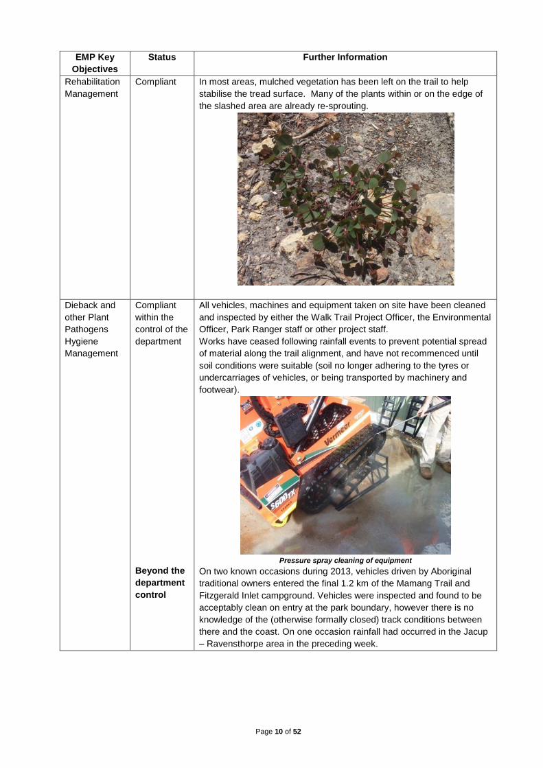
Rehabilitation
Management
Compliant In most areas, mulched vegetation has been left on the trail to help
stabilise the tread surface. Many of the plants within or on the edge of
the slashed area are already re-sprouting.
Dieback and
other Plant
Pathogens
Hygiene
Management
Compliant
within the
control of the
department
Beyond the
department
control
All vehicles, machines and equipment taken on site have been cleaned
and inspected by either the Walk Trail Project Officer, the Environmental
Officer, Park Ranger staff or other project staff.
Works have ceased following rainfall events to prevent potential spread
of material along the trail alignment, and have not recommenced until
soil conditions were suitable (soil no longer adhering to the tyres or
undercarriages of vehicles, or being transported by machinery and
footwear).
Pressure spray cleaning of equipment
On two known occasions during 2013, vehicles driven by Aboriginal
traditional owners entered the final 1.2 km of the Mamang Trail and
Fitzgerald Inlet campground. Vehicles were inspected and found to be
acceptably clean on entry at the park boundary, however there is no
knowledge of the (otherwise formally closed) track conditions between
there and the coast. On one occasion rainfall had occurred in the Jacup
– Ravensthorpe area in the preceding week.

Page 11 of 52
EMP Key
Objectives
Status Further Information
Access
Management
Compliant The walk trail construction site has been closed to public access using
signage and fencing. There were minor incidents of unauthorised trail
bike and pedestrian access to both trails, following which further
preventative action of improved management signage, several gates
and more bollards were installed.
Mamang Trail (The Trails officer and crew member) 2012
Hakea Trail construction access to Whalebone area August 2013
Page 12 of 52
EMP Key
Objectives
Status Further Information
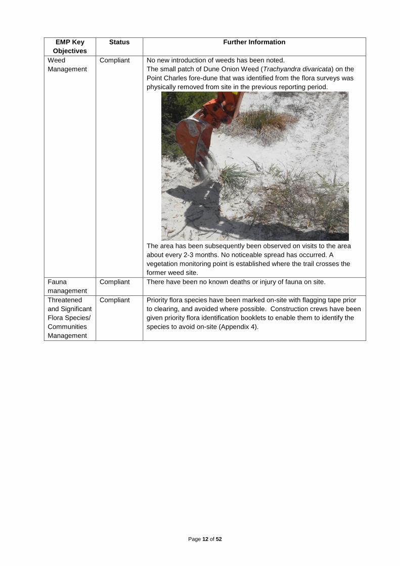
Weed
Management
Compliant No new introduction of weeds has been noted.
The small patch of Dune Onion Weed (Trachyandra divaricata) on the
Point Charles fore-dune that was identified from the flora surveys was
physically removed from site in the previous reporting period.
The area has been subsequently been observed on visits to the area
about every 2-3 months. No noticeable spread has occurred. A
vegetation monitoring point is established where the trail crosses the
former weed site.
Fauna
management
Compliant There have been no known deaths or injury of fauna on site.
Threatened
and Significant
Flora Species/
Communities
Management
Compliant Priority flora species have been marked on-site with flagging tape prior
to clearing, and avoided where possible. Construction crews have been
given priority flora identification booklets to enable them to identify the
species to avoid on-site (Appendix 4).

Page 13 of 52
EMP Key
Objectives
Status Further Information
Cultural and
Heritage Sites
Management
Compliant No indigenous artefacts have been found during construction activities.
Several non-indigenous artefacts from the telegraph line (e.g. telegraph
poles, old insulator fragments) have been located. The trail has gone
around artefacts where possible, or they have been moved off to the
side of the trail and marked with flagging tape to ensure they are not
accidently damaged during construction. Before trail opening visible
moveable artefacts will be recorded, photographed and removed for
safe keeping (otherwise they will inevitably become visitor souvenirs).
In some locations boardwalks have been constructed around heritage
sites and interpretation panels are to be installed to provide visitor
information and re-enforce the need for visitors to remain on the trail.
19
th century Intercolonial telegraph line post stump 2012
Boardwalk around same heritage feature installed July 2013 (Green Skills). Old
insulator (moveable heritage) will be taken for safe keeping and a low information
panel will be installed as indicated by the red ribbon

Page 14 of 52
EMP Key
Objectives
Status Further Information
Visual Amenity
Management
Compliant Strict housekeeping practices have been followed so that no litter has
been left on site from construction activities.
Some minor re-alignments of the trail have occurred due to landscape
impact. These have all been assessed first for any flora and vegetation
issues.
Page 15 of 52
EMP Key
Objectives
Status Further Information
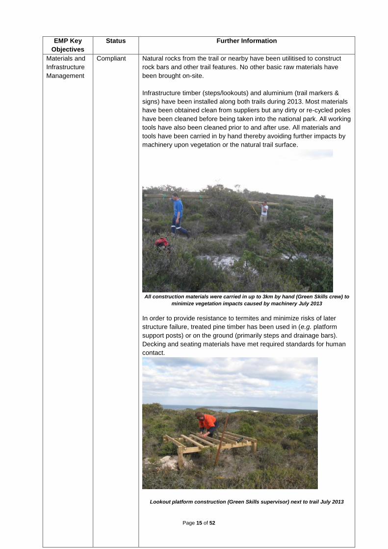
Materials and
Infrastructure
Management
Compliant Natural rocks from the trail or nearby have been utilitised to construct
rock bars and other trail features. No other basic raw materials have
been brought on-site.
Infrastructure timber (steps/lookouts) and aluminium (trail markers &
signs) have been installed along both trails during 2013. Most materials
have been obtained clean from suppliers but any dirty or re-cycled poles
have been cleaned before being taken into the national park. All working
tools have also been cleaned prior to and after use. All materials and
tools have been carried in by hand thereby avoiding further impacts by
machinery upon vegetation or the natural trail surface.
All construction materials were carried in up to 3km by hand (Green Skills crew) to
minimize vegetation impacts caused by machinery July 2013
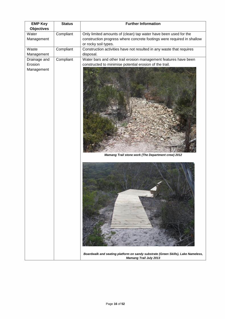
In order to provide resistance to termites and minimize risks of later
structure failure, treated pine timber has been used in (e.g. platform
support posts) or on the ground (primarily steps and drainage bars).
Decking and seating materials have met required standards for human
contact.
Lookout platform construction (Green Skills supervisor) next to trail July 2013
Page 16 of 52
EMP Key
Objectives
Status Further Information
Water
Management
Compliant Only limited amounts of (clean) tap water have been used for the
construction progress where concrete footings were required in shallow
or rocky soil types.
Waste
Management
Compliant Construction activities have not resulted in any waste that requires
disposal.
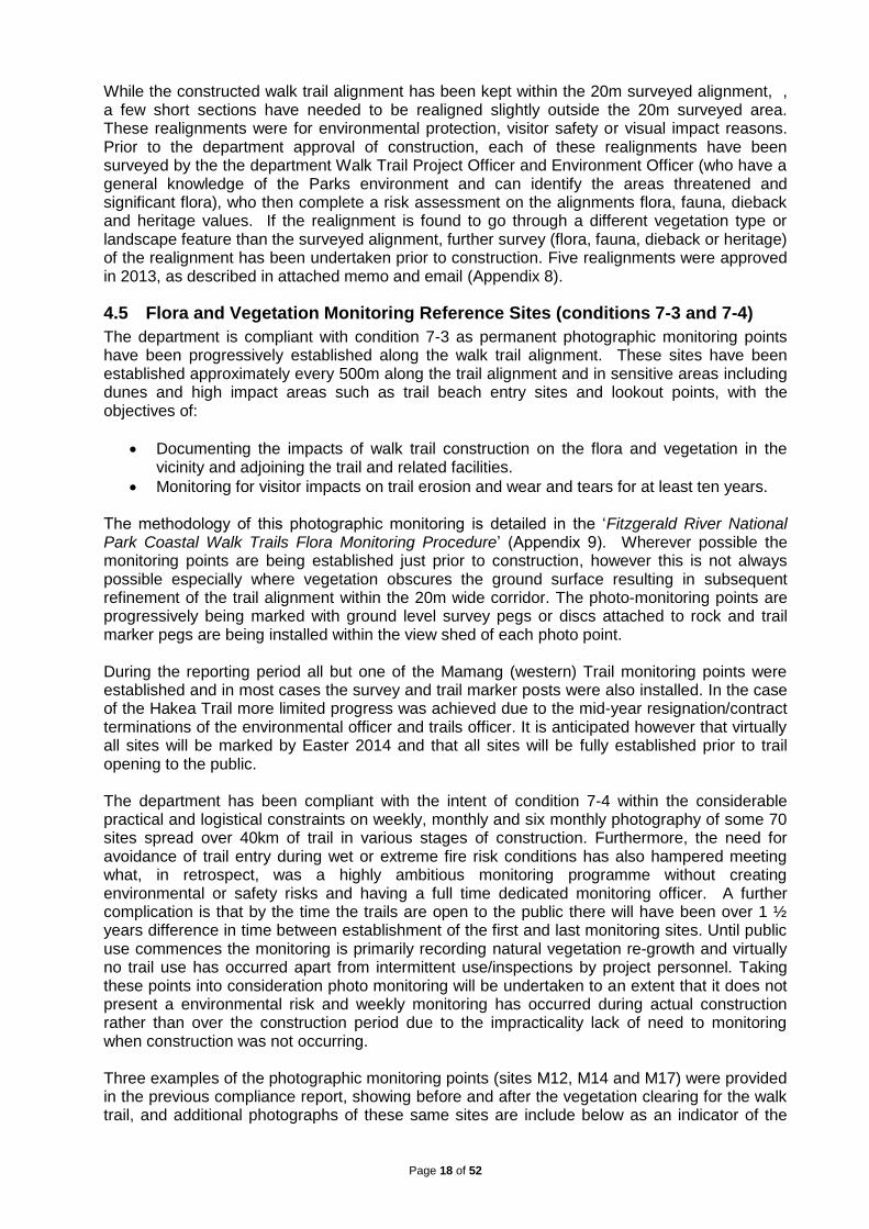
Drainage and
Erosion
Management
Compliant Water bars and other trail erosion management features have been
constructed to minimise potential erosion of the trail.
Mamang Trail stone work (The Department crew) 2012
Boardwalk and seating platform on sandy substrate (Green Skills), Lake Nameless,
Mamang Trail July 2013

Page 17 of 52
EMP Key
Objectives
Status Further Information
Fuel, Oil and
other
Hazardous
Substances
Management
Compliant There have been no oil or fuel spills or leaks. All fuel and oil have been
managed according to the EMP procedures.
Protective bituminised paint has been modestly applied to infrastructure
posts in the ground to reduce the risk of deterioration. Wooden
boardwalks and platforms etc have been double coated with a
protecting water based stain. Only fine localized droplet spillage has
occurred.
Fire Control
and Response
Management
Compliant Construction activities have been following strict safety protocols
including fire extinguishers on all machines and work has ceased during
Extreme or Catastrophic fire weather conditions – or the announcement
of harvesting or vehicle movement bans.
Travel and
Overnight
Management
Compliant Existing camping facilities at St Mary’s and Hamersley Inlet have been
used by construction crews for overnight camping with no open fires
permitted.
For logistical and safety reasons the crew constructing major beach
steps at Edwards Point were allowed to camp for 3 nights at an old
already cleared area near the construction site.
The newly cleared camping ground at Whalebone Creek was
subsequently used for overnight camping due to the otherwise long
commuting time from Hamersley Inlet or Hopetoun (1.5 hours driving
each way).
Portable toilet facilities have been used in all cases where permanent
facilities were not available.
4.4 Pre-construction Flora and Vegetation Surveys and Assessments (Conditions 7-1 and 7-2)
The department was compliant with conditions 7-1 and 7-2 by completing flora and vegetation surveys and assessing the potential impacts of the trail alignment prior to construction. A detailed flora and vegetation survey of a ~20m wide corridor following the originally proposed alignment for the FRNP coastal walk trail from Point Ann to Hamersley Inlet was completed by botanist Cate Tauss in summer (December 2010) and again in spring (September 2011) (Appendix 5). Due to some subsequent trail realignments, short sections of the trail were either missed completely or only surveyed once. Therefore the whole of the alignment was subsequently been re-assessed by the department Flora Officer Damian Rathbone during autumn or spring 2012 as part of a comprehensive flora survey that the department has completed of the coastal catchments which the original trail alignment crossed (Appendix 6). The results of all the flora and vegetation survey’s were used to assess the potential impacts of the trail alignment on threatened and significant flora and to adjust the alignment where required to minimise impacts. This assessment was summarised in two documents “Threatened and Significant Flora and Vegetation near the Western Walk Trail, Fitzgerald River National Park” and “Threatened and Significant Flora and Vegetation near the Eastern Walk Trail, Fitzgerald River National Park”, as provided to the OEPA under condition 7-2 (Appendix 7).
Page 18 of 52
While the constructed walk trail alignment has been kept within the 20m surveyed alignment, , a few short sections have needed to be realigned slightly outside the 20m surveyed area. These realignments were for environmental protection, visitor safety or visual impact reasons. Prior to the department approval of construction, each of these realignments have been surveyed by the the department Walk Trail Project Officer and Environment Officer (who have a general knowledge of the Parks environment and can identify the areas threatened and significant flora), who then complete a risk assessment on the alignments flora, fauna, dieback and heritage values. If the realignment is found to go through a different vegetation type or landscape feature than the surveyed alignment, further survey (flora, fauna, dieback or heritage) of the realignment has been undertaken prior to construction. Five realignments were approved in 2013, as described in attached memo and email (Appendix 8).
4.5 Flora and Vegetation Monitoring Reference Sites (conditions 7-3 and 7-4)
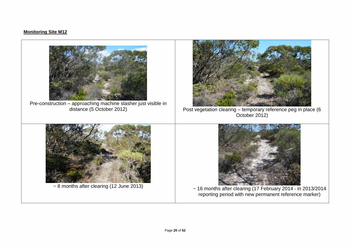
The department is compliant with condition 7-3 as permanent photographic monitoring points have been progressively established along the walk trail alignment. These sites have been established approximately every 500m along the trail alignment and in sensitive areas including dunes and high impact areas such as trail beach entry sites and lookout points, with the objectives of:
Documenting the impacts of walk trail construction on the flora and vegetation in the vicinity and adjoining the trail and related facilities.
Monitoring for visitor impacts on trail erosion and wear and tears for at least ten years. The methodology of this photographic monitoring is detailed in the ‘Fitzgerald River National Park Coastal Walk Trails Flora Monitoring Procedure’ (Appendix 9). Wherever possible the monitoring points are being established just prior to construction, however this is not always possible especially where vegetation obscures the ground surface resulting in subsequent refinement of the trail alignment within the 20m wide corridor. The photo-monitoring points are progressively being marked with ground level survey pegs or discs attached to rock and trail marker pegs are being installed within the view shed of each photo point. During the reporting period all but one of the Mamang (western) Trail monitoring points were established and in most cases the survey and trail marker posts were also installed. In the case of the Hakea Trail more limited progress was achieved due to the mid-year resignation/contract terminations of the environmental officer and trails officer. It is anticipated however that virtually all sites will be marked by Easter 2014 and that all sites will be fully established prior to trail opening to the public. The department has been compliant with the intent of condition 7-4 within the considerable practical and logistical constraints on weekly, monthly and six monthly photography of some 70 sites spread over 40km of trail in various stages of construction. Furthermore, the need for avoidance of trail entry during wet or extreme fire risk conditions has also hampered meeting what, in retrospect, was a highly ambitious monitoring programme without creating environmental or safety risks and having a full time dedicated monitoring officer. A further complication is that by the time the trails are open to the public there will have been over 1 ½ years difference in time between establishment of the first and last monitoring sites. Until public use commences the monitoring is primarily recording natural vegetation re-growth and virtually no trail use has occurred apart from intermittent use/inspections by project personnel. Taking these points into consideration photo monitoring will be undertaken to an extent that it does not present a environmental risk and weekly monitoring has occurred during actual construction rather than over the construction period due to the impracticality lack of need to monitoring when construction was not occurring. Three examples of the photographic monitoring points (sites M12, M14 and M17) were provided in the previous compliance report, showing before and after the vegetation clearing for the walk trail, and additional photographs of these same sites are include below as an indicator of the

Page 19 of 52
natural re-growth. Photo monitoring examples from the Hakea Trail are now included in this year’s report for sites H7, H20 and H35. .
Page 20 of 52
Monitoring Site M12
Pre-construction – approaching machine slasher just visible in
distance (5 October 2012)
Post vegetation clearing – temporary reference peg in place (6
October 2012)
~ 8 months after clearing (12 June 2013)
~ 16 months after clearing (17 February 2014 - in 2013/2014
reporting period with new permanent reference marker)
Page 21 of 52
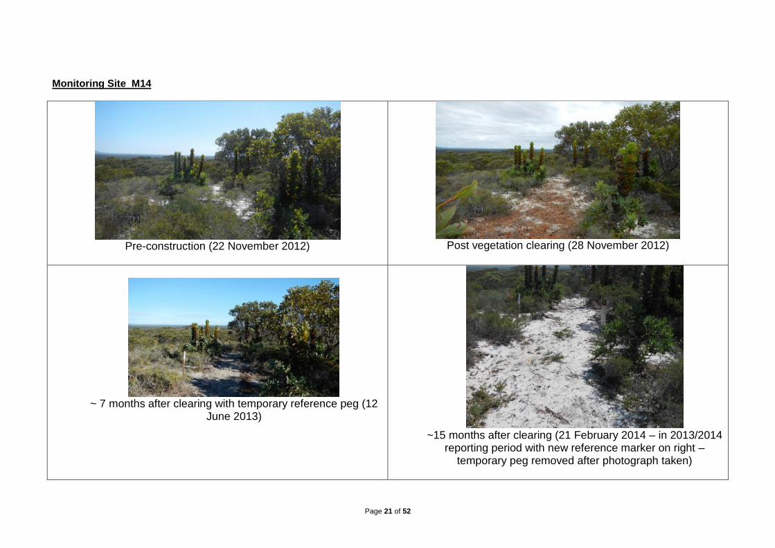
Monitoring Site M14
Pre-construction (22 November 2012)
Post vegetation clearing (28 November 2012)
~ 7 months after clearing with temporary reference peg (12
June 2013)
~15 months after clearing (21 February 2014 – in 2013/2014
reporting period with new reference marker on right – temporary peg removed after photograph taken)

Page 22 of 52
Monitoring Site M17
Pre-construction (22 November 2012)
Post vegetation clearing (28 November 2012)
~7 months after clearing (12 June 2013)
~ 15 months after clearing (21 February 2014 – in 2013/2014 reporting period with permanent reference marker installed)

Page 23 of 52
Monitoring Site H7 (Closed 4WD track on quartzite wave cut platform)
Pre-construction (9 May 2013)
One week after clearing - slasher has traversed left hand wheel
track (17 May 2013)
Six months after clearing (6 November 2013)
~ 8 months after clearing (18 February 2014 - in 2013/2014
reporting period with new permanent reference marker)

Page 24 of 52
Monitoring Site H20 (shallow sand over Tamala limestone)
Pre-construction (1 May 2013)
Same day after clearing (1 May 2013)
~ 6 weeks after clearing and forming (13 June 2013)
~ 9 months post clearing (29 January 2014 - in 2013/2014
reporting period with new permanent reference marker)
Page 25 of 52
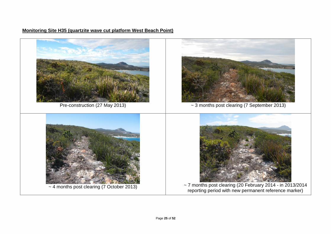
Monitoring Site H35 (quartzite wave cut platform West Beach Point)
Pre-construction (27 May 2013)
~ 3 months post clearing (7 September 2013)
~ 4 months post clearing (7 October 2013)
~ 7 months post clearing (20 February 2014 - in 2013/2014
reporting period with new permanent reference marker)

Page 26 of 52
4.6 Dieback Risk Assessment and Management Plan (condition 8-1, 8-2 and 9-1 to 9-5)
The dieback risk assessment and management plan for the walk trail (conditions 8-1, 8-2 and 9-1 to 9-5) were developed and submitted during the reporting period but are for implementation prior to operation of the trail, so their compliance status is ‘Not required at this stage’. The originally proposed walk trail alignment was interpreted for dieback via helicopter by The department Interpreter Peter Blankendaal in July 2011 to provide a baseline map of the trail, required for the Dieback Management Plan that will be developed prior to operation of the trail (condition 9-2) (Appendix 10). The majority (86%) of the trail alignment was assessed as uninfested, the other 14% was uninterpretable. The uninterpretable areas were those areas that are either, beach, dunes or uninterpretable vegetated areas close to estuaries and lakes. The dieback interpretation will be repeated annually and prior to construction. The western walk trail alignment was re-surveyed on foot by the department Interpreter Greg Freebury in August-November 2012 prior to construction. The trail alignment was assessed as uninfested, except the sections on the beach, dunes or close to Fitzgerald Inlet that are uninterpretable (Appendix 11).
4.7 Staging of Plans (Condition 10-1)
Condition 10-1 allows for staged implementation of the components of the Project. The department is compliant with this condition, having continued to stage the assessment of the potential impacts of the trail alignment on threatened and significant flora (Appendix 8). The department is also continuing to stage the implementation of the flora and vegetation monitoring reference sites (conditions 7-3 and 7-4), setting the sites up just ahead of the trail construction, some of which is still to occur within the next reporting period in 2014 (Section 4.5).

Page 27 of 52
5. PROPONENT DECLARATION I, ………………………………………............................………., (full name and position title) declare that I am authorised on behalf of …………………………………………. (being the person responsible for the proposal) to submit this form and that the information contained in this form is true and not misleading.
Signature:...................................................... Date:.....................................

Page 28 of 52
6. APPENDICES The Audit Table (Appendix 1) is attached to this document below. The other appendices are provided as separate documents. Appendix 1: Audit Table Appendix 2: Change to proposal under s45C of the Environmental Protection Act 1986 Appendix 3: Fitzgerald River National Park Improvement Project Walk Trails Environmental Management Plan 2012-2013 (EMP) Appendix 4: Western and Eastern walk trail significant flora identification booklets Appendix 5: Flora and vegetation survey of the FRNP coastal walk trail alignment (Tauss 2012) Appendix 6: Floristic surveys for the Fitzgerald River National Park Improvement Project (Rathbone 2013) Appendix 7: Assessments of potential impacts on significant flora and vegetation Appendix 8: Trail realignment risk assessment process Appendix 9: Flora monitoring procedure (the photographs from this monitoring are provided to the EPA with the electronic copy of this compliance assessment report) Appendix 10: FRNP coastal walk trail dieback interpretation report 2011 Appendix 11: Western walk trail alignment dieback interpretation report 2012
Page 29 of 52
APPENDIX 1 – AUDIT TABLE Note:
• Phases that apply in this table = Pre-Construction, Construction, Operation, Decommissioning, Overall (several phases).
• This audit table is a summary and timetable of conditions and commitments applying to this project. Refer to the Minister’s Statement for full detail/precise wording of individual elements.
• Code prefixes: M = Minister’s condition, P = Proponent’s commitment.
• Acronyms list: CEO = Chief Executive Officer of OEPA; DEC = Department of Environment and Conservation; DIA = Department of Indigenous Affairs; DMP = Department of Mining and
Petroleum; EPA = Environmental Protection Authority; DoH = Department of Health;
DoW = Department of Water, Minister for Env = Minister for the Environment; OEPA = Office of the Environmental Protection Authority.
• Compliance Status: C = Compliant, CLD = Completed, NA = Not Audited, NC = Non – compliant, NR = Not Required at this stage. Please note the terms VR = Verification Required and IP = In Process are only for OEPA use.
Page 30 of 52
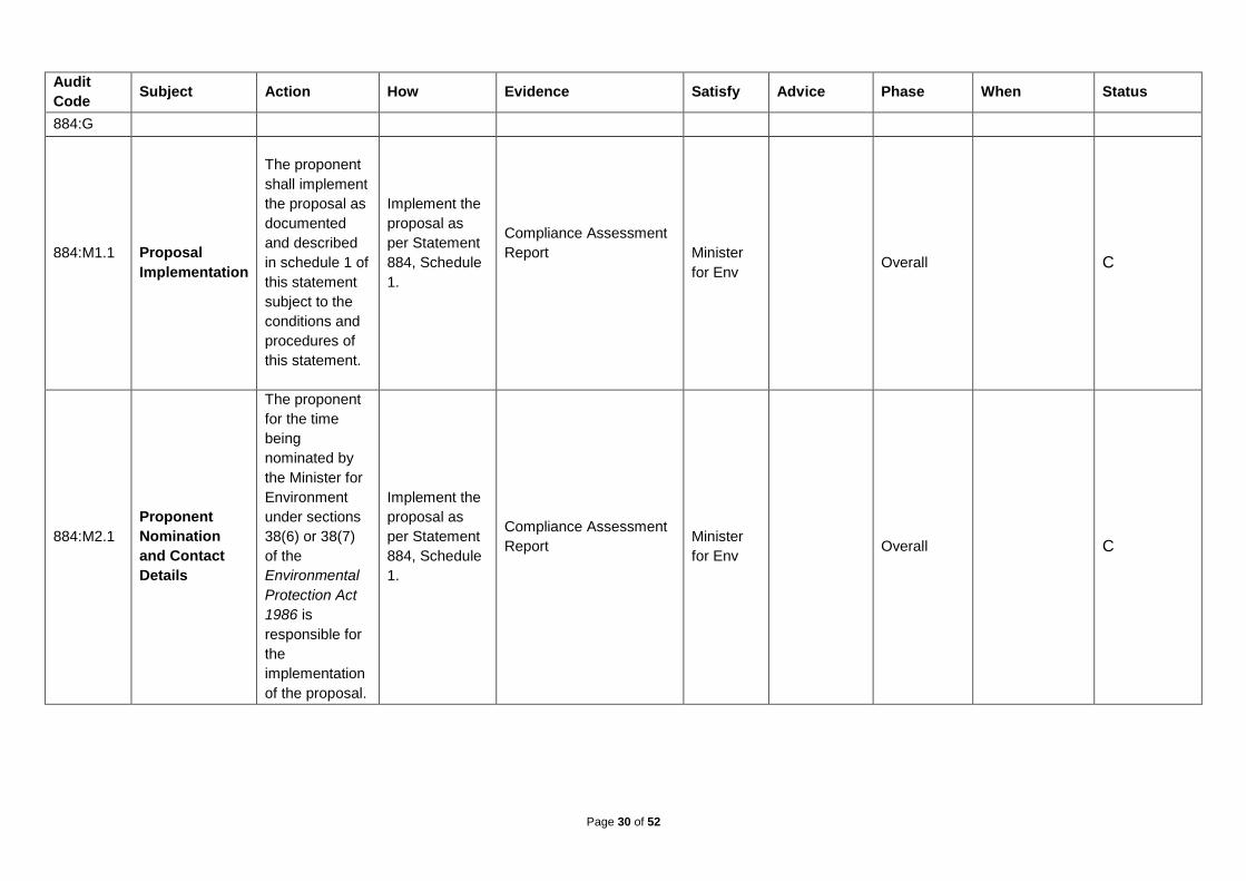
Audit
Code Subject Action How Evidence Satisfy Advice Phase When Status
884:G
884:M1.1
Proposal
Implementation
The proponent
shall implement
the proposal as
documented
and described
in schedule 1 of
this statement
subject to the
conditions and
procedures of
this statement.
Implement the
proposal as
per Statement
884, Schedule
1.
Compliance Assessment
Report
Minister
for Env Overall C
884:M2.1
Proponent
Nomination
and Contact
Details
The proponent
for the time
being
nominated by
the Minister for
Environment
under sections
38(6) or 38(7)
of the
Environmental
Protection Act
1986 is
responsible for
the
implementation
of the proposal.
Implement the
proposal as
per Statement
884, Schedule
1.
Compliance Assessment
Report
Minister
for Env Overall C
Page 31 of 52
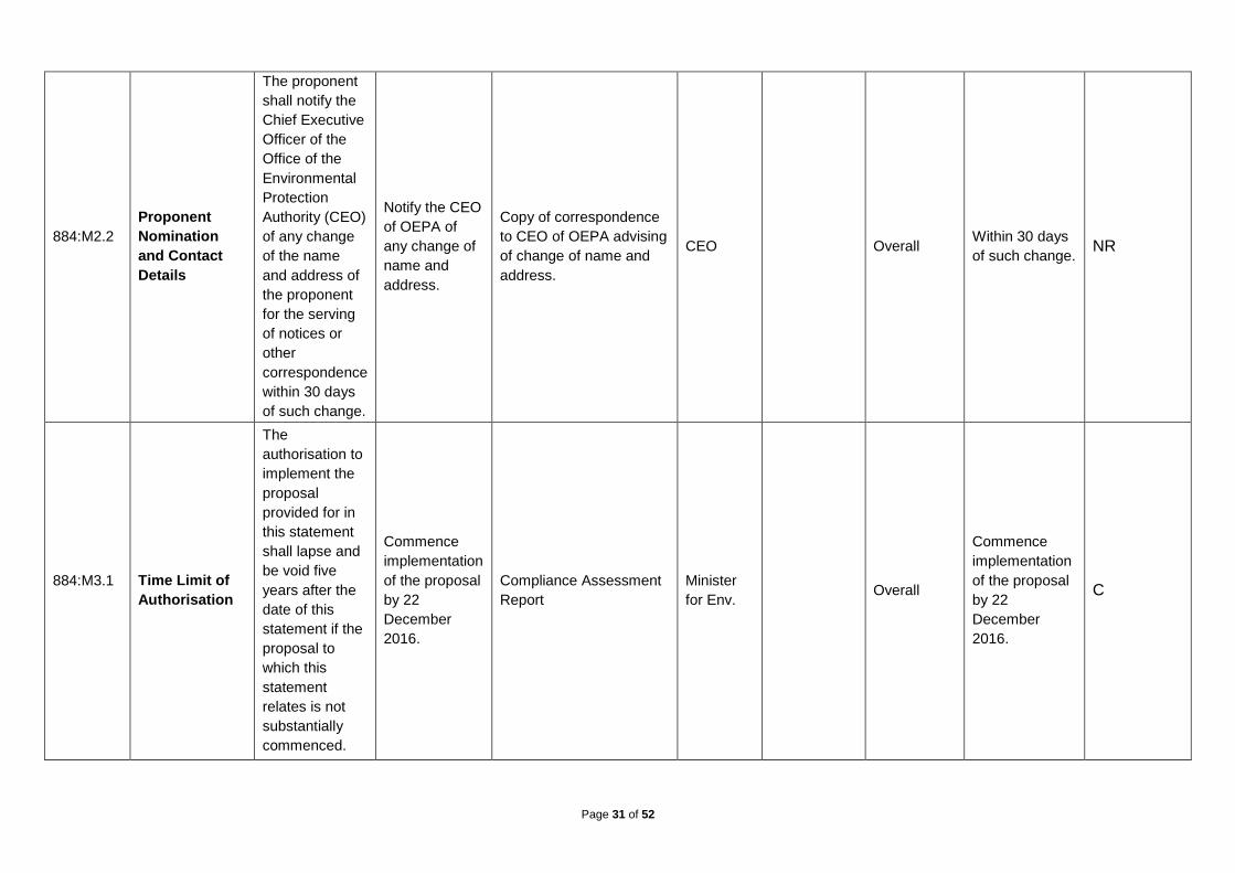
884:M2.2
Proponent
Nomination
and Contact
Details
The proponent
shall notify the
Chief Executive
Officer of the
Office of the
Environmental
Protection
Authority (CEO)
of any change
of the name
and address of
the proponent
for the serving
of notices or
other
correspondence
within 30 days
of such change.
Notify the CEO
of OEPA of
any change of
name and
address.
Copy of correspondence
to CEO of OEPA advising
of change of name and
address.
CEO Overall Within 30 days
of such change. NR
884:M3.1
Time Limit of
Authorisation
The
authorisation to
implement the
proposal
provided for in
this statement
shall lapse and
be void five
years after the
date of this
statement if the
proposal to
which this
statement
relates is not
substantially
commenced.
Commence
implementation
of the proposal
by 22
December
2016.
Compliance Assessment
Report
Minister
for Env. Overall
Commence
implementation
of the proposal
by 22
December
2016.
C
Page 32 of 52
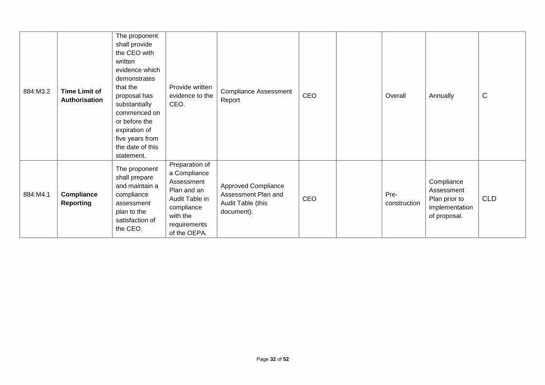
884:M3.2
Time Limit of
Authorisation
The proponent
shall provide
the CEO with
written
evidence which
demonstrates
that the
proposal has
substantially
commenced on
or before the
expiration of
five years from
the date of this
statement.
Provide written
evidence to the
CEO.
Compliance Assessment
Report CEO Overall Annually C
884:M4.1
Compliance
Reporting
The proponent
shall prepare
and maintain a
compliance
assessment
plan to the
satisfaction of
the CEO.
Preparation of
a Compliance
Assessment
Plan and an
Audit Table in
compliance
with the
requirements
of the OEPA.
Approved Compliance
Assessment Plan and
Audit Table (this
document).
CEO Pre-
construction
Compliance
Assessment
Plan prior to
implementation
of proposal.
CLD
Page 33 of 52
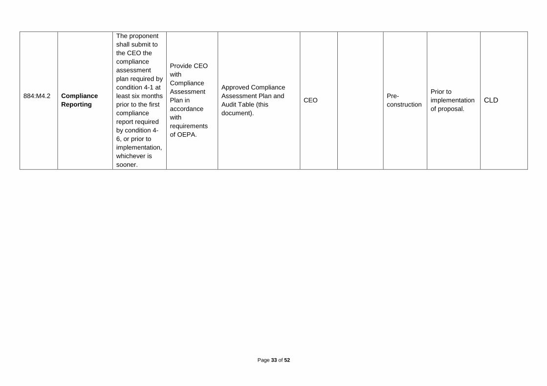
884:M4.2
Compliance
Reporting
The proponent
shall submit to
the CEO the
compliance
assessment
plan required by
condition 4-1 at
least six months
prior to the first
compliance
report required
by condition 4-
6, or prior to
implementation,
whichever is
sooner.
Provide CEO
with
Compliance
Assessment
Plan in
accordance
with
requirements
of OEPA.
Approved Compliance
Assessment Plan and
Audit Table (this
document).
CEO Pre-
construction
Prior to
implementation
of proposal.
CLD

Page 34 of 52
884:M4.2
Compliance
Reporting
The compliance
assessment
plan shall
indicate: 1. the
frequency of
compliance
reporting; 2. the
approach and
timing of
compliance
assessments;
3. the retention
of compliance
assessments;
4. the method
of reporting of
potential non-
compliances
and corrective
actions taken;
5. the table of
contents of
compliance
assessment
reports; and 6.
public
availability of
compliance
assessment
reports.
Provide CEO
with
Compliance
Assessment
Plan in
accordance
with
requirements
of OEPA.
Approved Compliance
Assessment Plan and
Audit Table (this
document).
CEO Pre-
construction
Prior to
implementation
of proposal.
CLD
Page 35 of 52
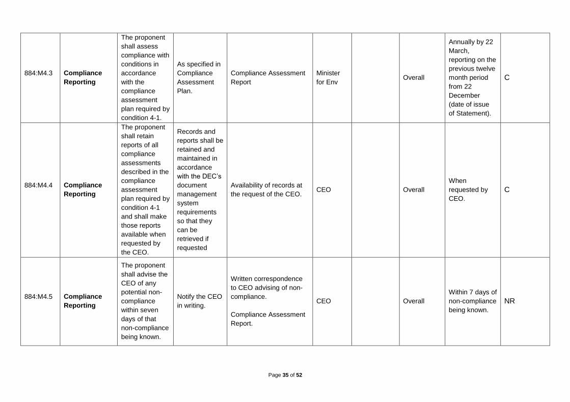
884:M4.3
Compliance
Reporting
The proponent
shall assess
compliance with
conditions in
accordance
with the
compliance
assessment
plan required by
condition 4-1.
As specified in
Compliance
Assessment
Plan.
Compliance Assessment
Report
Minister
for Env Overall
Annually by 22
March,
reporting on the
previous twelve
month period
from 22
December
(date of issue
of Statement).
C
884:M4.4
Compliance
Reporting
The proponent
shall retain
reports of all
compliance
assessments
described in the
compliance
assessment
plan required by
condition 4-1
and shall make
those reports
available when
requested by
the CEO.
Records and
reports shall be
retained and
maintained in
accordance
with the DEC’s
document
management
system
requirements
so that they
can be
retrieved if
requested
Availability of records at
the request of the CEO. CEO Overall
When
requested by
CEO.
C
884:M4.5
Compliance
Reporting
The proponent
shall advise the
CEO of any
potential non-
compliance
within seven
days of that
non-compliance
being known.
Notify the CEO
in writing.
Written correspondence
to CEO advising of non-
compliance.
Compliance Assessment
Report.
CEO Overall
Within 7 days of
non-compliance
being known.
NR

Page 36 of 52
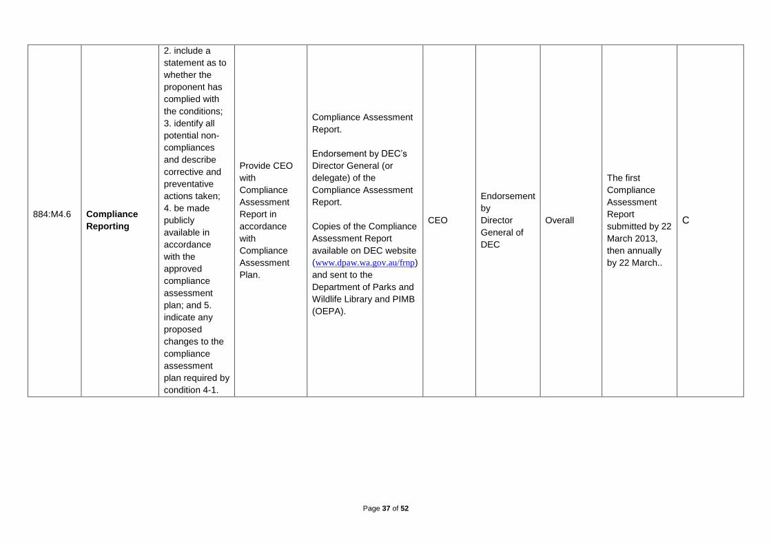
884:M4.6
Compliance
Reporting
The proponent
shall submit to
the CEO the
first compliance
assessment
report fifteen
months from
the date of
issue of this
Statement
addressing the
twelve month
period from the
date of issue of
this Statement
and then
annually from
the date of
submission of
the first
compliance
assessment
report. The
compliance
assessment
report shall: 1.
be endorsed by
the proponent’s
Director
General or a
person
delegated to
sign on the
Director
General’s
behalf;
Provide CEO
with
Compliance
Assessment
Report in
accordance
with
Compliance
Assessment
Plan.
Compliance Assessment
Report.
Endorsement by DEC’s
Director General (or
delegate) of the
Compliance Assessment
Report.
Copies of the Compliance
Assessment Report
available on DEC website
(www.dpaw.wa.gov.au/frnp)
and sent to the
Department of Parks and
Wildlife Library and PIMB
(OEPA).
CEO
Endorsement
by
Director
General of
DEC
Overall
The first
Compliance
Assessment
Report
submitted by 22
March 2013,
then annually
by 22 March..
C
Page 37 of 52
884:M4.6
Compliance
Reporting
2. include a
statement as to
whether the
proponent has
complied with
the conditions;
3. identify all
potential non-
compliances
and describe
corrective and
preventative
actions taken;
4. be made
publicly
available in
accordance
with the
approved
compliance
assessment
plan; and 5.
indicate any
proposed
changes to the
compliance
assessment
plan required by
condition 4-1.
Provide CEO
with
Compliance
Assessment
Report in
accordance
with
Compliance
Assessment
Plan.
Compliance Assessment
Report.
Endorsement by DEC’s
Director General (or
delegate) of the
Compliance Assessment
Report.
Copies of the Compliance
Assessment Report
available on DEC website
(www.dpaw.wa.gov.au/frnp)
and sent to the
Department of Parks and
Wildlife Library and PIMB
(OEPA).
CEO
Endorsement
by
Director
General of
DEC
Overall
The first
Compliance
Assessment
Report
submitted by 22
March 2013,
then annually
by 22 March..
C

Page 38 of 52
884:M5.1
Protection of
Wilderness
Management
Zone
The proponent
shall not
implement any
aspect of the
proposal within
the Wilderness
Management
Zone as
depicted in
Figure 1.
No aspect of
the proposal
will be
implemented in
the Wilderness
Management
Zone.
Compliance Assessment
Report
Overall Duration of
proposal. C
884:M6.1
Environmental
Management
Plan
Prior to the
commencement
of construction
of the proposal,
the proponent
shall prepare an
Environmental
Management
Plan for the
construction of
the proposal to
the satisfaction
of the CEO.
Preparation of
Fitzgerald
River National
Park
Improvement
Project Walk
Trails
Environmental
Management
Plan (Walk
Trails EMP)
addressing the
environmental
management
of the
proposal.
Walk Trails EMP to the
satisfaction of the CEO. CEO Construction
Prior to
construction. CLD

Page 39 of 52
884:M6.1
Environmental
Management
Plan
The primary
objective of the
Environmental
Management
Plan is to
ensure that
dieback disease
(Phytophthora
species) is not
introduced as a
direct or indirect
result of
construction
activities into
uninfected
areas of the
proposal area.
Other potential
impacts
associated with
construction
including, but
not limited to,
weeds, fire,
erosion and
uncontrolled
access, shall be
addressed in
the Plan.
Preparation of
Fitzgerald
River National
Park
Improvement
Project Walk
Trails
Environmental
Management
Plan (Walk
Trails EMP)
addressing the
environmental
management
of the
proposal.
Walk Trails EMP to the
satisfaction of the CEO. CEO Construction
Prior to
construction. CLD

Page 40 of 52
884:M6.2
Environmental
Management
Plan
During the
construction
phase, the
proponent shall
implement the
Environmental
Management
Plan referred to
in condition 6-1.
Implementation
of the Walk
Trails EMP.
Monthly EMP compliance
reports, which will be
summarised in the
Compliance Assessment
Report.
Construction Annually during
construction. C
884:M6.3
Environmental
Management
Plan
During the
construction
phase, the
proponent shall
annually review
and report
progress on
conditions 6-1
and 6-2 in the
compliance
assessment
report required
by condition 4-
6.
Annual review
of Walk Trails
EMP and
progress report
as part of the
Compliance
Assessment
Report.
Compliance Assessment
Report. Construction
Annually during
construction. C

Page 41 of 52
884:M7.1
Flora and
Vegetation
Prior to the
commencement
of construction
of the proposal,
the proponent
shall conduct a
detailed flora
and vegetation
survey of the
proposal area
to the
satisfaction of
the CEO.
Detailed flora
survey and
vegetation
mapping of
proposed walk
trail alignment.
Flora and
vegetation
surveys will be
staged for
different
sections of the
trail, as
allowed for in
Condition 10-1.
Report on the detailed
flora and vegetation
survey of the walk trail.
CEO Pre-
Construction
Prior to
construction. CLD

Page 42 of 52
884:M7.2
Flora and
Vegetation
Prior to the
commencement
of construction
of the proposal,
the proponent
shall use the
results of the
detailed flora
and vegetation
survey required
by condition 7-1
to demonstrate
to the
satisfaction of
the CEO that
the proposal
has been
located to
avoid, where
practicable,
populations of
rare or
threatened
communities or
species, or
species of
restricted
regional
distribution.
Alignment of
the walk trails
will be
designed to
avoid
significant flora
and vegetation
where
practicable.
The alignment
and an
assessment of
potential
impacts on
threatened and
priority flora
species and
communities
submitted to
the CEO.
Assessment of potential
impacts on threatened
and priority flora species
and communities reports
submitted to the CEO.
Walk Trails EMP.
CEO Pre-
construction
Prior to
construction. CLD

Page 43 of 52
884:M7.3
Flora and
Vegetation
Prior to the
commencement
of construction
of the proposal,
the proponent
shall establish
reference sites
to monitor
potential
impacts on flora
and vegetation
in the vicinity of
the proposal.
Establishment
of fixed
photographic
monitoring
points every
500m along
the trail
alignment and
in sensitive
areas such as
dunes or high
impact areas
such as
campsites.
Walk Trails EMP.
Compliance Assessment
Report.
CEO Pre-
construction.
Prior to
construction. C

Page 44 of 52
884:M7.4
Flora and
Vegetation
During the
construction
phase, the
proponent shall
monitor the
reference sites
referred to in
Condition 7-3
and report the
results in the
compliance
assessment
report required
by condition 4-
6.
Weekly
photographic
monitoring to
be undertaken
during
construction
phase at each
fixed
monitoring
point.
Following
construction,
photographic
monitoring at
each reference
site to be
undertaken
monthly for six
months post
construction,
then annually
for duration of
proposal.
Monitoring records, maps
and photographs.
Compliance Assessment
Report.
CEO Construction Ongoing. C

Page 45 of 52
884:M8.1
Dieback Risk
Assessment
Prior to the
commencement
of the operation
of the proposal,
the proponent
shall prepare a
Dieback Risk
Assessment for
the operation of
the proposal to
the satisfaction
of the CEO.
The primary
objective of the
Dieback Risk
Assessment is
to identify
appropriate
Phytophthora
dieback disease
risk
management
strategies for
the operation of
the proposal.
Dieback Risk
Assessment
and disease
management
strategies for
the operation
of the
proposal.
Submit
Dieback Risk
Assessment
report to the
CEO.
Dieback Risk
Assessment. CEO Operational
Prior to
commencement
of walk trail
operation.
NR

Page 46 of 52
884:M8.2
Dieback Risk
Assessment
The proponent
shall
commission an
Independent
Specialist to
review the
Dieback Risk
Assessment for
the operation of
the proposal,
with the
Independent
Specialist’s
assessment
report being
provided to the
CEO within 20
business days
of it being
received by the
proponent.
Engage
Independent
Specialist to
review the
Dieback Risk
Assessment.
Submit
Independent
Specialist’s
report to the
CEO within 20
business days
of receipt.
Consultant’s assessment
report on the Dieback
Risk Assessment.
CEO Independent
Specialist. Operational
Prior to
commencement
of walk trail
operation.
NR

Page 47 of 52
884:M9.1
Dieback
Management
Plan
Prior to the
commencement
of the operation
of the proposal,
the proponent
shall prepare a
Dieback
Management
Plan for the
operation of the
proposal to the
satisfaction of
the CEO. The
objective of the
Dieback
Management
Plan is to
ensure that
Phytophthora
dieback disease
is not
introduced into
uninfected
areas of the
Fitzgerald River
National Park
during the
ongoing
management of
the proposal.
Preparation of
a Dieback
Management
Plan in
accordance
with stated
objectives.
Submit
Dieback
Management
Plan to CEO.
Dieback Management
Plan. CEO Operational
Prior to
commencement
of walk trail
operation.
NR
Page 48 of 52
884:M9.2
Dieback
Management
Plan
The Dieback
Management
Plan shall
include, but not
limited to: 1. the
findings and
outcomes from
the Dieback
Risk
Assessment
required by
condition 8-1; 2.
hygiene
management
measures to
prevent the
introduction of
dieback
disease; 3.
surveys of the
project area to
identify and
map the
location of any
dieback
infestations; 4.
a baseline map
of any
previously
identified
dieback
infestations; 5.
procedures for
limiting and
authorising
access to areas
that are dieback
infected;
Preparation of
Dieback
Management
Plan in
accordance
with stated
criteria.
Dieback Management
Plan. CEO Operational
Prior to
commencement
of coastal walk
trail operation.
NR

Page 49 of 52
884:M9.2
Dieback
Management
Plan
6. infrastructure
and
maintenance
requirements;
7. public
education
programs and
facilities; and 8.
a dieback
response plan
detailing actions
and
contingency
measures that
will be taken if
the proposal
area is found to
be infected by
Phytophthora
dieback
including
containment,
resourcing and
remedial
treatment of
Phytophthora
dieback.
Preparation of
Dieback
Management
Plan in
accordance
with stated
criteria.
Dieback Management
Plan. CEO Operational
Prior to
commencement
of coastal walk
trail operation.
NR
884:M9.3
Dieback
Management
Plan
The proponent
shall implement
the Dieback
Management
Plan required
by condition 9-1
during the
ongoing
operation of the
proposal.
Implementation
of Dieback
Management
Plan.
Compliance Assessment
Report.
Operational
Annually for
duration of
proposal.
NR

Page 50 of 52
884:M9.4
Dieback
Management
Plan
The proponent
shall review
annually the
approved
Dieback
Management
Plan required
by condition 9-1
and report the
results in the
compliance
assessment
report required
by condition 4-
6.
Formal review
of Dieback
Management
Plan.
Review of Dieback
Management Plan.
Compliance Assessment
Report.
Operational
Annually for
duration of
proposal.
NR
Page 51 of 52
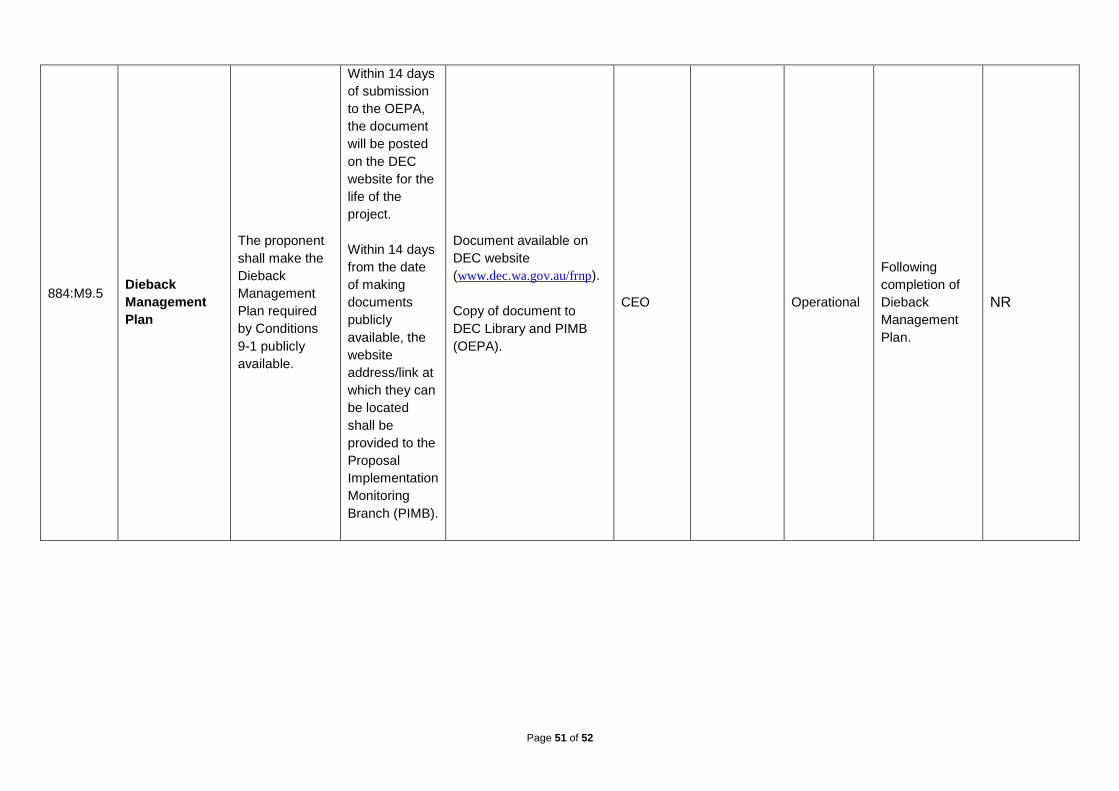
884:M9.5
Dieback
Management
Plan
The proponent
shall make the
Dieback
Management
Plan required
by Conditions
9-1 publicly
available.
Within 14 days
of submission
to the OEPA,
the document
will be posted
on the DEC
website for the
life of the
project.
Within 14 days
from the date
of making
documents
publicly
available, the
website
address/link at
which they can
be located
shall be
provided to the
Proposal
Implementation
Monitoring
Branch (PIMB).
Document available on
DEC website
(www.dec.wa.gov.au/frnp).
Copy of document to
DEC Library and PIMB
(OEPA).
CEO Operational
Following
completion of
Dieback
Management
Plan.
NR

Page 52 of 52
884:M10.1
Staging of
Plans
Where a plan,
assessment or
survey is
required by
these
conditions to be
prepared and
approved prior
to the
commencement
of an activity, it
is required that
the plan,
assessment or
survey can be
prepared and
approved as
per the relevant
condition
requirements
for a
component or
stage of the
activity,
allowing staged
implementation.
Staged flora
and vegetation
surveys.
Staged
assessments
of impacts on
threatened and
priority flora
species as
required for
Condition 7-2.
Flora and vegetation
surveys reports.
Assessment of potential
impacts on threatened
and priority flora species
and communities reports
submitted to the CEO.
CEO Overall Ongoing C