Embed Size (px)
Citation preview
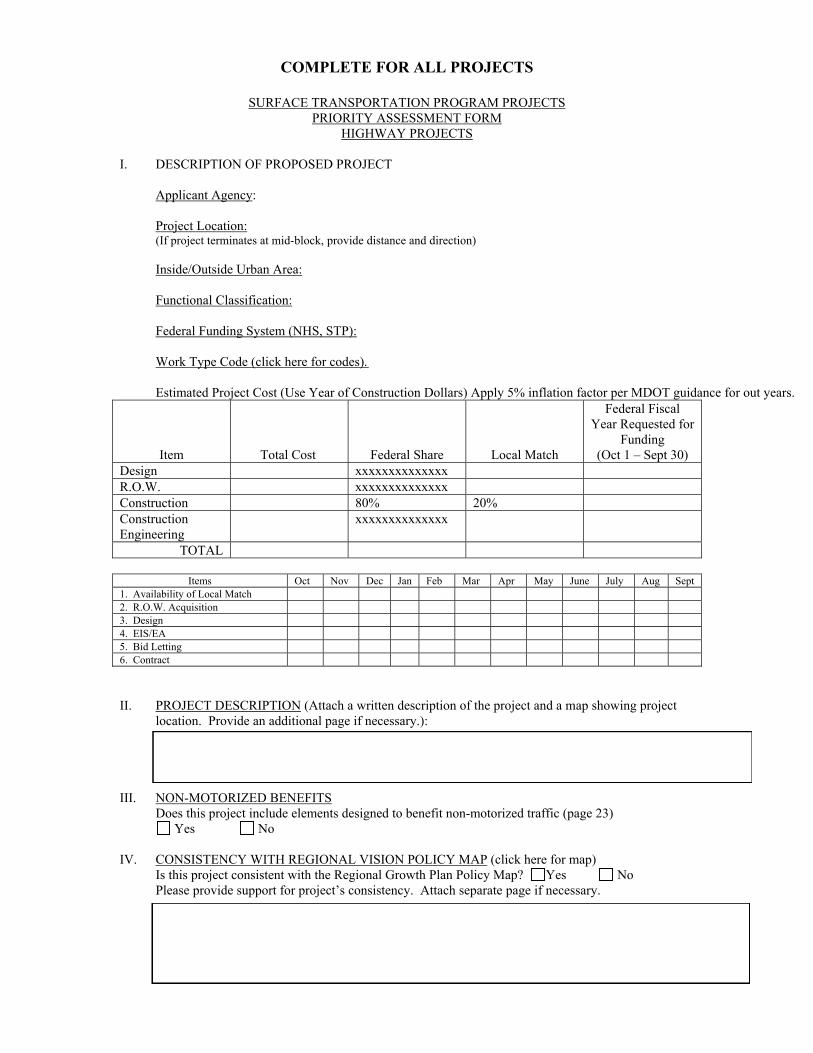
COMPLETE FOR ALL PROJECTS
SURFACE TRANSPORTATION PROGRAM PROJECTS PRIORITY ASSESSMENT FORM
HIGHWAY PROJECTS
I. DESCRIPTION OF PROPOSED PROJECT Applicant Agency: Project Location: (If project terminates at mid-block, provide distance and direction) Inside/Outside Urban Area: Functional Classification: Federal Funding System (NHS, STP): Work Type Code (click here for codes). Estimated Project Cost (Use Year of Construction Dollars) Apply 5% inflation factor per MDOT guidance for out years.
Item
Total Cost
Federal Share
Local Match
Federal Fiscal Year Requested for
Funding (Oct 1 – Sept 30)
Design xxxxxxxxxxxxxx R.O.W. xxxxxxxxxxxxxx Construction 80% 20% Construction Engineering
xxxxxxxxxxxxxx
TOTAL
Items Oct Nov Dec Jan Feb Mar Apr May June July Aug Sept 1. Availability of Local Match 2. R.O.W. Acquisition 3. Design 4. EIS/EA 5. Bid Letting 6. Contract II. PROJECT DESCRIPTION (Attach a written description of the project and a map showing project location. Provide an additional page if necessary.): III. NON-MOTORIZED BENEFITS Does this project include elements designed to benefit non-motorized traffic (page 23) Yes No IV. CONSISTENCY WITH REGIONAL VISION POLICY MAP (click here for map) Is this project consistent with the Regional Growth Plan Policy Map? Yes No Please provide support for project’s consistency. Attach separate page if necessary.
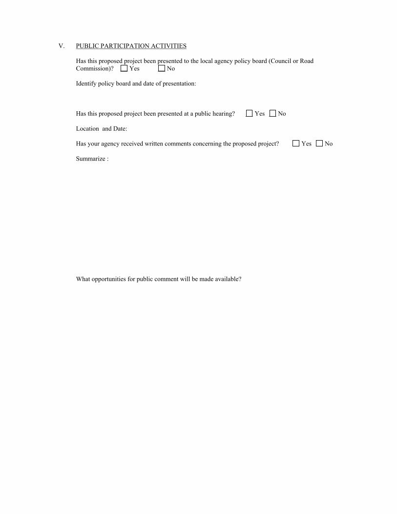
V. PUBLIC PARTICIPATION ACTIVITIES
Has this proposed project been presented to the local agency policy board (Council or Road Commission)? Yes No Identify policy board and date of presentation: Has this proposed project been presented at a public hearing? Yes No Location and Date: Has your agency received written comments concerning the proposed project? Yes No Summarize : What opportunities for public comment will be made available?
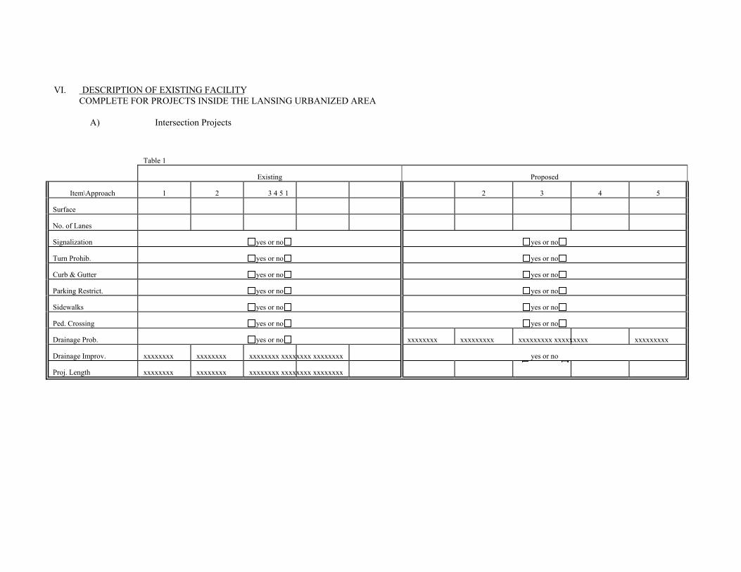
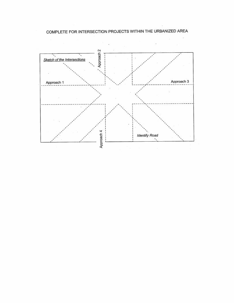
VI. DESCRIPTION OF EXISTING FACILITY COMPLETE FOR PROJECTS INSIDE THE LANSING URBANIZED AREA
A) Intersection Projects
Table 1
Existing Proposed
Item\Approach 1 2 3 4 5 1 2 3 4 5
Surface
No. of Lanes
Signalization yes or no yes or no
Turn Prohib. yes or no yes or no
Curb & Gutter yes or no yes or no
Parking Restrict. yes or no yes or no
Sidewalks yes or no yes or no
Ped. Crossing yes or no yes or no
Drainage Prob. yes or no xxxxxxxx xxxxxxxxx xxxxxxxxx xxxxxxxxx xxxxxxxxx
Drainage Improv. xxxxxxxx xxxxxxxx xxxxxxxx xxxxxxxx xxxxxxxx yes or no
Proj. Length xxxxxxxx xxxxxxxx xxxxxxxx xxxxxxxx xxxxxxxx

COMPLETE FOR PROJECTS INSIDE THE LANSING URBANIZED AREA
B) Highway Projects, Table 1 (cont.)
Item Existing Proposed
Surface Bitum - Concrete Bitum - Concrete Functional Classification
Collector
Collector
Pavement Width*
Total No. of Lanes
Total Thru-Lanes
Median Width
Pavement Thickness
Parking Restrictions None One both sides None One both sides
Curb & Gutter yes - no yes - no
Sidewalks yes - no yes - no
Drainage Problem xxxxxxxxxxxxxxxxxxxxxxxxx
Drainage Improvement xxxxxxxxxxxxxxxxxxxxxxx
Gravel Depth
Shoulder Width
Traffic Volumes 20 year forecast: Source:
Length of project xxxxxxxxxxxxxxxxxxxxxxx
Percent Commercial Vehicles (circle one)
0-5
0-5
One Way/Two Way
Density Intermediate Intermediate
Left Turns (two way facility)
Permitted Prohibited Permitted Prohibited
Green Time
Cycle Length
* Excluding curb and gutter.
Complete for Urban intersectionprojects(option one)
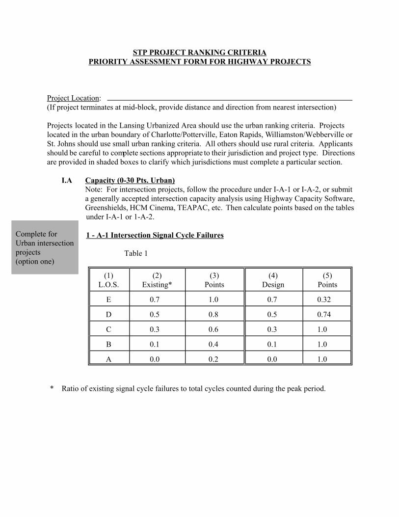
STP PROJECT RANKING CRITERIAPRIORITY ASSESSMENT FORM FOR HIGHWAY PROJECTS
Project Location: (If project terminates at mid-block, provide distance and direction from nearest intersection)
Projects located in the Lansing Urbanized Area should use the urban ranking criteria. Projectslocated in the urban boundary of Charlotte/Potterville, Eaton Rapids, Williamston/Webberville orSt. Johns should use small urban ranking criteria. All others should use rural criteria. Applicantsshould be careful to complete sections appropriate to their jurisdiction and project type. Directionsare provided in shaded boxes to clarify which jurisdictions must complete a particular section.
I.A Capacity (0-30 Pts. Urban)Note: For intersection projects, follow the procedure under I-A-1 or I-A-2, or submita generally accepted intersection capacity analysis using Highway Capacity Software,Greenshields, HCM Cinema, TEAPAC, etc. Then calculate points based on the tablesunder I-A-1 or 1-A-2.
1 - A-1 Intersection Signal Cycle Failures
Table 1
(1)L.O.S.
(2)Existing*
(3)Points
(4)Design
(5)Points
E 0.7 1.0 0.7 0.32
D 0.5 0.8 0.5 0.74
C 0.3 0.6 0.3 1.0
B 0.1 0.4 0.1 1.0
A 0.0 0.2 0.0 1.0
* Ratio of existing signal cycle failures to total cycles counted during the peak period.
Complete for UrbanIntersection Projects(option two)
Table 2 CALCULATION OF POINTS
Values Obtained from Table 1Product of PointsCol. 3 x Col.5(2) (3) (4) (5)
Road 1 (Project)Approach 1
Approach 2
Road 2Approach 1
Approach 2
Raw Score(divide by number of approaches) =
1 - A-2 Intersection Critical Lane Volume
Table 3
(1)*Existing Critical
Lane Volume
(2)
Points
(3)Design CriticalLane Volume
(4)
Points
> 15001350-15001200-13491050-1199900-1049
< 900
1.00.80.60.40.20.0
> 15001350-15001200-13491050-1199900-1049
< 900
0.00.30.71.01.01.0
* Use Transportation Research Circular 212, January, 1980.
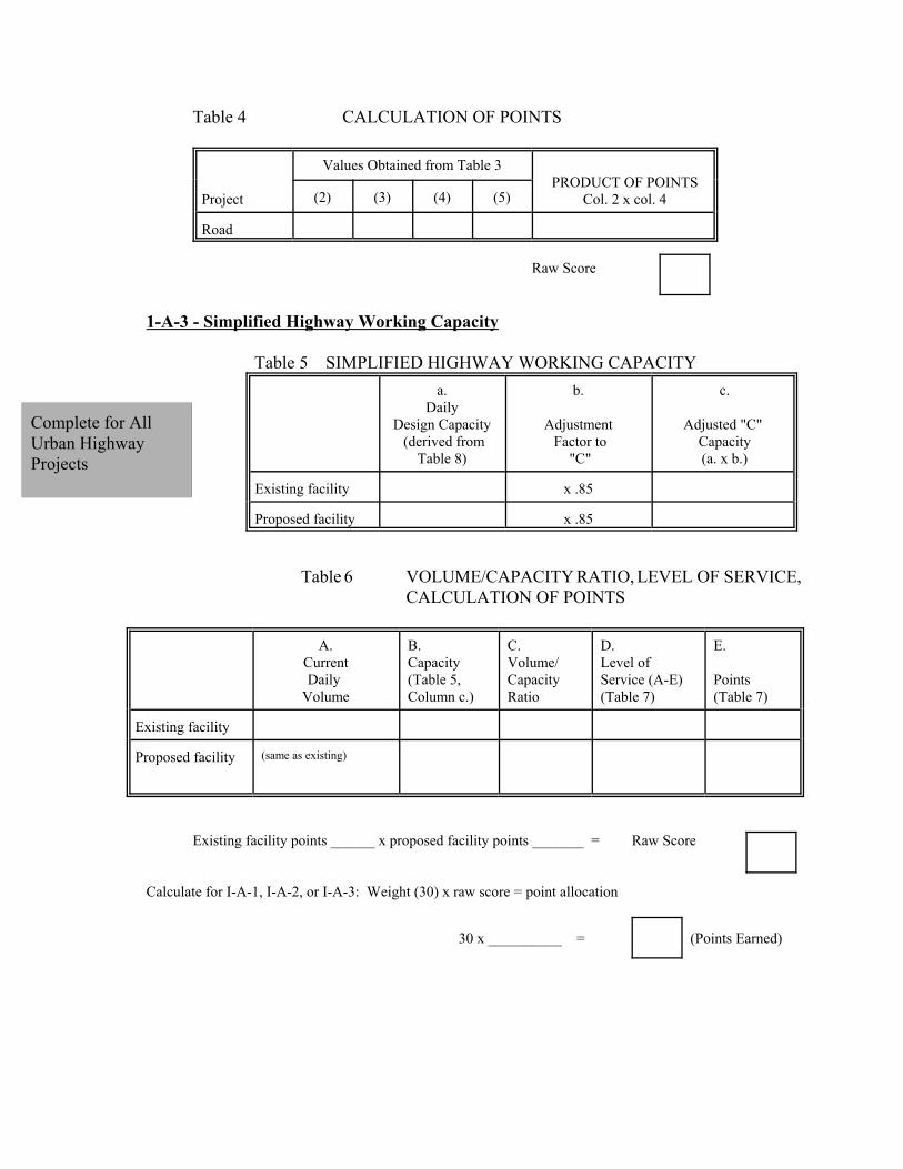
Complete for AllUrban HighwayProjects
Table 4 CALCULATION OF POINTS
Project
Values Obtained from Table 3PRODUCT OF POINTS
Col. 2 x col. 4(2) (3) (4) (5)
Road
Raw Score
1-A-3 - Simplified Highway Working Capacity
Table 5 SIMPLIFIED HIGHWAY WORKING CAPACITYa.
DailyDesign Capacity (derived from
Table 8)
b.
Adjustment Factor to
"C"
c.
Adjusted "C" Capacity(a. x b.)
Existing facility x .85
Proposed facility x .85
Table 6 VOLUME/CAPACITY RATIO, LEVEL OF SERVICE,CALCULATION OF POINTS
A.CurrentDaily
Volume
B.Capacity(Table 5,Column c.)
C.Volume/CapacityRatio
D.Level ofService (A-E)(Table 7)
E.
Points(Table 7)
Existing facility
Proposed facility (same as existing)
Existing facility points ______ x proposed facility points _______ = Raw Score
Calculate for I-A-1, I-A-2, or I-A-3: Weight (30) x raw score = point allocation
30 x __________ = (Points Earned)
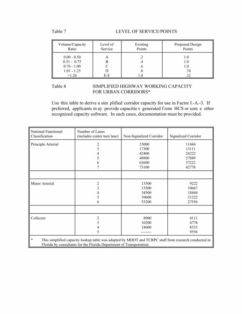
Table 7 LEVEL OF SERVICE/POINTS
Volume/CapacityRatio
Level ofService
ExistingPoints
Proposed DesignPoints
0.00 - 0.500.51 - 0.750.76 - 1.001.01 - 1.25
>1.26
ABCD
E-F
.2
.4
.6
.81.0
1.01.01.0
.74
.32
Table 8 SIMPLIFIED HIGHWAY WORKING CAPACITYFOR URBAN CORRIDORS*
Use this table to derive a sim plified corridor capacity for use in Factor I.-A.-3. Ifpreferred, applicants m ay provide capacitie s generated f rom HCS or som e otherrecognized capacity software. In such cases, documentation must be provided.
National FunctionalClassification
Number of Lanes(includes center turn lane) Non-Signalized Corridor Signalized Corridor
Principle Arterial 234567
150001730042400488006360073100
114441311124222278893722242778
Minor Arterial 23456
1350015500345003960053200
922210667184442122227556
Collector 2345
89001020018600--------
4111477883339556
* This simplified capacity lookup table was adapted by MDOT and TCRPC staff from research conducted inFlorida by consultants for the Florida Department of Transportation.

Complete For SmallUrban and RuralProjects
Complete for allHighway Projects
I.-B Volume Factor (0-30 Pts. Small Urban; 0-23 Pts. Rural). A volume factor is calculatedfor each roadway project based on the latest 24-hour count.
Daily Traffic/Small Urban
Awarded Points (Circle
appropriate value)Daily Traffic/
RuralAwarded
PointsOver 6000 30 Over 4000 23
5251 - 6000 27 3501 - 4000 204501 - 5250 24 3001 - 3500 173751 - 4500 21 2501 - 3000 143001 - 3750 18 2001 - 2500 112251 - 3000 15 1501 - 2000 8 1501 - 2250 12 1001 - 1500 5 751 - 1500 9 501 - 1000 2
0 - 750 6 0 - 500 0
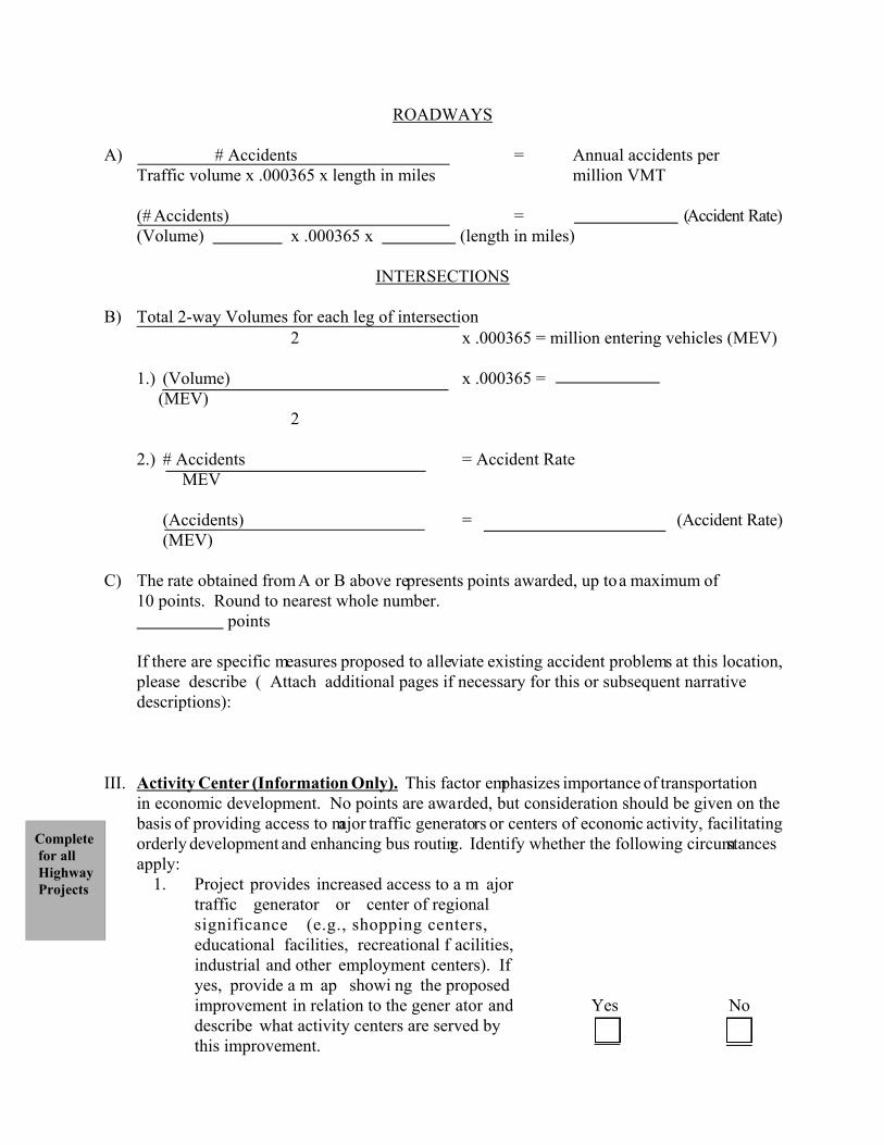
II. Accident Rate (0-10 Pts.). A greater number of points are awarded for locations withhigher accident rates. Accident data for the most recent three year period should be usedto calculate the average accident rate. Separate methods of calculating these rates areused for roadway segments and intersections as shown below. Multiple year accidentand traffic volume data for three years, if available, should be averaged. These accidentfigures are then used to calculate an accident rate per million vehicle miles of travel forhighway projects in “A” below. Intersection projects should use the procedure in “B”below to calculate a rate per m illion entering vehicles. The products are then used todetermine a point score in item “C.”
# Accidents Traffic Volumes Year
1.
2.
3.
4. (Total) (Total)
5. (Average) (Average)
Complete for all Highway Projects
ROADWAYS
A) # Accidents = Annual accidents per Traffic volume x .000365 x length in miles million VMT
(# Accidents) = (Accident Rate)(Volume) x .000365 x (length in miles)
INTERSECTIONS
B) Total 2-way Volumes for each leg of intersection2 x .000365 = million entering vehicles (MEV)
1.) (Volume) x .000365 = (MEV)
2
2.) # Accidents = Accident RateMEV
(Accidents) = (Accident Rate)(MEV)
C) The rate obtained from A or B above represents points awarded, up to a maximum of10 points. Round to nearest whole number. points
If there are specific measures proposed to alleviate existing accident problems at this location,please describe ( Attach additional pages if necessary for this or subsequent narrativedescriptions):
III. Activity Center (Information Only). This factor emphasizes importance of transportationin economic development. No points are awarded, but consideration should be given on thebasis of providing access to major traffic generators or centers of economic activity, facilitatingorderly development and enhancing bus routing. Identify whether the following circumstancesapply:
1. Project provides increased access to a m ajortraffic generator or center of regionalsignificance (e.g., shopping centers,educational facilities, recreational f acilities,industrial and other employment centers). Ifyes, provide a m ap showi ng the proposedimprovement in relation to the gener ator anddescribe what activity centers are served bythis improvement.
Yes No
Complete for all Highway Projects
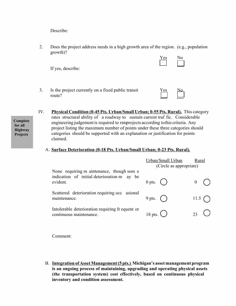
Describe:
2. Does the project address needs in a high growth area of the region. (e.g., populationgrowth)?
Yes No
If yes, describe:
3. Is the project currently on a fixed public transitroute?
Yes No
IV. Physical Condition (0-45 Pts. Urban/Small Urban; 0-55 Pts. Rural). This categoryrates structural ability of a roadway to sustain current traf fic. Considerableengineering judgement is required to rate projects according to this criteria. Any project listing the maximum number of points under these three categories shouldcategories should be supported with an explanation or justification for pointsclaimed.
A. Surface Deterioration (0-18 Pts. Urban/Small Urban; 0-23 Pts. Rural).
None requiring m aintenance, though som eindication of initial deterioration m ay beevident.
Urban/Small Urban Rural(Circle as appropriate)
0 pts. 0
Scattered deterioration requiring occ asionalmaintenance. 9 pts. 11.5
Intolerable deterioration requiring fr equent orcontinuous maintenance. 18 pts. 23
Comment:
B. Integration of Asset Management (5 pts.) Michigan’s asset management programis an ongoing process of maintaining, upgrading and operating physical assets(the transportation system) cost effectively, based on continuous physicalinventory and condition assessment.
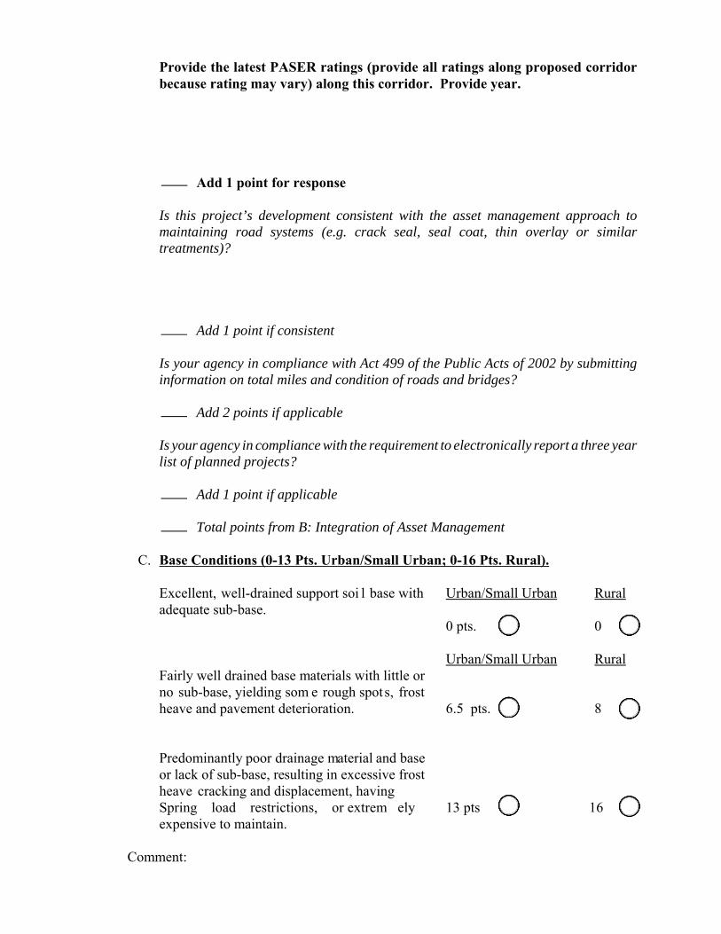
Provide the latest PASER ratings (provide all ratings along proposed corridorbecause rating may vary) along this corridor. Provide year.
Add 1 point for response
Is this project’s development consistent with the asset management approach tomaintaining road systems (e.g. crack seal, seal coat, thin overlay or similartreatments)?
Add 1 point if consistent
Is your agency in compliance with Act 499 of the Public Acts of 2002 by submittinginformation on total miles and condition of roads and bridges?
Add 2 points if applicable
Is your agency in compliance with the requirement to electronically report a three yearlist of planned projects?
Add 1 point if applicable
Total points from B: Integration of Asset Management
C. Base Conditions (0-13 Pts. Urban/Small Urban; 0-16 Pts. Rural).
Excellent, well-drained support soi l base withadequate sub-base.
Urban/Small Urban Rural
0 pts. 0
Fairly well drained base materials with little orno sub-base, yielding som e rough spots, frostheave and pavement deterioration.
Urban/Small Urban Rural
6.5 pts. 8
Predominantly poor drainage material and baseor lack of sub-base, resulting in excessive frostheave cracking and displacement, havingSpring load restrictions, or extrem elyexpensive to maintain.
13 pts 16
Comment:
Completefor allHighwayProjects
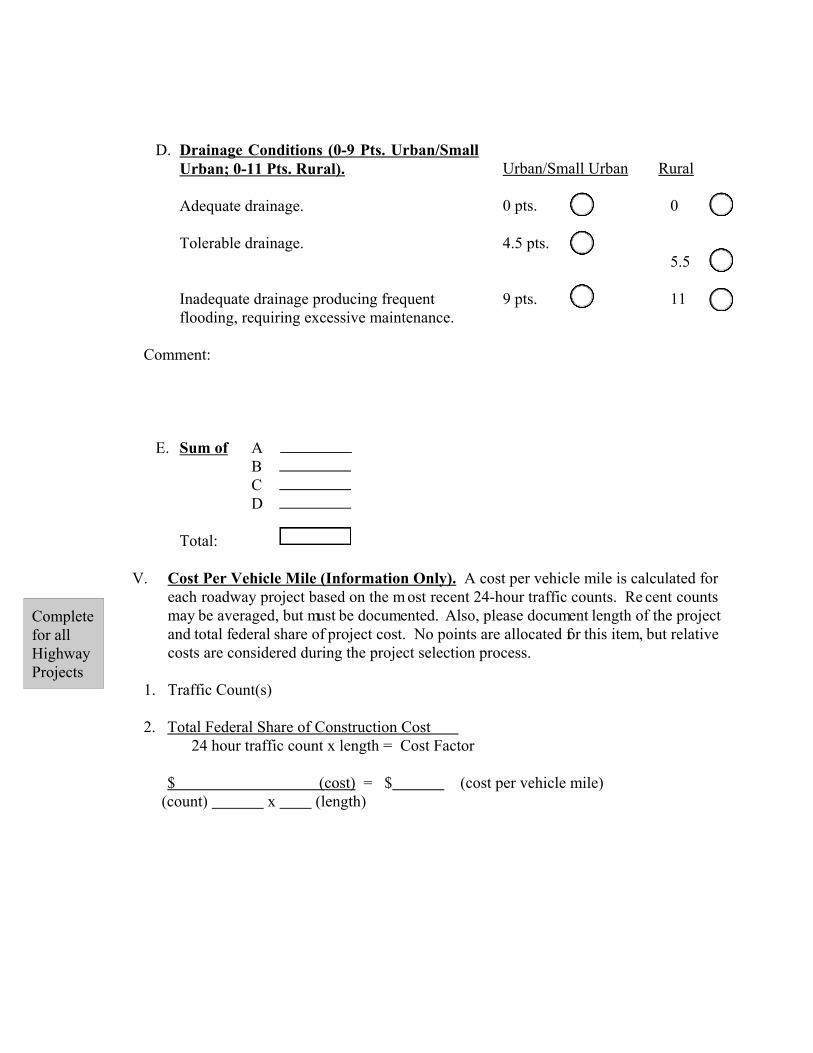
D. Drainage Conditions (0-9 Pts. Urban/SmallUrban; 0-11 Pts. Rural).
Adequate drainage.
Urban/Small Urban Rural
0 pts. 0
Tolerable drainage. 4.5 pts.5.5
Inadequate drainage producing frequentflooding, requiring excessive maintenance.
9 pts. 11
Comment:
E. Sum of A B C D
Total:
V. Cost Per Vehicle Mile (Information Only). A cost per vehicle mile is calculated foreach roadway project based on the m ost recent 24-hour traffic counts. Re cent countsmay be averaged, but must be documented. Also, please document length of the projectand total federal share of project cost. No points are allocated for this item, but relativecosts are considered during the project selection process.
1. Traffic Count(s)
2. Total Federal Share of Construction Cost 24 hour traffic count x length = Cost Factor
$ (cost) = $ (cost per vehicle mile)(count) x (length)
Completefor allHighwayProjects
Completefor allProjects
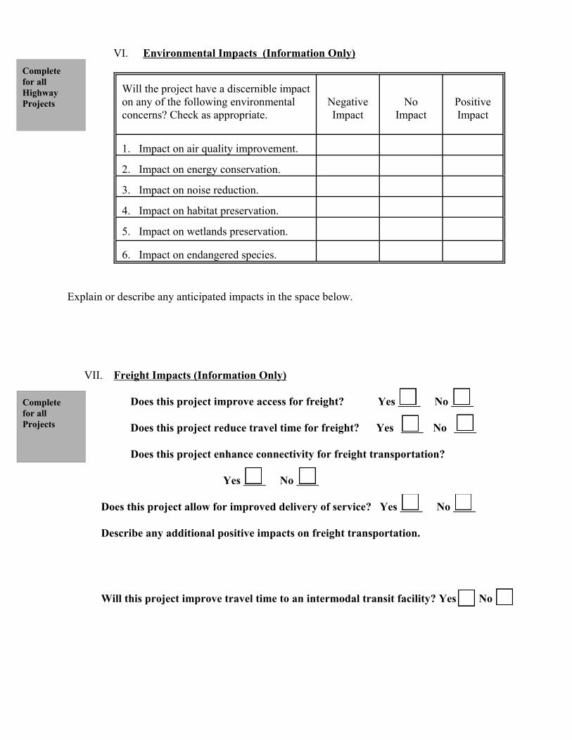
VI. Environmental Impacts (Information Only)
Will the project have a discernible impacton any of the following environmentalconcerns? Check as appropriate.
NegativeImpact
NoImpact
PositiveImpact
1. Impact on air quality improvement.
2. Impact on energy conservation.
3. Impact on noise reduction.
4. Impact on habitat preservation.
5. Impact on wetlands preservation.
6. Impact on endangered species.
Explain or describe any anticipated impacts in the space below.
VII. Freight Impacts (Information Only)
Does this project improve access for freight? Yes No
Does this project reduce travel time for freight? Yes No
Does this project enhance connectivity for freight transportation?
Yes No
Does this project allow for improved delivery of service? Yes No
Describe any additional positive impacts on freight transportation.
Will this project improve travel time to an intermodal transit facility? Yes No
Completefor allHighwayProjects
Completefor allHighwayProjects
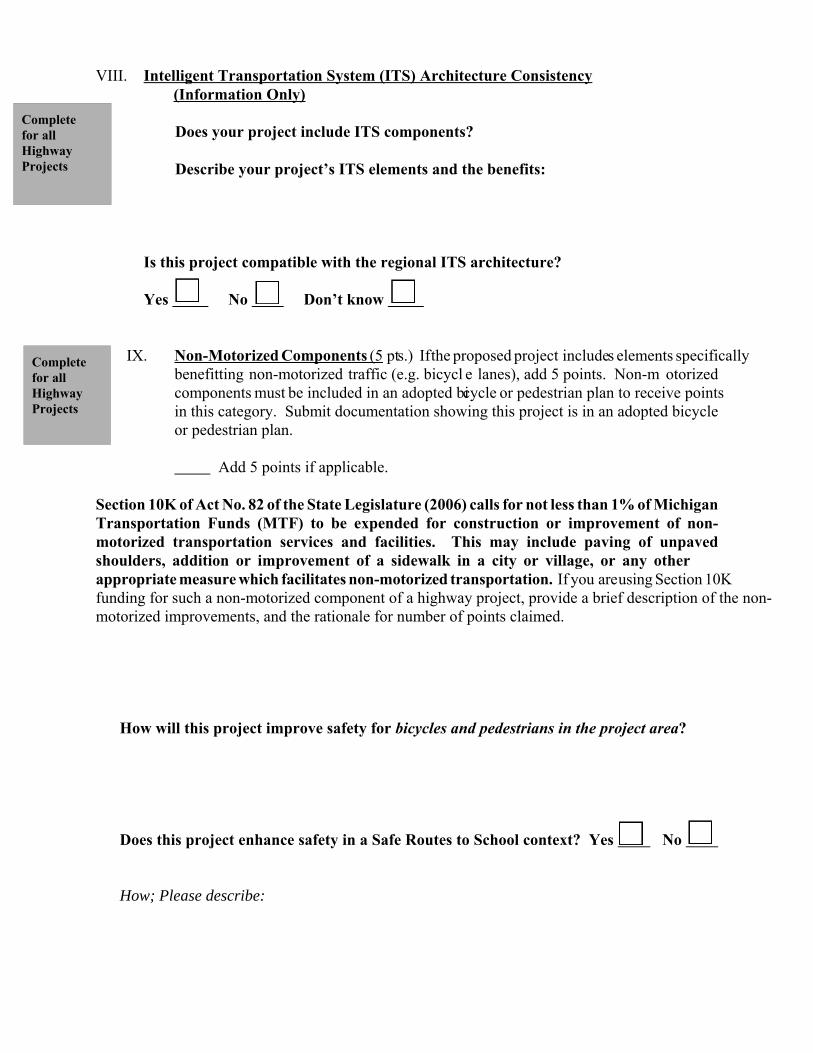
VIII. Intelligent Transportation System (ITS) Architecture Consistency(Information Only)
Does your project include ITS components?
Describe your project’s ITS elements and the benefits:
Is this project compatible with the regional ITS architecture?
Yes No Don’t know
IX. Non-Motorized Components (5 pts.) If the proposed project includes elements specificallybenefitting non-motorized traffic (e.g. bicycl e lanes), add 5 points. Non-m otorizedcomponents must be included in an adopted bicycle or pedestrian plan to receive pointsin this category. Submit documentation showing this project is in an adopted bicycleor pedestrian plan.
Add 5 points if applicable.
Section 10K of Act No. 82 of the State Legislature (2006) calls for not less than 1% of MichiganTransportation Funds (MTF) to be expended for construction or improvement of non-motorized transportation services and facilities. This may include paving of unpavedshoulders, addition or improvement of a sidewalk in a city or village, or any otherappropriate measure which facilitates non-motorized transportation. If you are using Section 10Kfunding for such a non-motorized component of a highway project, provide a brief description of the non-motorized improvements, and the rationale for number of points claimed.
How will this project improve safety for bicycles and pedestrians in the project area?
Does this project enhance safety in a Safe Routes to School context? Yes No
How; Please describe:
Completefor allHighwayProjects
Is the proposed project within two miles of a school? Yes No
X. Consistency with “Regional Growth: Choices for Our Future”
A. Is this project consistent with the Regional Growth Plan Policy Map?
Yes No
Provide support for project’s consistency. Attach separate page if necessary.
B. Has the local government where this project will be located adopted or
endorsed a resolution supporting policies contained in “Regional Growth: Choicesfor Our Future”?
Yes No
C. If applicable, has your independent transportation agency adopted oradopted or endorsed a resolution supporting policies contained in “RegionalGrowth: Choices for Our Future”?
Yes No Not applicable
D. Is this project consistent with adopted regional growth principle #14: “Theregional transportation priority will be to enhance and preserve the existing roadnetwork, public transit and non-motorized transportation modes rather thanfurther expansion of the road network in rural areas.”
Yes No
Add 4 points if applicable
Provide support for this consistency. Attach separate page if necessary.
E. Is this project consistent with adopted regional growth principle #19: “Pathways,sidewalks, trails and on-street bike facilities should be developed and enhanced toprovide alternatives to motorized transportation, improve linkages to recreationalopportunities for regional residents and provide public health benefits by offeringopportunities for physical activity.”
Yes No
Add 3 points if applicable
Provide support for this consistency. Attach separate page if necessary.
F. Does the project support increase in housing or population density consistent withthe Regional Growth Project principles? ( improve-expand;management/operations; and land use, community development and other?
Yes No
Add 3 points if applicable (This does not apply to rural projects; Urban and Small Urban projects are eligible)
Provide support for this consistency. Attach separate page if necessary.
Sum of points under X, Consistency with “Regional Growth: Choices for Our Future”(0-10 pts. Urban/Small Urban: 0-7 pts. Rural)
XI. Historic Preservation Considerations (Information Only)
Is the proposed project in or adjacent to a historic district or site? Yes No If so, describe the nature and proximity of this connection.
Is the site or structure identified on an eligible list of qualified historic places?
Yes No
Will there be any adverse impacts on the historic district or structure?
Yes No Not applicable
If yes, explain:
XII. Land Use, Community Development and Other Community Impacts
(Projects which fit this program category will be considered for a set aside
priority. Given the qualitative nature of this set aside category, points will not be
assigned for this section; however, projects completing this section will be
considered for set aside funding first).
Will the proposed project support coordinated and comprehensive development
planning? Yes No
Explain:
Will the proposed project facilitate re-use of previously used industrial sites for base
industry jobs? Yes No
Explain:
Will the proposed project support creation or retention of quality jobs?
Yes No
Explain:
Will the proposed project promote safe and efficient transportation of goods and
services to and from regional firms? Yes No
Explain:
Will the proposed project help to overcome barriers to locating or expanding
businesses and employers in the region? Yes No
Explain:
Will the proposed project assist in retaining and expanding quality jobs in base
industries? Yes No
Explain:
Is the proposed project consistent with the character of the area, and will it include
context sensitive solution principles? Yes No
Explain:
Will the proposed project support principles of strengthening city or town centers,
focused growth areas, clustered development or protection of environmentally sensitive
or agricultural lands? Yes No
Explain:
Will the proposed project support and encourage use of alternative modes?
Yes No
Explain:
Will the proposed project support or encourage higher population or housing densities
consistent with the adopted "Wise Growth" land use pattern?
scenario? Yes No
Explain:
Which goals/objectives from the Long Range Plan and regional vision land use
principles does the project support?
Is the project eligible under other program categories? Yes No
Explain:
XIII. Management and Operations Projects (Projects which fit this the program
category will be considered for a set aside priority. Given the qualitative nature
of this set aside category, points will not be assigned for this section; however,
projects completing this section will be considered for set aside funding first).
Is the program or project consistent with land use and community character in
the project area or corridor, which includes the entire area from building
facade to building facade, and does it consider all users of the area, regardless of mode?
Yes No
Explain:
Does the program or project improve operations for all users and modes?
In project area? Yes No
In the project corridor? Yes No
Over the total transportation system? Yes No
Explain:
Does the project reduce delay and improve safety in:
The project area? Yes No
The project corridor? Yes No
Over the total transportation system? Yes No
Explain:
Does the program or project improve operating conditions for more than one group of
modal users? Yes No
Explain:
Does the program or project improve operations or resolve a specific safety problem
at a specific location? Yes No
Explain:
Which goals/objectives from the Regional 2035 Transportation Plan and regional vision
land use principles does the project support? Click here for Goals and Objectives.
Explain:


![[Architecture Ebook] ZAHA HADID - COMPLETE BUILDINGS AND PROJECTS](https://img.pdfslide.us/doc/110x75/548caa98b47959593f8b45c7/architecture-ebook-zaha-hadid-complete-buildings-and-projects-558465d286101.jpg)