Embed Size (px)
Citation preview
City of North Charleston
Permitting Standards and
Procedures Manual
Date: September 2008
Revised: May 2019
City of North Charleston, South Carolina City of North Charleston Stormwater Program Public Works Department Permitting Standards and Procedures Manual May 2019
i
TABLE OF CONTENTS
CHAPTER 1 – GENERAL
1.1 Purpose ..................................................................................... 1-1
1.2 Scope ......................................................................................... 1-2
1.3 Manual Organization ............................................................... 1-2
1.4 Authorization ............................................................................ 1-3
1.4.1 NPDES MS4 General Permit SCR300000 ......................................... 1-3
1.4.2 City of North Charleston Ordinances, Regulations and Standards 1-3
1.5 Updates to the Design Manual ................................................ 1-4
1.6 Stormwater Management ........................................................ 1-4
1.6.1 Effects of Development on Watershed Hydrology ............................ 1-4
1.6.2 Steps to Successful Stormwater Management Plans ......................... 1-5
1.6.3 Innovative Design Approach ............................................................... 1-6
1.6.4 Best Management Practices and Site Planning Process ................... 1-6
1.6.4.1 Maintaining Site Resources and Natural Undisturbed Areas ....................... 1-7
1.6.4.2 Lower Impact Site Layout Techniques ........................................................... 1-7
1.6.4.3 Minimization of Impervious Cover .................................................................. 1-8 1.6.4.4 Utilization of Natural Features for Stormwater Management ..................... 1-8
1.6.4.5 Engineered/Proprietary Devices ...................................................................... 1-8
1.7 Engineering Design Accountability ........................................ 1-9
1.8 Legal Aspects ............................................................................ 1-9
1.9 Contact Information .............................................................. 1-10
1.10 Definitions ............................................................................... 1-10
City of North Charleston, South Carolina City of North Charleston Stormwater Program Public Works Department Permitting Standards and Procedures Manual May 2019
ii
CHAPTER 2 – STORMWATER PERMITTING PROCEDURES
2.1 Duty to Comply ........................................................................ 2-1
2.2 Stormwater Permit Application and Approval Procedures . 2-1
2.2.1 Final Approval ...................................................................................... 2-2
2.2.2 Site Construction and Project Closeout ............................................. 2-3
2.2.2.1 Permit Transfer ................................................................................................. 2-3
2.2.2.2 Project Closeout ................................................................................................. 2-4
2.2.2.3 Video Requirements .......................................................................................... 2-4
2.2.2.4 Asbuilt Requirements ........................................................................................ 2-5
2.2.2.5 Certification Statement ..................................................................................... 2-6
2.2.3 Exemptions ............................................................................................ 2-6
2.2.4 Expiration of the MS4 approval .......................................................... 2-7
2.2.5 Responsibility of Owner/Operator ...................................................... 2-7
2.2.6 Waivers .................................................................................................. 2-7
2.2.7 Non-Floodplain Variances ................................................................... 2-7
2.2.8 Encroachment Permits ......................................................................... 2-8
2.2.9 Easements .............................................................................................. 2-8
2.2.9.1 Storm Drain Pipe ............................................................................................... 2-8
2.2.9.2 Ditches/Canals ................................................................................................... 2-9
2.2.9.3 Detention Ponds ................................................................................................. 2-9
2.2.9.4 Other Stormwater Facilities and BMPs .......................................................... 2-9
City of North Charleston, South Carolina City of North Charleston Stormwater Program Public Works Department Permitting Standards and Procedures Manual May 2019
iii
2.2.9.5 Offsite Easements ............................................................................................ 2-10
2.2.10 Stormwater Facility Ownership and Maintenance ........................ 2-10
2.2.10.1 Ownership ........................................................................................................ 2-10
2.2.10.2 Maintenance ..................................................................................................... 2-10
2.2.11 Single Family Residential (SFR) Applications................................ 2-11
2.2.12 Type I – Minor Applications ............................................................ 2-11
2.2.13 Type II – Small/Intermediate Applications .................................... 2-12
2.2.14 Type III – Medium/Large Applications .......................................... 2-19
2.2.14.1 Pre-Submittal Meeting .................................................................................... 2-20
2.2.14.2 Phase Plan Requirement ................................................................................. 2-20
2.2.14.3 Stormwater Master Plan ................................................................................. 2-20
2.2.15 Utility Applications ............................................................................ 2-21
CHAPTER 3 - DESIGN REQUIREMENTS
3.1 General Design Standards ....................................................... 3-1
3.2 Hydrologic Computation Methods ......................................... 3-6
3.2.1 Inputs ..................................................................................................... 3-6
3.2.2 Drainage Design Methodologies .......................................................... 3-7
3.2.3 Hydrographs ......................................................................................... 3-8
3.3 Water Quantity/Quality Control Standards .......................... 3-8
3.3.1 Water Quantity Design Standarads .................................................... 3-8
City of North Charleston, South Carolina City of North Charleston Stormwater Program Public Works Department Permitting Standards and Procedures Manual May 2019
iv
3.3.2 Accepted Water Quantity Control Devices ........................................ 3-9
3.3.3 Water Quality Design Standards ..................................................... 3-10
3.3.4 Standard Design Procedures for Water Quality BMPs ................. 3-12
3.3.5 Detention Ponds/Reservoirs Standards ........................................... 3-13
3.3.6 Infiltration Standards ...................... ……………………………….3-14
3.3.7 Underground Detention Devices ...................................................... 3-15
3.3.8 Accepted Water Quality BMPs ........................................................ 3-17
3.3.9 Low Impact Development (LID) Concepts ..................................... 3-19
3.3.9.1 Runoff ............................................................................................................... 3-20
3.3.9.2 Reduce Limits of Clearing and Grading ....................................................... 3-21
3.3.9.3 Preserve Permeable Soils and Vegetated Areas ........................................... 3-21
3.3.10 Alternative Roadway Design ............................................................ 3-21
3.3.10.1 Time of Concentration .................................................................................... 3-23
3.3.10.2 LID Hydrologic Analysis ................................................................................ 3-25
3.3.10.3 LID Integrated Management Practices (IMPs) ............................................ 3-26
3.3.10.4 LID IMP Selection Process ............................................................................. 3-26
3.3.11 Stormwater Manufactured Treatment Devices .............................. 3-28
3.3.11.1 Design Criteria ................................................................................................. 3-28
3.3.11.2 MTD Components and Performance Requirements ................................... 3-29
3.3.11.3 Drawing Requirements ................................................................................... 3-30

City of North Charleston, South Carolina City of North Charleston Stormwater Program Public Works Department Permitting Standards and Procedures Manual May 2019
v
3.4 Stormwater Drainage System Design Standards ................ 3-31
3.5 Open Channel Hydraulics ..................................................... 3-38
3.6 Erosion Prevention and Sediment Control Standards ........ 3-40
3.6.1 Accepted EPSC BMPs ....................................................................... 3-40
3.6.1.1 Erosion Prevention Measures ....................................................................... 3-40
3.6.1.2 Temporary Sediment Control Measures ..................................................... 3-41
3.6.1.3 Runoff Control and Conveyance Measures ................................................. 3-43
3.6.1.4 Temporary Vegetation/Seeding .................................................................... 3-43
3.6.1.5 Permanent Vegeation/Seeding ...................................................................... 3-46
3.6.2 EPSC Design Standards .................................................................... 3-51
3.6.2.1 General Standards ......................................................................................... 3-51
3.6.2.2 Typical EPSC Design Procedures ................................................................. 3-55
3.7 Special Protection Areas ........................................................ 3-55
3.7.1 Water Quantity .................................................................................. 3-56
3.7.2 Water Quality .................................................................................... 3-56
CHAPTER 4 – INSPECTIONS AND ENFORCEMENT
4.1 Stormwater Management Inspections .................................... 4-1
4.1.1 Inspector Duties/Responsibilities ........................................................ 4-1
4.1.2 Inspection Process and Procedures ..................................................... 4-2
4.2 Permittee Inspection Responsibilities ..................................... 4-3
City of North Charleston, South Carolina City of North Charleston Stormwater Program Public Works Department Permitting Standards and Procedures Manual May 2019
vi
4.3 Enforcement ............................................................................. 4-3
4.3.1 Correction Orders ................................................................................ 4-3
4.3.2 Notices of Violation (NOV) .................................................................. 4-4
4.3.3 Stop Work Order .................................................................................. 4-4
4.3.4 Civil Penalties ........................................................................................ 4-5
4.3.5 Criminal Penalties ................................................................................ 4-5
CHAPTER 5 – REFERENCES
APPENDIX A – APPLICATION FORMS
APPENDIX B – OPERATING PERMIT FOR MAINTENANCE
APPENDIX C – PERMITTING PROCESS FLOWCHART
APPENDIX D – TABLES OF BMP SUGGESTED USES
APPENDIX E – PLAN REVIEW CHECKLIST
APPENDIX F – INSPECTION CHECKLIST
APPENDIX G – ENFORCEMENT FORMS
APPENDIX H– TRANSFER OF OWNERSHIP APPLICATION
APPENDIX I – BMP DETAILS
LIST OF TABLES Table 2.1: Storm Drain Pipe Easements .................................................................................... 2-8
Table 3.1: Design Storm Precipitation Data (in Inches) for North Charleston, S. C. ................ 3-6
Table 3.2: Recommended Methodologies Based on Land Disturbance Area ........................... 3-7
City of North Charleston, South Carolina City of North Charleston Stormwater Program Public Works Department Permitting Standards and Procedures Manual May 2019
vii
Table 3.3: Recommended Hydrologic Methods for Designing Various Stormwater Management Systems and Controls ............................................................................................... 3-8
Table 3.4: Accepted Water Quantity Controls .......................................................................... 3-9
Table 3.5: Accepted Water Quality Controls (BMPs) ............................................................. 3-17
Table 3.6: Limited Structural Controls (BMPs) ...................................................................... 3-18
Table 3.7: LID Planning Techniques to Reduce the Post-Development LID Runoff ............. 3-22
Table 3.8: LID Planning Techniques to Increase Post-Development Tc ................................ 3-24
Table 3.9: LID Techniques for Use with Design and Analysis Components .......................... 3-25
Table 3.10: Site Constraints of LID IMPs ................................................................................. 3-27
Table 3.11: Maximum Permissible Velocities for Vegetated Channels .................................... 3-39
Table 3.12: Erosion Prevention BMP Suggested Uses .............................................................. 3-41
Table 3.13: Temporary Sediment Control BMP Suggested Uses ............................................. 3-42
Table 3.14: Runoff Control and Conveyance Measures BMP Suggested Uses ........................ 3-43
Table 3.15: Temporary Vegetation/Seeding Schedule .............................................................. 3-46
Table 3.16: Temporary Vegetation/Seeding Schedule for Steep Slopes/Cut Slopes ................ 3-46
Table 3.17: Permanent Vegetation/Seeding Schedule ............................................................... 3-50
Table 3.18: Permanent Vegetation/Seeding Schedule for Steep Slopes/Cut Slopes ................. 3-50
Table 3.19: Native Species That Can Be Used On Non-Critical, Level Sites ........................... 3-51

City of North Charleston, South Carolina City of North Charleston Stormwater Program Public Works Department Permitting Standards and Procedures Manual May 2019
1-1
CHAPTER 1 – GENERAL INFORMATION
1.1 Purpose
It is the purpose of this Manual and the Stormwater Management Ordinance to protect, maintain, and enhance water quality and the environment of the City of North Charleston and the short-term and long-term public health, safety, and general welfare of the citizens of the City of North Charleston. This Manual and the Stormwater Management Ordinance is also designed to minimize property damage by establishing requirements and procedures to control the potential adverse effects of increased stormwater runoff and related pollutant loads associated with both future development and existing developed land. Proper management of stormwater runoff will further the purpose of this Manual and the Stormwater Management Ordinance to ensure a functional drainage system, reduce the effects of development on land and stream channel erosion, attain and maintain water quality standards, enhance the local environment associated with the drainage system, reduce local flooding, maintain where necessary pre-developed runoff characteristics of the area in terms of flow rate, volume and pollutant concentration, and facilitate economic development while mitigating associated pollutant, flooding, erosion, and drainage impacts. This Manual is for stormwater management purposes only, and the requirements herein are specific to the City’s stormwater management program and do not preclude the Planning, Zoning and Building Departments from performing their permit, plan review, inspection or other related duties and collecting applicable fees. This Manual describes the policies and procedures used by the Public Works Director to implement the Stormwater Management Ordinance and the City’s Stormwater Management Program (SWMP). These standards and procedures will:
1. Clearly describe the construction activity application requirements and approval process as it relates to stormwater management;
2. Convey the technical design standards to the engineering community, to include standards which address flow rates, runoff volume, and pollutant load/concentration, as well as specific standards during construction and for long-term performance;
3. Provide general information on approaches to improve water quality, prevent illicit discharges, and minimize stormwater runoff impacts due to development and re- development;
4. Convey other protection provisions related to stormwater discharges such as wetlands and watercourse conservation.
Every effort has been made throughout this Manual to cover the common conditions and information needed by those involved in construction activities, however, these design standards and the City Ordinances should be reviewed carefully to ensure that all requirements are being met. Developments may also be impacted by state and federal requirements to include, but not
City of North Charleston, South Carolina City of North Charleston Stormwater Program Public Works Department Permitting Standards and Procedures Manual May 2019
1-2
be limited to, the NPDES Phase II Construction General Permit (CGP) for Stormwater Discharges from Large and Small Construction Activities. Those projects not subject to NPDES requirements must still comply with applicable City standards.
1.2 Scope
The scope of this Manual is limited to the requirements related to stormwater management as reviewed and approved by the City of North Charleston’s Public Works Director. This Manual is not intended as a textbook or a comprehensive engineering design reference. It was instead developed under the assumption that the user possesses a basic understanding of stormwater control design, construction, or land development depending on the user’s particular area of expertise. References to guidance documents from federal, state, and local agencies, as well as commercial products are given throughout this Manual to provide additional information to users. Two common examples are the Natural Resources Conservation Service’s (NRCS) TR-55 and SCDHEC’s Best Management Practices (BMP) Manual. A copy of SCDHEC’s Best Management Practices may be found at http://www.scdhec.gov/environment/WaterQuality/Stormwater/BestManagementPractices/
The design standards are not intended to restrain or inhibit engineering creativity, freedom of design, or the need for engineering judgment. When shown to be applicable, it is encouraged that new methods, techniques, and innovative stormwater BMPs be submitted with supporting documentation. However, the use of such approaches should be substantiated with submitted documentation by design professionals showing that the proposed design is equal to, or exceeds the traditional procedures in terms of performance and economic feasibility. On projects that require site specific designs pertaining to stormwater management and water quality, site plans, details, calculations, construction specifications, and other technical documents must be designed and sealed by a professional engineer that is registered in the state of South Carolina, with sufficient knowledge and experience to accomplish all design elements of the site plan. Users who are not justly qualified by education or experience in the fields of stormwater control design, construction, or land development should consult with a qualified professional in one or more of these areas prior to planning for construction activities.
1.3 Manual Organization
The design standards are divided into five (5) chapters, organized to present recommended technical and engineering procedures along with criteria obtained from local, state, and federal requirements. The remainder of this chapter provides information on the City’s authority to develop and enforce design requirements along with several legal matters, some background information on stormwater management and its importance, and definitions for terms used throughout this Manual. Chapter 2 describes the application process for obtaining a construction permit. Chapter 3 contains specific design criteria and the site design credit system. Chapter 4 describes the inspection and enforcement process. Chapter 5 contains references for designing components of the stormwater management system.
City of North Charleston, South Carolina City of North Charleston Stormwater Program Public Works Department Permitting Standards and Procedures Manual May 2019
1-3
1.4 Authorization
This Manual has been prepared under the direction of the Public Works Director, which has been granted the authority to develop engineering design standards and enact programs and policies to ensure compliance with the NPDES Phase II General Permit for Stormwater Discharges from Regulated Small Municipal Separate Storm Sewer Systems (MS4s), SCR300000, and the City’s pertinent ordinances. 1.4.1 NPDES MS4 General Permit SCR300000
The City of North Charleston, like many other cities and counties across the United States, is required to have an NPDES MS4 permit to discharge stormwater. Because construction activities contribute to the discharge of pollutants, the NPDES MS4 permit requires that the City of North Charleston encourage, promote, and implement certain practices, programs, and procedures for the purpose of reducing or limiting discharge of pollutants to Waters of the State. The permit requires that the City of North Charleston develop and implement a Stormwater Management Program to control the discharge of pollutants from its MS4 to the maximum extent practicable (MEP). The SWMP has several components that must be met and this Manual provides partial compliance with several, including construction and post-construction management, and public education. A link to the MS4 permit can be found at https://www.scdhec.gov/sites/default/files/docs/Environment/docs/Final_SMS4_Permit.pdf 1.4.2 City of North Charleston Ordinances, Regulations, and Standards
The City of North Charleston has developed and adopted ordinances and standards, largely based on State and Federal regulations, specifically to address concerns associated with uncontrolled stormwater runoff. The principal ordinances and standards for the City that affect the selection of stormwater management control measures are:
1. Stormwater Management Ordinance: Established the engineering design standards and procedures for obtaining a construction permit within the City of North Charleston. The Public Works Director was authorized by this ordinance to develop all necessary regulations, as detailed in this Manual for properly controlling stormwater runoff and mitigating existing and future impacts.
2. Zoning and Land Development Regulations Ordinance: Issues that may be impacted by this Ordinance when designing stormwater management systems include but are not limited to: limits on building density, buffer and setback requirements, parking lot islands, required parking spaces, tree protection, planting species selection, and screening requirements for ponds and other BMPs. Applicants should specifically check to make sure a desired development type is allowed in the planned location.
3. Building Services: this office issues building permits and enforces all applicable provisions of the building codes and floodplain management regulations.
City of North Charleston, South Carolina City of North Charleston Stormwater Program Public Works Department Permitting Standards and Procedures Manual May 2019
1-4
1.5 Updates to the Design Standards
This Manual is subject to updates. As design technology and criteria evolve or change or it becomes evident that additional measures are needed to ensure the public general welfare, the Manual will be updated as needed. Updates will be approved by the City’s Public Works Director. Users of this manual are encouraged to provide comments on the content of this manual at anytime in writing to the Public Works Director. The comments shall include proposed changes, reasoning, and justification (including any supporting technical documents supporting the changes). All comments will be considered during manual updates. This Manual can also be found on the City of North Charleston website at www.northcharleston.org.
1.6 Stormwater Management
Development has the potential to alter the natural drainage patterns, flow rates, and volumes, and quality of the City’s water resources. Traditional solutions have removed stormwater as efficiently as possible, while maintaining runoff quantity controls. The following sections discuss these impacts and the design considerations that are available and encouraged. 1.6.1 Effects of Development on Watershed Hydrology
Development and urbanization have the following impacts on receiving waterbodies:
Changes to Stream Flow;
Increased runoff volumes;
Increased peak runoff discharges;
Greater runoff velocities;
Increased flooding frequency;
Lower dry weather flows (base flow) due to reduction in groundwater recharge;
Increase in floodplain elevation;
Changes to Stream Geometry;
Stream channel enlargement;
Stream down cutting;
Changes in channel bed due to sedimentation;
Degradation of Aquatic Habitat;
Degradation of habitat structure;
Decline in stream biological functions;
City of North Charleston, South Carolina City of North Charleston Stormwater Program Public Works Department Permitting Standards and Procedures Manual May 2019
1-5
Water Quality Impacts;
Reduced oxygen in streams;
Microbial contamination;
Hydrocarbons and toxic materials;
Sedimentation;
Property Damage and Safety Concerns;
Unsightly Aesthetic Stream Channel Conditions and Restricted Use of Recreational Waters.
1.6.2 Steps to Successful Stormwater Management Plans
Proper planning is necessary to ensure that stormwater management is considered and fully integrated at the various stages of the site-development process. This involves a comprehensive approach to site planning and a thorough understanding of the physical characteristics and resources associated with the project site. This planning includes addressing each of the following categories:
Stormwater quantity controls;
Erosion and sediment controls;
Stormwater quality controls;
Stormwater conveyance controls;
Maintenance schedules for construction and post construction activities.
The design of successful stormwater management plans involves adhering to the following principles, where applicable:
Pre-submittal site meeting/site visit;
Review of site development requirements;
Detailed site analysis and supporting calculations;
A thorough knowledge of the impacts the stormwater system may have on the watershed;
Creation of a Stormwater Concept Plan;
Design aspects of the stormwater management plans;
City of North Charleston, South Carolina City of North Charleston Stormwater Program Public Works Department Permitting Standards and Procedures Manual May 2019
1-6
Approval and completion of the land disturbance permit application.
In Chapter 2, the procedure for including the necessary documentation for a complete land disturbance application is provided. 1.6.3 Innovative Design Approach
When designing for land disturbance activities, the design must address the following four categories of control: water quantity (flood control), design storm control (rate and volume), erosion prevention and sediment control, and pollution control (water quality standards, long-term). If an innovative stormwater design approach is to be used, the design professional should take the following considerations in mind, in addition to meeting these categories of control:
Stormwater quantity and quality are best controlled at the source of the problem by
reducing the potential maximum amount of runoff and pollutants. Source control will typically be more economical in order to treat the first flush of a storm event since a simple BMP for a large area will only treat the first flush from the closest portions of the site;
Best management practices (BMPs) address stormwater runoff by using simple, structural and nonstructural methods along with or in place of traditional stormwater management structures when applicable;
Equaling or exceeding traditional stormwater management designs in terms of performance (rate/volume attenuation, pollutant removal) and economic feasibility (long-term) are essential to a proposed concept’s eventual approval.
Innovative approaches to site design focus on source control for stormwater runoff that limit the amount of runoff generated for a BMP to control. 1.6.4 Best Management Practices and Site Planning Process
The first step in addressing stormwater management begins in the site planning and design stage of the development project. By implementing BMPs during the site planning process, the amount of runoff and pollutants generated from a site can be reduced by minimizing the amount of impervious area and utilizing natural on-site treatments. The minimizing of adverse stormwater runoff impacts by the use of BMPs and site planning should be a major consideration for a design professional. The reduction of runoff volumes and stormwater pollutants decreases the total number and size of stormwater management controls that must be implemented under the guidelines set forth in this Manual. BMPs reduce the amount of total post-development impervious areas and maintain natural characteristics of the pre-development site conditions. Therefore, the post-development curve number(s) and time of concentrations are maintained more closely to the pre-development conditions. This reduces the overall hydrologic and hydraulic impact of the development.
City of North Charleston, South Carolina City of North Charleston Stormwater Program Public Works Department Permitting Standards and Procedures Manual May 2019
1-7
1.6.4.1 Maintaining Site Resources and Natural Undisturbed Areas Conservation of site resources and natural undisturbed areas helps to reduce the post development runoff volume and provides areas for natural stormwater management. Some natural site resources that should be maintained include, but are not limited to:
Natural drainage ways;
Vegetated buffer areas along natural waterways;
Floodplains;
Areas of undisturbed vegetation;
Low areas within the site terrain;
Natural forested infiltration areas;
Wetlands.
1.6.4.2 Lower Impact Site Layout Techniques Lower impact site layout techniques involve identifying and analyzing the location and configuration of structures on the site to be developed. Where applicable, the following options that create lower impact layouts should be used:
Fit the design layout to follow the natural contours of the site to minimize clearing
and grading and preserve natural drainage ways and patterns;
Limit the amount of clearing and grading by identifying the smallest possible area on the site that would require land disturbance;
Place development areas on the least sensitive areas of the site and avoid steeply sloped areas when possible;
Utilize nontraditional designs to reduce the overall imperviousness of the site by providing more undisturbed open space and minimizing clear-cutting;
Consider the utilization of cisterns and rain barrels to collect stormwater for reuse;
Level spreaders or other energy dissipation devices should be used at all discharge points. Level spreaders should also be considered for discharge points into ponds and other basin-type BMPs. More information on these devices is provided in Chapter 3.
City of North Charleston, South Carolina City of North Charleston Stormwater Program Public Works Department Permitting Standards and Procedures Manual May 2019
1-8
1.6.4.3 Minimization of Impervious Cover The minimization of total impervious area directly relates to a reduction in stormwater runoff volume and the associated pollutants from a development site. The amount of impervious cover on a site can be reduced by the following techniques where applicable:
Reduce building footprints by constructing some buildings as multi-story;
Reduce parking lot areas and use porous/pervious pavement surfaces for desired overflow parking where feasible;
Increase the amount of vegetated parking lot “islands” that can also be utilized for stormwater management practices such as bio-retention areas;
Disconnect impervious surfaces by directing runoff to adjacent pervious areas so that runoff can be filtered and infiltrated.
1.6.4.4 Utilization of Natural Features for Stormwater Management Structural stormwater drainage controls are traditionally designed to quickly remove stormwater runoff from the site without utilizing any of the natural storage areas. These natural drainage areas should be considered as potential stormwater drainage systems. These natural areas can be utilized in the following ways where applicable:
Vegetated buffers and undisturbed areas on the site are useful to control sheet flow
(not concentrated flows) by providing infiltration, runoff velocity reduction, and pollutant removal;
Various natural drainageways should be maintained and not disturbed to provide a natural stormwater drainage system to carry runoff to an existing outlet. The use of natural drainageways allows for more storage of stormwater runoff, lower peak flow rates, a reduction in erosive runoff velocities, and the capture and treatment of pollutants;
Curb and gutter systems may be combined with vegetated swales at outfalls to provide added water quality benefits versus the traditional piped outfall designs;
When applicable, direct rooftop runoff to pervious natural areas for water quality treatment and infiltration instead of connecting rooftop drains to roadways and other structural stormwater conveyance systems.
1.6.4.5 Engineered/Proprietary devices The City of North Charleston is aware of the potential benefit in using a number of stormwater engineered devices currently available on the market, such as baffle boxes, cartridge filters,

City of North Charleston, South Carolina City of North Charleston Stormwater Program Public Works Department Permitting Standards and Procedures Manual May 2019
1-9
bioretention, and sock and tube erosion control devices. The Public Works Director will evaluate any and all such devices specified for a given product and require appropriate drawings, specifications, and discussions as to the applicability of the product, expected performance, and required maintenance. The Public Works Director reserves the right to request that certain devices be installed and maintained.
1.7 Engineering Design Accountability
This Manual will assist engineers, plan reviewers, inspectors, and contractors in the design and layout of most land disturbance projects. However, this Manual does not replace or otherwise excuse the need for professional engineering judgment and knowledge. The user of this Manual is hereby cautioned that many aspects of engineering design must be considered, including but not limited to:
Public health and safety;
Site-specific conditions or unusual features of a project site that warrant special designs;
Current versions of design texts, manuals, technical documents, and research.
The design engineer (with assistance from other design professionals as needed) is expected to thoroughly investigate field conditions and coordinate all design efforts with the City of North Charleston. For applicable projects, construction plans must be stamped and signed by a professional engineer actively licensed in the state of South Carolina, unless otherwise stated in this Manual. The design professional must have sufficient education and experience to perform a complete and thorough design of each element shown on the construction plans, and must also have complete control to change or alter plans during the design phase. The professional's stamp is a public guarantee that their design has the highest regard for health and safety, protects the environment (air, soil, water) to the maximum degree possible, and serves the interests of the general public within the City of North Charleston. A Certificate of Authorization (COA) is required on the construction plans in addition to the engineer’s professional certification. The City of North Charleston requires a certain level of design expertise for stormwater calculations and flooding analyses. Stormwater design criteria are based upon current scientific knowledge and engineering judgment. It should be realized by engineering designers that floods and flooding may occur at any time due to any number of factors beyond the reasonable control of the City of North Charleston, such as: greater amounts of precipitation or different rainfall patterns than used in design storms, wet soil conditions, debris or blockage of key stormwater channels, high groundwater tables, etc.
1.8 Legal Aspects
If any portion of this Manual is ruled to be invalid or unconstitutional by any court with adequate jurisdiction over the City of North Charleston, then such portion shall be considered to have been selectively removed from the design standards without affecting this Manual’s overall
City of North Charleston, South Carolina City of North Charleston Stormwater Program Public Works Department Permitting Standards and Procedures Manual May 2019
1-10
applicability and legal standing to the land disturbance process. This Manual will be revised on a periodic basis to reflect known changes to laws and regulations. All local, state, and federal laws and regulations shall be considered in regards to this Manual. In each instance, the more restrictive requirement shall govern unless sound engineering judgment can determine and prove that the more restrictive requirements would be otherwise unnecessary. In most instances, laws and regulations that are phrased more explicitly shall apply over those items that are described in general terms.
1.9 Contact Information
The City of North Charleston should be contacted for any questions, clarifications, or other information related to stormwater management and this Manual. Contact for stormwater issues: City of North Charleston Department of Public Works
Engineering Division 5800 Casper Padgett Way North Charleston, S.C. 29406 (843) 745-1026
Fax: (843) 745-1099
1.10 Definitions
Words used in this Manual shall have their customary meanings as determined by the standard dictionary definition except for the following specific words and terms which are herein defined or are otherwise defined in the City of North Charleston’s Stormwater Management Ordinance. In any case, the Public Works Director shall have the right to define or interpret any other word or term contained within this Manual. The rules of verbal construction found in the Stormwater Management Ordinance apply to this Manual.
1. Best Management Practices (BMPs): activities, prohibition of practices, maintenance procedures, and other management practices to prevent or reduce the pollution of waters of the United States. BMPs also include treatment requirements, operating procedures, and practices to control runoff, spillage, or leaks, sludge or waste disposal or drainage raw material storage.
2. Buffer: an area left undisturbed between neighboring property lines or wetlands.
3. Building: (1) a relatively permanent enclosed structure over a plot of land, having a roof and usually windows and often more than one level, used for any of a wide variety of activities, as living, entertaining, or manufacturing; (2) anything built or constructed; (3) the act, business, or practice of constructing houses, office buildings, etc.

City of North Charleston, South Carolina City of North Charleston Stormwater Program Public Works Department Permitting Standards and Procedures Manual May 2019
1-11
4. Conditional MS4 approval: a proof of acceptance in order to obtain other Local, State, or Federal permits before a Final Permit is issued.
5. Culvert: any structure not classified as a bridge which provides an opening under any roadway, including pipe culverts, and any structure so named in the plans.
6. Contour: an imaginary line, or its representation on a contour (topographic) map, joining points of equal elevation.
7. Datum: a reference from which measurements are made.
8. Detention: the collection and storage of stormwater runoff in a surface or sub-surface facility for subsequent controlled discharge to a watercourse or water body.
9. Development or Redevelopment: any of the following actions undertaken by a person, a firm, a governmental agency, a partnership, a limited liability company, or any other individual or entity, without limitation:
a. any division or subdivision of a lot, tract, parcel, or other divisions by plat or deed;
b. the construction, installation, or alteration of land, a structure, impervious surface or drainage facility;
c. clearing, scraping, grubbing or otherwise significantly disturbing the soil, vegetation, mud, sand, or rock of a site: or,
d. adding, removing, exposing, excavating, leveling, grading, digging, burrowing, dumping, piling, dredging, or otherwise disturbing the soil, vegetation, mud, sand, or rock of a site.
10. Ditch: a drainage channel in earth created by natural or artificial means to convey surface and/or subsurface water, flowing continuously or intermittently.
11. Drainage: a general term applied to the removal of surface or subsurface water from a given area either by gravity via natural means or by systems constructed to remove water, and is commonly applied herein to surface water.
12. Elevation: height in feet above a given known datum, such as mean sea level.
13. Embankment or Fill: a deposit of soil, rock or other material placed by man.
14. Engineering Device: a structural device that is designed to improve stormwater quality and/or quantity by controlling runoff volumes, rates, pollutants, etc.
15. Erosion Prevention and Sediment Control (EPSC): any practice that protects the soil surface and prevents the soil particles from being detached by rainfall or wind.
16. Grading: any displacement of soil by stripping, excavating, filling, stockpiling, or any combination thereof, including the land in its excavated or filled state.
City of North Charleston, South Carolina City of North Charleston Stormwater Program Public Works Department Permitting Standards and Procedures Manual May 2019
1-12
17. Illicit Discharge (illegal discharge): any activity which results in a discharge to a North Charleston stormwater management system or facility or receiving waters that is not composed entirely of stormwater except (a) discharge pursuant to an NPDES permit (other than the NPDES for North Charleston) and (b) discharges resulting from the fire fighting activities.
18. Impervious surface: a surface which has been compacted or covered with a layer of material so that it is highly resistant to infiltration by water. The term includes most conventionally surfaced streets, roofs, sidewalks, parking lots, and other similar structures.
19. Mean sea level (MSL): the average (mean) height of the sea or ocean, in reference to NAVD88.
20. Municipal Separate Storm Sewer System (MS4): a system of conveyances that include, but are not limited to, catch basins, curbs, gutters, ditches, man-made channels, pipes, tunnels, and/or storm drains that discharge into waters of the state.
21. Outlet facility: stormwater management facility designed to regulate the elevation, rate, and volume of stormwater discharge from detention facilities.
22. Owner/Operator: means the property owner, or any person who acts in his own behalf, that submits an application for approval to disturb land or vegetation or for encroachment, and the person, if so designated by default or on legal documents, as the responsible party for maintenance of a stormwater management system(s) and/or facility(s). Certification statements must be signed by this person.
23. Pervious Surface: a surface type that allows water to penetrate through the surface and drain to the ground below at a rate greater than 0.1 in\hr.
24. Pollutant: dredged spoil, solid waste, incinerator residue, filter backwash, sewage, garbage, sewage sludge, munitions, chemical wastes, biological materials, radioactive materials, heat wrecked or discarded equipment, rock, sand, cellar dirt and industrial, municipal, and agricultural waster discharged into water.
25. Post-Development Conditions: those conditions which are expected to exist, or do exist, after alteration, of the natural topography, vegetation, and rate, volume or direction of stormwater runoff, (resulting from development activity).
26. Pre-Development Conditions: those conditions, in terms of the existing topography, vegetation and rate, volume or direction of stormwater runoff, which exist at the time the applicant submits an application form for a land disturbance permit or Waiver.
27. Project: improvements and structures proposed by the applicant to be constructed on a defined site as part of a common plan of development.
City of North Charleston, South Carolina City of North Charleston Stormwater Program Public Works Department Permitting Standards and Procedures Manual May 2019
1-13
28. Public Works Director: the Public Works Director of the City of North Charleston or his designee.
29. Rate: volume of water passing a point per unit of times, generally expressed in cubic feet per second (cfs).
30. Redevelopment: See Development.
31. Retention: the collection and storage of stormwater runoff without subsequent discharge to surface waters.
32. Retrofit: the process of altering an existing drainage system to function properly or more efficiently than currently exists. Retrofitting will be a common method used by the City to address Total Maximum Daily Loads (TMDLs) to include installation of water quality/runoff treatment devices.
33. Runoff: that part of rainfall that is not absorbed into the sites but flows over the site as surface waters.
34. Sediment: fine, particulate material, whether mineral or organic, that is in suspension and is being transported, or has been transported, from its site of origin by water or air.
35. Sedimentation: the process which operates at or near the surface of the ground, or deposits soils, debris and other materials either on other ground surfaces or in the waterbody.
36. Sedimentation Facility: any structure or area which is designed to retain suspended sediments from collected stormwater runoff, to include sediment basins.
37. Shallow Concentrated flow: stormwater flow after approximately 300 feet of sheet flow and before channelized flow.
38. Sheet flow: flow over plane surfaces, usually within the headwaters of streams.
39. Single Family Residence: buildings containing one (1) dwelling unit located on a single lot. This classification includes mobile home and factory-built housing.
40. Site: any tract, lot, or parcel of land or combination of tracts, lots, or parcels of land which are in common ownership, or are contiguous and in diverse ownership where development is to be performed as part of a unit, subdivision, or project.
41. Site Construction: is considered the act or process of altering the natural cover or topography and alters the quality or quantity of stormwater runoff.
42. Special Protection Areas: designated areas in the City within which more stringent design standards have been established to address an existing problem, such as
City of North Charleston, South Carolina City of North Charleston Stormwater Program Public Works Department Permitting Standards and Procedures Manual May 2019
1-14
flooding or water quality. Construction activities occurring within these areas will be required to comply with the additional or more stringent design criteria.
43. Storm Frequency: rate of likely recurrence of a rainstorm over a period of specified time.
44. Stormwater Management Plan: the plan to manage stormwater in terms of collection, conveyance, storage, treatment and disposal of stormwater runoff in a manner to meet the objectives of this Ordinance and its terms, including, but not limited to, measures that control the increased volume and rate of stormwater runoff and water quality impacts caused by man-made changes to the land. This plan is approved as detailed in this document and includes the engineering calculations and construction drawings.
45. Structures: anything constructed or erected, the use of which requires a location on the ground, or attached to something having a location on the ground, including, but not limited to, tennis courts, swimming pools, fences, and buildings.
46. Subdivision: all divisions of a tract or parcel of land into two or more lots, building sites, or other divisions for the purpose, whether immediate or future, of sale, lease, or building development, and includes all division of land involving a new street or change in existing streets, and includes re-subdivision which would involve the further division or relocation of lot lines of any lot or lots within a subdivision previously made and approved or recorded according to law; or, the alteration of any streets or the establishment of any new streets within any subdivision previously made and approved or recorded according to law, and includes a combination of lots of record.
47. Swales: a graded landscape feature appearing as a linear, shallow, open channel with trapezoidal or parabolic shape with the purpose of conveying surface water.
48. Undisturbed Area: an area still in its natural state in which no clearing, grading, or other construction activity has occurred.
49. Vegetation: all plant growth, especially trees, shrubs, mosses, and grasses.
50. Vegetative buffer: an area of existing, dense vegetation intended to slow runoff, trap sediment and pollutants, and provide some infiltration into underlying soils.
51. Wetlands: those areas that are inundated or saturated by surface or ground water at a frequency and duration sufficient to support, and that under normal circumstances do support, a prevalence of vegetation typically adapted for life in saturated soil conditions and delineated as freshwater wetlands by the U.S. Army Corps of Engineers.

City of North Charleston, South Carolina City of North Charleston Stormwater Program Public Works Department Permitting Standards and Procedures Manual May 2019
2-1
CHAPTER 2 - STORMWATER PERMITTING PROCEDURES This chapter provides developers, owners, engineers, contractors, and others with the information needed to obtain approval of a stormwater management plan from the Public Works Director as required for certain construction activities within incorporated City of North Charleston and encompassed municipalities as authorized under intergovernmental agreements. This section describes conditions when a permit is needed, the types of applications used by the Public Works Director that apply to different situations, application package requirements, and when and if waivers of such requirements are applicable for certain exempted activities.
2.1 Duty to Comply
Unless otherwise allowed by the Stormwater Management Ordinance or this Manual, the surface of land in the City of North Charleston shall not be disturbed or altered for any purpose whatsoever, nor any major drainage channel or component of the stormwater system impeded or encroached upon without approval from the Public Works Director. Construction activities cannot commence prior to approval from the Public Works Director and issuance of a City Final MS4 approval.
2.2 MS4 Stormwater Application and Approval Procedures
A Final MS4 approval is required for all new development, and redevelopment projects that disturb 5000 square feet or more and new single family residential construction that disturbs over one-half (0.5) acre or more. All MS4 applications shall be made, as necessary, to the City of North Charleston’s Public Works Department (see the contact information in Chapter 1, Section 1.9). Applications for review and approval under this chapter may be initiated by: (1) petition of all the owners of the property that is the subject of the application; (2) the owners' authorized operators; or (3) Review and Decision-Making Bodies. The remainder of this Manual describes the procedures and application requirements of the Public Works Director. The Public Works Director will require applicants that need permit coverage from any state or federal agency (such as but not limited to; DHEC-OCRM Coastal Zone Consistency Determinations, 401 Water Quality certifications, and/or Navigable waters permits from the US Army Corps of Engineers) to have such permits in hand prior to City permit issuance. The Public Works Director has established five (5) categories of applications:
1. Individual Single Family Residential (SFR) structures, that disturb one-half (0.5) acre or more and are not part of a larger common plan, must submit for a Final MS4 approval and certify that erosion control measures will be in place (See Section 2.2.11);
2. Type I applications include minor construction projects that disturb 5000 square feet
or more and less than or equal to one (1) acre (See Section 2.2.12);
City of North Charleston, South Carolina City of North Charleston Stormwater Program Public Works Department Permitting Standards and Procedures Manual May 2019
2-2
3. Type II applications are for construction projects greater than one (1) acre and under five (5) acres (See Section 2.2.13);
4. Type III applications are for projects greater than or equal to five (5) acres (See
Section 2.2.14);
5. A Utility Application for linear utility projects – Type I applications are used for linear projects. (See Section 2.2.15).
Each category has a slightly different list of submittal requirements. In general, the larger the project area and potential impact on the City’s stormwater system and waters of the state, the more in-depth the stormwater management plan must be and hence the more information that must be submitted for review. Utility companies are not exempt from NPDES requirements when applicable and the City of North Charleston must regulate utility projects just as any other type of construction. However, since most utility projects are small, linear, and underground, there is often no long term impact compared with other construction types. Therefore, these projects have been assigned there own application standards reflecting their potential impact on the City’s stormwater system. Applications required in this Manual shall be considered complete only if they are submitted in the required format, include all mandatory information, and are accompanied by the established fee(s). Any application that is determined to be incomplete shall be returned to the applicant along with an explanation of the application's deficiencies. Fees shall not be refunded. No further processing of the application shall occur until the deficiencies are corrected. Once the deficiencies are corrected, the application may be resubmitted without the payment of additional fees, provided that it is resubmitted within six months of the date that the application was returned to the applicant. Applications resubmitted more than six months after the date that the application was returned as incomplete shall require repayment of applicable fees. Whenever the procedures of the City expressly state that applications are to be submitted after a "pre-submittal meeting", applicants shall be responsible for scheduling and attending such meetings. When a pre-submittal meeting is required, an application shall not be accepted until the pre-submittal meeting has been conducted, and any errors or omissions noted in review of the application for completeness have been addressed by the applicant. 2.2.1 Final Approval
In all cases, one (1) complete application for a construction project shall be submitted to the City of North Charleston’s Public Works Department either via mail or hand delivery (see contact information in Section 1.9) along with required components and fees (Section 2.2.11-15). Failure to provide all of the required information shall be considered an incomplete application and the package will be returned to the applicant. If mailed, the applicant will be notified that further information is needed to complete the package. In some cases, a new complete application package will have to be resubmitted.
City of North Charleston, South Carolina City of North Charleston Stormwater Program Public Works Department Permitting Standards and Procedures Manual May 2019
2-3
Once the application is deemed complete, the City’s review shall be accomplished and either the approval, denial, review comments, or request for further information transmitted to the applicant. If a Type III permit is being sought, the review will not begin until after it has been verified that the pre-submittal meeting was held or until the Stormwater Master Plan has been discussed with the Public Works Director. Plan review checklists for the various approval types are provided in Appendix E. If review comments or request for further information are required or a denial is issued, a transmittal detailing the comments, requests, or reasons for the denial will be sent to the applicant. If the reply from the applicant does not contain all necessary information, another transmittal is sent to the applicant and this process will continue until all information needed by the Public Works Director has been received. Prior to approval, the applicant will be asked to submit four (4) full size and two (2) half size sets of construction drawings. SCDHEC may request additional information from the applicant for NPDES permit compliance, which may result in changes to the technical report or construction plans. Any such changes shall be provided to the Public Works Director as well. The owner must have the Final MS4 approval from the City of North Charleston prior to beginning any construction activities. The Public Works Director reserves the right to deny coverage if an application fails to conform to the provisions of the Stormwater Management Ordinance and this Manual. 2.2.2 Site Construction and Project Closeout
Site construction cannot commence until the Final MS4 approval is issued to the applicant by the City’s Public Works Department. Construction activities must adhere to the provisions agreed to in the approval. Any substantial revisions to the approved approval should be submitted in writing to the Public Works Director along with any subsequent fees for review. Such changes shall not be implemented until approval is given. Substantial revisions for stormwater management issues may include but are not limited to pipe size and grade alterations that affect hydraulic capacity, changes to easement boundary due to changes in the stormwater system components, or changes to the general grading plan of the site that affect the flow direction, rate, volume, or quality of stormwater runoff. The owner is required to maintain at least one copy of all approved permits, technical reports, and construction documents, available upon request by the City of North Charleston. The Public Works Director, or his designee, will conduct inspections during the construction phase. Frequency and specific times and dates of these inspections will be done at the discretion of the Public Works Director. More information on inspections is given in Chapter 4. During construction, the owner or designated representative (contractor) must conduct inspections of all temporary erosion and sediment controls on the site in accordance with the submitted and approved maintenance schedule, and if applicable, the NPDES Construction General Permit.

City of North Charleston, South Carolina City of North Charleston Stormwater Program Public Works Department Permitting Standards and Procedures Manual May 2019
2-4
2.2.2.1 Permit Transfer In certain cases and as requested by an applicant, a Final MS4 approval may be transferred from one applicant to another. The most obvious example of this is when a developer prepares a piece of property for a new neighborhood by performing grading activities, utility installation, the building of roads, and then turns the property over to a homebuilder(s). In such cases, the applicant must make the City of North Charleston aware of plans to transfer ownership of the approval and associated stormwater management issues through completion of the transfer of ownership form in Appendix H. A transfer of approval coverage is also allowed for phases within a project. If an approval transfer is not requested using the appropriate form, the current approval holder will continue to be held responsible for stormwater management issues at the site. 2.2.2.2 Project Closeout At the conclusion of construction, development or re-development activities, the owner is responsible for making sure a site is stabilized with established vegetation, paved areas and stormwater conveyances clean of debris and sediment, and that stormwater controls are working properly. The owner or their representative is to contact the City to schedule a final inspection of the site. The owner shall complete and submit a Project Closeout Application Form which includes a certification statement (see Appendix A), a copy of the drainage system as-builts (approved by the design engineer) and a copy of the video of the piped drainage system (if required). The certification statement includes language to the effect that for projects that include stormwater management systems which will be owned and maintained by the City, the necessary repair or replacement of any system components within the City’s drainage easements that fail within a two (2) year period from Project Closeout will be the responsibility of the owner. A certificate of occupancy may be withheld until the above conditions have been met by the owner/operator and verified by the Public Works Department. Any problems found shall be corrected by the owner/developer. The Public Works Department may require additional items in order to closeout a project. Upon confirming any necessary corrections are completed and the site is ready, the owner/operator will notify North Charleston for project closeout. Upon the closure of a stormwater permit the stormwater operating permit automatically goes into effect if an operating permit has been issued. 2.2.2.3 Video Requirements All closed conveyances proposed for public use and maintenance (pipes, boxes, etc.) shall be inspected with a video system showing the condition of the installed sections within 30 days of final site grading and site stabilization. All video inspections shall be completed in fully dewatered conditions at the expense of the owner/developer. The video files shall be submitted to the City as part of the Project Closeout procedure. Pipes shall be video inspected again at the end of the 2-year warranty period. All video inspections shall be reviewed by a Professional Engineer, and a report documenting the inspection shall be prepared by this Engineer and
City of North Charleston, South Carolina City of North Charleston Stormwater Program Public Works Department Permitting Standards and Procedures Manual May 2019
2-5
submitted to the City at the expense of the owner/developer. All video shall comply with the following requirements:
1. Color video submitted on a CD or DVD in a high-resolution digital format
compatible with City-approved and available software and equipment. 2. All visual observations will be recorded on a log inspection form incorporating at a
minimum the following items: i. Date and time televised; ii. Operator name; iii. Starting and ending manhole (Sta. number, street name, etc.); iv. Pipe diameter (inches), geometry, and material; v. Location of laterals; vi. Location of sags (feet); vii Location of inflow and infiltration; viii Location of sags and standing water (feet); and, ix. Location of dry weather flow (feet).
3. The notation of footage (starting at 0.0 feet at the beginning manhole and moving upstream through the pipe) shall be superimposed on the video and be recorded in increments of tenths of feet.
4. All pipe joints shall be inspected by panning 360 degrees at each pipe joint.
2.2.2.4 Asbuilt Requirements An asbuilt survey for critical elements of a stormwater system will be required prior to closeout. The asbuilt survey must provide, at a minimum, the following information:
a. All existing grades/contours/depths of the structure. b. All elevations and dimensions of all outlet structures, including:
a. Pipe and orifice inverts and diameters. b. Weir elevations and dimensions. c. Riser dimension and elevations d. Emergency spillway dimensions and elevations. e. Locations and inverts for all pipes discharging into the pond.
c. Spot elevations along the top of the structural BMPs embankment. d. Contours, dimension and locations of all structural components (e.g., forebays, level
spreaders, rip rap aprons, inlets structures) of the structural BMPs e. Pipes
a. Label actual values beside design values on the asbuilt. b. Label diameter, material and class of all pipes. c. Label slope and length of pipes.

City of North Charleston, South Carolina City of North Charleston Stormwater Program Public Works Department Permitting Standards and Procedures Manual May 2019
2-6
2.2.2.5 Certification Statement The asbuilt must include the following statement: “I hereby sign and affix my seal to certify confirm to the best of my knowledge that this record drawing accurately represents existing field conditions and that the comprehensive stormwater management system as constructed is in substantial conformance with the standards, dimension and specification of the approved construction plans.” SC Registered Professional Engineer 2.2.3 Exemptions
Per the Stormwater Management Ordinance, the provisions of this section shall not apply to:
1. Individual single family home construction that disturbs less than one-half (0.5) acre and is not part of a larger common plan of development.
2. Land disturbing activities undertaken on forestland for the production and harvesting
of timber and timber products and conducted in accordance with best management practices and minimum erosion protection measures established by the South Carolina Forestry Commission pursuant to Section 48-18-70 of the Code of Laws of South Carolina 1976, as amended.
3. Activities undertaken by persons who are otherwise regulated by the provisions of
Chapter 20 of Title 48, the South Carolina Mining Act. 4. Land disturbing activities on agricultural land for production of plants and animals
useful to man, including but not limited to: forages and sod crops, grains and feed crops, tobacco, cotton, and peanuts; dairy animals and dairy products; poultry and poultry products; livestock, including beef cattle, sheep, swine, horses, ponies, mules, or goats, including the breeding and grazing of these animals; bees; fur animals and aquaculture, except that the construction of an agricultural structure of one or more acres, such as broiler houses, machine sheds, repair shops and other major buildings and which require the issuance of a building permit shall require the submittal and approval of a stormwater management and sediment control plan prior to the start of the land disturbing activity.
City of North Charleston, South Carolina City of North Charleston Stormwater Program Public Works Department Permitting Standards and Procedures Manual May 2019
2-7
5. Linear utility installation activities that are covered under their own DHEC approved utility general permit requiring associated assurance of proper stormwater management.
2.2.4 Expiration of the MS4 approval
A Final MS4 approval will remain valid for up to five (5) years from the date of issuance, provided that the project is in compliance with the Stormwater Management Ordinance and this Manual and is not inactive for a period of twelve (12) consecutive months. Construction activity must be initiated within twelve (12) months of issuance of the City permit. Failure to initiate construction will render the permit invalid at the end of the twelfth month. An extension can be requested provided the Owner submits in writing the request and reasoning for the extension. 2.2.5 Responsibility of Owner/Operator
During any construction operation, the owner/operator shall be responsible for carrying out the proposed work in accordance with the permit, approved plan, specifications, and time schedule, and in compliance with all requirements of the Stormwater Management Ordinance and this Manual. 2.2.6 Waivers
The Public Works Director may grant waivers from the requirements of the Stormwater Management Ordinance and this Manual for individual construction activities if there are exceptional circumstances applicable to the site such that strict adherence to these provisions will result in unnecessary hardship and not fulfill their intent. A written request from the applicant shall contain descriptions, drawings, and any other information that is necessary to evaluate the proposed waiver. A separate written waiver request shall be required if there are subsequent additions, extensions, or modifications which would alter a previously approved waiver. A project may be eligible for a waiver of stormwater management for water quantity if the applicant can demonstrate that:
1. The proposed project will have no significant adverse impact on the receiving natural waterway or downstream properties; or
2. Attenuation of the runoff within the subject basin will alter the release rate such that
downstream systems will be adversely impacted by storing the regulated storm event (i.e. it can be shown that the time of concentration of the basins will coincide, leading to an increase of the peak at an already vulnerable point downstream).
The imposition of peak or volume control requirements of stormwater runoff would aggravate downstream flooding. An example of this situation would be when an overall analysis has indicated that imposing restrictions in the upstream watershed of the
City of North Charleston, South Carolina City of North Charleston Stormwater Program Public Works Department Permitting Standards and Procedures Manual May 2019
2-8
proposed project would cause the timing of the peak of the routed hydrograph to coincide with the peak flow from another contributing watershed at a certain point downstream.
2.2.7 Non-floodplain Variances
The Public Works Director may, upon written request from the applicant, grant variance and exception to any of the provisions of the Stormwater Management Ordinance or this Manual, provided such variance or exception is in harmony with the general purpose and intent of the Stormwater Management Ordinance and this Manual. A written request for variance must be provided to the Public Works Director stating the specific variance(s) sought and the reason(s) with supporting data for their granting. Any request for variance shall be clearly stated in the MS4 application. 2.2.8 Encroachment Permits
An Encroachment Permit, which controls the impacts of traffic, storm drainage, and sediment entering a public road right-of-way and drainage improvements within a public drainage easement, must be obtained from the SCDOT and/or the Public Works Department of the City of North Charleston before construction begins. Applicants should be aware of the City of North Charleston requirements which may differ from SCDOT’s. A copy of an Encroachment Permit application(s) to SCDOT must be included in the Final MS4 approval application package. It is the applicant’s responsibility to comply with all SCDOT Encroachment Permit application requirements. Approved encroachment permits are required prior to final approval from the Public Works Director. 2.2.9 Easements
The following section provides the required easement widths for various components of the stormwater management system(s). In all cases, there will be an allowance for offset easements, in which the pipe, channel, or other stormwater system component does not necessarily have to be in the middle of the easement width, but may be offset to allow for certain construction needs. Proposed offset easements will be identified and additional width may be required as prescribed by the Public Works Director. 2.2.9.1 Storm Drain Pipe Drainage easements shall provide adequate room for maintenance equipment to operate. Table 2.1 provides required minimum drainage easement widths for some of the more typical situations:
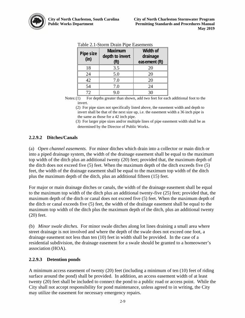
City of North Charleston, South Carolina City of North Charleston Stormwater Program Public Works Department Permitting Standards and Procedures Manual May 2019
2-9
Table 2.1-Storm Drain Pipe Easements
Pipe size (in)
Maximum depth to invert
(ft)
Width of drainage
easement (ft) 18 3.5 20 24 5.0 20 42 7.0 20 54 7.0 24 72 9.0 30
Notes: (1) For depths greater than shown, add two feet for each additional foot to the invert.
(2) For pipe sizes not specifically listed above, the easement width and depth to invert shall be that of the next size up, i.e. the easement width a 36 inch pipe is the same as those for a 42 inch pipe.
(3) For larger pipe sizes and/or multiple lines of pipe easement width shall be as determined by the Director of Public Works.
2.2.9.2 Ditches/Canals (a) Open channel easements. For minor ditches which drain into a collector or main ditch or into a piped drainage system, the width of the drainage easement shall be equal to the maximum top width of the ditch plus an additional twenty (20) feet; provided that, the maximum depth of the ditch does not exceed five (5) feet. When the maximum depth of the ditch exceeds five (5) feet, the width of the drainage easement shall be equal to the maximum top width of the ditch plus the maximum depth of the ditch, plus an additional fifteen (15) feet. For major or main drainage ditches or canals, the width of the drainage easement shall be equal to the maximum top width of the ditch plus an additional twenty-five (25) feet; provided that, the maximum depth of the ditch or canal does not exceed five (5) feet. When the maximum depth of the ditch or canal exceeds five (5) feet, the width of the drainage easement shall be equal to the maximum top width of the ditch plus the maximum depth of the ditch, plus an additional twenty (20) feet. (b) Minor swale ditches. For minor swale ditches along lot lines draining a small area where street drainage is not involved and where the depth of the swale does not exceed one foot, a drainage easement not less than ten (10) feet in width shall be provided. In the case of a residential subdivision, the drainage easement for a swale should be granted to a homeowner’s association (HOA). 2.2.9.3 Detention ponds A minimum access easement of twenty (20) feet (including a minimum of ten (10) feet of riding surface around the pond) shall be provided. In addition, an access easement width of at least twenty (20) feet shall be included to connect the pond to a public road or access point. While the City shall not accept responsibility for pond maintenance, unless agreed to in writing, the City may utilize the easement for necessary emergency repairs.
City of North Charleston, South Carolina City of North Charleston Stormwater Program Public Works Department Permitting Standards and Procedures Manual May 2019
2-10
2.2.9.4 Other Stormwater Facilities & BMPs All other structures used for the control of stormwater runoff (quantity or quality) not otherwise covered above, shall have an easement for access and maintenance that is a minimum of twenty (20) feet beyond the boundary of any such structure. The Public Works Director may request or allow other easement widths on a case-by-case basis given site constraints or special conditions. While the City shall not accept responsibility for stormwater facility maintenance, unless agreed to in writing, the City may utilize the easement for necessary emergency repairs. 2.2.9.5 Offsite Easements Any required off-site easements should be obtained prior to Final MS4 approval issuance which would impact upon that area. Any work done without a proper and adequate easement(s) shall be at the owner's own risk. Non-subdivision projects shall provide validation of necessary easements before a Final MS4 approval will be issued. 2.2.10 Stormwater Facility Ownership and Maintenance
2.2.10.1 Ownership Residential: Ownership of all BMPs (water quantity and quality basins/devices/non-structural practices) in new and re-development projects shall in most cases belong to the owner(s) of the parcel(s) or a homeowners association (HOA) of land under or on which it exists. Commercial: In new and re-development projects, ownership of the entire stormwater system (conveyances, as well as all BMPs, ponds, etc.) shall belong to the owner, or a lessee(s). For any project, the owner of a portion or the entire stormwater system, as the case may be, shall be clearly designated before a Final MS4 approval will be issued. Ownership shall also be recorded on the final plat. Ownership shall imply responsibility for maintaining the stormwater system, including all ponds and other BMPs used for controlling runoff quantity and quality. Ownership does not imply that the owner(s) may in any way alter the size, or function of any component of the stormwater system without consent from the City of North Charleston. Owners found altering such components will be required to remove any alterations. 2.2.10.2 Maintenance Each component of the stormwater management system (pipes, inlets, BMPs) shall have a maintenance plan (activities and associated schedule) as part of the application package for a Final MS4 approval. The plan shall also cover temporary measures used during construction in addition to the long term maintenance of the system. Suggested maintenance activities and recurrence intervals for water quality BMPs are discussed and referenced in Chapter 3. In addition, the owner/operator, HOA, or operator as applicable, must enter into a permanent maintenance agreement (Operating Permit) with the City of North Charleston. This Operating
City of North Charleston, South Carolina City of North Charleston Stormwater Program Public Works Department Permitting Standards and Procedures Manual May 2019
2-11
Permit is a legal document, recorded in the permanent land records with the County Register of Deeds, in addition to being fully described on the final plat. The Operating Permit is provided in Appendix B. The operating permit must be signed and executed prior to the issuance of a Final MS4 approval. This permit allows for maintenance to be performed by a third party such as an operator or other contractor. However, the owner must also be listed and is ultimately responsible for adherence to the maintenance requirements. The Public Works Director will provide oversight of these permits to ensure adherence by the owner or other responsible party. The Public Works Director will inspect a system as he deems necessary to ensure maintenance is being performed in accordance with this permit. More detail is provided in Chapter 4 on City inspection and enforcement procedures. 2.2.11 Single Family Residential (SFR) Applications
A Final MS4 approval shall be required for all individual Single Family Residential (SFR) construction (i.e. not part of a larger common plan of development) that disturbs one-half (0.5) acre or more must complete the SFR application (Appendix A) that contains guidance on selecting, installing, and maintaining erosion prevention and sediment controls on site. This application also requires a certification by the owner/contractor that these measures will be installed and maintained so as to prevent the discharge of sediment-laden runoff and to prevent, as applicable, that the construction will not cause non-compliance for any adjacent construction projects that may be under another City, State, or Federal permit. The application is considered complete if filled out and signed. 2.2.12 Type I – Minor Application
A Final MS4 approval shall be required for any new or re-development project (except individual SFR construction that is not part of a larger common plan of development) that disturbs 5000 square feet or more but less than one (1) acre must submit this application type. The project must have a Final MS4 approval from the City prior to beginning construction activities. Guidance on selecting necessary erosion control measures is provided in Appendix D. A complete application must provide the following:
1. Application Form: This form is contained in Appendix A.
2. Site Narrative: The narrative should describe the site in general, the purposes of the construction activity, and potential problems with adjacent properties and waterbodies receiving stormwater runoff (existing and proposed). Also, if applicable, wetland and waterbody disturbance issues should be discussed along with proof of permit coverage by the US Army Corps of Engineers (USACE) and/or SCDHEC-OCRM, as applicable.
3. Construction Site Plan: A sketch of the project area must accompany the narrative showing new and existing features, and selected BMPs.
4. Fees: No plan review or inspections fees are required at this time but it is anticipated
that review/inspection fees will be adopted by the City.
City of North Charleston, South Carolina City of North Charleston Stormwater Program Public Works Department Permitting Standards and Procedures Manual May 2019
2-12
5. Technical report – Type I projects may be required to include a technical report for
the proposed drainage system. This report shall include all the items listed under the Type II application (Section 2.2.13 Item #4).
2.2.13 Type II – Small/Intermediate Applications
A Final MS4 approval shall be required for any project which disturbs an area of one (1) acre or more, but less than five (5) acres or projects disturbing less than one (1) acre but which are part of a Larger Common Plan of Development that will disturb more than one (1) acre but less than five (5) acres. Submittal requirements are detailed below. Some small construction sites may be required to comply with conditions for Type II approvals on a case by case basis. The following submittal requirements must be provided as part of a complete application to receive a City permit.
1. Application Form: The form as shown in Appendix A.
2. Site Narrative: A narrative should be submitted with the application which includes, but is not limited to, the following:
a. General description of the site, b. Purpose of the construction activity,
c. Summary table(s) of existing and proposed runoff flows, volumes, and pollutant
loads,
d. Topographic and soil information,
e. Adjacent properties and owners,
f. Waterbodies receiving stormwater runoff,
g. Water quality and flooding issues, and potential impacts (quality, downstream structures, etc.) and benefits (open space, treatment, maintenance, etc.).
h. Anticipated starting and completion dates of the various stages of the
construction activities and the expected date of final stabilization.
i. If applicable, the narrative should also contain justification for variances, waivers, or other special conditions for the site.
j. Also, if applicable, wetland and water body disturbance issues should be
discussed along with details on the status of necessary permit applications to the USACOE.
City of North Charleston, South Carolina City of North Charleston Stormwater Program Public Works Department Permitting Standards and Procedures Manual May 2019
2-13
k. If a TMDL(S) is in place for the receiving waterbody, the narrative must describe how the project will comply with the TMDL(s)
3. A sketch of the project area to accompany the narrative containing the following,
when applicable:
a. Site location drawing of the proposed project showing project location in relation to roadways, jurisdictional boundaries, streams, rivers, and lakes and the boundary lines of the site to be developed,
b. Identification of all areas within the site that will be included in the construction activities,
c. Location of temporary and permanent stormwater management controls.
4. Technical Report:
One (1) copy of the technical report should be prepared by a licensed professional engineer as defined by state law and submitted as part of the application package. This report shall consist of maps, and supporting design calculations for the proposed stormwater system and erosion/sediment control measures used during construction, to include, but not be limited to, the following, when applicable:
a. Pre- and post-development hydrologic analysis that determines the existing
stormwater peak flow rates, flow velocities, and pollutant loads for all delineated sub basins/discharge points. The natural conditions prior to any development will be the standard by which the stormwater plan for a construction project is evaluated. The stormwater plan must demonstrate control of runoff quantity and quality in accordance with design criteria provided in Chapter 3 (flow and volume control, maximum velocities, etc.),
b. Hydraulic design calculations for all conveyances showing the ability to handle anticipated flows and volumes. Provide calculations showing that the project does not cause or increase any negative impact on downstream structures, and the upstream and downstream stormwater drainage system. The following computations should be included as necessary: hydrographs, routing of hydrographs through system components, pipe and open channel capacity, velocity calculations, and water surface elevations. Calculations and discussion shall be provided for energy dissipation and inlet/outlet protection devices. All system components should have standard details and specifications.
d. If the project is located in a Special Protection Area(s), a comprehensive evaluation of engineering calculations and analysis should be included that demonstrate that the project will not negatively impact current drainage conditions and/or complies with state and federal conditions on stormwater discharges. More information is provided in Chapter 3;
City of North Charleston, South Carolina City of North Charleston Stormwater Program Public Works Department Permitting Standards and Procedures Manual May 2019
2-14
e. Erosion and sediment control plan to include:
i. A description of the erosion and sediment control facilities selected,
ii. Map showing the location of all erosion and sediment control facilities,
iii. Design calculations of each measure, including trapping efficiencies. Each measure should also have a standard detail and specification,
iv. Explanation/discussion of models used in the design.
f. Downstream analysis calculations showing the effect of post-development design flows on downstream storm water conveyance systems and channels. More details on this analysis and where it is applicable is covered in Chapter 3;
g. Watershed delineation maps with consistent sequential notations;
h. Location map showing topography and waters of the state in relation to proposed project;
j. Discussion and calculation of any wetlands issues;
k. Map showing type and classification of all soils expected to be encountered or used at the development site;
l. Presentation of existing and proposed contours at the development site;
m. General description of the adjacent property and description of existing structures, buildings, and other fixed improvements located on surrounding properties;
n. Discussion of site access issues and easements to be obtained and provided to the City.
5. Construction Site Plans:
One complete set of site construction plans are to be included as part of the submittal package. The information required on the construction plans shall include, but is not limited to, the following list:
a. North arrow and scale,
b. Property lines, bearings and distances, adjacent landowners’ names, and land use conditions,
c. Legend,
d. Registered engineer’s seal and signature,
City of North Charleston, South Carolina City of North Charleston Stormwater Program Public Works Department Permitting Standards and Procedures Manual May 2019
2-15
e. Certificate of Authorization seal, as appropriate,
f. Existing and proposed contours (one foot intervals) and land uses,
g. Limits of disturbed area (highlighted by a boundary line),
h. Table with the following information: total project area, total disturbed area, total impervious area (pre and post), and total pervious area (pre and post),
i. Delineation of wetlands and/or waters of the state,
j. Easements,
k. Stormwater system profiles with existing and proposed ground elevations,
l. Construction sequence (include implementation of all stormwater and sediment controls in the first phase of construction),
m. Locations of all temporary and permanent control measures,
n. Details for all temporary and permanent control measures,
o. Grassing and stabilization specifications and schedule,
p. Maintenance requirements (for temporary and permanent controls, grassing, etc.),
q. Construction entrance/exit,
r. Tree protection, preservation, and overall landscaping plan with appropriate species selection and screening for ponds and other components subject to the provisions of the City’s Tree Protection Ordinance in Appendix A – Zoning Regulations.
s. Details and specifications of all necessary construction components,
t. Location map,
u. The cover sheet shall contain, at a minimum, the following items:
i. Project name,
ii. Engineers contact information (name, mailing address, telephone, fax),
iii. Contact information (name, mailing, address, telephone, fax) of the owner, operator or designated party,
iv. Tax Map System (TMS) Number(s) for the site,
City of North Charleston, South Carolina City of North Charleston Stormwater Program Public Works Department Permitting Standards and Procedures Manual May 2019
2-16
v. Vicinity map, and
vi. Table of contents.
u. All drawing elevations shall be based on the NAVD 88 and the property corners shall be projected in the state plane coordinate system.
v. The following standard notes shall be shown on the plans, if applicable. This list is not meant to be exhaustive and other notes should be included as necessary:
i. The standard SCDHEC notes found on the SCDHEC checklist - https://www.scdhec.gov/sites/default/files/docs/Environment/docs/erfchecklist.pdf
ii. Project Closeout Note for Plans – Upon completion for this development, the Owner shall provide the City of North Charleston with an asbuilt and video inspection of the completed storm drainage system, a final inspection report (prepared by a registered professional engineer) and a MS4 Closeout application form, in accordance with the requirements of Section 2.2.2 of City of North Charleston Stormwater Design Manual. The Owner shall provide a certification on the asbuilt as listed in Section 2.2.2.5. The Owner shall provide the City of North Charleston with a video inspection of the storm drainage system at the end of the 2- year warranty period.
**The video requirements are only for systems that are located in the City of North Charleston rights of way or easements.
iii. Proof Roll Note for Plans - The Contractor shall notify the City of North Charleston Public Works Department (745-1026) prior to construction for required inspection of roadway, curb and gutter, and storm drainage. Subgrade and base course shall be proof-rolled with a fully loaded tandem dump truck in the presence of Public Works Engineering inspectors. All areas determined to be unsuitable following inspection shall be excavated and re-compacted with suitable material to the design elevations shown on the approved plans. Installation of the approved drainage system shall be inspected by Public Works Personnel. A final inspection shall occur prior to acceptance of the roadway by the City.”
iv. Drainage Note for Plans - The Owner shall complete the storm drainage system in accordance with the approved plans. In the event that the development cannot be completed, due to circumstances beyond the Owner’s control, the Owner shall ensure that the completed storm drainage system will accommodate the stormwater runoff generated from the project and adjoining phases of development and is collected and discharged in a proper manner. In this case, the Owner shall submit a plan to Public Works for review/approval of the temporary drainage plan.
City of North Charleston, South Carolina City of North Charleston Stormwater Program Public Works Department Permitting Standards and Procedures Manual May 2019
2-17
v. As-Built Note for Plans w/ Pond - The Engineer/Owner shall provide the City of North Charleston with an as-built survey of the site (tied to the state plane coordinate system), to include all storm drainage lines, both existing and newly installed. Survey shall also include the pipe size, material, and invert elevations, in compliance with the City of North Charleston Stormwater Design Manual and NPDES permit. Detention pond as-built shall include all contours and spot elevations inside the pond, as well as the outlet structure weir elevations and sizes, as required by the City of North Charleston Stormwater Design Manual and NPDES permit. (See section 2.2.2.4)
vi. As-Built Note for Plans: no Pond - The Engineer/Owner shall provide the City of North Charleston with an as-built survey of the site (tied to the state plane coordinate system), to include all storm drainage lines, both existing and newly installed. Survey shall also include the pipe size, material, and invert elevations, in compliance with the City of North Charleston Stormwater Design Manual and NPDES permit. (See Section 2.2.2.4)
vii. Video Inspection Note for Plans (for projects with piped systems in the City rights of way or easements)
All video shall comply with the following requirements: Color video submitted on a CD or DVD in a high-resolution digital
format compatible with City-approved and available software and equipment.
All visual observations will be recorded on a log inspection form incorporating at a minimum the following items:
o Date and time televised; o Operator name; o Starting and ending manhole (Sta. number, street name,
etc.); o Pipe diameter (inches), geometry, and material; o Location of laterals; o Location of sags (feet); o Location of inflow and infiltration; o Location of sags and standing water (feet); and, o Location of dry weather flow (feet).
The notation of footage (starting at 0.0 feet at the beginning manhole and moving upstream through the pipe) shall be superimposed on the video and be recorded in increments of tenths of feet.
All pipe joints shall be inspected by panning 360 degrees at each pipe joint.
Any problems found shall be corrected by the owner/developer. Upon confirming such corrections are complete and the site is ready, the Public Works Department will request release of any
City of North Charleston, South Carolina City of North Charleston Stormwater Program Public Works Department Permitting Standards and Procedures Manual May 2019
2-18
remaining bonds from the City. The Public Works Department may require additional items in order to closeout a project.
viii. New Storm Pipe Notes for City of North Charleston Road R/W and Drainage Easements
i. All new storm pipes, bedding, trenching, storm boxes, etc. in City Rights-of-Way and/or City owned and maintained drainage easements shall be installed per current SCDOT specifications, located on the internet at https://www.scdot.org/business/road-technical-specs.aspx & SCDOT standard detail drawings can be located at the following website, https://www.scdot.org/business/standard-drawings.aspx
ii. All reinforced concrete pipe shall, at a minimum, be ASTM C76, Class III.
iii. Reinforced concrete pipe installed under pavement and/or parallel to the edge of pavement in Public Rights-of-Ways shall have O-Ring joints in accordance to ASTM C 443 and/or AASHTO M315. The joints shall be securely wrapped with filter fabric 18” in width.
iv. Submerged drainage systems with piping in the Public Rights-of-Way shall have O-Ring joints in accordance to ASTM C 443 and/or AASHTO M315. The joints shall be securely wrapped with filter fabric 18” in width.
v. Where Tongue & Groove storm pipe is allowed, reinforced concrete pipe shall be per ASTM C 76, Class III. Joints shall be sealed with Ramneck or equivalent per AASHTO M198. The joints shall be securely wrapped with filter fabric 18” in width.
vi. All new storm drainage lines shall be laid upgrade after confirmation of existing invert elevation.
vii. The City of North Charleston maintains the right to allow alternate pipe installations or type of pipe for all projects on a case-by-case basis for any pipes to be installed in an existing or proposed City road right-of-way and/or drainage easement.
Note: Some items may be included in other components of the permit application package, but should be adequately noted. Size D (24” X 36”) Plan sheets/drawings.
6. Subdivision projects shall have a complete set of plans and specifications to include, but not be limited to, the following items, as appropriate: lot layout/site plan and staking, acreage, road plan/profiles, storm drainage plan (pad elevations are to be
City of North Charleston, South Carolina City of North Charleston Stormwater Program Public Works Department Permitting Standards and Procedures Manual May 2019
2-19
shown on all lots)/profile, drainage areas (both on and off-site) with characteristics, sediment and erosion control, utilities (water and sanitary sewer), post-construction stormwater management facilities, and traffic patterns with temporary (construction) and permanent traffic signage. Plans shall provide existing and proposed contours with intervals of not more than one (1) foot. Where possible, and as needed, contour lines should be extended beyond the site boundary lines. While some of these items lend themselves to combining information on a single sheet/drawing, care should be taken to ensure that plans are not overcrowded/cluttered. The lot layout sheet should show a tie distance from the primary entrance of the proposed project to the nearest existing intersection.
7. All available or used bench marks shall be shown on the applicable sheet. At least one bench mark shall be available or established on/near (within survey instrument sight distance) the site. The bench mark shall be referenced to North American Vertical Datum (NAVD) 1988.
8. The applicant will provide a tentative construction time schedule for the development. Sediment and erosion control measures will be some of the first work at a site and such implementation will be demonstrated. The schedule will also provide for coordination with the responsibilities of all parties, including those installing utilities.
9. Specifications for all components of construction activities related to grading, utilities, sediment and erosion control, temporary and permanent vegetation, water quality BMPs, etc.
10. Maintenance Schedules and Operating Permits:
When stormwater management facilities and system components are to be maintained by an owner, operator, or other designated party, the City of North Charleston must be given assurance that such activities will be conducted. This is to be established using an Operating Permit that specifies the maintenance activities to be performed after construction and site stabilization. The maintenance schedules for all stormwater system components, and designation of the responsible parties must be included in the permit application. The Operating Permit will be enforced in perpetuity.
11. Stormwater Pollution Prevention Plan (SWPPP):
A SWPPP is a document that provides guidance to owners and contractors and co-permittees/subcontractors on the activities that shall be done during construction to reduce the risk of pollution. Construction projects are considered an industrial category and are required to prepare and implement a SWPPP to be submitted with the permit application package to the City of North Charleston. The stormwater pollution prevention plan requirement applies to both development and redevelopment sites.
City of North Charleston, South Carolina City of North Charleston Stormwater Program Public Works Department Permitting Standards and Procedures Manual May 2019
2-20
2.2.14 Type III – Medium/Large Applications
A Final MS4 approval shall be required for any project which disturbs an area that is five (5) acres or greater or projects disturbing less than five (5) acres but which are part of a Larger Common Plan of Development that will disturb more than five (5) acres. A complete application is accomplished by submitting the items listed for Type II applications (Section 2.2.13, Items 1-11) plus the additional requirements detailed below. 2.2.14.1 Pre-submittal Meeting The first step for Type III applications is to conduct a pre-submittal meeting. This meeting is intended to coordinate stormwater management needs. Design professionals are urged to see the site to understand existing runoff patterns and identify areas on the site that may require greater attention to meet the intent of the requirements. The City’s Public Works Director may waive this requirement on a case by case basis. 2.2.14.2 Phased Plan Requirement For non-linear construction sites disturbing five (5) acres or greater, the construction site plans must include a phased stormwater management plan. This phased plan identifies all BMPs and grading work implemented during a specific portion of a site’s construction sequenced (e.g., initial grading and perimeter controls, interim land disturbances through final grading, post-construction and final stabilization). One sheet showing all BMPs and grading work for the entire course of the construction project will not be considered a complete phased plan. 2.2.14.3 Stormwater Master Plan For Type III applications which are located in Special Protection Areas, a Stormwater Master Plan is required to be submitted prior to the submittal of the complete package as detailed below. Special Protection Areas are areas within the City that require some additional stormwater management controls due to existing problems. Such problems can include but are not limited to flooding and State recognized water quality impairments. This Master Plan is to be created to give the design professional the opportunity to propose a site layout and proposed stormwater controls to the City’s Public Works Director. The Master Plan should be submitted by hand or mail, and can be incorporated for discussion at the pre-submittal meeting. The Public Works Director may waive the requirement for a Master Plan for some permit applicants on a case by case basis. The Master Plan can be a preliminary sketch of the site and shall contain the following items, when applicable:
1. Site layout showing buildings, roads, parking areas, utilities, and grassed or landscaped areas.
2. Vicinity map.

City of North Charleston, South Carolina City of North Charleston Stormwater Program Public Works Department Permitting Standards and Procedures Manual May 2019
2-21
3. Pre- and post-development primary runoff patterns and discharge points.
4. Location/distances to Waters of the State and all other existing natural features such as wetlands, ponds, lakes, floodplains, and stream buffers.
In addition, the applicant should be prepared to discuss the following items, when applicable:
1. All modeling methodologies to be used.
2. Methods to show compliance with any adopted Total Maximum Daily Loads (TMDLs) or other waterbody impairments that may limit the allowable pollutant load that can be discharged.
3. Preliminary waiver or variance requests.
4. Others as requested by the Public Works Director.
Upon submittal and discussion of the Master Plan and related concerns, the applicant can create and submit a complete permit application (Section 2.2.13, items 1-11). 2.2.15 Utility Applications
Utility companies are not exempt from NPDES requirements when applicable and the City of North Charleston must regulate utility projects just as any other type of construction. The City of North Charleston requires that companies performing utility installations must obtain a Final MS4 approval prior to beginning work. This must be done whether the utility installation is part of another construction project (e.g. phone line extension) or an independent project (e.g. gas force main). A complete application must include the following items:
1. Site Narrative: The narrative should describe the installation to be performed and the measures that will be used for erosion prevention and sediment control. Inclusion of typical design details is preferred, but simple sketches may be used. Details should include at a minimum temporary and final stabilization measures and silt fencing.
2. If a waterbody crossing is necessary, a sketch of the proposed measures. If a
USACOE permit is needed, a copy of the permit application should also be included. City approval will not be issued until USACOE approval is obtained.
3. A signed certification agreeing to the conditions of the City approval and NPDES
permit if applicable. The certification form is provided on the Application Form (Type I and Linear Utility Project Application) in Appendix A.
The City of North Charleston is aware of the importance of coordinating utility installation, particularly when the installation is part of a larger project. The various parties are encouraged to work together to ensure that these installations do not impact the permit compliance of the larger project.
City of North Charleston, South Carolina City of North Charleston Stormwater Program
Public Works Department Permitting Standards and Procedures Manual
May 2019
3-1
CHAPTER 3 - DESIGN STANDARDS
This chapter includes information for engineers and designers to utilize in designing adequate stormwater management systems that will control the rate, volume, and pollutant loads released from a new or redevelopment project where the City’s Public Works Director has been
authorized by law or agreement to enforce engineering standards. These design standards have been developed based on common engineering practices, state and federal requirements, scientific research, engineering publications, and other municipal and academic guidance. The design standards included in this chapter should be incorporated along with proper planning, installation and maintenance methods to mitigate the impact of land development on existing/natural hydrologic and hydraulic processes and minimize the further degradation of the water resources in the City of North Charleston. The design professional shall use all means necessary to develop land in a manner consistent with all City Ordinances and this Manual. Specific methods and applications not covered in this section can and should be discussed with the Public Works Director for applicability. The following section details the criteria that shall be followed in the absence of designated specific watershed master plan criteria. Water quantity and quality are integral and required components of stormwater management. Requirements have been added to improve and preserve the water resources in the City of North Charleston. Section 3.4 outlines the standard design procedures for water quantity and quality along with the design criteria for accepted Best Management Practices (BMPs), Low Impact Development (LID) designs and Manufactured Treatment Devices (MTDs). 3.1 General Design Standards
The City of North Charleston design storm is a twenty-five (25) year, twenty-four (24) hour,
SCS Type III storm event. General requirements for all stormwater systems and facilities will
include, but are not limited to, the following:
1. Site designs shall minimize the generation of stormwater and maximize pervious
areas by:
a. Selecting portions of the site where the drainage pattern, topography, and soils are favorable for the intended use. Tracts of land vary in suitability for different uses. Knowing the major characteristics of the land area and kinds of soil helps in identifying and evaluating potential problems.
b. Exposing the smallest practical area of land for the least possible time during development. This includes maintaining or creating buffers and preserving natural areas.
c. Limiting the drainage area to all BMPs. Specific maximum contributing areas to BMPs are provided below.
City of North Charleston, South Carolina City of North Charleston Stormwater Program
Public Works Department Permitting Standards and Procedures Manual
May 2019
3-2
d. When feasible, retaining and protecting natural vegetation and saving topsoil, for replacing on graded areas.
e. Using temporary plant cover, mulching, hydroseeding, or other stabilization methods to control runoff and protect areas subject to erosion during and after construction.
f. For non-linear construction sites disturbing more than five (5) acres, the application package must be submitted with a phased erosion control and sediment control plan. This plan identifies all BMPs and grading work implemented during certain portions of a site’s construction. A separate plan
sheet is to be used for each phase according to the following requirements:
1. For site disturbances of less than ten (10) acres, a minimum of two (2) phasing plans shall be developed, which include the initial land disturbance phase and stabilization phase. Each phase should be addressed on a separate plan sheet and should indicate all conditions and BMPs necessary to manage stormwater runoff, erosion and sediment control.
2. For site disturbances of ten (10) acres or more, a minimum of three (3) phasing plans shall be developed, which include the initial land disturbance phase, construction phase and stabilization phase. Each phase should be addressed on a separate plan sheet and should indicate all conditions and BMPs necessary to manage stormwater runoff, erosion and sediment control.
2. Annual groundwater recharge rates will be maintained to the maximum extent
practical by promoting infiltration through the use of structural and non-structural methods.
3. Stormwater runoff generated from development shall be controlled to predevelopment and/or natural rates. The method for computing adequate control shall be a risk-based approach using several design storms. Greater detail is provided in the next section.
4. Stormwater runoff generated from development shall be treated through the use of structural and/or non-structural practices. It is presumed that sufficient treatment is provided by the proposed BMPs if they are:
a. Designed according to the specific performance criteria outlined in this manual,
b. constructed properly, and
c. maintained regularly.
5. Stormwater discharges to special protection areas with sensitive resources or that have existing flooding or water quality problems, such as Total Maximum Daily
City of North Charleston, South Carolina City of North Charleston Stormwater Program
Public Works Department Permitting Standards and Procedures Manual
May 2019
3-3
Loads (TMDLs) may be subject to additional performance criteria. Section 3.7 contains more specific information about the areas that will receive this additional set of protection criteria.
6. BMPs are required for the control and management of stormwater runoff and pollution. All permanent BMPs shall have an operation and maintenance agreement to ensure the system functions as designed. These agreements are referred to in this Manual as an operating permit. Chapter 2 contains more detail on permits that are required for stormwater systems or facilities which discharge stormwater.
7. Redevelopment, defined as any construction, alteration or improvement equal to or greater than one-half (0.5) acre of land disturbance on sites where existing land use is commercial, industrial, institutional, or multi-family residential, is governed by the same design criteria as new developments.
8. Clear cutting for installation of utilities and roads or for development shall be allowed, but limits have been established. The total disturbed area shall never exceed ten (10) acres unless otherwise approved by the Public Works Director. The Public Works Director may reduce the total area that may be disturbed at a given time. Project areas exceeding ten (10) acres must be phased to comply with this requirement. All clear cutting areas are to be clearly identified on construction documents. The decision to consider an activity as clear cutting shall belong to the Public Works Director, but will normally be defined as the removal of vegetation and disturbance of soil prior to grading or excavation in anticipation of construction and/or non-construction activities.
9. Debris from clear cutting, construction, and site preparation must not impede flow or create obstructions within streams and waterbodies. Stream crossings shall be avoided when possible. When stream crossings cannot be avoided, they shall have control devices to collect and divert surface flow from the access road or skid trail into undisturbed areas or other control structures.
10. Vegetative cover is the process of applying sod or growing, from seed, a vegetative cover on disturbed areas for erosion control during construction and soil-disturbing activities. Permanent vegetative cover and the long-term erosion protection structures shall be installed as soon as practical in the development process.
11. If wetlands are suspected to exist on the property, they will be investigated and delineated by a qualified professional. The US Army Corps of Engineers (USACE) must make a determination as to whether or not the wetlands fall under their jurisdiction. All efforts will be made to reduce or eliminate impacts such as using a buffer and/or installing a silt fence around the wetlands. If the wetlands fall under the jurisdiction of the USACE, a permit is needed before any disturbance of the wetlands is allowed. The City of North Charleston will accept certified delineations from qualified professionals, and then the City of North Charleston will consider the
City of North Charleston, South Carolina City of North Charleston Stormwater Program
Public Works Department Permitting Standards and Procedures Manual
May 2019
3-4
wetlands as waters of the US and require any applicable local, state, or federal permit prior to disturbance.
12. Where existing wetlands are intended as a component of an overall stormwater management system, the approved plan for stormwater management shall not be implemented until all necessary federal and state permits have been obtained.
13. All stormwater management and sediment control practices shall be designed, constructed, and maintained with consideration for the proper control of mosquitoes and other vectors. Design criteria are provided in sections below.
14. For the purposes of hydraulic design, capacity of a system to transport stormwater runoff, shall be based on the size of the contributing drainage basin or subwatershed (for that particular boundary), as outlined below:
a. Collector Systems and Minor Drainage Systems: 0 - < 100 Acres
All street drainage, pipe systems, culverts, ditches and channels which drain less
than 100 acres shall be designed to carry flows resulting from a ten (25)-year
frequency storm. Minimum allowable pipe diameter shall be fifteen (15) inches.
Curb and gutters can be designed to the ten (10) year frequency storm event.
Once in a closed system, the twenty-five (25) year storm will be the design
standard.
b. Major Drainage Channels: 100 - < 300 Acres
All drainage systems draining at least 100 acres but less than 300 acres, such as
channel improvements, culverts or bridges along these channels, shall be
designed to carry a flow resulting from a fifty (50) year frequency storm event.
Encroachment upon Major Drainage Channels and the adjacent overflow land
shall be avoided to the extent practicable.
c. Large Watersheds: 300 and more Acres
Bridges and culverts being constructed in natural channels, creeks, or rivers
draining more than 300 acres, shall be designed to carry a flow resulting from a
100 year frequency storm event. Encroachment upon these channels and the
adjacent overflow land shall be avoided as much as practicable.
The Floodplain provisions for the City of North Charleston can be found by
contacting the Building Department.
The area outside a project area (e.g. offsite areas) that drains to a particular design
point must be included in determining the appropriate design storm. All
hydrological computations shall be based on the contributing watershed, not just the
project area or disturbed area.
City of North Charleston, South Carolina City of North Charleston Stormwater Program
Public Works Department Permitting Standards and Procedures Manual
May 2019
3-5
15. All development sites disturbing more than one (1) acre shall have an analysis
performed of the drainage system to ascertain the function of the system during the
100-year storm event or more specifically, determine that the project will not:
a. Increase the likelihood of dwelling flooding and property damage.
b. Increase water surface elevations or reduce system capacity in stormwater system
and facilities upstream or downstream of the project.
c. Impose any new or additional increase in stormwater runoff velocity on adjacent
properties, discharge points, or downstream areas.
d. Impose any new or additional increase in erosion and pollutant loads that would
adversely impact waters of the state.
If a master plan exists for the area/watershed which encompasses the project, criteria
set by that plan shall be used for determining the extent of this analysis. Without a
master plan, the analysis shall extend up to the top of the watershed and down to
water of the state (WoS) or to a point in which the project comprises 10% of the total
contributing area, whichever occurs first. In these cases, the analysis criteria shall
include, but is not limited to:
a. Existing land use curve numbers shall be used for all areas,
b. Flows should be routed using an accepted hydrologic and hydraulic method, and
c. Hydraulic step-backwater calculations using USACE’s HEC-2 or HEC-RAS
models, ICPR, or equivalent shall be provided. Other calculations may be
required by the Public Works Director based on severity of potential impact and
location of project.
If the downstream analysis determines that the development of a particular site does
contribute to flooding, pollution, or erosion problems, then the system design shall
be changed or additional controls shall be included.
16. Watersheds that have documented water quantity problems may have more stringent or modified design criteria as determined from City of North Charleston master plan studies or as dictated by State and Federal Regulations. The Public Works Director reserves the right to impose additional design requirements, such as the examples listed below:
a. Post-development discharge rates from the entire development area not exceeding pre-development discharge rates for storm frequencies greater than the 25-year frequency 24-hour duration storm event,
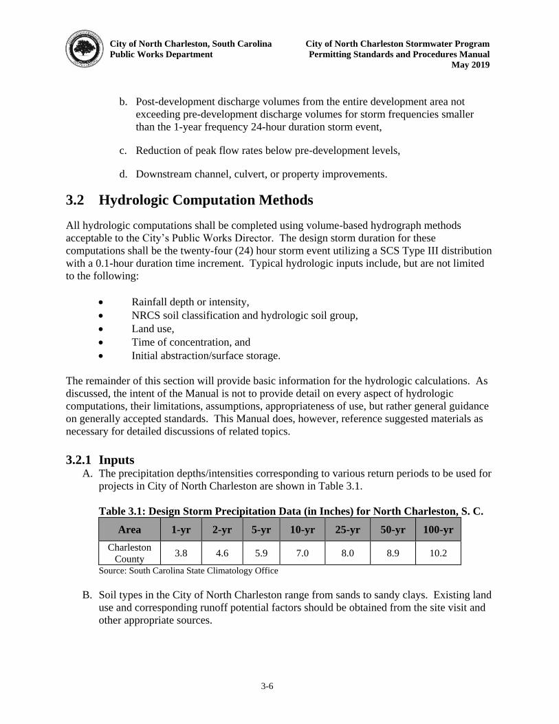
City of North Charleston, South Carolina City of North Charleston Stormwater Program
Public Works Department Permitting Standards and Procedures Manual
May 2019
3-6
b. Post-development discharge volumes from the entire development area not exceeding pre-development discharge volumes for storm frequencies smaller than the 1-year frequency 24-hour duration storm event,
c. Reduction of peak flow rates below pre-development levels,
d. Downstream channel, culvert, or property improvements.
3.2 Hydrologic Computation Methods
All hydrologic computations shall be completed using volume-based hydrograph methods acceptable to the City’s Public Works Director. The design storm duration for these computations shall be the twenty-four (24) hour storm event utilizing a SCS Type III distribution with a 0.1-hour duration time increment. Typical hydrologic inputs include, but are not limited to the following:
Rainfall depth or intensity, NRCS soil classification and hydrologic soil group, Land use, Time of concentration, and Initial abstraction/surface storage.
The remainder of this section will provide basic information for the hydrologic calculations. As discussed, the intent of the Manual is not to provide detail on every aspect of hydrologic computations, their limitations, assumptions, appropriateness of use, but rather general guidance on generally accepted standards. This Manual does, however, reference suggested materials as necessary for detailed discussions of related topics. 3.2.1 Inputs
A. The precipitation depths/intensities corresponding to various return periods to be used for projects in City of North Charleston are shown in Table 3.1.
Table 3.1: Design Storm Precipitation Data (in Inches) for North Charleston, S. C.
Area 1-yr 2-yr 5-yr 10-yr 25-yr 50-yr 100-yr
Charleston County 3.8 4.6 5.9 7.0 8.0 8.9 10.2
Source: South Carolina State Climatology Office
B. Soil types in the City of North Charleston range from sands to sandy clays. Existing land use and corresponding runoff potential factors should be obtained from the site visit and other appropriate sources.
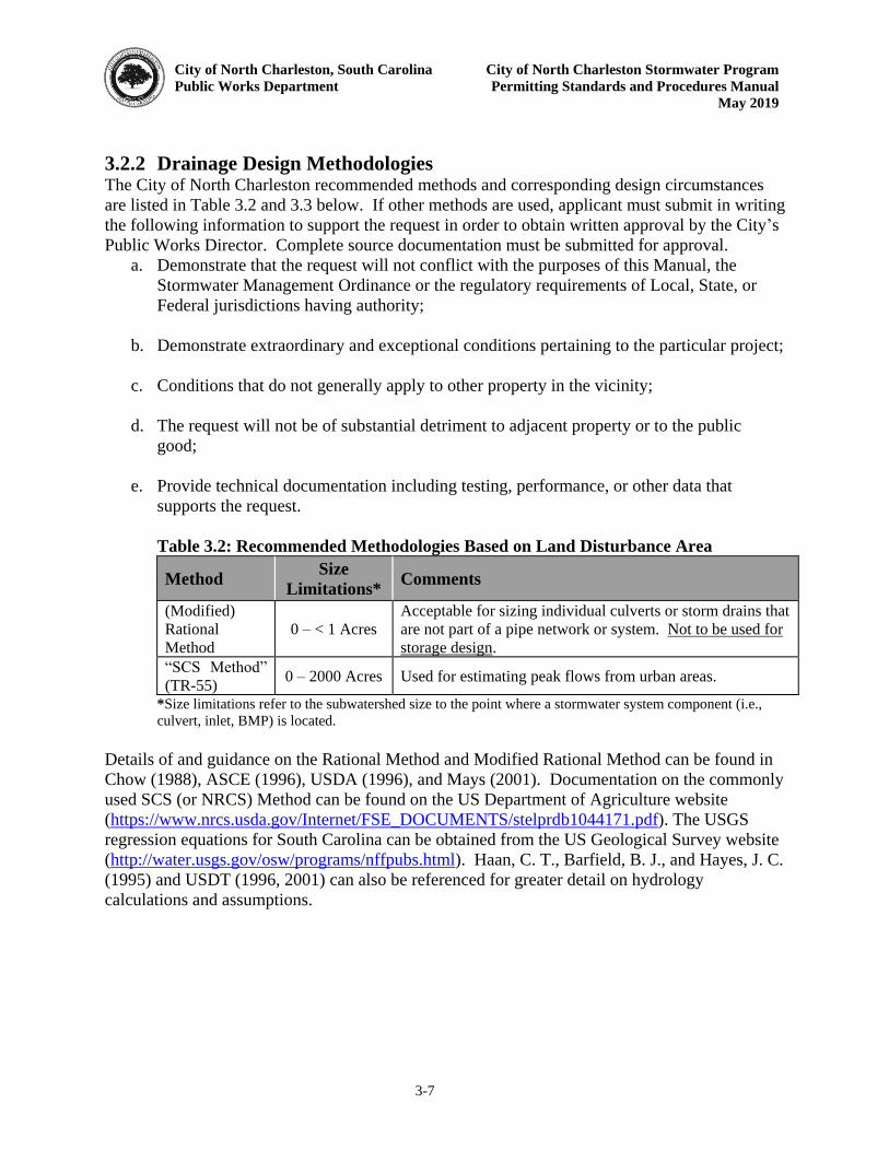
City of North Charleston, South Carolina City of North Charleston Stormwater Program
Public Works Department Permitting Standards and Procedures Manual
May 2019
3-7
3.2.2 Drainage Design Methodologies The City of North Charleston recommended methods and corresponding design circumstances are listed in Table 3.2 and 3.3 below. If other methods are used, applicant must submit in writing the following information to support the request in order to obtain written approval by the City’s Public Works Director. Complete source documentation must be submitted for approval.
a. Demonstrate that the request will not conflict with the purposes of this Manual, the Stormwater Management Ordinance or the regulatory requirements of Local, State, or Federal jurisdictions having authority;
b. Demonstrate extraordinary and exceptional conditions pertaining to the particular project;
c. Conditions that do not generally apply to other property in the vicinity;
d. The request will not be of substantial detriment to adjacent property or to the public good;
e. Provide technical documentation including testing, performance, or other data that supports the request.
Table 3.2: Recommended Methodologies Based on Land Disturbance Area
Method Size
Limitations* Comments
(Modified) Rational Method
0 – < 1 Acres Acceptable for sizing individual culverts or storm drains that are not part of a pipe network or system. Not to be used for storage design.
“SCS Method”
(TR-55) 0 – 2000 Acres Used for estimating peak flows from urban areas.
*Size limitations refer to the subwatershed size to the point where a stormwater system component (i.e., culvert, inlet, BMP) is located.
Details of and guidance on the Rational Method and Modified Rational Method can be found in Chow (1988), ASCE (1996), USDA (1996), and Mays (2001). Documentation on the commonly used SCS (or NRCS) Method can be found on the US Department of Agriculture website (https://www.nrcs.usda.gov/Internet/FSE_DOCUMENTS/stelprdb1044171.pdf). The USGS regression equations for South Carolina can be obtained from the US Geological Survey website (http://water.usgs.gov/osw/programs/nffpubs.html). Haan, C. T., Barfield, B. J., and Hayes, J. C. (1995) and USDT (1996, 2001) can also be referenced for greater detail on hydrology calculations and assumptions.
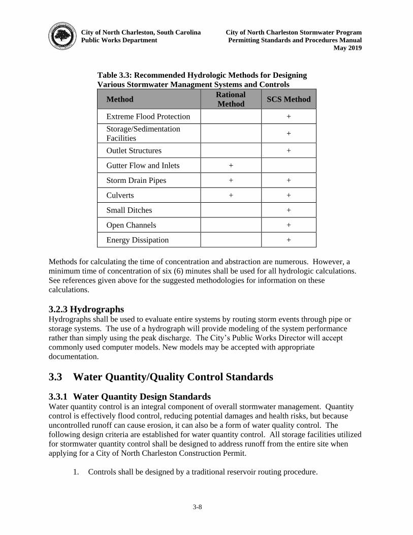
City of North Charleston, South Carolina City of North Charleston Stormwater Program
Public Works Department Permitting Standards and Procedures Manual
May 2019
3-8
Table 3.3: Recommended Hydrologic Methods for Designing
Various Stormwater Managment Systems and Controls
Method Rational
Method SCS Method
Extreme Flood Protection + Storage/Sedimentation Facilities +
Outlet Structures +
Gutter Flow and Inlets +
Storm Drain Pipes + +
Culverts + +
Small Ditches +
Open Channels +
Energy Dissipation + Methods for calculating the time of concentration and abstraction are numerous. However, a minimum time of concentration of six (6) minutes shall be used for all hydrologic calculations. See references given above for the suggested methodologies for information on these calculations. 3.2.3 Hydrographs Hydrographs shall be used to evaluate entire systems by routing storm events through pipe or storage systems. The use of a hydrograph will provide modeling of the system performance rather than simply using the peak discharge. The City’s Public Works Director will accept
commonly used computer models. New models may be accepted with appropriate documentation. 3.3 Water Quantity/Quality Control Standards
3.3.1 Water Quantity Design Standards Water quantity control is an integral component of overall stormwater management. Quantity control is effectively flood control, reducing potential damages and health risks, but because uncontrolled runoff can cause erosion, it can also be a form of water quality control. The following design criteria are established for water quantity control. All storage facilities utilized for stormwater quantity control shall be designed to address runoff from the entire site when applying for a City of North Charleston Construction Permit.
1. Controls shall be designed by a traditional reservoir routing procedure.
City of North Charleston, South Carolina City of North Charleston Stormwater Program
Public Works Department Permitting Standards and Procedures Manual
May 2019
3-9
2. The post condition peak outflow for the 2, 10, and 25-year 24 hour storm event must not exceed the peak outflow for the existing condition. The peak outflow for the 50 and 100-year 24-hour storm event must be provided.
3. All ponds shall have an emergency spillway designed to pass the design storm event if the storage capacity is exceeded.
4. All ponds shall be able to handle the 100-year storm event without overtopping the banks.
5. All discharge points may be no closer than twenty (20) feet from property boundary, where applicable.
6. All quantity controls that are also used for quality control shall have a forebay or screening vault for removal of debris and coarse sediments.
a. Forebays shall be placed upstream of the main pond storage area. b. Unless a separate vault is to be used for the forebay, the forebay shall be
separated from the larger detention area by barriers or baffles that may be constructed of earth, stones, riprap, gabions, or geotextiles. The barrier and/or baffles act as a trap for coarse sediments and minimize their movement into the main pond.
c. Maintenance of forebays will be needed more frequently than the main storage
area and all designs should consider this need. 3.3.2 Accepted Water Quantity Control Devices Detention structural controls are used for providing water quantity control and are typically used downstream of other minor structural controls. These structures are designed to provide channel protection, overbank flood protection, and protection against adverse downstream impacts that are related to the increase in peak flow rates and flow volumes from a development or re-development project. Structural detention stormwater controls accepted by the City of North Charleston are shown in Table 3.4.
Table 3.4: Accepted Water Quantity Controls
General Structural Control Description
Dry Detention/Dry Extended Basins
Dry detention basins and dry extended detention basins are surface storage facilities intended to provide temporary storage of stormwater runoff and releasing it at a designed flow rate to reduce downstream water quantity impacts. These structures are designed to completely drain to a dry condition within 72 hours.
City of North Charleston, South Carolina City of North Charleston Stormwater Program
Public Works Department Permitting Standards and Procedures Manual
May 2019
3-10
General Structural Control Description
Wet Storm Water Detention Basins
Wet Pond Wet Extended Detention Pond Multiple Pond System
Wet detention basins are constructed stormwater basins that have a permanent pool of water. Runoff from each rain event is detained above the permanent pool and released at a designed flow rate to reduce downstream water quantity impacts. Permanent pool depths should be 6 feet to prevent mosquito breeding.
Multi-purpose Detention Areas
Multi-purpose detention areas are used for one or more specific activities such as parking areas and rooftops. These areas are used to provide temporary storage of runoff. Some of the multi-purpose areas such as infiltration trenches or bio-retention cells may also be used for water quality purposes.
Underground Detention
Underground detention is used as an alternative to surface dry-detention basins. They are used in areas that are space-limited where there is not enough adequate land to provide the required detention volume. Underground storage utilizes tanks, vaults, and buried pipes to supply the required storage volume. Applicant is to verify the existing water table.
Infiltration Basins
Infiltration basins are used to remove runoff from the flow path into the ground. They are used in areas that currently do not discharge stormwater or create runoff only during large storm events.
3.3.3 Water Quality Design Standards Water quality control is an integral and required component of overall stormwater management systems. Redevelopment as well as new development projects must include controls that treat or otherwise limit the discharge of pollutants. These requirements have been added due to new local, state and federal requirements, but also due to the need to improve and preserve the water resources in the City of North Charleston. Background information and references are provided in the sections below, followed by the design standards for addressing water quality. The following design criteria are established for water quality control and must be incorporated in one or more BMPs for a given sub basin. In the case of redevelopment projects, the design standards will be required for the improved area instead of the entire site. Incorporation of the following requirements shall constitute adequate control of the discharge of pollutants.
City of North Charleston, South Carolina City of North Charleston Stormwater Program
Public Works Department Permitting Standards and Procedures Manual
May 2019
3-11
1. All sites which disturb one (1) acre or greater or redevelopment projects that are 0.5 acres or more shall include best management practices (BMPs) to address water quality, along with an Operation and Maintenance Agreement that guarantees maintenance of all BMPs in perpetuity. There are two options for demonstrating compliance with this requirement. The default method is to capture the first flush volume from the site and discharge it over a twenty-four (24) hour period. The alternative method is to size water quality treatment devices to trap 80% of total suspended solids (TSS) based on annual loading. The 1.8-inch, 1-year, twenty-four (24) hour storm event is the allowed water quality event (WQE). If using something other than this WQE, evidence must be provided to show that the results of this WQE are equivalent.
First Flush Volume
a. All permanent water quality ponds having a permanent pool shall be designed to store and release a water quality volume (WQV) defined as the first one-half inch (1/2”) of runoff (First Flush) over a twenty-four (24) hour period. The "first flush" volume should be determined from the contributing watershed area (impervious and pervious) that drains to the water quality pond (s).
b. Permanent water quality ponds, not having a permanent pool, shall be
designed to store and release the first one inch (1”) of runoff from the
contributing watershed area over a minimum period of twenty-four (24) hours.
c. Permanent water quality infiltration practices shall be designed to accommodate at a minimum the first one inch (1”) of runoff from the
contributing watershed areas located on the site.
80% TSS Trapping
a. The WQV requirement may be waived if treatment is instead provided by Low Impact Development (LID) practices, Manufactured Treatment Devices (MTD), or a combination of both. For such projects the designer must demonstrate that the water quality controls will achieve, at a minimum, an 80% trapping of total suspended solids (TSS) on an annual loading basis.
b. For constructed LID BMPs and treatment trains, calculations can be made with one of the following methodologies*:
i. IDEAL Model
ii. Georgia Stormwater Management Manual (Bluebook)
iii. WinSLAMM

City of North Charleston, South Carolina City of North Charleston Stormwater Program
Public Works Department Permitting Standards and Procedures Manual
May 2019
3-12
iv. Schueler Simple Method (Center for Watershed Protection)
* Alternative programs or methods not listed above may be used if
approved by the Public Works Director prior to submission.
c. With the exception of the IDEAL model, MTDs cannot be modeled with the methods above. Refer to Section 3.3.11 for MTD design criteria and calculation methods.
2. Projects that discharge either directly or indirectly into an impaired waterbody as determined by the existence of an adopted TMDL by SCDHEC or through SCDHEC’s listing of the waterbody on the latest 303(d) list shall be required to reduce pollutant loads so as to meet applicable water quality standards. This will require the installation and implementation of measures (structural or non-structural BMPs) which are expected to adequately reduce pollutant loads to levels required by the TMDL (currently expressed as % reductions) or to prevent further impairment.
3. All BMPs must have a maintenance plan. The SCDHEC BMP Manual (2005) (http://www.scdhec.gov/Environment/WaterQuality/Stormwater/BMPHandbook/) and the City of North Charleston Maintenance Template can be a reference source for maintenance schedules and routine activities.
4. For areas not draining to either a pond or being treated by the above mentioned BMPs, the applicant should demonstrate how permanent water quality requirements will be addressed.
5. The Public Works Director reserves the right to require specific effluent limits for any pollutant from a site if necessary to ensure the water quality standards and other local, state and federal water quality regulations are met.
3.3.4 Standard Design Procedures for Water Quality BMPs
1. Determine an appropriate, accepted BMP(s) needed for the site, considering the land use, pollutants of concern, soils, maintenance requirements, and location in relation to Waters of the State and any impairment that may exist.
2. Low impact development (LID) BMPs should be considered when applicable. LID practices can require less structural conveyance systems therefore reducing the construction cost while at the same time maintaining water quality and quantity standards.
3. Engineered Manufactured Treatment Devices (MTD) should be considered where applicable as they can provide enhanced pollutant removal in areas with limited space for water quality treatment. Manufacturer’s recommendations should be followed for sizing and placement requirements.
City of North Charleston, South Carolina City of North Charleston Stormwater Program
Public Works Department Permitting Standards and Procedures Manual
May 2019
3-13
4. If the receiving water of the project is impaired or has an adopted TMDL, the applicant must show that water quality standards are being met and designated uses are not impacted. This proof must be a quantitative and qualitative analysis for sites which disturb greater than twenty-five (25) acres.
3.3.5 Detention Ponds/Reservoirs Standards
1. Ponds with vegetated embankments shall be less than fifteen (15) feet in height and shall have side slopes (inside and outside) no steeper than 3H:1V. Embankments protected with Erosion Control Blankets or Turf Reinforcement Matting shall be no steeper than 2H:1V. Geotechnical slope stability analysis is required for embankments that are both greater than eight (8) feet in height with steeper slopes than those indicated above. Access to the inside of a pond shall be provided with at least one interior side slope at 3H:1V or flatter.
2. The flow path between the pond inlet and outlet must be maximized to ensure sufficient time to allow for sedimentation of pollutants. A pond length-to-width ratios of 3:1 or greater is recommended.
3. Ponds should include one or more forebays that trap course sediment, prevent short-circuiting, and facilitate maintenance.
4. A minimum freeboard of one (1) foot above the twenty-five (25) year, twenty-four (24) hour design storm high water elevation shall be provided for all impoundments. Ponds must be able to pass the 100-year storm event without overtopping the banks.
5. The bottom of detention structures shall be graded towards the outlet structure(s) to prevent standing water conditions with a minimum 1.0% bottom slope.
6. The maximum depth of static water for the permanent storage facilities with a permanent pool shall be determined by site conditions, design constraints, and environmental needs. The facility should provide a permanent pool of water with a depth sufficient to discourage weed and mosquito growth without creating undue potential for anaerobic bottom conditions. A minimum static water depth of six (6) feet is reasonable unless the Charleston County Mosquito Control requirements dictate otherwise. Aeration or other means shall be used as necessary to prevent anaerobic conditions for ponds less than one half (1/2) acre.
3.3.6 Infiltration Standards The following criteria shall be followed in the design of any BMP utilizing infiltration.
City of North Charleston, South Carolina City of North Charleston Stormwater Program
Public Works Department Permitting Standards and Procedures Manual
May 2019
3-14
1. Infiltration devices shall be required on those sites which do not currently discharge stormwater runoff or have no existing outlet. In such cases, in the post-development condition, devices shall be designed to infiltrate the runoff volume equivalent to the five (5) year storm event. For evaluating the ten (10) year and twenty-five (25) year storm events, the discharge rate from the site shall be limited to (not exceed) that of a site of equivalent size and slope with a SCS Curve Number equal to 39. As with detention ponds, the response of the system to one hundred (100) year storm event must be analyzed, but only to the extent that no structure flooding or damage results.
a. The feasibility of infiltration shall be evaluated by a soil scientist, geotechnical engineer, or other individual certified by the State of South Carolina in water table estimation.Water table estimation should be based on the first occurrence of two chroma features.
b. Infiltration device design shall be based on soils characteristics of the first six (6) inches below the proposed bottom of the device (not necessarily the first six (6) inches below ground surface).
c. Areas draining to these practices must be stabilized and vegetative filters established prior to runoff entering the system. Infiltration practices shall not be used if a suspended solids filter system does not accompany the practice. If vegetation is the intended filter, there shall be at least a twenty (20) foot length of vegetative filter prior to stormwater runoff entering the infiltration practice. Forebays or other engineered devices for sediment removal may be prudent.
d. Each system shall be designed to prevent clogging by fine material and for ease of maintenance.
e. The bottom of the infiltration practice shall be at least six (6) inches above the “zone of seasonal saturation” and infiltration interface.
f. The infiltration practice shall be designed to completely drain off water within seventy-two (72) hours.
g. Soils must have adequate permeability to allow water to infiltrate. Infiltration practices are limited to soils having an infiltration rate of at least 0.30 inches per hour. If the infiltration rate is greater than 0.30 inches but less than 4.0 inches per hour, then an underdrain system must be installed. Initial consideration will be based on a review of the appropriate soil survey, and proposed depths of excavation. The survey may serve as a basis for rejecting approval of using an infiltration device. On-site soil borings and textural classifications must be accomplished to verify the actual site and seasonal high water table conditions when infiltration is to be utilized.
City of North Charleston, South Carolina City of North Charleston Stormwater Program
Public Works Department Permitting Standards and Procedures Manual
May 2019
3-15
h. Infiltration practices greater than three (3) feet deep shall be located at least ten (10) feet from basement walls.
i. Infiltration practices designed to handle runoff from areas with a high runoff potential shall be a minimum of one hundred fifty (150) feet from any public or private water supply well.
j. The design of an infiltration practice shall have a properly sized overflow or bypass for larger storm events. Measures to provide a non-erosive velocity of flow along its length and at the outfall shall also be included as necessary. Additional control devices will typically be necessary prior to release to a watercourse to meet water quality requirements.
k. The slope of the bottom of the infiltration practice shall not exceed five (5) percent. Also, the practice shall not be installed in fill material as piping along the fill/natural ground interface may cause slope failure.
l. An infiltration practice shall not be installed on or atop a slope whose natural or existing angle of incline exceeds twenty (20) percent.
m. If an underdrain system is required, clean outs will be provided at a minimum of every one hundred (100) feet along the infiltration practice to allow for access and maintenance.
n. Soil analysis and infiltration rates must be performed by a professional geotechnical engineer and a copy of the geotechnical report shall be provided along with all design calculations of the infiltration system. Infiltration rates shall be determined by ASTM D5093, “Standard Test Method for Fields Measurement of Infiltration Rate Using Double Ring Infiltronmeter with Sealed-Inner Ring”, or other approved method as recommended by the
geotechnical engineer.
2. In cases where such criteria or limitations make the use of infiltration devices inappropriate, but no discharge currently leaves a given site, runoff control must be provided by some other measure. The Public Works Director shall be contacted to discuss other appropriate controls to employ or other mutually accepted best management practices.
3.3.7 Underground Detention Devices
1. Underground detention facilities shall be designed using the following criteria:
a. If using infiltration practices, refer to the design criteria in section 3.3.6 Infiltration Device Standards.
City of North Charleston, South Carolina City of North Charleston Stormwater Program
Public Works Department Permitting Standards and Procedures Manual
May 2019
3-16
b. Underground detention systems are to be located downstream of other stormwater controls providing treatment of the water quality volume.
c. The maximum contributing drainage area to be served by a single underground detention vault or tank is five (5) acres.
d. All systems shall be designed and laid out to facilitate maintenance. Systems should be cleaned out (sediment removal) at least once a year, but more frequently, if necessary. As with all stormwater controls, a maintenance schedule shall be submitted.
e. The minimum pipe diameter for underground detention tanks is thirty-six (36) inches or equivalent.
f. Underground detention systems must meet structural requirements for overburden support and traffic loading if appropriate.
g. Access must be provided over the inlet pipe and outflow structure. Access openings can consist of a standard frame, grate and solid cover, or preferably a removable panel.
h. All underground detention systems should accommodate at least six (6) inches of sediment storage in the volume calculations.
2. Any development that uses a parking area or other feature for detention storage capacity shall clearly identify the limits and depths of the expected detention pool.
3. Basin configurations which create stagnant water conditions are to be avoided.
4. Post-development discharge rates shall not exceed pre-development discharge rates for the two (2), ten (10), and twenty-five (25) year frequency twenty-four (24) hour duration storm events. The same hydrologic procedures shall be used in determining both the pre-development and post-development peak flow rates.
5. Post-development discharge velocities shall be reduced to provide non-erosive flow velocities from structures, channels or other control measures, or equal the pre-development ten (10) year twenty-four (24) hour storm event flow velocities, whichever is less.
6. The volume within any structure used for water quantity control shall be drained from the structure within seventy-two (72) hours.
3.3.8 Accepted Water Quality BMPs In selecting a BMP(s), it is most important to know what pollutants need to be removed, how to remove them, and what degree of removal is needed to meet water quality goals. BMPs are
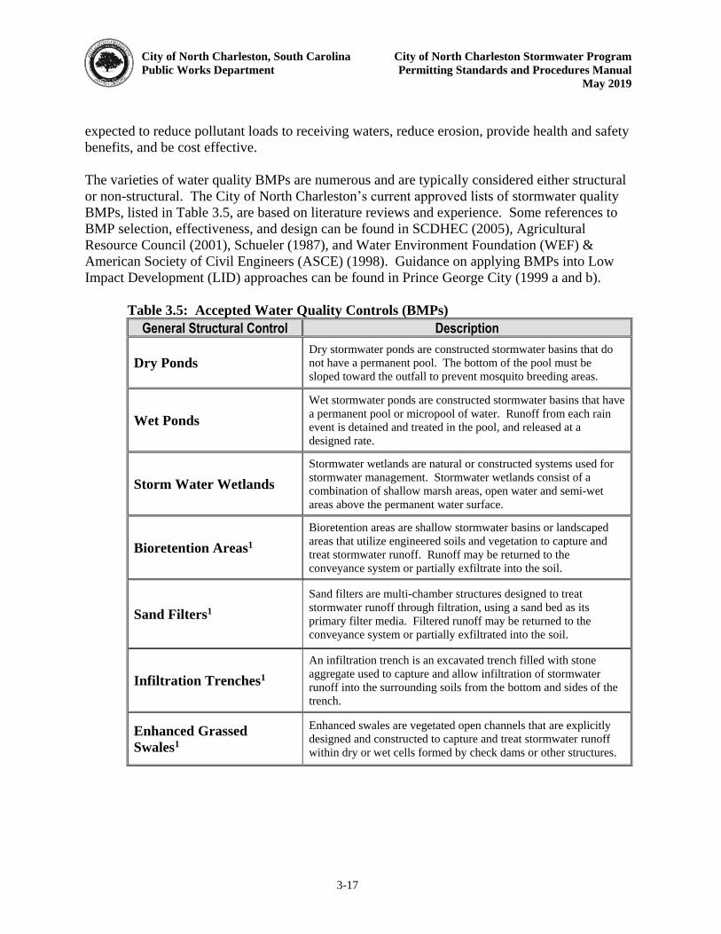
City of North Charleston, South Carolina City of North Charleston Stormwater Program
Public Works Department Permitting Standards and Procedures Manual
May 2019
3-17
expected to reduce pollutant loads to receiving waters, reduce erosion, provide health and safety benefits, and be cost effective. The varieties of water quality BMPs are numerous and are typically considered either structural or non-structural. The City of North Charleston’s current approved lists of stormwater quality BMPs, listed in Table 3.5, are based on literature reviews and experience. Some references to BMP selection, effectiveness, and design can be found in SCDHEC (2005), Agricultural Resource Council (2001), Schueler (1987), and Water Environment Foundation (WEF) & American Society of Civil Engineers (ASCE) (1998). Guidance on applying BMPs into Low Impact Development (LID) approaches can be found in Prince George City (1999 a and b).
Table 3.5: Accepted Water Quality Controls (BMPs)
General Structural Control Description
Dry Ponds Dry stormwater ponds are constructed stormwater basins that do not have a permanent pool. The bottom of the pool must be sloped toward the outfall to prevent mosquito breeding areas.
Wet Ponds Wet stormwater ponds are constructed stormwater basins that have a permanent pool or micropool of water. Runoff from each rain event is detained and treated in the pool, and released at a designed rate.
Storm Water Wetlands Stormwater wetlands are natural or constructed systems used for stormwater management. Stormwater wetlands consist of a combination of shallow marsh areas, open water and semi-wet areas above the permanent water surface.
Bioretention Areas1
Bioretention areas are shallow stormwater basins or landscaped areas that utilize engineered soils and vegetation to capture and treat stormwater runoff. Runoff may be returned to the conveyance system or partially exfiltrate into the soil.
Sand Filters1
Sand filters are multi-chamber structures designed to treat stormwater runoff through filtration, using a sand bed as its primary filter media. Filtered runoff may be returned to the conveyance system or partially exfiltrated into the soil.
Infiltration Trenches1
An infiltration trench is an excavated trench filled with stone aggregate used to capture and allow infiltration of stormwater runoff into the surrounding soils from the bottom and sides of the trench.
Enhanced Grassed
Swales1 Enhanced swales are vegetated open channels that are explicitly designed and constructed to capture and treat stormwater runoff within dry or wet cells formed by check dams or other structures.

City of North Charleston, South Carolina City of North Charleston Stormwater Program
Public Works Department Permitting Standards and Procedures Manual
May 2019
3-18
General Structural Control Description
Engineered Devices2
Vortex Separator Baffles Cartridges Skimmers Gravity Oil-Grit
Separator Filter Material Inlet inserts
Pre-fabricated controls use the movement of stormwater runoff through a specially designed structure to remove target pollutants. They are typically used on smaller commercial sites and urban hotspots. There are numerous commercial vendors of these structures, but there is limited data on the performance of these structures. Until further research is done and substantial removal efficiencies are published, these structures may require monitoring. Some of the popular vendors/products include, but are not limited to, Crystal Stream, Vortechnics, Aquashield, Filterra, Stormceptor, Stormfilter, CDS, BaySaver, and Downstream Defender1. This is by no means a complete list and the City’s Public Works Director will evaluate any such device if included in designs, provided evidence is provided as to its effectiveness. Such evidence must include applicability and proof of third-party testing on trapping efficiencies.
1 This is an infiltration design and must meet infiltration standard requirements. 2 This list is not intended as preference for these devices nor to exclude others.
Some structural BMPs have limited applications and are recommended to be used in conjunction with other BMPs. Limited application controls may be used within a system of water quality controls and are very effective pre-treatment structures for the controls listed in Table 3.5. Limited application structural controls should be designed and used only in development situations where regular maintenance is guaranteed. Popular limited stormwater controls are shown in Table 3.6.
Table 3.6: Limited Structural Controls (BMPs)
Limited Structural Control Description
Vegetated Filters
Filter Strip Grassed Channels and Swales
Both filter strips and grassed channels provide filtering of stormwater runoff as it flows across the vegetation. However, by themselves these controls do not consistently obtain adequate sediment and pollutant removal. Both filter strips and vegetated channels shall be used as pretreatment measures or part of a treatment system approach.
Submerged Gravel Wetland
Systems
Submerged gravel wetlands use wetland plants in a submerged gravel or crushed rock media to remove stormwater runoff pollutants. These systems should only be used in mid- to high- density environments where other structural controls will be utilized.
Small Sand Filters
Surface Sand Filter
Sand filters are multi-chamber structures designed to treat stormwater runoff through filtration, using a sand bed as its primary filter
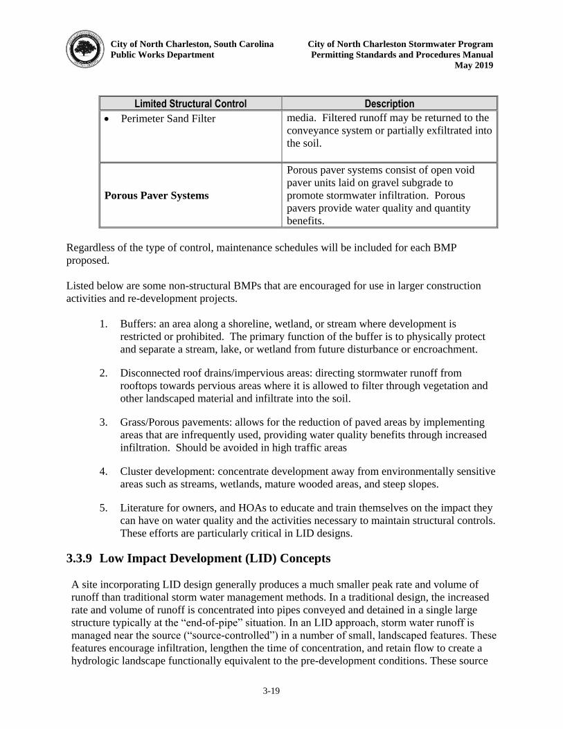
City of North Charleston, South Carolina City of North Charleston Stormwater Program
Public Works Department Permitting Standards and Procedures Manual
May 2019
3-19
Limited Structural Control Description
Perimeter Sand Filter media. Filtered runoff may be returned to the conveyance system or partially exfiltrated into the soil.
Porous Paver Systems
Porous paver systems consist of open void paver units laid on gravel subgrade to promote stormwater infiltration. Porous pavers provide water quality and quantity benefits.
Regardless of the type of control, maintenance schedules will be included for each BMP proposed. Listed below are some non-structural BMPs that are encouraged for use in larger construction activities and re-development projects.
1. Buffers: an area along a shoreline, wetland, or stream where development is restricted or prohibited. The primary function of the buffer is to physically protect and separate a stream, lake, or wetland from future disturbance or encroachment.
2. Disconnected roof drains/impervious areas: directing stormwater runoff from rooftops towards pervious areas where it is allowed to filter through vegetation and other landscaped material and infiltrate into the soil.
3. Grass/Porous pavements: allows for the reduction of paved areas by implementing areas that are infrequently used, providing water quality benefits through increased infiltration. Should be avoided in high traffic areas
4. Cluster development: concentrate development away from environmentally sensitive areas such as streams, wetlands, mature wooded areas, and steep slopes.
5. Literature for owners, and HOAs to educate and train themselves on the impact they can have on water quality and the activities necessary to maintain structural controls. These efforts are particularly critical in LID designs.
3.3.9 Low Impact Development (LID) Concepts A site incorporating LID design generally produces a much smaller peak rate and volume of runoff than traditional storm water management methods. In a traditional design, the increased rate and volume of runoff is concentrated into pipes conveyed and detained in a single large structure typically at the “end-of-pipe” situation. In an LID approach, storm water runoff is
managed near the source (“source-controlled”) in a number of small, landscaped features. These
features encourage infiltration, lengthen the time of concentration, and retain flow to create a hydrologic landscape functionally equivalent to the pre-development conditions. These source
City of North Charleston, South Carolina City of North Charleston Stormwater Program
Public Works Department Permitting Standards and Procedures Manual
May 2019
3-20
treatment structures should ideally connect to natural drainage ways. The goal of LID is to combine this hydrologically functional site design with pollution prevention integrated management practices (IMPs) to reduce the impacts of development on the quality and quantity of runoff. The term IMP is used in place of BMP or best management practices as IMPS are integrated throughout the development providing source treatment as well as landscape amenities. Some examples of LID site planning considerations are listed below:
Maintain natural drainage patterns Direct runoff to depressed areas for infiltration Preserve existing trees Reduce impervious areas Locate IMPs in soils with the highest permeability Disconnect impervious area from one another Limit clearing and grading as much as possible Locate impervious areas on less permeable soils Maintain the existing natural terrain and avoid construction in steep slope areas
(>15%) Preserve tree canopy and natural vegetative buffers Re-vegetate cleared and graded areas Avoid concentrating flow into pipes or channels
To assess the hydrologic functionality of a site, designers use the curve number (CN), time of concentration (Tc), and other factors. By maintaining the pre-development values of these parameters; a developed site will behave similarly to its pre-developed state; meeting storm water management requirements; as well as, preserving natural habitats and features, reducing thermal, flow and pollutant shocks to downstream environments, and utilizing runoff to supply groundwater recharge and landscaped areas.
3.3.9.1 Runoff
The CN is used to determine the volume of runoff from a site. Developed LID sites try to emulate the runoff characteristics of their pre-developed condition, in essence maintaining the same curve number. Changes in land cover can increase the amount of runoff from a site by reducing infiltration. Therefore, reduction of land cover changes is the first step in limiting changes to the CN. There are a number of ways to reduce changes in land cover, including:
Reduce the size of cleared area (i.e. preserve as much woodland as possible) and increase reforestation areas
Locate cleared/graded areas outside permeable soils and vegetated areas Design roads, sidewalks, and parking areas to minimize land cover impacts Reduce or disconnect site imperviousness
City of North Charleston, South Carolina City of North Charleston Stormwater Program
Public Works Department Permitting Standards and Procedures Manual
May 2019
3-21
3.3.9.2 Reduce Limits of Clearing and Grading
The limits of clearing and grading refer to the area of the site to which development is directed. This development area will include all impervious areas such as roads, sidewalks, rooftops, graded lawn areas and open drainage IMPs. To reduce the change in land cover and minimize hydrologic impact to the existing site, the development area should be located where impact on the predevelopment CN is less sensitive (e.g., on barren C and D type soils which will have less impact than developing forested A and B type soils).
3.3.9.3 Preserve Permeable Soils and Vegetated Areas
Addition of impervious surfaces and compaction due to construction traffic over soils creates the greatest possible change in infiltration (e.g. CN) between pre- and post-development conditions. Therefore the preservation of existing soils should be promoted in all unpaved areas throughout the site. Areas with well drained soils are generally good sites for bioretention areas and help sustain groundwater recharge and stream base flows. Preservation of woodland areas can help reduce impacts on existing land cover. Woodland areas promote infiltration, distribute flow, reduce velocities, provide wildlife habitat, and help maintain stream bank and bed stability. Saving existing trees on a development site is a cost-effective and quality-enhancing practice. Expansion of vegetated areas adds to the benefits of preservation by further reducing CN changes. Trees and other native species should be kept in groups large enough to maintain soil moisture, sunlight, wind and other growth characteristics. Retaining mature trees of a single species is seldom successful (Hinman, 2005). For best results flag tree preservation area at least three (3) feet outside of the existing edge of tree canopy. 3.3.10 Alternative Roadway Design
Roadways, sidewalks, driveways, and parking areas are the greatest contributors to increasing CN and the size of the required detention/ retention structure. The increase in CN due to impervious areas and the associated land clearing increase both the amount and rate of runoff over pre-development conditions. LID designs minimize the effective imperviousness of roadways and parking areas by using minimal grading and clearing techniques, minimizing impervious areas, and using open drainage sections. Site constraints can limit the applicability of LID designs. Table 3.10 outlines site constraints for commonly used LID practices. The following features may be incorporated into a roadway design to minimize land cover impacts but must be discussed with the Public Works Director prior to using in the design: Narrow road sections: Small road sections reduce impervious area and clearing and grading impacts. Reducing pavement widths will result in a reduction of overall pavement area. Traffic reduction techniques can also be used to minimize pavements while maintaining safety. Porous pavers may also be used where appropriate. Using queuing streets or pull-out parking in parking lots with porous pavers in peak overflow areas can reduce the size of parking lots. Open Drainage Sections: Grassed swales and infiltration trenches can be used in place of curb
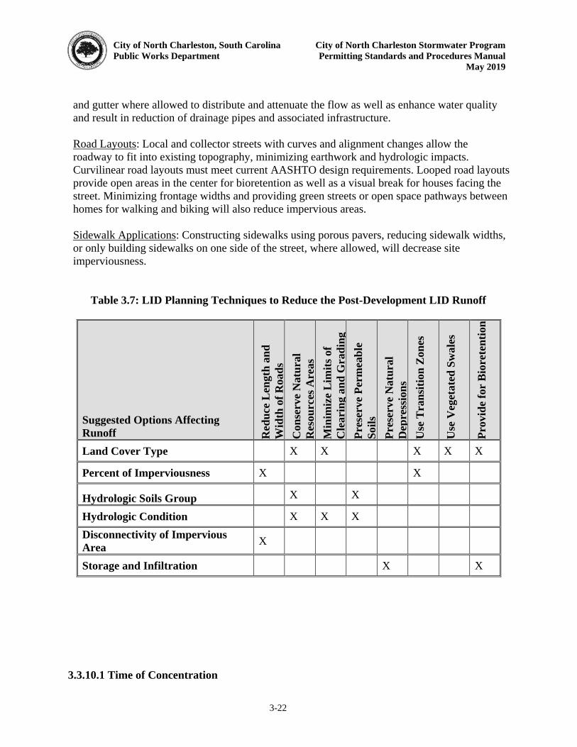
City of North Charleston, South Carolina City of North Charleston Stormwater Program
Public Works Department Permitting Standards and Procedures Manual
May 2019
3-22
and gutter where allowed to distribute and attenuate the flow as well as enhance water quality and result in reduction of drainage pipes and associated infrastructure. Road Layouts: Local and collector streets with curves and alignment changes allow the roadway to fit into existing topography, minimizing earthwork and hydrologic impacts. Curvilinear road layouts must meet current AASHTO design requirements. Looped road layouts provide open areas in the center for bioretention as well as a visual break for houses facing the street. Minimizing frontage widths and providing green streets or open space pathways between homes for walking and biking will also reduce impervious areas. Sidewalk Applications: Constructing sidewalks using porous pavers, reducing sidewalk widths, or only building sidewalks on one side of the street, where allowed, will decrease site imperviousness.
Table 3.7: LID Planning Techniques to Reduce the Post-Development LID Runoff
Suggested Options Affecting
Runoff Red
uce
Len
gth
an
d
Wid
th o
f R
oad
s
Dri
vew
ays
Con
serv
e N
atu
ral
Res
ou
rces
Area
s
Min
imiz
e L
imit
s of
Cle
ari
ng a
nd
Gra
din
g
Pre
serve
Per
mea
ble
Soil
s
Pre
serve
Natu
ral
Dep
ress
ion
s
Use
Tra
nsi
tion
Zon
es
Use
Veg
etate
d S
wale
s
Pro
vid
e fo
r B
iore
ten
tion
Land Cover Type X X X X X
Percent of Imperviousness X X
Hydrologic Soils Group X X
Hydrologic Condition X X X Disconnectivity of Impervious
Area X
Storage and Infiltration X X 3.3.10.1 Time of Concentration
City of North Charleston, South Carolina City of North Charleston Stormwater Program
Public Works Department Permitting Standards and Procedures Manual
May 2019
3-23
Time of concentration (Tc) describes the time it takes for runoff to flow from a site’s most hydrologically remote point to the outlet. The time of concentration in conjunction with the CN determines the peak discharge rate for a storm event. The time of concentration is a function of flow velocity which in turn is affected by:
Travel distance (flow path) Slope of the ground and/or water surface Ground surface roughness Channel shape and pattern
These factors can then be manipulated to modify the Tc of an LID site by modifying the following aspects of the flow:
Maximize sheet flow Modify/ lengthen flow path Site and lot slopes Open swale geometry Site and lot vegetation (roughness)
Sheet Flow: The site should be graded to maximize overland sheet flow distance and minimize the disturbance of woodlands along the Tc flow path. Where graded areas flow to natural drainage ways, velocities should not exceed one (1) ft/sec to the extent practicable, as faster velocities may provide insufficient contact time for settlement of suspended solids. The installation of a stable, level spreader along the upland edge of the natural drainage way buffer, or flat grassy area about thirty (30) foot wide upland of the buffer will allow the runoff to spread out. Flow Path: Increasing the flow path or travel distance will increase the time of concentration and allow more time for infiltration reducing not only the peak flow but the total volume of runoff as well. In residential areas, rooftop and driveway runoff can be permanently infiltrated or stored within infiltration trenches, dry wells, or cisterns strategically located to capture the runoff prior to it reaching the lawn. Strategic lot grading can increase both the surface roughness and the travel length of the runoff lengthening the time of concentration along that particular flow path. Site and Lot Slopes: Flatten lot slopes to approach a maximum of one (1) percent. This will increase infiltration and travel time. While codes may require a positive drainage perimeter around the building, lot areas outside the pad should contain at least one (1) percent positive slope. Also, soil compaction of original soils (not fill) in the lot should be avoided to maximize infiltration. Open Swales: Open drainage conveyances are preferred in LID designs over conventional storm drainage structures. To alleviate flooding problems, vegetated or grassed open drainage IMPs
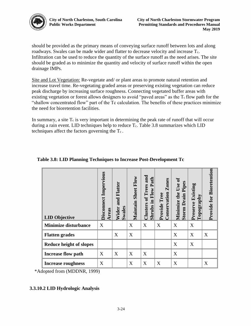
City of North Charleston, South Carolina City of North Charleston Stormwater Program
Public Works Department Permitting Standards and Procedures Manual
May 2019
3-24
should be provided as the primary means of conveying surface runoff between lots and along roadways. Swales can be made wider and flatter to decrease velocity and increase Tc. Infiltration can be used to reduce the quantity of the surface runoff as the need arises. The site should be graded as to minimize the quantity and velocity of surface runoff within the open drainage IMPs. Site and Lot Vegetation: Re-vegetate and/ or plant areas to promote natural retention and increase travel time. Re-vegetating graded areas or preserving existing vegetation can reduce peak discharge by increasing surface roughness. Connecting vegetated buffer areas with existing vegetation or forest allows designers to avoid “paved areas” as the Tc flow path for the “shallow concentrated flow” part of the Tc calculation. The benefits of these practices minimize
the need for bioretention facilities. In summary, a site Tc is very important in determining the peak rate of runoff that will occur during a rain event. LID techniques help to reduce Tc. Table 3.8 summarizes which LID techniques affect the factors governing the Tc .
Table 3.8: LID Planning Techniques to Increase Post-Development Tc
LID Objective Dis
con
nec
t Im
per
vio
us
Are
as
Wid
er a
nd
Fla
tter
Sw
ale
s
Main
tain
Sh
eet
Flo
w
Clu
ster
s of
Tre
es a
nd
Sh
rub
s in
Flo
w P
ath
Pro
vid
e T
ree
Con
serv
ati
on
Zon
es
Min
imiz
e th
e U
se o
f
Sto
rm D
rain
Pip
es
Pre
serve
Exis
tin
g
Top
ogra
ph
y
Pro
vid
e fo
r B
iore
ten
tion
Minimize disturbance X X X X X X
Flatten grades X X X X X
Reduce height of slopes X X
Increase flow path X X X X X
Increase roughness X X X X X X *Adopted from (MDDNR, 1999) 3.3.10.2 LID Hydrologic Analysis
City of North Charleston, South Carolina City of North Charleston Stormwater Program
Public Works Department Permitting Standards and Procedures Manual
May 2019
3-25
The goal of LID is to create a post-development landscape that has similar hydrologic functionality to the pre-developed site. This is done by minimizing the post-development CN and Tc as much as possible and using a number of small scale retention structures near sources of increased runoff to make up the difference in runoff volume and peak rate between the pre- and post-developed conditions. The LID design approach focuses on the following hydrologic analysis and design components: CN: Minimizing change in the post-development CN by reducing impervious areas, preserving trees, meadows and well drained areas to reduce storage requirements. Tc: Maintaining the pre-development Tc to minimize the increase in peak runoff rate by lengthening flow paths and reducing the length of conveyance systems Retention: Providing retention storage for volume, peak and water quality control, near the source of increased runoff. Detention: Providing additional detention storage, if required, to maintain peak runoff control and prevent flooding. Table 3.9 provides a summary of LID techniques that can be used to manipulate the above design and analysis components.
Table 3.9: LID Techniques for Use with Design and Analysis Components
LID Hydrologic Design
and Analysis Components
Fla
tten
Slo
pe
Incr
ease
Flo
w P
ath
Incr
ease
Sh
eet
Flo
w
Incr
ease
Rou
gh
nes
s
Min
imiz
e D
istu
rban
ce
Fla
tten
Slo
pes
On
Sw
ale
s
Infi
ltra
tion
Sw
ale
s
Veg
etati
ve
Fil
ter
Str
ips
Con
stri
cte
d P
ipes
Dis
con
nec
ted
Im
per
vio
us
Are
as
Red
uce
Cu
rb A
nd
Gu
tter
Rain
Barr
els
An
d C
iste
rns
Rooft
op
Sto
rage
Bio
rete
nti
on
Rev
eget
ati
on
Veg
etati
on
Pre
servati
on
Lower Post-development
CN X X X X X X X X
Increase Tc X X X X X X X X X X X X X X
Retention X X X X X X X
Detention X X X X 3.3.10.3 LID Integrated Management Practices (IMPs)
City of North Charleston, South Carolina City of North Charleston Stormwater Program
Public Works Department Permitting Standards and Procedures Manual
May 2019
3-26
Low-impact development uses distributed source control techniques to achieve the desired post-development hydrologic conditions. The previous sections highlight how site planning techniques can be used to minimize hydrologic effects of development; as well as, asses the need for storage due to increases in runoff volume, or peak rate. LID IMPs are used to satisfy these storage volume requirements. The design goal is to locate the IMPs at the source or lot, ideally on level ground within individual lots of the development or providing a green space connection to existing woodlands. Management practices that are suited to low-impact development include:
LID-01 Green Roofs LID-02 Rain Barrels, Cisterns, & Dry Wells LID-03 Pervious Pavement LID-04 Planter Box LID-05 Driveways LID-06 Vegetated Swales LID-07 Full Dispersion LID-08 Urban LID Applications LID-09 Disconnect Impervious and Green Space Preservation
3.3.10.4 LID IMP Selection Process
The selection and design process must be conducted to meet all the constraints and design considerations for a particular project. It is up to the developer’s/designer’s judgment to decide
which design is the most appropriate for their particular site and land use. Hydrologic functions such as infiltration, frequency and volume of discharges, and groundwater recharge become essential considerations when identifying and selecting IMPs. Table 3.10 provides a summary of potential site constraints for various IMPs. Table 3.10: Site Constraints of LID IMPs
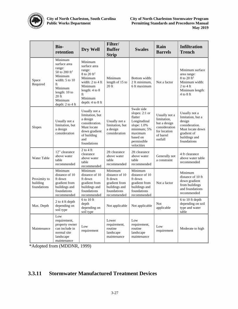
City of North Charleston, South Carolina City of North Charleston Stormwater Program
Public Works Department Permitting Standards and Procedures Manual
May 2019
3-27
Bio-
retention Dry Well
Filter/
Buffer
Strip
Swales Rain
Barrels
Infiltration
Trench
Space Required
Minimum surface area range: 50 to 200 ft2 Minimum width: 5 to 10 ft Minimum length: 10 to 20 ft Minimum depth: 2 to 4 ft
Minimum surface area range: 8 to 20 ft2 Minimum width: 2 to 4 ft Minimum length: 4 to 8 ft Minimum depth: 4 to 8 ft
Minimum length of 15 to 20 ft
Bottom width: 2 ft minimum, 6 ft maximum
Not a factor
Minimum surface area range: 8 to 20 ft2 Minimum width: 2 to 4 ft Minimum length: 4 to 8 ft
Slopes
Usually not a limitation, but a design consideration
Usually not a limitation, but a design consideration. Must locate down gradient of building and foundations
Usually not a limitation, but a design consideration
Swale side slopes: 2:1 or flatter Longitudinal slope: 1.0% minimum; 5% maximum based on permissible velocities
Usually not a limitation, but a design consideration for location of barrel outfall
Usually not a limitation, but a design consideration. Must locate down gradient of buildings and foundations
Water Table
12” clearance above water table recommended
2 to 4 ft clearance above water table recommended
2ft clearance above water table recommended
2ft clearance above water table recommended
Generally not a constraint
4 ft clearance above water table recommended
Proximity to building foundations
Minimum distance of 10 ft down gradient from buildings and foundations recommended
Minimum distance of 10 ft down gradient from buildings and foundations recommended
Minimum distance of 10 ft down gradient from buildings and foundations recommended
Minimum distance of 10 ft down gradient from buildings and foundations recommended
Not a factor
Minimum distance of 10 ft down gradient from buildings and foundations recommended
Max. Depth 2 to 4 ft depth depending on soil type
6 to 10 ft depth depending on soil type
Not applicable Not applicable Not applicable
6 to 10 ft depth depending on soil type and water table
Maintenance
Low requirement, property owner can include in normal site landscape maintenance
Low requirement
Lower requirement, routine landscape maintenance
Low requirement, routine landscape maintenance
Low requirement Moderate to high
*Adopted from (MDDNR, 1999) 3.3.11 Stormwater Manufactured Treatment Devices
City of North Charleston, South Carolina City of North Charleston Stormwater Program
Public Works Department Permitting Standards and Procedures Manual
May 2019
3-28
Manufactured Treatment Devices (MTDs) function as stormwater treatment devices before stormwater runoff is discharged off-site or to receiving water bodies, and may be incorporated into a series of water quality best management practices to remove pollutants from stormwater runoff. MTDs are not designed, or intended to store a volume of water for water quality treatment. MTD Pollutant removal efficiencies are variable and are highly dependent on storm size, influent pollutant concentrations, rainfall intensity and other factors.
Use MTDs designed to filter and trap trash, sediment, totals suspended solids (TSS), oil and grease, metals, hydrocarbons and other pollutants. Provide MTDs that combine settling, filtration, and various biological processes into one controlled system. The following MTD types may be considered for projects in the City of North Charleston:
MTD Type 1 - Separation Devices (Standard Stormwater MTD) MTD Type 3 - Catch Basin Inserts (Unique Project requirements)
Shop plans, working drawings, detailed specifications, and structural design calculations from
the manufacturer must be submitted for approval prior to the MTD installation. Shop plans and specifications must include installation drawings and instructions that completely describe the MTD. Manufactures’ specifications with certified third party testing results must be submitted and approved by the Public Works Director prior to permit application submission. MTD devices must be bypassed during construction and other best management practices in place until the system is completely installed and functional.
3.3.11.1 Design Criteria
MTD Type 1 and MTD Type 3 must be designed to treat, at a minimum, the peak flow rate of the stormwater runoff from the 1.8-inch, twenty-four (24) hour, SCS Type III storm event, from the entire drainage area to the MTD. This is defined as the water quality event (WQE).
MTDs are to be designed to treat the entire water quality event (WQE) with no by-pass for a minimum 80% Total Suspended Solids (TSS) removal efficiency. The WQE flow rate is a separate flow rate from the Level of Service (LOS) flow rate. In addition to meeting the required treatment efficiency for the WQE, the MTD must be capable of passing the specified LOS flow rate (i.e. ten (10) year storm event) without causing adverse hydraulic impact to upstream portions of the drainage system and without causing any re-suspension or scour of previously trapped pollutants, or the MTD may be required to be placed off-line. Ensure site constraints (available right of way and available depth) allow the installation of a single MTD for design peak water quality flow rates up to 8 cfs. Additional MTDs may be required for water quality event flow rates greater than 8 cfs. The drainage area contributing to an MTD must be 85% impervious or greater in order to use this calculation methodology.
City of North Charleston, South Carolina City of North Charleston Stormwater Program
Public Works Department Permitting Standards and Procedures Manual
May 2019
3-29
Ensure tail water conditions are accounted for in the MTD design.
3.3.11.2 MTD Components and Performance Requirements
1. Stormwater Manufactured Treatment Devices (MTDs) Type 1
MTD Type 1 (separation devices, also referred to as hydrodynamic separators) must be designed and sized to treat, at a minimum, the stormwater runoff from the 1.8-inch, twenty-four (24) hour, SCS Type III storm event, to prevent pollutants from being transported downstream. MTD Type 1 must contain a sump for sediment deposition with a series of chambers, baffles or weirs to trap trash, oil, grease and other contaminants. MTD Type 1 may include a high flow bypass mechanism for rainfall events larger than the water quality event to prevent scouring and re-suspension of previously trapped pollutants. MTD Type 1 not providing a high flow bypass mechanism must provide specific lab testing results verifying no re-suspension or scour of previously trapped pollutants during the Level of Service (LOS) design event for the MTD. Use MTD Type 1 with treatment elements or other upstream BMPs to remove trash, debris and other gross pollutants. MTD Type 1 must be sized using acceptable scaling methodologies based on the results of laboratory testing with a maximum Hydraulic Loading Rate of 25 gpm/sf (0.0557 cfs/sf). MTDs scaled with higher Hydraulic Loading Rates must provide specific lab results verifying the required removal efficiency for the water quality event at the higher Hydraulic Loading Rate. MTD Type 1 must have the following properties:
a. Designed for a minimum 80% Total Suspended Solids (TSS) removal efficiency (ASTM D-3977-97 SSC) of coarse sand (125-micron-mean size, OK-110, or F-95 Silica Sand) for the peak flow rate from the water quality event for average influent concentrations ranging from 100 mg/L to 300 mg/L.
b. Use settling, separation, swirling, and centrifugal force techniques to remove
pollutants from stormwater runoff.
c. Contain no moving components that require an external power source such as electricity, gas powered engines or generators.
2. Stormwater Manufactured Treatment Devices (MTDs) Type 3

City of North Charleston, South Carolina City of North Charleston Stormwater Program
Public Works Department Permitting Standards and Procedures Manual
May 2019
3-30
MTD Type 3 (catch basin inserts) may be needed for unique Project requirements. MTD Type 3 is not applicable for long stretches of linear highway projects containing many stormwater inlets. MTD Type 3 must be designed for direct installation into storm drain catch basins. Use MTD Type 3 sized for the specific catch basin they are inserted into. MTD Type 3 may contain filter media including polypropylene, porous polymers, treated cellulose, and activated carbon designed to absorb specific pollutants. MTD Type 3 must provide overflow features that do not reduce the original hydraulic capacity of the catch basin. Pollutant removal efficiencies vary and are highly dependent on storm size, influent pollutant concentrations, rainfall intensity and other factors. The following properties must be met for MTD Type 3 applications:
a. Designed for a minimum 80% Total Suspended Solids (TSS) removal efficiency (ASTM D-3977-97 SSC) for:
i. Coarse sand (125-micron-mean size, OK-110, or F-95 Silica Sand) with average influent concentrations ranging from 1,500 mg/L to 2,000 mg/L (6% target sediment to water concentration) using ASTM 7351 or equivalent laboratory testing methods.
ii. Street sweeping sediment load (average particle size of 200 micron) with average influent concentrations ranging from 24,000 mg/L to 26,000 mg/L (2.5% target sediment to water concentration) using ASTM 7351 or equivalent laboratory testing methods.
b. Use separation, settling, swirling, centrifugal force, and filtering techniques to
remove pollutants from stormwater runoff.
c. Contain no moving components that require external power sources such as electricity, gas powered engines or generators.
d. Are capable of removing the pollutants of concern for the unique Project
requirements.
3.3.11.3 Drawing Requirements
As part of the permit submittal, applicants must submit Working Drawings, Material Certification, and Certification that the MTD meets the requirements of this Specification to the Public Works Director. Ensure the Working Drawings contain at a minimum, MTD name and model and/or serial number, MTD dimensioning, MTD and storm sewer invert elevations, installation drawings, and instructions that completely describe the MTD bearing the seal and signature of a South Carolina registered Professional Engineer.
City of North Charleston, South Carolina City of North Charleston Stormwater Program
Public Works Department Permitting Standards and Procedures Manual
May 2019
3-31
3.4 Stormwater Drainage System Design Standards
This section provides the design requirements for various storm sewer drainage/collection system components including: design storms, velocities; and, pipe and inlet sizes. Storm drainage systems shall include all storm drainage structures and pipes that convey runoff under roadways. These systems are commonly referred to as lateral closed systems. These standards are required for all publicly maintained systems and are recommended for private systems.
1. Storm drain pipes:
a. Storm drainage lines shall be staked at each box or at intervals that will be sufficient to check alignment and grade of the construction with the approved plans. The use of lasers to augment control is encouraged.
b. The minimum size storm drainage pipe allowable shall be fifteen (15) inches
in diameter.
c. The minimum allowable slope for storm drainage pipe shall be four tenths (0.4%) percent [0.004 ft/ft] or a minimum flow velocity of three (3) feet per second at all flow levels, except where specifically approved in writing by the Public Works Director. Maximum allowable slope for storm drainage pipe is twenty (20) percent.
d. Drainage system installation must be such that stormwater discharge is not
concentrated on adjacent property owners and that the velocity is less than erosive limits for the site soils. At pipe outfalls, this normally requires the use of a rip-rap apron, placed on filter fabric and lightly grouted, for a minimum distance equal to or greater than six (6) pipe diameters.
e. Type and class of storm drainage pipe, as well as the construction of pipe
culverts, shall be in accordance with Sections 714 and 715 of the SCDOT specifications. All storm drainage pipes under pavement in roadways shall be RCP with o-ring joints and minimum Class III. Backfill shall consist of suitable material and compaction requirements per SCDOT specifications.
f. A minimum of one (1) foot of cover shall be provided for all storm drainage
pipes under unpaved roads or any other situation in which no roadway or other structure is to cover the pipe. For RCP pipe under any paved surface, the absolute minimum cover is nine (9) inches (excluding base course and pavement section), providing the pipe’s design meets loading requirements.
Minimum covers as listed in SCDOT’s 714 standard drawings is highly
recommended. Contact the City’s Public Works Director for minimum depths
in other situations (e.g. other pipe types). RCP Class IV or Class V may be requested by the City’s Public Works Director in special conditions (e.g. deep
installation, excessive surface loads, etc.).
City of North Charleston, South Carolina City of North Charleston Stormwater Program
Public Works Department Permitting Standards and Procedures Manual
May 2019
3-32
g. Storm drainage pipe shall be placed to minimize length running under
pavement. Where it is necessary for pipe to cross the roadway, it preferably shall be placed at a ninety (90) degree angle, and in no case at less than forty-five (45) degrees. All cross lines in the roadway shall be compacted in eight (8) inch lifts to ninety-five (95) percent Standard Proctor maximum density. Subgrade and base course compaction shall be per SCDOT Standard.
h. Any storm drainage pipe shall extend out to or beyond the toe of the roadway
embankment; in no case will the end of the pipe be within the five foot roadway shoulder.
i. Storm drainage pipe discharging into a drainage channel shall intersect the
channel in a manner such that the interior angles measured from their centerlines of flow, is greater than, or at most equal to ninety (90) degrees. Rip-rap, or other suitable protection, is required from the outlet point to the bottom of the channel and on the opposite channel bank to prevent scour and erosion.
j. Storm drainage pipe discharging into a wet pond or lake shall have the
discharge invert above the permanent pool elevation and rip-rap or other energy dissipation structures shall be placed from the bottom of the outlet to the normal permanent pool level. Submerged systems shall be avoided and will only be permissible based upon justification and prior approval from the Public Works Director.
k. A maintenance access point shall be available at a minimum distance of 200
feet for all drainage lines. In addition, manholes shall be placed at all intersections, grade changes, alignment changes, a pipe size or a pipe geometry change.
l. Where water quality devices are used, headwater depths shall be at such an elevation to allow for the appropriate function of the device.
m. Hydraulic grade line and head loss calculations for determining water surface
elevations shall be performed for all systems connections. Where water quality devices are used, headwater depths shall be at such an elevation to allow for the appropriate function of the device.
n. Calculations shall be performed for the appropriate design storm event.
o. For storm drainage systems with less than five (5) connections, Manning’s
Equation shall be acceptable for sizing the capacity of drain pipes for non-submerged conditions where the free water surface elevation is below the crown of the pipes. The Saint-Venant equations (full dynamic wave), which
City of North Charleston, South Carolina City of North Charleston Stormwater Program
Public Works Department Permitting Standards and Procedures Manual
May 2019
3-33
are used in many common engineering program, shall be employed in larger design situations. When the Saint-Venant equation is used the energy grade line should not be more than one (1) foot over the top of the pipe unless pipe joints are designed to for the access pressure.
p. Storm drain profile plots will be included in the set of construction plans.
q. Storm drainage systems shall be designed to convey stormwater runoff by gravity flow unless otherwise approved.
r. For very flat flow lines, flow velocities shall increase progressively throughout the system. Upper reaches of the pipe system may have flatter slopes than the lower end of the system.
s. It shall be unlawful for any person to uncover any component of the public stormwater system or connection branches thereof, for any purpose or to make connection therewith, unless and except with the approval and inspection of the Department of Public Works.
t. In opening trenches in any street or public way, the paving or base material shall be removed in a manner directed by the Department of Public Works. The sides of the trench shall be sheeted or braced in accordance with current OSHA standards. The earth removed from the trench shall be placed so as not to obstruct the gutters and so as to cause the least obstruction to public travel. Gas and water pipes shall be protected from impact, the trench enclosed and lighted at night, and every precaution taken to prevent injury to person or property during the progress of the work.
u. Notice shall be provided to the Department of Public Works at least two (2) working days prior to the installation of a public storm drain. No material shall be used or work covered until inspected and approved by the Department of Public Works. At the end of all projects located in the City rights of way or easements in which pipes were installed, the entire closed system (pipes, boxes, etc.) shall be video inspected and sent to the Engineering Division as part of the closeout procedure. Pipes shall be video inspected again at the end of the 2-year warranty period. See Chapter 2 for video specifications.
2. Culverts:
a. Proper consideration of inlet and outlet control shall be given in the design of culverts and outlets;
b. The pipe, appurtenant entrance and outlet structure shall properly account for water, bed-load, and floating debris at all stages of flow;
c. There shall be no unnecessary or excessive cause of property damage;
City of North Charleston, South Carolina City of North Charleston Stormwater Program
Public Works Department Permitting Standards and Procedures Manual
May 2019
3-34
d. The outlet shall be designed to resist undermining and washout.
e. Culvert design shall include all cross drainage facilities that transport stormwater runoff under roadways. Culvert selection techniques can range from solving empirical formulas, to using nomographs and charts, to comprehensive mathematical analysis for specific hydraulic conditions. The models approved for these calculations are listed below. Other widely accepted models may be used, but must be approved by the City’s Public
Works Director. Designs shall be based upon SCDOT requirements where applicable.
f. Culvert under roadways shall be designed using the fifty (50) year storm event, regardless of contributing area. Ponding on the upstream end of the culvert is acceptable as long as the roadway is not overtopped during the precipitation event. Ponding or backwater effects shall not impact any new or existing structures and recede after the storm event in a time period acceptable to the Public Works Department.
g. Additional hydraulic capacity shall be required as necessary to prevent backwater effects that may adversely impact upstream property or structures.
h. Acceptable models for designing culverts include, but are not limited to:
ICPR by Streamline Technologies HY-8 by the Federal Highway Administration (FHWA) Pond Pack by Bentley HEC-RAS by the US Army Corps of Engineers FlowMaster by Bentley XPSWMM by XP Solutions *This list is not intended as preference or to exclude others.
i. A complete study of culverts and design considerations can be found in USDOT 2001a.
j. Culvert installation should follow the standards outlined in SCDOT Standard Specifications, Section 714.
3. Headwalls and Outlets:
All exposed ends of pipes may be protected by a flared end section (limited to pipes 36" or less in diameter) or one of the following type headwalls:
a. A concrete or brick plastered with non-shrink grout, headwall is preferred; it
is required on culverts located in major defined drainage channels. An acceptable design detail is provided in the DHEC BMP handbook.
City of North Charleston, South Carolina City of North Charleston Stormwater Program
Public Works Department Permitting Standards and Procedures Manual
May 2019
3-35
b. A rip-rap headwall is acceptable for pipes twenty-four (24) inches or less in a number of situations; if used, it should conform to the standard details provided in the DHEC BMP Handbook. Note that this technique requires the use of filter fabric and grout and/or concrete.
c. Storm drainage or pond outfalls must be carried to an existing drainage outfall
such as a pipe, ditch, etc.
d. If feasible, provide a twenty (20) foot minimum buffer between the property line and the end of all pipes or energy dissipation measures installed.
d. No new point discharge onto adjacent property, where there was not an
existing point discharge, is allowed without the adjacent property owner’s
written permission. Discharge points created with new development shall connect to an existing drainage system, whether natural or man-made. The new outlet may not cause flooding or in any way degrade the existing drainage system and proof of such should be provided. In some cases, conveyance must be constructed from the new development to a point of discharge into the existing system and shall be done at the owner’s expense. In
these cases, the owner is responsible for obtaining all necessary easements and agreements to construct such drainage improvements.
e. Outlets will not be allowed to discharge on fill slopes.
4. Energy Dissipation:
a. All outlets shall be sufficiently stabilized. Calculations will be provided justifying the design and material used (e.g. riprap aprons geometry and diameter),
b. If riprap aprons are used, filter fabric is to be installed beneath all riprap.
c. Level spreaders, plunge pools, etc. shall be properly designed and installed at the proposed outlet(s).
5. Catch basins, yard inlets, manholes, and junction boxes.
a. Materials and construction shall be as specified in Section 719 of the SCDOT specifications.
b. When the depth of a catch basin or junction box exceeds four and one-half (4.5) feet, rungs/steps shall be provided for ascent and descent. (Steps are to be ASTM-C-478, or equivalent.)
c. The box top shall be a minimum of three (3) feet by three (3) feet. Sides shall be plastered with grout.

City of North Charleston, South Carolina City of North Charleston Stormwater Program
Public Works Department Permitting Standards and Procedures Manual
May 2019
3-36
d. All pipes entering or leaving shall not protrude more than four (4) inches into the box.
e. Maximum roadway catch basin inlet capacity for an inlet shall be determined based on the following:
For inlets at sag, capacity shall be based on weir flow (unsubmerged). The depth flow shall be limited to the curb depth, but may be further limited by the allowed spread, detailed below. In sag conditions, a fifteen (15) percent factor of safety shall be used to account for debris/clogging. Ponding at the sag location shall be limited to twenty-four (24) hours after the storm event.
For inlet on grade, theoretical capacity shall consider in the design the longitudinal and cross slopes, and gutter depression. The length of the gutter opening must be such that the gutter efficiency is eighty (80) percent of the theoretical capacity. Several equations and nomographs are available in the literature for determining the theoretical capacity. Maximum flow depth shall be limited to the depth of curb.
f. SCDOT inlets shall be designed to accommodate a given flow such that ponded water is removed within twenty-four (24) hours and does not cause flooding to adjacent buildings or other interests. As long as these criteria are met, the depth of ponded water is allowed to exceed the top of the manhole lid by no more than 6 inches for the appropriate design storm.
g. Catch basins will be located outside curve radii. If this is not possible, the catch basin shall be set back an extra foot and the face of the catch basin shall be parallel to a chord joining the two (2) points on the curve radius located by projecting lines from the sides of the catch basin box.
h. Catch basins shall contain a minimum drop of 0.1 feet from invert in to invert out.
i. Floors of drop boxes/manholes/junction boxes are to be of concrete and contain "formed troughs" to help channel flow.
j. Within a catch basin, the elevation at the crown of any inlet pipe shall be equal to or greater than the crown of the outlet pipe.
k. Catch basins shall be field staked to ensure proper catch basin inlet alignment with the street gutter line.
l. Area around all catch basins shall be backfilled in six (6) inch to eight (8) inch lifts, compacted to ninety-five (95) percent Standard Proctor maximum density.
City of North Charleston, South Carolina City of North Charleston Stormwater Program
Public Works Department Permitting Standards and Procedures Manual
May 2019
3-37
m. Inlet protection shall be provided at all inlets into the stormwater system during construction and until project closure procedures have been completed or notification from the Public Works Director has been given stating that an acceptable level of stabilization has been achieved. Guidance on design, installation and maintenance of inlet protection can be found in SCDOT (2005).
n. Inlet spacing shall be based partly on the maximum spread of water into the road way. For the appropriate design storm, at least one full travel lane width must be available during the rain event for all roads. Inlets up-gradient of a road intersection, sag inlets, or the last inlet for a given system must be designed with sufficient capacity to handle the entire flow, such that there is no flow through/bypass.
o. Maximum depth in which the water may pond above or around an inlet must not threaten surrounding permanent structures or facilities including vehicular or pedestrian traffic.
p. Inlets placed in roadway gutter lines shall be spaced to prevent flow from entering road intersections and to not exceed a maximum spread of six (6) feet, or one-half of a travel lane, whichever is greater, and based on maximum inlet capacity.
q. In depth design procedures for inlet and storm sewer design may be referenced in AASHTO (1999), USDT (2001b), Mays, L., (2001), and Yen (2001). Culvert design guidance is found in USDT (2001a).
r. Catch basins that are proposed in series shall include the last catch basin prior to discharge to a ditch/pond with a minimum of a 12” sump. The
location of the catch basin shall be such that access can be provided by Public Works personnel for maintenance purposes
s. All manhole lids and catch basins will contain the City of North Charleston. Contact the Public Works Department for information on how to obtain logos.
3.5 Open Channel Hydraulics
Open channels shall include all permanent storm drainage channels including swales, culverts, and diversions. These storm drainage systems shall be designed based upon the following criteria:
1. All open channels are to be uniform and shall be stabilized to prevent erosion in a
manner approved by the Public Works Director. A number of acceptable techniques are shown in the current version of the SCDHEC (2005).
City of North Charleston, South Carolina City of North Charleston Stormwater Program
Public Works Department Permitting Standards and Procedures Manual
May 2019
3-38
2. The design of open channels shall be based on Manning’s Formula where
backwater effects from obstructions and/or tailwater is not present. Flow velocities for the ten (10) year storm event must be less than five (5) ft/sec (two and one-half (2.5) ft/sec in bare sandy soils) or the channel surfaces must be adequately lined, e.g., rip-rap, concrete.
3. The minimum channel grade shall be 0.005 ft/ft, unless supporting calculations show that there will be no pools or standing water areas formed in the channels at smaller slopes.
4. Design conditions may be assumed to be steady, uniform flow.
5. Except for roadside ditches, the side slopes of grassed lined channels without Erosion Control Blankets or Turf Reinforcement Matting shall be no steeper than 3H to 1V.
6. Channels may be designed with multiple stage levels with a low flow section to carry the two (2) year storm event and a high flow section to carry storms of larger frequencies.
7. The City of North Charleston allows vegetated channels. Guidance on the design of these type channels can be found in Haan et. al. (1995) or by using computer software that is capable of calculating channel stability and capacity.
8. Additional hydraulic capacity shall be required as necessary to prevent backwater effects that may adversely impact upstream property or structures.
9. Acceptable models for designing open channels include, but are not limited to:
ICPR by Streamline Technologies HY-8 by the Federal Highway Administration (FHWA) Pond Pack by Bentley HEC-RAS by the US Army Corps of Engineers Flow Master by Bentley XP SWMM by XP Solutions *This list is not intended as preference or to exclude others.
Table 3.11: Maximum Permissible Velocities for Vegetated Channels
Permissible Velocity (ft./sec.)* Erosion Resistant Soils Easily Eroded Soils % Slope % Slope Cover 0-5 5-10 > 10 0-5 5-10 > 10
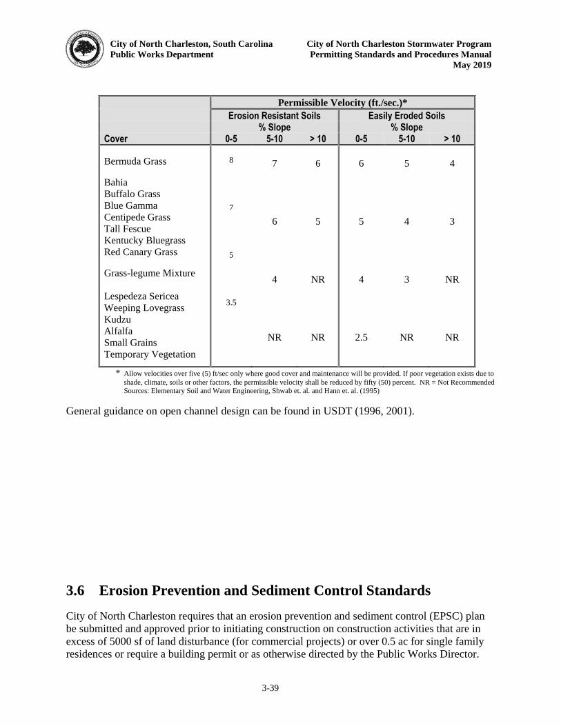
City of North Charleston, South Carolina City of North Charleston Stormwater Program
Public Works Department Permitting Standards and Procedures Manual
May 2019
3-39
Permissible Velocity (ft./sec.)* Erosion Resistant Soils Easily Eroded Soils % Slope % Slope Cover 0-5 5-10 > 10 0-5 5-10 > 10 Bermuda Grass Bahia Buffalo Grass Blue Gamma Centipede Grass Tall Fescue Kentucky Bluegrass Red Canary Grass Grass-legume Mixture Lespedeza Sericea Weeping Lovegrass Kudzu Alfalfa Small Grains Temporary Vegetation
8
7
5
3.5
7
6
4
NR
6
5
NR
NR
6
5
4
2.5
5
4
3
NR
4
3
NR
NR
* Allow velocities over five (5) ft/sec only where good cover and maintenance will be provided. If poor vegetation exists due to
shade, climate, soils or other factors, the permissible velocity shall be reduced by fifty (50) percent. NR = Not Recommended Sources: Elementary Soil and Water Engineering, Shwab et. al. and Hann et. al. (1995)
General guidance on open channel design can be found in USDT (1996, 2001). 3.6 Erosion Prevention and Sediment Control Standards
City of North Charleston requires that an erosion prevention and sediment control (EPSC) plan be submitted and approved prior to initiating construction on construction activities that are in excess of 5000 sf of land disturbance (for commercial projects) or over 0.5 ac for single family residences or require a building permit or as otherwise directed by the Public Works Director.

City of North Charleston, South Carolina City of North Charleston Stormwater Program
Public Works Department Permitting Standards and Procedures Manual
May 2019
3-40
This plan describes the practices and controls that will be used during and after construction to meet the following goals:
1. Minimize of the extent and duration of disturbed soil exposure,
2. Stabilize disturbed areas promptly,
3. Protect off-site and downstream locations, drainage systems and natural waterways from the impacts of erosion and sedimentation,
4. Limit the exit velocities of the flow leaving the site to non-erosive or pre-development conditions, and
5. Design and implement an ongoing inspection and maintenance plan.
3.6.1 Accepted EPSC BMPs The various types of EPSC BMPs that are acceptable for use in the City of North Charleston are presented below. These generally fall into three categories: erosion prevention measures, temporary sediment controls, and runoff control and conveyance measures. Runoff from sites shall contain controls that fall into at least one of these categories. 3.6.1.1 Erosion Prevention Measures
Erosion prevention measures shall be used during and after construction site preparation to avert the discharge of runoff highly concentrated with sediment and other associated pollutants. One or more measures are typically needed on a given site. Measures that fall into this category along with their preferred application are provided in Table 3.12. Details on each of these measures are not discussed in this Manual. Guidance documents that will be referenced as necessary include: SCDHEC (2003), Haan, C. T., Barfield, B. J., and Hayes, J. C. (1995) and Shwab, Glenn O. and Richard K. Frevert (1985). Other practices, such as engineered devices, will be allowed as long as sufficient evidence is presented as to their effectiveness. Standard details can be found in Appendix I. Table 3.12 Erosion Prevention BMP Suggested Uses
BMP Slope
Protection
Waterway
Protection
Surface
Protection
Enclosed
Drainage
Large
Flat
Areas
Borrow
Areas
Adjacent
Properties
Erosion Prevention Measures
X X X X X X X
Surface Roughening X X Bench Terracing X X Temporary Seeding X X X X X Mulching X X X
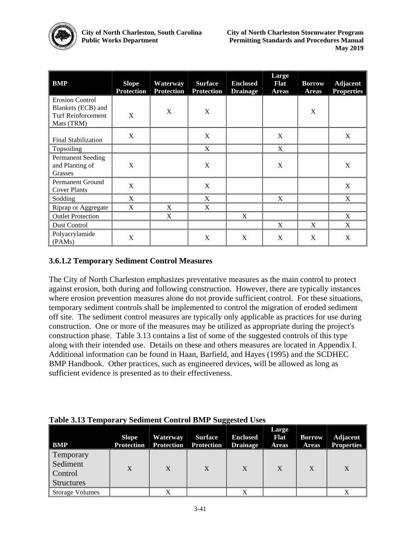
City of North Charleston, South Carolina City of North Charleston Stormwater Program
Public Works Department Permitting Standards and Procedures Manual
May 2019
3-41
BMP Slope
Protection
Waterway
Protection
Surface
Protection
Enclosed
Drainage
Large
Flat
Areas
Borrow
Areas
Adjacent
Properties
Erosion Control Blankets (ECB) and Turf Reinforcement Mats (TRM)
X X X X
Final Stabilization X X X X
Topsoiling X X Permanent Seeding and Planting of Grasses
X X X X
Permanent Ground Cover Plants X X X
Sodding X X X X Riprap or Aggregate X X X Outlet Protection X X X Dust Control X X X Polyacrylamide (PAMs) X X X X X X
3.6.1.2 Temporary Sediment Control Measures
The City of North Charleston emphasizes preventative measures as the main control to protect against erosion, both during and following construction. However, there are typically instances where erosion prevention measures alone do not provide sufficient control. For these situations, temporary sediment controls shall be implemented to control the migration of eroded sediment off site. The sediment control measures are typically only applicable as practices for use during construction. One or more of the measures may be utilized as appropriate during the project's construction phase. Table 3.13 contains a list of some of the suggested controls of this type along with their intended use. Details on these and others measures are located in Appendix I. Additional information can be found in Haan, Barfield, and Hayes (1995) and the SCDHEC BMP Handbook. Other practices, such as engineered devices, will be allowed as long as sufficient evidence is presented as to their effectiveness. Table 3.13 Temporary Sediment Control BMP Suggested Uses
BMP
Slope
Protection
Waterway
Protection
Surface
Protection
Enclosed
Drainage
Large
Flat
Areas
Borrow
Areas
Adjacent
Properties
Temporary Sediment Control Structures
X X X X X X X
Storage Volumes X X X

City of North Charleston, South Carolina City of North Charleston Stormwater Program
Public Works Department Permitting Standards and Procedures Manual
May 2019
3-42
and Maintenance Schedules Temporary Sediment Basin X X X X
Multipurpose Basin X X X X
Temporary Sediment Trap X X X
Silt Fence X X X Rock Ditch Check X X Stabilized Construction Entrance
X X
Storm Drain Inlet Protection
X X X
Vegetated Filter Strips X X
Rock Sediment Dike X X X
3.6.1.3 Runoff Control and Conveyance Measures
This category of EPSC BMPs may be used as necessary during and following construction. Suggested varieties and their corresponding uses are provided in Table 3.14. Table 3.14 Runoff Control and Conveyance Measures BMP Suggested Uses
BMP Slope
Protection
Waterway
Protection
Surface
Protection
Enclosed
Drainage
Large
Flat
Areas
Borrow
Areas
Adjacent
Properties
Pipe Slope Drains X X
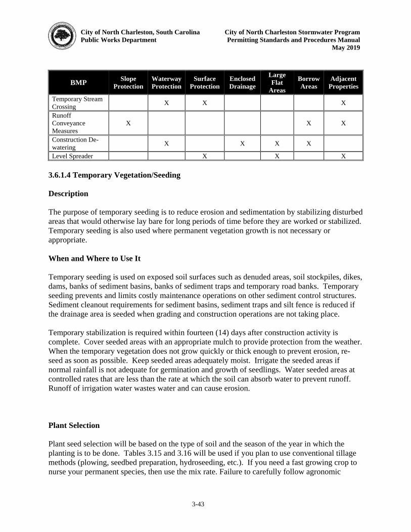
City of North Charleston, South Carolina City of North Charleston Stormwater Program
Public Works Department Permitting Standards and Procedures Manual
May 2019
3-43
BMP Slope
Protection
Waterway
Protection
Surface
Protection
Enclosed
Drainage
Large
Flat
Areas
Borrow
Areas
Adjacent
Properties
Temporary Stream Crossing X X X
Runoff Conveyance Measures
X X X
Construction De-watering X X X X
Level Spreader X X X 3.6.1.4 Temporary Vegetation/Seeding
Description
The purpose of temporary seeding is to reduce erosion and sedimentation by stabilizing disturbed areas that would otherwise lay bare for long periods of time before they are worked or stabilized. Temporary seeding is also used where permanent vegetation growth is not necessary or appropriate. When and Where to Use It
Temporary seeding is used on exposed soil surfaces such as denuded areas, soil stockpiles, dikes, dams, banks of sediment basins, banks of sediment traps and temporary road banks. Temporary seeding prevents and limits costly maintenance operations on other sediment control structures. Sediment cleanout requirements for sediment basins, sediment traps and silt fence is reduced if the drainage area is seeded when grading and construction operations are not taking place. Temporary stabilization is required within fourteen (14) days after construction activity is complete. Cover seeded areas with an appropriate mulch to provide protection from the weather. When the temporary vegetation does not grow quickly or thick enough to prevent erosion, re-seed as soon as possible. Keep seeded areas adequately moist. Irrigate the seeded areas if normal rainfall is not adequate for germination and growth of seedlings. Water seeded areas at controlled rates that are less than the rate at which the soil can absorb water to prevent runoff. Runoff of irrigation water wastes water and can cause erosion. Plant Selection
Plant seed selection will be based on the type of soil and the season of the year in which the planting is to be done. Tables 3.15 and 3.16 will be used if you plan to use conventional tillage methods (plowing, seedbed preparation, hydroseeding, etc.). If you need a fast growing crop to nurse your permanent species, then use the mix rate. Failure to carefully follow agronomic
City of North Charleston, South Carolina City of North Charleston Stormwater Program
Public Works Department Permitting Standards and Procedures Manual
May 2019
3-44
recommendations often results in an inadequate stand of temporary vegetation that provides little or no erosion control. Topsoil
If the surface soil of the seedbed is not adequate for plant growth, topsoil may be applied. Tillage
If the area has been recently plowed, no tillage is required other than raking or surface roughening to break any crust that has formed and to leave a textured surface. If the soil is compacted less than six (6) inches, it should be disked for optimal germination. Soil Testing
Information on soil testing is available from the Clemson University Home and Garden Information Center at (888) 656-9988 (9 AM to 1 PM ) or at http://www.clemson.edu/extension/hgic/ Lime
Lime is not required for temporary seeding unless a soil test shows that the soil pH is below 5.0. It may be desirable to apply lime during the temporary seeding operation to benefit the long-term permanent seeding. Apply a minimum of 1.5 tons of Lime/acre (70 pounds per 1000 square feet) if it is to be used. Fertilizer
Use Granular fertilizer for all temporary cover applications to ensure adequate stabilization. The proper fertilizer mixture is dependent on the soil conditions and it is recommended that a soil analysis be performed if soil conditions are uncertain in the area of fertilizer application. In general, because of the high natural levels of phosphorus in the City of North Charleston area, a fertilizer low in phosphorus is recommended. In a mixed fertilizer such as 18-0-8, the first number represents the percent of nitrogen required, the second number represents the percent of phosphorus, and the third number represents the percent of water soluble potassium in the fertilizer. Use fertilizer that incorporates a minimum of 50% water insoluble (slow release)
nitrogen. Animal by-product or municipal waste fertilizers are not acceptable under this specification. a soil analysis is performed to determine otherwise, a good rule of thumb granular fertilizer to apply in the City of North Charleston is 18-0-8. The 18-0-8 fertilizer contains the appropriate amount of slow release nitrogen and contains no phosphorus which is appropriate to the area due to the high levels of natural phosphorus content in the soils. Other potential granular fertilizer blends appropriate for us in the City of North Charleston, due to the high level of natural
City of North Charleston, South Carolina City of North Charleston Stormwater Program
Public Works Department Permitting Standards and Procedures Manual
May 2019
3-45
phosphorus in the soils, are 15-0-15 or 25-0-12. In no case should a 20-20-20 fertilizer be used on City stabilization projects due to the potential burning of the seedbed. Seeding
The surface of the soil may be loosened just before broadcasting the seed. Seed will be applied evenly by the most convenient method available for the type of seed to be used and the location of the temporary seeding. Typical application methods include but are not limited to cyclone seeders, rotary spreaders, drop spreaders, broadcast spreaders, hand spreaders, cultipacker seeder, and hydro-seeders. Cover applied seed by raking or dragging a chain, and then lightly firm the area with a roller or cultipacker. Mulching
Mulch may be used in seeded areas to retain soil moisture and reduce erosion during establishment of vegetation. The most commonly accepted mulch used in conjunction with temporary seeding is small grain straw. This straw should be dry and free from mold damage and noxious weeds. The straw may need to be anchored with netting or emulsions to prevent it from being blown or washed away. The straw mulch may be applied by hand or machine at the rate of 1.5 - 2 tons per acre (90 pounds per 1000 square feet). Frequent inspections are necessary to check that conditions for growth are good. Irrigation
Seeded areas should be kept adequately moist. Irrigate the seeded area if normal rainfall is not adequate for the germination and growth of seedlings. Water seeded areas at controlled rates that are less than the rate at which the soil can absorb water to prevent runoff. Runoff of irrigation wastes water and can cause erosion. Re-seeding
Areas where the plants do not grow quickly, thick enough, or adequately to prevent erosion should be re-seeded with temporary grasses as soon as such areas are identified. Table 3.15 Temporary Vegetation/Seeding Schedule
Species Rates
(lbs/acre)
Optimum Dates to
Plant Remarks
Browntop Millet (Alone) 40 April 20 - August 15 Quick, Dense Cover
City of North Charleston, South Carolina City of North Charleston Stormwater Program
Public Works Department Permitting Standards and Procedures Manual
May 2019
3-46
Species Rates
(lbs/acre)
Optimum Dates to
Plant Remarks
Browntop Millet (Mix)* 10 April 20 - August 15 Quick, Dense Cover
Rye Grain (Alone) 56 February - March, August 15 - November 20
Quick Cover
Rye Grain (Mix)* 10 February - March, August 15 - November 20
Quick Cover
Rye Grass (Alone) 50 August 10 - October 10 Competitive, Dense
Rye Grass (Mix)* 8 August 10 - October 10 Competitive, Dense
* For details on mixes consult the Charleston Soil and Water Conservation District.
Table 3.16 Temporary Vegetation/Seeding Schedule for Steep Slopes/Cut Slopes
Species Rates
(lbs/acre)
Optimum Dates to
Plant Remarks
Weeping Lovegrass (Alone) 4 April - July 20
Quick cover, deep roots, likes dry sites, seldom used alone, clumps
Weeping Lovegrass (Mix)* 2 April - July 20
Quick cover, deep roots, likes dry sites, seldom used alone, clumps
* For details on mixes consult the Charleston Soil and Water Conservation District.
3.6.1.5 Permanent Vegetation/Seeding
Description
The purpose of seeding is to reduce erosion and sedimentation by stabilizing disturbed areas that would otherwise lay bare for long periods of time before they are worked or stabilized. Seeding is also used where permanent vegetation growth is not necessary or appropriate. When and Where to Use It
Permanent seeding is used on exposed soil surfaces such as denuded areas, soil stockpiles, dikes, dams, banks of sediment basins, banks of sediment traps, and road banks. Seeding prevents and limits costly maintenance operations on other sediment control structures. Sediment cleanout requirements for sediment basins, sediment traps and silt fence is reduced if the drainage area is seeded when grading and construction operation are not taking place.
City of North Charleston, South Carolina City of North Charleston Stormwater Program
Public Works Department Permitting Standards and Procedures Manual
May 2019
3-47
Permanent stabilization is required within fourteen (14) days after construction activity is complete. Cover seeded areas with an appropriate mulch to provide protection from the weather. When the permanent vegetation does not grow quickly or thick enough to prevent erosion, re-seed as soon as possible. Keep seeded areas adequately moist. Irrigate the seeded area if normal rainfall is not adequate for germination and growth of seedlings. Water seeded areas at controlled rates that are less than the rate at which the soil can absorb water to prevent runoff. Runoff of irrigation water wastes water and can cause erosion. The City of North Charleston reserves the right to re-inspect a site over two (2) growing seasons to verify proper stabilization is maintained. Plant Selection
Plant seed selection should be based on the type of soil, the season of the year in which the planting is to be done, and the needs and desires of the permanent land user. Tables 3.14 and 3.15 should be used to select the desired species to be planted. Failure to carefully follow agronomic recommendations often results in an inadequate stand of permanent vegetation that provides little or no erosion control. The rates in Tables 3.14 and 3.15 are based on purity and germination standards required for certification. The following notes apply to Tables 3.14 and 3.15.
1. The full seeding rate of permanent cover shall be used. 2. Mix means two (2) or more-long term species plus short term species. For dates
other than optimum, contact the Clemson University Home and Garden Information Center at (888) 656-9988 or at http://hgic.clemson.edu.
3. A legume, such as a clover, crown vetch, and serecia should be used where it is
possible. 4. The appropriate inoculants should be used.
Topsoil
If the surface soil of the seedbed is not adequate for plant growth, topsoil may be applied. Tillage
If the area has been recently plowed, no tillage is required other than raking or surface roughening to break any crust that has formed and to leave a textured surface. If the soil is compacted less than six (6) inches, it should be disked for optimal germination. If the soil is compacted more than six (6) inches, it should be sub-soiled and disked. Soil Testing
City of North Charleston, South Carolina City of North Charleston Stormwater Program
Public Works Department Permitting Standards and Procedures Manual
May 2019
3-48
Information on soil testing is available from the Clemson University Home and Garden Information Center at (888) 656-9988 (9 AM to 1 PM) or at http://www.clemson.edu/extension/hgic/
Lime
Unless a specific soil test indicates otherwise, apply 1½ tons of ground course textured agricultural limestone per acre (70 pounds per 1000 square feet). Fertilizer
Use Granular fertilizer for all temporary cover applications to ensure adequate stabilization. The proper fertilizer mixture is dependent on the soil conditions and it is recommended that a soil analysis be performed if soil conditions are uncertain in the area of fertilizer application. In general, because of the high natural levels of phosphorus in the City of North Charleston area, a fertilizer low in phosphorus is recommended. In a mixed fertilizer such as 18-0-8, the first number represents the percent of nitrogen required, the second number represents the percent of phosphorus, and the third number represents the percent of water soluble potassium in the fertilizer. Use fertilizer that incorporates a minimum of 50% water insoluble (slow release)
nitrogen. Animal by-product or municipal waste fertilizers are not acceptable under this specification. Unless a soil analysis is performed to determine otherwise, a good rule of thumb granular fertilizer to apply in the City of North Charleston is 18-0-8. The 18-0-8 fertilizer contains the appropriate amount of slow release nitrogen and contains no phosphorus which is appropriate to the area due to the high levels of natural phosphorus content in the soils. Other potential granular fertilizer blends appropriate for us in the City of North Charleston, due to the high level of natural phosphorus in the soils, are 15-0-15 or 25-0-12. In no case should a 20-20-20 fertilizer be used on City stabilization projects due to the potential burning of the seedbed. Seeding
The surface of the soil should be loosened just before broadcasting the seed. Seed should be evenly applied by the most convenient method available for the type of seed to be applied and the location of the temporary seeding. Typical application methods include but are not limited to cyclone seeders, rotary spreaders, drop spreaders, broadcast spreaders, hand spreaders, cultipacker seeder, and hydro-seeders. Cover applied seed by raking or dragging a chain or brush mat, and then lightly firm the area with a roller or cultipacker. Do not roll seed that is applied with a hydro-seeder and hydro-mulch. Mulching
City of North Charleston, South Carolina City of North Charleston Stormwater Program
Public Works Department Permitting Standards and Procedures Manual
May 2019
3-49
All permanent seeded areas may be covered with mulch immediately upon completion of the seeding application to retain soil moisture and reduce erosion during establishment of vegetation. The mulch should be applied evenly in such a manner that it provides a minimum of seventy-five (75) percent coverage. Typical mulch applications include straw, wood chips, bark, wood fiber, and hydro-mulches. The most commonly accepted mulch used in conjunction with permanent seeding is small grain straw. This straw should be dry and free from mold damage and noxious weeds. The straw may need to be anchored with netting or asphalt emulsions to prevent it from being blown or washed away. The straw mulch may be applied by hand or machine at the rate of two (2) tons per acre (90 pounds per 1000 square feet). Frequent inspections are necessary to check that conditions for growth are good. Irrigation
Permanent seeded areas should be kept adequately moist, especially late in the specific growing season. Irrigate the seeded area if normal rainfall is not adequate for the germination and growth of seedlings. Water seeded areas at controlled rates that are less than the rate at which the soil can absorb water to prevent runoff. Runoff of irrigation water wastes water and can cause erosion.
Re-seeding
Inspect permanently seeded areas for failure, make necessary repairs and re-seed or over seed within the same growing season if possible. If the grass cover is sparse or patchy, re-evaluate the choice of grass and quantities of lime and fertilizer applied. If the permanent seeding has less than forty (40) percent cover, have the soil tested to determine any acidity or nutrient deficiency problems. Final stabilization by permanent seeding of the site requires that it be covered by a seventy (70) percent coverage rate. Post-Stabilization
Once areas are stabilized they can be converted to native species or for establishing on non-critical, level sites. Tables 3.17, 3.18 and 3.19 list some native species of the City of North Charleston that can be used.
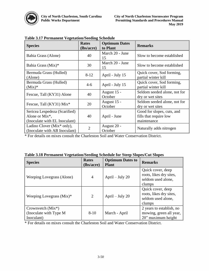
City of North Charleston, South Carolina City of North Charleston Stormwater Program
Public Works Department Permitting Standards and Procedures Manual
May 2019
3-50
Table 3.17 Permanent Vegetation/Seeding Schedule
Species Rates
(lbs/acre)
Optimum Dates
to Plant Remarks
Bahia Grass (Alone) 40 March 20 - June 15 Slow to become established
Bahia Grass (Mix)* 30 March 20 - June 15 Slow to become established
Bermuda Grass (Hulled) (Alone) 8-12 April - July 15 Quick cover, Sod forming,
partial winter kill Bermuda Grass (Hulled) (Mix)* 4-6 April - July 15 Quick cover, Sod forming,
partial winter kill
Fescue, Tall (KY31) Alone 40 August 15 - October
Seldom seeded alone, not for dry or wet sites
Fescue, Tall (KY31) Mix* 20 August 15 - October
Seldom seeded alone, not for dry or wet sites
Sericea Lespedeza (Scarified) Alone or Mix*, (Inoculate with EL Inoculant)
40 April - June Good for slopes, cuts, and fills that require low maintenance
Ladino Clover (Mix* only), (Inoculate with AB Inoculant) 2 August 20 -
October Naturally adds nitrogen
* For details on mixes consult the Charleston Soil and Water Conservation District.
Table 3.18 Permanent Vegetation/Seeding Schedule for Steep Slopes/Cut Slopes
Species Rates
(lbs/acre)
Optimum Dates to
Plant Remarks
Weeping Lovegrass (Alone) 4 April – July 20
Quick cover, deep roots, likes dry sites, seldom used alone, clumps
Weeping Lovegrass (Mix)* 2 April – July 20
Quick cover, deep roots, likes dry sites, seldom used alone, clumps
Crownvetch (Mix*) (Inoculate with Type M Inoculant)
8-10 March - April 2 years to establish, no mowing, green all year, 20” maximum height
* For details on mixes consult the Charleston Soil and Water Conservation District.
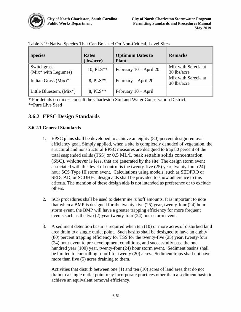
City of North Charleston, South Carolina City of North Charleston Stormwater Program
Public Works Department Permitting Standards and Procedures Manual
May 2019
3-51
Table 3.19 Native Species That Can Be Used On Non-Critical, Level Sites Species
Rates
(lbs/acre)
Optimum Dates to
Plant
Remarks
Switchgrass (Mix* with Legumes) 10, PLS** February 10 – April 20 Mix with Serecia at
30 lbs/acre
Indian Grass (Mix)* 8, PLS** February – April 20 Mix with Serecia at 30 lbs/acre
Little Bluestem, (Mix*) 8, PLS** February 10 – April
* For details on mixes consult the Charleston Soil and Water Conservation District. **Pure Live Seed 3.6.2 EPSC Design Standards 3.6.2.1 General Standards
1. EPSC plans shall be developed to achieve an eighty (80) percent design removal
efficiency goal. Simply applied, when a site is completely denuded of vegetation, the structural and nonstructural EPSC measures are designed to trap 80 percent of the total suspended solids (TSS) or 0.5 ML/L peak settable solids concentration (SSC), whichever is less, that are generated by the site. The design storm event associated with this level of control is the twenty-five (25) year, twenty-four (24) hour SCS Type III storm event. Calculations using models, such as SEDPRO or SEDCAD, or SCDHEC design aids shall be provided to show adherence to this criteria. The mention of these design aids is not intended as preference or to exclude others.
2. SCS procedures shall be used to determine runoff amounts. It is important to note
that when a BMP is designed for the twenty-five (25) year, twenty-four (24) hour storm event, the BMP will have a greater trapping efficiency for more frequent events such as the two (2) year twenty-four (24) hour storm event.
3. A sediment detention basin is required when ten (10) or more acres of disturbed land
area drain to a single outlet point. Such basins shall be designed to have an eighty (80) percent trapping efficiency for TSS for the twenty-five (25) year, twenty-four (24) hour event to pre-development conditions, and successfully pass the one hundred year (100) year, twenty-four (24) hour storm event. Sediment basins shall be limited to controlling runoff for twenty (20) acres. Sediment traps shall not have more than five (5) acres draining to them.
Activities that disturb between one (1) and ten (10) acres of land area that do not drain to a single outlet point may incorporate practices other than a sediment basin to achieve an equivalent removal efficiency.
City of North Charleston, South Carolina City of North Charleston Stormwater Program
Public Works Department Permitting Standards and Procedures Manual
May 2019
3-52
4. Silt fencing shall be placed at the toe of all fill slopes and soil berms and below disturbed areas where the size of the area is no more than ¼-acre per one hundred (100) feet of silt fence length. The maximum slope length behind the fence is one hundred (100) feet and the maximum gradient behind the fence is 2H:1V.
5. The following nonstructural site management practices shall be utilized on the plans where applicable:
a. Minimize site disturbance to preserve and maintain existing vegetative cover,
b. Limit the number of temporary access points to the site for land disturbing activities,
c. Protect off-site and downstream locations, drainage systems and natural waterways from the impacts of erosion and sedimentation,
d. Phase and sequence construction activities to minimize the extent and duration of disturbed soil exposure, and
e. Implement an ongoing inspection and maintenance plan. Suggested maintenance schedules are given in SCDHEC (2005).
6. Sediment storage volumes shall be calculated for all sediment controls to determine the required clean-out frequencies and maintenance schedules. The Universal Soil Loss Equation (USLE) and subsequent modifications or other acceptable methods that determine sediment yield may be used to predict the required sediment storage volumes for specific sediment control structures.
7. To encourage the development and testing of innovative alternative EPSC BMPs,
alternative management practices that are not included in the Manual may be allowed upon review and approval by the City’s Public Works Director. To use an alternative BMP, the design professional shall submit substantial evidence that the proposed measure will perform at least equivalent to currently approved BMPs contained in the Manual. Evidence may include, but is not limited to:
a. Supporting hydraulic and trapping efficiency calculations.
b. Peer review by a panel of licensed professional engineers.
c. Research results as reported in professional journals.
d. Manufacturer’s literature.
8. Detailed EPSC plans shall comply to the maximum extent practicable with the following specific standards and review criteria:
City of North Charleston, South Carolina City of North Charleston Stormwater Program
Public Works Department Permitting Standards and Procedures Manual
May 2019
3-53
a. Sediment tracking control shall be implemented using stabilized construction entrances that are to be located and utilized at all points of ingress/egress on a construction site. The transfer of soil, mud, and dust onto roads shall be prevented.
b. Crossings of waterways during construction will be minimized and must be approved by the City’s Public Works Director and possibly DHEC and USACE. Encroachment into stream buffers, riparian areas and wetlands will be avoided when possible.
c. Topsoil shall be stockpiled and preserved from erosion or dispersal both during and after site grading operations when applicable.
d. Where construction or land disturbance activity will or has temporarily ceased on any portion of a site, temporary site stabilization measures shall be required as soon as practicable, but no later than fourteen (14) calendar days after the activity has ceased. Hydroseeding as often as possible is encouraged. Stabilization of disturbed areas is one of the best approaches for erosion prevention and sediment control.
e. All slopes must be stabilized though grassing, hydroseeding, synthetic or vegetative matting, diversion berms, temporary slope drains, etc. and must be performed within two (2) working days after the necessary grading (temporary or permanent) has been achieved.
f. Final stabilization of the site shall be required within fourteen (14) calendar days of construction completion. Final stabilization is defined as having seventy (70) percent or more of the entire site with permanent coverage in good condition.
g. Temporary structural controls installed during construction shall be designed to accomplish maximum stabilization and control of erosion and sedimentation, and shall be installed, maintained, and removed according to the specifications set forth in the Manual and project specifics developed as part of the permit application/engineering calculations. All temporary structural controls shall be designed to control the peak runoff resulting from the twenty five (25) year storm event.
h. All permanent structural controls, including drainage facilities such as channels, storm sewer inlets, and detention basins, shall be cleaned out as part of the project closeout process.
i. Linear projects (utility lines, road construction) over, under, or along a water body shall include measures and controls which adequately protect the water body from undue impact. Such work shall not be performed without approval from USACE. In addition, such work shall be coordinated with the installation of erosion prevention and sediment control measures so that disruption is
City of North Charleston, South Carolina City of North Charleston Stormwater Program
Public Works Department Permitting Standards and Procedures Manual
May 2019
3-54
minimized. Every effort should be made to install utilities during the initial construction phases. Trench sharing is encouraged to the extent practicable
9. The grading plan shall include the following general measures at a minimum:
a. The finished cut and fill slopes to be vegetated should not be steeper than 3H:1V. The finished grades of cut and fill slopes to be vegetated with vines and/or groundcovers should not be steeper than 1H:1V.
b. Cuts or fills may not be so close to property lines as to endanger adjoining
property without adequately protecting such properties against erosion, sedimentation, slippage, settlement, subsidence, or other damages.
c. Subsurface drainage may be provided in areas having a high water table to
intercept seepage that would affect slope stability, bearing strength or create undesirable wetness.
d. No fill shall be placed where it can slide or wash onto another property. e. Fill shall not be placed adjacent to channel banks where it can create bank
failure, reduce the capacity of the stream, or result in downstream sediment deposition.
f. All borrow and disposal areas shall be included as part of the grading plan.
g. Adequate channels and floodways shall be provided to safely convey increased
runoff from the developed area to an adequate outlet without causing significant channel degradation, or increased off-site flooding.
h. The site shall be graded to direct flows to appropriate controls.
10. EPSC plan shall have the following information contained within a cohesive, organized, and easy to follow format:
a. Location of all erosion and sediment control structures on construction documents;
b. Delineation of all sensitive features (wetlands, streams, ponds, existing stormwater structures, etc.) and potential sediment sources;
c. Installation sequencing and maintenance schedules for all EPSC BMPs during and after construction;
d. Provisions to preserve topsoil and limit the amount of total disturbed area;
e. Details of site grading;
City of North Charleston, South Carolina City of North Charleston Stormwater Program
Public Works Department Permitting Standards and Procedures Manual
May 2019
3-55
f. Design details and computations for all EPSC structures;
g. Protection of all storm drain inlets and outlets;
h. For sites which disturb greater than five (5) acres, a list or calculation of the trapping efficiency for all EPSC BMPs, as applicable;
i. For sites which disturb greater than five (5) acres, calculations of required sediment storage volumes for all EPSC BMPs, as applicable;
j. Explanation of any computer models or software used with highlights of and/or notes on the output data;
k. Locate temporary and permanent soil disposal areas, haul roads, and construction staging areas to minimize erosion, sediment transport, and disturbance to existing vegetation;
l. All necessary certifications by the person responsible for the activity. This includes the NOI application signatures and maintenance agreement/operating permit. Proper preparation of the EPSC Plan and the SWPPP, if necessary, by a registered engineer, landscape architect, Tier B land surveyor, or a qualified Federal Government employee.
3.6.2.2 Typical EPSC Design Procedures
The design procedures will vary depending on the EPSC BMP. Many of the BMPs listed in Tables 3.12 thru 3.19 do not need to be “designed” using calculations, such as surface roughening or dust control. Others require the use of equations or design aids to properly design. SCDHEC has two handbooks, the BMP Handbook (SCDHEC 2005) and the Stormwater Management and Sediment Control Handbook (SCDHEC 2003) that provide the procedures and equations needed to design some of the EPSC BMPs listed in Tables 3.12 thru 3.19. Example problems are given for most types. As with the design of any BMP, engineering judgment will be needed on most applications. Proper design must be complemented with proper installation and routine maintenance in order for BMPs to be effective and to adhere to these provisions of this section. 3.7 Special Protection Areas
In an effort to address some of the most critical water resource problems that exist in the City, Special Protection Areas may be established. These areas may be established by the establishment of specific local, state or federal requirements (TMDL, State Anti-Degredation, etc.). Those wishing to develop or redevelop lands within these protected areas will be required to comply with the minimum standards listed in the preceding sections as well as a set of design criteria detailed below. Design criteria within Special Protection Areas may impose water quantity (reduces or prevents frequent and/or extreme flooding) or a water quality criteria that prevents or reduces degradation of riverine, estuarine, coastal ecosystems or maintains a
City of North Charleston, South Carolina City of North Charleston Stormwater Program
Public Works Department Permitting Standards and Procedures Manual
May 2019
3-56
designated use(s). Water quality impairments may be identified through the City’s Stormwater
Management Program and/or any other local, state or federal requirements. The City’s Public
Works Director will inform permit applicant(s) when submitted applications and/or proposed projects are located within a Special Protection Area. This does not relieve the applicant(s) of other local, state or federal requirements (State approved TMDL’s, etc.) Due to the dynamic
nature of these Special Protection Areas, the applicant will meet with the Public Works Director to discuss specific design criteria. 3.7.1 Water Quantity Flooding problem areas exist in many locations around the City to the point that stormwater controls have become overwhelmed where controls were never adequately designed or installed to control runoff. The ability to maintain a system is also suspected to contribute to some of the frequent flooding. In an effort to relieve existing flooding problems, the City of North Charleston may require additional design criteria during construction site permitting process. 3.7.2 Water Quality In conjunction with the NPDES permitting program, SCDHEC, through delegated responsibility from EPA, must identify and mitigate impaired waterbodies. Impaired waterbodies are identified through a monitoring program, the results of which are compared against water quality standards developed to protect designated uses of individual waterbodies. These impaired waterbodies are those that do not meet these standards and cannot be used for their designated purposes, such as fishing, swimming, recreation, and/or support of aquatic life. In accordance with Section 303 of the Clean Water Act, states must release a bi-annual report of the impaired waterbodies. Waters listed on the 303(d) list will have a TMDL developed, which represents the daily amount of a particular pollutant that a waterbody can receive and still meet the water quality standard for its designated use(s).
City of North Charleston, South Carolina City of North Charleston Stormwater Program Public Works Department Permitting Standards and Procedures Manual May 2019
4-1
CHAPTER 4 INSPECTIONS & ENFORCEMENT This chapter establishes inspection and enforcement guidelines to be followed by the City.
4.1 Stormwater Management Inspections
The City will inspect applicable construction sites from initial land clearing to final stabilization. The purpose of these inspections will be to check for compliance with the City stormwater management plan approved by the Stormwater Division. Maintenance inspections will also be performed on stormwater management systems and facilities throughout their useful life. For each system or facility installed or retrofitted during an approved construction project, the applicant must have submitted a maintenance schedule or plan. City inspectors will be checking for adherence to this plan and any necessary changes that may arise after installation. City inspections are not to be construed as a relaxation of the requirements on owners/operators to conduct self-inspection in accordance with any applicable local, state or federal stormwater requirements 4.1.1 Inspector Duties/Responsibilities
North Charleston’s Stormwater Management Inspectors shall inspect and enforce the requirements of the City Stormwater Management Ordinance. The job duties/responsibilities of a City Stormwater Inspector shall include, but not be limited to, the following:
1. Conduct and document during construction site inspections to ensure compliance with the approved City permit or stormwater management plan. Frequency of inspections will be determined by City staff on an as needed basis.
2. Ensure that the approved City permit or stormwater management plan, the SWPPP, and the construction plans are on the project site and are properly being followed and implemented.
3. Conduct post-construction inspections to ensure that permanent maintenance is being performed in accordance with the maintenance schedules for the various stormwater management facilities in the City permit or approved stormwater management plan.
4. Provide the owner/operator of the project a written report of any discrepancies found during the inspection within seven (7) days after the site inspection.
5. Issue enforcement orders, as necessary, to the owner/operator when any portion of the work does not comply with the approved City permit and/or stormwater management plan or work is occurring without appropriate permitting. The enforcement process and types of orders is detailed in Section 4.3.
City of North Charleston, South Carolina City of North Charleston Stormwater Program Public Works Department Permitting Standards and Procedures Manual May 2019
4-2
6. Perform a final inspection upon the completion of the stormwater system to determine if the system is constructed in accordance with the approved City permit and/or, stormwater management plan.
7. Take immediate action if the owner/operator fails to comply with the approved City permit or the approved stormwater management plan and an imminent hazard exists as a result. The inspector should address the situation and notify any applicable local, state and federal agencies.
8. Maintain accurate and comprehensive project inspection files ensuring all relevant information is entered in the files to be maintained in the Public Works Department.
4.1.2 Inspection Process and Procedures
As per the City’s Stormwater Ordinance, the Public Works Director or an authorized respresentative/designee (inspector) may enter upon all properties for regular inspections, periodic investigations, enforcement and to effectuate the provisions of the Ordinance. Upon refusal by any owner/operator or property owner to permit an inspector to enter upon the property or continue an inspection, the inspector shall terminate the inspection or confine the inspection to portions of the property to which no objection is raised. Upon completion of a during construction site inspection, the City inspector should, at a minimum, include the following in his inspection report to be provided to the owner/operator:
1. Date and location of the site inspection. 2. Whether the approved City permit or stormwater management plan, SWPPP, and
construction plans have been properly implemented and maintained. 3. Identification of any approved plan or BMP deficiencies. 4. Any corrective actions needed.
Upon completion of a post-construction maintenance inspection, the City inspector should, at a minimum, include the following in this inspection report to be provided to the owner/operator:
1. Date and location of the site inspection. 2. Whether the activities identified in the approved maintenance schedule have been
properly implemented and completed. 3. Identification of any maintenance deficiencies. 4. Any corrective actions needed.
City of North Charleston, South Carolina City of North Charleston Stormwater Program Public Works Department Permitting Standards and Procedures Manual May 2019
4-3
4.2 Permittee Inspection Responsibilities
In accordance with any applicable local, state and federal stormwater requirements including, but not limited to, the NPDES Construction General Permit (CGP), owner/operators are responsible for conducting during construction and post-construction site inspections. Records of such inspections should be kept for a minimum of five (5) years and must be made available to the City of North Charleston upon request.
4.3 Enforcement
If the City determines that a project is in non-compliance with the City’s Stormwater Management Ordinance, then the City may direct conformity by proceeding with the appropriate enforcement action. The types of enforcement tools available to the City include a Correction Order, Notice of Violation (NOV), Stop Work Order and/or Civil/Criminal Penalties. The enforcement mechanism to be utilized will depend on the circumstances as described in the following sections. 4.3.1 Correction Orders
The Public Works Director shall issue a Correction Order for first offenses of non-compliance with the City Ordinance, the City permit or the approved stormwater management plan. The purpose of the Correction Order is to give notice of the deficiencies, identify expected corrective results and provide a reasonable timeframe to the contractor prior to the City taking further action to get a problem resolved. Correction Orders shall be submitted in writing, but a verbal notice may be given if the deficiency needs immediate correction to prevent offsite or downstream impacts. The Director of Public Works shall issue Correction Orders within five (5) working days of an inspection. All Correction Orders, verbal or written, shall be noted in the project file. Correction Orders may be issued in such cases, but not be limited to, when there is:
1. Failure to comply with the approved stormwater design plans to include failure to have properly installed and/or maintained BMP measures.
2. Failure to properly maintain permanent stormwater management structures.
3. Failure to notify the Public Works Director before beginning work on a phase of an approved project.
4. Failure to call for a final site inspection.
A Correction Order should at a minimum include, but not be limited to, the following:
1. Nature of the violation(s).
City of North Charleston, South Carolina City of North Charleston Stormwater Program Public Works Department Permitting Standards and Procedures Manual May 2019
4-4
2. Proposed penalty.
3. Required corrective actions.
4. The time period for correcting the violation(s).
4.3.2 Notices of Violation (NOV)
If a Correction Order has been previously issued and there is either subsequent non-compliance issues or failure to complete the items on the Correction Order within a specified time period, then a Notice of Violation may be issued. In addition, for violations that do not involve a safety issue or an imminent threat of serious damage to the environment and/or public or private property, a Notice of Violation may be issued for, but are not limited to, the following:
1. If construction activities have been initiated and no BMP measures are in place, or are not working to prevent sediment from leaving the site.
2. Failure to have work inspected and approved before restarting construction activities
after a stoppage of work.
A Notice of Violation (NOV) should at a minimum include, but not be limited to, the following:
1. Nature of the violation(s).
2. Proposed penalty.
3. Notification that a Stop Work Order may be issued or that permits for the site may be suspended or revoked if there is continued non-compliance.
4. Required corrective actions.
5. The time period for correcting the violation(s).
4.3.3 Stop Work Order
A Stop Work Order may be issued for, but are not limited to, the following:
1. Construction activities are occurring without City permits and/or an approved stormwater plan.
2. Past enforcement actions taken by the City (Correction Orders, Notice of Violations)
to remedy a situation(s) have not been properly addressed with appropriate and prompt action to the satisfaction of the Public Works Director.
3. Non-compliance with the plans has resulted in a health or safety issue.

City of North Charleston, South Carolina City of North Charleston Stormwater Program Public Works Department Permitting Standards and Procedures Manual May 2019
4-5
4. Offsite sedimentation resulting from non-compliance with the approved stormwater plan has eliminated or severely degraded a use in a downstream waterbody or that such degradation is imminent.
5. Offsite sedimentation resulting from non-compliance with the approved stormwater
plan has caused severe damage to adjacent land.
A Stop Work Order may allow or require correction of violations, but no other construction activities may occur. The Stop Work Order shall state that failure to comply may result in the suspension or revocation of any remaining permits issued for the site and/or civil penalties being issued.
4.3.4 Civil Penalties
The Public Works Director may issue a Civil Penalty if a Notice of Violation and/or Stop Work Order has not been complied with or there has not been substantial progress in complying with the Notice of Violation and/or Stop Work Order. In addition, a Civil Penalty may be issued when there are repeated, recurring violations at the same site or when there are repeated, recurring violations by the same responsible party. Violations may subject the owner/operator to Civil Penalties in accordance with the Stormwater Management Ordinance, Division 6. Each separate day of a violation constitutes a new and separate violation.
4.3.5 Criminal Penalties
In addition to any applicable civil penalties, any person who negligently, willfully, or intentionally violates any provision of the Stormwater Management Ordinance shall be guilty of a misdemeanor and shall be punished within the jurisdictional limits of the magistrate’s court. The Public Works Director may issue a uniform summons citation for a violation of the Stormwater Management Ordinance in accordance with Division 6. Each day of a violation shall constitute a new and separate violation.
City of North Charleston, South Carolina City of North Charleston Stormwater Program Public Works Department Permitting Standards and Procedures Manual May 2019
5-1
CHAPTER 5 REFERENCES This chapter lists the various references used in the manual and if available, websites where they can be retrieved. ASCE, (1996). Hydrology Handbook. ASCE Manuals and Reports of Engineering Practice No. 28. ASCE & WEF, (1994). Design and Construction of Urban Stormwater Management Systems. ASCE Manuals and Reports of Engineering Practice No. 77, WEF Manual of Practice No. FD-20. American Association of State Highway and Transportation Officials, (1999). “Model Drainage Manual.” Atlanta Regional Commission, (2001) “Georgia Stormwater Management Manual- Volume 1: Stormwater Policy Guidebook, 1st Edition. Atlanta Regional Commission, (2001) “Georgia Stormwater Management Manual- Volume 2: Technical Handbook, 1st Edition. Chow, V.T., Maidment, D., and Mays L., (1988). Applied Hydrology. McGraw-Hill, NY. Haan, C. T., Barfield, B. J., and Hayes, J. C., (1995). Design Hydrology and Sedimentology for Small Catchments. Academic Press, San Diego, Ca. FEMA, (1998). Federal Guidelines for Dam Safety. Interagency Committee on Dam Safety, http://www.fema.gov/fima/damsafe/eap_toc.shtm. Mays, L., (2001). “Hydrology for Drainage System Design and Analysis,” in L. W. Mays, ed., Storm Water Collection Systems Design Handbook. McGraw-Hill, NY, p. 1-1 – 1-53. Paine, J., and Akan, A., (2001). “Design of Detention Systems,” in L. W. Mays, ed., Storm water Collection Systems Design Handbook. McGraw-Hill, NY, p. 7-1 – 7-66. Prince George’s County, (1999a). “Low-Impact Development Design Strategies - An Integrated Design Approach.” Department of Environmental Resources, Programs and Planning Division, Prince George’s County, Maryland. Prince George’s County, (1999b). “Low-Impact Development Hydraulic Analysis.” Department of Environmental Resources, Programs and Planning Division, Prince George’s County, Maryland. South Carolina Department of Health and Environmental Control, (2005). “Storm Water Management BMP Handbook.” Prepared by the Bureau of Water and OCRM.
City of North Charleston, South Carolina City of North Charleston Stormwater Program Public Works Department Permitting Standards and Procedures Manual May 2019
5-2
South Carolina Department of Health and Environmental Control, (2003). “Stormwater Management and Sediment Control Handbook for Land Disturbance Activities.” Prepared by the Bureau of Water and OCRM. Schueler, T. R. (1987). “Controlling Urban Runoff: A Practical Manual for Planning and Designing Urban BMPs,” Metropolitan Washington Council of Governments. Shwab, Glenn O. and Richard K. Frevert, (1985). Elementary Soil and Water Engineering. John Wiley & Sons, New York, New York. U.S. Environmental Protection Agency, June 1992. United States Department of Agriculture, (1986). “Urban Hydrology for Small Watersheds.” Technical Release No. 55, 2nd Edition, Natural Resources Conservation Service, Conservation Engineering Division, Washington D.C. United States Department of Transportation, (1996). “Highway Hydrology – Hydraulic Design Series # 2.” Federal Highway Administration, Publication # FHWA-SA-96-067. United States Department of Transportation, (2001). “Introduction to Highway Hydrology – Hydraulic Design Series # 4.” Federal Highway Administration, Publication # FHWA NHI 01-019. United States Department of Transportation, (2001a). “Hydraulic Design of Highway Culverts – Hydraulic Design Series # 5.” Federal Highway Administration, Publication # FHWA-NHI-01-020. United States Department of Transportation, (2001b). “Urban Drainage Design Manual – Hydraulic Engineering Circular # 22.” Federal Highway Administration, Publication # FHWA-NHI-01-021. WEF & ASCE, (1998). Urban Runoff Quality Management, WEF Manual of Practice No. 23, ASCE Manual and Report on Engineering Practice No. 87. Yen, B., (2001). “Hydraulics of Sewer Systems,” in L. W. Mays, ed., Storm Water Collection Systems Design Handbook. McGraw-Hill, NY, p. 6-1 – 6-113.
City of North Charleston, South Carolina City of North Charleston Stormwater Program Public Works Department Permitting Standards and Procedures Manual May 2019
APPENDIX A
APPLICATION FORMS
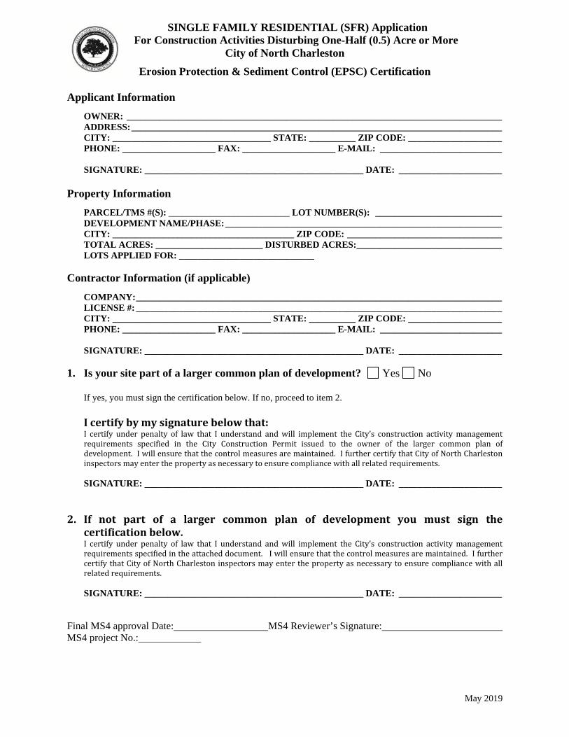
May 2019
SINGLE FAMILY RESIDENTIAL (SFR) Application For Construction Activities Disturbing One-Half (0.5) Acre or More
City of North Charleston
Erosion Protection & Sediment Control (EPSC) Certification
Applicant Information
OWNER: ________________________________________________________________________________ ADDRESS: _______________________________________________________________________________ CITY: __________________________________ STATE: __________ ZIP CODE: ____________________ PHONE: ____________________ FAX: ____________________ E-MAIL: __________________________
SIGNATURE: _______________________________________________ DATE: ______________________
Property Information
PARCEL/TMS #(S): __________________________ LOT NUMBER(S): ___________________________ DEVELOPMENT NAME/PHASE: ___________________________________________________________ CITY: _______________________________________ ZIP CODE: _________________________________ TOTAL ACRES: _______________________ DISTURBED ACRES: _______________________________ LOTS APPLIED FOR: _____________________________
Contractor Information (if applicable)
COMPANY: ______________________________________________________________________________ LICENSE #: ______________________________________________________________________________ CITY: __________________________________ STATE: __________ ZIP CODE: ____________________ PHONE: ____________________ FAX: ____________________ E-MAIL: __________________________
SIGNATURE: _______________________________________________ DATE: ______________________
1. Is your site part of a larger common plan of development? Yes No If yes, you must sign the certification below. If no, proceed to item 2. I certify by my signature below that: I certify under penalty of law that I understand and will implement the City’s construction activity management requirements specified in the City Construction Permit issued to the owner of the larger common plan of development. I will ensure that the control measures are maintained. I further certify that City of North Charleston inspectors may enter the property as necessary to ensure compliance with all related requirements.
SIGNATURE: _______________________________________________ DATE: ______________________ 2. If not part of a larger common plan of development you must sign the
certification below. I certify under penalty of law that I understand and will implement the City’s construction activity management requirements specified in the attached document. I will ensure that the control measures are maintained. I further certify that City of North Charleston inspectors may enter the property as necessary to ensure compliance with all related requirements. SIGNATURE: _______________________________________________ DATE: ______________________
Final MS4 approval Date: MS4 Reviewer’s Signature: MS4 project No.:
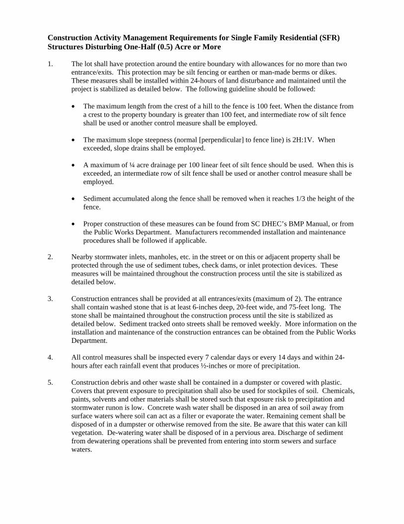
Construction Activity Management Requirements for Single Family Residential (SFR) Structures Disturbing One-Half (0.5) Acre or More 1. The lot shall have protection around the entire boundary with allowances for no more than two
entrance/exits. This protection may be silt fencing or earthen or man-made berms or dikes. These measures shall be installed within 24-hours of land disturbance and maintained until the project is stabilized as detailed below. The following guideline should be followed:
• The maximum length from the crest of a hill to the fence is 100 feet. When the distance from
a crest to the property boundary is greater than 100 feet, and intermediate row of silt fence shall be used or another control measure shall be employed.
• The maximum slope steepness (normal [perpendicular] to fence line) is 2H:1V. When exceeded, slope drains shall be employed.
• A maximum of ¼ acre drainage per 100 linear feet of silt fence should be used. When this is exceeded, an intermediate row of silt fence shall be used or another control measure shall be employed.
• Sediment accumulated along the fence shall be removed when it reaches 1/3 the height of the fence.
• Proper construction of these measures can be found from SC DHEC’s BMP Manual, or from the Public Works Department. Manufacturers recommended installation and maintenance procedures shall be followed if applicable.
2. Nearby stormwater inlets, manholes, etc. in the street or on this or adjacent property shall be protected through the use of sediment tubes, check dams, or inlet protection devices. These measures will be maintained throughout the construction process until the site is stabilized as detailed below.
3. Construction entrances shall be provided at all entrances/exits (maximum of 2). The entrance
shall contain washed stone that is at least 6-inches deep, 20-feet wide, and 75-feet long. The stone shall be maintained throughout the construction process until the site is stabilized as detailed below. Sediment tracked onto streets shall be removed weekly. More information on the installation and maintenance of the construction entrances can be obtained from the Public Works Department.
4. All control measures shall be inspected every 7 calendar days or every 14 days and within 24-
hours after each rainfall event that produces ½-inches or more of precipitation. 5. Construction debris and other waste shall be contained in a dumpster or covered with plastic.
Covers that prevent exposure to precipitation shall also be used for stockpiles of soil. Chemicals, paints, solvents and other materials shall be stored such that exposure risk to precipitation and stormwater runon is low. Concrete wash water shall be disposed in an area of soil away from surface waters where soil can act as a filter or evaporate the water. Remaining cement shall be disposed of in a dumpster or otherwise removed from the site. Be aware that this water can kill vegetation. De-watering water shall be disposed of in a pervious area. Discharge of sediment from dewatering operations shall be prevented from entering into storm sewers and surface waters.

6. Areas not used during construction should be vegetated with sod or grass seed. Existing/natural vegetation should be preserved as much as possible. Grass specifications are available from the Public Works Department.
7. A site is considered stabilized once the entire area other the buildings, driveways, and walkways,
has a vegetative cover with a density of 70%. Seeding should be accompanied or replaced with erosion control mats as necessary to achieve this density.
8. After final stabilization is achieved, all control measures shall be removed from the site.
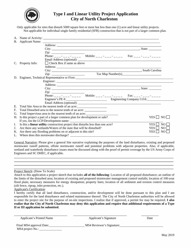
May 2019
Type I and Linear Utility Project Application City of North Charleston
Only applicable for sites that disturb 5000 square feet or more but less than one (1) acre and linear utility projects.
Not applicable for individual single family residential (SFR) construction that is not part of a larger common plan.
A. Name of Activity: __________________________________________________________________________ B. Applicant Name: ___________________________________________________________________________
Address: ___________________________________________________________________ City: ________________________________________________________, State: ________ Zip: _____________________ Phone: _ _ _ - _ _ _ - _ _ _ _ Mobile: _ _ _ - _ _ _ - _ _ _ _ Fax: _ _ _ - _ _ _ - _ _ _ _
Email Address (optional): _____________________________________________________ C. Property Info: Check Box if same as above
Address: ___________________________________________________________________ City: _________________________________________________________, South Carolina
Zip: _____________________ Tax Map Number(s)_________________________ D. Engineer, Technical Representative or Firm: ______________________________________________________________ Engineer: __________________________________________________________________________
Address: ___________________________________________________________________ City: ________________________________________________________, State: ________ Zip: _____________________ Phone: _ _ _ - _ _ _ - _ _ _ _ Mobile: _ _ _ - _ _ _ - _ _ _ _ Fax: _ _ _ - _ _ _ - _ _ _ _ Engineer’s PE #: Engineering Company COA:
Email Address (optional): _____________________________________________________ E. Total Site Area to the nearest tenth of an acre: F. Total Disturbed area to the nearest tenth of an acre: ______________ G. Total Impervious area to the nearest tenth of an acre: H. Is this project a part of a larger common plan for development or sale? YES NO If yes, list the LCP/Development name: I. Is this a linear utility construction project that disturbs less than one acre? YES NO J. Are there any wetlands/Waters of the state that will be disturbed? YES NO K. Are there any flooding problems on or adjacent to this site? YES NO L. Where does this stormwater discharge? _________________________________________________________ General Narrative: Please give a general Site narrative explaining the purposes of the land disturbance, existing and proposed stormwater runoff patterns, offsite stormwater runoff and potential problems with adjacent properties. Also, if applicable, wetland and waterbody disturbance issues must be discussed along with the proof of permit coverage by the US Army Corps of Engineers and SC DHEC, if applicable. ________________________________________________________________________________________________________________________________________________________________________________________________________________________________________________________________________________________________________________________________________________________________________________________________________________________ Project Sketch: (Draw To Scale) Attach to this application a project sketch that includes all of the following: Location of all proposed disturbance; an outline of the limits of the disturbed area; location of existing and proposed stormwater management control outfalls; location of 100-year flood plain; necessary measures for energy dissipation; property lines; location of all sediment and erosion control measures (silt fence, riprap, inlet protection, etc.). Applicant's Certification: I hereby certify that all land disturbance, construction, and/or development will be done pursuant to this plan and I am responsible for the land disturbance and related maintenance thereof. The City of North Charleston authorities will be allowed to enter the project site for the purpose of on-site inspections. I realize that if approved, a permit fee may be required. I also realize that the City of North Charleston may deny this application and require that additional requirements of a Type II or III application be submitted.
__________________________________ __________________________________ ___________ Applicant’s Printed Name Applicant’s Signature Date Final MS4 approval Date: MS4 Reviewer’s Signature: MS4 project No.:
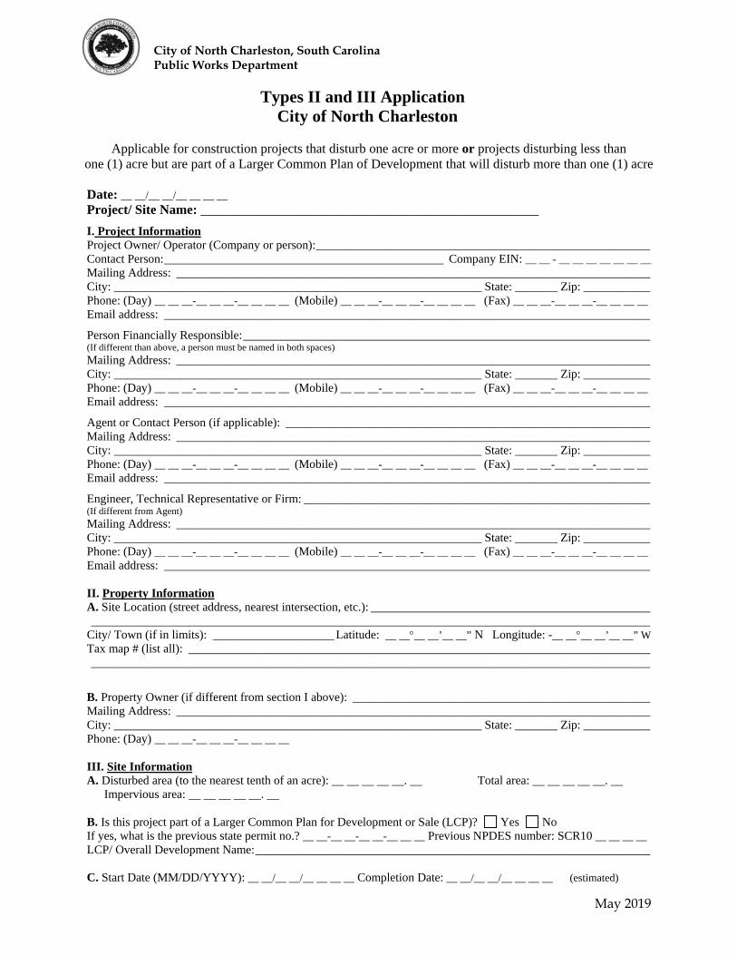
City of North Charleston, South Carolina Public Works Department
May 2019
Types II and III Application City of North Charleston
Applicable for construction projects that disturb one acre or more or projects disturbing less than
one (1) acre but are part of a Larger Common Plan of Development that will disturb more than one (1) acre
Date: __ __/__ __/__ __ __ __ Project/ Site Name: ___________________________________________________
I. Project Information Project Owner/ Operator (Company or person): _______________________________________________________ Contact Person: ______________________________________________ Company EIN: __ __ - __ __ __ __ __ __ __ Mailing Address: ______________________________________________________________________________ City: _____________________________________________________________ State: _______ Zip: ___________ Phone: (Day) __ __ __-__ __ __-__ __ __ __ (Mobile) __ __ __-__ __ __-__ __ __ __ (Fax) __ __ __-__ __ __-__ __ __ __ Email address: ________________________________________________________________________________
Person Financially Responsible: ___________________________________________________________________ (If different than above, a person must be named in both spaces) Mailing Address: ______________________________________________________________________________ City: _____________________________________________________________ State: _______ Zip: ___________ Phone: (Day) __ __ __-__ __ __-__ __ __ __ (Mobile) __ __ __-__ __ __-__ __ __ __ (Fax) __ __ __-__ __ __-__ __ __ __ Email address: ________________________________________________________________________________
Agent or Contact Person (if applicable): ____________________________________________________________ Mailing Address: ______________________________________________________________________________ City: _____________________________________________________________ State: _______ Zip: ___________ Phone: (Day) __ __ __-__ __ __-__ __ __ __ (Mobile) __ __ __-__ __ __-__ __ __ __ (Fax) __ __ __-__ __ __-__ __ __ __ Email address: ________________________________________________________________________________
Engineer, Technical Representative or Firm: _________________________________________________________ (If different from Agent)
Mailing Address: ______________________________________________________________________________ City: _____________________________________________________________ State: _______ Zip: ___________ Phone: (Day) __ __ __-__ __ __-__ __ __ __ (Mobile) __ __ __-__ __ __-__ __ __ __ (Fax) __ __ __-__ __ __-__ __ __ __ Email address: ________________________________________________________________________________ II. Property Information A. Site Location (street address, nearest intersection, etc.): ______________________________________________ ____________________________________________________________________________________________ City/ Town (if in limits): ____________________ Latitude: __ ____ __’__ __” N Longitude: -__ ____ __’__ __” W Tax map # (list all): ____________________________________________________________________________ ____________________________________________________________________________________________
B. Property Owner (if different from section I above): _________________________________________________ Mailing Address: ______________________________________________________________________________ City: _____________________________________________________________ State: _______ Zip: ___________ Phone: (Day) __ __ __-__ __ __-__ __ __ __ III. Site Information A. Disturbed area (to the nearest tenth of an acre): __ __ __ __ __. __ Total area: __ __ __ __ __. __
Impervious area: __ __ __ __ __. __ B. Is this project part of a Larger Common Plan for Development or Sale (LCP)? Yes No If yes, what is the previous state permit no.? __ __-__ __-__ __-__ __ __ Previous NPDES number: SCR10 __ __ __ __ LCP/ Overall Development Name: _________________________________________________________________ C. Start Date (MM/DD/YYYY): __ __/__ __/__ __ __ __ Completion Date: __ __/__ __/__ __ __ __ (estimated)
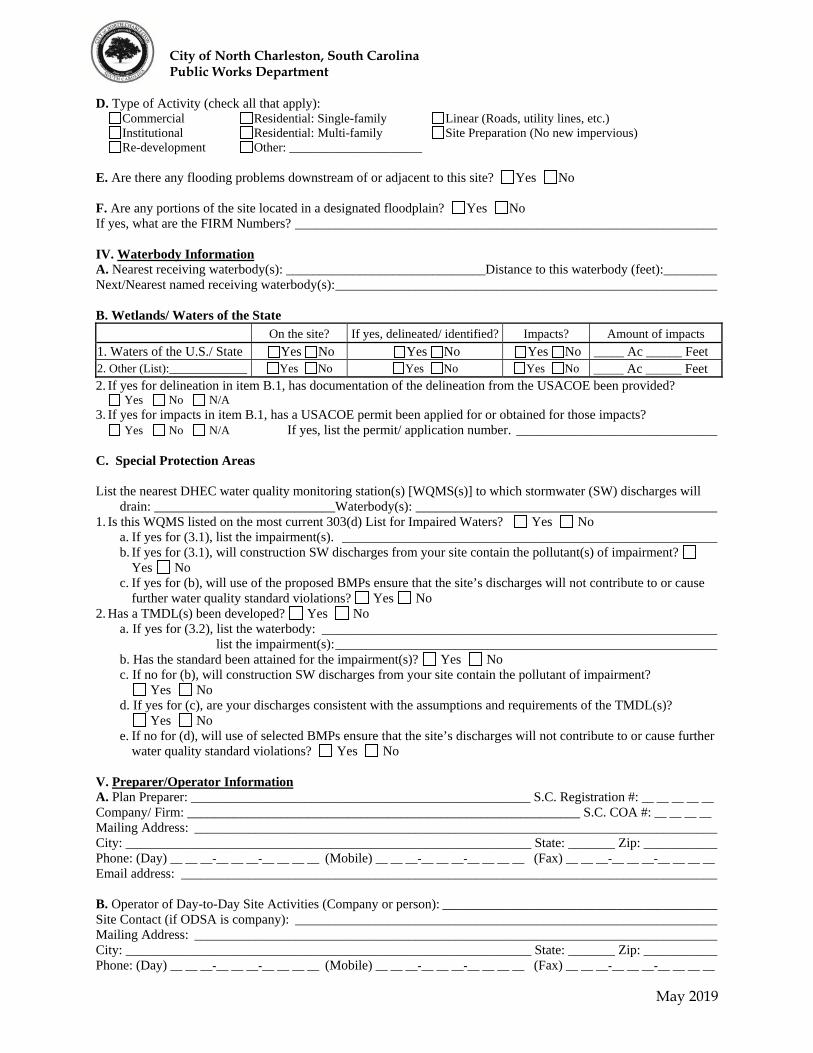
City of North Charleston, South Carolina Public Works Department
May 2019
D. Type of Activity (check all that apply): Commercial Residential: Single-family Linear (Roads, utility lines, etc.) Institutional Residential: Multi-family Site Preparation (No new impervious) Re-development Other: _____________________
E. Are there any flooding problems downstream of or adjacent to this site? Yes No F. Are any portions of the site located in a designated floodplain? Yes No If yes, what are the FIRM Numbers? _______________________________________________________________ IV. Waterbody Information A. Nearest receiving waterbody(s): ______________________________Distance to this waterbody (feet): ________ Next/Nearest named receiving waterbody(s): _________________________________________________________ B. Wetlands/ Waters of the State
On the site? If yes, delineated/ identified? Impacts? Amount of impacts
1. Waters of the U.S./ State Yes No Yes No Yes No _____ Ac ______ Feet 2. Other (List):_____________ Yes No Yes No Yes No _____ Ac ______ Feet 2. If yes for delineation in item B.1, has documentation of the delineation from the USACOE been provided? Yes No N/A 3. If yes for impacts in item B.1, has a USACOE permit been applied for or obtained for those impacts? Yes No N/A If yes, list the permit/ application number. ______________________________ C. Special Protection Areas List the nearest DHEC water quality monitoring station(s) [WQMS(s)] to which stormwater (SW) discharges will
drain: ___________________________Waterbody(s): _____________________________________________ 1. Is this WQMS listed on the most current 303(d) List for Impaired Waters? Yes No
a. If yes for (3.1), list the impairment(s). ________________________________________________________ b. If yes for (3.1), will construction SW discharges from your site contain the pollutant(s) of impairment?
Yes No c. If yes for (b), will use of the proposed BMPs ensure that the site’s discharges will not contribute to or cause
further water quality standard violations? Yes No 2. Has a TMDL(s) been developed? Yes No
a. If yes for (3.2), list the waterbody: ___________________________________________________________ list the impairment(s): _________________________________________________________ b. Has the standard been attained for the impairment(s)? Yes No c. If no for (b), will construction SW discharges from your site contain the pollutant of impairment?
Yes No d. If yes for (c), are your discharges consistent with the assumptions and requirements of the TMDL(s)?
Yes No e. If no for (d), will use of selected BMPs ensure that the site’s discharges will not contribute to or cause further
water quality standard violations? Yes No V. Preparer/Operator Information A. Plan Preparer: ___________________________________________________ S.C. Registration #: __ __ __ __ __ Company/ Firm: ___________________________________________________________ S.C. COA #: __ __ __ __ Mailing Address: ______________________________________________________________________________ City: _____________________________________________________________ State: _______ Zip: ___________ Phone: (Day) __ __ __-__ __ __-__ __ __ __ (Mobile) __ __ __-__ __ __-__ __ __ __ (Fax) __ __ __-__ __ __-__ __ __ __ Email address: ________________________________________________________________________________ B. Operator of Day-to-Day Site Activities (Company or person): _________________________________________ Site Contact (if ODSA is company): _______________________________________________________________ Mailing Address: ______________________________________________________________________________ City: _____________________________________________________________ State: _______ Zip: ___________ Phone: (Day) __ __ __-__ __ __-__ __ __ __ (Mobile) __ __ __-__ __ __-__ __ __ __ (Fax) __ __ __-__ __ __-__ __ __ __
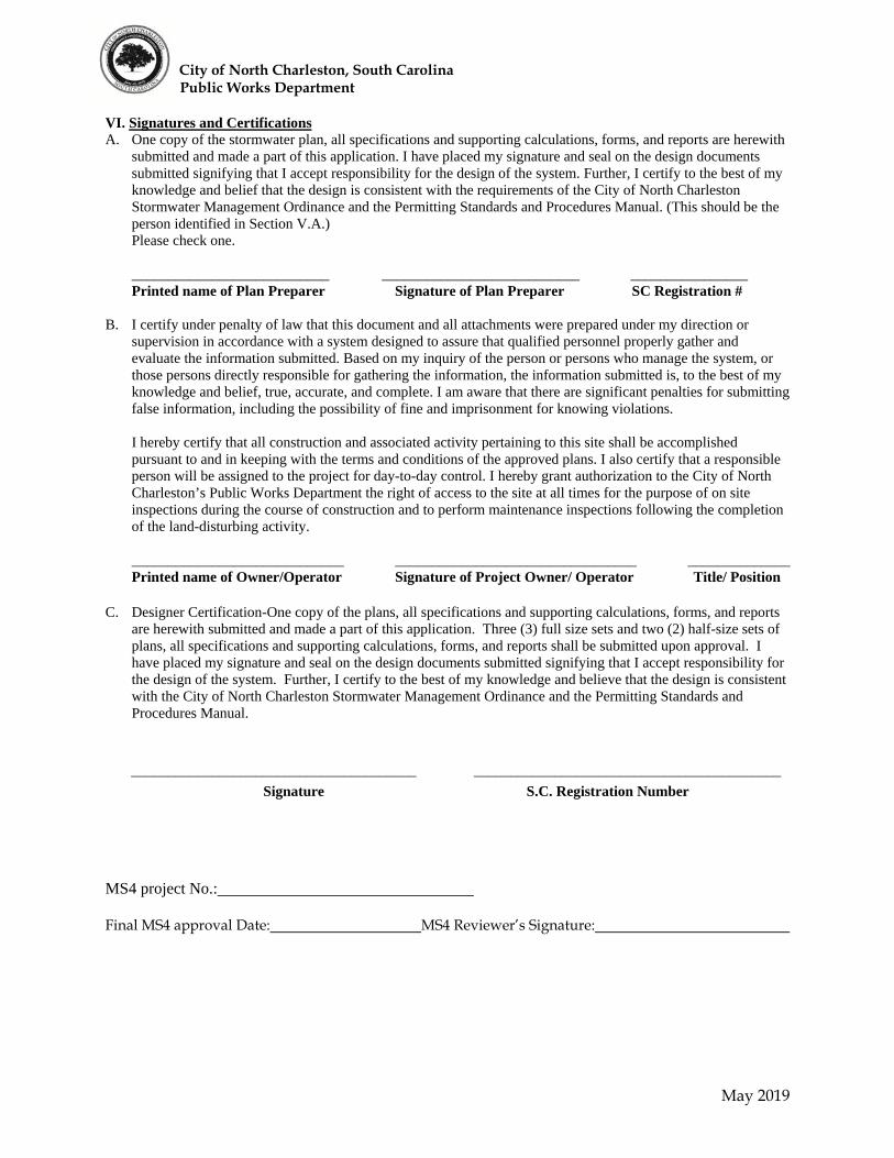
City of North Charleston, South Carolina Public Works Department
May 2019
VI. Signatures and Certifications A. One copy of the stormwater plan, all specifications and supporting calculations, forms, and reports are herewith
submitted and made a part of this application. I have placed my signature and seal on the design documents submitted signifying that I accept responsibility for the design of the system. Further, I certify to the best of my knowledge and belief that the design is consistent with the requirements of the City of North Charleston Stormwater Management Ordinance and the Permitting Standards and Procedures Manual. (This should be the person identified in Section V.A.) Please check one.
___________________________ ___________________________ ________________ Printed name of Plan Preparer Signature of Plan Preparer SC Registration # B. I certify under penalty of law that this document and all attachments were prepared under my direction or
supervision in accordance with a system designed to assure that qualified personnel properly gather and evaluate the information submitted. Based on my inquiry of the person or persons who manage the system, or those persons directly responsible for gathering the information, the information submitted is, to the best of my knowledge and belief, true, accurate, and complete. I am aware that there are significant penalties for submitting false information, including the possibility of fine and imprisonment for knowing violations.
I hereby certify that all construction and associated activity pertaining to this site shall be accomplished
pursuant to and in keeping with the terms and conditions of the approved plans. I also certify that a responsible person will be assigned to the project for day-to-day control. I hereby grant authorization to the City of North Charleston’s Public Works Department the right of access to the site at all times for the purpose of on site inspections during the course of construction and to perform maintenance inspections following the completion of the land-disturbing activity.
_____________________________ _________________________________ ______________ Printed name of Owner/Operator Signature of Project Owner/ Operator Title/ Position C. Designer Certification-One copy of the plans, all specifications and supporting calculations, forms, and reports
are herewith submitted and made a part of this application. Three (3) full size sets and two (2) half-size sets of plans, all specifications and supporting calculations, forms, and reports shall be submitted upon approval. I have placed my signature and seal on the design documents submitted signifying that I accept responsibility for the design of the system. Further, I certify to the best of my knowledge and believe that the design is consistent with the City of North Charleston Stormwater Management Ordinance and the Permitting Standards and Procedures Manual.
_______________________________________ __________________________________________
Signature S.C. Registration Number
MS4 project No.:
Final MS4 approval Date: MS4 Reviewer’s Signature:
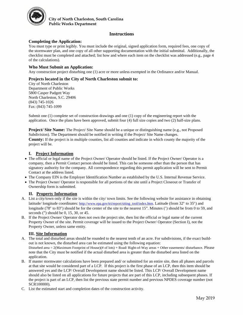
City of North Charleston, South Carolina Public Works Department
May 2019
Instructions
Completing the Application: You must type or print legibly. You must include the original, signed application form, required fees, one copy of the stormwater plan, and one copy of all other supporting documentation with the initial submittal. Additionally, the checklist must be completed and attached; list how and where each item on the checklist was addressed (e.g., page 4 of the calculations).
Who Must Submit an Application: Any construction project disturbing one (1) acre or more unless exempted in the Ordinance and/or Manual.
Projects located in the City of North Charleston submit to: City of North Charleston Department of Public Works 5800 Casper Padgett Way North Charleston, S.C. 29406 (843) 745-1026 Fax: (843) 745-1099 Submit one (1) complete set of construction drawings and one (1) copy of the engineering report with the application. Once the plans have been approved, submit four (4) full size copies and two (2) half-size plans. Project/ Site Name: The Project/ Site Name should be a unique or distinguishing name (e.g., not Proposed Subdivision). The Department should be notified in writing if the Project/ Site Name changes. County: If the project is in multiple counties, list all counties and indicate in which county the majority of the project will be. I. Project Information
The official or legal name of the Project Owner/ Operator should be listed. If the Project Owner/ Operator is a company, then a Permit Contact person should be listed. This can be someone other than the person that has signatory authority for the company. All correspondence regarding this permit application will be sent to Permit Contact at the address listed.
The Company EIN is the Employer Identification Number as established by the U.S. Internal Revenue Service. The Project Owner/ Operator is responsible for all portions of the site until a Project Closeout or Transfer of
Ownership form is submitted.
II. Property Information A. List a city/town only if the site is within the city/ town limits. See the following website for assistance in obtaining
latitude/ longitude coordinates: http://www.epa.gov/tri/report/siting_tool/index.htm. Latitude (from 32 to 35) and longitude (78 to 83) should be for the center of the site to the nearest 15”. Minutes (’) should be from 0 to 59, and seconds (”) should be 0, 15, 30, or 45.
B. If the Project Owner/ Operator does not own the project site, then list the official or legal name of the current Property Owner of the site. Permit coverage will be issued to the Project Owner/ Operator (Section I), not the Property Owner, unless same entity.
III. Site Information A. The total and disturbed areas should be rounded to the nearest tenth of an acre. For subdivisions, if the exact build-
out is not known, the disturbed area can be estimated using the following equation: Disturbed area = 2(Maximum Footprint of House)(# of lots) + Road/ Right-of-Way areas + Other easements/ disturbance. Please note that the City must be notified if the actual disturbed area is greater than the disturbed area listed on the application.
B. If master stormwater calculations have been prepared and/ or submitted for an entire site, then all phases and parcels at that site would be considered part of a LCP. If this project is the first phase of an LCP, then this item should be answered yes and the LCP/ Overall Development name should be listed. This LCP/ Overall Development name should also be listed on all applications for future projects that are part of this LCP, including subsequent phases. If the project is part of an LCP, then list the previous state permit number and previous NPDES coverage number (not SCR100000).
C. List the estimated start and completion dates of the construction activity.

City of North Charleston, South Carolina Public Works Department
May 2019
D. Institutional includes schools and other publicly owned projects, except linear projects. Site Preparation includes clearing, grubbing, and grading only; no new impervious areas should be proposed if this activity type is checked.
E. If yes, then the extent of the flooding problems and the effect of this project on those problems must be explained in the project narrative.
F. If any of the property is located inside an urbanized area or MS4, then list the entity. See the following website for information about MS4’s: http://www.scdhec.gov/water/html/swnms4page.html. Urbanized area boundary maps are available at http://cfpub.epa.gov/npdes/stormwater/urbanmapresult.cfm?state=SC.
IV. Waterbody Information
A. The nearest receiving waterbody is the nearest waters of the State to which the site’s stormwater will discharge. If this waterbody is unnamed, then provide a description that references the nearest, named waterbody (e.g., tributary to Grove Creek). If the site’s stormwater discharges to multiple waterbodies, then list all such waterbodies and attach additional sheets, if necessary.
B. Complete the “On the Site?” column for items a-c. If yes is selected for that column, then the next 3 columns must be completed. If there are other waters of the U.S./ State (WoS) on the site not listed in items a and b (e.g., stream, river, lake, pond), then list those in item c. Delineation means identification by U.S. Army Corps of Engineers (USACOE) or wetlands consultant. If there are WoS within 100’ of the disturbed area that were not delineated/identified, then explain this in the narrative; this includes WoS that are not on the project site but are within 100’ of the disturbed area. If construction activities will occur in and/ or will impact WoS, then select yes for “Impacts?” and list the amount of impacts to WoS. Provide an additional, separate plan sheet that shows all WoS on the site and the impacted areas. If there are proposed impacts to WoS, please contact USACOE (866-329-8187) and S.C. DHEC Water Quality Certification, Standards & Wetlands Programs Section (803-898-4300) to determine additional requirements before submitting this NOI. In the SCCZ, also contact S.C. DHEC Page 7 OCRM Wetlands Section (843-953-0200). Please note that it is the Project Owner/ Operator’s responsibility to ensure that all WoS are shown and identified in the SWPPP. USACOE is U.S. Army Corps of Engineers. If there are impacts to waters of the U.S./ State (should be listed in item IV.B), then list all permits and certifications that have been applied for or obtained for those impacts. Describe the activity(s), whether the impact is permanent or temporary, and any other relevant information. Provide a copy of all permits and certifications for and correspondence with USACOE and DHEC for the impacts. Make sure to include all plats referenced in the permits or correspondence.
C1. If there are flooding problems, the extent of the flooding problems and the effect of this project on those problems must be explained in the Project Narrative.
C2. If the site falls within a designated flood plain, list the zone and FIRM number. C3. Maps showing WQMS locations are available at the following website for each watershed:
http://www.scdhec.gov/environment/water/tmdl/index.htm - 303d. List the nearest DHEC WQMS(s) and corresponding waterbody(ies).
3.1 See the following website for the most current 303(d) List for Impaired Waters and related information: http://www.scdhec.gov/environment/water/tmdl/index.htm#303d. To search this document to determine whether a WQMS is listed, select “Edit” from the top toolbar. Then, select “Find”. Enter the WQMS exactly as listed on the map and hit enter. If none of the WQMS(s) are found, then select no for item 3.1 and proceed to item 3.2. If any of the WQMS(s) are found within the document, then select yes and proceed to item 3.1.a.
a. List the cause(s) of the impairment (see last column labeled “CAUSE”) for the WQMS(s) and proceed to item b.
b. DHEC has determined that construction SW discharges are expected to contain pollutants causing the following impairments: TURBIDITY, BIO (Macroinvertebrate), TP (Total Phosphorus), and TN (Total Nitrogen). You should carefully evaluate whether the site’s constructions SW discharges will contain any pollutants causing other impairments, not explicitly listed above. You should also consider previous land uses at the site in answering this question. For example, if the previous land use was a copper processing facility and the impairment at the nearest WQMS is copper, then you should carefully evaluate whether the site’s construction SW discharges would contain copper. If this question is answered yes and the disturbed area is less than 25 acres, then provide an evaluation of the site’s proposed Best Management Practices (BMPs) as described in section 3.4.C.2(c) of the CGP. If this question is answered yes and the disturbed area is greater than or equal to 25 acres, then provide a written qualitative and quantitative assessment of the site’s proposed BMPs as described in section 3.4.C.2(c) of the CGP. See item 22 on the checklist.
c. If the answer to this question is no, then the site is not eligible for coverage under the CGP. 3.2 See the following website for a list of all WQMS with Approved S.C. Total Maximum Daily Loads (TMDLs):
http://www.scdhec.gov/environment/water/tmdl/docs/tmdl_2008sites.pdf. To search this document to determine
City of North Charleston, South Carolina Public Works Department
May 2019
whether a WQMS is listed, select “Edit” from the top toolbar. Then, select “Find”. Enter the WQMS exactly as listed on the map and hit enter. If none of the WQMS(s) are found, then select “No” for item 3.2 and proceed to item V. If any of the WQMS(s) are found within the document, then select yes and proceed to item (a). The same document will be used for item 3.1a.
a. List the cause(s) of the impairment (see 7th column labeled “CAUSE”) and proceed to item b. If the WQMS(s) is impaired for more than one parameter, then the WQMS will be listed multiple times on successive rows. The same document will be used to answer item b.
b. See the 8th column labeled “USE SUPPORT” to determine if the standard has been attained for each impairment for each WQMS. “FULLY SUPPORTED” means the standard has been attained for the impairment listed in the “CAUSE” column. “NOT SUPPORTED” means that the standard has NOT been attained for that impairment. If the standard has NOT been attained for all impairments for all WQMS(s), then select no and proceed to item c. If the standard has been attained for all impairments for all WQMS(s); select yes and proceed to item d.
c. DHEC has determined that construction SW discharges are expected to contain pollutants causing the following impairments: TURBIDITY, BIO (Macroinvertebrate), TP (Total Phosphorus), and TN (Total Nitrogen). You should carefully evaluate whether the site’s constructions SW discharges will contain any pollutants causing other impairments, not explicitly listed above. You should also consider previous land uses at the site in answering this question.
d. Check the TMDL to make sure the site meets the assumptions and requirements. If the site cannot meet the appropriate TMDL, BMPs must be used.
e. If the answer to this question is no, then the site is not eligible for coverage under the CGP.
V. Preparer/Operator Information A. Enter the name and registration number of the stormwater plan preparer. S.C. COA is the company’s S.C. Certificate
of Authorization. Enter N/A for S.C. COA if the firm does not have a COA or the preparer is an individual. If an email address is entered, the Director may contact the plan preparer via email.
B. Enter the name of the operator or day-to-day site operations contact and pertinent information.
VI. Certifications A. The same registered professional must sign and seal the application, drawings, calculations, and supporting
documentation. B. A person with signatory authority for the Project Owner/ Operator must sign the application. The plan preparer
cannot sign the application for the Project Owner/ Operator. The plans, all reports, including monthly reports, and any information requested by the Department must be signed by a person with signatory authority for the Project Owner/ Operator or a duly authorized representative.
Corporation: A responsible corporate officer (e.g., president, vice-president, certain managers) Partnership or Sole Proprietorship: A general partner or the proprietor, respectively Municipality, State, Federal or Other Public Agency: Principal executive officer or ranking elected official
Office Mechanics and Filing This form and supporting documentation will be kept in the Public Works Department files (hard copy or digitized copy).
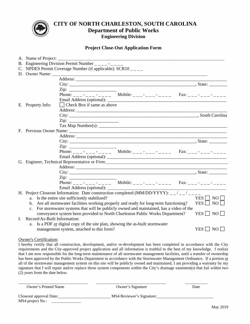
May 2019
CITY OF NORTH CHARLESTON, SOUTH CAROLINA Department of Public Works
Engineering Division
Project Close-Out Application Form A. Name of Project: __________________________________________________________________________ B. Engineering Division Permit Number _ _ _ _ - _ _ _ _ C. NPDES Permit Coverage Number (if applicable): SCR10 _ _ _ _ D. Owner Name: _____________________________________________________________________
Address: ___________________________________________________________________ City: ________________________________________________________, State: ________ Zip: _____________________ Phone: _ _ _ - _ _ _ - _ _ _ _ Mobile: _ _ _ - _ _ _ - _ _ _ _ Fax: _ _ _ - _ _ _ - _ _ _ _
Email Address (optional): _____________________________________________________ E. Property Info: Check Box if same as above
Address: ___________________________________________________________________ City: _________________________________________________________, South Carolina Zip: ______________________ Tax Map Number(s): _________________________________________________________
F. Previous Owner Name: ______________________________________________________________________ Address: ___________________________________________________________________
City: ________________________________________________________, State: ________ Zip: _____________________ Phone: _ _ _ - _ _ _ - _ _ _ _ Mobile: _ _ _ - _ _ _ - _ _ _ _ Fax: _ _ _ - _ _ _ - _ _ _ _
Email Address (optional): _____________________________________________________ G. Engineer, Technical Representative or Firm: ______________________________________________________
Address: ___________________________________________________________________ City: ________________________________________________________, State: ________ Zip: _____________________ Phone: _ _ _ - _ _ _ - _ _ _ _ Mobile: _ _ _ - _ _ _ - _ _ _ _ Fax: _ _ _ - _ _ _ - _ _ _ _
Email Address (optional): _____________________________________________________ H. Project Closeout Information: Date construction completed (MM/DD/YYYY): _ _ / _ _ / _ _ _ _
a. Is the entire site sufficiently stabilized? YES NO b. Are all stormwater facilities working properly and ready for long-term functioning? YES NO c. For stormwater systems that will be publicly owned and maintained, has a video of the conveyance system been provided to North Charleston Public Works Department? YES NO
I. Record/As-Built Information: a. Is a PDF or digital copy of the site plan, showing the as-built stormwater
management system, attached to this form? YES NO
Owner's Certification: I hereby certify that all construction, development, and/or re-development has been completed in accordance with the City requirements and the City-approved project application and all information is truthful to the best of my knowledge. I realize that I am now responsible for the long-term maintenance of all stormwater management facilities, until a transfer of ownership has been approved by the Public Works Department in accordance with the Stormwater Management Ordinance. If a portion or all of the stormwater management system on this site will be publicly owned and maintained, I am providing a warranty by my signature that I will repair and/or replace those system components within the City’s drainage easement(s) that fail within two (2) years from the date below.
__________________________________ __________________________________ ___________ Owner’s Printed Name Owner’s Signature Date Closeout approval Date: MS4 Reviewer’s Signature: MS4 project No.:
City of North Charleston, South Carolina City of North Charleston Stormwater Program Public Works Department Permitting Standards and Procedures Manual May 2019
APPENDIX B
OPERATING PERMIT FOR MAINTENANCE
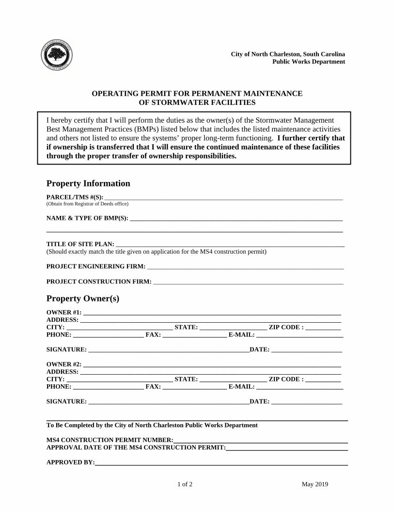
1 of 2 May 2019
City of North Charleston, South Carolina Public Works Department
OPERATING PERMIT FOR PERMANENT MAINTENANCE OF STORMWATER FACILITIES
I hereby certify that I will perform the duties as the owner(s) of the Stormwater Management Best Management Practices (BMPs) listed below that includes the listed maintenance activities and others not listed to ensure the systems’ proper long-term functioning. I further certify that if ownership is transferred that I will ensure the continued maintenance of these facilities through the proper transfer of ownership responsibilities.
Property Information
PARCEL/TMS #(S): __________________________________________________________________________ (Obtain from Registrar of Deeds office)
NAME & TYPE OF BMP(S): __________________________________________________________________
____________________________________________________________________________________________ TITLE OF SITE PLAN: _______________________________________________________________________ (Should exactly match the title given on application for the MS4 construction permit) PROJECT ENGINEERING FIRM: _____________________________________________________________
PROJECT CONSTRUCTION FIRM: ___________________________________________________________
Property Owner(s)
OWNER #1: ________________________________________________________________________________ ADDRESS: _________________________________________________________________________________ CITY: _________________________________ STATE: _____________________ ZIP CODE : ___________ PHONE: ______________________ FAX: ____________________ E-MAIL: ___________________________ SIGNATURE: __________________________________________________DATE: ______________________ OWNER #2: ________________________________________________________________________________ ADDRESS: _________________________________________________________________________________ CITY: _________________________________ STATE: _____________________ ZIP CODE : ___________ PHONE: ______________________ FAX: ____________________ E-MAIL: ___________________________ SIGNATURE: __________________________________________________DATE: ______________________ To Be Completed by the City of North Charleston Public Works Department MS4 CONSTRUCTION PERMIT NUMBER: APPROVAL DATE OF THE MS4 CONSTRUCTION PERMIT: APPROVED BY:
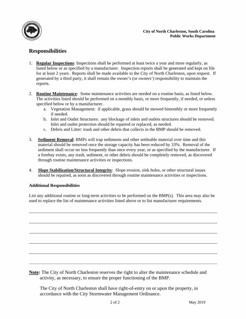
2 of 2 May 2019
City of North Charleston, South Carolina Public Works Department
Responsibilities 1. Regular Inspections: Inspections shall be performed at least twice a year and more regularly, as
listed below or as specified by a manufacturer. Inspection reports shall be generated and kept on file for at least 2 years. Reports shall be made available to the City of North Charleston, upon request. If generated by a third party, it shall remain the owner’s (or owners’) responsibility to maintain the reports.
2. Routine Maintenance: Some maintenance activities are needed on a routine basis, as listed below.
The activities listed should be performed on a monthly basis, or more frequently, if needed, or unless specified below or by a manufacturer.
a. Vegetation Management: if applicable, grass should be mowed bimonthly or more frequently if needed.
b. Inlet and Outlet Structures: any blockage of inlets and outlets structures should be removed. Inlet and outlet protection should be repaired or replaced, as needed.
c. Debris and Litter: trash and other debris that collects in the BMP should be removed. 3. Sediment Removal: BMPs will trap sediments and other settleable material over time and this
material should be removed once the storage capacity has been reduced by 33%. Removal of the sediment shall occur no less frequently than once every year, or as specified by the manufacturer. If a forebay exists, any trash, sediment, or other debris should be completely removed, as discovered through routine maintenance activities or inspections.
4. Slope Stabilization/Structural Integrity: Slope erosion, sink holes, or other structural issues
should be repaired, as soon as discovered through routine maintenance activities or inspections. Additional Responsibilities List any additional routine or long-term activities to be performed on the BMP(s). This area may also be used to replace the list of maintenance activities listed above or to list manufacturer requirements. Note: The City of North Charleston reserves the right to alter the maintenance schedule and
activity, as necessary, to ensure the proper functioning of the BMP.
The City of North Charleston shall have right-of-entry on or upon the property, in accordance with the City Stormwater Management Ordinance.
City of North Charleston, South Carolina City of North Charleston Stormwater Program Public Works Department Permitting Standards and Procedures Manual May 2019
APPENDIX C
PERMITTING PROCESS FLOWCHART

START
Submit for aType II approval
Apply for Building Permit and Certify EPSC planwith Public Works Department
Conduct pre-submittalmeeting and/or submit
Stormwater Master Plan
Submit Application andall applicable required
components to Public Works
Complete application?
Does Public Worksneed addtional information?
Resubmit completeapplication package,repeat as necessary
no yes
Approval Process Flow Chart
Review and commentby Public Works
yes
Applicationcomplete
Project Disturbs 1 or moreacres or is within 1/2 mileof a receiving water body?
Approval issuedby Public Works
Applicant sends cityapproval with NOI toSCDHEC-OCRM for
NPDES coverage
yes
Submit for aType I approval
Building a single familyresidence structure that
disturbs 1/2 acre or more?no
yes
Commerical, industrial,or residential
subdivision development?
Project disturbing5000 sf - 1 acre?
Project disturbing> 5 acres?
no
Submit for aType III approval
yes
yes
Apply for BuildingPermit
no
yes
no
Process Complete
no
no
Resubmit completeapplication package,repeat as necessary
September 1, 2008

City of North Charleston, South Carolina City of North Charleston Stormwater Program Public Works Department Permitting Standards and Procedures Manual May 2019
APPENDIX D
TABLES OF BMP SUGGESTED USES
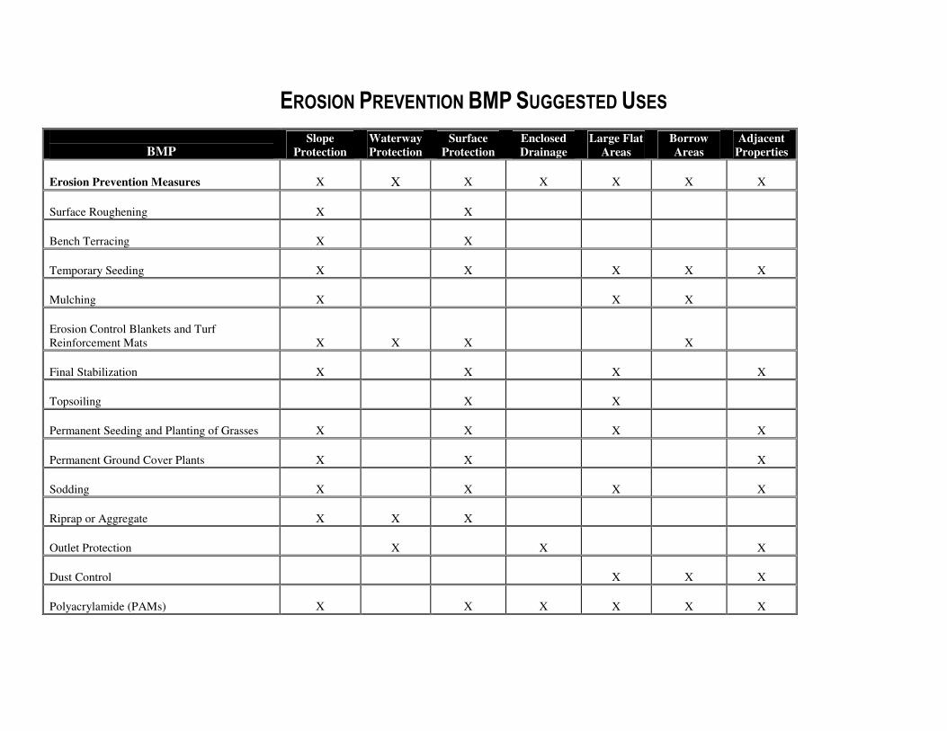
EROSION PREVENTION BMP SUGGESTED USES
BMP Slope
Protection
Waterway
Protection
Surface
Protection
Enclosed
Drainage
Large Flat
Areas
Borrow
Areas
Adjacent
Properties
Erosion Prevention Measures
X
X
X
X
X
X
X
Surface Roughening
X
X
Bench Terracing
X
X
Temporary Seeding
X
X
X
X
X
Mulching
X
X
X
Erosion Control Blankets and Turf
Reinforcement Mats
X
X
X
X
Final Stabilization
X
X
X
X
Topsoiling
X
X
Permanent Seeding and Planting of Grasses
X
X
X
X
Permanent Ground Cover Plants
X
X
X
Sodding
X
X
X
X
Riprap or Aggregate
X
X
X
Outlet Protection
X
X
X
Dust Control
X
X
X
Polyacrylamide (PAMs) X X X
X
X
X
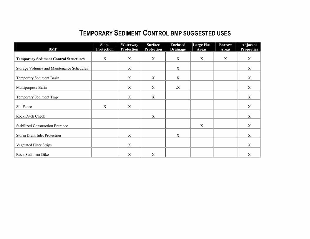
TEMPORARY SEDIMENT CONTROL BMP SUGGESTED USES
BMP
Slope
Protection
Waterway
Protection
Surface
Protection
Enclosed
Drainage
Large Flat
Areas
Borrow
Areas
Adjacent
Properties
Temporary Sediment Control Structures
X
X
X
X
X
X
X
Storage Volumes and Maintenance Schedules
X
X
X
Temporary Sediment Basin
X
X
X
X
Multipurpose Basin
X
X
.X
X
Temporary Sediment Trap
X
X
X
Silt Fence
X
X
X
Rock Ditch Check
X
X
Stabilized Construction Entrance
X
X
Storm Drain Inlet Protection
X
X
X
Vegetated Filter Strips
X
X
Rock Sediment Dike
X
X
X
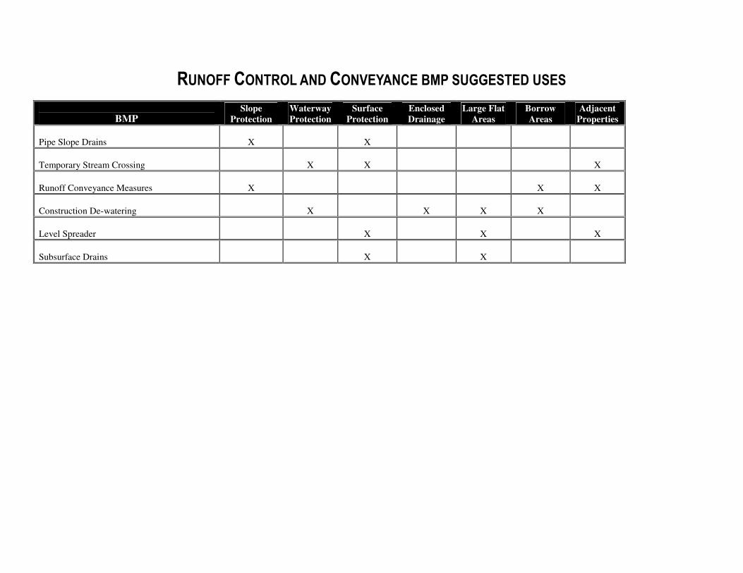
RUNOFF CONTROL AND CONVEYANCE BMP SUGGESTED USES
BMP Slope
Protection
Waterway
Protection
Surface
Protection
Enclosed
Drainage
Large Flat
Areas
Borrow
Areas
Adjacent
Properties
Pipe Slope Drains
X
X
Temporary Stream Crossing
X
X
X
Runoff Conveyance Measures
X
X
X
Construction De-watering
X
X
X
X
Level Spreader
X
X
X
Subsurface Drains
X
X
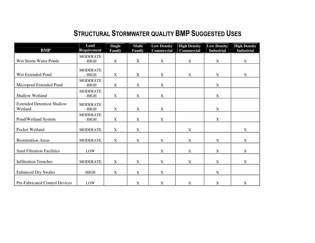
STRUCTURAL STORMWATER QUALITY BMP SUGGESTED USES
BMP
Land
Requirement Single
Family
Multi
Family
Low Density
Commercial
High Density
Commercial
Low Density
Industrial
High Density
Industrial
Wet Storm Water Ponds MODERATE
- HIGH
X
X
X
X
X
X
Wet Extended Pond MODERATE
- HIGH
X
X
X X
X
X
Micropool Extended Pond MODERATE
- HIGH X X X X
Shallow Wetland MODERATE
- HIGH X X X X
Extended Detention Shallow
Wetland MODERATE
- HIGH X X X X
Pond/Wetland System MODERATE
- HIGH X X X X
Pocket Wetland MODERATE X X X X
Bioretention Areas MODERATE
X
X
X
X
X
X
Sand Filtration Facilities LOW
X
X
X
X
Infiltration Trenches MODERATE
X
X
X
X
X
X
Enhanced Dry Swales HIGH X
X X X
Pre-Fabricated Control Devices LOW
X
X
X
X
X
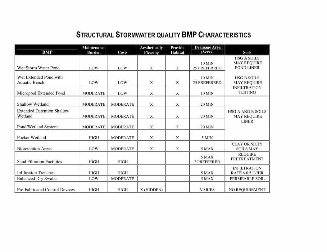
STRUCTURAL STORMWATER QUALITY BMP CHARACTERISTICS
BMP Maintenance
Burden
Costs
Aesthetically
Pleasing
Provide
Habitat
Drainage Area
(Acres) Soils
Wet Storm Water Pond
LOW
LOW
X
X
10 MIN
25 PREFERRED
HSG A SOILS
MAY REQUIRE
POND LINER
Wet Extended Pond with
Aquatic Bench
LOW
LOW X X
10 MIN
25 PREFERRED
HSG B SOILS
MAY REQUIRE
Micropool Extended Pond MODERATE
LOW X X
10 MIN
INFILTRATION
TESTING
Shallow Wetland MODERATE
MODERATE X X 20 MIN
Extended Detention Shallow
Wetland MODERATE
MODERATE X X 20 MIN
HSG A AND B SOILS
MAY REQUIRE
Pond/Wetland System MODERATE
MODERATE X X 20 MIN
LINER
Pocket Wetland HIGH
MODERATE X X 5 MIN
Bioretention Areas LOW
MODERATE
X
X
5 MAX
CLAY OR SILTY
SOILS MAY
Sand Filtration Facilities
HIGH
HIGH
5 MAX
2 PREFFERED
REQUIRE
PRETREATMENT
Infiltration Trenches
HIGH
HIGH
5 MAX
INFILTRATION
RATE > 0.5 IN/HR
Enhanced Dry Swales LOW MODERATE 5 MAX PERMEABLE SOIL
Pre-Fabricated Control Devices
HIGH
HIGH
X (HIDDEN)
VARIES NO REQUIREMENT
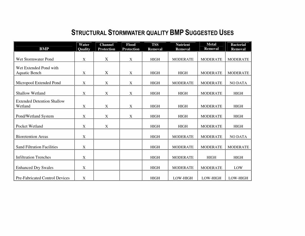
STRUCTURAL STORMWATER QUALITY BMP SUGGESTED USES
BMP Water
Quality
Channel
Protection
Flood
Protection
TSS
Removal
Nutrient
Removal
Metal
Removal Bacterial
Removal
Wet Stormwater Pond
X
X
X
HIGH MODERATE
MODERATE
MODERATE
Wet Extended Pond with
Aquatic Bench
X
X
X
HIGH
HIGH
MODERATE
MODERATE
Micropool Extended Pond X X X HIGH MODERATE
MODERATE NO DATA
Shallow Wetland X X X HIGH HIGH MODERATE
HIGH
Extended Detention Shallow
Wetland X X X HIGH HIGH MODERATE
HIGH
Pond/Wetland System X X X HIGH HIGH MODERATE
HIGH
Pocket Wetland X X HIGH HIGH MODERATE
HIGH
Bioretention Areas
X
HIGH
MODERATE MODERATE
NO DATA
Sand Filtration Facilities
X
HIGH MODERATE MODERATE MODERATE
Infiltration Trenches
X
HIGH
MODERATE HIGH
HIGH
Enhanced Dry Swales X
HIGH MODERATE
MODERATE LOW
Pre-Fabricated Control Devices X
HIGH LOW-HIGH
LOW-HIGH
LOW-HIGH
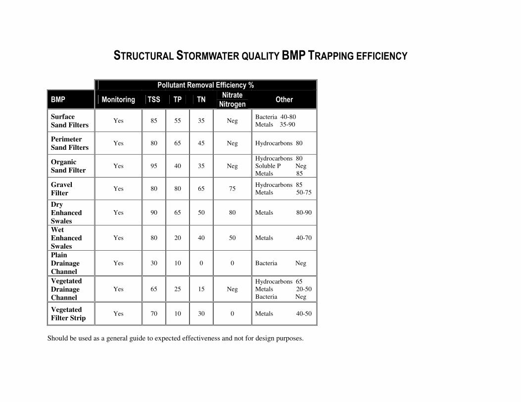
STRUCTURAL STORMWATER QUALITY BMP TRAPPING EFFICIENCY
Pollutant Removal Efficiency %
BMP Monitoring TSS TP TN Nitrate Nitrogen
Other
Surface
Sand Filters Yes 85 55 35 Neg
Bacteria 40-80
Metals 35-90
Perimeter
Sand Filters Yes 80 65 45 Neg Hydrocarbons 80
Organic
Sand Filter Yes 95 40 35 Neg
Hydrocarbons 80
Soluble P Neg
Metals 85
Gravel
Filter Yes 80 80 65 75
Hydrocarbons 85
Metals 50-75
Dry
Enhanced
Swales
Yes 90 65 50 80 Metals 80-90
Wet
Enhanced
Swales
Yes 80 20 40 50 Metals 40-70
Plain
Drainage
Channel
Yes 30 10 0 0 Bacteria Neg
Vegetated
Drainage
Channel
Yes 65 25 15 Neg
Hydrocarbons 65
Metals 20-50
Bacteria Neg
Vegetated
Filter Strip Yes 70 10 30 0 Metals 40-50
Should be used as a general guide to expected effectiveness and not for design purposes.
City of North Charleston, South Carolina City of North Charleston Stormwater Program Public Works Department Permitting Standards and Procedures Manual May 2019
APPENDIX E
PLAN REVIEW CHECKLIST
City of North Charleston, South Carolina City of North Charleston Stormwater Program
Public Works Department Permitting Standards and Procedures Manual
1 May 2019
CITY OF NORTH CHARLESTON CHECKLIST FOR DESIGN OF NEW
AND RE-DEVELOPMENT PROJECTS
This checklist will be used by the City of North Charleston Plan Reviewers or others employed by the Public Works Director, in reviewing proposed construction activities. This checklist shows the components that must be provided by the applicant per the project types (SFR, Type I and Linear Utility, and Type II and III). The submitted information typically includes three parts: the application, the technical engineering calculations and discussions, and the construction documents (plans, details, specs, SWPPP).
I. APPLICATION FORM Application Types: ALL
- All application items should be complete and answered sufficiently. - Signatory authority (original signatures) should be provided where requested. - Any fees to be returned to applicant.
II. TECHNICAL REPORT/ENGINEERING CALCULATIONS
1. REPORT COMPOSITION: Application Types: ALL (Type I if applicable)
- Table of Contents. - A summary table to include at least the following:
a. all hydrologic results (design storms and distribution type, peak discharges, pre- and post-development, CN, Tc, PRF),
b. results of hydraulic calculations (road overtopping, velocities, 100-yr event analysis) calculations and methodologies,
c. methodology/models used, d. tidal considerations, e. some documentation showing that peak stages are below minimum finished floor
elevation and that during the 100 year storm event ponds pass this event without overtopping (including the 1 foot freeboard) and the system would not result in an increased frequency of dwelling flooding, property damage or public access &/or utility interruption, and
f. results of water quality calculations. - Report should be put together in a manner that facilitates review. - Report prepared by licensed professional. - One copy is to be submitted.
2. MAP(S): Application Types: ALL
- Include north arrow and scale on all maps. - Outlined project location. - Labeled road names. - Nearest waterbodies, discharge points, and waters of the state. - Location of any nearby protected areas (waters, wetlands, etc.) - Topographic information showing runoff patterns/overland flow paths. - Soil types.
City of North Charleston, South Carolina City of North Charleston Stormwater Program
Public Works Department Permitting Standards and Procedures Manual
2 May 2019
- 100-year floodplain contours. - Wetlands. - Simple sketches will suffice for SFR, Utility, and Type I applications.
3. PROJECT NARRATIVE: Application Types: ALL - A description of the site in general, purposes of the construction activity, any issues with
adjacent properties and owners, waterbodies receiving stormwater runoff, any issues with site soils, existing water quality and flooding issues, anticipated impacts (quality, downstream structures, etc.) and benefits (open space, treatment, maintenance, etc.), and reasons for waiver request.
- A summary table of existing and proposed runoff flows, volumes, and pollutant loads. - A discussion of issues relating to other State and Federal permits needed or regulations to
be followed. - A summary of the maintenance of the stormwater system and arrangements for post-
construction maintenance responsibility. Maintenance agreements and/or operating permits must be provided in the application or otherwise addressed.
- This narrative should be much more detailed for larger (Types II and III) projects. - Simple narratives will suffice for SFR, Utility, and Type I applications. - Provide written proof that all offsite easements have been obtained.
4. HYDROLOGIC ANALYSIS: Application Types: II and III
- Proper delineation of the site shown on maps or construction plans (24” x 36” sheets). - Pre- and post- development hydrologic analysis calculations for the 2-, 10-, 25-, and 100-
year storm events, as necessary, at each outfall point. Analysis should be performed at the same points and with the same drainage area for both pre- and post-development conditions and correspond to the delineation. Hydrograph calculations should be provided as needed.
- Analysis performed using SCS methodology (Rational method not acceptable for Types II and III applications) or other if acceptable to Public Works.
- Use rainfall data from Chapter 3. 5. DETENTION ANALYSIS/DESIGN: Application Types: II and III
Analysis
- Pond routing using a volume based hydrograph for the 2-, 10-, 25-, and 100-year SCS 24-hour rainfall event (Drain:Edge, ICPR, HEC-1, SedCAD, HYDRAFLOW, etc. perform full pond routings: TR55 does not perform a full pond routing; rational method cannot be used).
- Hydrologic and hydraulic calculations necessary to determine the impact of hydrograph timing modifications of the proposed land disturbing activity, with and without the pond (results of analysis will determine the need to modify the pond design or eliminate the pond requirement-see note in item 10).
- Inputs and outputs from analysis program. - Summary table of the peak inflows, peak outflows, and maximum water surface
elevations (WSE) for the 2, 10, 25 and 100-year storm events for each pond. - Stage-storage-discharge relationship for the outlet structure of each detention structure. - If a rating curve for the outlet structure must be generated externally from the analysis
program (Drain:Edge, HEC-1, HydroCAD), data and equations used to rate the outlet structure.
City of North Charleston, South Carolina City of North Charleston Stormwater Program
Public Works Department Permitting Standards and Procedures Manual
3 May 2019
Design - Detail of outlet structure and cross-section of the dam, including elevations and
dimensions that correspond to the calculations. - Orifice constructability considered (do not specify orifice diameters with increments of
less than ¼”). - Pond banks shall have one (1) foot of freeboard above the design storm event. In
addition, ponds must be able to pass the 100 year storm event without overtopping the banks.
- The volume within any structure used for water quantity control shall be drained from the structure within 72 hours.
- Bottom of all detention and retention ponds graded to have a slope of not less than 1.0% and side slopes no steeper than 3:1 unless adequately protected.
- If the pond is to be used for sediment control during construction, outlet structure should be sufficiently protected.
- Permanent maintenance access to all permanent detention structures (easements may be needed for structures surrounded by lots).
- Infiltration and underground detention systems designed in accordance with Chapter 3. - Emergency spillways should not be built on fill slopes. - If a pond is to be used to meet water quality requirements and it is capturing runoff from
1 or more acres, a forebay, designed in accordance with this manual, shall be constructed. - Installation of a trash rack or other debris-screening device is recommended on all pond
risers.
6. HYDRAULIC DESIGN: Application Types: II and III - Design calculations for all conveyances, inlets, and outlets based on the contributing area,
allowable velocities, and upstream and downstream conditions. - Upstream and downstream analysis showing the project will not impact new and existing
structures or reduce downstream system capacity. - Check to make sure the proper design storms were used at the appropriate design points.
7. WATER QUALITY REQUIREMENTS: Application Types: II and III - All sites which disturb one (1) acre or greater or redevelopment projects that are 0.5 acres
or more shall include best management practices (BMPs) to address water quality, along with an Operation and Maintenance Agreement that guarantees maintenance of all BMPs in perpetuity.
- All permanent water quality ponds having a permanent pool shall be designed to store and release a water quality volume (WQV) defined as the first one-half (1/2”) inch of runoff (First Flush) over a 24 hour period. The "first flush" volume should be determined from the contributing watershed area (impervious and pervious) that drains to the water quality pond (s).
- Permanent water quality ponds, not having a permanent pool, shall be designed to store and release the first 1-inch (1”) of runoff from the contributing watershed area over a
minimum period of 24-hours. - For areas not draining to a pond, it should be demonstrated how permanent water quality
requirements will be addressed. - Other non-traditional stormwater controls such as Bioretention areas and constructed
wetlands may be used if adequate removal efficiencies can be demonstrated.
City of North Charleston, South Carolina City of North Charleston Stormwater Program
Public Works Department Permitting Standards and Procedures Manual
4 May 2019
- Pre-fabricated or proprietary treatment devices are approved on a case-by-case basis if adequate removal efficiency can be demonstrated. Provide pollutant removal efficiency data, preferably from a third-party testing company. Type of system to be used should be based on the ability to remove the pollutants of concern in that area/situation (i.e. bacteria, hydrocarbons, etc.).
- Waters of the U.S./State shall not be used for permanent water quality control. (Alternative means of treatment must be used if an existing pond is to be used for water quantity control).
8. INLET PROTECTION: Application Types: ALL
- Provided at all inlets (no hay bales). - Steel or wooden posts and buried fabric shown for filter fabric inlet protection. - Inlet protection details provided for pre-paving and after roadways have been paved. - Silt fence under the grate inlets is not allowed – proper inlet protection devices shall be
used.
9. DISCHARGE POINTS: Application Types: II and III - The post-development discharges rates should be less than pre-development discharges
for each discharge point for the 2-, 10, and 25-year storm events. If not, then a detention waiver should be requested.
- Storm drainage or pond outfalls are carried to an existing drainage outfall such as a pipe, ditch, easement, etc.
- No new point discharges onto adjacent property where there was not a point discharge previously without providing the adjacent property owner’s written permission.
- Level spreaders, plunge pools, etc. provided when the proposed outlet is near the property line.
- If feasible, provided a 20-foot minimum buffer between the property line and the end of all pipes or energy dissipation measures installed.
- Outlets do not discharge on fill slopes. - Discharge pipes greater than 24” require headwall with wings. - Headwalls required in major drainage channels. - All outlets stabilized. - Riprap aprons sized appropriately. - Riprap detail shows apron dimensions and stone sizes. - Filter fabric installed beneath all riprap. - Provide written proof that all offsite easements have been obtained.
10. SLOPE AND/OR CHANNEL STABILIZATION: Application Types: II and III
- All slopes designed and stabilized properly. - All channels and diversion ditches must be able to handle the 10-year storm event with
non-erosive velocities during construction and post-construction. - Rock check dams provided in temporary diversion. - Installation detail for erosion control blanket (ECB) or turn reinforcement matting (TRM)
if ECBs or TRMs to be used. - Slope drains provided where concentrated flows discharge onto a fill slope. - For all slopes steeper than 1.5:1, identification of stabilization practice (e.g., ECB, TRM).
Note: Measures, in addition to grassing or hydroseeding, include synthetic or vegetative matting, diversion berms, temporary slope drains, etc.
City of North Charleston, South Carolina City of North Charleston Stormwater Program
Public Works Department Permitting Standards and Procedures Manual
5 May 2019
Note: If retaining walls or fill slopes are to be constructed at the downstream property line, a 10’ buffer is recommended for construction and maintenance.
11. UTILITY/LINEAR LINES: Application Types: II, III, and Utility - Limits of disturbance include areas disturbed for water, sewer, gas, and electric line
installation. - Check for coverage by SCDHEC on utility company and for coordination with permit
holder. 12. SEDIMENTOLOGY: Application Types: III
- BMPs should be properly placed (silt fence, inlet protection, construction entrance, rip-rap at outfalls, check dams etc.).
- For projects that disturb five (5) or more acres, trapping efficiency calculations must be included which demonstrate that all sediment basins/ traps or other BMPs are capable of achieving a sediment trapping efficiency of 80 percent for suspended solids. The efficiency shall be calculated for disturbed conditions for the 10-year 24-hour design event.
- Sediment basins provide storage for the 10-year, 24-hour storm event for disturbed conditions if 10 acres or more drain to a common point (stream, lake, property line, etc.).
- Sediment traps only used for drainage areas of less than 5 acres. - Trapping efficiency calculations should be complete, specifying methods, assumptions,
and results. - Sediment basins and traps designed for total area draining to them. - Drainage area map should outline the area draining to each basin/trap. - Copies of any figures used to determine V15 and trapping efficiencies. The Design Aids
in SCDHEC (2003) can be used for these calculations. - Silt fence only used in areas with drainage areas of less than ¼ acre per 100 LF of fence
and not used in areas with concentrated flows. - Clean-out stake, marked at ½ the designed sediment storage depth, provided in all
sediment basins/ sediment traps. - Tree cutting shall be subject to the provisions of the City’s Tree Protection Ordinance in
Appendix A – Zoning Regulations. - Construction schedule with timeline for each activity.
Note: SCDHEC (2003) and SCDHEC (2005) provide information on the design of these and other devices.
Note: The Design Aids in SCDHEC (2003) cannot be used to determine trapping efficiencies for structures in series. If the flow for the10-year, 24-hour storm for construction conditions overtops the structure or the structure’s spillway, then the Design Aids cannot be used. If multiple soil types are in the area draining to the structure, then the soil type with the smallest D15 for the appropriate depth should be used to determine the settling velocity, V15; an average D15 should not be used.
13. WATERS-OF-THE-STATE, INCLUDING WETLANDS: Application Types: ALL
- Delineation of all waters of the State (WoS) located on the site, including wetlands, shown and labeled on plans.
City of North Charleston, South Carolina City of North Charleston Stormwater Program
Public Works Department Permitting Standards and Procedures Manual
6 May 2019
- If impacts to WoS, outlined areas of impacts and labeled that no work can begin in this area until all necessary USACE permits and SCDHEC 401 certifications have been obtained.
- Double row of silt fence provided in all areas where a 50’ undisturbed buffer cannot be
maintained between the disturbed area and the WoS. - Minimum 10’ maintenance buffer provided between last row of silt fence and WoS; or, if
buffer not provided, then statement from P.E. on plans indicating how silt fence will be installed and maintained without impacts to WoS. Note: If there are proposed impacts to WoS, then applicant must contact the UCACE
(866-329-8187) and/or S.C. DHEC Water Quality Certification, Standards & Wetlands Programs Section (803-898-4300) to determine additional requirements before submitting this application.
Note: If WoS are to be impacted, work cannot be performed in these designated areas until all necessary permits have been acquired.
Note: If USACE permit is required for construction of a permanent stormwater management structure, City final approval cannot be granted until all applicable State and Federal permits have been obtained. A preliminary approval is issued instead.
Note: A 50-foot buffer between a sediment trap/basin and waters of the State and wetland areas is recommended.
14. SPECIAL PROTECTION AREAS: Application Types: II and III
- List the nearest S.C.DHEC Water Quality Monitoring Station (WQMS) that the site’s
stormwater discharges drain to and the waterbody on which it is located. - Qualitative and quantitative assessment (described in Section 3.4C of SCR100000), if
nearest WQMS is listed on the most recent 303(d) List of Impaired Waters and if site’s
stormwater construction discharges contain the pollutant of impairment and if the site disturbs 25 or more acres.
- Evaluation of selected BMPs if nearest WQMS listed on the most recent 303(d) List of Impaired Waters and if site’s stormwater construction discharges contain the pollutant of
impairment and if site disturbs less than 25 acres. - If an Approved TMDL has been developed for the nearest WQMS and if the site’s
stormwater construction discharges contain the pollutant of impairment, show that measures and controls on the SWPPP met assumptions and requirements of TMDL (may need to contact DHEC Watershed Manager for assistance).
15. POST-CONSTRUCTION MAINTENANCE PLAN: Application Types: ALL
- Signed agreement from a responsible party accepting ownership and maintenance of the stormwater management structures (Operating Permit).
- Description of maintenance plan to be used. - Schedule of maintenance procedures, including time to replacement. - Detailed or manufacturer-specific maintenance items for proprietary control devices (oil-
water separators, etc.), underground detention structures, and non-traditional stormwater controls (constructed wetlands, bioretention, etc.).
- Typical maintenance items to be addressed: o Grass to be mowed. o Trees to be removed.

City of North Charleston, South Carolina City of North Charleston Stormwater Program
Public Works Department Permitting Standards and Procedures Manual
7 May 2019
o Trash to be removed from within and around the pond outlet structure and outlet pipes to be cleaned, inspected, and repaired, sediment accumulation to be removed from pond(s).
o Energy dissipator to be cleaned and repaired. o Pond bottom to be regraded to provide proper drainage towards the outlet
discharge point and/or energy dissipater to be cleaned and repaired. o Emergency spillway, if applicable, to be inspected and erosion repaired on side
slopes, if present. o The Public Works Director must be notified in writing of any changes in
maintenance responsibility for the stormwater devices at the site (include this statement in agreement).
o Specific maintenance items particular to more complex structures. 16. ACCESS: Application Types: ALL
- Project layout has considered access for maintenance and inspection during and after construction.
17. DETENTION WAIVER: Application Types: II and III
- A letter requesting a stormwater waiver must meet one of the following criteria and be signed by a Professional Engineer.
o A project may be eligible for a waiver of stormwater management for both quantitative and qualitative control if the applicant can demonstrate that the proposed project will return the disturbed area to a pre-development runoff condition and the pre-development land use is unchanged at the conclusion of the project.
o A project may be eligible for a waiver of stormwater management for water quantity control if the applicant can demonstrate that:
The proposed project will have no significant adverse impact on the receiving natural waterway or downstream properties; or
The imposition of peak control requirements for rates of stormwater runoff would aggravate downstream flooding.
III CONSTRUCTION PLANS Application Types: ALL
- One complete full size set of plans and one complete set of drainage calculations for review.
1. GENERAL ITEMS:
- All sheets 24” x 36”. - Engineer stamp and signature on every sheet. - Engineering Firm’s Certificate of Authorization seal on Grading plan. - Correct Scale and North Arrow. - Existing and proposed contours are to be tied to a NAVD 88 datum, no assumed
elevations (1’ interval is the minimum). - Lot Layout. - Property lines, adjacent landowners’ names, and land use conditions (locate houses,
driveways, etc. onsite/offsite), critical or protected area. - Legend. - Existing and proposed contours for entire disturbed area and off-site areas. - Limits of disturbed area.
City of North Charleston, South Carolina City of North Charleston Stormwater Program
Public Works Department Permitting Standards and Procedures Manual
8 May 2019
- Delineation of waters of the state, including wetlands with letter from US Army Corps of Engineers, if applicable.
- Easements and any offsite easements that will be used. - Road profiles with existing and proposed ground elevations. - Construction sequence (include implementation of all stormwater and sediment controls
in the first phase of construction). - Locations of all temporary and permanent control measures. - Details for all temporary and permanent control measures. - Grassing and stabilization specifications. - Construction entrance/exit. - Location map. - Individual lot erosion control plan (applicable to subdivisions). - Revision block utilized.
2. STORMWATER/DRAINAGE SHEETS
- 24” x 36” sheet. - Provide drainage area map for existing and proposed conditions, including pathways,
outlining delineated sub basins, sub basin characteristics (watershed identifier, Curve Number, Tc, Area length, Slope), and the areas draining to all BMPs on site. Off-site drainage areas should be included.
- Labeling should be consistent with Technical report. - Indicate high and low points for the site. - Catch basin locations should be outside intersection curve radii, uphill of intersection. - Easements for storm drainage. - A minimum of 10-foot wide riding surface around entire pond within a minimum 20-foot
easement for maintenance, install gravel if needed (e.g. clay soils). - Discharge pipes greater than 24-inch require headwall with wing walls. - Label all storm drainage structures. - Water surface elevation in pond/BMPs for all necessary storm events. - Cut/Fill volumes for the site. - Utility crossings (water, sewer, storm drainage) to have one foot of cover minimum. - 15-inch minimum pipe size (no decreases in pipe size in the downstream direction). - 0.4% minimum pipe slope. - 20% maximum pipe slope. - Minimum fall across boxes of 0.1-feet. - Crown elevation of inlet pipes equal or greater than crown elevation of outlet pipe. - Pre-cast storm drainage structures with knock out panels can be no greater than 6’ in
depth. Pre-cast pipe openings preferred. Knockout panel box not used in depths which exceed six feet deep. Deeper boxes shall be hand-built or use approved pre-cast. Steps required for boxes greater than 4 feet deep. Minimum inside box measurements are 3’x3’.
- Label calculated design flows on each pipe. - Hydraulic grade lines on profiles of storm pipe. - Existing and proposed grade on profiles of storm pipe. - Catch basins field staked to ensure proper alignment with the street and gutter.
3. DETAILS
- Curb (rolled, barrier, expulsion). - Typical road cross section(s). - Silt fence. - Inlet protection.

City of North Charleston, South Carolina City of North Charleston Stormwater Program
Public Works Department Permitting Standards and Procedures Manual
9 May 2019
- Lot to lot sediment and erosion control. - Headwalls. - Rip-rap apron. - Construction entrance. - Swale/ditch. - Typical detail for all BMPs (sediment traps, ponds, water quality devices, etc.). - Catch basins, manholes, junctions, etc.
4. STANDARD NOTES: - Notes as required by State and Federal agencies and any additional notes for compliance
with City of North Charleston requirements. - MS4 standard notes – include all that are applicable on the plans:
o Video Inspection Note for Plans All video shall comply with the following requirements: Color video submitted on a CD or DVD in a high-resolution digital format
compatible with City-approved and available software and equipment. All visual observations will be recorded on a log inspection form
incorporating at a minimum the following items: Date and time televised; Operator name; Starting and ending manhole (Sta. number, street name, etc.); Pipe diameter (inches), geometry, and material; Location of laterals; Location of sags (feet); Location of inflow and infiltration; Location of sags and standing water (feet); and, Location of dry weather flow (feet).
The notation of footage (starting at 0.0 feet at the beginning manhole and moving upstream through the pipe) shall be superimposed on the video and be recorded in increments of tenths of feet.
All pipe joints shall be inspected by panning 360 degrees at each pipe joint.
Any problems found shall be corrected by the owner/developer. Upon confirming such corrections are complete and the site is ready, the Public Works Department will request release of any remaining bonds from the City. The Public Works Department may require additional items in order to closeout a project.
o Proof Roll Note for Plans
The Contractor shall notify the City of North Charleston Public Works Department (843-745-1026) prior to construction for required inspection of roadway, curb and gutter, and storm drainage. Subgrade and base course shall be proof-rolled with a fully loaded tandem dump truck in the presence of Public Works Engineering inspectors. All areas determined to be unsuitable following inspection shall be excavated and re-compacted with suitable material to the design elevations shown on the approved plans. Installation of the approved drainage system shall be inspected by Public Works Personnel. A final inspection shall occur prior to acceptance of the roadway by the City.”
City of North Charleston, South Carolina City of North Charleston Stormwater Program
Public Works Department Permitting Standards and Procedures Manual
10 May 2019
o Project Closeout Note for Plans – Upon completion for this development, the
Owner shall provide the City of North Charleston with an asbuilt and video inspection of the completed storm drainage system, a final inspection report (prepared by a registered professional engineer) and a MS4 Closeout application form, in accordance with the requirements of Section 2.2.2 of City of North Charleston Stormwater Design Manual. The Owner shall provide a certification on the asbuilt as listed in Section 2.2.2.5. The Owner shall provide the City of North Charleston with a video inspection of the storm drainage system at the end of the 2- year warranty period.
**The video requirements are only for systems that are located in the City of North Charleston rights of way or easements.
o Drainage Note for Plans The Owner shall complete the storm drainage system in accordance with the approved plans. In the event that the development cannot be completed, due to circumstances beyond the Owner’s control, the Owner shall ensure that the completed storm drainage system will accommodate the stormwater runoff generated from the project and adjoining phases of development and is collected and discharged in a proper manner. In this case, the Owner shall submit a plan to Public Works for review/approval of the temporary drainage plan.
o As-Built Note for Plans w/ Pond The Engineer/Owner shall provide the City of North Charleston with an as-built survey of the site (tied to the state plane coordinate system), to include all storm drainage lines, both existing and newly installed. Survey shall also include the pipe size, material, and invert elevations, in compliance with the City of North Charleston Stormwater Design Manual and NPDES permit. Detention pond as-built shall include all contours and spot elevations inside the pond, as well as the outlet structure weir elevations and sizes, as required by the City of North Charleston Stormwater Design Manual and NPDES permit.
o As-Built Note for Plans: no Pond The Engineer/Owner shall provide the City of North Charleston with an as-built survey of the site (tied to the state plane coordinate system), to include all storm drainage lines, both existing and newly installed. Survey shall also include the pipe size, material, and invert elevations, in compliance with the City of North Charleston Stormwater Design Manual and NPDES permit.
o New Storm Pipe Notes for City of North Charleston Road RW and Drainage easements
All new storm pipes, bedding, trenching, storm boxes, etc. in City Rights-of-Way and/or City owned and maintained drainage easements shall be installed per current SCDOT specifications, located on the internet at http://www.scdot.org/doing/road_SupTechSpec.aspx
SCDOT standard detail drawings can be located at the following website, http://www.scdot.org/doing/sd_Disclaimer.aspx
City of North Charleston, South Carolina City of North Charleston Stormwater Program
Public Works Department Permitting Standards and Procedures Manual
11 May 2019
All reinforced concrete pipe shall, at a minimum, be ASTM C76, Class III. Reinforced concrete pipe installed under pavement and/or parallel to the
edge of pavement in Public Rights-of-Ways shall have O-Ring joints in accordance to ASTM C 443 and/or AASHTO M315. The joints shall be securely wrapped with filter fabric 18” in width.
Submerged drainage systems with piping in the Public Rights-of-Way shall have O-Ring joints in accordance to ASTM C 443 and/or AASHTO M315. The joints shall be securely wrapped with filter fabric 18” in width.
Where Tongue & Groove storm pipe is allowed, reinforced concrete pipe shall be per ASTM C 76, Class III. Joints shall be sealed with Ramneck or equivalent per AASHTO M198. The joints shall be securely wrapped with filter fabric 18” in width.
All new storm drainage lines shall be laid upgrade after confirmation of existing invert elevation.
The City of North Charleston maintains the right to allow alternate pipe installations or type of pipe for all projects on a case-by-case basis for any pipes to be installed in an existing or proposed City road right-of-way and/or drainage easement.

City of North Charleston, South Carolina City of North Charleston Stormwater Program Public Works Department Permitting Standards and Procedures Manual May 2019
APPENDIX F
INSPECTION CHECKLIST
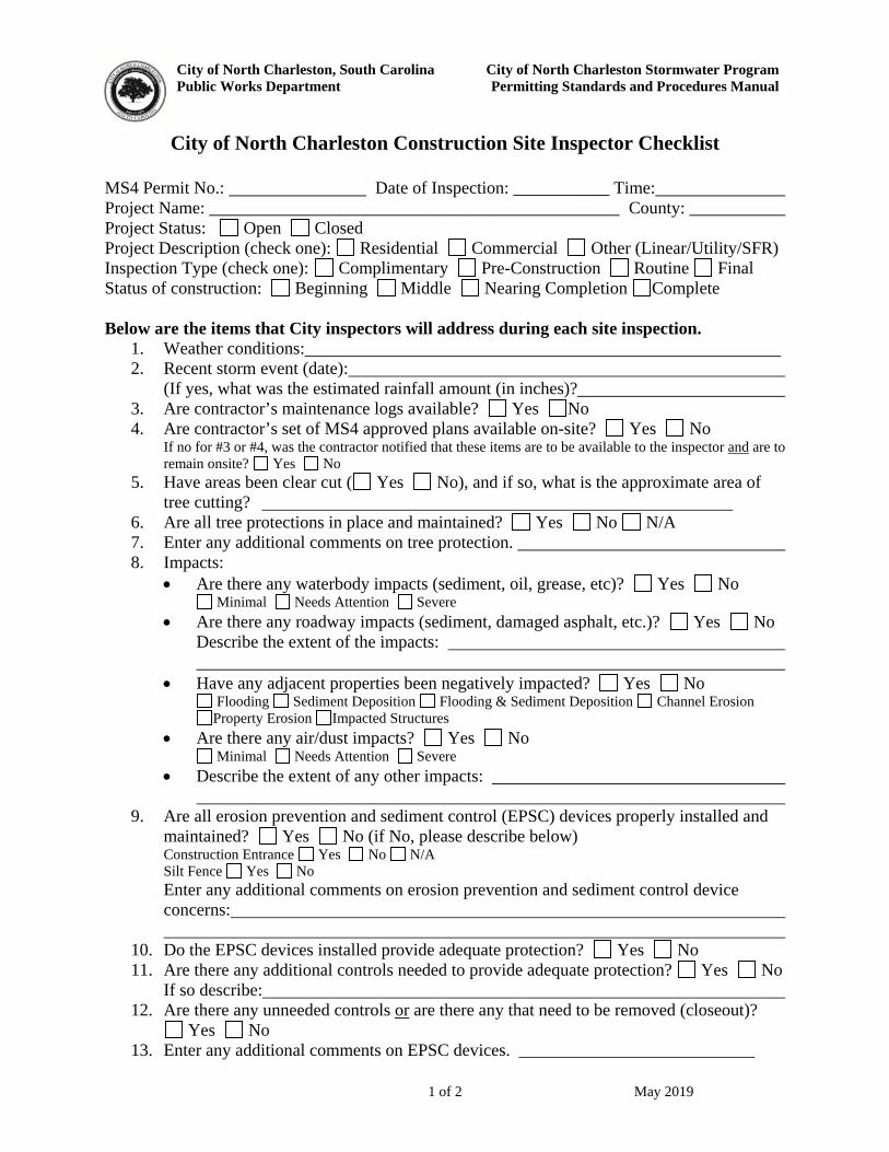
City of North Charleston, South Carolina City of North Charleston Stormwater Program
Public Works Department Permitting Standards and Procedures Manual
1 of 2 May 2019
City of North Charleston Construction Site Inspector Checklist
MS4 Permit No.: Date of Inspection: ___________ Time: Project Name: _______________________________________________ County: ___________ Project Status: Open Closed Project Description (check one): Residential Commercial Other (Linear/Utility/SFR) Inspection Type (check one): Complimentary Pre-Construction Routine Final Status of construction: Beginning Middle Nearing Completion Complete Below are the items that City inspectors will address during each site inspection.
1. Weather conditions: 2. Recent storm event (date):
(If yes, what was the estimated rainfall amount (in inches)? 3. Are contractor’s maintenance logs available? Yes No 4. Are contractor’s set of MS4 approved plans available on-site? Yes No
If no for #3 or #4, was the contractor notified that these items are to be available to the inspector and are to remain onsite? Yes No
5. Have areas been clear cut ( Yes No), and if so, what is the approximate area of tree cutting?
6. Are all tree protections in place and maintained? Yes No N/A 7. Enter any additional comments on tree protection. 8. Impacts:
Are there any waterbody impacts (sediment, oil, grease, etc)? Yes No Minimal Needs Attention Severe
Are there any roadway impacts (sediment, damaged asphalt, etc.)? Yes No Describe the extent of the impacts:
Have any adjacent properties been negatively impacted? Yes No Flooding Sediment Deposition Flooding & Sediment Deposition Channel Erosion Property Erosion Impacted Structures
Are there any air/dust impacts? Yes No Minimal Needs Attention Severe
Describe the extent of any other impacts:
9. Are all erosion prevention and sediment control (EPSC) devices properly installed and maintained? Yes No (if No, please describe below) Construction Entrance Yes No N/A Silt Fence Yes No Enter any additional comments on erosion prevention and sediment control device concerns:
10. Do the EPSC devices installed provide adequate protection? Yes No 11. Are there any additional controls needed to provide adequate protection? Yes No
If so describe: 12. Are there any unneeded controls or are there any that need to be removed (closeout)?
Yes No 13. Enter any additional comments on EPSC devices. ___________________________
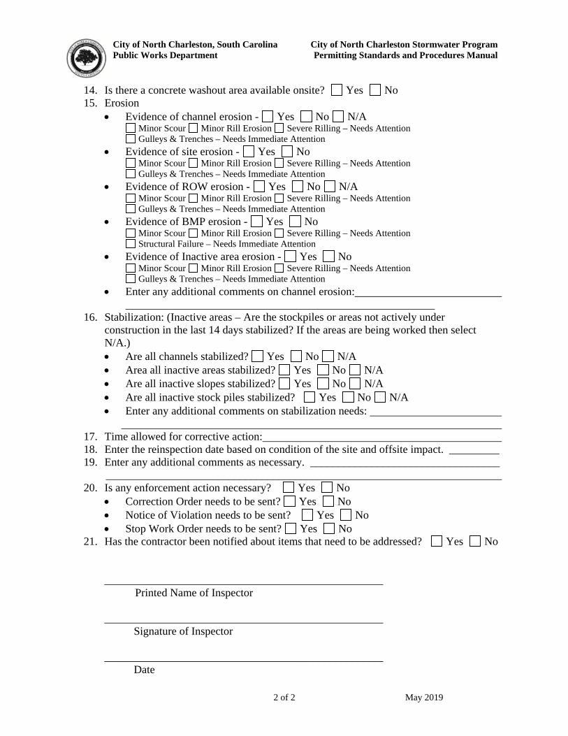
City of North Charleston, South Carolina City of North Charleston Stormwater Program
Public Works Department Permitting Standards and Procedures Manual
2 of 2 May 2019
14. Is there a concrete washout area available onsite? Yes No 15. Erosion
Evidence of channel erosion - Yes No N/A Minor Scour Minor Rill Erosion Severe Rilling – Needs Attention Gulleys & Trenches – Needs Immediate Attention
Evidence of site erosion - Yes No Minor Scour Minor Rill Erosion Severe Rilling – Needs Attention Gulleys & Trenches – Needs Immediate Attention
Evidence of ROW erosion - Yes No N/A Minor Scour Minor Rill Erosion Severe Rilling – Needs Attention Gulleys & Trenches – Needs Immediate Attention
Evidence of BMP erosion - Yes No Minor Scour Minor Rill Erosion Severe Rilling – Needs Attention Structural Failure – Needs Immediate Attention
Evidence of Inactive area erosion - Yes No Minor Scour Minor Rill Erosion Severe Rilling – Needs Attention Gulleys & Trenches – Needs Immediate Attention
Enter any additional comments on channel erosion:
16. Stabilization: (Inactive areas – Are the stockpiles or areas not actively under construction in the last 14 days stabilized? If the areas are being worked then select N/A.) Are all channels stabilized? Yes No N/A Area all inactive areas stabilized? Yes No N/A Are all inactive slopes stabilized? Yes No N/A Are all inactive stock piles stabilized? Yes No N/A Enter any additional comments on stabilization needs:
17. Time allowed for corrective action: 18. Enter the reinspection date based on condition of the site and offsite impact. _________ 19. Enter any additional comments as necessary. __________________________________
_______________________________________________________________________ 20. Is any enforcement action necessary? Yes No
Correction Order needs to be sent? Yes No Notice of Violation needs to be sent? Yes No Stop Work Order needs to be sent? Yes No
21. Has the contractor been notified about items that need to be addressed? Yes No
__________________________________________________
Printed Name of Inspector __________________________________________________
Signature of Inspector __________________________________________________
Date

City of North Charleston, South Carolina City of North Charleston Stormwater Program Public Works Department Permitting Standards and Procedures Manual May 2019
APPENDIX G
ENFORCEMENT FORMS
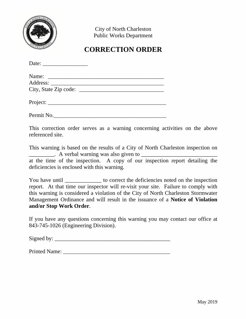
May 2019
City of North Charleston Public Works Department
CORRECTION ORDER
Date: ________________ Name: _________________________________________ Address: ________________________________________ City, State Zip code: ______________________________ Project: __________________________________________ Permit No.________________________________________ This correction order serves as a warning concerning activities on the above referenced site. This warning is based on the results of a City of North Charleston inspection on _________. A verbal warning was also given to ___________________________ at the time of the inspection. A copy of our inspection report detailing the deficiencies is enclosed with this warning. You have until _____________ to correct the deficiencies noted on the inspection report. At that time our inspector will re-visit your site. Failure to comply with this warning is considered a violation of the City of North Charleston Stormwater Management Ordinance and will result in the issuance of a Notice of Violation and/or Stop Work Order. If you have any questions concerning this warning you may contact our office at 843-745-1026 (Engineering Division). Signed by: _________________________________________ Printed Name: ______________________________________
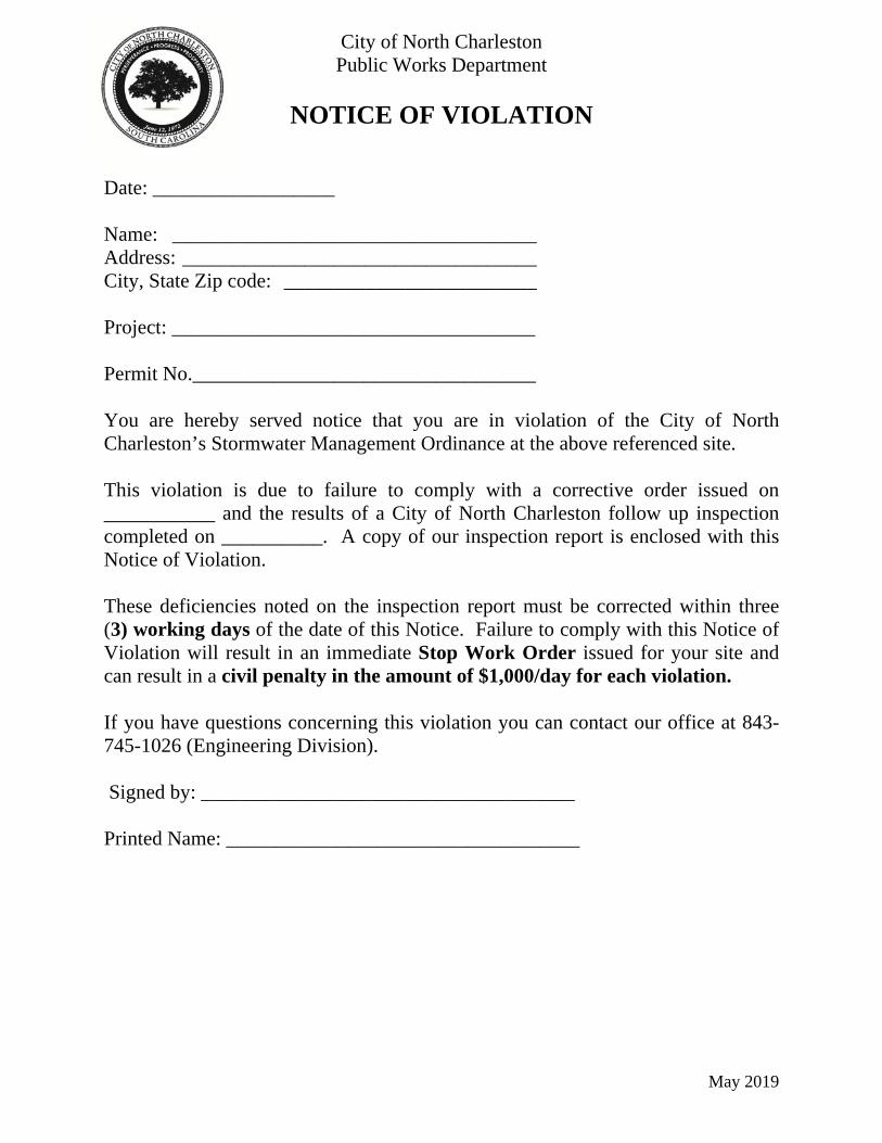
May 2019
City of North Charleston Public Works Department
NOTICE OF VIOLATION
Date: __________________ Name: ____________________________________ Address: ___________________________________ City, State Zip code: _________________________ Project: ____________________________________ Permit No.__________________________________ You are hereby served notice that you are in violation of the City of North Charleston’s Stormwater Management Ordinance at the above referenced site. This violation is due to failure to comply with a corrective order issued on ___________ and the results of a City of North Charleston follow up inspection completed on __________. A copy of our inspection report is enclosed with this Notice of Violation. These deficiencies noted on the inspection report must be corrected within three (3) working days of the date of this Notice. Failure to comply with this Notice of Violation will result in an immediate Stop Work Order issued for your site and can result in a civil penalty in the amount of $1,000/day for each violation. If you have questions concerning this violation you can contact our office at 843-745-1026 (Engineering Division). Signed by: _____________________________________ Printed Name: ___________________________________
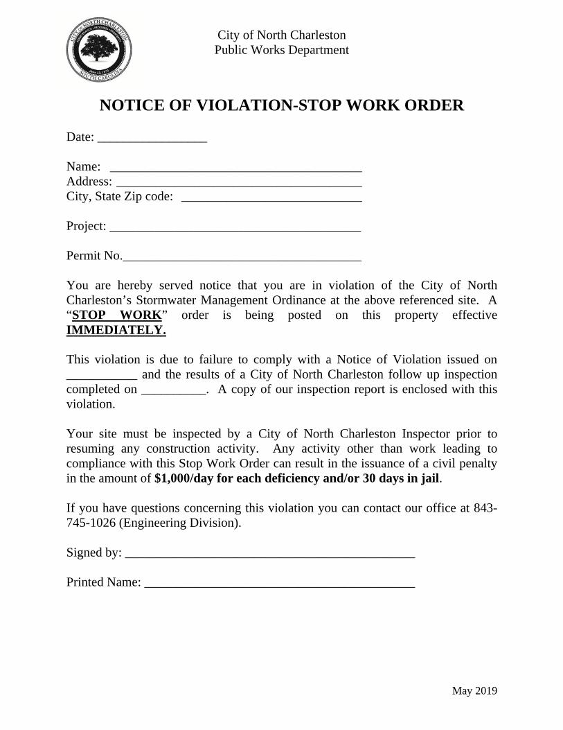
May 2019
City of North Charleston Public Works Department
NOTICE OF VIOLATION-STOP WORK ORDER
Date: _________________ Name: _______________________________________ Address: ______________________________________ City, State Zip code: ____________________________ Project: _______________________________________ Permit No._____________________________________ You are hereby served notice that you are in violation of the City of North Charleston’s Stormwater Management Ordinance at the above referenced site. A “STOP WORK” order is being posted on this property effective IMMEDIATELY. This violation is due to failure to comply with a Notice of Violation issued on ___________ and the results of a City of North Charleston follow up inspection completed on __________. A copy of our inspection report is enclosed with this violation. Your site must be inspected by a City of North Charleston Inspector prior to resuming any construction activity. Any activity other than work leading to compliance with this Stop Work Order can result in the issuance of a civil penalty in the amount of $1,000/day for each deficiency and/or 30 days in jail. If you have questions concerning this violation you can contact our office at 843-745-1026 (Engineering Division). Signed by: _____________________________________________ Printed Name: __________________________________________

City of North Charleston, South Carolina City of North Charleston Stormwater Program Public Works Department Permitting Standards and Procedures Manual May 2019
APPENDIX H
TRANSFER OF OWNERSHIP APPLICATION
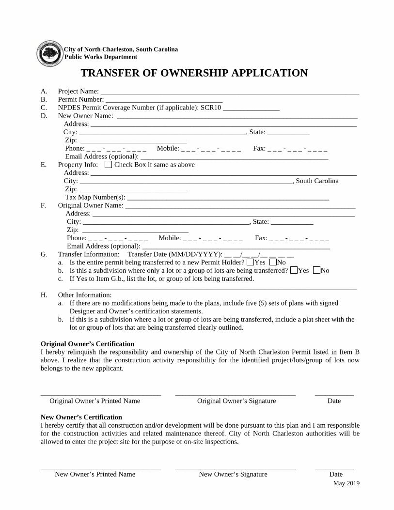
May 2019
City of North Charleston, South Carolina
Public Works Department
TRANSFER OF OWNERSHIP APPLICATION
A. Project Name: _________________________________________________________________________ B. Permit Number: _________________________________ C. NPDES Permit Coverage Number (if applicable): SCR10 ________________ D. New Owner Name: ____________________________________________________________________
Address: ___________________________________________________________________________ City: _______________________________________________, State: ____________ Zip: ______________________________ Phone: _ _ _ - _ _ _ - _ _ _ _ Mobile: _ _ _ - _ _ _ - _ _ _ _ Fax: _ _ _ - _ _ _ - _ _ _ _ Email Address (optional): _____________________________________________________
E. Property Info: Check Box if same as above Address: ___________________________________________________________________________ City: ____________________________________________________________, South Carolina
Zip: ______________________________ Tax Map Number(s): _________________________________________________________
F. Original Owner Name: _________________________________________________________________ Address: __________________________________________________________________________
City: _______________________________________________, State: ____________ Zip: ______________________________ Phone: _ _ _ - _ _ _ - _ _ _ _ Mobile: _ _ _ - _ _ _ - _ _ _ _ Fax: _ _ _ - _ _ _ - _ _ _ _
Email Address (optional): _____________________________________________________ G. Transfer Information: Transfer Date (MM/DD/YYYY): __ __/__ __/__ __ __ __
a. Is the entire permit being transferred to a new Permit Holder? Yes No b. Is this a subdivision where only a lot or a group of lots are being transferred? Yes No c. If Yes to Item G.b., list the lot, or group of lots being transferred.
_________________________________________________________________________________ H. Other Information:
a. If there are no modifications being made to the plans, include five (5) sets of plans with signed Designer and Owner’s certification statements.
b. If this is a subdivision where a lot or group of lots are being transferred, include a plat sheet with the lot or group of lots that are being transferred clearly outlined.
Original Owner’s Certification I hereby relinquish the responsibility and ownership of the City of North Charleston Permit listed in Item B above. I realize that the construction activity responsibility for the identified project/lots/group of lots now belongs to the new applicant. __________________________________ __________________________________ ___________ Original Owner’s Printed Name Original Owner’s Signature Date
New Owner’s Certification I hereby certify that all construction and/or development will be done pursuant to this plan and I am responsible for the construction activities and related maintenance thereof. City of North Charleston authorities will be allowed to enter the project site for the purpose of on-site inspections.
__________________________________ __________________________________ ___________ New Owner’s Printed Name New Owner’s Signature Date
City of North Charleston, South Carolina City of North Charleston Stormwater Program Public Works Department Permitting Standards and Procedures Manual May 2019
APPENDIX I
BMP DETAILS
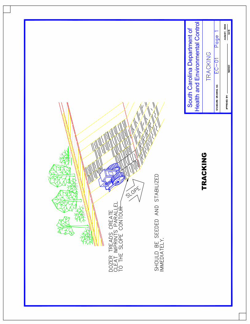
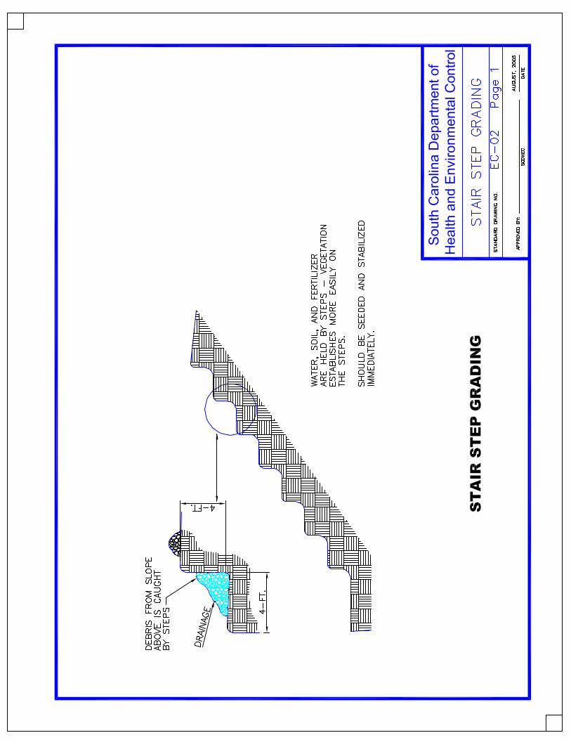
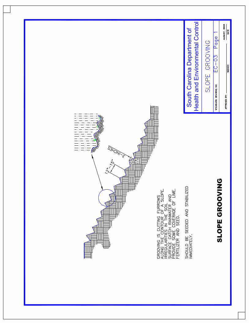
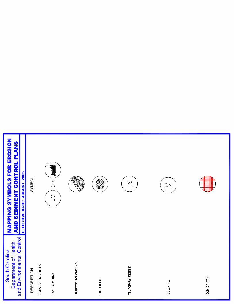
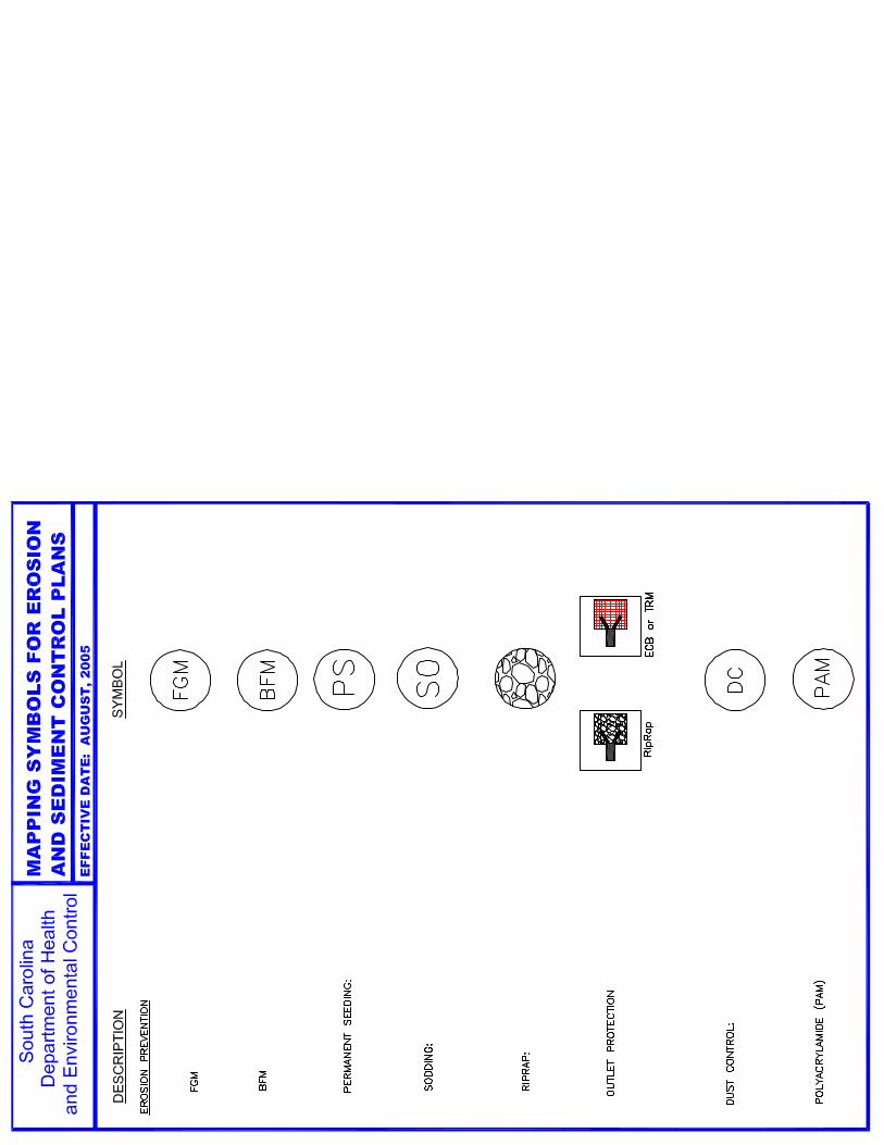
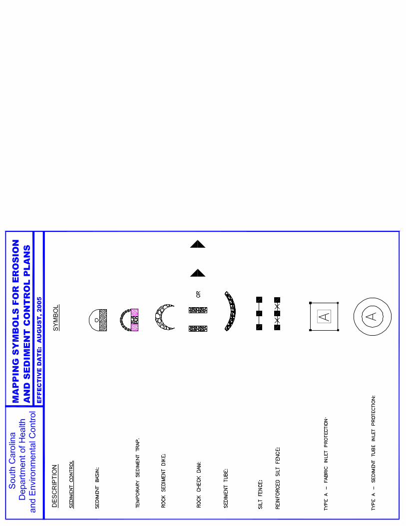
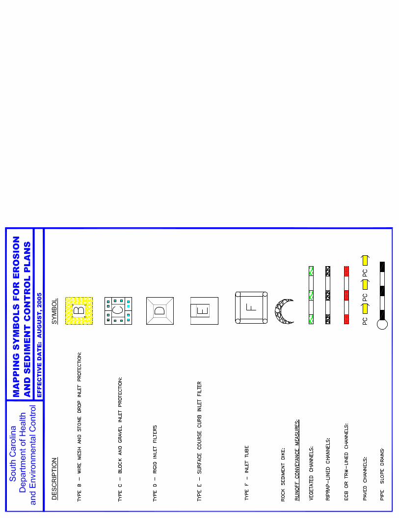
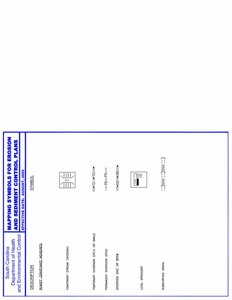
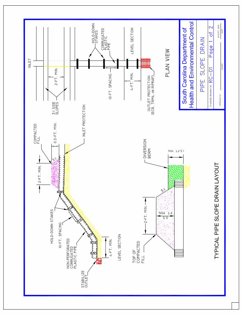
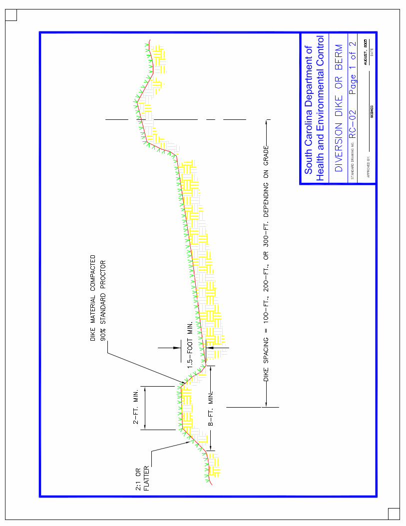
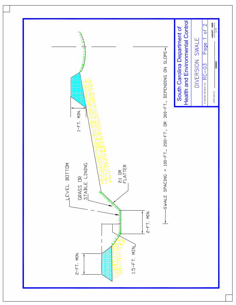
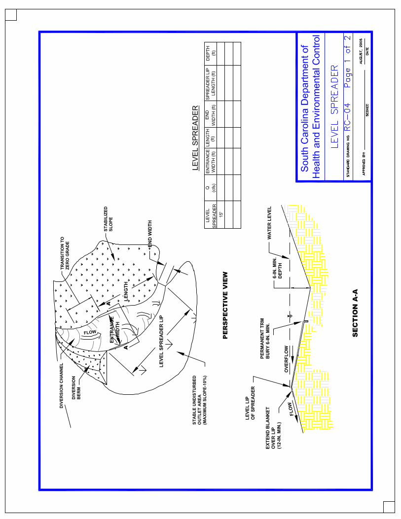


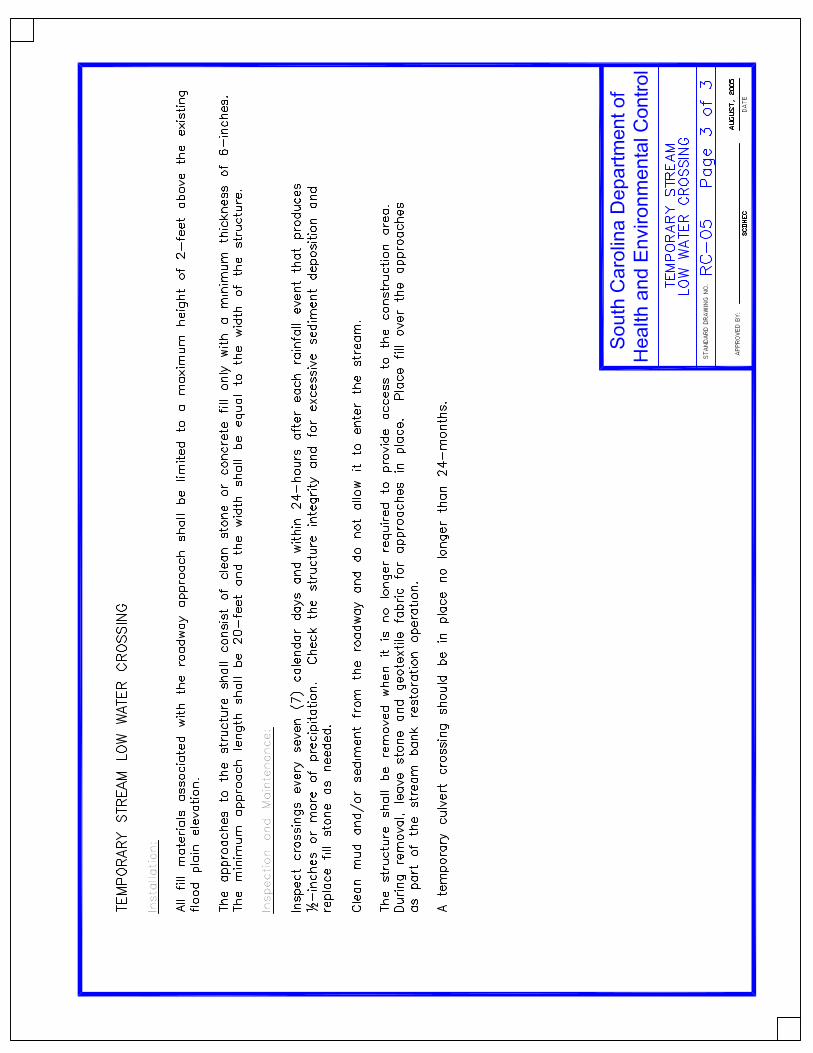
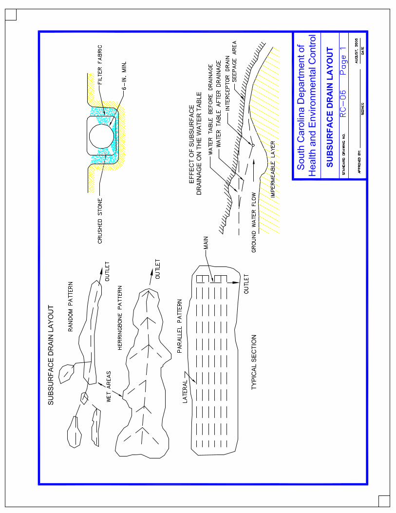
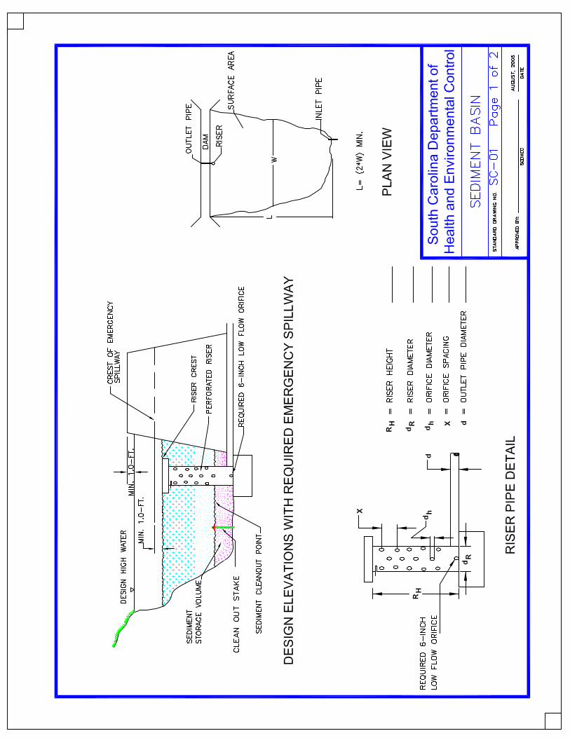
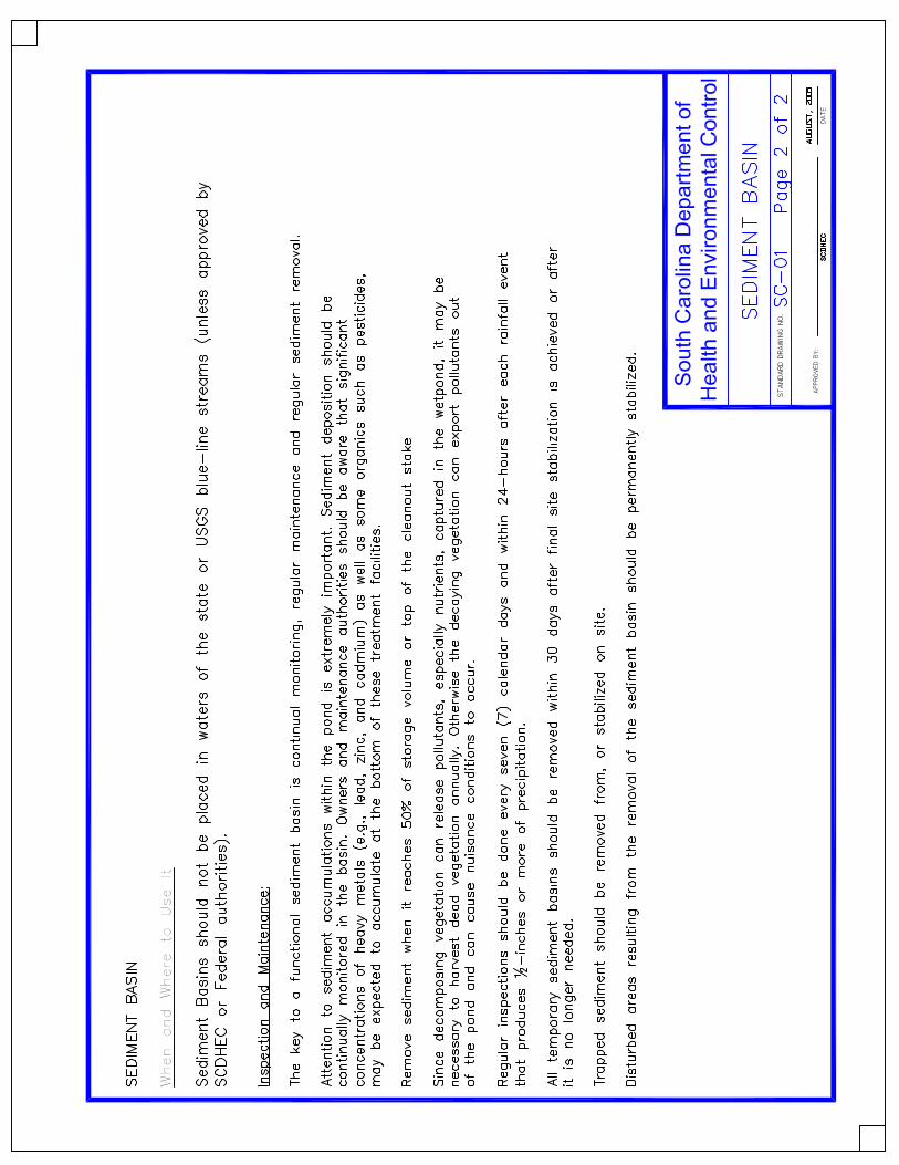
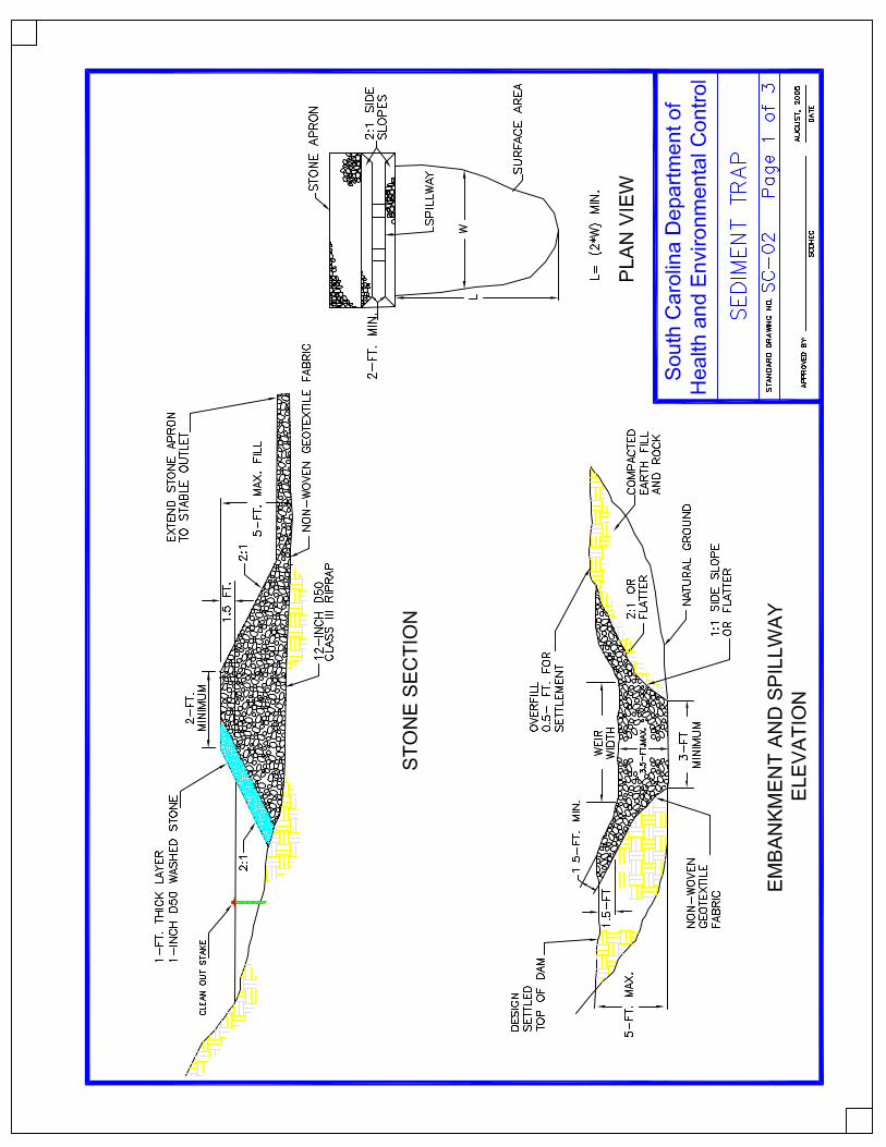
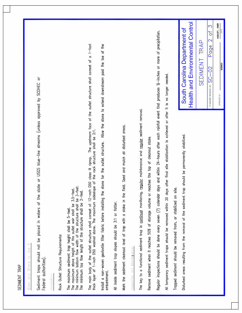
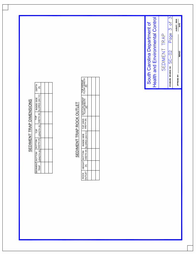
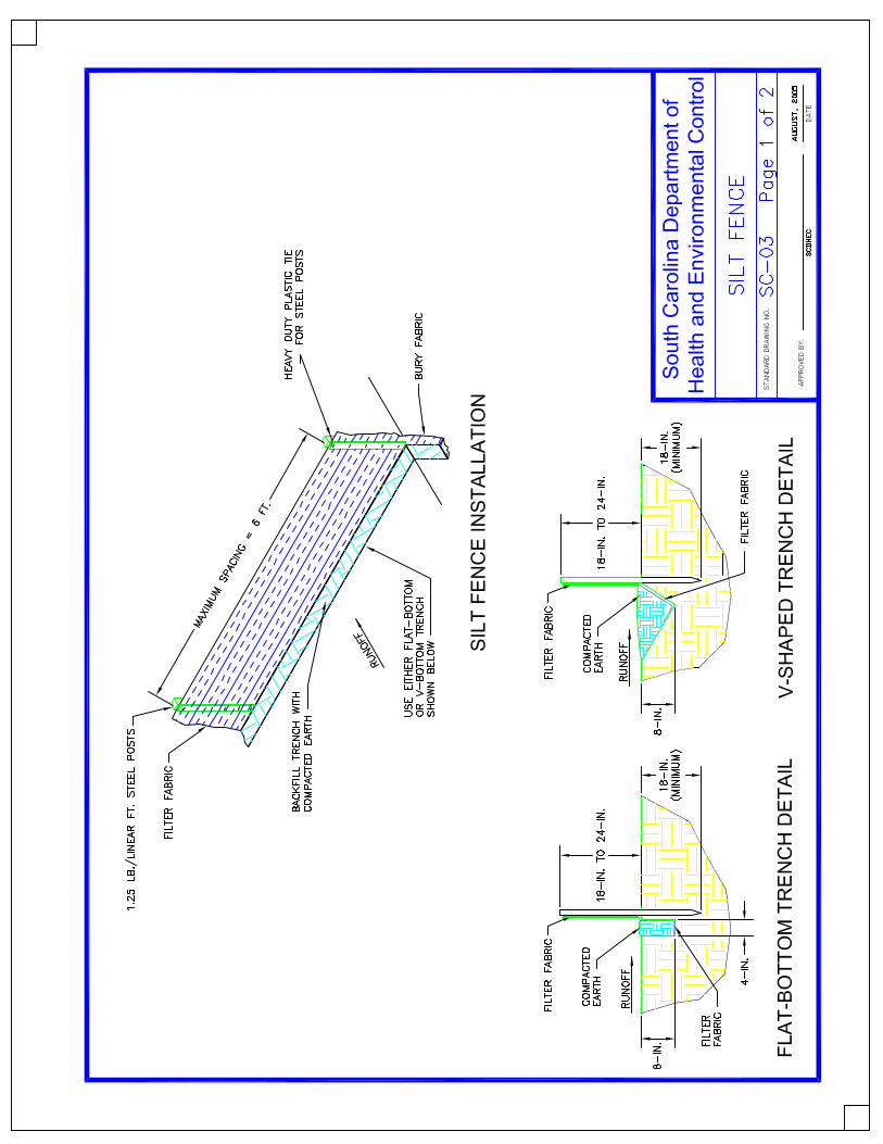
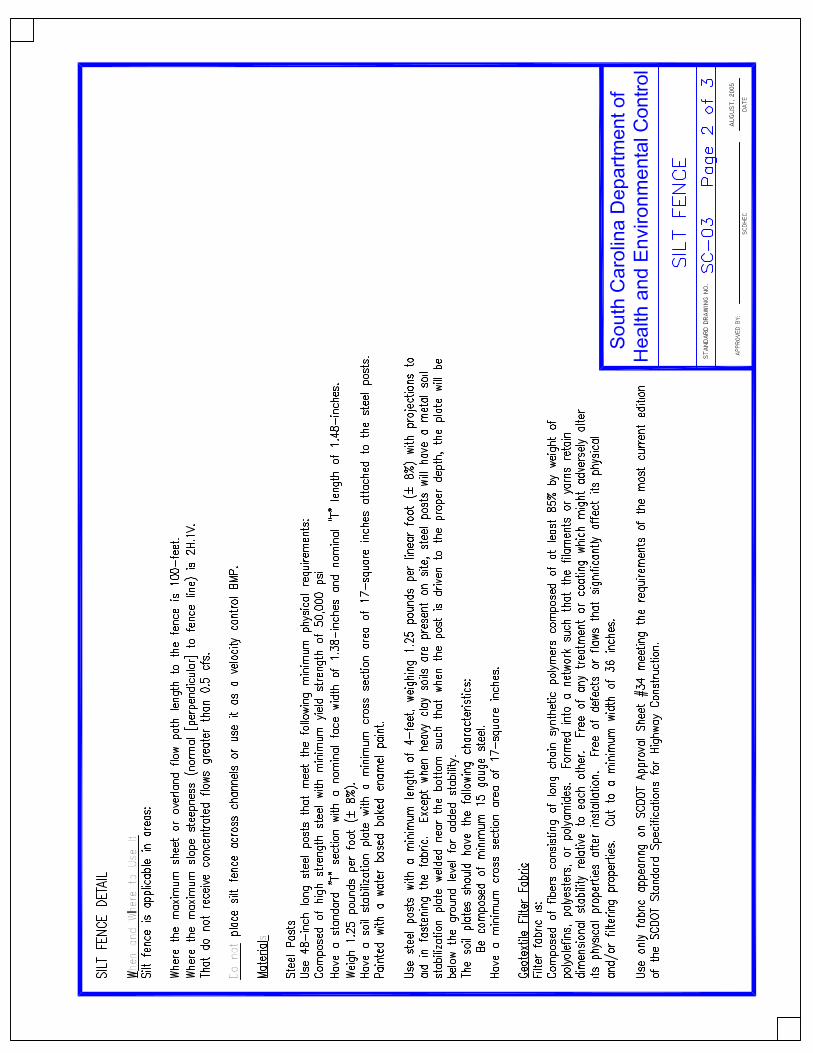
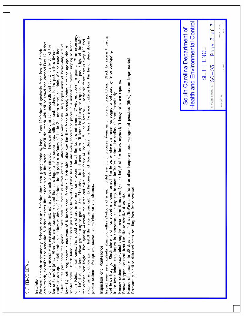
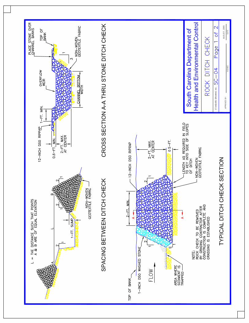

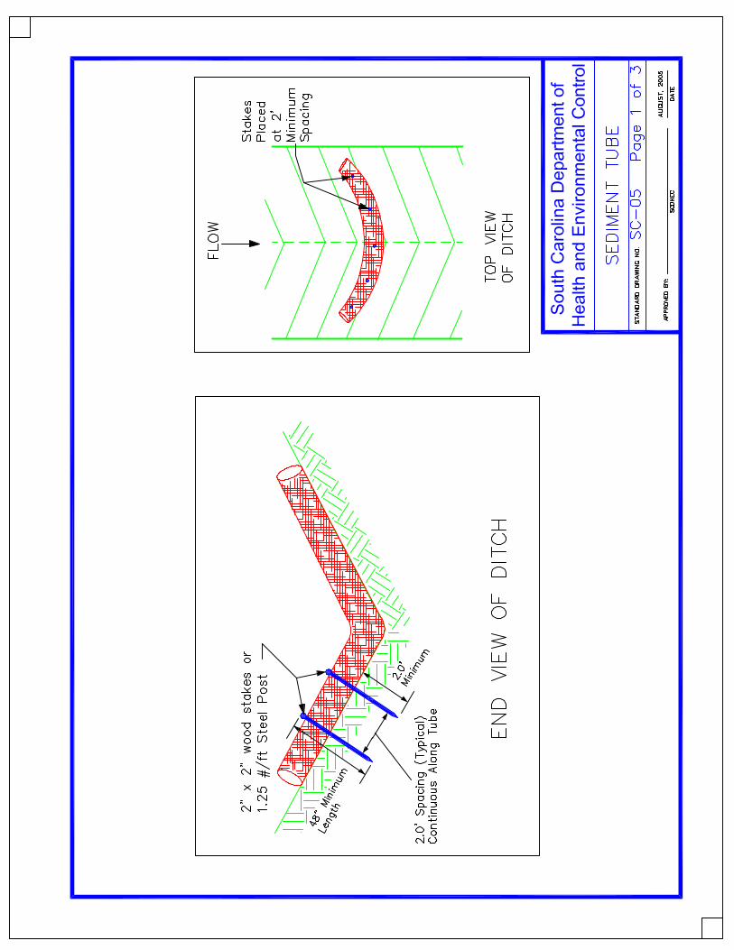

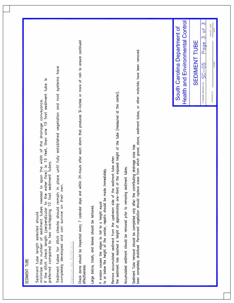
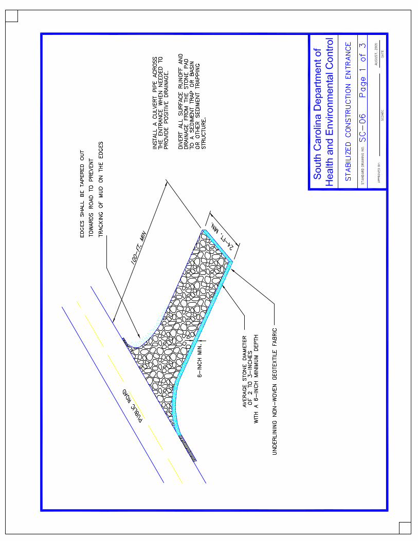
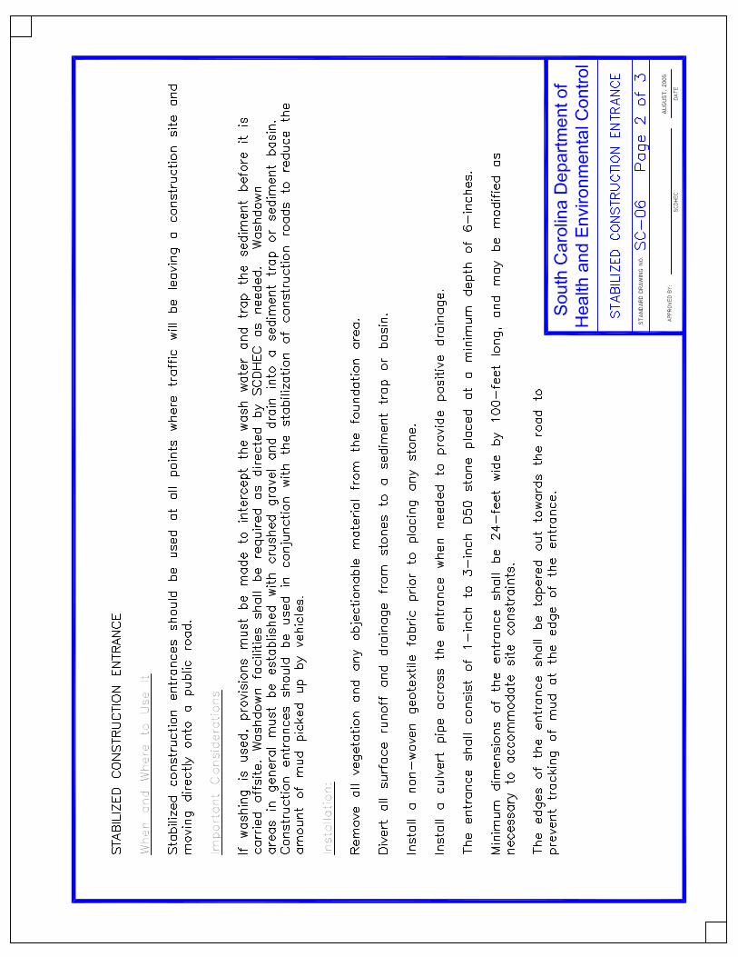
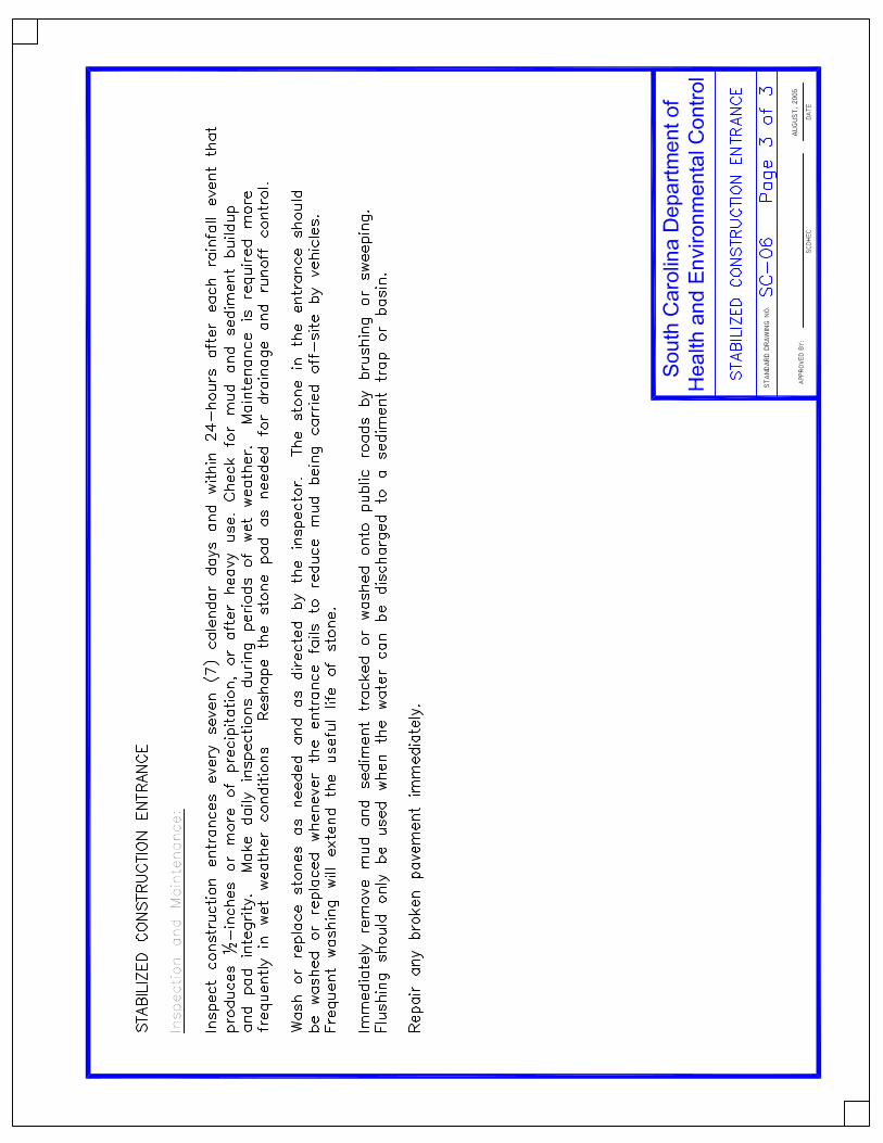
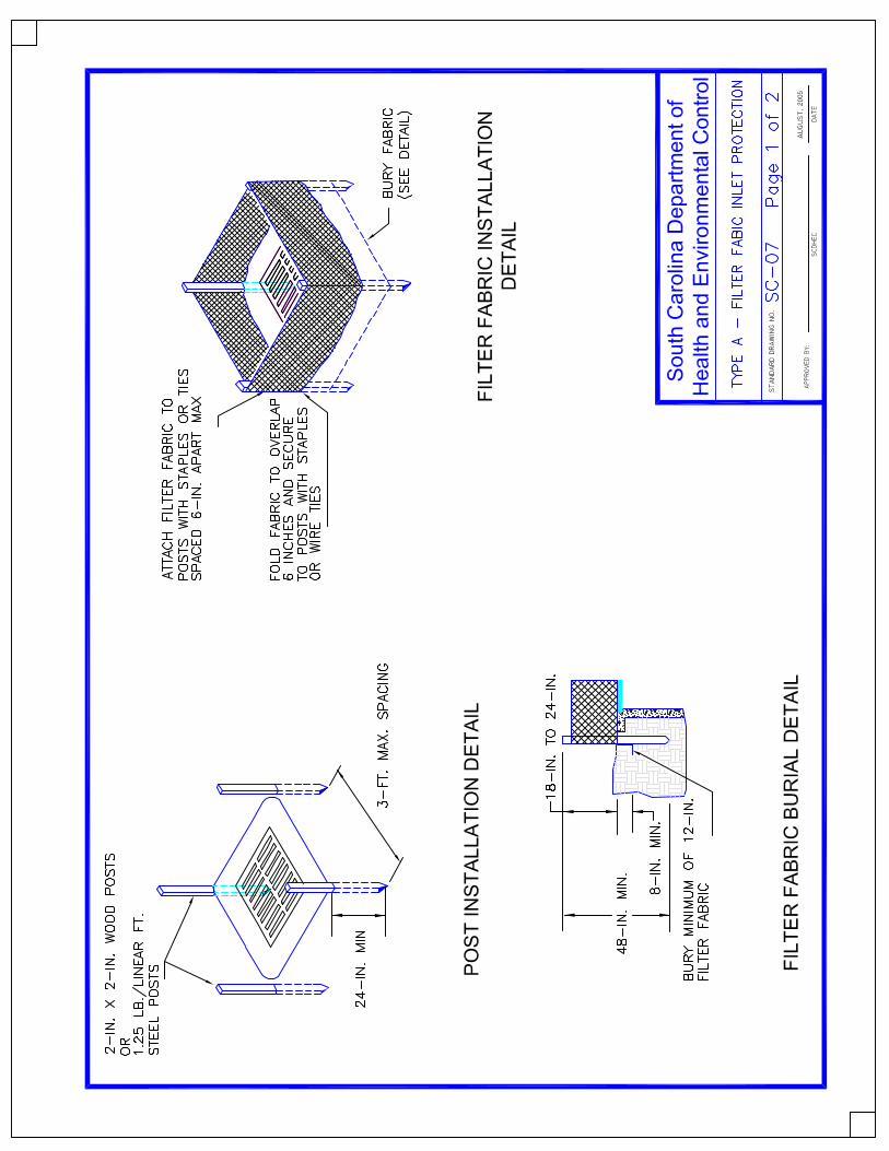
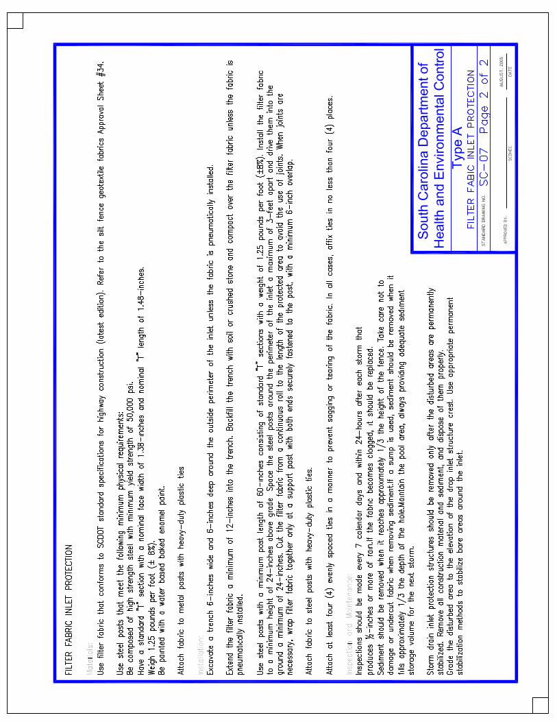
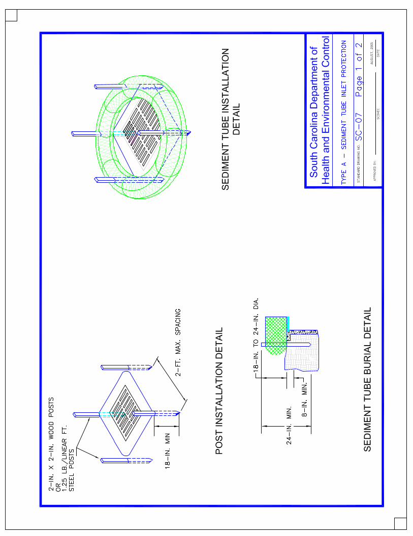
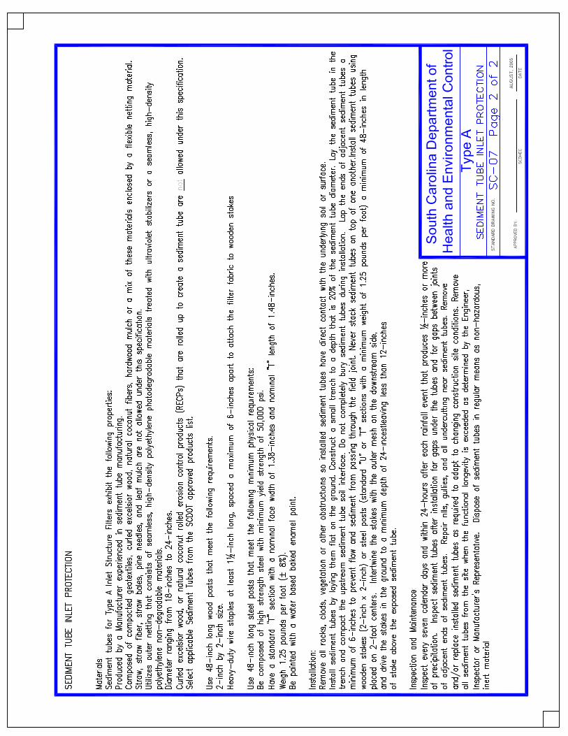
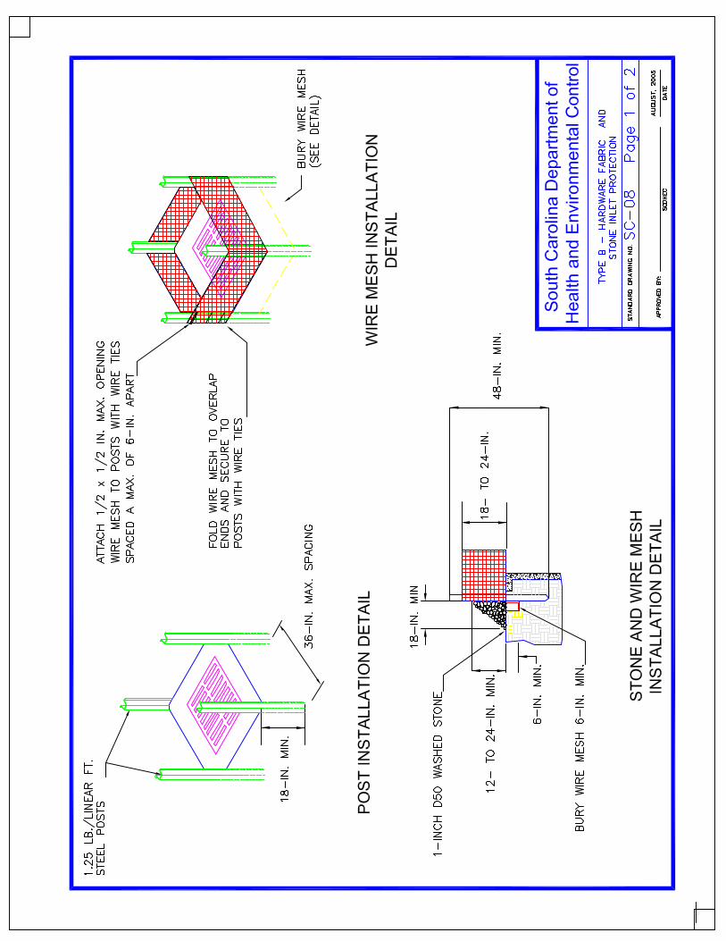
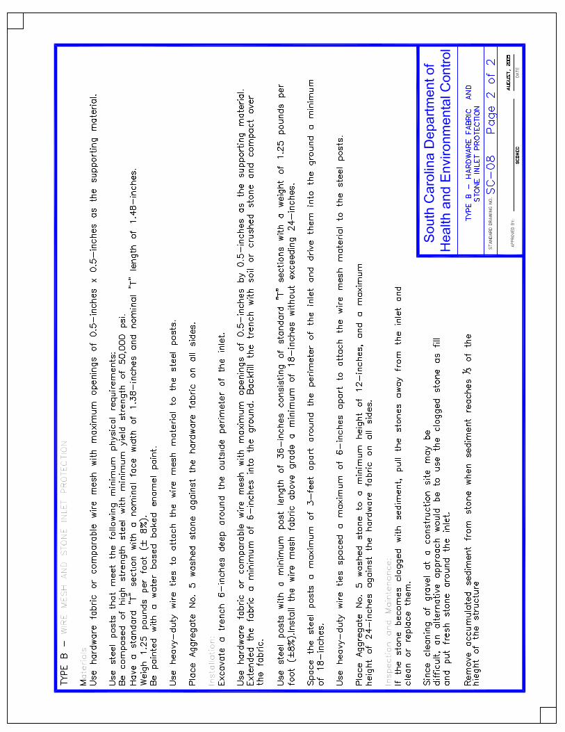
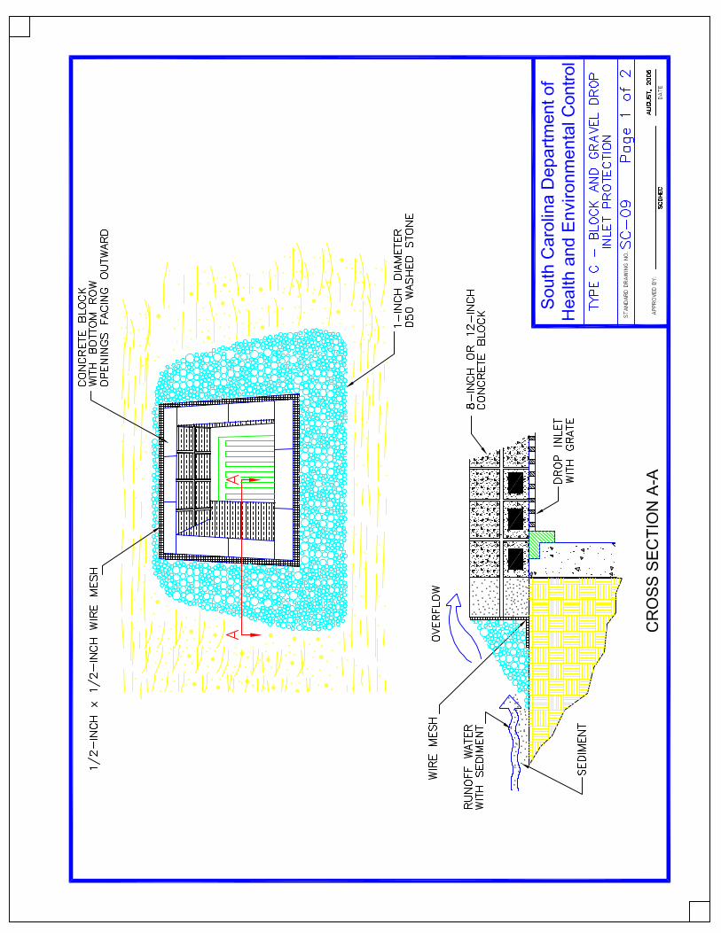
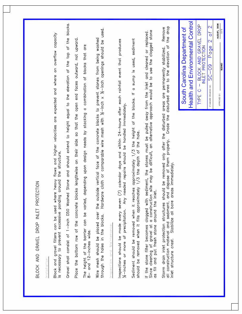
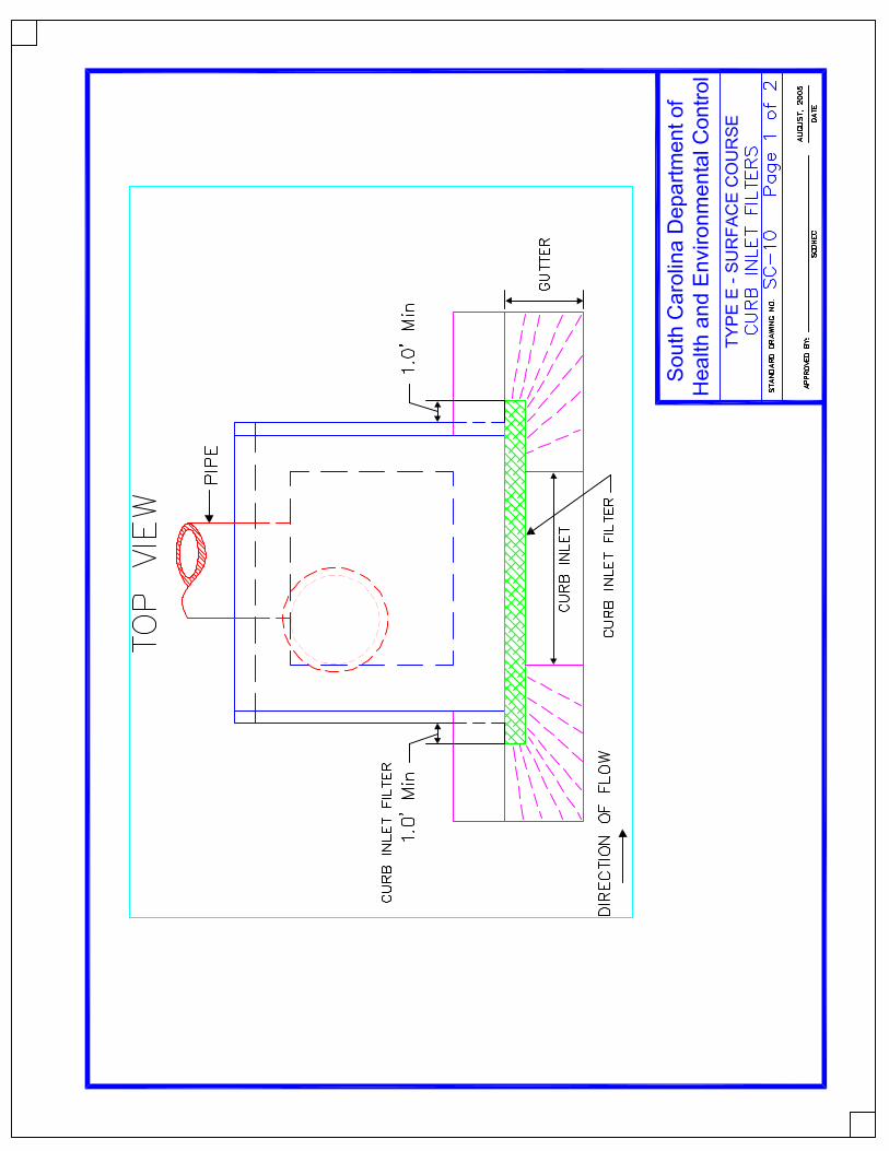
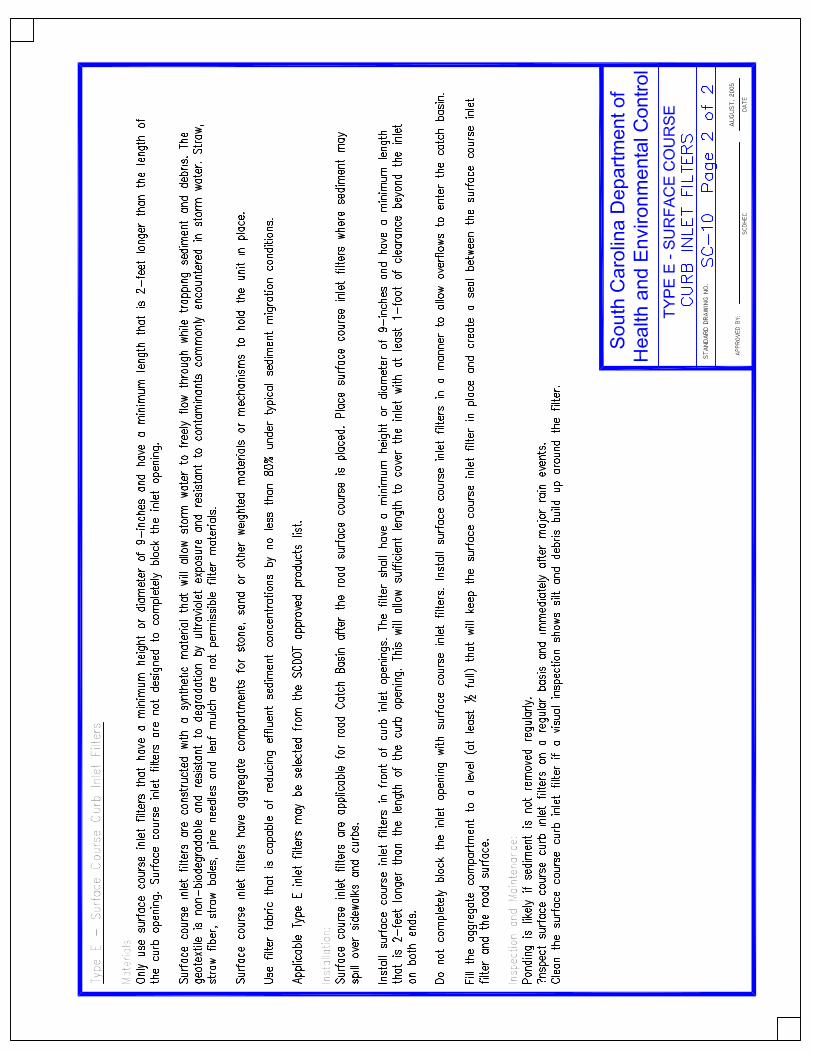
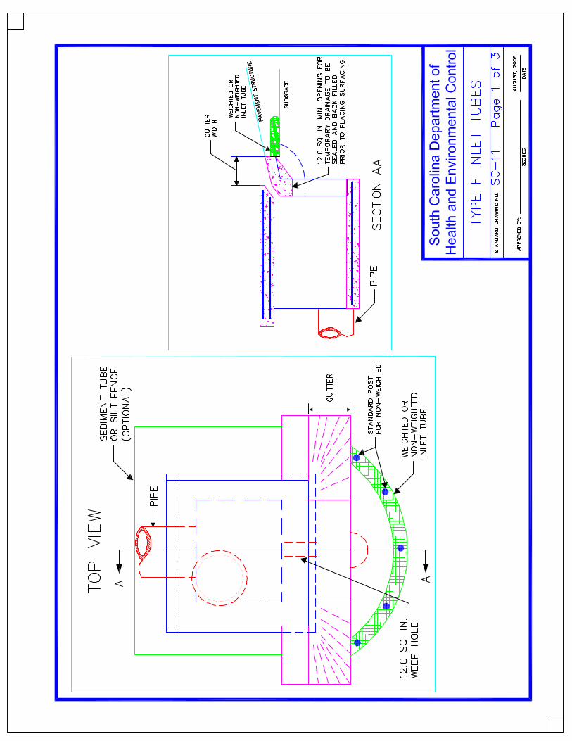
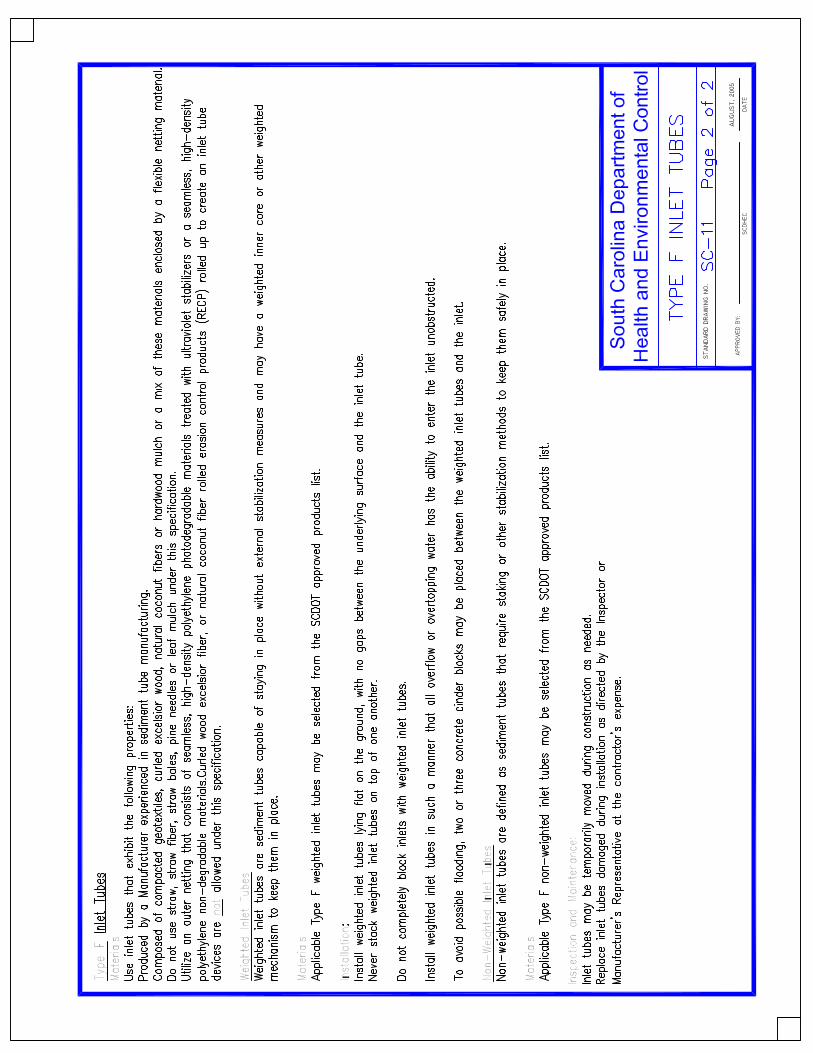
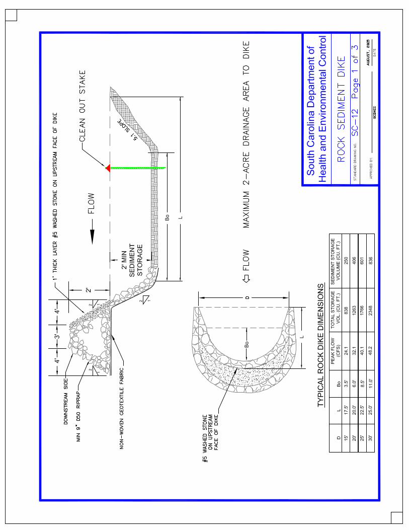
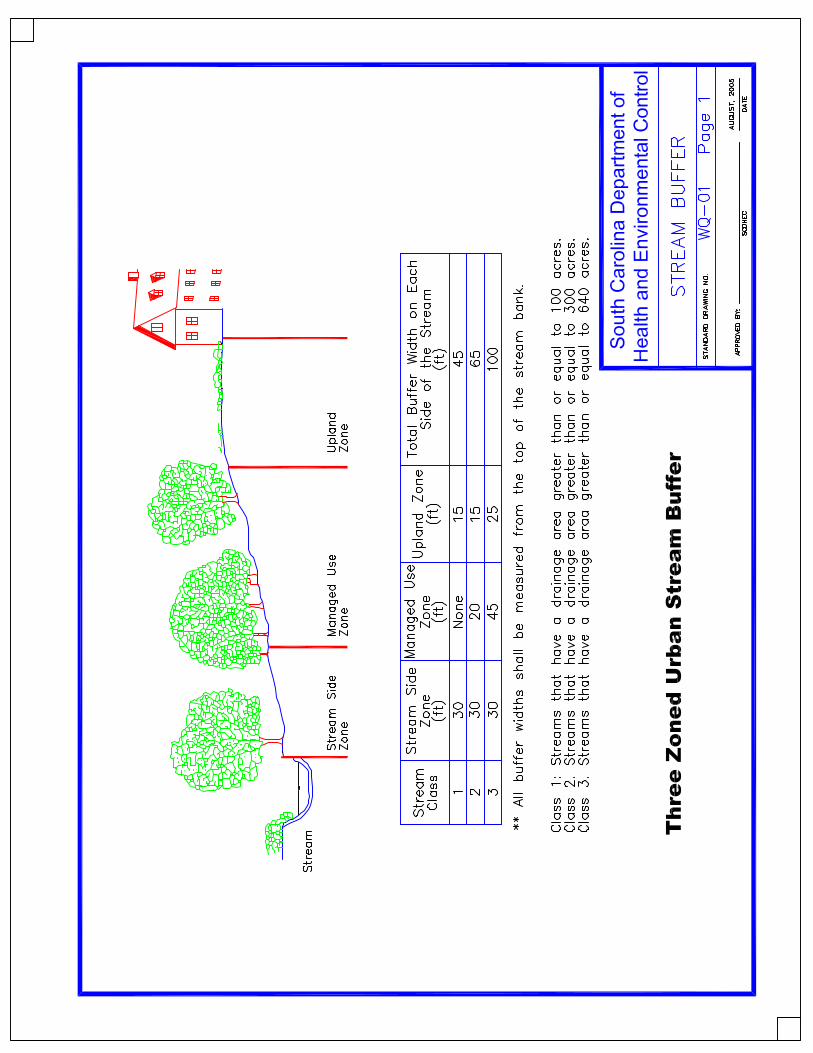
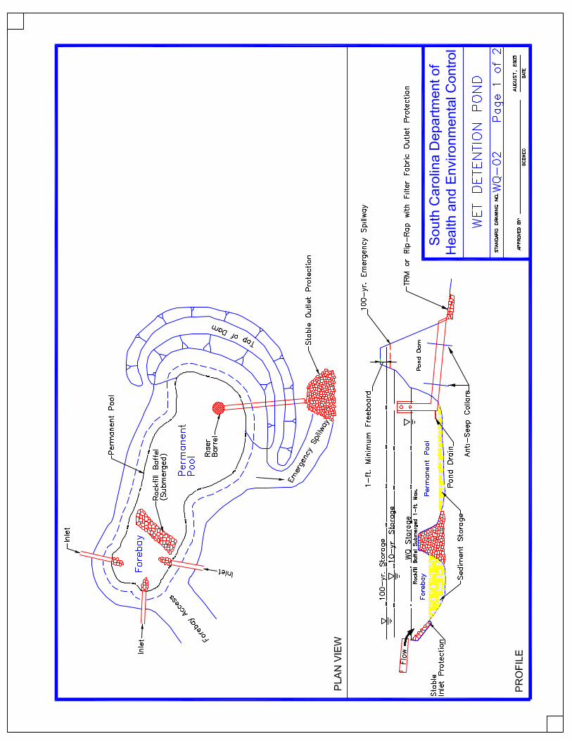

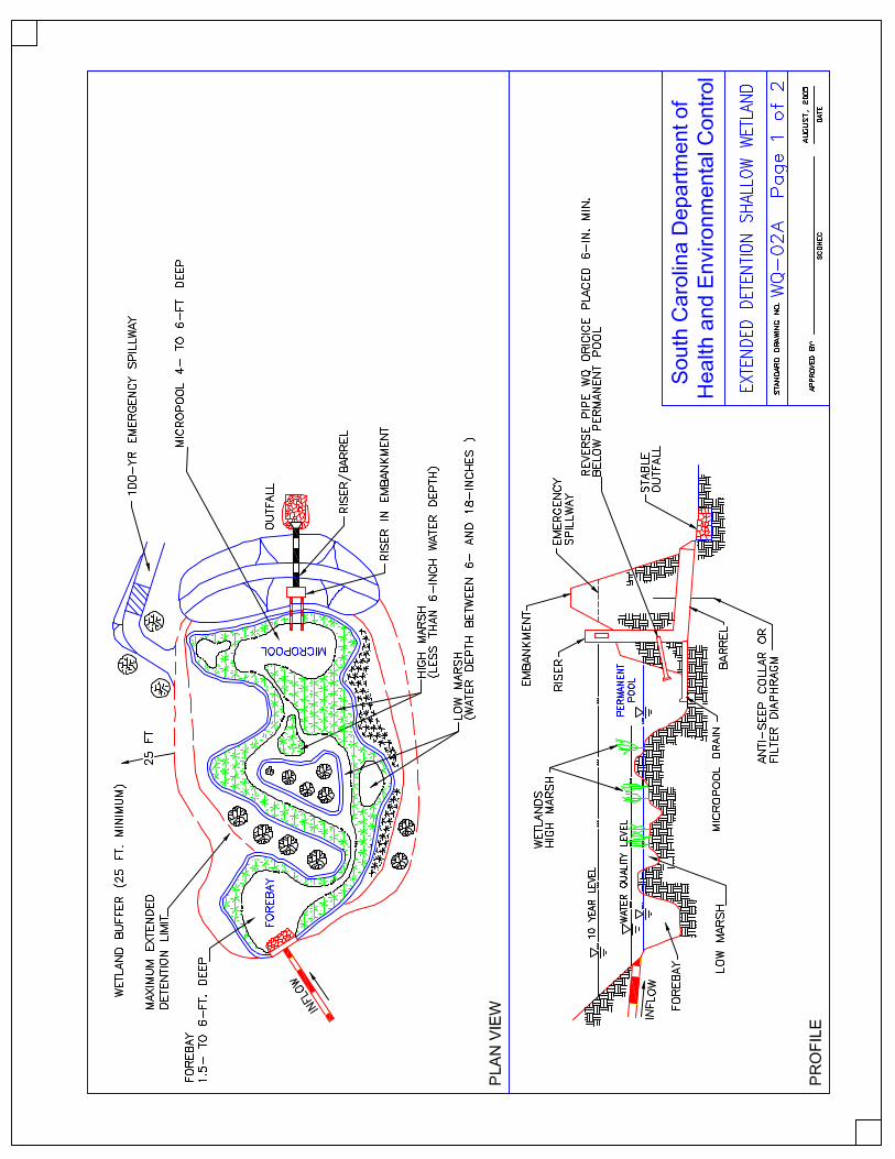
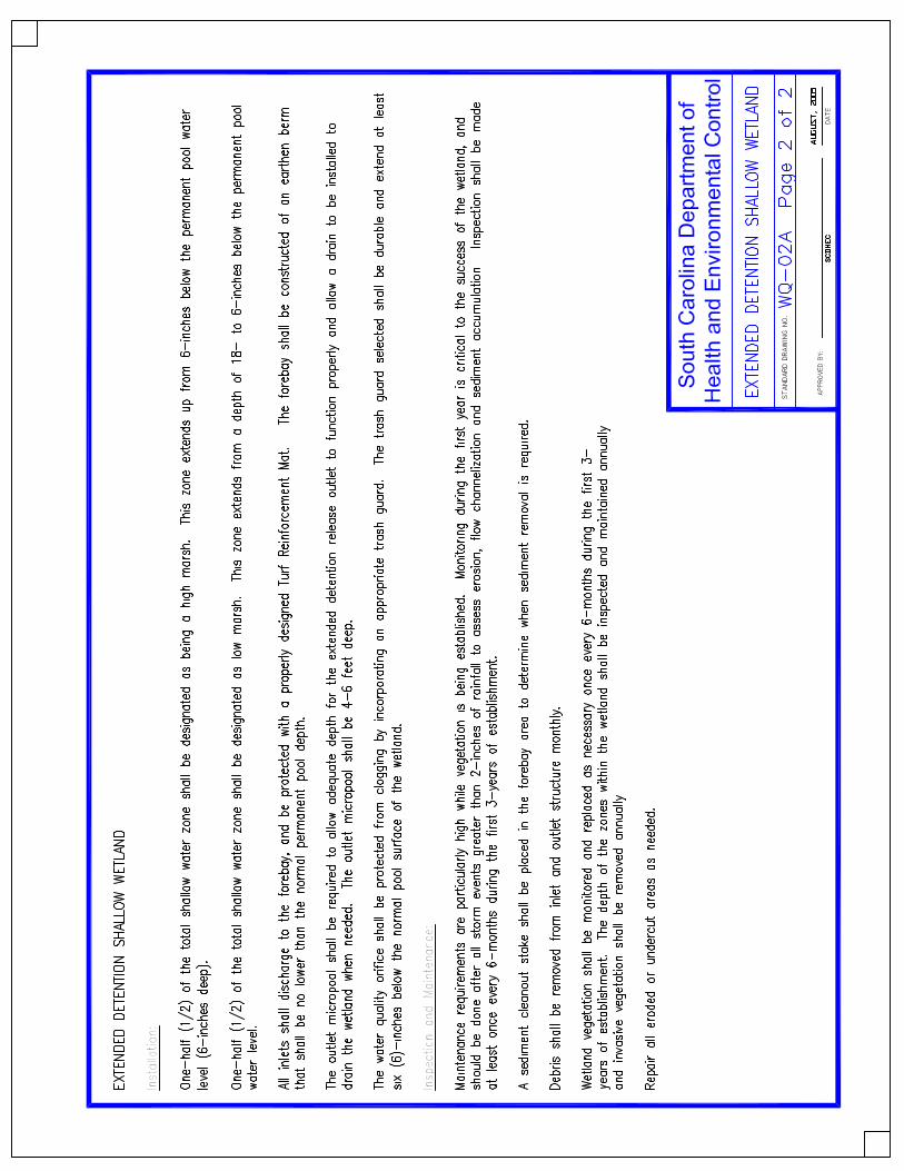
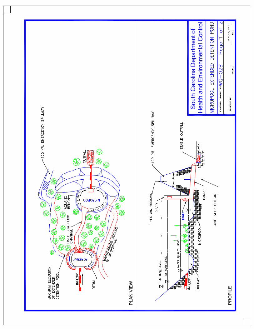
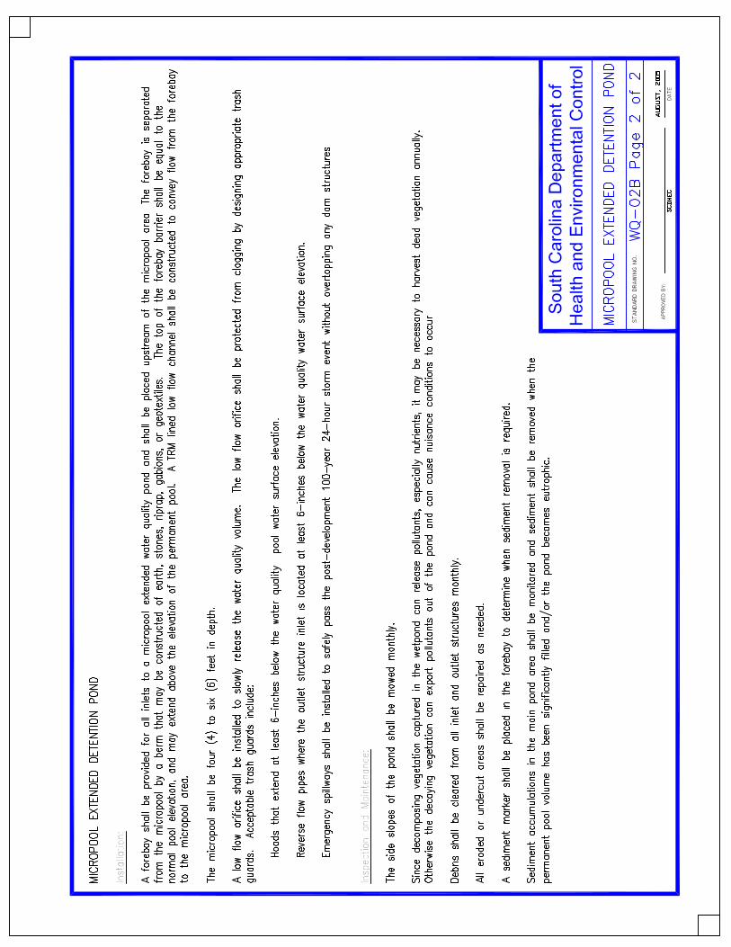
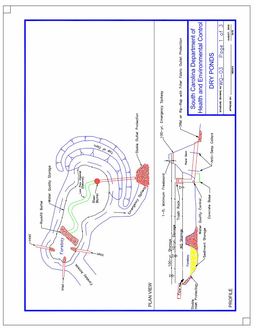
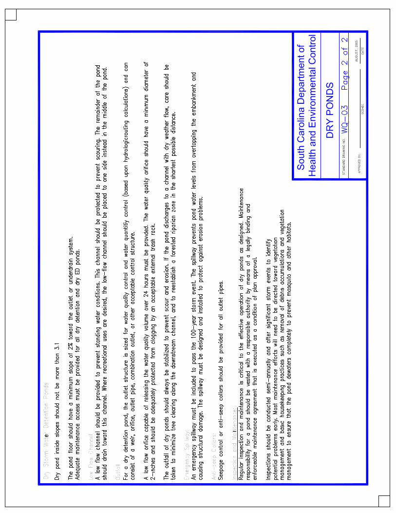
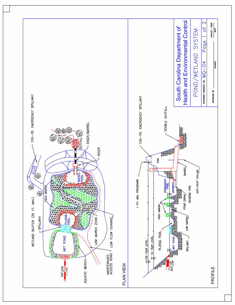

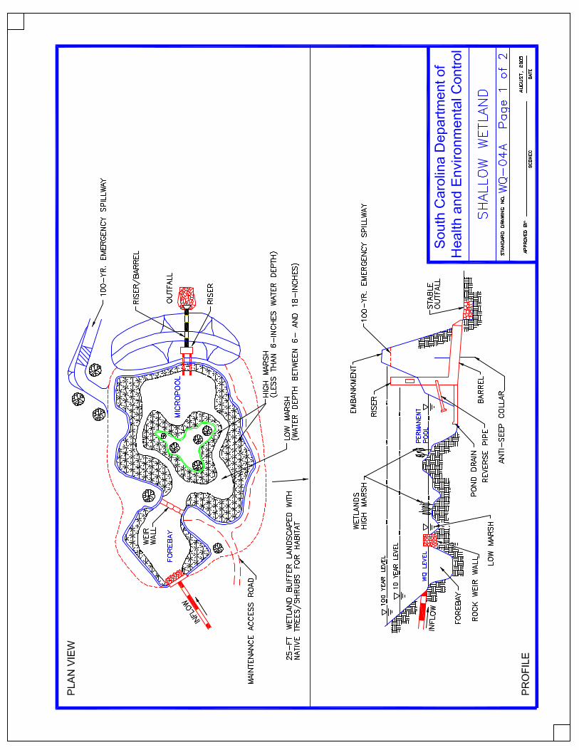
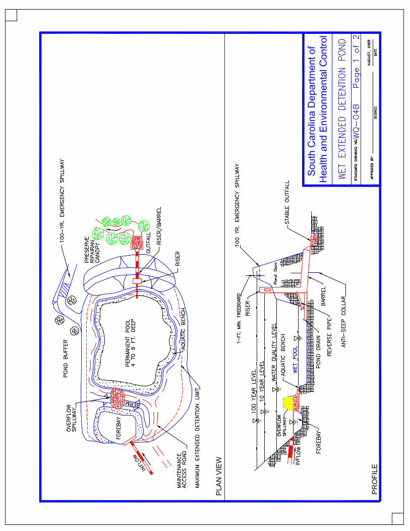
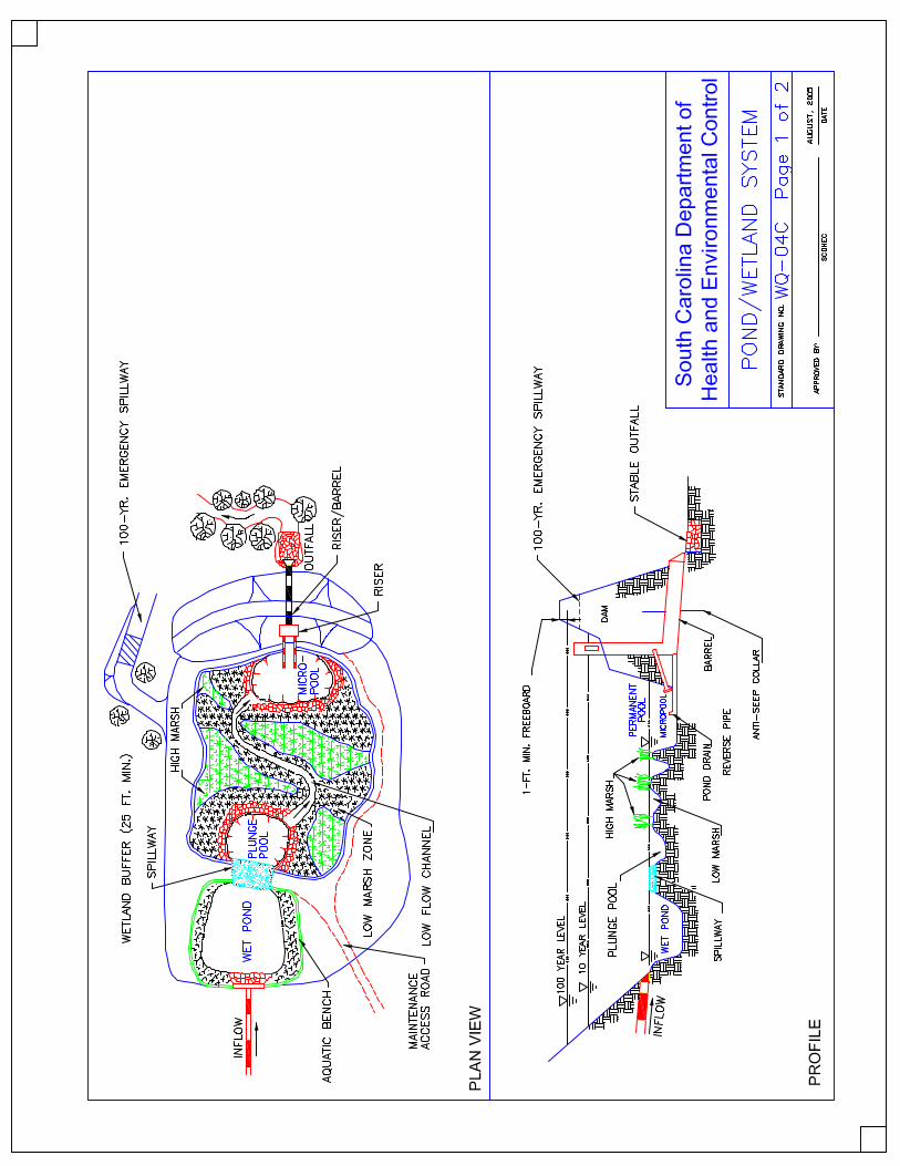
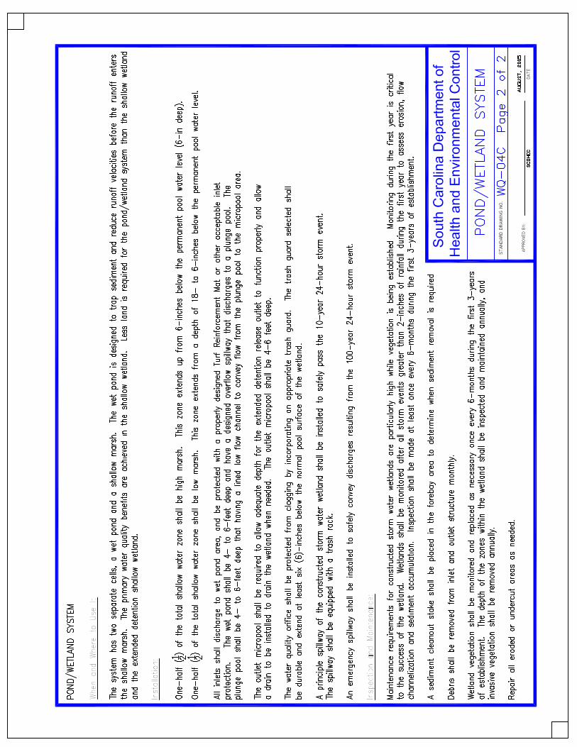
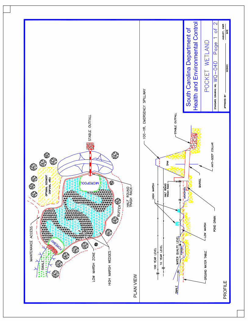
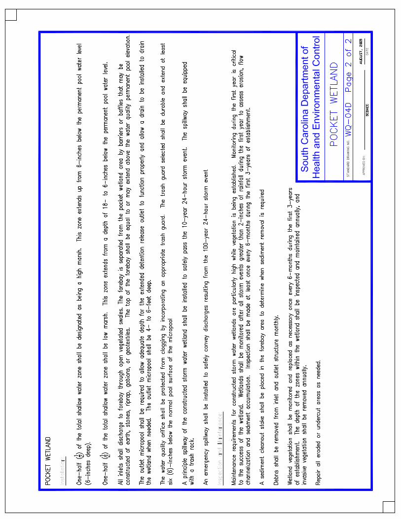
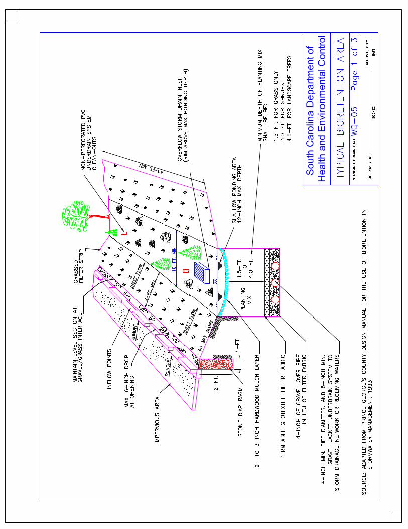
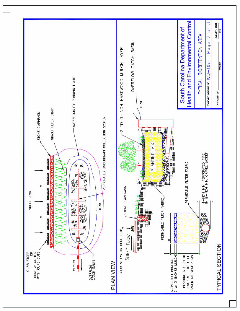
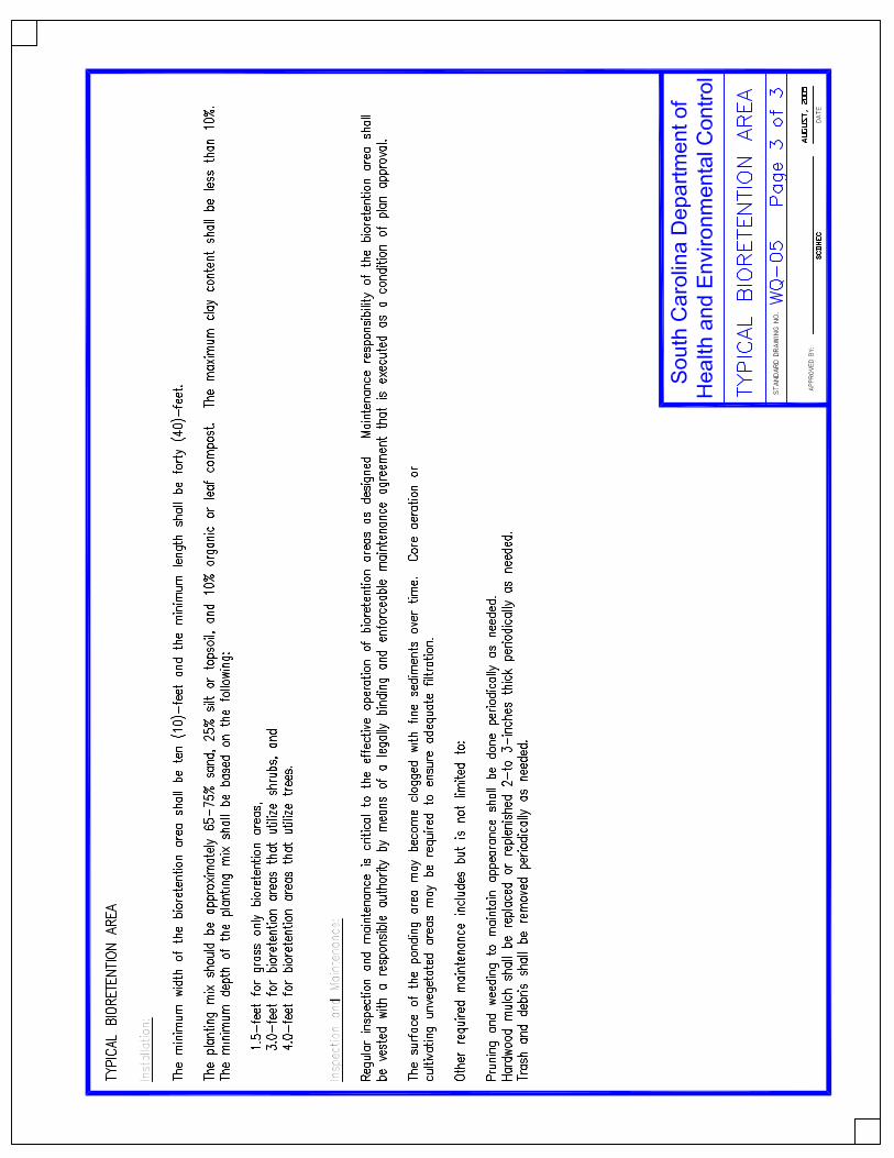
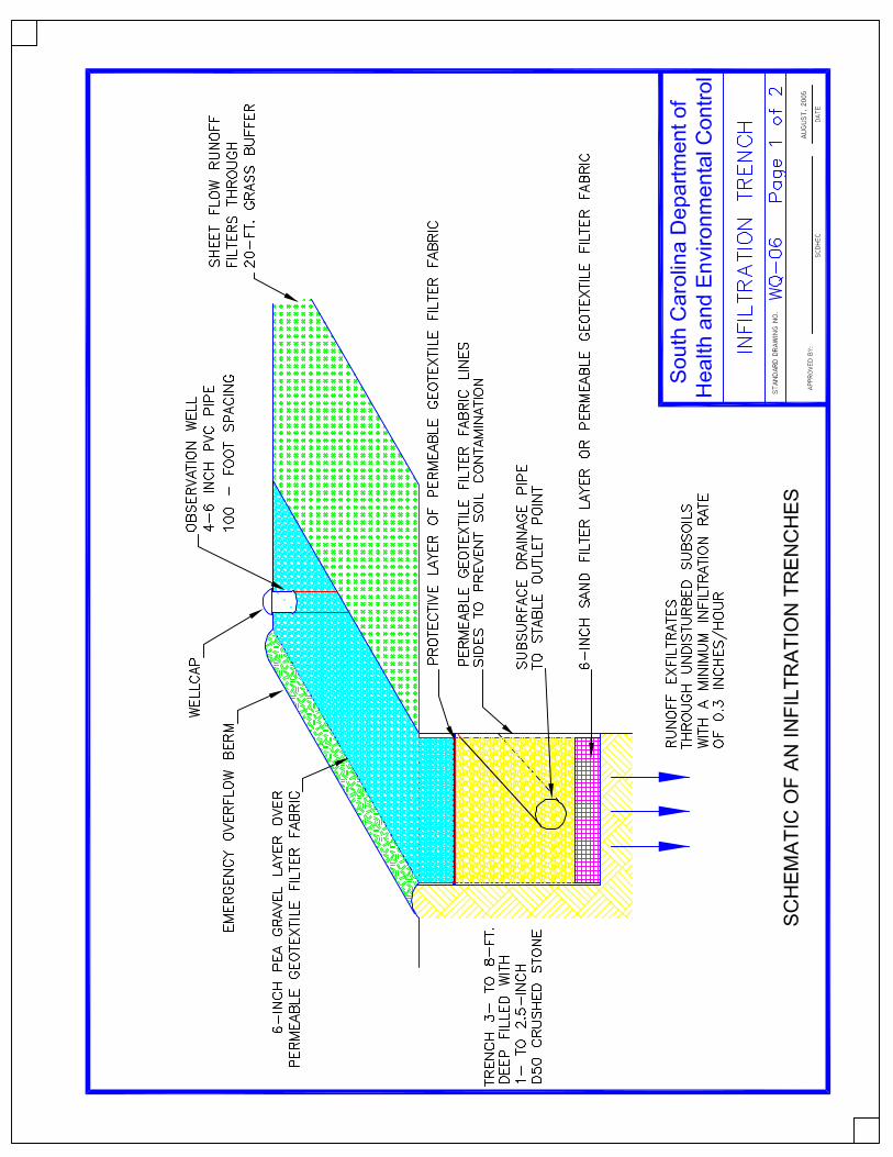
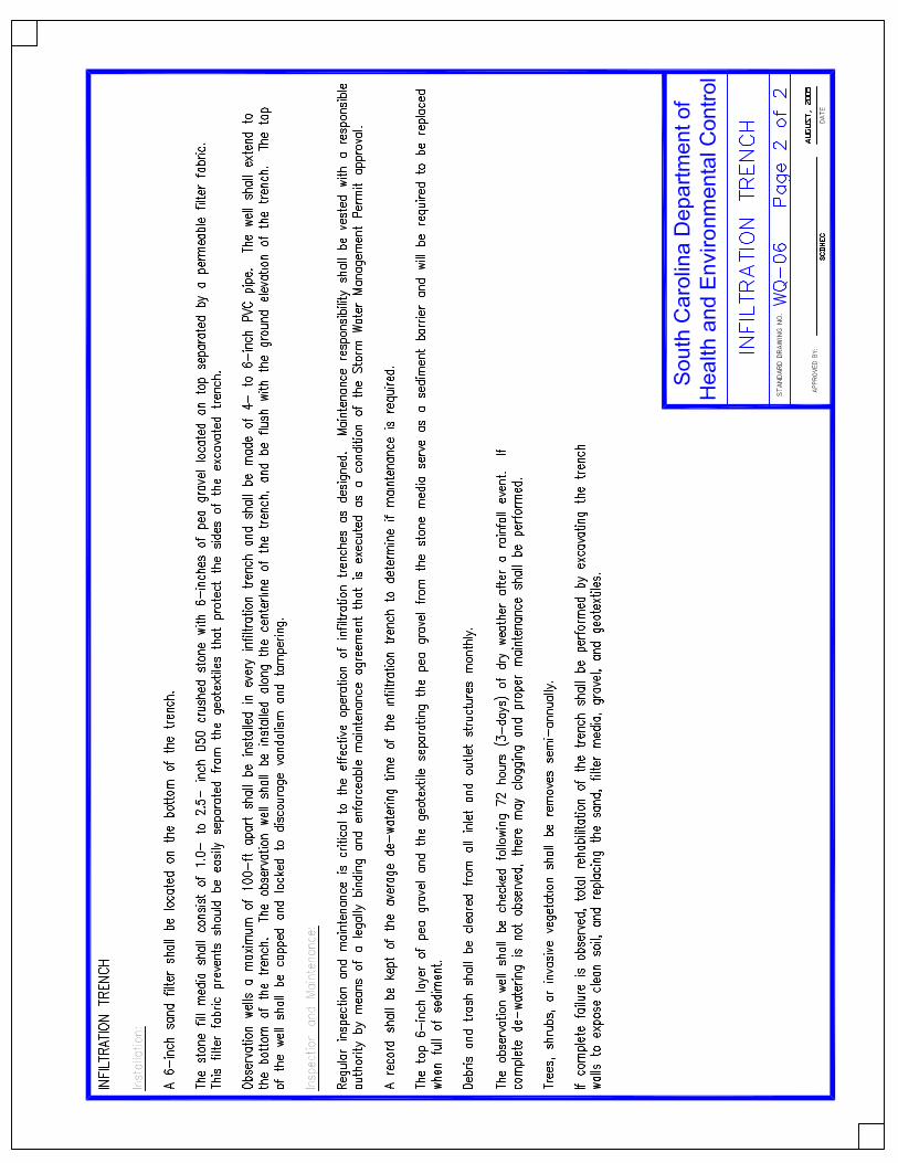
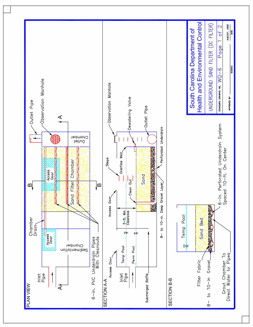
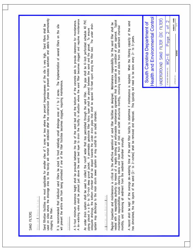
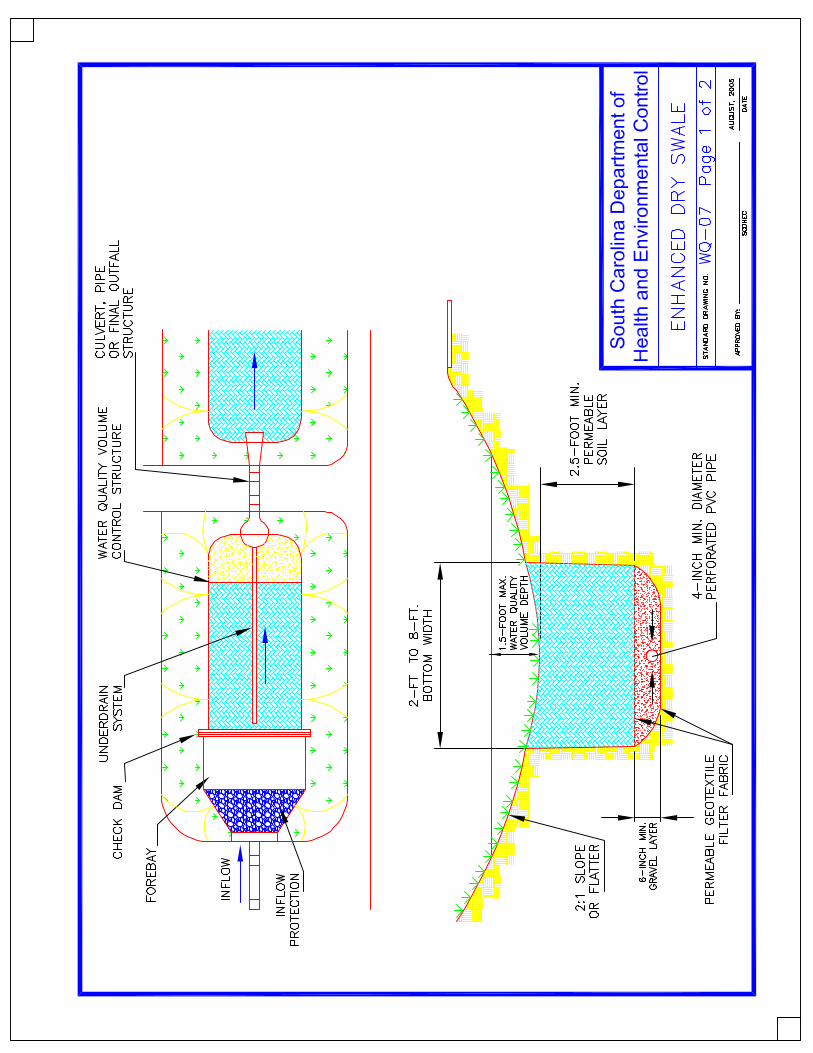


![[XLS]National Account DSD Matrix - SDMX · Web viewUS029 Charleston, WV US030 Charleston-North Charleston, SC US031 Charlotte-Gastonia-Salisbury, NC-SC US032 Chicago-Naperville-Michigan](https://img.pdfslide.us/doc/110x75/5b092df67f8b9a404d8d7006/xlsnational-account-dsd-matrix-sdmx-viewus029-charleston-wv-us030-charleston-north.jpg)