Embed Size (px)
Citation preview
County
Acreage:
Entry Year
Compartment
Compartment Review Presentation
Forest Management UnitAtlanta
61
2015
1,678
Montmorency
Management Area: Kirtland's Warbler
Legal Description:
Identified Planning Goals:
Soil and topography:
Ownership Patterns, Development, and Land Use in and Around the Compartment:
Unique Natural Features:
Archeological, Historical, and Cultural Features:
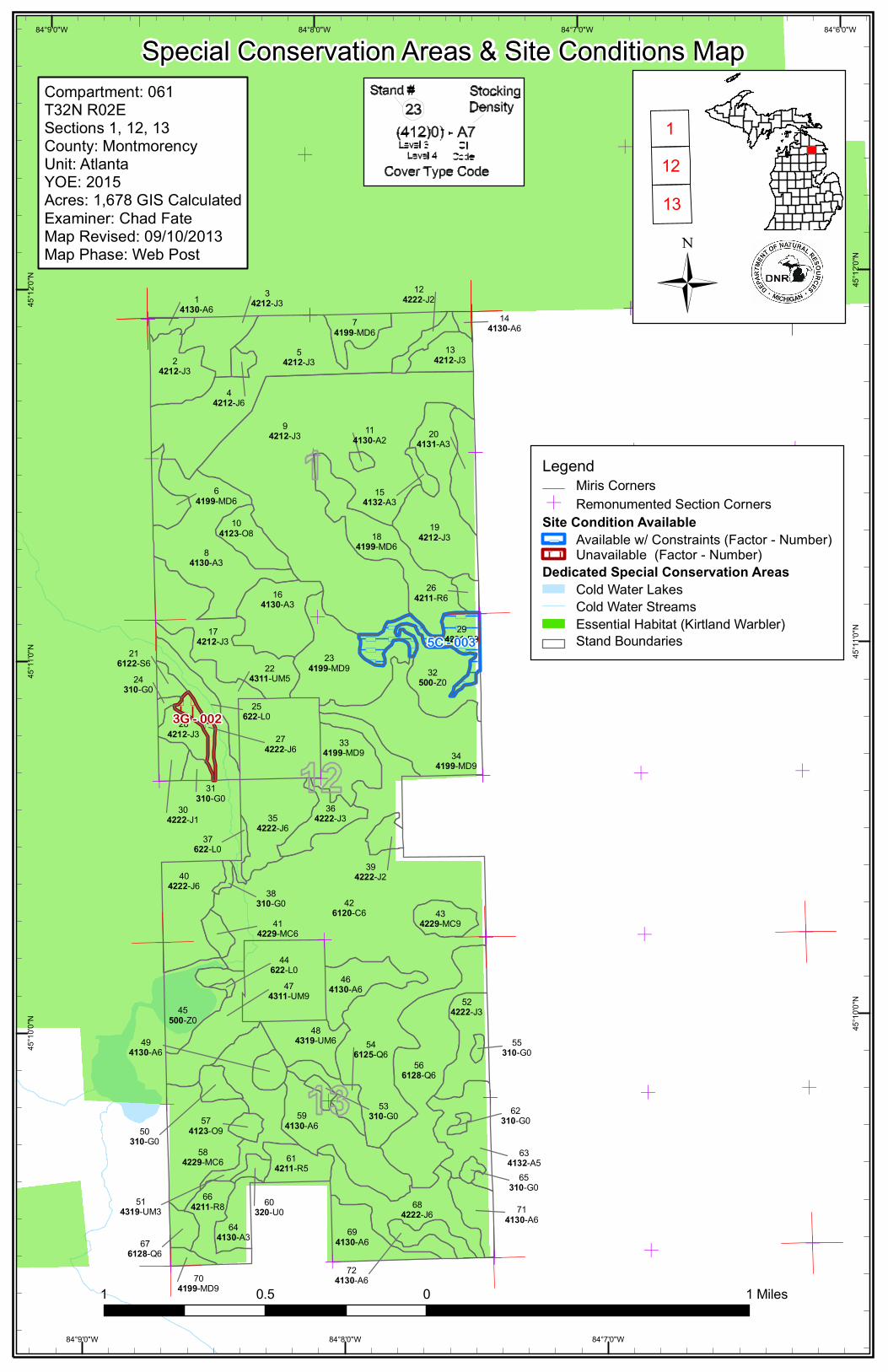
Special Management Designations or Considerations:
Watershed and Fisheries Considerations:
Wildlife Habitat Considerations:
Mineral Resource and Development Concerns and/or Restrictions
Vehicle Access:
Survey Needs:
Recreational Facilities and Opportunities:
Fire Protection:
Sections 1, 12 and 13, T32N-R2E
Timber, Kirtland Warbler and other wildlife habitat, and snowmobile/ORV trails.
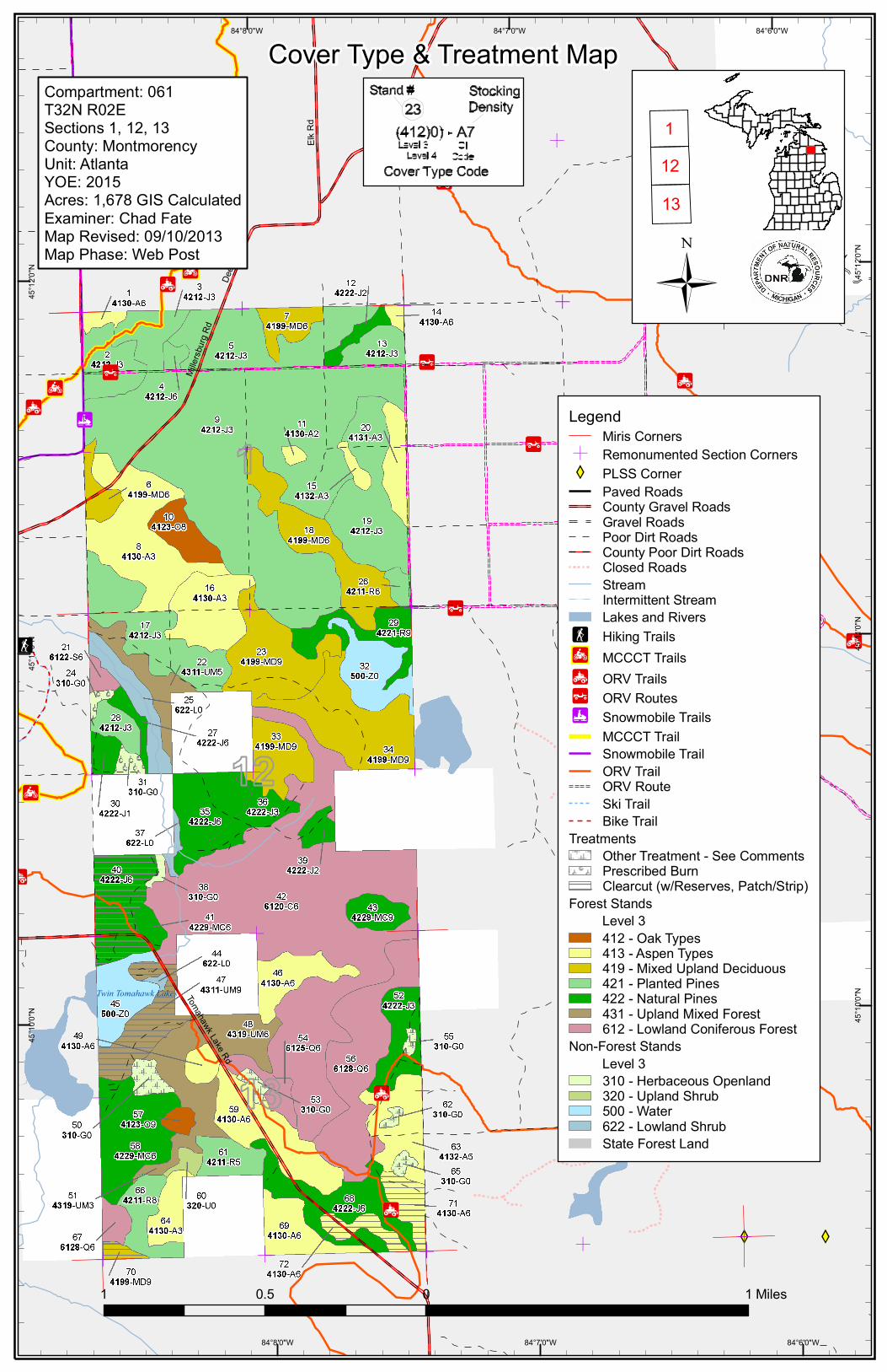
North of Tomahawk Creek the land is broadly rolling with about 80 feet total elevation change. The south is mostly flat, especially the conifer swamps. The northern soils include Grayling, Graycalm, Klacking and Millersburg, and range from excessively drained sand to well drained loamy sand. The southern swamps are mostly Tawas muck, with higher ground being Rubicon, Graycalm, Millersburg and Croswell.
This is part of a large area of state ownership. Several 40 acre inholdings of private property exist.
This area is Kirtland's warbler habitat and also may have the potential of massasauga ratlesnake, red shoulder hawk, goshawk, and others.
No Archeological, Historical, or Cultural Features known.
Kirtland's Warbler management area.
Tomahawk Creek—including one of the Twin Tomahawk Lakes—swings through the central portion of the compartment.
This compartment is part of the Clear Lake Kirtland's Warbler Management Area. As such, Kirtland's warbler is a featured species here along with white-tailed deer and snowshoe hare, which benefit from early successional jack pine habitats in the area. Openings coming in with brush should be maintained with fire, while others in good condition should be planted with food and cover crops for wildlife.
Surface sediments consist of coarse-textured glacial till. The glacial drift thickness varies between 200 and 400 feet. Beneath the glacial drift is the Devonian Antrim Shale and Traverse Group. The Traverse is quarried for limestone and both are quarried for cement products. The nearest gravel pits are located to the west and the potential is considered good. This area has had limited unsuccessful drilling for Niagaran reefs. The Antrim Shale is disappearing or gone in this area and drilling is unlikely. There are no leases for oil & gas in the compartment.
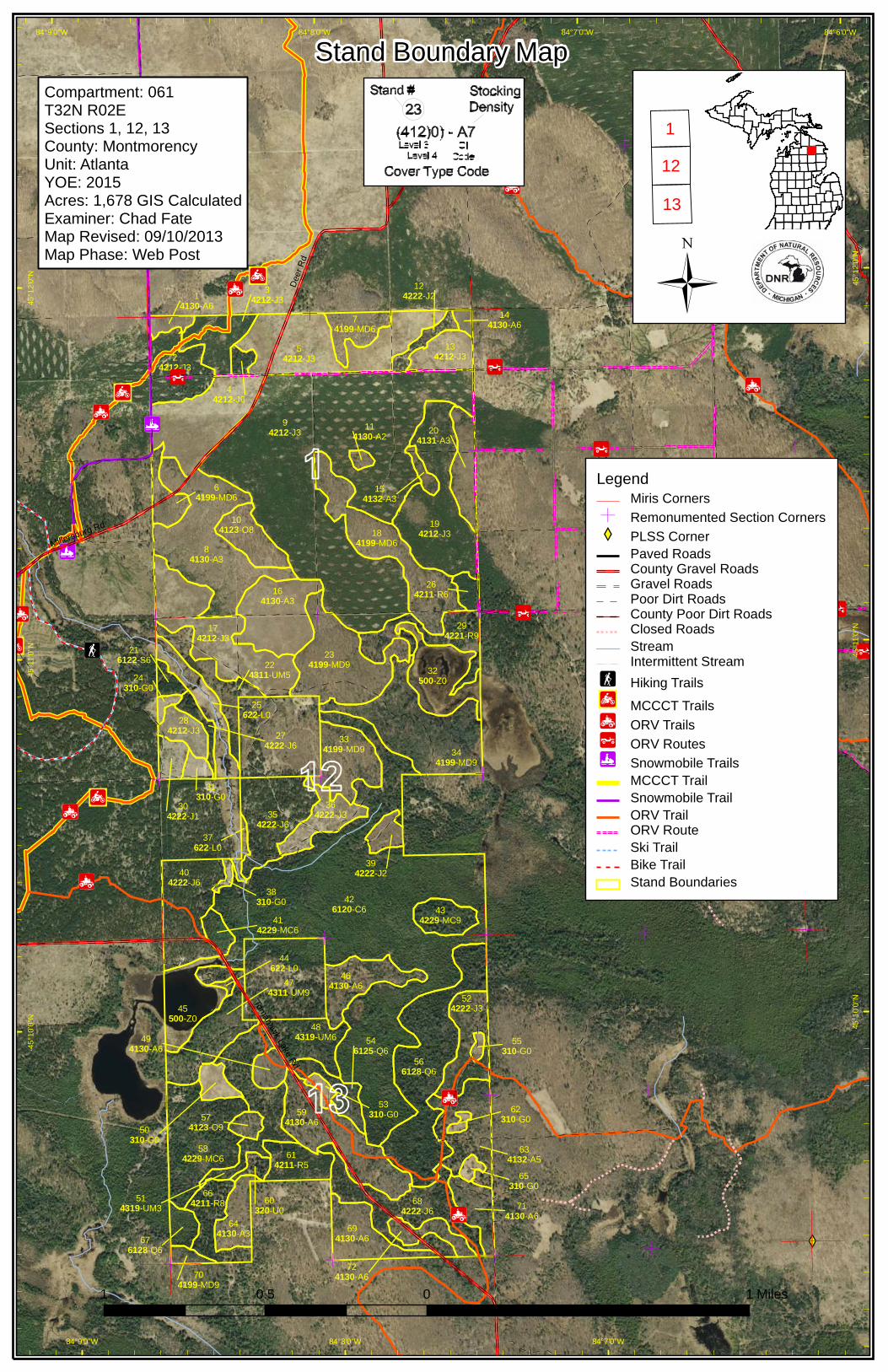
Excellent road access along with numerous two-tracks/fire breaks.
Snowmobile and ORV trails
Many stands of young Jack Pine and dry oak/pine mixed stands. There are numerous fire breaks and two-tracks between
Revision Date: 10/31/2013
Stand Examiner: Chad Fate
09/12/2013 8:33:02 AM - Page 1 of 2 GAMBERGP

Additional Compartment Information:
Jack Pine stands.
The following reports from the Inventory are attached:
Total Acres by Cover Type and Age Class
Cover Type by Harvest Method
Proposed Treatments – No Limiting Factors
Proposed Treatments – With Limiting Factors
Stand Details (Forested and Nonforested)
Dedicated and Proposed Special Conservation Areas
Site Condition Details
The following information is displayed, where pertinent, on the attached compartment maps:
Base feature information, stand boundaries, cover types, and numbers
Proposed treatments
Site condition boundaries
Details on the road access system
09/12/2013 8:33:02 AM - Page 2 of 2 GAMBERGP
Twin Tomahawk Lakes
Deer
Rd
Mertz Rd
Tomahawk Lake Rd
Elk R
d
Miller
sburg
RdBranch Rd
Hubert Rd
Hoffm
eyer
Rd
84°6'0"W
84°6'0"W
84°7'0"W
84°7'0"W
84°8'0"W
84°8'0"W45
°12'0
"N 45°1
2'0"N
45°11
'0"N
45°11
'0"N
45°1
0'0"N 45°1
0'0"N
Cover Type & Treatment Map
LegendMiris CornersRemonumented Section CornersPLSS CornerPaved RoadsCounty Gravel RoadsGravel RoadsPoor Dirt RoadsCounty Poor Dirt RoadsClosed RoadsStreamIntermittent StreamLakes and RiversHiking TrailsMCCCT TrailsORV TrailsORV RoutesSnowmobile TrailsMCCCT TrailSnowmobile TrailORV TrailORV RouteSki TrailBike Trail
TreatmentsOther Treatment - See CommentsPrescribed BurnClearcut (w/Reserves, Patch/Strip)
Forest Stands Level 3
412 - Oak Types413 - Aspen Types419 - Mixed Upland Deciduous421 - Planted Pines422 - Natural Pines431 - Upland Mixed Forest612 - Lowland Coniferous Forest
Non-Forest Stands Level 3
310 - Herbaceous Openland320 - Upland Shrub500 - Water622 - Lowland ShrubState Forest Land
1 0 10.5 Miles
Compartment: 061T32N R02ESections 1, 12, 13 County: MontmorencyUnit: AtlantaYOE: 2015Acres: 1,678 GIS CalculatedExaminer: Chad FateMap Revised: 09/10/2013Map Phase: Web Post
11213
32500-Z024
310-G0
38310-G0
31310-G0
25622-L0
62310-G0
65310-G0
60320-U0
53310-G0
50310-G0
45500-Z0
44622-L0
37622-L0
55310-G0
184199-MD6
294221-R9
134212-J3
694130-A6
566128-Q6
174212-J3
234199-MD9
464130-A6
644130-A3
684222-J6
194212-J3
14130-A6
24212-J3
34212-J3
44212-J6
54212-J3
74199-MD6
124222-J2
114130-A2
94212-J3
154132-A3
204131-A3
64199-MD6
104123-O8
164130-A3
84130-A3
216122-S6 22
4311-UM5
334199-MD9 34
4199-MD9
404222-J6
304222-J1
274222-J6
284212-J3
364222-J3
394222-J2
426120-C6
634132-A5
714130-A6
724130-A670
4199-MD9
676128-Q6
546125-Q6
484319-UM6
574123-O9
584229-MC6
594130-A6
494130-A6
474311-UM9
354222-J6
524222-J3
514319-UM3
144130-A6
264211-R6
414229-MC6
614211-R5
664211-R8
434229-MC9
Dee
r Rd
Mertz Rd
Tomahawk Lake Rd
Elk
Rd
Millersburg Rd
Branch Rd
Hof
fmey
er R
d
84°6’0"W
84°7’0"W
84°7’0"W
84°8’0"W
84°8’0"W
84°9’0"W
84°9’0"W45
°12’
0"N
45°1
2’0"
N
45°1
1’0"
N
45°1
1’0"
N
45°1
0’0"
N
45°1
0’0"
N
LegendMiris CornersRemonumented Section CornersPLSS CornerPaved RoadsCounty Gravel RoadsGravel RoadsPoor Dirt RoadsCounty Poor Dirt RoadsClosed RoadsStreamIntermittent StreamHiking Trails
MCCCT TrailsORV TrailsORV RoutesSnowmobile TrailsMCCCT TrailSnowmobile TrailORV TrailORV RouteSki TrailBike TrailStand Boundaries
Stand Boundary Map
1 0 10.5 Miles
Compartment: 061T32N R02ESections 1, 12, 13 County: MontmorencyUnit: AtlantaYOE: 2015Acres: 1,678 GIS CalculatedExaminer: Chad FateMap Revised: 09/10/2013Map Phase: Web Post
1
12
13
32500-Z024
310-G0
38310-G0
31310-G0
25622-L0
62310-G0
65310-G0
60320-U0
53310-G0
50310-G0
45500-Z0
44622-L0
37622-L0
55310-G0
184199-MD6
294221-R9
134212-J3
694130-A6
566128-Q6
174212-J3
234199-MD9
464130-A6
644130-A3
684222-J6
194212-J3
14130-A6
24212-J3
34212-J3
44212-J6
54212-J3
74199-MD6
124222-J2
114130-A2
94212-J3
154132-A3
204131-A3
64199-MD6
104123-O8
164130-A3
84130-A3
216122-S6 22
4311-UM5
334199-MD9 34
4199-MD9
404222-J6
304222-J1
274222-J6
284212-J3
364222-J3
394222-J2
426120-C6
634132-A5
714130-A6
724130-A670
4199-MD9
676128-Q6
546125-Q6
484319-UM6
574123-O9
584229-MC6
594130-A6
494130-A6
474311-UM9
354222-J6
524222-J3
514319-UM3
144130-A6
264211-R6
414229-MC6
614211-R5
664211-R8
434229-MC9
5C - 003
3G - 002
84°6'0"W
84°7'0"W
84°7'0"W
84°8'0"W
84°8'0"W
84°9'0"W
84°9'0"W45
°12'0
"N 45°1
2'0"N
45°11
'0"N
45°11
'0"N
45°1
0'0"N 45°1
0'0"N
Special Conservation Areas & Site Conditions Map
LegendMiris CornersRemonumented Section Corners
Site Condition AvailableAvailable w/ Constraints (Factor - Number)Unavailable (Factor - Number)
Dedicated Special Conservation AreasCold Water LakesCold Water StreamsEssential Habitat (Kirtland Warbler)Stand Boundaries
1 0 10.5 Miles
Compartment: 061T32N R02ESections 1, 12, 13 County: MontmorencyUnit: AtlantaYOE: 2015Acres: 1,678 GIS CalculatedExaminer: Chad FateMap Revised: 09/10/2013Map Phase: Web Post
11213
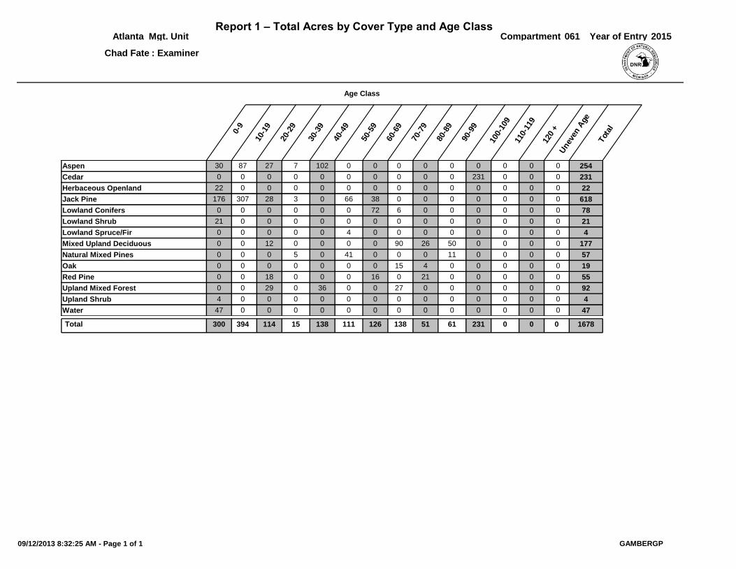
Report 1 – Total Acres by Cover Type and Age ClassCompartmentMgt. Unit
10-1
9
20-2
9
30-3
9
40-4
9
50-5
9
60-6
9
70-7
9
80-8
9
Unev
en A
ge
Tot
al
Year of Entry
Age Class
90-9
9
100-
109
110-
119
120
+0-9
061 2015Atlanta
Chad Fate : Examiner
00Aspen 30 87 27 7 102 0 0 0 0 0 0 2540
00Cedar 0 0 0 0 0 0 0 0 0 0 231 2310
00Herbaceous Openland 22 0 0 0 0 0 0 0 0 0 0 220
00Jack Pine 176 307 28 3 0 66 38 0 0 0 0 6180
00Lowland Conifers 0 0 0 0 0 0 72 6 0 0 0 780
00Lowland Shrub 21 0 0 0 0 0 0 0 0 0 0 210
00Lowland Spruce/Fir 0 0 0 0 0 4 0 0 0 0 0 40
00Mixed Upland Deciduous 0 0 12 0 0 0 0 90 26 50 0 1770
00Natural Mixed Pines 0 0 0 5 0 41 0 0 0 11 0 570
00Oak 0 0 0 0 0 0 0 15 4 0 0 190
00Red Pine 0 0 18 0 0 0 16 0 21 0 0 550
00Upland Mixed Forest 0 0 29 0 36 0 0 27 0 0 0 920
00Upland Shrub 4 0 0 0 0 0 0 0 0 0 0 40
00Water 47 0 0 0 0 0 0 0 0 0 0 470
0 0 0138300 114Total 394 15 138 111 126 51 61 231 1678
09/12/2013 8:32:25 AM - Page 1 of 1 GAMBERGP
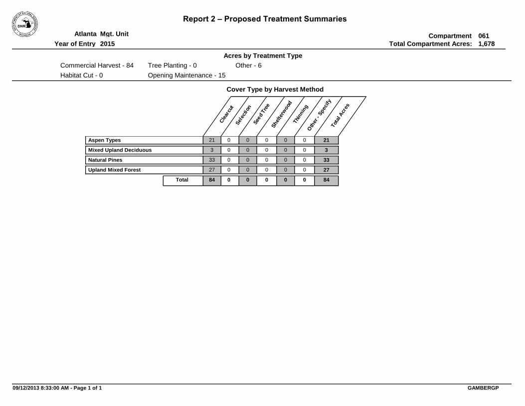
Report 2 – Proposed Treatment Summaries
CompartmentMgt. Unit
Total Compartment Acres:
Cover Type by Harvest Method
Cle
arcu
tSel
ection
See
d Tre
eShel
terw
ood
Thi
nnin
gO
ther
- S
pec
ify
Tot
al A
cres
Acres by Treatment Type
Year of Entry
Atlanta
2015
061
1,678
Commercial Harvest - 84
Habitat Cut - 0
Tree Planting - 0
Opening Maintenance - 15
Other - 6
Aspen Types 21 0 0 0 0 0 21
Mixed Upland Deciduous 3 0 0 0 0 0 3
Natural Pines 33 0 0 0 0 0 33
Upland Mixed Forest 27 0 0 0 0 0 27
84 0Total 0 0 0 0 84
09/12/2013 8:33:00 AM - Page 1 of 1 GAMBERGP
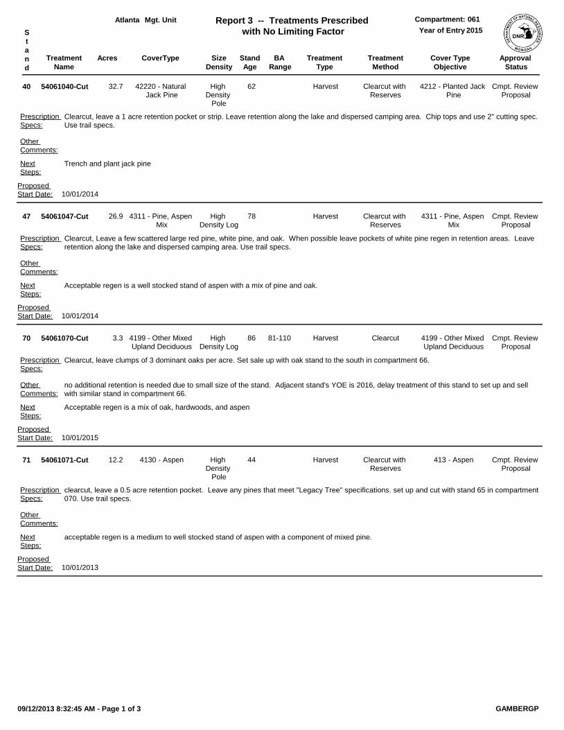
Treatment
Name
Acres Stand
Age
Cover Type
Objective
Size
Density
Treatment
Type
Treatment
Method
CoverType
Mgt. Unit Report 3 -- Treatments Prescribed
with No Limiting Factor
Compartment:
Year of EntryS
t
a
n
d
Approval
Status
BA
Range
Atlanta 061
2015
54061040-Cut 62High Density
Pole
Trench and plant jack pine
4212 - Planted Jack Pine
Harvest Clearcut with Reserves
Clearcut, leave a 1 acre retention pocket or strip. Leave retention along the lake and dispersed camping area. Chip tops and use 2" cutting spec. Use trail specs.
Other Comments:
Prescription Specs:
40 42220 - Natural Jack Pine
NextSteps:
Cmpt. Review Proposal
Proposed Start Date: 10/01/2014
32.7
54061047-Cut 78High Density Log
Acceptable regen is a well stocked stand of aspen with a mix of pine and oak.
4311 - Pine, Aspen Mix
Harvest Clearcut with Reserves
Clearcut, Leave a few scattered large red pine, white pine, and oak. When possible leave pockets of white pine regen in retention areas. Leave retention along the lake and dispersed camping area. Use trail specs.
Other Comments:
Prescription Specs:
47 4311 - Pine, Aspen Mix
NextSteps:
Cmpt. Review Proposal
Proposed Start Date: 10/01/2014
26.9
54061070-Cut 86High Density Log
Acceptable regen is a mix of oak, hardwoods, and aspen
4199 - Other Mixed Upland Deciduous
Harvest Clearcut
no additional retention is needed due to small size of the stand. Adjacent stand's YOE is 2016, delay treatment of this stand to set up and sell with similar stand in compartment 66.
Clearcut, leave clumps of 3 dominant oaks per acre. Set sale up with oak stand to the south in compartment 66.
Other Comments:
Prescription Specs:
70 4199 - Other Mixed Upland Deciduous
NextSteps:
Cmpt. Review Proposal
81-110
Proposed Start Date: 10/01/2015
3.3
54061071-Cut 44High Density
Pole
acceptable regen is a medium to well stocked stand of aspen with a component of mixed pine.
413 - AspenHarvest Clearcut with Reserves
clearcut, leave a 0.5 acre retention pocket. Leave any pines that meet "Legacy Tree" specifications. set up and cut with stand 65 in compartment 070. Use trail specs.
Other Comments:
Prescription Specs:
71 4130 - Aspen
NextSteps:
Cmpt. Review Proposal
Proposed Start Date: 10/01/2013
12.2
09/12/2013 8:32:45 AM - Page 1 of 3 GAMBERGP
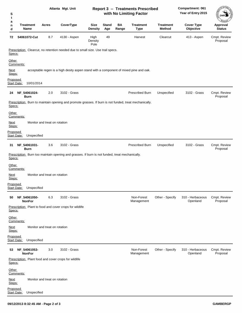
Treatment
Name
Acres Stand
Age
Cover Type
Objective
Size
Density
Treatment
Type
Treatment
Method
CoverType
Mgt. Unit Report 3 -- Treatments Prescribed
with No Limiting Factor
Compartment:
Year of EntryS
t
a
n
d
Approval
Status
BA
Range
Atlanta 061
2015
54061072-Cut 49High Density
Pole
acceptable regen is a high desity aspen stand with a component of mixed pine and oak.
413 - AspenHarvest Clearcut
Clearcut, no retention needed due to small size. Use trail specs.
Other Comments:
Prescription Specs:
72 4130 - Aspen
NextSteps:
Cmpt. Review Proposal
Proposed Start Date: 10/01/2014
8.7
NF_54061024-
Burn
Monitor and treat on rotation
3102 - GrassPrescribed Burn Unspecified
Burn to maintain opening and promote grasses. If burn is not funded, treat mechanically.
Other Comments:
Prescription Specs:
24 3102 - Grass
NextSteps:
Cmpt. Review Proposal
Proposed Start Date: Unspecified
2.0
NF_54061031-
Burn
Monitor and treat on rotation
3102 - GrassPrescribed Burn Unspecified
Burn too maintain opening and grasses. If burn is not funded, treat mechanically.
Other Comments:
Prescription Specs:
31 3102 - Grass
NextSteps:
Cmpt. Review Proposal
Proposed Start Date: Unspecified
3.6
NF_54061050-
NonFor
Monitor and treat on rotation
310 - Herbaceous Openland
Non-Forest Management
Other - Specify
Plant to food and cover crops for wildlife
Other Comments:
Prescription Specs:
50 3102 - Grass
NextSteps:
Cmpt. Review Proposal
Proposed Start Date: Unspecified
6.3
NF_54061053-
NonFor
Monitor and treat on rotation
310 - Herbaceous Openland
Non-Forest Management
Other - Specify
Plant food and cover crops for wildlife
Other Comments:
Prescription Specs:
53 3102 - Grass
NextSteps:
Cmpt. Review Proposal
Proposed Start Date: Unspecified
3.0
09/12/2013 8:32:45 AM - Page 2 of 3 GAMBERGP
Treatment
Name
Acres Stand
Age
Cover Type
Objective
Size
Density
Treatment
Type
Treatment
Method
CoverType
Mgt. Unit Report 3 -- Treatments Prescribed
with No Limiting Factor
Compartment:
Year of EntryS
t
a
n
d
Approval
Status
BA
Range
Atlanta 061
2015
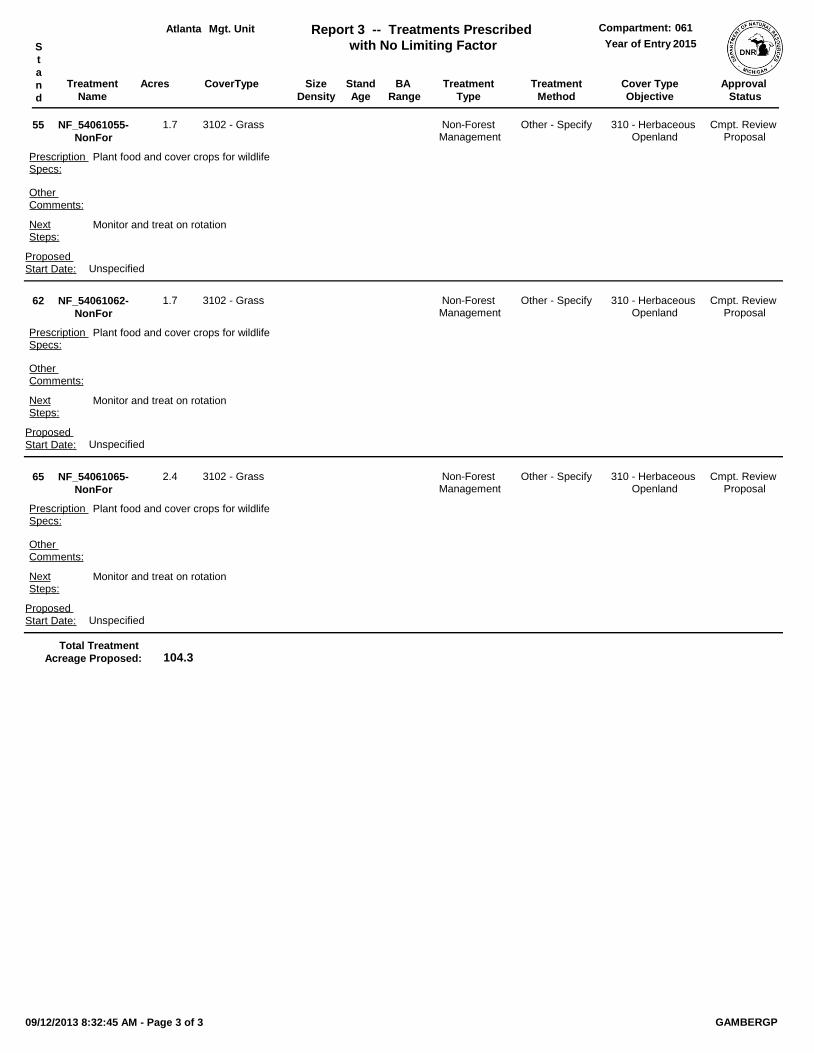
NF_54061055-
NonFor
Monitor and treat on rotation
310 - Herbaceous Openland
Non-Forest Management
Other - Specify
Plant food and cover crops for wildlife
Other Comments:
Prescription Specs:
55 3102 - Grass
NextSteps:
Cmpt. Review Proposal
Proposed Start Date: Unspecified
1.7
NF_54061062-
NonFor
Monitor and treat on rotation
310 - Herbaceous Openland
Non-Forest Management
Other - Specify
Plant food and cover crops for wildlife
Other Comments:
Prescription Specs:
62 3102 - Grass
NextSteps:
Cmpt. Review Proposal
Proposed Start Date: Unspecified
1.7
NF_54061065-
NonFor
Monitor and treat on rotation
310 - Herbaceous Openland
Non-Forest Management
Other - Specify
Plant food and cover crops for wildlife
Other Comments:
Prescription Specs:
65 3102 - Grass
NextSteps:
Cmpt. Review Proposal
Proposed Start Date: Unspecified
2.4
104.3Total Treatment
Acreage Proposed:
09/12/2013 8:32:45 AM - Page 3 of 3 GAMBERGP

Treatment
Name
Acres Stand
Age
Cover Type
Objective
Size
Density
Treatment
Type
Treatment
Method
CoverType
Mgt. Unit Report 4 -- Treatments Prescribed with
a Limiting FactorCompartment:
Year of EntryS
t
a
n
d
Approval
Status
BA
Range
Atlanta 061
2015
OtherComment:
PrescriptionSpecs:
#Type!
NextSteps:
Limiting Factor
Proposed Start Date: #Type!
#Type!
0.0Total Treatment
Acreage Proposed:
09/12/2013 8:32:47 AM - Page 1 of 1 GAMBERGP
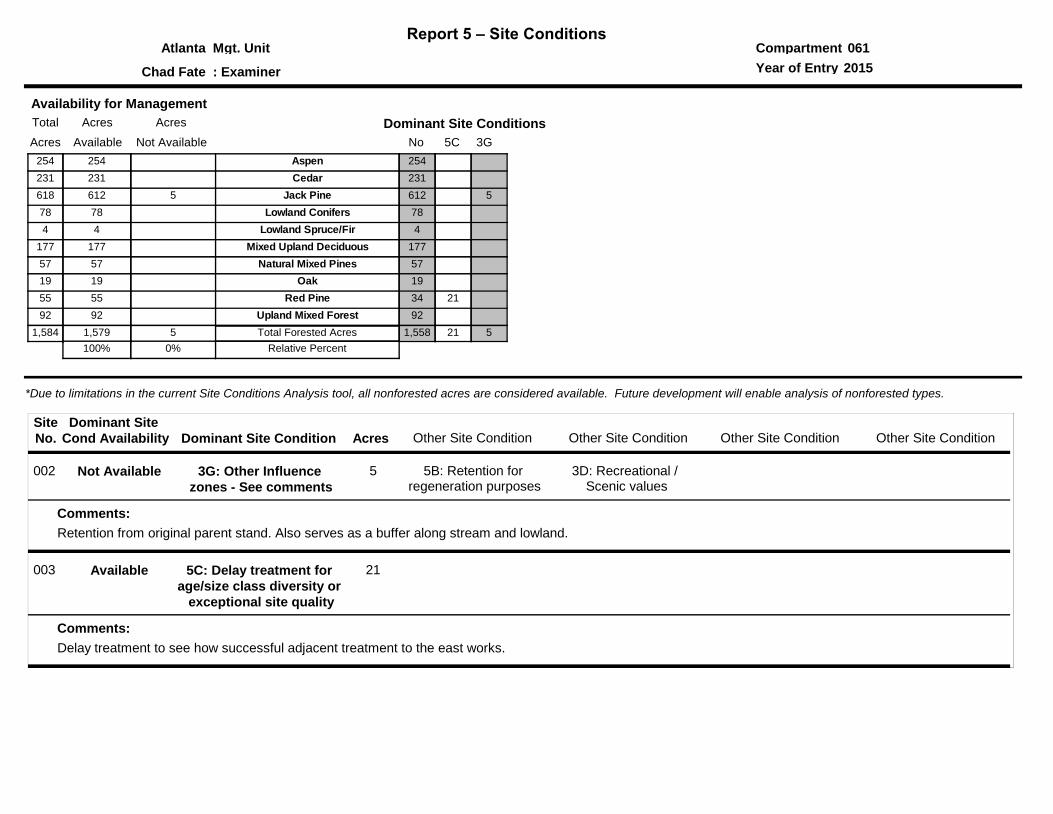
Report 5 – Site ConditionsCompartmentMgt. Unit
Year of Entry: Examiner
061Atlanta
Chad Fate 2015
*Due to limitations in the current Site Conditions Analysis tool, all nonforested acres are considered available. Future development will enable analysis of nonforested types.
No
Dominant Site Conditions
3G5C
Aspen 254
Cedar 231
Jack Pine 612 5
Lowland Conifers 78
Lowland Spruce/Fir 4
Mixed Upland Deciduous 177
Natural Mixed Pines 57
Oak 19
Red Pine 34 21
Upland Mixed Forest 92
1,558 21 5Total Forested Acres
Relative Percent
Dominant Site Condition Acres
Site
No. Other Site Condition Other Site Condition Other Site Condition Other Site ConditionDominant Site
Cond Availability
002 3G: Other Influence
zones - See comments
5B: Retention for regeneration purposes
5
Retention from original parent stand. Also serves as a buffer along stream and lowland.
3D: Recreational / Scenic values
Comments:
Not Available
003 5C: Delay treatment for
age/size class diversity or
exceptional site quality
21
Delay treatment to see how successful adjacent treatment to the east works.
Comments:
Available
Availability for Management
Acres AcresTotal
Available Not AvailableAcres
254254
231231
612 5618
7878
44
177177
5757
1919
5555
9292
1,579 51,584
100% 0%

SCA Category Acres
Mgt. Unit
Report 6 – PROPOSED SPECIAL CONSERVATION AREA* (SCA) DETAILS
Compartment:
Recommendation
* This is a partial list of SCAs for this compartment. Not included are those areas identified under other Department initiatives (Natural Rivers, Deer Wintering Areas, etc.). Those will be identified in separate, future map and report products.
Year of Entry:
SCA Name
Atlanta 061
2015
Detail Type
Comments
09/12/2013 8:32:30 AM - Page 1 of 1 GAMBERGP
Type
Mgt. Unit Compartment:
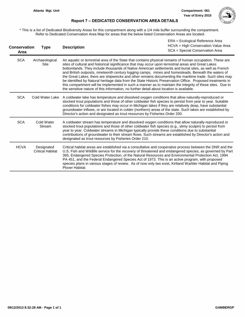
Description
* This is a list of Dedicated Biodiversity Areas for this compartment along with a 1/4 mile buffer surrounding the compartment. Refer to Dedicated Conservation Area Map for areas that the below listed Conservation Areas are located.
Report 7 – DEDICATED CONSERVATION AREA DETAILS
Conservation
Area SCA = Special Conservation Area
HCVA = High Conservation Value Area
ERA = Ecological Reference Area
Year of Entry
Atlanta 061
2015
An aquatic or terrestrial area of the State that contains physical remains of human occupation. These are sites of cultural and historical significance that may occur upon terrestrial areas and Great Lakes bottomlands. They include thousands of Native American settlements and burial sites, as well as French and British outposts, nineteenth century logging camps, mines and homesteads. Beneath the waters of the Great Lakes, there are shipwrecks and other remains documenting the maritime trade. Such sites may be identified by Natural heritage data from the State Historic Preservation Office. Proposed treatments in this compartment will be implemented in such a manner as to maintain the integrity of these sites. Due to the sensitive nature of this information, no further detail about location is available.
Archaeological Site
SCA
A coldwater lake has temperature and dissolved oxygen conditions that allow naturally-reproduced or stocked trout populations and those of other coldwater fish species to persist from year to year. Suitable conditions for coldwater fishes may occur in Michigan lakes if they are relatively deep, have substantial groundwater inflows, or are located in colder (northern) areas of the state. Such lakes are established by Director's action and designated as trout resources by Fisheries Order 200.
Cold Water LakeSCA
A coldwater stream has temperature and dissolved oxygen conditions that allow naturally-reproduced or stocked trout populations and those of other coldwater fish species (e.g., slimy sculpin) to persist from year to year. Coldwater streams in Michigan typically provide these conditions due to substantial contributions of groundwater to their stream flows. Such streams are established by Director's action and designated as trout resources by Fisheries Order 210.
Cold Water Stream
SCA
Critical habitat areas are established via a consultative and cooperative process between the DNR and the U.S. Fish and Wildlife service for the recovery of threatened and endangered species, as governed by Part 365, Endangered Species Protection, of the Natural Resources and Environmental Protection Act, 1994 PA 451, and the Federal Endangered Species Act of 1973. This is an active program, with proposed species plans in various stages of review. As of now only two exist, Kirtland Warbler Habitat and Piping Plover Habitat.
Designated Critical Habitat
HCVA
09/12/2013 8:32:28 AM - Page 1 of 1 GAMBERGP
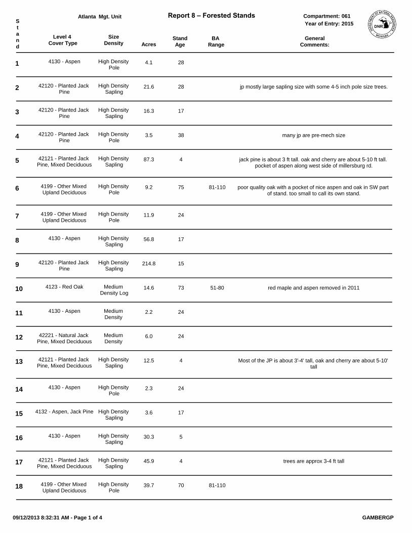
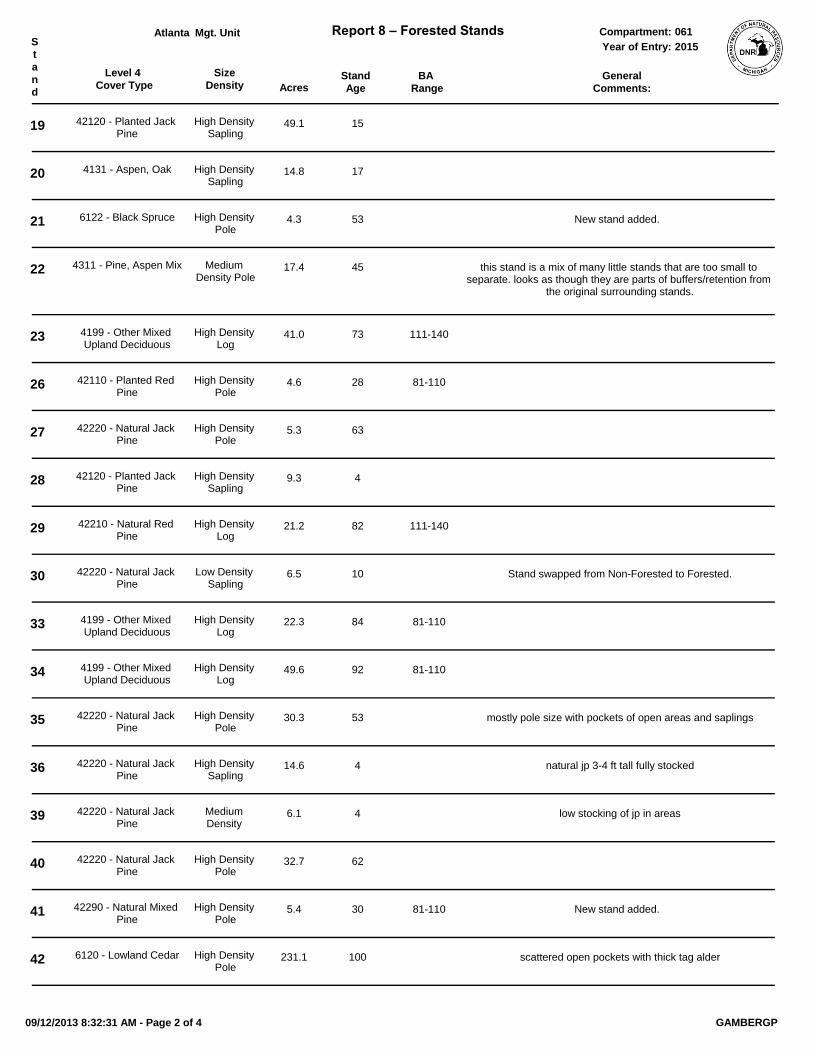
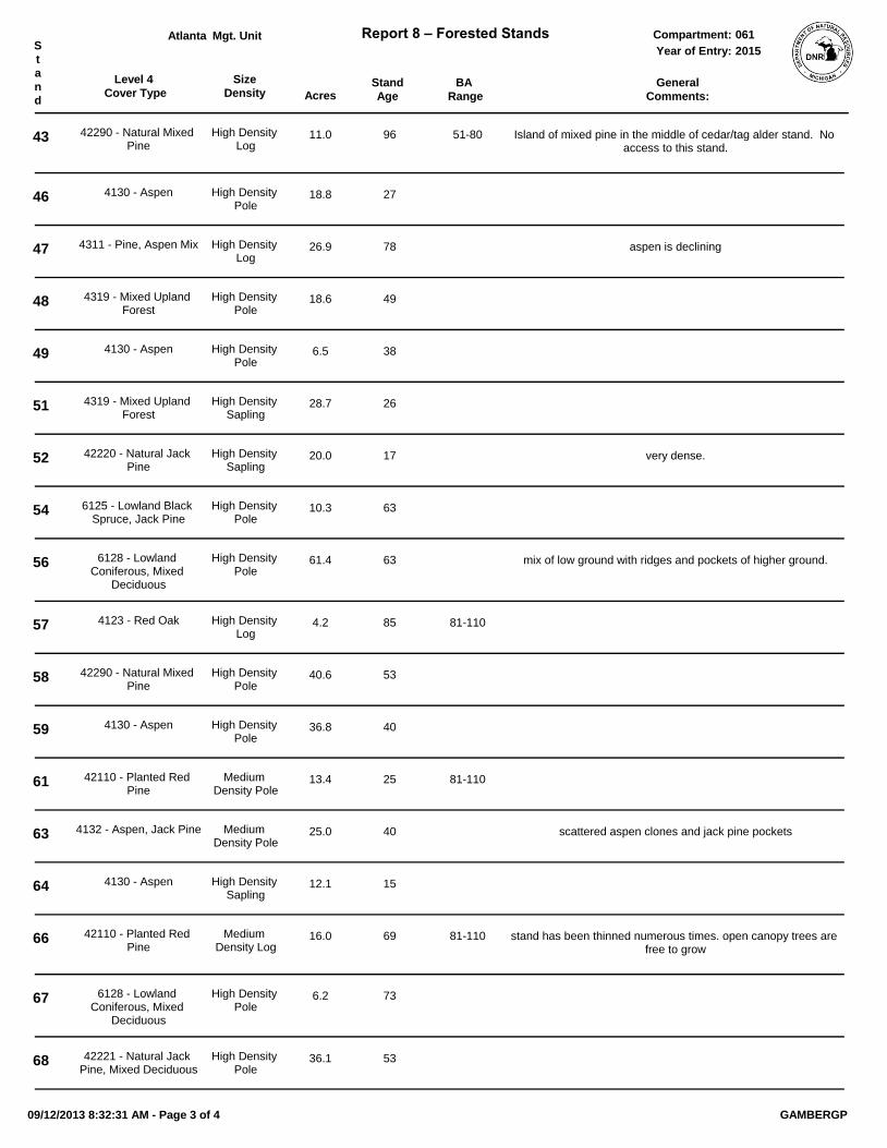
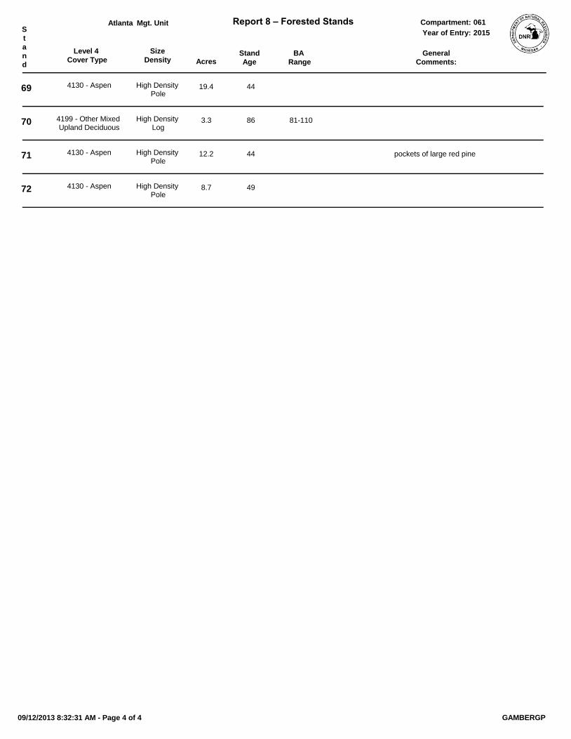
Level 4
Cover Type AcresStand
Age
Size
DensityBA
Range
Mgt. Unit Report 8 – Forested Stands Compartment:S
t
a
n
d
General
Comments:
Year of Entry:
Atlanta 061
2015
1 4130 - Aspen High Density Pole
4.1 28
2 42120 - Planted Jack Pine
High Density Sapling
21.6 28 jp mostly large sapling size with some 4-5 inch pole size trees.
3 42120 - Planted Jack Pine
High Density Sapling
16.3 17
4 42120 - Planted Jack Pine
High Density Pole
3.5 38 many jp are pre-mech size
5 42121 - Planted Jack Pine, Mixed Deciduous
High Density Sapling
87.3 4 jack pine is about 3 ft tall. oak and cherry are about 5-10 ft tall. pocket of aspen along west side of millersburg rd.
6 4199 - Other Mixed Upland Deciduous
High Density Pole
9.2 75 81-110 poor quality oak with a pocket of nice aspen and oak in SW part of stand. too small to call its own stand.
7 4199 - Other Mixed Upland Deciduous
High Density Pole
11.9 24
8 4130 - Aspen High Density Sapling
56.8 17
9 42120 - Planted Jack Pine
High Density Sapling
214.8 15
10 4123 - Red Oak Medium Density Log
14.6 73 51-80 red maple and aspen removed in 2011
11 4130 - Aspen Medium Density
2.2 24
12 42221 - Natural Jack Pine, Mixed Deciduous
Medium Density
6.0 24
13 42121 - Planted Jack Pine, Mixed Deciduous
High Density Sapling
12.5 4 Most of the JP is about 3'-4' tall, oak and cherry are about 5-10' tall
14 4130 - Aspen High Density Pole
2.3 24
15 4132 - Aspen, Jack Pine High Density Sapling
3.6 17
16 4130 - Aspen High Density Sapling
30.3 5
17 42121 - Planted Jack Pine, Mixed Deciduous
High Density Sapling
45.9 4 trees are approx 3-4 ft tall
18 4199 - Other Mixed Upland Deciduous
High Density Pole
39.7 70 81-110
09/12/2013 8:32:31 AM - Page 1 of 4 GAMBERGP
Level 4
Cover Type AcresStand
Age
Size
DensityBA
Range
Mgt. Unit Report 8 – Forested Stands Compartment:S
t
a
n
d
General
Comments:
Year of Entry:
Atlanta 061
2015
19 42120 - Planted Jack Pine
High Density Sapling
49.1 15
20 4131 - Aspen, Oak High Density Sapling
14.8 17
21 6122 - Black Spruce High Density Pole
4.3 53 New stand added.
22 4311 - Pine, Aspen Mix Medium Density Pole
17.4 45 this stand is a mix of many little stands that are too small to separate. looks as though they are parts of buffers/retention from
the original surrounding stands.
23 4199 - Other Mixed Upland Deciduous
High Density Log
41.0 73 111-140
26 42110 - Planted Red Pine
High Density Pole
4.6 28 81-110
27 42220 - Natural Jack Pine
High Density Pole
5.3 63
28 42120 - Planted Jack Pine
High Density Sapling
9.3 4
29 42210 - Natural Red Pine
High Density Log
21.2 82 111-140
30 42220 - Natural Jack Pine
Low Density Sapling
6.5 10 Stand swapped from Non-Forested to Forested.
33 4199 - Other Mixed Upland Deciduous
High Density Log
22.3 84 81-110
34 4199 - Other Mixed Upland Deciduous
High Density Log
49.6 92 81-110
35 42220 - Natural Jack Pine
High Density Pole
30.3 53 mostly pole size with pockets of open areas and saplings
36 42220 - Natural Jack Pine
High Density Sapling
14.6 4 natural jp 3-4 ft tall fully stocked
39 42220 - Natural Jack Pine
Medium Density
6.1 4 low stocking of jp in areas
40 42220 - Natural Jack Pine
High Density Pole
32.7 62
41 42290 - Natural Mixed Pine
High Density Pole
5.4 30 81-110 New stand added.
42 6120 - Lowland Cedar High Density Pole
231.1 100 scattered open pockets with thick tag alder
09/12/2013 8:32:31 AM - Page 2 of 4 GAMBERGP
Level 4
Cover Type AcresStand
Age
Size
DensityBA
Range
Mgt. Unit Report 8 – Forested Stands Compartment:S
t
a
n
d
General
Comments:
Year of Entry:
Atlanta 061
2015
43 42290 - Natural Mixed Pine
High Density Log
11.0 96 51-80 Island of mixed pine in the middle of cedar/tag alder stand. No access to this stand.
46 4130 - Aspen High Density Pole
18.8 27
47 4311 - Pine, Aspen Mix High Density Log
26.9 78 aspen is declining
48 4319 - Mixed Upland Forest
High Density Pole
18.6 49
49 4130 - Aspen High Density Pole
6.5 38
51 4319 - Mixed Upland Forest
High Density Sapling
28.7 26
52 42220 - Natural Jack Pine
High Density Sapling
20.0 17 very dense.
54 6125 - Lowland Black Spruce, Jack Pine
High Density Pole
10.3 63
56 6128 - Lowland Coniferous, Mixed
Deciduous
High Density Pole
61.4 63 mix of low ground with ridges and pockets of higher ground.
57 4123 - Red Oak High Density Log
4.2 85 81-110
58 42290 - Natural Mixed Pine
High Density Pole
40.6 53
59 4130 - Aspen High Density Pole
36.8 40
61 42110 - Planted Red Pine
Medium Density Pole
13.4 25 81-110
63 4132 - Aspen, Jack Pine Medium Density Pole
25.0 40 scattered aspen clones and jack pine pockets
64 4130 - Aspen High Density Sapling
12.1 15
66 42110 - Planted Red Pine
Medium Density Log
16.0 69 81-110 stand has been thinned numerous times. open canopy trees are free to grow
67 6128 - Lowland Coniferous, Mixed
Deciduous
High Density Pole
6.2 73
68 42221 - Natural Jack Pine, Mixed Deciduous
High Density Pole
36.1 53
09/12/2013 8:32:31 AM - Page 3 of 4 GAMBERGP
Level 4
Cover Type AcresStand
Age
Size
DensityBA
Range
Mgt. Unit Report 8 – Forested Stands Compartment:S
t
a
n
d
General
Comments:
Year of Entry:
Atlanta 061
2015
69 4130 - Aspen High Density Pole
19.4 44
70 4199 - Other Mixed Upland Deciduous
High Density Log
3.3 86 81-110
71 4130 - Aspen High Density Pole
12.2 44 pockets of large red pine
72 4130 - Aspen High Density Pole
8.7 49
09/12/2013 8:32:31 AM - Page 4 of 4 GAMBERGP
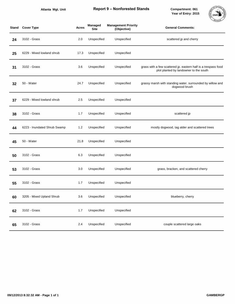
Cover Type Acres
Mgt. Unit Report 9 – Nonforested Stands Compartment:
Stand General Comments:
Year of Entry:
Managed
Site
Management Priority
(Objective)
Atlanta 061
2015
24 2.0 scattered jp and cherry3102 - Grass Unspecified Unspecified
25 17.36229 - Mixed lowland shrub Unspecified Unspecified
31 3.6 grass with a few scattered jp. eastern half is a trespass food plot planted by landowner to the south
3102 - Grass Unspecified Unspecified
32 24.7 grassy marsh with standing water. surrounded by willow and dogwood brush
50 - Water Unspecified Unspecified
37 2.56229 - Mixed lowland shrub Unspecified Unspecified
38 1.7 scattered jp3102 - Grass Unspecified Unspecified
44 1.2 mostly dogwood, tag alder and scattered trees6223 - Inundated Shrub Swamp Unspecified Unspecified
45 21.850 - Water Unspecified Unspecified
50 6.33102 - Grass Unspecified Unspecified
53 3.0 grass, bracken, and scattered cherry3102 - Grass Unspecified Unspecified
55 1.73102 - Grass Unspecified Unspecified
60 3.6 blueberry, cherry3205 - Mixed Upland Shrub Unspecified Unspecified
62 1.73102 - Grass Unspecified Unspecified
65 2.4 couple scattered large oaks3102 - Grass Unspecified Unspecified
09/12/2013 8:32:32 AM - Page 1 of 1 GAMBERGP