Embed Size (px)
Citation preview

CountyAcreage:
Entry YearCompartment
Compartment Review Presentation Forest Management UnitGrayling
7228220191,725Crawford
Management Area: Kirtland's Warbler
Legal Description:
Identified Planning Goals:
Soil and topography:
Ownership Patterns, Development, and Land Use in and Around the Compartment:
Unique Natural Features:
Archeological, Historical, and Cultural Features:
Special Management Designations or Considerations:
Watershed and Fisheries Considerations:
Wildlife Habitat Considerations:
Mineral Resource and Development Concerns and/or Restrictions
Vehicle Access:
Survey Needs:
T27N, R01W, Sections 21, 22, 27, 28, 34 Lovells Township
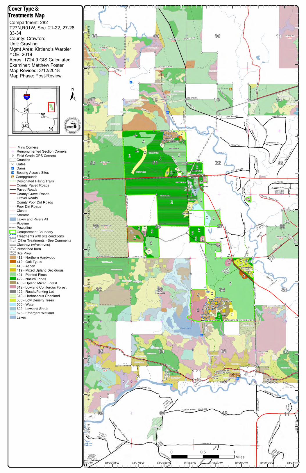
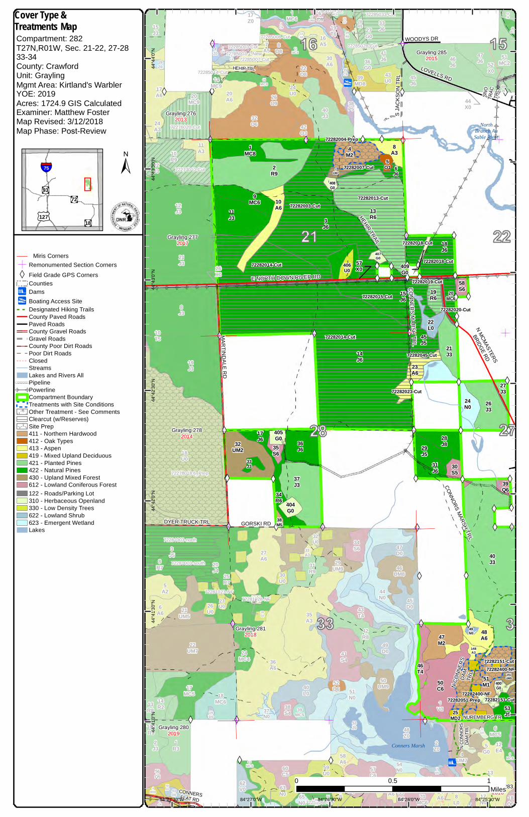
To maintain forest health, productivity, sustainability, and structural diversity by actively managing flora and fauna, while providing for multiple use and visual management. This compartment is a dedicated Dendroica kirtlandii (Kirtland’s warbler) management area. The area is to be managed in order to provide a healthy and sustainable habitat for the endangered Kirtland’s warbler in accordance with Wildlife Division management plans.
Topography is primarily flat with rolling hills in the north. Soils types are Grayling associations with inclusions of Tawas-Leafriver-Lupton and Kinross-Croswell-Au Gres associations. Grayling associations are excessively drained, sandy soils. They are found on outwash plains, kames, and moraines. The other two associations are nearly level, poorly drained, mucky and sandy soils. They are found on outwash plains, stream terraces, and lake plains.
The majority of 27N 01W is State of Michigan ownership. Private ownership can be found along the river corridors. Oil and gas development is present and active south of North Down River Road.
There is potential for dry prairie plants in grassy openings: Hill’s thistle, rough fescue, Alleghany plum, and pale agoseris. There is potential for several animals of concern in this compartment: Kirtland’s warbler, prairie warbler, secretive locust, dusted skipper, grizzled skipper, and the red legged spittle bug.
This compartment contains an old CCC camp. AuSable Camp 681. Old building foundations are still evident.
Compartment 282 is a Kirtland’s Warbler Management Area, these areas are designated High Conservation Value Areas (HCVA). The SW1/4 of Section 34 is involved with the Master Plan of the Conner’s Marsh Flooding.
Kirtland’s warbler and prairie warbler could occur in the young jack pine. Along the Au Sable, there may be eagles, osprey, and great blue heron rookeries. There is potential for dusted skipper, grizzled skipper, and red-legged spittle bug to occur in grassy openings. Secretive locust may occur in bog habitat and surrounding uplands. Blanding’s turtle, wood turtle, and massasauga rattle snake have potential to be found along the drainage ways.
Gravel pits are not located in the area, and sand and gravel potential appears to be low to moderate within the compartment. Most of the state mineral interests in the compartment are currently leased for oil and gas and is part of the Conner’s Marsh Field. The field has produced over 20 Bcf gas from the Ordovician Prairie du Chien (St. Peter Sandstone). There is no known metallic mineral potential in this part of the state.
This compartment is easily accessed by county roads and two-tracks.
A survey request has been submitted for the east edge of stand 58 to establish state/private boundary.
Revision Date: 2017-09-05
Stand Examiner: Matthew Foster
02/13/2018 3:56:03 PM - Page 1 of 2 TONELLOM1

Recreational Facilities and Opportunities:
Fire Protection:
Additional Compartment Information:
A portion of the Midland to Mackinaw Hiking Trail system is present in Section 34 . Sheep Pasture Boating Access site is located north of the compartment in section 16. This area is used heavily for recreational purposes, notably hunting, fishing, bird watching, dispersed camping and snowmobiling. Continue to use forest management techniques to close illegal activity or damage to natural resources.
There is potential for extreme fire events. This compartment has been involved in multiple fire events, including the Stephan Bridge Fire (1990) and the Bald Hill Fire (1975). The North Branch AuSable River provides a natural fire break to the east. This would also be sufficient water source for suppression needs. The area has adequate access for equipment which will be able to use the county roads and forest two-tracks
A large portion of Kirtland’s warbler habitat is scheduled for treatment and planting north and south of North Down River Road this year.
The following reports from the Inventory are attached: Total Acres by Cover Type and Age Class Cover Type by Harvest Method Proposed Treatments – No Limiting Factors Proposed Treatments – With Limiting Factors Stand Details (Forested and Nonforested) Dedicated and Proposed Special Conservation Areas Site Condition Details
The following information is displayed, where pertinent, on the attached compartment maps: Base feature information, stand boundaries, cover types, and numbers Proposed treatments Site condition boundaries Details on the road access system
02/13/2018 3:56:03 PM - Page 2 of 2 TONELLOM1
7 2 2 7 5 0 1 0 - C u t
Conners Marsh
SouthBranch AuSable River
Chub Lake
NorthBranch Au Sable
River
Au SableRiver
72282006-Cut
72282004-Prep
72282003-Cut
72282014-Cut
72282014-Cut
72282023-Cut
72282015-Cut
72282151-Cut
72282019-Cut
72282042-Burn
72282045-Cut
72282018-Cut
72282018-Cut
72282401-NF
72282007-Cut
72282013-Cut
72282051-Prep
72282020-Cut
72282400-NF
H E H I R T R A I L
H I R S C H F I E L DD R
K I R K L A N D D R
BRAC
K HI
LL R
D
S O U T HB I G
C R E E K R D
P O R T E RT R L
C O N N O R S M A R S H T R L
I N D I A N
B E N DT R L
L O N GS H A WT R L
N A S H C A M P R D
C H I M A R R A T R L
A L P E N H O F D R
G E P H A R TT R A I L
A L P I N E D RS J
A CK S
O N T R
L
S C E N I C D R
W I S E M A N T R L
CHAL
ET C
IR
C O N N E R S F L A T R D
P O L L Y T R
S MCM
ASTE
RS B
RIDG
E RD
S P E C K L E D
T R O U T T R L
N O R T H F O R KT R L
K E L L O G G T R L
P O W E L LT R A I L
F E D E R A L
F O R E S T
R O A D 4 0 6 3
H A R O L D S T R L
MIDD
LETO
N TR
L
G R O U S ET R A I L
F E D E R A L
F O R E S T
R O A D 3 0 9 3
I S L A N D S T
N U R E M B E R G T R
N CO
NNOR
SDA
M TR
L
E N O R T H D O W N R I V E R R D
G R A E B N E R T R L
M A R S H
C R E E K T R L
G R O U S ET R L
P O R T E RT R A I L
V ER A
L OG
T RL
N M C M A S T E R S B R I D G E R D
W O O D Y S D R
H E H I R T R L
W H I T EE A G L EB E N D T R L
C A R R I E L N
GAR B
E R T R
L
ERMI
NE TR
N U R E M B E R B T RN U R E N B E R G R D
F E D E R A LF O R E S T
R O A D 1 1 0 2
C ON N
O RS
F LA T
B AS A
C CE S
SR O
A D
F E R N W O O D D R
N O R T H B I GC R E E K R D
G O R S K I R D
C R E E K V I E W D R
M A R T I N D A L E R D
D EN N
I S T R
L
S P E N C E R T R L
C R O O K E D T R L
F E D E R A L F O R E S T R O A D 4 0 6 2
R A I N B O W B E N DS F C A C C E S S R O A D
ERM IN E T R A I L
C O N N E R S
M A R S HT R A I L
S U N R I S E R D
H E M L O C K D R
H E N R Y S T
M O R L E Y R D
W Y N N E W O O D R D
S S U N R I S E R D
S L I D E A W A Y S T R L
C H E R R Y C R E E K R D
NEA F
IE T R
L
P R I V A T E L N
H I B A N K S R D
F E D E R A L F O R E S T R O A D 4 0 3 0
F E D E R A L F O R E S T R O A D 1 1 0 0
L O V E L L S R D
F E D E R A LF O R E S TR O A D 1 1 0 1
N CO N N
E RS
D AM T R
L
S N O T R A C T R L
T I MB E R L A N E T R L
D Y E R T R U C K T R L
CO N N E R SM A R S H T R L
F E D E R A L FO R E S T R
O A D 3 09 4
S AW
M IL L
T RA I L
S Y L V E S T E R T R L
7 2 2 7 4 0 3 5 - C u t
7 2 2 7 6 0 2 0 - C u t
7 2 2 8 3 0 1 6 - c c r
7 2 2 8 3 0 2 7 - c c r
7 2 2 8 3 0 3 0 - c c r7 2 2 8 3 0 5 0 - c c r
7 2 2 8 5 0 0 3 - C u t
7 2 2 8 5 0 0 7 - C u t
7 2 2 8 5 0 0 8 - C u t
7 2 2 8 5 0 1 0 - P r e p
7 2 2 8 5 0 1 1 - C u t
7 2 2 8 5 0 1 4 - C u t
7 2 2 8 5 0 2 8 - C u t7 2 2 8 5 0 3 3 - C u t
7 2 2 8 3 0 3 4 - s a lv a g e
7 2 2 8 3 0 3 5 - h a b i t a t c u t
7 2 2 7 7 0 1 0 - C u t
7 2 2 8 5 0 0 3 - 1 - N e w
7 2 2 7 4 0 3 7 - M o n i t o r
7 2 2 7 4 0 3 4 - M o n i t o r
7 2 2 7 5 0 2 7 - C u t
7 2 2 7 5 0 0 2 - C u t
7 2 2 8 1 0 0 3 - n o r t h
7 2 2 8 1 0 0 9 - c c r
7 2 2 8 1 0 6 4 - c c r
7 2 2 8 1 0 7 6 - c c r
7 2 2 8 1 0 7 9 - c c r
7 2 2 8 1 0 2 3 - N F 7 2 2 8 1 0 2 8 - N F
7 2 2 8 1 0 6 6 - N F
7 2 2 7 5 0 1 7 - O t h e r
7 2 2 8 1 0 5 9 - P r e p
7 2 2 8 1 0 1 6 - N F
7 2 2 8 1 0 0 3 - s o u t h
7 2 2 8 5 0 6 5 - M o n i t o r
7 9 0 5 0 0 4 0 0 3 - C u t
7 2 2 8 3 0 1 9 - M o n i t o r
7 2 2 7 8 0 1 8 . 6 _ P r e p
7 2 2 8 5 0 6 6 - M o n i t o r7 2 2 8 5 0 5 6 - S p r a y
409G0
12MC6
401G0
57X0
G r a y l i n g 2 7 42 0 1 6
G r a y l i n g 2 7 52 0 1 8
G r a y l i n g 2 7 62 0 1 3
G r a y l i n g 2 7 72 0 1 7
G r a y l i n g 2 7 82 0 1 4
G r a y l i n g 2 8 02 0 1 9
G r a y l i n g 2 8 12 0 1 8
G r a y l i n g 2 8 32 0 1 6
G r a y l i n g 2 8 42 0 1 8
G r a y l i n g 2 8 52 0 1 5
G r a y l i n g 2 8 62 0 2 0
22L045
J5
406U0
42U0
19R6
2R9
5O1
59MC6
25MD2
8A3
51M1
31J6
48A6
11J3
28J8
34R6
20MC6
14J6
37J3
40J3
404G0
148A3
407G0
43O7
49N0
3J6
6J6
29J5
23A6
46T4
26J3
35S6
15J6
9MC6
55Z0
52A1
58S6
32UM2
18J6
41S5
17J6
405G0
1MC8
151UM9
21J3
44Q5
402G0
24N0
38M5
47M2
10A6
27J3
408G0
50C6
4M2
7UM7
30S5
39Q6
53J5
33J3
400G0
13R6
36J6
8 4 ° 2 4 '0 " W8 4 ° 2 4 '3 0 " W8 4 ° 2 5 '0 " W8 4 ° 2 5 '3 0 " W8 4 ° 2 6 '0 " W8 4 ° 2 6 '3 0 " W8 4 ° 2 7 '0 " W8 4 ° 2 7 '3 0 " W8 4 ° 2 8 '0 " W
44°4
5'0"N
44°4
4'30"N
44°4
4'0"N
44°4
3'30"N
44°4
3'0"N
44°4
2'30"N
44°4
2'0"N
44°4
1'30"N
44°4
1'0"N
44°4
0'30"N
44°4
0'0"N
44°3
9'30"N
0 10 . 5M i l e s
Miris CornersÓ Remonumented Section Corners W Field Grade GPS Corners
CountiesD Gatesn Damsy Boating Access Sites 9"Campgrounds
Designated Hiking Trails County Paved RoadsPaved RoadsCounty Gravel RoadsGravel RoadsCounty Poor Dirt RoadsPoor Dirt RoadsClosedStreamsLakes and Rivers All
\\\\\\\\PipelineA A Powerline
Compartment Boundary Treatments with site conditions Other Treatments - See Comments Ckearcyt (w/reserves) Perscribed burnSite Prep 411 - Northern Hardwood 412 - Oak Types413 - Aspen 419 - Mixed Upland Deciduous 421 - Planted Pines422 - Natural Pines430 - Upland Mixed Forest612 - Lowland Coniferous Forest122 - Roads/Parking Lot310 - Herbaceous Openland330 - Low Density Trees500 - Water622 - Lowland Shrub623 - Emergent WetlandLakes
§̈¦75
"!(93"!(72
"!(18£¤127
±
Cover Type &Treatments MapCompartment: 282T27N,R01W, Sec. 21-22, 27-28 33-34County: CrawfordUnit: GraylingMgmt Area: Kirtland's Warbler YOE: 2019Acres: 1724.9 GIS Calculated Examiner: Matthew Foster Map Revised: 3/12/2018Map Phase: Post-Review
NorthBranch AuSable River
Conners Marsh
72282004-Prep
72282003-Cut
72282014-Cut
72282014-Cut
72282023-Cut
72282015-Cut
72282151-Cut
72282151-Cut
72282019-Cut
72282045-Cut
72282018-Cut
72282018-Cut
72282007-Cut
72282013-Cut
72282051-Prep
72282020-Cut
72282400-NF
72282400-NF
HEHIR TRAIL
CONNORS MARSH TRL
SNO
TRAC
TRL
S JAC
KSON
TRL
NUREMBERG TR
N CON
NORS
DAM
TRL
E NORTH DOWN RIVER RD
WOODYS DR
HEHIR TRL
CONNERSFLAT RD
GORSKI RD
MARTINDALE RD
DYER TRUCK TRL
LOVELLS RD
N CON
NERS
DAM
TRL
CONNERS MARSH TRL
N MCMASTERS
BRIDGE RD
72276020-Cut
72285003-Cut
72285007-Cut
72285008-Cut
72285011-Cut
72285014-Cut
72285028-Cut
72285033-Cut
72277010-Cut
72285003-1-New
72281003-north
72281064-ccr
72281023-NF72281028-NF
72281066-NF
72281003-south
72278018.6_Prep
Grayling 2762013
Grayling 2772017
Grayling 2782014
Grayling 2802019
Grayling 2812018
Grayling 2832016
Grayling 2852015
22L0
45J5
406U0
19R6
2R9
5O1
25MD2
8A3
51M1
31J6
48A6
11J3
28J8
34R6
20MC6
14J6
37J3
40J3
404G0
148A3
407G0
49N0
3J6
6J6
29J5
23A6
46T4
26J3
35S6
15J6
9MC6
58S6
32UM2
18J6
17J6
405G0
1MC8
151UM9
21J3
24N0
38M5
47M2
10A6
27J3
408G0
50C6
4M2
7UM7
30S5
39Q6
53J5
33J3
400G0
13R6
36J6
45J6
40L0
51MC2
28G0
19Z0
38S4
5L0
19J3
13A6
2C9 48
MC8
24MC4
8O8
28R6
32U0
10Q8
59U0
45D0
8J3
61MC6
1R3
19D0
30U0
18Q5
50UM9
2Z0
14MC9
11A3
26U0
4MD8
20A6
57C6
3Q4
17A6
43U0
5A2
7V0
25R7
54N0
21J3
23O7
66G0
35A3
40J3
55C5
14R2
33A3
49J6
49D0
23U0
29R9
11S6
17MC5
46J6
20MC9
39MC5
32O6
6C6
26O9
29UM9
12MC8
2J3
34S6
65N0
3J5
35C9
15MC8
12J3
5Q6
60C5
38P5
46UM8
6A6
4UM7
18MC9
18U0
47J6
24U0
1MC6
22UM7
42R8
41J6
15J3
9MC9
69S6
53Z0
37N0
36A6
4Z0
22J3
18MC6
52O6
43D0
33J6
7A5
10R9
27A6
13G0
47D0
14A6
31R9
62V0
50J6
30A6
3G048
Z0
22O8
64J6
43T4
39MD8
51N0
56A6
19T6
56Q5
44N0
58A6
20J4
41S4
42O3
21UM5
6MC5
16A5
67J5 8
L0
13R8
70MC6
50X0
8R7
11UM8
17Z0
63N0
26X0
5G0
52X0
102R9
1V0
24A3
27G0
44X0
12E4
17N0
36G0
10T5
409G0
57X0
84°25'30"W84°26'0"W84°26'30"W84°27'0"W84°27'30"W
44°4
4'0"N
44°4
3'30"N
44°4
3'0"N
44°4
2'30"N
44°4
2'0"N
44°4
1'30"N
44°4
1'0"N
0 10.5Miles
Miris CornersÓ Remonumented Section CornersXW Field Grade GPS Corners
Counties"n Dams"y Boating Access Site
Designated Hiking TrailsCounty Paved RoadsPaved RoadsCounty Gravel RoadsGravel RoadsCounty Poor Dirt RoadsPoor Dirt RoadsClosedStreamsLakes and Rivers All
\\\\\PipelineA APowerline
Compartment BoundaryTreatments with Site ConditionsOther Treatment - See CommentsClearcut (w/Reserves)Site Prep411 - Northern Hardwood412 - Oak Types413 - Aspen419 - Mixed Upland Deciduous421 - Planted Pines422 - Natural Pines430 - Upland Mixed Forest612 - Lowland Coniferous Forest122 - Roads/Parking Lot310 - Herbaceous Openland330 - Low Density Trees622 - Lowland Shrub623 - Emergent WetlandLakes
§̈¦75
"!(93"!(72
"!(18£¤127
±
Cover Type &Treatments MapCompartment: 282T27N,R01W, Sec. 21-22, 27-28 33-34County: CrawfordUnit: GraylingMgmt Area: Kirtland's Warbler YOE: 2019Acres: 1724.9 GIS Calculated Examiner: Matthew FosterMap Revised: 3/12/2018Map Phase: Post-Review

72283027-ccr
Conners Marsh
NorthBranch Au Sable
River
Au SableRiver
72282006-Cut
72282004-Prep
72282003-Cut
72282014-Cut
72282014-Cut
72282023-Cut
72282015-Cut
72282151-Cut
72282019-Cut
72282045-Cut
72282018-Cut
72282018-Cut
72282007-Cut
72282013-Cut
72282051-Prep
72282020-Cut
72282400-NF
HEHIR TRAILE NORTH DOWN RIVER RD
KIRKLAND DR
CONNORS MARSH TRL
SPECKLED
TROUT TRL
HEHIRTRL
ISLANDST
S JAC
KSON
TRL
HEMLOCK
DR
NORTHFORK TRL
KELLOGG TRL
HAROLDS TRLMI
DDLE
TON
TRL
NUREMBERG TR
N CONNORSDAMTRL
CHERRYCREEK RD
GRAE
BNER
TRL
GROUSETR
L
N MCMASTERS BRIDGE RD
WOODYS DR
MORLEY RD
GARB
ER TR
L
ERMI
NE TR
NUREMBERB TRNURENBERG RD
HENRY ST
SCEN
IC D
R
CREEKVIEW DR
CROOKED TRL
SAWM
ILLTR
AIL
ERMINE TRAIL
CONNERS
MARSHTRAIL
WYNNEWOOD RD
NEAF
IE TR
L
PRIVATE LN
LOVELLS RD
N CON
NERS
DAM
TRL
SNO
TRAC
TRL
CONNERS MARSH TRL
72285008-Cut
72285011-Cut
72285028-Cut72285033-Cut
72283035-habitat cut
72281064-ccr
72281066-NF
72283019-Monitor
72285056-Spray
45J6
40L0
51MC2
38S4
13A6
48MC8
8O8
28R6
32U0
10Q859
U0 15C6
45D0
11UM8
54MC6
35A4
30U0
18Q5
50UM9
57J5
2Z0
57C6
43U0
24J1
12J6
7V0
54N0
23O7
35A3
40J3
63MC6
78R8
55C5
33A3
49J6
49D0
29R9
11S6
46J6
39MC5
33Q4
32O6
6C6
26O9
29UM9
12MC8
34S6
65N0
19U0
58J6
35C9
60C5
38P5
46UM8
4UM7
18MC9
47J6
24U0
1MC6
42R8
41J6
9MC9
69S6
53Z0
36A6
25D0
67Q9
12E4
52O6
33J6
56G0
13G0
47D0
14A6
31R9
50J6
30A6
53J4
3G048
Z0
22O8
64J6
43T4
39MD8
51N0
62J6
56A6
19T6
44N0
58A6
20A5
41S4
42O3
59J6
23U0
6MC5
16A5
32N0
8L0
2C9
38L0
17Z0
60X0
66G0
5G0
52X0
1V0
22V0
55U027
G0
44X0
17N0
27A6
26D0
36G0
22L0
45J5
406U0
42U0
19R6
2R9
5O1
59MC6
25MD2
8A3
51M1
31J6
48A6
28J8
34R6
20MC6
14J6
37J3
40J3
404G0
148A3
407G0
43O7
49N0
3J6
6J6
29J5
23A6
46T4
26J3
15J6
55Z0
52A1
58S6
18J6
41S5
1MC8
151UM9
21J3
44Q5
402G0
24N0
47M2
27J3
408G0
50C6
4M2
7UM7
30S5
39Q6
53J5
400G0
13R6
36J6
Grayling 2812018
Grayling 2832016
Grayling 2842018
Grayling 2852015
409G0
12MC6
401G0
35S6
57X0
405G0
38M5
10A6
84°24'30"W84°25'0"W84°25'30"W84°26'0"W84°26'30"W
44°4
4'0"N
44°4
3'30"N
44°4
3'0"N
44°4
2'30"N
44°4
2'0"N
44°4
1'30"N
44°4
1'0"N
0 10.5Miles
Miris CornersÓ Remonumented Section CornersXW Field Grade GPS Corners
Counties"n Dams"y Boating Access Site"9 Campground
Designated Hiking TrailsCounty Paved RoadsPaved RoadsCounty Gravel RoadsGravel RoadsPoor Dirt RoadsClosedStreamsLakes and Rivers All
\\\\\PipelineA APowerline
Compartment BoundaryTreatments with Site ConditionsOther Treatment - See CommentsClearcut (w/Reserves)Prescribed BurnSite Prep411 - Northern Hardwood412 - Oak Types413 - Aspen419 - Mixed Upland Deciduous421 - Planted Pines422 - Natural Pines430 - Upland Mixed Forest612 - Lowland Coniferous Forest122 - Roads/Parking Lot310 - Herbaceous Openland330 - Low Density Trees500 - Water622 - Lowland Shrub623 - Emergent WetlandLakes
§̈¦75
"!(93"!(72
"!(18£¤127
±
Cover Type &Treatments MapCompartment: 282T27N,R01W, Sec. 21-22, 27-28 33-34County: CrawfordUnit: GraylingMgmt Area: Kirtland's Warbler YOE: 2019Acres: 1724.9 GIS Calculated Examiner: Matthew FosterMap Revised: 3/12/2018Map Phase: Post-Review

Conners Marsh
NorthBranch AuSable River
HEHIRTRAIL
CONNORS MARSH TRL
SNO
TRAC
TRL
S JAC
KSON
TRL
NUREMBERG TR
N CONNORSDAMTRL
E NORTH DOWN RIVER RD
WOODYS DR
HEHIR TRL
CONNERSFLAT RD
GORSKI RD
MARTINDALE RD
DYER TRUCK TRL
LOVELLS RD
N CON
NERS
DAM
TRL
CONNERSMARSH
TRL
N MCMASTERS BRIDGE RD
409310 - G0
406330 - U0
54125 - O1
254199 - MD2
3442210 - R6
2042250 - MC6
1484130 - A3
407310 - G0
49623 - N0
642220 - J6
466121 - T4
356122 - S6
57122 - X0
1514310 - UM9
384113 - M5
2742121 - J3
74310 - UM7
3342220 - J3
45J6
40L0
51MC2
28G0
19Z0
38S4
5L0
19J3
13A6
2C9 48
MC8
24MC4
8O8
28R6
32U0
10Q8
59U0
45D0
8J3
61MC6
1R3
19D0
30U0
18Q5
50UM9
2Z0
14MC9
11A3
26U0
4MD8
20A6
57C6
3Q4
17A6
43U0
5A2
7V0
25R7
54N0
21J3
23O7
66G0
35A3
40J3
55C5
14R2
33A3
49J6
49D0
23U0
29R9
11S6
17MC5
46J6
20MC9
39MC5
32O6
6C6
26O9
29UM9
12MC8
2J3
34S6
65N0
3J5
35C9
15MC8
12J3
5Q6
60C5
38P5
46UM8
6A6
4UM7
18MC9
18U0
47J6
24U0
1MC6
22UM7
42R8
41J6
15J3
9MC9
69S6
53Z0
37N0
36A6
4Z0
22J3
18MC6
52O6
43D0
33J6
7A5
10R9
27A6
13G0
47D0
14A6
31R9
62V0
50J6
30A6
3G048
Z0
22O8
64J6
43T4
39MD8
51N0
56A6
19T6
56Q5
44N0
58A6
20J4
41S4
42O3
21UM5
6MC5
16A5
22622 - L0
4542220 - J5
1942110 - R6
242110 - R9
84130 - A3
514119 - M1
3142220 - J6
484130 - A6
1142220 - J3
2842220 - J8
1442220 - J6
3742120 - J3
4042121 - J3
404310 - G0
342220 - J6
2942220 - J5
234130 - A6
2642121 - J3
1542220 - J6
942250 - MC6
586122 - S6
324310 - UM2
1842220 - J6
1742220 - J6 405
310 - G0
142250 - MC8
2142121 - J3
246239 - N0
474119 - M2
104133 - A6
408310 - G0
506120 - C6
44119 - M2
306122 - S5
396128 - Q6
5342220 - J5
400310 - G0
1342110 - R6
3642220 - J6
8L0
13R8
70MC6
50X0
8R7
11UM817
Z0
63N0
26X0
5G0
52X0
102R9
1V0
24A3
27G0
44X0
12E4
17N0
36G0
10T5
84°25'30"W84°26'0"W84°26'30"W84°27'0"W84°27'30"W
44°4
4'0"N
44°4
3'30"N
44°4
3'0"N
44°4
2'30"N
44°4
2'0"N
44°4
1'30"N
44°4
1'0"N
0 10.5Miles
Miris CornersÓ Remonumented Section CornersXW Field Grade GPS Corners
Counties"n Dams"y Boating Access Site
Designated Hiking TrailsCounty Paved RoadsPaved RoadsCounty Gravel RoadsGravel RoadsCounty Poor Dirt RoadsPoor Dirt RoadsClosedStreamsLakes and Rivers All
\\\\\PipelineA APowerline
Compartment BoundaryStand Boundaries411 - Northern Hardwood412 - Oak Types413 - Aspen419 - Mixed Upland Deciduous421 - Planted Pines422 - Natural Pines430 - Upland Mixed Forest612 - Lowland Coniferous Forest122 - Roads/Parking Lot310 - Herbaceous Openland330 - Low Density Trees622 - Lowland Shrub623 - Emergent Wetland
§̈¦75
"!(93"!(72
"!(18£¤127
±
Stand BoundaryMapCompartment: 282T27N,R01W, Sec. 21-22, 27-28 33-34County: CrawfordUnit: GraylingMgmt Area: Kirtland's Warbler YOE: 2019Acres: 1724.9 GIS Calculated Examiner: Matthew FosterMap Revised: 3/12/2018Map Phase: Post-Review

Conners Marsh
NorthBranch Au Sable
River
Au SableRiver
HEHIRTRAIL
E NORTH DOWN RIVER RD
KIRKLAND DR
CONNORS MARSH TRL
SPECKLED
TROUT TRL
HEHIRTRL
ISLANDST
S JAC
KSON
TRL
HEMLOCK
DR
NORTHBIG
CREEK RD
NORTHFORK TRL
KELLOGG TRL
HAROLDS TRLINM
ANTR
AILMI
DDLE
TON
TRL
NUREMBERG TR
N CONNORSDAMTRL
CHERRYCREEK RD
GRAE
BNER
TRL
GROUSETR
L
N MCMASTERS BRIDGE RD
WOODYS DR
MORLEY RD
GARB
ER TR
L
ERMI
NE TR
NUREMBERB TRNURENBERG RD
HENRY ST
SCEN
IC D
R
CREEKVIEW DR
SAWM
ILLTR
AIL
CROOKED TRL
ERMINE TRAIL
CONNERS
MARSHTRAIL
WYNNEWOOD RD
NEAF
IE TR
L
PRIVATE LN
LOVELLS RD
N CON
NERS
DAM TR
L
SNO
TRAC
TRL
CONNERSMARSH TRL
409310 - G0
406330 - U0
54125 - O1
5942250 - MC6
1242250 - MC6
254199 - MD2
2042250 - MC6
401310 - G0
1484130 - A3
407310 - G0
434125 - O7
49623 - N0
642220 - J6
466121 - T4
356122 - S6
57122 - X0
55500 - Z0
405310 - G0
402310 - G038
4113 - M5
104133 - A6
2742121 - J3
74310 - UM7
45J6
40L0
51MC2
38S4
13A6
48MC8
8O8
28R6
32U0
10Q8
59U0
15C6
45D0
11UM8
54MC6
35A4
30U0
18Q5
50UM9
57J5
2Z0
57C6
43U0
24J1
12J6
7V0
54N0
23O7
35A3
40J3
63MC6
78R8
55C5
33A3
49J6
49D0
29R9
11S6
46J6
39MC5
33Q4
32O6
6C6
26O9
29UM9
12MC8
34S6
65N0
19U0
58J6
35C9
60C5
38P5
46UM8
4UM7
18MC9
47J6
24U0
1MC6
42R8
41J6
9MC9
69S6
53Z0
36A6
25D0
67Q9
12E4
52O6
33J6
56G0
13G0
47D0
14A6
31R9
50J6
30A6
53J4
3G048
Z0
22O8
64J6
43T4
39MD8
51N0
62J6
56A6
19T6
44N0
58A6
20A5
41S4
42O3
59J6
23U0
6MC5
16A5
32N0
8L0
2C9
38L0
17Z0
60X0
66G0
5G0
52X0
1V0
22V0
55U0
27G0
44X0
17N0
27A6
26D0
36G0
22622 - L0
4542220 - J5
42330 - U0
1942110 - R6
242110 - R9
84130 - A3
514119 - M1
3142220 - J6
484130 - A6
2842220 - J8
3442210 - R6
1442220 - J6
3742120 - J3
4042121 - J3
404310 - G0
342220 - J6
2942220 - J5
234130 - A6
2642121 - J3
1542220 - J6
524131 - A1
586122 - S6
1842220 - J6
416122 - S5
142250 - MC8
1514310 - UM9
2142121 - J3
446129 - Q5
246239 - N0
474119 - M2
408310 - G0
506120 - C6
44119 - M2
306122 - S5
396128 - Q6
5342220 - J5
400310 - G0
1342110 - R6
3642220 - J6
84°24'30"W84°25'0"W84°25'30"W84°26'0"W84°26'30"W
44°4
4'0"N
44°4
3'30"N
44°4
3'0"N
44°4
2'30"N
44°4
2'0"N
44°4
1'30"N
44°4
1'0"N
0 10.5Miles
Miris CornersÓ Remonumented Section CornersXW Field Grade GPS Corners
Counties"n Dams"y Boating Access Site"9 Campground
Designated Hiking TrailsCounty Paved RoadsPaved RoadsCounty Gravel RoadsGravel RoadsPoor Dirt RoadsClosedStreamsLakes and Rivers All
\\\\\PipelineA APowerline
Compartment BoundaryStand Boundaries411 - Northern Hardwood412 - Oak Types413 - Aspen419 - Mixed Upland Deciduous421 - Planted Pines422 - Natural Pines430 - Upland Mixed Forest612 - Lowland Coniferous Forest122 - Roads/Parking Lot310 - Herbaceous Openland330 - Low Density Trees500 - Water622 - Lowland Shrub623 - Emergent Wetland
§̈¦75
"!(93"!(72
"!(18£¤127
±
Stand BoundaryMapCompartment: 282T27N,R01W, Sec. 21-22, 27-28 33-34County: CrawfordUnit: GraylingMgmt Area: Kirtland's Warbler YOE: 2019Acres: 1724.9 GIS Calculated Examiner: Matthew FosterMap Revised: 3/12/2018Map Phase: Post-Review

Conners Marsh
NorthBranch AuSable River
HEHIRTRAIL
CONNORS MARSH TRL
SNO
TRAC
TRL
S JAC
KSON
TRL
NUREMBERG TR
N CON
NORS
DAM
TRL
E NORTH DOWN RIVER RD
WOODYS DR
HEHIRTRL
CONNERSFLAT RD
GORSKI RD
MARTINDALE RD
DYER TRUCK TRL
LOVELLS RD
N CON
NERS
DAM
TRL
CONNERSMARSH
TRL
N MCMASTERS BRIDGE RD
5C - 23
2D - 19
5C - 6
22622 - L0
4542220 - J5
1942110 - R6
242110 - R9
84130 - A3
514119 - M1
3142220 - J6
484130 - A6
1142220 - J3
2842220 - J8
1442220 - J6
3742120 - J3
4042121 - J3
404310 - G0
342220 - J6
2942220 - J5
234130 - A6
2642121 - J3
1542220 - J6
942250 - MC6
586122 - S6
324310 - UM2
1842220 - J6
1742220 - J6 405
310 - G0
142250 - MC8
2142121 - J3
246239 - N0
474119 - M2
104133 - A6
408310 - G0
506120 - C6
44119 - M2
306122 - S5
396128 - Q6
5342220 - J5
400310 - G0
1342110 - R6
3642220 - J6
5C - 16
5C - 13
5C - 14
5C - 15
8L0
13R8
70MC6
50X0
8R7
11UM817
Z0
63N0
26X0
5G0
52X0
102R9
1V0
24A3
27G0
44X0
12E4
17N0
36G0
10T5
409310 - G0
406330 - U0
54125 - O1
254199 - MD2
3442210 - R6
2042250 - MC6
1484130 - A3
407310 - G0
49623 - N0
642220 - J6
466121 - T4
356122 - S6
57122 - X0
1514310 - UM9
384113 - M5
2742121 - J3
74310 - UM7
3342220 - J3
2G - 46
2G - 1
5E - 17
5E - 9
5E - 4
5E - 75E - 8
5E - 10
5E - 6
5E - 3
45J6
40L0
51MC2
28G0
19Z0
38S4
5L0
19J3
13A6
2C9 48
MC8
24MC4
8O8
28R6
32U0
10Q8
59U0
45D0
8J3
61MC6
1R3
19D0
30U0
18Q5
50UM9
2Z0
14MC9
11A3
26U0
4MD8
20A6
57C6
3Q4
17A6
43U0
5A2
7V0
25R7
54N0
21J3
23O7
66G0
35A3
40J3
55C5
14R2
33A3
49J6
49D0
23U0
29R9
11S6
17MC5
46J6
20MC9
39MC5
32O6
6C6
26O9
29UM9
12MC8
2J3
34S6
65N0
3J5
35C9
15MC8
12J3
5Q6
60C5
38P5
46UM8
6A6
4UM7
18MC9
18U0
47J6
24U0
1MC6
22UM7
42R8
41J6
15J3
9MC9
69S6
53Z0
37N0
36A6
4Z0
22J3
18MC6
52O6
43D0
33J6
7A5
10R9
27A6
13G0
47D0
14A6
31R9
62V0
50J6
30A6
3G048
Z0
22O8
64J6
43T4
39MD8
51N0
56A6
19T6
56Q5
44N0
58A6
20J4
41S4
42O3
21UM5
6MC5
16A5
5E - 25E - 25E - 2
5E - 17
5E - 8
2G - 11
3G - 73G - 73G - 7
5E - 15
2G - 14
5E - 112F - 8
3L - 13
2G - 4
2G - 10
2G - 10
2G - 13
5E - 7
5E - 7
5E - 7
5E - 7
5E - 7
2H - 5
5E - 14
5E - 25E - 2
5E - 21A - 5
5E - 16 2H - 3
3L - 3
3J - 24
3D - 10
84°25'30"W84°26'0"W84°26'30"W84°27'0"W84°27'30"W
44°4
4'0"N
44°4
3'30"N
44°4
3'0"N
44°4
2'30"N
44°4
2'0"N
44°4
1'30"N
44°4
1'0"N
0 10.5Miles
Miris CornersÓ Remonumented Section CornersXW Field Grade GPS Corners
Counties"n Dams"y Boating Access Site
Designated Hiking TrailsCounty Paved RoadsPaved RoadsCounty Gravel RoadsGravel RoadsCounty Poor Dirt RoadsPoor Dirt RoadsClosedStreamsLakes and Rivers All
\\\\\PipelineA APowerline
Compartment Boundary\\ Available w/ Constraints\\ Unavailable
5C: Delay treatment for age/size classdiversity or exceptional site quality2G: Too wet (sensitive soils, does notinclude access issues)5E: Long-Term RetentionStand BoundariesNatural Rivers Vegetative BufferNatural Rivers Zoning DistrictKirtland Warbler HabitatHigh Priority Trout Stream BufferWildlife Management AreasResearch, Development, and MilitaryLandsFishing Access Site
§̈¦75
"!(93"!(72
"!(18£¤127
±
Special Conservation Areas& Site Conditions MapCompartment: 282T27N,R01W, Sec. 21-22, 27-28 33-34County: CrawfordUnit: GraylingMgmt Area: Kirtland's Warbler YOE: 2019Acres: 1724.9 GIS Calculated Examiner: Matthew FosterMap Revised: 3/12/2018Map Phase: Post-Review

Conners Marsh
NorthBranch Au Sable
River
Au SableRiver
HEHIRTRAIL
E NORTH DOWN RIVER RD
KIRKLAND DR
CONNORS MARSH TRL
SPECKLED
TROUT TRL
HEHIRTRL
ISLANDST
S JAC
KSON
TRL
HEMLOCK
DR
NORTHBIG
CREEK RD
NORTHFORK TRL
KELLOGG TRL
HAROLDS TRL
INMANTRAIL
MIDD
LETO
N TR
L
NUREMBERG TR
N CONNORSDAMTRL
CHERRYCREEK RD
GRAE
BNER
TRL
GROUSETR
L
N MCMASTERS BRIDGE RD
WOODYS DR
MORLEY RD
GARB
ER TR
L
ERMI
NE TR
NUREMBERB TRNURENBERG RD
HENRY ST
SCEN
IC D
R
CREEKVIEW DR
SAWM
ILLTR
AIL
CROOKED TRL
ERMINE TRAIL
CONNERS
MARSHTRAIL
WYNNEWOOD RD
NEAF
IE TR
L
PRIVATE LN
LOVELLS RD
N CON
NERS
DAM TR
L
SNO
TRAC
TRL
CONNERSMARSH TRL
5C - 23
2D - 19
5C - 165C - 16
5C - 13
5C - 14
5C - 12
5C - 15
22622 - L0
4542220 - J5
42330 - U0
1942110 - R6
242110 - R9
84130 - A3
514119 - M1
3142220 - J6
484130 - A6
2842220 - J8
3442210 - R6
1442220 - J6
3742120 - J3
4042121 - J3
404310 - G0
342220 - J6
2942220 - J5
234130 - A6
2642121 - J3
1542220 - J6
524131 - A1
586122 - S6
1842220 - J6
416122 - S5
142250 - MC8
1514310 - UM9
2142121 - J3
446129 - Q5
246239 - N0
474119 - M2
408310 - G0
506120 - C6
44119 - M2
306122 - S5
396128 - Q6
5342220 - J5
400310 - G0
1342110 - R6
3642220 - J6
45J6
40L0
51MC2
38S4
13A6
48MC8
8O8
28R6
32U0
10Q8
59U0
15C6
45D0
11UM8
54MC6
35A4
30U0
18Q5
50UM9
57J5
2Z0
57C6
43U0
24J1
12J6
7V054
N0
23O7
35A3
40J3
63MC6
78R8
55C5
33A3
49J6
49D0
29R9
11S6
46J6
39MC5
33Q4
32O6
6C6
26O9
29UM9
12MC8
34S6
65N0
19U0
58J6
35C9
60C5
38P5
46UM8
4UM7
18MC9
47J6
24U0
1MC6
42R8
41J6
9MC9
69S6
53Z0
36A6
25D0
67Q9
12E4
52O6
33J6
56G0
13G0
47D0
14A6
31R9
50J6
30A6
53J4
3G048
Z0
22O8
64J6
43T4
39MD8
51N0
62J6
56A6
19T6
44N0
58A6
20A5
41S4
42O3
59J6
23U0
6MC5
16A5
409310 - G0
406330 - U0
54125 - O1
5942250 - MC6
1242250 - MC6
254199 - MD2
2042250 - MC6
401310 - G0
1484130 - A3
407310 - G0
434125 - O7
49623 - N0
642220 - J6
466121 - T4
356122 - S6
57122 - X0
55500 - Z0
405310 - G0
402310 - G038
4113 - M5
104133 - A6
2742121 - J3
74310 - UM7
32N0
8L0
2C9
17Z0
60X0
66G0
5G0
52X0
1V0
22V0
55U0
27G0
44X0
17N0
27A6
26D0
36G0
5E - 22G - 2
2G - 2
2G - 11 2G - 11
5E - 15
2F - 8
3L - 13
5E - 11
1A - 3
2G - 4
2G - 10
2H - 52H - 3
3J - 12
5E - 14
1A - 5
2H - 3
1A - 6
3J - 24
3D - 10
2G - 9
1C - 44
2G - 11
2G - 46
2G - 1
3J - 2
5E - 17
5E - 5
5E - 3
5E - 9
5E - 4
5E - 75E - 8
5E - 10
5E - 6
84°24'30"W84°25'0"W84°25'30"W84°26'0"W84°26'30"W
44°4
4'0"N
44°4
3'30"N
44°4
3'0"N
44°4
2'30"N
44°4
2'0"N
44°4
1'30"N
44°4
1'0"N
0 10.5Miles
Miris CornersÓ Remonumented Section CornersXW Field Grade GPS Corners
Counties"n Dams"y Boating Access Site"9 Campground
Designated Hiking TrailsCounty Paved RoadsPaved RoadsCounty Gravel RoadsGravel RoadsPoor Dirt RoadsClosedStreamsLakes and Rivers All
\\\\\PipelineA APowerline
Compartment Boundary\\ Available w/ Constraints\\ Unavailable
5C: Delay treatment for age/size classdiversity or exceptional site quality1C: Other dept or div proc/practices2G: Too wet (sensitive soils, does notinclude access issues)3J: Water quality / BMPs (stream, river,or lake)5E: Long-Term RetentionStand BoundariesNatural Rivers Vegetative BufferNatural Rivers Zoning DistrictKirtland Warbler HabitatCold Water StreamsCold Water LakesHigh Priority Trout Stream BufferWildlife Management AreasFishing Access Site
§̈¦75
"!(93"!(72
"!(18£¤127
±
Special Conservation Areas& Site Conditions MapCompartment: 282T27N,R01W, Sec. 21-22, 27-28 33-34County: CrawfordUnit: GraylingMgmt Area: Kirtland's Warbler YOE: 2019Acres: 1724.9 GIS Calculated Examiner: Matthew FosterMap Revised: 3/12/2018Map Phase: Post-Review

Report 1 – Total Acres by Cover Type and Age ClassCompartmentMgt. Unit
10-1
9
20-2
9
30-3
9
40-4
9
50-5
9
60-6
9
70-7
9
80-8
9
Tota
l
Year of Entry
Age Class
90-9
9
100-
109
110-
119
0-9
: Examiner
Non-F
ores
t
120-
129
130-
139
140-
149
150+
Uneve
n-Age
d
Grayling
Matthew Foster
282 2019
0 0 7600000133100032 0 0 0 0 0Aspen0 0 40400000000000 0 0 0 0 0Cedar28 0 2800000000000 0 0 0 0 0Herbaceous Openland0 0 10870001949314033370780 0 0 0 0 0Jack Pine37 0 3700000000000 0 0 0 0 0Low-Density Trees0 0 700043000000 0 0 0 0 0Lowland Conifers9 0 900000000000 0 0 0 0 0Lowland Shrub0 0 20001064000000 0 0 0 0 0Lowland Spruce/Fir24 0 2400000000000 0 0 0 0 0Marsh0 0 15000000000150 0 0 0 0 0Mixed Upland Deciduous0 0 580026032000000 0 0 0 0 0Natural Mixed Pines0 0 76000000020074 0 0 0 0 0Northern Hardwood0 0 800500000030 0 0 0 0 0Oak0 0 15000521308500000 0 0 0 0 0Red Pine0 0 900900000000 0 0 0 0 0Tamarack0 0 590255000000290 0 0 0 0 0Upland Mixed Forest21 0 2100000000000 0 0 0 0 0Urban1 0 100000000000 0 0 0 0 0Water
000120 17254025107481294345125 370106 217 000Total
02/13/2018 3:52:09 PM - Page 1 of 1 TONELLOM1

Report 2 – Treatment Summary
CompartmentMgt. UnitTotal Compartment Acres:Acres of HarvestYear of Entry:
Grayling2019
2821,725
Commercial Harvest - 699
Habitat Cut - 0
Harvests with Site Condition - 0Next Step Harvest - 0
Cover Type by Harvest Method
Patch
Clea
rcut
Overst
ory R
emov
alSa
lvage
Other
Clea
rcut
Selec
tion
Seed
Tree
Shelt
erwo
odTh
inning
Total
Acre
s
000 140000014Aspen000 56600000566Jack Pine000 8000008Natural Mixed Pines000 850000085Red Pine000 260000026Upland Mixed Forest000 6990000 0699Total
Proposed and Next Step Treatments by Method
Total
Acre
s
Other
Non-F
orest
Mgt.
Monito
ring
Pesti
cide
Burn
ing
Seed
ing
Plan
ting
Site
Prep
Harve
st000 78712032045699Current01483708 2926045006910Next Step01483708 3714124532736Total 0699
02/13/2018 3:55:13 PM - Page 1 of 1 TONELLOM1

TreatmentName
Acres StandAge
Cover TypeObjective
SizeDensity
TreatmentType
TreatmentMethod
Stand CoverType
Mgt. Unit Report 3 -- Treatments Compartment:Year of Entry:S
tand
Approval Status
BA Range
Grayling 2822019
Age Structure
72282003-Cut 77Poletimber Well
jack pine
4212 - Planted Jack Pine
Harvest Clearcut with Retention
Start prep early in FY 19 and allow a 2 year contract to meet planting date, needs to be planted in 2023. Most of Hal Site is found in stand 406, some extends into this stand. Treatment has been adjusted to exclude foundations. Any extra foundations found during timber sale prep should be buffered 50 ft.
Final harvest with standard retention and replant to KW habitat, protect HAL site. Leave all red pine >20"DBH.
OtherComment:
PrescriptionSpecs:
3 42220 - Natural Jack Pine
Acceptable Regen:
Site Condition:
Draft Field Boundary
Unspecified
Proposed Start Date: 10/01/2018
125.6
SitePrep, Trenching; Planting, Initial Plant; Monitoring, Artificial Regen(1yr); Monitoring, Artificial Regen(3yr)Next Step Treatments:
Even-Aged
Habitat Cut: No
72282004-Prep
7Sapling Medium
Red Pine, Oak
4211 - Planted Red Pine
SitePrep Roller Chopping
Roller chop, herbicide, trench and plant red pine.
OtherComment:
PrescriptionSpecs:
4 4119 - Mixed Northern Hardwoods
Acceptable Regen:
Site Condition: Long-Term Retention
Draft Field Boundary
Immature
Proposed Start Date: 01/01/2018
16.3
Pesticide, Skidder/Mechanical; Planting, Initial Plant; Monitoring, Artificial Regen(1yr); Monitoring, Artificial Regen(3yr)Next Step Treatments:
Even-Aged
Habitat Cut: No
72282006-Cut 66Poletimber Well
jack pine
42120 - Planted Jack Pine
Harvest Clearcut
Start prep early in FY 19 and allow a 2 year contract to meet planting date, needs to be planted in 2023.
Final harvest, no retention due to small stand size. Replant to KW habitat.
OtherComment:
PrescriptionSpecs:
6 42220 - Natural Jack Pine
Acceptable Regen:
Site Condition:
Draft Field Boundary
Unspecified
Proposed Start Date: 10/01/2018
9.0
SitePrep, Trenching; Planting, Initial Plant; Monitoring, Artificial Regen(1yr); Monitoring, Artificial Regen(3yr)Next Step Treatments:
Even-Aged
Habitat Cut: No
72282007-Cut 81Sawtimber Poor
jack pine
42120 - Planted Jack Pine
Harvest Clearcut
Start prep early in FY 19 and allow a 2 year contract to meet planting date, needs to be planted in 2023.
Final harvest with no retention due to small stand size, replant to KW habitat.
OtherComment:
PrescriptionSpecs:
7 4310 - Pine, Oak Mix
Acceptable Regen:
Site Condition:
Draft Field Boundary
1-50
Proposed Start Date: 10/01/2018
4.6
SitePrep, Trenching; Planting, Initial Plant; Monitoring, Artificial Regen(1yr); Monitoring, Artificial Regen(3yr)Next Step Treatments:
Even-Aged
Habitat Cut: No
02/13/2018 3:54:26 PM - Page 1 of 5 TONELLOM1

TreatmentName
Acres StandAge
Cover TypeObjective
SizeDensity
TreatmentType
TreatmentMethod
Stand CoverType
Mgt. Unit Report 3 -- Treatments Compartment:Year of Entry:S
tand
Approval Status
BA Range
Grayling 2822019
Age Structure
72282013-Cut 57Poletimber Well
jack pine
4212 - Planted Jack Pine
Harvest Clearcut with Retention
Start prep early in FY 19 and allow a 2 year contract to meet planting date, needs to be planted in 2023.
Final harvest with standard retention and replant to KW habitat.
OtherComment:
PrescriptionSpecs:
13 42110 - Planted Red Pine
Acceptable Regen:
Site Condition:
Draft Field Boundary
111-140
Proposed Start Date: 10/01/2018
76.3
SitePrep, Trenching; Planting, Initial Plant; Monitoring, Artificial Regen(1yr); Monitoring, Artificial Regen(3yr)Next Step Treatments:
Even-Aged
Habitat Cut: No
72282014-Cut 43Poletimber Well
jack pine
4212 - Planted Jack Pine
Harvest Clearcut with Retention
Start prep early in FY 19 and allow a 2 year contract to meet planting date, needs to be planted in 2023.
Final harvest with standard retention and replant to KW habitat. Leave some retention near North Down River Road to address visual concerns.
OtherComment:
PrescriptionSpecs:
14 42220 - Natural Jack Pine
Acceptable Regen:
Site Condition:
Draft Field Boundary
Unspecified
Proposed Start Date: 10/01/2018
344.0
SitePrep, Trenching; Planting, Initial Plant; Monitoring, Artificial Regen(1yr); Monitoring, Artificial Regen(3yr)Next Step Treatments:
Even-Aged
Habitat Cut: No
72282015-Cut 71Poletimber Well
jack pine
4212 - Planted Jack Pine
Harvest Clearcut with Retention
Start prep early in FY 19 and allow a 2 year contract to meet planting date, needs to be planted in 2023.
Final harvest with standard retention and replant to KW habitat.
OtherComment:
PrescriptionSpecs:
15 42220 - Natural Jack Pine
Acceptable Regen:
Site Condition:
Draft Field Boundary
Unspecified
Proposed Start Date: 10/01/2018
44.0
SitePrep, Trenching; Planting, Initial Plant; Monitoring, Artificial Regen(1yr); Monitoring, Artificial Regen(3yr)Next Step Treatments:
Even-Aged
Habitat Cut: No
72282018-Cut 54Poletimber Well
jack pine
4212 - Planted Jack Pine
Harvest Clearcut with Retention
Start prep early in FY 19 and allow a 2 year contract to meet planting date, needs to be planted in 2023.
Final harvest with standard retention and replant to KW habitat.
OtherComment:
PrescriptionSpecs:
18 42220 - Natural Jack Pine
Acceptable Regen:
Site Condition:
Draft Field Boundary
Unspecified
Proposed Start Date: 10/01/2018
30.7
SitePrep, Trenching; Planting, Initial Plant; Monitoring, Artificial Regen(1yr); Monitoring, Artificial Regen(3yr)Next Step Treatments:
Even-Aged
Habitat Cut: No
02/13/2018 3:54:26 PM - Page 2 of 5 TONELLOM1

TreatmentName
Acres StandAge
Cover TypeObjective
SizeDensity
TreatmentType
TreatmentMethod
Stand CoverType
Mgt. Unit Report 3 -- Treatments Compartment:Year of Entry:S
tand
Approval Status
BA Range
Grayling 2822019
Age Structure
72282019-Cut 57Poletimber Well
jack pine
4212 - Planted Jack Pine
Harvest Clearcut
Start prep early in FY 19 and allow a 2 year contract to meet planting date, needs to be planted in 2023.
Final harvest with no retention due to small stand size, replant to KW habitat.
OtherComment:
PrescriptionSpecs:
19 42110 - Planted Red Pine
Acceptable Regen:
Site Condition:
Draft Field Boundary
141-170
Proposed Start Date: 10/01/2018
8.4
SitePrep, Trenching; Planting, Initial Plant; Monitoring, Artificial Regen(1yr); Monitoring, Artificial Regen(3yr)Next Step Treatments:
Even-Aged
Habitat Cut: No
72282020-Cut 69Poletimber Well
jack pine
4212 - Planted Jack Pine
Harvest Clearcut
Start prep early in FY 19 and allow a 2 year contract to meet planting date, needs to be planted in 2023.
Final harvest with no retention due to small stand size, replant to KW habitat.
OtherComment:
PrescriptionSpecs:
20 42250 - Pine, Oak
Acceptable Regen:
Site Condition:
Draft Field Boundary
51-80
Proposed Start Date: 10/01/2018
7.7
SitePrep, Trenching; Planting, Initial Plant; Monitoring, Artificial Regen(1yr); Monitoring, Artificial Regen(3yr)Next Step Treatments:
Even-Aged
Habitat Cut: No
72282023-Cut 43Poletimber Well
aspen
413 - AspenHarvest Clearcut
Final harvest with no retention due to small stand size and to maximize aspen regeneration. Add drumming log spec.
OtherComment:
PrescriptionSpecs:
23 4130 - Aspen
Acceptable Regen:
Site Condition:
Draft Field Boundary
Unspecified
Proposed Start Date: 10/01/2018
13.8
Monitoring, Natural Regen (Re-Inventory)Next Step Treatments:
Even-Aged
Habitat Cut: No
72282042-Burn
Nonstocked 310 - Herbaceous
Openland
Burn Opening
Periodic opening maintenance, as needed, that may include disking, fertilizing, liming, food plot seeding, no-till prairie grass seeding, mowing, brushing, burning, herbicide application, and planting of mast producing tree and shrubs along opening edges.
OtherComment:
PrescriptionSpecs:
42 330 - Low-Density Trees
Acceptable Regen:
Site Condition:
Draft Field Boundary
Unspecified
Proposed Start Date: 10/01/2018
32.1
Monitoring, Prescribed BurnNext Step Treatments:
Habitat Cut: No
02/13/2018 3:54:26 PM - Page 3 of 5 TONELLOM1

TreatmentName
Acres StandAge
Cover TypeObjective
SizeDensity
TreatmentType
TreatmentMethod
Stand CoverType
Mgt. Unit Report 3 -- Treatments Compartment:Year of Entry:S
tand
Approval Status
BA Range
Grayling 2822019
Age Structure
72282045-Cut 43Poletimber Medium
jack pine
4212 - Planted Jack Pine
Harvest Clearcut with Retention
Start prep early in FY 19 and allow a 2 year contract to meet planting date, needs to be planted in 2023.
Final harvest with standard retention and replant to KW habitat.
OtherComment:
PrescriptionSpecs:
45 42220 - Natural Jack Pine
Acceptable Regen:
Site Condition:
Draft Field Boundary
Unspecified
Proposed Start Date: 10/01/2018
12.7
SitePrep, Trenching; Monitoring, Artificial Regen(1yr); Monitoring, Artificial Regen(3yr); Planting, Initial PlantNext Step Treatments:
Even-Aged
Habitat Cut: No
72282051-Prep
6Sapling Poor
Red Pine
4211 - Planted Red Pine
SitePrep Roller Chopping
Roller chop, herbicide, trench and plant to Red Pine. Protect aspen pocket that is delineated out of treatment shape at the north end.
OtherComment:
PrescriptionSpecs:
51 4119 - Mixed Northern Hardwoods
Acceptable Regen:
Site Condition: Long-Term Retention
Draft Field Boundary
Immature
Proposed Start Date: 01/01/2018
28.3
Pesticide, Skidder/Mechanical; SitePrep, Trenching; Planting, Initial Plant; Monitoring, Artificial Regen(1yr); Monitoring, Artificial Regen(3yr)Next Step Treatments:
Even-Aged
Habitat Cut: No
72282151-Cut 91Sawtimber Well
Red pine, oak.
4211 - Planted Red Pine
Harvest Clearcut with Retention
Set up in FY 18 and try to harvest ASAP so planting can occur the same time as stand 51. Treatment area has already been adjusted to buffer wildlife opening, a portion of it has been designated retention for the harvest. T
Final harvest, leave retention along adjacent wildlife opening to protect it. Trench and plant to red pine, allowing roller chopping and herbicide use if needed.
OtherComment:
PrescriptionSpecs:
151 4310 - Pine, Oak Mix
Acceptable Regen:
Site Condition:
Draft Field Boundary
81-110
Proposed Start Date: 01/01/2018
21.8
Monitoring, Natural Regen (Intermediate)Next Step Treatments:
Even-Aged
Habitat Cut: No
72282400-NF Nonstocked 310 - Herbaceous
Openland
NonForestMgt Other - Specify
Periodic opening maintenance, as needed, that may include disking, fertilizing, liming, food plot seeding, no-till prairie grass seeding, mowing, brushing, burning, herbicide application, and planting of mast producing tree and shrubs along opening edges.
OtherComment:
PrescriptionSpecs:
400 310 - Herbaceous Openland
Acceptable Regen:
Site Condition:
Draft Field Boundary
Unspecified
Proposed Start Date: 10/01/2018
9.2
Next Step Treatments:
Habitat Cut: No
02/13/2018 3:54:26 PM - Page 4 of 5 TONELLOM1

TreatmentName
Acres StandAge
Cover TypeObjective
SizeDensity
TreatmentType
TreatmentMethod
Stand CoverType
Mgt. Unit Report 3 -- Treatments Compartment:Year of Entry:S
tand
Approval Status
BA Range
Grayling 2822019
Age Structure
72282401-NF Nonstocked 310 - Herbaceous
Openland
NonForestMgt Other - Specify
Periodic opening maintenance, as needed, that may include disking, fertilizing, liming, food plot seeding, no-till prairie grass seeding, mowing, brushing, burning, herbicide application, and planting of mast producing tree and shrubs along opening edges.
OtherComment:
PrescriptionSpecs:
401 310 - Herbaceous Openland
Acceptable Regen:
Site Condition:
Draft Field Boundary
Unspecified
Proposed Start Date: 10/01/2018
1.2
Next Step Treatments:
Habitat Cut: No
72282402-NF Nonstocked 310 - Herbaceous
Openland
NonForestMgt Other - Specify
Periodic opening maintenance, as needed, that may include disking, fertilizing, liming, food plot seeding, no-till prairie grass seeding, mowing, brushing, burning, herbicide application, and planting of mast producing tree and shrubs along opening edges.
OtherComment:
PrescriptionSpecs:
402 310 - Herbaceous Openland
Acceptable Regen:
Site Condition:
Draft Field Boundary
Unspecified
Proposed Start Date: 10/01/2018
1.4
Next Step Treatments:
Habitat Cut: No
787.1Total Treatment Acreage Proposed:
02/13/2018 3:54:26 PM - Page 5 of 5 TONELLOM1

Report 4 – Site ConditionsCompartment:Mgt. UnitYear of Entry:: Examiner
Grayling
Matthew Foster
2822019
*Due to limitations in the current Site Conditions Analysis tool, all nonforested acres are considered available. Future development will enable analysis of nonforested types.
Dominant Site Condition AcresSiteNo. Other Site Condition Other Site Condition Other Site Condition Other Site Condition
Dominant Site Cond Availability
1 2G: Too wet (sensitive soils, does not include
access issues)
3J: Water quality / BMPs (stream, river, or
lake)
40
Stand was flagged in 2015 query as being at high risk for Spruce Budworm impact. Checked site 12-21-15. Old OI comments appear to describe a different stand. The stand's core is 90% cedar with minor components of BS & tamarack, on wet ground (black muck & standing water in rootmat holes). A roughly 150-foot wide rim on the stand's north & east sides has majority BS with BF, JP & RM. The driest of that was cut with the adjacent stands 47 & 51. Most of the remaining BS rim is on operable transition ground, but some is too wet. Did not attempt to split out that portion in the Site condition layer. The 3J condition applies near the Conners Marsh Flooding (also not split out).
5F: Evaluated for Forest Health Considerations
Unspecified Unspecified
Comments:
Unavailable
5C
Dominant Site Conditions2G 3J 5E1C
Aspen 13 10Cedar 40
Herbaceous OpenlandJack Pine 13 11
Low-Density TreesLowland Conifers 3
Lowland ShrubLowland Spruce/Fir 7
MarshMixed Upland Deciduous 0
Natural Mixed Pines 26 4 6Northern Hardwood 0 56
Oak 5
Red Pine 52
Tamarack 9Upland Mixed Forest 2
UrbanWater
109 3 56 4 85Total Forested AcresRelative Percent
Availability for ManagementAcres Acres AvailTotal
Available With ConditionAcres
Acres
Not Available
54 1376 100 040 4028 028 0
1063 131088 1137 037 04 07 39 09 013 020 724 024 015 015 023 2658 920 076 563 58 097 52149 00 09 957 059 221 021 01 01 0
1,468 1091,725
6%85%1489%
02/13/2018 3:55:38 PM - Page 1 of 4 TONELLOM1

Report 4 – Site ConditionsCompartment:Mgt. UnitYear of Entry:: Examiner
Grayling
Matthew Foster
2822019
2 3J: Water quality / BMPs (stream, river, or lake)
Unspecified4
Natural River buffer.
Unspecified Unspecified Unspecified
Comments:
Unavailable
3 5E: Long-Term Retention Unspecified2 Unspecified Unspecified Unspecified
Comments:
Unavailable
4 5E: Long-Term Retention Unspecified1 Unspecified Unspecified Unspecified
Comments:
Unavailable
5 5E: Long-Term Retention Unspecified6 Unspecified Unspecified Unspecified
Comments:
Unavailable
6 5E: Long-Term Retention Unspecified0 Unspecified Unspecified Unspecified
Comments:
Unavailable
7 5E: Long-Term Retention Unspecified0 Unspecified Unspecified Unspecified
Comments:
Unavailable
8 5E: Long-Term Retention Unspecified0 Unspecified Unspecified Unspecified
Comments:
Unavailable
9 5E: Long-Term Retention Unspecified0 Unspecified Unspecified Unspecified
Comments:
Unavailable
02/13/2018 3:55:38 PM - Page 2 of 4 TONELLOM1

Report 4 – Site ConditionsCompartment:Mgt. UnitYear of Entry:: Examiner
Grayling
Matthew Foster
2822019
10 5E: Long-Term Retention 3I: Historical / archeological (add locked comments)
11
Buffer around HAL Site to serve as retention.
Unspecified Unspecified Unspecified
Comments:
Unavailable
11 2G: Too wet (sensitive soils, does not include
access issues)
Unspecified7 Unspecified Unspecified Unspecified
Comments:
Unavailable
12 5C: Delay treatment for age/size class diversity or
exceptional site quality
Unspecified5 Unspecified Unspecified Unspecified
Comments:
Available
13 5C: Delay treatment for age/size class diversity or
exceptional site quality
Unspecified13 Unspecified Unspecified Unspecified
Comments:
Available
14 5C: Delay treatment for age/size class diversity or
exceptional site quality
Unspecified13 Unspecified Unspecified Unspecified
Comments:
Available
02/13/2018 3:55:38 PM - Page 3 of 4 TONELLOM1

Report 4 – Site ConditionsCompartment:Mgt. UnitYear of Entry:: Examiner
Grayling
Matthew Foster
2822019
15 5C: Delay treatment for age/size class diversity or
exceptional site quality
Unspecified52 Unspecified Unspecified Unspecified
Comments:
Available
16 5C: Delay treatment for age/size class diversity or
exceptional site quality
Unspecified26 Unspecified Unspecified Unspecified
Comments:
Available
17 5E: Long-Term Retention Unspecified2 Unspecified Unspecified Unspecified
Comments:
Unavailable
44 1C: Other dept or div proc/practices
2B: Unknown if access through adjacent
landowner(s) is possible
3
No access, should dispose.
Unspecified Unspecified Unspecified
Comments:
Unavailable
46 2G: Too wet (sensitive soils, does not include
access issues)
4A: No Markets Available for these
Forest Products
9 Unspecified Unspecified Unspecified
Comments:
Unavailable
02/13/2018 3:55:38 PM - Page 4 of 4 TONELLOM1

SCA Category Acres
Mgt. Unit
Report 5 – PROPOSED SPECIAL CONSERVATION AREA* (SCA) DETAILS
Compartment:
Recommendation
* This is a partial list of SCAs for this compartment. Not included are those areas identified under other Department initiatives (Natural Rivers, Deer Wintering Areas, etc.). Those will be identified in separate, future map and report products.
Year of Entry:
SCA Name Detail Type
#Type!
Comments
02/13/2018 3:52:51 PM - Page 1 of 1 TONELLOM1

Type
Mgt. Unit Compartment:
Description
* This is a list of SCA's for this compartment along with a 1/4 mile buffer surrounding the compartment. Refer to the Special Conservation Area Map for locations of the below listed Conservation Areas.
Report 6 – EXISTING SPECIAL CONSERVATION AREA DETAILS
Conservation Area SCA = Special Conservation Area
HCVA = High Conservation Value AreaERA = Ecological Reference Area
Year of EntryGrayling 282
2019
A coldwater lake has temperature and dissolved oxygen conditions that allow naturally-reproduced or stocked trout populations and those of other coldwater fish species to persist from year to year. Suitable conditions for coldwater fishes may occur in Michigan lakes if they are relatively deep, have substantial groundwater inflows, or are located in colder (northern) areas of the state. Such lakes are established by Director's action and designated as trout resources by Fisheries Order 200.
Cold Water LakeSCA
These areas provide facilities and lands specifically dedicated for research, or other purposes. They include the 5,847 acre Forest Fire Experiment Station, the 12,000 acre Houghton Lake Wildlife Research Area, the Beaver Islands Archipelago Wildlife Research Area (that includes most of Garden Island, all of High and Hog Islands, all state owned land on Beaver, South Fox and North Fox Islands), the Cusino Wildlife Research Area, the 3,000 acre Hunt Creek Fisheries Research Station, the 125 acre Wyman Nursery, and over 144,000 acres of Military Lands.
Research and Military Areas
SCA
A transitional area between aquatic and terrestrial ecosystems in which the terrestrial ecosystem influences the aquatic ecosystem and vice-versa. Because of the unique conditions adjacent to lakes, streams and open water wetlands, riparian areas harbor a high diversity of plants and wildlife. Riparian communities are ecologically and socially significant in their effects on water quality and quantity, as well as aesthetics, habitat, bank stability, timber production, and their contribution to overall biodiversity.
Riparian AreaSCA
Critical habitat areas are established via a consultative and cooperative process between the DNR and the U.S. Fish and Wildlife service for the recovery of threatened and endangered species, as governed by Part 365, Endangered Species Protection, of the Natural Resources and Environmental Protection Act, 1994 PA 451, and the Federal Endangered Species Act of 1973. This is an active program, with proposed species plans in various stages of review. As of now only two exist, Kirtland Warbler Habitat and Piping Plover Habitat.
Designated Critical Habitat
HCVA
There are two Natural Rivers datasets which are derived from spatial buffers set from an established and approved distance from the river centerlines. The Natural Rivers Zoning District is a 400 foot buffer for most Natural Rivers. The Vegetative Buffer ranges from 25 to 100 feet. To view specific Zoning Districts and Vegetative Buffers for each Natural River see the table located on the I:\Documentation\GDSE data folder.
Natural RiversHCVA
02/13/2018 3:52:30 PM - Page 1 of 1

Level 4 Cover Type Acres
StandAge
SizeDensity
BA Range
Mgt. Unit Report 7 – Forested Stands Compartment:Stand
GeneralComments:
Year of Entry:Grayling
2019282
1 42250 - Pine, Oak Sawtimber Medium
25.8 80 51-80 Variable stand due to past management. Harvest occurred in 2011, red pine pockets were thinned to 80-90BA, areas with
more oak were harvested leaving 10-20BA of oak. This looks like it was planted with stand 2 in the past and had pockets of
mortality where the oak and maple filled in.
2 42110 - Planted Red Pine
Sawtimber Well
51.6 80 111-140 Stand was thinned in 2000, all jack pine and every third row cut under contract #003-99-01, Tree Slung Compass block. Average
BA is around 110-120.
3 42220 - Natural Jack Pine
Poletimber Well
136.5 77 Unspecified Good amount of red pine and oak mixed in with the jack pine. Found some xlog red pine in the stand, leave all red pine over
20" when harvested. Some old CCC foundations found in southern part of stand.
4 4119 - Mixed Northern Hardwoods
Sapling Medium
18.1 7 Immature Harvested in 2011, some jack pine seeding in, mostly cherry with stump sprout oak. Heavy deer browse, fails regeneration check.
5 4125 - Black, N. Pin Oak Sapling Poor 2.9 13 Immature These tree were harvested for fisheries "big tree project". There is some stump sprout oak and a pocket of aspen along the east
edge. The stand is mostly open w/ sedge and sweetfern.
6 42220 - Natural Jack Pine
Poletimber Well
9.0 66 Unspecified Mostly J6 with a couple pockets of overmature log sized jack pine, a few oak mixed in throughout.
7 4310 - Pine, Oak Mix Sawtimber Poor
4.6 81 1-50 Log sized oak mixed with pole sized jack pine, open stand.
8 4130 - Aspen Sapling Well 9.6 7 Immature West edge of stand is on a hill with a NE aspect. Quaking aspen found in the lower areas, big tooth is found in the dry spots
mixed w/ oak. Small drainage with some tag alder along the east edge. Stand is regenerating well to aspen, a lot of deer browse
and activity. Visual buffer was left along the north edge along the two track.
9 42250 - Pine, Oak Poletimber Well
15.1 69 51-80 Jack Pine with oak mixed in, hold stand due to amount of adjacent cutting and manage with stand 2 to the north.
10 4133 - Aspen, Mixed Pine
Poletimber Well
17.0 43 Unspecified Variable stand, aspen dominated in the south half and north half has more pine. A few scattered xlog red pine and white pine
found. Found a big depression at the south end of the stand, not sure what from. Should leave stand as is.
11 42220 - Natural Jack Pine
Sapling Well 29.7 28 Immature This stand was part of the 1990 Stephan Bridge Fire. Thick regeneration of jack pine and oak.
12 42250 - Pine, Oak Poletimber Well
5.7 66 51-80 Strip of retention that was left along the road when adjacent stand 42 was harvested.
13 42110 - Planted Red Pine
Poletimber Well
76.3 57 111-140 Third row thinned in 2011, best quality is at the north end. BA is variable but averages around 125ft2/acre.
02/13/2018 3:53:21 PM - Page 1 of 5 TONELLOM1

Level 4 Cover Type Acres
StandAge
SizeDensity
BA Range
Mgt. Unit Report 7 – Forested Stands Compartment:Stand
GeneralComments:
Year of Entry:Grayling
2019282
14 42220 - Natural Jack Pine
Poletimber Well
344.0 43 Unspecified Borderline sapling/pole stand, regenerated from the 1975 Bald Hill Fire. A couple pockets of oak with some aspen included.
15 42220 - Natural Jack Pine
Poletimber Well
44.0 71 Unspecified Jack pine varies in size and stocking, open pockets are mostly on the west side of the two track. East side of the two track has some aspen and tamarack along the adjacent lowland drainage. There is also a pocket or two of tag alder within the stand on the
east side, didn't look too wet though.
17 42220 - Natural Jack Pine
Poletimber Well
5.4 43 Unspecified Split this from stand 34, this is mostly thick jack pine regeneration from the bald hill fire, a few large red pine throughout. East end has more of an oak component.
18 42220 - Natural Jack Pine
Poletimber Well
30.7 54 Unspecified Slightly higher average diameter on the east side of the powerline, a few oak mixed in.
19 42110 - Planted Red Pine
Poletimber Well
8.4 57 141-170 Squirrely rows in spots, few jack pine and oak mixed in. Overall stand BA is around 165.
20 42250 - Pine, Oak Poletimber Well
7.7 69 51-80 Jack pine and oak are dying out, this needs to be harvested. Not much growing in the understory, if harvested we should try to
plant it. Driveway crosses the south end of the stand.
21 42121 - Planted Jack Pine, Mixed Deciduous
Sapling Well 15.4 18 Immature Harvested in 1999, planted in spring of 2000. A lot more jack pine volunteers and better survival at the south end near the
marsh (stand 24).
23 4130 - Aspen Poletimber Well
13.8 43 Unspecified Part of the bald hill fire, poor quality aspen. A lot of old beaver activity along the east edge.
25 4199 - Other Mixed Upland Deciduous
Sapling Medium
14.6 17 Immature Old 5 spot harvests cut in 2001, each block has a slightly different species composition.
26 42121 - Planted Jack Pine, Mixed Deciduous
Sapling Well 24.0 18 Immature Harvested in 1999, planted in 2000. A lot more volunteers and better jack pine survival closer to the adjacent marsh (stand 25).
27 42121 - Planted Jack Pine, Mixed Deciduous
Sapling Well 3.5 18 Immature This stand was underplanted with jack pine in May of 2000, could be coded as an O7 or J3. Driveway to the adjacent PVT
land crosses at the south end.
28 42220 - Natural Jack Pine
Sawtimber Medium
13.4 71 51-80 Found a couple of plow lines, portions of this stand may have been in the bald hill fire. Overall stand is declining jack pine. Small portion of spruce swamp is included at the north edge.
29 42220 - Natural Jack Pine
Poletimber Medium
13.6 43 Unspecified Stand regenerated from the Bald Hill Fire, more open grown and larger average diameter than stand 31 to the south. Found a
couple of xlog red pine.
30 6122 - Black Spruce Poletimber Medium
5.9 78 Unspecified Very wet, pocket of sapling sized trees in the north half of the stand. Found a few xlog red pine.
02/13/2018 3:53:21 PM - Page 2 of 5 TONELLOM1

Level 4 Cover Type Acres
StandAge
SizeDensity
BA Range
Mgt. Unit Report 7 – Forested Stands Compartment:Stand
GeneralComments:
Year of Entry:Grayling
2019282
31 42220 - Natural Jack Pine
Poletimber Well
7.6 43 Unspecified Very dense jack pine, regenerated from the Bald Hill Fire in 1975.
32 4310 - Pine, Oak Mix Sapling Medium
29.3 18 Immature Harvested in 2000, all trees 5" and up were harvested, a few trees were left along Martindale Road for visual. This is
developing into a nice mixed stand, south edge along the private is more open than the rest of the stand.
33 42220 - Natural Jack Pine
Sapling Well 3.3 33 Immature Small pocket of jack pine and oak that was not entered during the adjacent harvest.
34 42210 - Natural Red Pine
Poletimber Well
12.7 76 111-140 A thin strip left between adjacent past harvests, mostly red pine in the south but starts to become mixed in the north w/ jack pine,
oak, aspen, and scattered sawlog red pine.
35 6122 - Black Spruce Poletimber Well
3.3 82 111-140 Small lowland with spruce in the middle and edges with maple and red pine. Leave for diversity.
36 42220 - Natural Jack Pine
Poletimber Well
20.1 43 Unspecified Regenerated from the bald hill fire, dense jack pine with areas of leatherleaf underneath. Borderline sapling/pole stand, some oak mixed in. Small strip (<2 acres) at the north end was harvested
in 2001 with stand 37 to the south but was not planted, jack pine saplings are regenerating in this area.
37 42120 - Planted Jack Pine
Sapling Well 34.8 13 Immature Planted in 2005, dense stand. Small strip in the middle looks like it wasn't planted.
38 4113 - R.Maple, Conifer Poletimber Medium
1.8 30 Immature Mostly just red maple stump sprouts, north half didn't regenerate much and is open. This was harvested with stand 27 to the
south.
39 6128 - Lowland Coniferous, Mixed
Deciduous
Poletimber Well
3.5 78 51-80 Small stand, mostly lowland with spruce and tamarack. Upland areas have aspen and jack pine. A small creek weaves through
the middle of the stand, a lot of deer sign.
40 42121 - Planted Jack Pine, Mixed Deciduous
Sapling Well 332.2 28 Immature Planted in 1990 in the warbler weave pattern. Getting close to being a pole stand, will be next inventory cycle. Very dense, some oak mixed in with a couple small pockets of aspen.
41 6122 - Black Spruce Poletimber Medium
7.1 83 51-80 Thick around the edges and more open in middle, a lot of tag alder throughout. Saw a snowshoe hair, a few cedar north of
pipeline, very wet stand overall.
43 4125 - Black, N. Pin Oak Sawtimber Poor
5.4 89 1-50 Looks like oak was marked for visual along the road when stand 40 was harvested, this was never planted but now has jack pine
volunteers growing in the understory.
44 6129 - Mixed Coniferous Lowland
Forest
Poletimber Medium
3.3 64 1-50 Did not visit stand, Big Creek on three sides and private on the east side, no legal access.
02/13/2018 3:53:21 PM - Page 3 of 5 TONELLOM1

Level 4 Cover Type Acres
StandAge
SizeDensity
BA Range
Mgt. Unit Report 7 – Forested Stands Compartment:Stand
GeneralComments:
Year of Entry:Grayling
2019282
45 42220 - Natural Jack Pine
Poletimber Medium
12.7 43 Unspecified Part of the bald hill fire. Most of the stand is open grown jack pine, the south end is the dense area. There are old trenches
found throughout, doesn't look like it was ever planted.
46 6121 - Tamarack Poletimber Poor
9.3 82 1-50 Small diameter tamarack, very wet.
47 4119 - Mixed Northern Hardwoods
Sapling Medium
17.9 6 Immature Harvested in 2012, outside of a couple pockets of aspen (maybe 3 acres, now merged with stand 148) there is nothing but cherry regenerating. Oak stump sprouts are browsed to the stump. A 1 acre lowland pocket with spruce was excluded from the sale is part of this stand. Residual oak is dying out and blowing over.
Old comments: Stand is declining, both jack pine and oak are starting to die. Poor regen, there is some scattered mixed pine
and a fir here and there- understory is mostly cherry brush. The aspen is in pockets primarily along the SW edge of the stand. Would like to leave 10 -20 BA of oak, also leave some other
species represented in the stand in small pockets for in-stand retention. If conditions allow, make the stand boundary about a
chain inside stand 50 to try and create a feathered edge contrast. I would like to try and get natural regeneration. The management objective is oak but any combination of aspen,
maple, red pine, jack pine, white pine, and fir with an oak component which meets minimum stocking requirements should be considered a success. Pockets of open and/or brushy areas are expected and acceptable. If natural regeneration fails, the stand will be planted to jack pine around any present regen.
48 4130 - Aspen Poletimber Well
12.7 50 Unspecified A couple low spots in the stand with tag alder, a pocket of black spruce included. Scattered log sized oak and red pine.
50 6120 - Lowland Cedar Poletimber Well
40.4 106 141-170 The stand's core is 90% cedar with minor components of BS & tamarack, on wet ground (black muck & standing water in
rootmat holes). The stands north and east edges are majority black spruce with some balsam fir, jack pine and red maple. The
driest parts of this stand were cut with the adjacent stands 47 and 51.
51 4119 - Mixed Northern Hardwoods
Sapling Poor 38.3 6 Immature Harvested in 2012, outside of a couple aspen pockets at the north end, this is a cherry field with some oak mixed in. Heavy
deer browse on the oak. Scattered old 5 spot cuts were delineated out and made a different stand.
52 4131 - Aspen, Oak Sapling Poor 17.2 6 Unspecified Harvested in 2012, south 1/3 of the stand has good aspen regeneration. North part of the stand is open with scattered oak
stump sprouts and cherry.
Old comments: Final harvest - no reserves. Species of stand are represented well by stand 151. This stand is small and I
would like to maximize natural regen in order to create as diverse of a stand as possible. There is an aspen clone in the south east which should expand with harvest and some oak
stump sprouts are expected. Watch warbler specs. Wartch for green up issues for adj sale. This area is critical warbler habitat and is part of the Warbler Management Plan. These areas are coded as stand condition 8 and are designatd HCVA's. Except any natural regen -a poor to medium stocked pine barren type stand is expected. 6/27/12 Stand was treated under GE Jack
Pine & Oak 72-018-09-01
02/13/2018 3:53:21 PM - Page 4 of 5 TONELLOM1

Level 4 Cover Type Acres
StandAge
SizeDensity
BA Range
Mgt. Unit Report 7 – Forested Stands Compartment:Stand
GeneralComments:
Year of Entry:Grayling
2019282
53 42220 - Natural Jack Pine
Poletimber Medium
7.9 28 Unspecified Harvested in 1990, mostly jack pine around a small lowland shrub area. A few small aspen clones present as well.
58 6122 - Black Spruce Poletimber Well
4.0 64 51-80 North 1/3 of the stand near the road is Tamarack, south 2/3 is mostly spruce. Overall this is very wet. East stand boundary is
very close to adjacent house, survey request has been submitted to determine if this is a trespass or not.
59 42250 - Pine, Oak Poletimber Well
3.8 66 51-80 New stand added, used to be part of stand 42 but this was left as the natural river buffer. Steep drop off down to the river.
148 4130 - Aspen Sapling Well 5.8 6 Unspecified Harvested in 2012, dense aspen stand with some jack pine regeneration at the landing.
151 4310 - Pine, Oak Mix Sawtimber Well
25.2 91 81-110 Oak is in bad shape, quite a bit is dying/dead. Need to final harvest but will most likely end up regenerating poorly like
adjacent stands.
02/13/2018 3:53:21 PM - Page 5 of 5 TONELLOM1

Cover Type Acres
Mgt. Unit Report 8 – Nonforested Stands Compartment:
Stand General Comments:
Year of Entry:
Managed Site
Grayling 2822019
22 8.8 Lowland shrubs and grasses, drainage comes in from the north. East edge was trenched with stand 21, but looks like no jack pine survived or it was too wet to plant.
North finger has some aspen and tamarack growing in it.
622 - Lowland Shrub No
24 22.7 Large marsh, a couple of very small islands of spruce and areas with open water included. Edged with a mix of tamarack and spruce.
6239 - Mixed Emergent Wetland No
42 32.1 Harvested in 2012, scattered red, jack, and white pine throughout with a few oak. A strip of retention was left along the road. The MO of this stand is pine barrens, it was
first burned in 2015 under FTP W72-774. Heavy deer browse on the saplings that are growing back, pocket of dense aspen regeneration at the north end of the stand
near stand 402.
330 - Low-Density Trees Yes
49 1.3 Open water in the middle, outer edges with lowland shrubs and leatherleaf. 623 - Emergent Wetland No
55 1.4 North Branch AuSable River.500 - Water No
57 20.6 North Down River Rd and McMasters Bridge Rd.122 - Road/Parking Lot No
400 9.2 Maintained wildlife opening. JC update: Buckwheat and clover were planted in 2014, rye in 2015, and buckwheat & clover in 2016 (C72-673). Will need new FTP
for 2019 YOE
310 - Herbaceous Openland Yes
401 1.2 Maintained wildlife opening, trees were originally removed for a "big tree" river restoration project (2002-2003).
310 - Herbaceous Openland Yes
402 1.4 Maintained wildlife opening, trees were originally removed for a "big tree" river restoration progect (2002-2003).
310 - Herbaceous Openland Yes
404 5.1 Breitburn Lovell's 1-28, looks abandoned. 310 - Herbaceous Openland No
405 4.2 Breitburn Lovell's 2-28, looks abandoned. 310 - Herbaceous Openland No
406 4.6 Scattered Jack pine establishing in stand. Scattered foundations from AUSABLE CCC CAMP 681.
330 - Low-Density Trees No
407 2.5 Open area north of the transfer station.310 - Herbaceous Openland No
408 2.5 Small open grassy area. 310 - Herbaceous Openland No
409 1.8 Powerline ROW. 310 - Herbaceous Openland No
02/13/2018 3:53:54 PM - Page 1 of 1 TONELLOM1