Embed Size (px)
Citation preview
COMPARISON OF ORTHORECTIFICATION METHODS SUITABLE FOR RAPID MAPPING USING DIRECT GEOREFERENCING AND RPC
FOR OPTICAL SATELLITE DATA
D. Hoja*, M. Schneider, R. Müller, M. Lehner, P. Reinartz
German Aerospace Center (DLR), Remote Sensing Technology Institute (IMF), 82234 Wessling, Germany -
(Danielle.Hoja, Mathias.Schneider, Rupert.Mueller, Manfred.Lehner, Peter.Reinartz)@dlr.de
SS-6: Geo-Information for Disaster Mapping KEY WORDS: Registration, Orthorectification, Orthoimage, Direct Georeferencing, Rational Polynomial Function, Experience ABSTRACT: One of the first essential steps in response to a crisis event is to provide current, precise, and rapid information about the extent of the event, the affected population and infrastructure (e.g., information for relief teams). Experiences in crisis mapping show, that remote sensing data are an important information source to get an overview of the situation. For an efficient use of geo-information before or during a crisis of any kind, all information should be orthorectified. Satellite data are delivered normally geocoded with varying accuracy. However, today orthorectification without ground control points (GCP) using only ephemeris and attitude data measured on board the satellite provide an absolute accuracy of about 20 m to 1 km (depending on the satellite). For the intended applications like change detection this accuracy is not sufficient. For this purpose, accuracy in the sub-pixel range is necessary requiring a precise orthorectification. Different methods deployed in different software packages are analyzed and compared in this paper. They are chosen depending on the available metadata. To get an objective comparison of the different orthorectification methods, their accuracy is determined for several test datasets in this study. Additionally to the comparison of the accuracy, further criteria are analyzed like the potential of the algorithm for optimization and automation and the computing time needed, since the timely supply of information is also one of the most important requirements in crisis respond mapping.Results using the commercially available software packages Erdas Imagine, PCI Geomatics and ENVI are compared to products of the in-house developed software XDibias of the German Aerospace Center (DLR). All programs result in high accuracy. Differences are experienced in the computing times and userfriendlyness. While the commercial programs are very user friendly, knowledge about the details of the in-house developed software are very helpful and the automation potential of it has already been proven.
* Corresponding author.
1. INTRODUCTION
Objective of this paper is the collection of information on methods and algorithms suitable for near-real time orthorectifi-cation. Main result is the “methods-sensors matrix” presented in chapter 3 providing an overview of combinations, which optical data is processed best with which method. Experiences gained during rapid mapping actions at the Center for Satellite-Based Crisis Information (ZKI) of DLR show that satellite imagery are an important information source to get an overview of the crisis situation. For an efficient use of geo-information before or during a crisis of any kind, all information should be provided in a geographic information system (GIS). This requires the data to be orthorectified. This is also a precondition for the fusion of data acquired by different sensors as well as for change detection analysis of time series’. Satellite data are delivered normally geocoded with varying accuracy. However, today orthorectification without ground control points (GCP) using only ephemeris and attitude data measured on board the satellite provide an absolute accuracy of about 20 m to 1 km (depending on the satellite). Measurement inaccuracies for attitude angles on board the satellite are in most cases only small fractions of a degree, but due to the orbital height the influence is quite large. For the intended applications like change detection this accuracy is not sufficient. For this
purpose, accuracy in the sub-pixel range is necessary requiring a precise orthorectification, and especially in hilly or mountain-ous terrain this is not easily achieved. Different direct georeferencing methods are used in this paper that are chosen depending on the available metadata. Additional to the analysis and comparison of the accuracy of the different orthorectification methods and their implementation in various software packages, also further criteria are analyzed like the potential of the algorithm for optimization and automation and the computing time needed, since the timely supply of information is also one of the most important requirements in crisis respond mapping. The information collected are based on one hand on tests performed with the software packages applied directly onto satellite data (test datasets). On the other hand, information are included based on experience gained during the application of these methods so far. 1.1 Methodology of the Analysis
For crisis mapping as well as for monitoring of major events, data of optical sensors (in the visible and near resp. thermal infrared range of the electromagnetic spectrum) and synthetic aperture radar systems (SAR) are used. Up to now mainly satellite data have been used in crisis situations, airborne
1617
The International Archives of the Photogrammetry, Remote Sensing and Spatial Information Sciences. Vol. XXXVII. Part B4. Beijing 2008
sensors have been operated mainly in research projects. However, in particular cases airborne data have been acquired for crisis mapping (river Elbe floods 2002 and 2006, storm Wiebke 1990); this capability is analyzed and enhanced in DLR-internal projects. Our analysis is limited to optical satellite data. Different methods for direct georeferencing are used that are chosen depending on the available metadata. The particular orthorectification algorithm deployed in the different programs is given together with a short software description (chapter 2). When the metadata contain information on the exterior and inte-rior orientation of the satellite sensor, then direct georeferenc-ing is applicable. A special case of direct georeferencing are ra-tional polynomial functions (RPF). Here not the orientation data itself are provided, but so-called rational polynomial coeffi-cients (RPC). RPF are a simple substitute for the collinearity equations and describe the relation between 2D image space and 3D object space without having to bother about the series of coordinate transformations included in the rigorous direct georeferencing approach. Absolute accuracy of direct georefer-encing or RPF results can be improved by the integration of very precise GCP. Additionally, a digital elevation model (DEM) is necessary for precise results of both methods. With direct georeferencing or RPF a high relative positioning accuracy can be achieved in most cases. Absolute accuracy depends on the accuracy of the delivered orientation metadata. It can be improved by integration of precise GCP, which are re-trieved, e.g., by direct GPS measurements in the terrain. When an orthoimage is available (reference image, e.g., from archive), GCP can be extracted (automatically by image matching tech-niques or manually) to improve the absolute accuracy. If the number of extracted points is sufficient, they can be divided into GCP (used for improvement of the orthorectification) and independent control points (ICP). Analyzing the accuracy of the ICP after orthorectification results in an additional accuracy information, which is also of interest to the end user. To get an objective comparison, the accuracy of the different methods is determined for several scenes. From the high num-ber of satellite sensors available it is obvious that such an inves-tigation is not applicable with a scene of every single sensor. Therefore analysis scenes are chosen for sensors used frequently in crisis mapping tasks, i.e. IKONOS as example for an optical sensor with very high resolution and given RPC information and SPOT as example for direct georeferencing. Absolute accuracy can only be determined by comparison to reference points. Often, no reference points are available. In such cases, relative accuracy can be determined between the scenes or in comparison to another orthoimage already georeferenced and verified. The result then depends on the accuracy of the reference image. Additionally, the accuracy is also influenced by the accuracy of the DEM used for the ortho-rectification. The comparison of the geometric accuracy received for the test datasets is also presented in chapter 2. Results of all investigations are summarized with additional information in chapter 3. Hereby, not only the geometric accuracy is of interest, but also further criteria like the potential of the algorithm for optimization and automation and the computing time needed, since the current, precise, and rapid supply of information is one of the most important requirements in crisis respond mapping.
1.2 Description of the Test Datasets
Dataset 1 – IKONOS in an urban area (Munich) with and without Ground Control Points: The scene of Munich was chosen since GCP are available here. The IKONOS scene was acquired on July 15, 2005 at 10:28 GMT with a ground sampling distance of about 83 cm and a declination angle of -4.45°. It shows main parts of Munich downtown and covers an area of about 14 × 14 km². The DEM used for the ortho-rectification is derived from SRTM C-band Version 2 of NASA and improved by using inputs from MONAPRO and SRTM X-band DEM within a fusion process (Roth et al., 2002). It pro-vides ellipsoidal heights in geographic projection on ellipsoid WGS84 with one arc second resolution. For the comparison and the quantitative analysis about 30 3D points were measured in a stereo model of airborne data available at TU München. This stereo model is only available for a small part of the IKONOS scene. Additionally the point measurement was not straight forward since the airborne data was acquired in winter, when e.g. all paths in parks can be seen below the trees. This is not the case in the summer IKONOS scene, which has also a larger pixel size than the airborne data. 5 of these 3D points were used as ground control points (GCP) for the orthorectification with GCP, the remaining points were used as independent control points (ICP) showing the absolute accuracy of the orthorectification algorithms. Dataset 2 – IKONOS and SPOT in a mountainous area (Kashmir): With the second dataset the performance of the software packages in a mountainous region is shown. Here, the provision of a DEM is an indispensible requirement. Its integra-tion into the different algorithms can be analyzed, even if no ground truth is available by comparing the different results among each other. The Kashmir region came into the focus of ZKI after a series of severe earthquakes (max. magnitude 7.6) struck the region on October 8, 2005. DLR-ZKI, in cooperation with its partners from the "International Charter - Space and Major Disasters", RESPOND and the Space Imaging Consortium, was generating up to date maps, which were being made available to relief organizations. In this paper, the higher resolution of the pan-chromatic channels was preferred for the analysis; multispectral scenes were also available and deliver similar results. The IKONOS scene of the region Muzzaffarabad was acquired on October 9, 2005 and shows the central city area as well as the surrounding mountains. Heights in this region vary between 600 and 2450 m. The scene covers a region of about 9.5 × 13 km² with a spatial resolution of 1 m. The SPOT-5 scene is located in the uninhabited region near the Line of Control (1972 Simla Agreement) between the Pakistan- and Indian-controlled region of Kashmir. The image was acquired on October 21, 2005. This scene covers a larger area of 60 × 60 km² with a spatial resolution of 10 m comprising mainly mountains showing also some snow-covered summits. Heights in this region vary between 800 and 4800 m. For the comparison, the DEM used in all algorithms is the so-called „Best-of DEM“ comprising data mainly of the SRTM mission (SRTM C band Version 2 of NASA) and improved by using inputs from GLOBE and SRTM X-band within a fusion process. It provides ellipsoidal heights in the projection UTM on ellipsoid WGS84 with 5 meter resolution. A high DEM
1618
The International Archives of the Photogrammetry, Remote Sensing and Spatial Information Sciences. Vol. XXXVII. Part B4. Beijing 2008
accuracy is important especially in mountainous areas and with low acquisition angles, where height errors in the DEM result in large position errors in the resulting orthoimage.
2. SOFTWARE FOR ORTHORECTIFICATION OF OPTICAL SATELLITE DATA
2.1 XDibias
The digital image analysis system XDibias is developed since the 1970’s, in the beginning by the former Institute of Optoelectronics (today IMF) in cooperation with the Max Fruth GmbH. Currently the system runs in the sixth version on Linux platforms and is developed further in cooperation with the company Netplace Telematic. XDibias is an open modular system into which new algorithms and functions can be inte-grated fast and easily. More than 300 modules for processing and representation of image data acquired by different (mainly optical) sensors have been integrated so far. Due to the develop-ment of software parts close to research and application, the user friendliness and help functions are of different detail. Also a general support is not available. Therefore, XDibias is implemented besides at DLR only at some few universities. The following two modules are used for orthorectification of optical satellite images: ORTHO: The orthoimage processor (Müller, 2005) generates orthoimages of data from airborne and spaceborne scanners. The algorithm is based on direct georeferencing. A rigorous physical line-of-sight model is integrated describing the relation between the coordinates in the 2D image space and in the 3D object space. At the moment, SPOT-4 and 5, ALOS, and Quick-Bird are integrated as satellite sensors as well as some airborne sensors utilized by DLR. Additional sensors can be integrated into the module when the format of the orientation data is available. Additionally boresight angles can be input to the module for a higher accuracy. Boresight angles can be deter-mined, e.g., using some GCP and available add-on programs. RPCORTHO: The RPC orthoimage processor applies RPC files provided by a growing number of distributors of high resolution satellite imagery. If GCP are available, an additional improve-ment can be integrated in the module RPCORTHO by a simple shift (RPCcontrol) or an affine transformation (RPCcorrection) of the RPC. (Lehner, 2005) For both modules, a digital elevation model (DEM) of arbitrary projection can be provided containing either ellipsoid or geoid heights. The output orthoimage is available in a large number of projections on different ellipsoids and geodetic datums. An automatic processing chain to orthorectify satellite images was established in the project IMAGE2006 (Müller et al., 2007). It is part of the Global Monitoring for Environment and Security (GMES) Land Fast Track Service 2006 – 2008 to produce an updated version of the European Land Cover dataset (CORINE). During this project, existing and already tested modules of XDibias were connected to an operational processing chain, which is fully automatic, except for the manual process of the quality control. This work is continued in a DLR-internal project. Objective is an automatic processing chain for optical data with very high spatial resolution (< 30 m). Tests performed
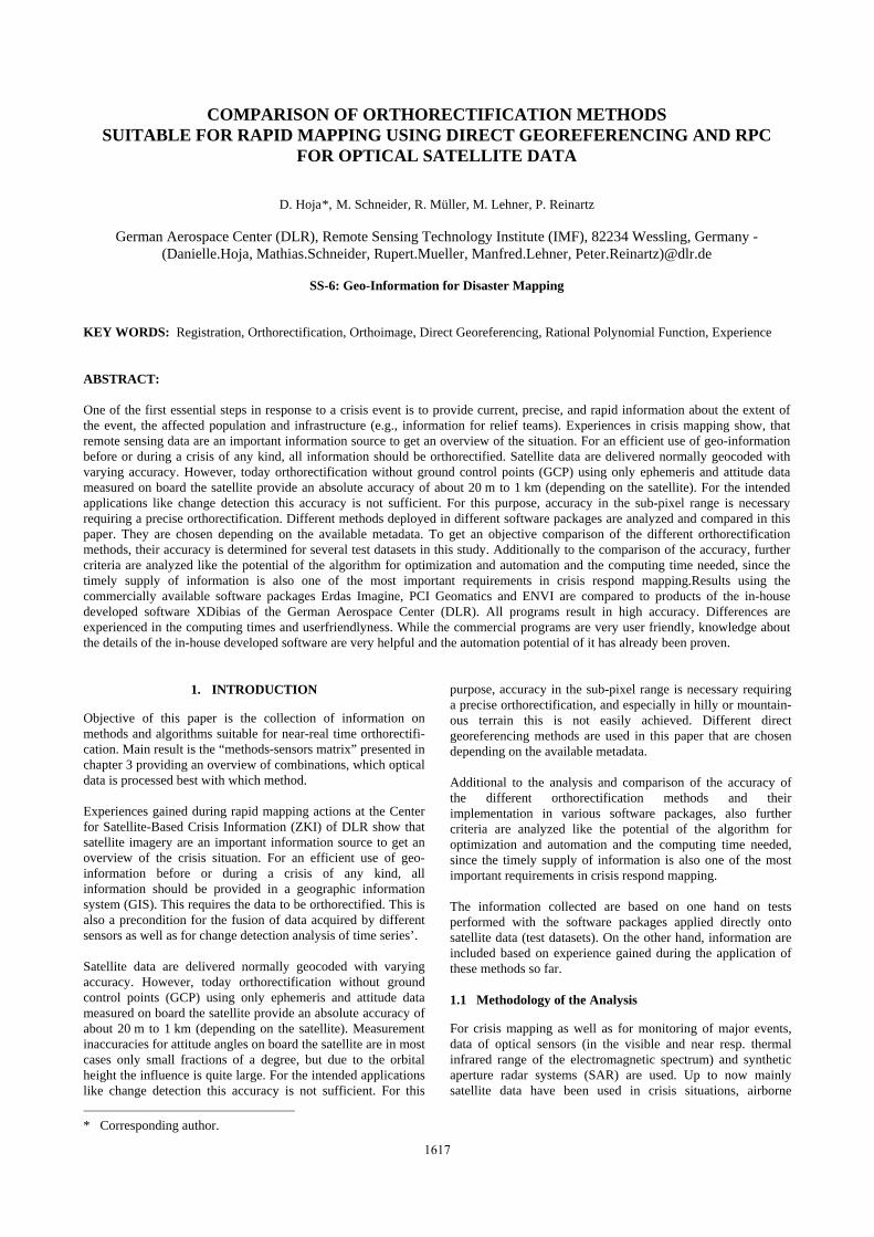
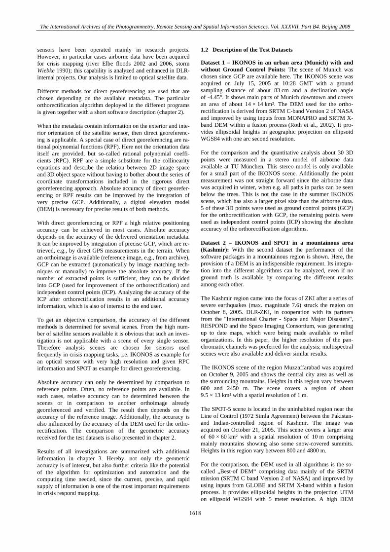
Dataset 1 – IKONOS in an urban area (Munich) with and without Ground Control Points: At first, the module RPCORTHO was applied without any GCP, since in most crisis situations such information is not readily available. Figure 1 shows the result of this panchromatic IKONOS scene as RGB image overlaid with results of other software packages (compare next sections). The uniform grey color in the image reflects the high conformity of the three results. In the orthorectified scene the position of 23 ICP was measured. The results describing the absolute geolocation accuracy can be seen in Table 1. The differences in the location of the ICP are in the decimeter range, which is below the resolution of IKONOS (1 m). It proves the high conformity that could already be seen in the overlay image. These small differences can result from the different image origins (in all software packages the default values were kept instead of defining own image origin) and from measurement differences. The mean deviation of the ICP location of -1.4 m and 6.0 m in x and y direction and the low standard deviation (< 1 m) show the good quality of the RPC.
Figure 1. Section of IKONOS scene of Munich orthorectified
with different software packages (Red: XDibias, Green: ENVI, Blue: PCI Geomatics)
Software package
Meanx Meany
StdDevx StdDevy
Minx Miny
Maxx Maxy
XDibias -1.43 5.90
0.77 0.76
-3.00 4.86
-0.15 7.66
Erdas Imagine
-1.39 6.03
0.52 0.76
-2.31 5.08
-0.36 7.89
ENVI -1.38 6.34
0.79 0.84
-2.94 5.36
-0.18 8.39
PCI Geomatics
-1.36 6.12
0.77 0.78
-2.90 5.08
0.26 7.75
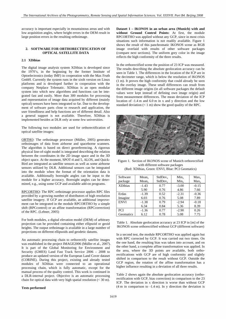
Table 1. Absolute geolocation accuracy at 23 ICP in [m] of the IKONOS scene orthorectified without GCP (different software) In a second test, the module RPCORTHO was applied again but with RPC corrected by GCP. It was carried out two times. On the one hand, the resulting bias was taken into account, and on the other hand, a complete affine transformation was applied. In the area, where the 3D points are available, both ortho-rectifications with GCP are of high conformity and slightly shifted in comparison to the result without GCP. Outside the GCP region, the rotation of the affine transformation has a higher influence resulting in a deviation of all three results. Table 2 shows again the absolute geolocation accuracy (ortho-rectification with GCP, bias correction) in comparison to the 23 ICP. The deviation in x direction is worse than without GCP (4 m in comparison to -1.4 m). In y direction the deviation is
1619
The International Archives of the Photogrammetry, Remote Sensing and Spatial Information Sciences. Vol. XXXVII. Part B4. Beijing 2008
improved and now only 1.6 m instead of 6 m. Better results were expected and further analysis has to be done here. But it also has to be taken into account, that the GCP had to be meas-ured in every software package separately. This was carried out by different persons resulting in small measurement deviations.
Software package
Meanx Meany
StdDevx StdDevy
Minx Miny
Maxx Maxy
XDibias 4.27 1.84
0.69 0.82
2.90 0.52
5.45 3.89
Erdas Imagine
3.73 1.92
1.01 1.12
0.96 0.52
5.45 4.89
ENVI 3.92 1.55
0.47 0.72
3.19 0.02
4.70 3.39
PCI Geomatics
3.89 1.10
0.64 0.74
2.63 -0.03
5.15 2.66
Table 2. Absolute geolocation accuracy at 23 ICP in [m] of the
IKONOS scene orthorectified with GCP (different software)
Results of project IMAGE2006: Since dataset 1 provides only few quantitative results and only for a small area, here the results of the project IMAGE2006 are given as further reference for the accuracy of the orthorectification with XDibias. The geometric accuracy was measured with respect to the reference images (IMAGE2000 panchromatic layer or ETM+ USGS Land cover data). About 3700 scenes (SPOT-4/-5 and IRS-P6) have been processed and an overall geometric accuracy of less than 10 m RMSE in each direction has been achieved, which corresponds to half a pixel size. The accuracy assessment is based on about 450 automatically extracted ICP per 1000 km². (Müller et al., 2007; 2008) Dataset 2 – IKONOS and SPOT in a mountainous area (Kashmir): Due to the long experience with XDibias and the accurate results in the project IMAGE2006, XDibias results were chosen as reference data and all other algorithms were compared to this dataset. However, it can already be stated here, that all results fit together with regard to geometric accuracy, so actually there is no superior software compared to the others. The orthorectification of the IKONOS scene was done with the module RPCORTHO using the DEM. The orthorectification of the SPOT scene was done with the module ORTHO using the DEM. Since no GCP were available, neither the RPC could be corrected nor could boresight angles be estimated for high absolute accuracy. The absolute accuracy is unknown. 2.2 Erdas Imagine
The commercially available image analysis system Erdas Imagine has been in constant development since 1978 by the company Erdas. Since 2001, Erdas is part of Leica Geosystems. Erdas Imagine is a pixel-oriented software package for the visualization, manipulation and analysis of aerial and satellite images as well as geographic data records. A wide variety of image processing functions is included comprising orthorectifi-cation, GlS analysis on pixel base, map production, processing of SAR images, and 3D visualization. Due to the wide distribu-tion of the software package, Erdas Imagine is considered to be standard remote sensing software. The program has a modular structure and is offered in three different bundles. It runs on PC basis (Windows). The most recent version is 9.2. Due to a close
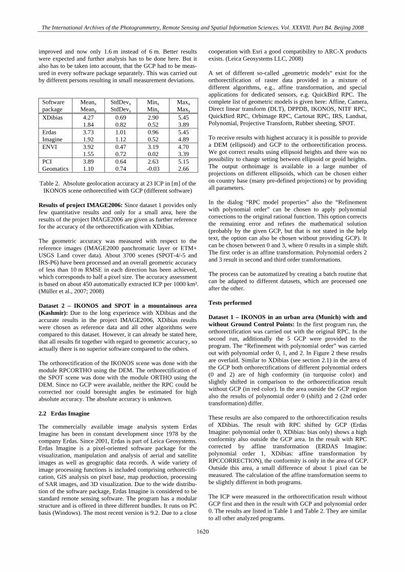
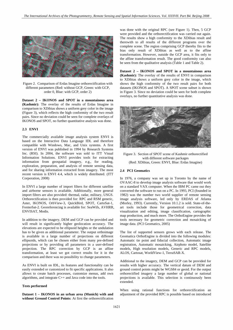
cooperation with Esri a good compatibility to ARC-X products exists. (Leica Geosystems LLC, 2008) A set of different so-called „geometric models“ exist for the orthorectification of raster data provided in a mixture of different algorithms, e.g., affine transformation, and special applications for dedicated sensors, e.g. QuickBird RPC. The complete list of geometric models is given here: Affine, Camera, Direct linear transform (DLT), DPPDB, IKONOS, NITF RPC, QuickBird RPC, Orbimage RPC, Cartosat RPC, IRS, Landsat, Polynomial, Projective Transform, Rubber sheeting, SPOT. To receive results with highest accuracy it is possible to provide a DEM (ellipsoid) and GCP to the orthorectification process. We got correct results using ellipsoid heights and there was no possibility to change setting between ellipsoid or geoid heights. The output orthoimage is available in a large number of projections on different ellipsoids, which can be chosen either on country base (many pre-defined projections) or by providing all parameters. In the dialog “RPC model properties” also the “Refinement with polynomial order” can be chosen to apply polynomial corrections to the original rational function. This option corrects the remaining error and refines the mathematical solution (probably by the given GCP, but that is not stated in the help text, the option can also be chosen without providing GCP). It can be chosen between 0 and 3, where 0 results in a simple shift. The first order is an affine transformation. Polynomial orders 2 and 3 result in second and third order transformations. The process can be automatized by creating a batch routine that can be adapted to different datasets, which are processed one after the other. Tests performed Dataset 1 – IKONOS in an urban area (Munich) with and without Ground Control Points: In the first program run, the orthorectification was carried out with the original RPC. In the second run, additionally the 5 GCP were provided to the program. The “Refinement with polynomial order” was carried out with polynomial order 0, 1, and 2. In Figure 2 these results are overlaid. Similar to XDibias (see section 2.1) in the area of the GCP both orthorectifications of different polynomial orders (0 and 2) are of high conformity (in turquoise color) and slightly shifted in comparison to the orthorectification result without GCP (in red color). In the area outside the GCP region also the results of polynomial order 0 (shift) and 2 (2nd order transformation) differ. These results are also compared to the orthorectification results of XDibias. The result with RPC shifted by GCP (Erdas Imagine: polynomial order 0, XDibias: bias only) shows a high conformity also outside the GCP area. In the result with RPC corrected by affine transformation (ERDAS Imagine: polynomial order 1, XDibias: affine transformation by RPCCORRECTION), the conformity is only in the area of GCP. Outside this area, a small difference of about 1 pixel can be measured. The calculation of the affine transformation seems to be slightly different in both programs. The ICP were measured in the orthorectification result without GCP first and then in the result with GCP and polynomial order 0. The results are listed in Table 1 and Table 2. They are similar to all other analyzed programs.
1620
The International Archives of the Photogrammetry, Remote Sensing and Spatial Information Sciences. Vol. XXXVII. Part B4. Beijing 2008
Figure 2. Comparison of Erdas Imagine orthorectification with
different parameters (Red: without GCP, Green: with GCP, order 0, Blue: with GCP, order 2)
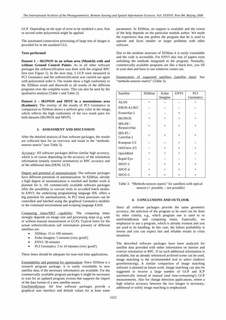
Dataset 2 – IKONOS and SPOT in a mountainous area (Kashmir): The overlay of the results of Erdas Imagine in comparison to XDibias shows a uniform grey color in the image (Figure 3), which reflects the high conformity of the two result pairs. Since no deviation could be seen for complete overlays of IKONOS and SPOT, no further quantitative analysis was done. 2.3 ENVI
The commercially available image analysis system ENVI is based on the Interactive Data Language IDL and therefore compatible with Windows, Mac, and Unix systems. A first version of ENVI was published in 1994 by Research Systems Inc. (RSI). In 2004, the software was sold to ITT Visual Information Solutions. ENVI provides tools for extracting information from geospatial imagery, e.g., for reading, exploration, preparation, and analysis of remote sensing data, and for sharing information extracted from imagery. The most recent version is ENVI 4.4, which is widely distributed. (ITT Corporation, 2008) In ENVI a large number of import filters for different satellite and airborne sensors is available. Additionally, more general import filters are also provided: thermal, radar, military, USGS. Orthorectification is then provided for: RPC and RSM generic, Aster, IKONOS, OrbView-3, QuickBird, SPOT, CartoSat-1, FormoSat-2. Georeferencing is available for: SeaWifs, AVHRR, ENVISAT, Modis. In addition to the imagery, DEM and GCP can be provided and will result in significantly higher geolocation accuracy. The elevations are expected to be ellipsoid heights or the undulation has to be given as additional parameter. The output orthoimage is available in a large number of projections on different ellipsoids, which can be chosen either from many pre-defined projections or by providing all parameters in a user-defined projection. The RPC correction by GCP is an affine transformation, at least we got correct results for it in the comparison and there was no possibility to change parameters. As ENVI is built on IDL, its features and functionality can be easily extended or customized to fit specific applications. It also allows to create batch processes, customize menus, add own algorithms, and integrate C++ and Java code into the tools. Tests performed Dataset 1 – IKONOS in an urban area (Munich) with and without Ground Control Points: At first the orthorectification
was done with the original RPC (see Figure 1). Then, 5 GCP were provided and the orthorectification was carried out again. The results show a high conformity to the XDibias result and therewith to all results of the different programs over the complete scene. The region comprising GCP thereby fits to the bias only result of XDibias as well as to the affine transformation. However, outside the GCP area, it fits only to the affine transformation result. The good conformity can also be seen from the qualitative analysis (Table 1 and Table 2). Dataset 2 – IKONOS and SPOT in a mountainous area (Kashmir): The overlay of the results of ENVI in comparison to XDibias shows a uniform grey color in the image, which shows the high conformity of the two result pairs for both datasets (IKONOS and SPOT). A SPOT scene subset is shown in Figure 3. Since no deviation could be seen for both complete overlays, no further quantitative analysis was done.
Figure 3. Section of SPOT scene of Kashmir orthorectified with different software packages
(Red: XDibias, Green: ENVI, Blue: Erdas Imagine)
2.4 PCI Geomatics
In 1976, a company was set up in Toronto by the name of OVAAC-8 to develop image analysis software that would work on a standard VAX computer. When the IBM PC came out they converted the software to run on a PC. In 1993, PCI (founded in 1982) was the number two world supplier of remote sensing image analysis software, led only by ERDAS of Atlanta (Morley, 1993). Currently, Version 10.1.2 is sold. State-of-the-art tools include those for geometrical correction, data visualization and editing, image classification, cartographic map production, and much more. The OrthoEngine provides the tools necessary for geometric correction and mosaicking of image data. (PCI Geomatics, 2005) The list of supported sensors grows with each release. The Geomatica OrthoEngine is divided into the following modules: Automatic tie point and fiducial collection, Automatic image registration, Automatic mosaicking, Airphoto model, Satellite models, High resolution models, Generic and RPC models, ALOS, Cartosat, WorldView-1, TerraSAR-X. Additional to the imagery, DEM and GCP can be provided for results with higher accuracy. The vertical datum of DEM and ground control points might be WGS84 or geoid. For the output orthorectified imagery a large number of global or national projections is available. This selection is continuously been extended. When using rational functions for orthorectification an adjustment of the provided RPC is possible based on introduced
1621
The International Archives of the Photogrammetry, Remote Sensing and Spatial Information Sciences. Vol. XXXVII. Part B4. Beijing 2008
GCP. Depending on the type of error to be modeled a zero, first or second order polynomial might be applied. The automated consecutive processing of large sets of images is provided for in the standard GUI. Tests performed Dataset 1 – IKONOS in an urban area (Munich) with and without Ground Control Points: As in all other software packages the orthorectification was done with the original RPC first (see Figure 1). In the next step, 5 GCP were measured in PCI Geomatics and the orthorectification was carried out again with polynomial order 0. The results show a high conformity to the XDibias result and therewith to all results of the different programs over the complete scene. This can also be seen by the qualitative analysis (Table 1 and Table 2). Dataset 2 – IKONOS and SPOT in a mountainous area (Kashmir): The overlay of the results of PCI Geomatics in comparison to XDibias shows a uniform grey color in the image, which reflects the high conformity of the two result pairs for both datasets (IKONOS and SPOT).
3. ASSESSMENT AND DISCUSSION
After the detailed analysis of four software packages, the results are collected here for an overview and result in the “methods-sensors matrix” (see Table 3). Accuracy: All software packages deliver similar high accuracy, which is of course depending on the accuracy of the orientation information (mainly exterior orientation) or RPC accuracy and of the additional data (DEM, GCP). Degree and potential of automatization: The software packages have different potentials of automatization. In XDibias, already a high degree of automatization is reached and further work is planned for it. All commercially available software packages offer the possibility to execute tools in so-called batch modes. In ENVI, the underlying programming language IDL offers a big potential for automatization. In PCI most processes can be controlled and batched using the graphical Geomatica modeler or the command environment and scripting language EASI. Computing times/NRT capability: The computing times strongly depends on image size and processing steps (e.g. with or without manual measurement of GCP). Typical times for the actual orthorectification (all information present) of different satellites are:
• XDibias: 15 to 100 minutes • Erdas Imagine: 5 minutes (very good!) • ENVI: 30 minutes • PCI Geomatics: 5 to 10 minutes (very good!)
These times should be adequate for near-real time applications. Extendability and potential for optimization: Since XDibias is a research program package, it is easily extendable to new satellite data, if the necessary information are available. For the commercially available program packages it might be necessary to wait for an updated program version that supports the import of the data format of a new satellite sensor. Userfriendlyness: All four software packages provide a graphical user interface and default values for at least some
parameters. In XDibias, no support is available and the extent of the help depends on the particular module author. We made the experience that one prefers the program that he is used to operate and faces smaller or larger problems with other software. Due to the modular structure of XDibias it is easily extendable and the code is accessible. For ENVI also lots of papers exist unfolding the methods integrated in the program. Normally, commercially available programs are like a black box, you fill in your data and have to use whatever comes out. Enumeration of supported satellites (satellite data): See “methods-sensors matrix” (Table 3).
Satellite XDibias Erdas Imagine
ENVI PCI Geomatics
ALOS + – – + EROS-A1/B/C – – – – FormoSat-2 – – + – IKONOS + + + + IRS-P6 / ResourceSat + + + +
IRS-P5 / CartoSat-1 + + + +
Kompsat-1/2 – – + – OrbView-3/5 – + + + QuickBird + + + + Rapid Eye – – – – SPOT-2 – + + + SPOT-4 + + + + SPOT-5 + + + +
Table 3. “Methods-sensors matrix” for satellites with optical
sensors (+ possible, – not possible)
4. CONCLUSIONS AND OUTLOOK
Since all software packages provide the same geometric accuracy, the selection of the program to be used can be done by other criteria, e.g., which program one is used to or userfriendlyness and computing times. Especially, we emphasize to use a program, which is already existent and you are used to its handling. In this case, the failure probability is lowest and you can expect fast and reliable results in crisis situations. The described software packages have been analyzed for satellite data provided with either information on interior and exterior orientation or RPC. If no such additional information is available, but an already referenced archived scene can be used, image matching is the recommended tool to select (indirect georeferencing). A similar comparison of image matching software is planned as future work. Image matching can also be suggested to receive a large number of GCP and ICP automatically instead of manual (and time-consuming!) GCP measurements. Also for change detection applications, where a high relative accuracy between the two images is necessary, additional or solely image matching is emphasized.
1622
The International Archives of the Photogrammetry, Remote Sensing and Spatial Information Sciences. Vol. XXXVII. Part B4. Beijing 2008
REFERENCES
ITT Corporation: ENVI – Solutions for Data Vis. and Image Analysis. http://www.ittvis.com/envi/, last access: April 2008. Lehner, M., Müller, R., Reinartz, P.: DSM and Orthoimages from Quickbird and Ikonos Data Using RPF. In: Proc. of the ISPRS Workshop “High-Resolution Earth Imaging for Geo-spatial Information”, Hannover, Germany, May 17–20, 2005. Leica Geosystems LLC: Erdas Imagine. http://gi.leica-geosystems.com/LGISub1x33x0.aspx, last access: April 2008. Morley, L.W.: Remote Sensing then and now (internet excerpt). http://www.ccrs.nrcan.gc.ca/org/history/index_e.php, 1993, last access: April 2008. Müller, R., Lehner, M., Reinartz, P., Schroeder, M.: Evaluation of Spaceborne and Airborne Line Scanner Images Using a Generic Ortho Image Processor. In: Proc. of the ISPRS Workshop “High-Resolution Earth Imaging for Geospatial Information”, Hannover, Germany, May 17–20, 2005. Müller, R., Krauß, T., Lehner, M., Reinartz, P.: Automatic Pro-duction of a European Orthoimage Coverage within the GMES Land Fast Track Service Using SPOT-4/5 and IRS-P6 LISS-III
Data. In: Proc. of the ISPRS Workshop “High-Resolution Earth Imaging for Geospatial Information”, Hannover, Germany, May 29–June 1, 2007. Müller, R., Krauß, T., Lehner, M., Rönnbäck, G., Karlsson, A.: GMES Fast Track Land Service 2006-2008 – Orthorectification of SPOT and IRS-P6 Products. Final Report, 2008. PCI Geomatics: Geomatica. http://www.pcigeomatics.com/, 2005, last access: April 2008. Roth, A., Knöpfle, W., Strunz, G., Lehner, M., Reinartz, P.: Towards a Global Elevation Product: Combination of Multi-Source DEM. In: Proc. of Symposium on Geospatial Theory, Processing, and Applications, Ottawa, Canada, July 9–12, 2002.
ACKNOWLEDGEMENTS
The authors acknowledge the numerous processing of the test datasets carried out by Jonathan Burger and Thomas Wagner, the precise ICP measurements by Sven Rühl and Christian Steger as well as the tests and helpful comments on PCI Geomatics by Michael Vollmar of GAF AG.
1623

The International Archives of the Photogrammetry, Remote Sensing and Spatial Information Sciences. Vol. XXXVII. Part B4. Beijing 2008
1624