Embed Size (px)
Citation preview

November 1992 • NREL/TP-463-5118
A Comparison of SOLMET/ERSAT National Solar Ra ·
.... ., .... from and the
·� tion Data Base
W. Marion and D. Myers
�*� ... ·��-· •. ···� � -·-· -
• National Renewable Energy Laboratory A Division of Midwest Research Institute Operated for the U.S. Department of Energy Under Contract No. DE-AC02-83CH10093

) i I
- ' ,. \
.. , I d
'1
I \)
J ,\
NREL{fP-463-5118 · UC Categories: 233,234 · DE93000018
A Comparison SOLMET/ERSA National Solar R
ata from and the tion Data Base
W. Marion and D. Myers
National Renewable Energy Laboratory (formerly the Solar Energy Research Institute) 1617 Cole Boulevard Golden, Colorado 80401-3393 A Division of Midwest Research Institute Operated for the U.S. Department of Energy under Contract No. DE-AC02-83CH10093
Prepared under Task Nos. RA210101, PV360501
November 1992
NOTICE
This report was prepared as an account of work sponsored by an agency of the United States government. Neither the United States government nor any agency thereof, nor any of their employees, makes any warranty, express or implied, or assumes any legal liability or responsibility for the accuracy, completeness, or usefulness of any information, apparatus, product, or process disclosed, or represents that its use would not infringe privately owned rights. Reference herein to any specific commercial product, process, or service by trade name, trademark, manufacturer, or otherwise does not necessarily constitute or imply its endorsement, recommendation, .or favoring by the United States government or any agency thereof. The views and opinions of authors expressed herein do not necessarily state or reflect those of the United States government or any agency thereof.
Printed in the United States of America Available from:
National Technical Information Service U.S. Department of Commerce
5285 Port Royal Road Springfield, VA 22161
Price: Microfiche A01 Printed Copy A03
Codes are used for pricing all publications. The code is determined by the number of pages in the publication. Information pertaining to the pricing codes can be found in the current issue of the following publications which are generally available in most libraries: Energy Research Abstracts (ERA); Government Reports Announcements and Index ( GRA and I); Scientific and Technical Abstract Reports (STAR); and publication NTIS-PR-360 available from NTIS at the above address.

I I)
)
\ I u
I . .I
. I'
I I
. J
TP-5118
Preface
This work was performed under the National Renewable Energy Laboratory's (NREL's) Solar Radiation Research Assessment Project Task No. RA210101 and Photovoltaic Solar Radiation Research Task No. PV360501. We would like to acknowledge Dave Menicucci (Sandia), Gobind Atmaram (Florida Solar Energy Center), and NREL staff members Roland Hulstrom, Carol Riordan, Dave Renne, Gene Maxwell, and Martin Rymes for their contributions to the report and their review. We would also like to thank Mary Anne Dunlap for technical editing and Terrie Webb for proofreading the appendices.
iii

TP-5118
Summary
This report compares data from the new National Solar Radiation Data Base (NSRDB) with data from the earlier SOLMETIERSATZ data base. It compares the two data bases, station-by-station, with respect to their long-term average daily values of global horizontal and direct normal solar radiation.
We conclude that on an annual basis, NSRDB values for global horizontal radiation are within ±5% of SOLMETIERSATZ values for 60% of the stations, more than 5% greater than the SOLMET/ERSATZ values for 30% of the stations, and more than 5% less than the SOLMETIERSATZ values for 10% of the stations. On an annual basis for direct normal radiation, the NSRDB values are within ±5% of the SOLMETIERSATZ data for only 40% of the stations, more than 5% greater than the SOLMETIERSATZ values for 45% of the stations, and more than 5% less than the SOLMETIERSATZ values for 15% of the stations.
In general, the NSRDB shows higher values of solar radiation for the eastern United States, particularly the Northeast, and lower values for some of the western states (Arizona, Colorado, Idaho, Nevada, New Mexico, Utah, and Wyoming). However, because some of the stations within a state show higher values of solar radiation while others show lower values, this generalization may be misleading when concerned with a particular station. Consequently, the appendices provide tables showing a station-by-station comparison of the NSRDB and SOLMET/ERSATZ data. In addition to comparing annual values, the tables compare the two data bases for the months of August and December. This comparison shows larger differences between the two data bases for December.
iv
�· ,,
••
1 , II '- •'
••

\ \
I
.I
Table of Contents
1.0 Introduction
2.0 Station Locations . . . . . . . . . . . . . . . . . . . . . . . . . . . . . . . . . . . . . . . . . . .
3.0 Comparison of NSRDB and SOLMET/ERSA1Z Data ................ .
3.1 Annual Solar Radiation . . . . . . . . . . . . . . . . . . . . . . . . . . . . . . . . .
3.2 August and December Solar Radiation ...................... .
3.3 Daily Solar Radiation Profiles ............................ .
4.0 NSRDB Products .......................................... .
5. 0 Conclusions . . . . . . . . . . . . . . . . . . . . . . . . . . . . . . . . . . . . . . . . . . . . . .
6. 0 References . . . . . . . . . . . . . . . . . . . . . . . . . . . . . . . . . . . . . . . . . . . . . . .
Appendix A Comparison of Annual Average Daily Radiation of SOLMET/ERSA1Z and NSRDB Data Bases ................. .
Appendix B Comparison of Monthly Average Daily Radiation of
TP-5118
Page
1
3
5
5 7 7
10
11
13
A-1
SOLMETJERSA1Z and NSRDB Data Bases . . . . . . . . . . . . . . . . . . B-1
v
·<.�;1

TP-5118
List of Figures
2-1 SOLMET/ERSA TZ station locations
2-2 NSRDB station locations . . . . . . . . . . . . . . . . . . . . . . . . . . . . . . . . . . . . .
3-1 Percentage of change in profile of average global horizontal radiation in 1968 for Nashville when comparing NSRDB data to SOLMET data . . . . . . . . . . . . . . . . . . . . . . . . .
3-2 December percentage of change in profile of average global horizontal radiation during 1961-1975 for Nashville when comparing NSRDB data to SOLMET data . . . . . . . . . . . . . .
5-1 Percentage of stations that have NSRDB data less than, approximately equal to, or greater than SOLMET/ ERSATZ data . . . . . . . . . . . . . . . . . • . . . . . . . . . . . . . . . . . . . . . . . . . . .
List of Tables
3-1 NSRDB Solar Radiation Source Flags . . . . . . . . . . . . . . . . . . .. . . . . . . . .
3-2 NSRDB Solar Radiation Uncertainty Flags . . . . . . . . . . . . . . . . . . . . . . . . .
4-1 NSRDB Solar Radiation and Meteorological Elements . . . . . . . . . . . . . . . . .
5-1 Range of Changes in Long-Term Averages When NSRDB Data Are Compared with SOLMET/ERSATZ Data . . . . . . . . . . . . . . . . . . . . . . .
A-1 Comparison of Annual Average Daily Radiation (kWh!nr) of SOLMET/ERSATZ and NSRDB Data Bases . . . . . . . . . . . . . . . . . . . . . . .
B-1 Comparison of Monthly Average Daily Radiation (kWh/m2) of SOLMET/ERSATZ and NSRDB Data Bases . . . . . . . . . . . . . . . . . . . . . . .
vi
Page
3
4
8
9
11
' '
r -7'1
.... _ . ...
.,
' ;j
' �
cf '
. "

\
� )
TP-5118
1.0 Introduction
The National Renewable Energy Laboratory (NREL) recently completed the National Solar Radiation Data Base (NSRDB). This new data base consists of hourly values of solar radiation and meteorological data for 239 stations for the period from 1961 to 1990. A 30-year period of data collection was chosen to establish averages and extremes of solar radiation parameters, and it coincides with the same 30-year period used for the National Oceanic and Atmospheric Administration's (NOAA's) latest update of climate statistics. A 30-year period with updates every 10 years is a standard meteorological practice.
For the NSRDB, all of the meteorological data were provided by the National Climatic Data Center (NCDC), which· is a part of NOAA. The majority of the measured solar radiation data was collected by NOAA's National Weather Service and was also provided to NREL by NCDC. Solar radiation data were also obtained from the University of Oregon; WEST Associates (a consortium of southwestern utilities); the University of New York at Albany; Trinity University, Texas; Georgia Institute of Technology; Bethune-Cookman College, Florida; and Savannah State College, Georgia (NSRDB-Vol. 1 1992).
The NSRDB is the successor to the 1952-1975 SOLMETIERSATZ data base. In addition to accounting for the more recent climate, the NSRDB provides more accurate values of solar radiation because:
• More measured data were available during 1961 through 1990. For the SOLMETIERSA 1Z data base, there was only one measured parameter: global horizontal solar radiation at 26 stations. The new data base has measured data for 56 of the 239 stations (however, some of these stations only made measurements for a few years). For a majority of these 56 stations, two parameters were measured: global horizontal solar radiation and direct normal solar radiation. Diffuse solar radiation was also measured for several years at nine stations. The greater availability of measured data enhanced model development and testing.
• A meteorological statistical model (METSTAT) provided better estimates of solar radiation for sites and times where no measurements were available (Maxwell 1991). Because 93% of the solar radiation data in the NSRDB is modeled, much emphasis was placed on model development.
• The accuracy of the measured data is improved. From 1977 to 1990, a radiometer calibration facility, operated by NOAA in Boulder, Colorado, performed routine calibrations to ensure the accuracy of instruments used to measure solar radiation by the National Weather Service. Universities and other agencies that provided solar radiation data also performed routine instrument calibrations.
• An improved synthetic calibration procedure (SYNCAL) corrected global horizontal solar radiation data for solar zenith and azimuth angles. Calibration corrections were determined for 10° by 20° zenith angle-azimuth angle cells for each instrument. The corrections were largest for data collected prior to 1976, when measurements were made using older style pyranometers.
• Procedures and software were devised for performing postmeasurement quality assessment of data. Each solar radiation data value was assigned a quality flag consisting of two characters that provide information on the source and uncertainty of the data.
1

TP-5118
The NSRDB represents the more recent climate and has an improved accuracy, but designers and engineers might ask the questions: Compared with SOLMET/ERSATZ data, how will NSRDB data impact analysis and design? Have the averages and extremes for the stations changed? Will we estimate more energy produced or less? Will the collector be sized larger or smaller?
Although this report does not answer these questions for specific applications, it does provide initial insight by comparing the two data bases with respect to their long-term averages of global horizontal and direct normal solar radiation on a station-by-station basis. The objective is to inform potential users about the magnitude of the differences between the two data bases for long-term averages of global horizontal and direct normal solar radiation.
Also, the information presented in this report is not intended for energy analysis and system design purposes. Analysis and design information will result from FY 1993 activities of NREL's Solar Radiation Research Assessment Project. The FY 1993 work includes using the data for the 239 NSRDB stations to develop typical meteorological year (TMY) data sets and to generate tabular data giving information on the monthly averages of solar radiation, the extremes, and the variability for various fixed and tracking collectors. FY1993 work will also include a detailed analysis explaining the reasons for the differences between the two data bases shown in this report. The contribution of improved measurements and models and the effects of climate change, such as changes in the amount of cloud cover, will be evaluated and presented.
This report begins by identifying the station locations for the two data bases. Next, annual and monthly long-term averages for global horizontal and direct normal solar radiation are compared, and daily solar radiation profiles are discussed. Last, information is provided on the NSRDB and its derived products, and the results are summarized.
2

I
[
I
l "
TP-5118
2.0 Station Locations
The 248 station locations in the SOLMETIERSATZ data base are shown in Figure 2-1. These stations were operated by the National Weather Service of NOAA. Data from 1952 to 1975 were included in this data base. Hourly values of global horizontal radiation were measured at 26 SOLMET stations during this period, and researchers modeled hourly values of direct normal radiation for these stations. In Figure 2-1, the SOLMET stations are identified by the use of the asterisk (*) symbol. No solar radiation measurements were made at the 222 ERSATZ stations. Rather, global horizontal radiation was modeled based on observed meteorological data such as cloudiness and minutes of sunshine. The ERSATZ data do not include direct normal radiation data, but this information is available in data sets derived from the ERSATZ data, such as ERSATZ TMY data sets and tabular data sets (SERI 1990) that modeled direct normal radiation for most of the ERSATZ sites.
Figure 2-1. SOLMETIERSATZ station locations
3
'" i
TP-5118
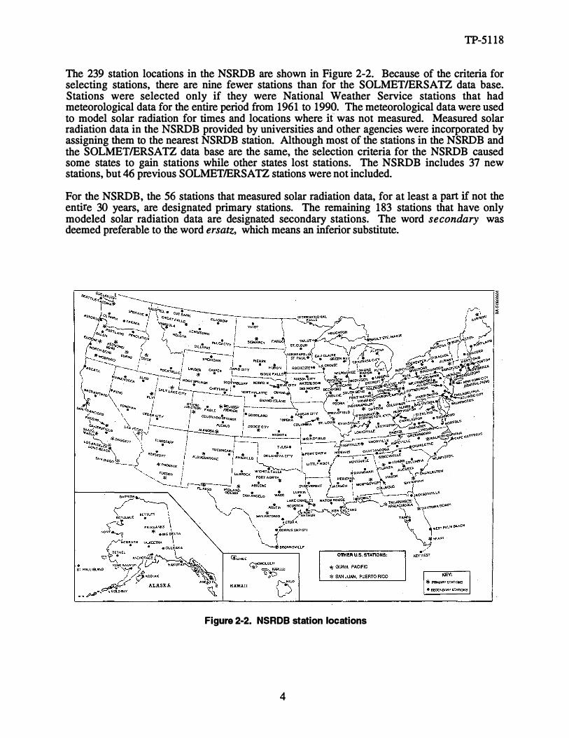
The 239 station locations in the NSRDB are shown in Figure 2-2. Because of the criteria for selecting stations, there are nine fewer stations than for the SOLMET/ERSATZ data base. Stations were selected only if they were National Weather Service stations that had meteorological data for the entire period from 1961 to 1990. The meteorological data were used to model solar radiation for times and locations where if was not measured. Measured solar radiation data in the NSRDB provided by universities and other agencies were incorporated by assigning them to the nearest NSRDB station. Although most of the stations in the NSRDB and the SOLMETIERSATZ data base are the same, the selection criteria for the NSRDB caused some states to gain stations while other states lost stations. The NSRDB includes 37 new stations, but 46 previous SOLMET/ERSATZ stations were not included.
For the NSRDB, the 56 stations that measured solar radiation data, for at least a part if not the entire 30 years, are designated primary stations. The remaining 183 stations that have only modeled solar radiation data are designated secondary stations. The word secondary was deemed preferable to the word ersatz, which means an inferior substitute.
Figure 2-2. NSRDB station locations
4
".
'-;
u _j
.. .
. .
I� -
\:._ . .:.'

j t
·,
r y
TP-5118
3�0 Comparison of NSRDB and SOLMET/ERSA TZ Data
Long-term averages of global horizontal and direct normal solar radiation for each of the two data bases were compared on an annual basis and for the months of August and December. For the comparison, the long-term averages of solar radiation used for the NSRDB stations were those presented in the daily statistic files for each station. Daily statistic files are one of the NSRDB products (NSRDB-Vol. 1 1992). For the SOLMET/ERSATZ long-term averages, tabular data were taken from the Insolation Data Manual and Direct Normal Solar Radiation Data Manual, (SERI 1990). Differences in long-term averages for the two data bases are due to differences in the measurement instruments, solar radiation models, and time periods. The SOLMETIERSATZ data base spans 23-112 years, from 1952 to 1975, and the NSRDB spans 30 years, from 1961 to 1990.
3.1 Annual Solar Radiation
Appendix A contains tables that compare the average annual global horizontal and direct normal solar radiation of the two data bases. All 239 NSRDB stations are listed in the tables along with their Weather Bureau Army Navy (WBAN) number and other station identification information such as latitude, longitude, and elevation. The SOLMET/ERSATZ stations not in the NSRDB ( 46 total) are not listed in the tables. SOLMET stations are identified in the tables by the use of the asterisk (*) symbol, and the pound (#) symbol is used to identify NSRDB primary stations. The absence of a station identifying symbol means the station is an ERSATZ station and/or a NSRDB secondary station.
Although not available for the SOLMETIERSATZ data, quality flags accompany the NSRDB data in the tables. The quality flags consist of two characters and provide information on the source and uncertainty of the NSRDB data. The solar radiation source and uncertainty flags are defined in Tables 3-1 and 3-2 (NSRDB-Vol. 1 1992). Most of the NSRDB data listed in the tables in Appendix A are assigned an uncertainty flag of 4, meaning the uncertainty of the data is from 6% to 9% of the solar radiation value.
The percentage of change listed in the tables indicates the percentage increase or decrease in solar radiation when comparing NSRDB and SOLMETIERSATZ data. A value greater than zero means that the NSRDB data are greater than the SOLMET/ERSATZ data; a value below zero means the reverse is true. For NSRDB stations that have no corresponding SOLMETIERSATZ station, no percentage change is indicated. Also, some ERSATZ stations have no direct normal radiation data; consequently, a comparison cannot be made for this situation either.
For global horizontal radiation, the NSRDB values are within ±5% of the SOLMET/ERSATZ values for 60% of the stations, more than 5% greater than the SOLMET/ERSATZ values for 30% of the stations, and more than 5% less than the SOLMETIERSA TZ values for 10% of the stations. For direct normal radiation, the NSRDB values are within ±5% of the SOLMETIERSATZ values for only 40% of the stations, more than 5% greater than the SOLMET/ERSATZ values for 45% of the stations, and more than 5% less than the SOLMETIERSATZ values for 15% of the stations.
In general, the NSRDB data show higher values for solar radiation for the eastern United States, particularly the northeast, and lower values for some of the western states ( Arizona, Colorado, Idaho, Nevada, New Mexico, Utah, and Wyoming). Examples of much higher values are stations in New York that show increases in global horizontal radiation of up to 17% and increases in direct normal radiation of up to 24%. Portland, Maine, shows the largest increase for a single station, 18% for global horizontal and 33% for direct normal. Nevada stations show
5

TP-5118
Table 3-1. NSRDB Solar Radiation Source Flags
Flag Definition
A Post-1976 measured solar radiation data as received from NCDC or other sources
B Same as 'A' except the global horizontal data underwent a calibration correction
c Pre-1976 measured global horizontal data (direct and diffuse were not measured before 1976)
D Data derived from the other two elements of solar radiation using the relation: Kt;=Kn+ Kd, where Kt = global horizontal transmittance, Kn = direct normal transmittance, and Kd = diffuse horizontal transmittance.
E Modeled solar radiation data using inputs of observed sky cover (cloud amount) and aerosol optical depths derived from direct normal data collected at the same location
F Modeled solar radiation data using inputs of interpolated sky cover and aerosol optical depths derived from direct normal data collected at the same location
G Modeled solar radiation data using observed sky cover and aerosol optical depths estimated from geographical relationships
H Modeled solar radiation data using interpolated sky cover and estimated aerosol optical depths
? Source does not fit any of the above categories. Used for nighttime values, calculated extraterrestrial values, and missing data
Table 3-2. NSRDB Solar Radiation Uncertainty Flags
Flag Uncertainty Range (%)
1 0 - 2
2 2 - 4
3 4 - 6
4 6 - 9
5 9 - 13
6 13 - 18
7 18 - 25
8 25 - 35
9 35 - 50
0 Not applicable
6

TP-5118
the largest decreases, from -4% to -10% for global horizontal radiation, and from -5% to -24% for direct normal radiation. Within a state, some of the stations may show higher values for solar radiation while others show lower values; consequently, generalizations about a change in solar radiation for a state may prove inaccurate. The tables in Appendix A may be used to evaluate changes for each station within a state.
3.2 August and December Solar Radiation
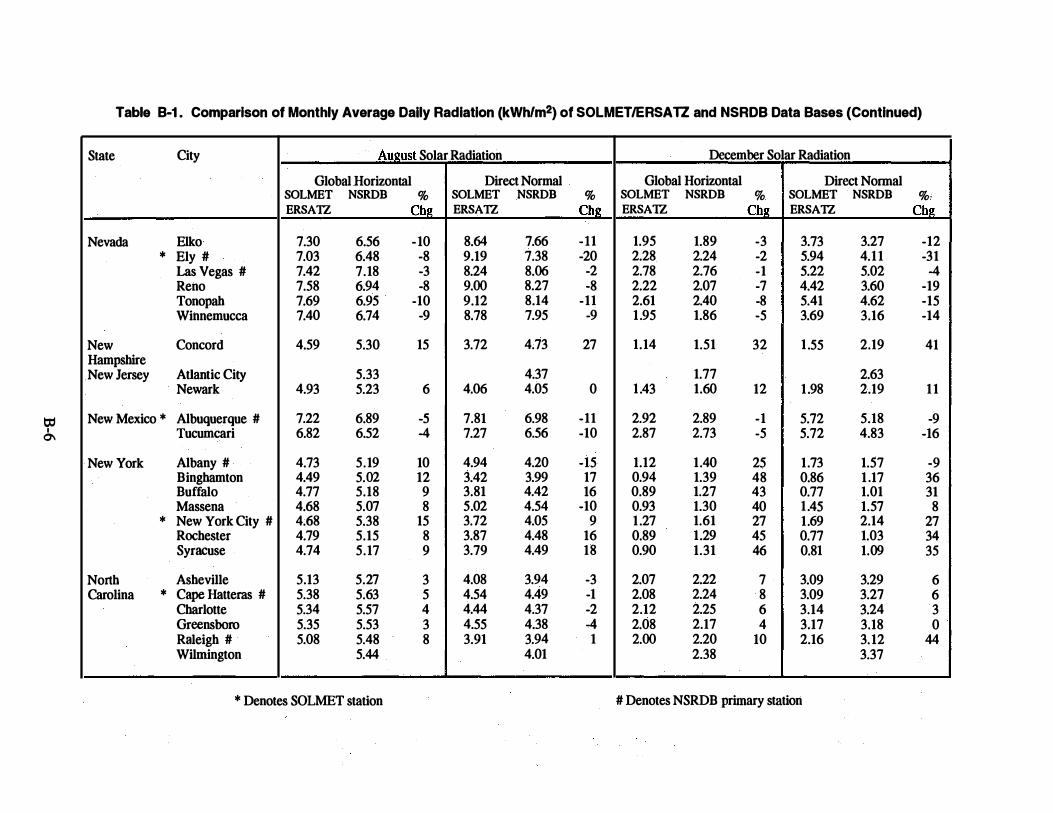
Appendix B contains tables that compare the average global horizontal and direct normal solar radiation of the two data bases for two months of the year, August and December. These two months were chosen because they have special significance for solar energy systems. For many stand-alone PV systems, designers size the PV system based on the amount of solar radiation for the month of December (assuming that December is the month with the smallest ratio of solar-radiation-to-electric-load demand). Therefore, a change in the solar resource for December can impact system size and cost. August was chosen because utilities analyze whether or not a solar electric power plant can help meet summertime electric demand. Consequently, a change in the solar resource for the month of August could favorably or unfavorably change the results of their analysis. The tables in Appendix B are similar to those in Appendix A, except they do not include the station identification information and the source and uncertainty flags for the NSRDB data. The tables in Appendix A provide this information.
For global horizontal radiation for August, the NSRDB values are within ±5% of the SOLMET/ERSATZ values for 70% of the stations, more than 5% greater than the SOLMET/ERSATZ values for 20% of the stations, and more than 5% less than the SOLMET/ERSATZ values for 10% of the stations. For direct normal radiation for August, the NSRDB values are within ±5% of the SOLMETIERSATZ values for 55% of the stations, more than 5% greater than the SOLMETIERSA TZ values for 20% of the stations, and more than 5% less than the SOLMETIERSATZ values for 25% of the stations. Overall, the results of the comparison for August were similar to the results of the annual comparison, but not necessarily with respect to individual stations.
For global horizontal radiation for December, the NSRDB values are within ±5% of the SOLMET/ERSATZ values for 25% of the stations, more than 5% greater than the SOLMET/ERSATZ values for 70% of the stations, and more than 5% less than the SOLMET/ERSATZ values for 5% of the stations. For direct normal radiation for December, the NSRDB values are within ±5% of the SOLMETIERSATZ values for 30% of the stations, more than 5% greater than the SOLMETIERSATZ values for 50% of the stations, and more than 5% less than the SOLMETIERSATZ values for 20% of the stations. December shows larger differences between the two data bases than does the annual or August comparison. Changes in global horizontal radiation ranged from -8% to +51%, and changes in direct normal radiation ranged from -32% to +56% (not including Alaskan stations where small values yielded larger percentage changes).
3.3 Daily Solar Radiation Profiles
For solar energy systems that have desired output requirements for specific times of the day, knowing how the solar radiation varies throughout the day permits evaluating different design options with respect to their load-matching ability. The daily solar radiation profile also influences the optimum orientation of fixed-tilt collectors and the performance benefit of tracking collectors when compared with fiXed-tilt collectors. Evaluating the daily solar radiation profiles for each station is beyond the scope of this report, but the comparison and discussion for a single station can, as a minimum, demonstrate and provide insight into how SOLMETIERSATZ and NSRDB daily solar radiation profiles may differ.
7

40
1-w � ..J 30 0 CIJ E e -Q) � 20 as .c
0 Q) C) .s c:: 10 Q) e Q)
a..
0
---.•-- Mar
4 8
--AA--Jun ----GII8>-- Sep ---o-- Dec
12
Hour (CST}
16
TP-5118
20
Figure 3-1. Percentage of change in profile of average global horizontal radiation in 1968 for Nashville when comparing NSRDB data to SOLMET data
Figure 3-1 compares the average daily profile for different months of the year for global horizontal radiation measured during 1968 at Nashville, Tennessee. For clarity, four months of the year are shown that represent different seasons and sun positions. For this station and year, the NSRDB data show an increase for all months when compared with the SOLMET data. Because both the SOLMET and NSRDB data are based on the same raw data measurements (1968 is a common year for both data bases), the difference between the two data bases results from using different synthetic calibration procedures. For NSRDB data, the synthetic calibration procedure also included correcting for solar zenith and azimuth angle. Each instrument was characterized for cosine and azimuth angle response, and then correction factors were applied to the data. The effect of this correction, shown in Figure 3-1, resulted in a greater difference between the SOLMET and NSRDB data for early morning and late afternoon hours and for the month of December. These times correspond to larger solar zenith angles that required larger correction factors to account for the imperfect cosine response of the instrument.
Corrections of NSRDB data were dependent on the zenith and azimuth angle response of the station's pyranometer. Each pyranometer had distinct characteristics. Some showed solar zenith and azimuth angle responses requiring different corrections for morning and afternoon and months of the year. Consequently, different corrections were required for all stations. In addition, when pyranometers were replaced at individual stations, different correction factors were applied to match the instrument being used. This is shown in Figure 3-2 in which the average daily profiles of global horizontal radiation from 1961 to 1975 for December at Nashville are illustrated. Notice how the different synthetic calibration procedures for the NSRDB caused the daily profiles to change from year to year when compared with the SOLMET profiles. Changes due to replacing instruments are also evident. (The profiles in Figure 3-2 are plotted against the hour of day, not the year, as indicated by the x-axis. The profile for December 1968 is the same as the December 1968 profile shown in Figure 3-1, but different scales are used.)
8

J
TP-5118
60 �--------------------------------------------------------------------------------------------�
1-w ::E _, 0 40 en E ,g Q) g> 20 as .r:
(.) Q) 0) � 0 Q) e Q)
a..
--�---- - - ------- - - -------------y-- -------------- - -----
------------- -------� -- --�---- -- - - - - -I -
------� -�----- - - -- ---- ----- - --------- - ---- - ---------- -
* Denotes instrument change
-20 +--+-+---+--r---+---...,�-+----1--+---+-+--+-+--+-+------l * * * * * *
60 61 62 63 64 65 66 67 68 69 70 71 72 73 74 75 76
Year
Figure 3-2. December percentage of change in profile of average global horizontal radiation during 1961-1975 for Nashville when comparing NSRDB data to SOLMET data
Although daily proflles were not evaluated for each station, the daily profiles for the NSRDB can be expected to be different than those for the SOLMETIERSATZ data base. Therefore, analyses performed concerning such things as load matching, optimum azimuth orientation of fixed collectors, and benefits of tracking collectors would be affected.
For NSRDB secondary stations and partly cloudy skies, the individual hourly model estimates can be different from the actual solar radiation received. Input parameters to the METSTAT model describe only the percentage of the sky dome covered by clouds and not the position of the clouds with respect to the sun. Consequently, for the same amount of cloud cover, the actual solar radiation can vary a large amount depending on the time during the hour that clouds are actually positioned in front of the sun. But for monthly and annual data, which have numerous hourly data values, the METSTAT model successfully simulates their statistical and stochastic characteristics (NSRDB-Vol. 1 1992).
9

TP-5118
4.0 NSRDB Products
Products available from the NSRDB include (1) serial hourly data in either a synoptic or TD-3282 format, (2) hourly, daily, and quality statistics for solar radiation elements, (3) daily statistics for meteorological elements, and (4) persistence statistics for daily total solar radiation.
The synoptic format is similar to the SOLMET format. Each line of data contains all solar radiation and meteorological elements for 1 hour. The next line of data contains data for the next hour. The synoptic format includes quality flags for global horizontal, direct normal, and diffuse horizontal radiation. Table 4-1 lists the solar radiation and meteorological data available in both the synoptic and TD-3282 format.
For the TD-3282 format, each line of data contains a day (24 hourly values) of data for one element. The next line of data contains a day of data for the next element. This format offers flexibility because only the solar radiation and meteorological elements requested need to be included in the data file. The TD-3282 format includes quality flags for all elements.
Both the synoptic and TD-3282 formats use local civil time for the hour of the day. For most applications, this is more useful than the solar time used for the SOLMETIERSA1Z data. When using the new NSRDB data to evaluate the performance of a solar energy system, analysis software and programs need to make the distinction between local civil time and solar time. Otherwise, the sun position and the amount of solar radiation for the collector will not be correctly calculated.
Statistical summaries computed from the hourly data include hourly, monthly, annual, and 30-year averages and their standard deviations. The statistical products, as well as the synoptic and TD-3282 formats, are completely described in the user's manual (NSRDB-Vol. 1 1992) available from the National Climatic Data Center (NCDC). The NSRDB data and statistical products may also be ordered from NCDC. Please use the following address for correspondence:
User Services National Climatic Data Center Federal Building Asheville, NC 28801-2696
Phone (704)259-0682 Fax (704)259-0876
Table 4-1. NSRDB Solar Radiation and Meteorological Elements
Global horizontal radiation
Direct normal radiation
Diffuse horizontal radiation
Extraterrestrial radiation
Atmospheric pressure
Wind direction
Wind speed
Horizontal visibility
Direct normal extraterrestrial radiation Ceiling height
Total sky cover
Opaque sky cover
Dry-bulb temperature
Dew-point temperature
Relative humidity
10
Present weather
Total precipitable water
Aerosol optical depth
Snow depth
Number of days since last snowfall

TP-5118
5.0 Conclusions
The NSRDB is the successor to the SOLMETIERSATZ data base. Its data better represents the solar resource because improved equipment measured solar radiation at more sites and better models estimated solar radiation for sites and times where no measurements were available. By comparing the two data bases with respect to their long-term averages of global horizontal and direct normal radiation, differences between the two data bases are evident. Appendices A and B present the results of this comparison, station-by-station, for annual and monthly (August and December) values of solar radiation.
Even though the two data bases compare within ±5% for many stations, the NSRDB data for others show changes in annual global horizontal radiation from -10% to +18% and changes in annual direct normal radiation from -24% to +33%. For the two months compared, the percentage of change was greater for December than for August. For December, the NSRDB data show changes in global horizontal radiation from -8% to +51% and show changes in direct normal radiation from -32% to +56% (not including Alaskan stations). Figure 5-1 and Table 5-1 present summary information on the comparisons made using SOLMETIERSATZ and NSRDB data.
Because of the differences in solar radiation values for the two data bases, the performance and economic analyses performed for some stations will show large changes when NSRDB data are used instead of SOLMETIERSA TZ data. For all stations, the credibility of performance and economic analyses is increased because the methods used during the development of the NSRDB had the advantage of more high quality measured data for developing better models (Maxwell et al.1991).
100
90
80
fiJ 70 c: 0 :;::: .$ 60 CJ) 0
50 Q) C) .$ c: 40 Q) � Q)
30 D..
20
10
0
Figure 5-1.
Annual Annual Global Direct Horizontal Normal
• More than 5% less than SOLMET/ERSATZ
0 Within ±5% of SOLMET/ERSATZ
1!1 More than 5% greater than SOLMET/ERSA TZ
August Global Horizontal
August Direct Normal
December December Global Direct Horizontal Normal
Percentage of stations that have NSRDB data less than, approximately equal to, or greater than SOLMETIERSA TZ data
11

Table 5-1. Range of Changes in Long-Term Averages When NSRDB Data Are Compared with SOLMETIERSA TZ Data
Period Global Horizontal Direct Normal
Annual -10% to +18% -24% to+33%
August -11% to+16% -20% to +31%
December -8% to+51% -32% to+56%
TP-5118
Future work includes developing products from the NSRDB such as TMY data sets and tabular data for various fiXed and tracking collectors. A detailed analysis explaining the reasons for differences between SOLMET/ERSATZ and NSRDB data is also under way. We also encourage others to evaluate the NSRDB. Of particular interest is how modeled solar radiation data for NSRDB secondary stations compare with measured data from nearby solar radiation monitoring stations operated by independent organizations and regional networks.
12

TP-5118
6.0 References
Maxwell, E.L. (1991). "Simulating Solar Radiation Data Sets." Proceedings of the Biennial Congress of the International Solar Energy Society; August 19-23, 1991, Denver, Colorado, pp. 975-980.
Maxwell, E.L.; Myers, D.R.; Rymes, M.D.; Stoffel, T.L.; Wilcox, S.M. (1991). "Producing a National Solar Radiation Data Base." Proceedings of the Biennial Congress of the International Solar Energy Society; August 19-23, 1991, Denver, Colorado, pp. 1007-1012.
NSRDB-Vol. 1 (1992). User's Manual - National Solar Radiation Data Base (1961-1990). Version 1.0. Asheville, NC: National Climatic Data Center.
SERI (1990). Insolation Data Manual and Direct Normal Solar Radiation Data Manual, SERI!TP-220-3880, Golden, CO: Solar Energy Research Institute.
13

Appendix A
Comparison of Annual Average Daily Radiation of SOLMET/ERSA TZ and NSRDB Data Bases

Table A-1. Comparison of Annual Average Daily Radiation (kWh/m2) of SOLMET/ERSATZ and NSRDB Data Bases
State City WBAN Latitude Longitude Elev Global Horizontal Radiation Direct N ormal Radiation N umber Deg Min Deg Min (m) SOLMET NSRDB Flag % SOLMET NSRDB Flag %
ERSATZ Chg ERSA1Z Chg
Alabama Birmingham 13876 N33 34 W 86 45 192 4.24 4.45 H4 5 3.80 3.96 H4 '4 Huntsville 03856 N34 39 W 86 46 190 4.37 H4 3.99 H4 Mobile 13894 N30 41 W 88 15 67 4.37 4.44 H4 2 3.46 3.87 H4 12 Montgomery # 13895 N32 18 W 86 24 62 4.38 4.61 F4 5 3.95 4.04 F4 2
Alaska Anchorage 26451 N61 10 W150 1 35 2.40 04 2.34 04
Annette 25308 N55 2 W131 34 34 2.51 2.62 H4 4 2.09 2.34 H4 12 Barrow 27502 N71 18 W156 47 4 1 .88 2.01 H4 7 1.90 H4
Bethel 26615 N60 47 W161 48 46 2.31 2.40 H4 4 2.05 2.40 H4 17 Bettles 26533 N66 55 W151 31 205 2.41 2.44 H4 1 3.03 H4 Big Delta 26415 N64 0 W145 44 388 2.56 2.56 H4 0 2.77 3.14 H4 13 Cold Bay 25624 N55 12 W162 43 29 2.18 H4 1 .22 H4 Fairbanks # 26411 N64 49 W147 52 138 2.42 2.55 H4 5 2.55 2.90 H4 14 Gulkana 26425 N62 9 W145 27 481 2.62 2.70 H4 3 2.75 3.21 H4 17
� King Salmon 25503 N58 41 W156 39 15 2.50 2.42 H4 -3 2.34 2.23 H4 -5 Kodiak 25501 N57 45 W152 20 34 2.51 2.48 H4 -1 2.32 2.49 H4 7
-Kotzebue 26616 N66 52 W162 38 5 2.35 2.42 H4 3 2.98 H4 Mcgrath 26510 N62 58 W155 37 103 2.31 2.47 H4 7 2.19 2.71 H4 24 N ome 26617 N64 30 W165 26 7 2.33 2.48 H4 6 2.46 3.02 H4 23 St Paul Island 25713 N57 9 W170 13 7 2.20 H4 1.16 H4 Talkeetna 26528 N62 18 W150 6 105 2.49 H4 2.77 H4 Yakutat 25339 N59 31 W139 40 9 2.09 2.28 H4 9 1.63 1.85 H4 13
Arizona Flagstaff 03103 N35 8 W111 40 2135 5.14 H4 6.43 H4 * Phoenix # 23183 N33 26 Wl12 .1 339 5.89 5.73 F4 -3 6.90 6.79 F4 -2
Prescott 23184 N34 39 W112 26 1531 5.72 5.33 H4 -7 7.25 6.78 H4 -6 Tucson# 23160 N32 7 WHO 56 779 5.90 5.70 F4 -3 7.12 7.02 F4 -1
Arkansas Fort Smith 13964 N35 20 W 94 22 141 4.43 4.56 H4 3 4.40 4.50 H4 2 Little Rock 13963 N34 44 W 92 14 81 4.43 4.51 H4 2 4.34 4.30 H4 -1
California Arcata 24283 N40 59 W124 6 69 3.83 3.90 H4 2 3.33 3.54 H4 6 Bakersfield 23155 N35 25 W1 19 3 150 5.51 5.20 H4 -6 6.21 5.74 H4 -8 Daggett# 23161 N34 52 W1 16 47 588 5.81 5.78 F4 -1 7.07 7.47 F4 6
* Fresno# 93193 N36 46 W1 19 43 100 5.39 5.17 F4 -4 6.09 5.63 F4 -8 ------
* Denotes SOLMET station #Denotes NSRDB primary station

Table A-1. Comparison of Annual Average Daily Radiation (kWhlm2) of SOLMET/ERSATZ and NSRDB Data Bases (Continued)
State City WBAN Latitude Longitude Elev Global Horizontal Radiation Direct N ormal Radiation N umber Deg Min Deg Min (m) SOLMET NSRDB Flag % SOLMET NSRDB Flag %
ERSA1Z Chg ERSA1Z Chg
Long Beach 23129 N33 49 W118 9 17 5.04 4.96 H4 -2 5.25 4.97 H4 -5 Los Angeles # 23174 N33 56 W118 24 32 5.02 4.95 E4 -1 4.83 E4
Sacramento 23232 N38 31 W121 30 8 5.18 4.93 H4 -5 5.82 5.51 H4 -5 San Diego # 23188 N32 44 W117 10 9 5.04 5.03 F4 0 5.17 5.25 F4 2 San Francisco 23234 N37 37 W122 23 5 4.90 4.72 H4 -4 5.23 5.02 H4 -4
* Santa Maria # 23273 N34 54 W120 27 72 5.07 5.17 H4 2 5.49 5.72 H4 4
Colorado Alamosa # 23061 N37 27 W105 52 2297 5.26 F4 6.83 F4
Boulder# 94018 N40 1 W105 15 1634 4.58 F4 5.41 F4
Colorado Springs 93037 N38 49 W104 43 1881 5.03 4.69 H4 -7 6.53 5.65 H4 -13 Eagle 23063 N39 39 W106 55 1985 5.03 4.67 H4 -7 6.27 5.43 H4 -13 Grand Junction # 23066 N39 7 W108 32 1475 5.23 4.98 F4 -5 6.50 5.86 F4 -10 Pueblo 93058 N38 17 W104 31 1439 5.12 4.98 H4 -3 6.47 6.08 H4 -6
)." N
Connecticut Bridgeport 94702 N41 10 W73 8 2 3.84 H4 3.54 H5
Hartford 14740 N41 56 W72 41 55 3.34 3.81 H4 14 2.77 3.33 H5 20
Delaware Wilmington 13781 N39 40 W75 36 24 3.81 4.07 H4 7 3.41 3.78 H5 11
Florida Daytona Beach # 12834 N29 11 W81 3 12 4.60 4.82 F4 5 3.84 4.29 F4 12 Jacksonville 13889 N30 30 W81 42 9 4.53 4.59 H4 1 3.84 4.18 H4 9 Key West 12836 N24 33 W81 45 1 5.12 H4 4.81 H4
* Miami# 12839 N25 48 W80 16 2 4.64 4.83 F4 4 3.88 3.96 F4 2 Tallahassee # 93805 N30 23 W84 22 21 4.52 4.69 F4 4 3.77 4.13 F4 10 Tampa 12842 N27 58 W82 32 3 4.70 4.85 H4 3 4.01 4.50 H4 12 West Palm Beach 12844 N26 41 W80 6 6 4.53 4.74 H4 5 3.71 4.09 H4 10
Georgia Athens 13873 N33 57 W83 19 244 4.54 H4 4.27 H4
Atlanta# 13874 N33 39 W84 26 315 4.24 4.58 E4 8 3.88 4.19 E4 8 Augusta 03820 N33 22 W81 58 45 4.29 4.57 H4 7 3.92 4.26 H4 9 Columbus 93842 N32 31 W84 57 136 4.63 H4 4.26 H4
Macon 03813 N32 42 W83 39 110 4.35 4.60 H4 6 4.01 4.24 H4 6 Savannah # 03822 N32 8 W81 12 16 4.30 4.61 F4 7 3.84 4.16 F4 8
* Denotes SOLMET station #Denotes NSRDB primary station

� lJ.)
Table A-1. Comparison of Annual Average Dally Radiation (kWhlm2) of SOLMET/ERSATZ and NSRDB Data Bases (Continued)
State City WBAN Latitude Longitude Elev N umber Deg Min Deg Min (m)
Hawaii Hilo 21504 N19 43 W155 4 11 Honolulu# 22521 N21 20 W157 55 5 Kahului 22516 N20 54 W156 26 15 Lihue 22536 N21 59 W159 21 45
Idaho Boise # 24131 N43 34 W116 13 874 Pocatello 24156 N42 55 W112 36 1365
Illinois Chicago 94846 N41 47 W87 45 190 Moline 14923 N41 27 W90 31 181 Peoria 14842 N40 40 W89 41 199 Rockford 94822 N42 12 W89 6 221 Springfield 93822 N39 50 W89 40 187
Indiana Evansville 93817 N38 3 W87 32 118 Fort Wayne 14827 N41 0 W85 12 252 Indianapolis # 93819 N39 44 W86 17 246 South Bend 14848 N41 42 W86 19 236
Iowa Des Moines 14933 N41 32 W93 39 294 Mason City 14940 N43 9 W93 20 373 Sioux City 14943 N42 24 W96 23 336 Waterloo 94910 N42 33 W92 24 265
Kansas * Dodge City # 13985 N37 46 W99 58 787 Goodland 23065 N39 22 W101 42 1124 Topeka 13996 N39 4 W95 38 270 Wichita 03928 N37 39 W97 25 408
Kentucky Covington 93814 N39 4 W84 40 271 Lexington 93820 N38 2 W84 36 301 Louisville 93821 N38 11 W85 44 149
* Denotes SOLMET station
Global Horizontal Radiation SOLMET ERSATZ
4.37 5.17
4.81
4.71 4.82
3.83 3.86
4.10
3.98 3.54 3.67 3.59
4.14 4.06 4.13
4.92 4.82 4.37 4.74
3.65 3.84 3.83
NSRDB Flag %
4.58 5.39 5.48 4.96
4.42 4.33
3.87 4.00 4.04 3.90 4.19
4.21 3.86 4.10 3.80
4.12 3.97 4.11 3.96
4.86 4.74 4.30 4.55
4.00 4.06 4.12
Chg
H4 5 H4 4 H4 H4 3
F4 -6 H4 -10
H4 1 H4 4 H4 H4 H4 2
H4 6 H4 9 H4 12 H4 6
H4 0 H4 -2 H4 0 H4
F4 -1 H4 -2 H4 -2 H4 -4
H4 10 H4 6 H4 8
-- ------·-
Direct N ormal Radiation SOLMET NSRDB Flag % ERSATZ Chg
' 3.10 3.62 H4 ·11 4.44 5.16 H4 16
5.84 H4
3.82 4.48 H4 17
5.53 5.20 F4 -6 5.84 4.91 H4 -16
3.71 3.44 H4 -7 3.72 3.86 H4 4
3.84 H4 3.64 H4
4.10 4.13 H4 1
3.60 3.96 H4 10 2.88 3.31 H4 15 3.05 3.59 H4 18 3.17 3.14 H4 -1
4.36 4.22 H4 -3 4.39 3.93 H4 -10 4.38 4.30 H4 -2
3.84 H4
5.79 5.43 F4 -6 5.88 5.59 H4 -5 4.61 4.41 H4 -4 5.29 4.82 H4 -9
3.52 H4
3.37 3.56 H4 6 3.32 3.67 H4 11
#Denotes NSRDB primary station

Table A-1. Comparison of Annual Average Daily Radiation (kWhlm2) of SOLMET/ERSAlZ and NSRDB Data Bases (Continued)
State City WBAN Latitude Longitude Elev Global Horizontal Radiation Direct N onnal Radiation N umber Deg Min Deg Min (m) SOLMET NSRDB Flag % SOLMET NSRDB Flag %
ERSA1Z Chg ERSA1Z Chg
Louisiana Baton Rouge 13970 N30 32 W91 9 23 4.35 4.47 H4 3 3.70 3.93 H4 , 6 * Lake Charles # 03937 N30 7 W93 13 3 4.30 4.61 F4 7 3.68 3.94 F4 7
N ew Orleans 12916 N29 59 W90 15 3 4.53 4.55 H4 0 4.02 3.98 H4 -1 Shreveport 13957 N32 28 W93 49 79 4.50 4.61 H4 2 4.27 4. 24 H4 -1
Maine * Caribou# 14607 N46 52 W68 1 190 3.35 3.55 F4 6 3.25 3.27 F4 1 Portland 14764 N43 39 W70 19 19 3.31 3.90 H4 18 2.95 3.93 H5 33
Maryland Baltimore 93721 N39 11 W76 40 47 3.83 4.05 H4 6 3.44 3.88 H4 13
Massachusetts * Boston # 14739 N42 22 W71 2 5 3.48 3.91 H4 12 3.24 3.72 H4 15 Worchester 94746 N42 16 W71 52 301 3.86 H4 3.48 H5
Michigan Alpena 94849 N45 4 W83 34 210 3.42 3.72 H4 9 3.08 3.54 H4 15
t Detroit 94847 N42 25 W83 1 191 3.53 3.78 H4 7 2.98 3.29 H4 10 Flint 14826 N42 58 W83 44 233 3.39 3.72 H4 10 2.77 3.18 H4 15 Grand Rapids 94860 N42 53 W85 31 245 3.58 3.80 H4 6 3.26 3.28 H4 1 Houghton 94814 N47 10 W88 30 329 3.56 H4 3.38 H4
Lansing 14836 N42 47 W84 36 256 3.76 H4 3.22 H4
Muskegon 14840 N43 10 W86 15 191 3.84 H4 3.30 H4
Sault Ste. Marie 14847 N46 28 W84 22 221 3.28 3.67 H4 12 3.01 3.49 H4 16 Traverse City 14850 N 44 44 W85 35 192 3.41 3.65 H4 7 2.98 3.15 H4 6
Minnesota Duluth 14913 N46 50 W92 11 432 3.36 3.71 H4 10 3.26 3.66 H4 12 International Falls 14918 N48 34 W93 23 361 3.43 3.55 H4 3 3.56 3.55 H4 0 Minneapolis 14922 N 44 53 W93 13 255 3.69 3.89 H4 5 3.68 3.99 H4 8 Rochester 14925 N43 55 W92 30 402 3.65 3.84 H4 5 3.61 3.71 H4 3 Saint Cloud 14926 N45 33 W94 4 313 3.85 H4 3.98 H4
Mississippi Jackson 03940 N32 19 W90 5 101 4.44 4.60 H4 4 4.07 4.21 H4 3 Meridian 13865 N32 20 W88 45 94 4.32 4.47 H4 3 3.80 3.87 H4 2
* Denotes SOLMET station # Denotes N SRDB primary station

Table A-1. Comparison of Annual Average Daily Radiation (kWhlm2) of SOLMET/ERSATZ and NSRDB Data Bases (Continued)
State City WBAN Latitude Longitude Elev Global Horizontal Radiation Direct N ormal Radiation N umber Deg Min Deg Min (m) SOLMET NSRDB Flag % SOLMET NSRDB Flag %
ERSATZ Chg ERSATZ Chg
Missouri * Columbia# 03945 N38 49 W92 13 270 4.19 4.33 F4 3 4.26 4.23 F4 ' -l Kansas City 03947 N39 18 W94 43 315 4.22 4.28 H4 1 4.26 4.41 H4 4 Springfield 13995 N37 14 W93 23 387 4.29 4.36 H4 2 4.39 4.33 H4 -1 St Louis 13994 N38 45 W90 23 172 4.18 4.22 H4 1 4.11 4.06 H4 -1
Montana Billings 2 4033 N45 48 W108 32 1088 4.18 4.14 H4 -1 4.85 4.80 H4 -1 Cut Bank 24137 N48 36 W112 22 1170 3.90 3.91 H4 0 4.58 4.60 H4 0 Glasgow 9 4008 N48 13 W106 37 700 3.84 3.86 H4 1 4.34 4.38 H4 1
* Great Falls # 24143 N47 29 W111 22 1116 3.98 3.99 F4 0 4.56 4.46 F4 -2 Helena 24144 N46 36 W112 0 1188 3.98 3.96 H4 -1 4.45 4.52 H4 2 Kalispell 24146 N48 18 W114 16 904 3.62 H4 3.68 H4 Lewistown 24036 N47 3 W1 09 27 12 64 3.91 3.92 H4 0 4.42 4.43 H4 0 Miles City 2 4037 N46 26 Wl05 52 803 4.10 4.11 H4 0 4.77 4.78 H4 0 Missoula 24153 N46 55 Wl14 5 972 3.68 3.76 H4 2 3.73 3.95 H4 6
� VI N ebraska Grand Island 14935 N40 58 W98 19 566 4.43 4.41 H4 0 5.10 4.92 H4 -4 N orfolk 14941 N41 59 W97 26 471 4.25 H4 4.55 H4 N orth Platte 24023 N41 8 WlOO 41 849 4.55 4.43 H4 -3 5.38 4.99 H4 -7
* Omaha# 94918 N41 22 W96 31 404 4.16 4.20 F4 1 4.45 4.24 F4 -5 Scottsbluff 24028 N41 52 W103 36 1206 4.49 4.43 H4 -1 5.38 5.12 H4 -5
N evada Elko 24121 N40 50 W115 47 1547 5.12 4.61 H4 -10 6.42 5.52 H4 -14 * Ely# 23154 N39 17 W114 51 1906 5.27 4.90 F4 -7 7.85 5.99 F4 -24
Las Vegas# 23169 N36 5 W115 10 664 5.88 5.65 F4 -4 7.43 7.05 F4 -5 Reno 23185 N39 30 W119 47 1341 5.55 5.00 H4 -10 7.22 6.16 H4 -15 Tonopah 23153 N38 4 W117 8 1653 5.82 5.22 H4 -10 7. 77 6.67 H4 -14 Winnemucca 24128 N40 54 W117 48 1323 5.19 4.72 H4 -9 6.49 5.63 H4 -13
N ew Hampshire Concord 14745 N43 12 W71 30 105 3.32 3.90 H4 17 2.92 3.78 HS 29
N ew Jersey Atlantic City 93730 N39 27 W74 34 20 4.03 H4 3.83 H4 N ewark 14734 N40 42 W74 10 9 3.67 3.90 H4 6 3.29 3.49 HS 6
N ew Mexico * Albuquerque # 23050 N35 3 Wl06 3 7 1619 5.76 5.57 F4 -3 7.20 6.69 F4 -7 Tucumcari 23048 N35 11 W103 36 1231 5.43 5.21 H4 -4 6.75 6.15 H4 -9
* Denotes SOLMET station #Denotes NSRDB primary station

Table A-1. Comparison of Annual Average Daily Radiation (kWhlm2) of SOLMET/ERSATZ and NSRDB Data Bases (Continued)
State City WBAN Latitude Longitude Elev Global Horizontal Radiation Direct N onnal Radiation N umber Deg Min Deg Min (m) SOLMET NSRDB Flag % SOLMET NSRDB Flag %
ERSA1Z Chg ERSA1Z Chg
N ew York Albany# 14735 N42 45 W 73 48 89 3.36 3.79 F4 13 3.65 3.28 F4 �10 Binghamton 04725 N42 13 W 75 59 499 3.14 3.66 H4 17 2.38 2.96 H5 24 Buffalo 14733 N42 56 W 78 44 215 3.26 3.68 H4 13 2.54 3.11 H4 22 Massena 94725 N44 56 W 74 51 63 3.28 3.72 H4 13 3.67 3.56 H4 -3
* N ew York City # 94728 N40 47 W 73 58 57 3.46 3.99 F4 15 3.03 3.45 F4 14 Rochester 14768 N43 7 W 77 40 169 3.29 3.69 H4 12 2.60 3.17 H4 22 Syracuse 14771 N43 7 W 76 7 124 3.26 3.72 H4 14 2.60 3.23 H4 24
N orth Carolina Asheville 03812 N35 26 W 82 32 661 4.14 4.29 H4 4 3.86 4.10 H4 6 * Cape Hatteras # 93729 N35 16 W 75 33 2 4.34 4.47 H4 3 4.21 4.33 H4 3
Charlotte 13881 N35 13 W 80 56 234 4.24 4.44 H4 5 3.98 4.21 H4 6 Greensboro 13723 N36 5 W 79 57 270 4.24 4.37 H4 3 4.06 4.18 H4 3 Raleigh # 13722 N35 52 W 78 47 134 4.08 4.39 F4 8 3.35 4.03 F4 20 Wilmington 13748 N34 16 W 77 54 9 4.49 H4 4.21 H4
� N orth Dakota * Bismarck # 2401 1 N46 46 W100 45 502 3.94 4.03 F4 2 4.46 4.45 F4 0 0\ Fargo 14914 N46 54 W96 48 274 3.79 3.83 H4 1 4.02 4.08 H4 1
Minot 24013 N48 16 W101 17 522 3.71 3.86 H4 4 4.1 1 4.39 H4 7
Ohio Akron 14895 N40 55 W 81 26 377 3.50 3.76 H4 7 2.87 3.02 H4 5 Cleveland 14820 N41 24 W 81 51 245 3.44 3.75 H4 9 2.78 3.04 H4 9 Columbus 14821 N40 0 W 82 53 254 3.54 3.83 H4 8 2.83 3.16 H4 12 Dayton 93815 N39 54 W 84 13 306 3.66 3.94 H4 8 3.08 3.46 H4 12 Mansfield 14891 N40 49 W 82 31 395 3.79 H4 3.1 1 H4
Toledo 94830 N41 36 W 83 48 211 3.57 3.89 H4 9 3.01 3.40 H4 13 Youngstown 14852 N41 16 W 80 40 361 3.30 3.63 H4 10 2.60 2.78 H4 7
Oklahoma Oklahoma City 13967 N35 24 W 97 36 397 4.61 4.76 H4 3 4.82 5.04 H4 5 Tulsa 13968 N36 12 W 95 54 206 4.33 4.50 H4 4 4.20 4.52 H4 8
* Denotes SOLMET station #Denotes NSRDB primary station

Table A-1. Comparison of Annual Average Daily Radiation (kWh/m2) of SOLMET/ERSATZ and NSRDB Data Bases (Continued)
State City WBAN Latitude Longitude Elev Global Horizontal Radiation Direct Nonnal Radiation Number Deg Min Deg Min (m) SOLMET NSRDB Flag % SOLMET NSRDB Flag %
ERSA1Z Chg ERSA1Z Chg
' ·� Oregon Astoria 94224 N46 9 W123 53 7 3.15 3.22 H4 2 2.40 2.70 H4 13
Burns # 94185 N43 35 Wl 19 3 1271 4.41 F4 5.01 F4
Eugene # 24221 N44 7 Wl23 13 109 3.73 F4 3.53 F4
* Medford # 24225 N42 22 W122 52 396 4.27 4.37 F4 2 4.29 4.70 F4 10 North Bend 24284 N43 25 W124 15 5 3.84 3.87 H4 1 3.48 3.69 H4 6 Pendleton 24155 N45 41 W118 51 456 3.97 4.10 H4 3 4.49 H4
Portland # 24229 N45 36 W122 36 12 3.36 3.52 F4 5 2.83 3.08 F4 9 Redmond # 24230 N44 16 Wl21 9 940 4.36 4.40 H4 1 4.91 4.95 H4 1 Salem 24232 N44 55 W123 1 61 3.55 3.69 H4 4 3.10 3.38 H4 9
Pacific Islands Guam # 41415 Nl3 33 E144 50 110 4.98 F4 3.59 F4
Pennsylvania Allentown 14737 N40 39 W 75 26 117 3.59 3.86 H4 8 3.06 3.35 HS 9 Bradford 04751 N41 48 W 78 38 600 3.72 H4 2.95 H4
� -...)
Erie 14860 N42 5 W 80 1 1 225 3.34 3.77 H4 13 2.71 3.12 H4 15 Harrisburg 14751 N40 13 W 76 51 106 3.63 3.94 H4 9 3.13 3.49 H4 12 Philadelphia 13739 N39 53 W 75 15 9 3.68 3.99 04 8 3.21 3.67 GS 14 Pittsburgh # 94823 N40 30 W 80 13 373 3.37 3.80 F4 13 2.64 2.91 F4 10 Wilkes-Barre 14777 N41 20 W 75 44 289 3.42 3.76 H4 10 2.75 3.10 HS 13 Williamsport 14778 N41 16 W 77 3 243 3.77 H4 3.10 HS
Puerto Rico San Juan # 11641 N18 26 W 66 0 19 5.17 5.30 H4 3 4.34 4.41 H4 2 I
Rhode Island Providence 14765 N41 44 W 71 26 19 3.51 3.88 H4 1 1 3.21 3.59 HS 12
South Carolina * Charleston # 13880 N32 54 W 80 2 12 4.24 4.60 H4 8 3.78 4.22 H4 12 Columbia 13883 N33 57 W 81 7 69 4.35 4.52 H4 4 4.12 4.25 H4 3 Greenville 3870 N34 54 W 82 13 296 4.25 4.45 H4 5 3.98 4.39 H4 10
South Dakota Huron 14936 N44 23 W 98 13 393 4.02 4.06 H4 1 4.38 4.35 H4 -1 Pierre 24025 N44 23 WlOO 17 526 4.25 4.16 H4 -2 4.89 4.63 H4 -5 Rapid City 24090 N44 3 W103 4 966 4.23 4.26 H4 1 4.95 5.00 H4 1 Sioux Falls 14944 N43 34 W 96 44 435 4.07 4.06 H4 0 4.48 4.32 H4 -4
* Denotes SOLMET station # Denotes NSRDB primary station

Table A-1. Comparison of Annual Average Dally Radiation (kWhlm2) of SOLMET/ERSATZ and NSRDB Data Bases (Continued)
State City WBAN Latitude Longitude Elev Global Horizontal Radiation Direct Nonnal Radiation Number Deg Min Deg Min (m) SOLMET NSRDB Flag % SOLMET NSRDB Flag %
ERSA1Z Chg ERSA1Z Chg
Tennessee Bristol 13877 N36 29 W 82 24 459 4.14 H4 3.74 H4 . .
Chattanooga 13882 N35 2 W 85 12 210 3.93 4.27 H4 9 3.34 3.73 H4 12 Knoxville 13891 N35 49 W 83 59 299 4.01 4.23 H4 5 3.51 3.71 H4 6 Memphis 13893 N35 3 W 89 59 87 4.31 4.52 H4 5 4.02 4.33 H4 8
* Nashville # 13897 N36 7 W 86 41 180 4.00 4.37 F4 9 3.62 3.88 F4 7
Texas Abliene 13962 N32 26 W 99 41 534 4.90 5.08 H4 4 5.22 5.48 H4 5 Amarillo 23047 N35 14 WlOl 42 1098 5.23 5.03 H4 -4 6.35 5.81 H4 -9 Austin 13958 N30 18 W 97 42 189 4.65 4.86 H4 5 4.38 4.63 H4 6
* Brownsville # 12919 N25 54 W 97 26 6 4.88 4.75 F4 -3 4.45 3.95 F4 -11 Corpus Christi 12924 N27 46 W 97 30 13 4.79 4.57 H4 -5 4.39 3.98 H4 -9
* El Paso # 23044 N31 48 W106 24 1 194 5.99 5.73 F4 -4 7.29 6.69 F4 -8 * Fort Worth # 03927 N32 50 W 97 3 164 4.65 4.89 H4 5 4.67 4.84 H4 4
Houston 12960 N29 59 W 95 22 33 4.26 4.43 H4 4 3.51 3.81 H4 9 Lubbock 23042 N33 39 WlOl 49 988 5.57 5 .11 H4 -8 6.57 5.75 H4 -12
� Lufkin 93987 N31 14 W 94 45 96 4.54 4.65 H4 2 4.27 4.19 H4 -2 00 Midland # 23023 N31 56 W102 12 871 5.68 5.33 F4 -6 6.61 5.91 F4 -11
Port Arthur 12917 N29 57 W 94 1 7 4.43 4.55 H4 3 3.81 4.00 H4 5 San Angelo 23034 N31 22 WlOO 30 582 4.94 5.13 H4 4 5.22 5.47 H4 5 San Antonio # 12921 N29 32 W 98 28 242 4.73 4.95 F4 5 4.44 4.54 F4 2 Victoria 12912 N28 51 W 96 55 32 4.61 H4 3.85 H4
Waco 13959 N31 37 W 97 13 155 4.63 4.87 H4 5 4.51 4.83 H4 7 Wichita Falls 13966 N33 58 W 98 29 314 4.79 4.90 H4 2 4.96 5.18 H4 4
Utah Cedar City 93129 N37 42 W113 6 1712 5.49 5.05 H4 -8 7.02 6.19 H4 -12 Salt Lake City # 24127 N40 46 W111 58 1288 5.05 4.58 E4 -9 6.19 5.1 1 E4 -17
Ve1mont Burlington # 14742 N44 28 W 73 9 104 3.22 3.72 F4 16 3.48 3.34 F4 -4
Virginia Lynchburg 13733 N37 20 W 79 12 279 4.39 H4 4.32 H4
Norfolk 13737 N36 54 W 76 12 9 4.18 4.19 H4 0 3.91 3.98 H4 2 Richmond 13740 N37 30 W 77 20 50 3.93 4.22 H4 7 3.49 3.92 H4 12 Roanoke 13741 N37 19 W 79 58 358 4.00 4.24 H4 6 3.75 3.98 H4 6
* Sterling # 93738 N38 57 W 77 27 82 3.81 4.12 F4 8 3.48 3.70 F4 6
* Denotes SOLMET station # Denotes NSRDB primary station

Table A-1. Comparison of Annual Average Daily Radiation (kWh/m2) of SOLMET/ERSATZ and NSRDB Data Bases (Continued)
State City WBAN Latitude Longitude Elev Global Horizontal Radiation Direct Nonnal Radiation Number Deg Min Deg Min (m) SOLMET NSRDB Flag % SOLMET NSRDB Flag %
ERSA1Z Chg ERSA1Z Chg
. ·� Washington Olympia 24227 N46 58 W122 54 61 3.16 3.26 H4 3 2.53 2.67 H4 6
Quillayute 94240 N47 57 Wl24 33 55 3.02 H4 2.60 H4
* Seattle # 24233 N47 27 W122 18 122 3.32 3.33 F4 0 2.80 2.94 F4 5 Spokane 24157 N47 38 Wl l7 32 721 3.86 3.84 H4 -1 4.12 4.22 H4 2 Yakima 24243 N46 34 W120 32 325 4.04 4.10 H4 1 4.22 4.68 H4 11
West Virginia Charleston 13866 N38 22 W 81 36 290 3.54 3.95 H4 12 2.80 3.28 H4 17 Elkins 13729 N38 53 W 79 51 594 3.77 H4 2.89 H4
Huntington 3860 N38 22 W 82 33 255 3.71 3.93 H4 6 3.29 H4
Wisconsin Eau Claire 14991 N44 52 )W 91 29 273 3.57 3.78 H4 6 3.45 3.67 H4 6
Green Bay 14898 N44 29 W 88 8 214 3.60 3.81 H4 6 3.45 3.68 H4 7 La Crosse 14920 N43 52 W 91 15 205 3.66 3.87 H4 6 3.52 3.79 H4 8
* Madison # 14837 N43 8 W 89 20 262 3.75 3.91 F4 4 3.72 3.54 F4 -5 Milwaukee 14839 N42 57 W 87 54 21 1 3.76 3.89 H4 3 3.65 3.65 H4 0
>,-\0 Wyoming Casper 24089 N42 55 Wl06 28 1612 4.93 4.40 H4 -11 6.44 5.32 H4 -17 Cheyenne 24018 N41 9 W104 49 1872 4.70 4.43 H4 -6 6.08 5.21 H4 -14 Lander # 24021 N42 49 Wl08 44 1696 4.58 . F4 5.47 F4
Rock Springs 24027 N41 36 W109 4 2056 5.15 4.60 H4 -11 6.90 5.43 H4 -21 Sheridan 24029 N44 46 W106 58 1209 4.19 4.18 H4 0 4.83 4.74 H4 -2
L_____ -------------- -- ----- -----
* Denotes SOLMET station # Denotes NSRDB primary station

Appendix B
Comparison of Monthly Average Daily Radiation of SOLMET/ERSATZ and NSRDB Data Bases

t:x1 I
,_.
State
Alabama
Alaska
Arizona
Arkansas
Table B-1. Comparison of Monthly Average Daily Radiation (kWhfm2) of SOLMETIERSATZ and NSRDB Data Bases
City Au2ust Solar Radiation December Solar Radiation
Global Horizontal Direct Normal Global Horizontal Direct Normal SOLMET NSRDB % SOLMET NSRDB % SOLMET NSRDB % SOLMET NSRDB ERSA1Z Chi! ERSA1Z Chi! ERSA1Z Chg ERSA1Z
Birmingham 5.43 5.61 3 4.44 4.14 -7 2.09 2.33 1 1 2.77 2.99 Huntsville 5.70 4.60 2.14 2.68 Mobile 5.18 5.24 1 3.68 3.66 -1 2.39 2.53 6 2.63 3.04 Montgomery # 5.50 5.71 4 4.48 3.98 -11 2.27 2.50 10 3.04 3.24
Anchorage 3.52 2.99 0.17 0.40 Annette 3.66 3.97 8 2.86 3.39 19 0.39 0.45 15 0.51 0.72 Barrow 2.70 2.63 -3 1 .59 0.00 0.00 0 0.00 Bethel 2.90 3.17 9 1 .80 2.01 12 0.15 0.22 47 0.19 0.79 Bettles 3.39 3.49 3 3.43 0.00 0.00 0 0.12 Big Delta 3.87 3.88 0 3.91 4.00 2 0.03 0.08 167 0.01 0.55 Cold Bay 2.99 1.09 0.45 0.61 Fairbanks # 3.52 3.73 6 3.26 3.49 7 0.01 0.05 400 0.00 0.29 Gulkana 3.95 4.12 4 3.95 4.39 1 1 0.09 0.16 78 0.08 0.58 King Salmon 3.30 3.38 2 2.39 2.16 -10 0.29 0.32 10 0.56 0.93 Kodiak 3.67 3.77 3 3.09 3.28 6 . 0.31 0.34 10 0.51 0.93 Kotzebue 3.29 3.32 1 3.21 0.00 0.01 0.1 1 Mcgrath 3.21 3.45 7 2.48 3.03 22 0.06 0.12 100 0.04 0.54 Nome 3.13 3.27 4 2.57 2.82 10 0.01 0.06 500 0.00 0.51 St Paul Is. 2.87 0.84 0.35 0.43 Talkeebla 3.57 3.25 0.16 0.69 Yakutat 2.97 3.39 14 2.02 2.50 24 0.16 0.26 63 0.17 0.53
Flagstaff 5.91 6.10 2.80 5.15 * Phoenix # 7.23 7.06 -2 7.49 7.23 -3 2.94 2.96 1 4.91 4.84
Prescott 6.59 6.28 -5 6.94 6.60 -5 2.92 2.82 -3 5.59 5.22 Tucson # 6.88 6.68 -3 7.00 6.80 -3 3.14 3.15 0 5.38 5.37
Fort Smith 5.92 5.98 1 5.46 5.46 0 2.15 2.31 7 3.18 3.25 Little Rock 5.87 5.92 1 5.31 5. 13 -3 2.12 2.23 5 3.04 2.97
* Denotes SOLMET station # Denotes NSRDB primary station
�� I 8
16 !
7 I 41
I 316 I
5400
625 ! 66 82
1250
212
-1 -7 0
2 -2
I

Table B-1. Comparison of Monthly Average Daily Radiation (kWhfm2) of SOLMETIERSATZ and NSRDB Data Bases (Continued)
State City Aul!ust Solar Radiation December Solar Radiation
Global Horizontal Direct Normal Global Horizontal Direct Normal SOLMET NSRDB % SOLMET NSRDB % SOLMET NSRDB % SOLMET NSRDB % ; ERSATZ Chg ERSATZ Chg ERSATZ Chg ERSATZ Chi!
California Arcata 4.98 5.03 1 3.94 3.86 -2 1.48 1.61 9 1.94 2.30 19 Bakersfield 7.63 7.21 -6 8.44 8.20 -3 2.14 2.10 -2 2.79 2.35 -16 Daggett # 7.51 7.34 -2 8.32 8.66 4 2.76 2.94 7 4.83 5.39 12
* Fresno # 7.64 7.18 -6 8.45 8.13 -4 1 .81 1.87 3 2.36 1.92 -19 Long Beach 6.62 6.67 1 6.44 6.36 -1 2.67 2.58 -3 4.16 3.70 -11 Los Angeles # 6.56 6.54 0 5.91 2.68 2.61 -3 3.76
' I
Sacramento 7.47 7.03 -6 8.37 8.10 -3 1 .70 1.74 2 2.22 1.95 -12 San Diego # 6.49 6.52 0 6.09 6.27 3 2.85 2.85 0 4.42 4.48 1 San Francisco 6.67 6.51 -2 6.84 6.57 -4 2.03 1.97 -3 3.07 2.90 -6
* Santa Maria # 6.64 6.78 2 6.57 6.79 3 2.53 2.65 5 4.09 4.39 7
Colorado Alamosa # 6.47 7.02 2.72 5.41 td Boulder # 5.97 6.29 2.13 3.95
I N Colorado Springs 6.39 6.02 -6 6.94 6.25 -10 2.47 2.30 -7 5.45 4.41 -19
Eagle 6.57 6.13 -7 7.23 6.51 -10 2.18 2.1 1 -3 4.52 3.53 -22 I Grand Junction # 6.88 6.60 -4 7.57 7.07 -7 2.31 2.22 -4 4.71 3.88 -18 ; Pueblo 6.63 6.48 -2 7.22 6.94 -4 2.47 2.41 -2 5.19 4.58 -12
Connecticut Bridgeport 5.18 4.22 1.55 2.20 Hartford 4.48 5.13 15 3.42 3.99 17 1 .21 1.51 25 1.50 1.99 33
Delaware Wilmington 5.09 5.45 7 4.22 4.46 6 1.54 1.74 13 2.10 2.44 16
Florida Daytona Beach # 5.30 5.66 7 3.92 4.12 5 2.74 2.88 5 3.34 3.58 7 Jacksonville 5.34 5.41 1 4.03 3.96 -2 2.58 2.68 4 3.16 3.44 9 Key West 5.83 4.39 3.44 4.41
* Miami # 5.14 5.59 9 3.56 3.63 2 3.21 3.30 3 4.01 3.88 -3 Tallahassee # 5.28 5.48 4 3.90 3.80 -3 2.56 2.74 7 3.07 3.41 1 1 Tampa 5.21 5.46 5 3.73 3.94 6 2.95 3.06 4 3.70 4.00 8 West Palm Beach 5.24 5.56 6 3.85 3.93 2 3.02 3.1 1 3 3.71 3.78 2
�- ----
* Denotes SOLMET station # Denotes NSRDB primary station

t::d I w
Table B-1. Comparison of Monthly Average Daily Radiation (kWhJm2) of SOLMET/ERSATZ and NSRDB Data Bases (Continued)
State City Au�ust Solar Radiation December Solar Radiation
Global Horizontal Direct Normal Global Horizontal Direct Normal SOLMET NSRDB % SOLMET NSRDB % SOLMET NSRDB % SOLMET NSRDB %' ERSATZ Chg ERSATZ Chg ERSATZ Chg ERSATZ Chg
Georgia Athens 5.63 4.30 2.35 3.26 Atlanta # 5.39 5.72 6 4.45 4.22 -5 2.13 2.39 12 2.94 3.20 9 Augusta 5.26 5.53 5 4.15 4.14 0 2.27 2.45 8 3.27 3.40 4 Columbus 5.64 4.18 2.52 3.37 Macon 5.42 5.63 4 4.41 4.20 -5 2.30 2.49 8 3.24 3.33 3 Savannah # 5.11 5.49 7 3.93 3.84 -2 2.38 2.57 8 3.23 3.41 6
Hawaii Hilo 5.02 5.30 6 3.45 4.00 16 3.21 3.49 9 3.12 3.54 13 Honolulu # 6.20 6.44 4 5.32 6.02 13 3.57 3.74 5 4.09 4.30 5 Kahului 6.52 6.76 3.87 4.95 Lihue 5.73 5.89 3 4.47 5.1 1 14 3.32 3.47 5 3.57 3.88 9
Idaho Boise # 6.92 6.55 -5 8.01 7.96 -1 1 .38 1.42 3 2.1 1 1.97 -7 Pocatello 7.06 6.33 -10 8.28 7.43 -10 1 .50 1.49 -1 2.53 1.90 -25
Illinois Chicago 5.42 5.36 -1 5.01 4.48 -11 1 .26 1 .45 15 1 .75 1.73 -1 Moline 5.41 5.51 2 4.93 5.00 1 1 .36 1.58 16 1 .96 2.1 1 8 Peoria 5.54 4.94 1.62 2.08 Rockford 5.38 4.68 1.51 1 .97 Springfield 5.69 5.70 0 5.42 5.29 -2 1 .55 1.73 12 2.29 2.31 1
Indiana Evansville 5.47 5.72 5 4.75 5.04 6 1 .57 1 .80 15 2.01 2.23 1 1 Fort Wayne 5.03 5.35 6 4.12 4.44 8 1.16 1.42 22 1 .25 1.39 1 1 Indianapolis # 5.18 5.63 9 4.33 4.71 9 1.31 1 .62 24 1.50 1.82 21 South Bend 5.25 5.30 1 4.67 4.37 -6 1 .07 1.36 27 1.21 1 .11 -8
Iowa Des Moines 5.76 5.66 -2 5.67 5.44 -4 1 .54 1.66 8 2.48 2.43 -2 Mason City 5.78 5.48 -5 5.85 5.06 -14 1 .40 1.52 9 2.41 2.13 -12 Sioux City 5.82 5.67 -3 5.83 5.55 -5 1 .48 1.61 9 2.42 2.45 1 Waterloo 5.48 5.01 1.55 2.14
* Denotes SOLMET station # Denotes NSRDB primary station

Table B-1. Comparison of Monthly Average Daily Radiation (kWhfm2) of SOLMET/ERSATZ and NSRDB Data Bases (Continued)
State City Au�ust Solar Radiation December Solar Radiation
Global Horizontal Direct Normal Global Horizontal Direct Normal SOLMET NSRDB % SOLMET NSRDB % SOLMET NSRDB % SOLMET NSRDB %; ERSA1Z Ch� ERSA1Z Ch� ERSA1Z Chg_ ERSA1Z Chg
Kansas * Dodge City # 6.48 6.31 -3 6.84 6.24 -9 2.31 2.35 2 4.28 4.01 -6 Goodland 6.45 6.28 -3 6.96 6.77 -3 2.19 2.20 0 4.40 4.01 -9 Topeka 6.02 5.80 -4 5.96 5.50 -8 1 .84 1.92 4 2.91 2.93 1 Wichita 6.41 6.07 -5 6.55 5.97 -9 2.18 2.17 0 3.76 3.45 -8
Kentucky Covington 5.15 5.50 7 4.61 1 .36 1 .62 19 1.80 Lexington 5.31 5.47 3 4.50 4.51 0 1 .53 1 .74 14 1 .91 2.01 5 Louisville 5.30 5.60 6 4.45 4.65 4 1 .54 1.74 13 1 .90 2.02 6
Louisiana Baton Rouge 5.29 5.44 3 4.09 4.05 -1 2.32 2.51 8 2.78 3.02 9 * Lake Charles # 5.23 5.65 8 4.09 4.06 -1 2.22 2.59 17 2.71 3.04 12
New Orleans 5.41 5.46 1 4.30 3.94 -8 2.46 2.58 5 3.01 3.02 0 ttl Shreveport 5.92 6.02 2 5.26 5.01 -5 2.30 2.45 7 3.19 3.14 -2
I .j::.
Maine * Caribou # 4.73 4.80 1 4.28 4.09 -4 0.98 1.23 26 1 .43 1.82 27 Portland 4.61 5.36 16 3.77 4.93 31 1 .14 1.51 32 1 .62 2.43 50
Maryland Baltimore 5.04 5.32 6 4.16 4.37 5 1.57 1.77 13 2.10 2.57 22
Massachusetts * Boston # 4.69 5.35 14 3.86 4.47 16 1 .27 1.52 20 1.82 2.34 29 Worchester 5.23 4.22 1.53 2. 13
Michigan Alpena 4.99 5.11 2 4.49 4.88 9 0.85 1.22 44 0.91 1 .12 23 Detroit 4.97 5.28 6 4.12 4.46 8 1 .08 1.30 20 1.17 1.28 9 Flint 4.90 5.22 7 4.08 4.42 8 0.97 1.28 32 0.97 1.16 20 i Grand Rapids 5.28 5.32 1 4.82 4.65 -4 0.98 1.29 32 1 .11 1 .02 -8 I Houghton 5.02 4.88 1.07 0.93 Lansing 5.24 4.45 1.30 1.13 Muskegon 5.45 4.97 1.24 0.76 Sault Ste. Marie 4.80 4.99 4 4.24 4.74 12 0.80 1.21 51 1 .04 1.23 18 Traverse City 5.07 5.05 0 4.50 4.48 0 0.81 1 .17 44 0.76 0.74 -3
J
* Denotes SOLMET station # Denotes NSRDB primary station

Table B-1. Comparison of Monthly Average Daily Radiation (kWhfm2) of SOLMETIERSATZ and NSRDB Data Bases (Continued)
State City August Solar Radiation December Solar Radiation
Global Horizontal Direct Nonnal Global Horizontal Direct Normal SOLMET NSRDB % SOLMET NSRDB % SOLMET NSRDB % SOLMET NSRDB %; ERSATZ Chi! ERSATZ Chi! ERSATZ Chi! ERSATZ Chg
Minnesota Duluth 4.88 5.08 4 4.45 4.76 7 0.92 1.25 36 1.50 1.83 22 International Falls 5.10 4.93 -3 4.99 4.68 -6 0.86 1 .11 29 1 .49 1.74 17 Minneapolis 5.32 5.41 2 4.98 5.22 5 1 . 11 1.38 24 1 .73 2.01 16 Rochester 5.24 5.31 1 4.88 4.86 0 1 .17 1.43 22 1.83 1.91 4 Saint Cloud 5.37 5.26 1.32 1.99
Mississippi Jackson 5.61 5.79 3 4.68 4.59 -2 2.23 2.43 9 2.97 3.08 4 Meridian 5.48 5.57 2 4.43 4.02 -9 2.21 2.40 9 2.84 2.91 2
Missouri * Columbia # 5.92 5.87 -1 5.71 5.21 -9 I
1.65 1.88 14 2.52 2.67 6 Kansas City 5.87 5.79 -1 5.63 5.51 -2 1 .77 1.88 6 2.74 2.85 4 Springfield 5.91 5.90 0 5.64 5.49 -3 1 .90 2.01 6 2.92 2.79 -4
tc St. Louis 5.73 5.67 -1 5.34 5.08 -5 1 .67 1.84 10 2.39 2.43 2 I
VI Montana Billings 6.38 6.10 -4 7.23 7.17 -1 1 .33 1 .44 8 2.61 2.54 -3
Cut Bank 5.98 5.79 -3 6.83 6.57 -4 1 .05 1 .14 9 2.13 2.32 9 Glasgow 5.87 5.70 -3 6.53 6.43 -2 1.05 1.17 11 2.02 2.04 1
* Great Falls # 6.09 5.90 -3 6.83 6.57 -4 1 .06 1.21 14 1.89 2.13 13 I Helena 6.09 5.91 -3 6.84 6.91 1 1 .15 1.24 8 2.03 1.98 -2 I Kalispell 5.60 6.36 0.99 0.84 Lewistown 5.99 5.81 -3 6.68 6.61 -1 1 .14 1.23 8 2.16 2.1 1 -2 Miles City 6.23 6.05 -3 7.03 7.07 1 1 .26 1.37 9 2.46 2.40 -2 Missoula 5.93 5.82 -2 6.58 6.81 3 0.84 1.07 27 1 .00 1.09 9
Nebraska Grand Island 6.1 1 5.97 -2 6.40 6.14 -4 1.80 1.89 5 3.37 3.25 -4 Norfolk 5.80 5.78 1.72 2.77 North Platte 6.27 5.98 -5 6.62 6.20 -6 1.91 1.94 2 3.80 3.43 -10
* Omaha # 5.86 5.72 -2 5.84 5.22 -11 1 .61 1.71 6 2.64 2.62 -1 Scottsbluff 6.30 6.18 -2 6.79 6.79 0 1.81 1.89 4 3.76 3.41 -9
* Denotes SOLMET station # Denotes NSRDB primary station
t::d I 0\
Table B-1. Comparison of Monthly Average Dally Radiation (kWhlm2) of SOLMETIERSAlZ and NSRDB Data Bases (Continued)
State City
Nevada Elko * Ely #
Las Vegas # Reno Tonopah Winnemucca
New Concord Hampshire New Jersey Atlantic City
Newark
New Mexico * Albuquerque # Tucumcari
New York Albany # Binghamton Buffalo Massena
* New York City # Rochester Syracuse
North Asheville Carolina * Cape Hatteras #
Charlotte Greensboro Raleigh # Wilmington
--
Au�ust Solar Radiation
Global Horizontal SOLMET NSRDB % ERSATZ Chi!
7.30 6.56 -10 7.03 6.48 -8 7.42 7.18 -3 7.58 6.94 -8 7.69 6.95 -10 7.40 6.74 -9
4.59 5.30 15
5.33 4.93 5.23 6
7.22 6.89 -5 6.82 6.52 -4
4.73 5.19 10 4.49 5.02 12 4.77 5.18 9 4.68 5.07 8 4.68 5.38 15 4.79 5.15 8 4.74 5.17 9
5.13 5.27 3 5.38 5.63 5 5.34 5.57 4 5.35 5.53 3 5.08 5.48 8
5.44 -- -- -
Direct Normal SOLMET ERSATZ
8.64 9.19 8.24 9.00 9.12 8.78
3.72
4.06
7.81 7.27
4.94 3.42 3.81 5.02 3.72 3.87 3.79
4.08 4.54 4.44 4.55 3.91
L_ __ ---
NSRDB
7.66 7.38 8.06 8.27 8.14 7.95
4.73
4.37 4.05
6.98 6.56
4.20 3.99 4.42 4.54 4.05 4.48 4.49
3.94 4.49 4.37 4.38 3.94 4.01
* Denotes SOLMET station
December Solar Radiation
Global Horizontal Direct Normal % SOLMET NSRDB % SOLMET NSRDB %;
Chi! ERSATZ Chi! ERSATZ Chi!
-11 1.95 1.89 -3 3.73 3.27 -12 -20 2.28 2.24 -2 5.94 4.1 1 -31
-2 2.78 2.76 -1 5.22 5.02 -4 -8 2.22 2.07 -7 4.42 3.60 -19
-11 2.61 2.40 -8 5.41 4.62 -15 -9 1 .95 1.86 -5 3.69 3.16 -14
27 1.14 1.51 32 1 .55 2.19 41
1.77 2.63 0 1 .43 1.60 12 1 .98 2.19 1 1
-11 2.92 2.89 -1 5.72 5.18 -9 -10 2.87 2.73 -5 5.72 4.83 -16
-15 1.12 1.40 25 1.73 1.57 -9 17 0.94 1.39 48 0.86 1.17 36 16 0.89 1.27 43 0.77 1.01 31
-10 0.93 1.30 40 1 .45 1.57 8 9 1 .27 1.61 27 1.69 2.14 27
16 0.89 1.29 45 0.77 1.03 34 18 0.90 1.31 46 0.81 1.09 35
-3 2.07 2.22 7 3.09 3.29 6 -1 2.08 2.24 8 3.09 3.27 6 -2 2.12 2.25 6 3.14 3.24 3 -4 2.08 2.17 4 3.17 3.18 0 1 2.00 2.20 10 2.16 3.12 44
2.38 3.37 --------
# Denotes NSRDB primary station

Table B-1. Comparison of Monthly Average Dally Radiation (kWhJm2) of SOLMETIERSATZ and NSRDB Data Bases (Continued)
State City AuJ!USt Solar Radiation December Solar Radiation
Global Horizontal Direct Normal Global Horizontal Direct Normal SOLMET NSRDB % SOLMET NSRDB % SOLMET NSRDB % SOLMET NSRDB % ; ERSA1Z ChR ERSA1Z ChR ERSA1Z Chg ERSA1Z Chg
North Dakota * Bismarck # 5.92 5.78 -2 6.49 6.16 -5 1.18 1.36 15 2.08 2.32 12 Fargo 5.75 5.52 -4 6.00 5.76 -4 1.06 1.28 21 1.83 2.04 1 1 Minot 5.68 5.59 -2 6.16 6.20 1 0.98 1.20 22 1 .84 2.26 23
Ohio Akron 5.03 5.24 4 4.21 4.16 -1 1 .11 1.37 23 1 .14 1.12 1 Cleveland 4.99 5.26 5 4.15 4.30 4 1 .00 1.30 30 0.92 0.97 5 Columbus 5.17 5.27 2 4.01 4.21 5 1.22 1.47 20 1.31 1.41 8 Dayton 5.19 5.45 5 4.34 4.61 6 1 .28 1 .53 20 1 .47 1.61 10 Mansfield 5.28 4.27 1.40 1.25 Toledo 5.09 5.43 7 4.29 4.60 7 1.12 1.38 23 1.24 1.36 10 Youngstown 4.75 5.01 5 3.78 3.76 -1 0.99 1.31 32 0.94 0.94 0
txl Oklahoma Oklahoma City 6.15 6.25 2 5.88 6.12 4 2.29 2.45 7 3.74 3.79 1 I -...J Tulsa 5.88 6.01 2 5.38 5.67 5 2.08 2.24 8 3.07 3.28 7
Oregon Astoria 4.73 4.77 1 3.87 3.96 2 0.82 0.98 20 0.73 1.14 56 Burns # 6.49 7.79 1.49 2.02 Eugene # 5.82 6.19 1.04 0.89
* Medford # 6.69 6.67 0 7.24 7.80 8 1.06 1.23 16 1.00 1.14 14 I North Bend 5.63 5.61 0 5.28 5.27 0 1.20 1.34 12 1 .40 1 .8 29 Pendleton 6.29 6.30 0 7.52 0.92 1.14 24 1.15 Portland # 5.28 5.42 3 4.96 5.18 4 0.82 0.98 20 0.69 0.94 36 Redmond # 6.52 6.56 1 7.49 7.72 3 1.34 1.42 6 2.13 2.07 -3 I
Salem 5.60 5.74 3 5.51 5.77 5 0.87 1.05 21 0.73 0.95 30
Pacific Islands Guam # 4.87 2.72 4.21 3.62
Pennsylvania Allentown 4.87 5.22 7 3.95 4.1 1 4 1 .36 1.56 15 1.71 1.96 15 Bradford 5.05 3.91 1.40 1.05 Erie 4.59 5.30 15 4.09 4.51 10 0.88 1.28 45 0.70 0.73 4 Harrisburg 4.89 5.26 8 3.97 4.16 5 1 .41 1.63 16 1 .80 2.06 14
* Denotes SOLMET station # Denotes NSRDB primary station
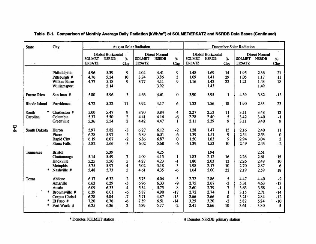
Table B-1. Comparison of Monthly Average Dally Radiation (kWhJm2) of SOLMETJERSATZ and NSRDB Data Bases (Continued)
! State City AuJ!ust Solar Radiation December Solar Radiation
Global Horizontal Direct Normal Global Horizontal Direct Nonnal SOLMET NSRDB % SOLMET NSRDB % SOLMET NSRDB % SOLMET NSRDB % i ERSA1Z Chg ERSA1Z Chg ERSA1Z Chg ERSA1Z Chg
Philadelphia 4.96 5.39 9 4.04 4.41 9 1 .48 1.69 14 1 .95 2.36 21 Pittsburgh # 4.76 5.24 10 3.74 3.86 3 1 .09 1.41 29 1 .05 1.17 11 Wilkes-Barre 4.77 5.18 9 3.77 4.1 1 9 1.16 1.42 22 1.21 1.43 18 Williamsport 5.14 3.92 1.43 1.49
Puerto Rico San Juan # 5.80 5.96 3 4.63 4.61 0 3.90 3.95 1 4.39 3.82 -13
Rhode Island Providence 4.72 5.22 1 1 3.92 4.17 6 1 .32 1.56 18 1 .90 2.33 23
South * Charleston # 5.00 5.47 9 3.70 3.84 4 2.27 2.53 1 1 3.11 3.48 12 Carolina Columbia 5.37 5.50 2 4.41 4.16 -6 2.28 2.40 5 3.42 3.40 -1
Greenville 5.36 5.54 3 4.42 4.47 1 2.11 2.29 9 3.11 3.40 9 o; I 00 South Dakota Huron 5.97 5.82 -3 6.27 6.12 -2 1.28 1.47 15 2.16 2.40 1 1
Pierre 6.28 5.97 -5 6.89 6.51 -6 1.39 1.51 9 2.54 2.53 0 Rapid City 6.19 6.07 -2 6.86 6.87 0 1.50 1.63 9 2.94 3.04 3 Sioux Falls 5.82 5.66 -3 6.02 5.68 -6 1 .39 1.53 10 2.49 2.43 -2
Tennessee Bristol 5.39 4.25 1.94 2.51 Chattanooga 5.14 5.49 7 4.09 4.15 1 1 .83 2.12 16 2.26 2.61 15 Knoxville 5.25 5.50 5 4.27 4.23 -1 1 .80 2.03 13 2.26 2.49 10 Memphis 5.75 5.97 4 5.02 5.18 3 1 .98 2.17 10 2.70 2.87 6
* Nashville # 5.48 5.73 5 4.61 4.35 -6 1 .64 2.00 22 2.19 2.59 18
Texas Abliene 6.17 6.32 2 5.75 6.06 5 2.72 2.86 5 4.47 4.40 -2 Amarillo 6.63 6.29 -5 6.96 6.33 -9 2.75 2.67 -3 5.31 4.63 -13 Austin 6.09 6.33 4 5.34 5.75 8 2.60 2.79 7 3.63 3.58 -1
* Brownsville # 6.39 6.01 -6 5.87 4.90 -17 2.72 2.74 1 3.15 2.71 -14 Corpus Christi 6.28 5.84 -7 5.71 4.87 -15 2.66 2.66 0 3.21 2.84 -12
* EI Paso # 7.20 6.76 -6 7.59 6.51 -14 3.25 3.20 -2 5.82 5.24 -10 * Fort Worth # 6.25 6.36 2 5.89 5.77 -2 2.41 2.66 10 3.61 3.80 5
* Denotes SOLMET station # Denotes NSRDB primary station

0:1 "'
Table B-1. Comparison of Monthly Average Daily Radiation (kWh/m2) of SOLMET/ERSATZ and NSRDB Data Bases (Continued)
State City
Houston Lubbock Lufkin Midland # Port Arthur San Angelo San Antonio # Victoria Waco Wichita Falls
Utah Cedar City Salt Lake City #
Vermont Burlington #
Virginia Lynchburg Norfolk Richmond Roanoke
* Sterling #
Washington Olympia Quillayute
* Seattle # Spokane Yakima
West Virginia Charleston Elkins Huntington
-- --- -----
Ammst Solar Radiation
Global Horizontal SOLMET ERSA1Z
5.32 6.96 5.88 6.97 5.47 6.20 6.14
6.17 6.21
7.07 7.1 1
4.65
5.30 5.05 5.1 1 5.10
4.88
5.10 6.12 6.23
4.77
4.98 -------
NSRDB % Ch�
5.61 5 6.33 -9 6.01 2 6.46 -7 5.72 5 6.38 3 6.42 5 5.83 6.36 3 6.30 1
6.53 -8 6.51 -8
5.19 12
5.63 5.39 2 5.43 8 5.45 7 5.40 6
5.06 4 4.53 5.15 1 5.94 -3 6.18 -1
5.28 1 1 5 .02 5.22 5
--- ---
Direct Normal SOLMET NSRDB ERSA1Z
4.08 4.39 7.26 6.25 5.07 5.00 7.13 6.16 4.36 4.50 5.77 6.15 5.39 5.47
4.55 5.59 6.04 5.84 6.12
7.95 7.19 8.20 7.31
4.93 4.48
4.62 4.37 4.32 4.07 4.22 4.25 4.32 4.23 3.99
4.42 4.57 3.82
4.74 4.83 6.90 7.01 6.82 7.37
3.57 4.01 3.51 3.92
----------
* Denotes SOLMET station
December Solar Radiation
Global Horizontal Direct Normal % SOLMET NSRDB % SOLMET NSRDB %;
Ch� ERSA1Z Ch� ERSA1Z Ch�
8 2.30 2.49 8 2.60 2.76 6 -14 2.95 2.81 -5 5.17 4.62 -1 1
-1 2.42 2.55 5 3.28 3.13 -5 -14 3.15 3.05 -3 5.36 4.85 -10
3 2.38 2.56 8 2.84 2.99 5 7 2.82 2.97 5 4.56 4.45 -2 1 2.67 2.85 7 3.65 3.52 -4
2.66 2.81 8 2.53 2.73 8 3.69 3.77 2 5 2.52 2.61 4 4.00 3.95 -1
-10 2.48 2.39 -4 4.82 4.37 -9 -1 1 1 .80 1.68 -7 3.18 2.16 -32
-9 0.89 1.25 40 1.26 1.31 4
2.09 3.16 -1 1.97 2.01 2 2.86 2.93 2 4 1 .79 2.00 12 2.44 2.83 16 2 1 .86 2.03 9 2.75 2.89 5
-6 1 .52 1.82 20 2.07 2.50 21
3 0.70 0.86 23 0.51 0.71 39 0.83 1.04
2 0.67 0.80 19 0.57 0.85 49 2 0.80 1.07 34 1 .00 1.15 15 8 0.93 1.15 24 1.15 1 .49 30
12 1 .39 1.68 21 1.51 1.79 19 1 .63 1 .56
1 .47 1.66 13 1.76 --- ---- L__ _ -- --- --
# Denotes NSRDB primary station
-

to I
...... 0
Table B-1. Comparison of Monthly Average Daily Radiation (kWhfm2) of SOLMETIERSATZ and NSRDB Data Bases (Continued)
State City Aul!ust Solar Radiation December Solar Radiation
Global Horizontal Direct Normal Global Horizontal Direct Normal SOLMET NSRDB % SOLMET NSRDB % SOLMET NSRDB % SOLMET NSRDB %! ERSA1Z Chg ERSA1Z Chg ERSA1Z Chg ERSA1Z Chi.!
Wisconsin Eau Claire 5.11 5.20 2 4.64 4. 76 3 1.07 1.3 7 28 1.61 1.88 1 7 Green Bay 5.11 5.22 2 4.58 4. 70 3 1.10 1.38 25 1.64 1.91 16 La Crosse 5.25 5.3 7 2 4.80 4.91 2 1.16 1.43 23 1.69 1.99 18
* Madison # 5.39 5.39 0 5.05 4.32 -14 1 .23 1.46 19 1 .79 1.96 9 Milwaukee 5.42 5.40 0 5.03 4.86 -3 1 .19 1.42 19 1.68 1.83 9
Wyoming Casper 7.02 6.26 -11 8.32 7.20 -13 1.8 7 1. 74 - 7 4.20 3.33 -21 Cheyenne 6.20 5.95 -4 6.83 6.31 -8 2.12 1.95 -8 4. 78 3. 71 -22 Lander # 6.23 7. 01 1.8 7 3.62 Rock Springs 7.06 6.39 -9 8.46 7.11 -16 2.05 1.88 -8 4.64 3.33 -28 Sheridan 6.32 6.03 -5 7.14 6.88 -4 1.39 1.57 13 2.6 7 2.62 -2
--- ---
* Denotes SOLMET station # Denotes NSRDB primary station