Embed Size (px)
Citation preview
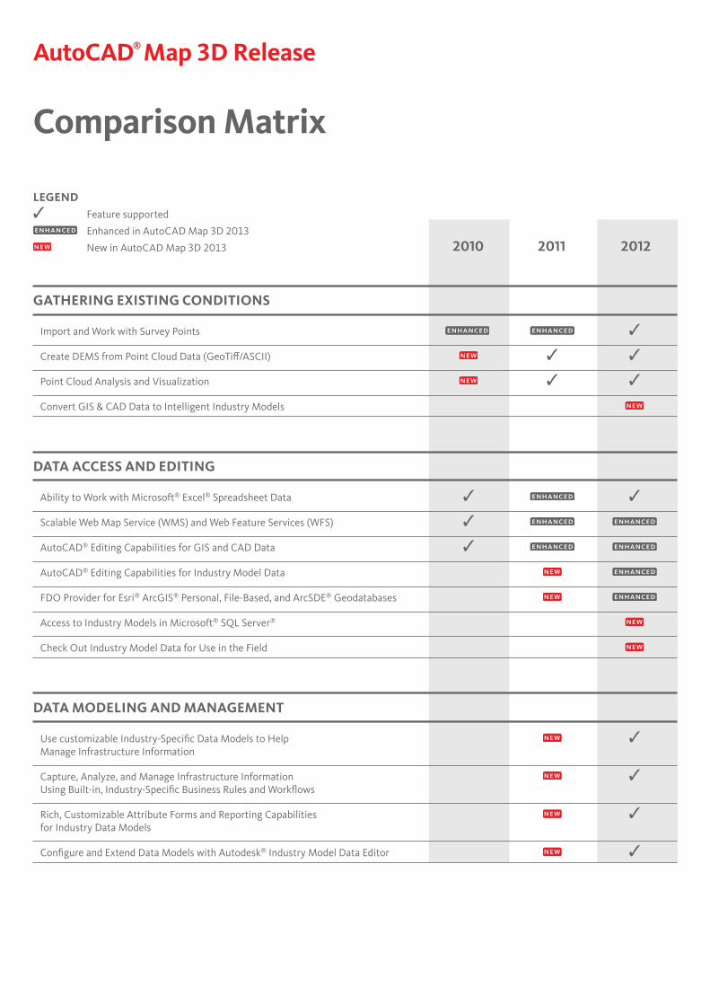
2010 2011 2012
LEGEND✓ Feature supported
Enhanced in AutoCAD Map 3D 2013
New in AutoCAD Map 3D 2013
AutoCAD® Map 3D Release
Comparison Matrix
GATHERING EXISTING CONDITIONS
Import and Work with Survey Points ✓
Create DEMS from Point Cloud Data (GeoTiff/ASCII) ✓ ✓
Point Cloud Analysis and Visualization ✓ ✓
Convert GIS & CAD Data to Intelligent Industry Models
DATA ACCESS AND EDITING
Ability to Work with Microsoft® Excel® Spreadsheet Data ✓ ✓
Scalable Web Map Service (WMS) and Web Feature Services (WFS) ✓
AutoCAD® Editing Capabilities for GIS and CAD Data ✓
AutoCAD® Editing Capabilities for Industry Model Data
FDO Provider for Esri® ArcGIS® Personal, File-Based, and ArcSDE® Geodatabases
Access to Industry Models in Microsoft® SQL Server®
Check Out Industry Model Data for Use in the Field
DATA MODELING AND MANAGEMENT
Use customizable Industry-Specific Data Models to Help ✓ Manage Infrastructure Information
Capture, Analyze, and Manage Infrastructure Information ✓Using Built-in, Industry-Specific Business Rules and Workflows
Rich, Customizable Attribute Forms and Reporting Capabilities ✓ for Industry Data Models
Configure and Extend Data Models with Autodesk® Industry Model Data Editor ✓
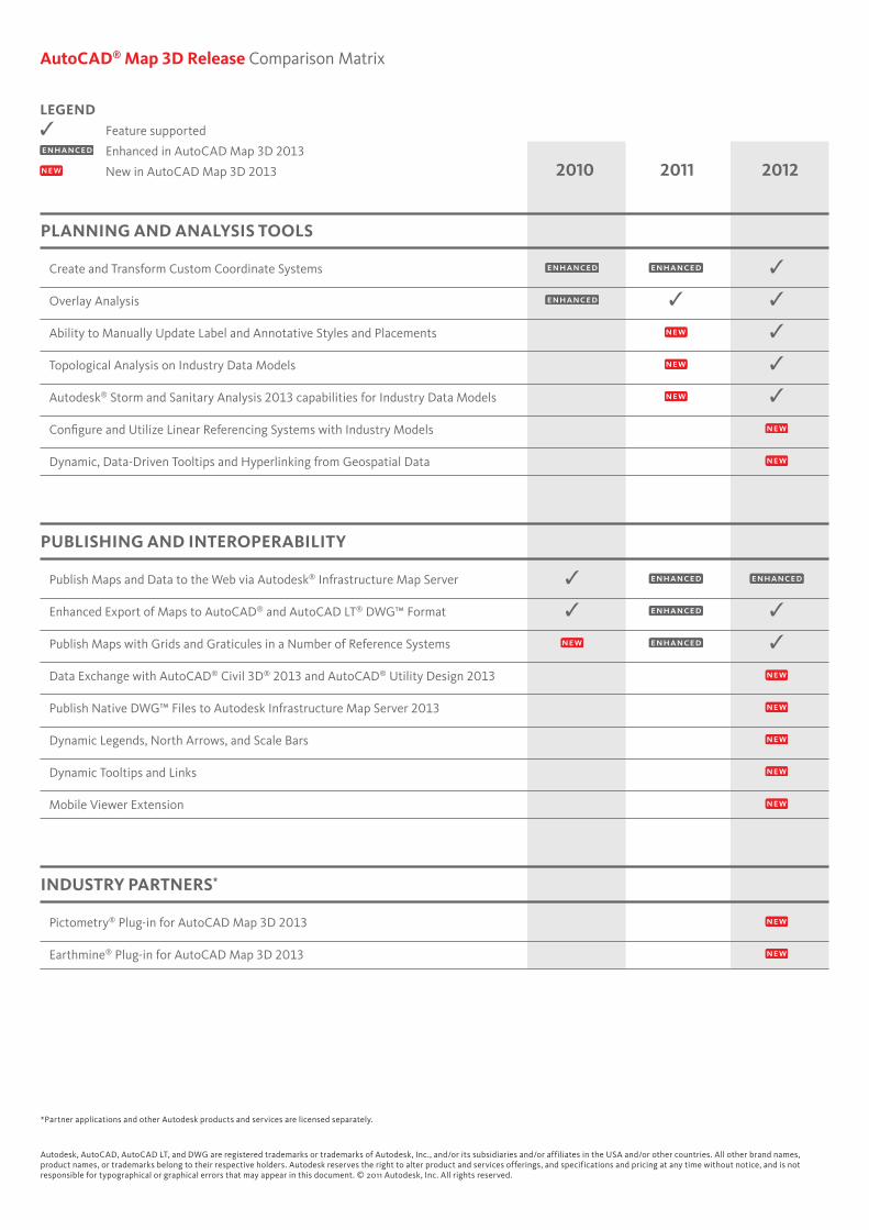
AutoCAD® Map 3D Release Comparison Matrix
2010 2011 2012
LEGEND✓ Feature supported
Enhanced in AutoCAD Map 3D 2013
New in AutoCAD Map 3D 2013
PLANNING AND ANALYSIS TOOLS
Create and Transform Custom Coordinate Systems ✓
Overlay Analysis ✓ ✓
Ability to Manually Update Label and Annotative Styles and Placements ✓
Topological Analysis on Industry Data Models ✓
Autodesk® Storm and Sanitary Analysis 2013 capabilities for Industry Data Models ✓
Configure and Utilize Linear Referencing Systems with Industry Models
Dynamic, Data-Driven Tooltips and Hyperlinking from Geospatial Data
PUBLISHING AND INTEROPERABILITY
Publish Maps and Data to the Web via Autodesk® Infrastructure Map Server ✓
Enhanced Export of Maps to AutoCAD® and AutoCAD LT® DWG™ Format ✓ ✓
Publish Maps with Grids and Graticules in a Number of Reference Systems ✓
Data Exchange with AutoCAD® Civil 3D® 2013 and AutoCAD® Utility Design 2013
Publish Native DWG™ Files to Autodesk Infrastructure Map Server 2013
Dynamic Legends, North Arrows, and Scale Bars
Dynamic Tooltips and Links
Mobile Viewer Extension
INDUSTRY PARTNERS*
Pictometry® Plug-in for AutoCAD Map 3D 2013
Earthmine® Plug-in for AutoCAD Map 3D 2013
Autodesk, AutoCAD, AutoCAD LT, and DWG are registered trademarks or trademarks of Autodesk, Inc., and/or its subsidiaries and/or affiliates in the USA and/or other countries. All other brand names, product names, or trademarks belong to their respective holders. Autodesk reserves the right to alter product and services offerings, and specifications and pricing at any time without notice, and is not responsible for typographical or graphical errors that may appear in this document. © 2011 Autodesk, Inc. All rights reserved.
*Partner applications and other Autodesk products and services are licensed separately.