Embed Size (px)
Citation preview

COMPARATIVE ASSESSMENT OF RUNOFF AND ITS COMPONENTS IN TWO
CATCHMENTS OF UPPER INDUS BASIN BY USING A SEMI DISTRIBUTED GLACIO-
HYDROLOGICAL MODEL
*Syed Hammad Ali1,2, Iram Bano1, Rijan Bhakta Kayastha1, Ahuti Shrestha1
1Himalayan Cryosphere, Climate and Disaster Research Centre, Department of Environmental Science and Engineering, School of
Science, Kathmandu University, Dhulikhel, Nepal ([email protected]) ([email protected]) ([email protected]) 2Glacier Monitoring Research Centre, Water & Power Development Authority, Pakistan ([email protected])
KEY WORDS: Positive degree day, climate variability, glacier coverage, water resource management, Gilgit River basin, Hunza
River basin, Upper Indus Basin
ABSTRACT:
The hydrology of Upper Indus basin is not recognized well due to the intricacies in the climate and geography, and the scarcity of
data above 5000 m a.s.l where most of the precipitation falls in the form of snow. The main objective of this study is to measure the
contributions of different components of runoff in Upper Indus basin. To achieve this goal, the Modified positive degree day model
(MPDDM) was used to simulate the runoff and investigate its components in two catchments of Upper Indus basin, Hunza and Gilgit
River basins. These two catchments were selected because of their different glacier coverage, contrasting area distribution at high
altitudes and significant impact on the Upper Indus River flow. The components of runoff like snow-ice melt and rainfall-base flow
were identified by the model. The simulation results show that the MPDDM shows a good agreement between observed and
modeled runoff of these two catchments and the effects of snow and ice are mainly reliant on the catchment characteristics and the
glaciated area. For Gilgit River basin, the largest contributor to runoff is rain-base flow, whereas large contribution of snow-ice melt
observed in Hunza River basin due to its large fraction of glaciated area. This research will not only contribute to the better
understanding of the impacts of climate change on the hydrological response in the Upper Indus, but will also provide guidance for
the development of hydropower potential and water resources assessment in these catchments.
1. INTRODUCTION
Pakistan is situated in South Asia between 24°-37°N latitude
and 66°-77°E. It hosts the triple point (junction) of three world
famous mountain rages Himalayas, Karakoram and Hindukush
in its north. There are more than 5000 glaciers feeding the Indus
from 10 sub-basins through different tributaries ranging from
few tens of meters to more than 70 km long. A major proportion
of flow in the Indus River is contributed by its snow and
glacier-fed river catchments situated in the Karakoram Range.
The major Indus basin is divided into three basins the Kabul,
Upper Indus, and Panjnad. The Upper Indus basin includes the
Gilgit, Hunza, Shigar, Shyok, Zanskar, Shingo, Astor, and
Upper Indus sub-basins (Bajracharya and Shrestha, 2011).
These basins feature distinct hydrological regimes, which are
linked with the main source (snow and glacier) of their melt-
water generation and can be differentiated by its strong
correlation with the climatic variables.
The hydrological system of Upper Indus basin is mainly reliant
on the monsoon and melting of snow and glaciers. To know the
contribution of glaciers to runoff is an essential step to identify
the impact of climate change on water resources, flooding and
drought in glacier fed basins. At present there are four
approaches to investigate the runoff components from rainfall,
melting of snow and glaciers: the water balance analysis
(Thayyen et al., 2005; Kumar et al., 2007), glacier degradation
from observation or modelling as contribution to runoff
(Kotliakov, 1996; Kaser et al., 2010), isotopic investigations
(Dahlke et al., 2013) and hydrological modelling (Hagg et al.,
2007; Naz et al., 2013) though limitations of these methods
cannot be ignored, especially for climate change studies. The
water balance method can roughly estimate the effects of glacier
and snow in monthly or larger time scale.
Approaches that relate glacier melt water production (gained by
the measurements or modelling) with measured discharge
further downstream are problematic because glacier melt water
can be considered as raw volume input into the runoff system,
but the discharge further downstream has been modified by
precipitation, evaporation, irrigation, damming, or exchange
with subsurface flow regimes and groundwater (Kaser et al.,
2010). The isotopic investigation cannot be used extensively as
it requires large financial and laboratory support. However, the
application of hydrological models to understand the glacier
effects in hydrology is comparatively new and more commonly
used (Hagg et al., 2007; Huss et al., 2008; Koboltschnig et al.,
2008; Prasch, 2010; Nepal et al., 2013). But the main problem
is the availability of long term data of high quality to symbolize
the hydrological dynamics of Upper Indus Basin (UIB).
The hydro-climatic conditions in glacierized basins of the UIB
alter considerably with elevation and topography and the
behavior of glaciers to climate changes may be dissimilar at
higher elevation than lower elevation, predominantly for large
glaciers where thick/thin debris cover can suppress/increase the
melting rate (Hewitt, 2005, 2011; Kaab et al., 2012; Gardelle et
al., 2012).
According to the findings of Archer, 2003; Fowler and Archer,
2005 and Hasson et al., 2015, the initial water supply from the
UIB after a long dry period (October to March) is gained from
melting of snow (late-May to late-July), the range of which
largely depends upon the accumulated snow amount and
concurrent temperatures and snowmelt runoff is then
overlapped by the glacier melt runoff (late-June to late-August),
The International Archives of the Photogrammetry, Remote Sensing and Spatial Information Sciences, Volume XLII-2/W7, 2017 ISPRS Geospatial Week 2017, 18–22 September 2017, Wuhan, China
This contribution has been peer-reviewed. https://doi.org/10.5194/isprs-archives-XLII-2-W7-1487-2017 | © Authors 2017. CC BY 4.0 License.
1487

the extent of which primarily be contingent to the melt season
temperatures.
Climate change is explicit and increasingly serious concern due
to its recent acceleration globally. Glaciers and icy surfaces are
the most sensitive indicators of global warming which have
shown their immediate response in terms of mass balance and
contribution of melt water to the sea level rise. According to
World Meteorological Organization statement on status of
climate, the first decade (2001-2010) is the warmest decade
recorded over the globe and 2010 ranked as the warmest year
(+0.53°C) followed by 2005 (+0.52°C) and 1998 (0.52°C).
Sixteen warmest years of the globe occurred during the last two
decades.
Similarly, local impacts of the regionally varying climate
change can differ significantly, depending upon the local
adaptive capacity, exposure and resilience (Salik et al., 2015),
especially for the sectors of water, food and energy security. In
view of high sensitivity of mountainous environments to climate
change and the role of melt water as an important regulator for
UIB runoff dynamics, it is very important to study the snow and
glacier and their impacts on the hydrologic regime of this Upper
Indus region under climate variability to manage the available
water resources. The aim of this study is to understand the
glacier and snow effects on hydrological regime in Upper Indus
basin and to identify the contributions to runoff components
2. STUDY AREA
The Gilgit River basin with drainage area, 13,471 km2 (Fig. 1),
encompasses eastern part of the Hindukush Range and drains
southeastward into the Indus River. Gilgit River is measured at
Alam Bridge hydrometric station. Geographically the basin
extends from 35.80°N, 72.53°E to 36.91°N, 74.70°E. The
elevation of the basin ranges from 1,250 - 7,730 m a.s.l.
Approximately 982 km² of catchment area is at an elevation
above 5000 m and almost the same area (8%) is glaciated
accounting for 4% of the UIB cryospheric extent. The clean
glacier area is ≈944 km2 and the debris cover area is ≈146 km2.
The average SCA varies from approximately 85% in winter to
10% in summer (Tahir, et al., 2011). Gilgit River basin receives
its precipitation from both westerly disturbances and summer
monsoon system. In Gilgit River basin there are 585 glaciers
and 605 glacier lakes, whereas, 8 potentially dangerous glacier
lakes.
Figure 1. Study Area
The Hunza River basin with drainage area of 13,713 km2 (Fig.
1), geographically extends from 36.05°N, 74.04°E to 37.08°N,
75.77°E. It is situated in the high-altitude central Karakoram
region, with a mean catchment elevation of 4,631 m.
Approximately 4,152 km2 of catchment area is glaciated. The
elevation ranges from 1432 - 7849 m a.s.l. Shuttle Radar
Topography Mission Digital Elevation Model (SRTM DEM
2000) of resolution 90m of U.S. National Aeronautics and
Space Administration (NASA) is used to delineate the
catchment boundaries of the study area. The total numbers of
glaciers in basin are approximately 1,384. The clean glacier area
is 3,673.04 km2 and the debris cover area is 479.56 km2. The
snow cover area in the Hunza River basin varies from
approximately 80% in winter to 30% in summer (Tahir, et al.,
2011). The distribution of area versus elevation for both basins
is shown in Figures 2 and 3.
Figure 2. Hypsograph of Hunza River Basin
Figure 3. Hypsograph of Gilgit River Basin
3. HYDROCLIMATIC DATA ANALYSIS
Hydro-meteorological characteristics of each river have been
determined through water yield calculation and basin analysis.
Temperature and precipitation varies place to place due to
altitudinal variation, monsoon path and topography. The Indus
River and its tributaries rise in the sparsely populated glaciated
mountains of western and central Asia. The Indus River itself
contributes more than half the total flow and has a controlling
storage at Tarbela Dam as the river emerges from the mountains
(Hayley et al., 2005).
The UIB perceives contrasting hydro-meteorological regimes
mainly because of the complex terrain of the HKH ranges and
sophisticated interaction of prevailing regional circulations
(Hasson et al., 2014a, 2015). The sparse (high and low altitude)
meteorological network in such a difficult area neither covers
fully its vertical nor its horizontal extents it may also be highly
influenced by the complex terrain features and variability of the
meteorological events. The hydrological regimes of Gilgit and
Hunza as sub catchments of UIB due to its complex terrain,
highly concentrated cryosphere and the form, magnitude and
seasonality of moisture input associated with two distinct modes
of prevailing large scale circulation; westerly disturbances and
summer monsoon and river runoff is mainly dependent on these
The International Archives of the Photogrammetry, Remote Sensing and Spatial Information Sciences, Volume XLII-2/W7, 2017 ISPRS Geospatial Week 2017, 18–22 September 2017, Wuhan, China
This contribution has been peer-reviewed. https://doi.org/10.5194/isprs-archives-XLII-2-W7-1487-2017 | © Authors 2017. CC BY 4.0 License.
1488

circulations. Two thirds of the precipitation in the Karakoram
region is a result of westerly’s influences and one third have a
strong monsoon component (Hewitt, 2009).
WAPDA and PMD has maintained some automatic weather
stations equipped with precipitation gauges as shown in (Fig. 1)
at Gilgit, Yasin and Ushkor in Gilgit and Naltar, Ziarat and
Khunjerab in Hunza basin located between elevation 1460 –
4700 m a.s.l. The data from these stations are used for this
study. Some year’s precipitation data is missing in Yasin and
Ushkor stations due to some problem in the gauges. Mean
annual precipitation and temperature at different stations of
both basins are presented in Table 1. Variations in temperature
and precipitation at different climate stations are demonstrated
in Figures 4 & 5 and 8 & 9 respectively. The decrease in
precipitation at higher altitude is partly due to wind induced
error especially in the case of snowfall where losses can be on
average 10–50%, regardless of the many gauges furnished with
wind shields Sevruk (1985, 1989) and Forland et al. (1996).
Figure 4. Variations in temperature at different climate stations
(Hunza River Basin)
Figure 5. Variations in temperature at different climate stations
(Gilgit River Basin)
Naltar is located in the south of the Hunza River basin and has
the highest precipitation and the strongest influence of the
monsoon (June, July, August [JJA]). The JJA variability is also
the highest in Naltar, underlining the strong variability in
monsoon strength. A non-parametric test Mann Kendall test
which is a pragmatic choice that has been extensively adopted
for hydro-climatic trend analysis has been done for studying the
temporal trends of hydro-climatic series which shows no
statistically significant trend in both temperature and
precipitation data with p > 0.05 value. From this data analysis,
it is observed that temperature is slightly decreasing at Naltar
climate station (Hunza River basin) by -0.0097°C yr-1 on the
other hand Yasin climate station (Gilgit basin) show an
increasing trend by 0.036°C yr-1 over a period of 1995 -2013
while precipitation shows increasing trend in both the stations
with 0.3 mm yr-1 and 11.41 mm yr-1 respectively for the same
time period (Fig. 6 and 7).
Figure 6. Annual Temperature trend at climate stations of both
basins
Figure 7. Annual Precipitation trend at climate stations of both
basins
Figure 8. Variations in precipitation at different climate stations
(Hunza River Basin)
Figure 9. Variations in precipitation at different climate stations
(Gilgit River Basin)
The International Archives of the Photogrammetry, Remote Sensing and Spatial Information Sciences, Volume XLII-2/W7, 2017 ISPRS Geospatial Week 2017, 18–22 September 2017, Wuhan, China
This contribution has been peer-reviewed. https://doi.org/10.5194/isprs-archives-XLII-2-W7-1487-2017 | © Authors 2017. CC BY 4.0 License.
1489
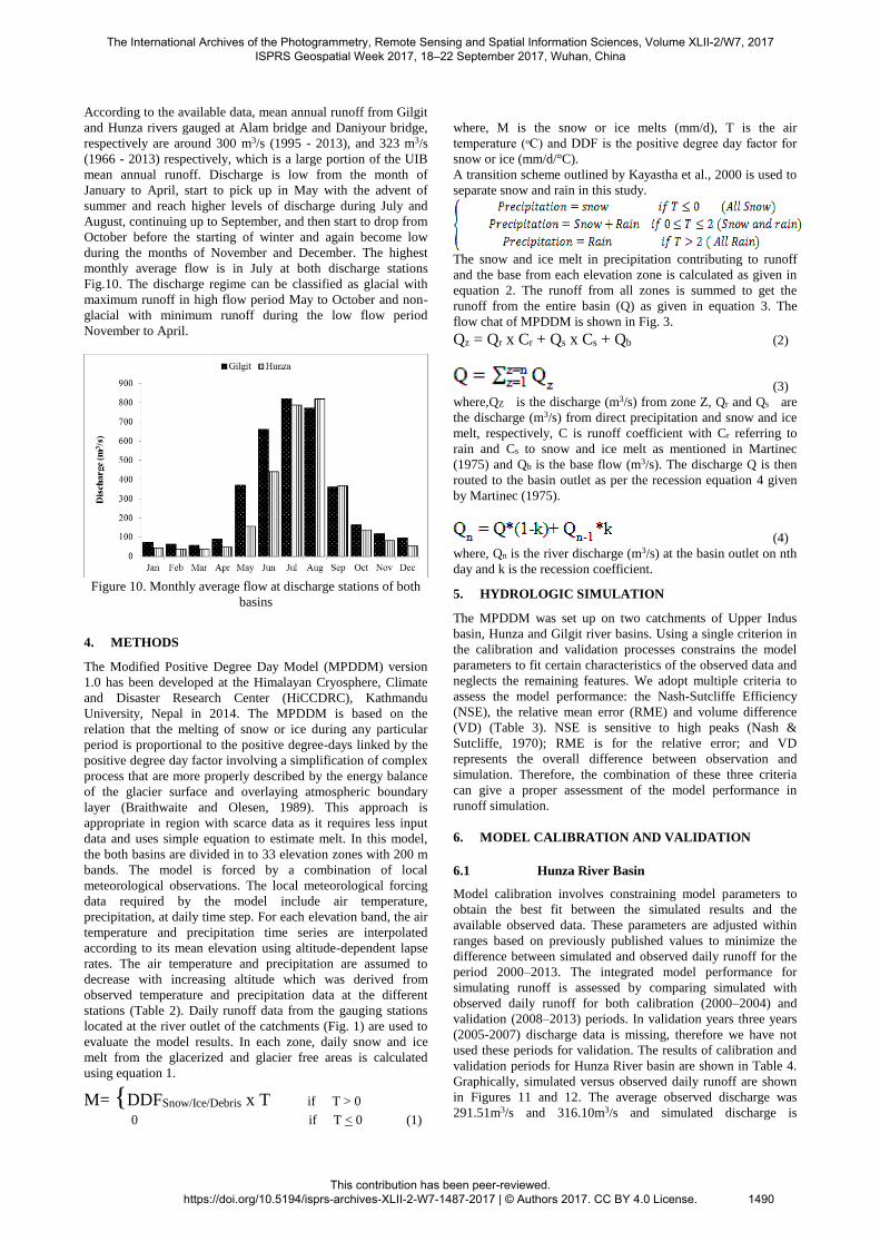
According to the available data, mean annual runoff from Gilgit
and Hunza rivers gauged at Alam bridge and Daniyour bridge,
respectively are around 300 m3/s (1995 - 2013), and 323 m3/s
(1966 - 2013) respectively, which is a large portion of the UIB
mean annual runoff. Discharge is low from the month of
January to April, start to pick up in May with the advent of
summer and reach higher levels of discharge during July and
August, continuing up to September, and then start to drop from
October before the starting of winter and again become low
during the months of November and December. The highest
monthly average flow is in July at both discharge stations
Fig.10. The discharge regime can be classified as glacial with
maximum runoff in high flow period May to October and non-
glacial with minimum runoff during the low flow period
November to April.
Figure 10. Monthly average flow at discharge stations of both
basins
4. METHODS
The Modified Positive Degree Day Model (MPDDM) version
1.0 has been developed at the Himalayan Cryosphere, Climate
and Disaster Research Center (HiCCDRC), Kathmandu
University, Nepal in 2014. The MPDDM is based on the
relation that the melting of snow or ice during any particular
period is proportional to the positive degree-days linked by the
positive degree day factor involving a simplification of complex
process that are more properly described by the energy balance
of the glacier surface and overlaying atmospheric boundary
layer (Braithwaite and Olesen, 1989). This approach is
appropriate in region with scarce data as it requires less input
data and uses simple equation to estimate melt. In this model,
the both basins are divided in to 33 elevation zones with 200 m
bands. The model is forced by a combination of local
meteorological observations. The local meteorological forcing
data required by the model include air temperature,
precipitation, at daily time step. For each elevation band, the air
temperature and precipitation time series are interpolated
according to its mean elevation using altitude-dependent lapse
rates. The air temperature and precipitation are assumed to
decrease with increasing altitude which was derived from
observed temperature and precipitation data at the different
stations (Table 2). Daily runoff data from the gauging stations
located at the river outlet of the catchments (Fig. 1) are used to
evaluate the model results. In each zone, daily snow and ice
melt from the glacerized and glacier free areas is calculated
using equation 1.
M= {DDFSnow/Ice/Debris x T if T > 0
0 if T < 0 (1)
where, M is the snow or ice melts (mm/d), T is the air
temperature (ᵒC) and DDF is the positive degree day factor for
snow or ice (mm/d/°C).
A transition scheme outlined by Kayastha et al., 2000 is used to
separate snow and rain in this study.
The snow and ice melt in precipitation contributing to runoff
and the base from each elevation zone is calculated as given in
equation 2. The runoff from all zones is summed to get the
runoff from the entire basin (Q) as given in equation 3. The
flow chat of MPDDM is shown in Fig. 3.
Qz = Qr x Cr + Qs x Cs + Qb (2)
(3)
where,QZ is the discharge (m3/s) from zone Z, Qr and Qs are
the discharge (m3/s) from direct precipitation and snow and ice
melt, respectively, C is runoff coefficient with Cr referring to
rain and Cs to snow and ice melt as mentioned in Martinec
(1975) and Qb is the base flow (m3/s). The discharge Q is then
routed to the basin outlet as per the recession equation 4 given
by Martinec (1975).
(4)
where, Qn is the river discharge (m3/s) at the basin outlet on nth
day and k is the recession coefficient.
5. HYDROLOGIC SIMULATION
The MPDDM was set up on two catchments of Upper Indus
basin, Hunza and Gilgit river basins. Using a single criterion in
the calibration and validation processes constrains the model
parameters to fit certain characteristics of the observed data and
neglects the remaining features. We adopt multiple criteria to
assess the model performance: the Nash-Sutcliffe Efficiency
(NSE), the relative mean error (RME) and volume difference
(VD) (Table 3). NSE is sensitive to high peaks (Nash &
Sutcliffe, 1970); RME is for the relative error; and VD
represents the overall difference between observation and
simulation. Therefore, the combination of these three criteria
can give a proper assessment of the model performance in
runoff simulation.
6. MODEL CALIBRATION AND VALIDATION
6.1 Hunza River Basin
Model calibration involves constraining model parameters to
obtain the best fit between the simulated results and the
available observed data. These parameters are adjusted within
ranges based on previously published values to minimize the
difference between simulated and observed daily runoff for the
period 2000–2013. The integrated model performance for
simulating runoff is assessed by comparing simulated with
observed daily runoff for both calibration (2000–2004) and
validation (2008–2013) periods. In validation years three years
(2005-2007) discharge data is missing, therefore we have not
used these periods for validation. The results of calibration and
validation periods for Hunza River basin are shown in Table 4.
Graphically, simulated versus observed daily runoff are shown
in Figures 11 and 12. The average observed discharge was
291.51m3/s and 316.10m3/s and simulated discharge is
The International Archives of the Photogrammetry, Remote Sensing and Spatial Information Sciences, Volume XLII-2/W7, 2017 ISPRS Geospatial Week 2017, 18–22 September 2017, Wuhan, China
This contribution has been peer-reviewed. https://doi.org/10.5194/isprs-archives-XLII-2-W7-1487-2017 | © Authors 2017. CC BY 4.0 License.
1490

279.59m3/s and 272.51m3/s for calibration and validation
period, respectively.
Figure 11. Calibration of MPDDM Hunza River Basin
Figure 12. Validation of MPDDM Hunza River Basin
6.2 Gilgit River Basin
The model was calibrated from 1999 to 2005, and validated
from 2006 to 2010 at a daily time step. The results of
calibration and validation periods for Gilgit River basin are
shown in Table 5. For graphical representation, the observed
and simulated discharge in calibration and validation period is
presented in Figures 13 and 14. The average observed discharge
was 298.18m3/s and 316.60m3/s and simulated discharge is
286.99m3/s and 304.07m3/s for calibration and validation period
respectively.
Calibration and validation results clearly shows that the model
can efficiently simulate hydrologic response of the Hunza and
Gilgit River basins and give a good fit of the low flow as well as
high flow using the optimal parameter sets (Table 6), with a
rating of ‘very good’ on the scale of Moriasi et al. (2007),
except some sudden peaks due to some extreme events like
(cloud burst, GLOF, eruption of ponds and etc.) during
monsoon period which is common in hydrological modeling but
the uncertainty of the results cannot be ignored. The sources of
the uncertainty are data used in the calibration and validation.
Among the observed data of precipitation, temperature and
discharge, the precipitation data are expected to be the largest
source of uncertainty because most stations are located at lower
elevations, while information about precipitation at higher
elevations (above 5000 m a.s.l) is missing. Additionally in this
study, a degree-day method for snow melting was used and the
snow cover area is not updated or modelled. By doing this,
there is unlimited snow available for melting, which might not
realistic in a long term simulation and may lead to high
estimation of water from rain-base flow as compared to snow-
ice melt.
Figure 13. Calibration of MPDDM Gilgit River Basin
Figure 14. Calibration of MPDDM Gilgit River Basin
7. RUNOFF COMPONENTS
We calculated variations in runoff and its components in the
both catchments of UIB using observed meteorological data. In
Hunza River basin a large fraction of runoff is from snow-ice
melt 38.73%. Irrespective of glacier runoff, base flow
contributes 50.84% of total runoff, rainfall runoff is 10.43%.
On the other hand the contributions of different components of
runoff like snow-ice melt, base flow and rainfall in Gilgit River
basin are 26.58%, 61.11% and 0.12% respectively. Base flow
is the technical name for the dry weather flow and much of the
wet weather flow in a stream or river. River base flow results
from ground water seeping into riverbanks or the riverbed. The
flow may be significant enough to allow the stream to flow year
round (i.e., perennial or permanent stream). Without base flow
recharge from ground water to streams and rivers, many would
not carry a flow of water except during storms. Streams that
flow only periodically in response to rainstorms or seasonal
snowmelt events are known as ephemeral or intermittent
streams (American Ground Water Trust, 2003). In an ideal
basin the geologic material are of uniform permeability and the
steam has excellent hydraulic continuity with the nearby aquifer
rarely if ever is this situation come across in nature most all
basins have complex geology and streams draining such basins
may have incomplete hydraulic continuity with the underlying
aquifers in many cases more than one aquifer may be
contributing water to the streams (Ferris et al., 1962).
According to genetic components of stream flow for the Hindu
Kush Karakoram, Pamir and Tien Shan mountains established
by (Dreyer et al., 1982) rivers are fed by groundwater from
November to February. Snowmelt begins in the lower parts of
basin in March, and groundwater discharge increase to
maximum in July – August, until September Rivers are fed by
groundwater, ice melt, snowmelt and precipitation. Snowmelt
ceases by October in high mountains and rivers are fed solely
by groundwater. The method is based on regular changes in
stream flow structure during the year.
Monthly variation in the magnitude of the contribution of each
runoff component to the total runoff and its intra-annual
distribution are presented for the period 1999–2013 in Figures
15 and 16. According to our estimation the mean annual glacier
runoff in Hunza and Gilgit River basin are observed between
May - October 47.71% and 33.2%, respectively, the fraction of
glacier runoff approaches zero during the winter months, and
runoff from the glacier-free zone of the catchment is a larger
component of total runoff. With increasing temperature, the
contribution from glacier runoff begins to increase and reaches
maximum in May (≈65%) and is also significant during the
other summer months (≈40 – 55%) in Hunza River basin. On
the other hand glacier runoff is maximum in May (≈50%) and
≈20 – 45% in other summer months in Gilgit River basin.
Rainfall is the largest contributor in July and August. The
melting of glaciers along with the more precipitation fall as rain
is likely to cause heavy flooding and Hunza and Gilgit River
The International Archives of the Photogrammetry, Remote Sensing and Spatial Information Sciences, Volume XLII-2/W7, 2017 ISPRS Geospatial Week 2017, 18–22 September 2017, Wuhan, China
This contribution has been peer-reviewed. https://doi.org/10.5194/isprs-archives-XLII-2-W7-1487-2017 | © Authors 2017. CC BY 4.0 License.
1491

basin is susceptible to floods in monsoon as recorded in 2005
and 2010.
Figure 15. Monthly contribution of runoff components from
Hunza River Basin
Figure 16. Monthly contribution of runoff components from
Gilgit River Basin
Table.1 Mean annual precipitation and temperature at different
stations of both basins Station Elevation
(m a.s.l)
Period Mean Annual
Temperature (°C)
Mean Annual
Precipitation (mm)
Gilgit 1460 1995 – 2013 16.0 155
Naltar 2898 1995 – 2013 6.0 669
Ushkor 3051 1995 – 2013 6.0 394
Yasin 3280 1995 – 2013 5.0 364
Ziarat 3668 1995 – 2013 3.0 285
Khunjerab 4730 1995 – 2013 -5.0 209
Table 2. Details of climatic and Discharge stations, their
coordinates, data period, and sources of data.
Sr.
No.
Station Basin Elevation (m) Coordinates
Lat Long
Period of
Record
Source
Climate Stations
1 Naltar
Hunza
2898 36.168 74.175 1995-2013 WAPDA
2 Ziarat 3668 36.829 74.418 1995-2013 WAPDA
3 Khunjerab 4730 36.812 75.332 1995-2013 WAPDA
4 Yasin
Gilgit
3280 36.451 73.294 1995-2013 WAPDA
5 Ushkor 3051 36.027 73.415 1995-2013 WAPDA
6 Gilgit 1460 35.921 74.327 2000-2013 PMD
Discharge Stations
1 Daniyour Br. Hunza 1450 35.56 74.23 1960-2013 WAPDA
2 Alam Br. Gilgit 1430 35.56 74.19 1995-2013 WAPDA
Table 3. Model performance assessment criteria and their
corresponding formulation Criteria Formula Value Range Perfect Value
NSE 1−
(𝑂𝑖 − 𝑆𝑖)2𝑛
𝑖=1
(𝑂𝑖 − 𝑂 𝑖)2𝑛𝑖=1
-∞,1 1
VD 𝑉𝑅 − 𝑉𝑅′
𝑉𝑅∗ 100
Least volume difference
indicate the good fit of
model
RME (𝑆𝑖 − 𝑂𝑖)𝑛𝑖=1
𝑂𝑖𝑛𝑖=1
-∞,+∞ 0
Where Oi and Si are the observed and simulated flow,
respectively; i is the time series index; n is the total number of
time steps; VR is measured runoff volume; VR′ is simulated
runoff volume.
Table 4. Model efficiency of calibration and validation periods
on Hunza River Basin Period NSE VD RME
Calibration 0.88 4.09% -0.04
Validation 0.89 13.79% -0.13
Table 5. Model efficiency of calibration and validation periods
on Gilgit River Basin Period NSE VD RME
Calibration 0.85 3.75% -0.04
Validation 0.78 3.96% -0.04
Table 6. List of calibrated parameters used in MPDDM
Parameters Description Values
ks Degree day factor for snow ablation
(Bocchiola, et al., 2011)
5.0-6.0 mm/°C/day (Jan – Apr)
6.0-8.0 mm/°C/day (May – Sep)
6.5-7.0 mm/°C/day (Oct – Dec)
ki Degree day factor for ice ablation
(Bocchiola, et al., 2011)
6.0-8.0 mm/°C/day (Jan – Apr)
6.0-9.0 mm/°C/day (May – Sep)
7.5-8.5 mm/°C/day (Oct – Dec)
kd Degree day factor for debris covered
ice (Mihalcea, et al., 2006)
4 - 6 mm/°C/day
Γ Temperature Lapse Rate 0.48 -0.76 °C/100m
PG Precipitation Gradient 0.25 -1
Cr
Cs
Coefficient of Rain
Coefficient of Snow.
(Tahir, et al., 2011)
0.08-0.5
0.1-0.40
X
Y
Constant for Recession Coefficient 0.97
0.04
8. CONCLUSION
The mountains region of UIB is a key source of water for
Pakistan and delivers the main water source for the IBIS, one of
the world’s largest assimilated irrigation networks. The River
Indus is nourished by an amalgamation of melt water from
seasonal and permanent snow fields and glaciers, and runoff
from rainfall both during the winter and monsoon season. To
simulate the runoff and its contribution components in Upper
The International Archives of the Photogrammetry, Remote Sensing and Spatial Information Sciences, Volume XLII-2/W7, 2017 ISPRS Geospatial Week 2017, 18–22 September 2017, Wuhan, China
This contribution has been peer-reviewed. https://doi.org/10.5194/isprs-archives-XLII-2-W7-1487-2017 | © Authors 2017. CC BY 4.0 License.
1492

Indus, the MPDDM was used to identify the runoff proportions
from rain and base flow, snow-ice melt in two catchments of
Upper Indus basin: Hunza River basin, and Gilgit River basin.
The results show that the MPDDM is able to give rational
assessment of runoff on these two catchments. The hydrological
components differ between both basins and these affect the flow
of Indus River and the water resource use in the lower Indus.
For the Gilgit river basin, the largest contributor to runoff is
rain and base flow, whereas melting of snow-ice is markedly
dominant in the Hunza River basin. The variation of
hydrological components within the basin was due to the
elevation range and the distribution of areas within each
elevation band in the catchment, temperature variations,
permanent snowfields and the glacierized proportion. The more
precipitation that falls as rain is likely to raise the high flow and
glacier retreating is likely to reduce the base flow, which
possibly leads to more droughts and floods. In summary, these
two study basins are vulnerable to climate change. The model
performances can be enhanced by using some other global
climate data and emissions scenarios to assess the potential
impacts of climate change on the hydrology of whole Upper
Indus basin as a macro scale model.
ACKNOWLEDGEMENTS
We acknowledge support from the Contribution to High Asia
Runoff from Ice and Snow (CHARIS) Project, University of
Colorado, Boulder, USA funded by the United States Agency
for International Development (USAID).We thank the project
partners for their help in carrying out this study, including: the
Himalayan Cryosphere, Climate and Disaster Research Center
(HiCCDRC), the Department of Environmental Science and
Engineering, School of Science, Kathmandu University, Glacier
Monitoring Research Center (GMRC); Water & Power
Development Authority (WAPDA) Government of Pakistan.
REFERENCES
Archer, D.R., (2003). Contrasting hydrological regimes in the
Upper Indus Basin. J. Hydrol. 274, 198–210.
American Ground Water Trust (2003). Groundwater and river
flow. THE AMERICAN WELL OWNER, 2003, Number 3
Bajracharya, SR; Shrestha, B.,(eds) 2011. The status of Glaciers
in Hindu Kush-Himalayan region. Kathmandu: ICIMOD.
Braithwaite, R. J., and Olesen, O.B., (1989): Calculation of
glacier ablation from air temperature, West Greenland. In
Glacier fluctuations and climate change. Ed. Oerleamas, J.,
Kluwer Academic Publishers, Dordrecht, 219-233.
Dahlke, H. E., Lyon, S. W., Jansson, P., Karlin, T. & Rosqvist,
G. (2013) Isotopic investigation of runoff generation in a
glacierized catchment in northern Sweden. Hydrological
Processes. doi: 10.1002/hyp.9668.
Dreyer, N. N., Nikolayeva, G. M., and Tsigelnaya, I.D., (1982)
Maps of streamflow resources of some high mountain areas in
Asia and North America Hydrological Aspects of Alpine and
High Mountain Areas (Proceedings of the Exeter Symposium,
July 1982). IAHS Publ. no. 138.
Ferris, J.G., and others, 1962, theory of aquifer tests: U. S.
Geol. Survey Water suppl Paper 1936E, p.99-101.
Forland, E.J. et al., 1996. Manual for operational correction of
Nordic precipitation data.24/96, DNMI, P.O. Box 43, Blindern,
Oslo, Norway.
Fowler, H. J. and Archer, D. R.: Hydro-climatological
variability in the Upper Indus Basin and implications for water
resources, in: IAHS Publ. 295, Regional Hydrological Impacts
of Climatic Change – Impact Assessment and Decision Making,
Proceedings of symposium S6, Seventh IAHS Scientific
Assembly, Foz do Iguaçu, Brazil, 2005
Gardelle, J., Berthier, E., Arnaud, Y., and Kääb, A.: Region-
wide glacier mass balances over the Pamir-Karakoram-
Himalaya during 1999–2011, The Cryosphere, 7, 1263–1286,
doi:10.5194/tc-7-1263-2013, 2013.
Hagg, W., Braun, L. N., Kuhn, M. & Nesgaard, T. I. (2007)
Modelling of hydrological response to climate change in
glacierized Central Asian catchments. Journal of Hydrology
332(1–2), 40–53.
Hasson, S., Lucarini, V., Pascale, S., and Böhner, J.:
Seasonality of the hydrological cycle in major South and
Southeast Asian river basins as simulated by PCMDI/CMIP3
experiments, Earth Syst. Dynam., 5, 67–87, doi:10.5194/esd-5-
67-2014, 2014a.
Hasson, S., Pascale, S., Lucarini, V., and Böhner, J. (2015):
Seasonal cycle of precipitation over Major River Basins in
South and Southeast Asia: a review of the CMIP5 climate
models data for present climate and future climate projections,
J. Atmos. Res.
Hayley J. Fowler and David R. Archer,” Hydro-climatological
variability in the Upper Indus Basin and implications for water
resources”, Regional Hydrological Impacts of Climatic Change-
Impact Assessment and Decision Making ,Proceedings of
symposium S6 held during the Seventh IAHS Scientific
Assembly at Foz do Iguaçu, Brazil, April 2005, IAHS Publ. 295
(2005).
Hewitt, K.: The Karakoram anomaly? Glacier expansion and the
“elevation effect”, Karakoram Himalaya, Mt. Res. Dev., 25,
332–340, 2005.
Hewitt, K (2009). Glacier change and Himalayan cryosphere.
Lecture presented at global change impact study center.
Islamabad, Pakistan.
Hewitt, K.: Glacier change, concentration, and elevation e_ects
in the Karakoram Himalaya, Upper Indus Basin, Mt. Res. Dev.,
31, 188–200, doi:10.1659/MRD-JOURNAL-D-11-00020.1,
2011.
Hussain, M., Farinotti, D., Bauder, A. & Funk, M. (2008)
Modelling runoff from highly glacierized alpine drainage basins
in a changing climate. Hydrological Processes 22(19), 3888–
3902.
The International Archives of the Photogrammetry, Remote Sensing and Spatial Information Sciences, Volume XLII-2/W7, 2017 ISPRS Geospatial Week 2017, 18–22 September 2017, Wuhan, China
This contribution has been peer-reviewed. https://doi.org/10.5194/isprs-archives-XLII-2-W7-1487-2017 | © Authors 2017. CC BY 4.0 License.
1493

Kaab, A., Berthier, E., Nuth, C., Gardelle, J., Arnaud, Y.
Contrasting patterns of early twenty-first-century glacier mass
change in the Himalayas. Nature 488, 495-498 (2012).
Kaser, G., Großhauser, M. & Marzeion, B. (2010) Contribution
potential of glaciers to water availability in different climate
regimes. In: National Academy of Sciences of the United States
of America (ed. by R. G. Barry), 20223–20227.
Kayastha, R. B., Ageta, Y., and Nakawo, M., (2000). Positive
Degree-day factors for ablation on glaciers in the Napalese
Himalayas: case study on Glacier AX010 in Shorong Himal
Nepal. Bulletin of glaciological research, 17. 1-10.
Koboltschnig, G. R., Schöner, W., Zappa, M., Kroisleitner, C.
& Holzmann, H. (2008) Runoff modelling of the glacierized
Alpine Upper Salzach basin (Austria): Multi‐criteria result
validation. Hydrological Processes 22(19), 3950–3964.
Kotliakov, V. M. (1996) Variations of Snow and Ice in the past
and at present on a Global and Regional Scale. Citeseer.
Kumar, V., Singh, P. & Singh, V. (2007) Snow and glacier melt
contribution in the Beas River at Pandoh Dam, Himachal
Pradesh, India. Hydrological Sciences Journal 52(2), 376–388.
Martinec, J., (1975). Snowmelt-runoff model for stream flow
forecasts. Nordic Hydrology, 6(3), 145-154. Doi:10.2166/nh.
1975.010.
Moriasi D.N., Arnold, J., Liew, M.W., Bingner, R.L., Harmel,
R.D., Veith, T.L., 2007. Model evaluation guidelines for
systematic quantification of accuracy in watershed simulations.
Trans. Am. Soc. Agric. Biol. Eng., 50(3), 885–900
Nash, J. E. & Sutcliffe, J. V. (1970) River flow forecasting
through conceptual models part I—A discussion of principles.
Journal of Hydrology 10(3), 282–290.
Naz, B., Frans, C., Clarke, G., Burns, P. & Lettenmaier, D.
(2013) Modeling the effect of glacier recession on streamflow
response using a coupled glacio-hydrological model. Hydrology
and Earth System Sciences Discussions 10(4), 5013–5056.
Nepal, S., Krause, P., Flügel, W.A., Fink, M. & Fischer, C.
(2013) Understanding the hydrological system dynamics of a
glaciated alpine catchment in the Himalayan region using the
J2000 hydrological model. Hydrological Processes doi:
10.1002/hyp.9627.
Prasch, M. (2010) Distributed process oriented modelling of the
future impact of glacier melt water on runoff in the Lhasa River
Basin in Tibet. Doctor, Ludwig-Maximilians-University of
Munich, Germany.
Salik, K. M., Jahangir, S., Zahdi, W. Z., and Hasson, S. (2015.):
Climate change vulnerability and adaptation options for the
coastal communities of Pakistan, Ocean Coast. Manage.
Sevruk, B., 1985. Correction of precipitation measurements,
Workshop on the Correction of Precipitation Measurements.
WMO/IAHS/ETH, Zurich, Switzerland, pp. 13–23.
Sevruk, B., 1989. Reliability of precipitation measurement,
International Workshop on Precipitation Measurement. WMO
Tech. Document, pp. 13–19.
Tahir, A.A., Chevallier, P., Arnaud, Y., Ahmad, B., 2011. Snow
cover dynamics and hydrological regime of the Hunza River
basin, Karakoram Range, Northern Pakistan. Hydrology and
Earth System Sciences 15(7):2275–2290. www.hydrolearth-
syst-sci.net/15/2275/2011/; accessed 4 August
2011.http://dx.doi.org/10.5194/hess-15-2275-2011.
Thayyen, R. J., Gergan, J. T. & Dobhal, D. P. (2005)
Monsoonal control on glacier discharge and hydrograph
characteristics, a case study of Dokriani Glacier, Garhwal
Himalaya, India. Journal of Hydrology 306(1–4), 37–49.
The International Archives of the Photogrammetry, Remote Sensing and Spatial Information Sciences, Volume XLII-2/W7, 2017 ISPRS Geospatial Week 2017, 18–22 September 2017, Wuhan, China
This contribution has been peer-reviewed. https://doi.org/10.5194/isprs-archives-XLII-2-W7-1487-2017 | © Authors 2017. CC BY 4.0 License.
1494


![[Nepal] Present Progress of Information Technology in ... · Health Care System of Nepal*1 Mukti Ram SHRESTHA1 *1 This article is base on a presentation made at the Symposium “Health](https://img.pdfslide.us/doc/110x75/5f03523b7e708231d408a2c3/nepal-present-progress-of-information-technology-in-health-care-system-of.jpg)