Embed Size (px)
Citation preview

1 | P a g e
AN ISO 9001:2008 COMPANY
A COMPLETE MARINE & GEOSPATIAL SOLUTION…
COMPANY PROFILE
…. Also visit us on www.gmiindia.in for more information.

2 | P a g e
VISION: To provide one stop Complete Marine Solution.
MISSION: To deliver sophisticated, contemporary, quality controlled, environmental friendly products so
as to provide 360 degree marine solutions. To achieve this company has highly motivated and
professional experts providing time bound and targeted solutions. We believe that our
approach will build a win long term relationship with our clients who will also evolve with the
changing business and technological environment.
MAIN AREA OF SERVICE: Marine Solution:
Land, Marine, Environmental & Geotechnical Surveys
Hydrography and Bathymetry
Dredging & Reclamation
NHO approved Nautical publications and Charts agent
Vessel Design & Marine Consultancy
Authorized resellers of High precision docking and navigation equipment.
Vessel and Crew Management
GIS Solution: GIS and Remote Sensing.
GIS Survey
Elevation Model (DEM, DSM, DHM).
GIS data for Telecom, Power, Oil and Natural Gas.
Cartographic data creation.
Road Navigation survey and GIS.
OUR PRESENCE NEAR TO YOU: Corporate Office Noida Office Global Marine Infratech Pvt.Ltd. Global Marine Infratech Pvt.Ltd Siksha Sadan, ND 7, VIP Area, B-5, Sector-31, Second Floor, IRC Village, Nayapalli, Indian Overseas Bank Building, Bhubaneswar. 751 015 NOIDA, GB Nagar, Tele Fax: +91 674 2550599 Uttarpradesh-201301 E mail: [email protected] Web site: www.gmiindia.in

3 | P a g e
ORGANIZATIONAL STRUCTURE:
GLOBAL MARINE INFRATECH PVT LTD. is a professional group formed by technocrats having Navy background with hands on experience in port planning and development, project
execution - enriched with more than 25 years of experience.
With emergence of new technological data solution and requirements currently our company
is also started providing GIS data and surveying solutions.
Our Directors and senior professionals have a vast knowledge and working experience at
domestic and international level, carefully monitor the portfolio of each expert in the
organization. Each team has a dedicated Manager as the Project Leader and skilled personnel
for their assistance.
OUR CORE TEAM OF EXPERTS:
No. Designation Field of expertise Experience
1
Director(BD & F)
Director(Ops.)
Ex. Navy, Hydrographer, Expert in
Dredging jobs and Channel design
25 years
2 Director Marine
Master Mariner and Marine Pilot -
Foreign shipping companies. Tanker operations. 16 years
3 Director
Master Mariner and Marine Pilot -
Foreign shipping companies. Tanker operations 26 years
4
General Manager -
Corporate
Marketing, Biz Development, Corp. Communication
Operations, Projects, HR 22 years
5 Sr. Project Manager
Ex. Navy, Topographical Surveyor and Marine
Surveyor. 25 years
6 Sr. Scientist
Ph. D. in Marine Ecotoxicology, EIA Studies, Ocean
modeling, sediment studies. 15 Years
7 Scientist
Ph. D. in Geology, Ground water study, Rain Water
harvesting expert. 10 Years
8 Chief Engineer
Ex. Merchant Navy, CE and First Class MOT in foreign
Going Vessels. 29 Years
9 Manager GIS
IIRS Hydro-Climatology (IIRS), M.A. Grography, GIS,
Remote Sensing, Disaster Management, Telecom ad Land
Surveying. 7 years
10 Asst. Manager GIS
M.Phil Geography (Watershed Management and
application of GIS and Remote Sensing), GIS, Remote
Sensing and Cartography. 6 Years
11 Engineers
Marine, Mechanical and Civil Engineers having hands
on practical experience. 3 to 10 years
12 Surveyors Hydrographic and topographic surveyors. 2 to 5 years
13 Engineer GIS PG Diploma in GIS and RS, M.A. in Geography 2-5 years
14 Junior Engineer GIS M.A. Geography and Earth Sciences 2-3 years

4 | P a g e
EQUIPMENT STRENGTH: SURVEY:
Marine:
Reson SeaBat Multi Beam Echo Sounder 7101 ST
BATHY-500DF Survey Echo Sounder
HYPACK MAX 8.0 (For Channel Design & Survey)
PDS 2000 acquisition and processing software for MBES
HEAVE Compensator (V100 SENSOR)
Submersible tide & wave recorder
2-Dimensional Current Meter
Automatic Tide Gauge Valeport
Sub bottom profiler
Side scan SONAR
GIS: DGPS Trimble with Beacon Receiver Trimble RTK.
Total Station Trimble. GPS
DREDGING & RECLAMATION:
Cutter Suction Dredger
Spud Carrier
Hoper Barges
Survey Boats
Support vessels
5 | P a g e
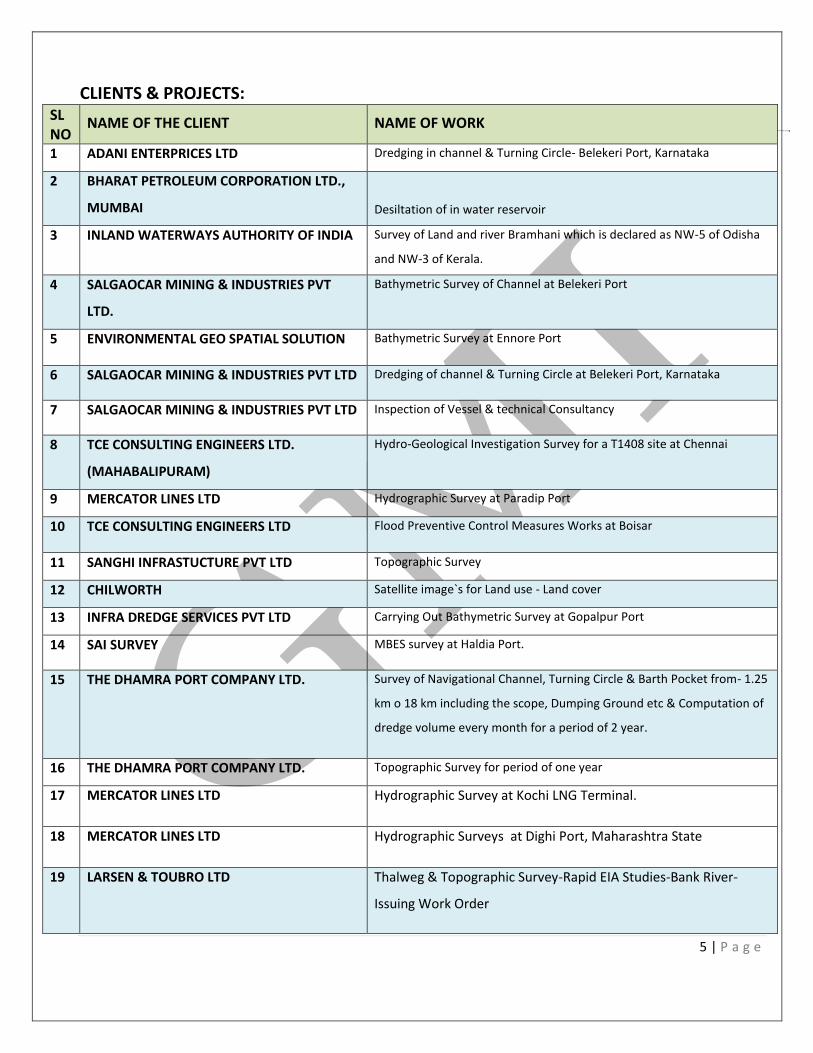
CLIENTS & PROJECTS:
SL
NO NAME OF THE CLIENT NAME OF WORK
1 ADANI ENTERPRICES LTD Dredging in channel & Turning Circle- Belekeri Port, Karnataka
2 BHARAT PETROLEUM CORPORATION LTD.,
MUMBAI Desiltation of in water reservoir
3 INLAND WATERWAYS AUTHORITY OF INDIA Survey of Land and river Bramhani which is declared as NW-5 of Odisha
and NW-3 of Kerala.
4 SALGAOCAR MINING & INDUSTRIES PVT
LTD.
Bathymetric Survey of Channel at Belekeri Port
5 ENVIRONMENTAL GEO SPATIAL SOLUTION Bathymetric Survey at Ennore Port
6 SALGAOCAR MINING & INDUSTRIES PVT LTD Dredging of channel & Turning Circle at Belekeri Port, Karnataka
7 SALGAOCAR MINING & INDUSTRIES PVT LTD Inspection of Vessel & technical Consultancy
8 TCE CONSULTING ENGINEERS LTD.
(MAHABALIPURAM)
Hydro-Geological Investigation Survey for a T1408 site at Chennai
9 MERCATOR LINES LTD Hydrographic Survey at Paradip Port
10 TCE CONSULTING ENGINEERS LTD Flood Preventive Control Measures Works at Boisar
11 SANGHI INFRASTUCTURE PVT LTD Topographic Survey
12 CHILWORTH Satellite image`s for Land use - Land cover
13 INFRA DREDGE SERVICES PVT LTD Carrying Out Bathymetric Survey at Gopalpur Port
14 SAI SURVEY MBES survey at Haldia Port.
15 THE DHAMRA PORT COMPANY LTD. Survey of Navigational Channel, Turning Circle & Barth Pocket from- 1.25
km o 18 km including the scope, Dumping Ground etc & Computation of
dredge volume every month for a period of 2 year.
16 THE DHAMRA PORT COMPANY LTD. Topographic Survey for period of one year
17 MERCATOR LINES LTD Hydrographic Survey at Kochi LNG Terminal.
18 MERCATOR LINES LTD Hydrographic Surveys at Dighi Port, Maharashtra State
19 LARSEN & TOUBRO LTD Thalweg & Topographic Survey-Rapid EIA Studies-Bank River-
Issuing Work Order

6 | P a g e
20 PETRONET LNG LTD Collection of water samples from prescribed depth of water
at lng terminal
21 THE DHAMRA PORT COMPANY LTD. WO for study of tidal current at two location in the navigation at
channel
22 SEA GEO SURVEY PVT LTD Side scan sonar and a geophysical &survey at Porbander
23 VAINATEYA POWER PVT LTD Geophysical & Bathymetric surveys for 4x 660 mw Thoothukudi
thermal power project in Tamilnadu
24 GUJARAT MARITIME BOARD Hydrographic survey, at Veraval port
25 THE DHAMRA PORT COMPANY LTD. Monitoring dredging activity on Dariya Kanchan/Manthan
26 DREDGING CORPORATION OF
INDIA,VISHAKHAPATNAM
Geophysical Investigation of hard Patches between of MD-5& MD-
6 at Marmagao Harbour.
27 GEOMARINEVISAKHAPATNAM Bathymetry survey at Vishakhapatnam Port
28 LARSEN &TOUBRO,CHENNAI Bathymetry survey at Ship lift, Katupalli.
29 THE DHAMRA PORT COMPANY LTD. Bathymetry Survey of Brahmani & Kharsuan River
30 WAPCOS LTD Collection of sea bed & water sample
31 CHELLARAM SHIPPING PVT. LTD
SBES survey at Vizag
32 DBM
Dredging at Agardanda Berth No. 3 and 4.
33 CHINNAR SHIPPING & INFRASTRUCTURE
(INDIA) PVT. LTD.
Bathymetric Survey using SBES
34 ADANI PORTS & SEZ LTD
MBES Survey Gangavaram Port
35 PRAGATI DREDGING Pvt ltd
Dredging Monitoring Survey using SBES at Gopalpur Port.
36 GEOSTAR SURVEYS INDIA PVT. LTD.
MBES Survey At Gopalpur Port (Work in Progress)

7 | P a g e
SERVICES WE OFFER:
Hydrographic/Bathymetric/Dredging Support Surveys/ GIS and Remote Sensing
Global Marine Infratech Pvt. Ltd. provides a range of specialist inshore survey systems to meet the requirements of
the Port, Harbor and Coastal Engineering and Construction communities.
Also GMI is providing solution in GIS, Remote sensing and GIS Survey.
SURVEY & STUDIES
Bathymetry survey
Pre Engineering Assessments
Physical Oceanographic studies
Hydro-geological investigations
Groundwater remediation and assessments
Identification of Navigational Routes.
Ocean Circulation Modeling and Sediment Dynamics
Assessment of Health and status of the Ecosystems
Eco Toxicological Assessments (Including Laboratory Studies)
Geo Technical Investigations.
DREDGING & CONSTRUCTION
1. Capital Dredging of Ports, Harbour, River, Lake & Tanks and Dams
2. Maintenance Dredging of Ports, Harbour, River, Lake & Tanks and Dams
3. Ports and Harbour Management.
4. Construction of quays and break waters.
5. Pipe laying and maintenance.
MARINE VERTICAL 1. Marine Navigational and nautical equipment reselling and service.
2. Authorised agents of NHO for sale of navigational charts & publications.
3. Authorised agents for Ad Navigation Portable Pilot unit.

8 | P a g e
GIS VERTICAL
GIS Land & Topographic Survey.
GIS Solutions in land use and land classification.
Vector and Raster data creation.
As-Build, Landbase, SLD and Corridor Maps.
Land Parcel Mapping
Cartographic maps.
POI/ Landmark, Socio –Economic GIS survey and
Data creation.
Environmental Impact assessments.
Disaster Management.
Image ortho-rectification
Positioning/Diving Operations Support A precise position is the fundamental parameter for all surveys and engineering operations at sea. We provide
Positioning for Drilling rig, Dredger, Diving operations, Trenching and extremely costly exercises requiring rapid
reaction solutions and minimal downtime. Global Marine Infratech Pvt. Ltd. provides the following positioning
services for seabed survey and platform orientation.
(1) Tow Outs (2) Inter-field moves (3) Barge and Tug management system (Using telemetry system for (Anchor handing)

9 | P a g e
(4) Underwater acoustic positioning solutions (5) Final positioning and heading confirmation (6) Remote rig position (7) Monitoring dredging operations
Off Shore Construction Support Survey
(1) Tow outs of structures and pre-fabricated pipelines
(2) Installation of templates, platforms, drilling rigs and sub-sea installations.
(3) Pipe laying support and touch-down monitoring.
(4) Feasibility Surveys
(5) Trenching support surveys for pipes and cables burial.
(6) Pre-engineering surveys for pipelines, cables and structures.
(7) Pre-installation/anchor sweeping surveys for pipelines, cables and structures.
(8) As- laid and as-built surveys.
(9) Routine/emergency pipeline inspection surveys.
(10) Cathode protection Survey Services. Topographic/cadastral Survey Geodetic control surveys are achieving un-precedent levels of accuracy, using advanced GPS techniques Global
Marine Infratech Pvt. Ltd. provides total surveying for all types of land/topographical/cadastral surveys which
includes the following :-
(1) Total Station survey of the area (2) Plane table survey (3) Tape and off-set survey (4) Preliminary survey and new alignment survey (5) Route survey and corridor identification for OFC laying (6) Water supply pipe line (7) Gas pipe line (8) High Tension Tower Line (9) Sewer line (10) As built Survey
Human Resource

10 | P a g e
We provide qualified and experienced personnel in India and abroad for GIS and onboard vessels and
offshore construction barges for Hydrographic/Geophysical surveys and offshore operations.
Consultancy (1) Hydrographic Surveying and nautical charting (2) Dredging, siltation and erosion management (3) Port & Marine facility Design (4) Environmental Impact Assessment Coastal and offshore projects (5) Ship/Vessel Management

11 | P a g e
DREDGING & RECLAIMATION SERVICES: CAPITAL DREDGING
MAINTENANCE DREDGING
RECLAMATION
BEACH NOURISHMENT
With a wide range of dredgers and resources at our command and supported by an adequate
ground staff with international exposure, GMI is capable of meeting the dredging challenges for both
Capital Dredging and Maintenance Dredging not only in India but in other countries also.

12 | P a g e
CUTTER SUCTION DREDGERS
GMI Pvt. Ltd can deliver complete Cutter Suction Dredgers (CSD's) or Wheel Suction Dredgers (WSD's).
The CSD's are available in a standard range with discharge diameters from 350mm to 650mm. In addition
to the standard sizes GMI also has custom-made vessels in any required size or format. Some examples
are: special mining applications, self-propelled, rock cutting, etc.
A generally smooth bottom can be achieved, and modern instrumentation allows profiles and side slopes
to be dredged accurately. Some of the larger cutter suction dredgers are self-propelled to allow easy
movement from site to site.
UNDER WATER CUTTING WHEEL: Besides, GMI’s UCW is e uipped ith a la ge u e of utti g blades, which ensure a small chip thickness, smooth cutting operation
and separation of oversize particles. Each cutting blade UCW can be
adapted to any kind of dredging task by installing suitable teeth taken
f o GMI’s p o e a ge of utti g teeth.

13 | P a g e
A special, automatically operated change-over flap installed inside the suction mouth of UCW guarantees
a high mixture concentration. The suction mouth of the inactive UCW half is closed by the change-over
flap so that the surrounding water is not drawn in from this side. The use of deflectors adapted to the inner contour of each UCW half provides a self-cleaning effect and
ensures that the UCW cannot become clogged, even when dredging adhesive soil. All wear and tear
components exposed to the mixture transport (e.g. suction mouth, change-over flap, suction channel)
are easily accessible and replaceable, ensuring minimum downtime.
SPUD CARRIERS The spud carrier and the pontoon are of a very
rigid design, so that the forces from the side wires
can be absorbed. The carrier is moved by a double
acting hydraulic cylinder. The cylinder has
sufficient strength to continue cutting during the
step forward. The carrier pontoon can easily be
fitted to the aft of your dredge and can be
ballasted so that the stability of the dredge can be
kept uncompromised. Optionally the spud carrier
installation can be fitted with its own hydraulic
power pack. GMI also supply specially designed
spud carriers, for offshore dredging or extra
rugged conditions.
GMI’s Spud Ca ie s a e desig ed to edu e spud ha dli g du i g d edge operations and to increase
production of the dredge with 10% to 20%. After completing a swing, the CSD or WSD is pushed forward
by the spud carrier, so that it can start a new swing. Once at the end of its traveling range, the auxiliary
spud is lowered, so that the carrier can be moved to its starting position. GMI Pvt. Ltd also supply specially designed spud carriers, for offshore dredging or extra rugged
conditions.

14 | P a g e
GMI is specialized in offshore vessels in worldwide such as:
Diving Vessels Multi Support Vessels Well Stimulation Vessel Geo-Technical Vessel Seismic Survey Vessel Construction Barges
Presently GMI takes care of operations and management of some of the Private Company and ONGC
offshore support vessels and its specialized vessels. Operation and management of these vessels is done
by GMI. GMI has enormous experience in managing offshore and specialized vessels and expects to play
a larger role in the Indian offshore shipping industry in future.
GMI ENVIRONMENTAL IMPACT ASSESSMENT:
We undertake Environmental Impact Assessments (EIA) to assist our clients in meeting the requirements
of the key national and international legislation required in planning and designing new developments,
and in the maintenance and rehabilitation of existing works in the
coastal and marine environments. A thorough EIA study conducted as
part of the planning and design processes will identify and address
potential problems in time to allow modifications to preliminary
engineering designs avoiding costly alterations later. At GMI we offer
consultation and supervision in the entire range of EIA studies including:
Environmental Impact Assessments
Screening and Scoping Assessments
Initial Environmental Evaluations
Targeted EIAs (for example, for pollution or thermal control)
Environmental Management Plans
Environmental Monitoring Programs

15 | P a g e
Our highly experienced marine EIA team comprises personnel drawn from a broad range of scientific and
planning disciplines. In addition, our team provides rapid response assessments for pollution incidents
using macro-benthos and bioaccumulation studies to ascertain the level of impact Environmental assessments and evaluations
Environmental impact assessment (EIA) and environmental statements
Design, optimization and operation of engineering projects
Integrated Coastal Zone Management
Fisheries assessments and surveys
Conservation and development projects
Estuarine, coastal and marine biodiversity studies
Ecological and biological surveys
Protected species studies
Coastal landscape issues
Management plans and monitoring programs
Desk studies and site appraisals
Screening and scoping studies
License and consent applications
Project management
Community and stakeholder consultation
Environmental legislation
Expert witness
Flora fauna Studies
GMI has specialized experts in the evaluation of health of an ecosystem in terms of the Floral - faunal
assemblages. Importance is given in the quality of the ecosystem and its capacity for self sustenance. A
number of coastal establishments like ports and harbors and activities like waste disposal prevalent in
the land and adjoining coastal areas have adverse impact on the ambient coastal and marine areas. Field
observation and information from other sources indicate degradation of coastal and marine environment
at some places and trend towards such degradation at considerable areas along the coastal stretch.
These locations also include certain critical habitats like Mangroves, Coral reefs, sea grass beds, areas of
biodiversity, etc. In order to reduce further degradation of coastal and marine environment and

16 | P a g e
Habitats, GMI have been involved in many studies related to flora and fauna conservation and
restoration. In order to provide proper insight to the clients GMI usually combines the application of
scientific tools and techniques like GIS, remote sensing and mathematical modeling to analyze the
problems prevalent along the coastal marine areas and develop integrated management solutions
Thanks for Viewing our Profile
======================XXXXX=====================