Embed Size (px)
Citation preview

Community Wildfire Protection Plan Keno, Oregon
Keno Rural Fire Protection District
John Ketchum, Fire Chief
Prepared by Gene Rogers Wildland Fire Technologies, Inc.
Klamath Falls, OR

Keno CWPP print.doc Page 2 of 46
Table of Contents
Executive Summary Page 3 Chapter One Introduction Page 5 Chapter Two Community Profile Page 14 Chapter Three Planning Process Page 19 Chapter Four Wildfire Risk Assessment Page 21 Chapter Five Emergency Management Page 30 Chapter Six Mitigation Action Plan Page 32 Chapter Seven Monitoring and Evaluation Page 37 Chapter Eight Appendices Page 38 Map Illustrations Page 40

Keno CWPP print.doc Page 3 of 46
Executive Summary
This document is the Community Wildfire Protection Plan (CWPP) for the community of Keno, Oregon. The document has been developed to meet the intent of the National Fire Plan (NFP), the Healthy Forest Restoration Act (HFRA) and to document analysis done to support several years of completed and planned proactive hazardous fuels reduction work in the Keno area. The Keno Rural Fire Protection District (Keno RFPD) began fuels reduction work with National Fire Plan grant funds in 2002 in partnership with the U.S. Fish and Wildlife Service with federal funds passed through the Oregon Department of Forestry. In 2003, Klamath County joined the partnership with the Keno RFPD when the Klamath County Commissioners granted Title III funding for a fire prevention and public education program. This funded a door-to-door education and risk assessment. This assessment led to the development of a Wildland Fire Risk Assessment Database in a Geographic Information System (GIS). Properties and structures in the Keno RFPD were physically inventoried and entered into this database during 2004. During the summer of 2005 a detailed forest fuel and tree inventory was initiated to support the use of satellite imagery for classification of surface and canopy fuel characteristics. This information was used to develop GIS data layers for assessment of fire behavior characteristics across the fire district. All of these activities were done to gather information to be used in the ultimate development of the Community Wildfire Protection Plan (CWPP) for Keno. Goals and Objectives The Keno CWPP was developed to compile documentation that supports the following goals and objectives:
• Protect human life and property from wildfire • Increase the local capacity for structure fire protection and emergency
medical services • Inform the public of the realities of living in fire ecosystems. • Continue a strategic reduction of hazard fuels across private and public
boundaries. • Develop a plan that can readily be updated for future needs of the Keno
RFPD and the public. • Develop a GIS database that will enable rapid, accurate assessments for
future emergency management decisions.

Keno CWPP print.doc Page 4 of 46
Action Plan The Keno CWPP is being developed under the following action plan:
• Identify obvious fuels hazard properties. Reduce the fuels hazard, while treating adjacent properties to achieve a strategic goal of increasing zones of defensible space within the Keno RFPD.
• Gather detailed information about the properties to sure a variety of public safety issues related to wildland fire protection, structural fire protection and emergency medical services.
• Develop a vegetation inventory database to allow the use of more sophisticated technology to assess fire behavior characteristics and potentials across the Keno RFPD.
• Utilize the property, structure and fuels data to complete a wildland fire risk assessment.
• Inform the public of the fire ecosystem in which they live via contact with field personnel and public meetings.
• Complete the CWPP, continue to mitigate hazards by priority, monitor and evaluate the process through public forum.
Strategy It is well understood that reducing the fire behavior potential of wildland fires increases the protection capacity of firefighting resources. The Keno CWPP goals and objectives, and action plan, are developed around a strategy for fuel hazard mitigation. This strategy, formally adopted by the Keno Fire Protection District Board, is to prioritize hazard fuels mitigation measures as follows:
1. Properties that have residential structures and/or constructed improvements.
2. Properties adjacent to parcels that have residential structures and/or constructed improvements.
3. Properties not adjacent to parcels that have residential structures and/or constructed improvements, but when treated are a segment of a larger treatment zone that offers tactical protection opportunities for the properties in priority 1.
Keno is a rural community with many dispersed, small clusters of homes. These clusters, although dispersed from more populated areas of the fire district, may contain properties that meet the first priority above, see Photo 1.
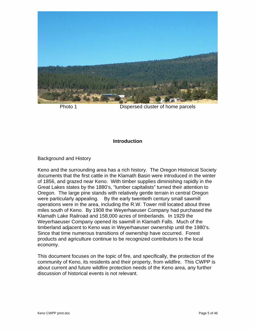
Photo 1 Dispersed cluster of home parcels
Introduction Background and History Keno and the surrounding area has a rich history. The Oregon Historical Society documents that the first cattle in the Klamath Basin were introduced in the winter of 1856, and grazed near Keno. With timber supplies diminishing rapidly in the Great Lakes states by the 1880’s, “lumber capitalists” turned their attention to Oregon. The large pine stands with relatively gentle terrain in central Oregon were particularly appealing. By the early twentieth century small sawmill operations were in the area, including the R.W. Tower mill located about three miles south of Keno. By 1908 the Weyerhaeuser Company had purchased the Klamath Lake Railroad and 158,000 acres of timberlands. In 1929 the Weyerhaeuser Company opened its sawmill in Klamath Falls. Much of the timberland adjacent to Keno was in Weyerhaeuser ownership until the 1980’s. Since that time numerous transitions of ownership have occurred. Forest products and agriculture continue to be recognized contributors to the local economy. This document focuses on the topic of fire, and specifically, the protection of the community of Keno, its residents and their property, from wildfire. This CWPP is about current and future wildfire protection needs of the Keno area, any further discussion of historical events is not relevant.
Keno CWPP print.doc Page 5 of 46

The community of Keno is located just east of the Cascade Mountains in south-central Oregon. This location puts the community in a part of Oregon with a significant history of natural and human-caused wildfire. The forest and shrub vegetation of the area evolved with fire’s influence prior to settlement by people of European descent. Surrounded by a forest type dominated by Ponderosa pine and associated species, Keno is in a historically fire dependent ecosystem. Historic fires thinned younger stems and tended to generate a more open forest condition than exists presently. Since settlement, the vegetation has increased in density (stems per acre) as a result of active fire suppression. Timber harvest removed many of the older, larger and more valuable trees prior to subdivision development. The remaining forested areas that were subdivided into residential lots are often represented by clumps of dense, smaller trees competing for nutrients, water and sunlight. This competition has lead to high mortality levels in many locations. Tree mortality has resulted in a build-up of dead fuel in tree clumps prone to crown fire behavior. Such fire behavior exceeds the fire suppression capabilities of ground-based firefighting resources such as personnel with hand tools and engines. Numerous wildfires have occurred within and adjacent to the Keno area. On August 26, 1962 the Keno Fire ran toward the town from the west. The fire started in the town dump, burned 157 acres and generated a 3 acre spot fire a quarter of a mile across Highway 66. A query of Oregon Department of Forestry fire records for the years 1967 through 2004 was done for fires within six miles of the Keno RFPD boundary. The resulting statistics showed 465 fires that totaled 3330 acres. One third of the fires were ignited by lightning. Photo 2, below was taken in winter to show the contrast of past fire scars, treatments and harvest units. Note the fire scar on Pearson Butte in the center of the picture. The curved opening to the left of center is a BLM fuel break. US Fish and Wildlife Service fuels treatments are visible to the right of center.
Photo 2 note the many fire scars, treatments and harvest units
Keno CWPP print.doc Page 6 of 46
Keno CWPP print.doc Page 7 of 46
Planning Area Boundaries The WUI planning area for this CWPP is defined on the WUI Boundary Map. Lakewoods Village is a separate community outside of the Keno RFPD boundary, but is annexed to the fire district. The fire district boundary is defined on several of the maps. As wildfire does not recognize administrative boundaries, this CWPP considers the fire behavior potential adjacent to the fire district boundaries. The satellite imagery used in the fuels analysis for this CWPP extends up to two miles beyond the fire district boundary. The WUI boundary extends beyond this imagery along the western side of Keno RFPD to account for vital communications facilities and terrain/fuel conditions that merit special attention. The approximately 29,000 acre Keno RFPD boundary was ultimately extended to include roughly 88,000 acres within the WUI boundary. The community of Keno is offered fire protection and emergency medical services by the Keno RFPD. The district has a primary station in Keno and three un-staffed substations. The substations are located at LaWanda, Worden and Lakewoods Village. The Lakewoods Village substation is 20 miles from the main Keno fire district. There is a structural engine housed there and volunteers from the community staff the engine. Various cooperating fire protection agencies are adjacent to the Keno RFPD including Klamath County Fire Districts 4 and 1, the Oregon Department of Forestry, the U.S. Forest Service, Bureau of Land Management and the U.S. Fish and Wildlife Service. Fire Policies and Programs The Healthy Forest Restoration Act (HFRA)
President Bush signed the Healthy Forests Restoration Act of 2003 (P.L. 108-148) (HFRA) in December 2003. HFRA, as it is known, contains a variety of provisions to speed up hazardous-fuel reduction and forest-restoration projects on specific types of Federal land that are at risk of wildland fire and/or of insect and disease epidemics. The HFRA helps States, Tribes, rural communities and landowners restore healthy forest and rangeland conditions on State, Tribal, and private lands. (additional information on the HFRA is available at http://www.healthyforests.gov/initiative/introduction.html)
The following excerpts are from the handbook: Preparing a Community Wildfire Protection Plan, A Handbook for Wildland-Urban Interface Communities.
Role of Community Wildfire Protection Plans The HFRA provides communities with a tremendous opportunity to influence where and how federal agencies implement fuel reduction projects on federal lands and how additional federal funds may be distributed for projects on nonfederal lands. A CWPP is the most effective way to take advantage of this opportunity.

Keno CWPP print.doc Page 8 of 46
Local wildfire protection plans can take a variety of forms, based on the needs of those involved in their development. They can be as simple or complex as a community desires.
The Keno CWPP has been kept brief and presented in a format, Geobook, that allows the reader access to a variety of background information electronically. This makes a great deal of reference material available to the reader without filling the printed document with it.
The minimum requirements for a CWPP as described in the HFRA are: (1) Collaboration: A CWPP must be collaboratively developed by local and state government representatives, in consultation with federal agencies and other interested parties. (2) Prioritized Fuel Reduction: A CWPP must identify and prioritize areas for hazardous fuel reduction treatments and recommend the types and methods of treatment that will protect one or more at-risk communities and essential infrastructure. (3) Treatment of Structural Ignitability: A CWPP must recommend measures that homeowners and communities can take to reduce the ignitability of structures throughout the area addressed by the plan.
The Keno CWPP has been developed during active collaboration with local, state and federal partners and interested local parties. This CWPP formally documents the ongoing prioritized fuel reduction and treatment (reduction) of structural ignitability in the Keno RFPD.
The HFRA requires that three entities must mutually agree to the final contents of a CWPP:
• The applicable local government (i.e., counties or cities); • The local fire department(s); and • The state entity responsible for forest management.
The Keno CWPP has been reviewed and achieved signatory agreement of the listed parties. National Fire Plan (NFP)
The National Fire Plan was developed in August 2000, following a landmark wildland fire season, with the intent of actively responding to severe wildland fires and their impacts to communities while ensuring sufficient firefighting capacity for the future. The NFP addresses five key points: Firefighting, Rehabilitation, Hazardous Fuels Reduction, Community Assistance, and Accountability.
The Healthy Forest Initiative (HFI) The Healthy Forests Initiative (HFI) was launched in August, 2002 by President Bush with the intent to reduce the risks severe wildfires pose to people, communities, and the environment.

Definitions and Descriptions Fire Behavior Basics In order to understand wildland fire behavior some known principles need to be introduced and considered. All wildland fires are the product of three components: Fuels, Weather and Topography.
The fuels have to be in sufficient quantity, arrangement and of low enough moisture content to ignite. The weather must be warm and dry enough to support combustion. Wind will assist in moving the fire. Topography supplies a path or barrier to fire spread.
2003 KAGO Fire Fuels Fuels are described in four categories: grass, brush, timber litter or slash. The size of a fuel particle is important; basically fine fuels (< 1/4” diameter) are responsible for the rate-of-spread of a fire. Larger fuel particles are responsible for the intensity and duration of a fire (twigs, limbs, logs, etc.). Fuel moisture changes daily, even hourly, but a fuel particle only contributes to the combustion process when it is sufficiently dry. Small fuels gain/lose moisture more quickly than large fuels, thus flammability can literally change through any given day. Fuels may be live or dead. As such, they may be a heat sink or a heat source depending on the moisture content. Live fuels are either annual or perennial grasses or woody shrubs and trees. A live shrub may contribute rapidly to the combustion process when it is decadent, e.g. old enough to have accumulated dead limbs and litter under the shrub. This condition is exacerbated when pine needles have draped into the shrub foliage. Fuels are arranged on the landscape in both horizontal and vertical patterns. The more continuous the arrangement in either plane or both, the more intensely a fire can burn. Fuels are referred to as ground, surface or aerial. Ground fuels are flammable woody material in the ground: roots, duff and peat. Surface fuels would include forest litter: leaves, needles, twigs, limbs, tree boles, and shrubs. Aerial fuels would be those above the surface fuels: typically the limbs of trees and taller shrubs. When a sufficient pathway from the surface fuels to the aerial fuels exists this pathway is referred to as ladder fuels. Keno CWPP print.doc Page 9 of 46

Keno CWPP print.doc Page 10 of 46
Weather Weather is a significant factor in fire behavior characteristics. Obviously, weather has to be conducive for a wildland fire to spread across the landscape. Seasonal weather patterns are referred to as climatology. These patterns are often discussed as normal or in terms of deviation from normal. Climatology has much bearing on the vegetation patterns and plant associations on a landscape. Seasonal patterns and their intensity have direct bearing on fuels. As the weather warms and dries fine fuels, especially the dead fuels begin to dry sufficiently to carry fire. Curing of live fine fuels follows next as the summer season develops. Woody fuels of increasing larger diameter lose moisture through the summer and actually achieve the lowest fuel moisture content in the fall. Precipitation plays a major role in fire season severity. Duration of moisture input is far more critical than measured amount. For example: 24 hours of cool weather with drizzle for hours measuring ½” of total rain has more effect on fire behavior potential than an 1” storm lasting an hour. Weather drives the rate of moisture gain or loss in forest fuels. Winter weather and type has a bearing on the intensity of fire season. In general, fire seasons are more severe if a dry, cold snow falls and packs onto forest fuels without a preceding extended period of precipitation as drizzle or rain. The rate of spring thaw can bring “early” fire season conditions to dead fuels. A lack of snow pack or limited snow pack obviously compounds this effect. Wind is the critical weather element in fire behavior. Wind dictates the direction and speed of fire spread. Shifts in wind directions due to frontal patterns or daily effects (diurnal) make fires move in different directions. A particularly critical weather factor is atmospheric stability. This is the atmosphere’s ability to allow a parcel of air to rise or drop. When a fire is burning under conditions otherwise ideal for fire spread and the atmosphere is or becomes quite unstable a fire behavior referred to as “plume-dominated” may occur. Such fire behavior is responsible for many of the larger, and often infamous, wildfires. Fires under this condition exhibit rapid spread and are characterized by a towering, billowing column.
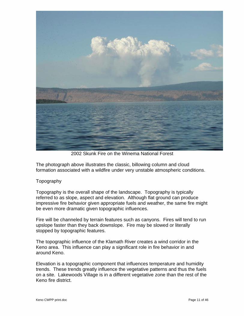
2002 Skunk Fire on the Winema National Forest
The photograph above illustrates the classic, billowing column and cloud formation associated with a wildfire under very unstable atmospheric conditions. Topography Topography is the overall shape of the landscape. Topography is typically referred to as slope, aspect and elevation. Although flat ground can produce impressive fire behavior given appropriate fuels and weather, the same fire might be even more dramatic given topographic influences. Fire will be channeled by terrain features such as canyons. Fires will tend to run upslope faster than they back downslope. Fire may be slowed or literally stopped by topographic features. The topographic influence of the Klamath River creates a wind corridor in the Keno area. This influence can play a significant role in fire behavior in and around Keno. Elevation is a topographic component that influences temperature and humidity trends. These trends greatly influence the vegetative patterns and thus the fuels on a site. Lakewoods Village is in a different vegetative zone than the rest of the Keno fire district.
Keno CWPP print.doc Page 11 of 46

Fire Behavior Terminology The following are terms that refer to types of fire behavior. A smoldering fire is burning in ground and surface fuels, often with little or no visible flame. A creeping fire is slowly moving, often backing downslope or against a wind. A creeping fire has relatively slow moving flaming front. The flaming front is the zone of active flame at the leading edge of a spreading fire.
Keno CWPP print.doc Page 12 of 46
smoldering fire creeping fire A running fire is moving relatively quickly. Often a running fire is driven by the wind, steep slope (upslope) or a combined influence of slope and wind. Spotting is when a series of new ignitions are occurring as the result of fire brands landing in receptive fuels beyond the current flaming front.
running fire spotting Torching or passive crown fire is a term used when an individual or small cluster of trees exhibit ignition of the canopy foliage. Crowning or active crown fire is when the canopy foliage of many acres or more ignite and the fire moves through the canopy.

torching or passive crown fire crowning or active crown fire It is important to understand that fire behavior is modified by topography and the weather. Of these two elements, weather is the most significant element of change in fire behavior. Fuel characteristics complete the equation for fire behavior potential. Firefighting capability changes inversely as fire behavior characteristics change. A creeping or slow running fire may be easily suppressed by available firefighting resources. An increase of wind on the same fire may result in higher rates of spread and spotting which allow the fire to spread more rapidly than the available firefighting resources can suppress. A fire exhibiting torching or passive crown fire is on the edge of becoming an active crown fire. Sustained active crown fire is beyond the capability of firefighting resources. The focus of hazard fuels mitigation is to identify locations where the fuel conditions are conducive to fire behavior transition from surface, to passive, and/ or active crown fire behavior. The term crown fire has been used for decades to describe a fire burning in the crown of trees. Crown fuels would be the foliage, twigs and branches of an individual tree. To support the development of this CWPP inventory collection was accomplished to quantify the canopy fuels for the fire district. Where crown fuels would refer to an individual tree, canopy fuels would refer to the total crown fuels in a stand of trees. A stand of trees can be a few acres to thousands of acres. Canopy base height is a term that refers to distance from the ground up to the canopy area of a tree that would support the vertical movement of fire. This value requires an estimate on the part of the observer. The importance of this value is that the higher the canopy base height is in a stand of trees, the less likely a fire is to move into passive fire behavior. A value for canopy base height was generated from field measurements in Keno stands. Areas where canopy base heights are conducive to passive or active crown fire behavior are possible candidates for pruning of limbs. Canopy bulk density is defined as the total canopy biomass divided by the area occupied by canopy biomass. The importance of this value is in determining stands with a likelihood of generating and sustaining active crown fire behavior. Wind is also a key element. Canopy bulk density values for sampled stands Keno CWPP print.doc Page 13 of 46

were generated in a software package called FMAPlus (Fire Program Solutions, LLC and Acacia Services, 2005). This software uses a process developed at the Missoula Fire Sciences Laboratory (Reinhardt, et. al. 2000) to develop estimates of canopy base height, canopy ceiling height and the canopy bulk density. Stands with low canopy base heights and high canopy bulk density are the most likely to generate passive and active crown fire behavior, assuming a surface fuel model generating enough heat is present. Reduction of surface fuel loadings can be applied to any location, with or without a canopy. Such treatments include mastication, hand and machine piling, pile burning, broadcast burning and chipping. Locations with these stand conditions would be candidate stands for combinations of treatments to reduce the flammability of the canopy fuels by reduction of surface fuel loading, raising the canopy base height, or reducing the canopy bulk density.
Community Profile Keno is a rural community in south-central Oregon. Keno is located on State Highway 66 southwest of Klamath Falls. Keno has approximately 3500 residents occupying over 1450 homes and related structures. The Klamath
River runs through the Keno area and much of the community has developed along the river course. Keno is a true wildland urban interface (WUI) community with most of its residences located on forested sites. Many dispersed residential areas exist in the area and will be described later. The community of Keno lies within a Ponderosa pine and mixed conifer forested area. Natural vegetation in the area transitions from forest to a mix of grass, shrubs and juniper. Irrigated agricultural land occupies the lowland portions of the area. Fire is very much a part of the formation and maintenance of the forests around Keno. Numerous recent and past fire scars are visible from the Keno Fire Station.
The forests around Keno are mostly in private ownership, although state and federally owned parcels are present. Due to the forested conditions in Keno, there is an obvious risk of wildfire. It is the wildland environment surrounding Keno that gives the community a sense of being and draws people to live in this rural setting. The town of Keno has no corporate structure as evidenced by banks, significant retail goods outlets, industrial or manufacturing, theaters, and large restaurants. Such facilities are found in Klamath Falls within 20 minutes driving time of Keno. It is
Keno CWPP print.doc Page 14 of 46

the rural setting and perhaps the lack of such development that gives the citizens of Keno a common desire for a more independent and rural lifestyle. Many of the Keno residents are employed in the Klamath Falls area and commute daily.
Photo 12 Klamath River flowing to the northwest from Keno
Photo 13 Approaching Keno on Highway 66 from Klamath Falls
Photo 14 Looking toward Keno from east on Stateline Road
Keno CWPP print.doc Page 15 of 46
Fire protection and emergency medical services are provided to the citizens of Keno by the Keno Rural Fire Department. The Keno Rural Fire Protection District (Keno RFPD) includes the community of Keno, several rural residential areas and the recently annexed Lakewoods Village subdivision located on the crest of the Cascade Mountains at the intersection of Clover Creek Road and Dead Indian Memorial Road. The Keno RFPD boundary covers approximately 44 square miles or about 28,160 acres. There are several named residential areas within the Keno RFPD. Each area has varying attributes. Residential settings range from high density lots in a more suburban setting on paved streets to isolated homes on many acres on a cinder road system to exclusive custom resort homes in a high elevation setting. The areas within the Keno RFPD include:
• Worden • Cedar Trails • Whispering Pines • Old Keno • Freight Road/McLaughlin • Pioneer • Round Lake • Jake Road • LaWanda Hills • Stagecoach • Lakewoods Village
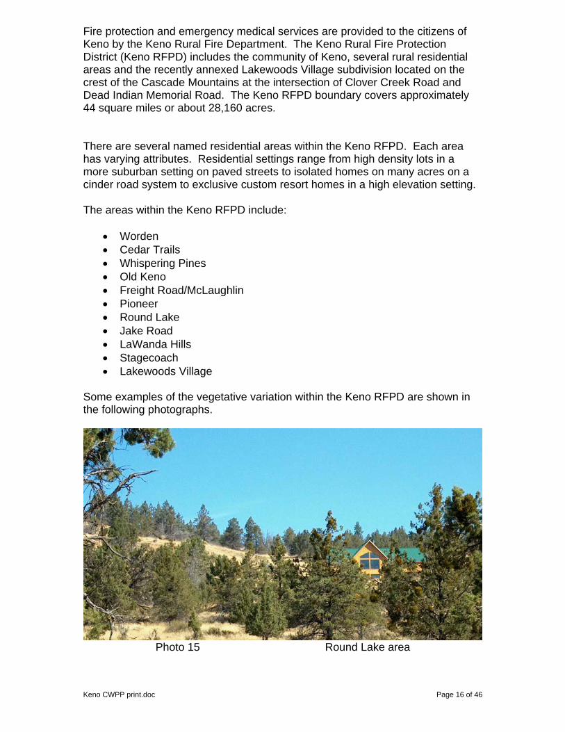
Some examples of the vegetative variation within the Keno RFPD are shown in the following photographs.
Photo 15 Round Lake area
Keno CWPP print.doc Page 16 of 46

Photo 16 Cedar Trails Area (note the roofs)
Photo 17 Round Lake
Photo 18 LaWanda Hills
Keno CWPP print.doc Page 17 of 46

Photo 19 Lakewoods Village
Keno has an aging population. The elementary school has experienced diminishing enrollment over the last several years (phone conversation with school office personnel). A significant proportion of the residents are middle-aged or older. This trend is evident in diminishing numbers of volunteers in the fire department. Volunteer participation is a key factor in the capacity of the fire department. The area continues to be a popular place for retirees seeking a quiet, wooded and rural lifestyle. The forested environment of the Keno area is truly the draw to its residents. The health of the community and the forest are related. Severe wildfire would alter the community adversely as the very environmental attributes that drew the residents would now be altered. A healthy forest and a healthy human community are parallel outcomes in Keno. Transportation routes in the Keno area include: Oregon State Highway 66, a two-lane, paved surface road that runs through the main town and connects Klamath Falls and Ashland, Oregon. Clover Creek Road, a two-lane, paved surface that connects Highway 66 to the Dead Indian Memorial Highway. Lakewoods Village is at the intersection of these two road systems. Keno-Worden Road, a two-lane, paved surface that connects Keno to Oregon State Highway 97 at Worden. The residential streets and roads in the Keno area are a mix of paved, sealed, and gravel/cinder roads. The ISO fire hazard rating for Keno is 5 or 8. More information is in the Emergency Management chapter.
Keno CWPP print.doc Page 18 of 46

Planning Process The planning process as outlined in the document: A Framework for Community Fire Plans (Oct 2004), Preparing a Community Wildfire Protection Plan (April 2005) and other CWPP documents and example plans guided the completion of the Keno CWPP. The Keno Fire Chief and the preparer of this document have been active in local and county-wide efforts to identify wildfire hazards and mitigation opportunities. They both sit on the Klamath County Forestland-Urban Interface Classification Committee for implementation of Oregon Senate Bill 360. The Keno RFPD is managed by the Fire Chief. Broad policy for the fire department is set by a Board. This board is made up of five members that oversee the management and financial activities of the fire district. This group was the initial group formally contacted about the development of this plan. This group has been informed of and supportive of fuel hazard reduction work performed by personnel from the Keno RFPD funded by National Fire Plan monies. The board is the primary contact for the Fire Chief for dialogue concerning this CWPP. No action teams or committees exist in Keno, however several interested citizens have informally been briefed on the CWPP status. The citizens of Keno have been aware of NFP activities since 2002 when fire department personnel first began doing fuels reduction work on individual properties. Most of the citizens openly supported the project and have encouraged the work. Others have become supportive after seeing the results of completed work. The citizens of Keno pass information through person-to-person communications. The local market is a hub for information exchange, many of the citizens stop at that facility several times a week. The Fire Chief and the author have organized two formal public field trips to view the fuels reduction work on the Keno RFPD. Both of these have been opportunities to discuss the planning process for the Keno CWPP with a diverse audience. The first was by invitation to speak at an Oregon State University Extension Service workshop entitled: Wildfire Workshop – Protecting Your Home and Forestland. The attendees toured Keno during the field trip portion of the workshop.
Chief Ketchum discussing Keno project OSU Workshop field trip The second was a lunch hosted by the Keno RFPD during the Klamath County VIP Tour. Barbara Kennedy, Cooperative Fire Specialist from the USFS PNW Keno CWPP print.doc Page 19 of 46

Keno CWPP print.doc Page 20 of 46
Regional Office spoke during lunch about WUI Topics. This tour was attended by the State Fire Marshal, County Commissioners, the County Planner, fire officials from local, county, state and federal agencies and departments, and interested citizens. The development of the CWPP for Keno was done in collaboration with all appropriate partner departments and agencies, including at a county-wide coordination group. Coordination and collaboration was formally organized with representatives from the Keno RFPD, Klamath Fire District #1, Chiloquin RFPD, Klamath County, Oregon Department of Forestry, U.S. Forest Service, Bureau of Land Management and the U.S. Fish and Wildlife Service. Other departments and agencies have been invited to participate. The described group is developing a Klamath County CWPP. The group coordinated the outline format for CWPP’s in Klamath County in order to have consistency in all the plans. The Klamath County CWPP is being guided by the local coordination group mentioned. The group also has sub-groups that are working on specific CWPP documents for communities, such as Klamath Falls. The Klamath County CWPP coordination group has had several monthly meetings. One objective the group has developed is to have a plan that leads to tactical utility. A large portion of the county is not covered by a local fire protection district. The county CWPP will address that portion of the county and the highlights of local CWPP documents.

Keno CWPP print.doc Page 21 of 46
Wildfire Risk Assessment The wildfire risk assessment for the Keno CWPP is the culmination of the professional judgment of fire experts, combined with the outputs of state-of-the-art fire behavior prediction software, supported by the extensive field data collection of structural inventory, surface and canopy fuels, and satellite data interpretation. Fire Hazard The fire hazard and potential in the Keno area is obvious. To support this CWPP and to allow for current and future planning and treatment priorities analysis of the fire potential was needed. The Fire Chief had a strong interest in using GIS capabilities to show current fuel conditions, map changes in fuel conditions as hazard fuels reduction work progressed and improve management of future wildfire events by providing readily accessed databases. The Keno RFPD began working with local cooperators on a structure and property assessment form in 2002. Existing formats were reviewed, but dismissed as not containing enough detail, nor much utility beyond general structural information. The process evolved and was incorporated into a GIS database, which contained not only structural information, but information that would assist in evacuation planning and more. By the summer of 2004 the Keno RFPD had completed a prototype field collection form to gather data for the Keno RFPD wildland fire mitigation database. A field crew of two interns inventoried the properties and structures in the Keno RFPD and entered the field data into the GIS. Data collected in this process included structure specific data, surface fuel, ladder fuel and canopy data to 30 ft. and 100ft of the structure and beyond, apparatus access data and much more. Klamath County Title III funds were granted for this work. This completed survey information is in data layers in the Keno RFPD GIS database. Early in 2005, the Keno RFPD applied for and received a grant funded by the Federal Emergency Management Agency (FEMA). This grant was requested to acquire current satellite imagery of the Keno RFPD, remote sensing analysis of the imagery, field data collection equipment, field data collection, field data compilation, and public education software. In preparing the grant application contact was made with a representative from Space Imaging, now Sanborn. This company specializes in satellite imagery and remote sensing products. The Fire Chief and the author met with a representative of Sanborn and a fire behavior specialist to discuss products that Sanborn could supply for the project. A contract proposal from Sanborn was accepted and imagery ordered. The intent of the author and the Fire Chief was to acquire satellite imagery to support a fuels mapping project for the fire district. Specifically, the generation of canopy fuel layers was an objective. Canopy fuels, when present in appropriate configuration, are responsible for crown fire behavior. Crown fire is the most problematic wildland fire behavior to manage. By developing a mapping of the

locations in and adjacent to the Keno RFPD that were capable of supporting crown fire behavior a risk assessment could be developed. Many modeling tools exist for assessment of fire spread rates in surface fuels. It was the intent of this project to acquire canopy fuels data for use of crown fire modeling tools, such as the computer programs, FlamMap and FARSITE. These two software packages are public domain software, developed by Systems for Environmental Management. These software programs are designed to predict canopy fire behavior characteristics over landscapes when data layers have been quantified for terrain, surface and canopy fuels. These software require GIS data layers populated with terrain and vegetation characteristics. The specific layers are shown in the illustration below.
Field data collection was necessary to gather specific fuels information to support the construction of the data layers by a remote sensing specialist from Sanborn. During the 2005 field session, the interns were trained on tree stand data collection using fixed and variable radius plots by Marc Barnes of Integrated Resource Management (IRM). Data collected included: tree counts by species, diameter, height, The collected data populated data files with tree data by plots for selected stands within the Keno RFPD. This field data was compiled by IRM for use in the FMAPlus software. The author completed the FMAPlus entries and recorded outputs.
Keno CWPP print.doc Page 22 of 46

The data collection was done on 626 plots in a total of 45 stands in the Keno and Lakewoods Village areas. An additional 7 stands were identified and data collected on the adjacent U.S. Fish and Wildlife Service refuge. Details of the process are available at the Keno RFPD office, in a document titled: Keno Tree Inventory Plot Instructions from IRM. In addition to tree inventory and measurement on the plots, a reading of canopy cover was taken and the surface fuel model recorded. To facilitate the proper selection of a surface fuel model, the author worked with the interns to develop a fuel model key for the Keno RFPD. That document: Keno Fuel Model Field Manual is also available at the Keno RFPD office. The surface fuel models recorded were the Fire Behavior Prediction System models, numbered 1-13, as documented by Anderson in 1982. The following table describes these fuel models.
Fuel Group FBPS Fuel Model 1 - Short Grass (1 foot) 2 - Timber (Grass and understory) Grass 3 - Tall Grass (2.5 feet) 4 – Chaparral 5 – Brush 6 - Dormant Brush Brush
7 - Southern Rough 8 - Closed Timber Litter 9 - Hardwood (pine long needle litter) Timber
Litter 10 - Timber 11 - Light Slash 12 - Medium Slash Slash 13 - Heavy Slash
The plots were recorded by a global positioning system (gps) unit for future identification with the imagery and if the site needed to be re-visited. A digital photo was taken at each plot, facing north. An intern held a 6 foot fuels pole in each photo with the stand number and plot number recorded on a sign on the pole, see photo 20. These plot photos have proven valuable for a variety of uses, including during imagery analysis.
Photo 20
Keno CWPP print.doc Page 23 of 46

Keno CWPP print.doc Page 24 of 46
FMAPlus was used to generate the canopy fuel characteristics of canopy base height, canopy bulk density and stand height (canopy ceiling height). This software also generates predictions of fire behavior types. The fire behavior types are surface, and passive or active canopy fire. A fire behavior summary report was produced for each of the stands surveyed. The original plan was to get started on the plot data collection process, then compare the imagery to field data for initial fuels classification. Sites that were in question during the classification process could then be inventoried by the field crew for calibrating the process. Unfortunately, the imagery was not available until the winter. The interns had returned to college and snow levels prohibited additional ground checking. The author worked with the Sanborn remote sensing specialist to make supervised calls on fuels classification. Professional judgment and local knowledge had to be the final decision-making input. Surface fuel model, canopy base height, canopy cover, stand height (canopy ceiling height) and canopy bulk density layers were developed by the Sanborn remote sensing specialist. Sanborn supplied the landscape files needed to run the FlamMap software (elevation, slope, aspect, surface fuel model, canopy base height, canopy bulk density and stand height). This software was used to generate crown fire behavior predictions for the Keno RFPD. Additional imagery was acquired that will be used for similar outputs for the Klamath County CWPP. This imagery covers collaborating fire departments, Klamath Fire District #1, #4 and Chiloquin specifically. In order to analyze fire behavior potential a weather data set was needed. The author evaluated the available fire weather stations in operation in relationship to Keno. The U.S. Forest Service remote automated weather station (RAWS) near the Chiloquin Ranger Station was used for generating weather values. Other stations considered included Gerber, Seldom and Parker. These three stations were eliminated from further consideration for a variety of reasons relative to the station location and weather record. Chiloquin RAWS has been proven to be a good representative station for overall Klamath Basin fire danger calculations. Computer software named Fire Family Plus was used to analyze fire weather data for the Chiloquin RAWS. The years 1976 through 2004 were used, with the dates analyzed being limited to June 1 through September 30 of each year. These dates represent the period during which most wildfires occur. The data was analyzed for the 90th percentile weather conditions. The 90th percentile value for a weather parameter, such as wind, would be the value in the data set at which only 10% of the wind speed values recorded were higher. Using the 90th percentile weather values would represent high fire danger days and thus generate outputs in fire behavior prediction systems that would represent fires difficult to suppress.

Keno CWPP print.doc Page 25 of 46
The Chiloquin RAWS is a National Fire Danger Rating System (NFDRS) weather station. Protocol for weather data collection on NFDRS stations is to record the observations at 13:00 hours or 1:00pm daily. Thus, the values in the following table represent the 90th percentile value for each parameter as recorded at the same time in the afternoon each day. The wind speed is the “20 foot” wind value. This wind value represents the wind speed above the vegetation layer. Standardized adjustment factors are applied to reduce this wind speed to an “eye level” value.
Chiloquin RAWS Weather Values 1976 – 2004
90th Percentile
Temperature
Relative Humidity Wind Speed
89 deg. F 16% 10 mph
Temperature, relative humidity and wind speed are utilized to determine a variety of fire behavior prediction inputs and outputs. Examples include: dead fuel moisture values, rate-of-spread, spotting distance, and probability of ignition. Fire Risk Keno has experienced significant wildfire in the town in the recent past. In 1962 a fire originating at the town dump made a run to the east and into town. The following information was taken from ODF records: The Keno Fire Started on August 26, 1962 and was reported @ 1300 hours by Chase Mountain Lookout NWNW Sec 1, T40 R07. The fire started in and spread from the public dump ground. Suppression action was started @ 1316 by KFPA personnel. Extreme burning conditions were noted and control of the fire was not gained until 1800. Personnel from Basin fire departments, Weyerhaeuser Co., and Jones Logging Co., were also involved in suppression. 5000 gallons of Borate was dropped and 3 dozers were in used. A pile of used lumber was damaged and nothing else. Total acres were 157 for main fire and 3 for the spot. Quote from George D. Wardell, District Warden: "I feel as if the only thing that averted a catastrophe for the town of Keno, or a conflagration of major proportion which could have and probably would have engulfed Hamaker Mountain, was the fine action of men and equipment from all of the various fire departments in the Basin, State Police, Klamath County Sheriff's Office, Weyerhaeuser Co., and Lowell Jones Logging Co."

Keno CWPP print.doc Page 26 of 46
It should be noted that the 1962 Keno Fire did not encounter the number of structures that are now constructed in the fire’s “footprint”. This type of fire is still very possible in Keno. Note that the fire made its run in the early afternoon (worst burning conditions of the day). As fire behavior is the result of the alignment of fuels, weather and topography the Keno RFPD strategy is to focus on fuels and hazard fuels reduction projects to reduce the impacts of future wildfires. The 1962 Keno Fire does present an example of the fire risk within the Keno RFPD. A fire originating under similar weather conditions could easily make a similar afternoon run where fuels are present to support such fire behavior. It is the goal of fuels mitigation work to reduce fire behavior to a surface fire to increase the capabilities of the fire protection resources. The Keno RFPD has a risk for wildland fire from within and from outside of the district. The following is a summary of the annual call volume to the Keno RFPD. A review of Keno RFPD responses per year by category yielded the following:
Keno RFPD Call Volume
Structure Fires 12 Vehicle Fires 5
Vegetation Fires 52 EMS (emergency medical services) 169
Rescue 36 Hazardous Condition/Materials Calls 0
Service Calls 19 False Alarms/Good Intent Calls 2
Other Calls and Incidents 2 The Keno RFPD is surrounded by mostly private forestlands which are under Oregon Department of Forestry (ODF) fire protection. Fire report records from ODF for the area around Keno revealed the following statistics and map. It should be noted that 98% of the fires are 10 or less in size. 1% of the fires accounted for 91% of the acres burned (size class E and larger).
ODF Fires 1967 – 2004 near Keno, OR
Number of Fires Size Class Size in Acres Percent of Total 376 A 0 - .25 81% 79 B .25 – 10 17% 5 C 10 – 100 1% 0 D 100 – 300 0.0% 4 E 300 – 1000 0.9% 1 F 1000 – 5000 0.2% 0 G 5000+ 0.0%

Total Fires Fires per Year Total Acres Acres per Year 465 12 3330 88
Number of Fires Cause Percent of Total 153 Lightning 33 % 312 Human 67 %
The above map shows the distribution of the ODF fires across the landscape, centered on Keno. The Klamath Basin National Wildlife Refuge reported the following statistics for their lands adjacent to the Keno RFPD. These fires were in the Bear Valley area of the refuge.
FWS Fires 1988 – 2005 near Keno, OR
Fire Name Year Size in Acres Cause Robin 1988 1.0 lightning
Bear Valley 1990 0.3 lightning Roost 2001 3 lightning Tire 2001 0.2 lightning
Fence 2005 0.1 lightning Keno CWPP print.doc Page 27 of 46

Keno CWPP print.doc Page 28 of 46
A review of U.S. Forest Service fire records revealed the following statistics for fires occurring within 3 miles of Lakewoods Village.
USFS Fires 1961 – 2000 near Lakewoods
Number of Fires Size Class Size in Acres Percent of Total 25 A 0 - .25 93% 2 B .25 – 10 7%
Number of Fires Cause Percent of Total
18 Lightning 67 % 9 Human 33 %
Protection Capabilities The Keno RFPD has a Chief that is experienced in wildland fire suppression. He serves as an Operations Section Chief on the Oregon State Fire Marshal’s Incident Management Team. He is the Oregon State Fire Marshal appointed County Fire Chief for Conflagration Act Incidents. The knowledge, skills and experience that the Chief brings to the job help to increase the capabilities of the fire district. A strong working relationship with adjacent federal and state cooperators further increases the Keno RFPD capabilities. The protection capabilities of the Keno RFPD are more than adequate for the day-to-day calls for structure fires, vehicle fires, EMS calls and routine demands on the fire department. The wildland fire season, basically June through September, sees an additional capability in the form of the Keno RFPD fuels crew. This crew of three to five personnel include a wildland engine and bolster the capabilities of the fire department and its cooperators. The challenge is to prepare for and have the capability to deal with an emerging wildland fire in the Keno area. A typical call to 911 would respond the Chief, a staffed engine and various volunteers to cover an incident. The incident for which this organization is designed is a single structure with threats to adjacent values. In the case of a wildland incident, the same level of capability may have to deal with a wildland fire impingement to multiple homes and properties. In a wildland fire situation the same initial response capability would be responding to a wildland fire threat to multiple properties. Thus, the capabilities of the fire department are greatly increased by measures taken to reduce the flammability of wildland fuels and the resultant threats to structures in the path of an approaching wildland fire.

Keno CWPP print.doc Page 29 of 46
Structural Vulnerability Structural vulnerability in the Keno RFPD is another GIS based assessment. Individual properties, with and without structures, were surveyed during 2004. The data collected answered a detailed list of information about the property, structure(s), vegetation/fuels, access, and topography. A scoring system was developed to generate an overall rating for each property. This was to help prioritize the parcels that were to be treated and to locate opportunity to tie together treated parcels for greater efficiency. Individuals interested in personally assessing their property and structural vulnerability are welcome to contact the Fire Chief. The document Living With Fire is recommended reading. Values As mentioned before, approximately 3500 people live in the Keno area. Their lives represent the primary value at risk in Keno. The economic values at risk to wildfire in Keno are predominantly residential structures. The town of Keno does have an elementary school, a post office, a store, a café, a tavern and miscellaneous small businesses. Several small industrial operations exist throughout the fire district, many operating from the owner’s residential property. A substantial wildfire could change the landscape significantly and manifest itself in reduced property values for surviving homes. Being located in a forested environment, the Keno RFPD possesses many ecological values. As previously noted, this environmental setting is the attraction to the residents of the Keno area. A severe fire would have detrimental impacts to forest resources including trees, wildlife, soil and water. The very attributes that drew residents to the area would be lost to a severe wildfire.

Keno CWPP print.doc Page 30 of 46
Emergency Management Protection Capabilities and Infrastructure Protection Emergency management capability will be increased as an indirect benefit of the data inventory work in the summers of 2004 and 2005. The capability of the Keno RFPD has been increased by the additional staffing of the fuels crew since the 2002 fire season. The fire department has increased its capacity to deal with wildland fire events through the continued hazard fuels reduction work accomplished since 2002. Cumulative treatments accomplished have altered the fire behavior potential on those sites to a level within the capabilities of the fire fighting resources. Keno is not unlike other rural communities that have been popularized and developed in the last 20-30 years. Unfortunately, development has come with shortfalls. As land parcels have been subdivided and sold as home site parcels, there has not always been sound evaluation of the firefighting capacity available. Water systems, specifically, hydrants are not a part of much of the developed residential areas of the Keno RFPD. Historically county land development codes have allowed rural development to occur with little or no infrastructure for fire protection. Single roads for ingress and egress for many subdivisions are a public safety issue. All weather access is marginal where no formal maintenance requirements are in place. Road districts exist in some subdivisions, but no consistent maintenance standards appear to exist. Many of the subdivision areas lack water supply, hydrants, and storage structures. Some residential driveways are too steep and/or lack adequate space for large structural fire apparatus to access. This situation is allowed on single residential driveways. Getting such issues resolved through county land development code changes is a topic of great concern for all the Klamath County Fire Chiefs. Prior to the mid 1980’s no water requirements were in place for subdivision development. Since that time only minimal water requirements have been in place. Without water storage and distribution there is no realistic expectation to improve capacity for the Keno RFPD. Improving the ISO rating will only occur with additional infrastructure for water capacity. An exception within the Keno RFPD is the Lakewoods Village subdivision. The developers chose to include water storage and delivery infrastructure in their plans and construction. All lots in that subdivision have an ISO 5 rating. Structures in Keno and Round Lake that are near hydrants or stored water have an ISO 5, all others are ISO 8.

Keno CWPP print.doc Page 31 of 46
Fire and EMS Inventory and Staffing The Keno RFPD maintains four fire stations with a structure engine with compressed air foam (CAFS) in each. Specific additional equipment, listed by station, include: Station 1: light wildland engine with CAFS, a type 2 structure engine with CAFS, Station 3: one heavy wildland engine. Emergency Medical Services (EMS) are supplied via one Advanced Life Support (ALS) ambulance housed at Station 1. A reserve ambulance used for inter-facility transports is housed at Station 3. The Keno RFPD operates with a small staff. The Chief refers to the staff as high quality with extensive cross-training, but relatively small in size. There are two full time employees in the fire district, three to four part-time/seasonal employees and up to thirty volunteers. As previously mentioned limited standards existed for planning department requirement for the rural subdivisions in the Keno RFPD. A pressurized water system with hydrants was planned and installed at Lakewoods Village. The Keno Elementary School has hydrants that are fed by a pump in the Klamath River. This system is owned and maintained by the fire department. The system includes four hydrants in town and will flow 1000 gallons per minute (g.p.m.) @ 80 pounds/square inch (p.s.i.). The Round Lake trailer park and subdivision has a pressurized hydrant system. Other water systems are scattered. Jake Road, near Round Lake has 2 underground water storage units, these are non-pressurized draft sites of 30,000 gallons each. Mystic Mountain has an underground draft site of 30,000 gallons. The Mormon Church has underground water storage of 30,000 gallons. Production Metal Forming, Inc. has hydrants that are fed by a pump in a pond. There are several Klamath River draft sites. As mentioned in the Community Profile, the bulk of working residents of Keno commute away from Keno for work. This reduces the population in the community during the day, resulting is less capacity than if there were employment centers in the community. The daily pool of available volunteers in the Keno area is reduced by this demographic fact.
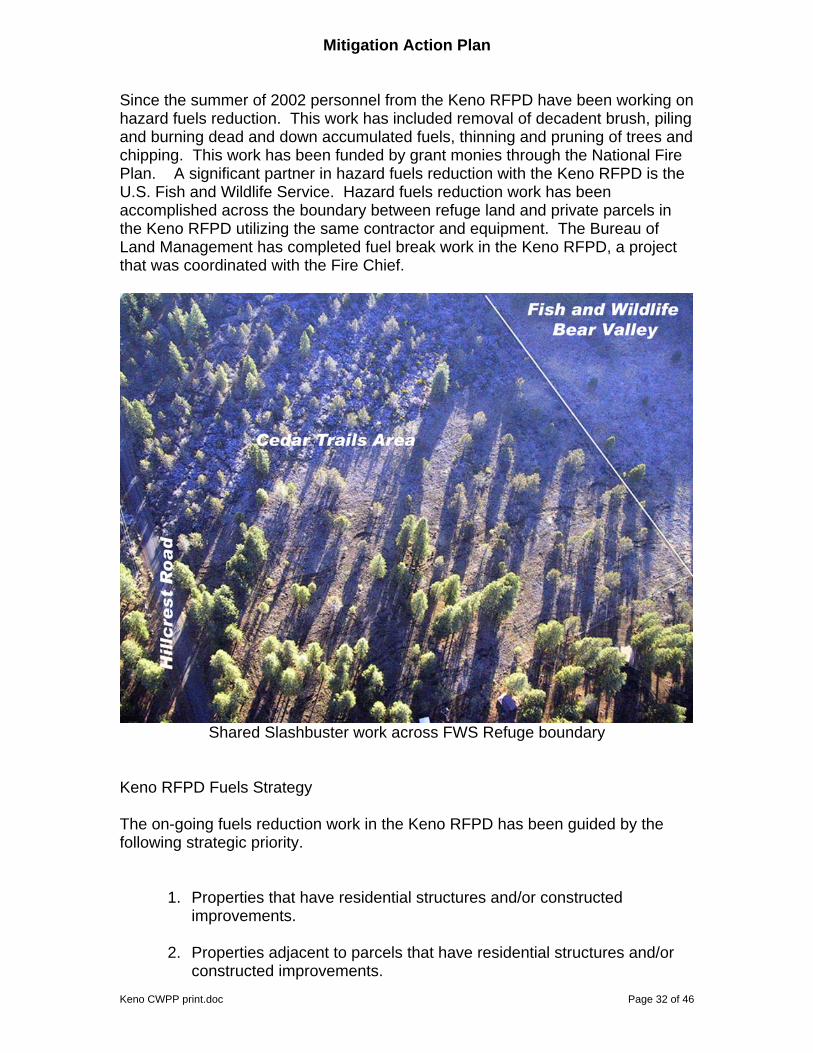
Mitigation Action Plan Since the summer of 2002 personnel from the Keno RFPD have been working on hazard fuels reduction. This work has included removal of decadent brush, piling and burning dead and down accumulated fuels, thinning and pruning of trees and chipping. This work has been funded by grant monies through the National Fire Plan. A significant partner in hazard fuels reduction with the Keno RFPD is the U.S. Fish and Wildlife Service. Hazard fuels reduction work has been accomplished across the boundary between refuge land and private parcels in the Keno RFPD utilizing the same contractor and equipment. The Bureau of Land Management has completed fuel break work in the Keno RFPD, a project that was coordinated with the Fire Chief.
Shared Slashbuster work across FWS Refuge boundary
Keno RFPD Fuels Strategy The on-going fuels reduction work in the Keno RFPD has been guided by the following strategic priority.
1. Properties that have residential structures and/or constructed improvements.
2. Properties adjacent to parcels that have residential structures and/or
constructed improvements.
Keno CWPP print.doc Page 32 of 46

Keno CWPP print.doc Page 33 of 46
3. Properties not adjacent to parcels that have residential structures and/or constructed improvements, but when treated are a segment of a larger treatment zone that offers tactical protection opportunities for the properties in priority 1.
The philosophy of the Keno RFPD is that reducing the flammability of individual parcels will reduce the flammability of the community. Homes and properties that will contribute to the reduced intensity of a wildfire will increase the capacity of the fire department. The extensive fuels and forest inventory work completed in 2005 has allowed the development of the visual products from a GIS and fire prediction software. These products have allowed a clear, graphical representation of terrain, vegetation and fire behavior characteristics to assist in prioritizing locations for fuels mitigation work. As work is accomplished the data will be updated to document the change in fire behavior potential. Not just done to support this document and plan, the data capability developed by the Keno RFPD will be used into the future for:
1. Wildfire assessment, strategic and tactical decisions.
2. Public education and fire prevention information dispersal. 3. Public safety operations, such as evacuation planning. 4. Planning of future fuels mitigation projects.

Keno CWPP print.doc Page 34 of 46
The following table was used for assessing areas of the Keno RFPD. Outputs from FMAPlus and FlamMap were used for an indication of landscape fire behavior characteristics. The combination of the surface fire behavior, canopy fuels, stand density and ladder fuels was used to identify the indicated likelihood of an area supporting significant wildfire. Individual parcel assessments from 2004 data would indicate the relative susceptibility of a given property and/or structures. Specific inputs and outputs of the evaluation process can be viewed in the Geobook maps: Fuels and Fire Behavior.
Keno RFPD Fuels Hazard Rating Low Moderate High
Surface fire behavior < 4’ flame length
4 -12’ flame
length
> 12’ flame length
Crown or canopy fire type None Passive Passive – Active
Canopy None or little
or high canopy base height
Some, low canopy base
height
Dense, low canopy base
height
Stand density
Low Moderate High
Ladder fuels Little or absent Present Significantly present
mitigation Little or none
Moderate surface fuel reduction, thinning and
pruning
Significant surface fuel
reduction, heavy thinning, pruning

Keno CWPP print.doc Page 35 of 46
Use of the previous table, fire behavior software outputs and professional judgment by the Fire Chief and the author produced the following hazard rating table for Keno RFPD communities. This rating is the first cut of prioritization of future fuels mitigation work. The final parcels are selected following the Keno RFPD fuels strategy and the Keno structural assessment.
Keno RFPD Fuels Hazard Rating Low Moderate High
Lakewoods
x
Cedar Trails
x
Jake Road x
LaWanda Hills x
Freight Road/McLaughlin
Lane
x
Old Keno
x
Pioneer x
Round Lake
x
Stagecoach x
Whispering Pines
x
Worden x

Keno CWPP print.doc Page 36 of 46
Biomass Utilization and Economic Development Biomass utilization is a preferred option for removal of hazardous fuels residues. Many attempts have been made to generate biomass markets in the Klamath Falls area. The market has not been strong. To date no opportunity to move residues to market for biomass utilization has presented itself. None of the fuels reduction projects in Keno have generated enough material to interest commercial biomass companies. Contact with Biomass One in White City, Oregon indicates that they will pickup material when there is enough for 7 to 8 chip truck loads and all material is in a pile. The pile site needs enough room for their chipper, and room for loading of trucks. Such an operation is not a viable option for lot-by-lot fuels mitigation work done on residential parcels. Education and Community Outreach Through door-to-door contact with Keno residents personnel from the Keno RFPD have distributed public education materials and information. These contacts have occurred since 2002 with the beginning of the hazard fuels reduction work, and during the property survey completed in 2004. The citizens of Keno regularly see the Keno fire district fuels crew working in their neighborhood and stop to ask questions. The Keno RFPD has plans to go forward with education and community outreach as a result of the development of this CWPP. Equipment secured via another grant will be utilized for interactive sessions and polling of participants in sessions. This equipment includes an interactive whiteboard system that allows display and editing from the viewing screen. This equipment will be part of collection that will be added to the mobile command unit that the Keno RFPD is acquiring through another grant. This unit will be capable of being set up at public gatherings, e.g. the county fair, and used to display a wide variety of outputs to the public regarding wildland fire. Although evacuation is not the preferred outcome for structure protection the Keno RFPD GIS data contains residential information that could assist in evacuations. An example would be the identification of residents with respiratory ailments that would prioritize them for evacuation during a smoke event. This information is not available in the public copies of the Keno CWPP Geobook.

Keno CWPP print.doc Page 37 of 46
Monitoring and Evaluation The Keno RFPD has been utilizing GIS for many years. It has proven to be valuable beyond an initial project use. For example, the data gathered for structural vulnerability in 2004 has proven valuable in the preparation of this CWPP. The fuels information developed to support this CWPP will be modified as future fuels mitigation work is accomplished. The GIS database allows for a dynamic information storage and retrieval system. The prioritization of future projects and coordination with cooperating/collaborating agencies will be enhanced by GIS technology. The imagery technology brought into this CWPP development will benefit the future prioritization of projects in the fire district. Monitoring and evaluation is tentatively scheduled on a basis of 5 year intervals. Sites that were treated will be visited and evaluated for treatment effectiveness and any developing indicators of approaching need for future treatment. An example would be reproduction or young seedling occupying sites that had been thinned, or brush re-sprouting. Normal accumulation of litter in the pine stands around Keno will occur. Such material may require a mitigation action in the 5 to 10 year range. The Fire Chief hopes to draw on the expertise of fire ecologists from the BLM and U.S. Fish and Wildlife Service during the monitoring and evaluation phase. Another objective is to establish more photo points to track changes over time. Existing photo points will be re-shot for the 5 year monitoring and evaluation visits. Such photography will be digital and can be linked to the GIS database. This plan will be complete and fully adopted once the signatures on the second page are secured. A open house public meeting was held on April 12, 2006 to release the final draft document and give demonstrations of the technology that helped develop it. Compact discs were handed out that included a self-installing GEOBOOK of the Keno CWPP. Hard copies of the document have been produced, circulated to appropriate officials and additional copies are available from the Keno RFPD.
Keno CWPP print.doc Page 38 of 46
Appendices Contact Information
Keno Rural Fire Protection District PO Box 10 14800 Puckett Road Keno, OR 97627 Phone: 541 883-3062 Fire Chief: John Ketchum [email protected] Wildland Fire Technologies, Inc. 1041 Vista Way Klamath Falls, OR 97601 Phone: 541 883-2556 President: Gene Rogers [email protected]
Referenced Documents and Materials on file at Keno RFPD office
• 2004 Property and Structure Survey Form and GIS database
• Keno Fuel Model Field Manual
• Keno Trees and Brush
• Keno Tree Inventory Plot Instructions from IRM
• FMA+ Fire Behavior Reports for KRFPD stands inventoried
• FlamMap input and output graphics
• Sanborn Mapping Details/Technical Documentation
• Keno Fuels Work slideshow
Bibliography Anderson, Hal E. 1982. Aids to determining fuel models for estimating fire behavior. USDA Forest Service General Technical Report INT-122, 20 p.

Keno CWPP print.doc Page 39 of 46
Andrews, Patricia L.; Bevins, Collin D.; Seli, Robert C. 2005. BehavePlus fire modeling system, version 3.0: User's Guide. Gen. Tech. Rep. RMRS-GTR-106WWW. Ogden, UT: Department of Agriculture, Forest Service, Rocky Mountain Research Station. 142 p. Fuels Management Analyst Plus, version 3, copyright 1999-2005, Fire Program Solutions/Acacia Services: all rights reserved. Fire Family Plus User’s Guide, ver 3.0, 2002. USDA Forest Service, Rocky Mountain Research Station, Fire Sciences Lab, Systems for Environmental Management, 124 p. Scott, Joe H.: Reinhardt, Elizabeth D. 2001. Assessing crown fire potential by linking models of surface and crown fire behavior. Res. Pap. RMRS-RP-29. Fort Collins, CO: U.S. Department of Agriculture, Forest Service, Rocky Mountain Research Station. 59 p. Websites pertinent to this CWPP Sanborn, http://www.sanborn.com Integrated Resource Management, Inc. http://www.irmforestry.com/ Fire Program Solutions, LLC. http://www.fireps.com/ Fire Management at the Klamath Basin National Wildlife Refuge Complex: http://www.fws.gov/klamathbasinrefuges/fire/index.html Lakewoods Village, http://www.lakewoods-oregon.info/index.html The Oregon History Project, by the Oregon Historical Society, http://www.ohs.org/education/oregonhistory/index.cfm Preparing a Community Wildfire Protection Plan, A Handbook for Wildland-Urban Interface Communities. http://www.safnet.org/policyandpress/cwpp.cfm Information about The Healthy Forest Initiative and The Healthy Forest Restoration Act http://www.healthyforests.gov/index.html Federal Agency Implementation Guidance for the Healthy Forest Initiative and the Healthy Forest Restoration Act: www.fs.fed.us/projects/hfi/field-guide/ Field Guidance for Identifying and Prioritizing Communities at Risk: www.stateforesters.org/reports/COMMUNITIESATRISKFG.pdf The National Fire Plan: www.fireplan.gov Fire Safe Councils: www.firesafecouncil.org Western Governors Association: www.westgov.org

Keno CWPP print.doc Page 40 of 46
Collaboration: www.redlodgeclearinghouse.org www.snre.umich.edu/emi/lessons/index.htm

Map Illustrations The following images are just examples of the many images available for inter-active viewing by the reader in the Geobook format. The enclosed compact disc contains a self-loading Geobook that can be installed on the viewer’s computer.
Keno RFPD WUI Boundary The WUI boundary is shown as cross-hatched. The WUI boundary extends beyond the Keno RFPD boundary to take into account areas that would have a likely influence on tactical decisions within the Keno RFPD.
Keno CWPP print.doc Page 41 of 46

Keno Fire 1962
Note the structures currently in the fire footprint, as mentioned in Chapter Four, such a fire run in a single afternoon would impact houses today that didn’t exist in 1962. Such a rapid, single afternoon fire run is typical for the Keno area.
Keno CWPP print.doc Page 42 of 46
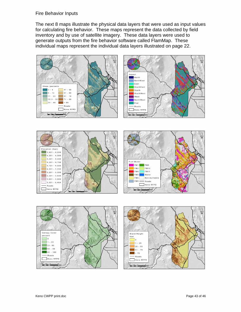
Fire Behavior Inputs The next 8 maps illustrate the physical data layers that were used as input values for calculating fire behavior. These maps represent the data collected by field inventory and by use of satellite imagery. These data layers were used to generate outputs from the fire behavior software called FlamMap. These individual maps represent the individual data layers illustrated on page 22.
Keno CWPP print.doc Page 43 of 46

Fire Behavior Inputs – continued
Fire Behavior Outputs
Flame length is a common indicator of fire intensity. It can be used as an approximation of a fire’s difficulty to suppress. Personnel with hand tools can usually handle a fire with up to 4 foot flame lengths. Fires exhibiting flame lengths of 4 to 8 feet usually require equipment such as engines and dozers. A fire with 8 to 12 foot flame lengths may require aircraft such as air tankers. Fires with flame lengths exceeding 12 feet often defy suppression efforts. Keno CWPP print.doc Page 44 of 46
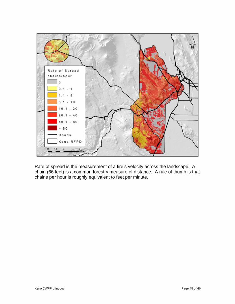
Rate of spread is the measurement of a fire’s velocity across the landscape. A chain (66 feet) is a common forestry measure of distance. A rule of thumb is that chains per hour is roughly equivalent to feet per minute.
Keno CWPP print.doc Page 45 of 46

Crown Fire Types: 0 = little or no fire spread 1 = surface fire
2 = passive crown fire 3 = active crown fire Fires that enter the canopy fuels in forest stands quickly exceed suppression efforts. All of the canopy characteristics contribute to a fire spreading vertically into the crowns of individual trees. The canopy base height is the critical to passive crown fire behavior (often called torching). The canopy bulk density is critical to sustaining a crown or canopy fire. Fuels mitigation work including pruning and thinning reduces both of these crown fire factors and can play a significant role in keeping a fire in the surface fuels. A fire in surface fuels can often be suppressed except in cases of extreme wind events.
Keno CWPP print.doc Page 46 of 46