Embed Size (px)
Citation preview

CommunityRedevelopmentPlan
Old Tampa Police Department Tampa Heights Riverfront
CRA Site
Aerial Map
May 1999First Amendment May, 2005Second Amendment February, 2006Third Amendment August 2007

i
Table of Contents
Part 1. Introduction................................................................................................. 1
Part 2. Statutory Requirements for a Community Redevelopment Plan ................ 2
Part 3. Analysis of existing conditions and need for redevelopment ...................... 2
Part 4. Description of Proposed Redevelopment Actions ...................................... 5
Part 5. Neighborhood Impact ................................................................................. 9
Part 6. Proposed redevelopment actions ............................................................. 12
Part 7. Publicly funded capital improvements ...................................................... 14
Part 8. Development Controls .............................................................................. 17
Part 9. Projected costs of redevelopment ............................................................ 17
Part 10. Timing of redevelopment .......................................................................... 18
Part 11. Legal description of redevelopment area.................................................. 18

1
Part 1. Introduction
This plan for redevelopment of the area which surrounds the City of Tampa's OldTampa Police Department site Tampa Heights Riverfront CRA has been prepared incompliance with the State of Florida's redevelopment statute Chapter 163 Part III. TheCity of Tampa declared this area blighted and eligible for redevelopment in March 1999.This Plan includes a description of initial redevelopment projects and provides aframework for coordinating public and private redevelopment. Typically areas which areblighted contain deteriorated land uses and vacant or under utilized properties whichare obstacles to the renewal of a vital urban area. The purpose of preparing aredevelopment plan is to guide public and private actions to eliminate blightingconditions and provide for continued reinvestment in the neighborhood.
In 1997 the City of Tampa moved the main police department to a renovatedbuilding near City Hall. The former police department, which was inadequate for currentneeds, has become surplus property. Located in a declining area immediately adjacentto Interstate 275 and north of downtown, the City has recognized an opportunity toconvert the police department and surrounding property into an extension of Tampa'surban renaissance. The site, which is located on the Hillsborough River, enjoysdramatic views and deep-water access.
Several historic properties are located nearby. With renovated housing, transitand interstate access, this site and its surrounding area are well positioned to become acommunity cornerstone and a major gateway to Downtown Tampa. In order toaccomplish these goals, a redevelopment plan is needed. The Hillsborough CountyCity-County Planning Commission and the City of Tampa have prepared thisredevelopment plan in order to achieve these goals.
The plan is designed to eliminate unsafe conditions and obsolete land uses, andprovide a framework that will increase investor confidence in the renewal of the area. Asa result of redevelopment, the City's tax base will be expanded, jobs and housing will beavailable in the redevelopment area, parks and open space improvements will beimplemented and the environment will be enhanced to increase the enjoyment of arearesidents and employees.
In 2003, the Tampa City Council approved a community plan entitled the "TampaHeights Plan: Rebuilding Community" (also referred to as "Tampa HeightsNeighborhood Plan"), which plan was developed by the City and the PlanningCommission, working together with representatives of the Tampa Heights Community. Itis the intent of this Community Redevelopment Plan that any redevelopment in the areashould encompass the stated goals and vision of the Tampa Heights NeighborhoodPlan.

2
Part 2. Statutory Requirements for a Community Redevelopment Plan
Areas that are subject to Community Redevelopment Plans must first be found toconform to the provisions of Chapter 163.355, which require that the local governmentestablish a finding of necessity to conduct redevelopment activities.
A Community Redevelopment Agency must be appointed to conductredevelopment activities. In the City of Tampa, City Council acts as the CommunityRedevelopment Agency (CRA). Redevelopment activities must be conducted inaccordance with the CRA Plan.
The Redevelopment Plan is required to comply with Chapter 163.360. The Planmust indicate areas for acquisition, demolition, redevelopment, improvements andrehabilitation. In approving the CRA Plan, the local government must find that a feasiblemethod exists to relocate families displaced by redevelopment.
The Plan must conform to the City of Tampa's Comprehensive Plan and indicatezoning and planning changes, if any; land uses; maximum densities; and buildingrequirements. Among the other findings, the CRA Plan must address communitypolicing and parks and recreation. Additional requirements may be invoked, dependingon the types of land use specified in the Redevelopment Plan.
After the governing body approves the Plan, the CRA is empowered toimplement the Plan. Among the powers the CRA may use are the installation of publicfacilities, disposition of property for uses specified in the Plan, property acquisition,demolition, and administration of a tax increment finance trust fund (subject to thecreation of a tax increment financing trust fund by the governing body).
A tax increment financing Redevelopment Trust Fund was adopted by the City ofTampa for the Old Tampa Police Department Tampa Heights Riverfront CommunityRedevelopment Area on May 20, 2005 (Ord. No. 2005-137).
Part 3. Analysis of existing conditions and need for redevelopment
3.1. Land Use
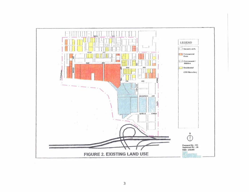
The CRA area boundaries are the Hillsborough River and North Boulevard on thewest, Ross Avenue on the north, Tampa Street on the east and 1-275 on the south (SeeFigure 1). In earlier years, Tampa Street and Florida Avenue served as vibrantextensions of the downtown. Tampa's first water source was found here and the City'sfirst waterworks was built. The spring still exists, and is located in a small park adjacentto the Hillsborough River. The barn for Tampa's early trolley system was here, whichfunctions as an armature works. A fish market is located at the western end of thearea, adjacent to North Boulevard. Single family housing was built surrounding thepublic facilities and in the 1960's the main Tampa Police Department was built.

3
1-275 bisects this area from the main focus of activity of the downtown area, andthe commercial properties along Tampa Street and Florida Avenue have declined. Theolder housing stock has fallen into disrepair and the commercial buildings within thedistrict have not upgraded. With the relocation of the Tampa Police Department, the Cityrecognized an opportunity to use the property as a catalyst for neighborhood renewal.
The City of Tampa in 1999 prepared a survey of the conditions of the structuresin this area, as part of their designation of blight. The CRA encompasses approximately77 acres of which approximately 68 acres are upland of the Hillsborough River. Therewere 66 structures included in that area in 1999. Existing uses and publicly owned landsin the area are shown on Figure 2. Of the 66 structures 18 percent, or 12 structures,were vacant.
Table 1. Existing uses of structures as of 1999Use Number PercentResidential 41 62Commercial 18 27Public 7 11TOTAL 66 100
Source: City of Tampa, 1999
Based on a review of property appraiser's records, most of the structures werebuilt prior to 1960. Approximately 43 percent of the area is owned by the government ornon-profit organizations and 57 percent of the area is vacant (includes parcels andstructures).
Non-governmental structures include a mortuary, warehouses, an office building,the armature works, a marina and a fish market.
Governmental uses included the Old Tampa Police Department and other officesused for City administrative services. The main Tampa Police Department operationshave been relocated to the downtown, and the municipal offices, which remain, will berelocated to other City facilities. There is now located within the area the StetsonUniversity College of Law-Tampa Campus. With the exception of the Stetson Campus,there has not been much change in conditions in the area since the time of the 1999survey.
3.2. Housing
When studied in 1999, there were 41 residential properties in the area. Less thanhalf of the homes had homestead exemptions, according to the Hillsborough CountyProperty Appraiser. Homestead exemption is an indication of owner occupancy. Thevalues of the homes were well below the area median. (See, Old Tampa PoliceDepartment Site: Factors Determining "Slum" and/or "Blighted" Conditions, City ofTampa, February 1999).
4
3.3. Open Space
Two parks are located in the area. The Water Works Park commemorates thelocation of the spring, which was the original water source for the City. A small springstill emerges at this location, adjacent to the Hillsborough River. At the present time thesite is seldom used and is fenced.
Phil Bouguardez Park is approximately 1.3 acres located at the southwest cornerof 7th and Tampa Street. The park is a passive park with sidewalks and a manmadewater feature.
3.4. Public services
The area is served by all municipal services. Water service is provided from theCity's central facility. Some components of the water system are as old as the City,which is in part due to the location of Tampa's first water works within the study area.There is a need to modernize the system. In addition, it may be necessary to relocatesome water lines. There is sufficient water capacity to meet demands created byredevelopment.
Wastewater is treated at the Howard F. Curren Advanced Wastewater TreatmentPlant. There is sufficient capacity to accommodate both present and futuredevelopment. The City does not have as built drawings of sewer lines in this older area.The existing lines are presumed to be in fair to poor condition, and are in need of repairor replacement. In addition, sewer lines may need to be relocated. There is one pumpstation in the redevelopment area, located at Oak Street. This pump station presentlyreceives sewage from the property west of Ola Avenue.
Drainage within the CRA flows generally to the Hillsborough River. Because theproperties were developed prior to present day environmental legislation, there is nostormwater retention or detention in the redevelopment area. Due to the extensiveamount of impervious surface which exists in the area, there is a significant opportunityto enhance surface water quality within the new development.
Good transportation connections exist on the periphery of the redevelopmentarea. North Boulevard and Tampa Street bound the area to the west and east. TampaStreet and Florida Avenue are one-way pairs serving the study area.
Realignment of streets within the redevelopment area may serve to facilitateredevelopment while maintaining adequate capacity.
Bus service is provided along Tampa Street. The City's largest bus terminal islocated just southeast of the redevelopment area. Transit service is provided to all areasof Hillsborough County.

5
Sidewalks along Tampa Street and North Boulevard provide pedestrian access.There are sidewalks on Henderson and Highland Avenues in the vicinity of the OldTampa Police Department.
3.5. Summary, need for redevelopment
The need for redevelopment of the Old Tampa Police Department TampaHeights Riverfront CRA site is driven by the opportunity to replace a combination ofdeteriorated structures, vacant land and obsolete structures and street patterns (internalto the redevelopment site) with uses that will create a positive economic benefit for thecommunity. With a prime location along the Interstate, waterfront access and underusedtransportation links surrounding the site, redevelopment of the Old Tampa PoliceDepartment and the environs will provide jobs for area residents, an increase in thecommunity's tax base, and an attractive visual feature at the gateway to Tampa'sdowntown.
Within the redevelopment area, the Old Tampa Police Department formerlyoccupied the most prominent site. However, the entire CRA area will benefit fromredevelopment, using the public ownership as leverage to encourage privateinvestment.
Part 4. Description of Proposed Redevelopment Actions
The land use program is designed to augment the jobs and economicopportunities available in the community, to preserve historic and cultural features, andto provide a variety of housing types for new and existing residents. The riverfront willbe maintained and improved to a higher standard of safety and aesthetics. An advisorypanel made up of neighborhood residents and land development specialists reviewedthese proposed land uses and provided input during the initial development of the plan.A description of the proposed uses is provided below. Figure 3 illustrates the areasdescribed in the following pages.
The Future Land Use Plan and Zoning Code of the City of Tampa will guide thefuture land use. Height, bulk and other land development regulations as prescribed inthese codes shall be applicable to the Old Tampa Police Department Tampa HeightsRiverfront Community Redevelopment Area.
The Future Land Use Map of the City of Tampa Comprehensive Plan carries adesignation of "Regional Mixed Use- 100" (RMU-l00) for most of the redevelopmentarea south of Palm Avenue. The RMU-l00 category identifies areas suitable for high-riseresidential, major office, and regional serving commercial developments that because oftheir need for space, significant vehicular access, or intensity of use require locationsrelated to major transportation facilities. Permitted uses include: Single family and multi-family residential, general and intensive commercial including shopping malls with oneor more major department stores, low to high intensity office uses, mixed usedevelopments. Land use types are permitted according to the following scheduleexpressed as a percentage of the total area in this plan category. The percentages shall

6
be applied on an area-wide basis but shall not be interpreted to require developmentwith a mixture of such uses.
Maximum Allowable Percentages of Land Use Within the Area:Residential: 50Commercial (including office development): 75Industrial: 0
Residential density ranges from 0-75.0 dwelling units per acre (du's/ acre). Anincrease from 0-100 dwelling units may be considered with applicable bonusperformance standards. A 3.5 floor area ratio (FAR) maximum maybe considered in thisland use designation.
The frontage along Tampa Street, between Palm Avenue and 7th Avenue isdesignated ITeavy Commercial (ITC-24). Permitted uses include general commercialand low to medium-high intensity offices uses. Residential development shall be limitedto site plan controlled zoning districts. Land use types shall be permitted according tothe following schedule, expressed as a percentage of the total area in this plancategory. The percentages shall be applied on an area-wide basis but shall not beinterpreted to require development with a mixture of such uses.
Maximum Allowable Percentages of Land Use Within the Area:Residential: 70Commercial (including office development): 100Industrial: 0
The cumulative development in these areas shall be monitored to ensure that theproportion of mixed uses is maintained.
Density/Intensity: A 1.5 floor area ratio (FAR) maximum may be considered inthis land use designation. A range of 0-24.0 du's/acre shall guide residential density.
The portion of the redevelopment area between Palm Avenue and Ross Avenueis designated Residential-35 (R-35). Permitted uses include single family detached,semi-detached, attached and multi-family residential, and mid-rise multi-familyresidential uses, neighborhood commercial, and low intensity office uses.
A range from 0-30.0 du's/acre is permitted. An increase from 0-35.0 dwellingunits per gross acre may be considered with applicable bonus performance standardsor a site plan controlled zoning district. A 0.5 floor area ratio (FAR) maximum may beconsidered for non-residential uses.
7
4.1. Area "A" High Density Mixed Uses: Office, Hotel, Retail andResidential
This area is proposed to be a high intensity node of mixed land uses. Thepotential uses for this area include office, hotel, residential, retail; as well as theprovision of opportunities as support facilities for cultural and community uses. Thehighly visible site, adjacent to the interstate highway, will be ideally located for a majoruser who can take advantage of the opportunity to be instantly recognized as part of thedowntown skyline.
The uses described above are expected to be developed in several buildingswithin area A. Potential office, hotel and retail sites would have both excellent accessesto the arterial street network and vistas on the Hillsborough River. It is intended topermit high intensity development consistent with the comprehensive plan designation,Regional Mixed Use-l00 (RMU- 100) which permits a maximum floor area ratio of 3.5.Residential uses, if developed in this area, would be done consistent with thecomprehensive plan floor area ratio designation (RMU-100). Similarly, building heightswould be allowed to take advantage of the intensity anticipated in the RMU-100category (approximately 200 feet). Height references in this plan are the heights abovethe flood plain elevation for this site.
Retail commercial opportunities may be incorporated in office/hotel buildings toserve office workers and hotel guests for goods such as food, beverage, cards, sundriesand office supplies. Free standing retail may be incorporated into the mixed land useconfiguration. Retail, which is built as an accessory use to the office and hoteldevelopment, is not anticipated to draw new trips to the site.
A hotel would add to the inventory of hotel spaces downtown in support ofactivities at the convention center, Performing Arts Center and Ice Palace. Water viewsand good transportation access are benefits of Area "A". Connection to the downtownTampa riverwalk to the south can be made providing access to the performing artscenter on Doyle Carlton Drive. The convention center and the Ice Palace will be a shorttrip from the hotel.
4.2. Area "B", Medium Density Mixed Uses Residential, Office andRetail
Area "B" is planned for a medium density mixed use land use pattern. This areacontains internal streets, some of which may be vacated to permit greater flexibility insite design. To the extent employees of new office occupy those residential units orother downtown offices trip demand will be reduced.
Additional neighborhood-service offices may be located in this area. Retail/officespace in this area may be developed in conjunction with residential opportunities.Storefront office/retail development would draw the interest of residents wishing to openlocal businesses. The mix between office and retail use will be determined by end userdemand. The intent is to provide flexibility in space design and tenant characteristics to
8
meet market demand and at a scale and character compatible with the surroundingarea.
Retail development in Area "B" will be oriented to supplying goods and servicesto nearby employees and residents. There are retail opportunities for grocery, drug andconvenience uses. Building heights in area B are limited to 175 feet. Densities of theresidential development in this area are proposed to be an average of 50 du's/acre orapproximately 650 units. Retail and office use development will be limited to a floor arearatio of .5.
4.3. Area "C" Medium Density Residential
Area "C" is north of Palm Avenue. Development within Area "C" is expected to besingle family homes, town house or condominium units at a density of 24-30 du's/acreor about 350-438 dwelling units, neighborhood commercial and low intensity office uses(with a 0.5 FAR). This density is compatible with the comprehensive plan designation inthe immediate area; similar in scale and mass to the current residential in-filldevelopment patterns being developed in the City of Tampa. Building heights in thisarea are limited to 45 feet. Efforts shall be made to preserve or relocate contributinghistorical structures, and historical architectural details found within the area shall beincorporated into new development in order to preserve the character of TampaHeights.
4.4. Area "D" High Density Residential
Area "D" abuts the Hillsborough River and North Boulevard. This site is proposedto be redeveloped as a multi-story residential development with building heights not toexceed 175 feet and compatible office and retail uses. High rise apartments have alower trip generation rate than detached housing or garden apartments.
The total number of residential units at all sites is projected to be approximately216 units when developed at a density of 75 du/ acre. Bonus provisions of thecomprehensive plan permit densities of up to 100 du's/acre, or about 289 units in thiscase. Families and singles will be accommodated in the proposed housing unit mix.Retail and office uses will be limited to a floor area ration of 1.0.
4.5. Area "E", Open Space
Area "E" is planned for parks and open space connections to the HillsboroughRiver. Open space is planned to be an integral part of the redevelopment area. Theexisting Waterworks Park (including the Water Works Building) will remain and will beimproved with landscaping and amenities. It is anticipated that this park will be astronger functional element of the redevelopment area landscape. Fencing surroundingthe Waterworks Park is proposed to be replaced with a more aesthetic treatment. Thepresent Waterworks Park will be improved and the relationship of the park to the riverwill be strengthened. It is intended that the open space provisions in Area E will beconsidered in determining open space requirements of the other areas of the CRA plan.

9
The Revised Figure 3 shows anticipated open space connections to thesurrounding area and the Hillsborough River. The exact locations will be determinedduring project design, but it is intended that open space connections will be included tothe waterfront. The connections are encouraged to be developed as streets capeimprovements; providing for vehicular movement as well as safe and pleasantpedestrian circulation, including street trees, pedestrian scale lighting and pavingconsistent with the development's design theme.
Additional open space/pedestrian linkages will be reinforced through streetscapeimprovements along Tampa Street, Palm Avenue, North Boulevard and along 1-275.This will include appropriate landscaping, sidewalks, lighting, and street furniture thatwill be incorporated at selected sites. New streetscape materials will be designed to becompatible with the surrounding community.
4.6. Area "F", Medium to High Density Mixed Use
The land in Area "F", including the Tampa Armature works, has an extensivecommercial history within the district. The plan proposes medium to high-densityresidential, office and retail uses compatible with the enhanced development programfor the remainder of the site.
Adaptive reuse of the armature works is anticipated to take advantage of thehistoric value of the site and structure. Located adjacent to the old water works, theTampa Armature Works encompasses the trolley barn which was a historictransportation hub. Adaptive reuse will be determined in the future, but may encompassperforming and visual arts, historic displays, residential uses, food and beverageretailing and education opportunities. The structure is located on approximately 2.5acres.
The mix of uses planned for this area is similar to that proposed for Area B, butthe intensity of the uses are greater. The intensity of development of this area has beendesignated medium to high-density to allow for reuse of the historic structures. Thefocus of this area is on the river frontage. Commercial uses may include outdoor cafesand shopping that take advantage of the river views and attraction of the river activities.A mix of retail, offices and residential uses in this area are proposed to take advantageof waterfront and also to create a lively urban atmosphere, with a maximum buildingheight of 175 feet. Docking facilities are anticipated for visitors arriving by boat and forthe project's residents. Densities are proposed to be 50 du's/acre or approximately855818 units. Retail and office use will be limited to a floor area ratio of 1.0.
It is an objective of this Plan to protect view corridors to the river. Site planning,green space areas and building massing shall be designed to facilitate this objective.
Part 5. Neighborhood Impact
The residential neighborhood in the CRA area retains few elements of vitality.

10
Many of the homes are not owner-occupied and the residential structures arescattered throughout the area.
5.1. Impact on residents of the redevelopment area
The City operates an extensive housing rehabilitation program that has bothamortizing (repayments) and deferred payment loans. Opportunities may exist torehabilitate existing structures for relocation in the surrounding neighborhood.
Several of the residential structures were determined to be in need of demolition.Demolition is called for when the unit is so severely deteriorated that the cost ofrehabilitation would exceed the value of the structure. Old wooden homes often havedamage to structural members, which make rehabilitation cost-prohibitive. It isanticipated that on-site residential rehabilitation will not be undertaken. As stated above,it may be possible to relocate some homes off-site for renovation.
Residents in rental housing will be given the opportunity to relocate to safe,suitable housing in the vicinity of the redevelopment area. There are numerousresidential structures in the area north of Ross Avenue. Owner-occupants who chooseto relocate will be given assistance through the City's Department of Business andHousing Development.
Redevelopment will have a positive impact on those residents who remain in thearea. Expanded employment and recreation opportunities are expected to increaseproperty values.
5.2. Impact on residents of the surrounding area
The redevelopment area is located between Downtown Tampa and TampaHeights. Downtown Tampa has a significant concentration of office, convention andcultural land uses. The impact of redevelopment of the Tampa Police Department siteon the downtown is expected to be positive. Additional jobs, housing and hotel spaceswill be added in this redevelopment area. Corporate relocations from outside theimmediate area are expected to be the target market for redeveloped office space. Norelocations from the immediate area are anticipated. The downtown employment basewill be enhanced by the addition of housing in the redevelopment area. Commuters whopresently drive to downtown office sites will have attractive alternatives within a shortwalk or bus ride. Auto trips to downtown Tampa may decrease slightly for thosecommuters who relocate to housing in the study area.
The impact of the redevelopment program on Tampa Heights is expected to bepositive. The present structures, in their present condition, are not an asset to theneighborhood. The public buildings are largely vacant and do not contribute to theneighborhood, either aesthetically or economically. The residential uses are largelyisolated and do not form a cohesive part of the greater Tampa Heights neighborhood.With the addition of approximately 2080 dwelling units, there will be an addition of 3700-4400 residents, many of whom will be new to the area. New residents will help revitalize

11
the community's institutions. New members for churches, schools and the TampaHeights Civic Association will provide increased community stability.
5.3. Relocation and replacement housing; affordable housing
The Tampa Housing Authority operates affordable housing units. The City willprovide relocation assistance and counseling.
Given the small number of residences which may be impacted by theredevelopment plan, the large number of housing options in the area, and the expertiseof the City in providing housing opportunities, relocation and replacement housing tosupport implementation of the redevelopment plan is expected to be easilyaccommodated within the existing support framework.
Residents who are displaced will be provided with full opportunity to occupycomparable replacement housing that is safe and sanitary and within the resident'sability to pay. The City will remain responsible for any residential and commercialrelocation activities. The City's customary relocation policies will be followed.
State funds and Federal tax credits have been used in recent years to expandFlorida's inventory of affordable housing. According to the Florida Housing FinanceCorporation, as of 1999 there were 875 units of low income (below 80% of area median)in operation in Hillsborough County developed under the SAIL program. Approximately2628 units in Hillsborough County" had been produced through Low Income HousingTax Credits. New residential development should include an affordable housingcomponent.
5.4. Traffic Circulation
A reconfigured street grid system may help to foster redevelopment in the area.This will be addressed as a component of site plan approval.
Accommodations for in-town circulation will reduce traffic demand. Connectionsto the downtown riverwalk will encourage pedestrian access to the performing artscenter and other downtown destinations. Future circulation options include a river taxiand a trolley or equivalent mass transit circulation.
5.5. Environmental Quality
Environmental quality in the area is expected to improve as a result ofredevelopment. In order to redevelop the sites, environmental regulations will requireremediation on any on-site contamination that may be discovered or a Brownfield maybe considered. In addition to remediation of contaminants, the environment of the areawill be enhanced through landscaping and open space improvements.
12
5.6. Availability of Community Facilities
The need for water, sewage treatment, solid waste disposal and other communityfacilities will be increased as a result of redevelopment. Specific actions to meet theseneeds are addressed in Part 6 of this Plan. Upgrading of water delivery and sewagelines will be needed, both to replace obsolete conditions and to meet the demands ofredevelopment.
The City has sufficient administrative capacity to plan and implementredevelopment. With the continued success of redevelopment in downtown Tampa,Ybor City and the Channel district, the administration has the talent and expertise tomeet the challenges of redeveloping the CRA site.
5.7. Effect on School Population
It is assumed that any additions to the school population can be accommodatedby capacity within the school area. At the present time, there has been no market nicheassigned to the proposed additional housing units. The impact on school population willdepend on whether these units are oriented to family housing, working singles or "emptynest" adults. At such time as development proposals are brought forward, additionalanalysis may be needed.
There are several schools within the vicinity of the study area: including LeeElementary, Graham Elementary, Brewster Adult School, and Just Elementary. BlakeHigh School is located across the Hillsborough River from the project site. VillaMadonna and Sacred Heart Academy are in the area, also. These schools would be theclosest service providers for any students who locate into the redevelopment area.
Part 6. Proposed redevelopment actions
Implementation of the plan depends on inducing private investment throughpublic actions. One component of these actions may include public investment ininfrastructure to support the proposed redevelopment program.
6.1. Property acquisition
The Community Redevelopment Act authorizes the City or agency to acquire realproperty by purchase, condemnation, gift, exchange or other lawful means, inaccordance with an approved redevelopment plan.
In general, the purpose of the CRA plan for the Tampa Police Department site isto provide the optimum means for sale of the substantial amount of publicly ownedproperty that is presently within the district boundaries. However, in order to effectorderly redevelopment it may be necessary from time to time to purchase privatelyowned property. If such purchases are necessary, the first line of acquisition action willoccur through traditional City Housing and Economic Development programs.
13
6.2. Rehabilitation
Rehabilitation of property is a lawful exercise of Agency powers under StateStatutes. The Agency may rehabilitate or cause to be rehabilitated, property as acondition of sale, lease or owner participation agreement. In addition to CRA actrehabilitation powers, the City operates an extensive program of structural rehabilitationunder the Department of Business and Housing Development. This program focuses onimprovements to the community's housing stock, but it has limited applicability to otherproperties.
Rehabilitation will likely play some role within the CRA redevelopment plan.Particularly for the historic properties, adaptive reuse and rehabilitation will supportpreservation of important structures and afford the district a sense of place andcontinuity with the roots of the City.
6.3. Structure relocation
Structural relocation is not anticipated to be a major component ofredevelopment program implementation. For the most part, redevelopment willnecessitate replacement of existing structures. Adaptive reuse of historic structures willbe sought in their present locations.
Relocation may be appropriate for a small number of the older vernacular housesfor reuse such as craftsmen's studios and galleries or like uses.
6.4. Cooperation with public agencies
The redevelopment agency (supported by the City's administrative staff) will seekaid and cooperation with other public agencies and will in turn coordinate this plan withthe activities of the City, Hillsborough County, State, Hillsborough River Planning Board,School Board, and other agencies as may have interests in redevelopment planningand permitting.
6.5. Property management
Should any real property be owned, leased or otherwise come under the controlof the agency, the City's administrative staff will conduct supervision and management.The agency shall enter into contracts, leases or management agreements as necessaryto insure the preservation and maintenance of any such real property, and shall insurethe greatest return feasible to the agency.
6.6. Demolition and clearance
The redevelopment agency (supported by the City's administrative staff) isauthorized to demolish, clear or move buildings, structures or other improvements fromany real property in the area which has been acquired or as may be necessary to carryout the purpose of the redevelopment plan.

14
Demolition is not anticipated to be an activity of the redevelopment agency. Suchdemolition as may be necessary to implement the CRA plan is anticipated to beconducted by other public or private agencies.
6.7. Preparation of building and development sites
The agency is authorized to prepare or cause to be prepared as building anddevelopment sites, any real property in the redevelopment area owned or acquired bythe agency or any other person, which property is to be developed pursuant to the plan.
6.8. Disposition and development
The redevelopment agency (supported by the City's administrative staff) isauthorized to sell, lease, exchange, subdivide, transfer, assign, pledge, encumber bymortgage or deed of trust or otherwise dispose of any interest in real property acquiredpursuant to the plan. To the extent permitted by law, the agency is authorized todispose of real property by negotiated sale or lease. All real property acquired by theagency shall be sold or leased for development for fair value in accordance with theuses permitted in the plan and as required by the act.
The agency may reserve such powers and controls through disposition anddevelopment documents with purchasers or lessees of real property as may benecessary to ensure that development begins within a reasonable period of time andthat such development is carried out pursuant to the purposes of the redevelopmentplan.
Part 7. Publicly funded capital improvements
The CRA may recommend to the City that the construction of publicimprovements and infrastructure be undertaken by the City, or by another entity, asdesignated by the Cit, respecting the location, installation, ownership, maintenance andoperation thereof, as shall be agreed to by the City and the CRA in order to carry outthe purposes of the plan.
The City will retain the responsibility of insuring that public infrastructure systemsare adequately installed and maintained. Through development agreements and/orinterlocal agreements with other entities such as Community Development Districts,elements of this responsibility may be assigned to other entities; however, adequatesafeguards will be instituted to insure that the necessary and appropriate levels of publicservices are provided and the rights of the public to use such facilities are protected.
7.1. Transportation
The street grid pattern may be reconfigured to implement a more cohesivedevelopment pattern. This may necessitate the vacation of right-of-way and/or closureof certain existing streets. New public streets and alleys may be created, withappropriate signage and/or traffic control devices provided. Bus stops to provide

15
linkages to downtown and other parts of the community are planned and new shelterswill be installed. Expansion of trolley-bus service for lunchtime to provide connections tothe main transit terminals may be provided to ease the traffic impacts of development.
7.2. Parking
The greatest demand for parking within the redevelopment area is anticipated tobe a consequence of private development. Parking is anticipated to be constructed asan accessory to the primary uses principally office and hotel structures.
7.3. Water
Water system improvements are required for the land use densities proposed inthe redevelopment area. These improvements address service connections to individualproperties and replacement of main transmission lines. Some of the locations that havebeen identified as requiring improvement are at Garcia Avenue, Oak Avenue andHighland Avenue. Others are anticipated to be identified as well.
Other improvements that may be associated with redevelopment include allelements of the potable water distribution system, as well as a reclaimed water irrigationdistribution system. Some relocation of utilities may also be required in order toconstruct improvements to the water system.
7.4. Sewer
Improvements to the sewer system may be a necessary component of theredevelopment project. The existing pumping station at Oak Avenue may not haveadequate capacity for redevelopment of the area. A new pumping station and gravitycollection system may be constructed, and existing sewer lines may be upgraded orreplaced.
7.5. Drainage
At the present time, there is a minimal drainage system in the study area.Drainage is accomplished through direct flow into the Hillsborough River. Drainageimprovements will be addressed during site planning stages of the proposeddevelopment.
7.6. Parks and open space
Expansion and rehabilitation of the Open space/Park area will be an importantpublic amenity, which enhances the environment for both residents and employees ofthe redevelopment area. Redevelopment will include the enhancement of existingparks and creation of new parks and greenways within the redevelopment area. Parkenhancements may include landscaping, irrigation, outdoor benches, tables andplayground equipment, gazebos, pavement, landscape architecture, historical markers,street lighting and landscape lighting.

16
Access to the River may be enhanced by the construction of boat slips, piers andboat launch areas for public and private use.
7.7. Pedestrian improvements/Riverwalk
Pedestrian improvements will benefit both the aesthetics and the function of theredevelopment area. Projects that abut arterial and major collector streets will beplanned to incorporate streetscape improvements into the project plans. Improvementsto minor streets may be done by either the public or private sectors.
Pedestrian access improvements along the river are to be provided as a result ofthe construction of the Tampa Riverwalk. The Riverwalk will extend from the boundaryof the redevelopment area north along the river to North Boulevard, which is an area ofapproximately 2100 linear feet. The Riverwalk will be dotted with periodic plantings ofpredominantly native vegetation in organically shaped beds placed along the walkway.These plantings will be punctuated and somewhat formalized by live oaks on eitherside of the Riverwalk. This will establish a lush, picturesque canopy in future years. TheRiverwalk can also serve as a recipient site for the many dozens of trees to betransplanted out of The Heights CRA while under development.
Site furnishings will include benches, water fountains, bike racks, trash cans andother people-oriented amenities. Landscape architectural elements will complement thecharacter of the two turn-of-the-century brick vernacular buildings along the site -- theWaterworks Building and the Tampa Armature Works building. Landscape architecturalelements may include shelters, follies, pavilions, amphitheaters, gazebos, and publicrestrooms. The Riverwalk will also have street lighting and landscape irrigation andlighting features.
Construction of the Riverwalk is expected to require repair and/or replacement ofthe existing seawall located along the River within the project area, including piles,pilings, bulkheads, caps and revetments.
7.8. Other Capital Improvements
Redevelopment of the area will also require and be benefited by:
• installation of underground electrical transmission lines and otherunderground distribution lines;
• earthwork, grading, and fill materials required to comply with new FEMArequirements;
• enhanced street tree plantings;
• enhanced street lighting features;
• installation of brick pavers to accentuate and complement the historiccharacter of the neighborhood.

17
Part 8. Development Controls
All new construction shall comply with all applicable local laws and ordinancesand shall be consistent with the Plan. Proposals for new development shall be reviewedby the City administration and forwarded to the Community Redevelopment Agency.
No limitations are anticipated on building use as long as development conformsto the approved plans and ordinances.
Development abutting the river shall show sensitivity with respect to theplacement of structures that can be seen from the Hillsborough River and shall bedesigned to provide view corridors to the river. No architectural restrictions will beplaced on development in the remainder of the district, with the exception of anyapplicable provisions of the Zoning Code or restrictions applicable to officiallydesignated historic properties.
In general, the Agency shall, or will require the developer to provide existingbusiness owners and business tenants within the redevelopment area preference for re-entry into business within the redevelopment area provided the business is compatiblewith the uses, theme and quality of development in the redevelopment area and that thebusiness owner or tenant has the financial ability to operate the business consistentwith the overall integrity of the redevelopment district.
Part 9. Projected costs of redevelopment
9.1. Funding sources
In order to carry out redevelopment, the CRA (supported by the City'sadministrative staff) will use multiple funding sources, including private sector as well aslocal, state and federal government sources. General funding methods and sources thatwill be examined to finance redevelopment activities to implement the Plan include thefollowing:
1. Special taxing district. A special taxing district, including aCommunity Development District (CDD) can be created for the purpose oflevying a millage assessment within a defined area to pay for improvements andservices within that area.
2. State enterprise zone tax credits. State corporate income taxcredits are available through revitalization programs for corporations who locateand hire residents of designated enterprise zones. Credits are also available forcontributions to community projects.
3. Revenue bonds. Revenue bonds can be issued to finance publicimprovements within the project area. Eligible projects include parking andutilities.

18
4. Federal and state funds. Funding for redevelopment is an eligibleexpense of the Community Development Block Grant (CDBG) programadministered by the U.S. Department of Housing and Urban Development (BUD).Federal transportation funds under the ISTEA program may be used to fundpedestrian and transportation-related improvements. Environmental fundingunder the P-2000 and related programs has been used for urban landconservation.
5. Tax increment financing. Tax increment financing is a powerdelegated by statute to the CRA. The City of Tampa adopted an ordinanceestablishing a Redevelopment Trust Fund for this area on May 20, 2005 (Ord.No. 2005-137) in order to finance redevelopment in the area. Per Florida StatuteSection 163.87, the trust fund shall be used to finance or refinance communityredevelopment activities pursuant to this approved plan. The cost of suchredevelopment activities may include the professional service fees associatedwith redevelopment activities, including but not limited to design, planning,engineering, architecture, legal, any and all administrative fees associated withsuch redevelopment activities, all soft costs and other programmaticexpenditures associated with implementing capital-based communityredevelopment plan activities.
6. Local funds. General fund revenues can be used to financeredevelopment activities. General fund revenues are the source of staffingassistance to the redevelopment program. Enterprises of local government,including the utility and parking systems, may be used to fund systemimprovements in the redevelopment area.
Part 10. Timing of redevelopment
Due to economic considerations, start of the redevelopment is planned to beginas soon as possible. It is anticipated that redevelopment of the CRA will be completewithin 30 years.
Part 11. Legal description of redevelopment area
A copy of the legal description is included in the attached appendix.

APPENDIX
Old Tampa Police Department Tampa Heights Riverfront CRA Site
Community Redevelopment Area
Legal Description
Begin at the center point of the intersection of the Right-Of-Way Lines of Tampa Streetand Palm Avenue, run thence West, along the center line of the Palm Avenue Right-Of-Way lineto the center point of the intersection of the Right-Of-Way Lines of Palm Avenue and HighlandAvenue; thence run North along the center line of Highland Avenue to the center point of theintersection of the Centerlines of Ross Avenue and Highland Avenue; thence run West along theCenterline of the Ross Avenue Right-of-Way to the center point of the intersection of RossAvenue and North Boulevard; thence run South along the center line of the North BoulevardRight-of-Way to the intersection of the North Boulevard Right-of-Way and the Centerline of theHillsborough River (said centerline being equidistant from opposing mean high water lines asestablished by the U.S. Army Corps of Engineers); thence run East/Southeast along saidcenterline of the Hillsborough River to the intersection of the centerline of the HillsboroughRiver and the Northern Limited Access Right-of-Way line of Interstate-275; thence run Eastalong the Northern Right-of-Way line of Interstate-275, to the Center point of the intersection ofInterstate-275 and Tampa Street; and Tampa Street; thence run North along the center line ofTampa Street to the intersection of the Right-Of-Way lines of Tampa Street and Palm Avenueand the Point of Beginning; all of the area previously described is located within Section 13,Township 29 South, Range 18 East, City of Tampa, Hillsborough County, Florida; containing77.04 acres, more or less.

2
3

FIGURE 3