Embed Size (px)
Citation preview
Community Mapping with Youth
in Santarém’s Bairro Nova República
Stephen C. Bentley
June, 2007
The New Public Consortia for Metropolitan Governance Project
Primary Project Partners: Prefeitura Municipal de Santarém, Environmental Youth Alliance, Centre for Human Settlements – UBC
Community Partners: Escola Municipal Princesa Izabel, Pastoral da
Juventude
1
Table of Contents 1) Introduction . . . . . . . . . 2 2) Objectives of Mapping Project . . . . . . 2
2.1 General Goals . . . . . . . 2 2.2 Specific Objectives . . . . . . . 3
3) Evolution of the Mapping Project . . . . . . 3 3.1 Pastoral da Juventude . . . . . 3 3.2 Agenda 21 and the Public School System . . . 4 3.3 Government Community Extension Initiatives . . 6 3.4 Belterra . . . . . . . . 6
4) Methodology . . . . . . . . . 7 5) Results and Lessons Learned . . . . . . 9
6.1 Mapping Process Lessons . . . . . 9 6.2 Information Learned about the Neighbourhood . . 10
6) Next Steps . . . . . . . . . 11 Appendix 1: The Five Thematic Maps . . . . . 12 Appendix 2: Original Project Proposal and Methodology . . . 16 Appendix 3: Project Partner Contacts . . . . . . 20 Appendix 3: Map Systemization Matrix . . . . . 21
2
1. Introduction This report outlines a community mapping project that was carried out with youth in the municipality of Santarém, Pará state, Brazil, as part of the New Public Consortia for Metropolitan Governance Project. The principal focus of the NPC project, a partnership between Canada and Brazil, is to reduce poverty in Brazil’s informal settlements through the formation of regional governance structures known in Brazil as public consortia. Through a process of collaborative action research, the consortiation experiences of the five metropolitan regions participating in the project (Belo Horizonte, Fortaleza, Recife, Santarém, Santo André) are to improve the quality of life for residents of their peripheries and generate knowledge to help guide other efforts at regional collaboration for poverty reduction. While public consortia are by definition governmental institutions, the consortia’s “user groups,” i.e. the residents of informal settlements – particularly women and youth – are to be protagonists in the consortia project’s development. While there are numerous strategies for community participation in governance, two of the Canadian partner organizations, the University of British Columbia’s Centre for Human Settlements and the Environmental Youth Alliance, proposed community resource mapping with youth as an initial methodology since it can be a useful tool for community development, environmental education, and public policy formation. This report provides an overview of the mapping project developed in the Santarém between January and June 2007. It discusses the project’s objectives, its evolution, the methodology used, key lessons learned and data collected, and future steps that might be taken with regard to community mapping in the Santarém region. Finally, the maps themselves are included in the appendix, along with local contacts, and resources related to the project’s process.
2. Objectives of the Mapping Project 2.1 Overall Goals:
o Train neighbourhood residents to participate in processes of urban governance and public policy-making;
o Contribute to processes of economic and socio-environmental development of the community;
o Inform the formation of public policies that could be implemented by the public consortium that is to be created in the region;
o Develop knowledge regarding participatory management methodologies that can be used by other public consortia in the region.
3
2.2 Specific Objectives:
o Train community residents (including youth, children, and women) to recognize and value assets (social, environmental, economic, etc.) that already exist in the neighbourhood, and to identify and resolve local problems, through participatory mapping processes;
o Develop a map of community resources and priorities to strengthen social, environmental, and political security;
o Document the process and write a manual on participatory mapping in the New Public Consortia Project, so that others may replicate the process in other communities.
3. Evolution of the Mapping Project Initially, the community mapping proposal encountered some resistance in the Santarém region (municipalities of Aveiro, Belterra, Placas, Juruti, and Santarém) because the local consortia project lacked definition in terms of both thematic focus and pilot projects. Specifically, it was felt by some working in the municipality that beginning to work in the community before a government intervention had been defined with allocated budget might create unreasonable expectations in the community. However, after convincing the local project coordinator of the value of youth participation in the project, it was agreed that a youth engagement “pre-pilot” project might be carried out, while the “official” pilot projects were in the process of being defined. Because of the lack of definition of the “official” projects, the mapping needed to be carried out in conjunction with existing government and community-based initiatives. I therefore presented the community youth mapping concept to city staff working in Santarém’s Participatory Budgeting (Orçamento Participativo, or OP) department, as well as to environmental education coordinators working in the municipality’s Socio-Environmental Institute (ISAM), Secretariat of Education (SEMED), and Secretariat of Infrastructure (SEMINF). I also discussed the project with government and community members in the municipality of Belterra. (The project proposal and methodology that I presented to potential partners can be found in Appendix 2). In some cases these discussions went nowhere, but in others they led the project in various directions, each with different levels of success. These are described below. 3.1 Pastoral da Juventude Interested in supporting me in the project, staff at OP offered to help me get in touch with the Neighbourhood Association of Santarenzinho, one of Santarém’s largest and reputedly most dangerous neighbourhoods. When communication difficulties were incurred, OP staff put me in touch with the president of the neighbourhood association of Bairro Nova República. The president expressed interest in supporting the initiative,
4
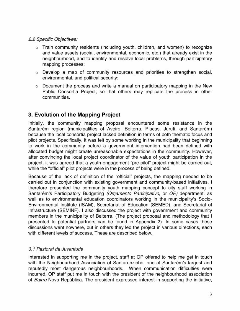
but informed me that the association did not offer much in the way of youth engagement. He suggested I work with youth groups at the local Catholic church and suggested I contact the church’s father, Egilberto Sena, also a radio commentator and internationally renown environmentalist. After conversing with him at the Rádio Rural station, Padre Sena invited me to Sunday mass, promising to introduce me to the youth groups. (In fact he would introduce me to the entire congregation). Upon meeting
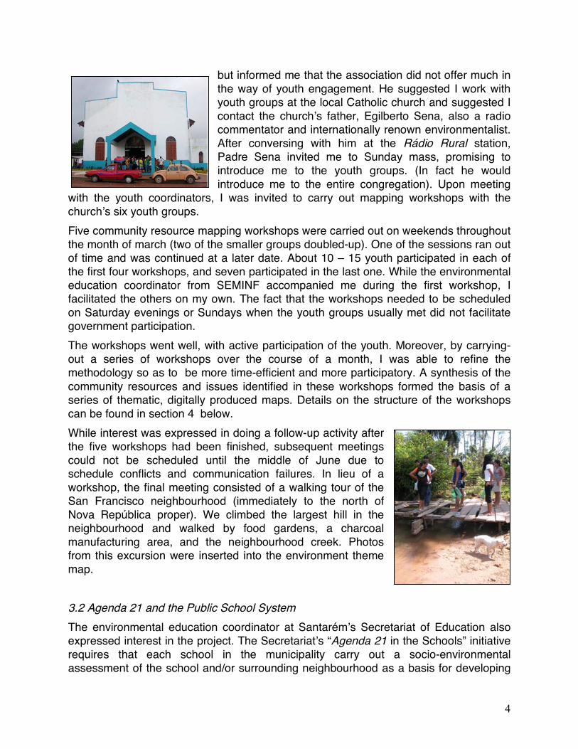
with the youth coordinators, I was invited to carry out mapping workshops with the church’s six youth groups. Five community resource mapping workshops were carried out on weekends throughout the month of march (two of the smaller groups doubled-up). One of the sessions ran out of time and was continued at a later date. About 10 – 15 youth participated in each of the first four workshops, and seven participated in the last one. While the environmental education coordinator from SEMINF accompanied me during the first workshop, I facilitated the others on my own. The fact that the workshops needed to be scheduled on Saturday evenings or Sundays when the youth groups usually met did not facilitate government participation. The workshops went well, with active participation of the youth. Moreover, by carrying-out a series of workshops over the course of a month, I was able to refine the methodology so as to be more time-efficient and more participatory. A synthesis of the community resources and issues identified in these workshops formed the basis of a series of thematic, digitally produced maps. Details on the structure of the workshops can be found in section 4 below. While interest was expressed in doing a follow-up activity after the five workshops had been finished, subsequent meetings could not be scheduled until the middle of June due to schedule conflicts and communication failures. In lieu of a workshop, the final meeting consisted of a walking tour of the San Francisco neighbourhood (immediately to the north of Nova República proper). We climbed the largest hill in the neighbourhood and walked by food gardens, a charcoal manufacturing area, and the neighbourhood creek. Photos from this excursion were inserted into the environment theme map. 3.2 Agenda 21 and the Public School System The environmental education coordinator at Santarém’s Secretariat of Education also expressed interest in the project. The Secretariat’s “Agenda 21 in the Schools” initiative requires that each school in the municipality carry out a socio-environmental assessment of the school and/or surrounding neighbourhood as a basis for developing
5
its own Agenda 21. Since this assessment has so much in common with the community mapping proposal, it was proposed that I might carry out workshops in the school system, thus fulfilling a need of both Agenda 21 and the NPC Project. The coordinator put me in touch with municipality’s Youth and Adult Schools (Escolas de Jovens e Adultos) coordinator, who in turn introduced me to the staff and students of Escola Princesa Izabel (also in the Nova República neighbourhood), during a cultural presentation at the school. I subsequently scheduled a meeting with the principal and teaching staff at the school to present the mapping idea. At the meeting, I discovered that although the school had not carried out a school or neighourhood diagnostic as such, it did have a schedule of environmental events related to Agenda 21. Unfortunately, I also encountered some resistance to the project. One teacher reminded me that third world countries are routinely victimized for environmental degradation when developed countries are among the worst polluters in the world, and asked if I was doing anything to promote sustainability back home. Another argued that many of the neighbourhood’s environmental problems are the fault of the government. The pollution of the neighbourhood creek, for example is largely due to the lack of drainage and sewage infrastructure. Was the government going to do anything as a result of this mapping project? In response, I noted that EYA was very much concerned with “acting locally” and the school principal supported me by pointing out that this project could be helpful in bringing governmental attention to the neighbourhood. He also suggested that we start with one group of students and invited me to facilitate a workshop at a Saturday Agenda 21 event. The workshop, which followed the community resource mapping methodology that I was using with the Pastoral da Juventude youth went reasonably well, and a follow-up “community visioning” workshop was planned, this time during the school week. This second event was more traumatic for me than the first. First of all, I had asked to work with group of 15 students rather than an entire class of 35-40 students, and when I arrived the school administration had forgotten that the workshop was scheduled. Saying that he would not have me come to the school for nothing, the vice-principal sent home all the students in the class except for those that had participated in the first workshop. I am sure the students did not mind having the rest of the afternoon off, but I felt incredibly guilty. A second challenge related to the age group. My rationale for coordinating the workshops via the Municipality’s Youth and Adult School program coordinator was related to my preference to work with a high school and young adult demographic. I had understood, moreover, when I was introduced to staff, administration and students, that this was the demographic with whom I would be working. At the end of the day, however, the principal arranged for me to work with middle-school students. Although I was in no position to reject his offer, I am afraid that my rather informal facilitation style did not work well with grade eight students. Besides my inability to speak Portuguese perfectly and failure to provide a firm structure to the workshop, I also failed to emphasize that the students focus on actions that they
6
personally might take to improve their community. The result, not surprisingly, was a host of complaints against the government with little sense of personal agency in promoting change. For example, a student from the breakout group that had suggested that the municipality hire more street cleaners to resolve the problem of litter in the neighbourhood himself threw garbage on the ground after the workshop. To be sure, the groups which I clearly asked to include actions that they might take in their own lives, produced proactive ideas like not littering, organizing petitions and even planting trees. Nevertheless, I did not carry-out subsequent workshops with the school due to the awkwardness of the situation, communication failure with the principal, and my sense that additional workshops were more burdensome than desirable to school staff and administration. 3.3 Government Community Extension Initiatives Staff from ISAM, the Socio-Environmental Institute, and SEMINF, the Secretariat of Infrastructure, also expressed interest in the project. Staff from ISAM were in the stages of planning its municipal tree-planting program, and thought that a community mapping initiative might help inform this process. SEMINF’s environmental education coordinator, also a highschool teacher, was very enthusiastic about the project and even published the methodology (my words verbatim) in a regional newspaper, the Estado de Tapajós. Initially suggesting we work through the schools, he would later suggest that we work with through the municipality’s neighbourhood extension program Nossa Gente (“Our People”), then being organized by a variety of municipal agencies and secretariats, in partnership with NGO’s and universities. While we were put on the agenda to facilitate a community mapping workshop during the inaugural event of Nossa Gente in the Nova República neighourhood, the initiative was canceled at the last minute, much to my frustration. During subsequent discussions with ISAM, I learned that the agency is organizing a course for urban environmental agents. Covering a variety of themes, the course includes a section on environmental mapping. I have suggested that the maps that the youth in Nova República developed be presented at the event. Community mapping with the environmental agents might also be linked to the environmental sanitation inventory described below under Next Steps (Section 6). 3.4 Belterra Of the five cities participating in the NPC project in the region, Santarém and Belterra are the closest to one another. Hence Belterra would make a convenient place for a second “pre-pilot” mapping project. During a presentation about the NPC made to the municipality’s Citizenship Council (Conselho da Cidadania), it was noted that the municipality has a youth and development coordination body related to the Municipal Youth Plan. I presented the mapping proposal to a priest who was coordinating the youth engagement initiative. While he was interested in the project, staff from the
7
municipality expressed their concern that catholic youth were not representative of the youth community at large. The priest responded by saying that all youth would be included and we agreed to meet again to discuss the project. While this meeting never occurred due to communication breakdown, Belterra remains a key potential locale for future youth mapping projects.
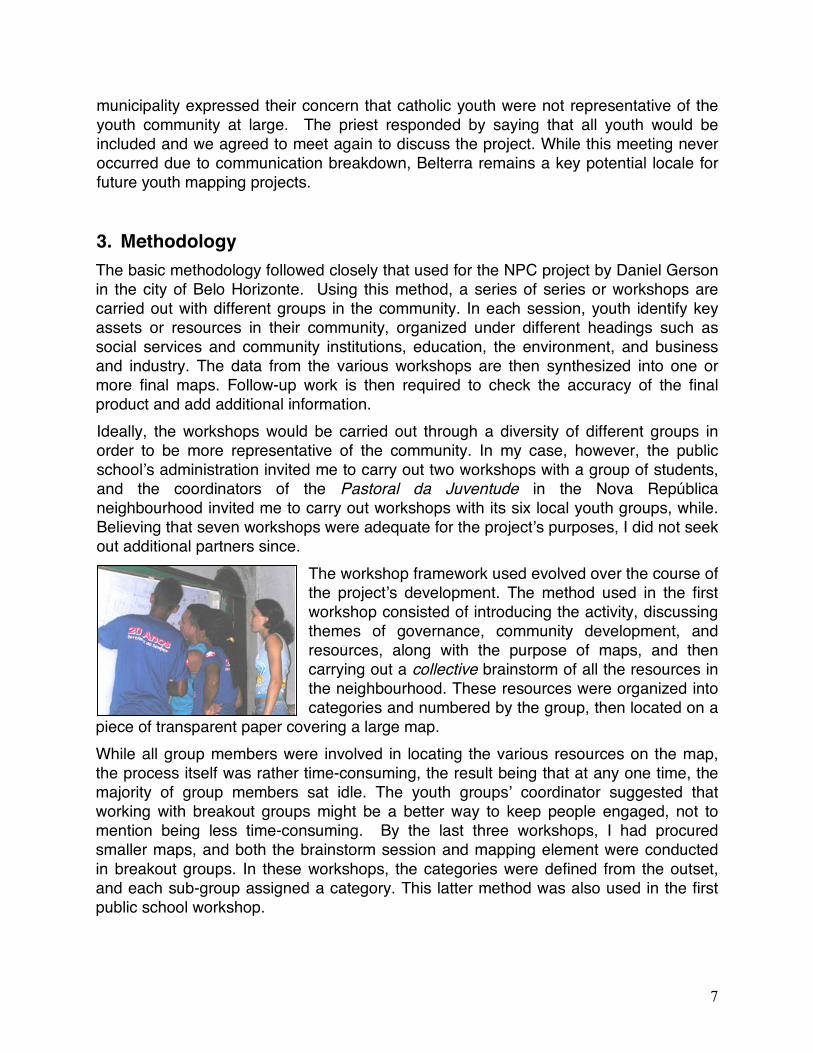
3. Methodology The basic methodology followed closely that used for the NPC project by Daniel Gerson in the city of Belo Horizonte. Using this method, a series of series or workshops are carried out with different groups in the community. In each session, youth identify key assets or resources in their community, organized under different headings such as social services and community institutions, education, the environment, and business and industry. The data from the various workshops are then synthesized into one or more final maps. Follow-up work is then required to check the accuracy of the final product and add additional information. Ideally, the workshops would be carried out through a diversity of different groups in order to be more representative of the community. In my case, however, the public school’s administration invited me to carry out two workshops with a group of students, and the coordinators of the Pastoral da Juventude in the Nova República neighbourhood invited me to carry out workshops with its six local youth groups, while. Believing that seven workshops were adequate for the project’s purposes, I did not seek out additional partners since.
The workshop framework used evolved over the course of the project’s development. The method used in the first workshop consisted of introducing the activity, discussing themes of governance, community development, and resources, along with the purpose of maps, and then carrying out a collective brainstorm of all the resources in the neighbourhood. These resources were organized into categories and numbered by the group, then located on a
piece of transparent paper covering a large map. While all group members were involved in locating the various resources on the map, the process itself was rather time-consuming, the result being that at any one time, the majority of group members sat idle. The youth groups’ coordinator suggested that working with breakout groups might be a better way to keep people engaged, not to mention being less time-consuming. By the last three workshops, I had procured smaller maps, and both the brainstorm session and mapping element were conducted in breakout groups. In these workshops, the categories were defined from the outset, and each sub-group assigned a category. This latter method was also used in the first public school workshop.
8
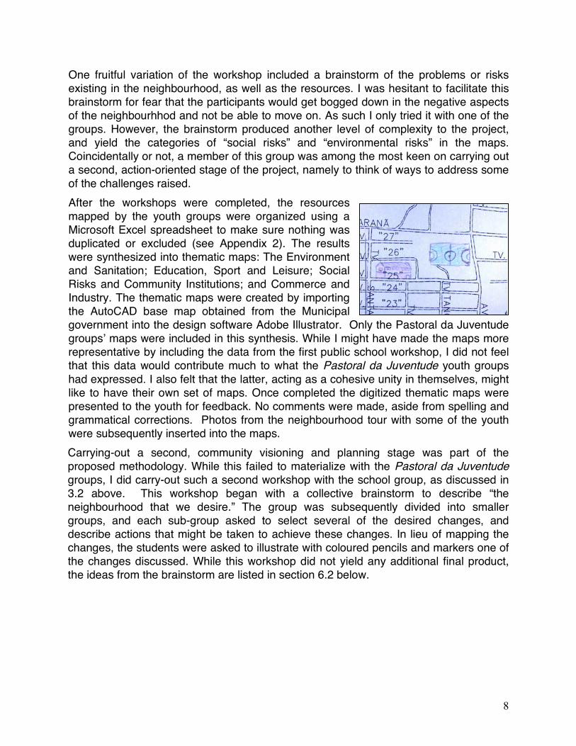
One fruitful variation of the workshop included a brainstorm of the problems or risks existing in the neighbourhood, as well as the resources. I was hesitant to facilitate this brainstorm for fear that the participants would get bogged down in the negative aspects of the neighbourhhod and not be able to move on. As such I only tried it with one of the groups. However, the brainstorm produced another level of complexity to the project, and yield the categories of “social risks” and “environmental risks” in the maps. Coincidentally or not, a member of this group was among the most keen on carrying out a second, action-oriented stage of the project, namely to think of ways to address some of the challenges raised. After the workshops were completed, the resources mapped by the youth groups were organized using a Microsoft Excel spreadsheet to make sure nothing was duplicated or excluded (see Appendix 2). The results were synthesized into thematic maps: The Environment and Sanitation; Education, Sport and Leisure; Social Risks and Community Institutions; and Commerce and Industry. The thematic maps were created by importing the AutoCAD base map obtained from the Municipal government into the design software Adobe Illustrator. Only the Pastoral da Juventude groups’ maps were included in this synthesis. While I might have made the maps more representative by including the data from the first public school workshop, I did not feel that this data would contribute much to what the Pastoral da Juventude youth groups had expressed. I also felt that the latter, acting as a cohesive unity in themselves, might like to have their own set of maps. Once completed the digitized thematic maps were presented to the youth for feedback. No comments were made, aside from spelling and grammatical corrections. Photos from the neighbourhood tour with some of the youth were subsequently inserted into the maps. Carrying-out a second, community visioning and planning stage was part of the proposed methodology. While this failed to materialize with the Pastoral da Juventude groups, I did carry-out such a second workshop with the school group, as discussed in 3.2 above. This workshop began with a collective brainstorm to describe “the neighbourhood that we desire.” The group was subsequently divided into smaller groups, and each sub-group asked to select several of the desired changes, and describe actions that might be taken to achieve these changes. In lieu of mapping the changes, the students were asked to illustrate with coloured pencils and markers one of the changes discussed. While this workshop did not yield any additional final product, the ideas from the brainstorm are listed in section 6.2 below.
9
6. Lessons Learned and Information Acquired 6.1 Mapping Process Lessons Age group and structure. One of the most important learning experiences for me resulted from working with grade seven and eight students. While the students were perfectly capable of carrying out the mapping and community visioning exercises, the workshops themselves were not structured enough to be very effective. Working with school groups is not the same as working with community groups, and different engagement styles are needed. I imagine that the technical aspects of this mapping methodology would be challenging for younger students, and would recommend a different approach. The more conceptual “mental maps” and Agenda 21 community drawings used and advocated by Santarém’s environmental education coordinator might be more appropriate for children. Pedagogical style. Through carrying out these workshops, I encountered a strong inclination to blame all community problems on the failure of the government. When I asked students to explain what they personally could do to improve their neighbourhood, I found more interesting responses. The mapping workshops do not have to be purely information gathering. They can and should be educational. Its okay to be didactic. Smaller groups. Keeping people’s attention while they are not actively engaged can be a challenge. As discussed above, I found that working in breakout groups on smaller maps was a more effective way to keep people’s attention. Different categories will take different amounts of time. Also related to keeping the group members’ attention is trying to plan the workshop so that all subgroups finish at the same time. In the neighbourhood where I was working, the “Industry and Commerce” category repeatedly produced the biggest list of resources, and was therefore the most time-consuming. I would say that sub-groups responsible for mapping such extensive categories, should not be responsible for other ones as well. Diversification of locale and themes. Repeating the same workshop a number of times, I did not find a large discrepancy in the participants’ responses. And the one workshop where I asked people to map social and environmental risks produced a whole other set of data. While repeating the same workshop a number of times has an education value, it may not contribute much to the maps produced. So I would suggest diversifying the categories mapped, or the workshop structure, or diversifying the area mapped (i.e. carry out workshops in other communities). Concrete partnerships and better articulation. I basically carried out this mapping project on my own because I felt that this was the only way to make it happen, and that it had to happen to prove to the local consortium project team that it is a viable methodology. The process was exhausting, however, and at times humiliating. Now that this pilot experience has been developed, future mapping should be carried out in with genuine support from teachers or staff from the municipalities.
10
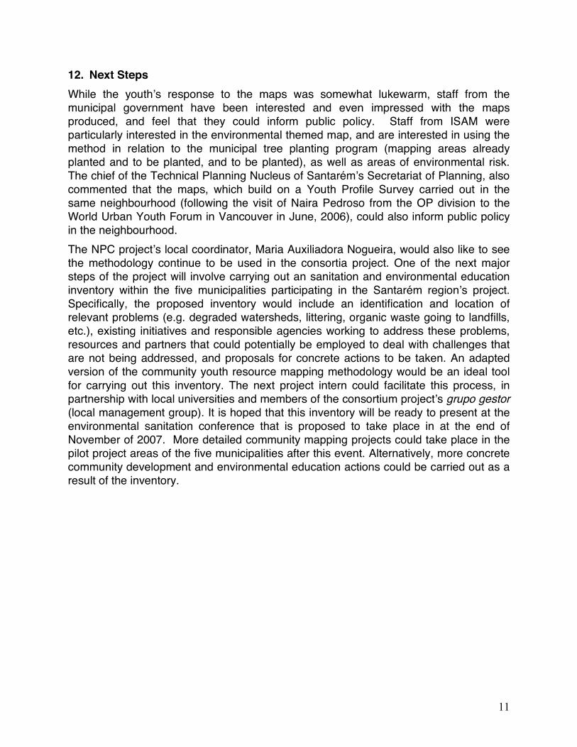
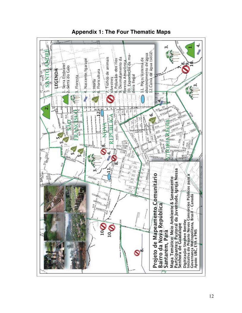
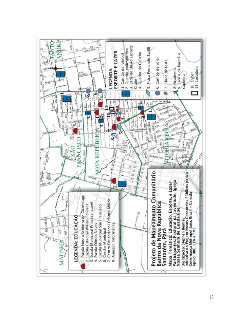
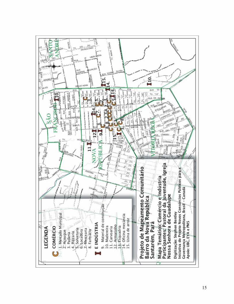
6.2 Information Gleaned about the Neighbourhood Along with Santarém’s neighbourhoods of Santarenzinho, Maracanã, and Mapiri, Nova República is among the most reputed for its social problems. However, several of the youth participating in the project informed me that much of these are not within the borders of Nova República, but rather in other neighbourhoods in the “Greater Nova República” area, such as Vitória Régia and Santo André. A look at the “Social Risks and Community Institutions” map demonstrates this point: gang violence, prostitution, and drug activity are concentrated on the neighbourhood’s frontiers. While Nova República itself (as its name “New Republic” suggests) was created as a model neighbourhood in the 1980s, the surrounding neighbourhoods were initially created through land occupation, and subsequently consolidated into “regular” neighbourhoods. The land invasion process is being repeated on southern frontier of Vitória Régia. While the neighbourhood includes an abundance of businesses, industries, services, and educational facilities as the Comércio e Indústria map demonstrates, the youth complained of the poor quality of the services. It was also pointed out that local services serve not only Nova República proper, but also the surrounding neighbourhoods such as Santo André, Vitória Régia, and São Francisco, and residents from the interior since the Nova República stands on the urban-rural fringe, such that services cannot keep up with demand. (This is one of the key regional “discoveries” made through the mapping process). Many residents feel Nova República has been abandoned by governmental institutions. The giant water supply tank that stands empty in the middle of the square in front of the church – heritage of the “model community” era, stands as the ultimate symbol of governmental neglect.
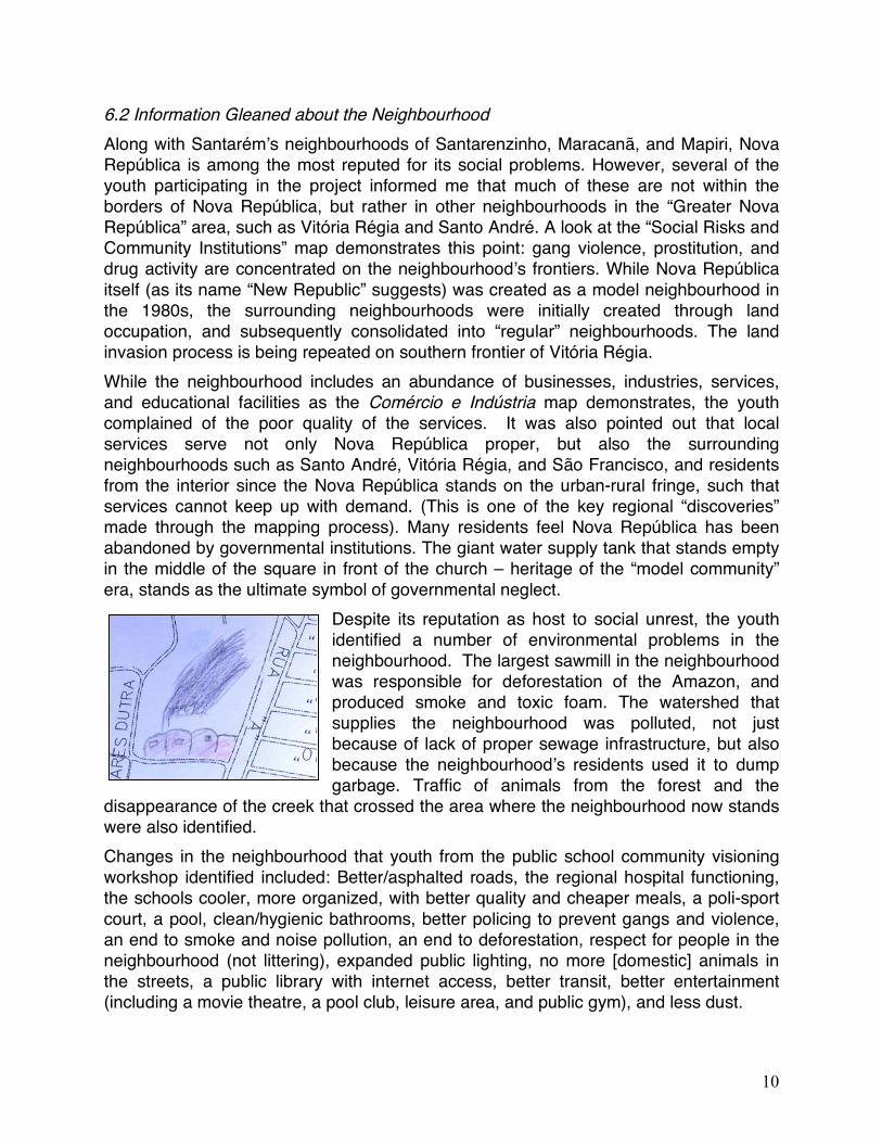
Despite its reputation as host to social unrest, the youth identified a number of environmental problems in the neighbourhood. The largest sawmill in the neighbourhood was responsible for deforestation of the Amazon, and produced smoke and toxic foam. The watershed that supplies the neighbourhood was polluted, not just because of lack of proper sewage infrastructure, but also because the neighbourhood’s residents used it to dump garbage. Traffic of animals from the forest and the
disappearance of the creek that crossed the area where the neighbourhood now stands were also identified. Changes in the neighbourhood that youth from the public school community visioning workshop identified included: Better/asphalted roads, the regional hospital functioning, the schools cooler, more organized, with better quality and cheaper meals, a poli-sport court, a pool, clean/hygienic bathrooms, better policing to prevent gangs and violence, an end to smoke and noise pollution, an end to deforestation, respect for people in the neighbourhood (not littering), expanded public lighting, no more [domestic] animals in the streets, a public library with internet access, better transit, better entertainment (including a movie theatre, a pool club, leisure area, and public gym), and less dust.
11
12. Next Steps While the youth’s response to the maps was somewhat lukewarm, staff from the municipal government have been interested and even impressed with the maps produced, and feel that they could inform public policy. Staff from ISAM were particularly interested in the environmental themed map, and are interested in using the method in relation to the municipal tree planting program (mapping areas already planted and to be planted, and to be planted), as well as areas of environmental risk. The chief of the Technical Planning Nucleus of Santarém’s Secretariat of Planning, also commented that the maps, which build on a Youth Profile Survey carried out in the same neighbourhood (following the visit of Naira Pedroso from the OP division to the World Urban Youth Forum in Vancouver in June, 2006), could also inform public policy in the neighbourhood. The NPC project’s local coordinator, Maria Auxiliadora Nogueira, would also like to see the methodology continue to be used in the consortia project. One of the next major steps of the project will involve carrying out an sanitation and environmental education inventory within the five municipalities participating in the Santarém region’s project. Specifically, the proposed inventory would include an identification and location of relevant problems (e.g. degraded watersheds, littering, organic waste going to landfills, etc.), existing initiatives and responsible agencies working to address these problems, resources and partners that could potentially be employed to deal with challenges that are not being addressed, and proposals for concrete actions to be taken. An adapted version of the community youth resource mapping methodology would be an ideal tool for carrying out this inventory. The next project intern could facilitate this process, in partnership with local universities and members of the consortium project’s grupo gestor (local management group). It is hoped that this inventory will be ready to present at the environmental sanitation conference that is proposed to take place in at the end of November of 2007. More detailed community mapping projects could take place in the pilot project areas of the five municipalities after this event. Alternatively, more concrete community development and environmental education actions could be carried out as a result of the inventory.
12
Appendix 1: The Four Thematic Maps
13
14
15

16
Appendix 3: Mapping Proposal Presented to Potential Partners Proposta de Projeto do Mapeamento Comunitário Participativo Fevereiro – abril de 2007. Projeto Novos Consórcios Públicos para a Governança Metropolitana Stephen C. Bentley Email: [email protected] Trabalho (O CIAM): (93) 2101-3200/ 3523-2810 Cellular (93) 9974-4676 Âmbito do Projeto: Desenvolver um projeto de mapeamento participativo num bairro dos municípios paraenses participando no Projeto Novos Consórcios Públicos para a Governança Metropolitana (Aveiro, Belterra, Juruti, Placas e Santarém). O processo incluirá a participação dos jovens e das crianças, e informará o processo de participação popular a ser utilizado na execução do Projeto dos Consórcios, cujo objetivo é reduzir a pobreza e melhorar a qualidade da vida em regiões urbanas brasileiras. Objetivos Gerais: • Capacitar moradores do bairro a participar em processos de governança urbana e
formação das políticas públicas; • Contribuir ao processo de desenvolvimento econômico e sócio-ambiental da
comunidade; • Subsidiar a formação das políticas públicas que podem ser implementadas pelo
consórcio público que vai ser criado na região; • Desenvolver conhecimentos sobre metodologias de gestão participativa que podem
ser utilizadas por outros consórcios públicos no Brasil. Metas Específicas: • Capacitar os moradores da comunidade (inclusive jovens, crianças, e mulheres) a
reconhecer e valorizar recursos (sociais, ambientais, econômicas, etc.) já existentes na comunidade, e identificar e resolver problemas locais, através atividades de mapeamento participativo;
• Desenvolver um Mapa dos Recursos Comunitários e das Prioridades para o Fortalecimento da Segurança Social, Ambiental e Política;
17
• Documentar o processo e escrever um manual sobre mapeamento participativo no Projeto dos Consórcios Públicos, para que outras pessoas possam replicar o processo em outros lugares.
Plano de Trabalho:
1. Identificar um/uns bairro(s)/comunidade(s) para realizar o projeto (preferivelmente mas não necessariamente uma(s) comunidade(s) prevista a ser local de projeto piloto(s) do Projeto dos Consórcios Públicos) conjunto com umas das Prefeituras participando no Projeto; *
2. Identificar parceiros e interesses locais dentro da comunidade (escolas e professores, associações de bairro, ONGs e entidades sociais e ambientais, grupos de mãe, conselhos da juventude, etc.) e dentro da Prefeitura para participar no projeto;
3. Introduzir a proposta do projeto de mapeamento aos parceiros identificados e elaborar o projeto conjuntos com eles (inclusive identificação dos problemas, prioridades e peculiaridades da área, identificação dos locais das oficinas, divulgação do projeto na comunidade, etc.);
4. Obter materiais necessários para realizar as oficinas (canetas, mapas brancas, papel transparente, papel grande, fita adesiva), e reservar o local da oficina;
5. Facilitar oficinas na comunidade para introduzir o projeto e conceitos chaves (“governança,” “desenvolvimento comunitário,” “recursos”, “meio-ambiente,” “mapeamento,” etc.), discutir as problemas e prioridades na área, explicar o processo de mapeamento participativo, e executar-lo;
6. Verificar e aprofundar dados coletados nas oficinas, e desenvolver uma síntese dos mapas elaborados nas várias oficinas;
7. Facilitar oficina(s) de mapeamento da “visão do futuro do bairro”; 8. Organizar encontro para que os participantes do projeto do mapeamento
puderem apresentar o trabalho deles ás famílias e amigos, e ao grupo gestor do Projeto dos Consórcios Públicos;
9. Realizar um encontro sobre os próximos passos a ser tomados para o desenvolvimento comunitário do bairro, utilizando o mapa elaborado como uma base de informação;
10. Fechar as atividades do campo e escrever o manual técnico, incluindo “lições aprendidas” durante o processo, para que o processo puder ser replicado por outras pessoas, e em outros bairros.
18
Articulação Tanto na seleção do local, como na execução, esse projeto busca articular-se com iniciativas e diretrizes já existentes na região, por exemplo, em Santarém: • Iniciativas de educação ambiental sendo realizadas o desenvolvidas pela Secretaria
Municipal de Educação (SEMED) e o Instituto Sócio-Ambiental (ISAM), órgão da Secretaria Municipal de Planejamento (SEMPLAN), incluindo o programa “Agenda 21 nas Escolas”;
• O Programa “Nossa Gente” da equipe de Orçamento Participativo (OP) da SEMPLAN, que quer incentivar a participação pública (inclusive a juventude) na gestão urbana;
• Levantamentos comunitários realizados durante a elaboração do Plano Diretor Participativo e pesquisa “Perfil da Juventude de Santarém”;
• Atividades sociais, econômicas, ambientais, e culturais realizado pelos grupos comunitários, ONGs, etc. na cidade.
Em Belterra, o projeto de mapeamento pode articular-se com: • Projetos de empoderamento das jovens e mulheres da Secretaria de Trabalho e
Promoção Social; • O Plano Diretor Municipal e o Conselho da Cidadania; e • A Assessoria da Juventude e desenvolvimento do Plano Municipal da Juventude,
ente outros;
19
Esboço de Oficina de Mapeamento 1. Apresentações dos participantes da oficina 2. Introdução geral ao projeto e aos objetivos da oficina (que os participantes
produzem um mapa das prioridades e recursos da comunidade que vai ser uma ferramenta de desenvolvimento comunitário);
3. Discussão sobre os conceitos chaves - “governança,” “desenvolvimento comunitário,” “meio-ambiente,” “recursos” (os temas vão variar dependente na idade dos participantes)
4. Discussão sobre mapas e mapeamento – quais tipos de mapas existem? Qual é a funciona deles?
5. Atividade de chuva das idéias a. Existem problemas e prioridades no bairro? O grupo faz uma lista dos
assuntos importantes (por exemplo: gangues, poluição, desemprego etc.) b. Os quais são os recursos da comunidade? O grupo desenvolve uma lista
dos recursos que existem no bairro (recursos naturais como árvores, iguarapés, rios, praias, áreas vazias; serviços públicos como postos da saúde e escolas; espaços recreativos como campos de futebol e piscinas; espaços culturais como igrejas, boates; instituições de liderança com grupos de jovem de igreja, e associações de bairro, etc.)
6. Atividade de categorização – o grupo desenvolve categorias (instituições de educação e aprendizagem, espaços de esporte e lazer, etc.) e coloca cada prioridade e recurso dentro de uma categoria, e criar um código ou um símbolo para cada um;
7. Mapeamento – o grupo reúne se em frente do mapa da base e mostrar onde fica cada tipo problema e recurso. Cada recurso identificado recebe um número, e os participantes escrevem uma legenda, dizendo o que significam cada número;
8. Discussão – o grupo discute o que é que eles têm mapeado; as idéias da discussão são gravadas, e depois adicionados ao mapa.
9. (Opcional – pode também ser realizado em uma outra oficina) Mapa do Futuro – a parte da base das prioridades e recursos mapeados, o grupo mapear a visão do futuro do bairro.
20
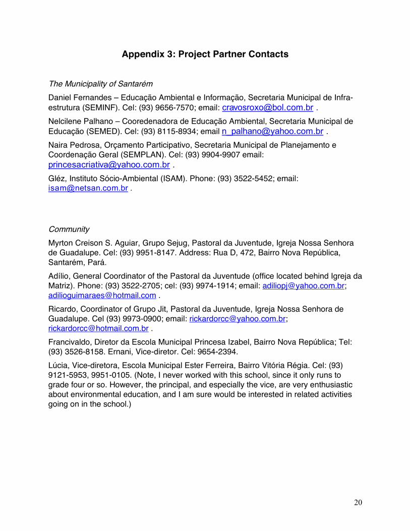
Appendix 3: Project Partner Contacts
The Municipality of Santarém Daniel Fernandes – Educação Ambiental e Informação, Secretaria Municipal de Infra-estrutura (SEMINF). Cel: (93) 9656-7570; email: [email protected] . Nelcilene Palhano – Cooredenadora de Educação Ambiental, Secretaria Municipal de Educação (SEMED). Cel: (93) 8115-8934; email [email protected] . Naira Pedrosa, Orçamento Participativo, Secretaria Municipal de Planejamento e Coordenação Geral (SEMPLAN). Cel: (93) 9904-9907 email: [email protected] . Gléz, Instituto Sócio-Ambiental (ISAM). Phone: (93) 3522-5452; email: [email protected] .
Community Myrton Creison S. Aguiar, Grupo Sejug, Pastoral da Juventude, Igreja Nossa Senhora de Guadalupe. Cel: (93) 9951-8147. Address: Rua D, 472, Bairro Nova República, Santarém, Pará. Adílio, General Coordinator of the Pastoral da Juventude (office located behind Igreja da Matriz). Phone: (93) 3522-2705; cel: (93) 9974-1914; email: [email protected]; [email protected] . Ricardo, Coordinator of Grupo Jit, Pastoral da Juventude, Igreja Nossa Senhora de Guadalupe. Cel (93) 9973-0900; email: [email protected]; [email protected] . Francivaldo, Diretor da Escola Municipal Princesa Izabel, Bairro Nova República; Tel: (93) 3526-8158. Ernani, Vice-diretor. Cel: 9654-2394. Lúcia, Vice-diretora, Escola Municipal Ester Ferreira, Bairro Vitória Régia. Cel: (93) 9121-5953, 9951-0105. (Note, I never worked with this school, since it only runs to grade four or so. However, the principal, and especially the vice, are very enthusiastic about environmental education, and I am sure would be interested in related activities going on in the school.)
21
Appendix 4: Map Systemization Matrix
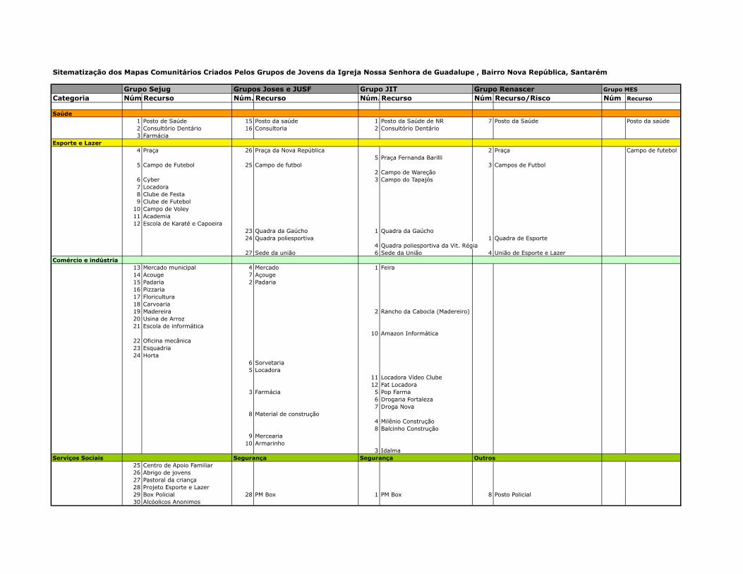
Sitematização dos Mapas Comunitários Criados Pelos Grupos de Jovens da Igreja Nossa Senhora de Guadalupe , Bairro Nova República, Santarém
Grupo Sejug Grupos Joses e JUSF Grupo JIT Grupo Renascer Grupo MES
Categoria Núm.Recurso Núm. Recurso Núm. Recurso Núm Recurso/Risco Núm Recurso
Saúde1 Posto de Saúde 15 Posto da saúde 1 Posto da Saúde de NR 7 Posto da Saúde Posto da saúde2 Consultório Dentário 16 Consultoria 2 Consultório Dentário3 Farmácia
Esporte e Lazer4 Praça 26 Praça da Nova República 2 Praça Campo de futebol
5 Praça Fernanda Barilli5 Campo de Futebol 25 Campo de futbol 3 Campos de Futbol
2 Campo de Wareção6 Cyber 3 Campo do Tapajós7 Locadora8 Clube de Festa9 Clube de Futebol
10 Campo de Voley11 Academia12 Escola de Karaté e Capoeira
23 Quadra da Gaúcho 1 Quadra da Gaúcho24 Quadra poliesportiva 1 Quadra de Esporte
4 Quadra poliesportiva da Vit. Régia27 Sede da união 6 Sede da União 4 União de Esporte e Lazer
Comércio e indústria13 Mercado municipal 4 Mercado 1 Feira14 Acouge 7 Açouge15 Padaria 2 Padaria16 Pizzaria17 Floricultura18 Carvoaria19 Madereira 2 Rancho da Cabocla (Madereiro)20 Usina de Arroz21 Escola de informática
10 Amazon Informática22 Oficina mecânica23 Esquadria24 Horta
6 Sorvetaria5 Locadora
11 Locadora Vídeo Clube12 Fat Locadora
3 Farmácia 5 Pop Farma6 Drogaria Fortaleza7 Droga Nova
8 Material de construção4 Milênio Construção8 Balcinho Construção
9 Mercearia10 Armarinho
3 IdalmaServiços Sociais Segurança Segurança Outros
25 Centro de Apoio Familiar26 Abrigo de jovens27 Pastoral da criança28 Projeto Esporte e Lazer29 Box Policial 28 PM Box 1 PM Box 8 Posto Policial30 Alcóolicos Anonimos
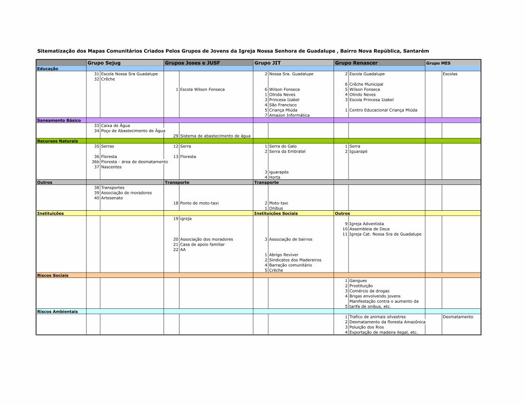
Sitematização dos Mapas Comunitários Criados Pelos Grupos de Jovens da Igreja Nossa Senhora de Guadalupe , Bairro Nova República, Santarém
Grupo Sejug Grupos Joses e JUSF Grupo JIT Grupo Renascer Grupo MESEducação
31 Escola Nossa Sra Guadalupe 2 Nossa Sra. Guadalupe 2 Escola Guadalupe Escolas32 Crêche
6 Crêche Municipal1 Escola Wilson Fonseca 6 Wilson Fonseca 5 Wilson Fonseca
1 Olinda Neves 4 Olindo Neves3 Princesa Izabel 3 Escola Princesa Izabel4 São Francisco5 Criança Miúda 1 Centro Educacional Criança Miúda7 Amazon Informática
Saneamento Básico33 Caixa de Água34 Poço de Abastecimento de Água
29 Sistema de abastecimento de águaRecursos Naturais
35 Serras 12 Serra 1 Serra do Galo 1 Serra2 Serra da Embratel 2 Iguarapé
36 Floresta 13 Floresta36b Floresta - área de desmatamento37 Nascentes
3 iguarapés4 Horta
Outros Transporte Transporte38 Transportes39 Associação de moradores40 Artesenato
18 Ponto de moto-taxi 2 Moto-taxi1 Onibus
Instituições Instituições Sociais Outros19 igreja
9 Igreja Adventista10 Assembleia de Deus11 Igreja Cat. Nossa Sra de Guadalupe
20 Associação dos moradores 3 Associação de bairros21 Casa de apoio familiar22 AA
1 Abrigo Reviver2 Sindicatos dos Madereiros4 Barração comunitário5 Crêche
Riscos Sociais1 Gangues2 Prostituição3 Comércio de drogas4 Brigas envolvendo jovens
5Manifestação contra o aumento da tarifa de onibus, etc.
Riscos Ambientais1 Trafico de animais silvestres Desmatamento2 Desmatamento da floresta Amazônica3 Poluição dos Rios4 Exportação de madeira ilegal, etc.