Embed Size (px)
Citation preview
Community Forests: A path to prosperity and connection
A case-study approach to understanding the range of economic benefits provided by Community Forests in the U.S.
1
Community Forests: A path to prosperity and connection A case-study approach to understanding the range of economic benefits provided by Community Forests in the U.S.
2
The Trust for Public Land creates parks and protects land for people, ensuring healthy, livable communities for generations to come.
The Trust for Public Land M A Y 2 0 2 1
3
Table of Contents About ............................................................................................................................... 5
Acknowledgments ........................................................................................................... 6
Executive summary ......................................................................................................... 7
Map ................................................................................................................................. 9
Introduction ................................................................................................................... 10
Defining community forests ........................................................................................... 12
Study areas ................................................................................................................... 13
Case studies ................................................................................................................. 14
Northeast/Midwest ............................................................................................................................. 15
BARRE TOWN FOREST ................................................................................................................ 15
CATAMOUNT COMMUNITY FOREST ........................................................................................ 17
HIDDEN VALLEY NATURE CENTER .......................................................................................... 19
LINCOLN COMMUNITY FOREST ................................................................................................ 21
POESTENKILL COMMUNITY FOREST ...................................................................................... 23
PORTMAN NATURE PRESERVE / LIME LAKE COMMUNITY FOREST ............................. 25
RANDOLPH TOWN FOREST ........................................................................................................ 27
13 MILE WOODS COMMUNITY FOREST / ERROL TOWN FOREST .................................. 29
South ..................................................................................................................................................... 31
BOSQUE COMUNITARIO DE RÍO HONDO / RIO HONDO COMMUNITY FOREST .......... 31
HALL MOUNTAIN COMMUNITY FOREST ................................................................................. 33
NINE TIMES COMMUNITY FOREST ........................................................................................... 35
URBAN FOOD FOREST AT BROWNS MILL ............................................................................. 37
West ....................................................................................................................................................... 39
AMY B. H. GREENWELL ETHNOBOTANICAL GARDEN ........................................................ 39
FOY’S COMMUNITY FOREST ...................................................................................................... 41
4
MT. ASCENSION NATURAL PARK ............................................................................................. 43
MT. ADAMS COMMUNITY FOREST / PINE FLATS ................................................................. 45
STEMILT-SQUILCHUCK COMMUNITY FOREST ..................................................................... 47
Conclusion .................................................................................................................... 50
Economic benefits in the context of the COVID-19 pandemic ....................................... 51
Appendix ....................................................................................................................... 52
Endnotes ....................................................................................................................... 55

5
About The Trust for Public Land creates parks and protects land for people, ensuring healthy, livable communities for generations to come.
The Trust for Public Land’s Conservation Economics team has extensive experience measuring the economic benefits and fiscal impacts of land conservation. Partnering with its award-winning GIS team, it has published over 50 economic analyses across the country, including reports in Alabama, Arizona, California, Colorado, Florida, Georgia, Illinois, Kansas, Kentucky, Maine, Massachusetts, Michigan, Minnesota, Missouri, New Hampshire, New Jersey, New York, North Carolina, Ohio, Pennsylvania, South Carolina, Tennessee, Texas, Vermont, Virginia, Washington, and Wyoming. The Trust for Public Land has advanced this research working with leading academic partners and research institutions, including Colorado State University, Dartmouth College, Georgia Institute of Technology, Michigan State University, University of California-Davis, University of Georgia, Texas A&M, University of Minnesota, University of New Hampshire, University of Vermont, University of Wyoming, and the U.S. Forest Service.
tpl.org/community-forest-economic-case-studies
6
Acknowledgments This project was completed by The Trust for Public Land in partnership with the U.S. Forest Service and would not have been possible without generous support from the U.S. Endowment for Forestry and Communities and the U.S. Forest Service. The Trust for Public Land gratefully acknowledges the contributions from the Technical Advisory Committee (TAC), the members of which contributed their time, energy, and ideas toward the creation of this report. The TAC guided the report and provided input throughout the various phases of the report’s production, including data collection and review.
Members of the TAC included:
• Ben Rothfuss Dair, Senior Manager of Conservation Finance, Sustainable Northwest• Margaret Haines, Natural Resource Specialist, U.S. Forest Service• Claire Harper, Regional Forest Legacy Program and Community Forest Program Manager, U.S. Forest
Service• Nausheen Iqbal, Cooperative Foresty Program Specialist, U.S. Forest Service• Ian MacFarlane, Executive Director, Northeast-Midwest State Foresters Alliance• Jennifer Melville, VP Conservation Grants, Open Space Institute• Mikki Sager, Vice President, Resourceful Communities, The Conservation Fund• Shelby Semmes, Northern New England Area Director, The Trust for Public Land• Peter Stangel, COO, U.S. Endowment for Forestry and Communities• Peter Stein, Managing Director, The Lyme Timber Company; Cofounder, Land Trust Alliance; Cofounder,
Conservation Finance Network; Cofounder, International Land Conservation Network• Scott Stewart, National Forest Legacy Program and Community Forest Program Manager, U.S. Forest
Service
U.S. Department of Agriculture is an equal opportunity provider, employer, and lender.
7
Executive summary
Community forests are protected forestlands that contribute to healthy, flourishing communities. Importantly, they offer residents and community members a direct say in how these lands are stewarded over time. These assets are being nurtured across the country as they are increasingly recognized as land-based economic development tools that deliver positive outcomes to the residents, visitors, and businesses located in their service areas. The U.S. Forest Service’s Community Forest and Open Space Conservation Program (CFP) helps communities create these assets and provide benefits as envisioned by the local community. Community forests can enhance quality of life, enrich cultural and spiritual heritage, strengthen economies, and provide tangible economic value. This value occurs because these resources are designed to provide access to amenities for recreation, education, and tourism; offer forest-based products (e.g., timber, maple syrup, and firewood); produce forest-based services (e.g., carbon sequestration, habitat, fire risk mitigation, and water quality); and foster economic development opportunities by bolstering the recreation economy and enhancing property value.
This report identifies and expands upon the values provided by community forests. The following summary represents an overview of the types of values provided and gives a few examples demonstrating the range in benefits.1 The icons, while not exhaustive of all the benefits each forest provides, can serve as a guide to fully exploring the benefits throughout the report.
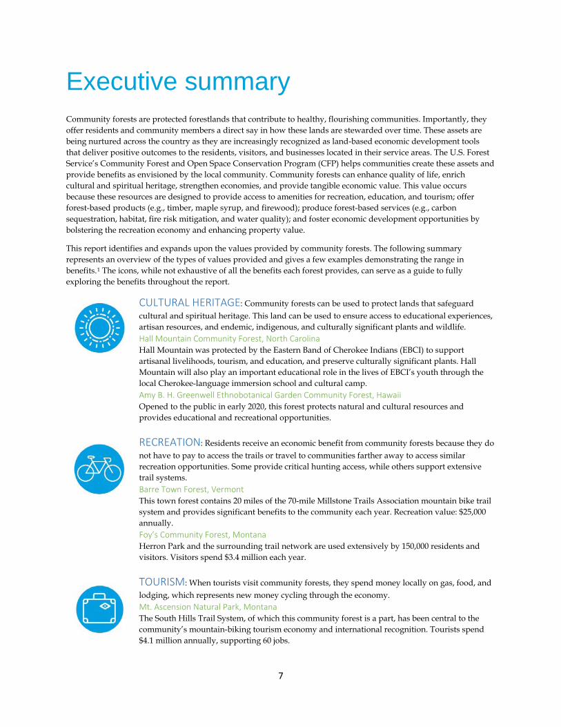
CULTURAL HERITAGE: Community forests can be used to protect lands that safeguard cultural and spiritual heritage. This land can be used to ensure access to educational experiences, artisan resources, and endemic, indigenous, and culturally significant plants and wildlife. Hall Mountain Community Forest, North Carolina Hall Mountain was protected by the Eastern Band of Cherokee Indians (EBCI) to support artisanal livelihoods, tourism, and education, and preserve culturally significant plants. Hall Mountain will also play an important educational role in the lives of EBCI’s youth through the local Cherokee-language immersion school and cultural camp. Amy B. H. Greenwell Ethnobotanical Garden Community Forest, Hawaii Opened to the public in early 2020, this forest protects natural and cultural resources and provides educational and recreational opportunities.
RECREATION: Residents receive an economic benefit from community forests because they do not have to pay to access the trails or travel to communities farther away to access similar recreation opportunities. Some provide critical hunting access, while others support extensive trail systems. Barre Town Forest, Vermont This town forest contains 20 miles of the 70-mile Millstone Trails Association mountain bike trail system and provides significant benefits to the community each year. Recreation value: $25,000 annually. Foy’s Community Forest, Montana Herron Park and the surrounding trail network are used extensively by 150,000 residents and visitors. Visitors spend $3.4 million each year.
TOURISM: When tourists visit community forests, they spend money locally on gas, food, and lodging, which represents new money cycling through the economy. Mt. Ascension Natural Park, Montana The South Hills Trail System, of which this community forest is a part, has been central to the community’s mountain-biking tourism economy and international recognition. Tourists spend $4.1 million annually, supporting 60 jobs.
8
Nine Times Community Forest, South Carolina This community forest is a regional resource that provides recreational access to rock climbing, hiking, mountain biking, and hunting. It supports $70,000 in visitor spending each year.
EDUCATION: Community forests frequently serve as educational resources for the local community, providing opportunities for students to engage in research, participate in nature-based programming and summer camps, and learn in outdoor environments during the pandemic. Catamount Community Forest, Vermont This community forest provides opportunities for students in K–12 education programs as well as the general public and the University of Vermont. For example, during the COVID-19 pandemic, the forest offered half-day nature camps and outdoor after-school programs to complement remote learning or supplement homeschooling. Hidden Valley Nature Center, Maine The Hidden Valley Nature Center is a sustainably managed working forest and community hub that provides public access for recreation and over 40 nature-based programs that reach hundreds of children and adults in the 10-county region.
FOREST-BASED SERVICES : Community forests provide essential natural services to their local communities by helping ensure water quality, sequestering and storing carbon, lowering wildfire risk, and providing critical habitat for important species. Mt. Adams Community Forest / Pine Flats, Washington In addition to generating substantial timber-based forest products, this community forest sequesters $17,000 of carbon annually and stores $1.2 million in carbon. Wildfires pose significant risks to residential homes and agricultural operations in the region, and the forest management practices on the forest lower the risk to homes by $10 million. Stemilt-Squilchuck Community Forest, Washington The community forest helps protect water quality in the region. There are 10 irrigation reservoirs on and around this forest, which provide water to four irrigation districts that service 5,400 acres of farmland. The orchards in the watershed produce 34 million pounds of cherries each year, resulting in $76 million of economic impact. This safeguards over 1,000 seasonal jobs in the orchards.
FOREST-BASED PRODUCTS: Community forests can produce timber-based revenues for the community, many provide less traditional forest-based products, such as maple syrup, firewood, and food grown on trees. 13 Mile Woods Community Forest / Errol Town Forest, New Hampshire This community forest safeguards the forest-based economy, producing $1.7 million in timber revenue in the first seven years and supporting $2 million in earnings in the logging sector. Each year, the forest supports two local jobs in forestry and logging and indirectly supports 10 additional jobs in other sectors. Urban Food Forest at Browns Mill, Georgia This urban community forest is a key component of the City of Atlanta’s plan to connect more neighborhoods with healthy food. The vision for this space includes plants and trees that produce fresh nuts, fruits, vegetables, and herbs for local residents. Randolph Town Forest, New Hampshire In addition to timber, this community forest is used by a local maple syrup producer who leases 35,000 maple taps on 750 acres of the forest, employing five people. The maple project is expected to bring in 50 percent more revenue over 15 years than it would if the same section of the forest were managed for timber.
9
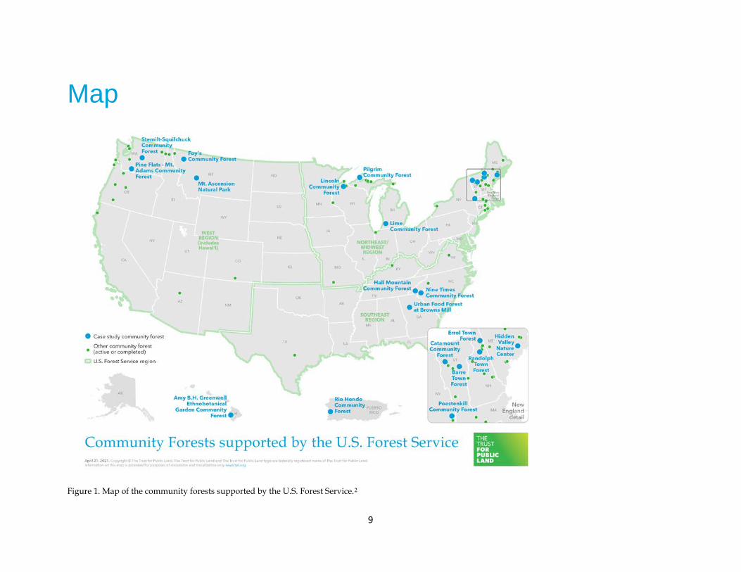
Map
Figure 1. Map of the community forests supported by the U.S. Forest Service.2
10
Introduction
Community forests are protected forestlands that contribute to healthy, flourishing communities. These assets are being nurtured across the country as they are increasingly recognized as land-based economic development tools that deliver positive outcomes to the residents, visitors, and businesses located in their service areas. Forestlands have long been recognized for their environmental benefits and ability to provide recreational opportunities for residents and tourists; however, the community forest model offers an alternative mechanism by which communities can come to own and manage forestland, with an ownership and management structure that is designed to meet the specific needs of the local population. These community amenities build cohesion across the community, protect assets that appreciate in value over time, and generate financial or economic returns that remain in the local community and can be invested in local priorities. This report seeks to help interested stakeholders understand the tangible economic values that community forests provide and the role they play in strengthening economies and enhancing quality of life. Using a case-study approach, The Trust for Public Land studied several exisiting community forests across the country and documented the diverse set of benefits they offer.
Community-based forest conservation has long been a priority of the U.S. Forest Service (USFS). The U.S. Forest Service’s Community Forest and Open Space Conservation Program (CFP) was created by Congress to slow the rapid development of private forestlands across the nation, increase public access for recreational opportunities, and help combat rising obesity rates linked to decreased outdoor recreation. CFP was authorized by the 2008 Farm Bill and established in 2011 to provide financial resources for communities to establish community forests by protecting forestlands that provide public access to recreational opportunities, protect vital water supplies and wildlife habitat, serve as demonstration sites for private forest landowners, and provide economic benefits from timber and non-timber products.
Funding through CFP is available to local governments, federally designated Indian tribes, and qualified nonprofit organizations to protect lands in their communities. As of March 2021, the program has funded 62 completed projects across the country since awarding its first round of projects in 2012. In total, $19.5 million in CFP funding has leveraged $38.2 million in funding from other sources to create over 24,000 acres of community forests.3 Funding from the USFS’s Forest Legacy Program (FLP) was also used to protect community forests across the country on a limited basis prior to the creation of CFP, and it may still be available for particularly large or expensive community forests. This funding and the leverage it attracts allows CFP applicants to invest in their community forests at a fraction of the cost that would otherwise be required to protect these significant community assets.
Most of the existing literature about community forests focuses on their definition as well as the details of creating and managing them successfully, often providing critical resources and supplementary materials to aid practictioners.4 There is less research that documents and quantifies the economic benefits of community forests, and what does exist is specific to a forest, place, and context. The purpose of this report is to demonstrate the breadth of the community forest program and to highlight the range of community types the program can support, the assortment of needs it can address, and the variety of economic and finanical benefits that can be provided.
A case study approach was developed with the USFS in order to facilitate this outcome. The community forests were selected to showcase the diversity in community forests that have been funded by the USFS. Forests were selected based on a set of criteria to represent various geographies across the country, a collection of ownership and management types, and a range of years since the forest’s establishment. Rather than offering insights about community forest trends as would be possible using a representative sample of forests, this analysis provides readers with a comprehensive understanding of the extent of benefits that can flow from community forests creation based on an investigation of 17 community forests that were created between 2001 and 2018.
The following case studies present summarizing information to orient the reader about the basic details of each community forest, including the year the forest was established; its size, ownership, and management; and the tapestry of funding that made its acquisition possible, with information from the USFS as provided in the applications. In addition, the case studies include the community served by each community forest so as to provide

11
context for the types of places creating community forests. Unless otherwise noted, this report includes 2019 population estimates from the U.S. Census Bureau for the communities most directly served by the forest as defined by the application for CFP funding.
The summarizing section of each case study also shows infographic icons that indicate the economic benefits of interest, although these icons are not exhaustive of all the benefits provided by each forest. Some of these forests are highlighted for their role in generating forest products such as timber, maple syrup, and basket-making materials. Other forests are featured for their recreational opportunities; development into destinations for mountain biking, hiking, and climbing; and support for economic development. The report also draws attention to other forests that are used extensively for educational purposes for both schoolchildren and private forestland owners or those that provide exceptional examples of leverage. Other forests are underscored for their provision of essential habitat for game and threatened or endangered species, their protection of water quality, and their carbon sequestration and storage benefits. Although these environmental benefits are frequently described in the project’s application for CFP funding, they are not often quantified. This report includes these benefits to the extent that data was available to quantify them.
12
Defining community forests
There are many formal and informal “communities of practice” within community forestry, in many cases anchored within deep and long-standing traditions of communal land stewardship among a wide range of indigenous communities both across the United States and abroad. Within the US, a few specific forums have recently emerged to champion the community forest conservation “model.” These include but are not limited to the Northwest Community Forest Coalition and the New England Community Forest Network, the latter an outgrowth of the Community Forest Collaborative, which in 20115 put forward a practitoner-oriented definition of community forests. Across various states and tribal nations, legal statutes and designations of municipal, county, tribal, and/or town forests can also influence the structure, goals, and management of community forests that have in many cases benefited from support of CFP.
For the purposes of this report, The Trust for Public Land integrated key attributes of these definitions, along with guidelines under CFP,6 to arrive at the following characteristics of a community forest:
Community forests are lands that are largely forested and, rather than being united in any specific uses of the forestland, are instead defined by the following characteristics:
• Monetary and nonmonetary benefits from the land flow directly to the community and reflect community priorities and values.
• The land’s public values are permanently protected in perpetuity. • The land is owned and managed by a local government, tribal government, or community-based
organization, on behalf of a community. • There is community participation in, responsibility for, and accountability in management and use of the
land.
13
Study areas
The Trust for Public Land worked with the USFS and the project’s Technical Advisory Committee to determine the community forests that were studied in this report. The case studies were selected to highlight the depth and diversity of how community forests benefit communities across the nation.
The selection process was guided by a series of criteria. First, The Trust for Public Land identified community forests that:
• Received funding through CFP or FLP, • Met the definition of a community forest (explained on page 12), • Were complete and had started providing benefits to the community, and • Had high-quality data readily available.
In addition, The Trust for Public Land sought a group of community forests, which when considered together:
• Provided a diversity of economic benefits, • Were located in various geographies, • Ranged in size, and • Represented different ownership types (e.g., tribal or local government or qualified nonprofit organization).
14
Case studies
The Trust for Public Land selected several projects to highlight as case studies that demonstrate how community forests benefit local communities economically. The Trust for Public Land gathered a list of potential case study candidates based on research and recommendations from local, state, and national community forest practitioners and advocates. Case studies were selected using a set of criteria including the project’s funding through CFP or FLP and the project’s definition of a community forest as determined for this project (see definition on page 12). In addition, The Trust for Public Land sought to highlight a group of case studies that showcased geographic diversity and a range of economic benefits provided, as well as community forests of varying longevity, size, and ownership types. Detailed case study candidates also needed to be completed acquisitions, rather than planned or envisioned. The quantification of economic benefits also depended on the availability of high-quality economic information. Detailed information did not exist for a small number of high-priority forests. In those cases, The Trust for Public Land developed exploratory case studies that describe the economic benefits using a more qualitative approach.
The following pages describe the several community forest projects and the economic benefits they provide to their communities.
15
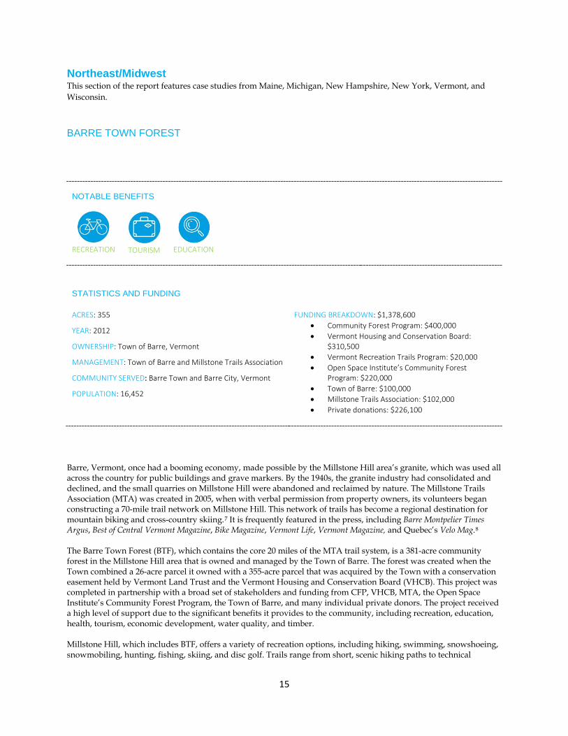
Northeast/Midwest This section of the report features case studies from Maine, Michigan, New Hampshire, New York, Vermont, and Wisconsin.
BARRE TOWN FOREST
NOTABLE BENEFITS
RECREATION
TOURISM
EDUCATION
STATISTICS AND FUNDING
ACRES: 355
YEAR: 2012
OWNERSHIP: Town of Barre, Vermont
MANAGEMENT: Town of Barre and Millstone Trails Association
COMMUNITY SERVED: Barre Town and Barre City, Vermont
POPULATION: 16,452
FUNDING BREAKDOWN: $1,378,600 • Community Forest Program: $400,000 • Vermont Housing and Conservation Board:
$310,500 • Vermont Recreation Trails Program: $20,000 • Open Space Institute’s Community Forest
Program: $220,000 • Town of Barre: $100,000 • Millstone Trails Association: $102,000 • Private donations: $226,100
Barre, Vermont, once had a booming economy, made possible by the Millstone Hill area’s granite, which was used all across the country for public buildings and grave markers. By the 1940s, the granite industry had consolidated and declined, and the small quarries on Millstone Hill were abandoned and reclaimed by nature. The Millstone Trails Association (MTA) was created in 2005, when with verbal permission from property owners, its volunteers began constructing a 70-mile trail network on Millstone Hill. This network of trails has become a regional destination for mountain biking and cross-country skiing.7 It is frequently featured in the press, including Barre Montpelier Times Argus, Best of Central Vermont Magazine, Bike Magazine, Vermont Life, Vermont Magazine, and Quebec’s Velo Mag.8 The Barre Town Forest (BTF), which contains the core 20 miles of the MTA trail system, is a 381-acre community forest in the Millstone Hill area that is owned and managed by the Town of Barre. The forest was created when the Town combined a 26-acre parcel it owned with a 355-acre parcel that was acquired by the Town with a conservation easement held by Vermont Land Trust and the Vermont Housing and Conservation Board (VHCB). This project was completed in partnership with a broad set of stakeholders and funding from CFP, VHCB, MTA, the Open Space Institute’s Community Forest Program, the Town of Barre, and many individual private donors. The project received a high level of support due to the significant benefits it provides to the community, including recreation, education, health, tourism, economic development, water quality, and timber. Millstone Hill, which includes BTF, offers a variety of recreation options, including hiking, swimming, snowshoeing, snowmobiling, hunting, fishing, skiing, and disc golf. Trails range from short, scenic hiking paths to technical

16
mountain-biking routes. During the winter, 20 miles of trails are open for snowshoeing and groomed cross-country skiing. A few are designated snowmobile trails on the property that are managed by a local snowmobile club affiliated with the statewide Vermont Association of Snow Travelers, which provides access to the property for people who have disabilities, are elderly, or have other physical challenges to accessing the property. BTF enhances educational and health opportunities throughout the community as well. MTA works closely with local schools to involve children in various activities, including mountain bike races, festivals, trail walks, clinics, and trail-building days. Websterville Baptist School currently uses the property for biology classes and trail walks. Spaulding High School’s cross-country team practices and holds meets on the property. The Boy Scouts also use the property for hiking, mountain biking, and other outdoor excursions. The forest is also used by local office workers who visit the trails for bike rides, trail runs, and walks. The forest and its 18-hole disc golf course are well used by residents, tournament participants, and clients of Washington County Mental Health Services. According to MTA, BTF parking lots may see 100 to 150 cars on a weekend day, many from Vermont, Massachusetts, New Hampshire, New York, and Quebec.9 If during the 12 weeks of summer 200 cars visit the community forest per weekend, and approximately two people arrive per car,10 The Trust for Public Land estimates that at least 5,000 people visit the community forest.11 The Trust for Public Land estimated the number of local and nonlocal visitors by assuming that the distribution of visitors is similar to visitation at other community forests in Vermont.12 The recreational use provides economic value for residents who do not have to pay to access private amentities or travel further distances to access other public amenities. The value of recreation by residents to BTF is approximately $8 per visit.13 Approximately $25,000 in economic value is provided in the form of cost savings to residents who do not have to pay to access the trails or travel to farther communities to access similar recreation opportunities. This result is based on the types of recreation that have been valued in previous work in Vermont that are also available in BTF. For example, estimates of hunting and camping were not considered, but estimates of hiking and wildlife watching were. The COVID-19 pandemic has led to an increase in use. In fact, MTA reports a 26 percent increase in pass and membership revenue compared to last year.14 Although this higher level of use could continue after the pandemic, it is not included in this baseline calculation of recreational value. This out-of-town recreational use attracts new money to the local economy as nonlocal visitors spend money on items like gas, food in restaurants, and lodging. A previous study estimated the potential for future use of BTF.15 The Trust for Public Land used a conservative approach to determine that 1,900 nonlocal residents use BTF each summer. Since the average visitor to similar community forests in Vermont spends $70 per visit, this results in $130,000 in direct spending each year.16 In addition to providing this recreation and tourism value, the forest supports the local economy by generating opportunities for new businesses and helping retain existing residents and employees. Prior to becoming a community forest, Darren Winham, the former director of Barre Area Development, Inc., said, “The town forest will have an immense positive impact on the economy of the region. Retail and restaurants will spring up. Other employers see the bike trails as a recruiting tool for attracting new employees.”17 Barre Area Development, Inc., continues to see BTF and the trails as a recreational asset to the Barre area and continues to promote it heavily.18 The forestland within BTF is sustainably managed to produce forest products that will provide income for the Town of Barre over time. The forest also safeguards drinking water for over 1,600 people, and significant portions of both the Websterville Water District Source Water Protection Area and the Town of Barre Source Water Protection Area are within the forest.19 The Barre Town Forest provides numerous benefits to the local community, including recreation, education, health, tourism, economic development, water quality, and timber. These varied benefits demonstrate the importance of programs like CFP to creating economic opportunity, bolstering quality of life, and sustaining local economies.
17
CATAMOUNT COMMUNITY FOREST
NOTABLE BENEFITS
RECREATION
TOURISM
EDUCATION
STATISTICS AND FUNDING
ACRES: 383
YEAR ESTABLISHED: 2019
OWNERSHIP: Town of Williston, Vermont
MANAGEMENT: Catamount Outdoor Family Center
COMMUNITY SERVED: Town of Williston, Vermont
POPULATION: 9,870
FUNDING BREAKDOWN: $2,011,000 • Community Forest Program: $400,000 • Town of Williston: $400,000 • Vermont Housing and Conservation Board:
$327,500 • Land and Water Conservation Fund, Stateside:
$280,000 • Private donations: $534,500 • Donation of 17 adjacent forested acres: $69,000
The Catamount Community Forest (CCF) is located on 383 acres of forest and meadows in Williston, Vermont. The property, now owned by the Town, is located less than 10 miles from Burlington, the state’s largest city. Prior to its protection, CCF was one of the last remaining large tracts of undeveloped land left in a rapidly developing town within the most developed county in Vermont. The creation of this community forest adds to existing protected lands and results in a 660-acre corridor of public and private conservation land—the largest core forest block in the town of Williston. In addition to the $400,000 provided by CFP, this acquisition was made possible by the Vermont Housing and Conservation Board, the Town of Williston, The Land and Water Conservation Fund, the donation of 17 acres of adjacent land, and a long list of foundations and private donors. In addition to the ecological values protected by this forest, CCF generates numerous benefits for the local economy, from providing essential recreation, health, and education benefits for residents to attracting tourists who support local businesses, to protecting ecologically rich habitat and working forestlands.
Prior to becoming a community forest, CCF was owned by the McCullough family and operated by the nonprofit Catamount Outdoor Family Center (COFC), which still manages the recreation in the community forest. The property boasts a network of over 20 miles of trails, which have been open to the public for 40 years but were threatened with loss of public access when the McCulloughs needed to sell. Trails are used year-round for mountain biking, hiking, trail running, snowshoeing, cross-county skiing, and sledding, attracting beginners and Olympic athletes alike. The public can hike, run, walk, and snowshoe on the property at no charge. Mountain biking and cross-country skiing require the purchase of a day-pass or seasonal membership. CCF also hosts weekly running and mountain bike races and mountain bike camps in the summer. Summer camp programming typically serves 400 campers.20
COFC has expanded the use of the trails through community partnerships that foster outdoor experiences for residents. The trail network includes four miles of trail that are open to wheelchairs in the summer and sit skiing in the winter. These trails are frequently utilized by the Northeast Disabled Athletic Association, which has been

18
running Nordic sit-skiing clinics and offering equipment rentals at Catamount for nearly two decades. The association is now launching a program for off-road hand-cycling, providing the only place in Chittenden County where disabled athletes can really get into the woods.21 COFC also partners with Green Mountain Audubon and Little Bellas, a nonprofit that builds confidence and athleticism in elementary school girls through mountain-biking camps. Little Bellas started at COFC and now runs programming in 17 states across the country.
COFC attracts 20,000 visits annually, and 14,400 visitors (or 63 percent) come from Williston and Chittenden County. The number of local visitors is growing as a result of increased awareness of COFC’s offerings and free access to hiking, running, walking, and snowshoeing. This recreational use provides economic value for residents who do not have to pay to access private amenities or travel further distances to access other public amenities. The Trust for Public Land determined the value of recreation activities using estimates of outdoor recreation value.22 Applying the values of each outdoor recreation visit to the number of each type of recreational visit, The Trust for Public Land estimated that the value of trail use is $210,000 for residents of Chittenden County, including $30,000 per year for the residents of Williston.
In addition to local users, CCF draws 7,400 visitors (or 37 percent) from outside Chittenden County.23 These visitors support the local economy by spending money locally on items like gas, groceries, food in restaurants, and lodging. This visitor spending cycles through the economy as vendors purchase supplies and employees spend their paychecks. Before CCF became a community forest, a study found that the average visitor to COFC spends $70 per visit, which results in $518,000 in direct spending each year, or $875,000 in total sales, which generates $70,600 in sales and income tax for the state and supports 14 jobs in Chittenden County.24 By becoming a community forest, CCF has preserved these values into the future; in fact, by becoming a community forest, CCF may see public use increase over time.
CCF is also used for educational purposes, providing opportunities for students in K–12 education programs and the general public and the University of Vermont. For example, Williston Central School and Fairfax School use CCF as an outdoor classroom. During the COVID-19 pandemic, COFC offered half-day nature camps and outdoor after-school programs to complement remote learning or supplement homeschooling. Green Mountain Audubon, which has named COFC an Important Bird Education Site, surveys the bird population and hosts monthly public birding walks on the property. The University of Vermont’s research scientists also use CCF to access the adjacent Talcott Forest owned by the university but to which no access exists except through the community forest. In 2020, in partnership with the University of Vermont, CCF became involved in a long-term research project called “Adaptation and Restoration of Northern Forests.” Through this project, Catamount will be one of several demonstration sites across northern New England and New York that will show how forests can be managed responsibly and adaptively in a changing climate.
In addition to use-related value, most of the CCF property is mature forest, and sustainable forest management is expected to provide the community with revenue as timber production is pursued where it is compatible with the recreation and ecological values of the forest. The CCF property’s forestlands also filter rain and snow precipitation, helping to ensure the quality of water flowing in the Winooski River and Lake Champlain, the drinking water source for 145,000 residents of Vermont, New York, and Quebec.25 The forest also contains 84 acres of deer-wintering habitat, a vernal pool, and 7.8 acres of wetlands.
This community forest provides a great example of how CFP enables communities to think broadly about how forest protection can safeguard local economies, providing benefits beyond the traditional forest products industry. By investing in CCF, the USFS helps protect a key recreational and educational opportunity for residents and bolsters the local tourism economy.
19
HIDDEN VALLEY NATURE CENTER
NOTABLE BENEFITS
RECREATION
EDUCATION
FOREST-BASED
PRODUCTS
STATISTICS AND FUNDING
ACRES: 943
YEAR: 2017
OWNERSHIP: Midcoast Conservancy
MANAGEMENT: Midcoast Conservancy
COMMUNITY SERVED: Lincoln County, Maine
POPULATION: 34,634
FUNDING BREAKDOWN: $1,257,000 • Community Forest Program: $400,000 • Sewall Foundation: $200,000 • Jane’s Trust: $100,000 • Private donations: $557,000
Located in Jefferson, Maine, the Hidden Valley Nature Center (HVNC) is a sustainably managed working forest and community hub that provides public access for recreation and educational programming. The property spans 1,000 acres and features two ponds, a brook, and over 30 vernal pools. In addition to its natural assets, the center has constructed infrastructure to support recreation and educational outcomes, including a large timber frame building with a 30ʹ by 60ʹ work area and a wood-heated solar-powered indoor classroom. Visitors can explore 25 miles of trails for hiking, snowshoeing, cross-country skiing, trail running, mountain biking, canoeing, and fishing. The property also offers year-round overnight accommodation at two small tent sites, four huts, and a yurt. HVNC supports the forest economy and has grown to be a tremendous local resource, both as a destination for nonmotorized recreation and as a center for nature study and learning. HVNC employs seven part-time employees that support the center’s forest- and education-related activities.
The property was previously owned by David Moskovitz and Barbara Jones, who opened the property to the public in 2009. In 2016, HVNC merged with three other conservation organizations in the region to become Midcoast Conservancy, which leased the property from Moskovitz and Jones before it became a community forest in 2017. The land’s protection was facilitated by a $400,000 CFP grant, as well as $557,000 in contributions from private foundations and individual donors.
Overall, HVNC draws 7,000 visitors each year who use the property to explore the trails and ponds or participate in events. HVNC provides over 40 nature-based programs annually focused on timber frame construction, chainsaw safety, forest ecology, and trail building. The center also hosts “Women and Our Woods” workshops and science programming for the area’s fourth-grade students. Each year, these programs reach over 300 adults and 300 children in the 10-county region. HVNC also hosts a biathlon with 200 participants, the Live Edge Music Festival with 500

20
attendees, a half-marathon trail race that draws 150 people, and a mountain bike series that attracts 50 participants each year.
This recreational use provides economic value for residents who do not have to pay to access private amenities or travel further distances to access other public amenities. The Trust for Public Land determined the value of recreation activities using estimates of outdoor recreation value.26 Applying the values of each outdoor recreation visit to the number of each type of recreational visit, The Trust for Public Land estimated that the value of trail use is $72,000 per year for residents of Lincoln County, including $10,000 for Jefferson residents. In addition to providing this value to residents, HVNC works with local businesses, including the general store and local breweries, to supply provisions for events. Approximately 2,590 of the center’s 7,000 visitors are nonlocal.27 The Trust for Public Land estimates that those visitors spend approximately $270,000 locally each year.28
In addition to these recreation and tourism benefits, HVNC supports the local forest-based economy. For example, the center contracts with five forest professionals, including a forester, a logger, a sawyer, and a firewood processor as well as a local timber framer who teaches three timber frame courses each year. On an annual basis, approximately $25,000 in forest products is sold to support HVNC.
The CFP investment in Jefferson is strengthening the region’s local economy by providing high-quality recreation, education, and sustainable forest management. The program has enabled the community to ensure essential recreational and educational opportunities while bolstering the forest products industry.
21
LINCOLN COMMUNITY FOREST
NOTABLE BENEFITS
RECREATION
FOREST-BASED
SERVICES
FOREST-BASED
PRODUCTS
STATISTICS AND FUNDING
ACRES: 396
YEAR ESTABLISHED: 2012
OWNERSHIP: Landmark Conservancy
MANAGEMENT: Landmark Conservancy
COMMUNITY SERVED: Town of Lincoln, Wisconsin
POPULATION: 1,759
FUNDING BREAKDOWN: $735,450 • Community Forest Program: $367,725 • Wisconsin Department of Natural Resources
Knowles-Nelson Stewardship Fund: $367,725
The Lincoln Community Forest is a 396-acre community forest that was protected in 2012 by the Bayfield Regional Conservancy, which merged with West Wisconsin Land Trust to form Landmark Conservancy. The forest was protected using funding from CFP as well as a Knowles-Nelson Stewardship Grant from the Wisconsin Department of Natural Resources (DNR). The property is also supported by the Friends of Lincoln Community Forest, which maintains the trails, provides nature-based recreational and educational opportunities, manages the forest, and collaborates to improve water quality.
Prior to its acquisition, the property was enrolled in a forest management program through DNR. The program allowed public access and precluded development, but when the property was listed for sale, citizens were concerned about potential development and loss of access.29 The property can now be used for hiking, fishing, cross-country skiing, birding, snowshoeing, trapping, fat biking, and nature viewing. Several hundred people visit the property each year, the winter and summer seasons being most popular. The Friends group annually hosts at least one trail workday on the forest as well as field days with the Wisconsin Woodland Owners Association and University of Wisconsin Extension. The Friends group also annually hosts a nature hike as part of the Chequamegon Bay Birding and Nature Festival that occurs each May. The events typically have approximately 10–25 participants. Landmark Conservancy will also be working with the Friends group to create a new trail to the lake in the next couple of years so visitors can access the water and view wildlife.
The forest is also enrolled in Wisconsin’s Managed Forest Law program, which encourages sustainable forestry, and portions of the property have been harvested in recent years. For example, in 2017 an aspen harvest occurred on a 23-acre section of the forest. Revenue from harvests is used to cover staff time to manage the property and complete projects on the property. Future projects will ensure the establishment of white pine seedlings that have been planted.

22
In addition, the property has two miles of frontage on the Marengo River, a category II trout stream in the Lake Superior watershed that has a strong population of native brook trout. By maintaining the land’s forest cover and managing it properly, the community forest is able to help to slow the flow of water across the landscape, which protects the water quality, the Marengo River watershed, and the greater Bad River Watershed and Lake Superior.30
This project is a great example of how CFP is creating opportunities for local communities. This investment was able to leverage state funding to enable a group of concerned citizens to protect a property that provides important access to recreational opportunities, supports the forest-based economy through its harvesting activities, and protects water quality in the watershed.
23
POESTENKILL COMMUNITY FOREST
NOTABLE BENEFITS
RECREATION
EDUCATION
FOREST-BASED
PRODUCTS
STATISTICS AND FUNDING
ACRES: 350
YEAR ESTABLISHED: 2014
OWNERSHIP: Rensselaer Plateau Alliance
MANAGEMENT: Rensselaer Plateau Alliance
COMMUNITY SERVED: Town of Poestenkill, New York
POPULATION: 4,490
FUNDING BREAKDOWN: $320,000 • Community Forest Program: $150,000 • Bargain sale donation: $100,000 • The Conservation Fund loan to be paid off with
private donations as well as timber harvest revenue: $70,000
The Rensselaer Plateau is considered the fifth-largest forest region in New York State. It possesses natural resources that are recognized locally and nationally for their importance in the forest products industry and in providing clean water and air for the region. The region spans over 100,000 acres and is acknowledged for its economic contributions to the tourism and recreation industries as well.31
Rensselaer Plateau Alliance (RPA) is an organization that works with the community to conserve forests and other ecologically important areas on the Rensselaer Plateau.32 RPA has developed two community forests in the region, the first of which was Poestenkill Community Forest (PCF). In 2012, RPA identified the desire to create a community forest and established a committee to proactively search for a parcel of land that would maximize the benefits to the community. In 2014, RPA acquired the 350-acre parcel located in Poestenkill that would become PCF. The acquisition was funded by a CFP grant of $150,000, a $100,000 bargain sale donation from Callanan Industries, and an $80,000 loan from The Conservation Fund, which was paid off on schedule with contributions from over 100 donors, two private foundations, and timber harvest revenue.33 PCF was so popular and positive that RPA decided to replicate it with the nearby Albert Family Community Forest (AFCF) in 2017 using another CFP grant.
PCF protects an important swath of the forested Rensselaer Plateau, which comprises mostly privately owned land. RPA developed a Forest Management Plan for the forest in 2016, to guide its use as demonstration forest and training site for best forestry practices. The property is mostly forested, with a mix of hemlock, maple, cherry, ash, beech, and conifers. A recent harvest that was focused on timber stand improvement in PCF and AFCF yielded $16,550 in revenue, which will be reinvested back into the larger RPA community forest portfolio, along with the revenue from sustainable harvests on RPA’s community forest lands in the future.34
In addition to providing support for the traditional forest products industry, PCF provides numerous opportunities for recreation, education, and drawing people to the community. Organizations and government agencies in the Rensselaer Plateau have been working to develop an implementable plan for trail development, which was catalyzed
24
with a 2015 grant from the New York State Hudson River Valley Greenway that enabled the group to formalize a vision for the region. PCF is outlined as part of the central core of the trail system. Specific trail opportunities outlined in the plan include connecting PCF with the nearby 600-acre Dyken Pond Environmental Education Center and its trail system. 35 It also connects directly to a newly anticipated 4,500-acre state forest funded in part by the FLP and New York State Environmental Protection Fund (EPF) led by The Conservation Fund with help from RPA. PCF contains an old network of logging roads and newly built trails that are used for hiking, dog walking, cross-country skiing, snowshoeing, and orienteering as well as a children’s fairy house trail that was developed by a local Eagle Scout. RPA estimates about 800 people use these trails in a typical year, mostly from Rensselaer County, providing $12,000 in recreational value to residents. The COVID-19 pandemic has also led to an uptick in visitation, which generates a higher level of benefits. There is also vast potential to expand the opportunities available through connections to other recreation lands, like the adjacent 750-acre Pineridge Cross Country Ski Area.36
PCF is also used for educational events, naturalist programs, woods walks, and a children’s journey stick program, as well as chainsaw safety and logger rescue training. Vocational classes are being planned in partnership with the New York Forest Owners Association, Empire State Forest Products Association, and New York Logger Training, Inc.37 The Dyken Pond Environmental Center uses PCF to promote service learning and citizen science projects with local school districts.38 Rensselaer Youth Outdoors also uses PCF for the Forest Conservation Corps program, a weeklong service-learning program that combines volunteer work with professional development training to prepare teens to enter the workforce, perform community service, and apply for college programs.39
RPA credits the success of the community forest to the engaged community partners that were involved from the beginning of the project. The Community Forest Committee consists of a diverse set of organizations such as the Saratoga Mountain Bike Association, New York State Department of Environmental Conservation, Grafton Lakes State Park, Rensselaer Land Trust, Empire State Forest Products Association, New York Logger Training, Inc., Empire State Forestry Foundation, New York Forest Owners Association, Callanan Industries, and Dyken Pond Environmental Education Center as well as several community members and neighboring landowners.40
PCF is a successful example of how CFP supports local community-driven initiatives to protect forestland for the benefit of communities. The forest serves as a demonstration area of best management practices for forest stewardship, provides recreational trails for residents and visitors, and is a venue for a variety of other educational programs for adults and children.
25
PORTMAN NATURE PRESERVE / LIME LAKE COMMUNITY FOREST
NOTABLE BENEFITS
RECREATION
FOREST-BASED
SEVICES
STATISTICS AND FUNDING
ACRES: 189
YEAR ESTABLISHED: 2017
OWNERSHIP: Southwest Michigan Land Conservancy
MANAGEMENT: Southwest Michigan Land Conservancy
COMMUNITY SERVED: Antwerp and Almena Townships, Michigan
POPULATION: 17,378
FUNDING BREAKDOWN: $2,200,00041 • Community Forest Program: $150,000 • U.S. Fish and Wildlife Service Partners for Wildlife
Program: $100,000 • EPA ESA-RLA Section 6: $400,000 • Michigan Department of Natural Resources
Wildlife Habitat Incentive Program: $100,000 • Conservation Fund Grant: $1,100,000 • Landowner sale value donated: $150,000 • Applicant value donated: $200,000 • Private donations
The Portman Nature Preserve is a 189-acre community forest that was protected by the Southwest Michigan Land Conservancy (SWMLC) in 2017. The acquisition was protected with assistance from Enbridge Energy, in partnership with the U.S. Fish and Wildlife Service (USFWS) and The Conservation Fund, with a mix of funding from the USFWS’s Endangered Species Program (Section 6), CFP, The Carls Foundation, The Burdick-Thorne Foundation, The H. P. and Genevieve Connable Fund, Nancy Malcomson Connable Fund, Gerald and Julie Portman, and over 350 individual and organizational donors from the community. The property is a rich natural asset that provides high value to the surrounding community. The property provides critically needed outdoor recreation access, enhanced groundwater recharge, and vast habitat. Located in Antwerp and Almena, Michigan, the community forest is an essential recreational asset in two communities with limited access to public outdoor areas. Portman Nature Preserve has nearly two miles of trails and boardwalks that provide opportunities for users to walk, hike, bird-watch, snowshoe, trail-run, and hunt. The property also enables forest-based learning by creating a space for outdoor learning with local school districts as well as a research laboratory for universities and colleges. The property is also part of the Southwest Michigan Land Conservancy’s Hike Our Preserves program, encouraging children and families to get fit outside.42 SWMLC is also planning to develop a universal access trail in the near future to ensure that all people can enjoy the preserve.43
Portman Nature Preserve boasts three lakes: two are natural lakes with 3,000 feet of frontage and the third is a 30-acre lake that has one mile of frontage and is formed by a water control structure. Local groundwater recharge from nearby gravel hills is essential for maintaining groundwater and surface water quality. The lands also contain headwater tributaries to the Paw Paw River, the protection of which ensures clean and plentiful water for residents in the Paw Paw watershed. The protection of this property further improves groundwater recharge capacity, especially

26
as SWMLC works with partners to remove invasive exotic plants. The wetlands on the property also provide floodwater storage.
The water, wetland, and forested upland areas of the property make the Portman Nature Preserve prime habitat for a number of species, including rare, threatened, and endangered species such as the federally listed Mitchell’s satyr butterfly and the eastern massasauga rattlesnake. SWMLC is also working with partners to promote habitat for local game species, such as trout, waterfowl, wild turkey, woodcock, and white-tailed deer. SWMLC is managing the forest sustainably and is exploring the potential to harvest black locust trees, which are invasive and of interest to a local builder.
The CFP investment in the Portman Nature Preserve provides value to the local community by offering important and much-needed access to outdoor natural areas, bolstering water quality, and providing habitat for a variety of game and nongame species.
27
RANDOLPH TOWN FOREST
NOTABLE BENEFITS
RECREATION
FOREST-BASED
PRODUCTS
TOURISM
STATISTICS AND FUNDING
ACRES: 10,198
YEAR ESTABLISHED: 2001
OWNERSHIP: Town of Randolph, easement held by New Hampshire Department of Resources and Economic Development (funded by FLP)
MANAGEMENT: Town of Randolph
COMMUNITY SERVED: Randolph, New Hampshire
POPULATION: 398
FUNDING BREAKDOWN: $4,010,00044 • Challenge grant from a national foundation:
$250,000 • Regional and national charitable organizations:
$800,000 • Land and Community Heritage Investment
Program: $250,000 • Randolph Foundation: $600,000 • Forest Legacy Program: $2,110,000
(conservation easement)
In 2001, after two years of hard work by a coalition of Randolph residents, officials, and nonprofit organizations, the Town of Randolph created a new 10,198–acre community forest in the towns of Randolph and Jefferson. The acquisition was made possible by a mix of funding sources including the USFS Forest Legacy Program, New Hampshire’s Land and Community Heritage Investment Program, and a host of national, regional, and local foundation support. Simultaneously, 3,000 acres that included the Pond of Safety—a nearby area of cultural and historical importance—were added to White Mountain National Forest.45 This community forest acquisition was part of a larger ongoing effort to connect the two units of the White Mountain National Forest and create an 800,000-acre block of contiguous conserved forestlands that contribute to the local timber- and outdoor-recreation-based economies.46 This quilt of forest ownership—including Randolph Town Forest and the Pond of Safety—is complementary to the region’s forest-based economy. Together these lands contribute to the timber- and outdoor-recreation-based interests in the area and are allowing for these industries to continue.47
The Tri-County, or North Country, region of New Hampshire includes Coos, Grafton, and Carroll Counties, which are significant suppliers in the state’s forest products industry. Land in the region has been harvested for more than a century by commercial landowners. Although the land had once been owned by local paper mills, as mergers and buy-outs occurred over the years, decision making about the land’s future kept moving farther away, leading to concerns by the town and citizens about development in large subdivisions. Protecting the land offered a chance to preserve the hiking trails enjoyed by seasonal residents and protect the forest as an economic asset that provided jobs, hunting, fishing, and outdoor recreation that sustained the year-round residents. 48
A viable forest-products economy depends on large tracts of forestland. Protecting the land as a community forest helped ensure that the land could efficiently be managed for timber production. In the first two years of harvesting, the town realized $19,600 in net revenues, and management activities provided jobs for a three-person professional
28
forestry team.49 More recently, timber harvests have occurred approximately once every two years. The town also entered a contract with a local maple syrup producer who plans to lease 35,000 maple taps on 750 acres of the forest, a project that keeps five people employed full-time. The maple project is expected to bring in 50 percent more revenue to the town over 15 years than it would if the same section of the forest were managed for timber.50 As of 2020, approximately $250,000 was added to the community forest fund from timber harvesting and maple lease payments, and another $250,000 was added from gifts and grants, including donations to manage wildlife habitat.51 Timber and maple revenues are used to make payments to the town in lieu of taxes, resulting in no loss of the town’s tax base, which prior to its protection received tax revenue for the property’s forestland uses.
Randolph Town Forest boasts dozens of miles of trails for hiking that are maintained by the Randolph Mountain Club, including the Four Soldiers path and a trail up Mount Crescent. These trails are used to host the Randolph Ramble, a trail running race that attracts over 50 participants and is held annually in the fall. The property is also open for hunting, and the Pond of Safety offers fishing for brook trout and hornpout. Limited trapping is also allowed with a permit from the Randolph Forest Commission. During winter, snowmobiling is popular on over 15 miles of trails maintained by three local clubs. Opportunities for cross-country skiing, backcountry skiing, and snowshoeing are available on the trails and forest roads as are glade lines created by the Randolph Society for the Advancement of Backcountry Skiing and Granite Backcountry Alliance.
The forest provides critical connectivity in the region, connecting two sections of the White Mountain National Forest, which is an important recreational asset.52 Each year, recreation spending from visitors to the White Mountain National Forest supports 5,170 full- and part-time jobs, about $177 million in labor income, and $305 million in contributions to GDP.53
The community forest supports local businesses such as Hub North, which provides unique glamping—or upscale camping — accommodations in Gorham, New Hampshire. According to owners Kara and Jason Hunter, their target audience is outdoor enthusiasts, including backcountry skiers who use the community forest’s glades. Mike Chabot, owner of Gorham Hardware and Sport, also sees recreational amenities, such as the community forest, as assets for his business because they give visitors more reasons to come to the area and rent or buy outdoor equipment. The community forest also helps preserve the area’s rural character and quality of life, which preserves the seasonal resident culture and provides income for residents who provide caretaking and other services to seasonal residents.
The early creation of Randolph Town Forest leveraging the FLP is providing demonstrable economic benefits for local residents. This investment reinforced the region’s forest-based economy by offering opportunities for timber and maple syrup production, providing access for traditional outdoor activities, and bolstering the region’s recreational assets that are critical to the region’s identity, tourism economy, and sense of place.
29
13 MILE WOODS COMMUNITY FOREST / ERROL TOWN FOREST
NOTABLE BENEFITS
RECREATION
FOREST-BASED
PRODUCTS
TOURISM
STATISTICS AND FUNDING
ACRES: 7,108
YEAR ESTABLISHED: 2005
OWNERSHIP: Town of Errol
MANAGEMENT: Town of Errol
COMMUNITY SERVED: Errol, New Hampshire
POPULATION: 234
FUNDING BREAKDOWN: $4,620,000 ($4,050,000 in Phase I and $570,000 in Phase II)
• Forest Legacy Program: $1,640,000 • New Hampshire Land and Community Heritage
Investment Program: $350,000 (Phase I) and $150,000 (Phase II)
• USFWS North American Wetlands Conservation Act: $75,000
• Private philanthropy: $110,000 • Sale of leased camp lot (inholding): $30,000 • Town of Errol: $70,000 • Bargain sale by TPL: $135,000 • New Market Tax Credit repaid by Town of Errol:
o First Colebrook Bank loan to Town: $1,381,872
o TPL loan to Town: $300,000 o First Colebrook Bank equity
investment in LLC: $771,128
The 13 Mile Woods Community Forest, also known as Errol Town Forest, was created by the residents of Errol, New Hampshire, in 2005, after they had decided a few years earlier that they wanted to create a community forest to protect the character of their community, ensure economic stability, and safeguard their forest-based economy. Stemming from a broad partnership that included the Northern Forest Center, The Trust for Public Land, Open Space Institute, and others, the town originally protected a 5,269-acre forest using a mix of funding from the USFS Forest Legacy Program, New Hampshire’s Land and Community Heritage Investment Program, the New Markets Tax Credit program, and private fundraising. In 2009, the town added 1,839 acres, bringing the community forest to 7,108 acres. Since then, the community forest has proved to be an incredibly important community investment that protects a way of life, safeguards the forest-based economy, and provides recreational opportunities for residents and tourists.
The community forest, and the adjacent Umbagog National Wildlife Refuge, provide an essential gateway entrance to the town of Errol, a remote, rural community that offers prime opportunities for moose watching and motorized recreation on snowmobiles and ATVs. The 11-mile trail network within the forest provides essential connections between the motorized recreational trail system and the town amenities that visitors seek on their trips, such as gas stations and lodging. As many lands traditionally owned by timber interests are being sold, lands are posted with signs to block access, which threatens the culture of access that many Northern New England residents have enjoyed

30
for generations. The community forest boasts nine miles of frontage on the Androscoggin River, provides critical habitat, and ensures opportunities for hunting, fishing, cross-country skiing, and hiking.
According to Bill Freedman, an Errol resident, former selectman, hotel owner, and fly fisherman, this benefit extends beyond the access provided to residents. “13 Mile Woods has helped to keep Errol beautiful. Our only economic drivers up here are our forest products and recreation. It’s very important to have land conservation—people want to see moose, osprey, eagles; they want to fish and hike. And when they come up here, the town benefits.” 54 The outdoor opportunities afforded by the community forest bring visitors from out of state. These visitors spend money in the local economy. For example, snowmobiling, fishing, and hunting provide more than $2.2 million in visitor spending in the Errol area annually, hunting and fishing accounting for over half of the visitor economic impact. Following this spending through the economy is estimated to support 20 jobs in Errol.55 Sustainably harvested timber is a critical component of the town’s vision to ensure its economic stability. The forest had not been extensively harvested prior to becoming a community forest and as a result has a relatively healthy stock of timberland that generates significant benefits for the municipality and the local forest-based economy.56 In its first seven years, the community forest produced $1.7 million in net revenues and generated over $2 million in earnings in the logging sector. Each year, the forest supports two local full-time equivalent jobs in forestry and logging and indirectly supports 10 additional jobs in other sectors of forest products and manufacturing. At the time of the most recent study, the consultants estimated that sustainable timber management over the next ten years (2013–2022) would result in over $1.07 million in revenue.57 Combined with the jobs supported through visitor spending, this finding is consistent with research about New Hampshire’s forest economy, which found that every 1,000 acres of forest supports 2.4 forest-based recreation and tourism jobs.58 The early creation of 13 Mile Woods Community Forest leveraging the FLP investment in Errol is strengthening the region’s forest-based economy. The program has enabled the community to protect its way of life and safeguard the timber-based economy while also bolstering recreational access that benefits residents and tourist alike.
31
South This section of the report features case studies of community forests in Georgia, North Carolina, Puerto Rico, and South Carolina.
BOSQUE COMUNITARIO DE RÍO HONDO / RIO HONDO COMMUNITY FOREST
NOTABLE BENEFITS
RECREATION
FOREST-BASED
PRODUCTS
EDUCATION
STATISTICS AND FUNDING
ACRES: 67
YEAR ESTABLISHED: 2017
OWNERSHIP: Mayagüez, Puerto Rico
MANAGEMENT: Proyecto Comunitario Agro-Eco-Turístico de Barrio Río Hondo, Inc.
COMMUNITY SERVED: The Río Hondo neighborhood of Mayagüez, Puerto Rico
POPULATION: 3,640
FUNDING BREAKDOWN: $500,000 • Community Forest Program: $250,000 • Municipality of Mayagüez: $250,000
The last remaining large block of continuous forest had been privately owned but leased by Proyecto Comunitario Agro-Eco-Turístico de Barrio Río Hondo for community purposes for nearly a decade. But when the private owner presented several development projects to the Puerto Rico Planning Board and expressed a need to develop or sell, the community came together to ensure that the land would remain a community asset forever. With the Municipality of Mayagüez willing to commit time and energy to the long-term community forest vision and the support of CFP, a long-standing effort finally became a reality and the Bosque Comunitario de Río Hondo now provides recreational, educational, cultural, and economic benefits for residents and visitors.
The project offers an immense opportunity for residents of the local community by providing access to this space in an area that is otherwise densly populated with suburban and rural subdivision development. The Río Hondo community had a population of 3,640, a poverty rate of 36.3 percent, and an unemployment rate of 34.2 percent.59 AmeriCorps volunteers recently created a one-mile system of nine trails throughout the property. These trails and other portions of the forest can be used for hiking, exercising, birding, camping, horseback riding, nature watching, picknicking, and dog walking.
This forest provides a plethora of educational opportunties. It enables workshops for students from the Community Institute of the University of Puerto Rico’s Mayagüez campus, serves as a living laboratory for fourth- to sixth-grade students enrolled at Consuelo Pérez Cintrón Elementary School, and hosts community workshops focused on

32
landscape conservation, food security, community gardens, and other topics that are attended by over 100 people each year.
Most of the site is forested, and 10 percent of the project area is devoted to nonforested uses such as a conference room that hosts community and educational events and a greenhouse that produces trees, herbs, and vegetables. The community envisions business opportunities created through the potential for renting the facilities, offering guided tours, birding, and selling trees, herbs, vegetables, and sustainably harvested wood and other forest products to artisans.60 This is the first CFP project in Puerto Rico, and it solidly demonstrates the ways in which the program seeks to support communities in protecting their locally significant forests to provide numerous community benefits.

33
HALL MOUNTAIN COMMUNITY FOREST
NOTABLE BENEFITS
CULTURAL HERITAGE
FOREST-BASED
PRODUCTS
EDUCATION
STATISTICS AND FUNDING
ACRES: 108
YEAR ESTABLISHED: 2012
OWNERSHIP: Eastern Band of Cherokee Indians
MANAGEMENT: Eastern Band of Cherokee Indians
COMMUNITY SERVED: The Qualla Boundary of the Eastern Band of Cherokee Indians, and Macon and Swain Counties, North Carolina
POPULATION: 14,000 enrolled tribal members of the Eastern Band of Cherokee Indians and 50,129 county residents
FUNDING BREAKDOWN: $604,770 • Community Forest Program: $302,385 • Eastern Band of Cherokee Indians: $297,385 • Land Trust for the Little Tennessee: $5,000
Located over a bend in the Little Tennessee River in Macon County, North Carolina, Hall Mountain is owned by the Eastern Band of Cherokee Indians (EBCI). The Tribal Council committed to protecting the 108-acre property with an investment through EBCI’s General Fund that leveraged additional investment of $302,000 from CFP and the local land trust.61 Hall Mountain was purchased in large part due to its cultural significance. The site is next to the Cowee Mound and Cowee Town, the historic diplomatic center of the Middle Cherokee Nation, and sits within their viewsheds. After acquiring these sites in 2009, EBCI set its sights on purchasing neighboring properties, including Hall Mountain.62 Since that time, Hall Mountain has proved to have great potential in its own right for its roles in supporting artisanal livelihoods, tourism, and education, and preserving culturally significant plants. Hall Mountain has been so successful that the project was awarded a 2020 CFP grant to fund a future expansion.
Providing support for artisanal communities is one of EBCI’s major goals at Hall Mountain. Creating a healthy forest with a high availability of culturally significant plants is essential to safeguarding these livelihoods. Basket making is one of EBCI’s most cherished pastimes and an important economic boon. Specific information on the number of basket makers in the region is unknown. However, in addition to basketry’s immense cultural value, recent economic literature supports the craft’s significance as an important economic contributor in native communities.63 Cherokee baskets are regularly priced between $100 and $1,200.64
One of the most important materials in Cherokee basket making is the white oak, and this is one of the trees that is being promoted at Hall Mountain. However, growing white oak trees that have the size and characteristics that basket makers need takes time and careful management. In addition to having a 10-inch diameter and a stem that is at least 6 feet tall, these trees need to be free of blemishes.65
34
Silvicultural practices like crop tree release have allowed EBCI to combine its focus on preserving culturally significant plants with its dedication to forest health. Crop tree release involves removing crown competition from adjacent trees to increase growing space for selected trees. At Hall Mountain, EBCI and partners at Western Carolina University’s Forest Stewards are conducting regular releases to promote the growth of white oak for basket making. In addition to crop tree release, EBCI carries out regular invasive species removal and has conducted prescribed burns in partnership with the North Carolina Forest Service in 2012 and 2018. Both the species removal and the prescribed burns were found to have positive impacts on stand structure and are believed to have had benefits for producing white oak materials for basket making.66 “We try to capture what makes a good basket stand of white oak; sunlight, soil characteristics, fire,” reflects Tommy Cabe, EBCI forester. “In successional forests, trees grow tight and strong.”67
Hall Mountain provides an important source of culturally significant plants, and EBCI makes use of this resource in a variety of ways. One of the most significant contributions of Hall Mountain is the ability to collect seeds. Through its seed-banking effort, EBCI has acquired a significant seed collection to preserve culturally significant plants. While some of these seeds will be used on-site in ecological restoration efforts (the removal of invasive species is ongoing), others will be transferred to the Museum of the Cherokee Indians, where they will be preserved in perpetuity. In addition to collecting these native seeds, the tribe has plans to build a botanical garden on Hall Mountain dedicated to these plants.68
Hall Mountain will also play an important educational role in the lives of EBCI’s youth. Together with Kituwah Academy, a Cherokee-language immersion school located in the town of Cherokee, EBCI has established an educational camp at the site. The Kituwah Academy’s 32 students will take two overnight trips to the site annually. By carrying out one trip in the spring and one in the fall, students will have a chance to learn about the stages of plants and their uses during the different seasons. The camp will connect education, culture, science, and forest management, and will host tribal elders who will assist in the students’ education. The site has already hosted some student trips, but a more regular integration into the academic year will likely be postponed until the fall due to COVID-19.69
EBCI is also in the process of planning an eagle aviary at Hall Mountain. The aviary would be a place where injured no-fly or partial-fly eagles could remain permanently, receiving care and the necessary medical treatment. In addition to caring for wounded eagles, the aviary would be a source of feathers for tribes throughout the Southeast, making EBCI the first tribe on the East Coast to take on such an endeavor. These feathers have cultural significance and are used in certain forms of Cherokee dance, celebration, and the settling of disputes. 70
Because of the aviary’s cultural and biological significance, it is also being considered as part of a larger ecotourism effort along the Cherokee cultural corridor, which runs from Nikwasi Mound to Kituwah. A local group known as the Nikwasi Initiative has dedicated itself to preserving and enhancing this corridor. Together with the eagle enclosures (which will include areas for visitors to view the eagles), the site may also host trails, a small café, a residence and office for a full-time staff member, a visitor center, and an educational building. The possibility of including a river access point is also being discussed.71
Currently EBCI is carrying out due diligence related to permitting and project cost. Although it would be premature to give a specific timeline for the aviary’s opening, the project continues to move forward. EBCI has contracted Equinox Design to produce a conceptual design, and soon the tribe will likely begin holding community engagement events to solicit feedback on the project. In 2019, several EBCI members visited Zuni Pueblo in New Mexico, which is the home of a similar aviary, and Zuni officials offered to host EBCI staff in the future to train them in aviary management practices.72
Encompassing only 108 acres, Hall Mountain is a small community forest with incredible potential. Although the mountain was originally acquired in large part for its proximity to other culturally relevant sites, the dedication of EBCI staff and leadership is transforming it into a meaningful site in its own right. From protecting native plants to creating artisanal livelihoods, to sheltering injured eagles and supporting cultural tourism, the Eastern Band of Cherokee Indians has ambitious goals for Hall Mountain. The initial funding from the CFP grant played an integral part in making these goals a reality and in supporting artisanal livelihoods, forest health, and Cherokee culture for generations to come.
35
NINE TIMES COMMUNITY FOREST
NOTABLE BENEFITS
RECREATION
FOREST-BASED PRODUCTS
TOURISM
STATISTICS AND FUNDING
ACRES: 1,648
YEAR ESTABLISHED: 2012
OWNERSHIP: Naturaland Trust
MANAGEMENT: Naturaland Trust
COMMUNITY SERVED: Pickens County, South Carolina
POPULATION: 126,884
FUNDING BREAKDOWN: $3,544,000 • Community Forest Program: $400,000 • Fred and Alice Stanback: $600,000 • Duke Energy as part of the Keowee Toxaway
Relicensing Agreement: $1,044,000 • South Carolina Conservation Bank: $1,500,000
Nine Times Community Forest comprises 1,648 acres of Blue Ridge Escarpment in Pickens County, South Carolina. The forest takes its name from the Nine Times Creek, which passes through the property. The creek was named for a historic Native American trade route connecting several village complexes that crossed the creek nine times. In recent decades, Upstate South Carolina has experienced massive development pressure, losing nearly 100 acres of rural farm and forestland to suburban development each day.73 When the previous owner, Crescent Resources, attempted to sell the site, touting its potential for residential development, the community asked Naturaland Trust to protect the land. Following a successful 2012 grant application to the USFS, Naturaland Trust was able to leverage this initial $400,000 to create local interest, including $600,000 from philanthropists Fred and Alice Stanback, $1,044,000 from Duke Energy as part of the Keowee Toxaway Relicensing Agreement, and $1,500,000 from the South Carolina Conservation Bank.74 “People were pleading with us to buy this piece of land,” recalls Mac Stone, executive director of Naturaland Trust. “This was marketed to be a huge development. Now this whole viewshed is protected.”75
Although establishing Nine Times was an enormous victory for local conservationists, many say that the site’s greatest value is as a recreational resource for the local community. Nine Times hosts roughly 3,500–4,000 users annually, most of whom are local and all of whom access the site free of charge.76 Approximately 1,500 of these users are rock climbers, coming to explore Big Rock Mountain’s hundreds of bouldering and rock-climbing lanes. Although Crescent Resources, the previous owner, had intermittently allowed rock climbing, Nine Times’ conversion to a community forest catapulted usership. Brad Caldwell, local climber and former representative for the Carolina Climbers Coalition, recalls, “I had been trying to get people to go rock climbing there for years, but no one wanted to go until Naturaland Trust had it. Now that it is officially open, it became a lot more popular.”77
Nine Times has become not only the most popular climbing destination in the state but also one of the biggest regional destinations, drawing climbers from Georgia, North Carolina, and other regions of South Carolina each weekend. “I think one of the best things about having climbers utilize the resources on this property is that they are
36
attracting a new user group to the Upstate, one that has typically had to go to North Carolina to find places to recreate,” reflects Stone.78 The establishment of Nine Times has been a huge benefit to local climbers, who have in turn given back to the site. Carolina Climbers Coalition members regularly assist with maintenance. At the second annual Big Rock Climbing Festival in November of 2019, the gathering’s 200 attendees devoted a half day to stewardship. When Naturaland Trust acquired two neighboring parcels to establish a parking lot to serve the influx in climbers, the coalition assisted with the purchase.79
Naturaland Trust currently holds a lease with the South Carolina Department of Natural Resources (DNR), allowing hunting on the property, with payments (averaging $13,800 per year over the last five years) supporting maintenance at Nine Times.80 In addition to providing funding, the arrangement has had the benefit of ensuring DNR’s assistance in enforcing regulations. Because of their partnership, DNR has been able to send game wardens to investigate violations ranging from unauthorized access (e.g., neighbors entering the property on 4 by 4s or trucks, knocking over barriers, and cutting down trees to create new roads and trails) to poaching, and take preventative measures.
Nine Times has also become popular among hikers. Between 100 and 300 hikers visit the property each month. In the fall, the area receives a rush of guests coming to view the changing foliage. In the spring, Nine Times is home to an immense wildflower bloom. The site has also become a popular destination for birders. The three power lines passing through Nine Times create an edge effect, increasing the density and diversity of birds. Mountain biking also attracts around 50 users each year.81
In the wake of the COVID-19 crisis, Nine Times has seen a huge influx of hikers, and managers estimate as many as 150 visitors come on weekend days and 15–25 visitors on weekdays. “Because we have miles of roads and trails and limited parking at the various entry points, people are able to enjoy the outdoors while avoiding any crowds,” says Wes Cooler, Nine Times’ volunteer steward.82
Naturaland Trust estimated that 3,500 people use the site each year for climbing, hiking, birding, mountain biking, and hunting. Approximately 65 percent of users, or 2,275 visits, are local residents. The remaining users are not local to the area. Estimates were based on a combination of trail camera videos and observation of car numbers and license plates within Nine Times’ parking lots.83 The Trust for Public Land estimated that the value of forest use is $40,000 per year.84 The Trust for Public Land then calculated the direct visitor spending attributable to Nine Times visitors and found that the average spending by day visitors in South Carolina was $57.85 Applying that spending to the 1,225 nonlocal visitors results in $70,000 in direct tourism spending that is new to the region due to Nine Times Community Forest.
Timbering has provided an unexpected windfall to Naturaland Trust, and one that has complemented its ecological focus nicely. In the late 1960s, Nine Times was planted with loblolly and white pine. Eliminating these monoculture stands is an important management goal on the property. In 2014 and 2015, Naturaland Trust completed regeneration timber harvests on 170 acres, raising $80,000 in net revenue, which was spent on maintenance and the purchase of additional properties. Other regeneration harvests will likely occur in the future, and Nine Times’ remaining 200 acres of monoculture will be replanted with oak, hickory, and shortleaf pine forest.86
In establishing Nine Times, CFP has helped to preserve a landscape rapidly being lost to development and to provide wilderness recreation access to thousands of users each year. According to Mac Stone, the CFP grant acted as a catalyst for all of these. “Once we had the $400,000 from the community forest program, we could go to other entities and say ‘Hey, we have federal buy-in! That means we should be able to get state and local buy-in.’”87
37
URBAN FOOD FOREST AT BROWNS MILL By The Conservation Fund
NOTABLE BENEFITS
EDUCATION
FOREST-BASED PRODUCTS
STATISTICS AND FUNDING
ACRES: 7.1
YEAR ESTABLISHED: 2019
OWNERSHIP: City of Atlanta
MANAGEMENT: City of Atlanta, Department of Parks and Recreation
COMMUNITY SERVED: City of Atlanta
POPULATION: 506,811
FUNDING BREAKDOWN: $172,300 • Community Forest Program: $86,150 • City of Atlanta Parks Department: $74,150 • City of Atlanta Mayor’s Office of Sustainability:
$12,000
Once a thriving family farm flanked by stately pecan trees in the ’70s and ‘80s, the Browns Mill property was almost cleared of trees and converted to townhomes in the early-2000s. The development fell through, and once again the property sat abandoned and neglected for more than a decade. But signs of its agrarian past still peeked through, as the property continued to produce blackberries, muscadines, mulberries, walnuts, and pecans. Wildlife may have enjoyed the abundance, but the local community saw it as overgrown, vacant, and blighted. Meanwhile, residents of the surrounding area lacked access to healthy food. Most were African American, and 36 percent were living below the poverty line.
Working together, the City of Atlanta and The Conservation Fund partnered with CFP to protect this urban forest as part of the City of Atlanta’s efforts to bring healthy food within a half mile of 85 percent of Atlanta residents by 2022.
Through a collaborative and community-centered approach, more than 15 public agencies, nonprofit partners, private funders, and, most importantly, community-based organizations and neighborhood residents came together to create a vision for this space. Plans included fresh nuts, fruits, vegetables, and herbs, as well as space for recreation and educational activities. Partners at Trees Atlanta and Greening Youth Foundation supported implementation of the Community Vision Plan through multiple workforce opportunities, which have employed residents in the planning, construction, maintenance, and activation of this community forest.88 To date, more than 2,500 new edible plants have been installed and 30 raised beds have been built and are stewarded by lifelong residents who lead the Browns Mill Community Garden. Two orchard areas have been cleared and planted with hundreds of fruit trees. A hoop house has been constructed, rain gardens and green infrastructure now retain and repurpose stormwater, trails have been cleared and established across the site, and a new permeable parking area has been added.
Although it will take some time before the new fruit trees and shrubs reach maturity and begin producing in abundance, there has already been significant production from the community garden beds and even fresh honey

38
from on-site beehives. None of this would be possible without the support from the community and more than 1,000 residents, students, and corporate partners that have committed time to the project—valued at more than $26,000.89 One such partner is the Friends of the Food Forest, a community-based organization supporting programming focused on gardening, cooking, nature, and healthy habits. Partnerships with local schools have also connected hundreds of students to the Food Forest for STEM-based, outdoor learning and environmental education.
Members of the Food Forest partnership were awarded the USFS 2019 Chief’s Award, recognizing the impact this community forest has had on the local community. CFP was critical to the protection of the Urban Food Forest at Browns Mill and the essential community and economic benefits that it provides. As this project demonstrates, CFP helps rural and urban communities safeguard essential forest assets and delivers a variety of additional social and economic benefits.
39
West This section of the report features case studies of community forests in Hawaii, Montana, and Washington.
AMY B. H. GREENWELL ETHNOBOTANICAL GARDEN
NOTABLE BENEFITS
RECREATION
EDUCATION
CULTURAL HERITAGE
FOREST-BASED
PRODUCTS
STATISTICS AND FUNDING
ACRES: 11.8
YEAR ESTABLISHED: 2019
OWNERSHIP: Friends of Amy B. H. Greenwell Ethnobotanical Garden
MANAGEMENT: Friends of Amy B. H. Greenwell Ethnobotanical Garden
COMMUNITY SERVED: Town of Captain Cook, Hawai’i Island
POPULATION: 4,17190
FUNDING BREAKDOWN: $1,347,60091 • Hawaii Department of Land and Natural
Resources, Legacy Land Conservation Program: $611,100
• Community Forest Program: $550,000 • Landowner discount (bargain sale): $179,300 • Atherton Family Foundation: $7,300
When the Bishop Museum closed the Amy B. H. Greenwell Ethnobotanical Garden and put the land up for sale in 2016, a group of residents, volunteers, and supporters was inspired to form the Friends of Amy B. H. Greenwell Ethnobotanical Garden (Friends of AGEG), protect the property, steward its natural resources, and reopen it for public use. Over 40 years prior, Amy Greenwell had entrusted the property to the Bishop Museum for use as an ethnobotanical garden. Residents and visitors have recognized the property as a living treasure because of the botanical and cultural resources it hosts. The property contains over 250 tree and plant species, nearly all of which are rare, extinct in the wild, endemic, or indigenous to Hawaii, or are Polynesian-introduced “canoe plants” that served as food, medicines, building and transportation materials, fibers, or oil for daily life and religious ceremonies for the Polynesian settlers who arrived by canoe. When the museum determined that the property no longer fit within its core mission, this local group became determined to see that it continued as a community resource. With funding from the State of Hawaii’s Legacy Land Conservation Program, CFP, the County of Hawaii, and other private sources including the Atherton Family Foundation, the Friends of AGEG purchased the land in 2019 and reopened it to the public in early 2020.92
The goals of the Friends of AGEG are to protect natural and cultural resources; provide access for residents, visitors, and volunteers; provide educational and recreational opportunities; and reestablish the on-site nursery for native and canoe plants and trees to aid in habitat conservation and rehabilitation as well as facilitate plant sales to community residents. The property boasts a visitor center, an information counter, restroom facilities, and a small meeting room
40
and office. The parking lot is used to host a weekly farmers market. Amy’s original house was used to support research and education when the garden was run by the Bishop Museum.
When AGEG reopened in January 2020, it began with free admission during the Sunday farmers market. An average of 70 to 100 people visited on those Sundays in January through mid-March, prior to the pandemic-related shutdowns. The Grand Opening was held in February 2020, when the Friends hosted the Grow Hawaii Festival that drew over 800 people to this free event. Other events have included a lauhala (Pandanus leaf) weaving workshop and ti (Cordyline) leaf collection. Biology and Hawaiian history classes at Palamanui Junior College have been conducted on the property, which has also been used by students from a Hawaiian immersion school and a teacher’s workshop. Just in its first quarter of operation, the Friends estimate at least 2,000 people benefited from the AGEG’s public events, tours, classes, and cultural gatherings.93 Preliminarily, The Trust for Public Land estimates that this use resulted in a conservative $7,300 in value to local residents, acknowledging that such use represented only a small portion of the year and would likely be much larger post-pandemic when normal activities are able to resume. The Trust for Public Land also used the lowest recreational use value in the Pacific region, which is not specific to the activities that are and will be available in the future.94
During the remainder of 2020 and early 2021, the garden was regularly open for socially distanced weeding and volunteer work on Saturdays, as well as garden access during the ongoing Sunday farmers market. A sociallydistanced kalo (taro or Colocasia) replanting event and huli distribution were held in February, using the COVID-19 protocols established by the Kohala Center during a similar huli (taro planting material) session. The garden also started hosting limited-size guided tours twice a day on Thursdays and Fridays, of course with appropriate COVID-19 protocols. The Friends have obtained several smaller grants to help with garden operation and technology upgrades and are working on reestablishing an operational nursery to once again make plants available to the community. As the community becomes vaccinated and COVID-19 cases continue to decline, the Friends anticipate that the garden will continue to incrementally reopen to full capacity, as appropriate.95
Future plans include distributing agroforestry materials; engaging adults and youth in education, training, and workforce development; increasing revenues for local farmers and rural communities through the sale of locally grown forest products; and reopening the nursery to distribute important tree and plant species.96 This project is a testament to the importance of CFP and its ability to enable communities to safeguard natural and cultural assets and provide access to significant lands, programming, education, and recreation.
41
FOY’S COMMUNITY FOREST
NOTABLE BENEFITS
RECREATION TOURISM
STATISTICS AND FUNDING
ACRES: 170
YEAR ESTABLISHED: 2012
OWNERSHIP: Flathead County, Montana
MANAGEMENT: Foy’s to Blacktail Trails
COMMUNITY SERVED: Flathead County, Montana
POPULATION: 103,806
FUNDING BREAKDOWN: $920,000 • Community Forest Program: $400,000 • Land match: $370,000 • Foy’s to Blacktail Trails: $150,000
When Flathead County acquired Herron Memorial Park in 1977, it gained much more than a 120-acre natural park—it gained what would become an anchor for land protection efforts by the community. Trail enthusiasts started organizing in 2001 to protect public access to lands from Herron Park to Blacktail Mountain. Formally recognized as a nonprofit in 2005, Foy’s to Blacktail Trails focuses on the establishment and maintenance of a trail network through the diverse landscape-level tapestry of public lands in the region. Foy’s Community Forest, which was created in 2012, secured critical access for the community and expanded the trails in and around Herron Park. The land was protected with funding from CFP and Foy’s to Blacktail Trails, which was matched by the donation of a 50-acre parcel also purchased by Foy’s to Blacktail Trails and donated to the county. This investment is bolstering economic development efforts, providing recreational opportunities for residents, boosting the real estate market, and attracting tourist spending to the region.
The network of trails in the region provides exceptional recreational opportunities for the community’s rapidly growing and changing population. Between 1970 and 2018, Flathead County’s population grew by 157 percent. The timber economy has been declining. In 1998, the industry accounted for over 7 percent of total employment, but by 2016 it represented 3.1 percent of jobs. Meanwhile, the tourism economy has maintained at about 20 percent of total employment, and the services economy has grown from 75 percent of jobs in 1998 to 84 percent of jobs in 2016. Thus, it is becoming increasingly important in Flathead County to focus on policies and management actions that can attract and retain service businesses and employees. Amenities alone are not typically sufficient to foster growth, but they have been increasingly shown to contribute to it.97
Local economic development organizations realize the value of conserved lands and trails to creating a community where people want to live. Kim Morisaki, business development and marketing director for the Flathead County Economic Development Authority and Montana West Economic Development, explains that “Flathead Valley is the third fastest growing ‘micropolitan’ in the United States. This is without a doubt due to the amenities and lifestyle afforded to everyone who lives here. Many of these benefits are free to the residents, whether it is state parks on Flathead Lake, camping in the Bob Marshall Wilderness, hiking trails with amazing vistas in and out of Glacier National Park, or the trail system that continues to grow throughout the county and western Montana. Visitors and
42
locals alike enjoy the miles of biking trails like the rugged Foy’s to Blacktail Trail or the much-anticipated Linear Park and Trail through the heart of Kalispell. The Kalispell Trail, when completed, will be the catalyst for millions of dollars of mixed-use redevelopment investment in downtown while connecting to the Great Northern Historical Trail that may one day connect to the Blacktail Trail, creating a 40+ mile loop. As Americans continue to move to amenity-filled areas that allow them to live, work, and play all in one place, communities that invest in trails and other attractions will continue to see growth.”98
Herron Park and the surrounding trail network are used extensively. In fact, according to Foy’s to Blacktail Trails, Herron Park receives approximately 150,000 visits each year; 75 to 90 percent of visits are made by local residents.99 In 2015, Foy’s to Blacktail Trails conducted a Herron Park User Survey, which found that hikers were the most frequent trail user group (52 percent), followed by mountain bikers (24 percent), horseback riders (14 percent), and runners (10 percent). 100 Various events take place on the trail system each year, including several running and mountain-biking events, such as the Herron Hustle, Wild West Cyclocross Race, Herron Half Marathon, 10 K and 5 K races, and the Foy’s to Blacktail Trail Marathon.101
The value of outdoor recreation has been extensively studied in Montana. The Trust for Public Land determined the value of recreation activities using estimates of outdoor recreation value.102 Applying the values of each outdoor recreation visit to the number of each type of recreational visit, The Trust for Public Land estimated that the value of trail use is $2.3 million per year, which accrues to residents who do not have to pay to access private amenities or travel further distances to access other public amenities.
Economic activity is also spurred by the spending of nonlocals who come to the area to enjoy amenities like the Foy’s Community Forest and the larger tapestry of recreational opportunities. According to Diane Medler, director of Discover Kalispell, “The availability of trails in town is critical for residents, as they place a high value on access to outdoor recreation, and for visitors as they look for these types of outdoor amenities when planning to explore the natural world. We support and promote the Foy’s to Blacktail Trail system, along with other outdoor amenities like the paved trail connecting our downtown to Flathead Lake, because it makes our destination a great place to live, work, play, and visit.”103
Nature-based recreation is important to the local tourism economy. In fact, 60 percent of visitors to the county participated in day hiking, 42 percent observed wildlife, and 42 percent photographed nature. In addition, if visitors were in Flathead County on vacation, some of the primary reasons for their trips included mountains and forests (10 percent) and open space or uncrowded areas (8 percent). By providing a place for visitors to enjoy the mountains, forests, and open spaces, Foy’s to Blacktail Trails is responsible for a portion of the $614 million that the 2.7 million visitors to Flathead County spent in 2018.104 In fact, an estimated 15,000 to 32,000 users of the Foy’s to Blacktail Trail system are made by nonresidents.105 If visitors to Flathead County spend an average of $220 per person,106 the visitors to Foy’s to Blacktail Trails spent between $3.4 million and $7.1 million in the local economy. Although not every visitor came exclusively to visit Herron Park and the larger trail system, these amenities are a part of what attracts visitors to the region, which contributes to this economic impact.
Foy’s to Blacktail Trails also boosts local property values and makes proximate parcels more desirable. The local real estate community recognizes the importance of these amenities. Erica Wirtala, public affairs director for Northwest Montana Association of Realtors, explains that “Montanans of all ages and backgrounds can appreciate and value accessible public lands. Proximity to trails, whether in urban or wilderness settings, has consistently shown to increase the overall worth of property. It’s also important to have a variety of trail network opportunities. For example, there is equal value found in county or city parks that include highly maintained areas with built structures, restrooms, groomed trails, and outdoor programs, as well as National Forests, conservation easements, and State Trust Land that offer more primitive, expansive, and remote hiking and biking experiences.”107
CFP is helping communities across the country strengthen their local economies. By investing in this trail system, CFP protects a key recreational opportunity for residents and maintains the quality of life that residents and visitors know and love. CFP has enabled the region to protect a critical section of the Foy’s to Blacktail Trail, which ensures access to an important recreational amenity and provides necessary stability for residents and the local tourism economy.
43
MT. ASCENSION NATURAL PARK
NOTABLE BENEFITS
RECREATION TOURISM EDUCATION
STATISTICS AND FUNDING
ACRES: 62
YEAR ESTABLISHED: 2013
OWNERSHIP: City of Helena, Montana
MANAGEMENT: Prickly Pear Land Trust
COMMUNITY SERVED: City of Helena, East Helena, Montana City, Clancy, and Jefferson City, Montana
POPULATION: 40,530
FUNDING BREAKDOWN: $480,000108 • Community Forest Program: $220,000 • Donations of land value: $160,000 • Prickly Pear Land Trust: $60,000
Since 2006, the City of Helena and the Prickly Pear Land Trust (PPLT) have been working to protect critical open space and develop the South Hills Trail System, an 80-mile network of hiking and mountain biking trails. Mt. Ascension Natural Park (MANP) is the result of these ongoing efforts to reassemble a fractured landscape and create an outdoor recreation amenity and community asset. The benefits of this work are amplified due to MANP’s adjacency to lands owned by the USFS (Helena National Forest), the Bureau of Land Management, the City of Helena, and its proximity to easement lands held by PPLT. In 2013, the community expanded MANP by 62 acres with funding from PPLT, a donation of land value, and $220,000 from CFP. This expansion of MANP plays a key role in providing access to thousands of acres of public lands, which boosts recreational opportunity, enhances the local tourism economy, and provides educational opportunities. The South Hills Trail System has been central to the community’s growing mountain-biking tourism economy as well as its designation as a Silver Level Ride Center by the International Mountain Biking Association.109 The local business community is very supportive of the trail system, and many local businesses sponsor the free community shuttle that connects users to trailheads on the Continental Divide, Helena Ridge, and Mt. Ascension. As Andrea Opitz, executive director of the Helena Tourism Alliance, explains, “The Tourism Business Improvement District (TBID) continues to use our funds to promote Helena and all of the outdoor recreation opportunities as well as a mountain biking destination and a Silver Level International Mountain Biking Association Ride Center. We work with the City of Helena Parks Department, Helena Open Lands, Helena/Lewis & Clark County National Forest, and the Prickly Pear Land Trust to ensure that we are working in the best interests of everyone involved with our incredible assets — our trail system. The Helena Trail Rider Program is running under the direction of the Helena TBID. The Trail Rider accommodates all trail users including hikers, trail runners, and mountain bikers. The Trail Rider is a tool to help shuttle riders as well as disperse users.”110 The results of a recent analysis estimated that 63,000 users recreated in the South Hills Trail System between May and September 2017 and that 22 percent of that use was driven by nonlocals. Visitors to the Helena region were asked about their spending in the area on items like food, lodging, and fuel. Altogether, nonlocal users spent $4.1 million in

44
the local area. A total of $4.4 million in economic opportunity and 60 jobs can be attributed to the spending by visitors to the area who recreate in the trail system.111 The South Hill Trails System not only boosts the local tourism economy; it also provides significant value to local residents. According to recent visitor research, 78 percent of the use that occurs on the Mt. Ascension and Mt. Helena trail networks is by residents, and more than 70 percent of residents use the trail at least three times a week during late spring through summer. With an estimated 12,700 local mountain bikers and 36,500 local hikers, the recreational value provided to the community is approximately $850,000 per year.112 This value represents the savings individuals realize by not having to pay or travel further distances to access these amenities. This value is considered a conservative lower-bound estimate of the recreational value, since the trails are used outside the May–September window and include more than biking and hiking activities. For example, the trails can be used for walking, running, snowshoeing, birding, wildlife viewing, photography, and botany. PPLT also hopes to build a universally accessible trail that would meet the requirements of the Americans with Disabilities Act, which is expected to expand the recreational opportunities available. Nonlocal and resident trail users also support local businesses, including outdoor-recreation-related businesses. Two-thirds of all users (80 percent of residents and about one-third of nonresidents) indicated that they purchased hiking, biking, running, or walking gear in Helena in the last year. In addition, 60 percent of those making purchases indicated that using the trail system had a high influence on their decision.113 The value of the trail system extends beyond the recreation and tourism economy. For example, MANP is used by local school groups and scout troops. Each year, local sixth graders participate in an annual Kids Day where they rotate through seven stations that discuss natural history, trail building, weed management, pine beetles, wildflowers, geology, and botany. There is also a Youth Forest Monitoring Program for high school students, overseen by Helena National Forest. The City of Helena also actively manages the forest for forest health and fuel reduction. The existing road infrastructure has been improved for both emergency response and fire. The CFP investment in Helena is strengthening the region’s local recreation and tourism economy. The program has enabled the community to enhance its South Hills Trail System, which is a critical component of the local tourism economy but also provides essential recreational access and educational opportunities for the resident population.
45
MT. ADAMS COMMUNITY FOREST / PINE FLATS
NOTABLE BENEFITS
FOREST-BASED
PRODUCTS
FOREST-BASED
SERVICES
STATISTICS AND FUNDING
ACRES: 299
YEAR ESTABLISHED: 2014
OWNERSHIP: Mt. Adams Resource Stewards
MANAGEMENT: Mt. Adams Resource Stewards
COMMUNITY SERVED: Town of Glenwood, Washington
POPULATION: 457
FUNDING BREAKDOWN: $800,000 • Community Forest Program: $400,000 • Private donations: $250,000 • Murdock Charitable Trust: $150,000
The Mt. Adams Community Forest (MACF) is an initiative of the Mt. Adams Resource Stewards (MARS), which is focused on linking locally driven land and forest stewardship with efforts to sustain and enhance the well-being of several small rural communities in southern Washington. The town of Glenwood has the most direct ties to the Pine Flats Tract, while the neighboring town of Trout Lake is central to the community forest vision. The Yakama Reservation is also in proximity. The forest represents a tapestry of lands protected with federal, state, and private funding that provides critical benefits to the local community. MACF includes the 90-acre Mill Pond Tract near Glenwood Washington that was protected with individual donations in 2011 and the 299-acre Pine Flats forest that was protected in 2014 with $400,000 from CFP along with individual and foundation support. Given the community’s proven interest in protecting some of its working forest base and engaging in the management and restoration of the Mill Pond tract, the Pine Flats property represented an opportunity to build on the community’s working forest heritage. The acquisition not only protects productive forestland, but also reduces wildfire risk, sequesters carbon, preserves the community’s rural character, and provides opportunities for hunting and gathering. The forest management activities in MACF and the adjoining Conboy Lake National Wildlife Refuge (CLNWR), which is managed by MARS because of the community forest, provide economic benefits to the local community. Between 2014 and 2017, MARS completed four timber harvests and three prescribed burns in MACF that generated $610,000 in direct gross timber receipts and contracts for forest management activities. These activities resulted in the equivalent of 5.5 months of full time equivalent employment opportunities at the median wage rate, which supplements and complements the earnings that local logging crews capture each year from other landowners in order to provide full-time, year-round work. Of the four total harvests, 96 percent of the direct effects were due to the Pine Flats Forest. In addition to the harvests in MACF, MARS oversaw seven harvests on CLNWR between 2013 and 2017. These harvests accounted for $2.6 million in timber receipts and contracts, which supported the equivalent of 18.4 months of FTE employment opportunities at the median wage rate. These 11 harvests also generated $26,000 in timber excise tax, paid back to the community.114 Additional harvests occurred on CLNWR in 2018 and 2019,

46
bringing the total value of timber receipts and contracts to $3.5 million. The community also works together to harvest and deliver firewood for local senior citizens in need.115 MACF also helps lower the risk of wildfire, which in this part of the country poses significant risks to residential homes and agricultural operations. MARS plays a leadership role in the resiliency of its forest from the wildfire risk perspective. According to Jay McLaughlin, executive director of MARS, “There aren’t a lot of NGOs lighting their forests on fire, even though resilient forests are increasingly a topic of interest. There is a shortage of people qualified to do this and we’re leading in that respect, working with USFWS leadership to keep our forests healthy.”116 A recent study found that fuel treatment and restoration activities on MACF reduce the risk of wildfire on the community forest by 20–30 percent. This risk reduction leads to a 1 percent reduction in wildfire risk for the neighboring 10,000 acres. Using data about the value of properties in the area, the study concluded that at least $10 million worth of residential wildfire risk could be reduced for residential properties. The same study found that additional residential development in the area would increase wildfire risk, further increasing the benefit provided by these fuels reduction and restoration activities in MACF.117 MACF also plays a critical role in sequestering and storing carbon. The two tracts together sequester 332 tons of carbon dioxide per year and store 23,400 tons of carbon dioxide. This quantity of storage is the equivalent to offsetting the annual emissions of 72 cars.118 Using the 2020 social cost of carbon, The Trust for Public Land estimates that the value of sequestering 332 tons of CO2 is $17,000 annually and that the value of the carbon stock is $1.2 million.119 The forest is also part of the larger Gilmer Coordinated Resource Management Plan (CRMP), which provides a way for local communities to resolve land use and natural resource issues using collaborative problem solving. Keith Kreps, owner of Kreps Ranch, belongs to the CRMP and is a proponent of the community forest. As Kreps explains, “MARS has a property within a portion of the CRMP. They do a great job managing that property. They don’t use chemicals or clear cutting and use fire to do thinning, which is better for the forest and keeping the bugs away. It’s a pristine and healthy forest. It’s good for me, because in addition to owning a big cattle ranch, we own several thousand acres of forest. The community forest is good and benefits me in the cow business but is also good for wildlife. There are a lot of elk up there.”120
In addition to the forest management–related benefits provided by MACF, the lands provide recreational and educational opportunities. The community forest provides access for hunting and mushroom harvesting. MARS estimates that its properties are used for approximately 70 hunting days per year, which is worth approximately $2,300 each year.121 MARS is also working with the local school district on various initiatives, including an enrichment day for local students and establishing a forestry class for high school students. MACF has been incredibly successful and is popular in the community. Given this success, the forest continues to expand. Since the time of this analysis, 576 acres of forest have been added to the community forest, bringing total acreage in this ownership to 965 acres. This additional acreage was funded by CFP, Washington Department of Commerce, Washington Recreation and Conservation Office, and USFWS’s North American Wetlands Conservation Act. This partnership across agencies and organizations is a testament to the value provided by MACF and CFP that enables communities to protect essential forestlands that provide significant economic benefits.
47
STEMILT-SQUILCHUCK COMMUNITY FOREST
NOTABLE BENEFITS
RECREATION
FOREST-BASED
SERVICES
STATISTICS AND FUNDING
ACRES: 4,010
YEAR ESTABLISHED: 2013
OWNERSHIP: Chelan County, Washington
MANAGEMENT: Chelan County with guidance from Stemilt Partnership
COMMUNITY SERVED: Stemilt-Squilchuck watershed, Washington
POPULATION: 4,000122
FUNDING BREAKDOWN: $2,211,188 • Community Forest Program: $400,000 • State of Washington: $1,523,188 • NGO: $95,000 • Private donations: $92,000 • Irrigation districts: $101,000
In the spring of 2007, Chelan County established the Stemilt Partnership — a broad coalition of agriculture, wildlife, recreation, development, and conservation interests — in response to the proposed privatization of 2,500 acres of public land owned by Washington Department of Natural Resources (DNR) in the Stemilt basin. Additionally, Longview Fibre Timber Company planned to sell over 4,000 acres that adjoined the DNR parcels. The partnership worked with DNR and The Trust for Public Land to stop the sale of DNR lands to private ownership and create a plan for the landscape based on the needs of the community, recognizing the role that these lands played in providing clean and essential water, wildlife habitat, and recreational opportunities to the local community. The result of that effort was the Stemilt-Squilchuck Community Vision, which included a road map for action by the partnership.123
The community’s vision for this area included protecting the land for three main purposes: water storage, habitat, and recreation. According to Norm Gutzwiler, an avid hunter and member of the Wenatchee Sportsmen’s Association (WSA), who is also a cherry orchardist affiliated with the Wenatchee Heights Irrigation District, “This project was about maintaining the Stemilt Basin and protecting it from urban sprawl, because the basin is so key to sustaining our community. Mike Kaputa and Chelan County really pulled the community together, involving every person and entity in the county, to make sure this partnership and its vision were what we wanted. There are many community interests at the heart of the project, which seeks to keep the watershed intact for multiple uses, including agriculture, wildlife habitat, and recreation. This community involvement is what has made this project so successful.”124
The first phase of the Stemilt project was completed in 2012 when Chelan County purchased about 2,500 acres in the basin from Longview Timberlands and Washington Department of Fish and Wildlife (DFW) purchased several sections from DNR. The second phase of acquisition protected an additional 4,010 acres in 2013. In addition to the $400,000 provided by CFP, this acquisition was funded by the State of Washington through Washington Recreation and Conservation Office (RCO), DFW, and legislative appropriations, as well as a diverse stakeholder group
48
including private businesses, individuals, landowners, multiple irrigation districts, and community organizations like Rocky Mountain Elk Foundation and the Wenatchee Sportsmen’s Association. The Stemilt Partnership meets regularly to discuss management of what is now referred to as the Stemilt-Squilchuck Community Forest.125
Close to the city of Wenatchee, the Stemilt-Squilchuck watershed extends from the Columbia River through prized cherry orchards and subalpine forests to snowy Mission Peak. This semiarid watershed receives 94 percent of its total water input from precipitation, 70 percent of which falls as snow in the upper elevations. Because of this reality, snowpack and water storage are critical for ensuring clean and sufficient amounts of water in the reservoirs, homes, and orchards that are connected by the elaborate irrigation system that was created in the 1870s. 126
The availability of clean water is critical to the region’s agricultural economy. Chelan County has 835 farms spanning almost 59,800 acres, 40 percent of which are irrigated. Most of the county’s farms are family owned and operated (91 percent) and hire farm labor (65 percent). In 2017, these farms sold agricultural products valued at $258 million, a 25 percent increase since 2012. Orchards dominate the valley landscape; the top crops are apples (7,920 acres), pears (7,820 acres), cherries (5,650 acres), forage (2,200 acres), and grapes (558 acres).127
Cherries are particularly important in the Stemilt-Squilchuck watershed, and the local agricultural economy includes tree fruit growers, packers, and shippers. There are over 1,000 seasonal jobs in the orchards, plus workers in warehouses in Chelan, Douglas, and Yakima Counties, as well as several businesses that support the industry by providing agricultural inputs, supplies, and expertise. In 2008, Washington State University estimated that the orchards within the watershed produce 34 million pounds of cherries, resulting in $76 million of economic impact to the region each year.128 This provides reliable economic opportunities for local families.
There are 10 irrigation reservoirs on and around the properties protected by this community forest, and these reservoirs provide water to four irrigation districts that service 5,400 acres of farmland. For this reason and others, Gutzwiler explained, “We need to take care of our water. It’s something that my grandfather instilled in me. We need to maintain these lands and manage them in ways that will ensure that water is available to sustain our community’s need for water, irrigate our orchards, prevent forest fires and erosion, and ensure there is habitat to support all the flora and fauna who live in the basin.”129
In addition to protecting habitat for many listed and special status species, like the federally threatened Upper Columbia River steelhead and the state endangered and federally threatened spotted owl, this area provides essential habitat for elk and mule deer, which utilize this area in the spring and summer. Hunting for elk, mule deer, turkey, and other wildlife is one of the most popular activities in the area.130 According to Herb Troxel, an avid sportsman in the region and member of the Wenatchee Sportsmen’s Association, “I’ve been recreating here for over 70 years. It’s where I caught my first fish, shot my first deer, and went camping for the first time. It’s very close and convenient for people in our community— in fact, it is close enough to enjoy a little quiet time after work. And the Stemilt is prime habitat, especially for elk, which is hard to come by. A lot of effort has gone into preserving this area, and going forward I’m very interested in making sure we protect what makes this area so special. Interactions with humans, which are facilitated by road networks, are threatening the quality of this habitat. Maintaining the elk herd is dependent on the animals being able to feed and rest, and ensuring they have the space to do that is critical to their continued success in the region.” There are around 300 members of the Wenatchee Sportsmen’s Association, which seeks to protect the hunting and fishing heritage and ensure that the Stemilt can sustain the wildlife into the future. The group’s work includes local fund drives for the acquisition of local habitat lands as well as the sponsoring of events to connect youth with this heritage. The local kids hunting and fishing day brings local and national outdoor groups together to introduce children to activities like shooting, archery, trapping, fly tying, and plant identification. 131
The Natural Resources Conservation Service’s former Grassland Reserve Program (GRP) provides a proxy measure of the value of pastureland for wildlife habitat. The program provided landowners financial incentives to conserve their land for wildlife habitat. Using a rental rate of $12 per acre, the most recent GRP rate for Chelan County,132 The Trust for Public Land estimates that the 4,010-acre community forest provides $48,000 in habitat value each year.
The Stemilt-Squilchuck watershed also provides recreational access to public lands. The public lands in the watershed are extensively used for hunting, snowmobiling and other winter recreation, biking, hiking, wildlife viewing, camping, fishing, and other activities. The nearby Mission Ridge Ski and Snowboard Resort attracts more than 100,000 visitors annually. 133 In addition, local estimates of recreational use suggest that there are at least 34,000 recreational visits to the watershed each year.134 These lands are providing a benefit for residents who do not have to pay to access these sites or travel further distance to access similar lands. Applying estimates of the value of outdoor

49
recreation in Washington shows that this recreational use is providing a benefit of approximately $520,000 annually.135 This does not account for the economic impact of tourism, which is likely also occuring due to this resource. Although there is not sufficient data to estimate the specific value of these lands, we know that nonlocal overnight visitor parties spend an average of $280 and $1,080 per trip and that every dollar spent on outdoor recreation in the region results in $1.59 of total spending.136
This project is a great example of how CFP supports local community-driven initatives to protect important components of the landscape. This particular project conserves the farm economy and ensures that orchards will have a clean supply of water for irrigation. It also preserves key habitat and provides opportunities for the local community to recreate. CFP makes it possible to pursue ambitious projects that seek to maintain the landscape and the community that depends on it.
50
Conclusion
This report demonstates that the community forests supported by the USFS generate significant economic benefits for their local communities. The CFP, and the FLP that funded community forests on a limited basis prior to the creation of CFP, have enabled communities to protect lands that contribute to healthy, flourishing communities.
Spanning from under 50 acres to over 10,000 acres, community forests are assets that address many social and economic needs. The first community forests were often centered around traditional forest products; however, the definition of community forestry has become more expansive over time. Some of the forests highlighted in this report show the significant revenue that can be generated from productive forests and the resulting impacts those harvests can have on the local forest economy. Others ensure critical access to outdoor recreation that provides an underpinning to the regional tourism economy and supports local businesses. Host communities point to these community forests as resources that provide opportunities for residents to improve their health and bolster educational opportunities, especially during the pandemic. Other communities approach the creation of community forests even more expansively. They are creating places that serve as cultural touchstones and classrooms for maintaining traditional ecological knowledge and that preserve spiritual connections to the land. In many cases, these community forests ensure clean drinking water, provide habitat for numerous important species, and sequester and store carbon that is essential to mitigating climate change.
Community forests are often created on lands that are central to the character and vitality of their local communities. These public resources are owned by local governments, tribal goverments, and nonprofit organizations to provide a host of community and economic benefits to residents. Using a case-study approach, The Trust for Public Land studied a number of exisiting community forests and documented the diverse set of benefits they offer. This report shows that community forests provide extensive economic value as these investments pay dividends throughout the local communities.
51
Economic benefits in the context of the COVID-19 pandemic This report was completed in the spring of 2021, in the midst of the COVID-19 pandemic. At the time, the pandemic had already proved the important role that conserved lands and trails play in enhancing physical and mental health while providing critical spaces for people to more safely connect with nature and each other. It also highlighted the challenges associated with managing these amenities under such complicated circumstances, especially given stay-at-home orders and other recommendations that limited movements. Although it is unknown how the pandemic and resulting economic fallout will affect community forests in the short and long term, this analysis sought to provide a baseline understanding of the economic benefits provided by community forests.
Nationally, the global pandemic underscored that close-to-home trails and natural areas are crucial to quality of life. During this crisis, people have turned to these spaces like never before—for fresh air, exercise, meditation, recreation, and a sense of peace.137 For example, a survey of Vermont residents in 2020 demonstrated that nature may play an important role in coping during times of crisis, especially for certain segments of the population including women and unemployed individuals.138 Research shows that conservation land is indeed a potent force for our well-being: numerous scientific studies show the benefits of nature for both physical and mental health.139
At the time of this report’s writing, high levels of uncertainty existed around the extent to which the COVID-19 pandemic would affect the economy or the economic benefits provided by trails and conserved lands across the country. In the United States, economic activity plummeted and unemployment soared in the wake of the coronavirus pandemic. Despite not knowing the scale of these impacts, researchers at The Trust for Public Land identified the types of economic benefit categories that were most likely to be affected. For example, natural goods and services, like air pollution removal and water quality, are not likely to be directly affected by the pandemic or the economy more broadly; however, benefits related to the use of these resources or more directly related to consumer spending are likely to see the repercussions of the pandemic. For example, the recreation value provided to residents may increase as individuals seek activities that are more likely to feel safe, like outdoor recreation and trail use.
Tourism value is dependent on several factors including the state of the overall tourism economy. This benefit category will likely be affected by the pandemic, which has limited the feasibility and desirability of travel, changed the nature of travel (i.e., mode of travel, distance traveled, and the activities or experiences sought), and limited the ability of visitors to make discretionary purchases on their trips. Although tourism will be lower for an unknown amount of time, early data indicates that outdoor tourism may rebound faster or account for a larger share of the market as the tourism economy recovers, especially if visitors shift to outdoor activities that require fewer interactions and enable social distancing.140
In a selection of case studies, The Trust for Public Land also explored the recreation-based economy and spending by residents on related goods and equipment. Although the pandemic will impact consumer spending in unknown ways, data collected during the pandemic indicates that certain industries, like bicycling, are experiencing increased demand that may help counteract dips in spending to some extent.141 In addition, open spaces may serve as essential learning spaces during the pandemic as communities seek safe approaches to foster learning. Conserved lands offer opportunities to complement remote learning and indoor in-person instruction. 142 As a result of creative approaches to education, community forests could see increased use by local schools.
The economic values derived in the report are based on the most recent data that was available at the time of analysis, which occurred prior to COVID-19 taking hold in the U.S. While the changes due to COVID-19 are certain to impact the overall economy and the level of benefits provided, this report’s results emphasize how significant the tapestry of conserved lands, including community forests, is to local communities and the return these residents gain from investing in these assets. The pandemic has underscored the importance of having these resources and the power they have to improve our health and well-being, but as this report also demonstrates, they are a key part of the nation’s local and regional economies and will be essential to economic recovery.

52
Appendix
As of March 2021, the U.S. Forest Service’s Community Forest and Open Space Conservation Program (CFP) funded 62 completed projects across the country since awarding its first round of projects in 2012. In total, these projects created over 24,000 acres of community forests using $19.5 million in CFP funding. The following project-specific information in Figure 2 was provided by the U.S. Forest Service.
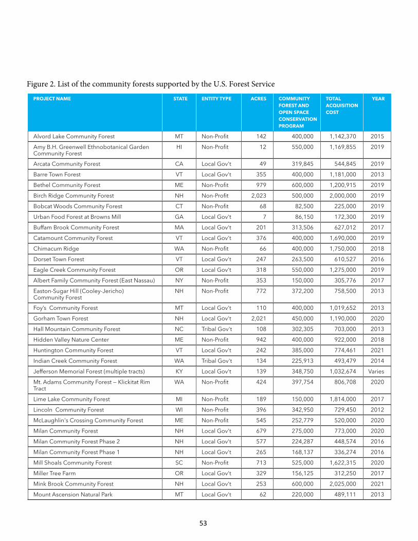
Project name State entity tyPe acreS community ForeSt and oPen SPace conServation Program
total acquiSition coSt
year
Alvord Lake Community Forest MT Non-Profit 142 400,000 1,142,370 2015
Amy B.H. Greenwell Ethnobotanical Garden Community Forest
HI Non-Profit 12 550,000 1,169,855 2019
Arcata Community Forest CA Local Gov't 49 319,845 544,845 2019
Barre Town Forest VT Local Gov't 355 400,000 1,181,000 2013
Bethel Community Forest ME Non-Profit 979 600,000 1,200,915 2019
Birch Ridge Community Forest NH Non-Profit 2,023 500,000 2,000,000 2019
Bobcat Woods Community Forest CT Non-Profit 68 82,500 225,000 2019
Urban Food Forest at Browns Mill GA Local Gov't 7 86,150 172,300 2019
Buffam Brook Community Forest MA Local Gov't 201 313,506 627,012 2017
Catamount Community Forest VT Local Gov't 376 400,000 1,690,000 2019
Chimacum Ridge WA Non-Profit 66 400,000 1,750,000 2018
Dorset Town Forest VT Local Gov't 247 263,500 610,527 2016
Eagle Creek Community Forest OR Local Gov't 318 550,000 1,275,000 2019
Albert Family Community Forest (East Nassau) NY Non-Profit 353 150,000 305,776 2017
Easton-Sugar Hill (Cooley-Jericho) Community Forest
NH Non-Profit 772 372,200 758,500 2013
Foy’s Community Forest MT Local Gov't 110 400,000 1,019,652 2013
Gorham Town Forest NH Local Gov't 2,021 450,000 1,190,000 2020
Hall Mountain Community Forest NC Tribal Gov't 108 302,305 703,000 2013
Hidden Valley Nature Center ME Non-Profit 942 400,000 922,000 2018
Huntington Community Forest VT Local Gov't 242 385,000 774,461 2021
Indian Creek Community Forest WA Tribal Gov't 134 225,913 493,479 2014
Jefferson Memorial Forest (multiple tracts) KY Local Gov't 139 348,750 1,032,674 Varies
Mt. Adams Community Forest — Klickitat Rim Tract
WA Non-Profit 424 397,754 806,708 2020
Lime Lake Community Forest MI Non-Profit 189 150,000 1,814,000 2017
Lincoln Community Forest WI Non-Profit 396 342,950 729,450 2012
McLaughlin's Crossing Community Forest ME Non-Profit 545 252,779 520,000 2020
Milan Community Forest NH Local Gov't 679 275,000 773,000 2020
Milan Community Forest Phase 2 NH Local Gov't 577 224,287 448,574 2016
Milan Community Forest Phase 1 NH Local Gov't 265 168,137 336,274 2016
Mill Shoals Community Forest SC Non-Profit 713 525,000 1,622,315 2020
Miller Tree Farm OR Local Gov't 329 156,125 312,250 2017
Mink Brook Community Forest NH Local Gov't 253 600,000 2,025,000 2021
Mount Ascension Natural Park MT Local Gov't 62 220,000 489,111 2013
Figure 2. List of the community forests supported by the U.S. Forest Service
53
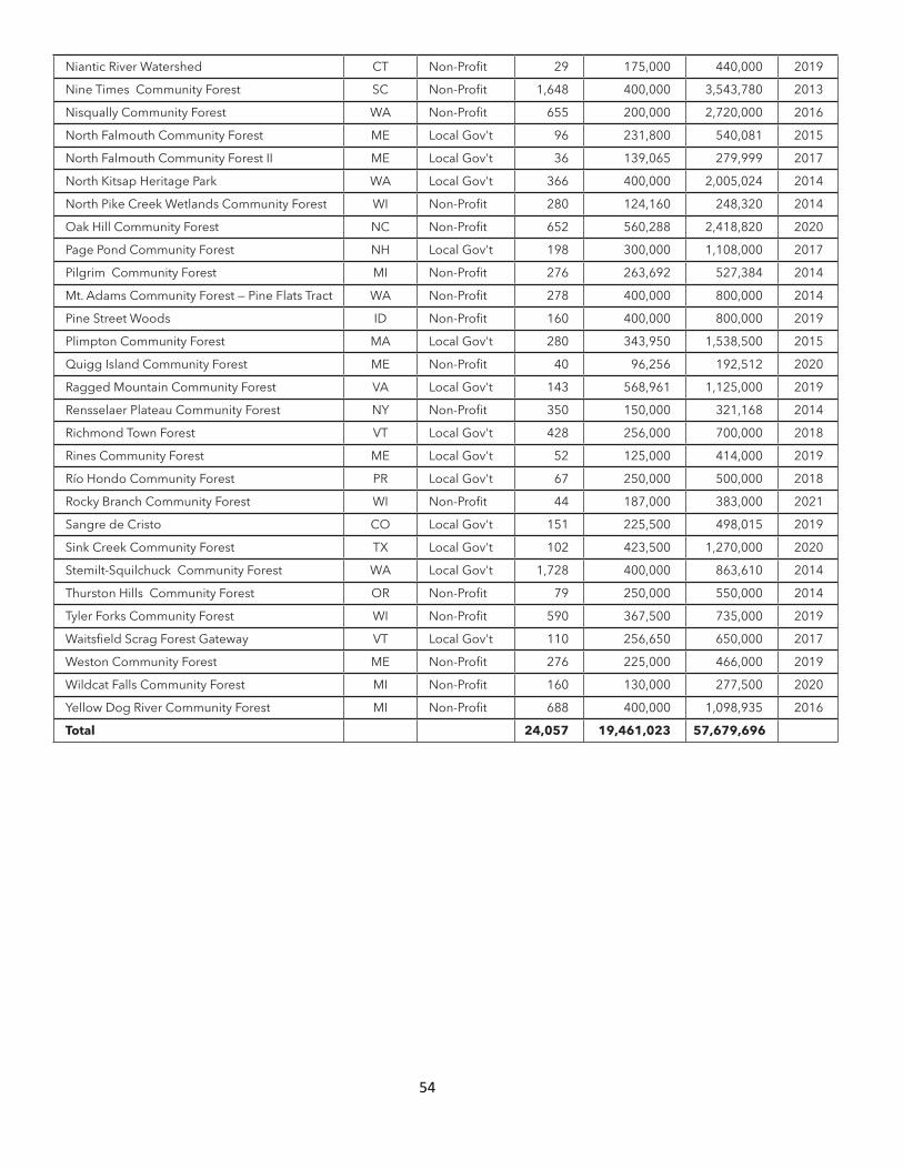
Niantic River Watershed CT Non-Profit 29 175,000 440,000 2019
Nine Times Community Forest SC Non-Profit 1,648 400,000 3,543,780 2013
Nisqually Community Forest WA Non-Profit 655 200,000 2,720,000 2016
North Falmouth Community Forest ME Local Gov't 96 231,800 540,081 2015
North Falmouth Community Forest II ME Local Gov't 36 139,065 279,999 2017
North Kitsap Heritage Park WA Local Gov't 366 400,000 2,005,024 2014
North Pike Creek Wetlands Community Forest WI Non-Profit 280 124,160 248,320 2014
Oak Hill Community Forest NC Non-Profit 652 560,288 2,418,820 2020
Page Pond Community Forest NH Local Gov't 198 300,000 1,108,000 2017
Pilgrim Community Forest MI Non-Profit 276 263,692 527,384 2014
Mt. Adams Community Forest — Pine Flats Tract WA Non-Profit 278 400,000 800,000 2014
Pine Street Woods ID Non-Profit 160 400,000 800,000 2019
Plimpton Community Forest MA Local Gov't 280 343,950 1,538,500 2015
Quigg Island Community Forest ME Non-Profit 40 96,256 192,512 2020
Ragged Mountain Community Forest VA Local Gov't 143 568,961 1,125,000 2019
Rensselaer Plateau Community Forest NY Non-Profit 350 150,000 321,168 2014
Richmond Town Forest VT Local Gov't 428 256,000 700,000 2018
Rines Community Forest ME Local Gov't 52 125,000 414,000 2019
Río Hondo Community Forest PR Local Gov't 67 250,000 500,000 2018
Rocky Branch Community Forest WI Non-Profit 44 187,000 383,000 2021
Sangre de Cristo CO Local Gov't 151 225,500 498,015 2019
Sink Creek Community Forest TX Local Gov't 102 423,500 1,270,000 2020
Stemilt-Squilchuck Community Forest WA Local Gov't 1,728 400,000 863,610 2014
Thurston Hills Community Forest OR Non-Profit 79 250,000 550,000 2014
Tyler Forks Community Forest WI Non-Profit 590 367,500 735,000 2019
Waitsfield Scrag Forest Gateway VT Local Gov't 110 256,650 650,000 2017
Weston Community Forest ME Non-Profit 276 225,000 466,000 2019
Wildcat Falls Community Forest MI Non-Profit 160 130,000 277,500 2020
Yellow Dog River Community Forest MI Non-Profit 688 400,000 1,098,935 2016
total 24,057 19,461,023 57,679,696
54
55
Endnotes 1 All numbers in the text are rounded to two significant digits unless otherwise noted. Because of rounding, some report figures may not appear to sum. The values of the economic benefits estimated in this analysis are reported in 2019 dollars (2019$), having been adjusted with the most recent consumer price index (CPI) and producer price index (PPI) data available at the time of analysis. 2 This map contains the projects funded by the U.S. Forest Service’s Community Forest and Open Space Conservation Program as of March 2021, as well as two community forests funded through the Forest Legacy Program prior to CFP’s establishment. 3 Neal Bungard, natural resource program leader, U.S. Forest Service, personal communication with author via email, March 24, 2021. 4 Northern Forest Alliance, The Vermont Town Forest Stewardship Guide: A Users’ Manual for Town Forests; American Forests, Communities Committee, National Network of Forest Practitioners, and Pinchot Institute for Conservation, Quick Guide for Community Forestry Practitioners: Introduction to Community-Owned Forests; Nils Christoffersen, Don Harker, Martha West Lyman, and Barbara Wyckoff, The Status of Community-Based Forestry in the United States: A Report to the U.S. Endowment for Forestry and Communities, 2008; California Forest Stewardship Program, “New Directions in Community-Based Forestry,” Forestland Steward, 2011; Community Forest Collaborative, The Trust For Public Land, Northern Forest Center, Sustainable Forest Futures, and Quebec-Labrador Foundation, Community Forests: Needs and Resources for Creating and Managing Community Forests, 2011; Martha West Lyman, Curt Grimm, and Julie Renaud Evans, “Community Forests as a Wealth Creation Strategy for Rural Communities,” Community Development (2014). 5 The Trust for Public Land, “Community Forests: A Community Investment Strategy,” accessed February 10, 2021, https://www.tpl.org/community-forests-community-investment-strategy. 6 U.S. Forest Service, Community Forest Program, accessed February 10, 2021, https://www.fs.usda.gov/sites/default/files/Community-Forest-Program-Road-Map-2020.pdf. 7 Joshua Brown, “A Milestone for Millstone Hill,” The Trust for Public Land, Land & People Magazine, Spring/Summer 2012, https://www.tpl.org/magazine/milestone-millstone-hill-%E2%80%94-landpeople. 8 Graham Averill, “Rock Steady: Tapping Millstone Trails’ Secret Ingredient,” Bike Magazine, April 25, 2017, accessed July 7, 2020, https://www.bikemag.com/features/rock-steady/; Aaron Retherford, “Millstone Trails Grows into a Mountain Biker, Hiker, and Winter Recreationist Paradise,” The World Online, July 6, 2015; Drew Pogge, “The Second Coming of Millstone Hill: Recreation Replaces Mining in the Granite Capital of Vermont,” Vermont Magazine, 2009; Millstone Trails Association, “Press Coverage,” accessed July 7, 2020, http://www.millstonetrails.org/about-mta/press-coverage/. 9 Eric Blaisdell, “Town Forest, Millstone Trails Thrive,” Barre Montpelier Times Argus, July 20, 2015, accessed July 9, 2020, https://www.timesargus.com/articles/town-forest-millstone-trails-thrive/. 10 This assumption is consistent with the 2017 National Household Travel Survey by U.S. Department of Transportation Federal Highway Authority, which indicates that the average vehicle occupancy for social/recreation trip purposes is 2.10. 11 This study acknowledges that Barre Town Forest is visited year round, but in order to be conservative, this study does not include that other use in the estimate of recreational and tourism value. 12 This assumption is based on the results of a study about Catamount Community Forest. Kyle Walsh, MPS Candidate, SUNY- School of Environmental Science and Forestry, An Economic Impact Analysis of the Proposed Catamount Community Forest in Williston, Vermont, 2017. 13 Oregon State University, Recreation Use Values Database, accessed December 1, 2016, http://recvaluation.forestry.oregonstate.edu/database. Oregon State University’s database contains values for more than 20 activities and is based on over 420 economic studies that estimated the use value of recreation activities in the United States and Canada from 1958 to 2015. 14 Pete Kopsco, president, Millstone Trails Association, email message to author September 22, 2020. 15 The study, completed prior to the creation of the community forest, estimated that there would be 10,500 annual visitors by 2015 and that those visitors would spend $640,000 annually in the Barre area and support 20 jobs. Steve Posner, Gund Institute for Ecological Economics, University of Vermont, and Marta Ceroni, Green Compass, Potential Economic Impact of Outdoor Recreation in the Barre Town Forest, Vermont, 2012.
56
16 Kyle Walsh, MPS Candidate, SUNY- School of Environmental Science and Forestry, An Economic Impact Analysis of the Proposed Catamount Community Forest in Williston, Vermont, 2017. 17 Joshua Brown, “A Milestone for Millstone Hill,” The Trust for Public Land, Land & People Magazine, Spring/Summer 2012, https://www.tpl.org/magazine/milestone-millstone-hill-%E2%80%94-landpeople. 18 Joel Schwartz, executive director, Barre Area Development, Inc., email message to author, September 16, 2020; Barre Vermont Rock Solid, accessed February 10, 2021, https://barrevt.com/. 19 Acquisition and Conservation of Barre Town Forest, Washington County, Vermont, Application to the Federal Community Forest Program. 20 Catamount Community Forest, Community Forest Program Application, 2017; Kyle Walsh, MPS Candidate, SUNY- School of Environmental Science and Forestry, An Economic Impact Analysis of the Proposed Catamount Community Forest in Williston, Vermont. 21 Jonathan Mingle, “Take Your Marks,” Land & People Magazine, The Trust for Public Land, Fall-Winter 2019. 22 The Trust for Public Land determined the value of recreational activities using estimates of recreation value from Oregon State University’s Recreation Use Values Database, accessed December 1, 2016, http://recvaluation.forestry.oregonstate.edu/database. Oregon State University’s database contains values for more than 20 activities and is based on over 420 economic studies that estimated the use value of recreation activities in the United States and Canada from 1958 to 2015. 23 This data was collected before the land became a community forest and is most likely a lower-bound estimate of the current use. 24 Kyle Walsh, MPS Candidate, SUNY- School of Environmental Science and Forestry, An Economic Impact Analysis of the Proposed Catamount Community Forest in Williston, Vermont, 2017. 25 Lake Champlain Basin Program, “Drinking Water,” accessed July 2, 2020, https://www.lcbp.org/water-environment/human-health/drinking-water/. 26 The Trust for Public Land determined the value of outdoor recreation using Oregon State University’s Recreation Use Values Database, accessed December 1, 2016, http://recvaluation.forestry.oregonstate.edu/database. Oregon State University’s database contains values for more than 20 activities and is based on over 420 economic studies that estimated the use value of recreation activities in the United States and Canada from 1958 to 2015. 27 The Trust for Public Land assumed the distribution of local and nonlocal visitors to HVNC was similar to visitors of Catamount Community Forest in Williston, Vermont. Kyle Walsh, MPS Candidate, SUNY- School of Environmental Science and Forestry, An Economic Impact Analysis of the Proposed Catamount Community Forest in Williston, Vermont, 2017. 28 This estimate is based on an average day trip party size of 2.9 people and average day trip spending per party of $306. DPA, Maine Office of Tourism, Visitor Tracking Research, 2018 Calendar Year Annual Report, 2019. 29 Neal Bungard, “Lincoln Community Forest: The Very First Community Forest and Open Space Conservation Project in the Country,” Forest Matters Stewardship Newsletter, Summer 2013. 30 Erika Lang, conservation manager, Landmark Conservancy, email message to author, March 9, 2020. 31 Brian Zweig, Business Opportunities Management Consulting, Economic Impact Study of Business Activity, prepared for the Rensselaer Plateau Alliance, 2012; Sarah Parks, The Economic Value of Ecosystem Services on the Rensselaer Plateau, prepared for the Rensselaer Plateau Alliance, 2012. 32 Rensselaer Plateau Alliance, “Rensselaer Plateau Alliance,” accessed July 1, 2020, https://www.rensselaerplateau.org/. 33 Jim Bonesteel, Rensselaer Plateau Alliance, “Rensselaer Plateau Community Forest: A Grassroots Community Effort from its Inception,” U.S. Forest Service, Forest Matters Stewardship Newsletter, Summer 2016; U.S. Department of Agriculture, A Community Forest Program Success Story: New York Demo Forest Shows Landowners Best Management Practices, 2015. 34 Jim Bonesteel, executive director, Rensselaer Plateau Alliance, email messages to author, March 3 and July 9, 2020. 35 Rensselaer Plateau Alliance, Regional Trail Vision Plan, 2015. 36 Rensselaer Plateau Alliance, A Capital Campaign for the Community Forest of the Rensselaer Plateau, 2015. 37 Jim Bonesteel, Rensselaer Plateau Alliance, “Rensselaer Plateau Community Forest: A Grassroots Community Effort from its Inception,” U.S. Forest Service, Forest Matters Stewardship Newsletter, Summer 2016. 38 Rensselaer Plateau Community Forest, USFS Community Forest & Open Space Conservation Program Application. 39 Amanda McCreary, program coordinator, Rensselaer Youth Outdoors, email message to author, March 10, 2020. 40 Jim Bonesteel, Rensselaer Plateau Alliance, “Rensselaer Plateau Community Forest: A Grassroots Community Effort from its Inception,” U.S. Forest Service, Forest Matters Stewardship Newsletter, Summer 2016; U.S. Department of Agriculture, A Community Forest Program Success Story: New York Demo Forest Shows Landowners Best Management Practices, 2015.
57
41 Southwest Michigan Land Conservancy, “Portman Nature Preserve,” accessed February 10, 2021, https://swmlc.org/project/portman-nature-preserve/; Southwest Michigan Land Conservancy, Lime Lake Community Forest Application. 42 Southwest Michigan Land Conservancy, “Hike Our Preserves,” accessed February 10, 2021, https://swmlc.org/hop/. 43 Southwest Michigan Land Conservancy, “Portman Nature Preserve,” accessed February 10, 2021, https://swmlc.org/project/portman-nature-preserve/. 44 David L. Willcox, “The Story of the Randolph Community Forest: Building on Local Stewardship, Securing Access through Community Ownership,” accessed February 10, 2021, http://www.communitiescommittee.org/pdfs/randolphstory.pdf; The Trust for Public Land, Conservation Almanac, https://conservationalmanac.org. 45 The Trust for Public Land, “First Pond of Safety Purchase Completed (NH),” December 4, 2001, accessed August 19, 2020, https://www.tpl.org/media-room/first-pond-safety-purchase-completed-nh. 46 The Trust for Public Land, “Randolph Community Forest / Pond of Safety,” accessed August 19, 2020, https://www.tpl.org/our-work/randolph-community-forest-pond-safety. 47 The Trust for Public Land, How U.S. Forest Service Land and Water Conservation Fund (LWCF) Program Acquisitions Impact Communities in Six Case Studies, 2014. 48 David L. Willcox, “The Story of the Randolph Community Forest: Building on Local Stewardship, Securing Access through Community Ownership,” accessed February 10, 2021, http://www.communitiescommittee.org/pdfs/randolphstory.pdf. 49 Community Forest Collaborative, A Community Investment Strategy: Community Forests, 2007. 50 Helena Murray, Paul Catanzaro, Marla Markowski-Lindsay, Brett Butler, and Henry Eichman, Economic Contributions of Land Conserved by the USDA Forest Service’s Forest Legacy Program, https://www.fs.usda.gov/sites/default/files/media_wysiwyg/flp-economiccontributionsreportfullresolution.pdf. 51 In-person conversation with John Scarinza, planning board chair, Town of Randolph, New Hampshire, and Lisa Fordadaro, senior writer and researcher, The Trust for Public Land, June 23, 2020. 52 David L. Willcox, “The Story of the Randolph Community Forest: Building on Local Stewardship, Securing Access through Community Ownership,” accessed February 10, 2021, http://www.communitiescommittee.org/pdfs/randolphstory.pdf. 53 U.S. Department of Agriculture, Economic Contributions of Outdoor Recreation from the White Mountain National Forest. Figures reported in 2016 dollars. 54 Northern Forest Center, “13 Mile Woods Community Forest,” accessed February 10, 2021, https://northernforest.org/programs/community-forests/13-mile-woods-community-forest. 55 Elizabeth Reaves and Marta Ceroni, Economic Impacts of the 13 Mile Woods Community Forest in Errol, New Hampshire, Donella Meadows Institute for Green Compass LLC, 2013. 56 Northern Forest Center, “13 Mile Woods Community Forest,” accessed February 10, 2021, https://northernforest.org/programs/community-forests/13-mile-woods-community-forest. 57 Elizabeth Reaves and Marta Ceroni, Economic Impacts of the 13 Mile Woods Community Forest in Errol, New Hampshire, Donella Meadows Institute for Green Compass LLC, 2013. 58 North East State Foresters Association, The Economic Importance of New Hampshire’s Forest-Based Economy, 2011, accessed August 18, 2020, https://www.nh.gov/nhdfl/documents/nefa-nh-forest-econ-impor-2011-final.pdf. 59 These are the 2010 U.S. Census statistics for the Municipality of Mayagüez, Puerto Rico, as reported in the Río Hondo Community Forest Application, 2015. 60 U.S. Forest Service, “Deliver Benefits to the Public: IITF Helps Lead the Way for the Establishment of New Community Forest in Puerto Rico,” November 27, 2018, accessed January 27, 2021, https://www.fs.usda.gov/inside-fs/delivering-mission/deliver/iitf-helps-lead-way-establishment-new-community-forest-puerto. 61 Hall Mountain Community Forest, USFS Community Forest & Open Space Conservation Program Application. 62 Tommy Cabe, tribal forest resource specialist, Eastern Band of Cherokee Indians, personal communication with author via phone, December 19, 2019. 63 Lisa K. Neuman, “Basketry as Economic Enterprise and Cultural Revitalization: The Case of the Wabanaki Tribes of Maine,” Wicazo Sa Review 25, no. 2 (2010): 89–106. 64 Qualla Arts and Crafts Mutual, Inc., “Gallery,” accessed May 12, 2020, https://www.quallaartsandcrafts.com/gallery.php?view=price. 65 Tommy Cabe, tribal forest resource specialist, Eastern Band of Cherokee Indians, personal communication with author via phone, March 31, 2020. 66 Peter Bates, Craig Breedlove, and Paul Carlson, Forest Stewards, Hall Mountain Forest Management Plan – 2019 Update, prepared for Eastern Band of Cherokee Indians, 2019.
58
67 Tommy Cabe, tribal forest resource specialist, Eastern Band of Cherokee Indians, personal communication with author via phone, March 31, 2020. 68 Tommy Cabe, tribal forest resource specialist, Eastern Band of Cherokee Indians, personal communication with author via phone, December 19, 2019. 69 Tommy Cabe, tribal forest resource specialist, Eastern Band of Cherokee Indians, personal communication with author via phone, March 31, 2020. 70 Equinox, “EBCI-Eagle Aviary Master Plan Concept: Kickoff Meeting,” August 13, 2019. 71 Ibid. 72 Tommy Cabe, tribal forest resource specialist, Eastern Band of Cherokee Indians, personal communication with via phone, March 31, 2020. 73 Nine Times Community Forest, USFS Community Forest & Open Space Conservation Program Application. 74 Mac Stone, executive director, Naturaland Trust, email to author, May 19, 2020. 75 Mac Stone, executive director, Naturaland Trust, personal communication with author via phone, September 19, 2019. 76 Wes Cooler, volunteer steward, Naturaland Trust, email to author September 19, 2019. 77 Brad Caldwell, former representative, Carolina Climbers Coalition, personal communication with author via phone, September 25, 2019. 78 Mac Stone, executive director, Naturaland Trust, email to author March 31, 2020. 79 Wes Cooler, volunteer steward, Naturaland Trust, email to author April 1, 2020. 80 Wes Cooler, volunteer steward, Naturaland Trust, email to author April 2, 2020. 81 Ibid. 82 Wes Cooler, volunteer steward, Naturaland Trust, email to author April 1, 2020. 83 Wes Cooler, volunteer steward, Naturaland Trust, email to author September 19, 2019. 84 The Trust for Public Land determined the value of each type of recreational visit by residents using Oregon State University’s Recreation Use Values Database, accessed December 1, 2016. 85 South Carolina Department of Parks, Recreation, and Tourism, Total Domestic Travel to South Carolina, updated July 2019. 86 Wes Cooler, volunteer steward, Naturaland Trust, personal communication with author via phone, September 19, 2019. 87 Mac Stone, executive director, Naturaland Trust, personal communication with author via phone, September 19, 2019. 88 The Conservation Fund, Atlanta Food Forest, Community Vision Plan 2017, provided February 8, 2021. 89 Value estimated by assuming that each volunteer contributed at least one hour of time, at a rate of $25.86, the 2019 value of volunteer time in Georgia as estimated by the Independent Sector. Independent Sector, accessed January 26, 2021, https://independentsector.org/wp-content/uploads/2018/04/value-of-volunteer-time-state-historical-2001-2019.pdf. 90 U.S. Census Bureau, 2019: ACS 5-Year Estimates, https://data.census.gov/cedsci/table?g=1600000US1503850&tid=ACSDP5Y2019.DP05&hidePreview=false. 91 Kathleen Friday, program manager, Forest Legacy and Forest Stewardship, Institute of Pacific Islands Forestry, U.S. Forest Service, and Margaret Haines, natural resource specialist, Cooperative Forest, U.S. Forest Service via email February 8, 2021. 92 Friends of Amy B.H. Greenwell Ethnobotanical Garden, Fee Acquisition of the Amy B. H. Greenwell Ethnobotanical Garden Community Forest: Application to the U.S.D.A. Forest Service Community Forest and Open Space Conservation Program; Friends of Amy B. H. Greenwell Botanical Garden, “2020 Grow Hawaiian Festival,” accessed February 10, 2021, https://www.amygreenwell.garden/2020-grow-hawaiian-festival/. 93 Friends of Amy B. H. Greenwell Ethnobotanical Garden, Community Forest Management Plan: Amy B. H. Greenwell Ethnobotanical Garden Community Forest, March 2020. 94 The Trust for Public Land determined the value of recreation activities using Oregon State University’s Recreation Use Values Database, accessed December 1, 2016, http://recvaluation.forestry.oregonstate.edu/database. Oregon State University’s database contains values for more than 20 activities and is based on over 420 economic studies that estimated the use value of recreation activities in the United States and Canada from 1958 to 2015. 95 Marie Morin, secretary, Friends of Amy B. H. Greenwell Ethnobotanical Garden, email to author via Katie Friday, U.S. Forest Service, February 13, 2021. 96 Friends of Amy B. H. Greenwell Ethnobotanical Garden, Fee Acquisition of the Amy B. H. Greenwell Ethnobotanical Garden Community Forest: Application to the U.S.D.A. Forest Service Community Forest and Open Space Conservation Program.
59
97 Headwaters Economics, Economic Profile System, Flathead County, MT, accessed January 23, 2020, https://headwaterseconomics.org/tools/economic-profile-system/. 98 Kim Morisaki, business development and marketing director, Flathead County Economic Development Authority and Montana West Economic Development, email to author September 25, 2019. 99 Gabriel Dillon, executive director, Foy’s to Blacktail Trails, email to author, September 9, 2019. 100 Foy’s to Blacktail Trails, “2015 Annual Report,” accessed September 11, 2019, https://www.foystoblacktailtrails.org/wp-content/uploads/2016/07/2015-FtoB-Annual-Report-small.pdf. 101 Gabriel Dillon, Foy’s to Blacktail Trails, email to author, September 11, 2019. 102 The Trust for Public Land determined the value of recreation activities using Oregon State University’s Recreation Use Values Database, accessed December 1, 2016, http://recvaluation.forestry.oregonstate.edu/database. Oregon State University’s database contains values for more than 20 activities and is based on over 420 economic studies that estimated the use value of recreation activities in the United States and Canada from 1958 to 2015. 103 Diane Medler, director of Discover Kalispell and Kalispell CVB, email message to author, September 17, 2019. 104 University of Montana, Institute for Tourism and Recreation Research, accessed September 12, 2019, http://www.tourismresearchmt.org/. 105 Gabriel Dillon, program coordinator of Foy’s to Blacktail Trails, estimates 10 to 25 percent of users are nonlocal. The Herron Park User Survey indicated that 21 percent of respondents were from out of town. Foy’s to Blacktail Trails, “2015 Annual Report,” accessed September 11, 2019, https://www.foystoblacktailtrails.org/wp-content/uploads/2016/07/2015-FtoB-Annual-Report-small.pdf. 106 University of Montana, Institute for Tourism and Recreation Research, accessed September 12, 2019, http://www.tourismresearchmt.org/. 107 Erica Wirtala, public affairs director, Northwest Montana Association of Realtors (NMAR), email to author, September 27, 2019. 108 City of Helena and Prickly Pear Land Trust, Mt. Ascension Natural Park Expansion Proposal: Application to the U.S.D.A. Forest Service Community Forest and Open Space Conservation Program. 109 International Mountain Biking Association, “Explore the Ride Centers,” accessed January 17, 2020, https://www.imba.com/ride/where-to-ride/ride-centers; Visit Helena Montana, Helena Tourism Business Improvement District, FY2019 Work Plan, accessed September 13, 2019, https://www.helenamt.com/wp-content/uploads/2016/06/FY2019-TBID-WORK-PLAN.pdf. 110 Andrea Optiz, executive director of Helena Tourism Alliance, email message to author, September 16, 2019. 111 University of Montana, Institute for Tourism and Recreation Research, J. L. Sage and N. Nickerson, Trail Usage and Value: A Helena Case Study, 2018. Values adjusted to 2019 dollars using the consumer price index. 112 This was calculated based on estimates for local users from the 2018 study by the University of Montana. Value per use was estimated using the Oregon State University’s Recreational Use Database. The value of mountain biking and hiking in Montana is estimated at $17.71 (2019$) and $17.08 (2019$) per use, respectively. 113 University of Montana, Institute for Tourism and Recreation Research, J. L. Sage and N. Nickerson, Trail Usage and Value: A Helena Case Study, 2018. 114 Washington Department of Natural Resources, University of Washington School of Environmental and Forest Sciences, Northwest Community Forests, Mt. Adams Resource Stewards, Washington Environmental Council, and Center for Trade in Forest Products, Economic Impacts of the Mt. Adams Community Forest, 2014-2017, September 2018. 115 Jay McLaughlin, executive director, Mt. Adams Resource Stewards, personal communication with author via phone, January 27, 2020. 116 Jay McLaughlin, executive director, Mt. Adams Resource Stewards, personal communication with author via phone, January 27, 2020. 117 Washington Department of Natural Resources, University of Washington School of Environmental and Forest Sciences, Northwest Community Forests, Mt. Adams Resource Stewards, Washington Environmental Council, Center for Trade in Forest Products, Economic Impacts of the Mt. Adams Community Forest, 2014–2017, 2018. 118 Washington Department of Natural Resources, University of Washington School of Environmental and Forest Sciences, Northwest Community Forests, Mt. Adams Resource Stewards, Washington Environmental Council, and Center for Trade in Forest Products, Economic Impacts of the Mt. Adams Community Forest, 2014–2017, 2018. 119 The social cost of carbon was based on the values established by the U.S. Environmental Protection Agency. The Trust for Public Land used the central social cost of carbon value for 2020, calculated at a 3 percent discount rate and adjusted to 2019 dollars using the Producer Price Index. U.S. Environmental Protection Agency, “Social Cost of Carbon,” accessed January 28, 2020, https://19january2017snapshot.epa.gov/climatechange/social-cost-carbon_.html. 120 Keith Kreps, owner Kreps Ranch, personal communication with author via phone, February 10, 2020.
60
121 Jay McLaughlin, executive director, Mt. Adams Resource Stewards, personal communication with author via phone, January 27, 2020. Value per use was estimated using the Oregon State University’s Recreational use database. The most conservative value of hunting in Washington is estimated at $32.90 (2019$) per use. 122 The Stemilt-Squilchuck community was described as the Stemilt-Squilchuck watershed in the CFP application. The population provided in the application was used here because a watershed is not a political boundary and the population estimate could not be replicated. 123 The Trust for Public Land; Chelan County, Washington; The Stemilt Partnership; and Core GIS, LLC, Stemilt-Squilchuck Community Vision, September 2008. 124 Norm Gutzwiler, email message to author, January 27, 2020. 125 County of Chelan, Washington, “Stemilt Partnership,” accessed December 20, 2019, https://www.co.chelan.wa.us/natural-resources/pages/stemilt-partnership?parent=Planning. 126 The Trust for Public Land; Chelan County, Washington; The Stemilt Partnership; and Core GIS, LLC, Stemilt-Squilchuck Community Vision, 2008. The reported economic impact was $64 million per year to Chelan and Douglas Counties. Values were adjusted to 2019 dollars using the consumer price index. 127 U.S. Department of Agriculture, 2017 Census of Agriculture: Chelan County, Washington County Profile. 128 Timothy J. Smith, Washington State University Extension – Tree Fruit Production, 2008. The economic impact was adjusted to 2019 dollars using the consumer price index. 129 Norm Gutzwiler, email message to author, January 27, 2020. 130 County of Chelan, Community Forest Conservation Program Application. 131 Herb Troxel, email message to author, January 16, 2020. 132 U.S. Department of Agriculture, “Rental Rates for GRP,” accessed January 15, 2020, https://www.fsa.usda.gov/ Internet/FSA_File/4grprentrates.pdf. It is unclear which of these rates were applied. The only indication of year is the xx-xx-10 at the bottom of each page, which indicates the document was produced in 2010. However, to be conservative, we assume that the year was 2014, the last year Grassland Reserve Program (GRP) payments were made (Feb 7, 2014, is the actual date used by NRCS). GRP was a program of the USDA that sought to prevent grazing and pastureland from being converted into cropland, used for urban development, or developed for other nongrazing uses. Participants in the program voluntarily limited future development of their grazing and pasture land, while still being able to use the land for livestock grazing and activities related to forage and seed production. The Agricultural Act of 2014 established the Agricultural Conservation Easement Program (ACEP). It repealed FRPP, GRP, and WRP but did not affect the validity or terms of any FRPP, GRP, or WRP contract, agreement, or easement entered into prior to the date of enactment on February 7, 2014, or any associated payments required to be made in connection with an existing FRPP, GRP, or WRP contract, agreement, or easement. Values were adjusted to 2019 dollars using the consumer price index. 133 County of Chelan, Community Forest Conservation Program Application. 134 The Trust for Public Land; Chelan County, Washington; The Stemilt Partnership; and Core GIS, LLC, Stemilt-Squilchuck Community Vision, 2008. 135 The Trust for Public Land determined the value of recreation activities utilizing estimates of outdoor recreation value from Oregon State University’s Recreation Use Values Database. Oregon State University, Recreation Use Values Database, accessed December 1, 2016, http://recvaluation.forestry.oregonstate.edu/database. Oregon State University’s database contains values for more than 20 activities and is based on over 420 economic studies that estimated the use value of recreation activities in the United States and Canada from 1958 to 2015. Values adjusted to 2019 dollars using consumer price index. 136 ECONorthwest, The Economic Importance of Outdoor Recreation in Chelan and Douglas Counties, WA: Current Contributions and Future Potential, 2017. 137 Zander S. Venter, David N. Barton, Vegrad Gundersen, Helene Figari, and Megan Nowell, “Urban Nature in a Time of Crisis: Recreational Use of Green Space Increases during the COVID-19 Outbreak in Oslo, Norway,” Environmental Research Letters 15, no. 10 (2020) 104075. William L. Rice, Timothy J. Mateer, Nathan Reigner, Peter Newman, Ben Lawhon, and B. Derrick Taff, “Changes in Recreational Behaviors of Outdoor Enthusiasts during the COVID-19 Pandemic: Analysis across Urban and Rural Communities,” Journal of Urban Ecology 6, no. 1 (2020), https://doi.org/10.1093/jue/juaa020; Christoph Randler, Piotr Tryjanowski, Jukka Jokimaki, Marja-Liisa Kaisanlahti-Jokimaki, and Naomi Staller, “SARS-CoV2 (COVID-19) Pandemic Lockdown Influences Nature-Based Recreational Activity: The Case of Birders,” International Journal of Environmental Research and Public Health 17, no. 19 (2020) 7310, https://doi.org/10.3390/ijerph17197310. 138 Joshua W. Morse, Tatiana M. Galdkikh, Diana M. Hackenburg, and Rachelle K. Gould, “COVID-19 and Human-Nature Relationships: Vermonters’ Activities in Nature and Associated Nonmaterial Values during the Pandemic,” PLOS ONE, https://doi.org/10.1371/journal.pone.0243697; The University of Vermont: GUND Institute for

61
Environment, “In Pandemic, People Are Turning To Nature – Especially Women,” December 15, 2020, accessed March 12, 2021, https://www.uvm.edu/gund/news/pandemic-people-are-turning-nature-especially-women. 139 Jake M. Robinson, Paul Brindley, Ross Cameron, Danielle MacCarthy, and Anna Jorgensen, “Nature’s Role in Supporting Health during the COVID-19 Pandemic: A Geospatial and Socioecological Study,” International Journal of Environmental Research and Public Health 18, no. 5 (2021): 2227, https://doi.org/10.3390/ijerph18052227. 140 Longwoods International and Miles Partnership, Travel Sentiment Study Wave 20, September 15, 2020. 141 NPD Group, “Sporting Goods, Home Fitness, and Cycling Sales Surge in the U.S., Reports the NPD Group,” May 7, 2020, accessed September 17, 2020, https://www.npd.com/wps/portal/npd/us/news/press-releases/2020/sporting-goods-home-fitness-and-cycling-sales-surge-in-the-us-reports-the-npd-group/. 142 The Trust for Public Land, School’s Out: In a Time of Compounding Crises, America’s Schoolyards Are Packed with Potential, 2020.

The Trust for Public Land
101 Montgomery St., Suite 900
San Francisco, CA 94104
415.495.4014
tpl.org
Front top:Joe KlementoviCh; Front Bottom: BriAn mohr / emBer photogrAphy;
BACK: Joe KlementoviCh