Embed Size (px)
Citation preview
2
Community Design Manual
INTRODUCTION Page 2.2THE ILLUSTRATIVE SETTLEMENT MAP Page 2.4THE IMPROVED MODEL Page 2.5
GREAT NEIGHBORHOODS Page 2.6What makes a great neighborhood? Page 2.6How Collier County builds neighborhoods today Page 2.13Revitalizing maturing neighborhoods Page 2.16Transforming plans for conventional subdivisions Page 2.27Growing new neighborhoods Page 2.32Regarding gated communities Page 2.38Regarding stormwater management Page 2.45
WORLD CLASS STREETS Page 2.50What makes a great street? Page 2.51Why streets must be memorable Page 2.52Strategies for designing great streets Page 2.55Rethinking the corridors Page 2.62The evolution of a corridor Page 2.63Steps for transforming the corridor and adjacent neighborhoods Page 2.66
MEMORABLE CENTERS Page 2.72The basics Page 2.72The features of enduring centers Page 2.76How to avoid “blank wall syndrome” Page 2.79Regarding large-footprint buildings Page 2.80Commercial architectural standards Page 2.81Activating the activity center Page 2.87
EVOLVING THE SUBDIVIDED PERIPHERY Page 2.92History Page 2.92Problems Page 2.94Opportunities & good timing Page 2.98
I N T R O D U C T I O N
This Manual is the backbone of the Community Character Plan.Collier County has a wonderful variety of urban and rural settings thatshould be planned for in different ways. Development in Golden GateEstates is not the same in type or intensity as that in Naples, norshould it be. Successful development and revitalization in CollierCounty requires guidelines specifically formulated for these settings.
A map of Collier County has been prepared that identifies six primarytypes of settlement areas, ranging from urban activity centers to ruralcrossroads. These areas are defined as existing neighborhoods, newneighborhoods, corridors, activity centers, transitional lands, and rurallands, based on the unique characteristics of distinctive areas ofCollier County. For the purposes of this plan, each of Collier’s com-munities can be considered to be in one of these six types of settle-ment areas.
Collier County’s existing growth management plan can be seen asbreaking the county into three basic areas: urban, rural, and pre-exist-ing Golden Gate Estates lots. A north-south line generally running amile east of Collier Boulevard (CR 951) separates the urban designat-ed areas (toward the coast) from the rural areas. This line has held formany years, but its importance is diminishing, in part because manyrecent developments in the urban area have been built at very lowdensities. At the same time, Twin Eagles and other proposed develop-ments to the east (in rural areas) have suburban rather than ruralcharacteristics even though their densities are extremely low. Thesesuburban characteristics are not compatible with agriculture, ruralcommunities, or habitat preservation, and they will also conflict withhealthy urban development patterns should Collier County grow tothe point that these formerly rural areas need to be urbanized.
The zoning tool of choice for implementing the Collier growth man-
agement plan has been the planned unit development, or PUD. This isa catchall zoning classification that replaces compliance with standardregulations with a negotiated approval process that is closely focusedon a single development project, rather than on how that project willintegrate with adjoining neighborhoods or add to the character ofCollier County. The PUD approach has been successful in many ways,but Collier’s reliance on this planning tool has cost many other oppor-tunities for creating or ensuring character.
PUD zoning had been viewed as the solution to the failures of rigidconventional zoning, especially its promise of mixing uses in compati-ble patterns. After 25 years of use in Collier County, it is apparentthat the PUD approach has not achieved this promise either, deliveringmixed uses only very rarely.
Without clear character guidelines for land at various points along theurban/rural transect, a project-specific PUD negotiation cannotachieve the goal of having each new neighborhood become an impor-tant building block that adds to Collier County’s constantly improvingcharacter.
Rather than viewing the county as being divided simply into urbanand rural areas, or as a series of disconnected PUDs, this chapter rec-ognizes the character variations along the entire spectrum or transectof human activities, from the most urban to the most rural. Individualdesign features have their places at various points along this transect.Even the most useful and beautiful design feature can be used incor-rectly if these distinctions are not recognized.
Each settlement pattern illustrated in this chapter contains specificgoals for development in these archetypal situations, and is followedby implementation steps that show how to start realizing its goals anddesigns. The result is a guidebook for creating a more memorable andlivable Collier County.
2.2 C o l l i e r C o u n t y C o m m u n i t y C h a r a c t e r P l a n
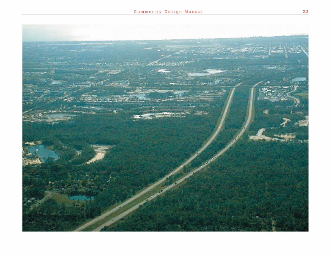
2.3C o m m u n i t y D e s i g n M a n u a l
2.4 C o l l i e r C o u n t y C o m m u n i t y C h a r a c t e r P l a n
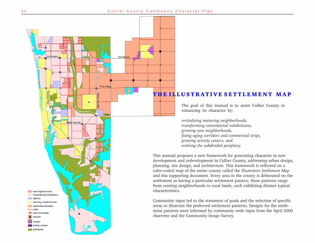
T H E I L L U S T R AT I V E S E T T L E M E N T M A P
The goal of this manual is to assist Collier County inenhancing its character by:
revitalizing maturing neighborhoods,transforming conventional subdivisions,growing new neighborhoods,fixing aging corridors and commercial strips,growing activity centers, andevolving the subdivided periphery.
This manual proposes a new framework for generating character in newdevelopment and redevelopment in Collier County, addressing urban design,planning, site design, and architecture. This framework is reflected on acolor-coded map of the entire county called the Illustrative Settlement Mapand this supporting document. Every area in the county is delineated on thesettlement as having a particular settlement pattern; these patterns rangefrom existing neighborhoods to rural lands, each exhibiting distinct typicalcharacteristics.
Community input led to the statement of goals and the selection of specificareas to illustrate the preferred settlement patterns. Designs for the settle-ment patterns were informed by community wide input from the April 2000charrette and the Community Image Survey.
2.5C o m m u n i t y D e s i g n M a n u a l
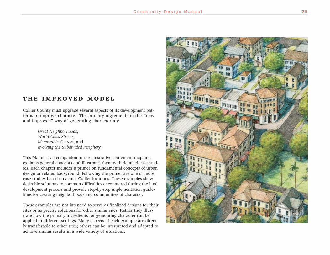
T H E I M P R O V E D M O D E L
Collier County must upgrade several aspects of its development pat-terns to improve character. The primary ingredients in this “newand improved” way of generating character are:
Great Neighborhoods,World-Class Streets,Memorable Centers, andEvolving the Subdivided Periphery.
This Manual is a companion to the illustrative settlement map andexplains general concepts and illustrates them with detailed case stud-ies. Each chapter includes a primer on fundamental concepts of urbandesign or related background. Following the primer are one or morecase studies based on actual Collier locations. These examples showdesirable solutions to common difficulties encountered during the landdevelopment process and provide step-by-step implementation guide-lines for creating neighborhoods and communities of character.
These examples are not intended to serve as finalized designs for theirsites or as precise solutions for other similar sites. Rather they illus-trate how the primary ingredients for generating character can beapplied in different settings. Many aspects of each example are direct-ly transferable to other sites; others can be interpreted and adapted toachieve similar results in a wide variety of situations.
2.6 C o l l i e r C o u n t y C o m m u n i t y C h a r a c t e r P l a n
G R E AT N E I G H B O R H O O D S
WHAT MAKES A GREAT NEIGHBORHOOD?
Portions of Old Naples were mentioned frequently during public par-ticipation events as good examples of neighborhoods in Collier County.These were often contrasted with gated PUDs and cul-de-sac subdivi-sions that proliferate in Collier today. The difference between thesetwo development approaches is subtle when viewed through regulato-ry eyes, but profound in the three-dimensional results.
There is no single litmus test for neighborhood quality; neighborhoodsof strong character are created through a variety of techniques. Themost successful neighborhoods generally exhibit design conventions thatare absent in conventional sprawl. These include: a legible center andedge to the neighborhood, an integrated network of walkablestreets, an overall size to the neighborhood suitable for walking,buildings set close enough to the streets to spatially define the streetsas public spaces, and opportunities for shopping and workplacesclose to home. Developing and redeveloping settlements based upona model of traditional neighborhood design principles is the first steptowards great neighborhoods. These design standards and conventionshave withstood the test of time. Discussed in more detail below, theseideas help create livability, a sense of community, and ultimately com-munity character.
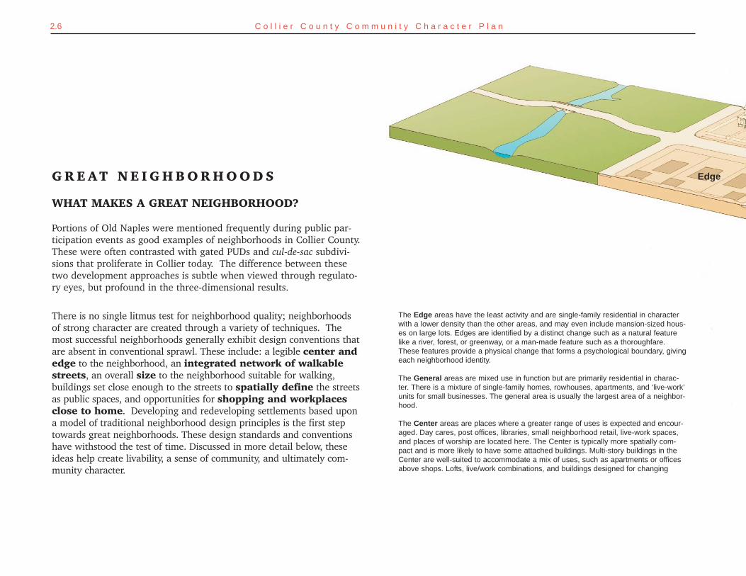
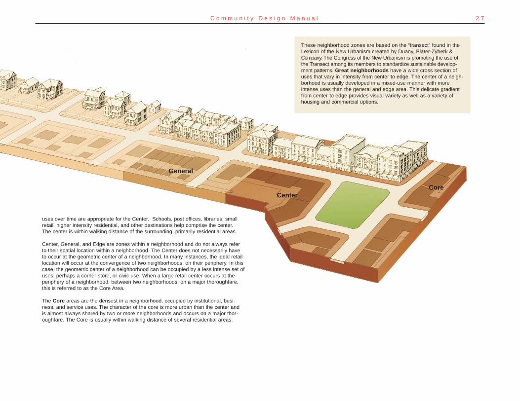
Edge
The Edge areas have the least activity and are single-family residential in characterwith a lower density than the other areas, and may even include mansion-sized hous-es on large lots. Edges are identified by a distinct change such as a natural featurelike a river, forest, or greenway, or a man-made feature such as a thoroughfare.These features provide a physical change that forms a psychological boundary, givingeach neighborhood identity.
The General areas are mixed use in function but are primarily residential in charac-ter. There is a mixture of single-family homes, rowhouses, apartments, and ‘live-work’units for small businesses. The general area is usually the largest area of a neighbor-hood.
The Center areas are places where a greater range of uses is expected and encour-aged. Day cares, post offices, libraries, small neighborhood retail, live-work spaces,and places of worship are located here. The Center is typically more spatially com-pact and is more likely to have some attached buildings. Multi-story buildings in theCenter are well-suited to accommodate a mix of uses, such as apartments or officesabove shops. Lofts, live/work combinations, and buildings designed for changing
2.7C o m m u n i t y D e s i g n M a n u a l
General
CenterCore
These neighborhood zones are based on the “transect” found in theLexicon of the New Urbanism created by Duany, Plater-Zyberk &Company. The Congress of the New Urbanism is promoting the use ofthe Transect among its members to standardize sustainable develop-ment patterns. Great neighborhoods have a wide cross section ofuses that vary in intensity from center to edge. The center of a neigh-borhood is usually developed in a mixed-use manner with moreintense uses than the general and edge area. This delicate gradientfrom center to edge provides visual variety as well as a variety ofhousing and commercial options.
uses over time are appropriate for the Center. Schools, post offices, libraries, smallretail, higher intensity residential, and other destinations help comprise the center.The center is within walking distance of the surrounding, primarily residential areas.
Center, General, and Edge are zones within a neighborhood and do not always referto their spatial location within a neighborhood. The Center does not necessarily haveto occur at the geometric center of a neighborhood. In many instances, the ideal retaillocation will occur at the convergence of two neighborhoods, on their periphery. In thiscase, the geometric center of a neighborhood can be occupied by a less intense set ofuses, perhaps a corner store, or civic use. When a large retail center occurs at theperiphery of a neighborhood, between two neighborhoods, on a major thoroughfare,this is referred to as the Core Area.
The Core areas are the densest in a neighborhood, occupied by institutional, busi-ness, and service uses. The character of the core is more urban than the center andis almost always shared by two or more neighborhoods and occurs on a major thor-oughfare. The Core is usually within walking distance of several residential areas.
2.8 C o l l i e r C o u n t y C o m m u n i t y C h a r a c t e r P l a n
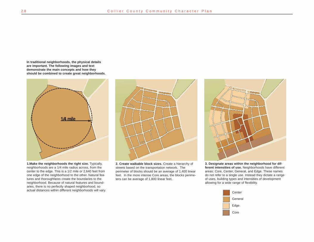
In traditional neighborhoods, the physical detailsare important. The following images and textdemonstrate the main concepts and how theyshould be combined to create great neighborhoods.
1/4 mile
1.Make the neighborhoods the right size. Typically,neighborhoods are a 1/4 mile radius across, from thecenter to the edge. This is a 1/2 mile or 2,640 feet fromone edge of the neighborhood to the other. Natural fea-tures and thoroughfares create the boundaries to theneighborhood. Because of natural features and bound-aries, there is no perfectly shaped neighborhood, soactual distances within different neighborhoods will vary.
2. Create walkable block sizes. Create a hierarchy ofstreets based on the transportation network. Theperimeter of blocks should be an average of 1,400 linearfeet. In the more intense Core areas, the blocks perime-ters can be average of 1,800 linear feet.
3. Designate areas within the neighborhood for dif-ferent intensities of use. Neighborhoods have differentareas: Core, Center, General, and Edge. These namesdo not refer to a single use. Instead they dictate a rangeof uses, building types and intensities of developmentallowing for a wide range of flexibility.
Center
General
Edge
Core
2.9C o m m u n i t y D e s i g n M a n u a l
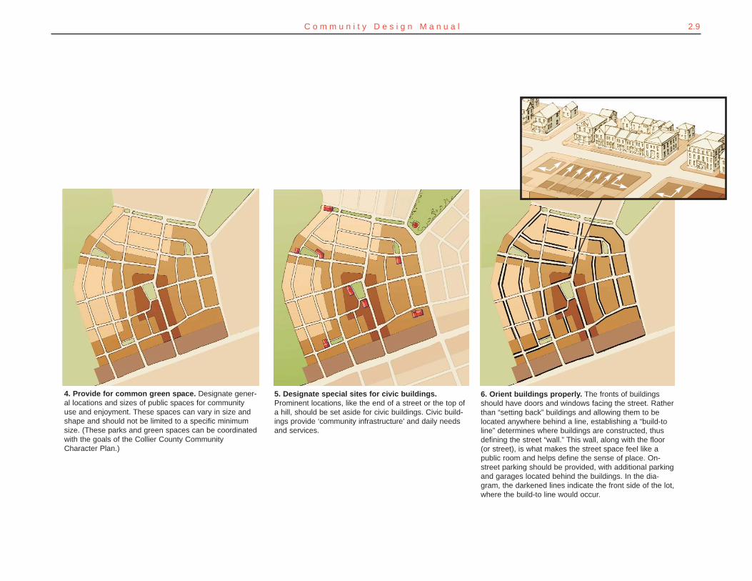
4. Provide for common green space. Designate gener-al locations and sizes of public spaces for communityuse and enjoyment. These spaces can vary in size andshape and should not be limited to a specific minimumsize. (These parks and green spaces can be coordinatedwith the goals of the Collier County CommunityCharacter Plan.)
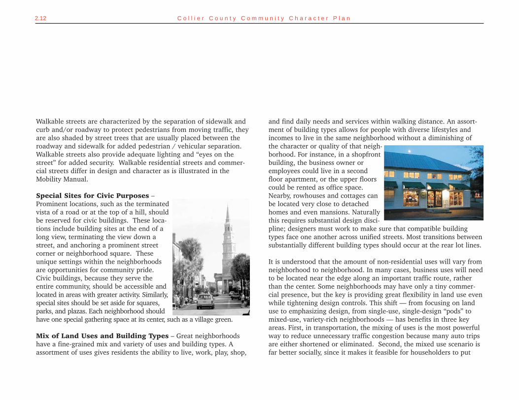
5. Designate special sites for civic buildings.Prominent locations, like the end of a street or the top ofa hill, should be set aside for civic buildings. Civic build-ings provide ‘community infrastructure’ and daily needsand services.
6. Orient buildings properly. The fronts of buildingsshould have doors and windows facing the street. Ratherthan “setting back” buildings and allowing them to belocated anywhere behind a line, establishing a “build-toline” determines where buildings are constructed, thusdefining the street “wall.” This wall, along with the floor(or street), is what makes the street space feel like apublic room and helps define the sense of place. On-street parking should be provided, with additional parkingand garages located behind the buildings. In the dia-gram, the darkened lines indicate the front side of the lot,where the build-to line would occur.
2.10 C o l l i e r C o u n t y C o m m u n i t y C h a r a c t e r P l a n
Center
Edge
Shaped Spaces
Walkable Streets
Special Civic Sites
Mixed Land Uses
Varied Building Types
CE
NT
ER
TO
ED
GE
-- F
I VE
MI N U T E W A L K
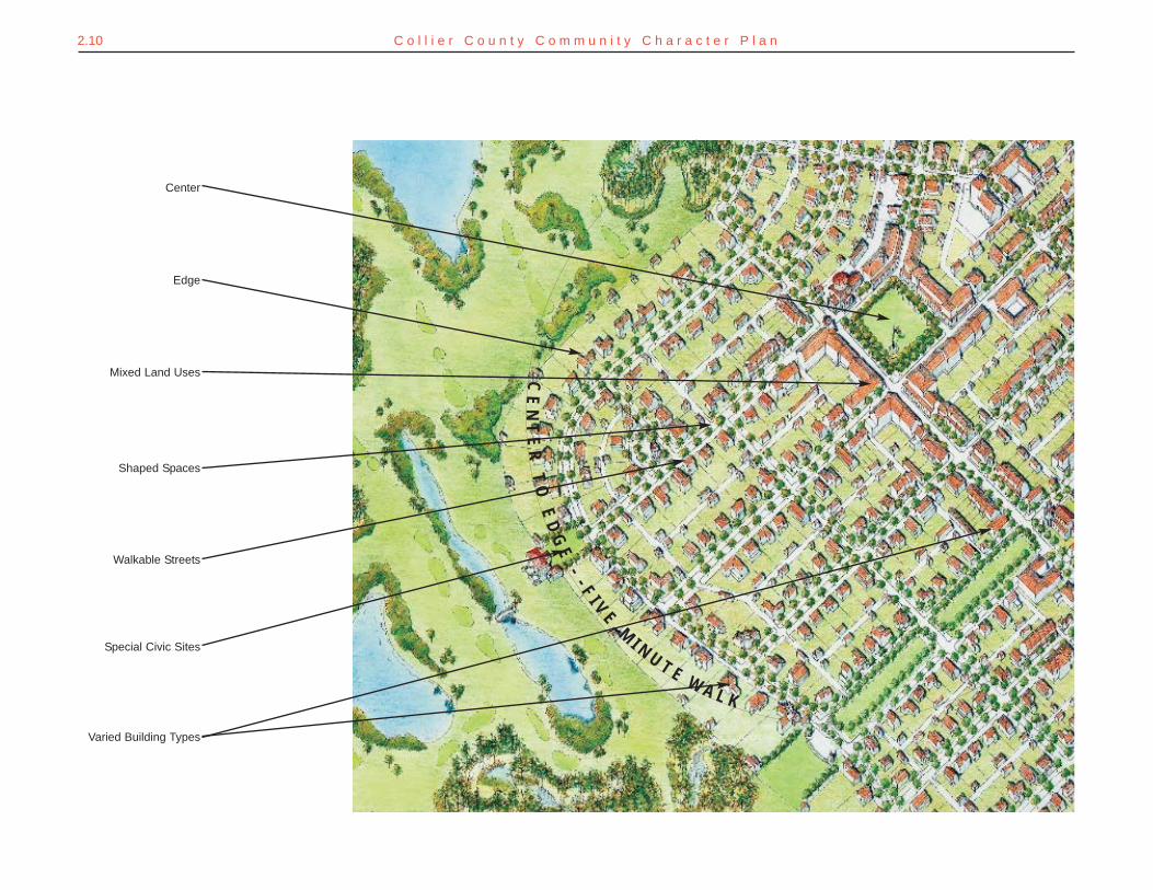
Identifiable Center and Edge – Neighborhoods generally have anidentifiable center and edge; one can tell when one has arrived in theneighborhood, and one can tell when they have reached the heart ofthe neighborhood.
Walkable Size – Most people will walk a distance of approximately¼ mile (1320 feet) before turning back or opting to drive or ride abike rather than walk. This dimension is a constant in the way peoplehave settled for centuries. Most neighborhoods built before World WarII are ¼ mile from center to edge. This distance relates to the mannerin which people define the edges of their own neighborhoods. OldNaples is just 1.5 miles long by 3/4 mile wide. A ¼ mile radius from5th Avenue shopping in old Naples would include Central Avenuesouth to 9th Avenue and 4th Street east to Tamiami Trail, for example.
Of course, neighborhoods are not necessarily circular in design, noris that desirable. The ¼ mile radius is a benchmark for creating aneighborhood unit that is manageable in size and feel and is inher-ently walkable. Neighborhoods of many shapes and sizes can satisfythe ¼ mile radius test. It is also important to note that larger devel-opments or master planned communities can satisfy the ¼ mileradius by establishing several distinct neighborhoods or quarterswithin the community.
Proper Building Placement – Character-rich neighborhoods oftenhave houses within a conversational distance of the sidewalk, produc-ing a neighborly environment that promotes social interaction. This isan excellent strategy for overcoming the isolation and disconnected-ness of which suburban householders often complain. Buildings andtrees positioned fairly close to the street also yield an environment
which feels very comfortable for pedestrians; this is because a degreeof spatial enclosure is agreeable to the human eye. In both residentialand mixed-use settings, spatial enclosure results from the proportionalrelationship between the width of the space and the height of thebuildings that frame the space. Houses that are built close to the streetoffer another fundamental benefit for a neighborhood, by providing asense of safety through what Jane Jacobs termed “eyes on the street.”Having front porches, balconies, and windows that overlook the side-walk and street creates a feeling of safety because one can sense thatif something were to happen, someone might see or hear the event.This apparent closeness and supervision may sometimes only be a per-ception, but it is a potent deterrent to crime nonetheless. Securityspecialists and law enforcement officers call this concept “crime pre-vention through environmental design,” and it is especially importantin a time when security concerns have driven householders behindgates and bars. Lastly, positioning buildings forward on their lotsmakes the householders’ private spaces more generous in size, bothindoors and out.
Integrated Network ofWalkable Streets – A network ofstreets allows pedestrians, cyclists,and motorists to move safely andcomfortably through a neighborhood.A network forms blocks that are anappropriate size for walking, and pro-vides multiple routes. The networkof streets also provides non-automo-bile alternatives to the two largestsegments of Collier’s population: those under the driving age, and sen-ior citizens.
2.11C o m m u n i t y D e s i g n M a n u a l
Walkable streets are characterized by the separation of sidewalk andcurb and/or roadway to protect pedestrians from moving traffic, theyare also shaded by street trees that are usually placed between theroadway and sidewalk for added pedestrian / vehicular separation.Walkable streets also provide adequate lighting and “eyes on thestreet” for added security. Walkable residential streets and commer-cial streets differ in design and character as is illustrated in theMobility Manual.
Special Sites for Civic Purposes –Prominent locations, such as the terminatedvista of a road or at the top of a hill, shouldbe reserved for civic buildings. These loca-tions include building sites at the end of along view, terminating the view down astreet, and anchoring a prominent streetcorner or neighborhood square. Theseunique settings within the neighborhoodsare opportunities for community pride.Civic buildings, because they serve theentire community, should be accessible andlocated in areas with greater activity. Similarly,special sites should be set aside for squares,parks, and plazas. Each neighborhood shouldhave one special gathering space at its center, such as a village green.
Mix of Land Uses and Building Types – Great neighborhoodshave a fine-grained mix and variety of uses and building types. Aassortment of uses gives residents the ability to live, work, play, shop,
and find daily needs and services within walking distance. An assort-ment of building types allows for people with diverse lifestyles andincomes to live in the same neighborhood without a diminishing ofthe character or quality of that neigh-borhood. For instance, in a shopfrontbuilding, the business owner oremployees could live in a secondfloor apartment, or the upper floorscould be rented as office space.Nearby, rowhouses and cottages canbe located very close to detachedhomes and even mansions. Naturallythis requires substantial design disci-pline; designers must work to make sure that compatible buildingtypes face one another across unified streets. Most transitions betweensubstantially different building types should occur at the rear lot lines.
It is understood that the amount of non-residential uses will vary fromneighborhood to neighborhood. In many cases, business uses will needto be located near the edge along an important traffic route, ratherthan the center. Some neighborhoods may have only a tiny commer-cial presence, but the key is providing great flexibility in land use evenwhile tightening design controls. This shift — from focusing on landuse to emphasizing design, from single-use, single-design “pods” tomixed-use, variety-rich neighborhoods — has benefits in three keyareas. First, in transportation, the mixing of uses is the most powerfulway to reduce unnecessary traffic congestion because many auto tripsare either shortened or eliminated. Second, the mixed use scenario isfar better socially, since it makes it feasible for householders to put
2.12 C o l l i e r C o u n t y C o m m u n i t y C h a r a c t e r P l a n
Most importantly, the design conventions that generate livablecommunities— like walkability and interconnectedness— were appliedonly occasionally and haphazardly even then. Commonly the individ-ual uses are separated in a manner consistent with conventional zon-ing, thus negating one objective of the PUD. In several cases the dis-tances are too great or the access between such mixed uses is improb-able or impossible for a pedestrian or bicyclist to navigate. The Countyhas experimented with density incentives in exchange for intercon-necting streets, in an attempt to reintroduce a basic norm lost to thevery flexibility for which the PUD process was conjured, but the sheermarketability of low-density sprawl meant few developers, if any,opted to pursue the incentives.
The unintended consequence of the PUD trend was to create an easierapproval process for pedestrian-unfriendly, disconnected, and essen-tially homogeneous large scale developments. Eventually, the combi-nation of easy approvals under the PUD process and the large tracts ofland under private ownership led to nearly all the developable land inthe urbanized area being designated as PUDs. As these PUDs began toaccumulate, so did a host of problems with traffic, disappearing openspace, and loss of identity. Eventually, a public backlash, uniting envi-ronmental activists and aggrieved neighbors as critics of the PUDs,emerged in Collier County. Today, almost all PUD approvals burden
2.13C o m m u n i t y D e s i g n M a n u a l
down roots in the community and come to know their neighbors, andhousing for families of modest means is included and therefore neednot be segregated into concentrations (or pushed to the next county).Third, the occupancy of the neighborhood by households with variedschedules and interests not only adds vibrancy to the place (as com-pared to suburbs that are deserted at certain times of the day or daysof the week) but adds security, as well.
HOW COLLIER COUNTY BUILDS NEIGHBORHOODSTODAY
Almost thirty years ago, Planned Unit Developments (PUDs) werewritten into the Land Development Code in response to the develop-ment boom in Collier County. Based on a national development trend,PUDs were legalized “to encourage ingenuity, innovation and imagina-tion in the planning, design, and development or redevelopment ofrelatively large tracts of land under unified ownership or control”(Collier County Land Development Code, 1999). But as the next sen-tence in the Code indicates, this new PUD approach allowed develop-ers to vary from the standard regulations, “PUDs produced in compli-ance with the terms and provisions of this code and the growth man-agement plan may depart from the strict application of setback,height, and minimum lot requirements of conventional zoning dis-tricts...” (Collier County Land Development Code, 1999).
The intention of PUD zoning was to give the developer greater flexibil-ity to provide innovative solutions to large-scale projects such as mas-ter planned communities. Although the code calls for a mix of uses,the result is usually quite homogeneous, one or two uses per PUD.
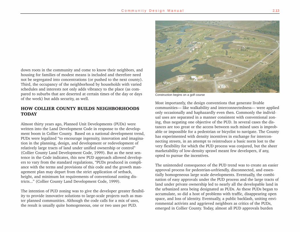
Construction begins on a golf course
the County Commission with a decision that causes political turmoiland engenders rancor among leaders and constituents alike. Politiciansfeel pressured to approve projects that resemble comparable peer proj-ects to maintain an appearance of fairness and equality. The Countyneeds to set reasonable standards and guidelines by which to judgePUD projects, to determine whether the design has merit and if it cre-ates character. The yardstick for design success in Collier has becomequite short.
What Lies Ahead?
Collier County has several futures from which to choose. The least sus-tainable is the business-as-usual model. Left to operate within theexisting rules and habits, development in the recent manner and atthe current rate will cripple the road network and decimate anyremaining character in Collier County. The Community Character Planwas undertaken at the urging of citizens who foresaw such a futureand sought to alter it.
The currently approved PUD projects, if built out to the intendeddesign capacity, would have a profound impact on the Collier land-scape. Approved PUDs alone include 42,792 new dwelling units. Thisnumber multiplied by a 65.66% occupancy rate and the 1990 censusallocation of 2.41 persons per dwelling unit produces 67,549 newCollier residents. These new residents must live somewhere. The ram-pant consumption of undeveloped land for sprawl-type communitiescoupled with current policies on density, affordable housing, andurban form will lead to a collapse of Collier County’s prestige anddesirability. This scenario is often compared to the disastrous change
2.14 C o l l i e r C o u n t y C o m m u n i t y C h a r a c t e r P l a n
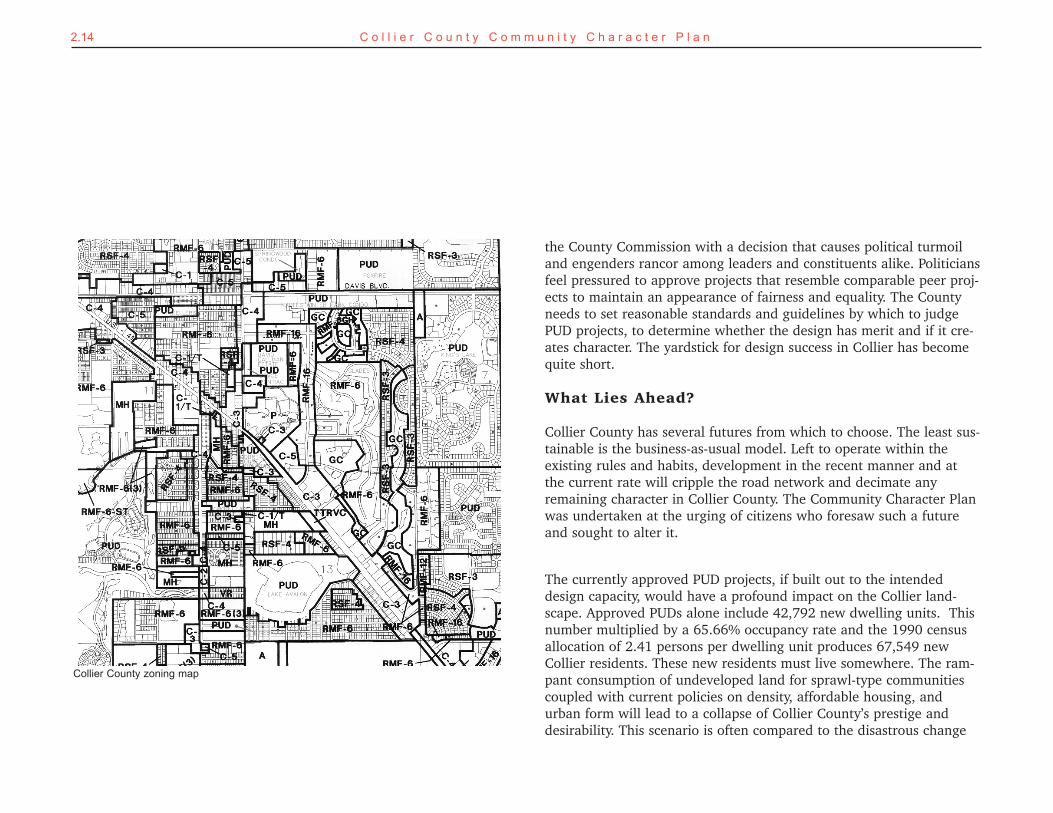
Collier County zoning map
in character experienced during the last forty years in Miami-Dadeand Broward counties. Many residents spoke during the planningprocess about how they did not want Collier County to turn into aGulf coast equivalent of those struggling places, and yet the develop-ment pattern exhibited in recent Collier sprawl mirrors the worst ofthose counties’ disappointing growth patterns.
The alternative is clear. The culture of community-making and spirit ofresponsibility demonstrated by the County’s pioneers and townfounders can be reestablished. Community character should be placedat the forefront of planning decisions, not contemplated as an after-thought. Housing density must be rethought, especially in core areasand activity centers; the bias against higher density and toward plan-ning by the numbers – with an assumption that lower density is betterdensity – needs to be replaced with an emphasis on design. Affordablehousing needs to be addressed in bricks and mortar, not lip service.Streets of such quality that they are genuine amenities in the neigh-borhoods they serve, instead of just utilitarian “traffic sewers,” shouldbe customary.
2.15C o m m u n i t y D e s i g n M a n u a l
Eight Factors Supporting Traditional Neighborhood Development
From the developer's point of view --
1. Relatively higher densities enable a lower land cost per unit. Public spaces created by tra-ditional neighborhood planning- the trade-off that allows higher densities- also serve as sub-stantial amenities for the community.
2. Lower up-front infrastructure costs are required prior to building and selling the first unitscompared with a conventional master-planned community. The first construction phase canoffer the full range of housing types in one area, rather than in separate "pods" for each hous-ing type, each with its own associated infrastructure.
3. Greater product flexibility throughout the neighborhood enables quick response to changingmarket demand characteristics.
4. The market can be deeper than just "new home buyers." TNDs offer a new constructionalternative that conveys the diversity and pedestrian orientation of typically highly-valued olderneighborhoods. Many resale buyers find these aspects of community lacking in conventionalsubdivisions and master-planned communities.
From the investor's point of view --
5. Residual value is enhanced. Once the TND is established, appreciation of remainingdwelling units- particularly in later phases- should occur at a higher rate than within conven-tional master-planned communities in otherwise similar circumstances. Appreciation is mani-fest as some combination of escalating sales or rising prices.
6. With little or no privately-owned retail common areas, neighborhood and "main street" shop-ping districts do not require periodic refurbishment to maintain market appeal. The environ-ment is constantly renewed as the shopfronts change, upgrade, and evolve.
From the municipality's point of view --
7. Integrated-use development creates a broader, more balanced tax base for municipalities.
8. Public maintenance and infrastructure costs are lower for higher-density developmentbecause of the greater economies of scale, shorter runs of lower tech infrastructure.
-Excerpted from Development Feasibility and Implementation of Traditional Neighborhoods byTodd Zimmerman, Laurie Volk, and Peter Katz. (reprinted with permission).
improvements designed to impart a sense of predictable return oninvestment will attract new generations of residents to Naples Park,and their contributions will be beneficial. (Absent such a strategy,haphazard redevelopment— in which older, smaller homes are incre-mentally knocked down and replaced with tracts of disappointingcharacter— is likely, given the scarcity of land in the western parts ofthe county.)
Naples Park should have an officially sanctioned plan, with its detailsgenerated through the grassroots involvement of the neighbors; thisplan should promote the area’s intrinsic strengths, including its open-ness and its connected street scene. This plan would be used to guidepublic and private improvements but also to reposition these neigh-borhoods in the marketplace as the county’s premier alternative tosprawl. Interestingly, the basic bone structure of Naples Park showsevidence of some of the same ideas underlying the latest “NewUrbanist” neighborhoods that have proven so marketable around thecountry. In the Naples Park of the future, homebuyers should find thesense of community and authenticity lacking in the corporate, slicklypackaged subdivisions built in the 1990s further east.
The key to this lies in getting the physical details right. The transfor-mation of Naples Park from neglected older suburb to premier neigh-borhoods will not occur overnight. Several steps to aid the transfor-mation are outlined below. These essential steps can be used for mostolder neighborhoods in Collier County. For example, these strategiesshould be applicable to Golden Gate City (see Evolving the SubdividedPeriphery.)
2.16 C o l l i e r C o u n t y C o m m u n i t y C h a r a c t e r P l a n
REVITALIZING MATURING NEIGHBORHOODS
Collier residents identified several neighborhoods in the region asbeing among their favorites, such as Old Naples. Old Naples hasrecently benefited from several years of reinvestment focused on thewell-coordinated revitalization of Fifth Avenue, with its spectacularinfill development and redevelopment.
Making Good Neighborhoods into Great Neighborhoods
How can other neighborhoods benefit from these characteristics?Naples Park is an excellent example to study. On one hand, NaplesPark enjoys an organized, diverse citizenry determined to improve theneighborhood, a close-to-the-Gulf location, a relatively connected lay-out, and underutilized real estate that has begun to attract the atten-tion of builders. On the other hand, the public realm in Naples Parksuffers from years of disinvestment; the tree canopy is inadequate,streets appear worn and unfinished and invite speeding, and overallthe suburb is not aging as gracefully as it should. Naples Park hasreached a threshold in its history. It will be either re-energized andtransformed for the better or its character will continue to decline.
Naples Park is one of the older first-ring suburbs in Collier County. It islocated along the U.S. 41 corridor and stands out compared with thenewer developments surrounding it. Real estate here is still relativelyaffordable, at least for the time being. While not exactly the “innercity,” Naples Park resembles many of the older neighborhoods in citiesacross the US that were rediscovered by home buyers during the pasttwenty years and now fetch higher prices than new sprawl develop-ment. If that pattern holds true here, a strategic policy and physical
2.17C o m m u n i t y D e s i g n M a n u a l
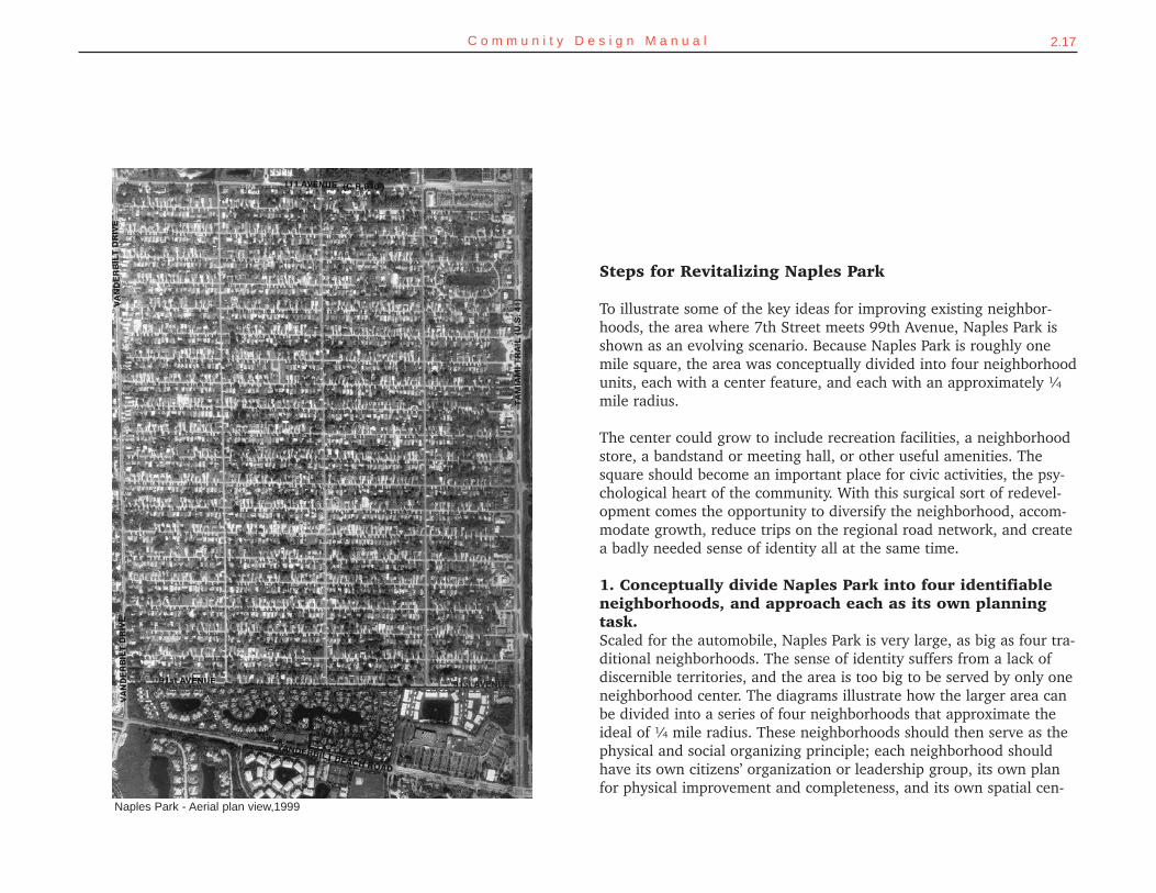
Naples Park - Aerial plan view,1999
Steps for Revitalizing Naples Park
To illustrate some of the key ideas for improving existing neighbor-hoods, the area where 7th Street meets 99th Avenue, Naples Park isshown as an evolving scenario. Because Naples Park is roughly onemile square, the area was conceptually divided into four neighborhoodunits, each with a center feature, and each with an approximately ¼mile radius.
The center could grow to include recreation facilities, a neighborhoodstore, a bandstand or meeting hall, or other useful amenities. Thesquare should become an important place for civic activities, the psy-chological heart of the community. With this surgical sort of redevel-opment comes the opportunity to diversify the neighborhood, accom-modate growth, reduce trips on the regional road network, and createa badly needed sense of identity all at the same time.
1. Conceptually divide Naples Park into four identifiableneighborhoods, and approach each as its own planningtask.Scaled for the automobile, Naples Park is very large, as big as four tra-ditional neighborhoods. The sense of identity suffers from a lack ofdiscernible territories, and the area is too big to be served by only oneneighborhood center. The diagrams illustrate how the larger area canbe divided into a series of four neighborhoods that approximate theideal of ¼ mile radius. These neighborhoods should then serve as thephysical and social organizing principle; each neighborhood shouldhave its own citizens’ organization or leadership group, its own planfor physical improvement and completeness, and its own spatial cen-
2.18 C o l l i e r C o u n t y C o m m u n i t y C h a r a c t e r P l a n
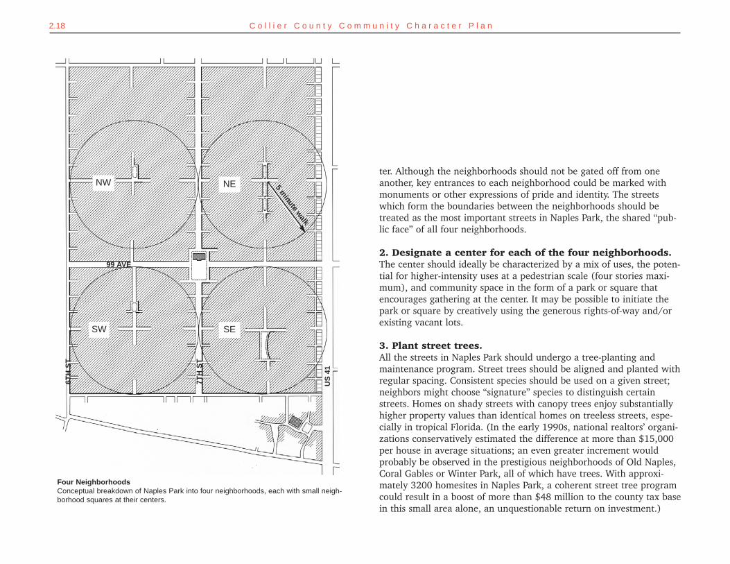
ter. Although the neighborhoods should not be gated off from oneanother, key entrances to each neighborhood could be marked withmonuments or other expressions of pride and identity. The streetswhich form the boundaries between the neighborhoods should betreated as the most important streets in Naples Park, the shared “pub-lic face” of all four neighborhoods.
2. Designate a center for each of the four neighborhoods. The center should ideally be characterized by a mix of uses, the poten-tial for higher-intensity uses at a pedestrian scale (four stories maxi-mum), and community space in the form of a park or square thatencourages gathering at the center. It may be possible to initiate thepark or square by creatively using the generous rights-of-way and/orexisting vacant lots.
3. Plant street trees.All the streets in Naples Park should undergo a tree-planting andmaintenance program. Street trees should be aligned and planted withregular spacing. Consistent species should be used on a given street;neighbors might choose “signature” species to distinguish certainstreets. Homes on shady streets with canopy trees enjoy substantiallyhigher property values than identical homes on treeless streets, espe-cially in tropical Florida. (In the early 1990s, national realtors’ organi-zations conservatively estimated the difference at more than $15,000per house in average situations; an even greater increment wouldprobably be observed in the prestigious neighborhoods of Old Naples,Coral Gables or Winter Park, all of which have trees. With approxi-mately 3200 homesites in Naples Park, a coherent street tree programcould result in a boost of more than $48 million to the county tax basein this small area alone, an unquestionable return on investment.)
Four NeighborhoodsConceptual breakdown of Naples Park into four neighborhoods, each with small neigh-borhood squares at their centers.
5 minute w
alk
NW
6TH
ST
99 AVE
7TH
ST
US
41
NE
SESW
2.19C o m m u n i t y D e s i g n M a n u a l
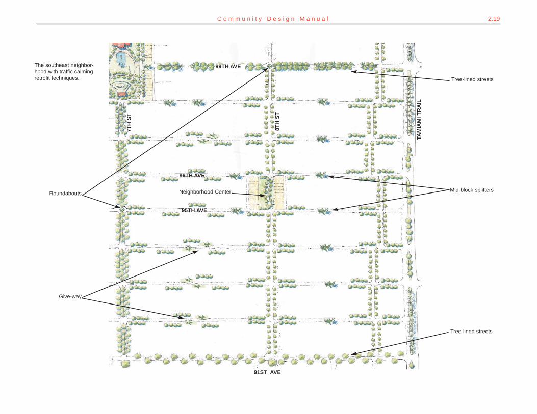
The southeast neighbor-hood with traffic calmingretrofit techniques.
Mid-block splitters
Tree-lined streets
Tree-lined streets
Give-way
Roundabouts
95TH AVE
8TH
ST
7TH
ST
TAM
IAM
I TR
AIL
96TH AVE
Neighborhood Center
99TH AVE
91ST AVE
2.20 C o l l i e r C o u n t y C o m m u n i t y C h a r a c t e r P l a n
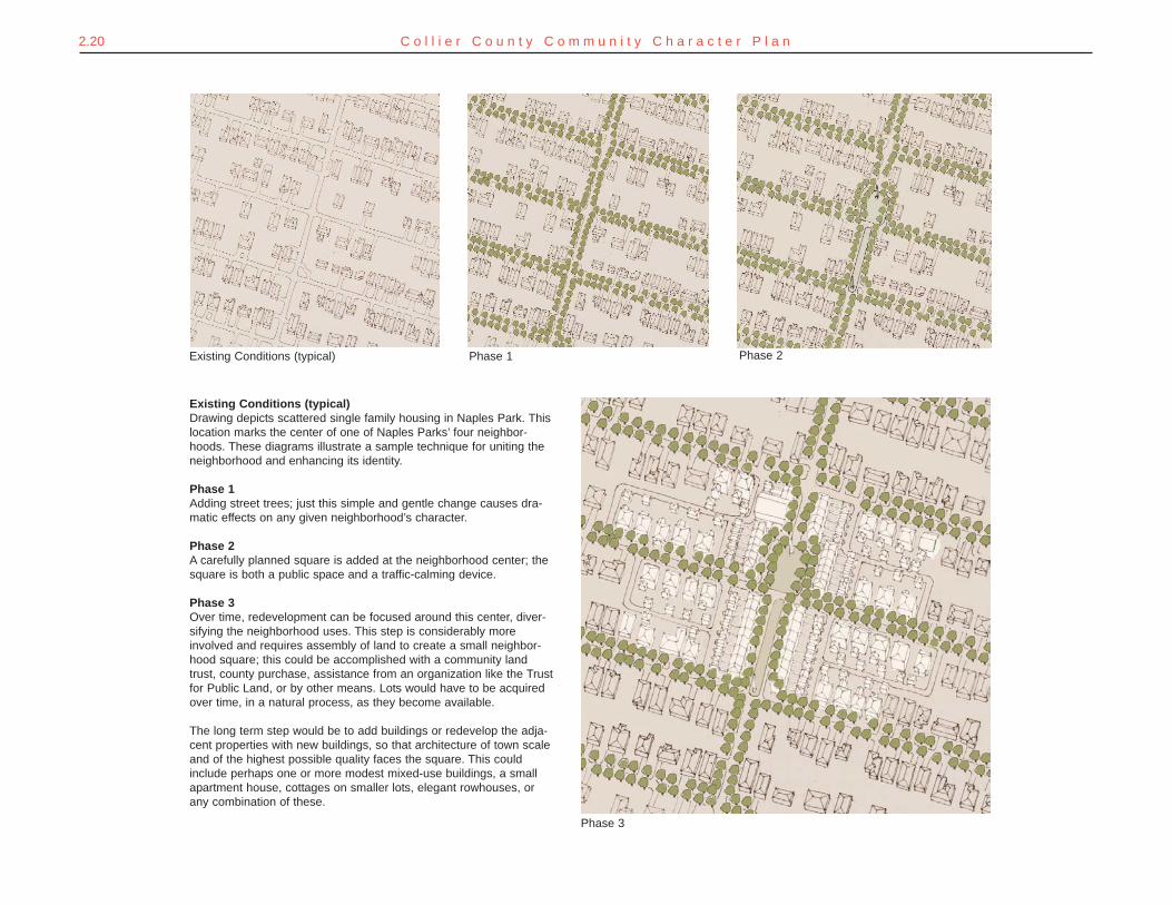
Existing Conditions (typical) Phase 1 Phase 2
Phase 3
Existing Conditions (typical)Drawing depicts scattered single family housing in Naples Park. Thislocation marks the center of one of Naples Parks’ four neighbor-hoods. These diagrams illustrate a sample technique for uniting theneighborhood and enhancing its identity.
Phase 1Adding street trees; just this simple and gentle change causes dra-matic effects on any given neighborhood’s character.
Phase 2A carefully planned square is added at the neighborhood center; thesquare is both a public space and a traffic-calming device.
Phase 3Over time, redevelopment can be focused around this center, diver-sifying the neighborhood uses. This step is considerably moreinvolved and requires assembly of land to create a small neighbor-hood square; this could be accomplished with a community landtrust, county purchase, assistance from an organization like the Trustfor Public Land, or by other means. Lots would have to be acquiredover time, in a natural process, as they become available.
The long term step would be to add buildings or redevelop the adja-cent properties with new buildings, so that architecture of town scaleand of the highest possible quality faces the square. This couldinclude perhaps one or more modest mixed-use buildings, a smallapartment house, cottages on smaller lots, elegant rowhouses, orany combination of these.
2.21C o m m u n i t y D e s i g n M a n u a l
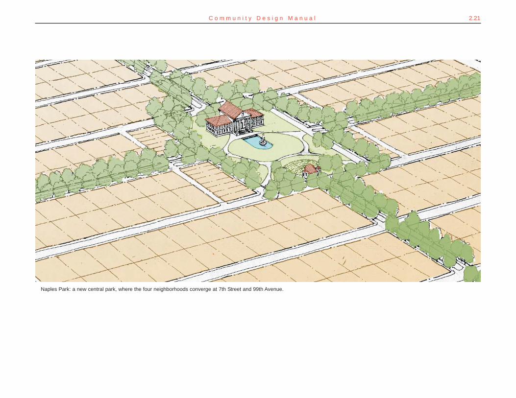
Naples Park: a new central park, where the four neighborhoods converge at 7th Street and 99th Avenue.
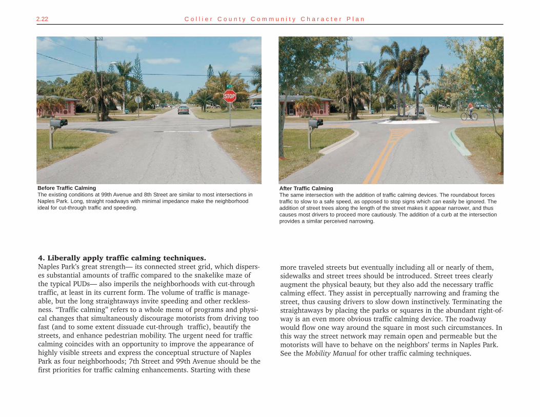
more traveled streets but eventually including all or nearly of them,sidewalks and street trees should be introduced. Street trees clearlyaugment the physical beauty, but they also add the necessary trafficcalming effect. They assist in perceptually narrowing and framing thestreet, thus causing drivers to slow down instinctively. Terminating thestraightaways by placing the parks or squares in the abundant right-of-way is an even more obvious traffic calming device. The roadwaywould flow one way around the square in most such circumstances. Inthis way the street network may remain open and permeable but themotorists will have to behave on the neighbors’ terms in Naples Park.See the Mobility Manual for other traffic calming techniques.
2.22 C o l l i e r C o u n t y C o m m u n i t y C h a r a c t e r P l a n
4. Liberally apply traffic calming techniques.Naples Park’s great strength— its connected street grid, which dispers-es substantial amounts of traffic compared to the snakelike maze ofthe typical PUDs— also imperils the neighborhoods with cut-throughtraffic, at least in its current form. The volume of traffic is manage-able, but the long straightaways invite speeding and other reckless-ness. “Traffic calming” refers to a whole menu of programs and physi-cal changes that simultaneously discourage motorists from driving toofast (and to some extent dissuade cut-through traffic), beautify thestreets, and enhance pedestrian mobility. The urgent need for trafficcalming coincides with an opportunity to improve the appearance ofhighly visible streets and express the conceptual structure of NaplesPark as four neighborhoods; 7th Street and 99th Avenue should be thefirst priorities for traffic calming enhancements. Starting with these
Before Traffic CalmingThe existing conditions at 99th Avenue and 8th Street are similar to most intersections inNaples Park. Long, straight roadways with minimal impedance make the neighborhoodideal for cut-through traffic and speeding.
After Traffic Calming The same intersection with the addition of traffic calming devices. The roundabout forcestraffic to slow to a safe speed, as opposed to stop signs which can easily be ignored. Theaddition of street trees along the length of the street makes it appear narrower, and thuscauses most drivers to proceed more cautiously. The addition of a curb at the intersectionprovides a similar perceived narrowing.
2.23C o m m u n i t y D e s i g n M a n u a l
5. Create pedestrian and bicycle connections.There are too few reasons to walk anywhere, and given the lack ofstreet trees and sidewalks, walking for pleasure is also discouraged. Inrecent public meetings, residents of Naples Park expressed a desire tobe able to walk comfortably in their neighborhood, but because of cut-through traffic, speeding cars, and a lack of shade trees, people areoften hesitant to walk, especially with children.
6. Sidewalks should be provided on all streets.Streets within the neighborhoods need not have dedicated bike lanes(although this is an option for perceptually “narrowing” the pavementfor traffic calming reasons, if no other option is achievable in the shortterm on a given road). However, the streets in Naples Park can easilybe optimized by cycling by the addition of a tree canopy and trafficcalming devices.
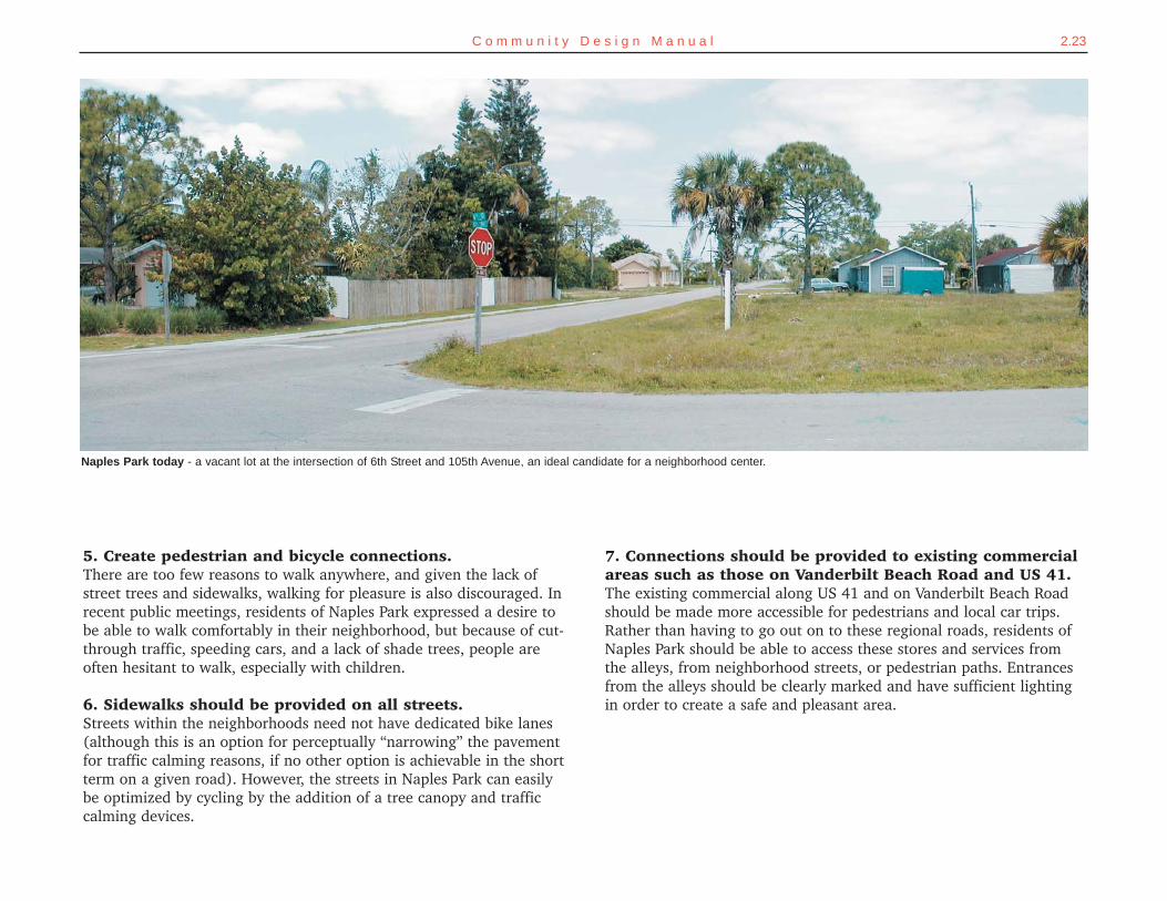
Naples Park today - a vacant lot at the intersection of 6th Street and 105th Avenue, an ideal candidate for a neighborhood center.
7. Connections should be provided to existing commercialareas such as those on Vanderbilt Beach Road and US 41.The existing commercial along US 41 and on Vanderbilt Beach Roadshould be made more accessible for pedestrians and local car trips.Rather than having to go out on to these regional roads, residents ofNaples Park should be able to access these stores and services fromthe alleys, from neighborhood streets, or pedestrian paths. Entrancesfrom the alleys should be clearly marked and have sufficient lightingin order to create a safe and pleasant area.
Augustine were densified historically). Occasional alleys would allowsome narrower lots, reducing the per-unit land cost and making rede-velopment feasible. This approach also allows the creation of moreaffordable dwellings that are nevertheless very dignified, makes efficientuse of existing infrastructure, and encourages more activity at the cen-ter. The approach also improves safety, while adding texture and inter-est to the neighborhood center.
10. Create new parks or greens in existing or enlargedrights-of-way.Citizens in Naples Park expressed a desire for more opportunities toknow their neighbors and to venture out into the public realm withouttheir vehicles, but there are few spots to do this. These improvementsto the right-of-way will serve a triple purpose. Not only will they addto the physical beauty and add traffic calming, but also they will cre-ate an open public place for civic activities or simple recreation. Places
2.24 C o l l i e r C o u n t y C o m m u n i t y C h a r a c t e r P l a n
8. Reorganize blocks and lots in the immediate areaaround centers.Naples Park, although based on a grid of streets, suffers from theunrelenting nature of the grid. As discussed above, while a networkis a necessity, the combination of an unending gridiron, curblessstreets, and the low densities and detached building types of suburbiais undesirable. The lack of variation in the pattern or appearance ofthe streets discourages pedestrian activity and actually encouragescut-through traffic, since the clear sight distances and straightawaysincite faster driving. As the existing aerial photograph reveals, thegrid of Naples Park streets is virtually uninterrupted.
9. Create some smaller lots through subdivision and recla-mation of vacant lots at the center of each new neighbor-hood; this will allow graceful densification over time (inmuch the same way the memorable parts of Savannah or St.
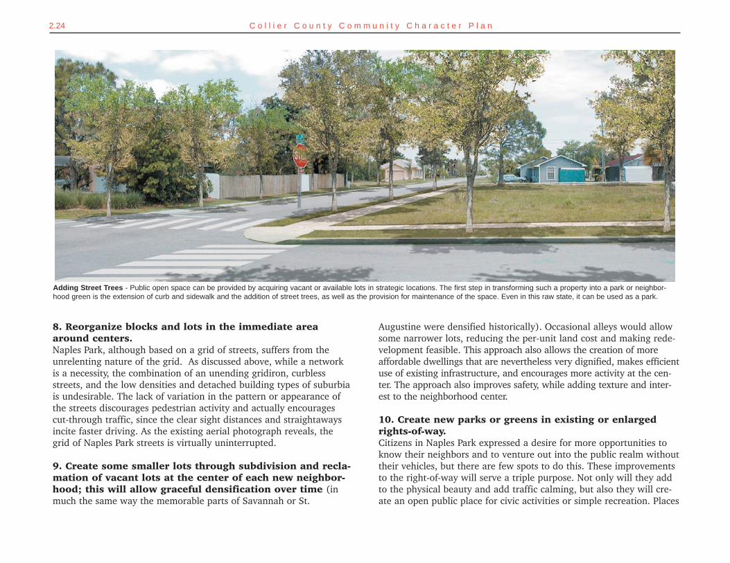
Adding Street Trees - Public open space can be provided by acquiring vacant or available lots in strategic locations. The first step in transforming such a property into a park or neighbor-hood green is the extension of curb and sidewalk and the addition of street trees, as well as the provision for maintenance of the space. Even in this raw state, it can be used as a park.
2.25C o m m u n i t y D e s i g n M a n u a l2.25
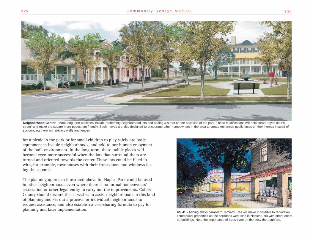
Neighborhood Center - More long term additions include reorienting neighborhood lots and adding a street on the backside of the park. These modifications will help create “eyes on thestreet” and make the square more pedestrian friendly. Such moves are also designed to encourage other homeowners in the area to create enhanced public faces on their homes instead ofsurrounding them with privacy walls and fences.
US 41 - Adding alleys parallel to Tamiami Trail will make it possible to redevelopcommercial properties on the corridor’s west side in Naples Park with street orient-ed buildings. Note the importance of trees even on the busy thoroughfare.
for a picnic in the park or for small children to play safely are basicequipment in livable neighborhoods, and add to our human enjoymentof the built environment. In the long term, these public places willbecome even more successful when the lots that surround them areturned and oriented towards the center. These lots could be filled inwith, for example, townhouses with their front doors and windows fac-ing the squares.
The planning approach illustrated above for Naples Park could be usedin other neighborhoods even where there is no formal homeowners’association or other legal entity to carry out the improvements. CollierCounty should declare that it wishes to assist neighborhoods in this kindof planning and set out a process for individual neighborhoods torequest assistance, and also establish a cost-sharing formula to pay forplanning and later implementation.
2.26 C o l l i e r C o u n t y C o m m u n i t y C h a r a c t e r P l a n
SETTING THE COURSESome of Collier County’s neighborhoods aren’t aging as gracefully asthey should be and need to be re-energized. These neighborhoodsshould have officially sanctioned “community plans” generated throughdirect involvement of local residents. These plans should promote eachneighborhood’s intrinsic strengths and identify their deficiencies, andthen be used to guide public and private improvements.
GETTING THEREGrowth Management Plana. In the Future Land Use Element, adopt a new goal #2 stating that county planning
efforts shall recognize the variations among Collier County's diverse communities andthe special characters that are created by their physical settings, including roadsides,natural features, memorable buildings, and the public realm between buildings.
b. Add an achievable objective #1 under goal #2 about Collier County's commitment torevitalize older neighborhoods.
i. Add a policy describing typical improvements for maturing neighborhoods,such as adding sidewalks and street trees, creating focal points within walkableportions of neighborhoods, improving street connections, improving pedestrianaccess to shopping, and traffic calming.
ii. Add a policy that would allow a greater variety of housing types in maturingneighborhoods, such as accessory apartments, live-work units, or townhouses.
iii. Add a policy that describes the various levels of involvement that CollierCounty can use to improve or redevelop existing neighborhoods, including amunicipal service taxing or benefit district, a community plan, a communityredevelopment agency, or a dependent special district.
iv. Add a policy under objective #4 of goal #1 adding "community plans" as anew Collier County planning process that can be requested for existing neigh-borhoods or commercial/industrial developments. Community plans couldinclude the following steps:1. Collier County would declare that it wishes to assist neighborhoods in
community planning and set out a process for individual neighborhoods torequest professional assistance.
2. The process would typically include:a. neighborhood meetings to gather input and develop design and
implementation ideas;b. preparation of a master plan;c. acceptance of this master plan by Collier County, as part of the
community plan;d. adoption of any amendments that are needed to the growth man-
agement plan or land development code;e. determination of cost-sharing requirements for capital improve-
ments; andf. initiation of any capital improvements through normal county channels.
3. An administrative code would be adopted with the details of the communi-ty planning process, such as the application process, suggested time-frames, and whether the group would be assisted by county staff, consult-ants selected for each neighborhood, or consultants on retainer; and
4. General guidelines for cost-sharing of community improvements would beprovided. Improvements of community-wide benefit would generally bepaid for by the county (such as new connector streets and associatedsidewalks and street trees), whereas improvements of local benefit mayrequire matching funds contributed by a private entity, another publicsource, or charged to property owners through a municipal service taxingor benefit district.
Administrative Codea. Adopt an administrative code establishing guidelines for community plans.
Land Development Codea. Allow single-family lots to be split when a continuous alley can be provided behind the
lots to allow vehicular access from the rear.b. Modify the required minimum depths of lots in situations where right-of-way acquisitions
have reduced lot depths.c. Make other changes to the land development code that are found necessary during the
community planning process.
Financing Issuesa. Allocate $250,000 annually beginning next fiscal year from the unincorporated municipal
service taxing district to fund community planning studies.b. Allocate $750,000 from the same source beginning in the following fiscal year to be used
in the capital improvements program as matching funds to implement community plans.
REVITALIZING MATURING NEIGHBORHOODS
2.27C o m m u n i t y D e s i g n M a n u a l
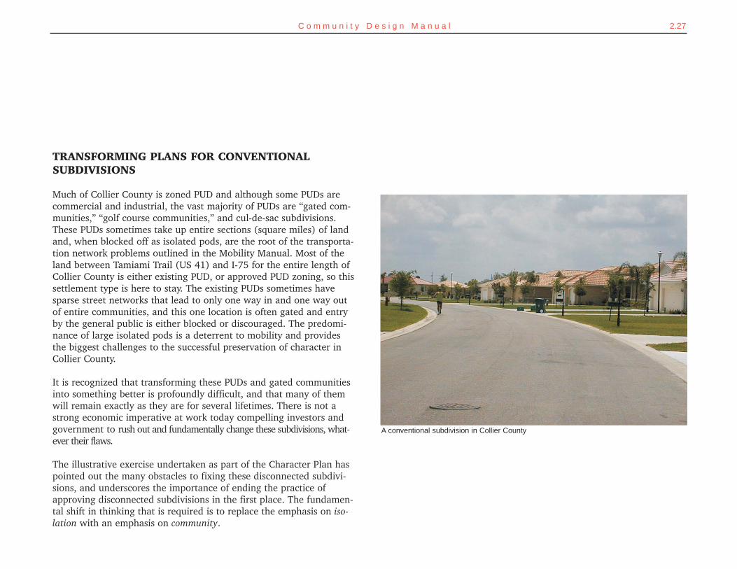
TRANSFORMING PLANS FOR CONVENTIONALSUBDIVISIONS
Much of Collier County is zoned PUD and although some PUDs arecommercial and industrial, the vast majority of PUDs are “gated com-munities,” “golf course communities,” and cul-de-sac subdivisions.These PUDs sometimes take up entire sections (square miles) of landand, when blocked off as isolated pods, are the root of the transporta-tion network problems outlined in the Mobility Manual. Most of theland between Tamiami Trail (US 41) and I-75 for the entire length ofCollier County is either existing PUD, or approved PUD zoning, so thissettlement type is here to stay. The existing PUDs sometimes havesparse street networks that lead to only one way in and one way outof entire communities, and this one location is often gated and entryby the general public is either blocked or discouraged. The predomi-nance of large isolated pods is a deterrent to mobility and providesthe biggest challenges to the successful preservation of character inCollier County.
It is recognized that transforming these PUDs and gated communitiesinto something better is profoundly difficult, and that many of themwill remain exactly as they are for several lifetimes. There is not astrong economic imperative at work today compelling investors andgovernment to rush out and fundamentally change these subdivisions, what-ever their flaws.
The illustrative exercise undertaken as part of the Character Plan haspointed out the many obstacles to fixing these disconnected subdivi-sions, and underscores the importance of ending the practice ofapproving disconnected subdivisions in the first place. The fundamen-tal shift in thinking that is required is to replace the emphasis on iso-lation with an emphasis on community.
A conventional subdivision in Collier County
2.28 C o l l i e r C o u n t y C o m m u n i t y C h a r a c t e r P l a n
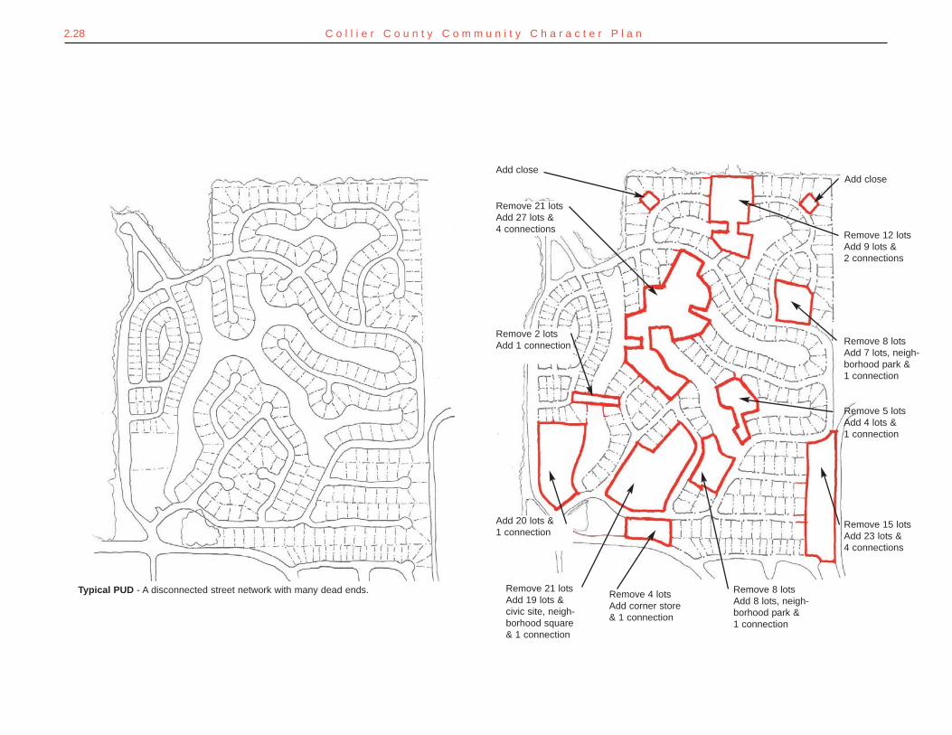
Add close
Remove 21 lots Add 27 lots &4 connections
Remove 2 lotsAdd 1 connection
Add 20 lots &1 connection
Remove 21 lots Add 19 lots &civic site, neigh-borhood square& 1 connection
Remove 4 lotsAdd corner store& 1 connection
Remove 8 lotsAdd 8 lots, neigh-borhood park &1 connection
Remove 15 lotsAdd 23 lots &4 connections
Remove 5 lotsAdd 4 lots &1 connection
Remove 8 lotsAdd 7 lots, neigh-borhood park &1 connection
Add close
Remove 12 lotsAdd 9 lots &2 connections
Typical PUD - A disconnected street network with many dead ends.
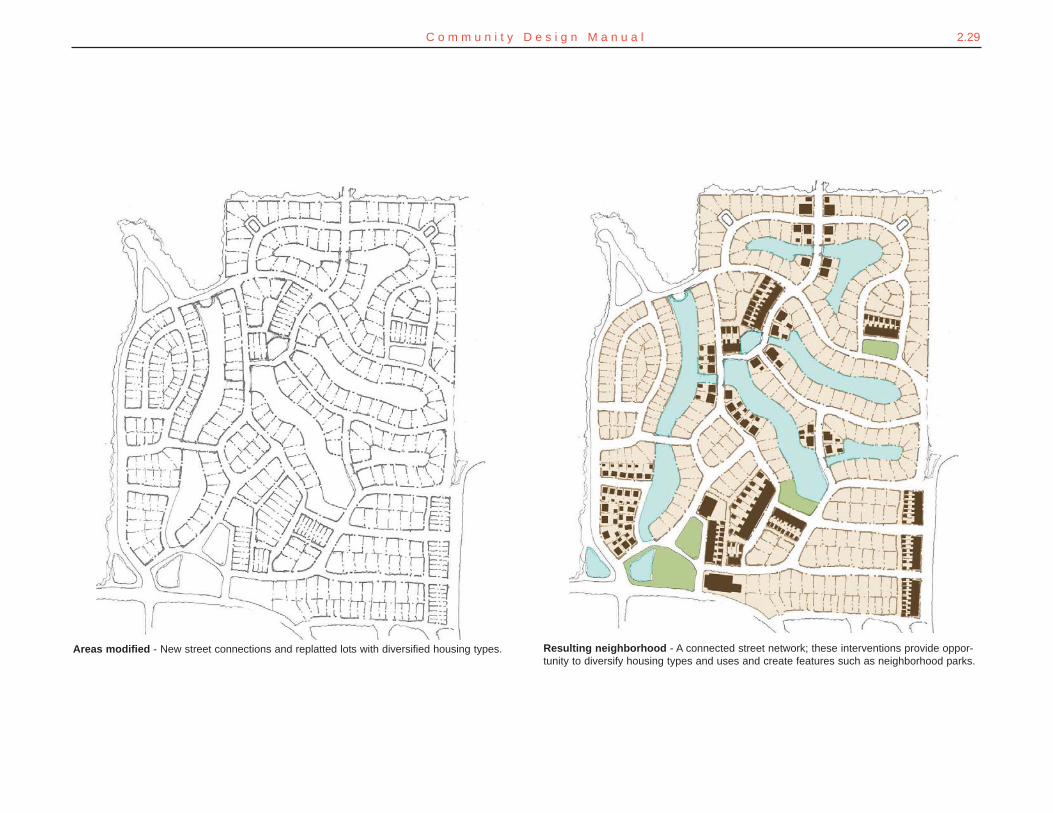
Resulting neighborhood - A connected street network; these interventions provide oppor-tunity to diversify housing types and uses and create features such as neighborhood parks.
Areas modified - New street connections and replatted lots with diversified housing types.
2.29C o m m u n i t y D e s i g n M a n u a l
5. Encourage a range of housing prices and types; where new street con-nections are made, single-family lots can be reconfigured for rowhousesor apartment buildings.
6. Liberally apply traffic calming, street tree planting, and sidewalks tomake the streets more livable and attractive.
7. Improve the image of the neighborhood by modifying houses, employ-ing front porches and de-emphasizing garage doors by moving themaway from the facade of the houses to de-emphasize garage doors.
2.30 C o l l i e r C o u n t y C o m m u n i t y C h a r a c t e r P l a n
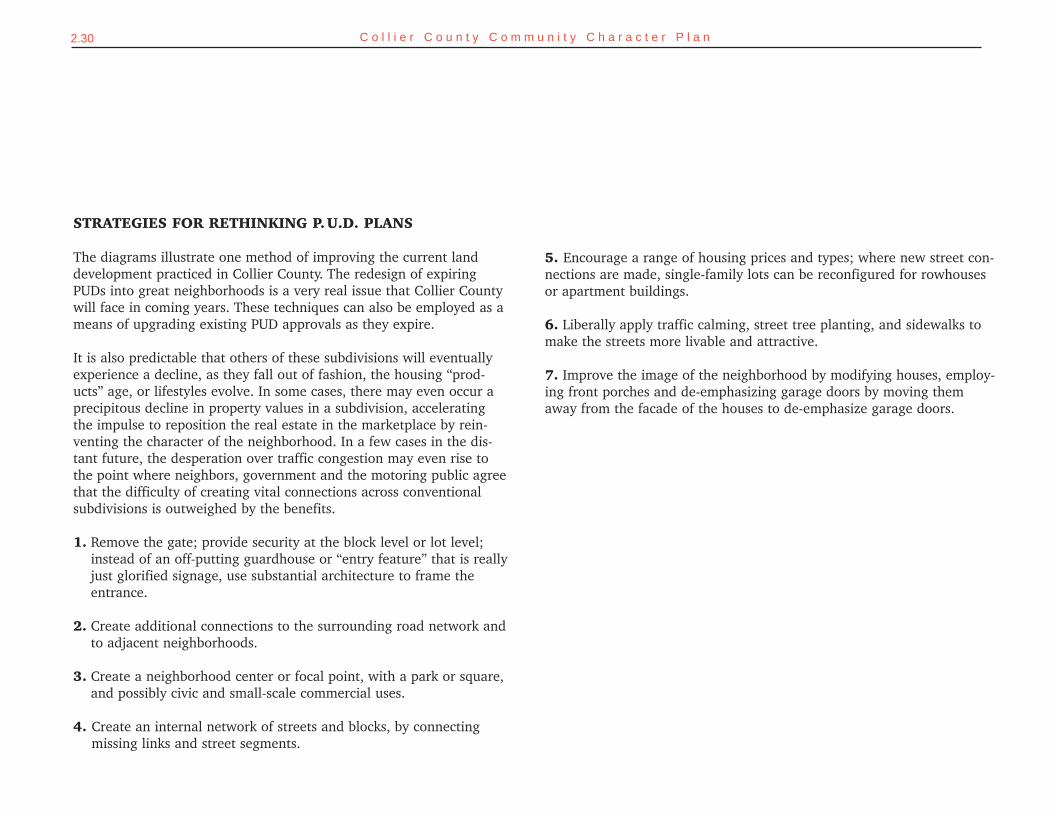
STRATEGIES FOR RETHINKING P.U.D. PLANS
The diagrams illustrate one method of improving the current landdevelopment practiced in Collier County. The redesign of expiringPUDs into great neighborhoods is a very real issue that Collier Countywill face in coming years. These techniques can also be employed as ameans of upgrading existing PUD approvals as they expire.
It is also predictable that others of these subdivisions will eventuallyexperience a decline, as they fall out of fashion, the housing “prod-ucts” age, or lifestyles evolve. In some cases, there may even occur aprecipitous decline in property values in a subdivision, acceleratingthe impulse to reposition the real estate in the marketplace by rein-venting the character of the neighborhood. In a few cases in the dis-tant future, the desperation over traffic congestion may even rise tothe point where neighbors, government and the motoring public agreethat the difficulty of creating vital connections across conventionalsubdivisions is outweighed by the benefits.
1. Remove the gate; provide security at the block level or lot level;instead of an off-putting guardhouse or “entry feature” that is reallyjust glorified signage, use substantial architecture to frame theentrance.
2. Create additional connections to the surrounding road network andto adjacent neighborhoods.
3. Create a neighborhood center or focal point, with a park or square,and possibly civic and small-scale commercial uses.
4. Create an internal network of streets and blocks, by connectingmissing links and street segments.
2.31C o m m u n i t y D e s i g n M a n u a l
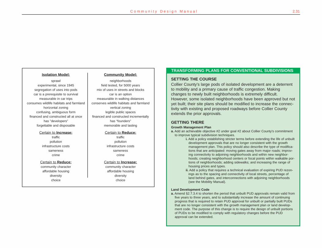
Isolation Model:
sprawlexperimental, since 1945
segregation of uses into podscar is a prerequisite to survival
measurable in car tripsconsumes wildlife habitats and farmland
horizontal zoningconfusing, ambiguous form
financed and constructed all at oncehas ”developers”
forgettable and disposable
Certain to Increase:traffic
pollutioninfrastructure costs
samenesscrime
Certain to Reduce:community characteraffordable housing
diversitychoice
Community Model:
neighborhoodsfield tested, for 5000 years
mix of uses in streets and blockscar is an option
measurable in walking distancesconserves wildlife habitats and farmland
vertical zoninglegible public spaces
financed and constructed incrementallyhas “founders”
memorable and lasting
Certain to Reduce:traffic
pollutioninfrastructure costs
samenesscrime
Certain to Increase:community characteraffordable housing
diversitychoice
SETTING THE COURSECollier County’s large pods of isolated development are a deterrentto mobility and a primary cause of traffic congestion. Makingchanges to newly built neighborhoods is extremely difficult.However, some isolated neighborhoods have been approved but notyet built; their site plans should be modified to increase the connec-tivity with existing and proposed roadways before Collier Countyextends the prior approvals.
GETTING THEREGrowth Management Plana. Add an achievable objective #2 under goal #2 about Collier County's commitment
to improve typical subdivision techniques.i. Add a policy establishing stricter terms before extending the life of unbuilt
development approvals that are no longer consistent with the growthmanagement plan. This policy should also describe the type of modifica-tions that are anticipated: moving gates away from major roads; improv-ing connectivity to adjoining neighborhoods and within new neighbor-hoods; creating neighborhood centers or focal points within walkable por-tions of neighborhoods; adding sidewalks; and increasing the range ofhousing prices and types.
ii. Add a policy that requires a technical evaluation of expiring PUD rezon-ings as to the spacing and connectivity of local streets, percentage ofland behind gates, and interconnections with adjoining neighborhoods(see the Mobility Manual).
Land Development Codea. Amend §2.7.3.4 to shorten the period that unbuilt PUD approvals remain valid from
five years to three years, and to substantially increase the amount of continuingprogress that is required to retain PUD approval for unbuilt or partially built PUDsthat are no longer consistent with the growth management plan or land develop-ment code. The purpose of this change is to require the design of unbuilt portionsof PUDs to be modified to comply with regulatory changes before the PUDapproval can be extended.
TRANSFORMING PLANS FOR CONVENTIONAL SUBDIVISIONS
2.32 C o l l i e r C o u n t y C o m m u n i t y C h a r a c t e r P l a n
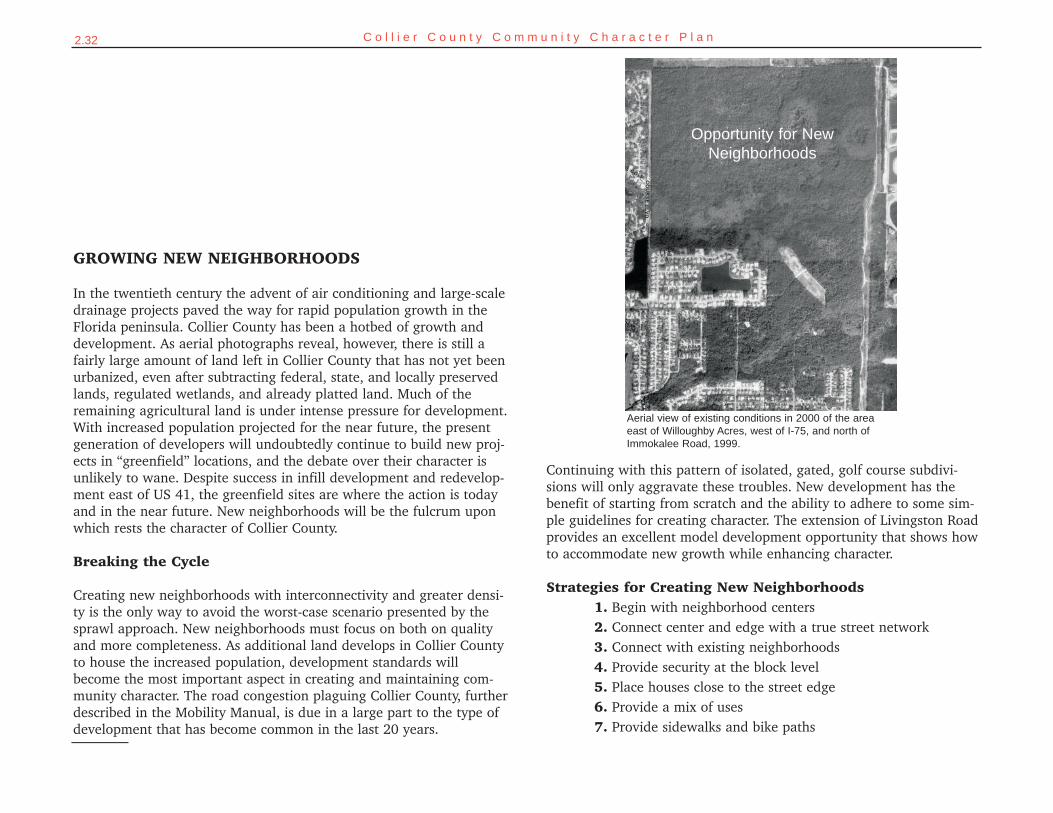
Aerial view of existing conditions in 2000 of the areaeast of Willoughby Acres, west of I-75, and north ofImmokalee Road, 1999.
Opportunity for NewNeighborhoods
GROWING NEW NEIGHBORHOODS
In the twentieth century the advent of air conditioning and large-scaledrainage projects paved the way for rapid population growth in theFlorida peninsula. Collier County has been a hotbed of growth anddevelopment. As aerial photographs reveal, however, there is still afairly large amount of land left in Collier County that has not yet beenurbanized, even after subtracting federal, state, and locally preservedlands, regulated wetlands, and already platted land. Much of theremaining agricultural land is under intense pressure for development.With increased population projected for the near future, the presentgeneration of developers will undoubtedly continue to build new proj-ects in “greenfield” locations, and the debate over their character isunlikely to wane. Despite success in infill development and redevelop-ment east of US 41, the greenfield sites are where the action is todayand in the near future. New neighborhoods will be the fulcrum uponwhich rests the character of Collier County.
Breaking the Cycle
Creating new neighborhoods with interconnectivity and greater densi-ty is the only way to avoid the worst-case scenario presented by thesprawl approach. New neighborhoods must focus on both on qualityand more completeness. As additional land develops in Collier Countyto house the increased population, development standards willbecome the most important aspect in creating and maintaining com-munity character. The road congestion plaguing Collier County, furtherdescribed in the Mobility Manual, is due in a large part to the type ofdevelopment that has become common in the last 20 years.
Continuing with this pattern of isolated, gated, golf course subdivi-sions will only aggravate these troubles. New development has thebenefit of starting from scratch and the ability to adhere to some sim-ple guidelines for creating character. The extension of Livingston Roadprovides an excellent model development opportunity that shows howto accommodate new growth while enhancing character.
Strategies for Creating New Neighborhoods1. Begin with neighborhood centers2. Connect center and edge with a true street network3. Connect with existing neighborhoods4. Provide security at the block level5. Place houses close to the street edge6. Provide a mix of uses7. Provide sidewalks and bike paths
2.33C o m m u n i t y D e s i g n M a n u a l
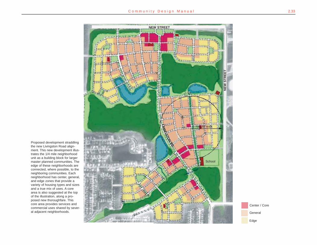
Proposed development straddlingthe new Livingston Road align-ment. This new development illus-trates the 1/4 mile neighborhoodunit as a building block for largermaster planned communities. Theedge of these neighborhoods areconnected, where possible, to theneighboring communities. Eachneighborhood has center, general,and edge zones that provide avariety of housing types and sizesand a true mix of uses. A corearea is also suggested at the topof the illustration, along a pro-posed new thoroughfare. Thiscore area provides services andcommercial uses shared by sever-al adjacent neighborhoods.
Center / Core
General
Edge
5 minute walk
School
NEW STREET
NE
W S
TR
EE
T
LIV
ING
STO
NR
D

2.34 C o l l i e r C o u n t y C o m m u n i t y C h a r a c t e r P l a n
Livingston Road - where several neighborhoods converge. Connectivity, a mix of uses, and a gradient in density from center to edge.
Corridor Substantial architecture creates a stronger senseof neighborhood identity than that of the conven-tional “entry feature.”
Neighborhood streets lead directly to themixed-use “Main Street.”
Special sites are reserved for civicbuildings
The neighborhood is focused around green,public, open spaces fronted by buildings.
Retail / office and higher density residential isfocused along the major through street.
2.35C o m m u n i t y D e s i g n M a n u a l
GROWING NEW NEIGHBORHOODS
SETTING THE COURSEThe culture of community-making demonstrated by Collier County’s pio-neers should be reestablished. New neighborhoods should be basedon a sound pattern of streets and lots. A wider variety of housing choic-es should be made available by reintroducing traditional neighborhoodconcepts as an alternative to balance the many gated subdivisions thathave been built over the past 20 years.
GETTING THEREGrowth Management Plana. Add an achievable objective #3 under goal #2 regarding standards for planning new
neighborhoods.i. Add policies endorsing the strategies for creating new neighborhoods as stat-
ed in this plan, including right-sized neighborhoods with walkable blocks, dif-fering intensities, common public spaces, and sites for civic buildings.
ii. Add a policy that requires master plans in proposed PUD rezones to show aconceptual street and block pattern for the entire site.
iii. Add a policy that requires a technical evaluation of proposed PUD masterplans and site development plans as to the spacing and connectivity of localstreets, percentage of land behind gates, and interconnections with adjoin-ing neighborhoods (see page 1-9 in the Mobility Manual).
iv. Add a policy that requires street connections to all fronting collector andarterial roads, except where no such connection can be made without violat-ing intersection spacing requirements of the land development code.
v. Add a policy clearly supporting neighborhoods with a fine-grain mix of hous-ing types, densities, and costs.
b. Amend the description of the "Urban - Mixed Use District and related subdistricts"(pages 18-23 of the Future Land Use Element) to reflect the county's new strategiesfor creating neighborhoods.
c. Amend the description of the "Traditional Neighborhood Design subdistrict" (pages 21-22 of the Future Land Use Element) to convert this subdistrict into an option that canbe used throughout the urban designated area without need for rezoning, provided aproposed development plan complies with specific regulations to be placed into theland development code.
d. Amend Policy 9.3 of the Transportation Element to strengthen its requirement for inter-connection of local streets between neighborhoods.
Land Development Codea. Amend the land development code to require newly approved developments to:
i. Include collector roads that are open to the public and not blocked by gates;ii. Incorporate any road links shown on the thoroughfare map; andiii. Provide detailed criteria for evaluating the connectivity and spacing of local
streets in proposed developments.b. Amend §3.2.8.4.16 and §2.2.20.3.11 of the code to delete the ambiguity as to when
street interconnections will be required.c. Require newly subdivided neighborhoods to establish a connected street pattern with
only a minimum of cul-de-sacs.d. Adopt specific regulations to implement the revised "Traditional Neighborhood Design
subdistrict."
2.36 C o l l i e r C o u n t y C o m m u n i t y C h a r a c t e r P l a n
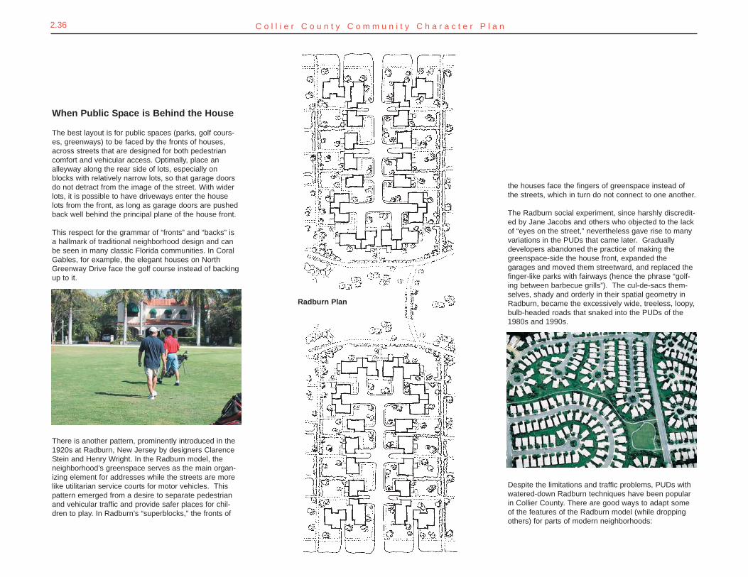
When Public Space is Behind the House
The best layout is for public spaces (parks, golf cours-es, greenways) to be faced by the fronts of houses,across streets that are designed for both pedestriancomfort and vehicular access. Optimally, place analleyway along the rear side of lots, especially onblocks with relatively narrow lots, so that garage doorsdo not detract from the image of the street. With widerlots, it is possible to have driveways enter the houselots from the front, as long as garage doors are pushedback well behind the principal plane of the house front.
This respect for the grammar of “fronts” and “backs” isa hallmark of traditional neighborhood design and canbe seen in many classic Florida communities. In CoralGables, for example, the elegant houses on NorthGreenway Drive face the golf course instead of backingup to it.
There is another pattern, prominently introduced in the1920s at Radburn, New Jersey by designers ClarenceStein and Henry Wright. In the Radburn model, theneighborhood’s greenspace serves as the main organ-izing element for addresses while the streets are morelike utilitarian service courts for motor vehicles. Thispattern emerged from a desire to separate pedestrianand vehicular traffic and provide safer places for chil-dren to play. In Radburn’s “superblocks,” the fronts of
the houses face the fingers of greenspace instead ofthe streets, which in turn do not connect to one another.
The Radburn social experiment, since harshly discredit-ed by Jane Jacobs and others who objected to the lackof “eyes on the street,” nevertheless gave rise to manyvariations in the PUDs that came later. Graduallydevelopers abandoned the practice of making thegreenspace-side the house front, expanded thegarages and moved them streetward, and replaced thefinger-like parks with fairways (hence the phrase “golf-ing between barbecue grills”). The cul-de-sacs them-selves, shady and orderly in their spatial geometry inRadburn, became the excessively wide, treeless, loopy,bulb-headed roads that snaked into the PUDs of the1980s and 1990s.
Despite the limitations and traffic problems, PUDs withwatered-down Radburn techniques have been popularin Collier County. There are good ways to adapt someof the features of the Radburn model (while droppingothers) for parts of modern neighborhoods:
Radburn Plan
C o m m u n i t y D e s i g n M a n u a l 2.37
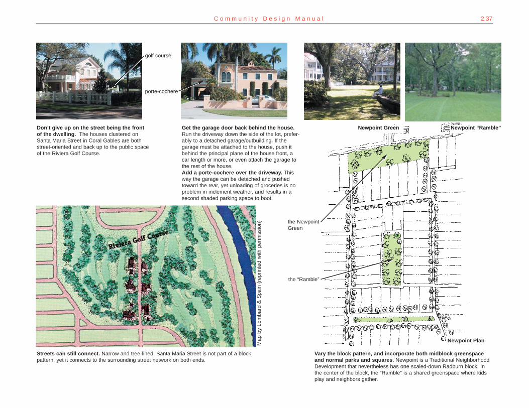
Streets can still connect. Narrow and tree-lined, Santa Maria Street is not part of a blockpattern, yet it connects to the surrounding street network on both ends.
Vary the block pattern, and incorporate both midblock greenspaceand normal parks and squares. Newpoint is a Traditional NeighborhoodDevelopment that nevertheless has one scaled-down Radburn block. Inthe center of the block, the “Ramble” is a shared greenspace where kidsplay and neighbors gather.
Don’t give up on the street being the frontof the dwelling. The houses clustered onSanta Maria Street in Coral Gables are bothstreet-oriented and back up to the public spaceof the Riviera Golf Course.
Get the garage door back behind the house.Run the driveway down the side of the lot, prefer-ably to a detached garage/outbuilding. If thegarage must be attached to the house, push itbehind the principal plane of the house front, acar length or more, or even attach the garage tothe rest of the house.Add a porte-cochere over the driveway. Thisway the garage can be detached and pushedtoward the rear, yet unloading of groceries is noproblem in inclement weather, and results in asecond shaded parking space to boot.
Newpoint Green
golf course
Map
by
Lom
bard
& S
pain
(re
prin
ted
with
per
mis
sion
)
porte-cochere
the “Ramble”
the NewpointGreen
Newpoint “Ramble”
Newpoint Plan
2.38 C o l l i e r C o u n t y C o m m u n i t y C h a r a c t e r P l a n
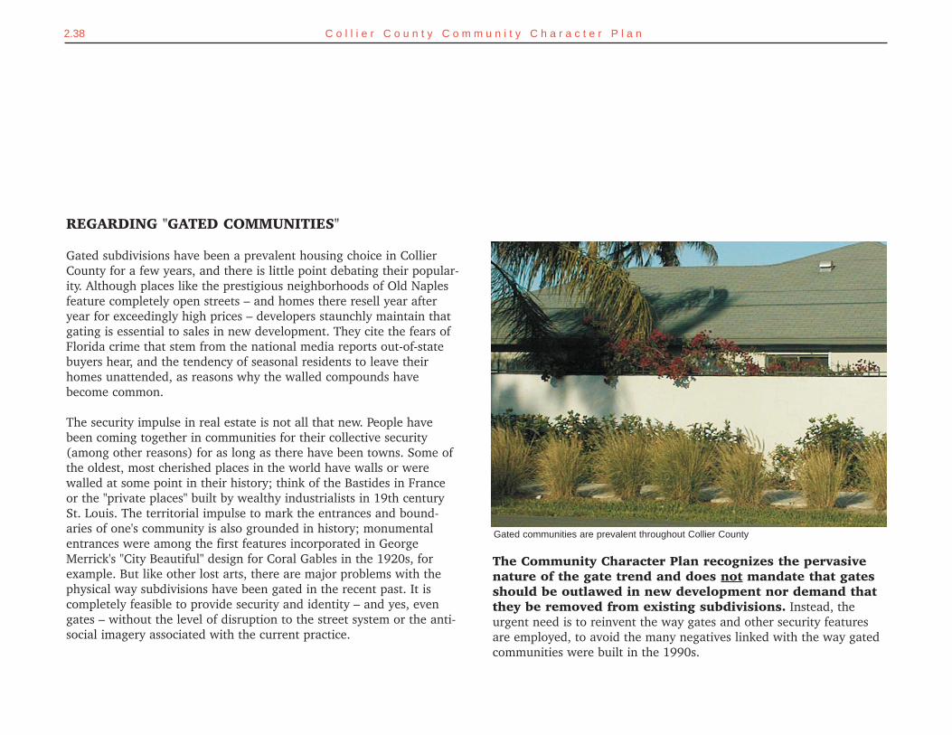
Gated communities are prevalent throughout Collier County
REGARDING "GATED COMMUNITIES"
Gated subdivisions have been a prevalent housing choice in CollierCounty for a few years, and there is little point debating their popular-ity. Although places like the prestigious neighborhoods of Old Naplesfeature completely open streets – and homes there resell year afteryear for exceedingly high prices – developers staunchly maintain thatgating is essential to sales in new development. They cite the fears ofFlorida crime that stem from the national media reports out-of-statebuyers hear, and the tendency of seasonal residents to leave theirhomes unattended, as reasons why the walled compounds havebecome common.
The security impulse in real estate is not all that new. People havebeen coming together in communities for their collective security(among other reasons) for as long as there have been towns. Some ofthe oldest, most cherished places in the world have walls or werewalled at some point in their history; think of the Bastides in Franceor the "private places" built by wealthy industrialists in 19th centurySt. Louis. The territorial impulse to mark the entrances and bound-aries of one's community is also grounded in history; monumentalentrances were among the first features incorporated in GeorgeMerrick's "City Beautiful" design for Coral Gables in the 1920s, forexample. But like other lost arts, there are major problems with thephysical way subdivisions have been gated in the recent past. It iscompletely feasible to provide security and identity – and yes, evengates – without the level of disruption to the street system or the anti-social imagery associated with the current practice.
The Community Character Plan recognizes the pervasivenature of the gate trend and does not mandate that gatesshould be outlawed in new development nor demand thatthey be removed from existing subdivisions. Instead, theurgent need is to reinvent the way gates and other security featuresare employed, to avoid the many negatives linked with the way gatedcommunities were built in the 1990s.
2.39C o m m u n i t y D e s i g n M a n u a l
1. First among the problems with gated communities was impact ontraffic circulation. A number of PUDs simply walled off too big an area,sometimes enclosing a square-mile section of land or even more.Motorists from outside the subdivision have to go all the way aroundit (and, perhaps the next one and the next, too); this is basically whya relatively manageable amount of population growth has resulted inso much traffic congestion heaped upon so few roads. Commutersfrom within the gated PUDs tend to all crowd through the soleentrance at peak hours. Last, the disconnected and loopy street sys-tems of the gated PUDs make it hard for public safety vehicles to findtheir way quickly, costing precious minutes when the need is mosturgent. The practice of cordoning off a square mile section or quartersection of land (½-square mile) must end. A street connection to thesurrounding street system at intervals of every quarter mile, at a mini-mum, should be expected in new development (see Mobility Manualfor more information).
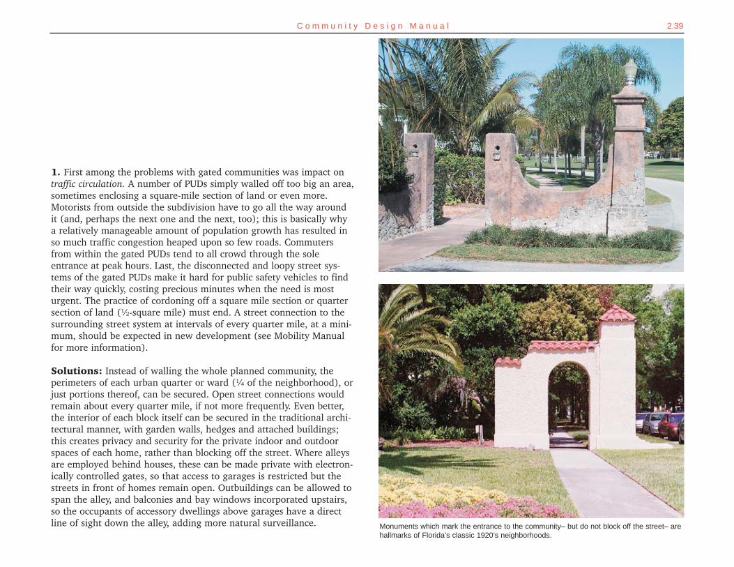
Solutions: Instead of walling the whole planned community, theperimeters of each urban quarter or ward (¼ of the neighborhood), orjust portions thereof, can be secured. Open street connections wouldremain about every quarter mile, if not more frequently. Even better,the interior of each block itself can be secured in the traditional archi-tectural manner, with garden walls, hedges and attached buildings;this creates privacy and security for the private indoor and outdoorspaces of each home, rather than blocking off the street. Where alleysare employed behind houses, these can be made private with electron-ically controlled gates, so that access to garages is restricted but thestreets in front of homes remain open. Outbuildings can be allowed tospan the alley, and balconies and bay windows incorporated upstairs,so the occupants of accessory dwellings above garages have a directline of sight down the alley, adding more natural surveillance. Monuments which mark the entrance to the community– but do not block off the street– are
hallmarks of Florida’s classic 1920’s neighborhoods.
2.40 C o l l i e r C o u n t y C o m m u n i t y C h a r a c t e r P l a n
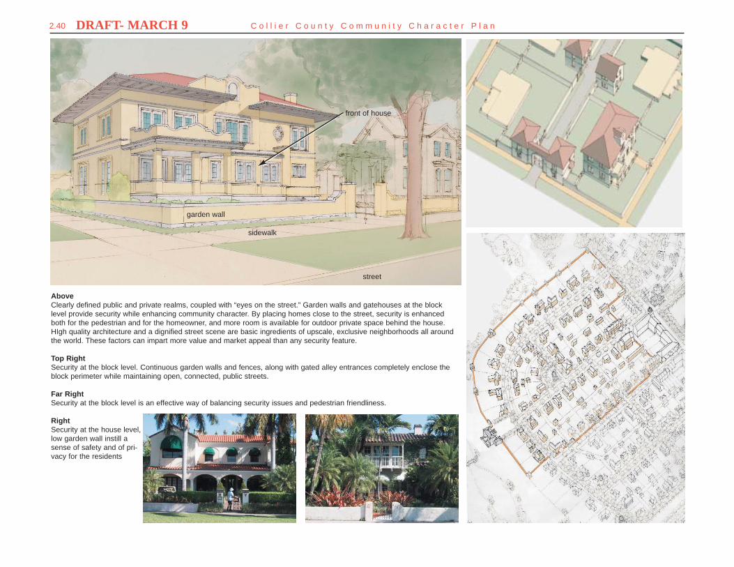
AboveClearly defined public and private realms, coupled with “eyes on the street.” Garden walls and gatehouses at the blocklevel provide security while enhancing community character. By placing homes close to the street, security is enhancedboth for the pedestrian and for the homeowner, and more room is available for outdoor private space behind the house.HIgh quality architecture and a dignified street scene are basic ingredients of upscale, exclusive neighborhoods all aroundthe world. These factors can impart more value and market appeal than any security feature.
Top RightSecurity at the block level. Continuous garden walls and fences, along with gated alley entrances completely enclose theblock perimeter while maintaining open, connected, public streets.
Far RightSecurity at the block level is an effective way of balancing security issues and pedestrian friendliness.
RightSecurity at the house level,low garden wall instill asense of safety and of pri-vacy for the residents
garden wall
front of house
sidewalk
street
DRAFT- MARCH 9
2.41C o m m u n i t y D e s i g n M a n u a l
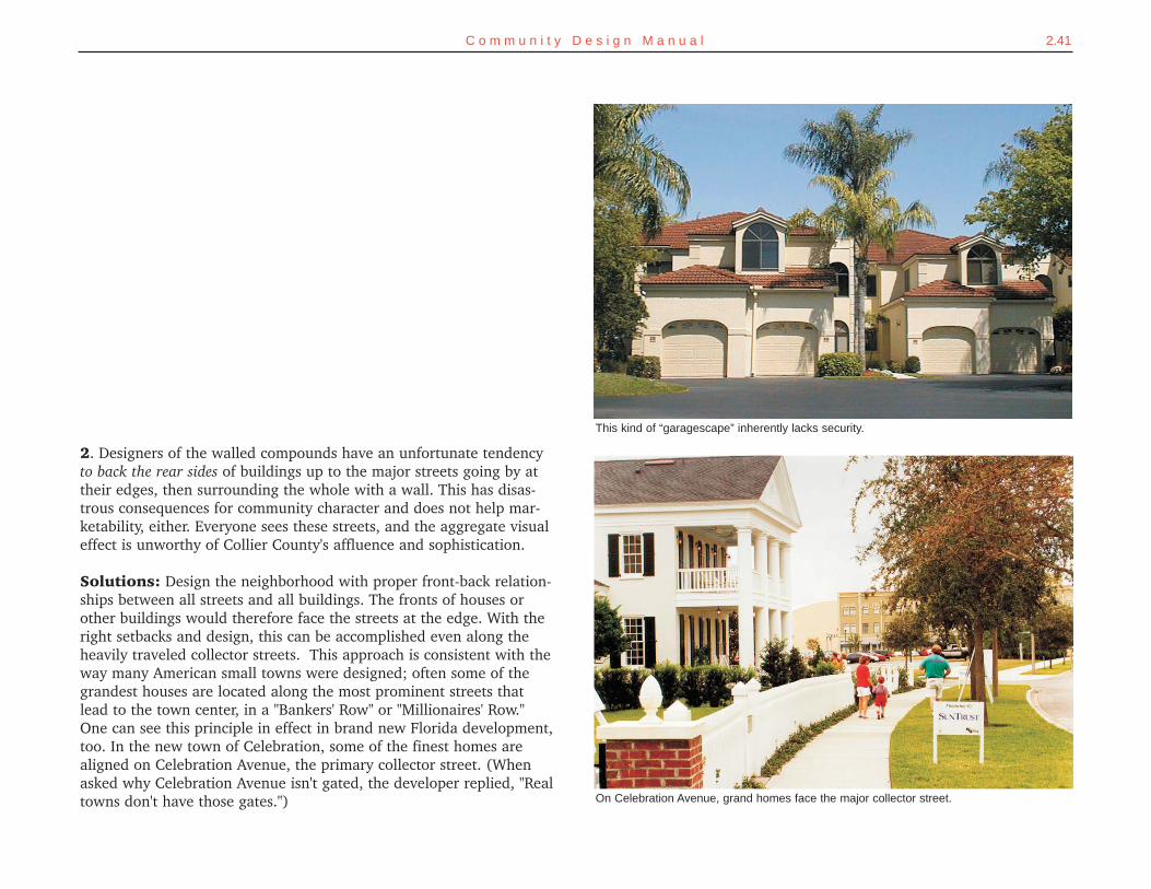
2. Designers of the walled compounds have an unfortunate tendencyto back the rear sides of buildings up to the major streets going by attheir edges, then surrounding the whole with a wall. This has disas-trous consequences for community character and does not help mar-ketability, either. Everyone sees these streets, and the aggregate visualeffect is unworthy of Collier County's affluence and sophistication.
Solutions: Design the neighborhood with proper front-back relation-ships between all streets and all buildings. The fronts of houses orother buildings would therefore face the streets at the edge. With theright setbacks and design, this can be accomplished even along theheavily traveled collector streets. This approach is consistent with theway many American small towns were designed; often some of thegrandest houses are located along the most prominent streets thatlead to the town center, in a "Bankers' Row" or "Millionaires' Row."One can see this principle in effect in brand new Florida development,too. In the new town of Celebration, some of the finest homes arealigned on Celebration Avenue, the primary collector street. (Whenasked why Celebration Avenue isn't gated, the developer replied, "Realtowns don't have those gates.")
This kind of “garagescape” inherently lacks security.
On Celebration Avenue, grand homes face the major collector street.
2.42 C o l l i e r C o u n t y C o m m u n i t y C h a r a c t e r P l a n
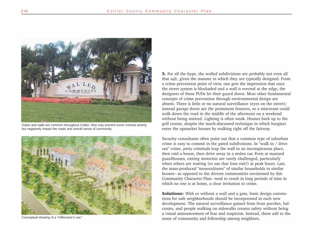
3. For all the hype, the walled subdivisions are probably not even allthat safe, given the manner in which they are typically designed. Froma crime prevention point of view, one gets the impression that oncethe street system is blockaded and a wall is erected at the edge, thedesigners of these PUDs let their guard down. Most other fundamentalconcepts of crime prevention through environmental design areabsent. There is little or no natural surveillance (eyes on the street);instead garage doors are the prominent features, so a miscreant couldwalk down the road in the middle of the afternoon on a weekendwithout being noticed. Lighting is often weak. Houses back up to thegolf course, despite the much-discussed technique in which burglarsenter the upmarket houses by walking right off the fairway.
Security consultants often point out that a common type of suburbancrime is easy to commit in the gated subdivisions. In "walk in / driveout" crime, petty criminals leap the wall in an inconspicuous place,then raid a house, then drive away in a stolen car. Even at mannedguardhouses, exiting motorists are rarely challenged, particularlywhen others are waiting (to use that lone exit!) at peak hours. Last,the mass-produced "monocultures" of similar households in similarhouses– as opposed to the diverse communities envisioned by thisCommunity Character Plan– tend to result in long periods of time inwhich no one is at home, a clear invitation to crime.
Solutions: With or without a wall and a gate, basic design conven-tions for safe neighborhoods should be incorporated in each newdevelopment. The natural surveillance gained from front porches, bal-conies, and people walking on sidewalks creates safety without beinga visual announcement of fear and suspicion. Instead, these add to thesense of community and fellowship among neighbors. Conceptual drawing of a “millionaire’s row.”
Gates and walls are common throughout Collier; they may prevent some criminal activity,but negatively impact the roads and overall sense of community.
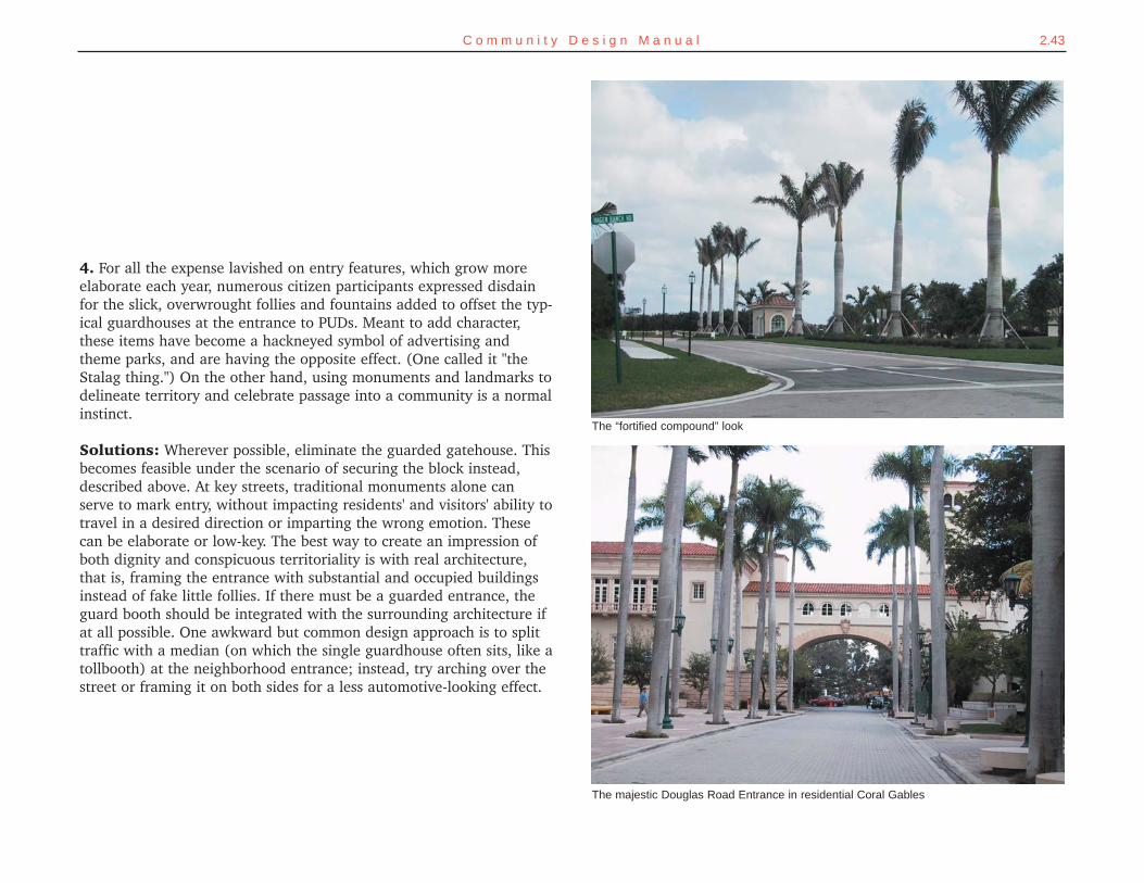
2.43C o m m u n i t y D e s i g n M a n u a l
4. For all the expense lavished on entry features, which grow moreelaborate each year, numerous citizen participants expressed disdainfor the slick, overwrought follies and fountains added to offset the typ-ical guardhouses at the entrance to PUDs. Meant to add character,these items have become a hackneyed symbol of advertising andtheme parks, and are having the opposite effect. (One called it "theStalag thing.") On the other hand, using monuments and landmarks todelineate territory and celebrate passage into a community is a normalinstinct.
Solutions: Wherever possible, eliminate the guarded gatehouse. Thisbecomes feasible under the scenario of securing the block instead,described above. At key streets, traditional monuments alone canserve to mark entry, without impacting residents' and visitors' ability totravel in a desired direction or imparting the wrong emotion. Thesecan be elaborate or low-key. The best way to create an impression ofboth dignity and conspicuous territoriality is with real architecture,that is, framing the entrance with substantial and occupied buildingsinstead of fake little follies. If there must be a guarded entrance, theguard booth should be integrated with the surrounding architecture ifat all possible. One awkward but common design approach is to splittraffic with a median (on which the single guardhouse often sits, like atollbooth) at the neighborhood entrance; instead, try arching over thestreet or framing it on both sides for a less automotive-looking effect.
The majestic Douglas Road Entrance in residential Coral Gables
The “fortified compound” look
2.44 C o l l i e r C o u n t y C o m m u n i t y C h a r a c t e r P l a n
SETTING THE COURSEMost recent developments provide only one way in and out, andinstall a security gate at that point. Newly approved developmentsshould instead have open street connections along spine roadsabout every quarter mile. Multiple gates can be used to secure indi-vidual blocks or portions of neighborhoods, provided these gates donot block access to adjoining neighborhoods.
GETTING THEREGrowth Management Plana. Add a policy that requires newly subdivided neighborhoods to limit gates and other
access restrictions to individual blocks or portions of neighborhoods so thateven communities with gates can have street interconnections with adjoining neigh-borhoods. Open street connections would remain about every quarter mile, if notmore frequently.
Land Development Codea. Adopt specific regulations to implement the county's new policy on gates in newly
subdivided neighborhoods. Interconnections to the surrounding public street net-work should occur at approximately 1/4 mile intervals, even if portions of the neigh-borhood are gated.
REGARDING GATED COMMUNITIES

2.45C o m m u n i t y D e s i g n M a n u a l
Some planners and engineers object that traditional neighborhoods cannot be built todaybecause of state and federal requirements. It is true that certain requirements pose barriers tosome design features, especially in flood prone areas.
For instance, the federal government mandates minimum floor elevations along the coastlineand near rivers to protect new buildings from flooding. Residential buildings absolutely mustcomply with these elevations; however, commercial buildings may be placed at sidewalk levelif they are "dry-floodproofed," a structural process that allows the building to withstand theeffects of flooding.
Florida's stringent water management rules require on-site detention of rainwater expectedover the rainiest three days during a 25-year period. This strenuous requirement is usuallymet by creating large lakes spread throughout a new development, an aesthetically pleasingsolution but one that interferes with a traditional street and block pattern and often reduceswalkability.
This problem is easier to resolve in larger developments because a comprehensive surfacewater management system can be designed simultaneously with the street pattern and green-way system such that it provides minimum interference with streets and maximum aestheticenjoyment. the best strategy is to locate required ponds at the neighborhood edges and inte-
REGARDING STORMWATER MANAGEMENT AND THE CREATION OF TRADITIONAL NEIGHBORHOODS
2.46 C o l l i e r C o u n t y C o m m u n i t y C h a r a c t e r P l a n
grate them with coherent parks, greenbelts, and other useful openspaces, faced by the fronts of buildings. The worst strategy is to forceretention ponds into canal-widths and wind them through the devel-opment, lined by the backs of houses.
In smaller developments and while retrofitting existing neighbor-hoods, other techniques are available such as pervious pavement, drydetention areas, exfiltration trenches, and other direct recharge con-cepts. These techniques return rainwater directly to the ground ratherthan routing it through highly engineered conveyances to drainagecanals. Dry soil has much greater capacity to absorb water than apond has; maintaining infiltration capacity throughout a site canreplace the storage capacity of conventional ponds. These techniques,
SETTING THE COURSETechnical regulations can inadvertently block ideal developmentpractices. Collier County should encourage stormwater managementtechniques that return rainwater directly to the ground wheneverthose techniques can reduce runoff that would otherwise be routedto drainage canals.
GETTING THEREGrowth Management Plana. Add a new policy under objective 1.6 in the Public Facilities Element (drainage sub-
element) to encourage the use of stormwater management techniques that returnrainwater directly to the ground, such as pervious pavement, dry detention areas,exfiltration trenches, and other direct recharge concepts.
Land Development Codea. Amend any provisions of the code that inappropriately restrict the use of stormwa-
ter management techniques that return rainwater directly to the ground.b. Add a policy encouraging most new lakes or ponds to be located at edges of
neighborhoods so as to minimize interruptions to pedestrian connectivity.
REGARDING STORMWATER MANAGEMENT
2.47C o m m u n i t y D e s i g n M a n u a l
New Traditional Neighborhoods: The Financial Outlook
Investment in traditional neighborhooddevelopment (TND) was on of the fastestgrowing segments of the real estate indus-try in the late 1900's. The TND Fund esti-mates that cumulative investment in thissector rose to $2.1 billion in 1998, up 75percent from the year before.
TND investments fall under six subcate-gories:
1) Corporate owners of large propertieshave funded some of the larger newtowns. Examples include Disney'sinvestment in Celebration (Orlando,Florida) and Weyerhaeuser'sNorthwest Landing (Dupont,Washington).
2) Real Estate Investment Trusts (REITs)have made sizeable investments in ahandful of projects. Examples are PostProperties' investments in AddisonCircle (Dallas, Texas) and FederalRealty investments in neighborhoodcenters.
3) Life insurance companies have madeloans to developers. One example isNorthwestern Mutual Life InsuranceCompany's debt financing of HaileVillage Center in Gainesville, Florida.
4) Bank and mortgage companies were asource for such projects as AmeliaPark in Fernandina Beach, Florida(First Union National Bank) and DanielIsland in Charleston, South Carolina,(National Bank of South Carolina).
5) Government credit agencies have putcapital into projects such as Southlakenear Orlando, Florida (Florida HousingFinance Agency).
6) Life insurance companies have con-tributed equity, e.g. Leucadia NationalCorporation (Colonial Penn holdingcompany) financed Rosemary Beach.
Why is TND a fast growing segment?The New Urbanism offers economic andpractical benefits to developers, buyers andlocal government. For the developer, walk-able neighborhoods usually means higherdensity which can mean lower land cost perhome. TND's typically attract a broaderrange of buyers, because they offer a widerange of housing types and prices withneighborhood commercial and retail.Developers of TND's believe that the prod-uct will have a higher value - a study by theUrban Land Institute, Valuing the NewUrbanism, has shown that this assumptionis well founded.
TND investments likely will continue togrow, for the following reasons. First, insti-tutions are expected to have at least someof their portfolio in "specialty investments,"including mixed-use properties. However,institutions require higher yields from suchinvestments. Second, successful investorswant to be on the next bandwagon – earlyand in a big way. To all appearances, thenext bandwagon is TND.
Furthermore, TND will grow because it fulfillsthe needs of a growing number of peoplewho see suburbia as dysfunctional and dis-like sprawl. This market segment wants tobreak free from automobile dependence andseeks community. “Sample the attitudes ofsuburbanites today and you'll find a growingnumber who think their lifestyle is becomingmore difficult and less appealing," reportsERE/Yarmouth's Emerging Trends in RealEstate: 1998. "And for the first time they arebeginning to consider alternatives."
At the current rate of increase, the totalinvested in TND will rise to more than $10billion by 2004 - a scenario that is not unre-alistic given the number of projects that areplanned, financed and just beginning con-struction.
Investment in TND may, in fact, increasefaster. One reason is that TND investmentis a hedger against risk. The principles of
investment diversification found in HarryMarkowitz's classic concept, ModernPortfolio Theory (MPT), argue against allo-cating all of a real estate portfolio to conven-tional development. By imposing constraintson conventional investments and by diversi-fying into TND and New Urbanism, the port-folio risk is reduced, according to MPT.
Short term versus long-term investmentsBy their nature, TND's are a longer-terminvestment. Although some have done wellin early years, they are generally structuredto yield higher returns later than conven-tional development. TND's are designed tobe more than the sum of their parts, and ittakes many years to develop all the ele-ments, i.e. retail, mix of housing types andcommunity amenities, which add to thevalue of the neotraditional projects. Also,TND's generally have no market compara-bles nearby – therefore little data is avail-able upon which to base house and lot val-ues in early years of the project, delayingthe time when peak yields are achieved.The exception is Rosemary Beach, only 12miles from Seaside, where buyers have aneasily understood point of reference.Rosemary Beach in all likelihood had thebest first-year financial return of any TND todate.
Financial returns from selected TND'sInformation on financial returns of TND's issketchy, but there have been some pub-lished reports, including an analysis byRobert Chapman in the January 1998 issueif New Urban News. Chapman gathereddata and estimates on annual returns of sixprojects. The returns ranged from 25 per-cent to 45 percent, measured by the annualincrease in market value of developed prop-erty as determined by sale and resaleprices. The TND returns substantiallyexceed the real estate investment returnsreported in the National Council of RealEstate Investment Fiduciaries PropertyIndex (just under 9 percent average annualreturn over the last 10 years).
The figures come from published reportsand interviews with developers. The sixTND's listed are not a representative sam-ple (although they do comprise nearly 20percent of all U.S. TND's that were farenough along to be analyzed financially inlate 1997) and these figures may differ sig-nificantly from the industry as a whole. Allsix are located in the Southeast. Morestudy is required to obtain defensible fig-ures for TND's generally.
...At Newpoint, in Beaufort, South Carolina,the 130-lot, 54-acre property was pur-chased by developer Vince Graham for $1.3 million, and $1.15 million was spent onroads and infrastructure. Total developmentcosts were estimated at $14,600 on interiorlots and $60,000 on waterfront lots. Interiorlot prices began at $20,000 in 1992, andrecently have sold for $85,000. Somewaterfront lots have sold for as high as$369,000. "We generated a pretty heftyreturn in the first year," Graham told theWSJ.
The project features homes close to thestreet, wide and deep porches, traffic calm-ing devices and architecture based on thehistoric town of Beaufort. Graham esti-mates that the project is performing 30 to40 percent better than expected, from apure financial standpoint. Moreover,Newpoint has become a local civic amenity,with neighboring subdivisions advertisingtheir proximity, and youngsters from sur-rounding suburbia overrunning the place onHalloween.
By Robert Chapman III, partner of the TNDFund, an equity investment group for neo-traditional developments
Excerpted from "New Urbanist ProjectsAttract Investment," New Urban NewsComprehensive Report & Best PracticesGuide. Reprinted by permission.
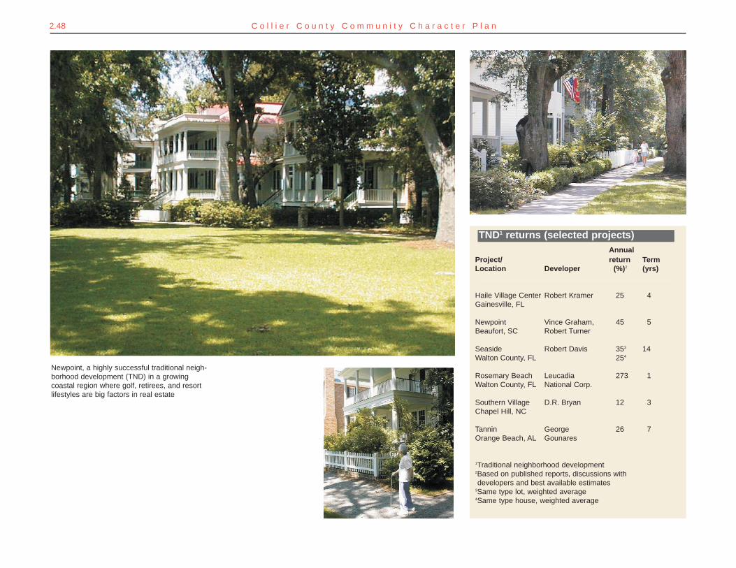
2.48 C o l l i e r C o u n t y C o m m u n i t y C h a r a c t e r P l a n
Newpoint, a highly successful traditional neigh-borhood development (TND) in a growingcoastal region where golf, retirees, and resortlifestyles are big factors in real estate
AnnualProject/ return TermLocation Developer (%)2 (yrs)
Haile Village Center Robert Kramer 25 4Gainesville, FL
Newpoint Vince Graham, 45 5Beaufort, SC Robert Turner
Seaside Robert Davis 353 14Walton County, FL 254
Rosemary Beach Leucadia 273 1Walton County, FL National Corp.
Southern Village D.R. Bryan 12 3Chapel Hill, NC
Tannin George 26 7Orange Beach, AL Gounares
1Traditional neighborhood development2Based on published reports, discussions with developers and best available estimates
3Same type lot, weighted average4Same type house, weighted average
TND1 returns (selected projects)
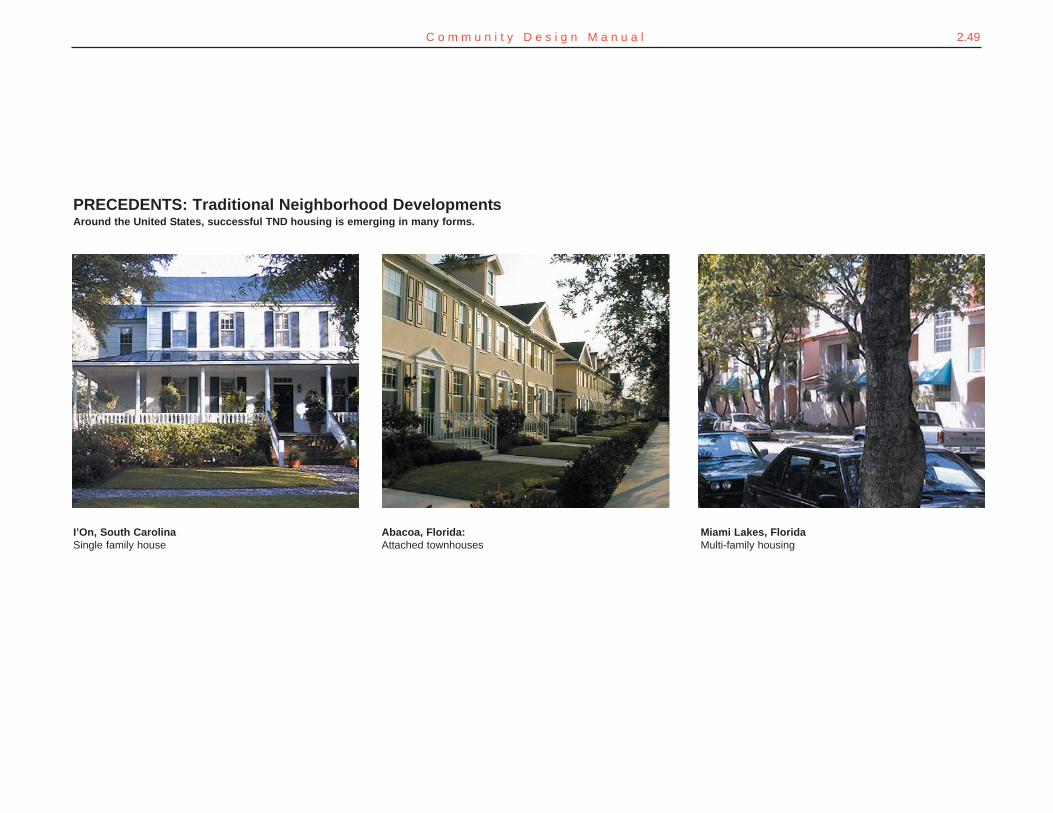
2.49C o m m u n i t y D e s i g n M a n u a l
Miami Lakes, Florida Multi-family housing
Abacoa, Florida:Attached townhouses
PRECEDENTS: Traditional Neighborhood DevelopmentsAround the United States, successful TND housing is emerging in many forms.
I’On, South CarolinaSingle family house
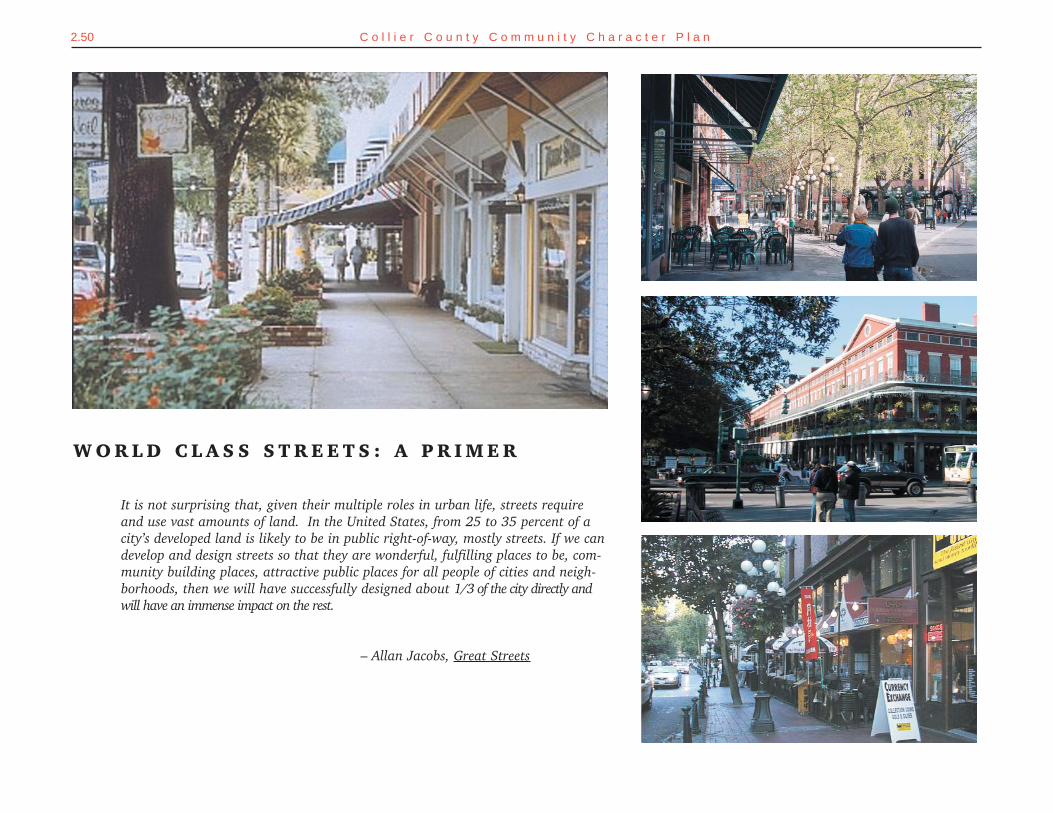
2.50 C o l l i e r C o u n t y C o m m u n i t y C h a r a c t e r P l a n
W O R L D C L A S S S T R E E T S : A P R I M E R
It is not surprising that, given their multiple roles in urban life, streets requireand use vast amounts of land. In the United States, from 25 to 35 percent of acity’s developed land is likely to be in public right-of-way, mostly streets. If we candevelop and design streets so that they are wonderful, fulfilling places to be, com-munity building places, attractive public places for all people of cities and neigh-borhoods, then we will have successfully designed about 1/3 of the city directly andwill have an immense impact on the rest.
– Allan Jacobs, Great Streets
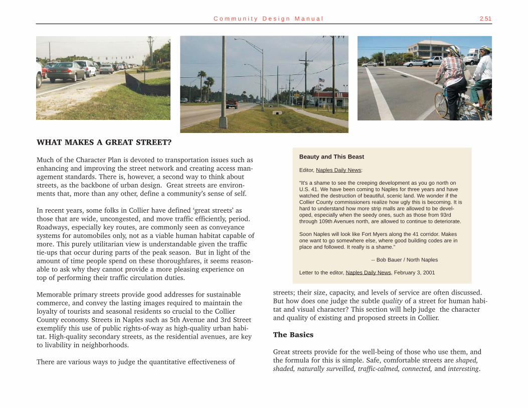
streets; their size, capacity, and levels of service are often discussed.But how does one judge the subtle quality of a street for human habi-tat and visual character? This section will help judge the characterand quality of existing and proposed streets in Collier.
The Basics
Great streets provide for the well-being of those who use them, andthe formula for this is simple. Safe, comfortable streets are shaped,shaded, naturally surveilled, traffic-calmed, connected, and interesting.
2.51C o m m u n i t y D e s i g n M a n u a l
WHAT MAKES A GREAT STREET?
Much of the Character Plan is devoted to transportation issues such asenhancing and improving the street network and creating access man-agement standards. There is, however, a second way to think aboutstreets, as the backbone of urban design. Great streets are environ-ments that, more than any other, define a community’s sense of self.
In recent years, some folks in Collier have defined ‘great streets’ asthose that are wide, uncongested, and move traffic efficiently, period.Roadways, especially key routes, are commonly seen as conveyancesystems for automobiles only, not as a viable human habitat capable ofmore. This purely utilitarian view is understandable given the traffictie-ups that occur during parts of the peak season. But in light of theamount of time people spend on these thoroughfares, it seems reason-able to ask why they cannot provide a more pleasing experience ontop of performing their traffic circulation duties.
Memorable primary streets provide good addresses for sustainablecommerce, and convey the lasting images required to maintain theloyalty of tourists and seasonal residents so crucial to the CollierCounty economy. Streets in Naples such as 5th Avenue and 3rd Streetexemplify this use of public rights-of-way as high-quality urban habi-tat. High-quality secondary streets, as the residential avenues, are keyto livability in neighborhoods.
There are various ways to judge the quantitative effectiveness of
Beauty and This Beast
Editor, Naples Daily News:
“It's a shame to see the creeping development as you go north onU.S. 41. We have been coming to Naples for three years and havewatched the destruction of beautiful, scenic land. We wonder if theCollier County commissioners realize how ugly this is becoming. It ishard to understand how more strip malls are allowed to be devel-oped, especially when the seedy ones, such as those from 93rdthrough 109th Avenues north, are allowed to continue to deteriorate.
Soon Naples will look like Fort Myers along the 41 corridor. Makesone want to go somewhere else, where good building codes are inplace and followed. It really is a shame.”
-- Bob Bauer / North Naples
Letter to the editor, Naples Daily News, February 3, 2001
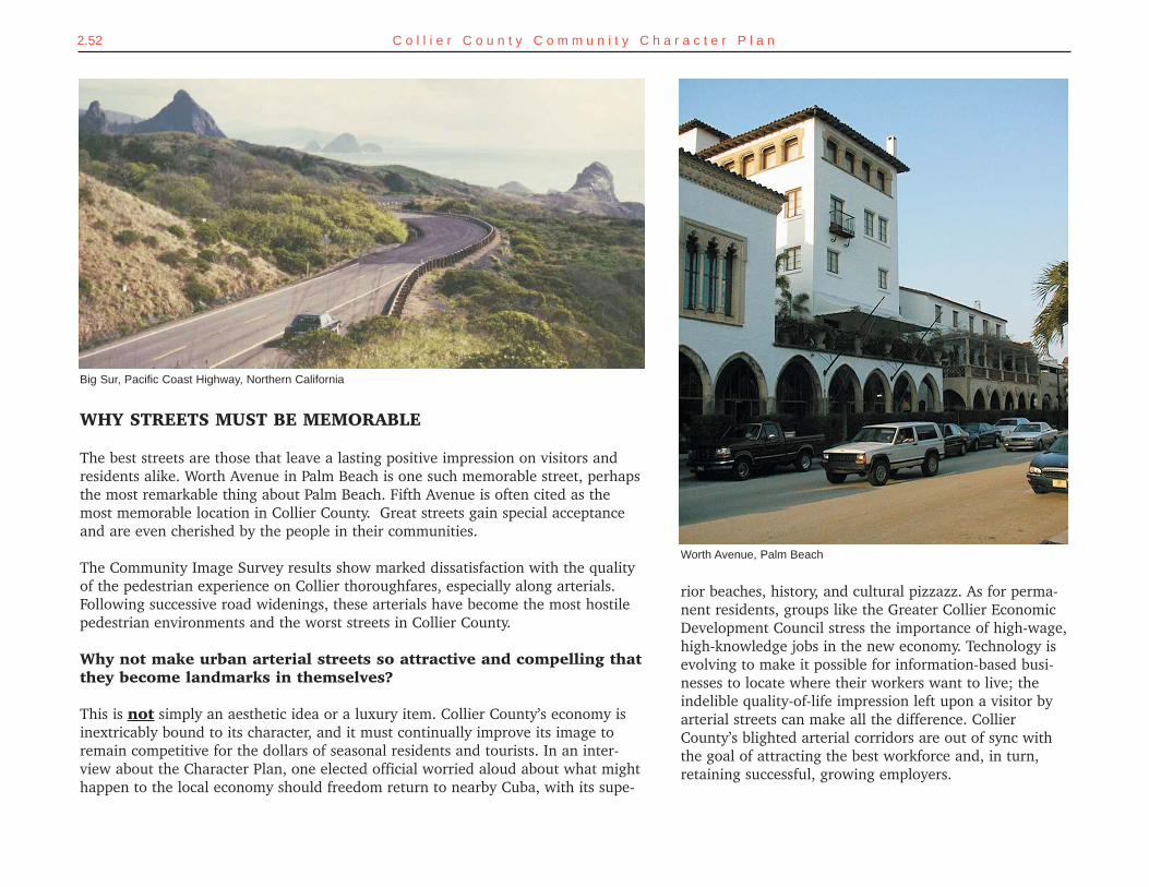
2.52 C o l l i e r C o u n t y C o m m u n i t y C h a r a c t e r P l a n
Worth Avenue, Palm Beach
Big Sur, Pacific Coast Highway, Northern California
WHY STREETS MUST BE MEMORABLE
The best streets are those that leave a lasting positive impression on visitors andresidents alike. Worth Avenue in Palm Beach is one such memorable street, perhapsthe most remarkable thing about Palm Beach. Fifth Avenue is often cited as themost memorable location in Collier County. Great streets gain special acceptanceand are even cherished by the people in their communities.
The Community Image Survey results show marked dissatisfaction with the qualityof the pedestrian experience on Collier thoroughfares, especially along arterials.Following successive road widenings, these arterials have become the most hostilepedestrian environments and the worst streets in Collier County.
Why not make urban arterial streets so attractive and compelling thatthey become landmarks in themselves?
This is not simply an aesthetic idea or a luxury item. Collier County’s economy isinextricably bound to its character, and it must continually improve its image toremain competitive for the dollars of seasonal residents and tourists. In an inter-view about the Character Plan, one elected official worried aloud about what mighthappen to the local economy should freedom return to nearby Cuba, with its supe-
rior beaches, history, and cultural pizzazz. As for perma-nent residents, groups like the Greater Collier EconomicDevelopment Council stress the importance of high-wage,high-knowledge jobs in the new economy. Technology isevolving to make it possible for information-based busi-nesses to locate where their workers want to live; theindelible quality-of-life impression left upon a visitor byarterial streets can make all the difference. CollierCounty’s blighted arterial corridors are out of sync withthe goal of attracting the best workforce and, in turn,retaining successful, growing employers.
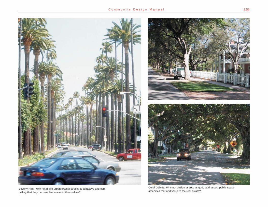
2.53C o m m u n i t y D e s i g n M a n u a l
Beverly Hills: Why not make urban arterial streets so attractive and com-pelling that they become landmarks in themselves?
Coral Gables: Why not design streets as good addresses, public spaceamenities that add value to the real estate?
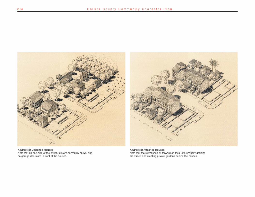
2.54 C o l l i e r C o u n t y C o m m u n i t y C h a r a c t e r P l a n
A Street of Detached HousesNote that on one side of the street, lots are served by alleys, andno garage doors are in front of the houses.
A Street of Attached HousesNote that the rowhouses sit forward on their lots, spatially definingthe street, and creating private gardens behind the houses.
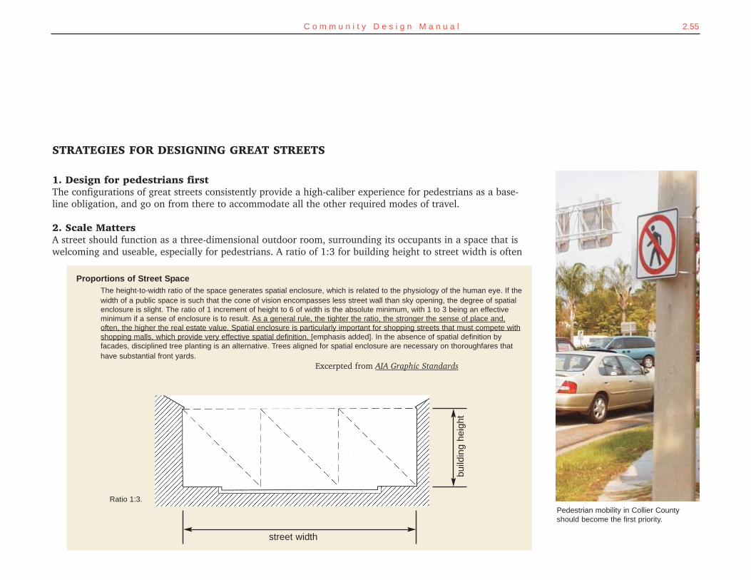
2.55C o m m u n i t y D e s i g n M a n u a l
Pedestrian mobility in Collier Countyshould become the first priority.
Proportions of Street SpaceThe height-to-width ratio of the space generates spatial enclosure, which is related to the physiology of the human eye. If thewidth of a public space is such that the cone of vision encompasses less street wall than sky opening, the degree of spatialenclosure is slight. The ratio of 1 increment of height to 6 of width is the absolute minimum, with 1 to 3 being an effectiveminimum if a sense of enclosure is to result. As a general rule, the tighter the ratio, the stronger the sense of place and,often, the higher the real estate value. Spatial enclosure is particularly important for shopping streets that must compete withshopping malls, which provide very effective spatial definition. [emphasis added]. In the absence of spatial definition byfacades, disciplined tree planting is an alternative. Trees aligned for spatial enclosure are necessary on thoroughfares thathave substantial front yards.
Excerpted from AIA Graphic Standards
STRATEGIES FOR DESIGNING GREAT STREETS
1. Design for pedestrians firstThe configurations of great streets consistently provide a high-caliber experience for pedestrians as a base-line obligation, and go on from there to accommodate all the other required modes of travel.
2. Scale MattersA street should function as a three-dimensional outdoor room, surrounding its occupants in a space that iswelcoming and useable, especially for pedestrians. A ratio of 1:3 for building height to street width is often
Ratio 1:3.
build
ing
heig
ht
street width
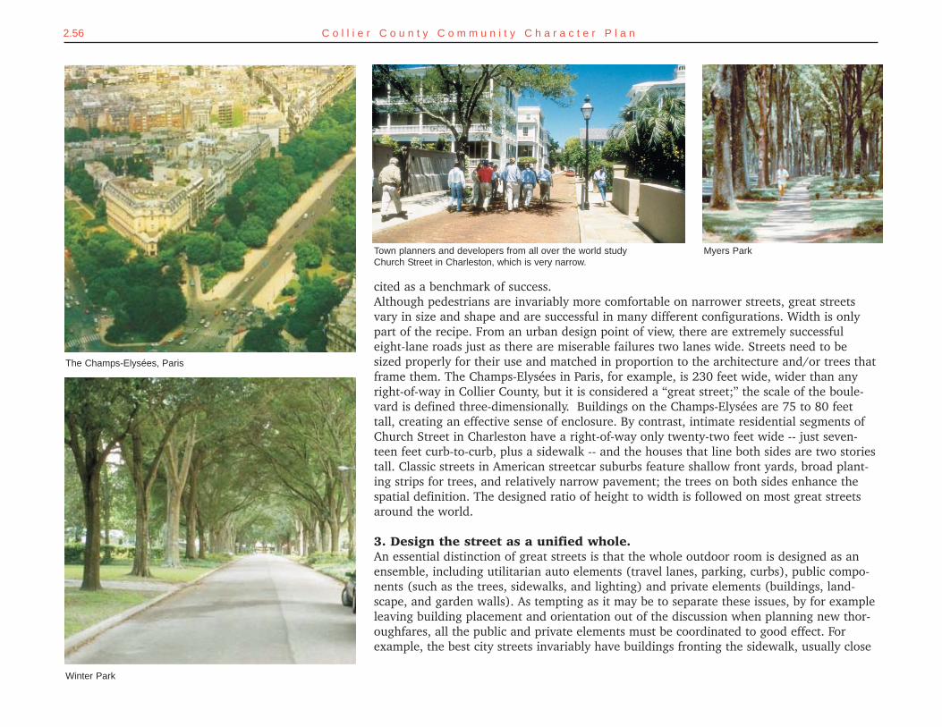
2.56 C o l l i e r C o u n t y C o m m u n i t y C h a r a c t e r P l a n
Myers Park
Winter Park
The Champs-Elysées, Paris
cited as a benchmark of success. Although pedestrians are invariably more comfortable on narrower streets, great streetsvary in size and shape and are successful in many different configurations. Width is onlypart of the recipe. From an urban design point of view, there are extremely successfuleight-lane roads just as there are miserable failures two lanes wide. Streets need to besized properly for their use and matched in proportion to the architecture and/or trees thatframe them. The Champs-Elysées in Paris, for example, is 230 feet wide, wider than anyright-of-way in Collier County, but it is considered a “great street;” the scale of the boule-vard is defined three-dimensionally. Buildings on the Champs-Elysées are 75 to 80 feettall, creating an effective sense of enclosure. By contrast, intimate residential segments ofChurch Street in Charleston have a right-of-way only twenty-two feet wide -- just seven-teen feet curb-to-curb, plus a sidewalk -- and the houses that line both sides are two storiestall. Classic streets in American streetcar suburbs feature shallow front yards, broad plant-ing strips for trees, and relatively narrow pavement; the trees on both sides enhance thespatial definition. The designed ratio of height to width is followed on most great streetsaround the world.
3. Design the street as a unified whole. An essential distinction of great streets is that the whole outdoor room is designed as anensemble, including utilitarian auto elements (travel lanes, parking, curbs), public compo-nents (such as the trees, sidewalks, and lighting) and private elements (buildings, land-scape, and garden walls). As tempting as it may be to separate these issues, by for exampleleaving building placement and orientation out of the discussion when planning new thor-oughfares, all the public and private elements must be coordinated to good effect. Forexample, the best city streets invariably have buildings fronting the sidewalk, usually close
Town planners and developers from all over the world studyChurch Street in Charleston, which is very narrow.
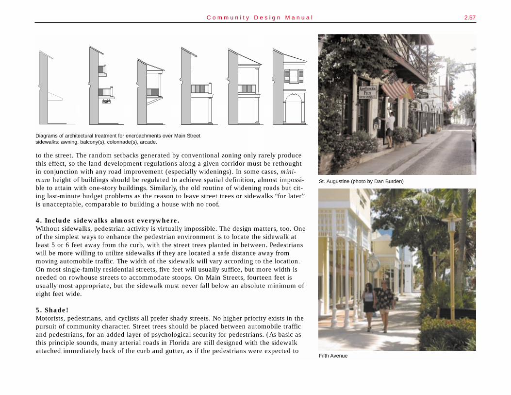
2.57C o m m u n i t y D e s i g n M a n u a l
to the street. The random setbacks generated by conventional zoning only rarely producethis effect, so the land development regulations along a given corridor must be rethoughtin conjunction with any road improvement (especially widenings). In some cases, mini-mum height of buildings should be regulated to achieve spatial definition, almost impossi-ble to attain with one-story buildings. Similarly, the old routine of widening roads but cit-ing last-minute budget problems as the reason to leave street trees or sidewalks “for later”is unacceptable, comparable to building a house with no roof.
4. Include sidewalks almost everywhere.Without sidewalks, pedestrian activity is virtually impossible. The design matters, too. Oneof the simplest ways to enhance the pedestrian environment is to locate the sidewalk atleast 5 or 6 feet away from the curb, with the street trees planted in between. Pedestrianswill be more willing to utilize sidewalks if they are located a safe distance away frommoving automobile traffic. The width of the sidewalk will vary according to the location.On most single-family residential streets, five feet will usually suffice, but more width isneeded on rowhouse streets to accommodate stoops. On Main Streets, fourteen feet isusually most appropriate, but the sidewalk must never fall below an absolute minimum ofeight feet wide.
5. Shade!Motorists, pedestrians, and cyclists all prefer shady streets. No higher priority exists in thepursuit of community character. Street trees should be placed between automobile trafficand pedestrians, for an added layer of psychological security for pedestrians. (As basic asthis principle sounds, many arterial roads in Florida are still designed with the sidewalkattached immediately back of the curb and gutter, as if the pedestrians were expected to
St. Augustine (photo by Dan Burden)
Diagrams of architectural treatment for encroachments over Main Streetsidewalks: awning, balcony(s), colonnade(s), arcade.
STORE
STORE
THE WONDERFULTHE WONDERFUL
Fifth Avenue
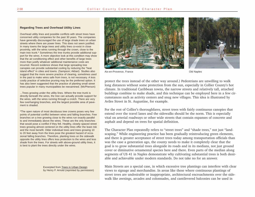
2.58 C o l l i e r C o u n t y C o m m u n i t y C h a r a c t e r P l a n
protect the trees instead of the other way around.) Pedestrians are unwilling to walklong distances without some protection from the sun, especially in Collier County’s hotclimate. In traditional Caribbean towns, the narrow streets and relatively tall, attachedbuildings combine to make shade, and this technique can be employed here in a few cir-cumstances such as activity centers and snug new villages. This idea is illustrated byAviles Street in St. Augustine, for example.
For the rest of Collier’s thoroughfares, street trees with fairly continuous canopies thatextend over the travel lanes and the sidewalks should be the norm. This is especiallyvital on arterial roadways or other wide streets that contain expanses of concrete andasphalt and depend on trees for spatial definition.
The Character Plan repeatedly refers to “street trees” and “shade trees,” not just “land-scaping.” While engineering practice has been gradually reintroducing green elements,and there is greater acceptance of street trees today among transportation officials thanwas the case a generation ago, the county needs to make it completely clear that thegoal is to grow substantial trees alongside its roads and in its medians, not just groundcover or diminutive ornamental species here and there. Even parts of the median alongsegments of US 41 in Naples demonstrate why cultivating substantial trees is both desir-able and achievable under modern standards. Do not take no for an answer.
Main Streets are a special case, in which excessive tree plantings can interfere with clearviews to signage and merchandise. In areas like these where continuous plantings ofstreet trees are undesirable or inappropriate, architectural encroachments over the side-walk like awnings, arcades and colonnades, and cantilevered balconies can be used in
Old NaplesAix-en-Provence, France
Regarding Trees and Overhead Utility Lines
Overhead utility lines and possible conflicts with street trees haveconcerned utility companies for the past 30 years. The companieshave generally discouraged the use of large shade trees on urbanstreets where there are power lines. This does not seem justified.In many towns the large trees and utility lines co-exist in closeproximity, with the wires running through the crown, close to themain tree trunk.* Sometimes the tree trunks provide additional sup-port for the wires. A more objective look at this condition may showthat the air-conditioning effect and other benefits of large treesmore than justify whatever additional maintenance costs areincurred. Recent evidence shows that large spreading treecanopies can provide substantial cooling by reducing the “heatisland effect” in cities and towns. (Sampson; Akbari) Studies alsosuggest that the more severe practice of clearing, sometimes usedin the past to make wires safe from trees, is not necessary. A lesscostly practice of selective pruning may be the preferred option. Ithas also been suggested that the practice of planting small streettrees popular in many municipalities be reexamined. (McPherson)
...Trees growing under the utility lines. Where the tree trunk isdirectly beneath the wires, the tree can actually provide support forthe wires, with the wires running through a crotch. There are veryfew overhanging branches, and the largest possible area of pave-ment is shaded.
*The open nature of most deciduous tree crowns poses very fewpoints of potential conflict between wires and falling branches. Fewbranches on a tree growing close to the wires run exactly parallelto and immediately above the wires. These are the only branchesthat would pose a conflict if they fell. Healthy, closely spaced streettrees growing almost centered on the utility lines offer the least riskand the most benefit. Older individual trees and trees growing 10to 20 feet away from the lines pose the greatest hazard of occa-sional falling branches. Therefore, planting trees on the sidewalkopposite the utility lines offers less protection to the wires and lessshade from the trees. For streets with above-ground utility lines, itis best to plant the trees directly under the wires.
Excerpted from Trees in Urban Designby Henry F. Arnold (reprinted by permission)
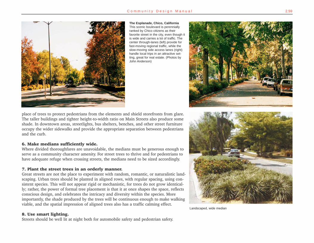
2.59C o m m u n i t y D e s i g n M a n u a l
place of trees to protect pedestrians from the elements and shield storefronts from glare.The taller buildings and tighter height-to-width ratio on Main Streets also produce someshade. In downtown areas, streetlights, bus shelters, benches, and other street furnitureoccupy the wider sidewalks and provide the appropriate separation between pedestriansand the curb.
6. Make medians sufficiently wide. Where divided thoroughfares are unavoidable, the medians must be generous enough toserve as a community character amenity. For street trees to thrive and for pedestrians tohave adequate refuge when crossing streets, the medians need to be sized accordingly.
7. Plant the street trees in an orderly manner.Great streets are not the place to experiment with random, romantic, or naturalistic land-scaping. Urban trees should be planted in aligned rows, with regular spacing, using con-sistent species. This will not appear rigid or mechanistic, for trees do not grow identical-ly; rather, the power of formal tree placement is that it at once shapes the space, reflectsconscious design, and celebrates the intricacy and diversity within the species. Moreimportantly, the shade produced by the trees will be continuous enough to make walkingviable, and the spatial impression of aligned trees also has a traffic calming effect.
8. Use smart lighting.Streets should be well lit at night both for automobile safety and pedestrian safety.
Landscaped, wide median
The Esplanade, Chico, CaliforniaThis scenic boulevard is perenniallyranked by Chico citizens as theirfavorite street in the city, even though itis wide and carries a lot of traffic. Thecenter through-lanes (left) provide forfast-moving regional traffic, while theslow-moving side access lanes (right)handle local trips in an attractive set-ting, great for real estate. (Photos byJohn Anderson)
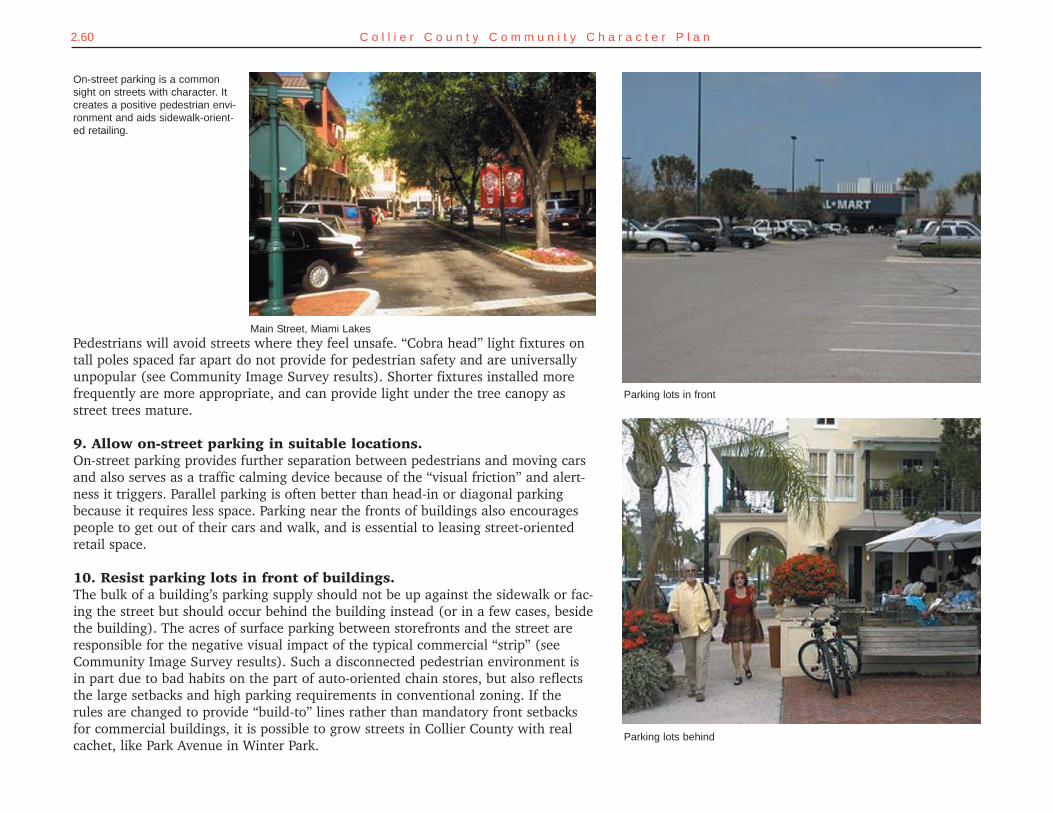
2.60 C o l l i e r C o u n t y C o m m u n i t y C h a r a c t e r P l a n
On-street parking is a commonsight on streets with character. Itcreates a positive pedestrian envi-ronment and aids sidewalk-orient-ed retailing.
Parking lots in front
Parking lots behind
Pedestrians will avoid streets where they feel unsafe. “Cobra head” light fixtures ontall poles spaced far apart do not provide for pedestrian safety and are universallyunpopular (see Community Image Survey results). Shorter fixtures installed morefrequently are more appropriate, and can provide light under the tree canopy asstreet trees mature.
9. Allow on-street parking in suitable locations.On-street parking provides further separation between pedestrians and moving carsand also serves as a traffic calming device because of the “visual friction” and alert-ness it triggers. Parallel parking is often better than head-in or diagonal parkingbecause it requires less space. Parking near the fronts of buildings also encouragespeople to get out of their cars and walk, and is essential to leasing street-orientedretail space.
10. Resist parking lots in front of buildings.The bulk of a building’s parking supply should not be up against the sidewalk or fac-ing the street but should occur behind the building instead (or in a few cases, besidethe building). The acres of surface parking between storefronts and the street areresponsible for the negative visual impact of the typical commercial “strip” (seeCommunity Image Survey results). Such a disconnected pedestrian environment isin part due to bad habits on the part of auto-oriented chain stores, but also reflectsthe large setbacks and high parking requirements in conventional zoning. If therules are changed to provide “build-to” lines rather than mandatory front setbacksfor commercial buildings, it is possible to grow streets in Collier County with realcachet, like Park Avenue in Winter Park.
Main Street, Miami Lakes
2.61C o m m u n i t y D e s i g n M a n u a l
SETTING THE COURSEGreat streets are the backbone of a well-designed community. Streets arecritical conduits for vehicles but they are also important public spaces thatshould be designed as a unified whole, with sidewalks and street trees neverbeing mere afterthoughts. Streets should be of such quality that they aregenuine amenities to the neighborhoods they serve.
GETTING THEREGrowth Management Plana. In the Future Land Use Element, establish a new goal #3 promoting "great streets" for Collier
County and memorable commercial centers that combine resilient traditional buildings, cus-tomer convenience, diversity of offerings, and a complementary mix of uses.
b. Add an achievable objective #1 under goal #3 of the Future Land Use Element regarding thedesign of great streets and adjoining buildings.
i. Add policies that endorse the basic strategies for designing great streets as statedin this plan.
ii. Add a policy that recognizes the following features as desirable for developmentalong roads: buildings fronting sidewalks with little or no setback; parking lotsmoved behind or aside buildings; and buildings more than one story tall.
c. Add a policy in the Transportation Element that commits to include the following basic ameni-ties in the design and construction of all new roads to be built by Collier County: ample side-walks away from curbs, street trees in uniform rows; attractive lighting fixtures that will notconflict with mature trees, and on-street parking along boulevards and collector roads and inother locations where buildings are (or are planned to be) close to the road.
Land Development Code:a. Amend the code wherever conflicts are found between its current provisions and the new
growth management plan policies regarding great streets.b. Amend the code to provide “build-to” lines rather than mandatory front setbacks for com-
mercial buildings.
STRATEGIES FOR DESIGNING GREAT STREETS
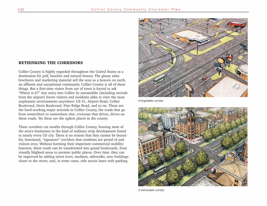
RETHINKING THE CORRIDORS
Collier County is highly regarded throughout the United States as adestination for golf, beaches and natural beauty. The glossy salesbrochures and marketing material sell the area as a heaven on earth,an affluent and exceptional community. Collier County is all of thesethings. But a first-time visitor from out of town is forced to ask“Where is it?” Any entry into Collier by automobile (including arrivalsfrom the airport) forces visitors and residents alike to view the mostunpleasant environments anywhere: US 41, Airport Road, CollierBoulevard, Davis Boulevard, Pine Ridge Road, and so on. These arethe hard-working major arterials in Collier County, the roads that gofrom somewhere to somewhere else; everyone that drives, drives onthese roads. Yet these are the ugliest places in the county.
These corridors cut swaths through Collier County, housing most ofthe area’s businesses in the kind of ordinary strip development foundin nearly every US city. There is no reason that they cannot be beauti-ful, functional, “signature” corridors that residents are proud of andvisitors envy. Without harming their important commercial mobilityfunction, these roads can be transformed into grand boulevards, fromvisually blighted areas to premier public places. Over time, they canbe improved by adding street trees, medians, sidewalks, new buildingscloser to the street, and, in some cases, side access lanes with parking.
2.62 C o l l i e r C o u n t y C o m m u n i t y C h a r a c t e r P l a n
A memorable corridor
A forgettable corridor
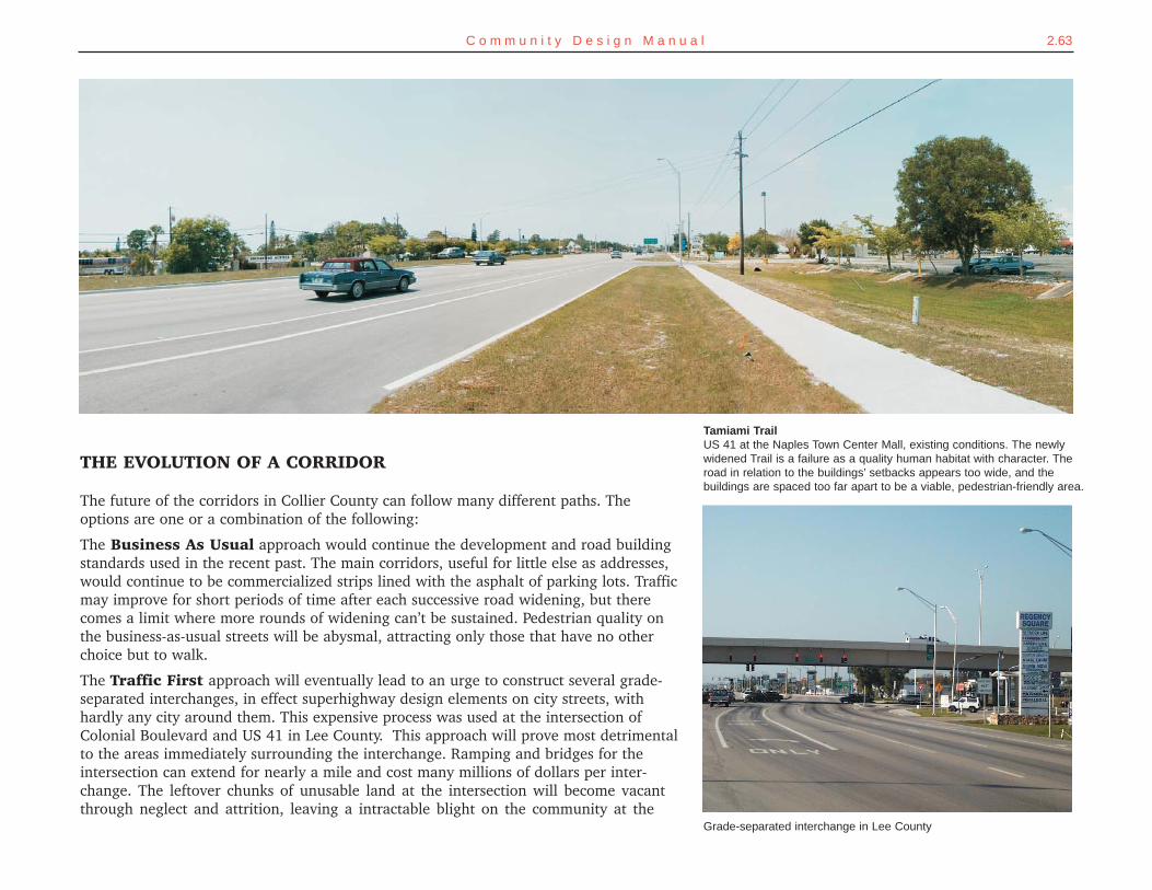
2.63C o m m u n i t y D e s i g n M a n u a l
THE EVOLUTION OF A CORRIDOR
The future of the corridors in Collier County can follow many different paths. Theoptions are one or a combination of the following:
The Business As Usual approach would continue the development and road buildingstandards used in the recent past. The main corridors, useful for little else as addresses,would continue to be commercialized strips lined with the asphalt of parking lots. Trafficmay improve for short periods of time after each successive road widening, but therecomes a limit where more rounds of widening can’t be sustained. Pedestrian quality onthe business-as-usual streets will be abysmal, attracting only those that have no otherchoice but to walk.
The Traffic First approach will eventually lead to an urge to construct several grade-separated interchanges, in effect superhighway design elements on city streets, withhardly any city around them. This expensive process was used at the intersection ofColonial Boulevard and US 41 in Lee County. This approach will prove most detrimentalto the areas immediately surrounding the interchange. Ramping and bridges for theintersection can extend for nearly a mile and cost many millions of dollars per inter-change. The leftover chunks of unusable land at the intersection will become vacantthrough neglect and attrition, leaving a intractable blight on the community at the
Tamiami TrailUS 41 at the Naples Town Center Mall, existing conditions. The newlywidened Trail is a failure as a quality human habitat with character. Theroad in relation to the buildings’ setbacks appears too wide, and thebuildings are spaced too far apart to be a viable, pedestrian-friendly area.
Grade-separated interchange in Lee County
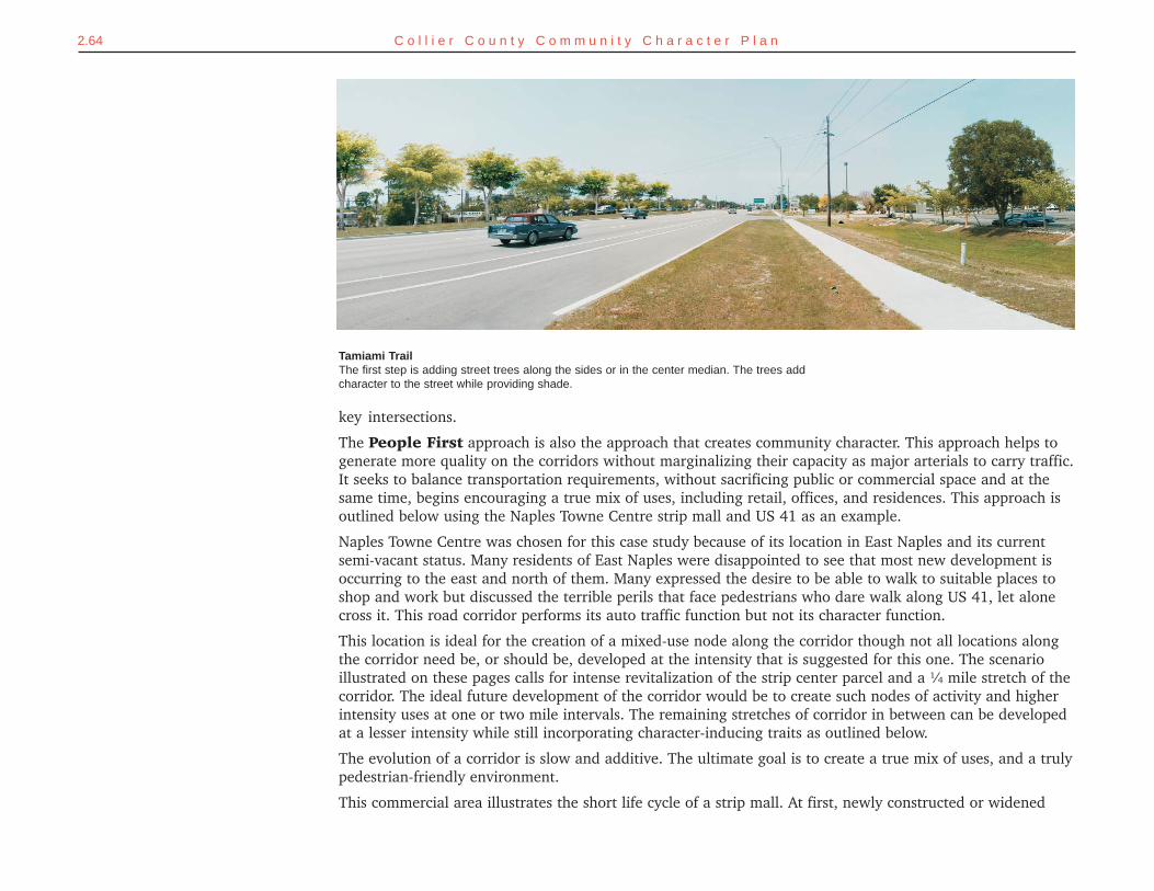
2.64 C o l l i e r C o u n t y C o m m u n i t y C h a r a c t e r P l a n
key intersections.
The People First approach is also the approach that creates community character. This approach helps togenerate more quality on the corridors without marginalizing their capacity as major arterials to carry traffic.It seeks to balance transportation requirements, without sacrificing public or commercial space and at thesame time, begins encouraging a true mix of uses, including retail, offices, and residences. This approach isoutlined below using the Naples Towne Centre strip mall and US 41 as an example.
Naples Towne Centre was chosen for this case study because of its location in East Naples and its currentsemi-vacant status. Many residents of East Naples were disappointed to see that most new development isoccurring to the east and north of them. Many expressed the desire to be able to walk to suitable places toshop and work but discussed the terrible perils that face pedestrians who dare walk along US 41, let alonecross it. This road corridor performs its auto traffic function but not its character function.
This location is ideal for the creation of a mixed-use node along the corridor though not all locations alongthe corridor need be, or should be, developed at the intensity that is suggested for this one. The scenarioillustrated on these pages calls for intense revitalization of the strip center parcel and a ¼ mile stretch of thecorridor. The ideal future development of the corridor would be to create such nodes of activity and higherintensity uses at one or two mile intervals. The remaining stretches of corridor in between can be developedat a lesser intensity while still incorporating character-inducing traits as outlined below.
The evolution of a corridor is slow and additive. The ultimate goal is to create a true mix of uses, and a trulypedestrian-friendly environment.
This commercial area illustrates the short life cycle of a strip mall. At first, newly constructed or widened
Tamiami TrailThe first step is adding street trees along the sides or in the center median. The trees addcharacter to the street while providing shade.
2.65C o m m u n i t y D e s i g n M a n u a l
roads bring people. Increased traffic counts on the road meaninitially high customer traffic in the stores. Then (usually fol-lowing more roadbuilding downstream or on another nearbycorridor) a newer or more convenient shopping center is built,cannibalizing the customer base, and after a short durationthe process repeats itself. As strip centers obsolesce and arereplaced by newer and more convenient centers, customers aredrawn away. Discount stores move in as the higher revenueproducing stores migrate to new centers. These market shiftsmake the standard strip mall configuration cyclically obsolete,which owners combat through repeated façade renovations.Once the location becomes less desirable, though, no amountof façade renovations will bring back business. The end resultis a shell or a half-used symbol of decay. The Naples TowneCentre / US 41 case study illustrates the recycling of sucha key commercial parcel that has become obsolete.
Tamiami TrailThe next step in humanizing the corridor stripis to transform the 6-lane road into a trueboulevard with 4 through lanes and 2 localtraffic lanes. The boulevard separates localtraffic from the high speed interior travellanes, easing turning movements off TamiamiTrail and reducing speed on the side accesslanes to a rate more conducive to pedestrianactivities.
The short life cycle of strip malls and big boxes.
2.66 C o l l i e r C o u n t y C o m m u n i t y C h a r a c t e r P l a n
STEPS FOR TRANSFORMING THE CORRIDOR AND ADJACENT DEVELOPMENT:
1. Install street trees.
The first step to make these corridors more attractive and functional for all modes of transportation is to changetheir character. The easiest way to begin doing this is to add street trees to the central median. Pedestrians willnever consider using a street such as US 41 if they find it a hostile environment while driving. Adding street treesto the central median already present will beautify the street somewhat and spatially define two separate sectors,a step toward creating the “public room.”
2. Change the traffic pattern; convert to a boulevard cross-section.
The road is currently carrying three lanes of traffic in each direction at an officially posted speed of 45 miles perhour, though designed for a much higher speed. Presently the regional traffic making longer trips must competefor lanes with neighborhood traffic making local trips . It is necessary to re-enter the regional roadway just totravel a block or two. An excessive number of oversized curb cuts along the sidewalk make walking and biking ahazard.
Using surplus right-of-way to create a second median, between the curb and center lanes of traffic on both sides, a
Tamiami TrailAllow on-street parking along the sideaccess lanes, offering motorists conven-ience. The parking provides a physicaland psychological barrier betweenpedestrians and moving traffic.
2.67C o m m u n i t y D e s i g n M a n u a l
street with two motoring profiles will result. The boulevard cross-section created will have four interior lanes tomove high-speed traffic along, and a slow-moving side access lane on each side for local traffic. After the sideaccess lane is created by the additional median, on-street parking can be added to facilitate walking and supportbusinesses. Street trees will be incorporated on the boulevard medians and along the sidewalks.
3. Construct buildings along the sidewalk on the side access lane.
Ensure that buildings are built at the street edge. Sidewalk dining and retail will be viable along the corridor.(This requires a significant policy shift to embrace build-to lines instead of setbacks.) Apartments, condominiums,hotels, and office spaces can occupy the upper floors, thereby fostering additional vitality and pedestrian trafficwithout displacing valuable commercial space downstairs. Parking lots will be principally located midblock, inparking structures if need be, screened from view.
Tamiami TrailThis final step, a long range one, is tobring the buildings close to the streetedge. The on-street parking and a viablepedestrian environment must come firstfor retailers to succeed. Businesses willbenefit by the proximity to the street andnew visual prominence.
2.68 C o l l i e r C o u n t y C o m m u n i t y C h a r a c t e r P l a n
Naples Towne CentreExisting conditions
Phase 1Planting street trees andaddition of wider medians andside access lanes.
Phase 2Buildings along Tamiami Trail arepositioned close to the street, framing it.
Phase 3Street network emerges.
Naples Towne Centre in 2000: one of the three lowest-rankedphotos from the Community Image Survey.
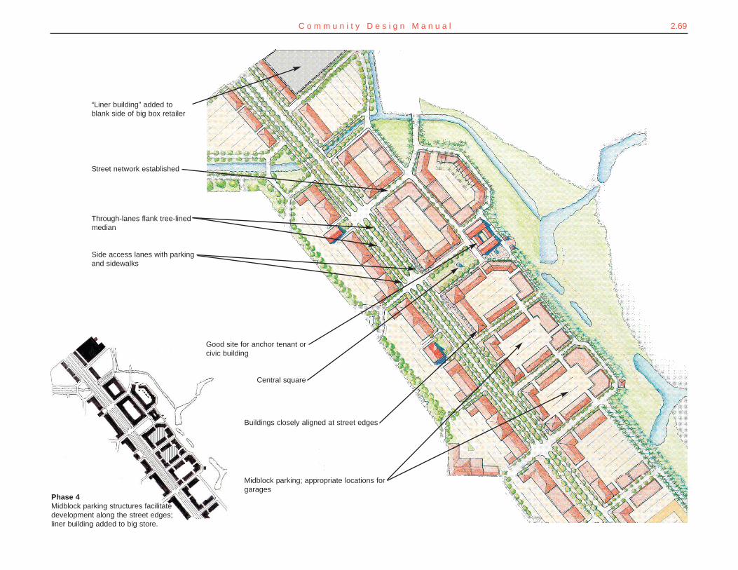
2.69C o m m u n i t y D e s i g n M a n u a l
“Liner building” added toblank side of big box retailer
Street network established
Through-lanes flank tree-linedmedian
Good site for anchor tenant orcivic building
Buildings closely aligned at street edges
Midblock parking; appropriate locations forgarages
Central square
Side access lanes with parkingand sidewalks
Phase 4Midblock parking structures facilitatedevelopment along the street edges;liner building added to big store.
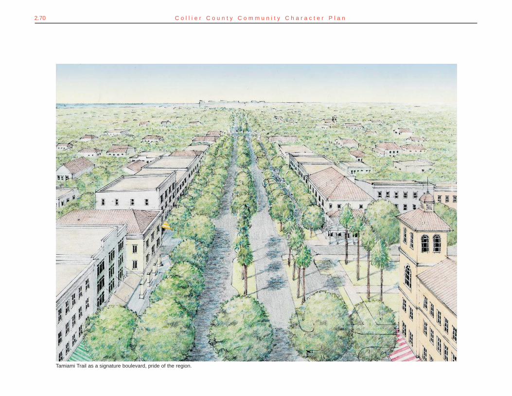
2.70 C o l l i e r C o u n t y C o m m u n i t y C h a r a c t e r P l a n
Tamiami Trail as a signature boulevard, pride of the region.
2.71C o m m u n i t y D e s i g n M a n u a l
SETTING THE COURSECollier County’s major roads can be functional yet beautiful corridors thatresidents are proud of and visitors admire. Even failing commercial stripscan be transformed into grand boulevards – converting visually blightedareas to premier mixed-use public places. Partnerships with adjoininglandowners, and public / private development partnerships, are a key tosuch transformations.
GETTING THEREGrowth Management Plana. Add an achievable objective #2 under goal #3 encouraging the transformation of aging com-
mercial developments into mixed-use neighborhoods.i. Add a new policy stating that activity centers or aging shopping centers may quali-
fy for "community planning" assistance as potential "town centers" as describedunder objective #4 of goal #3.
ii. Add a policy describing steps for transforming an aging commercial corridor asdescribed in this plan.
iii. Add a policy specifically encouraging aging shopping centers to include moder-ate-cost housing that can reduce travel demand by those currently priced intoremote locations for housing.
RETHINKING THE CORRIDORS