Embed Size (px)
Citation preview
FSAHANDBOOK
Common Land Unit
For State and County Offices
SHORT REFERENCE
8-CM(Revision 1)
UNITED STATES DEPARTMENT OF AGRICULTUREFarm Service Agency
Washington, DC 20250
UNITED STATES DEPARTMENT OF AGRICULTURE Farm Service Agency
Washington, DC 20250
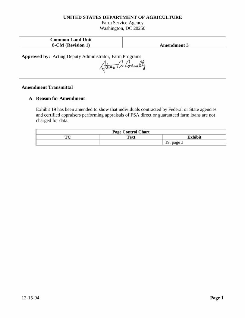
Common Land Unit 8-CM (Revision 1) Amendment 3
Approved by: Acting Deputy Administrator, Farm Programs
Amendment Transmittal
A Reason for Amendment
Exhibit 19 has been amended to show that individuals contracted by Federal or State agencies and certified appraisers performing appraisals of FSA direct or guaranteed farm loans are not charged for data.
Page Control Chart TC Text Exhibit
19, page 3 12-15-04 Page 1

…
Table of Contents
Page No. Part 1 Purpose and Responsibilities 1 General Information ........................................................................................ 1-1 2 Authority and Related Handbooks .................................................................. 1-6 3-30 (Reserved) Part 2 Managing CLU
Section 1 CLU Data Managers 31 Overview ........................................................................................................ 2-1 32 CLU Data Responsibilities .............................................................................. 2-2 33 CLU Service Center Managers ........................................................................ 2-6 34-60 (Reserved)
Section 2 CLU Data Quality Control 61 Ensuring Quality Control ................................................................................ 2-37 62 Quality Control in Digitizing Centers .............................................................. 2-39 63 Service Center Initial Quality Control Review ................................................ 2-41 64 Maintaining CLU Quality ............................................................................... 2-42 65-90 (Reserved) Part 3 Delineating CLU’s
Section 1 Rules for Delineation 91 Overview ........................................................................................................ 3-1 92 Data Layers .................................................................................................... 3-3 93 Delineating Urban CLU .................................................................................. 3-5 94 Delineating Cropland CLU ............................................................................. 3-6 95 Delineating Rangeland CLU ........................................................................... 3-8 96 Delineating Other Agricultural CLU ............................................................... 3-9 97 Delineating Forest CLU .................................................................................. 3-10 98 Delineating Water Body CLU ......................................................................... 3-12 99 Delineating Mined CLU ................................................................................. 3-13 100 Delineating Barren CLU ................................................................................. 3-14 101 Delineating Tundra CLU ................................................................................ 3-15 102 Delineating Perennial Snow and Ice CLU ....................................................... 3-16 103-130 (Reserved) 7-27-01 8-CM (Rev. 1) Amend. 1 TC Page 1
Table of Contents
Page No. Part 3 Delineating CLU’s (Continued)
Section 2 Digitizing Standards 131 Introduction .................................................................................................... 3-69 132 Minimum Digitizing Scale .............................................................................. 3-70 133 Minimum Precision ........................................................................................ 3-70 134 Standard Digitizing Defaults ........................................................................... 3-71 135 Tract Digitizing Standards .............................................................................. 3-72 136 Handling Existing Multi-Tracts ....................................................................... 3-73 137 Land Physically Located Outside of County ................................................... 3-74 138-160 (Reserved) Part 4 Identifying CLU 161 Numbering and Labeling CLU ........................................................................ 4-1 162 Attributing CLU’s ........................................................................................... 4-3 163-190 (Reserved) Part 5 Relationship With Other Data 191 Overview ........................................................................................................ 5-1 192 Linking CLU to Customer .............................................................................. 5-2 193 CLU and Other Data Layers ........................................................................... 5-3 194 Wetland Point Layer ....................................................................................... 5-4 195 Conservation Management Units Layer .......................................................... 5-5 196-220 (Reserved) Part 6 Releasing Data
Section 1 Rules for Release of Data 221 General Information......................................................................................... 6-1 222 Releasing CLU Data........................................................................................ 6-2 223-250 (Reserved) 7-27-01 8-CM (Rev. 1) Amend. 1 TC Page 2
Table of Contents (Continued)
Page No. Part 6 Releasing Data (Continued)
Section 2 Servicing Requests 251 Basic Policy..................................................................................................... 6-55 252 Requests for Ortho-Imagery............................................................................. 6-56 253 Requests for CLU............................................................................................ 6-57 254 Requests for Wetland Point Data ..................................................................... 6-58.5 255 Requests for CRP Data .................................................................................... 6-59 256-280 (Reserved) Part 7 Metadata 281 General Information......................................................................................... 7-1 282-310 (Reserved) Exhibits
1 Reports, Forms, Abbreviations, and Redelegations of Authority 2 Definitions of Terms Used in This Handbook 3-5 (Reserved) 6 Example of DOQ 7 Example of Digitized CLU’s on Top of DOQ 8 Example of Digitized CLU’s With Soils Layer on Top of DOQ 9 Example of Digitized CLU’s With Labels on Top of DOQ 10-12 (Reserved) 13 CLU Tools 14 Available Standards 15-16 (Reserved) 17 CLU Attributes 18 Land Classification Codes` 19 Charging for Data 20, 21 (Reserved) 22 Example of CLU Metadata
8-18-04 8-CM (Rev. 1) Amend. 2 TC Page 3

.

.
Par. 1Part 1 Purpose and Responsibilities
1 General Information
AHandbookPurpose
This handbook provides:
• policy and standards for establishing and using CLU’s
• specifications for developing a CLU geo-referenced data layer for use withGIS.
BCLU Initiative The CCE initiative is providing FSA, NRCS, and RD with modern,
windows-based computers that support the use of GIS, as well as local databasesand other software tools.
The Agencies are taking advantage of this new environment through projects suchas the spatial data initiatives and investing in a nationwide coverage oforthophotography. With the new CCE equipment, GIS software, and digitalversions of the photographs, a new work environment is being created. Theorthophotographs can be displayed on a computer screen, and additional layers ofdata can be displayed on top of the photograph to produce many new types ofproducts for use in USDA offices and for USDA customers.
The CLU initiative described in this handbook is a major step in establishing aninteragency standard for delineating the boundaries of a piece of land. A commondefinition established across agencies for the most basic divisions or segments ofland will:
• improve data sharing• make information provided to customers more complete and meaningful.
Transferring CLU polygons into GIS is called digitizing. Digitization is thecreation of digital lines in GIS and is accomplished using heads-up digitizingmethods. Heads-up digitizing is the process of tracing lines over an imagedisplayed on the computer screen using a computer mouse. For Service Centers,these polygons will represent CLU boundary lines.
Note: See Exhibits 6 through 9 for examples of digital polygons.
Continued on the next page
7-27-01 8-CM (Rev. 1) Amend. 1 Page 1-1
Par. 11 General Information (Continued)
CCLU Link toExisting Data
In addition to the orthophotograph data, CLU’s are currently being digitized toproduce a CLU data layer. Digitizing involves using GIS to draw a border arounda unit of land found on a photograph. This border forms a polygon (a many-sidedshape) that can be processed by GIS.
GIS can:
• make these lines a particular color
• overlay the border lines on top of the original orthophotograph
• calculate the area of the polygon
• attach elements of data, such as a label or a field number or a record identifier,to this polygon shape.
In this way, the Agencies will build a framework for linking the vast stores ofdata currently held in files and databases to new data in the spatial dimension.This ties an agency’s existing data to a specific point or area on the ground.
DDefinition ofCLU
CLU is the smallest unit of land that has a:
• permanent, contiguous boundary• common land cover and land management• common owner• common producer association.
It is difficult to define terms and boundary delineations for CLU that covers allland uses and earth covers. To accommodate this diversity, the definition in thissubparagraph has been adopted with the understanding that the rules fordelineation will vary slightly across land categories. The differences are noted inthis handbook as each basic category of land use is discussed.
Note: CLU’s are closely related to:
• FSA’s definition of “fields”, according to 2-CP
• lands units such as parcels, farmsteads, and lots, that are used byNRCS, RMA, and RD program administration.
Continued on the next page
7-27-01 8-CM (Rev. 1) Amend. 1 Page 1-2
Par. 11 General Information (Continued)
EUses of CLU’s While the potential uses of CLU data are many, work is currently focused on:
• replacing current paper maps with digital images that can be updated andproduce high-quality prints whenever needed
• using GIS to achieve greater accuracy in acreage calculations
• drawing the established boundaries of a field, and then using those boundariesas the basis for creating other data layers to show cropping patterns,subdivisions, and conservation plans
• establishing a central, national database of land unit boundaries, and linkingthese land units to customers
• building user-friendly tools to make the creation and maintenance of spatialdata layers easier
• speeding the process for implementing disaster payment and other specializedsystems.
Continued on the next page
7-27-01 8-CM (Rev. 1) Amend. 1 Page 1-3
Par. 11 General Information (Continued)
FBenefits CLU’s will:
• improve communication and data flow between Service Center Agencies, andwith farmers and other customers
• improve communication between software applications by providing acommon set of data elements to describe every CLU, establish commonidentifiers for units of land, and provide a common framework for spatiallylocating data in relation to the ground
• facilitate the creation of shared Service Center Agency data warehouses forland-related data
• provide for the incorporation of data from outside sources, includingdemographic data, satellite imagery, global position system data, andelevation data
• provide for consistent and more accurate land measurements, such as fieldacreage and riparian buffers and wetland areas
• provide for data summarizing to a county, watershed, regional, State,Congressional District, or national level.
• encourage the establishment of agreements with Federal, State, local, andprivate agencies, such as BLM, State GIS Policy Boards, property valuators,county appraisers, utility companies, etc., to facilitate the exchange of dataand resource costs
• provide more efficient and timely program-specific data.
Continued on the next page
7-27-01 8-CM (Rev. 1) Amend. 1 Page 1-4
Par. 11 General Information (Continued)
GReplacing PaperMaps With GISTechnology
R
As GIS becomes established in the Service Centers, the current paper aerialphotography used for planning program delivery, and for identifying landholdings, will be superseded by digital orthophotographs and digitized “layers” or“themes” of data. To give a digital equivalent of the current maps, the CLU layerwill be viewed on top of an orthophotograph base. Attributes from CLU andother layers will be displayed in place of previously-handwritten notations.
HConverting Dataon Paper Maps
Before Service Centers can stop maintaining paper aerial photography, additionalinformation, must be added to the descriptive information stored in the GISsystem (wetland point data, easements, and HEL determinations). In addition,since subdivisions are not digitized in the initial transfer process, CLU’s mayneed to be added for fields that were incorrectly numbered as subdivisions on theaerial photography. Other additional information may be added as sublayers atthe option of the Service Center according to paragraph 92.
7-27-01 8-CM (Rev. 1) Amend. 1 Page 1-5
Par. 22 Authority and Related Handbooks
ASource ofAuthority
Authority for the development of the CLU theme (data) was provided by theNational Food and Agricultural Council. The USDA Service Center GISStrategy, as approved by the National Food and Agricultural Council onAugust 18, 1998:
• designated FSA as the Data Steward for the CLU theme• provided the initial funding and production schedule for CLU digitizing.
BRelatedHandbooks
Service Center Agencies’ handbooks related to CLU’s are:
• 25-AS for recordkeeping requirements• 1-CM for common management procedures• 2-CM for reconstitutions procedures• 3-CM for farm records• 2-CP for compliance procedures and field definition• 6-CP for HELC and WC procedures• 2-CRP for Agricultural Resource Conservation Program procedures• 2-INFO for information available to the public• 3-INFO for Privacy Act operations• NRCS’s technical and policy manuals• RMA’s and RD’s policy and procedure handbooks.
3-30 (Reserved)
7-27-01 8-CM (Rev. 1) Amend. 1 Page 1-6

Par. 31Part 2 Managing CLU
Section 1 CLU Data Managers
31 Overview
AAgencyResponsibilities
The CLU layer is a shared geospatial dataset used by all agencies in the ServiceCenter. FSA assumes primary responsibility at the national, State, and local levelfor the maintenance of the layer, with partner agencies collaborating on thecontent and standards for the layer.
BCLU DataManagers
Data Managers, alternatively referred to as CLU Stewards for the CLU layer, willbe appointed at national, State, and local levels, wherever CLU data is stored andmaintained.
CRole ofDigitizingCenters
Digitizing centers are responsible for initially delineating CLU and entering CLUattribute data.
7-27-01 8-CM (Rev. 1) Amend. 1 Page 2-1
Par. 3232 CLU Data Responsibilities
AExecutiveSponsorResponsibilities
The Executive Sponsor is a high-level, business-area manager who is accountablefor the collection, management, and use of data assets. The person has overallresponsibility for:
• determining the potential business value of data
• overseeing the creation of software systems to collect and process data
• providing ongoing executive leadership over data content, validity, and usage
• designating national Data Manager and other critical data management rolesand responsibilities as appropriate.
Note: Diane Sharp is the Executive Sponsor for CLU.
Continued on the next page
7-27-01 8-CM (Rev. 1) Amend. 1 Page 2-2
Par. 3232 CLU Data Responsibilities (Continued)
BNational DataManagerResponsibilities
The national CLU Data Manager, alternatively referred to as the national CLUSteward, is responsible for:
• acting as the designated authority and point of contact for all business-areadecisions concerning the database
• establishing and maintaining business rules and consistent definitions for dataelements
• establishing data quality and certification standards associated with thecontents of the database
• ensuring that metabase is colleced, approved, and certified for releaseaccording to the adopted industry, Federal, and USDA metadata and datamanagement standards
• establishing policy and procedures that ensure the validity, accuracy, andcompleteness of the physical data and supporting metadata
• establishing policy and procedures for certifying that data is ready for releasefor internal and/or public use
• establishing policy and procedures for ensuring that data meets qualitystandards
• ensuring that adequate stewardship of data occurs at each location where datais collected and stored
• delegating responsibilities as necessary to ensure the accuracy of new dataand the ongoing protection of data assets
• providing training to the State Offices on CLU data stewarding roles andresponsibilities.
Note: Sandy Bryant has been designated as the national Data Manager.
Continued on the next page
7-27-01 8-CM (Rev. 1) Amend. 1 Page 2-3
Par. 3232 CLU Data Responsibilities (Continued)
CState DataManagerResponsibilities
The State CLU Data Manager, alternatively referred to as the State CLU Steward,and backup will be identified in each FSA State Office. Both the manager andbackup are responsible for:
• establishing adequate CLU training procedures for Service Centers
• developing and implementing a certification process for Service Center CLUstewards
• maintaining a list at the State Office of certified local CLU Data Stewards andtheir backups at the State Office
• certifying that Service Center CLU’s meet quality control standards beforeService Center converts to GIS
• conducting annual reviews of CLU datasets for the State to ensure continuedquality control
• knowing the standards and criteria for maintaining the official CLU layer
• ensuring that Service Centers maintain the data and metadata to meet theneeds of the partner agencies and protect data from loss
• collecting, validating, and linking geospatial State data to related tabular data;distributing geospatial State level data.
Continued on the next page
7-27-01 8-CM (Rev. 1) Amend. 1 Page 2-4
Par. 3232 CLU Data Responsibilities (Continued)
DLocalData ManagerResponsibilities
The Service Center Data Manager, alternatively referred to as the local CLUSteward, is responsible for:
• knowing the standards and criteria for maintaining the official CLU layer• ensuring that persons updating CLU have had adequate training• clearing all changes to the official CLU layer• performing periodic reviews of CLU to ensure continued quality control• maintaining the data and metadata to meet the needs of the partner agencies• collecting and validating new county level data• linking county level geospatial data to related tabular data• verifying that changes have been forwarded to the national database• protecting the data from loss.
7-27-01 8-CM (Rev. 1) Amend. 1 Page 2-5
Par. 3333 CLU Service Center Managers
AOverview The person assuming responsibility for the CLU delineations and data in each
Service Center shall be designated the CLU Data Manager. One CLU DataManager and at least one backup shall be identified in each Service Center. Themanager and backup shall be responsible for knowing the standards and criteriafor maintaining the official CLU layer and for making appropriate changes.
BCertification ofCLU Managers
The CLU Manager and backup at the Service Center must be certified by theState CLU Manager.
CDelegation ofAuthority forLocal CLUManager
Personnel from other agencies may be assigned to manage the CLU data at thelocal level only when FSA, with mutual agreement of the partner agencies in theService Center, designates another agency to handle the duties. The State CLUManager must approve the delegation of authority.
A person from another agency may be assigned as the backup CLU manager, withthe approval of the State CLU Manager.
DPrimaryResponsibility
The manager’s primary responsibility is maintaining the integrity and quality ofthe CLU boundaries and associated data for the partner agencies.
Continued on the next page
7-27-01 8-CM (Rev. 1) Amend. 1 Page 2-6
Par. 3333 CLU Service Center Managers (Continued)
EGeneral CLUMaintenance
Maintaining CLU data in the Service Center includes:
• seeing that day-to-day updates are performed as necessary on CLU’s• adding CLU’s for FSA or partner agency business needs• correcting CLU boundaries• updating CLU attributes• performing regular backups of the data.
FService CenterCLU ManagerTraining
State CLU Managers are responsible for establishment and training of CLUmanagers and certification of personnel.
34-60 (Reserved)
7-27-01 8-CM (Rev. 1) Amend. 1 Page 2-7(through 2-36)

.

Par. 61Section 2 CLU Data Quality Control
61 Ensuring Quality Control
AOverview Quality control is an essential part of managing the CLU data. Quality begins
with the Service Center ensuring that the aerial photography used to prepare CLUare updated and correct. It continues with accuracy in digitizing and entry ofCLU attributes. Once initial digitizing is completed, quality again depends on theService Center reviewing, correcting, and maintaining CLU boundaries andattributes.
BPreparing BaseMaps
Service Centers shall follow 2-CP to ensure that all aerial photographs that will beused as base maps are correct before they are shipped for digitizing. Thisincludes review and correction of areas that are not within the county boundaries,but cover farms administered by the Service Center. Sending base maps for allfarms that a Service Center administers will reduce the amount of work that aService Center has to do after CLU is digitized and returned.
CDigitizingCenters
Digitizing centers are responsible for digitizing the CLU according to thishandbook. They are also responsible for entry of the initial set of CLU attributes.See paragraph 62 for specific instructions on quality control in digitizing centers.
Continued on the next page
7-27-01 8-CM (Rev. 1) Amend. 1 Page 2-37
Par. 6161 Ensuring Quality Control (Continued)
DReplacingOfficial USDAPhotography
Once the initial digitizing of CLU and entry of attributes is completed, themosaicked orthophotography and CLU file are sent to the Service Center for aquality control review. This review includes the checking of returned CLU dataand entry of additional information, such as wetland point data, CRP data, farmnumbers, easements, and HEL determinations.
The review and entry of the additional information is necessary to ensure that nodata from the aerial photographs is lost in the conversion to CLU. Once theconversion is complete, the Service Center is responsible for maintaining CLU’sand the underlying orthophotography layer will become the official USDAphotography.
ETools andStandards
Specialized tools and basic standards have been developed to assist digitizingcenters and Service Centers in creating, maintaining, and using CLU. SeeExhibit 13 for a list of the available tools and Exhibit 14 for a list of approvedstandards documents.
7-27-01 8-CM (Rev. 1) Amend. 1 Page 2-38
Par. 6262 Quality Control in Digitizing Centers
AOverview Digitizing centers use FSA’s aerial photography as the “source” document or
“base map” for initial delineations of CLU boundaries. Only existing field andtract lines will be transferred as CLU boundaries. Line work and data added bycounties that is not required or provided as an option, such as subdivisions, willnot be transferred. Attribute information from the base map will also be part ofthe initial transfer.
BDigitizing Digitizing centers shall:
• follow this handbook for rules and procedures for digitizing• use the Digitizing Tool to digitize CLU.
CAttribute Data Digitizing centers shall enter the following CLU attribute data from the base
maps:
Tract number in TRACTNBRCLU number in CLUNBRFarm number in FARMNBRHighly erodible land type code in HELTYPECDOfficial acreage in FSA_ACRES.
Note: Items in this subparagraph shall be left blank when not present on thebase map.
DState andCounty Codes
Digitizing centers shall use the FIPS button in the Digitizing Tool to enter thefollowing in the CLU attribute table:
• State code where land is physically located, in STATECD• county code where land is physically located, in COUNTYCD.
Note: These are the FIPS codes, not the county code FSA uses to identify theService Centers. In the future, the county code will be linked to theFIPS code to handle cases where the FIPS code does not match thecounty code.
Continued on the next page
7-27-01 8-CM (Rev. 1) Amend. 1 Page 2-39
Par. 6262 Quality Control in Digitizing Centers (Continued)
EReasons forEntering OfficialAcreage
Digitizing centers shall enter the official field acreage from the aerial photographsin FSA_ACRES. This entry allows Service Centers to compare official acreagefrom the aerial photographs with the CLU calculated acreage. During the ServiceCenter’s initial quality review, at a minimum CLU’s with differences that exceedthe greater of 3 percent or 5 acres will be reviewed to determine whether the CLUboundaries were misinterpreted or whether the official acreage was incorrect.
The differences between official acreage and CLU calculated acreage will also betracked to determine the general trend in acreage changes.
FRunning QualityControl Tools
Digitizing centers shall:
• run the set of quality control tools provided in the Digitizing Tool against theCLU file
• correct errors before file is sent to the Service Center.
7-27-01 8-CM (Rev. 1) Amend. 1 Page 2-40
Par. 6363 Service Center Initial Quality Control Review
AOverview Quality control is an essential part of managing the CLU data. Before Service
Centers can stop maintaining the aerial photographs, additional informationrequired by various handbooks, such as wetland point data, CRP data, farmnumbers, easements, and HEL determinations shall be added as needed. This isnecessary to ensure that no data from the aerial photography is lost in theconversion to CLU.
Once the initial digitizing of CLU’s and the conversion of labels and other datafrom paper maps conversion is complete, the Service Center will be responsiblefor reviewing, correcting, and maintaining the CLU boundaries and attributes.CLU’s and the underlying orthophotography layer will become the official USDAphotography.
BInitialCertification ofCLU’s
A quality control review shall be performed on the CLU layer after digitizing iscomplete. This is necessary to ensure that no data from the paper maps is lost inthe conversion process.
The Service Center CLU Data Manager is responsible for overseeing the initialquality control review. Once CLU’s are considered complete, the State OfficeCLU Manager will perform a review and determine whether CLU’s can becertified.
Note: See 2-CP, Part 5, Section 2 for how to get CLU and the underlyingorthophotography layer initially certified as official USDA photography.
7-27-01 8-CM (Rev. 1) Amend. 1 Page 2-41
Par. 6464 Maintaining CLU Quality
AOverview Quality is contingent on training and reviews of work completed. It also involves
ensuring that a sufficient number of staff are trained and certified in each ServiceCenter to manage the CLU layer.
Each employee allowed to modify CLU must demonstrate to the local CLU DataSteward that they have sufficient knowledge of the GIS software to conductAgency business and maintain CLU as the official USDA photography for thepartner agencies. Limiting the use of this software to only certified employees isintended to ensure that the quality of CLU is maintained to specifications.
BClearingChanges to CLU
All changes to the official CLU layer shall be cleared through the local CLU DataManager or the backup.
CAcreage Changes GIS will automatically provide the calculated acreage of the digitized land unit
polygon. This acreage may differ from the acreage calculated by other means andrecorded as “official acreage” in historical records and program-delivery systems.Acreage changes in official acres or in tract acreage shall be handled according to2-CP and 3-CM.
65-90 (Reserved)
7-27-01 8-CM (Rev. 1) Amend. 1 Page 2-42
Par. 91Part 3 Delineating CLU’s
Section 1 Rules for Delineation
91 Overview
AAKey Information Transferring CLU polygons is called digitizing. Digitization is the creation of
digital lines in GIS and is accomplished using heads-up digitizing methods.Heads-up digitizing is the process of tracing lines over an image displayed on thecomputer screen using a computer mouse. For Service Centers, these polygonsrepresent CLU boundary lines.
Service Centers shall delineate CLU at a level of detail and accuracy that matchesor exceeds that used on 24” x 24” aerial photography. This includes not only thetract and field boundaries, but key information such as CRP data; HELdeterminations; farm, tract, and field numbers; and easement identification. Theinformation associated with CLU is entered by attributing (attaching) thesecharacteristics to CLU.
BLandClassifications
The partner agencies have established 10 fundamental land classifications basedon land cover and land use. These classifications are:
• Barren• Cropland• Forest• Mined• Other Agricultural• Perennial Snow and Ice• Rangeland• Tundra• Urban• Water Body.
The specialized rules for delineating each of these land classifications areincluded in this section.
Continued on the next page
7-27-01 8-CM (Rev. 1) Amend. 1 Page 3-1
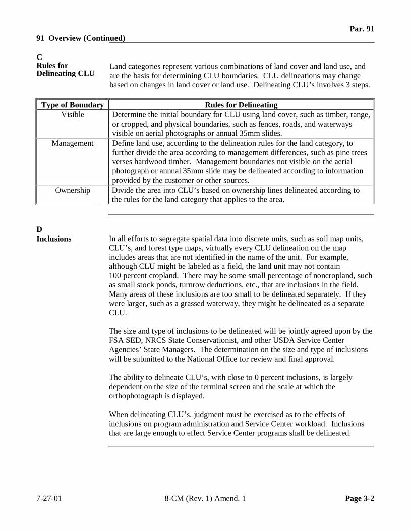
Par. 9191 Overview (Continued)
CRules forDelineating CLU
Land categories represent various combinations of land cover and land use, andare the basis for determining CLU boundaries. CLU delineations may changebased on changes in land cover or land use. Delineating CLU’s involves 3 steps.
Type of Boundary Rules for DelineatingVisible Determine the initial boundary for CLU using land cover, such as timber, range,
or cropped, and physical boundaries, such as fences, roads, and waterwaysvisible on aerial photographs or annual 35mm slides.
Management Define land use, according to the delineation rules for the land category, tofurther divide the area according to management differences, such as pine treesverses hardwood timber. Management boundaries not visible on the aerialphotograph or annual 35mm slide may be delineated according to informationprovided by the customer or other sources.
Ownership Divide the area into CLU’s based on ownership lines delineated according tothe rules for the land category that applies to the area.
DInclusions In all efforts to segregate spatial data into discrete units, such as soil map units,
CLU’s, and forest type maps, virtually every CLU delineation on the mapincludes areas that are not identified in the name of the unit. For example,although CLU might be labeled as a field, the land unit may not contain100 percent cropland. There may be some small percentage of noncropland, suchas small stock ponds, turnrow deductions, etc., that are inclusions in the field.Many areas of these inclusions are too small to be delineated separately. If theywere larger, such as a grassed waterway, they might be delineated as a separateCLU.
The size and type of inclusions to be delineated will be jointly agreed upon by theFSA SED, NRCS State Conservationist, and other USDA Service CenterAgencies’ State Managers. The determination on the size and type of inclusionswill be submitted to the National Office for review and final approval.
The ability to delineate CLU’s, with close to 0 percent inclusions, is largelydependent on the size of the terminal screen and the scale at which theorthophotograph is displayed.
When delineating CLU’s, judgment must be exercised as to the effects ofinclusions on program administration and Service Center workload. Inclusionsthat are large enough to effect Service Center programs shall be delineated.
7-27-01 8-CM (Rev. 1) Amend. 1 Page 3-2
Par. 9292 Data Layers
ASubordinateData Layers
By definition, CLU is delineated by permanent features such as fence lines, roads,waterways. This requirement minimizes the number of changes that will berequired to CLU boundaries.
However, an important function and advantage of GIS is the ability to buildadditional layers of data. For example, subdivisions of CLU to show croppingpatterns or conservation practices can be created in a separate layer andsuperimposed over the established CLU boundaries. The CLU layer can thusbecome the base layer for many other program-specific information layers createdby partner agencies.
BExamples ofSubordinateData Layers
Layers already identified to be built from and tied to the CLU layer are NRCS’sCM Land Units layer, and FSA’s Wetland Points data layer.
Other possible examples are:
• subdividing an existing CLU to indicate crop variations or terraces
• combining CLU’s with other layers such as soils to create thematic maps thatshow the soils for specific fields
• partitioning wetland determinations
• grouping CLU’s with common attributes into new data layers such as CRPfields or tracts.
These layers may have permanent or short-term use in a Service Center or at otherlevels of the Service Center Agencies.
Continued on the next page
7-27-01 8-CM (Rev. 1) Amend. 1 Page 3-3
Par. 9292 Data Layers (Continued)
CSubdivisions Subdivisions may change regularly within CLU boundaries because of farm
management factors. FSA currently delineates subdivisions on a photocopy ofthe aerial photograph enlargement. Subdivisions are delineated according tocompliance reporting dates, if not sooner, and are based on a description by thefarmer. The placement of the boundary line is often approximated since it is notlikely that MDOQ or the base layer digital map matches current conditions.
Initial delineation of CLU’s will not include data on any field subdivisions, suchas CRP or terraces. The Service Center may transfer these subdivisions into theautomated system as subordinate data layers after the initial delineations arecompleted.
7-27-01 8-CM (Rev. 1) Amend. 1 Page 3-4
Par. 9393 Delineating Urban CLU
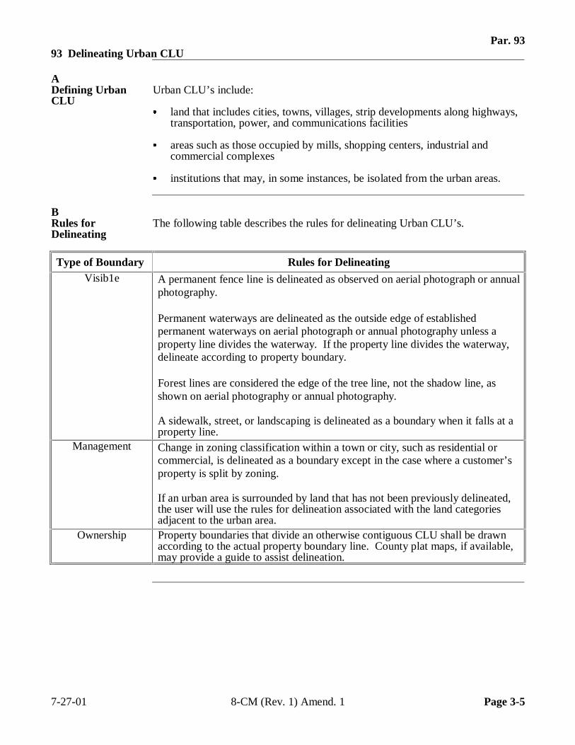
ADefining UrbanCLU
Urban CLU’s include:
� land that includes cities, towns, villages, strip developments along highways,transportation, power, and communications facilities
� areas such as those occupied by mills, shopping centers, industrial andcommercial complexes
� institutions that may, in some instances, be isolated from the urban areas.
BRules forDelineating
The following table describes the rules for delineating Urban CLU’s.
Type of Boundary Rules for DelineatingVisib1e A permanent fence line is delineated as observed on aerial photograph or annual
photography.
Permanent waterways are delineated as the outside edge of establishedpermanent waterways on aerial photograph or annual photography unless aproperty line divides the waterway. If the property line divides the waterway,delineate according to property boundary.
Forest lines are considered the edge of the tree line, not the shadow line, asshown on aerial photography or annual photography.
A sidewalk, street, or landscaping is delineated as a boundary when it falls at aproperty line.
Management Change in zoning classification within a town or city, such as residential orcommercial, is delineated as a boundary except in the case where a customer’sproperty is split by zoning.
If an urban area is surrounded by land that has not been previously delineated,the user will use the rules for delineation associated with the land categoriesadjacent to the urban area.
Ownership Property boundaries that divide an otherwise contiguous CLU shall be drawnaccording to the actual property boundary line. County plat maps, if available,may provide a guide to assist delineation.
7-27-01 8-CM (Rev. 1) Amend. 1 Page 3-5
Par. 9494 Delineating Cropland CLU
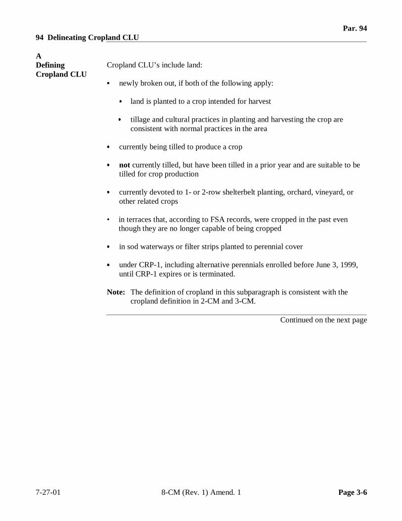
ADefiningCropland CLU
Cropland CLU’s include land:
� newly broken out, if both of the following apply:
� land is planted to a crop intended for harvest
� tillage and cultural practices in planting and harvesting the crop areconsistent with normal practices in the area
� currently being tilled to produce a crop
� not currently tilled, but have been tilled in a prior year and are suitable to betilled for crop production
� currently devoted to 1- or 2-row shelterbelt planting, orchard, vineyard, orother related crops
• in terraces that, according to FSA records, were cropped in the past eventhough they are no longer capable of being cropped
� in sod waterways or filter strips planted to perennial cover
� under CRP-1, including alternative perennials enrolled before June 3, 1999,until CRP-1 expires or is terminated.
Note: The definition of cropland in this subparagraph is consistent with thecropland definition in 2-CM and 3-CM.
Continued on the next page
7-27-01 8-CM (Rev. 1) Amend. 1 Page 3-6
Par. 9494 Delineating Cropland CLU (Continued)
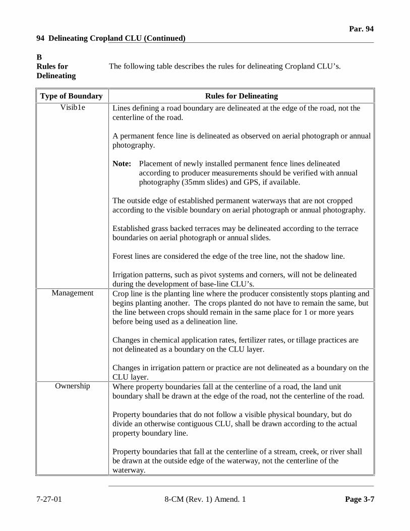
BRules forDelineating
The following table describes the rules for delineating Cropland CLU’s.
Type of Boundary Rules for DelineatingVisib1e Lines defining a road boundary are delineated at the edge of the road, not the
centerline of the road.
A permanent fence line is delineated as observed on aerial photograph or annualphotography.
Note: Placement of newly installed permanent fence lines delineatedaccording to producer measurements should be verified with annualphotography (35mm slides) and GPS, if available.
The outside edge of established permanent waterways that are not croppedaccording to the visible boundary on aerial photograph or annual photography.
Established grass backed terraces may be delineated according to the terraceboundaries on aerial photograph or annual slides.
Forest lines are considered the edge of the tree line, not the shadow line.
Irrigation patterns, such as pivot systems and corners, will not be delineatedduring the development of base-line CLU’s.
Management Crop line is the planting line where the producer consistently stops planting andbegins planting another. The crops planted do not have to remain the same, butthe line between crops should remain in the same place for 1 or more yearsbefore being used as a delineation line.
Changes in chemical application rates, fertilizer rates, or tillage practices arenot delineated as a boundary on the CLU layer.
Changes in irrigation pattern or practice are not delineated as a boundary on theCLU layer.
Ownership Where property boundaries fall at the centerline of a road, the land unitboundary shall be drawn at the edge of the road, not the centerline of the road.
Property boundaries that do not follow a visible physical boundary, but dodivide an otherwise contiguous CLU, shall be drawn according to the actualproperty boundary line.
Property boundaries that fall at the centerline of a stream, creek, or river shallbe drawn at the outside edge of the waterway, not the centerline of thewaterway.
7-27-01 8-CM (Rev. 1) Amend. 1 Page 3-7
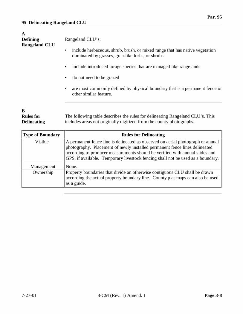
Par. 9595 Delineating Rangeland CLU
ADefiningRangeland CLU
Rangeland CLU’s:
• include herbaceous, shrub, brush, or mixed range that has native vegetationdominated by grasses, grasslike forbs, or shrubs
� include introduced forage species that are managed like rangelands
� do not need to be grazed
• are most commonly defined by physical boundary that is a permanent fence orother similar feature.
BRules forDelineating
The following table describes the rules for delineating Rangeland CLU’s. Thisincludes areas not originally digitized from the county photographs.
Type of Boundary Rules for Delineating
Visible A permanent fence line is delineated as observed on aerial photograph or annualphotography. Placement of newly installed permanent fence lines delineatedaccording to producer measurements should be verified with annual slides andGPS, if available. Temporary livestock fencing shall not be used as a boundary.
Management None.Ownership Property boundaries that divide an otherwise contiguous CLU shall be drawn
according the actual property boundary line. County plat maps can also be usedas a guide.
7-27-01 8-CM (Rev. 1) Amend. 1 Page 3-8
Par. 9696 Delineating Other Agricultural CLU
ADefining OtherAgriculturalCLU
Other agricultural CLU’s include farmsteads, holding areas for livestock such ascorrals, breeding and training facilities on horse farms, farm lanes and roads,ditches and canals, small farm ponds, and similar uses.
Note: This corresponds to “other land on the farm” portion of Farmland asdefined in 3-CM.
BRules forDelineating
The following table describes the rules for delineating other agricultural landCLU’s.
Type of Boundary Rules for Delineating
Visible A permanent fence line is delineated as shown on aerial photography or annualphotography. Placement of newly installed permanent fence lines delineatedaccording to producer measurements should be verified with annualphotography. Temporary livestock fencing will not be used as a boundary.
The outside edge of established permanent waterways that are not cropped aredelineated according to visible boundary on aerial photograph or annualphotography. Newly created permanent waterways can be delineated accordingto measurements provided by NRCS.
Forest lines are considered the edge of the tree line, not the shadow line, asshown on aerial photography.
A sidewalk, street, or landscaping is delineated as a boundary when it falls at aproperty line.
Management Changes in land cover, such as from cropped land to a holding area for livestock,could cause boundary delineation if required for a Service Center Agency’sbusiness needs.
Ownership Property boundaries that divide an otherwise contiguous CLU shall be drawnaccording to the actual property line.
7-27-01 8-CM (Rev. 1) Amend. 1 Page 3-9
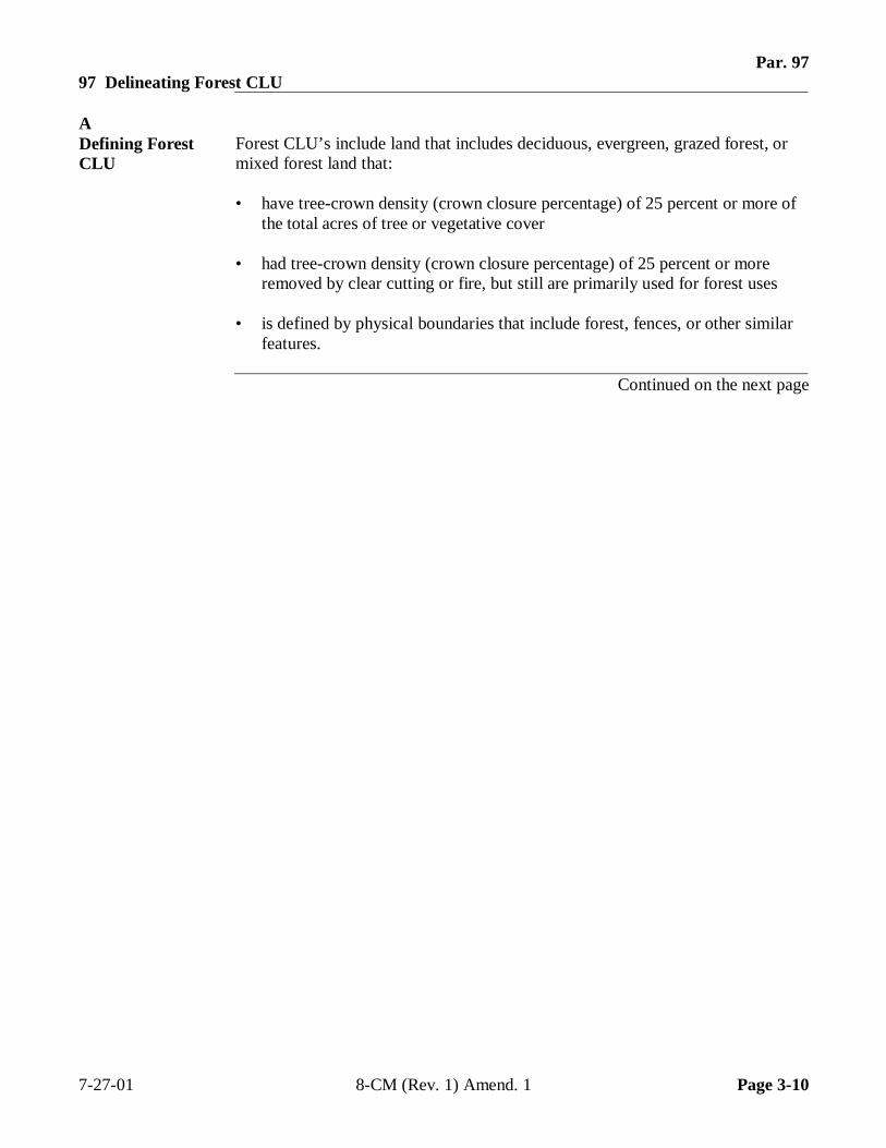
Par. 9797 Delineating Forest CLU
ADefining ForestCLU
Forest CLU’s include land that includes deciduous, evergreen, grazed forest, ormixed forest land that:
• have tree-crown density (crown closure percentage) of 25 percent or more ofthe total acres of tree or vegetative cover
• had tree-crown density (crown closure percentage) of 25 percent or moreremoved by clear cutting or fire, but still are primarily used for forest uses
• is defined by physical boundaries that include forest, fences, or other similarfeatures.
Continued on the next page
7-27-01 8-CM (Rev. 1) Amend. 1 Page 3-10
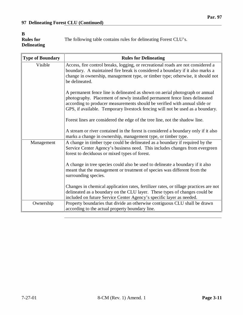
Par. 9797 Delineating Forest CLU (Continued)
BRules forDelineating
The following table contains rules for delineating Forest CLU’s.
Type of Boundary Rules for Delineating
Visible Access, fire control breaks, logging, or recreational roads are not considered aboundary. A maintained fire break is considered a boundary if it also marks achange in ownership, management type, or timber type; otherwise, it should notbe delineated.
A permanent fence line is delineated as shown on aerial photograph or annualphotography. Placement of newly installed permanent fence lines delineatedaccording to producer measurements should be verified with annual slide orGPS, if available. Temporary livestock fencing will not be used as a boundary.
Forest lines are considered the edge of the tree line, not the shadow line.
A stream or river contained in the forest is considered a boundary only if it alsomarks a change in ownership, management type, or timber type.
Management A change in timber type could be delineated as a boundary if required by theService Center Agency’s business need. This includes changes from evergreenforest to deciduous or mixed types of forest.
A change in tree species could also be used to delineate a boundary if it alsomeant that the management or treatment of species was different from thesurrounding species.
Changes in chemical application rates, fertilizer rates, or tillage practices are notdelineated as a boundary on the CLU layer. These types of changes could beincluded on future Service Center Agency’s specific layer as needed.
Ownership Property boundaries that divide an otherwise contiguous CLU shall be drawnaccording to the actual property boundary line.
7-27-01 8-CM (Rev. 1) Amend. 1 Page 3-11
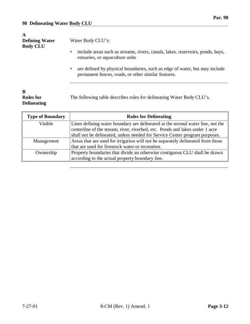
Par. 9898 Delineating Water Body CLU
ADefining WaterBody CLU
Water Body CLU’s:
• include areas such as streams, rivers, canals, lakes, reservoirs, ponds, bays,estuaries, or aquaculture units
• are defined by physical boundaries, such as edge of water, but may includepermanent fences, roads, or other similar features.
BRules forDelineating
The following table describes rules for delineating Water Body CLU’s.
Type of Boundary Rules for Delineating
Visible Lines defining water boundary are delineated at the normal water line, not thecenterline of the stream, river, riverbed, etc. Ponds and lakes under 1 acreshall not be delineated, unless needed for Service Center program purposes.
Management Areas that are used for irrigation will not be separately delineated from thosethat are used for livestock water or recreation.
Ownership Property boundaries that divide an otherwise contiguous CLU shall be drawnaccording to the actual property boundary line.
7-27-01 8-CM (Rev. 1) Amend. 1 Page 3-12
Par. 9999 Delineating Mined CLU
ADefining MinedCLU
Mined CLU’s include:
� extractive mining activities that have significant surface expression
• areas where vegetative cover and overburden are removed to expose suchdeposits as coal, iron ore, limestone, and copper
• areas where quarrying of building and decorative stone and recovery of sandand gravel deposits also result in large open surface pits
• inactive, unreclaimed, and active strip mines; quarries, borrow pits, andgravel pits even where current mining activity is not always distinguishableare included in this category until other cover or use has been established.
Note: Unused pits or quarries that have flooded, however, are placed in theWater category.
BRules forDelineating
The following table describes rules for delineating Mined CLU’s.
Type of Boundary Rules for Delineating
Visible A permanent fence line is delineated as shown on aerial photography or annualphotography. Placement of newly installed permanent fence lines delineatedaccording to producer measurements should be verified with annualphotography. Temporary livestock fencing will not be used as a boundary.
The outside edge of established permanent waterways that are not cropped aredelineated according to visible boundary on aerial photograph or annualphotography. Newly created permanent waterways can be delineatedaccording to measurements provided by NRCS.
Forest lines are considered the edge of the tree line, not the shadow line, asshown on aerial photography.
Management Changes in land cover, such as from a strip mine to a gravel pit, could causeboundary delineation if required for a Service Center Agency’s business needs.
Ownership Property boundaries that divide an otherwise contiguous CLU shall be drawnaccording to the actual property boundary line.
7-27-01 8-CM (Rev. 1) Amend. 1 Page 3-13
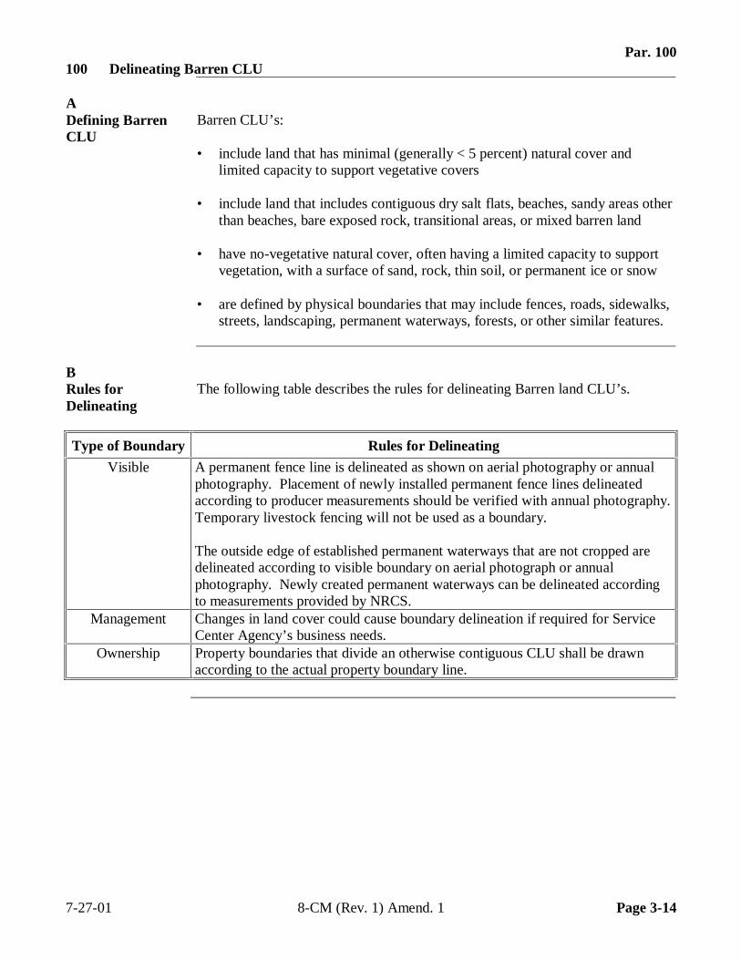
Par. 100100 Delineating Barren CLU
ADefining BarrenCLU
Barren CLU’s:
• include land that has minimal (generally < 5 percent) natural cover andlimited capacity to support vegetative covers
• include land that includes contiguous dry salt flats, beaches, sandy areas otherthan beaches, bare exposed rock, transitional areas, or mixed barren land
• have no-vegetative natural cover, often having a limited capacity to supportvegetation, with a surface of sand, rock, thin soil, or permanent ice or snow
• are defined by physical boundaries that may include fences, roads, sidewalks,streets, landscaping, permanent waterways, forests, or other similar features.
BRules forDelineating
The following table describes the rules for delineating Barren land CLU’s.
Type of Boundary Rules for Delineating
Visible A permanent fence line is delineated as shown on aerial photography or annualphotography. Placement of newly installed permanent fence lines delineatedaccording to producer measurements should be verified with annual photography.Temporary livestock fencing will not be used as a boundary.
The outside edge of established permanent waterways that are not cropped aredelineated according to visible boundary on aerial photograph or annualphotography. Newly created permanent waterways can be delineated accordingto measurements provided by NRCS.
Management Changes in land cover could cause boundary delineation if required for ServiceCenter Agency’s business needs.
Ownership Property boundaries that divide an otherwise contiguous CLU shall be drawnaccording to the actual property boundary line.
7-27-01 8-CM (Rev. 1) Amend. 1 Page 3-14
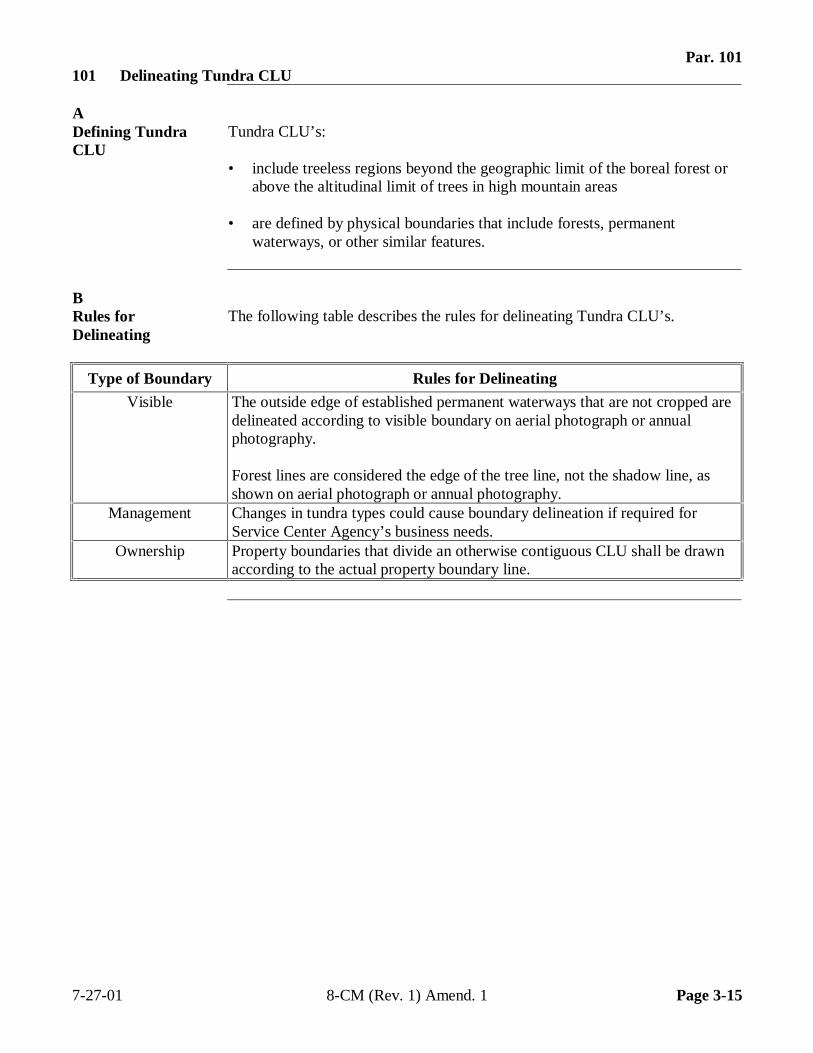
Par. 101101 Delineating Tundra CLU
ADefining TundraCLU
Tundra CLU’s:
• include treeless regions beyond the geographic limit of the boreal forest orabove the altitudinal limit of trees in high mountain areas
• are defined by physical boundaries that include forests, permanentwaterways, or other similar features.
BRules forDelineating
The following table describes the rules for delineating Tundra CLU’s.
Type of Boundary Rules for Delineating
Visible The outside edge of established permanent waterways that are not cropped aredelineated according to visible boundary on aerial photograph or annualphotography.
Forest lines are considered the edge of the tree line, not the shadow line, asshown on aerial photograph or annual photography.
Management Changes in tundra types could cause boundary delineation if required forService Center Agency’s business needs.
Ownership Property boundaries that divide an otherwise contiguous CLU shall be drawnaccording to the actual property boundary line.
7-27-01 8-CM (Rev. 1) Amend. 1 Page 3-15
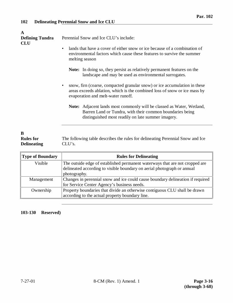
Par. 102102 Delineating Perennial Snow and Ice CLU
ADefining TundraCLU
Perennial Snow and Ice CLU’s include:
• lands that have a cover of either snow or ice because of a combination ofenvironmental factors which cause these features to survive the summermelting season
Note: In doing so, they persist as relatively permanent features on thelandscape and may be used as environmental surrogates.
• snow, firn (coarse, compacted granular snow) or ice accumulation in theseareas exceeds ablation, which is the combined loss of snow or ice mass byevaporation and melt-water runoff.
Note: Adjacent lands most commonly will be classed as Water, Wetland,Barren Land or Tundra, with their common boundaries beingdistinguished most readily on late summer imagery.
BRules forDelineating
The following table describes the rules for delineating Perennial Snow and IceCLU’s.
Type of Boundary Rules for Delineating
Visible The outside edge of established permanent waterways that are not cropped aredelineated according to visible boundary on aerial photograph or annualphotography.
Management Changes in perennial snow and ice could cause boundary delineation if requiredfor Service Center Agency’s business needs.
Ownership Property boundaries that divide an otherwise contiguous CLU shall be drawnaccording to the actual property boundary line.
103-130 Reserved)
7-27-01 8-CM (Rev. 1) Amend. 1 Page 3-16(through 3-68)
Par. 131Section 2 Digitizing Standards
131 Introduction
AOverview Transferring CLU polygons into GIS is called digitizing. Digitization is the creation
of digital lines in GIS and is accomplished using heads-up digitizing methods.Heads-up digitizing is the process of tracing lines over an image displayed on thecomputer screen using a computer mouse. For Service Centers, these polygons willrepresent CLU boundary lines.
Note: See Exhibits 6 through 9 for examples of digital polygons.
BRelationshipof CLU toMDOQ
MDOQ map images are used for digitizing in Service Centers. When the user hascompleted tracing CLU’s, the software will “close” the lines into a completedpolygon and the software functionality will maintain the placement of the CLUboundary lines in reference to MDOQ.
Example: When the user prompts the computer to show CLU’s for a particulartract, the software will automatically display the polygon with preciseplacement over MDOQ. Digitized polygons drawn on top of the digitalorthophotographs will remain exactly as placed until the lines aremanually changed.
7-27-01 8-CM (Rev. 1) Amend. 1 Page 3-69
Par. 132132 Minimum Digitizing Scale
AOverview GIS software allows the user to select, enlarge, and minimize the map image in
the window area of the computer screen. The window is the actual viewable areaof map features on the computer screen. As a minimum, it is suggested that theService Centers use a digitizing window of approximately 6” x 8” and start at ascale that yields approximately 40 acres, more or less, in the window.
BRequiredDigitizing Scale
The minimum scale at which on-screen digitizing will be performed is 1:4800.Small CLU areas will have to be done at a larger scale.
133 Minimum Precision
AOverview Precision is the standard of accuracy for acreage measurements.
BRequiredPrecision
The standard precision for acres for the Service Center Agencies is .01 acres.
Note: In those areas that grow tobacco, MDOQ may not support digital acreagemeasurements to one one-hundredth of an acre. At present, these areasrequire field measurements.
7-27-01 8-CM (Rev. 1) Amend. 1 Page 3-70
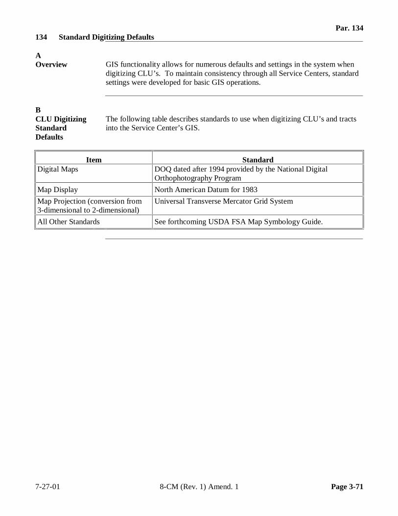
Par. 134134 Standard Digitizing Defaults
AOverview GIS functionality allows for numerous defaults and settings in the system when
digitizing CLU’s. To maintain consistency through all Service Centers, standardsettings were developed for basic GIS operations.
BCLU DigitizingStandardDefaults
The following table describes standards to use when digitizing CLU’s and tractsinto the Service Center’s GIS.
Item StandardDigital Maps DOQ dated after 1994 provided by the National Digital
Orthophotography Program
Map Display North American Datum for 1983
Map Projection (conversion from3-dimensional to 2-dimensional)
Universal Transverse Mercator Grid System
All Other Standards See forthcoming USDA FSA Map Symbology Guide.
7-27-01 8-CM (Rev. 1) Amend. 1 Page 3-71
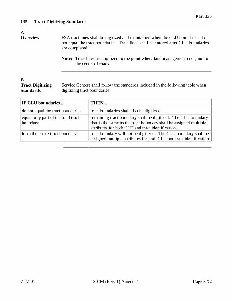
Par. 135135 Tract Digitizing Standards
AOverview FSA tract lines shall be digitized and maintained when the CLU boundaries do
not equal the tract boundaries. Tract lines shall be entered after CLU boundariesare completed.
Note: Tract lines are digitized to the point where land management ends, not tothe center of roads.
BTract DigitizingStandards
Service Centers shall follow the standards included in the following table whendigitizing tract boundaries.
IF CLU boundaries... THEN...
do not equal the tract boundaries tract boundaries shall also be digitized.
equal only part of the total tractboundary
remaining tract boundary shall be digitized. The CLU boundarythat is the same as the tract boundary shall be assigned multipleattributes for both CLU and tract identification.
form the entire tract boundary tract boundary will not be digitized. The CLU boundary shall beassigned multiple attributes for both CLU and tract identification.
7-27-01 8-CM (Rev. 1) Amend. 1 Page 3-72
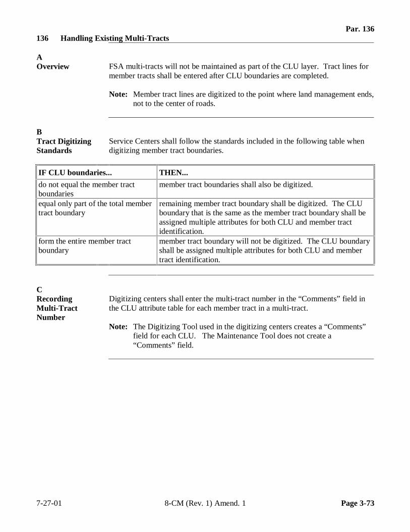
Par. 136136 Handling Existing Multi-Tracts
AOverview FSA multi-tracts will not be maintained as part of the CLU layer. Tract lines for
member tracts shall be entered after CLU boundaries are completed.
Note: Member tract lines are digitized to the point where land management ends,not to the center of roads.
BTract DigitizingStandards
Service Centers shall follow the standards included in the following table whendigitizing member tract boundaries.
IF CLU boundaries... THEN...
do not equal the member tractboundaries
member tract boundaries shall also be digitized.
equal only part of the total membertract boundary
remaining member tract boundary shall be digitized. The CLUboundary that is the same as the member tract boundary shall beassigned multiple attributes for both CLU and member tractidentification.
form the entire member tractboundary
member tract boundary will not be digitized. The CLU boundaryshall be assigned multiple attributes for both CLU and membertract identification.
CRecordingMulti-TractNumber
Digitizing centers shall enter the multi-tract number in the “Comments” field inthe CLU attribute table for each member tract in a multi-tract.
Note: The Digitizing Tool used in the digitizing centers creates a “Comments”field for each CLU. The Maintenance Tool does not create a“Comments” field.
7-27-01 8-CM (Rev. 1) Amend. 1 Page 3-73
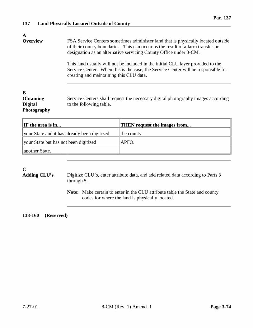
Par. 137137 Land Physically Located Outside of County
AOverview FSA Service Centers sometimes administer land that is physically located outside
of their county boundaries. This can occur as the result of a farm transfer ordesignation as an alternative servicing County Office under 3-CM.
This land usually will not be included in the initial CLU layer provided to theService Center. When this is the case, the Service Center will be responsible forcreating and maintaining this CLU data.
BObtainingDigitalPhotography
Service Centers shall request the necessary digital photography images accordingto the following table.
IF the area is in... THEN request the images from...
your State and it has already been digitized the county.
your State but has not been digitized APFO.
another State.
CAdding CLU’s Digitize CLU’s, enter attribute data, and add related data according to Parts 3
through 5.
Note: Make certain to enter in the CLU attribute table the State and countycodes for where the land is physically located.
138-160 (Reserved)
7-27-01 8-CM (Rev. 1) Amend. 1 Page 3-74
Par. 161Part 4 Identifying CLU
161 Numbering and Labeling CLU
AUnique CLU ID With the greater use of GIS software and the installation of the new CCE
equipment, it is important to ensure that data can easily move among systems anddatabases without overwriting data that someone else previously created. It isessential that each CLU have a globally-unique identifier GUID.
For the most part, the generation of unique identifiers for CLU’s will be:
• accomplished by the software• largely transparent to the user.
To ensure uniqueness, GUID’s are usually long jumbles of characters that havelittle recognition value except to the computer. The important thing for the userto remember is that you need one. CLU records usually contain other attributes,such as a field number and a CLU label, that provide a human-recognizableidentification.
Note: Whenever CLU is created by the Maintenance Tool, it will be assigned aunique identifier. It is called CLUID.
BCLU LabelOverview
A label will also be assigned or attributed to each CLU to:
• identify CLU for Agencies in a specific Service Center• assist in effective communication with the farmer and customers• provide a link to previous historical tabular data.
This label is not related to the ID number. Each Agency in the Service Centerwill use the same label to identify CLU so that the farmer or other customerunderstands which CLU is being discussed no matter which Agency in theService Center uses the number.
Example: Tract 2002, field 1 will be assigned to identify the same CLU by allAgencies in that Service Center.
Continued on the next page
7-27-01 8-CM (Rev. 1) Amend. 1 Page 4-1
Par. 161161 Numbering and Labeling CLU (Continued)
CCLU Labels forExisting Fields
CLU that was correctly identified on an aerial photograph as a tract and field willbe assigned the same tract and field number as it had on the photograph whenCLU data is entered into GIS. Using existing field number minimizes thechanges required to historical data, such as NRCS conservation plans, that is tiedto FSA field numbers. Any existing field number that does not meet 2-CPguidelines for numbering fields must be corrected on the 24” x 24” aerialphotograph before it can be used to identify CLU.
DCLU Labels forOther Areas
CLU’s or land enclosed in tract boundaries that did not have an FSA fieldnumber will not be assigned a label that is unique to the tract; instead, these areaswill be assigned a field number of “0”. This number is used as a generic flagdenoting undefined CLU’s prompting the Service Center to review and assignCLU a new number. Undefined tracts will be assigned the number “0”. When aCLU boundary is the same as a tract boundary, a field number of “1” shall beassigned to CLU.
Note: Follow 2-CP, paragraph 494 to determine new CLU numbers.
7-27-01 8-CM (Rev. 1) Amend. 1 Page 4-2
Par. 162162 Attributing CLU’s
AWhat IsAttributing
GIS systems allow data elements (called attributes) to be attached to geospatialpoints, lines, and polygons. These attributes can contain human-recognizableidentifiers and labels, or they may contain identifiers that point to data stored inother files and databases. Identifiers can provide a path to a potential bounty ofinformation about a place on the ground.
BCLU AttributeTable
A standard set of data attributes, such as data elements, shall be attached to eachCLU polygon. See Exhibit 17 for a table listing the standard set of attributes andthe method of entry. Additional attributes may be added to this standard set tomeet unique agency business requirements.
163-190 (Reserved)
7-27-01 8-CM (Rev. 1) Amend. 1 Page 4-3

.
Par. 191Part 5 Relationship With Other Data
191 Overview
ABackground Decades of records exist in files and databases describing USDA programs
applied to abstract locations such as a tracts, management units, developmentsites, etc. GIS systems can now be used to relate this information concerningprogram delivery to specific points on the earth. This new capability envisionsthe user clicking the mouse on a place on a map or photograph and having thecomputer respond with data about the land.
BExamples ofLinking Tabularand Spatial Data
This capability can be a major productivity enhancer. If you know a specificpoint on the earth, you can find all of the instances of program delivery that relateto that point on the earth. Any data that can be tied to a point on the ground canbe related to any other data tied to that same geographic point. The following area few examples of the type of data that could be displayed:
• who owns the land• who is the current operator• CRP contract data• wetlands identified on the property• the distance from the nearest road or river• the conservation plan• outstanding financial obligations tied to the land.
CFuture Plans forLinks
It will take time to establish all of the data linkages needed to implement thiscapability. Existing and new tabular data (data contained in database tables ortraditional computer files) must be linked to geospatial locations. Acquiringadditional layers of spatial data will produce other links. Through reengineering,program delivery systems will be adapted to store links to digitized land units, orto store spatial coordinates for the area where an activity takes place.
Additional information on linking CLU’s to tabular data will be forthcoming indocumentation for new and reengineered systems.
7-27-01 8-CM (Rev. 1) Amend. 1 Page 5-1
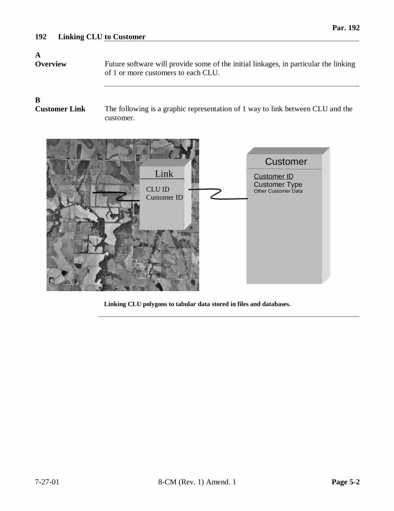
Par. 192192 Linking CLU to Customer
AOverview Future software will provide some of the initial linkages, in particular the linking
of 1 or more customers to each CLU.
BCustomer Link The following is a graphic representation of 1 way to link between CLU and the
customer.
Linking CLU polygons to tabular data stored in files and databases.
7-27-01 8-CM (Rev. 1) Amend. 1 Page 5-2
CustomerCustomer IDCustomer TypeOther Customer Data
Link
CLU IDCustomer ID
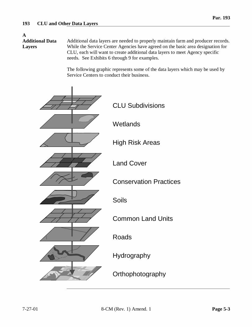
Par. 193193 CLU and Other Data Layers
AAdditional DataLayers
Additional data layers are needed to properly maintain farm and producer records.While the Service Center Agencies have agreed on the basic area designation forCLU, each will want to create additional data layers to meet Agency specificneeds. See Exhibits 6 through 9 for examples.
The following graphic represents some of the data layers which may be used byService Centers to conduct their business.
7-27-01 8-CM (Rev. 1) Amend. 1 Page 5-3
Conservation Practices
Orthophotography
Hydrography
Roads
Common Land Units
Soils
Land Cover
High Risk Areas
Wetlands
CLU Subdivisions
Par. 194194 Wetland Point Layer
ABackground NRCS is responsible for delineating official certified wetlands, but the certified
wetland layer may not be complete by the time the initial CLU layer arrives in theService Center. To assist producers before wetlands are completely certified,FSA will associate both basic certified and inventoried wetland information fromthe existing aerial maps to points on a layer separate from CLU.
When this point data is displayed in conjunction with the CLU layer, producerscan be directed to NRCS for appropriate wetland certifications on specific CLU’s.Once the certified wetland layer is completed, the FSA wetland point data forcorresponding wetlands will no longer be used. Point data associated withexisting inventoried wetland determinations that are not officially certified willcontinue to be used until NRCS makes an official certification at the producer’srequest.
BEstablishingPoints
Information for both certified official wetlands and noncertified wetlands onexisting aerial maps shall be transferred to the wetland point layer. Place thewetland points and enter the appropriate attribute data according to the FSAmanual provided with the Wetland Point Data Tool. The manual can also befound by selecting download at the following website:http://dc.ffasintranet.usda.gov/fsagis.
CWetlandAttribute Data
The following attribute data shall be recorded for FSA wetland points:
• approved wetland label from 2-CP, subparagraph 495 D• acreage of wetland if shown on aerial map• whether wetland is certified or inventoried• date certified.
7-27-01 8-CM (Rev. 1) Amend. 1 Page 5-4
Par. 195195 Conservation Management Units Layer
ACM Unit Layer The NRCS Customer Service Toolkit software produces a GIS data layer called
“Conservation Management Land Units”. These CM Land Units:
• delineate and describe land where conservation activities are being planned orhave been applied
• are derived from the CLU layer but form a separate spatial layer.
The CM Land Units layer retains all the attributes of the CLU layer, plus it hasadditional attributes related to conservation planning.
A District Conservationist may create several of these conservation managementlayers, each one representing a planning alternative. One or more of theselayers/themes may represent a customer’s conservation plan or contract.
When a land owner finally implements a conservation plan, it may triggerchanges to the CLU layer. However, it will be up to the CLU data steward ineach Service Center to actually change the boundaries in the CLU layer. TheCLU boundary changes will usually occur after the conservation practice isconstructed, and is based on the new physical CLU boundaries found on theground.
The NRCS Conservation Planning Handbook refers to these types of land units as“Conservation Management Units”. In previous versions of the handbook, thesewere referred to as “Conservation Treatment Units”.
7-27-01 8-CM (Rev. 1) Amend. 1 Page 5-5
Par. 195195 Conservation Management Units Layer (Continued)
BSubdivisions Frequently, a District Conservationist will subdivide a CM Land Unit into
multiple land units for conservation treatment purposes. This is especiallycommon for pasture or grazing land. These subdivisions are:
• delineated on the CM Land Units layer• are usually referred to as management units.
For example, a field conservationist may divide pastures or grazing land intoseveral management units to develop grazing plans for customers. In this case,Fields 1 and 2, CLU’s that are pastureland, can be divided into CM Land Units1a, 1b, 2a, and 2b respectively.
CMerging CLU’sinto LargerUnits
As conservationists develop land unit themes for individual customers, they willprobably want to merge them to cover larger geographic areas. This provides theability to query on current and planned land use, and on conservation practices forscheduling or reporting purposes.
DTabularAttributes forCM Land Units
See Exhibit 18 for the data elements for the CM Land Units. The first 8 attributescome directly from the CLU data layer.
196-220 (Reserved)
7-27-01 8-CM (Rev. 1) Amend. 1 Page 5-6
Par. 221 Part 6 Releasing Data
Section 1 Rules for Release of Data
221 General Information
A Overview
It is FSA policy to safeguard individual privacy from the misuse of Federal records while granting individuals access to records concerning themselves. FSA information that is now available in digital form has no new release procedure than when it was retained in paper format.
As before, the information that is released to agencies of USDA should only be provided when they have an official use for the information. Release of this information to other Government agencies or a third party is allowable only if there has been a routine use established in the FSA Privacy Act system of records granting use of the information.
2-INFO provides procedures for all FSA offices to follow when making records available to the public, other Federal agencies, and Congress. 3-INFO provides procedures to be followed by all offices when collecting, maintaining, or disclosing data or information concerning an individual.
B Releasing CLU Data
In general, CLU boundaries may be released as long as no identifying information links CLU to a particular producer. Appropriate metadata must accompany the data according to Part 7.
7-27-01 8-CM (Rev. 1) Amend. 1 Page 6-1
Par. 222 222 Releasing CLU Data
A Releasing CLU Boundaries
CLU boundaries may be released as long as no identifying information links CLU to a *--particular producer. All attribute information, except calculated acreage figures, must be
stripped from CLU before distribution. Appropriate metadata must accompany the data according to Part 7.
B Not Releasing Farm, Tract, and CLU Numbers
Farm, tract, and CLU numbers appearing in the CLU attribute shall not be released, except to a producer on a farm in which that producer has an interest.
C Releasing CLU Acreage
Calculated acreage appearing in the CLU attribute table may be released.
D Releasing CLU Unique ID
The CLU unique numbers appearing in the CLU attribute table shall not be released, except to a producer on a farm in which that producer has an interest. A producer is considered to have an interest in CLU if the producer is an operator, owner, or other producer on CLU.--*
E HEL or Non-HEL Attributes
HEL/non-HEL status appearing in the CLU attribute table shall not be released, except to a producer on a farm in which they have an interest.
223-250 (Reserved) 8-18-04 8-CM (Rev. 1) Amend. 2 Page 6-2
(through 6-54)
Par. 251 Section 2 Servicing Requests
251 Basic Policy
A Overview
2-INFO provides procedures for all FSA offices to follow when determining the cost of making records available to the public, other Federal agencies, and Congress. 2-INFO, Part 4 provides procedures for determining the cost of search services, review services, computer services, and related services.
B Metadata Requirements
For CLU and related data, it will be necessary to provide metadata that accurately describes the data whenever data is released. See Part 7 for information on metadata.
*--C Official Distribution Point for CLU
APFO is the official collection and distribution point for FSA CLU data. County Offices shall provide copies of their CLU to APFO, through the APFO FTP site, immediately following certification and post an updated copy every 30 days. APFO will process CLU for archival and distribution. Note: See 2-CP, Exhibit 37 for FTP instructions.--*
8-18-03 8-CM (Rev. 1) Amend. 2 Page 6-55
Par. 252 *--252 Requests for Ortho-Imagery
A Basic Policy
APFO is the USDA data steward for ortho-imagery. There are no privacy issues concerning this data.
B Requests for Large Areas
Requests for ortho-imagery for the entire county or large areas shall be directed to APFO. This is similar to the existing policy concerning photographs.
C Requests for Small Areas
Requests from an individual producer for ortho-imagery covering their land can be filled--* at the Service Center.
D Charges
Producers shall not be charged for digital or paper copies of farms in which they have an interest. Charge other requestors only for the cost of reproduction. See Exhibit 19 for additional information on calculating costs for digital data and printed maps.
*--E More Information on Ortho-Imagery
For more information on ortho-imagery, see APFO’s web site at http://www.apfo.usda.gov.--*
8-18-04 8-CM (Rev. 1) Amend. 2 Page 6-56
Par. 253 253 Requests for CLU
A Basic Policy
The release of CLU information has many privacy issues and Service Centers must ensure that privacy requirements are not violated according to paragraph 222, 2-INFO, and 3-INFO.
*--B Requests for Entire CLU
County Offices shall direct producers and the public to contact APFO by phone, e-mail, or mail for copies of entire CLU. See Exhibit 19 for the cost of data to be reproduced on CD. County Offices will soon be able to direct all geospatial data orders, CLU included, through the USDA Geospatial Data Gateway at http://datagateway.nrcs.usda.gov/. There is no charge when CLU is downloaded using FTP from this web site.--*
8-18-04 8-CM (Rev. 1) Amend. 2 Page 6-57
Par. 253 *--253 Requests for CLU (Continued)
C Servicing Producer Requests for CLU In Which the Producer Has an Interest
Requests from an individual producer for CLU’s covering their land may be filled at the Service Center. In this case, privacy issues do not apply to the data associated with that producer and the data is provided at no charge. Only the CLU associated with that producer may be provided with full attribute data. A producer is considered to have an interest in CLU if the producer is an operator, owner, or other producer on CLU. Appropriate metadata must accompany that data according to Part 7. Select the producer’s CLU, click “Theme” and then click “Convert to Shapefile” to create a file containing only the producer’s CLU. See the Maintenance Tool User Guide, “Search CLU and PLSS” for specific instructions on how to select CLU by farm, tract, or CLU number. Note: File is not saved on hard drive or server.
D Charges
Producers shall not be charged for digital paper copies of farms in which they have an interest. A producer is considered to have an interest in CLU if the producer is an operator, owner, or other producer on CLU. See Exhibit 19 for additional information on how--* to calculate costs for digital data and printed maps.
8-18-04 8-CM (Rev. 1) Amend. 2 Page 6-58
Par. 254 254 Requests for Wetland Point Data
A Basic Policy
Requests for official wetland information should be directed to NRCS as they are the responsible agency.
B Requests for Large Areas
The Wetland Point Layer data shall not be released except to a producer for a farm in which they have an interest. NRCS will have access to the data through CCE so it will not be necessary to provide them with a copy of the data.
C Requests From Producers
The Wetland Point Layer data shall be provided to a producer for farms in which they have an interest. The data is provided as a tool for producers to use when communicating with NRCS. It is very important that producers understand the proper use of the data and request a final determination as soon as possible for all noncertified wetlands.
D Charges
Producers shall not be charged for digital or paper copies of farms in which they have an interest.
8-18-04 8-CM (Rev. 1) Amend. 2 Page 6-58.5
(and 6-58.6)

--
Par. 255 255 Requests for CRP Data
A Basic Policy
CRP data recorded for CLU cannot be released except to a producer on a farm in which they have an interest.
B Requests for Large Areas
CRP data cannot be released on a county wide, or large scale basis. Partner agencies will have access to the data through CCE so it will not be necessary to provide them with a copy of the data.
C Requests From Producers
The CRP data shall be provided to a producer for farms in which they have an interest.
D Requests for Small Areas
CRP data cannot be released except to a producer on a farm in which they have an interest.
E Requests for CRP Data
Producers shall not be charged for digital or paper copies of farms in which they have an interest.
256-280 Reserved 7-27-01 8-CM (Rev. 1) Amend. 1 Page 6-59

.
Par. 281 Part 7 Metadata
281 General Information
A Background
Metadata essentially describes the information in a data set. For GIS data, it answers questions such as:
• what does the data set describe • who produced the data set • why was the data set created • how was the data set created • and how reliable are the data. • who wrote the metadata • how can someone get a copy of the data set.
Refer to http://geology.usgs.gov/tools/metadata/tools/doc/ctc to see a more detailed explanation of metadata.
Metadata is included when you provide a copy of digital data to someone who requests it. It is also used to describe the data sets that are searchable by using the web. For maps of CLU and related data, it will be necessary to provide metadata that accurately describes the data whenever data is released.
B Metadata Standards
*--Metadata for SCA agency data sets is to conform to FGDC Metadata Content Standards. See
http://www.fgdc.gov/metadata/meta_stand.html to download the standards.
C Creating Compliant Metadata
FGDC compliant metadata will be available to Service Centers after certified CLU files are sent to APFO at http://www.apfo.usda.gov/. Metadata files for certified CLU’s already sent to APFO will also be posted to the same web site for Service Centers to download their metadata using FTP.
D Example of CLU Metadata
See Exhibit 22 for an example of FGDC compliant metadata for a CLU file.--* 8-18-04 8-CM (Rev. 1) Amend. 2 Page 7-1

.

.
Exhibit 1 Reports, Forms, Abbreviations, and Redelegations of Authority
Reports
None
Forms
This table lists all forms referenced in this handbook.
Number Title Display
Reference Reference AD-1026 Highly Erodible Land Conservation (HELC) and
Wetland Conservation (WC) Certification Ex. 10
Abbreviations
The following abbreviations are not listed in 1-CM.
Approved
Abbreviation Term Reference CCE Common Computing Environment 1, 2, 254, 255, 161,
Ex. 12 CD compact disc 253,
Ex. 13, 19 CLU common land unit Text,
Ex. 7-11, 13 CM Conservation Management Land Unit 92, 195
DOQ digital orthophotography quadrangle 134, Ex. 6-9
FGDC Federal Geographic Data Committee 281, Ex. 22 FTS file transfer protocol 251, 253, 281 GIS geographic information system 1, 2, 32, 64, 91, 131,
134, 161, 162, 191, Ex. 10, 13
GPS global positioning system 94, 95, 97 GUID Globally-unique identifier 161
LA Loss Adjustor Ex. 12 MDOQ mosaicked digitial ortho-photography 92, 31-133 PLSS Public Land Survey System Ex. 13 QC Quality Control Ex. 13 SCI Service Center Initiative 281
SCIMS Service Center Information Management System Ex. 10
Redelegations of Authority
None 8-18-04 8-CM (Rev. 1) Amend. 2 Page 1

.

.
Exhibit 2Definitions of Terms Used in This Handbook
Attribute Table An attribute table is a database, or other tabular file, containing rows andcolumns. It is used to store nongeospatial data, such as cropping history andsystem calculated acres, in precise fields which allow the system to quickly find,retrieve, and query the data when prompted by the user.
Attribute Field An attribute field is a single column of information contained in an attribute table.
Common Data Common data:
� is common to more than 1 of the Service Center Agencies
� originates outside the Service Centers and is maintained for all Agencies bythe Service Center data steward or system administrator.
Common LandUnit (CLU)
CLU is the smallest unit that has:
� a permanent, contiguous boundary� common land cover management� a common owner� a common producer association.
Continued on the next page
7-27-01 8-CM (Rev. 1) Amend. 1 Page 1
Exhibit 2Definitions of Terms Used in This Handbook (Continued)
Database A database is a logical collection of interrelated information, managed and storedas a unit, usually on some form of mass-storage system such as a magnetic tape ordisk.
A GIS database includes data about the spatial location and shape of geographicfeatures recorded as points, lines, areas, pixels, grid cells, or tins as well as theirattributes.
Digital Ortho-photography(DOQ)
Digital orthophotography is a digital representation (map) of an aerialphotograph. Ground and land features are accurately located in their true mappositions on DOQ. Distortions caused by differences in terrain relief and aerialcamera tilt have been removed. Service Centers will use DOQ’s as the base mapin their GIS.
Digitizing Digitizing is encoding map features, such as points, lines and polygons, ascoordinates in a digital form, that is, using the computer to draw lines and pointson an digital map. Field Service Agencies will be digitizing tract/CLUboundaries on top of the digital aerial photography.
GeographicInformationSystem (GIS)
GIS is an application software capable of manipulating, analyzing, and storingspatial or geographic referenced data. GIS will automatically compute distancesand acres using imbedded calculation models.
Geo-reference Geo-reference is to establish the relationship between coordinates on a papermap (2-dimensional) and known real-world coordinates using longitude andlatitude.
Map Projection Map projection is the conversion of the Earth’s 3-dimensional coordinates into a2-dimensional plane. Since the Earth is round, when it is displayed as a flat map,map projections maintain the integrity of data by shifting the 2-dimensional mapto correlate with 3-dimensional longitude and latitude locations.
Continued on the next page
7-27-01 8-CM (Rev. 1) Amend. 1 Page 2
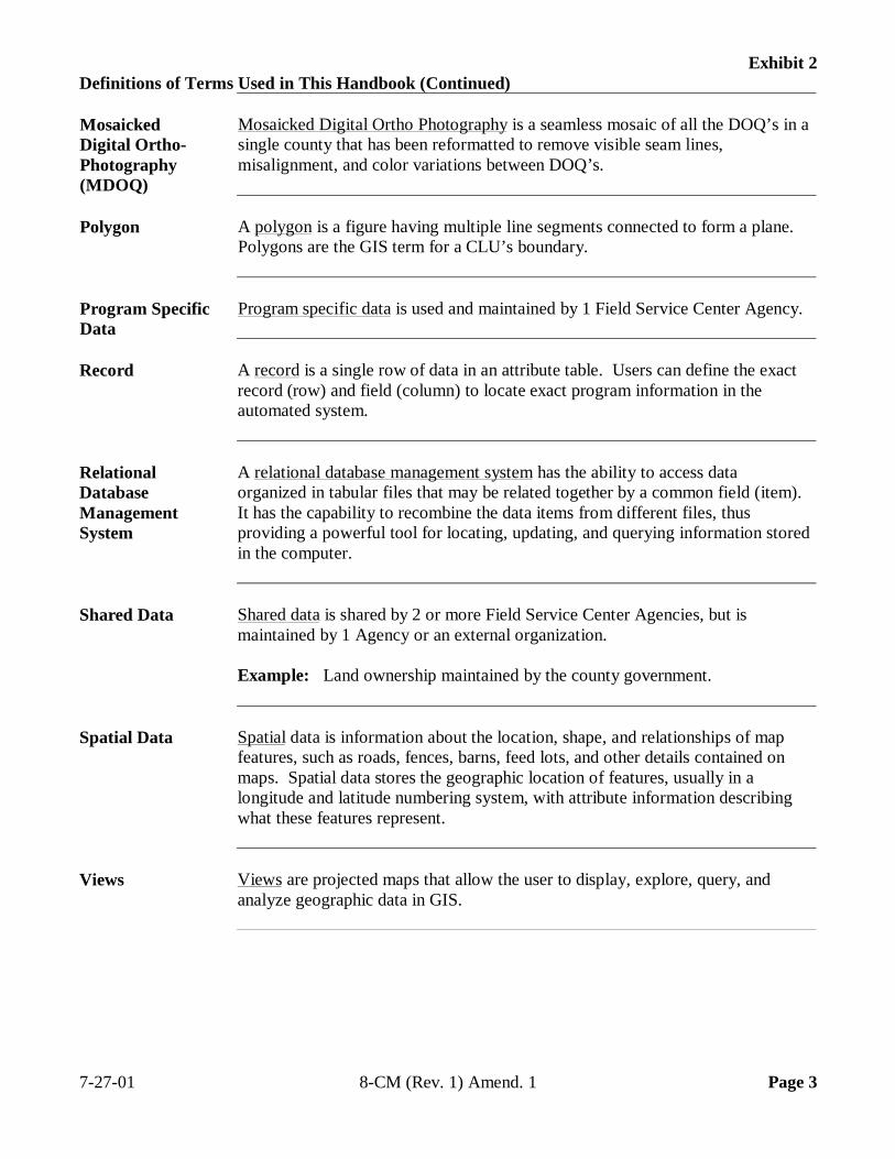
Exhibit 2Definitions of Terms Used in This Handbook (Continued)
MosaickedDigital Ortho-Photography(MDOQ)
Mosaicked Digital Ortho Photography is a seamless mosaic of all the DOQ’s in asingle county that has been reformatted to remove visible seam lines,misalignment, and color variations between DOQ’s.
Polygon A polygon is a figure having multiple line segments connected to form a plane.Polygons are the GIS term for a CLU’s boundary.
Program SpecificData
Program specific data is used and maintained by 1 Field Service Center Agency.
Record A record is a single row of data in an attribute table. Users can define the exactrecord (row) and field (column) to locate exact program information in theautomated system.
RelationalDatabaseManagementSystem
A relational database management system has the ability to access dataorganized in tabular files that may be related together by a common field (item).It has the capability to recombine the data items from different files, thusproviding a powerful tool for locating, updating, and querying information storedin the computer.
Shared Data Shared data is shared by 2 or more Field Service Center Agencies, but ismaintained by 1 Agency or an external organization.
Example: Land ownership maintained by the county government.
Spatial Data Spatial data is information about the location, shape, and relationships of mapfeatures, such as roads, fences, barns, feed lots, and other details contained onmaps. Spatial data stores the geographic location of features, usually in alongitude and latitude numbering system, with attribute information describingwhat these features represent.
Views Views are projected maps that allow the user to display, explore, query, andanalyze geographic data in GIS.
7-27-01 8-CM (Rev. 1) Amend. 1 Page 3

.
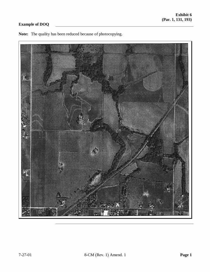
Exhibit 6(Par. 1, 131, 193)
Example of DOQ
Note: The quality has been reduced because of photocopying.
7-27-01 8-CM (Rev. 1) Amend. 1 Page 1

.
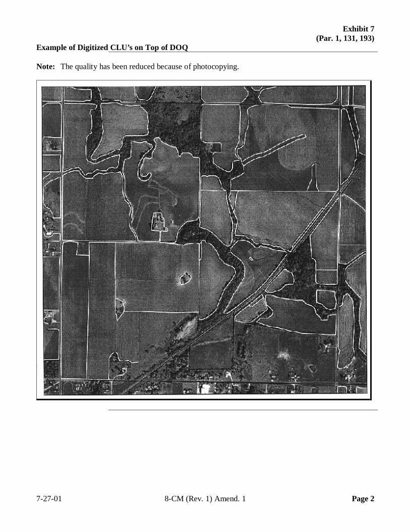
Exhibit 7(Par. 1, 131, 193)
Example of Digitized CLU’s on Top of DOQ
Note: The quality has been reduced because of photocopying.
7-27-01 8-CM (Rev. 1) Amend. 1 Page 2

.
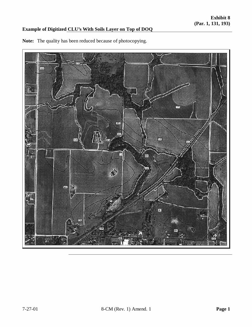
Exhibit 8(Par. 1, 131, 193)
Example of Digitized CLU’s With Soils Layer on Top of DOQ
Note: The quality has been reduced because of photocopying.
7-27-01 8-CM (Rev. 1) Amend. 1 Page 1

.
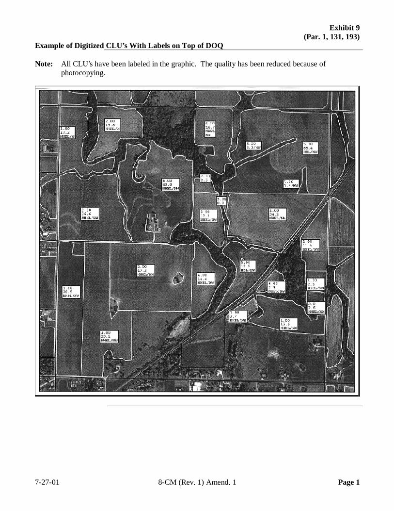
Exhibit 9(Par. 1, 131, 193)
Example of Digitized CLU’s With Labels on Top of DOQ
Note: All CLU’s have been labeled in the graphic. The quality has been reduced because ofphotocopying.
7-27-01 8-CM (Rev. 1) Amend. 1 Page 1

.
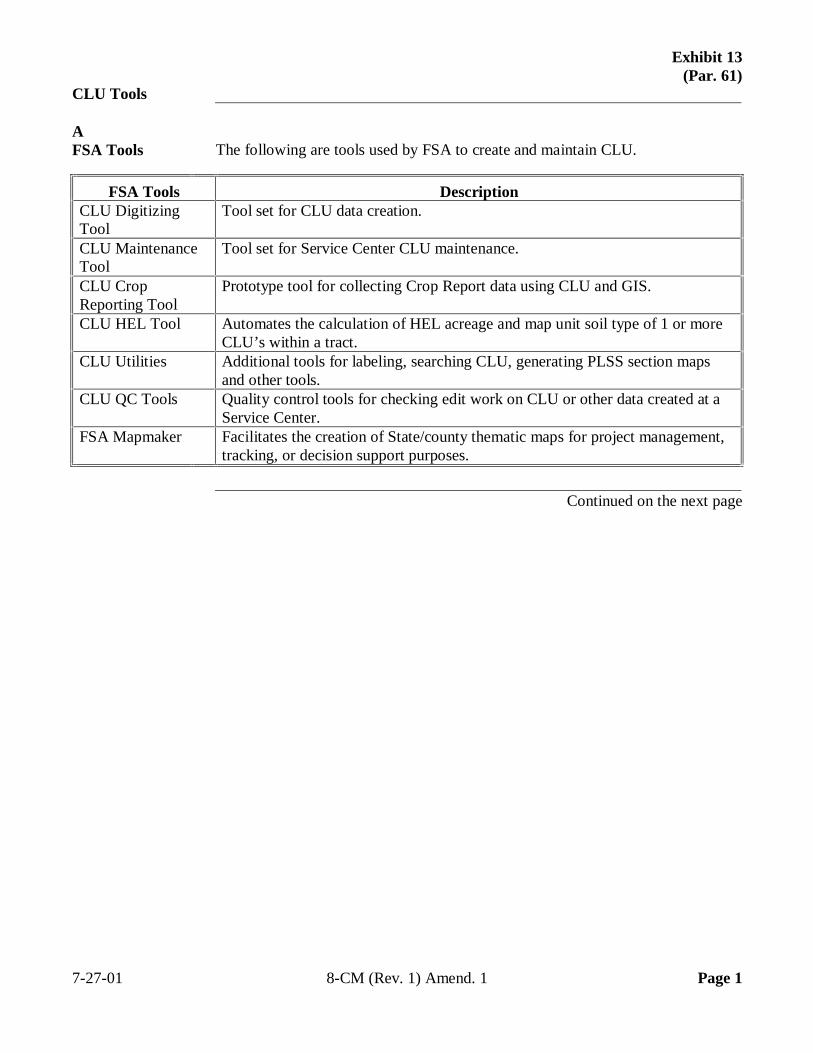
Exhibit 13(Par. 61)
CLU Tools
AFSA Tools The following are tools used by FSA to create and maintain CLU.
FSA Tools DescriptionCLU DigitizingTool
Tool set for CLU data creation.
CLU MaintenanceTool
Tool set for Service Center CLU maintenance.
CLU CropReporting Tool
Prototype tool for collecting Crop Report data using CLU and GIS.
CLU HEL Tool Automates the calculation of HEL acreage and map unit soil type of 1 or moreCLU’s within a tract.
CLU Utilities Additional tools for labeling, searching CLU, generating PLSS section mapsand other tools.
CLU QC Tools Quality control tools for checking edit work on CLU or other data created at aService Center.
FSA Mapmaker Facilitates the creation of State/county thematic maps for project management,tracking, or decision support purposes.
Continued on the next page
7-27-01 8-CM (Rev. 1) Amend. 1 Page 1
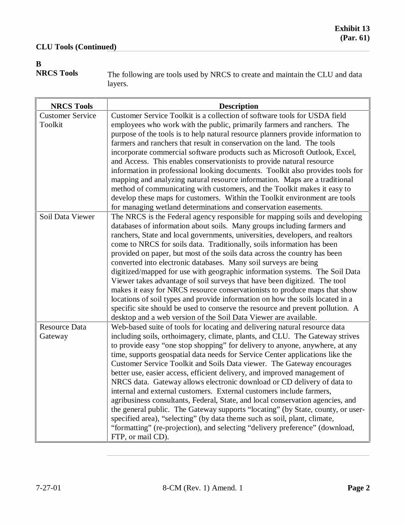
Exhibit 13(Par. 61)
CLU Tools (Continued)
BNRCS Tools The following are tools used by NRCS to create and maintain the CLU and data
layers.
NRCS Tools DescriptionCustomer ServiceToolkit
Customer Service Toolkit is a collection of software tools for USDA fieldemployees who work with the public, primarily farmers and ranchers. Thepurpose of the tools is to help natural resource planners provide information tofarmers and ranchers that result in conservation on the land. The toolsincorporate commercial software products such as Microsoft Outlook, Excel,and Access. This enables conservationists to provide natural resourceinformation in professional looking documents. Toolkit also provides tools formapping and analyzing natural resource information. Maps are a traditionalmethod of communicating with customers, and the Toolkit makes it easy todevelop these maps for customers. Within the Toolkit environment are toolsfor managing wetland determinations and conservation easements.
Soil Data Viewer The NRCS is the Federal agency responsible for mapping soils and developingdatabases of information about soils. Many groups including farmers andranchers, State and local governments, universities, developers, and realtorscome to NRCS for soils data. Traditionally, soils information has beenprovided on paper, but most of the soils data across the country has beenconverted into electronic databases. Many soil surveys are beingdigitized/mapped for use with geographic information systems. The Soil DataViewer takes advantage of soil surveys that have been digitized. The toolmakes it easy for NRCS resource conservationists to produce maps that showlocations of soil types and provide information on how the soils located in aspecific site should be used to conserve the resource and prevent pollution. Adesktop and a web version of the Soil Data Viewer are available.
Resource DataGateway
Web-based suite of tools for locating and delivering natural resource dataincluding soils, orthoimagery, climate, plants, and CLU. The Gateway strivesto provide easy “one stop shopping” for delivery to anyone, anywhere, at anytime, supports geospatial data needs for Service Center applications like theCustomer Service Toolkit and Soils Data viewer. The Gateway encouragesbetter use, easier access, efficient delivery, and improved management ofNRCS data. Gateway allows electronic download or CD delivery of data tointernal and external customers. External customers include farmers,agribusiness consultants, Federal, State, and local conservation agencies, andthe general public. The Gateway supports “locating” (by State, county, or user-specified area), “selecting” (by data theme such as soil, plant, climate,“formatting” (re-projection), and selecting “delivery preference” (download,FTP, or mail CD).
7-27-01 8-CM (Rev. 1) Amend. 1 Page 2
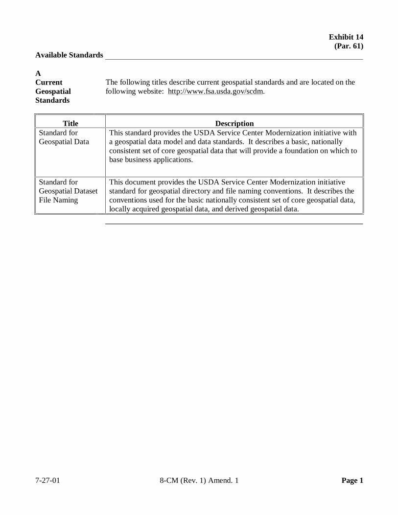
Exhibit 14(Par. 61)
Available Standards
ACurrentGeospatialStandards
The following titles describe current geospatial standards and are located on thefollowing website: http://www.fsa.usda.gov/scdm.
Title DescriptionStandard forGeospatial Data
This standard provides the USDA Service Center Modernization initiative witha geospatial data model and data standards. It describes a basic, nationallyconsistent set of core geospatial data that will provide a foundation on which tobase business applications.
Standard forGeospatial DatasetFile Naming
This document provides the USDA Service Center Modernization initiativestandard for geospatial directory and file naming conventions. It describes theconventions used for the basic nationally consistent set of core geospatial data,locally acquired geospatial data, and derived geospatial data.
7-27-01 8-CM (Rev. 1) Amend. 1 Page 1
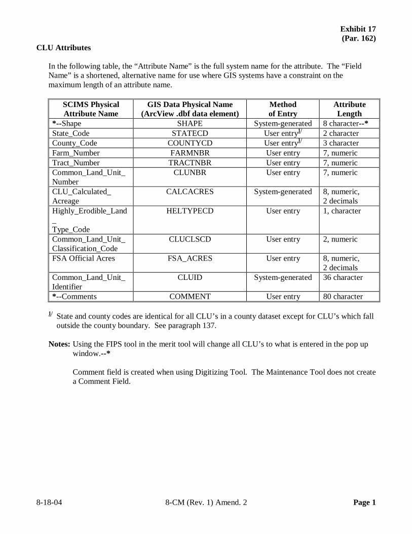
Exhibit 17 (Par. 162)
CLU Attributes
In the following table, the “Attribute Name” is the full system name for the attribute. The “Field Name” is a shortened, alternative name for use where GIS systems have a constraint on the maximum length of an attribute name.
SCIMS Physical Attribute Name
GIS Data Physical Name (ArcView .dbf data element)
Method of Entry
Attribute Length
*--Shape SHAPE System-generated 8 character--* State_Code STATECD User entry1/ 2 character County_Code COUNTYCD User entry1/ 3 character Farm_Number FARMNBR User entry 7, numeric Tract_Number TRACTNBR User entry 7, numeric Common_Land_Unit_ Number
CLUNBR User entry 7, numeric
CLU_Calculated_ Acreage
CALCACRES System-generated 8, numeric, 2 decimals
Highly_Erodible_Land_ Type_Code
HELTYPECD User entry 1, character
Common_Land_Unit_ Classification_Code
CLUCLSCD User entry 2, numeric
FSA Official Acres FSA_ACRES User entry 8, numeric, 2 decimals
Common_Land_Unit_ Identifier
CLUID System-generated 36 character
*--Comments COMMENT User entry 80 character
1/ State and county codes are identical for all CLU’s in a county dataset except for CLU’s which fall outside the county boundary. See paragraph 137.
Notes: Using the FIPS tool in the merit tool will change all CLU’s to what is entered in the pop up
window.--* Comment field is created when using Digitizing Tool. The Maintenance Tool does not create
a Comment Field. 8-18-04 8-CM (Rev. 1) Amend. 2 Page 1
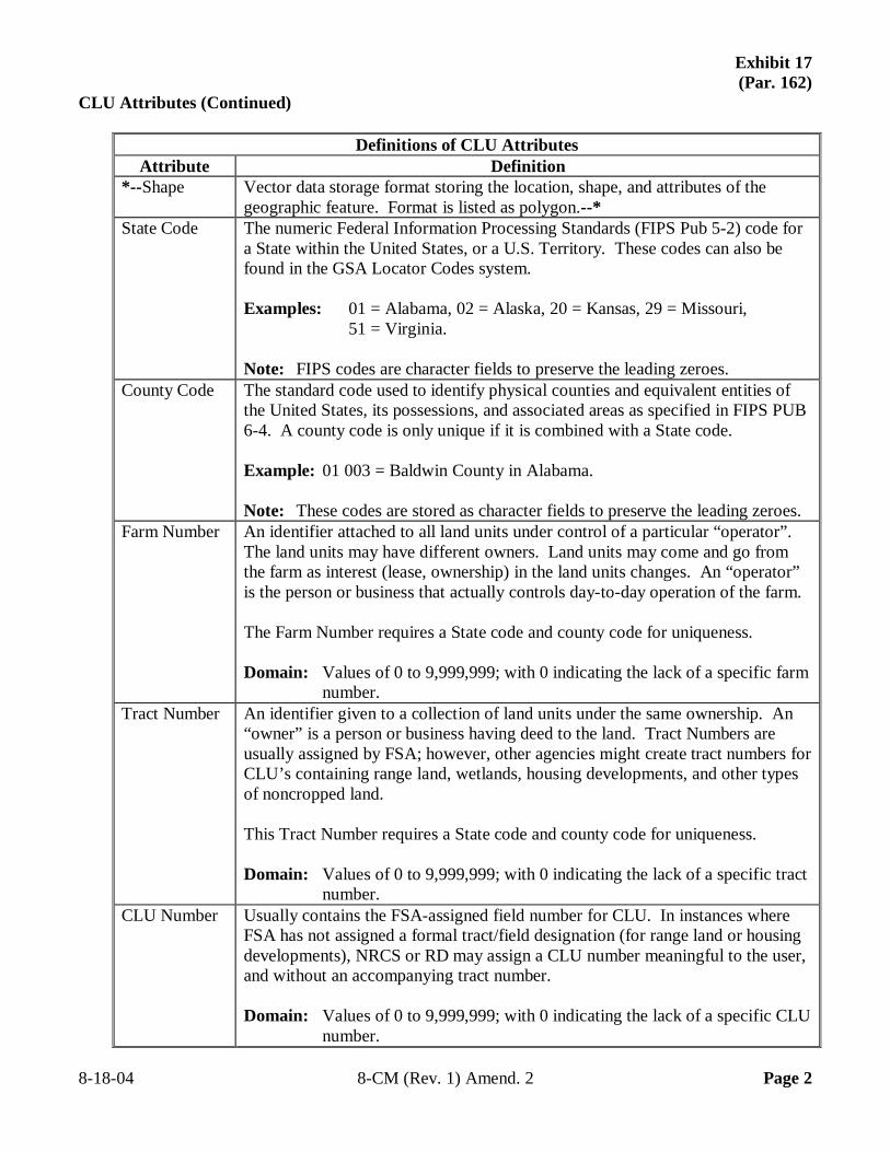
Exhibit 17 (Par. 162)
CLU Attributes (Continued)
Definitions of CLU Attributes Attribute Definition
*--Shape Vector data storage format storing the location, shape, and attributes of the geographic feature. Format is listed as polygon.--*
State Code The numeric Federal Information Processing Standards (FIPS Pub 5-2) code for a State within the United States, or a U.S. Territory. These codes can also be found in the GSA Locator Codes system. Examples: 01 = Alabama, 02 = Alaska, 20 = Kansas, 29 = Missouri, 51 = Virginia. Note: FIPS codes are character fields to preserve the leading zeroes.
County Code The standard code used to identify physical counties and equivalent entities of the United States, its possessions, and associated areas as specified in FIPS PUB 6-4. A county code is only unique if it is combined with a State code. Example: 01 003 = Baldwin County in Alabama. Note: These codes are stored as character fields to preserve the leading zeroes.
Farm Number An identifier attached to all land units under control of a particular “operator”. The land units may have different owners. Land units may come and go from the farm as interest (lease, ownership) in the land units changes. An “operator” is the person or business that actually controls day-to-day operation of the farm. The Farm Number requires a State code and county code for uniqueness. Domain: Values of 0 to 9,999,999; with 0 indicating the lack of a specific farm
number. Tract Number An identifier given to a collection of land units under the same ownership. An
“owner” is a person or business having deed to the land. Tract Numbers are usually assigned by FSA; however, other agencies might create tract numbers for CLU’s containing range land, wetlands, housing developments, and other types of noncropped land. This Tract Number requires a State code and county code for uniqueness. Domain: Values of 0 to 9,999,999; with 0 indicating the lack of a specific tract
number. CLU Number Usually contains the FSA-assigned field number for CLU. In instances where
FSA has not assigned a formal tract/field designation (for range land or housing developments), NRCS or RD may assign a CLU number meaningful to the user, and without an accompanying tract number. Domain: Values of 0 to 9,999,999; with 0 indicating the lack of a specific CLU
number. 8-18-04 8-CM (Rev. 1) Amend. 2 Page 2
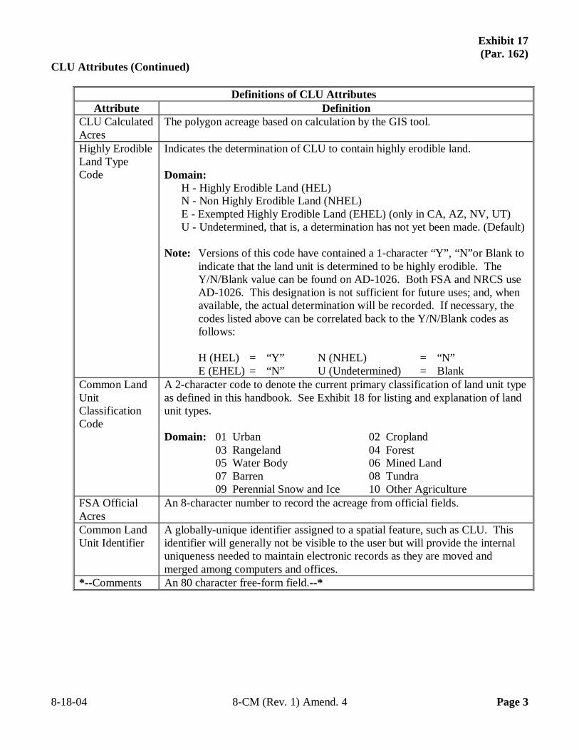
Exhibit 17 (Par. 162)
CLU Attributes (Continued)
Definitions of CLU Attributes Attribute Definition
CLU Calculated Acres
The polygon acreage based on calculation by the GIS tool.
Highly Erodible Land Type Code
Indicates the determination of CLU to contain highly erodible land. Domain:
H - Highly Erodible Land (HEL) N - Non Highly Erodible Land (NHEL) E - Exempted Highly Erodible Land (EHEL) (only in CA, AZ, NV, UT) U - Undetermined, that is, a determination has not yet been made. (Default)
Note: Versions of this code have contained a 1-character “Y”, “N”or Blank to
indicate that the land unit is determined to be highly erodible. The Y/N/Blank value can be found on AD-1026. Both FSA and NRCS use AD-1026. This designation is not sufficient for future uses; and, when available, the actual determination will be recorded. If necessary, the codes listed above can be correlated back to the Y/N/Blank codes as follows:
H (HEL) = “Y” N (NHEL) = “N” E (EHEL) = “N” U (Undetermined) = Blank
Common Land Unit Classification Code
A 2-character code to denote the current primary classification of land unit type as defined in this handbook. See Exhibit 18 for listing and explanation of land unit types. Domain: 01 Urban 02 Cropland
03 Rangeland 04 Forest 05 Water Body 06 Mined Land 07 Barren 08 Tundra 09 Perennial Snow and Ice 10 Other Agriculture
FSA Official Acres
An 8-character number to record the acreage from official fields.
Common Land Unit Identifier
A globally-unique identifier assigned to a spatial feature, such as CLU. This identifier will generally not be visible to the user but will provide the internal uniqueness needed to maintain electronic records as they are moved and merged among computers and offices.
*--Comments An 80 character free-form field.--* 8-18-04 8-CM (Rev. 1) Amend. 4 Page 3

.

.

.
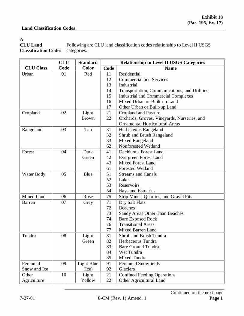
Exhibit 18(Par. 195, Ex. 17)
Land Classification Codes
ACLU LandClassification Codes
Following are CLU land classification codes relationship to Level II USGScategories.
Relationship to Level II USGS CategoriesCLU Class
CLUCode
StandardColor Code Name
Urban 01 Red 11121314151617
ResidentialCommercial and ServicesIndustrialTransportation, Communications, and UtilitiesIndustrial and Commercial ComplexesMixed Urban or Built-up LandOther Urban or Built-up Land
Cropland 02 LightBrown
2122
Cropland and PastureOrchards, Groves, Vineyards, Nurseries, andOrnamental Horticultural Areas
Rangeland 03 Tan 31323362
Herbaceous RangelandShrub and Brush RangelandMixed RangelandNonforested Wetland
Forest 04 DarkGreen
41424361
Deciduous Forest LandEvergreen Forest LandMixed Forest LandForested Wetland
Water Body 05 Blue 51525354
Streams and CanalsLakesReservoirsBays and Estuaries
Mined Land 06 Rose 75 Strip Mines, Quarries, and Gravel PitsBarren 07 Grey 71
7273747677
Dry Salt FlatsBeachesSandy Areas Other Than BeachesBare Exposed RockTransitional AreasMixed Barren Land
Tundra 08 LightGreen
8182838485
Shrub and Brush TundraHerbaceous TundraBare Ground TundraWet TundraMixed Tundra
PerennialSnow and Ice
09 Light Blue(Ice)
9192
Perennial SnowfieldsGlaciers
OtherAgriculture
10 LightYellow
2122
Confined Feeding OperationsOther Agricultural Land
Continued on the next page7-27-01 8-CM (Rev. 1) Amend. 1 Page 1
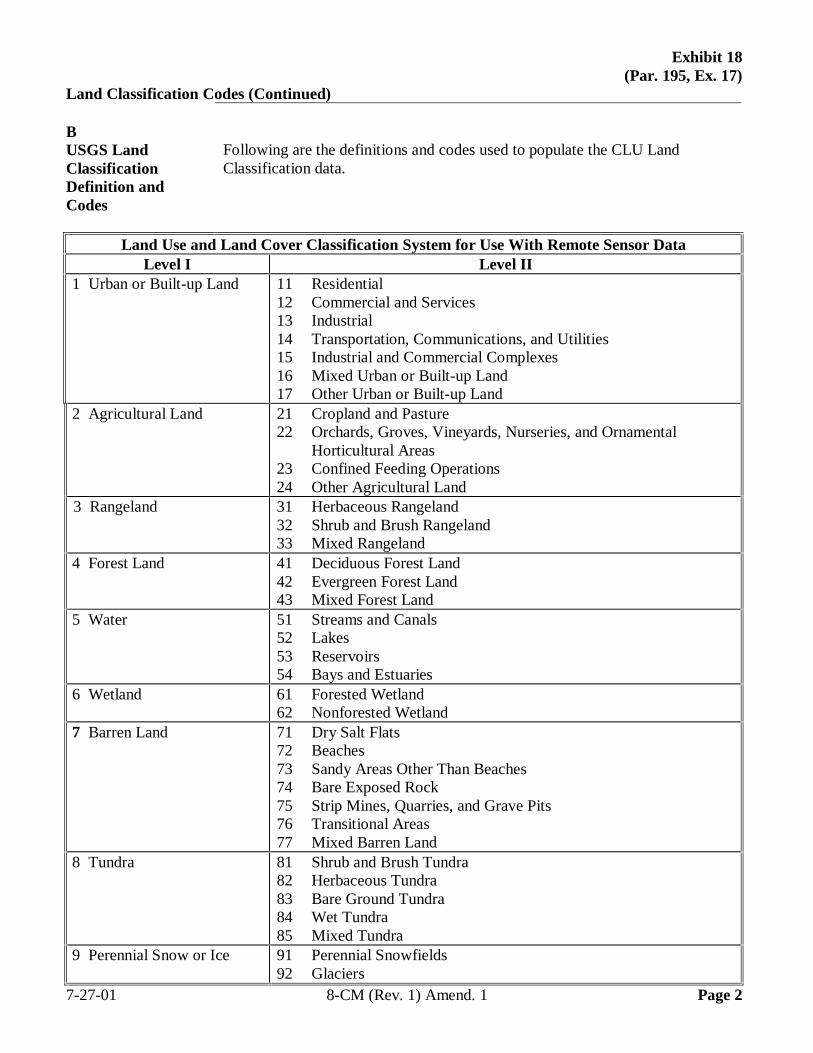
Exhibit 18(Par. 195, Ex. 17)
Land Classification Codes (Continued)
BUSGS LandClassificationDefinition andCodes
Following are the definitions and codes used to populate the CLU LandClassification data.
Land Use and Land Cover Classification System for Use With Remote Sensor DataLevel I Level II
1 Urban or Built-up Land 11 Residential12 Commercial and Services13 Industrial14 Transportation, Communications, and Utilities15 Industrial and Commercial Complexes16 Mixed Urban or Built-up Land17 Other Urban or Built-up Land
2 Agricultural Land 21 Cropland and Pasture22 Orchards, Groves, Vineyards, Nurseries, and Ornamental
Horticultural Areas23 Confined Feeding Operations24 Other Agricultural Land
3 Rangeland 31 Herbaceous Rangeland32 Shrub and Brush Rangeland33 Mixed Rangeland
4 Forest Land 41 Deciduous Forest Land42 Evergreen Forest Land43 Mixed Forest Land
5 Water 51 Streams and Canals52 Lakes53 Reservoirs54 Bays and Estuaries
6 Wetland 61 Forested Wetland62 Nonforested Wetland
7 Barren Land 71 Dry Salt Flats72 Beaches73 Sandy Areas Other Than Beaches74 Bare Exposed Rock75 Strip Mines, Quarries, and Grave Pits76 Transitional Areas77 Mixed Barren Land
8 Tundra 81 Shrub and Brush Tundra82 Herbaceous Tundra83 Bare Ground Tundra84 Wet Tundra85 Mixed Tundra
9 Perennial Snow or Ice 91 Perennial Snowfields92 Glaciers
7-27-01 8-CM (Rev. 1) Amend. 1 Page 2
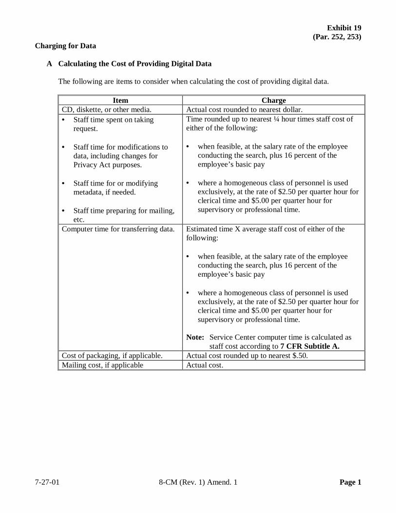
Exhibit 19 (Par. 252, 253)
Charging for Data
A Calculating the Cost of Providing Digital Data
The following are items to consider when calculating the cost of providing digital data.
Item Charge CD, diskette, or other media. Actual cost rounded to nearest dollar. • Staff time spent on taking
request. • Staff time for modifications to
data, including changes for Privacy Act purposes.
• Staff time for or modifying
metadata, if needed. • Staff time preparing for mailing,
etc.
Time rounded up to nearest ¼ hour times staff cost of either of the following: • when feasible, at the salary rate of the employee
conducting the search, plus 16 percent of the employee’s basic pay
• where a homogeneous class of personnel is used
exclusively, at the rate of $2.50 per quarter hour for clerical time and $5.00 per quarter hour for supervisory or professional time.
Computer time for transferring data. Estimated time X average staff cost of either of the following: • when feasible, at the salary rate of the employee
conducting the search, plus 16 percent of the employee’s basic pay
• where a homogeneous class of personnel is used
exclusively, at the rate of $2.50 per quarter hour for clerical time and $5.00 per quarter hour for supervisory or professional time.
Note: Service Center computer time is calculated as
staff cost according to 7 CFR Subtitle A. Cost of packaging, if applicable. Actual cost rounded up to nearest $.50. Mailing cost, if applicable Actual cost.
7-27-01 8-CM (Rev. 1) Amend. 1 Page 1
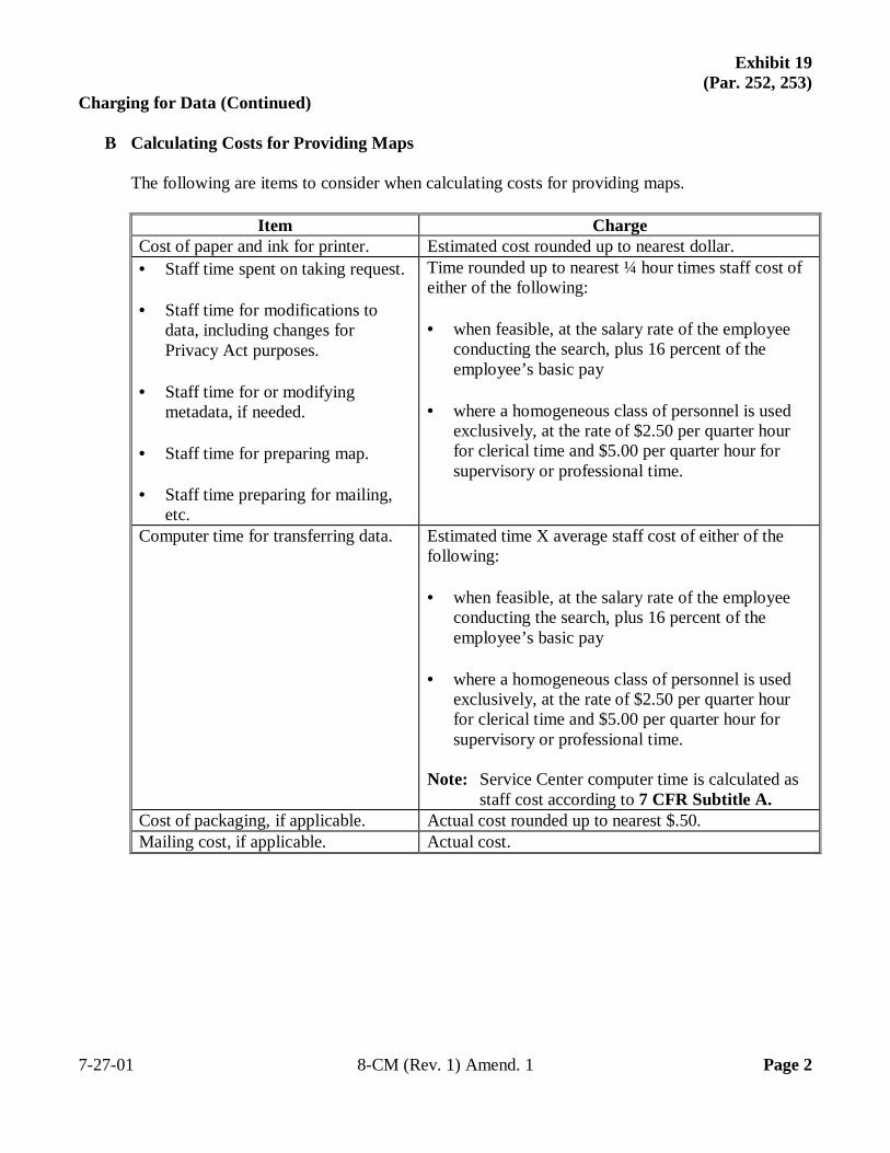
Exhibit 19 (Par. 252, 253)
Charging for Data (Continued)
B Calculating Costs for Providing Maps
The following are items to consider when calculating costs for providing maps.
Item Charge Cost of paper and ink for printer. Estimated cost rounded up to nearest dollar. • Staff time spent on taking request. • Staff time for modifications to
data, including changes for Privacy Act purposes.
• Staff time for or modifying
metadata, if needed. • Staff time for preparing map. • Staff time preparing for mailing,
etc.
Time rounded up to nearest ¼ hour times staff cost of either of the following: • when feasible, at the salary rate of the employee
conducting the search, plus 16 percent of the employee’s basic pay
• where a homogeneous class of personnel is used
exclusively, at the rate of $2.50 per quarter hour for clerical time and $5.00 per quarter hour for supervisory or professional time.
Computer time for transferring data. Estimated time X average staff cost of either of the following: • when feasible, at the salary rate of the employee
conducting the search, plus 16 percent of the employee’s basic pay
• where a homogeneous class of personnel is used
exclusively, at the rate of $2.50 per quarter hour for clerical time and $5.00 per quarter hour for supervisory or professional time.
Note: Service Center computer time is calculated as
staff cost according to 7 CFR Subtitle A. Cost of packaging, if applicable. Actual cost rounded up to nearest $.50. Mailing cost, if applicable. Actual cost.
7-27-01 8-CM (Rev. 1) Amend. 1 Page 2
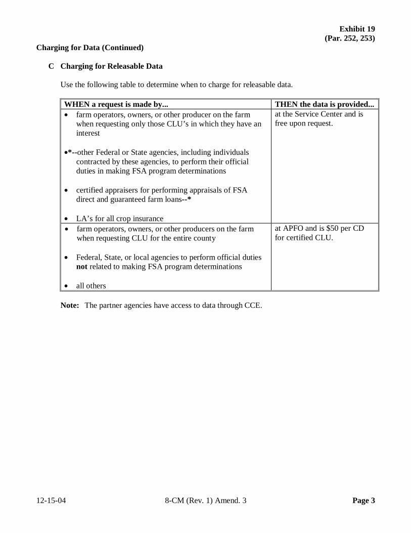
Exhibit 19 (Par. 252, 253)
Charging for Data (Continued)
C Charging for Releasable Data
Use the following table to determine when to charge for releasable data.
WHEN a request is made by... THEN the data is provided... • farm operators, owners, or other producer on the farm
when requesting only those CLU’s in which they have an interest
•*--other Federal or State agencies, including individuals contracted by these agencies, to perform their official duties in making FSA program determinations • certified appraisers for performing appraisals of FSA direct and guaranteed farm loans--* • LA’s for all crop insurance
at the Service Center and is free upon request.
• farm operators, owners, or other producers on the farm when requesting CLU for the entire county
• Federal, State, or local agencies to perform official duties
not related to making FSA program determinations • all others
at APFO and is $50 per CD for certified CLU.
Note: The partner agencies have access to data through CCE. 12-15-04 8-CM (Rev. 1) Amend. 3 Page 3

.
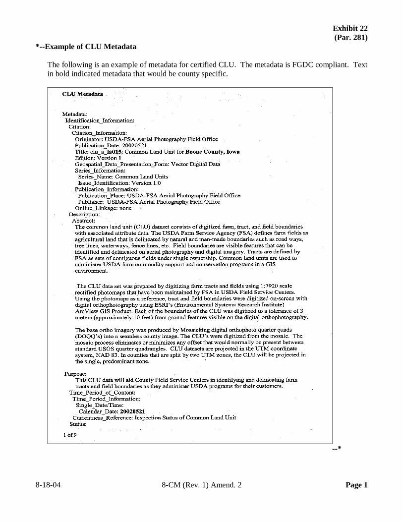
Exhibit 22 (Par. 281)
*--Example of CLU Metadata
The following is an example of metadata for certified CLU. The metadata is FGDC compliant. Text in bold indicated metadata that would be county specific.
--* 8-18-04 8-CM (Rev. 1) Amend. 2 Page 1
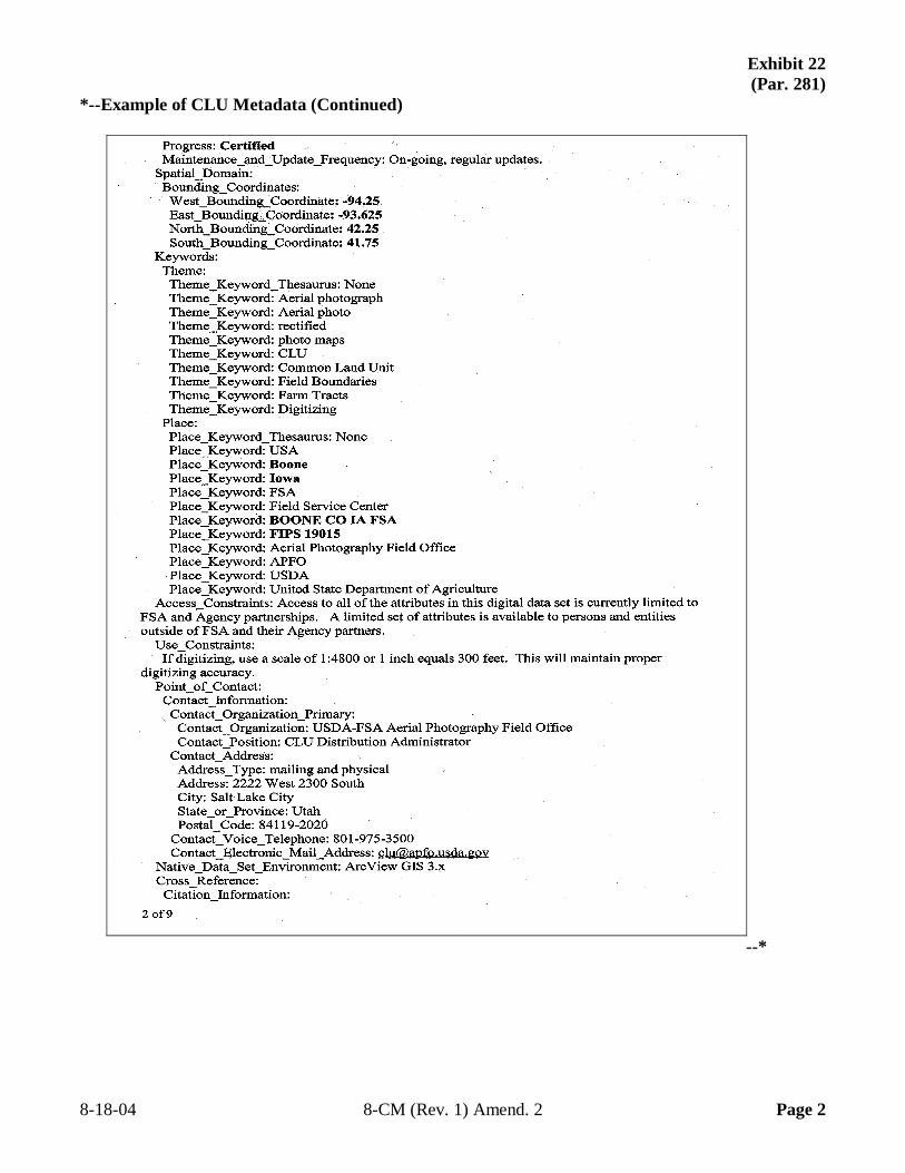
Exhibit 22 (Par. 281)
*--Example of CLU Metadata (Continued)
--* 8-18-04 8-CM (Rev. 1) Amend. 2 Page 2
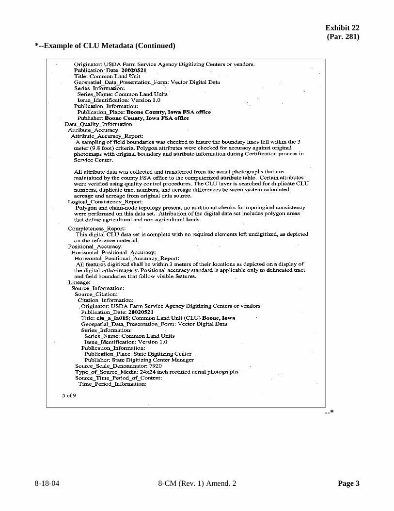
Exhibit 22 (Par. 281)
*--Example of CLU Metadata (Continued)
--* 8-18-04 8-CM (Rev. 1) Amend. 2 Page 3
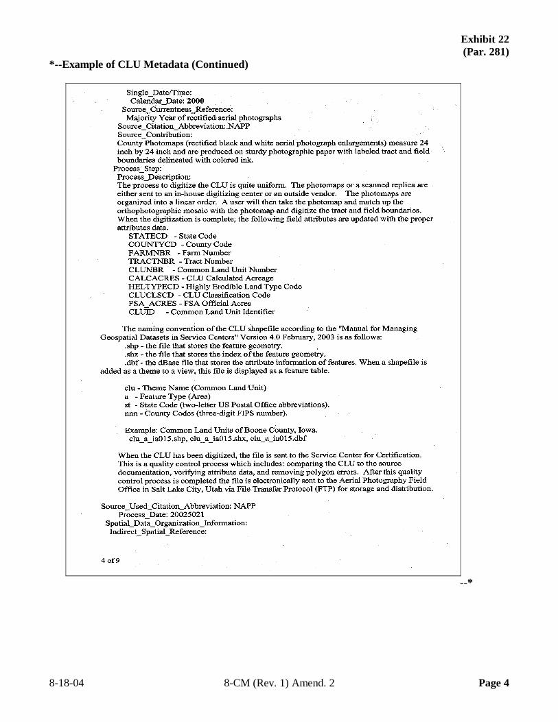
Exhibit 22 (Par. 281)
*--Example of CLU Metadata (Continued)
--* 8-18-04 8-CM (Rev. 1) Amend. 2 Page 4
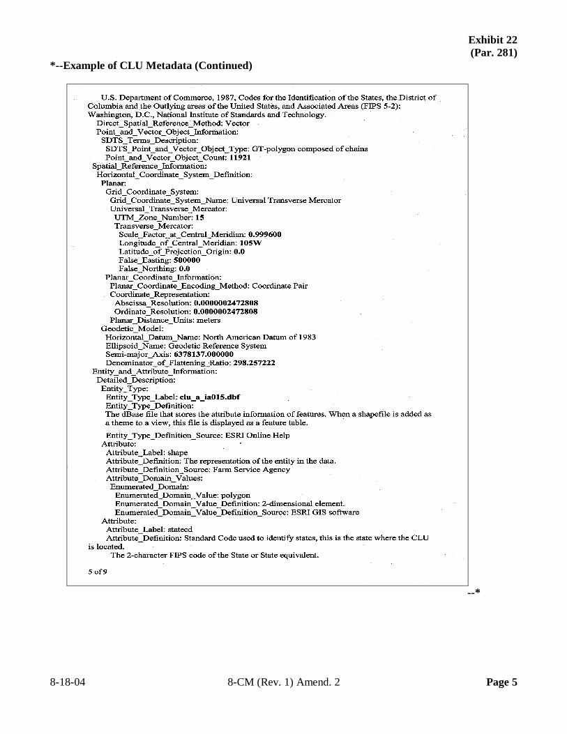
Exhibit 22 (Par. 281)
*--Example of CLU Metadata (Continued)
--* 8-18-04 8-CM (Rev. 1) Amend. 2 Page 5
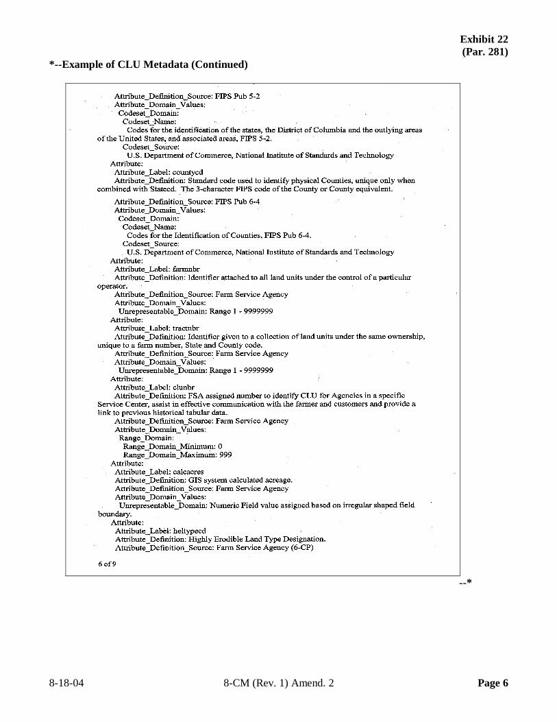
Exhibit 22 (Par. 281)
*--Example of CLU Metadata (Continued)
--* 8-18-04 8-CM (Rev. 1) Amend. 2 Page 6
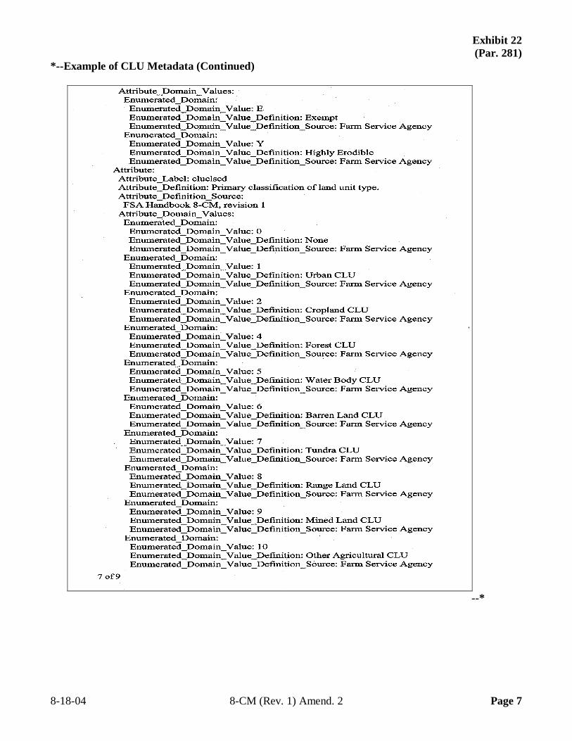
Exhibit 22 (Par. 281)
*--Example of CLU Metadata (Continued)
--* 8-18-04 8-CM (Rev. 1) Amend. 2 Page 7
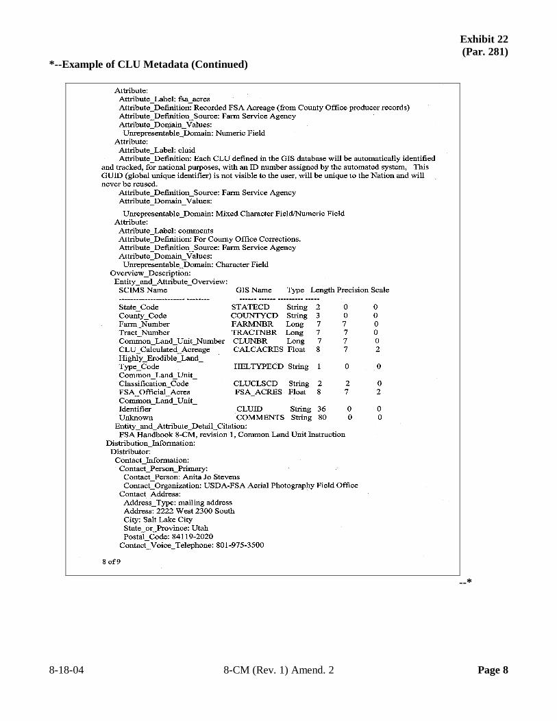
Exhibit 22 (Par. 281)
*--Example of CLU Metadata (Continued)
--* 8-18-04 8-CM (Rev. 1) Amend. 2 Page 8
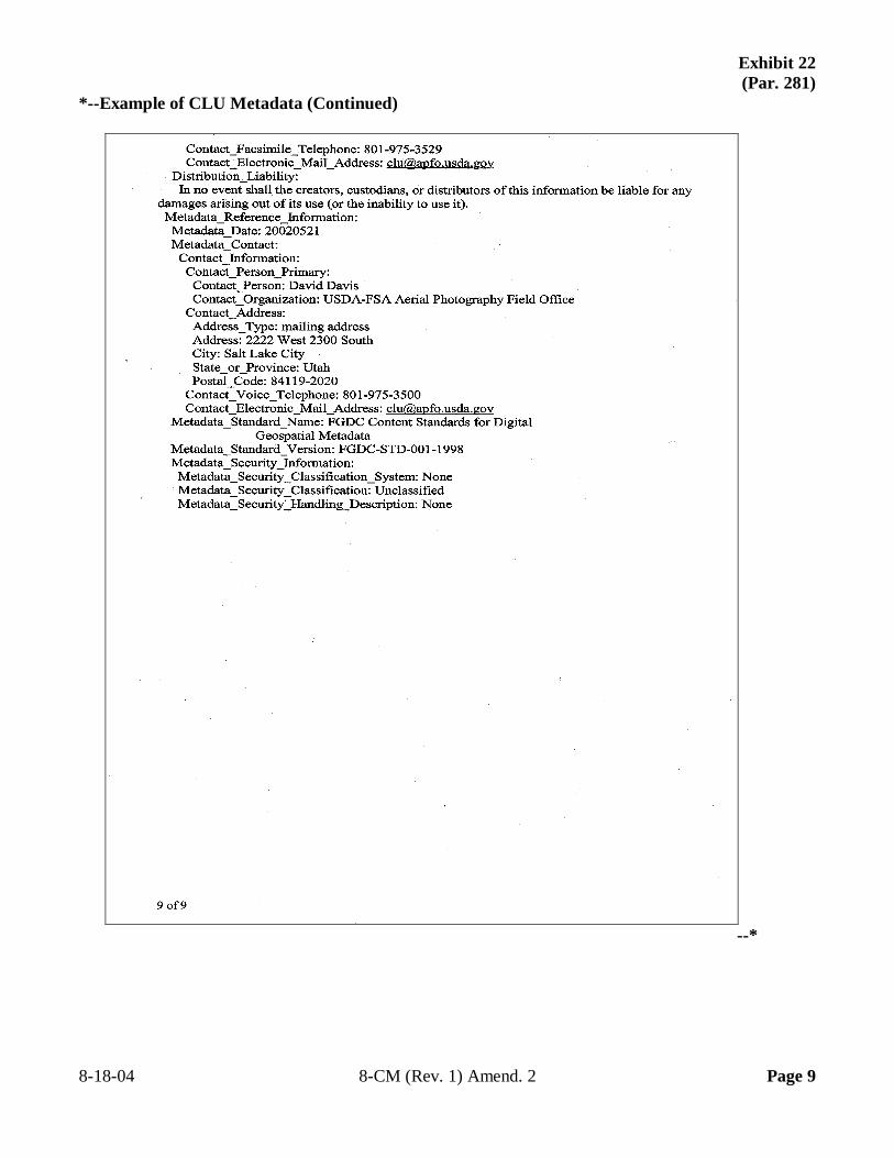
Exhibit 22 (Par. 281)
*--Example of CLU Metadata (Continued)
--* 8-18-04 8-CM (Rev. 1) Amend. 2 Page 9

--