Embed Size (px)
Citation preview

GCENTRAL COMMISSION FOR NAVIGATION ON THE RHINE RP (08) 36RIS/G (08) 4630 September 2008Or. de de/fr/nl/en
COMMITTEE POLICE REGULATIONWORKING GROUP RIS
Leaflet Inland AIS Vessel Tracking and Tracing Standard for Inland Navigation
Communication by the Secretariat____________________________________________________________________________________________________________________________
The secretariat transmits attached to this communication the final version of the modified leaflet, which incorporates the amendments agreed upon by the Working Group RIS.
The secretariat suggests that the Police Committee will adopt the leaflet in the course of its next meeting.

DRAFT
Leaflet
Inland AIS
Vessel Tracking and Tracing Standard for Inland Navigation
Edition 2008 - 22 October 2008 Page 1d/rip08_36en

Central Commission for Navigation on the RhineLeaflet Inland AIS
Edition 2008 - 22 October 2008 Page 2d/rp08_36en
Central Commission for Navigation on the RhineLeaflet Inland AIS
Contents
1. Principles.................................................................................................................... 51.1 Purpose of Inland AIS ............................................................................................... 51.2 Compatibility with maritime AIS ................................................................................. 51.3 Characteristics of AIS ................................................................................................ 51.4 System-related performance limits for AIS ................................................................ 6
2. International standardisation of Inland AIS ................................................................ 62.1 Purpose ..................................................................................................................... 62.2 Legal bases ............................................................................................................... 62.3 Structure of the Standard (of the technical specifications) for Vessel Tracking
and Tracing for Inland Navigation............................................................................... 72.4 Current editions ......................................................................................................... 72.5 Type approval of Inland AIS devices ......................................................................... 8
3. RIS fields of interest covered ..................................................................................... 8
4. Functioning of Inland AIS .......................................................................................... 10
5 Operating modes of AIS ............................................................................................ 11
6 AIS devices ............................................................................................................... 11
7. Information transmitted by Inland AIS ...................................................................... 117.1 Static ship information ............................................................................................... 127.2 Dynamic ship information .......................................................................................... 127.3 Voyage-related ship information ................................................................................ 137.4 Traffic management information ................................................................................ 137.5 ETA at lock/bridge/terminal ....................................................................................... 137.6 RTA at lock/bridge/terminal ....................................................................................... 147.7 Number of persons on board ..................................................................................... 147.8 Signal status............................................................................................................... 147.9 EMMA weather warnings .......................................................................................... 147.10 Water level reports .................................................................................................... 147.11 Safety-related messages ........................................................................................... 15
8. Reporting interval for information transmission ......................................................... 15
9. On-board operation of Inland AIS devices ................................................................. 16
10. Display of information transmitted by Inland AIS ...................................................... 17
11. Status of Inland AIS implementation in European countries ...................................... 18
12. Contacts .................................................................................................................... 19
13. List of abbreviations .................................................................................................. 19
Edition 2008 - 22 October 2008 Page 3d/rp08_36en

Central Commission for Navigation on the RhineLeaflet Inland AIS
Edition 2008 - 22 October 2008 Page 4d/rp08_36en

Central Commission for Navigation on the RhineLeaflet Inland AIS
1. Principles
1.1 Purpose of Inland AIS
Inland AIS (AIS stands for “Automatic Identification System“) is a standardised procedure for the automatic exchange of nautical data between ships and between ships and shore installations.
As an instrument for the tracking and tracing of inland navigation vessels it is part of the “River Information Services” (RIS) for inland navigation and its goal is to improve safety and efficiency in the sector.
It supports onboard navigation, shore-based traffic monitoring as part of Vessel Traffic Services (VTS) and other tasks such as calamity abatement.
1.2 Compatibility with maritime AIS
The information content of Inland AIS basically tallies with that of maritime AIS, while providing additional information specific to inland waterways. In view of their shared information content, Inland AIS and maritime AIS are compatible. All data transmitted can be received by both maritime and Inland AIS devices to be visually displayed and analysed. However the specifically Inland AIS information is only transmitted and assessed by Inland AIS devices.
1.3 Characteristics of AIS
AIS is a cooperative procedure, therefore all those wishing to use and participate in the system must be equipped with an AIS device.
Vessels fitted with AIS transmit and receive information on an automatic and periodical basis from other ships equipped with AIS. This information regards the vessel and its current nautical data: Identity of the ship, Its exact position, Its course and speed, Other ship-specific data.
The data provided by AIS can be visualised in various ways. The most efficient way of going about this is to display the identity of the vessel and geo-referenced data such as that on its position and movements on a chart, and compile static data in alphanumerical form in tables.
AIS shore stations within VHF radio range can also receive these data and in turn broadcast navigation-related information to vessels.
AIS is an additional source for navigation-related information. AIS does not replace navigation-related services such as tracking by radar and VTS, but in fact supports them. The strength of AIS lies in the detection and tracking of those craft fitted with it. AIS and radar complement one another due to their different characteristics.
Edition 2008 - 22 October 2008 Page 5d/rp08_36en

Central Commission for Navigation on the RhineLeaflet Inland AIS
1.4 System-related performance limits of AIS
The following points are to be considered when using information conveyed by AIS: Not all vessels are equipped with AIS. Users, particularly the shipmaster, should always
bear in mind that other vessels may not be fitted with AIS, or that an AIS device installed on another ship might transmit incomplete or erroneous information.
Users should ensure they are in a position to construe the data received correctly. AIS is purely an additional source of information. It in no way replaces navigation aids such
as radar, but is intended to support them.
2. International standardisation of Inland AIS
2.1 Purpose
Both standards and harmonised procedures are required to ensure the interoperability of devices from various manufacturers, whilst guaranteeing that they operate safely.
As part of the standardisation of tracking and tracing for inland navigation, the Inland AIS Standard and the Test Standard for Inland AIS were developed.
The Inland AIS Standard and the Test Standard for Inland AIS define: Functional requirements for Inland AIS devices, Technical requirements for Inland AIS devices, Specification of AIS messages for the exchange of messages between Inland AIS devices
via radio, Specification of AIS data sets for data exchange between Inland AIS devices and
connected applications.
The European Expert Group “Vessel Tracking and Tracing on Inland Waterways" drew up the Inland AIS Standard and the Test Standard for Inland AIS and will, if need be, make proposals for their further development
2.2 Legal bases
Resolution of the Central Commission for Navigation on the Rhine (CCNR) of May 31st, 2006: “Vessel Tracking and Tracing Standard for Inland Navigation (VTT Standard 2006)“ (Protocol 2006-I-21)
Commission Regulation (EC) No 415/2007 of 13 March 2007 concerning the technical specifications for vessel tracking and tracing systems referred to in Article 5 of Directive 2005/44/EC of the European Parliament and of the Council on harmonised river information services (RIS) on inland waterways in the Community
Edition 2008 - 22 October 2008 Page 6d/rp08_36en

Central Commission for Navigation on the RhineLeaflet Inland AIS
Resolution of the Central Commission for Navigation on the Rhine (CCNR) of May 31st, 2007: “Vessel Tracking and Tracing Standard for Inland Navigation – Type approval, installation and operation of Inland AIS devices on inland navigation vessels “ (Protocol 2007-I-15)
Resolution of the Central Commission for Navigation on the Rhine (CCNR) of December 6 th, 2007: “Vessel Tracking and Tracing Standard for Inland Navigation – Type approval, installation and operation of Inland AIS devices on inland navigation vessels“ (Protocol 2007-II-24)
Police Regulation for Rhine Navigation, § 4.07
Rhine Vessel Inspection Regulation, § 7.06 Nr. 3
2.3 Structure of the Standard (of the technical specifications) for Vessel Tracking and Tracing in Inland Navigation
The Standard for Vessel Tracking and Tracing in Inland Navigation comprises the following sections: The usage of vessel tracking and tracing in inland navigation (functional description) Inland AIS Standard (including Inland AIS radio messages (VDL Messages, VHF data link)) Definitions (Annex A) Emma Codes (Annex B) Example of signal status (Annex C) Proposed digital interface sentences for Inland AIS (Annex D) ERI ship types (Annex E) Overview of information required by the user and the data fields, which are available in the
defined Inland AIS messages (Annex F).
Future developments may lead to alternative vessel tracking and tracing systems which must still be compatible with maritime AIS.
2.4 Current editions
The current editions of the Standards are published on the Internet at www.ccr-zkr.org.
Edition 2008 - 22 October 2008 Page 7d/rp08_36en

Central Commission for Navigation on the RhineLeaflet Inland AIS
2.5 Type approval of Inland AIS devices
Inland AIS devices are checked by a Competent Authority (type test) and are registered by it. As long as these devices have already been granted a type approval for maritime AIS, the type test may be limited to the requirements of the Inland AIS Test Standard. The CCNR website (www.ccr-zkr.org) contains registers of the Competent Authorities, the approved devices and accredited specialist firms. There is presently one Competent Authority:
Wasser- und Schifffahrtsverwaltung des Bundes Fachstelle der WSV für VerkehrstechnikenWeinbergstraße 11-13, D-56070 Koblenz(www.fvt.wsv.de)
3. RIS fields of interest covered
The table below provides an overview of which fields of interest can be covered by Inland AIS. Each field is subdivided into tasks. The users are defined for each task.
Table 1.1: Overview of services, tasks and users
Service Task User
Navigation Medium term:Looking minutes up to hours ahead, outside on-board radar range
Conning skipper
Short term:Looking minutes ahead, in on-board radar range
Conning skipper
Very short term:Looking up to one minute ahead
Conning skipper
Vessel
Traffic Management
VTS VTS operator, conning skipper
Lock operation Lock operator, conning skipper
Lock planning Lock operator, conning skipper, shipmaster, fleet manager
Bridge operation Bridge operator, conning skipper
Bridge planning Bridge operator, conning skipper, shipmaster, fleet manager
Edition 2008 - 22 October 2008 Page 8d/rp08_36en

Central Commission for Navigation on the RhineLeaflet Inland AIS
Service Task User
Calamity abatement service
Operator in calamity centre, VTS operator, lock operator, bridge operator, conning skipper, shipmaster, Competent Authority
Transport management Voyage planning Shipmaster, freight broker, fleet manager, terminal operator, conning skipper, VTS operator, lock operator, bridge operator, RIS operator
Transport logistics Fleet manager, shipmaster, consignor, consignee, supply forwarder
Port and terminal management
Terminal operator, shipmaster, consignor, port authority, Competent Authority
Cargo and fleet management
Fleet manager, consignor, consignee, supply forwarder, freight broker, shipmaster
Enforcement Cross-border Customs, Competent Authority, shipmaster
Traffic safety Competent Authority, shipmaster (police authorities)
Waterway and port infrastructure charges
Competent Authority, shipmaster, fleet manager, waterway authority
Fairway information service
Meteorological Information
Conning skipper
Signal status Competent Authority, shipmaster, fleet manager
Water levels Competent Authority, shipmaster, fleet manager, conning skipper
Edition 2008 - 22 October 2008 Page 9d/rp08_36en

Central Commission for Navigation on the RhineLeaflet Inland AIS
4. Functioning of Inland AIS
Onboard AIS devices transmit the identity of the vessel, its position and other data at regular intervals. By receiving these transmissions, AIS shore stations or ships fitted with AIS can automatically recognise, identify and track vessels equipped with AIS on a suitable screen, such as an inland ECDIS display. AIS systems are meant to boost the safety of navigation by use from vessel-to-vessel alongside onshore Vessel Traffic Services (VTS) to trace and track vessels and to assist in calamity abatement.
Illustration: Functioning of AIS
A peculiar trait of AIS is the autonomous mode which uses the SOTDMA (Self-Organised Time Division Multiple Access) procedure, thus dispensing with the need for a coordinating base station. The radio protocol is designed so that the ship stations work autonomously through exchanging access parameters for connection. The time is split into one-minute cycles with 2250 intervals per radio channel which are synchronised according to UTC time. Each participant organises their access to the radio channel by selecting free intervals, whilst taking account of the future use of intervals by other stations. There is no need for a central control point for assigning intervals.
Edition 2008 - 22 October 2008 Page 10d/rp08_36en

Central Commission for Navigation on the RhineLeaflet Inland AIS
5. Operating modes of AIS
The following operating modes can be distinguished for AISa) Ship to ship: All vessels fitted with AIS are able to receive static and dynamic information
from all other vessels equipped with AIS within the area of coverage.b) Ship to shore: Data from vessels equipped with AIS can also be picked up by AIS base
stations and relayed to an RIS Centre where they can be used to display Tactical Traffic Information (TTI) and Strategic Traffic Information (STI).
c) Shore to ship: Safety-related data can be transmitted to vessels by shore installations.
6. AIS devices
An AIS device normally contains the following components: VHF transmitter/receiver (1 transmitter and 2 receivers), GNSS receiver, Data processor.
Various kinds of AIS device types or AIS stations may be distinguished: AIS mobile stations of Class A on all seagoing vessels subject to the requirements of the
International Maritime Organisation (IMO) SOLAS Chapter V, AIS mobile stations of Class B CS/SO with restricted functionality, i.e. on seagoing leisure
craft, Inland AIS mobile stations, derivatives of AIS mobile stations of Class A with full Class A
functionality at VDL level plus additional inland navigation functions, AIS base stations, including shore-based Simplex repeater stations, AIS nautical signal stations for use on signalling devices such as beacons and buoys.
("Aids to Navigation“ AtoN).
AIS operates on the internationally defined VHF frequencies AIS 1 (161,975 MHz) and AIS 2 (162,025 MHz) and may be switched to other channels in the VHF maritime band.
7. Information transmitted by Inland AIS
The information transmitted by Inland and maritime AIS is identical bar the data specific to inland navigation. The information transmitted by Inland AIS can be divided into the following categories: Static information, such as vessel number, call-sign, vessel name, vessel type, Dynamic information, such as position of the ship with data on accuracy and integrity
status, Voyage-related information, such as length and beam of combinations, dangerous cargo, Information specific to inland navigation such as Standard European Vessel Number, type
of combination, number of blue cones/lights as per ADN/ADNR, estimated time of arrival (ETA) at locks, bridges, terminals, borders and presence of “blue signs”.
Edition 2008 - 22 October 2008 Page 11d/rp08_36en

Central Commission for Navigation on the RhineLeaflet Inland AIS
For transmitting messages Inland AIS uses the same parameters and the same structure as AIS mobile stations of Class A, which the IMO prescribes for maritime navigation (IMO-AIS). Fields with unused parameters are defined as “not available”. Elements marked with ‘*’ must be dealt with differently from seagoing vessels.
7.1 Static ship information
Static or fixed information is already fed into the AIS device during installation onboard and need only be amended if, for example, the name of the vessel were to change.
Static ship information is broadcast automatically be the vessel or on request.
Identification characteristic of the radio (MMSI) (as per IMO-AIS)
Ship name (as per IMO-AIS)
Call sign (as per IMO-AIS)
IMO number* (“not available“ for inland navigation vessels)
Type of ship and cargo* (as per IMO-AIS/with extra data as per ERI)
Overall length (dm)* (as per IMO-AIS/data in dm rather than m)
Overall beam (dm)* (as per IMO-AIS/data in dm rather than m)
European Vessel Identification Number (ENI) (Inland AIS extension)
Type of ship or combination (ERI) (Inland AIS extension)
Loaded/unloaded vessel1 (Inland AIS extension,)
7.2 Dynamic ship information
Dynamic information, bar the navigation status, is automatically updated by the position sensor inside the AIS device or by the connected sensors.
Dynamic ship information is broadcast automatically from the vessel or on request.
Position (WGS 84) (as per IMO-AIS)
Speed SOG* (as per IMO-AIS/additional quality information)
Course COG* (as per IMO-AIS/additional quality information)
Heading HDG* (as per IMO-AIS/additional quality 1
Within the Standard Vessel Tracking and Tracing in Inland Navigation, Edition 1.01, this information is mentioned among the static ship information. However, it actually concerns dynamic ship information. See chapter 9 of this leaflet.
Edition 2008 - 22 October 2008 Page 12d/rp08_36en

Central Commission for Navigation on the RhineLeaflet Inland AIS
information)
Rate of turn ROT (as per IMO-AIS)
Position accuracy and integrity information (GNSS/DGNSS)
(as per IMO-AIS)
Time of position-fixing device (as per IMO-AIS)
Navigation status (as per IMO-AIS)
Blue sign set (Inland AIS extension)
Quality of speed information (Inland AIS extension,/derived from ship sensor or GNSS)
Quality of course information (Inland AIS extension/derived from ship sensor or GNSS)
Quality of heading information (Inland AIS extension,/derived from certified sensor (e.g. gyro)
7.3 Voyage-related ship information
Voyage-related information is inputted manually and must be updated during the voyage where necessary.
Voyage-related ship information is broadcast automatically from the vessel or on request.
Destination (ERI location codes) (as per IMO-AIS)
Category of dangerous cargo (as per IMO-AIS)
Maximum present static draught * (as per IMO-AIS)
ETA (as per IMO-AIS)
Maximum present static draught * (Inland AIS extension /data in cm rather than dm)
Hazardous cargo classification (Inland AIS extension)
7.4 Traffic management information
Traffic management information is for specific use in inland navigation. This information is transmitted when required or on request to/from inland vessels.
Edition 2008 - 22 October 2008 Page 13d/rp08_36en

Central Commission for Navigation on the RhineLeaflet Inland AIS
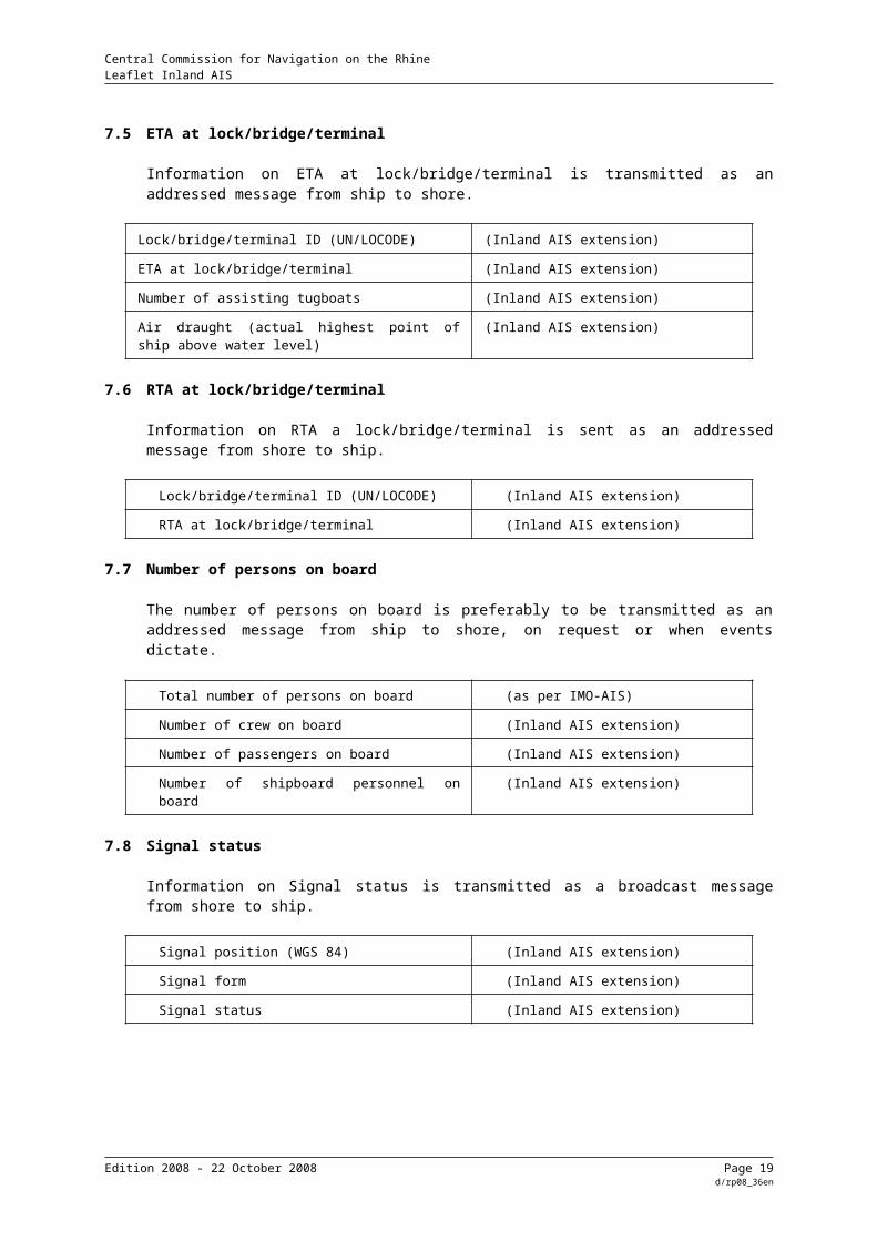
7.5 ETA at lock/bridge/terminal
Information on ETA at lock/bridge/terminal is transmitted as an addressed message from ship to shore.
Lock/bridge/terminal ID (UN/LOCODE) (Inland AIS extension)
ETA at lock/bridge/terminal (Inland AIS extension)
Number of assisting tugboats (Inland AIS extension)
Air draught (actual highest point of ship above water level)
(Inland AIS extension)
7.6 RTA at lock/bridge/terminal
Information on RTA a lock/bridge/terminal is sent as an addressed message from shore to ship.
Lock/bridge/terminal ID (UN/LOCODE) (Inland AIS extension)
RTA at lock/bridge/terminal (Inland AIS extension)
7.7 Number of persons on board
The number of persons on board is preferably to be transmitted as an addressed message from ship to shore, on request or when events dictate.
Total number of persons on board (as per IMO-AIS)
Number of crew on board (Inland AIS extension)
Number of passengers on board (Inland AIS extension)
Number of shipboard personnel on board (Inland AIS extension)
7.8 Signal status
Information on Signal status is transmitted as a broadcast message from shore to ship.
Signal position (WGS 84) (Inland AIS extension)
Signal form (Inland AIS extension)
Signal status (Inland AIS extension)
Edition 2008 - 22 October 2008 Page 14d/rp08_36en

Central Commission for Navigation on the RhineLeaflet Inland AIS
7.9 EMMA weather warnings
EMMA weather warnings are transmitted as a broadcast message from shore to ship.
Local Weather warnings (Inland AIS extension)
7.10 Water level reports
Water level reports are transmitted as a broadcast message from shore to ship.
Local water level information (Inland AIS extension)
7.11 Safety-related messages
Safety-related messages are transmitted when required as broadcast messages to everyone or as addressed messages.
8. Reporting interval for information transmission
The different information types for Inland AIS are transmitted at different reporting intervals.
For ships travelling on inland waterways the reporting interval for dynamic data can be switched between the SOLAS mode (reporting interval for AIS mobile stations of Class A on maritime vessels) and the inland navigation mode.
The following reporting intervals apply:
Static ship information Every 6 minutes or when data are amended or on request
Dynamic ship information Depends on navigation status and operating mode of the ship, either in inland navigation or SOLAS mode (default setting), or on request.Ship “at anchor“ every 3 minutes, Ship “en route“ between 10 and 2 seconds
Voyage-related ship information Every 6 minutes or when data are amended or on request
Traffic management information As required (in line with provisions of the Competent Authority)
Safety-related information As required
Edition 2008 - 22 October 2008 Page 15d/rp08_36en

Central Commission for Navigation on the RhineLeaflet Inland AIS
When in inland navigation mode, the reporting interval for dynamic information may be reduced by up to 2 seconds in line with the provisions of the Competent Authority, via an AIS shore station or an onboard application.
Reporting interval for dynamic ship information:
Ship dynamic conditions Nominal reporting interval
Ship status “at anchor“ and speed not above 3 knots 3 minutes
Ship status “at anchor“ and speed exceeding 3 knots 10 seconds
Ship with Inland AIS device with SOLAS reporting rate, speed 0 – 14 knots 10 Seconds
Ship with Inland AIS device with SOLAS reporting rate, speed 0 – 14 knots and changing course
3 1/3 seconds
Ship with Inland AIS device with SOLAS reporting rate, speed 14 – 23 knots 6 seconds
Ship with Inland AIS device with SOLAS reporting rate, speed 14 – 23 knots and changing course
2 seconds
Ship with Inland device with SOLAS reporting rate, speed exceeding 23 knots
2 seconds
Ship with Inland AIS device with SOLAS reporting rate, speed exceeding 23 knots and changing course
2 seconds
Ship with Inland AIS device with inland navigation reporting rate *Assigned between 2 and 10 seconds
* Can be assigned by the Competent Authority using AIS message 23 when the ship is in the inland waterway area.
9. On-board operation of Inland AIS devices
The Inland AIS device shall be in permanent operation whenever the ship is at anchor or en route. When in port, operation will take place in accordance with the regulations in force in the port in question.
The shipmaster shall manually input the following data at the start of the voyage and whenever the data are amended: Correct navigation status, Type of combination, Length/beam of combination, Category of dangerous cargo, Draught of the ship, Loaded/unloaded, Port of destination and ETA.
The conning skipper must check data to ensure that the static ship data are correct and reflect the latest situation. This must be done at least once a month. At certain intervals the shipmaster must also check the dynamic data of his own AIS device, such as position, course and speed.
Edition 2008 - 22 October 2008 Page 16d/rp08_36en

Central Commission for Navigation on the RhineLeaflet Inland AIS
Once the Inland AIS device comes into operation it must perform an ongoing built-in integrity test (BIIT). If a functional anomaly occurs in the Inland AIS device an error message must be displayed and, if necessary, the Inland AIS device should cease broadcasting information.
10. Display of information transmitted by Inland AIS
The minimum keyboard and display (MKD) for Inland AIS devices serves to input voyage-related ship data and other vessel-specific data such as status indication and alarm messages.
The MKD may also show AIS messages received, such as ship name, distance and heading of the reporting ship, alphanumerically. Other ship data can be displayed by selecting a given ship.
This form of displaying AIS data is not suited for navigational support. When using AIS data onboard, it would appear that a graphical display like Inland ECDIS is essential.
Illustration: Display of the position of a vessel fitted with AIS (MS Storch) on an Inland ECDIS device in navigation mode as an omnidirectional symbol, showing the name of the vessel as a moving blip alongside the additional ship data table in a separate window.
Edition 2008 - 22 October 2008 Page 17d/rp08_36en

Central Commission for Navigation on the RhineLeaflet Inland AIS
11. Status of Inland AIS implementation in European Countries
Inland AIS Geographical coverage of waterways of Class Va or higher
Landbased AIS infrastructure
Countries dGPS via AIS Water level via AIS
Equipment programme
Status 2007 Outlook 2008
AT Austria
BE
Flanders Brussels Wallonia
BG Bulgaria CH Switzerland
CZ Czech Republic
DE Germany FR France HR Croatia HU Hungary LU Luxembourg
NL Netherlands PL Poland
RO Romania RS Serbia SK Slovakia UA Ukraine
Status:
No Information
No activities planned
In preparation
Pilot operation Last update: 31.3.2008
Fully operational Source: IRIS Europe
Edition 2008 - 22 October 2008 Page 18d/rp08_36en
Central Commission for Navigation on the RhineLeaflet Inland AIS
12. Contacts
European Expert Group “Vessel Tracking and Tracing on Inland Waterways"
Chair: Ms. Lea KuitersRijkswaterstaat, Centre for Transport and NavigationP.O. Box 5044NL-2600 GA DelftTel.: +31 102 825 868
Technical expert, type approval of Inland AIS devices:
Mr. Stefan BoberFachstelle für VerkehrstechnikenWeinbergstraße 11-13D-56070 Koblenz
Tel.: +49 261 981 922 31
Technical expert: Mr Jürgen TröglVia DonauDonau-City-Strasse 1A-1220 WienTel.: +43 504 321 16 15
Email address: [email protected]
Edition 2008 - 22 October 2008 Page 19d/rp08_36en

Central Commission for Navigation on the RhineLeaflet Inland AIS
13. Abbreviations
ADN/ADNR European Agreement concerning the International Carriage of Dangerous Goods by Inland Waterways
COG Course Over Ground
CS Carrier Sense
DGNSS Differential GNSS
ECDIS Electronic Chart Display and Information System
EMMA European Multiservice Meteorological Awareness System
ERI Electronic Reporting International
GNSS Global Navigation Satellite System
HDG Heading
ID Identifier
LOCODE Location Code
MMSI Maritime Mobile Service Identifier
ROT Rate Of Turn
RTA Requested Time of Arrival
SOG Speed Over Ground
SOLAS Safety Of Life At Sea
UTC Universal Time Coordinated
VDL VHF Data Link
VHF Very High Frequency
VTS Vessel Traffic Services
WGS 84 World Geodatic System from 1984
Edition 2008 - 22 October 2008 Page 20d/rp08_36en

![[PPT]Slide 1 - ASSE International · Web viewVessel walls Seal Reverse Osmosis Driving Pressure OsmoticPressure Applied Pressure General RO System Design FOR EXAMPLE, A SINGLE 4”](https://img.pdfslide.us/doc/110x75/5af43a837f8b9a8d1c8be34f/pptslide-1-asse-viewvessel-walls-seal-reverse-osmosis-driving-pressure-osmoticpressure.jpg)


![[XLS] Vessels... · Web viewSheet3 REG-VesselsinGoodstanding CountByFlag VMSReports Name Flag Ircs Flag_reg_number Mmsi Port_of_registry Date_of_flag_registerd Parallel_registry Previous_de_registered_date](https://img.pdfslide.us/doc/110x75/5b087a487f8b9a3d018c442a/xls-vesselsweb-viewsheet3-reg-vesselsingoodstanding-countbyflag-vmsreports.jpg)


![[XLS] Standing... · Web viewREG-VesselsinGoodstanding CountByFlag VMSReports Name Flag Ircs Flag_reg_number Mmsi Port_of_registry Date_of_flag_registerd Parallel_registry Previous_de_registered_date](https://img.pdfslide.us/doc/110x75/5b087a487f8b9a3d018c442c/xls-standingweb-viewreg-vesselsingoodstanding-countbyflag-vmsreports-name-flag.jpg)