Embed Size (px)
Citation preview

Comments from Rockwell Collins onICG WG-A Topics
© 2013 Rockwell CollinsAll rights reserved.
Angelo Joseph – Pr. Systems Engr., Navigation Products
Joel Wichgers – Pr. Systems Engr., CNS Advanced Technology
26 April 2013

Note on the Contents of this Presentation
The views in this presentation are solely those of theauthors, and are not to be construed to be the views ofRockwell Collins.
© 2013 Rockwell CollinsAll rights reserved.
2
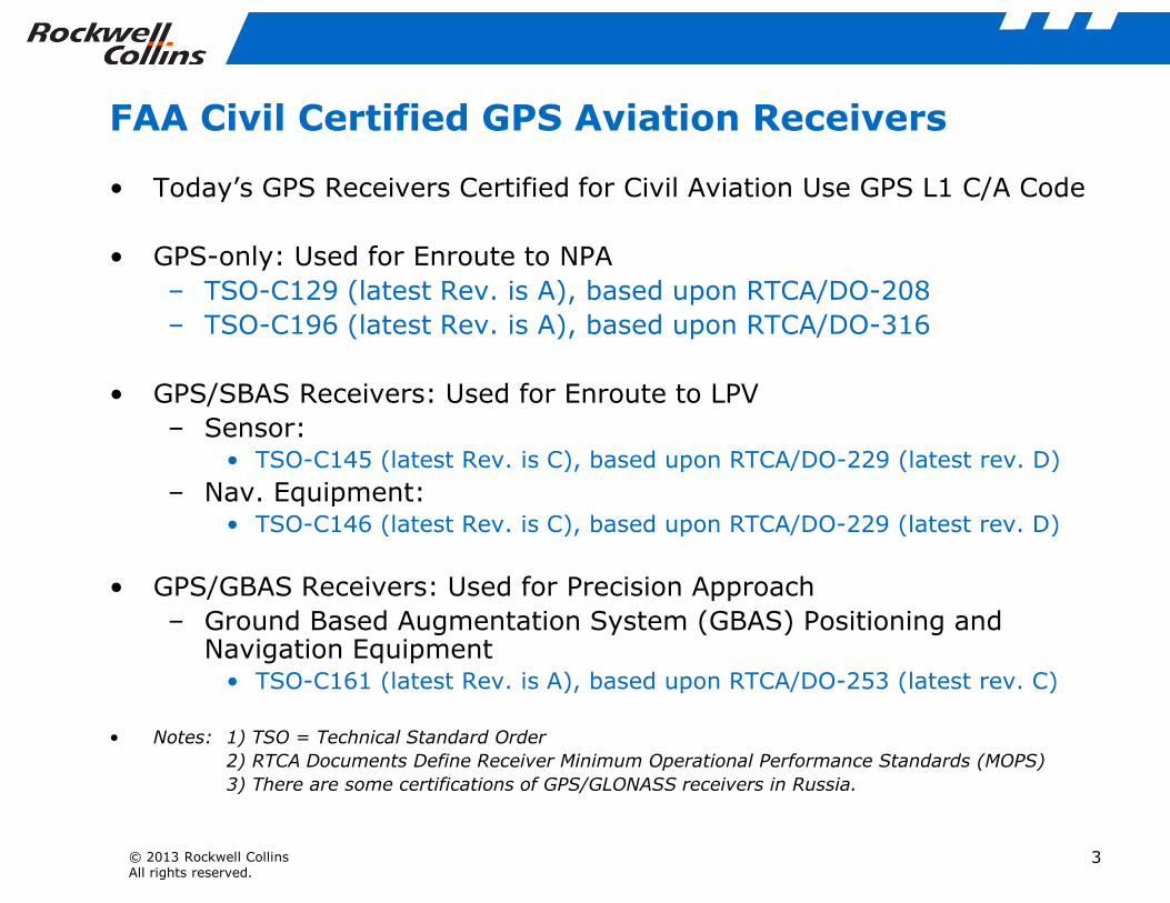
FAA Civil Certified GPS Aviation Receivers
• Today’s GPS Receivers Certified for Civil Aviation Use GPS L1 C/A Code
• GPS-only: Used for Enroute to NPA
– TSO-C129 (latest Rev. is A), based upon RTCA/DO-208
– TSO-C196 (latest Rev. is A), based upon RTCA/DO-316
• GPS/SBAS Receivers: Used for Enroute to LPV
– Sensor:• TSO-C145 (latest Rev. is C), based upon RTCA/DO-229 (latest rev. D)
© 2013 Rockwell CollinsAll rights reserved.
3
• TSO-C145 (latest Rev. is C), based upon RTCA/DO-229 (latest rev. D)
– Nav. Equipment:• TSO-C146 (latest Rev. is C), based upon RTCA/DO-229 (latest rev. D)
• GPS/GBAS Receivers: Used for Precision Approach
– Ground Based Augmentation System (GBAS) Positioning andNavigation Equipment
• TSO-C161 (latest Rev. is A), based upon RTCA/DO-253 (latest rev. C)
• Notes: 1) TSO = Technical Standard Order
2) RTCA Documents Define Receiver Minimum Operational Performance Standards (MOPS)
3) There are some certifications of GPS/GLONASS receivers in Russia.

Rockwell Collins GPS/MMR Products
• Business and Regional JetSolution
• Service Entry Date: 2003
• Certifications C-145A (MOPS)
• Air Transport Solution
• Service Entry Date: 2003
• Certifications C-145A/145 (MOPS)
• # of Channels: 24
GPS-4000S GLU-925/925S
© 2013 Rockwell CollinsAll rights reserved.
4
• Certifications C-145A (MOPS)
• # of Channels: 24
• Meets US ADS-B outrequirements: Yes
• SA Aware: Yes
• SBAS Augmented Output: Yes
• Maturity Level: High
• # of Channels: 24
• Meets US ADS-B outrequirements: Yes
• SA Aware: Yes
• SBAS Augmented Output: Yes(GLU-925S certifies in 2014)
• Maturity Level: High
• ILS CAT III: Yes
• GLS CAT I: Yes (optional)

Increase in Noise Floor
Do you see a threat to GNSS receivers due to many more GNSS signalscentered at 1575.42 MHz?
• We do not see a threat to the GNSS receivers with the envisionednumbers at 1575.42 MHz
− Assumes proper coordination of effective received power level so that the increase in the noise floor is less than or equal to those in civilaviation receiver test standards
− The Civil GPS Receiver Certification Standards (e.g., per RTCA MOPS) specify GNSS test noise to account for increase in noise floor
© 2013 Rockwell CollinsAll rights reserved.
MOPS) specify GNSS test noise to account for increase in noise floorfrom future constellations
• Whether you see a threat or not, do you prefer all new CDMA signals at“L1” to be centered at 1575.42 MHz or have some of them elsewhere,e.g., at 1602 MHz?
• We prefer all CDMA signals at L1 to be centered at 1575.42 MHz
– Moving to other frequencies like 1602 MHz requires additionalinterference susceptibility analysis (e.g., from SATCOM)
– It also complicates receiver and antenna design
5

Increase in Noise Floor
• Given that most GNSS providers plan to transmit a “modernized” signalat 1575.42 MHz, what is your long term perspective on whether youwill continue to use C/A?
– Why and How?
• We will continue to use L1 C/A for the foreseeable future
– Existing (legacy) receivers will use L1 C/A for civil applications
» SBAS and GBAS systems are expected to support L1 C/A for theforeseeable future
» There has been no (formal) plan by the FAA to sunset the use of
© 2013 Rockwell CollinsAll rights reserved.
» There has been no (formal) plan by the FAA to sunset the use ofexisting receivers
– Modernized Receivers
» ARAIM studies have assumed the use of L1 C/A, L5 GPS, E1 andE5a
» L1 C/A code signals can be acquired faster than other GNSS signals
» L1 C/A signal accuracy and noise models are well established foruse in Avionics receivers
6

CDMA / FDMA
• Once there are a large number of good CDMA signals, will there becontinuing commercial interest in FDMA signals?
– Why or why not?
• We currently do not see an interest in supporting FDMA signals
• There are no FAA TSOs that provide a certification basis for the use of FDMAsignals
• Russian Aviation authority (RCAA) recently announced a mandate requiringall avionics receivers to support GPS L1 and Glonass L1-M signals by January2017
© 2013 Rockwell CollinsAll rights reserved.
2017
– Our recommendation is that this mandate be rescinded because it hasnot been properly coordinated internationally
– Negotiations are underway regarding this mandate
– If this mandate is enforced there might be some interest to supportFDMA signals
7

Compatibility
• Do you prefer signals in different “L1” frequency bands for interferencemitigation rather than at one center frequency for interoperability?
– Why?
• We prefer one center frequency
• Interference mitigation will be addressed using multiple frequencies
• Interoperability and simplicity of receiver design is very important for ourapplications
© 2013 Rockwell CollinsAll rights reserved.
8

What to do About Misbehaving Signals (Slide 1 of 2)
• If a satellite’s signals do not meet quality standards,
should they:
– Be set unhealthy
– Transmit with a nonstandard code
– Transmit with reduced signal power (reduce interference)
– Be switched off
– What combination of the above
• The action to be taken should be based on the type of failure
© 2013 Rockwell CollinsAll rights reserved.
• The action to be taken should be based on the type of failure
• Hard failures should result in non-standard code or transmission beingswitched off
– Faster time to alert
– Signals from satellites with hard failures are unlikely to be used by anytype of GNSS users.
– Almanac should still indicate “unhealthy status”
• Failures that result in marginal/degraded performance should be indicatedwith a health status or quality indicator such as the URA
– User could de-weight or elect to use marginal signals when operating inenvironments where highest levels of accuracy are not necessary
9

What to do About Misbehaving Signals (Slide 2 of 2)
• To assure only “good” signals, should GNSS providers agree onminimum international signal quality standards and agree to provideonly signals meeting the standard?
• GNSS providers should agree on a common method of characterizing quality
– Standard indicators for signal quality such as URA, health status,Integrity parameters etc. should be defined and included in the ICAOSARPS
• Hard failures should result in non-standard code or transmission being
© 2013 Rockwell CollinsAll rights reserved.
• Hard failures should result in non-standard code or transmission beingswitched off
10

E5a and E5b
• Given that L5/E5a will be transmitted by most GNSS providers, do youintend to use the E5b signal?
– If so, for what purpose?
• No, we do not intend to support the E5b signals
– Support for E5b (along with L1 and L5) may cause antenna dimensionsto become larger than the ARINC 743-A specification
– Integrity messages transmitted on E5b are available on E1 as well
© 2013 Rockwell CollinsAll rights reserved.
11

Frequency Steps
• For your applications, are small satellite “frequency steps” (Δf) a problem?
• If so, what interval between “frequency steps” and what Δf magnitude would be excessive?
• Frequency steps that corrupt carrier smoothed code measurements are aproblem
– Receiver parameters such as tracking loop type, order and bandwidthwill determine the actual step size that would be excessive
© 2013 Rockwell CollinsAll rights reserved.
12

Interoperable Use (Slide 1 of 2)• Assuming signal quality is acceptable from every provider, would you
limit the number signals used by provider or by other criteria? Whatcriteria?
• Limit signal use by provider and other criteria
– Future receivers are envisioned to use minimum of 2 constellations in dualfrequency mode with GPS L1 and GPS L5 always being chosen as one pairof signals
– Use of third constellation for civil aviation provides minimal improvementin operational performance over dual system solutions.
– Exception to use of GPS may occur if deceptive interference is detected onone or both of the GPS signals
© 2013 Rockwell CollinsAll rights reserved.
one or both of the GPS signals
– May employ policy databases to select signals based on the airspace inwhich the receiver is operating (if mandated)
• Is having more signals inherently better or do you think there should bea limit?
• More signals of a given quality level tend to be inherently better
– Improves geometry
– Provides signals of opportunity for receivers operating under harsh signalconditions
– Frequency and system diversity that helps deal with jamming anddeceptive interference
– Inter-signal interference could be an issue that needs to be assessedbefore the addition of too many signals in view
13

Interoperable Use (Slide 2 of 2)
• Will the marketplace “force” you to make use of every available signal?
• Probably not
– FAA has stated that they intend to continue with performance basedrequirements. We prefer that the future marketplace will beperformance based, and our customers can buy products that suit theirperformance needs.
– Mandated use of satellite constellations/signals may occur in someairspaces. We do not favor such mandates.
• For best interoperability, how important is a common center frequency?
© 2013 Rockwell CollinsAll rights reserved.
• For best interoperability, how important is a common center frequency?How important is a common signal spectrum?
• Common center frequency is important as it promotes interoperability
– Allows use of common RF front ends for processing the different signalswhich helps reducing cost/power/complexity and avoids problems suchas differential RF delays.
• Common spectrum is not so important
14

Another Common Open Service Signal ( 1 of 2)
• Will you provide “tri-lane” capability in the future?
– Why?
• If so, do you prefer a common middle frequency or the combined useof L2 (1227.6), B3 (1268.52), and E6 (1278.75) if B3 and E6 openaccess is available
• We don’t expect to provide “tri-lane” capability in the future for commercialaviation applications
– For future commercial aviation GNSS receivers, we expect to use dualfrequency
© 2013 Rockwell CollinsAll rights reserved.
frequency
15
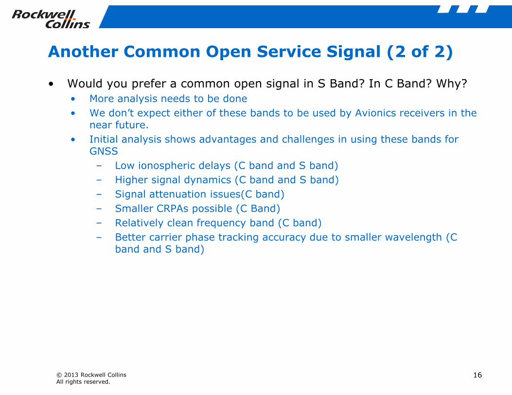
Another Common Open Service Signal (2 of 2)
• Would you prefer a common open signal in S Band? In C Band? Why?
• More analysis needs to be done
• We don’t expect either of these bands to be used by Avionics receivers in thenear future.
• Initial analysis shows advantages and challenges in using these bands forGNSS
– Low ionospheric delays (C band and S band)
– Higher signal dynamics (C band and S band)
– Signal attenuation issues(C band)
© 2013 Rockwell CollinsAll rights reserved.
– Signal attenuation issues(C band)
– Smaller CRPAs possible (C Band)
– Relatively clean frequency band (C band)
– Better carrier phase tracking accuracy due to smaller wavelength (Cband and S band)
16

Precision Code Measurements
• Does a wider satellite transmitter bandwidth help with multipathmitigation?
• Yes
– Provides better multipath mitigation for BPSK and BOC signals
– Enables the use of sophisticated code tracking discriminators such asdouble-delta that improve multipath performance
• What minimum transmitter bandwidth would you recommend for futureGNSS signals in order to achieve optimum code precision
© 2013 Rockwell CollinsAll rights reserved.
GNSS signals in order to achieve optimum code precisionmeasurements?
• At least 24 MHz assuming a chipping rate of no more than 10.23MHz
17

Added GNSS or SBAS Messages?• Would you recommend GNSS or SBAS services provide interoperability
parameters
– System clock offsets
– Geodesy offsets
– ARAIM parameters
– Others
• Yes, GNSS service providers should definitely provide the interoperabilityparameters
• Airborne receivers have increased satellite visibility and most likely willdetermine system clock offsets on their own using additional satellites
© 2013 Rockwell CollinsAll rights reserved.
determine system clock offsets on their own using additional satellites
• SBAS should not be used solely for transmitting these parameters as thatwould preclude use in areas not served by SBAS
– GEAS has recommended a low-rate Integrity Support Message thatcould be delivered by using some other means (other than SBAS) tothe aircraft.
• Should they be provided by other means so as not to compromise TTFFor other navigation capabilities
• Probably not necessary but use of channels such as data from internetservers may be useful for some commercial GNSS receivers.
18

Signal Coherence
• For your applications and for each signal, what amount of drift betweencode and carrier over what time frame would be excessive?
• Relates to earlier question on frequency jumps
• Exact values are TBD
• Carrier smoothed code processing is important in safety of life applications
– Time constants could range from a few seconds to a thousand seconds
– Carrier phase stability at the 10-13 level is required
• For your applications and for two or more signals in different frequencybands, e.g., L1 and L5 (when scaled properly), what amount of relative
© 2013 Rockwell CollinsAll rights reserved.
bands, e.g., L1 and L5 (when scaled properly), what amount of relativedrift in code and carrier between the signals would be excessive?
• Again this is TBD.
• Dual frequency processing will become increasingly important withapplications like ARAIM where the smoothing time constants could be verylong.
19

Spectrum Protection
• Should the international community strive to protect all GNSS signalbands from terrestrial signal interference?
• Yes
© 2013 Rockwell CollinsAll rights reserved.
20

System Geodesy
• Do the current differences (~10 cm) in Geodesy pose a problem foryour users? Why or why not?
• Not a significant problem for our applications where we do not deal withposition errors at the cm/mm level
• If geodesy differences are a problem, what is the preferred method ofcompensation:
– Published values (e.g., on websites)
– Satellite messages
© 2013 Rockwell CollinsAll rights reserved.
• N/A
21

System Time
• Do you want each system to cross reference the other’s time (e.g., witha GGTO type of message) or compare itself to a common internationalGNSS ensemble time? To what precision?
• GGTO type messages that reference different system times to GPS time ispreferred. Precision is TBD.
• Avionics receivers will calculate the offset based on measurements.
• Will your future receivers calculate a time offset between systemsbased on signal measurements or use only external time offset data?
• Future avionics receivers will compute these offsets using signal
© 2013 Rockwell CollinsAll rights reserved.
• Future avionics receivers will compute these offsets using signalmeasurements.
– Avionics receivers will not have satellite visibility issues and henceshould have enough satellites to compute these offsets.
• What is the preferred method of receiving time offsets: Satellitemessages, Internet messages, or internally calculated?
• Preferred to have both satellite messages and internally calculated
22

Thank You!
© 2013 Rockwell CollinsAll rights reserved.
23