Embed Size (px)
Citation preview
Comment on “Restoration of Cenozoic deformation in Asia andthe size of Greater India” by D. J. J. van Hinsbergen et al.
Jason R. Ali1 and Jonathan C. Aitchison2
Received 25 December 2011; revised 29 May 2012; accepted 1 June 2012; published 14 July 2012.
Citation: Ali, J. R., and J. C. Aitchison (2012), Comment on “Restoration of Cenozoic deformation in Asia and the size ofGreater India” by D. J. J. van Hinsbergen et al., Tectonics, 31, TC4006, doi:10.1029/2011TC003091.
1. Introduction
[1] Despite decades of investigation and literally thousandsof research papers, there remain strongly divergent opinionson a number of key features/phenomena associated with theIndia-Asia collision system and the Himalayan Mountain-Tibetan Plateau orogen that resulted. One particularlycontentious issue concerns the timing of contact betweenthe two continents; although many favor an early Eocene/early–middle Eocene age, recent proposals have ranged from�65 Ma [e.g., Cai et al., 2011] to �35 Ma [Aitchison et al.,2007].[2] In order to deduce the collision timing, we argue
that detailed understanding is required first of the elementsassociated with the suture zone, and second, the broadergeodynamic configuration before and during the contact.Regarding the former, the following are critical: (i) age ofthe youngest marine sediments; (ii) age of the youngestsubduction-generated calc-alkaline volcanic rocks; (iii) iden-tification and full interpretation of any trapped terranes;(iv) age and clast-assemblage lithologies of any molasseformations; (v) ages of the youngest entrained blocks in anymélange deposits plus that of the matrix. From a plate-modeling perspective, we need to know (i) past positionof stable Eurasia; (ii) extent of deformation (shortening,extrusion etc) Eurasia’s leading edge experienced after thecontact; (iii) motion path of the Indian block; (iv) size of theIndian sub-continent prior to the collision, which is com-monly referred to as “Greater India.”[3] Recently, Van Hinsbergen et al. [2011a, 2011b] have
proposed a new collision scenario. In their model, contact isinterpreted to have taken place at 50 Ma, and followinga structural restoration of Asia’s southern margin, a sub-continent extension is proposed that bridges the gap betweenthe Indian craton (to the south of the Himalayan frontalthrust) and the Lhasa Block; �1350 km in the west,�2600 km in the east. By corollary, a huge amount oflithosphere must therefore have been subducted/underthrust
beneath the Asian margin in Tibet. The model has provokedour interest, not only because the hypothesized GreaterIndia is the largest so far presented [see Ali and Aitchison,2005], but we consider it to suffer from two “unintended-consequence” flaws.
2. Problem of Refitting India Back IntoGondwana
[4] Although the extension proposal of van Hinsbergenet al. [2011a], based around a 50 Ma contact can in theoryexplain the collision (to avoid potential misunderstanding,though, we reiterate our long-held view that the India-Asiacollision occurred �15 my later), a problem arises whenit comes to positioning their Greater India at its former sitein Gondwana (before the Early Cretaceous, �130 Ma).Since the classic “tight-fit” reconstruction of Smith andHallam [1970], there has been widespread consensus overthe manner in which India (eastern), Australia (western) andAntarctica (eastern) are considered to have once abutted[e.g., Schettino and Scotese, 2005; Cocks and Torsvik, 2006](see Ricou [1994] for a radical alternative). The issue withthe van Hinsbergen et al. [2011a] model is that not only doesthe eastern side of the extension overlap western Australia(Figure 1a), but it fails to accommodate various rafts ofcontinental crust that are present offshore, specifically theExmouth, Wallaby and Zenith plateaus plus the CarnarvonTerrace. It was the second and third features [see alsoColwell et al., 1994; Symonds et al., 1998] that prompted us[Ali and Aitchison, 2005] to propose a Greater India whosenorthern edge was delimited, at least in the eastern andcentral parts, as including the area today occupied by thePerth Basin, southwest of the Wallaby-Zenith Fracture zone(Figure 1a). The recent paleontologically focused publica-tions of Quilty [2011] and Stilwell et al. [2012] add consid-erable weight to this proposal. They indicate that in the LateJurassic (Oxfordian-Kimmeridgian), around 12 my prior tothe India’s rifting from the Australian margin, the WallabyPlateau occupied a shallow marine site. Thus, the widelyheld view is that the edifice is “continental” and is capped bysea-ward dipping reflectors; critically it is not an EarlyCretaceous submarine large igneous province resulting fromexcessive magmatism as the oceanic crust off western Aus-tralia formed. We therefore argue that the various plateauswest of Australia act to eliminate large tracts of lithospherefrom the van Hinsbergen et al. [2011a] Greater India.
1Department of Earth Sciences, University of Hong Kong, Hong Kong,China.
2School of Geosciences, University of Sydney, Sydney, NSW, Australia.
Corresponding author: J. R. Ali, Department of Earth Sciences,University of Hong Kong, Pokfulam Rd., Hong Kong, China.([email protected])
©2012. American Geophysical Union. All Rights Reserved.0278-7407/12/2011TC003091
TECTONICS, VOL. 31, TC4006, doi:10.1029/2011TC003091, 2012
TC4006 1 of 3
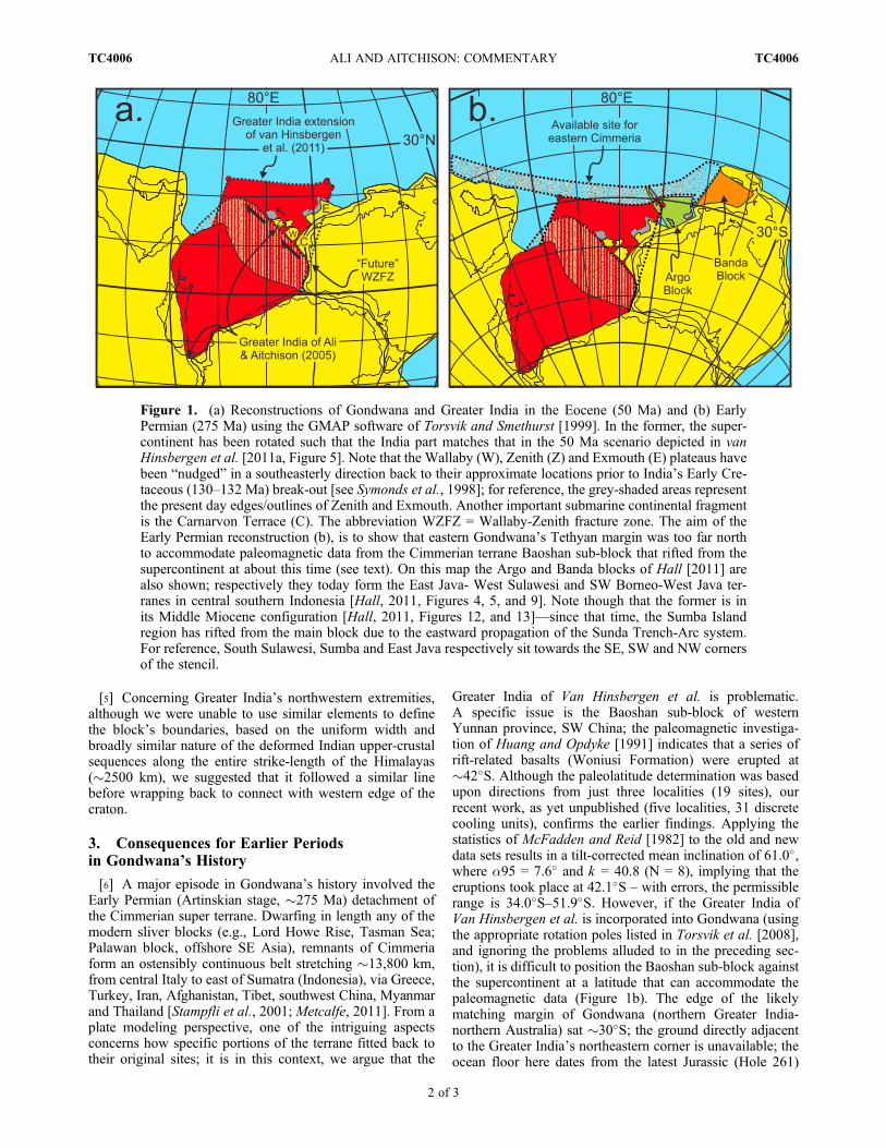
[5] Concerning Greater India’s northwestern extremities,although we were unable to use similar elements to definethe block’s boundaries, based on the uniform width andbroadly similar nature of the deformed Indian upper-crustalsequences along the entire strike-length of the Himalayas(�2500 km), we suggested that it followed a similar linebefore wrapping back to connect with western edge of thecraton.
3. Consequences for Earlier Periodsin Gondwana’s History
[6] A major episode in Gondwana’s history involved theEarly Permian (Artinskian stage, �275 Ma) detachment ofthe Cimmerian super terrane. Dwarfing in length any of themodern sliver blocks (e.g., Lord Howe Rise, Tasman Sea;Palawan block, offshore SE Asia), remnants of Cimmeriaform an ostensibly continuous belt stretching �13,800 km,from central Italy to east of Sumatra (Indonesia), via Greece,Turkey, Iran, Afghanistan, Tibet, southwest China, Myanmarand Thailand [Stampfli et al., 2001; Metcalfe, 2011]. From aplate modeling perspective, one of the intriguing aspectsconcerns how specific portions of the terrane fitted back totheir original sites; it is in this context, we argue that the
Greater India of Van Hinsbergen et al. is problematic.A specific issue is the Baoshan sub-block of westernYunnan province, SW China; the paleomagnetic investiga-tion of Huang and Opdyke [1991] indicates that a series ofrift-related basalts (Woniusi Formation) were erupted at�42�S. Although the paleolatitude determination was basedupon directions from just three localities (19 sites), ourrecent work, as yet unpublished (five localities, 31 discretecooling units), confirms the earlier findings. Applying thestatistics of McFadden and Reid [1982] to the old and newdata sets results in a tilt-corrected mean inclination of 61.0�,where a95 = 7.6� and k = 40.8 (N = 8), implying that theeruptions took place at 42.1�S – with errors, the permissiblerange is 34.0�S–51.9�S. However, if the Greater India ofVan Hinsbergen et al. is incorporated into Gondwana (usingthe appropriate rotation poles listed in Torsvik et al. [2008],and ignoring the problems alluded to in the preceding sec-tion), it is difficult to position the Baoshan sub-block againstthe supercontinent at a latitude that can accommodate thepaleomagnetic data (Figure 1b). The edge of the likelymatching margin of Gondwana (northern Greater India-northern Australia) sat �30�S; the ground directly adjacentto the Greater India’s northeastern corner is unavailable; theocean floor here dates from the latest Jurassic (Hole 261)
Figure 1. (a) Reconstructions of Gondwana and Greater India in the Eocene (50 Ma) and (b) EarlyPermian (275 Ma) using the GMAP software of Torsvik and Smethurst [1999]. In the former, the super-continent has been rotated such that the India part matches that in the 50 Ma scenario depicted in vanHinsbergen et al. [2011a, Figure 5]. Note that the Wallaby (W), Zenith (Z) and Exmouth (E) plateaus havebeen “nudged” in a southeasterly direction back to their approximate locations prior to India’s Early Cre-taceous (130–132 Ma) break-out [see Symonds et al., 1998]; for reference, the grey-shaded areas representthe present day edges/outlines of Zenith and Exmouth. Another important submarine continental fragmentis the Carnarvon Terrace (C). The abbreviation WZFZ = Wallaby-Zenith fracture zone. The aim of theEarly Permian reconstruction (b), is to show that eastern Gondwana’s Tethyan margin was too far northto accommodate paleomagnetic data from the Cimmerian terrane Baoshan sub-block that rifted from thesupercontinent at about this time (see text). On this map the Argo and Banda blocks of Hall [2011] arealso shown; respectively they today form the East Java- West Sulawesi and SW Borneo-West Java ter-ranes in central southern Indonesia [Hall, 2011, Figures 4, 5, and 9]. Note though that the former is inits Middle Miocene configuration [Hall, 2011, Figures 12, and 13]—since that time, the Sumba Islandregion has rifted from the main block due to the eastward propagation of the Sunda Trench-Arc system.For reference, South Sulawesi, Sumba and East Java respectively sit towards the SE, SW and NW cornersof the stencil.
ALI AND AITCHISON: COMMENTARY TC4006TC4006
2 of 3
[Veevers et al., 1974] /earliest Cretaceous (Hole 765)[Ludden et al., 1990], and is thought to be the original siteof the Argo and Banda blocks that today form terranes incentral southern Indonesia [Hall, 2011].
4. Conclusion
[7] For the two reasons outlined above, we contendthat the “Greater India” of van Hinsbergen et al. [2011a] isuntenable when (i) key geotectonic features of the easternIndian Ocean-western Australia region and (ii) accommo-dation of Cimmerian-terrane blocks are considered. Anymodel attempting to delimit the Indian sub-continent’s pre-Asia-collision size needs to be compatible with tectonicconfigurations that are applicable for earlier times in theblock’s history.
[8] Acknowledgments. Douwe van Hinsbergen kindly suppliedrotation data that enabled us to replicate the van Hinsbergen et al. [2011a]tectonic model. Formal critiques by an anonymous reviewer and Robert Hallwere very useful. Our research on the India-Asia collision has almost exclu-sively been supported by grant awards from the Hong Kong Research GrantsCouncil; recent paleomagnetic studies of the Baoshan block were funded byan award to JRA (HKU7001/10).
ReferencesAitchison, J. C., J. R. Ali, and A. M. Davis (2007), When and where didIndia and Asia collide?, J. Geophys. Res., 112, B05423, doi:10.1029/2006JB004706.
Ali, J. R., and J. C. Aitchison (2005), Greater India, Earth Sci. Rev., 72,169–188, doi:10.1016/j.earscirev.2005.07.005.
Cai, F., L. Ding, and Y. Yue (2011), Provenance analysis of upper Creta-ceous strata in the Tethys Himalaya, southern Tibet: Implications for tim-ing of India–Asia collision, Earth Planet. Sci. Lett., 305, 195–206,doi:10.1016/j.epsl.2011.02.055.
Cocks, L. R. M., and T. H. Torsvik (2006), European geography in a globalcontext from the Vendian to the end of the Palaeozoic, Geol. Soc. Lond.Mem, 32, 83–95, doi:10.1144/GSL.MEM.2006.032.01.05.
Colwell, J. B., P. A. Symonds, and A. J. Crawford (1994), The nature ofthe Wallaby (Cuvier) Plateau and other igneous provinces of the westAustralian margin, AGSO J. Aust. Geol. Geophys., 15, 137–156.
Hall, R. (2011), Australia–SE Asia collision: Plate tectonics and crustalflow, Geol. Soc. Spec. Publ., 355, 75–109, doi:10.1144/SP355.5.
Huang, K. N., and N. D. Opdyke (1991), Paleomagnetic results from theUpper Carboniferous of the Shan-Thai-Malay block of western Yunnan,
China, Tectonophysics, 192, 333–344, doi:10.1016/0040-1951(91)90107-4.
Ludden, J. N., et al. (1990), Initial Reports of the Deep Sea Drilling Project,vol. 123, U.S. Gov. Print. Off., Washington, D. C.
McFadden, P. L., and A. B. Reid (1982), Analysis of palaeomagnetic incli-nation data, Geophys. J. R. Astron. Soc., 69, 307–319, doi:10.1111/j.1365-246X.1982.tb04950.x.
Metcalfe, I. (2011), Tectonic framework and Phanerozoic evolution ofSundaland, Gondwana Res., 19, 3–21, doi:10.1016/j.gr.2010.02.016.
Quilty, P. G. (2011), Late Jurassic foraminifera, Wallaby plateau, offshoreWestern Australia, J. Foraminiferal Res., 41, 182–195, doi:10.2113/gsjfr.41.2.182.
Ricou, L.-E. (1994), Tethys reconstructed plates, blocks and their bound-aries since 260 Ma from Central America to south-eastern Asia, Geodin.Acta, 7, 169–218.
Schettino, A., and C. R. Scotese (2005), Apparent polar wander paths forthe major continents (200 Ma to the present day): A palaeomagnetic ref-erence frame for global plate tectonic reconstructions, Geophys. J. Int.,163, 727–759, doi:10.1111/j.1365-246X.2005.02638.x.
Smith, A. G., and A. Hallam (1970), The fit of the southern continents,Nature, 225, 139–144, doi:10.1038/225139a0.
Stampfli, G. M., G. D. Borel, W. Cavazza, J. Mosar, and P. A. Ziegler(2001), Palaeotectonic and palaeogeographic evolution of the westernTethys and PeriTethyan domain (IGCP Project 369), Episodes, 24,22–28.
Stilwell, J. D., P. G. Quilty, and D. J. Mantle (2012), Paleontology of earlyCretaceous deep-water samples dredged from the Wallaby Plateau: Newperspectives of Gondwana break-up along the Western Australian mar-gin, Aust. J. Earth Sci., 59, 29–49, doi:10.1080/08120099.2011.615864.
Symonds, P. A., S. Planke, O. Frey, and J. Skogseid (1998), Volcanic evo-lution of the Western Australian continental margin and its implicationsfor basin development, in The Sedimentary Basins of Western Australia2: Proceedings of the PESA Symposium, edited by P. G. Purcell andR. R. Purcell, Pet. Explor. Soc., pp. 33–54, Perth, Aust.
Torsvik, T. H., and M. A. Smethurst (1999), Plate tectonic modelling:Virtual reality with GMAP, Comput. Geosci., 25, 395–402, doi:10.1016/S0098-3004(98)00143-5.
Torsvik, T. H., R. D. Müller, R. Van der Voo, B. Steinberger, and C. Gaina(2008), Global plate motion frames: Toward a unified model, Rev. Geo-phys., 46, RG3004, doi:10.1029/2007RG000227.
van Hinsbergen, D. J. J., P. Kapp, G. Dupont‐Nivet, P. C. Lippert, P. G.DeCelles, and T. H. Torsvik (2011a), Restoration of Cenozoic defor-mation in Asia and the size of greater India, Tectonics, 30, TC5003,doi:10.1029/2011TC002908.
van Hinsbergen, D. J. J., B. Steinberger, P. V. Doubrovine, andR. Gassmöller (2011b), Acceleration and deceleration of India‐Asia con-vergence since the Cretaceous: Roles of mantle plumes and continentalcollision, J. Geophys. Res., 116, B06101, doi:10.1029/2010JB008051.
Veevers, J. J., et al. (1974), Initial Reports of the Deep Sea Drilling Project,vol. 27, 1060 pp., U.S. Gov. Print. Off., Washington, D. C.
ALI AND AITCHISON: COMMENTARY TC4006TC4006
3 of 3


![Comment [CS1]: Drafting comment: I have Document Control Sheet](https://img.pdfslide.us/doc/110x75/622bfcce04df413257310ac6/comment-cs1-drafting-comment-i-have-document-control-sheet.jpg)