Embed Size (px)
Citation preview
1
Combining quantitative field and modelling approaches towards understanding landscape
dynamics: an evolution of ideas spanning Jef Vandenberghe’s research career.
Abstract
Geomorphology as a scientific discipline has underwent major developments since the mid
20th century. From its original descriptive nature aiming to understand landscape evolution,
it developed towards a more process-based oriented discipline. To a large extent this
evolution followed a quantitative approach whereby modelling becomes more and more
important. A schism between applied or engineering geomorphology and system-based
geomorphology aiming at understanding landscape change emerges in the 1950-1960’s.
Only at the end of the 20th century – early 21st century, integration of quantitative field-
based approaches on longer term issues of landscape evolution with numerical modelling
emerges. This is particularly true for the Holocene for which the importance of human
impact on geomorphic processes and landforms became acknowledged. With respect to
landscape evolution on much longer timescales, the development of tectonic
geomorphology becomes apparent. In this paper, some evolution of ideas and trends within
geomorphology with respect to understanding landscape dynamics are summarized and put
into the career perspective of Jef Vandenberghe.
Keywords: quantitative geomorphology, numerical modelling, process geomorphology, Jef
Vandenberghe, human impact, sediment dynamics
2
Introduction
During the second half of the 20th century, major developments in all scientific disciplines
took place. This is also true for the interdisciplinary field of Geomorphology. Extensive
reviews and opinions on the various trajectories within geomorphology have been made
before (Brocklehurst, 2010; Church, 2005; Church, 2010; Keylock, 2010; Richards and
Clifford, 2008; Summerfield, 2005). It is therefore not the aim of this paper to come up with
an entirely new view on how geomorphology developed as a scientific discipline. Rather, in
this paper some of the major evolutions in geomorphology of the last 50-60 years are
sketched in view of Jef Vandenberghe’s research career that started with his Geography
studies in Leuven, Belgium during the late 1960’s. As such it provides an overview on how
the international changes within geomorphology have equally developed in the Low
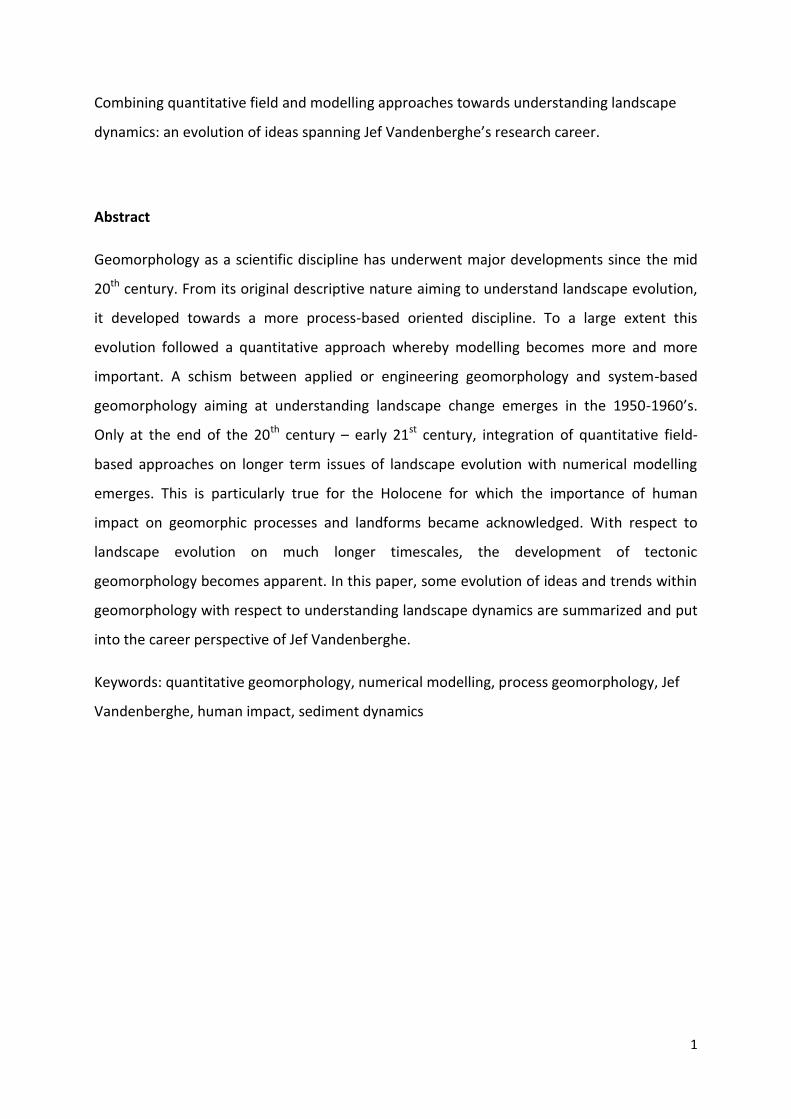
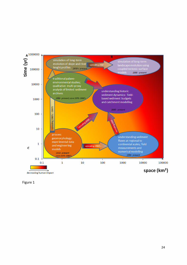
Countries. A synthesis of the main evolutions discussed in this paper is shown on Figure 1.
1950's-1970's: the establishment of a new geomorphic paradigm
The apparent dichotomy in geomorphology as discussed for instance by Richards and Clifford
(2008), whereby studies on long-term landform evolution or not linked to detailed local and
short-term process studies, has many origins but one of the more important ones is the
development of quantitative approaches in geomorphology. Although quantitative
geomorphology originated in the 1940’s and 1950’s it remains at first stage rather
descriptive as well: landforms and features in the landscape are now being measured and
ordered but the quantitative description is largely being used to interpret the dominant
processes shaping these landforms (see e.g. Doyle and Julian, 2005). The work by Robert
Horton and Arthur Strahler on drainage basins in developing this new approach in
geomorphology is widely known (Horton, 1945; Strahler, 1952) and within fluvial
geomorphology the work by Luna Leopold and co-workers gave a further boost to this
emerging discipline (Leopold and Maddock, 1953; Leopold and Wolman, 1957; Wolman and
Leopold, 1957). However, by the 1960's this paradigm shift from descriptive or Davision
geomorphology to quantitative geomorphology became more and more established and
measurements of geomorphic and hydrological variables now form the basis for process-
understanding. Next to measuring geomorphic features in the field, experimental
3
geomorphology provided an enormous amount of data upon which process-interactions
could be studied. The relations between drivers of geomorphic processes and the intensity
of processes could now be quantified under controlled conditions. Hence, basic relations
were established that predict amongst others the rate of erosion, sediment transport or
discharge. This rapid expanding field of experimental geomorphology thus gave a further
boost to process geomorphology studies upon which the first numerical modelling of
geomorphic processes could build. Since both quantitative observations as well as
experiments mostly focus on short-term timescales, the majority of modelling exercises is
also oriented towards the prediction of contemporary process intensities. Often, such
modelling approaches have direct engineering purposes. Typical examples are the hydraulic
HEC model (HEC, 1968) and the Universal Soil Loss Equation or USLE to predict average
erosion rates at the field plot scale (Wischmeier and Smith, 1960). In fact, these model
approaches were built upon earlier quantitative field and experimental data, collected
mostly by non-geomorphologists before World War II at agricultural or forestry experimental
stations (Duley and Miller, 1923; Lentz et al., 1930) or by engineers (Meyer-Peter and Müller,
1948; Reynolds, 1883; Shields, 1936). The embracement of physical process understanding in
quantitative geomorphology has led to the further development of applied geomorphology,
thus leading away from the basic questions in the geomorphic discipline that relate to an
understanding of how landscapes originate and develop (see also Church, 2005).
On the other hand, we also see in this time period the emergence of long-term geomorphic
modelling approaches that are based on the mass conservation equation and that use a
common transport law:
With TC the transport capacity of the erosion process, k a constant reflecting land use,
climatic, soil, etc conditions, A contributing drainage area, S the slope angle, whereas m and
n are the area and slope exponents, respectively. Based on values for m and n from earlier
empirical studies, Kirbky (1971) used this mathematical approach to simulate the impact of
different erosion processes on hillslope form, thus suggesting that a quantitative description
of hillslope morphology teaches us which processes were dominant on the long run. Ahnert
(1970) came to the same conclusion but also added the variation of regolith thickness along
4
a slope catena to the model. Nevertheless, the bulk of research papers on long-term
landscape evolution remained rather descriptive in its nature.
It is in this context of changing trajectories in geomorphology that Jef Vandenberghe
performed his Geography studies at KU Leuven in the late 1960's. The dichotomy in
geomorphic approaches as seen in the United States and the UK is also reflected by the
different expertises of the Physical Geography staff members in Leuven. Jef performed his
doctoral studies under supervision of Frans Gullentops whose research at the time can best
be described as a field-based approach to study landscape evolution during the Quaternary.
Research methods included traditional geomorphic mapping, sediment coring, palynology as
well as the application of geo-electric prospection methods (Gullentops, 1957; Gullentops,
1960; Gullentops et al., 1966; Mullenders and Gullentops, 1956; Mullenders and Gullentops,
1957; Mullenders et al., 1966; Vandenberghe, 1969). Although for that time innovative
research methods were being used, for instance radiocarbon dating and palynology, most of
the Quaternary research in Leuven remained, as in the rest of the world, rather descriptive.
Jef’s Phd (Vandenberghe, 1973) on the Geomorphology of the Southern Campine area in
northern Belgium (published as Vandenberghe, 1977) is a typical example of this research
field in Leuven. The same is true for the PhD of Paul De Smedt, also in 1973, on fluvial
changes since the last pleniglacial in the confluence area of the Dijle and Demer Rivers in
central Belgium (De Smedt, 1973). Jef Vandenberghe contributed to the fieldwork in the
Dijle River floodplain and the analysis of changes in fluvial style of this river since the late
Pleistocene became the topic of one of his first publications after taking the chair in
Amsterdam in 1976 (Vandenberghe and De Smedt, 1979).
Meanwhile, Jan De Ploey embraced the new quantitative process geomorphology in Leuven
in the late 1960's. His research focused on contemporary erosion process studies, mainly
through experimental set-ups. Rainfall simulations, flume experiments as well as mechanical
shear strength measurements were used to identify the main factors controlling rates of
erosion under various conditions (e.g. De Ploey, 1971; De Ploey, 1974; De Ploey, 1977; De
Ploey and Moeyersons, 1975; De Ploey and Savat, 1968). Although at the time no modelling
of erosion processes was performed in Leuven, it was argued by the authors that the various
empirical relations established through the experiments could be used to test and improve
existing numerical or conceptual overland flow and erosion models (De Ploey et al., 1976).
5
Although observations on contemporary process knowledge was also used by De Ploey and
co-workers to reconsider landscape evolution during the Quaternary (De Ploey, 1977;
Mucher and De Ploey, 1977), this feedback between process studies and long-term
landscape evolution remained rather limited unlike for instance Kirkby (1971) and Ahnert
(1970). In fact, there was almost no interaction between both schools in Leuven and the
dichotomy in geomorphic approaches was deeply rooted.
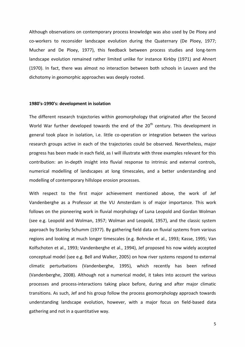
1980's-1990's: development in isolation
The different research trajectories within geomorphology that originated after the Second
World War further developed towards the end of the 20th century. This development in
general took place in isolation, i.e. little co-operation or integration between the various
research groups active in each of the trajectories could be observed. Nevertheless, major
progress has been made in each field, as I will illustrate with three examples relevant for this
contribution: an in-depth insight into fluvial response to intrinsic and external controls,
numerical modelling of landscapes at long timescales, and a better understanding and
modelling of contemporary hillslope erosion processes.
With respect to the first major achievement mentioned above, the work of Jef
Vandenberghe as a Professor at the VU Amsterdam is of major importance. This work
follows on the pioneering work in fluvial morphology of Luna Leopold and Gordan Wolman
(see e.g. Leopold and Wolman, 1957; Wolman and Leopold, 1957), and the classic system
approach by Stanley Schumm (1977). By gathering field data on fluvial systems from various
regions and looking at much longer timescales (e.g. Bohncke et al., 1993; Kasse, 1995; Van
Kolfschoten et al., 1993; Vandenberghe et al., 1994), Jef proposed his now widely accepted
conceptual model (see e.g. Bell and Walker, 2005) on how river systems respond to external
climatic perturbations (Vandenberghe, 1995), which recently has been refined
(Vandenberghe, 2008). Although not a numerical model, it takes into account the various
processes and process-interactions taking place before, during and after major climatic
transitions. As such, Jef and his group follow the process geomorphology approach towards
understanding landscape evolution, however, with a major focus on field-based data
gathering and not in a quantitative way.
6
This is quite in contrast with the development of long-term landscape evolution models that
build upon the pioneering work of Kirkby, Ahnert and others. Such modelling approaches
vary from simulating catchment development at small spatial scales to channel growth
models and bedrock incision models that are assumed to be applicable at regional to
continental scales (e.g. Howard et al., 1994; Tucker and Slingerland, 1994; Willgoose et al.,
1991). The rapid growth in the availability of global digital elevation models, although still
with a coarse resolution in the 1990's, certainly gave a major boost towards this research
field. Although most of these models were run on hypothetical catchments, thus lacking any
field verification, these were most useful for identifying which parameters and controlling
mechanism were most important in landscape development on the long run. Probably one
of the most important contributions of such models is the Kooi and Beaumont (1996) paper.
They could illustrate that, depending on the duration of tectonic pulses, landscapes may
evolve according to either one of the three classical landscape evolution models, including
the Davision concept of the geographical cycle. Thus, long-standing debates on how
landscapes evolve on longer timescales were now being resolved through a simple numerical
modelling approach.
The research in Leuven in this time period, first of all continues with experimental and field-
based studies that aimed at a better understanding of the various water erosion processes
operating at the plot and hillslope scale. Furthermore, quantification of the contemporary
erosion processes is being made, i.e. limited to erosion following single rain events or a few
years of rain events at maximum. It includes, amongst others, detailed studies on splash
erosion (Poesen, 1986), interrill and rill erosion (Govers, 1991; Govers and Poesen, 1988) as
well as gully erosion (Poesen et al., 1996) and sediment deposition by overland flow
(Beuselinck et al., 2000). Through time, the spatial scale increased towards the size of entire
catchments, thereby integrating all hillslope water erosion processes (Steegen et al., 2000;
Vandaele and Poesen, 1995). Furthermore, more attention is also being paid towards the
consequences of soil erosion (Verstraeten and Poesen, 1999) and the adaptation of soil
conservation measures (De Ploey, 1988). Here, the research in Leuven more or less follows
one of the trends in international research described above, namely the development of
applied geomorphology. The fact that Jan De Ploey was one of the co-founders and first
president of the European Society for Soil Conservation (1988) is another illustration of this
7
development. On the other hand, much research also focused on the landscape scale and
aimed to improve our knowledge on landscape development. For instance, Govers et al.
(1996) showed that water erosion is the dominant process shaping the landscape at
timescales of centuries to millennia, whilst more recently, tillage redistribution has become
the dominant process. As such, geomorphology in Leuven did not choose between either the
applied geomorphic approach or the traditional geomorphic questions with respect to the
genesis and evolution of landscapes. In fact this is also reflected in the other field of research
that further developed in Leuven in the 1990’s, i.e. spatial modelling of geomorphic
processes. Indeed, next to a better understanding and quantification of the erosion
processes, the Leuven team also continued on the international trend towards modelling
geomorphic processes. The enormous amount of field and experimental data on erosion and
sediment transport processes gave a boost to the development, calibration and validation of
relatively simple models. Most of these models can be considered to be on the bridge
between pure "engineering" models and "geomorphic" models. I will not provide an
overview of all model approaches developed, but rather give a selection pointing towards
the broad character of model concepts. For instance, models that predict the location of
ephemeral gullies in the landscape (Desmet et al., 1999) make use of thresholds within slope
vs contributing area plots (S-A relationships) similar to the landscape approach by
Montgomery and Dietrich (1992). In fact, the S-A relations all come back to the common
transport law equation given above when considering steady-state incision and a mobile
bed. Basic geomorphic expertise on how landscapes operate is also behind the factorial
scoring model or FSM that predicts sediment export values for larger catchments (de Vente
et al., 2006; Verstraeten et al., 2003). The main variables controlling sediment production
and transport (lithology, topography, gully incisions, vegetation cover and shape) are rated
and the product of each factor provides a score that is indicative of the sediment yield. In
fact, such a lumped approach towards modelling catchment sediment export has also been
postulated by Jan De Ploey in his erosion susceptibility model (Es) whereby he relates Es to
the ratio between catchment wide denudation rate and the potential and kinetic energy
input into the systems that steers the erosion processes (De Ploey, 1990; De Ploey et al.,
1995). It can be seen as a synthesis of his work on individual erosion processes.
Unfortunately, Jan deceased in 1992 and the Es-model was never fully developed. Probably
the most important model development in Leuven is a suite of models that all follow the
8
basics of the USLE-like approach. This model was adjusted to account for flow convergence
such that it provides more realistic assessments of erosion rates in 2D landscapes (Desmet
and Govers, 1996). This adjustment formed the basis for the WATEM/SEDEM model that
predicts sediment fluxes from slopes to river channels and that is fully spatially distributed
(Van Oost et al., 2000; Van Rompaey et al., 2001; Verstraeten et al., 2002). This model
approach can and has been applied in an engineering fashion to simulate the impact of soil
conservation management scenario's (Verstraeten et al., 2002) but one of its predecessors
has also shown to correctly predict the spatial patterns of historic erosion and colluviation
(Desmet and Govers, 1995).
21st century: towards more synergies again
During the first decade of the 21st century, a new trend towards increasing synergies
between the various fields in geomorphology can be observed. This is in particular true with
respect to understanding landscape evolution over timescales of several centuries up to
several millennia. In this field of research, the blending of geomorphic process knowledge
with quantitative field-based approaches provided a boost towards a better understanding
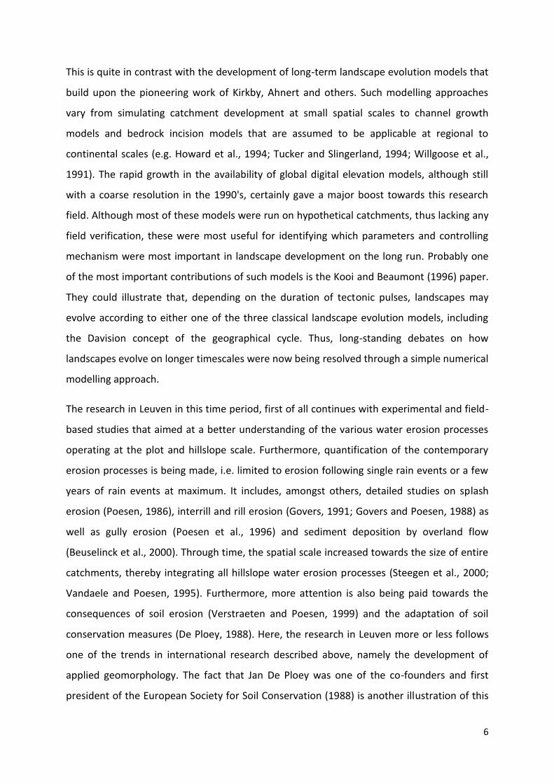
on how landscapes react to human impact. In Leuven, a renewed interest in landscape
evolution arose and although traditional field based approaches that include detailed
analysis of sedimentary archives at single observation points in the landscape are not
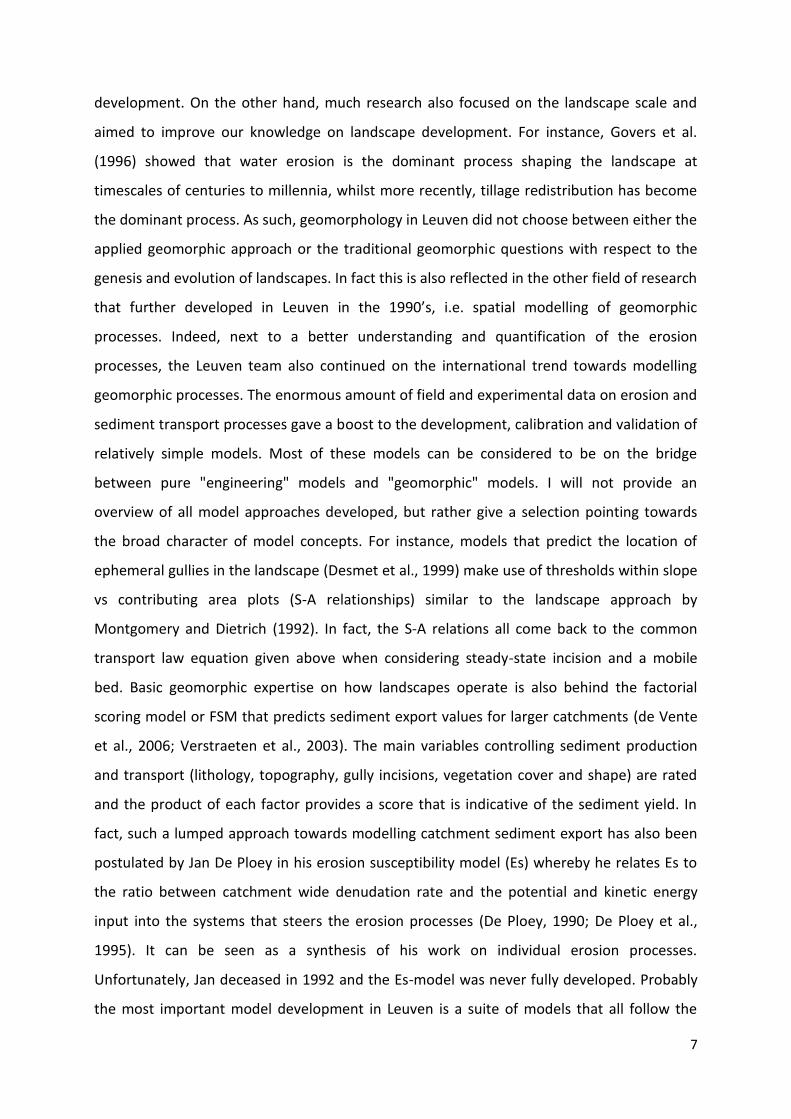
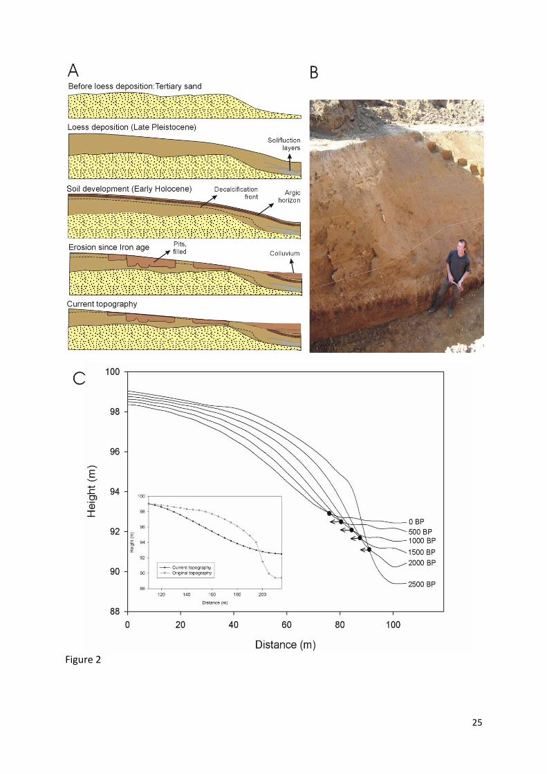
excluded (Rommens et al., 2007) (Figure 2a), the major focus is now on the full
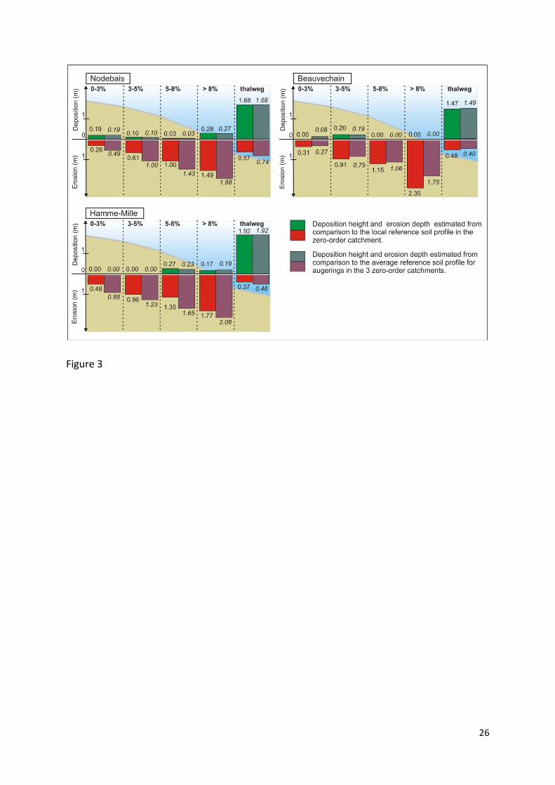
quantification of Holocene erosion depths, colluvial and alluvial storage through intensive
coring programs (Notebaert et al., 2010; Rommens et al., 2005) (Figure 3). This enabled, for
the first time, the establishment of sediment budgets for small to intermediate river
catchments spanning the entire Holocene (Notebaert et al., 2009; Verstraeten et al., 2009b).
Sediment budget studies have been performed before and in other regions, however, their
focus was either restricted to limited components of the sediment budget such as alluvial
storage, or towards more recent time periods for which more detailed and accurate data
exist (Abrahams and Marston, 1993 and references therein; Phillips, 1991; Trimble, 1999).
The quantification of sediment sources and sinks in the Dijle catchment in central Belgium
has illustrated that even at the millennial time scale, around 40 to 50 % of the eroded soil

9
material is still stored on the slopes, with another 30 to 40 % being stored in the floodplains.
Similar studies from other catchments in western and Central Europe all point towards this
large buffering effect (Fuchs et al., 2011; Hoffmann et al., 2007; Notebaert and Verstraeten,
2010; Stolz, 2011). Furthermore, a large database (n>100) of colluvial and fluvial sediment
ages was obtained through C14 and OSL in order to obtain a timeframe of sedimentation
rates (Notebaert et al., 2011a) Such a statistical analysis of large datasets on the timing of
geomorphic processes during the Holocene has seen a major boost during the last decade
(Dusar et al., 2012; Gregory et al., 2006; Hoffmann et al., 2009; Hoffmann et al., 2008;
Macklin et al., 2006; Macklin and Lewin, 2003), although its validity has been questioned
recently as well (Chiverrell et al., 2011). Nevertheless, the wealth of radiocarbon and
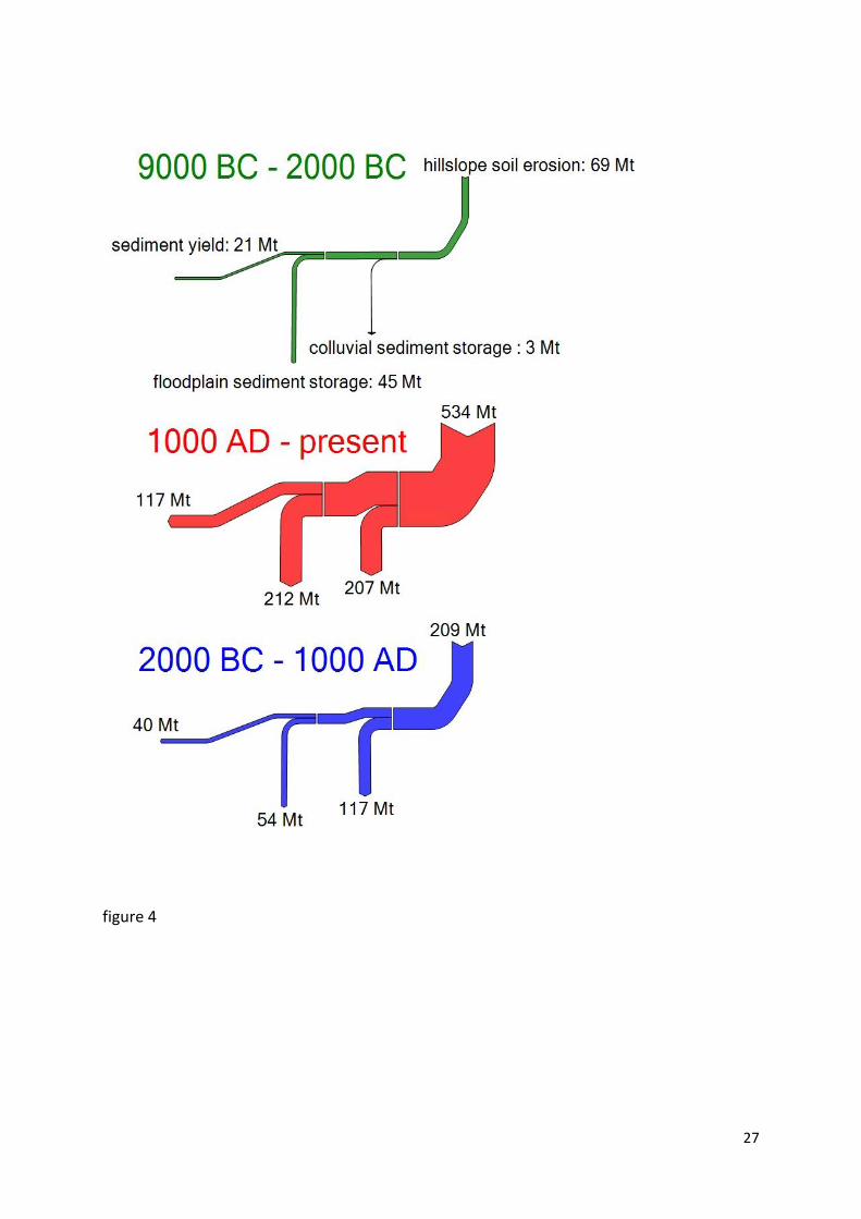
luminescence dating made it possible to differentiate the sediment budget for the Dijle
catchment in three major time periods, each with a different intensity of human impact
(Figure 4). The various quantitative field-based approaches in temperate Europe has thus
shown not only that during the Holocene human impact has become the dominant factor
controlling sediment dynamics – not climate – but also that the importance of colluvial and
alluvial storage changes through time as is clearly shown for the Dijle catchment
(Verstraeten et al., 2009b). Despite the high number of dated sediment units, the resolution
of the sediment chronology remains limited, making it difficult to have a full understanding
of the respective role climate and human impact have played, or to understand why
sediment delivery ratio’s change through time. These issues, however, can be resolved much
easier through numerical modelling which enables to test various scenarios of climate and
land use. Simple 2D and 3D versions of the WATEM/SEDEM model show that not only the
patterns but also the average rates of erosion and sediment deposition at timescales of a
few millennia can be correctly simulated when confronted with the quantitative field data,
thus suggesting that a model that is built using contemporary process knowledge is valid
when predicting longer term landscape evolution (Peeters et al., 2006; Peeters et al., 2008)
(Figure 2c). Confrontation of field data with different alternative modelling approaches also
made clear that best results are obtained when using separate equations for erosion and
sediment transport, which is in contrast to the majority of long-term landscape evolution
models that are usually based on a single transport capacity equation. In fact, traditional
landscape evolution models relying on only one approach may be valid to simulate
10
catchment-wide climate or tectonic change but not the role of human impact during the
Holocene as this impact may vary strongly in space (Temme et al., 2011).
Meanwhile, Jef’s research group continued with a major research focus on fluvial processes
and the impact of climate on these processes. However, modelling also emerged as an
important tool in this group during the 21st century. Bogaart clearly showed how numerical
models are able to simulate the changing behaviour of river channels at climate transitions
(Bogaart et al., 2003a; Bogaart et al., 2003b; Bogaart et al., 2003c), similar to the conceptual
model of Vandenberghe (1995), whilst Ward et al. (2007) now also focused on the impact of
climate on Holocene flood hydrology of larger river systems. Also De Moor et al. (2008)
turned their focus to the Holocene and their study in the Geul catchment is one of the first in
Jef’s research group that considered the role of human activity in shaping river
morphologies. Keesstra et al. (Keesstra et al., 2005), moreover, studied the changes in river
morphology for the Dragonja in Slovenia solely as a consequence of land use changes. Thus,
the research in physical geography at the VU evolved from field-based studies of long-term
fluvial activity under changing climate conditions towards field-based studies of Holocene
fluvial dynamics under anthropogenic impact on the one hand, and modelling focusing on
hydrological/fluvial processes on the other hand.
This broadening of the scope in Jef’s group thus took place during a period where research in
physical geography at KU Leuven evolved from contemporary erosion studies and modelling
towards Holocene catchment sediment dynamics again through field-based studies and
modelling. As such, the research of both groups evolved in such a way that it opened several
opportunities for integration. Modelling expertise on historic hillslope soil erosion was
combined with field-based expertise in alluvial stratigraphy to develop a Late-Holocene
sediment budget for the Geul catchment (de Moor and Verstraeten, 2008), or to better
understand river channel changes for the Dragonja (Keesstra et al., 2009). Experience with
palaeoclimate and palaeohydrology modelling was in turn coupled with land use modelling
tools and soil erosion models to simulate the changes in sediment fluxes for the Meuse
catchment following land use and climate change during the Holocene and in the near future
(Ward et al., 2009). The same approach was repeated for the Dijle catchment (Notebaert et
al., 2011b) further illustrating that changing rates of hillslope sediment delivery closely
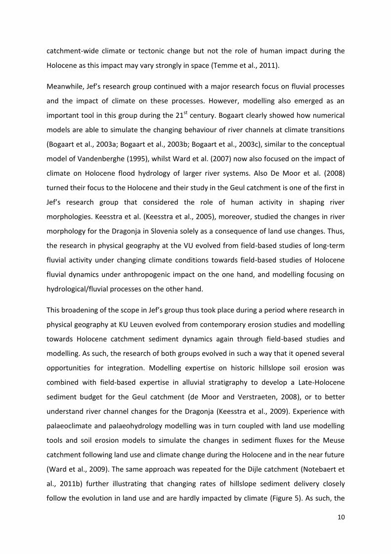
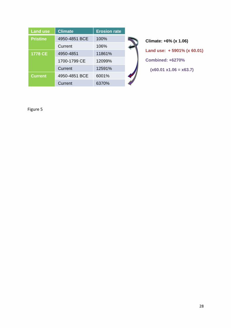
follow the evolution in land use and are hardly impacted by climate (Figure 5). As such, the
11
modelling approach confirms the conclusions made from the field-based studies, yet the role
of climatic events that could not be resolved through the field work can be largely rejected
by the modelling. The combination of the soil erosion model developed in Leuven with the
hydrology model of the VU has also shown, both for the Dijle and the Meuse catchment, that
human and climatic impact on sediment transport and flood frequency is different for the
period before the major Industrialisation process in the 19th century compared to expected
trends for the 21st century. Where erosion, sediment transport and flood frequency
increased during the course of the Holocene because of an increase in deforestation and
agriculture, opposite trends can be projected for the coming century. Indeed, under a
warming climate, rainfall intensities may increase and the rapid increase of urbanising areas
further increased the risk to flooding. On the other hand, decreased acreage of arable land
due to urbanisation and reforestation further protects the soil against erosion and sediment
transport is likely to decrease (Notebaert et al., 2011b; Ward et al., 2009).
The embracement of quantitative field-based and numerical modeling approaches into
landscape evolution studies is not only restricted to the Holocene. Also with respect to long-
term landscape evolution models an increasing coupling with quantitative field and
experimental data can be observed. Whereas the earlier landscape evolution models where
mostly applied on theoretical landscapes (see e.g. Kooi and Beaumont, 1996 referred to
above), model outcomes are more and more compared to reality. Recently, an increasing
number of experimental set-ups with rainfall simulators are being used to study the erosion
and sedimentation processes in uplifting mountain ranges or drainage network evolution in
tectonically active regions (Graveleau and Dominguez, 2008; Hancock and Willgoose, 2002;
Hasbargen and Paola, 2000; Turowski et al., 2006). Furthermore, recent advances in dating
methods have made it possible get a better control on the chronology of landscape
evolution that was hitherto not achievable (Duller, 2004; Gosse and Phillips, 2001; Reiners
and Brandon, 2006). The application of cosmogenic radionuclides now also makes it possible
to infer long-term catchment wide erosion rates that can be used for model validation (e.g.
Schaller et al., 2001). Particularly of importance in explaining the boost of research on
landscape evolution models is the ever increasing availability of digital elevation models
spanning nearly the entire globe (first GTOPO30, than SRTM global dataset and now also the
ASTER-GDEM) and at smaller spatial units the development of high-resolution LIDAR
12
imagery. Finally, during the last decade the increase in computing power facilities made it
possible to simulate more complex and thus realistic landscapes. All these developments led
to a new boost in the study of long-term landscape evolution that closely examines the link
between tectonics and geomorphology (Bishop, 2007; Brocklehurst, 2010; Burbank and
Anderson, 2001; Summerfield, 2000).
Despite the fact that quantitative and numerical modeling approaches are now being used in
understanding landscape evolution at both long-term (i.e. Plio-Pleistocene) and mid-term
(i.e. Holocene) temporal scales, there remains a major gap between the research
communities. Research on long-term landscape evolution traditionally focuses on the
respective role climate and tectonics has played. Both natural forcing factors have been used
in the past to understand Holocene landscape dynamics as well. However, during the last
two decades, growing evidence has pointed to the overwhelming anthropogenic impact on
late Holocene landscape dynamics (Messerli et al., 2000; Syvitski and Milliman, 2007). The
increasing number of palaeo-environmental studies that focus on the role humans have
played in landscape evolution point to the rise of a new paradigm into geomorphology:
humans as geomorphic agents (Hooke, 2000; Montgomery, 2007). The dominance of
humans in controlling late Holocene sediment dynamics also made those modeling
approaches that intend to simulate these landscape dynamics different from long-term
landscape evolution models. For instance, the aforementioned WATEM/SEDEM model partly
incorporates an adapted version of the Universal Soil Loss Equation that is mainly used to
simulate the impact of changes in land use practices on local soil loss. In landscapes with a
long history of human impact such as the northwestern European Loess Belt, it is therefore
not surprising that the WATEM/SEDEM is capable of correctly simulating landscape
evolution for the last few thousand years (e.g. Notebaert et al., 2011b; Peeters et al., 2006;
Peeters et al., 2008). Long-term landscape evolution models, though, are not developed to
simulate the impact of changing anthropogenic land cover conditions. Nevertheless, a few
studies have combined information on long-term landscape dynamics and short-term
anthropogenic driven geomorphic processes (Syvitski and Milliman, 2007; Vanacker et al.,
2007; Wilkinson and McElroy, 2007). What is still missing is a comprehensive model
approach that is able to incorporate all possible forcing mechanisms (climate, tectonics, land
use change, human impact in all its forms) and this at various temporal and spatial scales.
13
Such a unified model approach that can simulate landscape evolution under any given
conditions can be considered the Holy Grail in Geomorphology.
Conclusions
Geomorphology as a scientific discipline has seen a major evolution since the mid of the 20th
century. One of the main aspects of this evolution is the development of quantitative
approaches as well as numerical modelling techniques. Quantitative field-based approaches
have generated large datasets that were used to develop, calibrate and validate numerical
models of contemporary sediment dynamics. It is mainly contemporary process knowledge
derived from actual field measurements and experimental data that led to the development
of these models. In recent years, these modelling approaches have been applied successfully
to understand historical fluxes of sediment as well. Again this was made possible through a
quantitative (r)evolution in the study of palaeo-landscapes. These developments led to a
narrowing of the apparent schism between process geomorphology and descriptive palaeo-
environmental studies. The increasing awareness that human impact has become the major
driver of landscape change throughout the Holocene in palaeo-environmental research has
certainly facilitated this coupling of contemporary processes and studies of landscape
evolution. As such, the apparent shift of quantitative geomorphology towards engineering
studies, away from long-standing questions in geomorphology on landscape genesis and
evolution, and which has by some been seen as a threat to geographical geomorphology
(Church, 2005), is no longer a major concern. Also within the study of long-term landscape
evolution (> million years), a quantitative and modelling revolution has taken place over the
last few decades. The schism between quantitative geomorphology on the one hand and
traditional geomorphology on the other, which lasted for decades in the second half of the
21st century, has now been replaced by the emergence of two new large paradigms in
geomorphology, i.e. tectonic geomorphology and humans as geomorphic agents, the latter
being part of the larger research domain on human-environment interactions. Both research
domains are applying quantitative and numerical modelling approaches, yet at different
timescales. These new paradigms do find their origin to a certain extent in the various
curricula in which geomorphology is taught. It is certainly not surprising to note that tectonic
14
geomorphology mainly has emerged in the US where geomorphology has (and still is) mainly
been taught in Geology programs. On the other hand, the emergence of anthropogenic
geomorphology is mainly seen in the UK and the rest of Europe where geomorphology is
often taught in the broader discipline of Geography that encompasses both physical and
human geography. Remarkable in this respect is that in Leuven, where a broad Geography
curriculum exists, much more attention has been paid to the role of humans in
geomorphology. On the other hand, the focus of Jef's research in Amsterdam on
understanding the role climate and tectonics have played in long-term landscape evolution
may well arise from the fact that in the Netherlands Physical Geography has long been a
separate study program with close links to Geology, but without a major introduction in
Human and Social Geography.
Although quantitative and numerical modelling approaches have made major progress over
the last few decades, this is not sufficient fully understand past landscape dynamics. The
various model outcomes for the Dijle catchment discussed above do show that still major
uncertainties with respect to sediment transport and the role of humans therein exist for
time periods with a limited intensity of land use. It is, for instance, unclear to what extent
early human impact in the Neolithic has already impacted river channel behaviour and
floodplain sedimentation rates. Which thresholds needed to be crossed before all
components of a catchment’s sediment budget, including the larger river floodplains, react
to human disturbance in the catchment ? How important is the intensity, quality and spatial
patterns of human induced land use change on controlling sediment fluxes ? Neither the
quantitative sediment budget approach, nor the modelling approach, is able to answer this
research question in full. Amongst other reasons, especially the lack of detailed and precise
chronologies of sediment dynamics and human impact relates to this problem (Verstraeten
et al., 2009a). Ongoing research, jointly carried out by Jef’s research group and that of the
author, therefore applies ‘traditional’ palynology (Broothaerts et al., 2011), yet in such a way
that in the near future a quantitative pollen-analytical approach using numerical pollen
dispersal models will be used to fine-tune the historical land use maps that were up till now
used in the geomorphic process models. It is the combination of traditional field-based
approaches with spatial modelling techniques that allows us to further enhance our
knowledge on past (and present) landscape evolution. Calibration and validation of models,
15
which is crucial in any model approach, requires that extensive data on real-world
landscapes are being collected.
References
Abrahams, A.D., Marston, R.A., 1993. DRAINAGE-BASIN SEDIMENT BUDGETS - AN INTRODUCTION - A COLLECTION OF PAPERS PRESENTED AT THE 3RD INTERNATIONAL GEOMORPHOLOGY CONFERENCE, HAMILTON, ONTARIO, AUGUST 1993. Physical Geography, 14(3), 221-224.
Ahnert, F., 1970. A comparison of theoretical slope models with slopes in the field. Zeitschrift Fur Geomorphologie, supplement band, 9, 88-101.
Bell, M., Walker, M.J.C., 2005. Late Quaternary Environmental Change. Physical and Human Perspectives. Pearson Eduction, Harlow, England.
Beuselinck, L., Steegen, A., Govers, G., Nachtergaele, J., Takken, I., Poesen, J., 2000. Characteristics of sediment deposits formed by intense rainfall events in small catchments in the Belgian Loam Belt. Geomorphology, 32(1-2), 69-82.
Bishop, P., 2007. Long-term landscape evolution: linking tectonics and surface processes. Earth Surface Processes and Landforms, 32(3), 329-365.
Bogaart, P.W., Tucker, G.E., de Vries, J.J., 2003a. Channel network morphology and sediment dynamics under alternating periglacial and temperate regimes: a numerical simulation study. Geomorphology, 54(3-4), 257-277.
Bogaart, P.W., Van Balen, R.T., Kasse, C., Vandenberghe, J., 2003b. Process-based modelling of fluvial system response to rapid climate change - I: model formulation and generic applications. Quaternary Science Reviews, 22(20), 2077-2095.
Bogaart, P.W., Van Balen, R.T., Kasse, C., Vandenberghe, J., 2003c. Process-based modelling of fluvial system response to rapid climate change II. Application to the river Maas (the Netherlands) during the Last Glacial-Interglacial Transition. Quaternary Science Reviews, 22(20), 2097-2110.
Bohncke, S., Vandenberghe, J., Huijzer, A.S., 1993. PERIGLACIAL ENVIRONMENTS DURING THE WEICHSELIAN LATE-GLACIAL IN THE MAAS VALLEY, THE NETHERLANDS. Geologie En Mijnbouw, 72(2), 193-210.
Brocklehurst, S.H., 2010. Tectonics and geomorphology. Progress in Physical Geography, 34(3), 357-383.
Broothaerts, N., Notebaert, B., Verstraeten, G., 2011. The changing geo-ecology of the Dijle floodplain (Belgium) during the Holocene in relation to human impact, INQUA congress, Bern.
Burbank, D.W., Anderson, R.S., 2001. Tectonic Geomorphology. Blackwell Science, Malden, MA, USA. Chiverrell, R.C., Thorndycraft, V.R., Hoffmann, T.O., 2011. Cumulative probability functions and their
role in evaluating the chronology of geomorphological events during the Holocene. Journal of Quaternary Science, 26(1), 76-85.
Church, M., 2005. Continental drift. Earth Surface Processes and Landforms, 30(1), 129-130. Church, M., 2010. The trajectory of geomorphology. Progress in Physical Geography, 34(3), 265-286. de Moor, J.J.W., Kasse, C., van Balen, R., Vandenberghe, J., Wallinga, J., 2008. Human and climate
impact on catchment development during the Holocene - Geul River, the Netherlands. Geomorphology, 98(3-4), 316-339.
de Moor, J.J.W., Verstraeten, G., 2008. Alluvial and colluvial sediment storage in the Geul River catchment (The Netherlands) - Combining field and modelling data to construct a Late Holocene sediment budget. Geomorphology, 95(3-4), 487-503.
De Ploey, J., 1971. Liquefaction and rainwash erosion. Zeitschrift Fur Geomorphologie, 15, 491-496.

16
De Ploey, J., 1974. Mechanical properties of hillslopes and their relation to gullying in Central semi-arid Tunesia. Zeitschrift Fur Geomorphologie, supplement band, 21, 177-190.
De Ploey, J., 1977. SOME EXPERIMENTAL-DATA ON SLOPEWASH AND WIND ACTION WITH REFERENCE TO QUATERNARY MORPHOGENESIS IN BELGIUM. Earth Surface Processes and Landforms, 2(2-3), 101-115.
De Ploey, J., 1988. No-tillage experiments in the central Belgian Loess Belt. Soil Technology, 1, 181-184.
De Ploey, J., 1990. MODELING THE EROSIONAL SUSCEPTIBILITY OF CATCHMENTS IN TERMS OF ENERGY. Catena, 17(2), 175-183.
De Ploey, J., Moeyersons, J., 1975. Runoff creep of coarse debris: experimental data and some field observations. Catena, 2, 275-288.
De Ploey, J., Moeyersons, J., Goossens, D., 1995. THE DE PLOEY EROSIONAL SUSCEPTIBILITY MODEL FOR CATCHMENTS, E(S). Catena, 25(1-4), 269-314.
De Ploey, J., Savat, J., 1968. Contribution a l'étude de l'érosion par le splash. Zeitschrift Fur Geomorphologie, 12, 174-193.
De Ploey, J., Savat, J., Moeyersons, J., 1976. DIFFERENTIAL IMPACT OF SOME SOIL LOSS FACTORS ON FLOW, RUNOFF CREEP AND RAINWASH. Earth Surface Processes and Landforms, 1(2), 151-161.
De Smedt, P., 1973. Paleogeografie en Kwartair-Geologie van het confluentiegebiede Dijle-Demer. Acta Geographica Lovaniensia, 11.
de Vente, J., Poesen, J., Bazzoffi, P., Van Rompaey, A., Verstraeten, G., 2006. Predicting catchment sediment yield in Mediterranean environments: the importance of sediment sources and connectivity in Italian drainage basins. Earth Surface Processes and Landforms, 31(8), 1017-1034.
Desmet, P.J.J., Govers, G., 1995. GIS-BASED SIMULATION OF EROSION AND DEPOSITION PATTERNS IN AN AGRICULTURAL LANDSCAPE - A COMPARISON OF MODEL RESULTS WITH SOIL MAP INFORMATION. Catena, 25(1-4), 389-401.
Desmet, P.J.J., Govers, G., 1996. A GIS procedure for automatically calculating the USLE LS factor on topographically complex landscape units. Journal of Soil and Water Conservation, 51(5), 427-433.
Desmet, P.J.J., Poesen, J., Govers, G., Vandaele, K., 1999. Importance of slope gradient and contributing area for optimal prediction of the initiation and trajectory of ephemeral gullies. Catena, 37(3-4), 377-392.
Doyle, M.W., Julian, J.P., 2005. The most-cited works in Geomorphology. Geomorphology, 72(1-4), 238-249.
Duley, F.L., Miller, M.F., 1923. Erosion and surface runoff under different soil conditions, University of Missouri Agricultural Experiment Station.
Duller, G.A.T., 2004. Luminescence dating of Quaternary sediments: recent advances. Journal of Quaternary Science, 19(2), 183-192.
Dusar, B., Verstraeten, G., D'Haen, K., Bakker, J., Kaptijn, E., Waelkens, M., 2012. Sensitivity of the Eastern Mediterranean geomorphic system towards environmental change during the Late Holocene: a chronological perspective. Journal of Quaternary Science, n/a-n/a.
Fuchs, M., Will, M., Kunert, E., Kreutzer, S., Fischer, M., Reverman, R., 2011. The temporal and spatial quantification of Holocene sediment dynamics in a meso-scale catchment in northern Bavaria, Germany. Holocene, 21(7), 1093-1104.
Gosse, J.C., Phillips, F.M., 2001. Terrestrial in situ cosmogenic nuclides: theory and application. Quaternary Science Reviews, 20(14), 1475-1560.
Govers, G., 1991. RILL EROSION ON ARABLE LAND IN CENTRAL BELGIUM - RATES, CONTROLS AND PREDICTABILITY. Catena, 18(2), 133-155.
Govers, G., Poesen, J., 1988. Assessment of the interrill and rill contributions to total soil loss from an upland field plot Geomorphology, 1, 343-354.
17
Govers, G., Quine, T.A., Desmet, P.J.J., Walling, D.E., 1996. The relative contribution of soil tillage and overland flow erosion to soil redistribution on agricultural land. Earth Surface Processes and Landforms, 21(10), 929-946.
Graveleau, F., Dominguez, S., 2008. Analogue modelling of the interaction between tectonics, erosion and sedimentation in foreland thrust belts. Comptes Rendus Geoscience, 340(5), 324-333.
Gregory, K.J., Benito, G., Dikau, R., Golosov, V., Jones, A.J.J., Macklin, M.G., Parsons, A.J., Passmore, D.G., Poesen, J., Starkel, L., Walling, D.E., 2006. Past hydrological events related to understanding global change: An ICSU research project. Catena, 66(1–2), 2-13.
Gullentops, F., 1957. Quelques phénomènes géomorphologiques depuis le Pléni-Wurm. Bulletin de la Société Belge de Géologie, 61(1), 86-95.
Gullentops, F., 1960. Quelques indices de cycles climatiques au Pleistocène inferieur et moyen en Belgique. Bulletin Peryglacjalny, 9, 91-95.
Gullentops, F., Mullenders, W., Schaillee, L., Gilot, E., Bastin-Servais, Y., 1966. Observations géomorpologiques et palynologiques dans la vallée de la Lienne. Acta Geographica Lovaniensia, 4, 192-204.
Hancock, G.R., Willgoose, G.R., 2002. The use of a landscape simulator in the validation of the SIBERIA landscape evolution model: Transient landforms. Earth Surface Processes and Landforms, 27(12), 1321-1334.
Hasbargen, L.E., Paola, C., 2000. Landscape instability in an experimental drainage basin. Geology, 28(12), 1067-1070.
HEC, 1968. HEC-1: Flood hydrograph package, US Army Corps of Engineers, Hydraulic Engineering Center.
Hoffmann, T., Erkens, G., Cohen, K.M., Houben, P., Seidel, J., Dikau, R., 2007. Holocene floodplain sediment storage and hillslope erosion within the Rhine catchment. Holocene, 17(1), 105-118.
Hoffmann, T., Erkens, G., Gerlach, R., Klostermann, J., Lang, A., 2009. Trends and controls of Holocene floodplain sedimentation in the Rhine catchment. Catena, 77(2), 96-106.
Hoffmann, T., Lang, A., Dikau, R., 2008. Holocene river activity: analysing C-14-dated fluvial and colluvial sediments from Germany. Quaternary Science Reviews, 27(21-22), 2031-2040.
Hooke, R.L., 2000. On the history of humans as geomorphic agents. Geology, 28(9), 843-846. Horton, R.E., 1945. Erosional development of streams and their drainage basins, hydrophysical
approach to quantitative morphology. Bulletin of the Geological Society of America, 56(3), 275-370.
Howard, A.D., Dietrich, W.E., Seidl, M.A., 1994. MODELING FLUVIAL EROSION ON REGIONAL TO CONTINENTAL SCALES. Journal of Geophysical Research-Solid Earth, 99(B7), 13971-13986.
Kasse, C., 1995. Younger Dryas cooling and fluvial response (Maas River, the Netherlands). Geologie En Mijnbouw, 74(3), 251-256.
Keesstra, S.D., van Dam, O., Verstraeten, G., van Huissteden, J., 2009. Changing sediment dynamics due to natural reforestation in the Dragonja catchment, SW Slovenia. Catena, 78(1), 60-71.
Keesstra, S.D., van Huissteden, J., Vandenberghe, J., Van Dam, O., de Gier, J., Pleizier, I.D., 2005. Evolution of the morphology of the river Dragonja (SW Slovenia) due to land-use changes. Geomorphology, 69(1-4), 191-207.
Keylock, C.J., 2010. Introduction to special issue: The future of geomorphology. Progress in Physical Geography, 34(3), 261-264.
Kirkby, M.J., 1971. Hillslope process-response models based on the continuity equation. Transactions of the Institute of British Geographers, special publication, 3, 15-30.
Kooi, H., Beaumont, C., 1996. Large-scale geomorphology: Classical concepts reconciled and integrated with contemporary ideas via a surface processes model. Journal of Geophysical Research-Solid Earth, 101(B2), 3361-3386.
Lentz, G.H., Sinclair, J.D., Meginnis, G.H., 1930. Soil erosion in the silt loam uplands of Mississippi, Southern Forest Experiment Station. Journal of Forestry, 971-977.
18
Leopold, L.B., Maddock, T.J., 1953. The hydraulic geometry of stream channels and some physiographic implications. US Geol. Survey Prof. Paper, 252.
Leopold, L.B., Wolman, M.G., 1957. River channel patterns: braided, meandering and straight. US Geol. Survey Prof. Paper 282-B.
Macklin, M.G., Benito, G., Gregory, K.J., Johnstone, E., Lewin, J., Michczyoska, D.J., Soja, R., Starkel, L., Thorndycraft, V.R., 2006. Past hydrological events reflected in the Holocene fluvial record of Europe. Catena, 66(1–2), 145-154.
Macklin, M.G., Lewin, J., 2003. River sediments, great floods and centennial-scale Holocene climate change. Journal of Quaternary Science, 18(2), 101-105.
Messerli, B., Grosjean, M., Hofer, T., Nunez, L., Pfister, C., 2000. From nature-dominated to human-dominated environmental changes. Quaternary Science Reviews, 19(1-5), 459-479.
Meyer-Peter, E., Müller, R., 1948. Formulas for Bed-Load transport. Proceedings of the 2nd IAHSR meeting, 7 June 1948, Stockholm.
Montgomery, D.R., 2007. Dirt. The Erosion of Civilizations. University of California Press, Berkeley. Montgomery, D.R., Dietrich, W.E., 1992. CHANNEL INITIATION AND THE PROBLEM OF LANDSCAPE
SCALE. Science, 255(5046), 826-830. Mucher, H.J., De Ploey, J., 1977. EXPERIMENTAL AND MICROMORPHOLOGICAL INVESTIGATION OF
EROSION AND REDEPOSITION OF LOESS BY WATER. Earth Surface Processes and Landforms, 2(2-3), 117-124.
Mullenders, W., Gullentops, F., 1956. Evolution de la végétation et de la plaine alluviale de la Dyle, à Louvain, depuis le Pleni-Wurm. Mededelingen van de Klasse der Wetenschappen, Koninklijke Academie van België, 42, 1123-1137.
Mullenders, W., Gullentops, F., 1957. Palynologisch en geologisch onderzoek in de alluviale vlakte van de Dijle te Heverlee-Leuven. Agricultura, 5, 57-64.
Mullenders, W., Gullentops, F., Lorent, J., Coremans, M., Gilot, E., 1966. Le remblaiement de la vallée de la Néthen. Acta Geographica Lovaniensia, 4, 169-181.
Notebaert, B., Verstraeten, G., 2010. Sensitivity of West and Central European river systems to environmental changes during the Holocene A review. Earth-Science Reviews, 103(3-4), 163-182.
Notebaert, B., Verstraeten, G., Govers, G., Poesen, J., 2010. Quantification of alluvial sediment storage in contrasting environments: Methodology and error estimation. Catena, 82(3), 169-182.
Notebaert, B., Verstraeten, G., Rommens, T., Vanmontfort, B., Govers, G., Poesen, J., 2009. Establishing a Holocene sediment budget for the river Dijle. Catena, 77(2), 150-163.
Notebaert, B., Verstraeten, G., Vandenberghe, D., Marinova, E., Poesen, J., Govers, G., 2011a. Changing hillslope and fluvial Holocene sediment dynamics in a Belgian loess catchment. Journal of Quaternary Science, 26(1), 44-58.
Notebaert, B., Verstraeten, G., Ward, P., Renssen, H., Van Rompaey, A., 2011b. Modeling the sensitivity of sediment and water runoff dynamics to Holocene climate and land use changes at the catchment scale. Geomorphology, 126(1-2), 18-31.
Peeters, I., Rommens, T., Verstraeten, G., Govers, G., Van Rompaey, A., Poesen, J., Van Oost, K., 2006. Reconstructing ancient topography through erosion modelling. Geomorphology, 78(3-4), 250-264.
Peeters, I., Van Oost, K., Govers, G., Verstraeten, G., Rommens, T., Poesen, J., 2008. The compatibility of erosion data at different temporal scales. Earth and Planetary Science Letters, 265(1-2), 138-152.
Phillips, J.D., 1991. FLUVIAL SEDIMENT BUDGETS IN THE NORTH-CAROLINA PIEDMONT. Geomorphology, 4(3-4), 231-241.
Poesen, J., 1986. Field measurements of splash erosion to validate a splash transport model. Zeitschrift Fur Geomorphologie, supplement band, 58, 81-91.
19
Poesen, J.W., Vandaele, K., vanWesemael, B., 1996. Contribution of gully erosion to sediment production on cultivated lands and rangelands. In: D.E.W.B.W. Walling (Ed.), Erosion and Sediment Yield: Global and Regional Perspectives. Iahs Publications, pp. 251-266.
Reiners, P.W., Brandon, M.T., 2006. Using thermochronology to understand orogenic erosion, Annual Review of Earth and Planetary Sciences. Annual Review of Earth and Planetary Sciences, pp. 419-466.
Reynolds, O., 1883. An experimental investigation of the circumstances which determine whether the motion of water shall be direct or sinuous, and the law of resistance in parallel channels. Philosophical Transactions of the Royal Society of London, 174, 935-982.
Richards, K., Clifford, N., 2008. Science, systems and geomorphologies: why LESS may be more. Earth Surface Processes and Landforms, 33(9), 1323-1340.
Rommens, T., Verstraeten, G., Peeters, I., Poesen, J., Govers, G., Van Rompaey, A., Mauz, B., Packman, S., Lang, A., 2007. Reconstruction of late-Holocene slope and dry valley sediment dynamics in a Belgian loess environment. Holocene, 17(6), 777-788.
Rommens, T., Verstraeten, G., Poesen, J., Govers, G., Van Rompaey, A., Peeters, I., Lang, A., 2005. Soil erosion and sediment deposition in the Belgian loess belt during the Holocene: establishing a sediment budget for a small agricultural catchment. Holocene, 15(7), 1032-1043.
Schaller, M., von Blanckenburg, F., Hovius, N., Kubik, P.W., 2001. Large-scale erosion rates from in situ-produced cosmogenic nuclides in European river sediments. Earth and Planetary Science Letters, 188(3-4), 441-458.
Schumm, S.A., 1977. The Fluvial System. John Wiley & Sons Ltd., New York, USA. Shields, A., 1936. Anwendung der Aehnlichkeitsmechanik und der Turbulenzforschung auf die
Geschiebebewegung. Mitteilungen der Preussischen Versuchsanhalt für Wasserbau und Schiffbau, 26.
Steegen, A., Govers, G., Nachtergaele, J., Takken, I., Beuselinck, L., Poesen, J., 2000. Sediment export by water from an agricultural catchment in the Loam Belt of central Belgium. Geomorphology, 33(1-2), 25-36.
Stolz, C., 2011. Budgeting soil erosion from floodplain sediments of the central Rhenish Slate Mountains (Westerwald), Germany. Holocene, 21(3), 499-510.
Strahler, A.N., 1952. Hypsometric (Area-Altitude) analysis of erosional topography. Bulletin of the Geological Society of America, 63, 1117-1142.
Summerfield, M.A., 2000. Geomorphology and Global Tectonics. Wiley, Chichester, UK. Summerfield, M.A., 2005. The changing landscape of geomorphology. Earth Surface Processes and
Landforms, 30(6), 779-781. Syvitski, J.P.M., Milliman, J.D., 2007. Geology, geography, and humans battle for dominance over the
delivery of fluvial sediment to the coastal ocean. Journal of Geology, 115(1), 1-19. Temme, A., Peeters, I., Buis, E., Veldkamp, A., Govers, G., 2011. Comparing landscape evolution
models with quantitative field data at the millennial time scale in the Belgian loess belt. Earth Surface Processes and Landforms, 36(10), 1300-1312.
Trimble, S.W., 1999. Decreased rates of alluvial sediment storage in the Coon Creek Basin, Wisconsin, 1975-93. Science, 285(5431), 1244-1246.
Tucker, G.E., Slingerland, R.L., 1994. EROSIONAL DYNAMICS, FLEXURAL ISOSTASY, AND LONG-LIVED ESCARPMENTS - A NUMERICAL MODELING STUDY. Journal of Geophysical Research-Solid Earth, 99(B6), 12229-12243.
Turowski, J.M., Lague, D., Crave, A., Hovius, N., 2006. Experimental channel response to tectonic uplift. J. Geophys. Res., 111(F3), F03008.
Van Kolfschoten, T., Roebroeks, W., Vandenberghe, J., 1993. The Middle and Late Pleistocene sequence at Maastricht-Belvédère: the type locality of the Belvédère Interglacial. Mededelingen Rijks Geologische Dienst, N.S., 47, 81-91.
Van Oost, K., Govers, G., Desmet, P., 2000. Evaluating the effects of changes in landscape structure on soil erosion by water and tillage. Landscape Ecology, 15(6), 577-589.
20
Van Rompaey, A.J.J., Verstraeten, G., Van Oost, K., Govers, G., Poesen, J., 2001. Modelling mean annual sediment yield using a distributed approach. Earth Surface Processes and Landforms, 26(11), 1221-1236.
Vanacker, V., von Blanckenburg, F., Govers, G., Molina, A., Poesen, J., Deckers, J., Kubik, P., 2007. Restoring dense vegetation can slow mountain erosion to near natural benchmark levels. Geology, 35(4), 303-306.
Vandaele, K., Poesen, J., 1995. SPATIAL AND TEMPORAL PATTERNS OF SOIL-EROSION RATES IN AN AGRICULTURAL CATCHMENT, CENTRAL BELGIUM. Catena, 25(1-4), 213-226.
Vandenberghe, J., 1969. Enquêtes géoélectriques dans la méandre recoupé d'Annevoie. Acta Geographica Lovaniensia, 7, 93-103.
Vandenberghe, J., 1973. Geomorfologie van de Zuiderkempen. Phd Geography, KU Leuven, Leuven. Vandenberghe, J., 1977. Geomorphology of the Zuiderkempen Belgium. Verhandelingen van de
Koninklijke Academie voor Wetenschappen, Letteren en Schone Kunsten van Belgie, 39(140). Vandenberghe, J., 1995. TIMESCALES, CLIMATE AND RIVER DEVELOPMENT. Quaternary Science
Reviews, 14(6), 631-638. Vandenberghe, J., 2008. The fluvial cycle at cold-warm-cold transitions in lowland regions: A
refinement of theory. Geomorphology, 98(3-4), 275-284. Vandenberghe, J., De Smedt, P., 1979. Palaeomorphology in the Eastern Scheldt basin (Central
Belgium). The Dijle-Demer-Grote Nete Confluence Area. Catena, 6, 73-105. Vandenberghe, J., Kasse, C., Bohncke, S., Kozarski, S., 1994. CLIMATE-RELATED RIVER ACTIVITY AT
THE WEICHSELIAN HOLOCENE TRANSITION - A COMPARATIVE-STUDY OF THE WARTA AND MAAS RIVERS. Terra Nova, 6(5), 476-485.
Verstraeten, G., Lang, A., Houben, P., 2009a. Human impact on sediment dynamics - quantification and timing Introduction. Catena, 77(2), 77-80.
Verstraeten, G., Poesen, J., 1999. The nature of small-scale flooding, muddy floods and retention pond sedimentation in central Belgium. Geomorphology, 29(3-4), 275-292.
Verstraeten, G., Poesen, J., de Vente, J., Koninckx, X., 2003. Sediment yield variability in Spain: a quantitative and semiqualitative analysis using reservoir sedimentation rates. Geomorphology, 50(4), 327-348.
Verstraeten, G., Rommens, T., Peeters, I., Poesen, J., Govers, G., Lang, A., 2009b. A temporarily changing Holocene sediment budget for a loess-covered catchment (central Belgium). Geomorphology, 108(1-2), 24-34.
Verstraeten, G., Van Oost, K., Van Rompaey, A., Poesen, J., Govers, G., 2002. Evaluating an integrated approach to catchment management to reduce soil loss and sediment pollution through modelling. Soil Use and Management, 18(4), 386-394.
Ward, P.J., Aerts, J.C.J.H., de Moel, H., Renssen, H., 2007. Verification of a coupled climate-hydrological model against Holocene palaeohydrological records. Global and Planetary Change, 57(3-4), 283-300.
Ward, P.J., van Balen, R.T., Verstraeten, G., Renssen, H., Vandenberghe, J., 2009. The impact of land use and climate change on late Holocene and future suspended sediment yield of the Meuse catchment. Geomorphology, 103(3), 389-400.
Wilkinson, B.H., McElroy, B.J., 2007. The impact of humans on continental erosion and sedimentation. Geological Society of America Bulletin, 119(1-2), 140-156.
Willgoose, G., Bras, R.L., Rodrigueziturbe, I., 1991. A COUPLED CHANNEL NETWORK GROWTH AND HILLSLOPE EVOLUTION MODEL .1. THEORY. Water Resources Research, 27(7), 1671-1684.
Wischmeier, W.H., Smith, D.D., 1960. A universal soil-loss equation to guide conservation farm planning. Transactions International Congress Soil Science, pp. 418-425.
Wolman, M.G., Leopold, L.B., 1957. River floodplains: Some observations on their formation. US Geol. Survey Prof. Paper, 282-C, C87-C107.

21
22
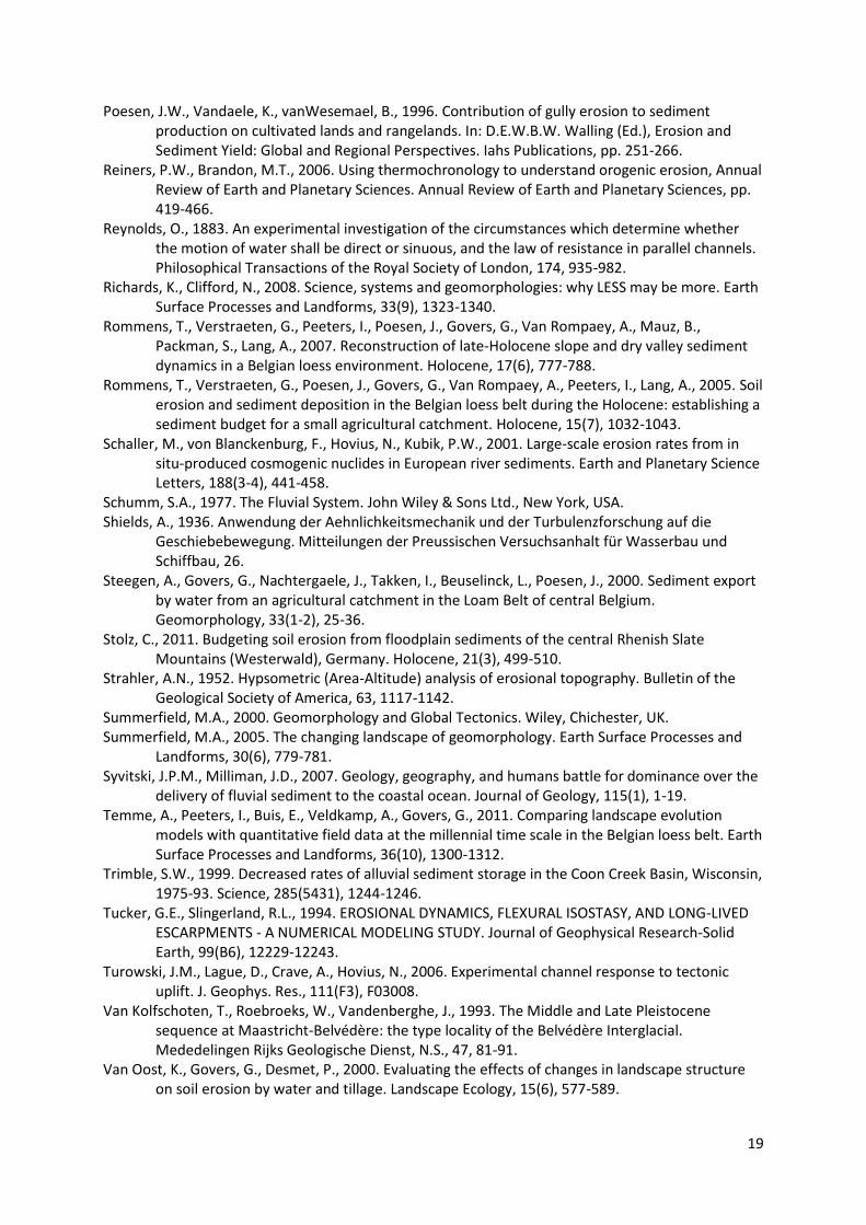
List of figures
Figure 1: Evolution of different research fields within geomorphology since the mid 20th
century within a range of spatial and temporal scales. Text in italics refers to the time period
during which each research field made most progress or when major evolution from one
field to another took place. Background colour refers to the generalized importance of
human impact on geomorphic processes.
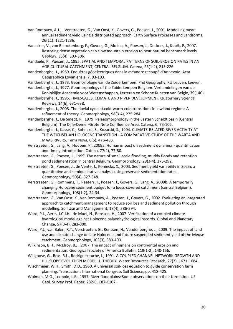
Figure 2: Reconstruction of the 2D landscape evolution during the Holocene along a slope
catena in the Belgian Loess belt using a combined field and modelling approach. A:
landscape reconstruction based on soil stratigraphy mapped in a trench (after Rommens et
al., 2007). B: Photograph showing 4 m colluvial deposits on top of the original Holocene
Luvisol. First sediments on top of the soil profile were dated to the late Bronze Age - early
Iron age (see Rommens et al., 2007). C: Results of modelling approach showing the evolution
of the topography along the catena after 2500 years of continuous cultivation - the inset
compares the measured original topography reconstructed in the trench (= model input
2500 BP) with the current measured topography. Note that the modelled topography at 0 BP
corresponds with the original topography (after Peeters et al., 2008).
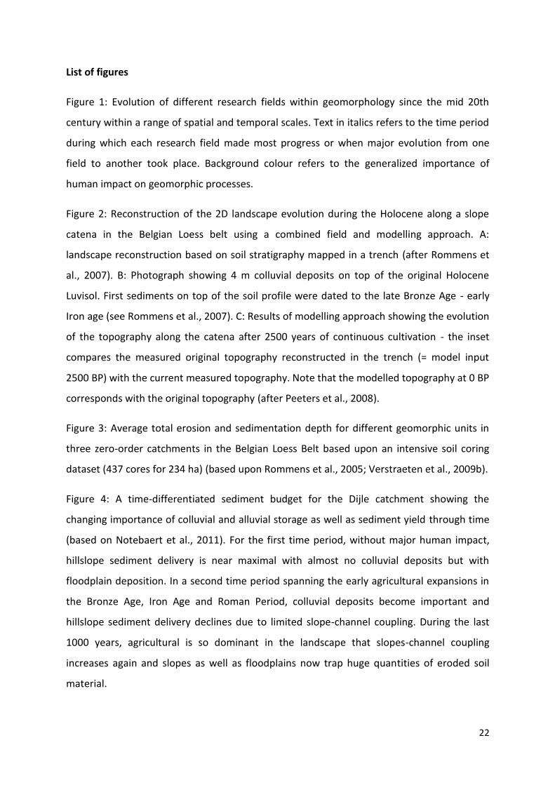
Figure 3: Average total erosion and sedimentation depth for different geomorphic units in
three zero-order catchments in the Belgian Loess Belt based upon an intensive soil coring
dataset (437 cores for 234 ha) (based upon Rommens et al., 2005; Verstraeten et al., 2009b).
Figure 4: A time-differentiated sediment budget for the Dijle catchment showing the
changing importance of colluvial and alluvial storage as well as sediment yield through time
(based on Notebaert et al., 2011). For the first time period, without major human impact,
hillslope sediment delivery is near maximal with almost no colluvial deposits but with
floodplain deposition. In a second time period spanning the early agricultural expansions in
the Bronze Age, Iron Age and Roman Period, colluvial deposits become important and
hillslope sediment delivery declines due to limited slope-channel coupling. During the last
1000 years, agricultural is so dominant in the landscape that slopes-channel coupling
increases again and slopes as well as floodplains now trap huge quantities of eroded soil
material.
23
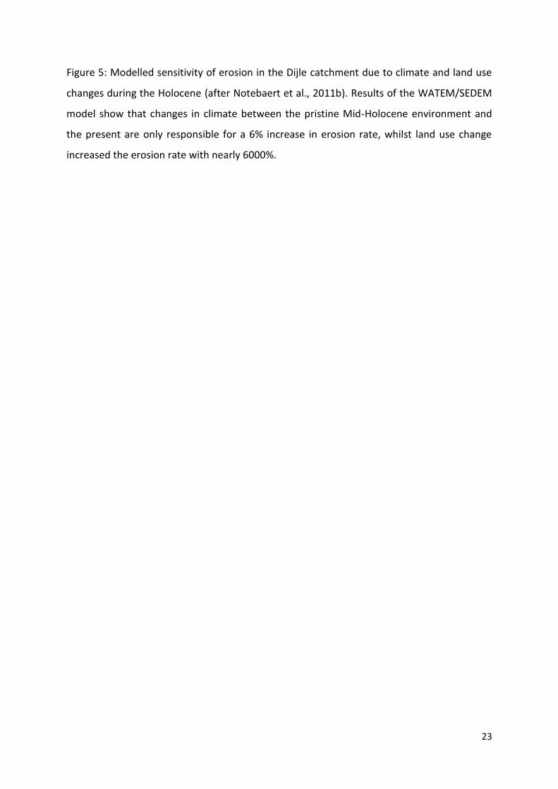
Figure 5: Modelled sensitivity of erosion in the Dijle catchment due to climate and land use
changes during the Holocene (after Notebaert et al., 2011b). Results of the WATEM/SEDEM
model show that changes in climate between the pristine Mid-Holocene environment and
the present are only responsible for a 6% increase in erosion rate, whilst land use change
increased the erosion rate with nearly 6000%.
24
Figure 1
A B
C
25
Figure 2
26
Figure 3
27
figure 4
28
Figure 5
Land use Climate Erosion rate
Pristine 4950-4851 BCE
BCE
100%
Current 106%
1778 CE 4950-4851
BCEBCE
11861%
1700-1799 CE
CE
12099%
Current 12591%
Current 4950-4851 BCE
BCE
6001%
Current 6370%
Climate: +6% (x 1.06)
Land use: + 5901% (x 60.01)
Combined: +6270%
(x60.01 x1.06 = x63.7)