Embed Size (px)
Citation preview
Combined Use of Electromagnetic and Magnetic Survey for Hydrogeophysical Characterization of Ija po
Housing Estate, Akure.
Ogungbemi O.S. 1*, Oladapo M.I. 2
1*Department of Chemical/Petroleum Engineering, AfeBa balola University, Ado Ekiti. 2Department of Applied Geophysics, Federal Universit y of Technology, Akure.
ABSTRACT Very Low Frequency Electromagnetic (VLF-EM) and ground magnetic studies were carried out in Ijapo Housing Estate, Akure, with the aim of delineating hydrogeologic associated structures. The area is underlain by the Precambrian Basement Complex rocks of southwestern Nigeria. The VLF-EM profiling was undertaken along 19 traverses with eight traverses aligned NW – SE and eleven aligned SW – NE. The traverse lengths varied from 180 to 1,200 m. The ground magnetic data were acquired along 35 traverses of lengths ranging from 120 to 1,060 m. Nine of the traverses were oriented E – W, thirteen traverses NE – SW while the remaining thirteen were oriented NW – SE. The VLF-EM readings vary from – 110.3 to + 99.9 % in the filtered real and imaginary components. Areas with positive peak anomalies are considered as probable fracture zones. The VLF-EM depth-structure map enables the classification of the area into zones of shallow and deep fractures. The western and eastern flanks are situated within zones of deep fractures. The relative magnetic values vary from -1290.38 to +835.38 nT. The low magnetic readings are presumably indicative of concealed linear features. The depths to the top of structures delineated vary between 14.5 and 46.6 m. The magnetic depth-structure map enabled the classification of the study area into shallow and deep fracture zones. The integrated result of the VLF-EM and the magnetic methods show that the deep structures delineated with the VLF-EM method coincides fairly well with zones where deep fractures were delineated with the magnetic method.It is recommended that groundwater development programme be limited to deep-fractured (high groundwater potential) zonewhere detailed geophysical survey would be carried out prior to drilling and confirmatory drill-holes should be sited at some selected locations e.g. deep-fracture zones.It is important to sink boreholes beyond the regolith layerfor optimum yield of groundwater. Keywords: Electromagnetic, Magnetic, Hydrogeology, Structures, Depths
1. INTRODUCTION
The successful exploration and exploitation of groundwater requires a proper understanding of its hydrogeological characteristics [12]. Careful studies that are supported by improved drilling techniques yield very favorable results even in the problematic areas of the basement complex [7]. Geophysical methods are important in investigating near surface formations and modeling of aquifer units for groundwater development. Notable among the methods are the electric resistivity, electromagnetic, seismic refraction and magnetic methods [3]. The aquifer in the basement terrain is not only inhomogeneous but also localized;hencethe description of aquifer parameters in this geological terrain may be difficult [6]. In such terrain thorough geophysical investigations must be carried out for optimum siting of viable boreholes for groundwater development. VLF EM method is more relevant in the delineation of near surface fractures than in the estimation of overburden thickness, because their anomalies aremore influenced by the conductivity of the overburden (weathered layer) than the thickness [9].
Comment [C1]: Rephrase the statement: It should be clear that this applies to crystalline basement aquifers only
Deleted: Electric
Deleted: Electromagnetic
Deleted: Seismic
Deleted: Magnetic
Deleted: ;
Deleted: therefore, a
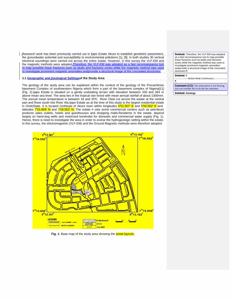
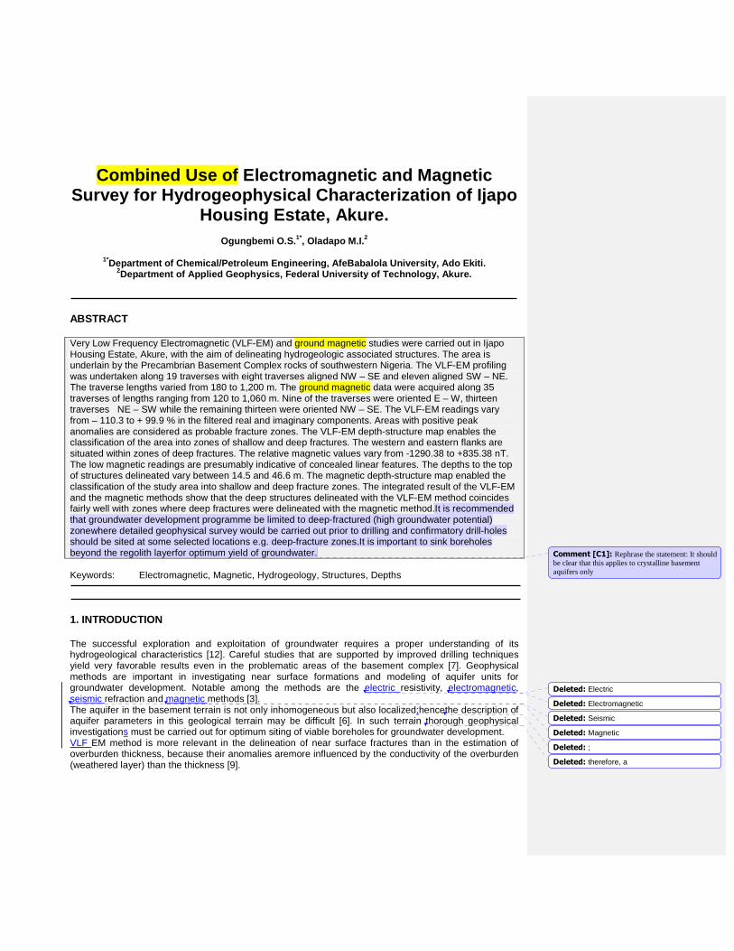
Research work has been previously carried out in ljapo Estate Akure to establish geoeletric parameters, the groundwater potential and susceptibility to environmental pollutions [1], [8]. In both studies 30 vertical electrical soundings were carried out across the entire estate. However, in this survey the VLF-EM and the magnetic methods were adopted.Therefore, the VLF-EM was adopted as a fast reconnaissance tool to map possible linear fractures such as faults and fractures zones while the magnetic method was used to investigate prominent magnetic anomalies andprovide a structural image of the concealed structures. 1.1 Geographic and Geological Settings of the Study Area The geology of the study area can be explained within the context of the geology of the Precambrian basement Complex of southwestern Nigeria which form a part of the basement complex of Nigeria[11] (Fig. 2).Ijapo Estate is situated on a gently undulating terrain with elevation between 330 and 364 m above mean sea level. The area lies in the tropical rain forest with mean annual rainfall of about 1300mm. The annual mean temperature is between 18 and 33°C. River Osisi cut across the estate at the central part and flows south into River Ala.Ijapo Estate as at the time of this study is the largest residential estate in OndoState. It is located northeast of Akure town within longitudes 5°12.307' E and 5°16.552' E and latitudes 7°15.859' N and 7°16.552' N. The estate h osts some commercial centers such as petroleum products sales outlets, hotels and guesthouses and shopping malls.Residents in the estate, depend largely on hand-dug wells and motorized boreholes for domestic and commercial water supply (Fig. 1). Hence, there is need to investigate the area in order to evolve the hydrogeologic setting within the estate. In this survey, the electromagnetic (VLF-EM) and the Ground Magnetic methods were therefore adopted.
Fig. 1 : Base map of the study area showing the street layouts.
Deleted: Therefore, the VLF-EM was adopted as a fast reconnaissance tool to map possible linear fractures such as faults and fractures zones while the magnetic method was used to investigate prominent magnetic anomalies andprovide a structural image of the concealed structures.
Deleted: ¶Section Break (Continuous)
Comment [C2]: The information is not flowing, you can consider this to be the last statement
Deleted: Geology
Fig. 2 : A generalized geological map of Akure (after Owoyemi, 1996)
2. MATERIALS AND METHODS
The VLF-EM profiling was undertaken at 25 m station interval on 19 traverses. The traverses lengths vary from 180 to 1,200 m. The Ground Magnetic data were acquired on 35 traverses of lengths ranging from 120 to 1,060 m at 20 m station intervals. ABEM-WADI VLF instrument was utilized for Electromagnetic data acquisition while Proton Precision Magnetometer was used for magnetic data acquisition. 2-D filtering operation was carried out on VLF-EM data while the magnetic data were interpreted quantitatively using deconvolution process. The generated profiles, sections and maps enabled the delineation of concealed structures.The integration of the results of VLF-EM and ground magnetic survey enabled the hydrogeophysical characterization of the study area. 3. RESULTS AND DISCUSSION
3.1 Filtered Real Component Map
WADI VLF-EM detects the ratio (in percentage) between the vertical and the horizontal components. This is an indication of the degree of inhomogeneity of the subsurface. The real component readings were plotted as a contour map of the study area (Fig. 3a). The map was characterized with zone of positive and negative anomaly, the readings range between - 50 to +35 %. The zones with positive anomaly occur as patches and are more prominent around the western part, also around the central region and the northern flank. VLF-EM anomalies were delineated at twenty-nine (29) locations within the study area.This indicates that these areas have concealed geological structures suspected to be linear steeply-dipping fractures that favoursgroundwater accumulate.
GRANITE
PORPHYRITICGRANITE
180
GNEISS
110
16
30188
5 14' 00'' E7 19' 00''N
31120
PELITICSCHIST
30188
CHARNOCKITE
MIGMATITE
GNEISS
100116
33
30
168180
QTZ
QTZ
QTZ
13
1040
5 07' 00'' E
MIGMATITE
GNEISS
180180
19
004173
80
18
30
32
181 BIOTITE
GRANITE
QTZQTZ
168
178
TO ALA
167
1507 13' 00'' N
5 14'00''E
170
0 1 2 3 Km
CHARNOKITE
QUARTZ
PELISTIC SHCIST
APPROXIMATE GEOLOGICALBOUNDARY
STRIKE AND DIP OFFOLIATION
RIVERS
FOLIATION DIRECTION OFBIOTITE AND FELOSPATE
MAJOR ROAD
LEGEND
MIGMATITE GNEISS
PORPHYRITIC GNEISS
GRANITE GNEISS
BIOTITE GRANITE
QTZ
7 13' 00''N5 07'00'' E
Deleted: OF STUDY
Comment [C3]: Remove this part its unnecessary
Deleted: ,
Deleted: Magnetic
Deleted: Ground
Deleted: Magnetic
Comment [C4]: You should describe the data processing in this section so that you do not mix presentation of results and discussion with methodology. It has to be clear how the data inversion was carried out.
Deleted: detect
Deleted: %)
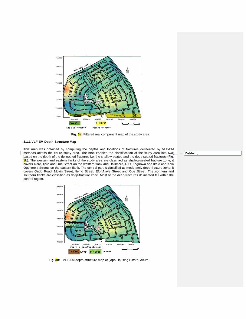
Fig. 3a: Filtered real component map of the study area 3.1.1 VLF-EM Depth-Structure Map
This map was obtained by computing the depths and locations of fractures delineated by VLF-EM methods across the entire study area. The map enables the classification of the study area into two; based on the depth of the delineated fractures i.e. the shallow-seated and the deep-seated fractures (Fig. 3b). The western and eastern flanks of the study area are classified as shallow-seated fracture zone; it covers Ikere, Ijero and Ode Street on the western flank and Dallimore, D.O. Fagunwa and Ikale and Kola Ogunmola Streets on the eastern flank. The central part is classified as moderately deep-fracture zone; it covers Ondo Road, Mokin Street, Ilemo Street, EfonAlaye Street and Ode Street. The northern and southern flanks are classified as deep-fracture zone. Most of the deep fractures delineated fall within the central region.
Fig. 3b: VLF-EM depth-structure map of Ijapo Housing Estate, Akure
Deleted: ,
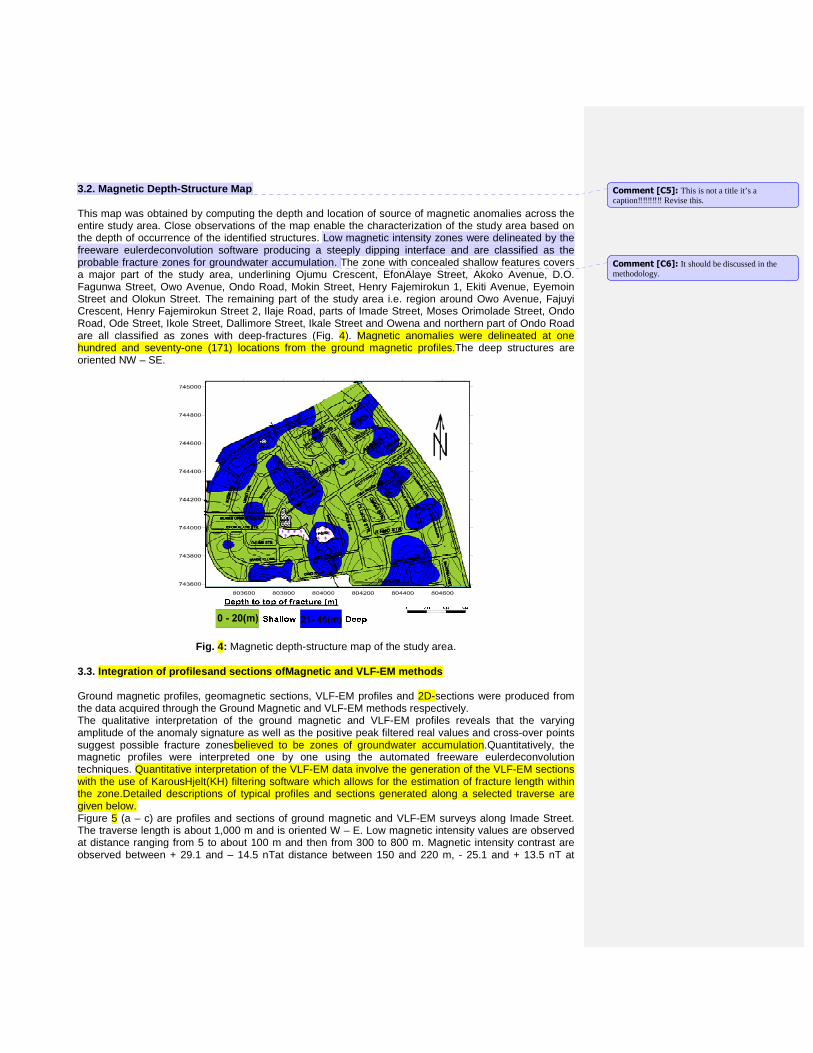
3.2. Magnetic Depth-Structure Map This map was obtained by computing the depth and location of source of magnetic anomalies across the entire study area. Close observations of the map enable the characterization of the study area based on the depth of occurrence of the identified structures. Low magnetic intensity zones were delineated by the freeware eulerdeconvolution software producing a steeply dipping interface and are classified as the probable fracture zones for groundwater accumulation. The zone with concealed shallow features covers a major part of the study area, underlining Ojumu Crescent, EfonAlaye Street, Akoko Avenue, D.O. Fagunwa Street, Owo Avenue, Ondo Road, Mokin Street, Henry Fajemirokun 1, Ekiti Avenue, Eyemoin Street and Olokun Street. The remaining part of the study area i.e. region around Owo Avenue, Fajuyi Crescent, Henry Fajemirokun Street 2, Ilaje Road, parts of Imade Street, Moses Orimolade Street, Ondo Road, Ode Street, Ikole Street, Dallimore Street, Ikale Street and Owena and northern part of Ondo Road are all classified as zones with deep-fractures (Fig. 4). Magnetic anomalies were delineated at one hundred and seventy-one (171) locations from the ground magnetic profiles.The deep structures are oriented NW – SE.
Fig. 4: Magnetic depth-structure map of the study area.
3.3. Integration of profilesand sections ofMagnetic and VLF-EM methods Ground magnetic profiles, geomagnetic sections, VLF-EM profiles and 2D-sections were produced from the data acquired through the Ground Magnetic and VLF-EM methods respectively. The qualitative interpretation of the ground magnetic and VLF-EM profiles reveals that the varying amplitude of the anomaly signature as well as the positive peak filtered real values and cross-over points suggest possible fracture zonesbelieved to be zones of groundwater accumulation.Quantitatively, the magnetic profiles were interpreted one by one using the automated freeware eulerdeconvolution techniques. Quantitative interpretation of the VLF-EM data involve the generation of the VLF-EM sections with the use of KarousHjelt(KH) filtering software which allows for the estimation of fracture length within the zone.Detailed descriptions of typical profiles and sections generated along a selected traverse are given below. Figure 5 (a – c) are profiles and sections of ground magnetic and VLF-EM surveys along Imade Street. The traverse length is about 1,000 m and is oriented W – E. Low magnetic intensity values are observed at distance ranging from 5 to about 100 m and then from 300 to 800 m. Magnetic intensity contrast are observed between + 29.1 and – 14.5 nTat distance between 150 and 220 m, - 25.1 and + 13.5 nT at
Comment [C5]: This is not a title it’s a caption‼‼‼‼‼ Revise this.
Comment [C6]: It should be discussed in the methodology.
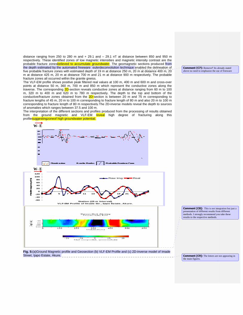
distance ranging from 250 to 280 m and + 29.1 respectively. These identified zones of low magnetic intensities and magnetic intensity contrprobable fracture zonesbelieved to the depth estimated by the automated freeware eulerdeconvolution technique five probable fracture zones with estimated depth of 19 m at distance 250 m, 20 m at distance 400 m, 20 m at distance 425 m, 20 m at distance 700 m and 21 m at distance 900 m respectively. The probable fracture zones all occurred within the granite gneiss.The VLF-EM profile shows positive peak filtered real values at 100 m, 400 m and 600 m and crosspoints at distance 50 m, 360 m, 700 m and 850 m which represent the conductive zones along thtraverse. The corresponding 2D-section reveals conductive zones at distance ranging from 60 m to 100 m, 320 m to 400 m and 620 m to 780 m respectively. The depth to the top and bottom of the conductive/fracture zones obtained from the fracture lengths of 45 m, 20 m to 100 m corresponding to fracture length of 80 m and also 20 m to 100 m corresponding to fracture length of 80 m respectively.of anomalies which ranges between 37.5 and 100The interpretation of the different sections and profiles produced from the processing of results obtained from the ground magnetic and VLFprofilesuggestingzoneof high groundwater potential.
Fig. 5: (a)Ground Magnetic profile and Geosection (b) VLFStreet, Ijapo Estate, Akure.
-60
-40
-20
0
20
40
60
80
100
120
1 3 5 7
VLF-EM Profile of Imade Str., Ijapo Estate, Akure.
Real/Imaginary (%
)
W- E
W- E
distance ranging from 250 to 280 m and + 29.1 and – 29.1 nT at distance between 850 and 950 m tified zones of low magnetic intensities and magnetic intensity contrbelieved to accumulate groundwater. The geomagnetic sections produced
the depth estimated by the automated freeware eulerdeconvolution technique enabled the delineation of five probable fracture zones with estimated depth of 19 m at distance 250 m, 20 m at distance 400 m, 20 m at distance 425 m, 20 m at distance 700 m and 21 m at distance 900 m respectively. The probable
ed within the granite gneiss. EM profile shows positive peak filtered real values at 100 m, 400 m and 600 m and cross
points at distance 50 m, 360 m, 700 m and 850 m which represent the conductive zones along thsection reveals conductive zones at distance ranging from 60 m to 100
m, 320 m to 400 m and 620 m to 780 m respectively. The depth to the top and bottom of the cture zones obtained from the 2D-section is between 20 m and 75 m corresponding t
fracture lengths of 45 m, 20 m to 100 m corresponding to fracture length of 80 m and also 20 m to 100 m corresponding to fracture length of 80 m respectively.The 2D-inverse models reveal the depth to sources of anomalies which ranges between 37.5 and 100 m. The interpretation of the different sections and profiles produced from the processing of results obtained
ound magnetic and VLF-EM reveal high degree of fracturing along suggestingzoneof high groundwater potential.
Ground Magnetic profile and Geosection (b) VLF-EM Profile and (c) 2D-inverse model of Imade
9 11 13 15 17 19 21 23 25
Station (25 m Interval)VLF-EM Profile of Imade Str., Ijapo Estate, Akure.
Raw Img Real
29.1 nT at distance between 850 and 950 m tified zones of low magnetic intensities and magnetic intensity contrast are the
. The geomagnetic sections produced from enabled the delineation of
five probable fracture zones with estimated depth of 19 m at distance 250 m, 20 m at distance 400 m, 20 m at distance 425 m, 20 m at distance 700 m and 21 m at distance 900 m respectively. The probable
EM profile shows positive peak filtered real values at 100 m, 400 m and 600 m and cross-over points at distance 50 m, 360 m, 700 m and 850 m which represent the conductive zones along the
section reveals conductive zones at distance ranging from 60 m to 100 m, 320 m to 400 m and 620 m to 780 m respectively. The depth to the top and bottom of the
section is between 20 m and 75 m corresponding to fracture lengths of 45 m, 20 m to 100 m corresponding to fracture length of 80 m and also 20 m to 100 m
inverse models reveal the depth to sources
The interpretation of the different sections and profiles produced from the processing of results obtained high degree of fracturing along this
inverse model of Imade
25
Comment [C7]: Remove‼ Its already stated above no need to emphasize the use
Comment [C8]: This is not integration but presentation of different results from different methods. I strongly recommend you take these results to the respective methods.
Comment [C9]: The letters are not appearing the main figures.
Its already stated above no need to emphasize the use of freeware
This is not integration but just a different results from different
methods. I strongly recommend you take these
The letters are not appearing in
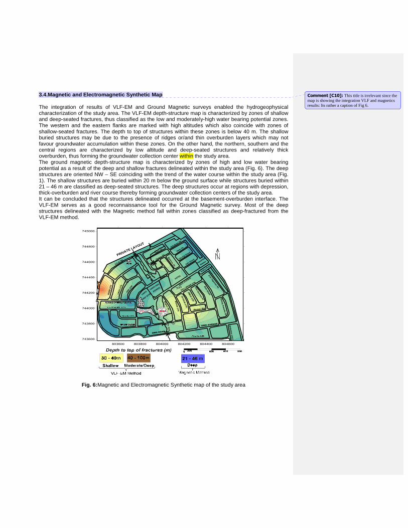
3.4.Magnetic and Electromagnetic Synthetic Map The integration of results of VLF-EM and Ground Magnetic surveys enabled the hydrogeophysical characterization of the study area. The VLF-EM depth-structure map is characterized by zones of shallow and deep-seated fractures, thus classified as the low and moderately-high water bearing potential zones. The western and the eastern flanks are marked with high altitudes which also coincide with zones of shallow-seated fractures. The depth to top of structures within these zones is below 40 m. The shallow buried structures may be due to the presence of ridges or/and thin overburden layers which may not favour groundwater accumulation within these zones. On the other hand, the northern, southern and the central regions are characterized by low altitude and deep-seated structures and relatively thick overburden, thus forming the groundwater collection center within the study area. The ground magnetic depth-structure map is characterized by zones of high and low water bearing potential as a result of the deep and shallow fractures delineated within the study area (Fig. 6). The deep structures are oriented NW – SE coinciding with the trend of the water course within the study area (Fig. 1). The shallow structures are buried within 20 m below the ground surface while structures buried within 21 – 46 m are classified as deep-seated structures. The deep structures occur at regions with depression, thick-overburden and river course thereby forming groundwater collection centers of the study area. It can be concluded that the structures delineated occurred at the basement-overburden interface. The VLF-EM serves as a good reconnaissance tool for the Ground Magnetic survey. Most of the deep structures delineated with the Magnetic method fall within zones classified as deep-fractured from the VLF-EM method.
Fig. 6: Magnetic and Electromagnetic Synthetic map of the study area
Comment [C10]: This title is irrelevant since the map is showing the integration VLF and magnetics results: Its rather a caption of Fig 6.
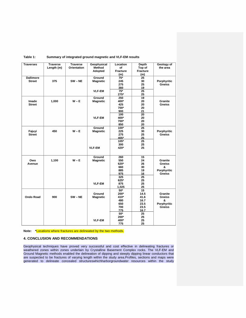
Table 1: Summary of integrated ground magnetic and VLF-EM results
Traverses Traverse Length (m)
Traverse Orientation
Geophysical Method Adopted
Location of
Fracture (m)
Depth Top of
Fracture (m)
Geology of the area
Dallimore Street
375
SW – NE
Ground Magnetic
VLF-EM
75* 245 275 360 75* 275*
25 30 25 19 25 25
Porphyritic
Gneiss
Imade Street
1,000
W – E
Ground Magnetic
VLF-EM
250 400* 425 700* 900 100 400* 700* 850
19 20 20 20 21 20 20 20 20
Granite Gneiss
Fajuyi Street
450
W – E
Ground Magnetic
VLF-EM
100* 225 275 405* 105* 300 420*
25 30 25 25 25 25 25
Porphyritic
Gneiss
Owo
Avenue
1,100
W – E
Ground Magnetic
VLF-EM
260 550 620* 660 885 975 325 625* 875
1,025
15 24 26 30 19 16 25 25 25 25
Granite Gneiss
& Porphyritic
Gneiss
Ondo Road
900
SW – NE
Ground
Magnetic
VLF-EM
50* 200* 410* 480 650 700 775 50* 200* 400* 775
15 14.5 41.6 16.7 23.5 23.5 16.7 25 25 25 25
Granite Gneiss
& Porphyritic
Gneiss
Note: * Locations where fractures are delineated by the two methods.
4. CONCLUSION AND RECOMMENDATIONS
Geophysical techniques have proved very successful and cost effective in delineating fractures or weathered zones within zones underlain by Crystalline Basement Complex rocks. The VLF-EM and Ground Magnetic methods enabled the delineation of dipping and steeply dipping linear conductors that are suspected to be fractures of varying length within the study area.Profiles, sections and maps were generated to delineate concealed structureswhichharborgroundwater resources within the study
area.Alinear filter - Karous and Hjelt Filter (KHF) was used to interpret the VLF-EM data toproduce 2D-inverse model which serves as a useful tool for estimating the depth to source of anomaly.The 2D-inverse models reveal the depth to sources of anomalies which ranges between 37.5 and 100 m. Structures less than 40 m are grouped as near-surface structures while those above 40 m are grouped as deep-seated structures, most of which occurred within the near-surface structures zone.Freeware Euler Deconvolution software was used to analyze magnetic data obtained within the study area. The magnetic profiles give an estimate of depth to magnetic sources ranging between 14.32 and 46.54 m. Zones with fractures of length less than 21 m are classified as near-surface structure zone while areas with fractures longer than 21 m are classified as deep-seated structure zone. The Magnetic depth-structure map enables the classification of the groundwater potential of the study area based on the depths of the identified structures.Ijapo is a highly fractured area as revealed by the results obtained from the two geophysical techniques employed for the research. The trends of the identified fracture zones are mostly in the NW-SE, the orientation of the structures agree with the physical trend of the river course as shown on thebasemap of the study area(Fig. 1). Groundwater occurrence can therefore be said to be structurally controlled. In conclusion, the results of these two techniques correlate with one another; they are complimentary and the integration produced a better resolution.
It is recommended that pre-drilling geophysical survey be carried out prior to sitting of water boreholes.Groundwater development programme should be limited to deep-fractured zones of the study area i.e. the high groundwater potential zone.Where necessary, confirmatory drill-holes should be sited at some selected locations e.g. conductive zones, deep-fracture zones, e.t.c.It is therefore pertinent to sink boreholes beyond the regolith layerfor optimum yield of groundwater. 5. ACKNOWLEDGEMENTS The authors would like to acknowledge the effort of Mr. AfolabiAbiodun who assisted during data acquisition. The support of colleagues who gave technical and moral assistance towards the success of the work is also acknowledged with thanks. REFERENCES
[1] Ayolabi, E.A., Adedeji, J.K. and Oladapo, M.I. A geoelectric mapping of Ijapo, Akure Southwest
Nigeria and its Hydrogeological Implications.Global Jour. of Pure and Applied Sciences.2003; 10(3), 441-446.
[2] Cooper, G.R.J. An improved algorithm for the Euler deconvolution of potential field data.The Leading Edge.2002; 21(12), 1197-1198.
[3] Freeborn, O.E.Geoelectric investigation for groundwater in Aniocha South Local Government Area, Delta state, Nigeria. 2006.
[4] Humill, L and Bell, F.G. Groundwater Resources Development, Publ. Buterworths, London; 334p. [5] Karous, M. and Hjelt, S.E. Linear Filtering of VLF-EM dip angle measurements.
Geophysical.1983; 31, 782-794. [6] Lewis, M.A. The analysis of borehole yields from basement Aquifer. Common Wealth Science
Council Technical paper.1990; 273(2), 171-202. [7] Offordile, M.E. The occurrence andexploration of groundwater in Nigeria Basement rocks. Nigeria
Jour. of Min. and Geol. 1983; 20, 131-146. [8] Oladapo, M.I., Mohammed, M.Z., Adeoye, O.O. and Adetola, B.A. Geoelectrical Investigation of
the Ondo State Housing Corporation Estate Ijapo Estate Akure, Southwestern Nigeria. Jour. of Min. and Geology.2004; 40(1), 41-48.
[9] Olorunfemi, M.O., Dan-Hassan, M.A. and Ojo, J.S. On the Scope and Limitations of the Electromagnetic Method in Groundwater Prospecting in a basement Complex Area – A case study. Jour. of African Earth Sciences.1995; 31(2), 151-163.
[10] Owoyemi, F.B.An updated Geologic map of Akure, Ondo State. 1996. [11] Rahaman, M.A. Review of the Basement Geology of southwestern Nigeria. Geology of
Nigeria.1976, 41-57. [12] Van Overmeeren, R.A., A combination of Electrical resistivity, Seismic refraction and Gravity
measurements for groundwater exploration in Sudan. Geophysics.1981, 46(6), 1304-1311.
Comment [C11]: Summaries your findings in less than 15 lines. Do not just duplicate the results but paraphrase and give the reader, what you have achieved in your work. Avoid being specific; avoid quoting all the data.
Comment [C12]: Rephrase this: The idea is to bring the usefulness of geophysical methods in groundwater exploration. Just be straight to your point. From your study its clear that VLF and magnetics are good tools in delineating geological structures which are related to groundwater occurrence.