Embed Size (px)
Citation preview
Alara Uranium Limited A.B.N. 27 122 892 719
Level 14, The Forrest Centre 221 St Georges Terrace Perth Western Australia 6000
Telephone | +61 8 9214 9787 Facsimile | +61 8 9322 1515
Web | www.alarauranium.com Email | [email protected]
ASX Code AUQ
ANNUAL REPORT For
EXPLORATION LICENCES 24879, 24928 & 24929
SEPTEMBER 2008
Alara Uranium Limited A.B.N. 27 122 892 719
Level 14, The Forrest Centre 221 St Georges Terrace Perth Western Australia 6000
Telephone | +61 8 9214 9787 Facsimile | +61 8 9322 1515
Web | www.alarauranium.com Email | [email protected]
PROJECT: Bigrlyi South TITLE: Annual Report for Exploration Licences 24879, 24928 & 24929 EDITED: GK AUTHOR/S: G. Krishnamurthy APPROVED: GK DATE: September 2008 PLACE: Perth 1:250 000 Sheet Name/s & No/s: SF5212 Mount Doreen Text Pages No:4 Map Nos:2 Table Nos:1 Appendices:1 KEYWORDS: Uranium Exploration ABSTRACT: Alara Uranium Limited has conducted exploration for uranium over the combined tenement group (EL24879, EL24928 and EL24929) during the reporting period. The objective of the exploration was to locate uranium mineralisation. Exploration involved an airborne radiometric and magnetic geophysical survey, processing of data, ground verification, geological evaluation and preparation of a mine management plan. COPY TO: DPIFM Ref: gk2008_02_auq_rep.doc
TABLE OF CONTENTS 1. INTRODUCTION 2. TENEMENT 3. WORK UNDERTAKEN 3.1. Geophysical Surveying 3.2. Ground Reconnaissance Surveying 3.3. Mine Management Plan 4. CONCLUSION
LIST OF TABLES
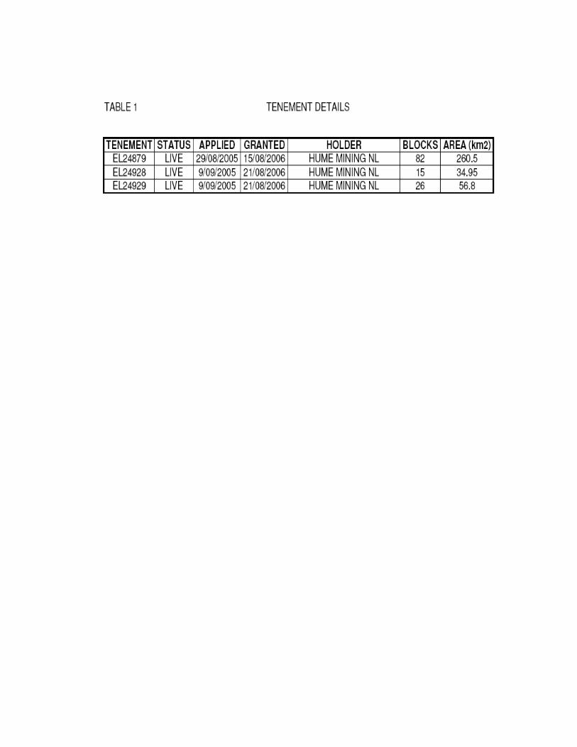
Table 1 TENEMENT SUMMARY
LIST OF MAPS Map 1 LOCATION & GEOLOGY MAP Map 2 AIRBORNE GEOPHYSICAL SURVEY
LIST OF ATTACHMENTS Airborne geophysical data
1. INTRODUCTION
This second combined annual report covers work conducted by Alara Uranium Limited (Alara) on exploration licences 24879, 24928 and 24929 for the period ending 20/8/2008. Alara is the operator and beneficial owner of the tenement group. The registered holder of the tenements is Hume Mining NL (a subsidiary of Alara). Work undertaken involved geological and geophysical activities, and technical studies.
2. TENEMENT
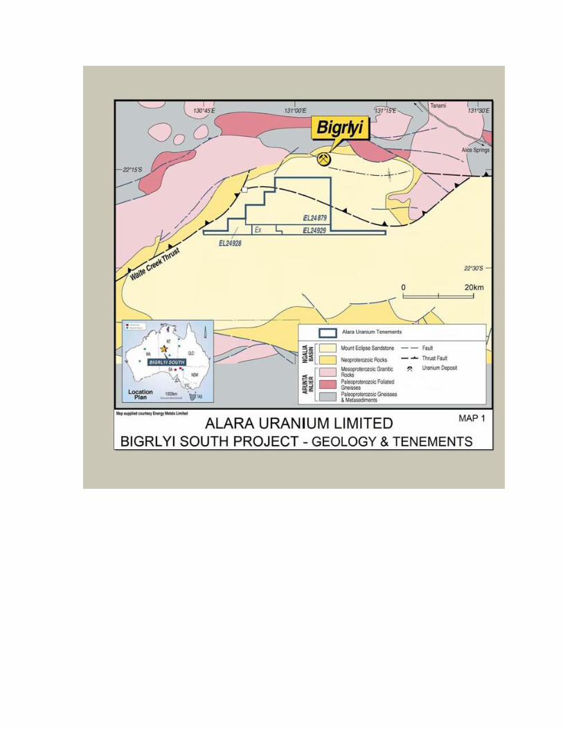
An application for exploration licence 24879 was made on 29/8/2005 and was granted on 15/8/2006. Exploration licences 24928 and 24929 were applied for on 9/9/2005 and both were granted on 21/8/2006. The combined tenement group covers 123 blocks (352.2km²) and lies approximately 390km northwest of Alice Springs, on the Mount Doreen 1:250000 mapsheet.
Table 1 lists the tenement details and Map 1 displays the location of the tenements.
3. WORK UNDERTAKEN 3.1 Geophysical Surveying
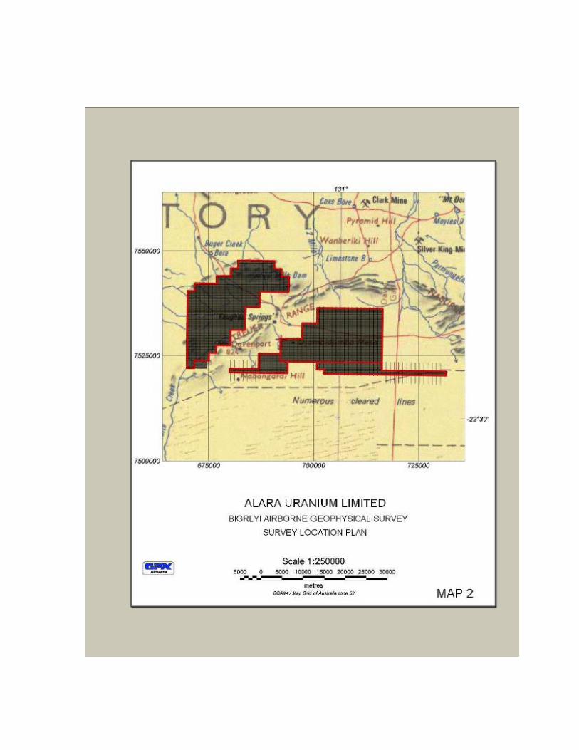
Alara contracted GPX Airborne Pty Ltd to fly a low level airborne geophysical (radiometric and magnetic) survey, the Bigrlyi Airborne Geophysical Survey (Map 2). The survey covered an area of 7076 line kilometres over part of the tenement group, and was conducted during October 2007 and January 2008. The results of the survey data comprised a large portion of our planned field programme for 2008, including conducting detailed ground geophysical surveying, sampling and drilling. The radiometric data was acquired using a radiometric sensor with 32 litre crystal capacity, whilst the magnetic data was acquired using a cesium vapour magnetometer (0.001nT resolution). Flight lines were flown in a North-South direction at 100m spacing with a nominal terrain clearance of 60m. The data was processed and evaluated by Southern Geoscience Consultants for anomalous magnetic and radiometric signatures. Survey data and results showed multiple anomalous areas which require further investigation to assess their potential for drilling in 2008/2009. Alara purchased 400m line spaced public domain aerial radiometric survey data, which covered the tenement group. The data was assessed, to identify regional anomalies identified within the Mt Eclipse Sandstone unit. Ground inspection was conducted to locate and confirm the anomalies during November 2007. Map 2 shows the location of the airborne geophysical survey.
3.2 Ground Reconnaissance Surveying
Following the flying of airborne geophysics it was necessary to ground traverse the derived radiometric anomalies. Whilst in the region, land holders (pastoral & aboriginal) were liaised with.
3.3 Mine Management Plan
A Mine Management Plan was prepared and presented to the department for conducting heritage survey and meeting with the Central Land Council.
4. CONCLUSION
Alara Uranium Limited has conducted exploration for uranium over the combined tenement group (EL24879, EL24928 and EL24929) during the reporting period. The objective of the exploration was to locate uranium mineralisation. Exploration involved an airborne radiometric and magnetic geophysical survey, data processing, geological evaluation and preparation of a Mine Management Plan. Further work planning is in progress for ground geophysical surveys and drilling the details of which will be submitted in the next reporting period.