Embed Size (px)
Citation preview
COMAL APPRAISAL DISTRICT
REAPPRAISAL PLAN
FOR
2015 & 2016 APPRAISAL YEARS
September 9, 2014
1
TABLE OF CONTENTS
Introduction………………………………………………………………………………….......2
Tax Code Requirement 3
USPAP Requirement 4
Available Resources……………………………………………………………………………..6
Personnel Resources 6
Organizational Chart 6
Staff Listing & Responsibilities 7
Staff Education & Training 7
Information System 8
Facilities 9
Budget 10
Tax Calendar 10
Appraisal Activities…………………………………………………………………………….15
Reappraisal Decision 15
Reappraisal Map 17
Planning & Organization 18
Pilot Study 18
Data Management 18
Data Sources 19
Data Collection & Verification 20
Data Entry 21
Quality Control 21
Organization 21
Cost Analysis 26
Income Analysis 26
Sales Analysis 26
Valuation System 29
Administrative Activities……………………………………………………………………….30
Mass Appraisal Report 30
Preparation of Appraisal Roll 30
Appeals Process 30
Final Performance Analysis 31
Attachments
Residential Property Plan
Unique Properties Plan
Commercial Property Plan
Business Personal Property Plan
Land Plan
2
INTRODUCTION
The Comal Appraisal District’s Board of Directors published this reappraisal plan to provide the
citizens and taxpayers of Comal County with a better understanding of the district’s
responsibilities and activities. This plan has several parts: a general introduction, a section
describing the current resources available to the District, the appraisal and administrative
activities, and finally the specific objectives over the next two years for each appraisal
department.
The Comal Appraisal District (CAD) is a political subdivision of the State of Texas created
January 1, 1980. The provisions of the Texas Property Tax Code govern the legal, statutory, and
administrative requirements of the appraisal district. A Board of Directors, appointed by the
voting taxing units within the boundaries of the Comal Appraisal District, constitutes the
District’s governing body. The Chief Appraiser, appointed by the Board of Directors, is the
chief administrator and chief executive officer of the appraisal district.
The appraisal district is responsible for local property tax appraisal, exemption administration
and special valuation of property for jurisdictions or taxing units in its county. Each taxing unit
sets its own tax rate to generate revenue to pay for police and fire protection, public schools, road
and street maintenance, courts, water and sewer systems, and other public services. The
following is a list of all the taxing entities within the appraisal district’s jurisdiction:
Comal County
City of New Braunfels
City of Schertz
City of Garden Ridge
City of Bulverde
City of Fair Oaks Ranch
City of Selma
Comal ISD
Boerne ISD
New Braunfels ISD
Wimberley ISD
Lateral Road
Emergency Service District #1
Emergency Service District #2
Emergency Service District #3
Emergency Service District #4
Emergency Service District #5
Emergency Service District #6

3
Emergency Service District #7
Rebecca Creek MUD
York Creek Improvement District
Johnson Ranch MUD
Property appraisals by the appraisal district establish the market value of each property as of
January 1st. Market value as defined by the code means the price at which a property would
transfer for cash or its equivalent under prevailing market conditions if:
- Exposed for sale in the open market with a reasonable time for the seller to find a buyer.
- Both the seller and the buyer know of all the property uses and purposes to which the
property is adapted and for which it is capable or being used for and of any enforceable
restrictions on the use of the property
- Both the seller and the buyer seek to maximize their gains and neither is in a position to
take advantage of situations of the other.
TAX CODE REQUIREMENT
The legal requirement of a reappraisal plan passed by the Texas Legislature in Senate Bill 1652
during the 2005 regular session is as follows:
Section 6.05, Tax Code, is amended by adding Subsection (i) to read as follows:
(i) To ensure adherence with generally accepted appraisal practices, the board of directors of
an appraisal district shall develop biennially a written plan for the periodic reappraisal of
all property within the boundaries of the district according to the requirements of Section
25.18 and shall hold a public hearing to consider the proposed plan. Not later than the
10th
day before the date of the hearing, the secretary of the board shall deliver to the
presiding officer of the governing body of each taxing unit participating in the district a
written notice of the date, time, and place of the hearing. Not later than September 15 of
each even numbered year, the board shall complete its hearings, make any amendments,
and by resolution finally approve the plan. Copies of the approved plan shall be
distributed to the presiding officer of the governing body of each taxing unit participating
in the district and to the comptroller within 60 days of the approval date.
Subsections (a) and (b), Section 25.18, Tax Code, are amended to read as follows:
(a) Each appraisal office shall implement the plan for periodic reappraisal of property
approved by the board of directors under Section 6.05 (i).
4
(b) The plan shall provide for the following reappraisal activities for all real and personal
property in the district at least once every three years:
(1) Identifying properties to be appraised through physical inspection
or by other reliable means of identification, including deeds or other legal documentation,
aerial photographs, land-based photographs, surveys, maps, and property sketches;
(2) Identifying and updating relevant characteristics of each property
in the appraisal records;
(3) Defining market areas in the district;
(4) Identifying property characteristics that affect property value in each market area,
including:
(A) The location and market area of the property;
(B) Physical attributes of property, such as size, age, and condition;
(C) Legal and economic attributes; and
(D) Easements, covenants, leases, reservations, contracts, declarations,
special assessments, ordinances, or legal restrictions;
(5) Developing an appraisal model that reflects the relationship among
the property characteristics affecting value in each market area and determines the
contribution of individual property characteristics;
(6) Applying the conclusions reflected in the model to the characteristics of the
properties being appraised; and
(7) Reviewing the appraisal results to determine value.
UNIFORM STANDARDS OF PROFESSIONAL APRAISAL PRACTICES (USPAP)
USPAP is a set of standards to be followed when appraising the value of a property. It does not
prescribe specific methods. The rules were created by the Appraisal Foundation, and appraisers
are required to follow these guidelines. Some of the standards include best practices for research,
reporting, and other activities that an appraiser would go through.
Standard Six: Mass Appraisal, Development and Reporting
A mass appraisal includes:
1. Identifying properties to be appraised
2. Defining market area of consistent behavior that applies to properties
3. Identifying characteristics (supply and demand) that affect the creation of value in that
market area
4. Developing a model structure that reflects the relationship among the characteristics
affecting value in the market area
5. Calibrating the model structure to determine the contribution of the individual
characteristics affecting value

5
6. Applying the conclusions reflected in the model to the characteristics of the property (ies)
being appraised; and
7. Reviewing the mass appraisal results
6
AVAILABLE RESOURCES
The District must take stock of all its available resources. This includes staff, existing systems,
maps, support, facilities, and budget.
PERSONNEL RESOURCES
The office of the Chief Appraiser is responsible for overall planning, organizing, staffing,
coordinating, and controlling the district operations. The District is basically grouped into two
general departments: administrative and appraisal.
All personnel in support services coordinate information, update database, assist property
owners, and assist during hearings. The appraisal department is responsible for the valuation of
all real and personal property accounts.
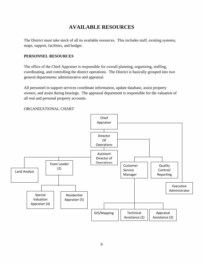
ORGANIZATIONAL CHART
Chief Appraiser
Director Of
Operations
Assistant Director of Operations
Team Leader
(2)
Quality Control/
Reporting
Executive Administrator
Special Valuation
Appraiser (4)
Residential Appraiser (5)
Land Analyst
GIS/Mapping
Technical Assistance (2)
Assistant (2)
Appraisal Assistance (3)
Customer Service Manager
7
STAFF LISTING & RESPONSIBILITIES
Title # Brief Description
Chief Appraiser 1 Strategic planning/organizing/coordinating
Director of Operations 1 Strategic planning/coordinating/reporting
Assistant Director of Operations 1 Organizing/coordinating/analysis
Team Leader 2 Organize activities/analysis and value correlation
Residential Appraiser 5 Data collection/update property data
Special Valuation Appraiser 4 Data collection/update property data/analysis
Land Analyst 1 Data collection/analysis and value correlation
Customer Service Manager 1 Organize support activities/review exemptions
Executive Support 1 Maintain financials/prepare meeting agenda/reports
Quality Control & Reporting 1 Review, Edit, manage, & maintain processes
GIS/Mapping 1 Update & maintain maps
Technical Assistance 2 Assist property owners
Appraisal Assistance 3 Support appraisal staff
Total 24
STAFF EDUCATION & TRAINING
All personnel that are performing appraisal work are registered with the TDLR and are required
to take appraisal courses to achieve the status of Registered Professional Appraiser within five
years of employment as an appraiser. Designated courses must be completed at the one-year,
three-year, and five-year mark. After they are awarded their certification they must receive
additional training of 30 continuing education units every two years (effective January 2011).
Failure to meet these minimum standards results in the termination of the employee.
Additionally, all appraisal personnel receive extensive training in data gathering processes used
in fieldwork and statistical analysis of all types of property to ensure equality and uniformity.
Management delivers on-the-job training for new appraisers. The Chief Appraiser, Director of
Operations, and other management personnel meet regularly to identify any areas needing
change, and discuss any staff needing additional training due to changes in the operation or the
tax code. Supervisors meet with their teams to introduce new procedures and monitor appraisal
activity to ensure that all personnel are following standardized appraisal procedures.
8
INFORMATION SYSTEM
Comal Appraisal District coordinates with the County IT department who houses and maintains
the server, Dell Power Ede R900 for PACS (Property Appraisal and Collection System)
Databases. True Automation manages and maintains the district’s software applications and
internet website. True Automation provides software services for appraisal and GIS applications.
The geographic information system (GIS) maintains cadastral maps and various layers of data,
aerial maps, topographical maps, and flood plain maps.
PACS (Property Appraisal and Collection System) software provides for the following
capabilities:
-Maintain appraisal records
-Selection of data items by specified fields
-Sorting of data according to multiple criteria
-Editing of existing data by adding, removing or changing the property or owner
characteristics individually or in mass
-Restriction of access to only authorized personnel
-Limit a user to certain functions
-Monitor system use
The District’s website makes a broad range of information available for public access including
information on the appraisal process, property characteristics data, certified values, protests and
appeal procedures. Downloadable files of related tax information and district forms including
exemption applications and business personal property renditions are also available.
The District has email access provided through the county network. These services allow for
inter office communications. The District also has internet access provided by the county
network. This service is a critical tool for research and the discovery process for both real and
personal property.
America Cadastre, LLC (dba Amcad) provides a data retrieval system for the county clerk’s
office. The appraisal district has an agreement with the county clerk’s office to have access to
the data retrieval system for research of the county deed records.
9
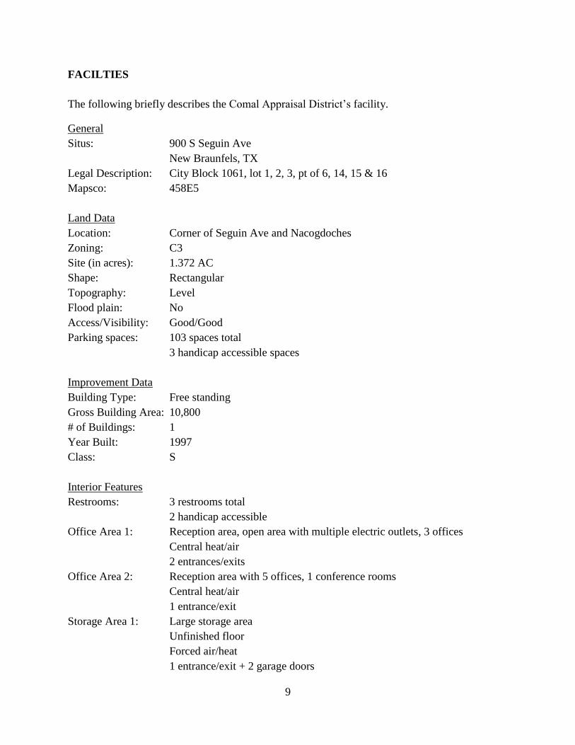
FACILTIES
The following briefly describes the Comal Appraisal District’s facility.
General
Situs: 900 S Seguin Ave
New Braunfels, TX
Legal Description: City Block 1061, lot 1, 2, 3, pt of 6, 14, 15 & 16
Mapsco: 458E5
Land Data
Location: Corner of Seguin Ave and Nacogdoches
Zoning: C3
Site (in acres): 1.372 AC
Shape: Rectangular
Topography: Level
Flood plain: No
Access/Visibility: Good/Good
Parking spaces: 103 spaces total
3 handicap accessible spaces
Improvement Data
Building Type: Free standing
Gross Building Area: 10,800
# of Buildings: 1
Year Built: 1997
Class: S
Interior Features
Restrooms: 3 restrooms total
2 handicap accessible
Office Area 1: Reception area, open area with multiple electric outlets, 3 offices
Central heat/air
2 entrances/exits
Office Area 2: Reception area with 5 offices, 1 conference rooms
Central heat/air
1 entrance/exit
Storage Area 1: Large storage area
Unfinished floor
Forced air/heat
1 entrance/exit + 2 garage doors
10
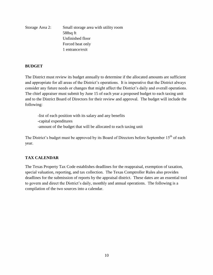
Storage Area 2: Small storage area with utility room
588sq ft
Unfinished floor
Forced heat only
1 entrance/exit
BUDGET
The District must review its budget annually to determine if the allocated amounts are sufficient
and appropriate for all areas of the District’s operations. It is imperative that the District always
consider any future needs or changes that might affect the District’s daily and overall operations.
The chief appraiser must submit by June 15 of each year a proposed budget to each taxing unit
and to the District Board of Directors for their review and approval. The budget will include the
following:
-list of each position with its salary and any benefits
-capital expenditures
-amount of the budget that will be allocated to each taxing unit
The District’s budget must be approved by its Board of Directors before September 15th
of each
year.
TAX CALENDAR
The Texas Property Tax Code establishes deadlines for the reappraisal, exemption of taxation,
special valuation, reporting, and tax collection. The Texas Comptroller Rules also provides
deadlines for the submission of reports by the appraisal district. These dates are an essential tool
to govern and direct the District’s daily, monthly and annual operations. The following is a
compilation of the two sources into a calendar.
11
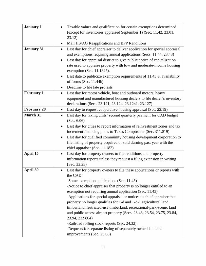
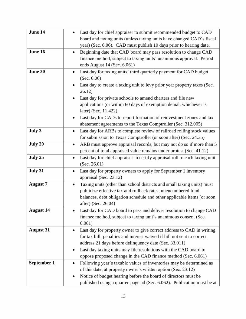
January 1 Taxable values and qualification for certain exemptions determined
(except for inventories appraised September 1) (Sec. 11.42, 23.01,
23.12)
Mail HS/AG Reapplications and BPP Renditions
January 31 Last day for chief appraiser to deliver application for special appraisal
and exemptions requiring annual applications (Secs. 11.44, 23.43)
Last day for appraisal district to give public notice of capitalization
rate used to appraise property with low and moderate-income housing
exemption (Sec. 11.1825).
Last date to publicize exemption requirements of 11.43 & availability
of forms (Sec. 11.44b).
Deadline to file late protests
February 1 Last day for motor vehicle, boat and outboard motors, heavy
equipment and manufactured housing dealers to file dealer’s inventory
declarations (Secs. 23.121, 23.124, 23.1241, 23.127)
February 28 Last day to request cooperative housing appraisal (Sec. 23.19)
March 31 Last day for taxing units’ second quarterly payment for CAD budget
(Sec. 6.06)
Last day for cities to report information of reinvestment zones and tax
increment financing plans to Texas Comptroller (Sec. 311.019)
Last day for qualified community housing development corporation to
file listing of property acquired or sold durning past year with the
chief appraiser (Sec. 11.182)
April 15 Last day for property owners to file renditions and property
information reports unless they request a filing extension in writing
(Sec. 22.23)
April 30 Last day for property owners to file these applications or reports with
the CAD:
-Some exemption applications (Sec. 11.43)
-Notice to chief appraiser that property is no longer entitled to an
exemption not requiring annual application (Sec. 11.43)
-Applications for special appraisal or notices to chief appraiser that
property no longer qualifies for 1-d and 1-d-1 agricultural land,
timberland, restricted-use timberland, recreational-park-scenic land
and public access airport property (Secs. 23.43, 23.54, 23.75, 23.84,
23.94, 23.9804)
-Railroad rolling stock reports (Sec. 24.32)
-Requests for separate listing of separately owned land and
improvements (Sec. 25.08)
12
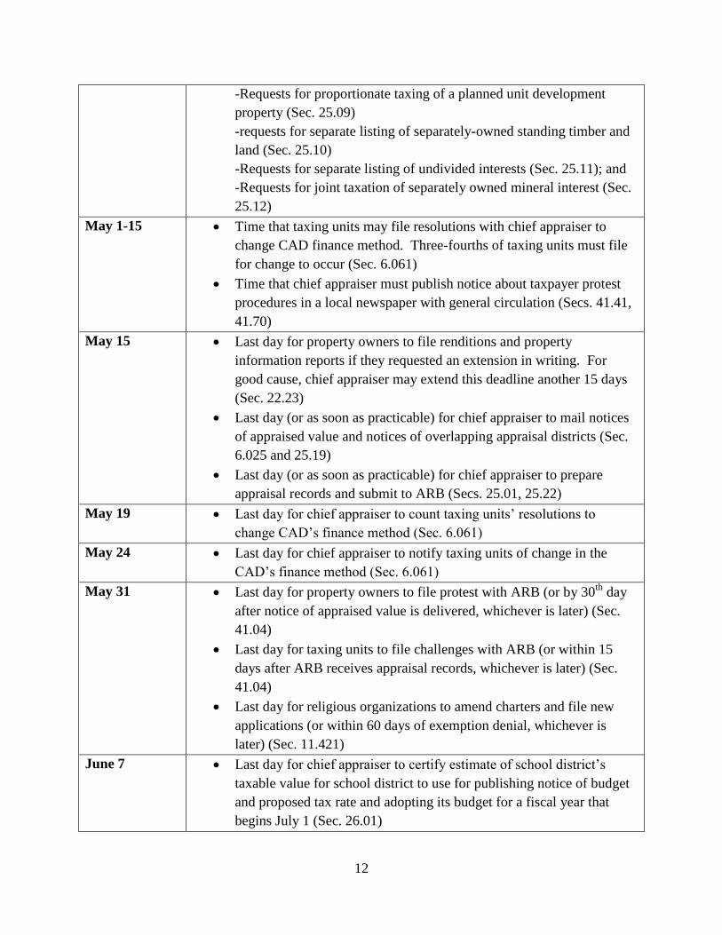
-Requests for proportionate taxing of a planned unit development
property (Sec. 25.09)
-requests for separate listing of separately-owned standing timber and
land (Sec. 25.10)
-Requests for separate listing of undivided interests (Sec. 25.11); and
-Requests for joint taxation of separately owned mineral interest (Sec.
25.12)
May 1-15 Time that taxing units may file resolutions with chief appraiser to
change CAD finance method. Three-fourths of taxing units must file
for change to occur (Sec. 6.061)
Time that chief appraiser must publish notice about taxpayer protest
procedures in a local newspaper with general circulation (Secs. 41.41,
41.70)
May 15 Last day for property owners to file renditions and property
information reports if they requested an extension in writing. For
good cause, chief appraiser may extend this deadline another 15 days
(Sec. 22.23)
Last day (or as soon as practicable) for chief appraiser to mail notices
of appraised value and notices of overlapping appraisal districts (Sec.
6.025 and 25.19)
Last day (or as soon as practicable) for chief appraiser to prepare
appraisal records and submit to ARB (Secs. 25.01, 25.22)
May 19 Last day for chief appraiser to count taxing units’ resolutions to
change CAD’s finance method (Sec. 6.061)
May 24 Last day for chief appraiser to notify taxing units of change in the
CAD’s finance method (Sec. 6.061)
May 31 Last day for property owners to file protest with ARB (or by 30th
day
after notice of appraised value is delivered, whichever is later) (Sec.
41.04)
Last day for taxing units to file challenges with ARB (or within 15
days after ARB receives appraisal records, whichever is later) (Sec.
41.04)
Last day for religious organizations to amend charters and file new
applications (or within 60 days of exemption denial, whichever is
later) (Sec. 11.421)
June 7 Last day for chief appraiser to certify estimate of school district’s
taxable value for school district to use for publishing notice of budget
and proposed tax rate and adopting its budget for a fiscal year that
begins July 1 (Sec. 26.01)
13
June 14 Last day for chief appraiser to submit recommended budget to CAD
board and taxing units (unless taxing units have changed CAD’s fiscal
year) (Sec. 6.06). CAD must publish 10 days prior to hearing date.
June 16 Beginning date that CAD board may pass resolution to change CAD
finance method, subject to taxing units’ unanimous approval. Period
ends August 14 (Sec. 6.061)
June 30 Last day for taxing units’ third quarterly payment for CAD budget
(Sec. 6.06)
Last day to create a taxing unit to levy prior year property taxes (Sec.
26.12)
Last day for private schools to amend charters and file new
applications (or within 60 days of exemption denial, whichever is
later) (Sec. 11.422)
Last day for CADs to report formation of reinvestment zones and tax
abatement agreements to the Texas Comptroller (Sec. 312.005)
July 3 Last day for ARBs to complete review of railroad rolling stock values
for submission to Texas Comptroller (or soon after) (Sec. 24.35)
July 20 ARB must approve appraisal records, but may not do so if more than 5
percent of total appraised value remains under protest (Sec. 41.12)
July 25 Last day for chief appraiser to certify appraisal roll to each taxing unit
(Sec. 26.01)
July 31 Last day for property owners to apply for September 1 inventory
appraisal (Sec. 23.12)
August 7 Taxing units (other than school districts and small taxing units) must
publicize effective tax and rollback rates, unencumbered fund
balances, debt obligation schedule and other applicable items (or soon
after) (Sec. 26.04)
August 14 Last day for CAD board to pass and deliver resolution to change CAD
finance method, subject to taxing unit’s unanimous consent (Sec.
6.061)
August 31 Last day for property owner to give correct address to CAD in writing
for tax bill; penalties and interest waived if bill not sent to correct
address 21 days before delinquency date (Sec. 33.011)
Last day taxing units may file resolutions with the CAD board to
oppose proposed change in the CAD finance method (Sec. 6.061)
September 1 Following year’s taxable values of inventories may be determined as
of this date, at property owner’s written option (Sec. 23.12)
Notice of budget hearing before the board of directors must be
published using a quarter-page ad (Sec. 6.062). Publication must be at
14
least 10 days before hearing.
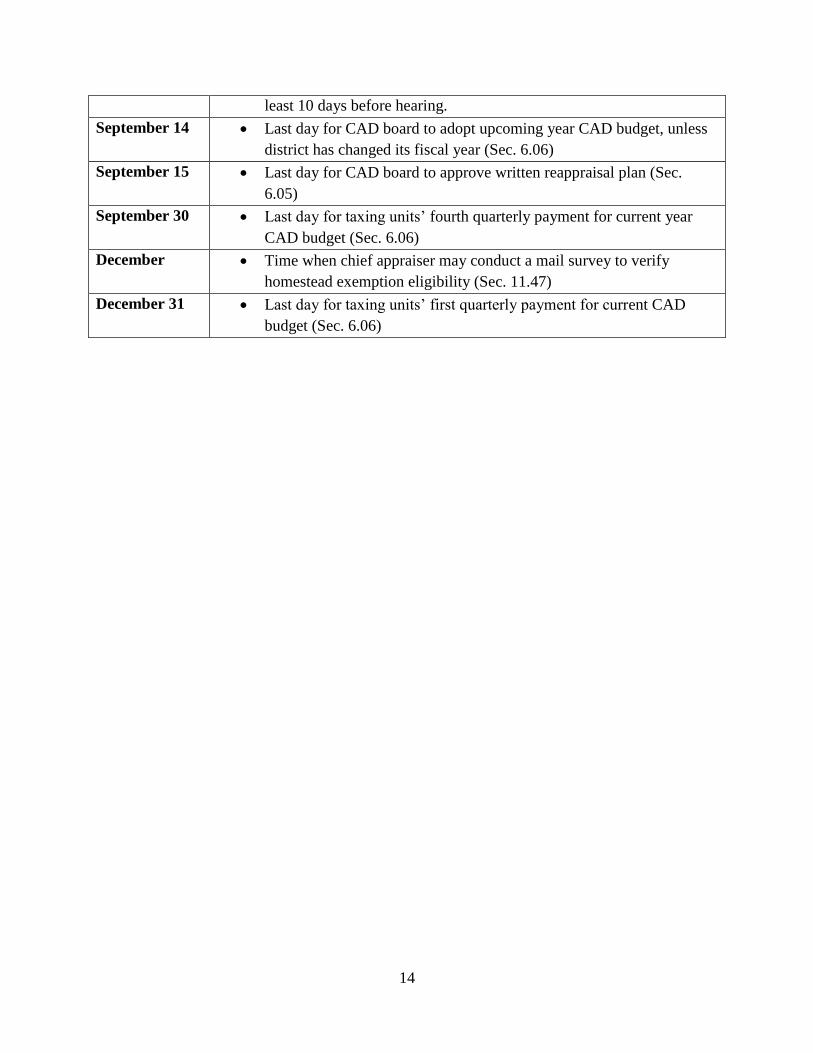
September 14 Last day for CAD board to adopt upcoming year CAD budget, unless
district has changed its fiscal year (Sec. 6.06)
September 15 Last day for CAD board to approve written reappraisal plan (Sec.
6.05)
September 30 Last day for taxing units’ fourth quarterly payment for current year
CAD budget (Sec. 6.06)
December Time when chief appraiser may conduct a mail survey to verify
homestead exemption eligibility (Sec. 11.47)
December 31 Last day for taxing units’ first quarterly payment for current CAD
budget (Sec. 6.06)
15
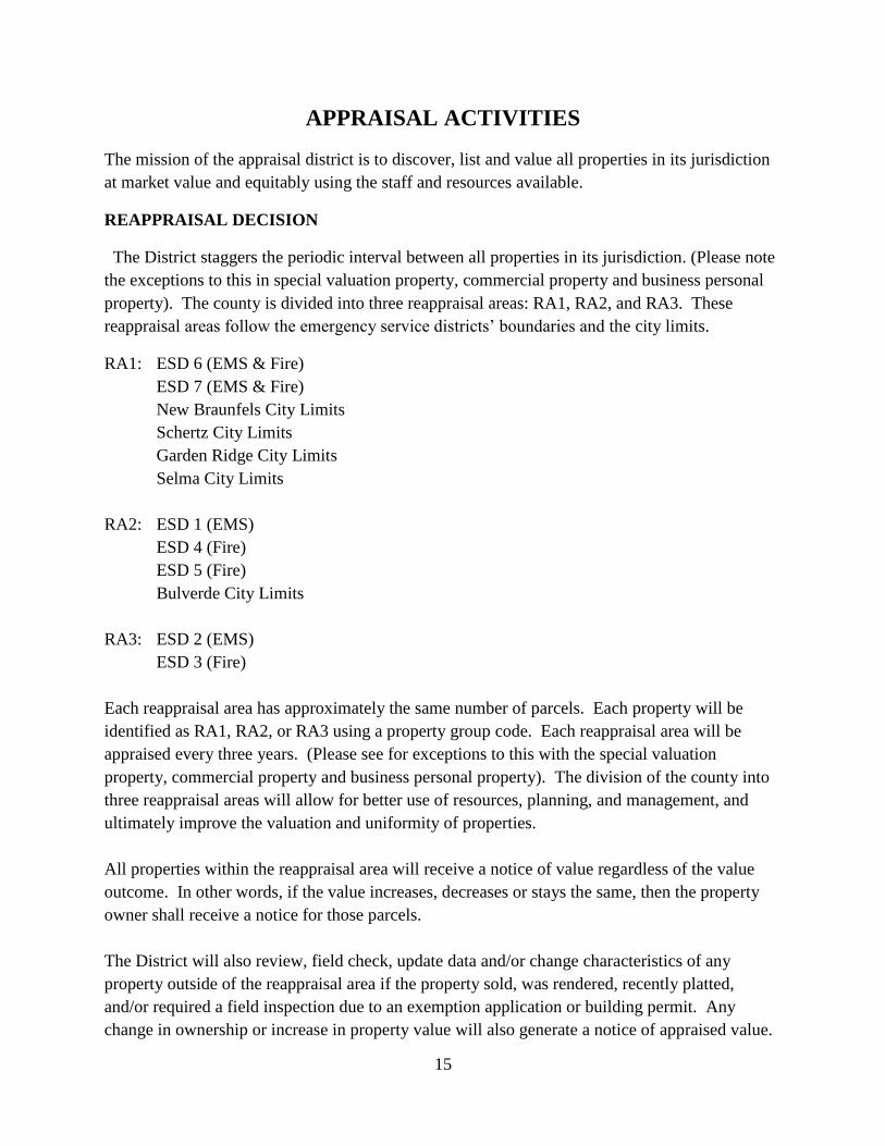
APPRAISAL ACTIVITIES
The mission of the appraisal district is to discover, list and value all properties in its jurisdiction
at market value and equitably using the staff and resources available.
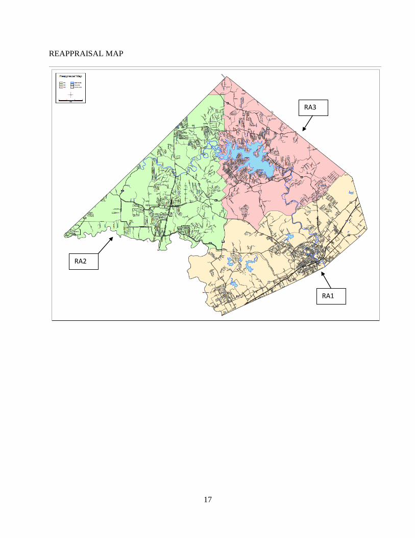
REAPPRAISAL DECISION
The District staggers the periodic interval between all properties in its jurisdiction. (Please note
the exceptions to this in special valuation property, commercial property and business personal
property). The county is divided into three reappraisal areas: RA1, RA2, and RA3. These
reappraisal areas follow the emergency service districts’ boundaries and the city limits.
RA1: ESD 6 (EMS & Fire)
ESD 7 (EMS & Fire)
New Braunfels City Limits
Schertz City Limits
Garden Ridge City Limits
Selma City Limits
RA2: ESD 1 (EMS)
ESD 4 (Fire)
ESD 5 (Fire)
Bulverde City Limits
RA3: ESD 2 (EMS)
ESD 3 (Fire)
Each reappraisal area has approximately the same number of parcels. Each property will be
identified as RA1, RA2, or RA3 using a property group code. Each reappraisal area will be
appraised every three years. (Please see for exceptions to this with the special valuation
property, commercial property and business personal property). The division of the county into
three reappraisal areas will allow for better use of resources, planning, and management, and
ultimately improve the valuation and uniformity of properties.
All properties within the reappraisal area will receive a notice of value regardless of the value
outcome. In other words, if the value increases, decreases or stays the same, then the property
owner shall receive a notice for those parcels.
The District will also review, field check, update data and/or change characteristics of any
property outside of the reappraisal area if the property sold, was rendered, recently platted,
and/or required a field inspection due to an exemption application or building permit. Any
change in ownership or increase in property value will also generate a notice of appraised value.
16
Residential Property
All residential properties in subdivisions within the reappraisal area will be checked by field or
aerial inspection, reviewed and analyzed. Neighborhoods will be statistically analyzed to ensure
that sales that have occurred in the market area during the past 12 months are within a +/-5%
range of appraised value. If the sales do not indicate that range, adjustments are made to the
neighborhood or market area using a process outlined in the Sales Analysis section.
Special Valuation Property
Properties with a state code of A5 (condos) and B2 (duplex, triplex and 4plex) generally follow
the reappraisal cycle. Properties with a state code of B1 (apartment complex) are reviewed
annually. This review may consist of a field inspection, an aerial check or review of cost, sales
and/or income data.
Commercial Property
Commercial properties identified with state codes of F1 (commercial improved) follow the
appraisal cycle of RA1, RA2 and RA3. All commercial properties in the reappraisal area will be
reviewed and analyzed. This review may consist of a field inspection, an aerial check or review
of income, cost and/or sales data.
Properties identified with a state code of F2 (industrial) will not follow this reappraisal cycle.
The Capitol Appraisal Group is retained by Comal Appraisal District to appraise industrial
properties. Industrial real estate is observed annually to verify class and condition. Pictures are
taken of the improvements when first appraised and when a change is detected during an on-site
inspection.
Business Personal Property
Business personal property is observed annually. Appraisers either go into new businesses to
determine the type of business and its assets or research websites for additional information to
set up accounts. Businesses are categorized using standard industrial codes (SIC). A rendition is
mailed to all businesses in the CAD records as of January of the appraisal year. Rendition laws
provide additional information on which to base values of all BPP accounts.
Land
Regardless of the type of improvements to the land or the state code (A, B, C, E, F or J), all land
will follow the appraisal cycle of RA1, RA2 and RA3.
17
REAPPRAISAL MAP
RA2
RA3
RA1
18
PLANNING AND ORGANIZATION
This is an important step of a reappraisal plan. The District creates several types of plans to
accomplish its goals: operational, action plans, and project plans.
Operational Plans are created for each department. These plans set forth major goals, identify
specific properties to be reappraised, any special projects and specify the time frame.
Annual Objectives are prepared every year for each department around August or as soon as
possible after protest hearings are completed. These objectives are prepared by management for
Special Valuation, Residential, Commercial, and Business Personal Property. They are
submitted to the Director of Operations for review and final approval. The annual objectives are
not attached to the reappraisal plan as they are prepared year by year. They are an opportunity
for management to assess the prior year’s results in order to make assumptions about the next
work year. The annual objectives reflect any required changes to the reappraisal plan. These
objectives will specify any plans for field work, sales analysis, income analysis, required changes
and updates to any manuals and/or reports, as well as provide detailed information about the
changes to work loads, performance measures and resources required.
Action Plans are created to define activities, assign responsibilities, and identify completion
dates. All recurring projects, such as conducting ratio studies, appear in the District’s action
plans. The District has developed action plans in the form of calendars for each department.
Project Plans are a detail plan for specific activities. They may be attached to the reappraisal
plan, but in most instances, these plans are not developed until necessary.
PILOT STUDY
A pilot study is an opportunity for the District to test new procedures on a small sample of
properties in its jurisdiction. It provides for a new system to be critiqued for accuracy, efficiency
and reliability, as well as allow for editing prior to implementation to the entire population.
DATA MANAGEMENT
The District is responsible for establishing and maintaining approximately 90,000 real and
personal property accounts within Comal County. This data includes property characteristics,
ownership, and exemption information.
The appraisal records are comprised of the following categories:
Ownership
General property description – legal description, situs
Land detail – site characteristics such as size
Improvement detail – building characteristics such as square foot, year built, quality of
construction and condition
19
Value history – a year by year history of the value of the property
Exemption information
DATA SOURCES
Inspection Requests (IR), Building Permits (BP), Sales Listings, Renditions, plats, publications,
and surveys are sources of information used by an appraiser when evaluating a property’s market
value. The named sources are explained below.
Inspection Requests
Property owners are one of the best sources for identifying incorrect data that generates a field
check, also referred to as an Inspection Request (IR). Frequently, the property owner provides
reliable data to allow correction of records without having to send an appraiser on-site. As the
district has increased the amount of information available on the internet, property owners have
the opportunity to review information on their property and forward corrections via e-mail. For
the property owner with access to the internet, letters are sometimes submitted notifying the
district of inaccurate data. Properties identified in this manner are added to a work file and
inspected at the earliest opportunity.
Building Permits
Building Permits (BP’s) are applied for by contractors or owners in order to comply with city
and/or county building codes. Permits are issued by incorporated cities within Comal County.
Copies of the permits are mailed monthly to the District from the City of New Braunfels, City of
Bulverde, City of Garden Ridge, City of Fair Oaks Ranch, City of Schertz, City of Selma, and
Comal County. After receipt of the building permits, inspection requests are generated within
PACS for an inspection to be completed by an appraiser.
Sales
The District gathers actual documented sales from various sources. These sources include
Listing Services, Bill of Sales, and Housing and Urban Development (HUD) forms, also referred
to as settlement statements. The District compares the sales data to the Districts existing records.
Sales checks are generated as a result of finding discrepancies between the sales information and
the District’s records.
Real Property Renditions
Real Property Renditions are submitted by property owners between January 1st and April 15
th
each year. In a rendition, the owner may state what and how many improvements exist at a
specified property. The owner may also state an opinion of value. All renditions are reviewed
by the District and compared to the current appraisal records.
20
Real Property Inventory
Real Property Inventory renditions are submitted by property owners between January 1st and
April 15th
each year. The owner should identify all property actively on the market along with
listing prices. The rendition may also provide an estimate of inventory value per development
cost or income.
Plats & Survey Maps
Copies of plats and surveys are provided to the District and processed by the District’s GIS
department. Plats should provide size and legal descriptions of the subject property.
Publications
There are several publications available to appraisers for the research and the discovery process.
The following is a list of frequently used materials: PTD Classification Guide, Texas Rights &
Remedies, Apartment Guide, The Flick Report, Texas Hotel Performance Fact Book, The SA
Multi-Family Trend Report, Marshall Valuation Service, Korpacz Real Estate Investor Survey,
Austin Investors, and the Motor Vehicle Registration by Just Texas.
Surveys
Surveys of various types of rental and/or leased properties are conducted to collect a sample of
income streams. These surveys are typically done at the beginning of each calendar year. There
are two types of surveys the District utilizes: phone surveys and mail out surveys.
County Records
All property transactions are recorded with the County Clerk’s Office. The information should
provide a complete legal description, as well as, ownership information. If a property or group
of properties such as a subdivision is platted, then a deed may specify any restrictions or limited
uses for the property or subdivision.
DATA COLLECTION & VERIFICATION
The field appraisal staff is responsible for collecting and maintaining property characteristic data
for classification, valuation, and other purposes. Accurate valuation of real and personal
property by any method requires a comprehensive physical description of personal property, land
and building characteristics. The data collection effort involves the field or aerial inspection of
real and personal property.
The District established procedures whereby ownership and property data information are
routinely exchanged within properties split by the boundary lines. Appraisers from adjacent
appraisal districts discuss data collection and valuation issues to minimize the possibility of
differences in property characteristics, legal descriptions, and other administrative data. Under
current state law the county line is the boundary line for all districts.
21
DATA ENTRY
All data collected from the various data sources shall be entered into PACS (Property Appraisal
and Collection System). Data entry is routinely updated throughout the year by appraisers, as
well as, support staff.
QUALITY CONTROL
It is a requirement of the appraisal district to maintain accurate records of all properties within its
boundaries. In order for the district to do this, it must employ a process where quality of work
and services can be identified and evaluated. The results must show certain minimum levels of
quality are being attained, identify those areas that do not meet the district’s specified standards
and lead to the correction of any issues identified.
Quality control as it relates to appraisers should be utilized as a learning tool by providing the
opportunity for constructive feedback over the course of their development. An appraiser’s work
should be monitored for understanding of the process, uniformity of procedures followed, and
accuracy of work turned in. Quality control will help identify appraisers having difficulty with
appraisal concepts, technical aspects of data collection, or mass appraisal techniques which may
lead to retraining. End results of quality control should promote appraiser development and
produce a more accurate final product.
Supervisors provide frontline quality control and are held responsible for the quality of the work
done by appraisers under their direct supervision. Quality control tasks include going to the field
with appraisers to ensure correct procedures are being followed and to witness interaction with
property owners, random field checks of work turned in, and review of field data entered into
PACS.
ORGANIZATION
The District utilizes several types of property classifications to identify and define properties.
Each of these classification systems allows the District to identify market, income, and/or
geographic trends. The various classification systems also enable the District to sort the data for
research and equity. These property classifications include:
State Property Classification
The state property classification system is a guide developed by the Texas Comptroller of Public
Accounts to classify property. All properties are required to have a state code.
SIC codes
SIC codes are a numeric classification system used to identify the type of business. These codes
are only used for business personal property accounts.
22
CAD Regions
Comal Appraisal District has established regions (also referred to as work areas) throughout the
county. The regions are used to sort geographic data, as well as, assign areas to appraisers.
Zoning
Many commercial properties exist within areas that have zoning districts. Zoning districts are set
by the local city government. These zoning districts specify how properties can be developed.
The zoning districts may limit the property use, set lot restrictions and establish building
requirements. The zoning information is useful in determining neighborhood perimeters,
identifying market trends, and selecting land tables.
Neighborhoods
A neighborhood may be characterized as an area that contains complimentary land uses.
Analysis of a neighborhood is important due to the fact that the various forces that affect a
neighborhood may directly influence the individual properties located within its boundaries.
Property Use Codes
All commercial properties will have a property use code. The property use code is a three digit
code that should identify the property’s highest and best use. The property use code not only
identifies the best use for the property, but it also provides Comal Appraisal District the ability to
sort data for market and equity.
Class & Construction Types
The District utilizes various class descriptions to define the quality of the improvements. No
property should fit in more than one class and each property should fit into a class.
Construction types are used to group and identify similar type buildings from others: single
family dwellings vs. duplex, apartment buildings vs. motel buildings. These attributes allow for
market analysis and valuation to be conducted.
Subsets
Subsets are a classification system used to distinguish properties that share a unique market trait
such as river access, in a specific market area.
COST ANALYSIS
Cost schedules are used to develop a cost value for all improvements. The District refers to
published national cost schedules to develop the residential, commercial, and rural improvement
schedules.
The District reviews all existing improvement schedules within PACS annually. These
schedules are checked against the published schedules to determine any necessary changes. This
23
review generally occurs in fall around October. If changes are to be made to the schedules, then
they should be completed before January.
The District follows a series of steps in order to develop appropriate cost schedules for all
residential, commercial, and rural structures. The following steps are followed:
Determine Usefulness
Define Improvement
Determine Standards
Determine Unit of Measure
Determine Value per Unit
Determine Adjustments for Variations from Standards
Determine Modifiers
Determine Usefulness
The District does not create nor maintain all of the various schedules outlined in most
publications. The county does not have many of the unique structures described in these cost
publications. The District therefore only creates and maintains cost schedules for improvements
that are typically found within its jurisdiction.
Define Improvement
The District must recognize all improvements by a use. The District has three categories of use:
Residential
Commercial (includes Industrial)
Rural
Determine Standards
In order to recognize the differences between structures, the District has established categories.
They should be reflective of conditions within this county as determined by both physical
observation and market analysis. As a result, the number of categories for an improvement type
may be expanded on or limited as necessary.
Residential buildings:
Type-category of residential building(single story, 2 story, etc.)
Class-quality of construction
Features-building refinements and characteristics(# baths, fireplace, exterior type, etc.)
Depreciation-estimate as to what extent the improvement has deteriorated
Auxiliary improvements-additional improvements(porches, garages, patios, etc.)

24
Commercial buildings:
Method-describes the building’s occupancy
Class-type of construction
Subclass- quality of construction
Features-building refinements(ceiling height, exterior type, etc)
Depreciation-estimate as to what extent the improvement has deteriorated
Auxiliary improvements-additional improvements
Determine Unit of Measure
Most structures will generally be measured by square foot. However, not all improvements are
measured the same. This variation is more commonly found with commercial improvements.
Whatever unit of measure is selected, it must be identified in the cost schedule.
Determine Value Per Unit
Published cost schedules should have a value per unit for the various types of structures. The
District will generally use the established price per unit.
Determine Adjustments for Variations from Standards
Some publications may include adjustments for variations from the standards of an improvement
type. The District will determine if these adjustments are necessary or appropriate.
The District typically adjusts for variations from the standard size when it applies. Other
adjustments the District typically recognizes include height and plumbing.
Determine Modifiers
Published cost schedules identify a national value per unit for the various types of structures.
These values require an adjustment to bring them in line with the current local cost. It is also
important to note that not all modifiers may be necessary or appropriate. This may be especially
true for tract housing. This type of construction does not always require a local modifier. The
determination to include or even adjust the amount of a local modifier should be made based on
the conditions in the area.
Testing Model
The appraisal district’s residential cost schedules are also tested to determine if they are plus or
minus 10% from the nationally recognized cost schedules. The District will also compare cost
estimates developed from the publications to structures of known cost when available within its
jurisdiction. These tests are performed after the schedules are updated. These calculation
worksheets include various years of tests for the different property types.
25
INCOME ANALYSIS
The District collects samples of income and expenses for specified markets from various
sources. These sources include surveys, websites, rent rolls and income/expense reports
provided by owners or their agents during the appeals process. From this data, any economic
classes are identified and the median lease and expense rates are calculated. Schedules are
created when appropriate for each economic class of properties. The schedules are tested and
then applied to all properties within the specified market.
Income schedules are developed for most multi-family and certain commercial properties.
Income is considered for residential properties, but is not generally used to determine value.
Data Collection
Surveys of various types of rental and/or leased properties are conducted to collect a sample of
income streams. These surveys are typically done at the beginning of each calendar year.
The District also incorporates all income and expenses provided by owners or their agents
during the appeals process. This information along with publications and data collected from
websites is also included to determine the various income streams.
Review
All income data will be analyzed in order to identify trends in the local rents and expenses.
When there is sufficient income and expense data, an income schedule will be developed. This
schedule will then be applied to all properties within a specified market. When analyzing
income data, the following steps are necessary to determine if an income schedule can be
developed.
- Determine if the sample size of the income data is sufficient to draw a conclusion about
that market.
- Identify the range of rents (low to high) for property uses.
- Calculate the median and mean rents for each property use and its economic classes (or
submarkets) if any.
- Identify the range in expenses (low to high) for property uses.
- Calculate the median and mean expenses for each property use and its economic classes
(or submarkets) if any.
- Determine the typical vacancy for each property use.
Once the median income and expenses has been established for a specified market, then the
information will be entered into various screens in PACS to create an income schedule.
Testing the Model
The income schedule will be tested with a sample of properties from the same market. This
sample should include properties that were used to develop the model. The District will
26
determine if an appropriate value is calculated for each property. If erroneous values are
appearing as the final value, then the data entry fields may need to be checked.
Reports
The Annual Commercial Report is prepared when the property values are finalized. It is
usually prepared in late April or early May. The report will include a summary of all property
uses that were analyzed and valued per income approach.
SALES ANALYSIS
When sales are available, they are used to develop cap rates, identify trends in the market,
produce ratio studies, and estimate the land value component for all properties.
A series of steps must be performed in order to determine market values for any group of
properties. The following steps are used to arrive at a value per sales approach:
-collection of sales data
-verification
-data entry
-determination of property attributes & units of comparison
-market areas defined
-ratio studies
-analysis
-reports
Collection of Sales Data
Sales are gathered from various sources. These sources include Multiple Listing Services, HUD
forms and Bill of Sales. Other sources for sales information may also be available. These other
sources may include any of the following: sales survey letters, purchase agreements and sales
from brokerage firms.
Verification
All sales are verified to determine accuracy of appraisal records. A field inspection is conducted
on all sold properties where differences exist between the sale document and the appraisal
record. Once a field check is conducted, the appraisal record is updated with any changes along
with appraiser comments.
27
Data Entry
Sales information is stored within the PACS software. The sale file should be a “snapshot” of
the sold property at the time of the sale (property characteristics and condition). Any
remodeling, renovation or additions after the sale should not be included in this “snapshot”
because it is not an indication of what sold.
Determine Attributes & Units of Comparison
The District determines what attributes and characteristics of a property the market recognized as
important or of utility. The property attributes and characteristics are used to establish the
benchmark property of a market area. Correctly identifying the attributes of a property is
important for developing a model that reflects what and how those characteristics relate to the
market.
This information is collected and/or verified at the time of a field inspection. It should be
included on both appraisal records, as well as, updated on the sales profiles.
The District uses the following list as a guide in identifying the residential attributes which
typically affect the market.
Residential Attributes Comments
Site- Land size described in square feet or acres
Access limited due to easements; to water
View ex. water feature, hill, scenic view
Utility limited or sufficient building site
Topography
Improvements-
Building total living area
Class construction quality
Age
Story height single story or multi story
Condition at time of sale
Auxiliary improvements pools, guest houses, etc.
The District uses the following list as a guide in identifying the commercial attributes which
typically affect the market.
Commercial Attributes Comments
Site- land size used to calculate land to building ratio
Access limited or sufficient
Visibility
28
Excess is there excess land for future development
Improvements-
Building gross building area & net rentable area
Class construction quality
Age
Story height
Condition at time of sale
Number of units multi tenant or single
Market Areas Defined
A neighborhood is a group of properties that share characteristics and are often identified by a
physical or geographical boundary (such as a street or river), or legal restrictions such as zoning
or subdivision declarations. A neighborhood may also be defined as a group of properties that
react similarly to market influences. Regardless of how the neighborhood was delineated, it
should contain a sufficient population (number of parcels) so an adequate sample of sales may be
extracted. Correctly defining the parameters of each market area is essential for developing an
appraisal model which reflects the characteristics affected by the market conditions.
Once a neighborhood has been identified, the District develops a neighborhood profile for each
neighborhood. The profile describes the boundaries that define it, describes the influences
affecting value in the neighborhood, and identifies the benchmark property.
Ratio Studies
After the sales are verified and data entry is complete, a preliminary ratio study will be
performed. A ratio study should be completed for properties with a state category of A1
(residential improved), C1 (vacant land), and F1 (commercial improved) within each school
district. Please note that no ratio studies are conducted by Comal on F2 (industrial improved)
properties because they are valued by Capitol Appraisal Group. Ratio studies are also performed
for each neighborhood.
The ratio studies will list all the sales within the specified category of properties. It should
identify the sales price for each property and the ratio of property value to sales price. The
median and co-efficient of dispersion (COD) should also be calculated in a ratio study. This sales
ratio study should be conducted each quarter.
The District has created templates in PACS for sales ratio studies. Each template has been set up
with specific criteria to perform a ratio study. The template allows a user to quickly and easily
extract sales data from PACS.
29
Analysis
The District shall analyze every ratio study to first determine if the sample size is sufficient. The
District requires a 5% sample size in order to make conclusions about the market and make
necessary adjustments to the defined market area. If the sample size is too small, then the search
criteria may need to be adjusted. Either the time frame of sales may need to be expanded or the
boundaries of an area may need to change. Once the sample size is sufficient, then conclusions
must be drawn from the data.
Reports
There should be a ratio study for each neighborhood that sales occurred in and for each school
district. Each ratio study should be printed and kept with the supervisor. These ratio studies will
be included in the Annual Ratio Report. The report will include when the studies were
conducted, as well as its results.
VALUATION SYSTEM
The final step to the mass appraisal process is to determine the best indicator of value for a group
of properties. The supervisor shall decide if a group of properties should be valued via the cost,
income or market approach to value. Generally, all residential properties within a specified
market or neighborhood will be valued using the same approach to value. For commercial
properties, all properties within a specified market or property use will be valued using the same
approach to value. However, an appraiser should always consider any qualities or characteristics
about a property which differ or do not equally compare to the sample of properties.
Once the supervisor has determined the appropriate approach to value, he/she must select that
method of valuation and apply it to each account. This is generally done as a mass update for
residential and rural properties. However, it is the Commercial Department’s Policy to
individually review each account, then to select the valuation method for each account.
The supervisor shall perform a quality control check for all property uses. The supervisor will
select a specific property use or market area, review the values, identify any inconsistencies, add
any additional remarks in the appraiser remarks for any property, and/or initiate an additional
field check. Once the quality control check is completed, the properties are ready for notice.
The supervisor shall prepare the annual report. The report should include a summary of the
income data for each property use and/or market area, as well as, a summary of sales and
building activity for the county. This shall be submitted to the Director of Operations for
completion and final approval.
30
ADMINISTRATIVE ACTIVITIES
MASS APPRAISAL REPORT
The appraisal district is required to prepare a written mass appraisal report. The mass appraisal
report must comply with USPAP standard 6. The report is prepared by the Director of
Operations and submitted to the Chief Appraiser for approval. The Chief Appraiser shall certify
the mass reappraisal report on or about the 15th
of May of each appraisal year.
PREPARATION OF APPRAISAL ROLL
After the supervisors for residential, rural, commercial and personal property have reconciled the
values, the system will be recalculated by Quality Control & Reporting. Any system errors are
checked and corrected. A preliminary appraisal roll is prepared by Quality Control & Reporting,
and submitted to the Chief Appraiser for verification. Not later than April 30th
, “the Chief
Appraiser shall prepare and certify to the assessor for each county, municipality, and school
district participating in the appraisal district an estimate of the taxable value of property in that
taxing unit” (sect. 26.01 (e) of the Texas Property Tax Code). A letter is prepared for each of
these taxing units along with the estimate of taxable value of property in that taxing unit. (See
attachments section for a template of letter).
Valuation notices are mailed to property owners only after the above steps are completed.
APPEALS PROCESS
The appeals process relies on the results from the valuation process, property characteristics,
ratio studies and sales reports. Informal hearings are not mandated by the Texas Property Tax
Code; however, it is the District’s policy to offer informal hearings to all property owners prior
to their scheduled formal hearing. Although the informal hearings are a courtesy extended to
property owners, the District considers informal hearings as an opportunity to communicate with
property owners, verify records and identify any areas of the appraisal records which may
require further review. The District recognizes that informal hearings exist for both the benefit
of the public and the District.
Evidence to be used by the appraisal district to meet its burden of proof for market and equity for
the Appraisal Review Board hearings consists of market or equity data in either a list format or
in grids for improved residential properties. Commercial and rural properties’ evidence consists
of market or equity data in a list format. No grids are available at this time for these types of
properties. Income calculation worksheets and the commercial report are also used by the
31
District for commercial properties. All data sources named in the Appraisal Activities section of
this plan are also used by the District for all properties types.
FINAL PERFORMANCE ANALYSIS
According to Chapter 5 of the Texas Property Tax Code and Section 403.302 of the Texas
Government Code, the State Comptroller’s Property Tax Division (PTD) conducts biannual
property value studies (PVS) of each Texas school district and each appraisal district. As part of
this biannual study, the code requires the Comptroller to: use sales and recognized auditing and
sampling techniques; test the validity of school district taxable values in each appraisal district
and presume the appraisal roll values are correct when values are valid; and, determine the level
and uniformity of property tax appraisal in each appraisal district. The methodology used in the
property value study includes stratified samples to improve sample representation and techniques
or procedures of measuring uniformity. This study utilizes statistical analyses of sold properties
(sale ratio studies) and appraisals of unsold properties (appraisal ratio studies) as a basis for
assessment ratio reporting. For appraisal districts, the reported measures include median level of
appraisal, coefficient of dispersion (COD), the percentage of properties within 10% of the
median, the percentage of properties within 25% of the median and price-related differential
(PRD) for properties overall and by state category. There are four independent school districts in
Comal County for which appraisal rolls are annually developed. The preliminary results of this
study are released February 1 in the year following the year of appraisal. The final results of this
study are certified to the Education Commissioner of the Texas Education Agency (TEA) the
following July of each year. This outside (third party) ratio study provides additional assistance
to the CAD in determining areas of market activity or changing market conditions.

32
ATTACHMENTS
The following plans are developed to assist the Comal Appraisal District in its reappraisal
activities. It is a guide only. The District may deviate or need to change its objectives due to
changes in the tax code or out of necessity. These plans are updated and submitted every two
years to the Comal Appraisal District Board of Directors.
33
RESIDENTIAL PROPERTY PLAN
OPERATIONAL PLAN
The purpose of the appraisal district is to discover, list and value the property equitably and at
market value as of January 1st
of each year. In the year 2015, the district will focus its field and
analysis effort on properties identified as being in area RA2. In the year 2016, the district will
focus its field effort and analysis on RA3. The properties that will be part of this reappraisal will
include those within a subdivision with a state code of A1 or A2. The properties that will also be
part of this reappraisal will include those with a state code of A1, D1, D2 or E1 that are in
abstract.
The District will also review, field check, update data and/or change characteristics of any
property outside of the reappraisal area if the property sold, was rendered, recently platted,
and/or requires a field inspection due to an exemption application or building permit. Any
change in ownership or increase in property value will also generate a notice of appraised value.
PERFORMANCE OBJECTIVES & TARGET COMPLETION
The cost schedules for each of the residential classes will be reviewed and updated as needed for
both 2015 & 2016. The cost schedules for rural structures, such as barns, stables and workshops,
will be reviewed and expanded if needed. A cost schedule for historical homes will be created
and applied by 2016.
Currently there are three subclasses: RLQ, RAQ, and RHQ. As appraisers field check residences
in the assigned area, the subclass will be changed, if needed, per their observation and opinion
There are several residential projects to be completed for the 2015 appraisal year. They include:
- Perform field inspections using the ipad devices.
- Review residences in neighborhoods within RA2 with no public utilities to ensure all
improved properties include a well and septic in appraisal records.
- Review properties in the county set to ARB in prior years.
There are several residential projects to be completed for the 2016 appraisal year. They include:
- All properties in neighborhoods with historical designation within the city of New
Braunfels will be updated with the new historical cost schedules.
34
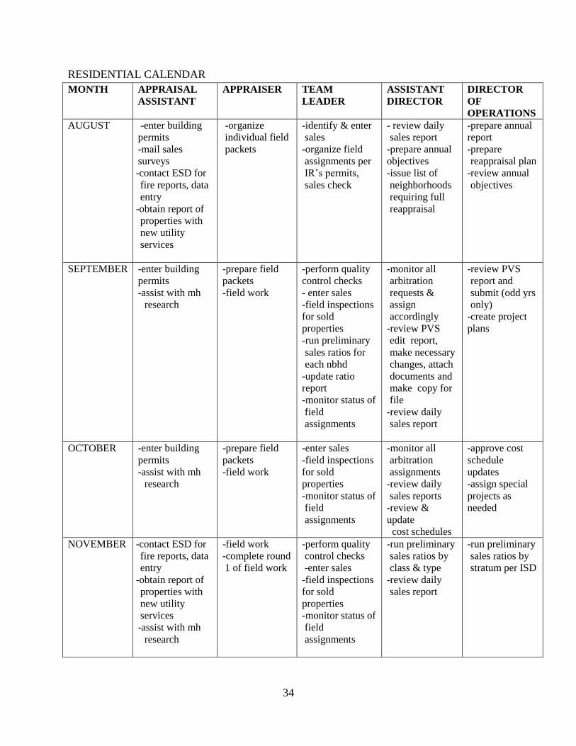
RESIDENTIAL CALENDAR
MONTH APPRAISAL
ASSISTANT
APPRAISER TEAM
LEADER
ASSISTANT
DIRECTOR
DIRECTOR
OF
OPERATIONS
AUGUST -enter building
permits
-mail sales
surveys
-contact ESD for
fire reports, data
entry
-obtain report of
properties with
new utility
services
-organize
individual field
packets
-identify & enter
sales
-organize field
assignments per
IR’s permits,
sales check
- review daily
sales report
-prepare annual
objectives
-issue list of
neighborhoods
requiring full
reappraisal
-prepare annual
report
-prepare
reappraisal plan
-review annual
objectives
SEPTEMBER -enter building
permits
-assist with mh
research
-prepare field
packets
-field work
-perform quality
control checks
- enter sales
-field inspections
for sold
properties
-run preliminary
sales ratios for
each nbhd
-update ratio
report
-monitor status of
field
assignments
-monitor all
arbitration
requests &
assign
accordingly
-review PVS
edit report,
make necessary
changes, attach
documents and
make copy for
file
-review daily
sales report
-review PVS
report and
submit (odd yrs
only)
-create project
plans
OCTOBER -enter building
permits
-assist with mh
research
-prepare field
packets
-field work
-enter sales
-field inspections
for sold
properties
-monitor status of
field
assignments
-monitor all
arbitration
assignments
-review daily
sales reports
-review &
update
cost schedules
-approve cost
schedule
updates
-assign special
projects as
needed
NOVEMBER -contact ESD for
fire reports, data
entry
-obtain report of
properties with
new utility
services
-assist with mh
research
-field work
-complete round
1 of field work
-perform quality
control checks
-enter sales
-field inspections
for sold
properties
-monitor status of
field
assignments
-run preliminary
sales ratios by
class & type
-review daily
sales report
-run preliminary
sales ratios by
stratum per ISD

35
MONTH APPRAISAL
ASSISTANT
APPRAISER TEAM
LEADER
ASSISTANT
DIRECTOR
DIRECTOR
OF
OPERATIONS
DECEMBER -update agents
-enter building
permits
-assist with mh
research
-prepare field
packets for
round 2 field
work
-organize full
reappraisal
assignments and
any special
projects
-perform quality
control checks
-enter sales
-field inspections
for sold
properties
-update
neighborhood
profiles
-monitor all
arbitration
assignments
- monitor status
of field
assignments
-review daily
sales report
-test schedules
JANUARY -update agents
-enter building
permits
-assist with mh
research
-complete field
work by
January 31st
-enter sales
-run sales ratios
per nbhd
-update ratio
report
-contact city for
any additional
information
(historical
areas,
annexations,
etc)
-run edit reports
FEBRUARY -update agents
-assist with mh
research
-data entry
deadline
-field
inspections
-enter sales
-review distribute
values list &
determine if
CAD has
sufficient
evidence for
value change
-review
neighborhood
ratio studies
-run ratios by
class
-review
neighborhood
ratio studies
-run ratios by
stratum per ISD
MARCH -update agents
-assist with mh
research
-review %
change reports
per
neighborhood
(make changes
or may require
additional field
checks)
-re import
updated sales
-print % change
reports for
appraisers
-quality control
check % change
reports
-re import
updated sales
-review ratio
studies on each
ISD
-update
benchmark
study
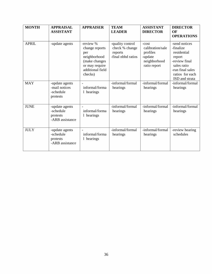
36
MONTH APPRAISAL
ASSISTANT
APPRAISER TEAM
LEADER
ASSISTANT
DIRECTOR
DIRECTOR
OF
OPERATIONS
APRIL -update agents
-review %
change reports
per
neighborhood
(make changes
or may require
additional field
checks)
-quality control
check % change
reports
-final nbhd ratios
-cost
calibration/sale
profiles
-update
neighborhood
ratio report
-send notices
-finalize
residential
report
-review final
sales ratio
-run final sales
ratios for each
ISD and strata
MAY -update agents
-mail notices
-schedule
protests
-
informal/forma
l hearings
-informal/formal
hearings
-informal/formal
hearings
-informal/formal
hearings
JUNE -update agents
-schedule
protests
-ARB assistance
-
informal/forma
l hearings
-informal/formal
hearings
-informal/formal
hearings
-informal/formal
hearings
JULY -update agents
-schedule
protests
-ARB assistance
-
informal/forma
l hearings
-informal/formal
hearings
-informal/formal
hearings
-review hearing
schedules
37
UNIQUE PROPERTIES PLAN
OPERATIONAL PLAN
The purpose of the appraisal district is to discover, list and value the property equitably and at
market value as of January 1st. In the year 2015, the district will focus its field and analysis
effort to properties identified as being in area RA2. The properties that will be part of this
reappraisal will include those with a state code of D1. All properties with a subset of POA
(Property Owners Association) will also be reviewed to determine current use. In the year 2016,
the district will focus its field effort and analysis to RA3. The properties that will be part of this
reappraisal will include those with a state code of D1.
The District will also review, field check, update data and/or change characteristics of any
property outside of the reappraisal area if the property sold, was rendered, and/or requires a field
inspection due to an exemption application or building permit. Any change in ownership or
increase in property value will also generate a notice of appraised value.
PERFORMANCE OBJECTIVES & TARGET COMPLETION
Residences with a property group code of 23.01C will be reviewed to verify that the properties
have a current homestead exemption and verify the highest and best use.
The cost schedules for the B2 (duplex, triplex & 4plex) properties will be reviewed and updated
for 2015. Manufactured housing cost schedules will be reviewed and updated as necessary to
reflect current trends in replacement cost and market. This will be part of the 2015 reappraisal
year.
During 2015, all properties with a subset of POA (Property Owners Association) within RA2
will be reviewed to determine current use.
All properties with an active agricultural or wildlife special valuation will be reviewed and
verified for compliance. This review will begin with those properties in RA2 with a state code of
D1 that have an agricultural application that was filed prior to 2006. In 2016, the district will
review those properties in RA3 with a state code of D1 that have an agricultural application that
was filed prior to 2007.
All properties with the state code of B1(apartments) will be reviewed for 2015 & 2016. The cost
schedules will be updated and an income analysis will be completed.
All condo regimes will be reviewed in 2015 to verify % ownership in common elements.
38
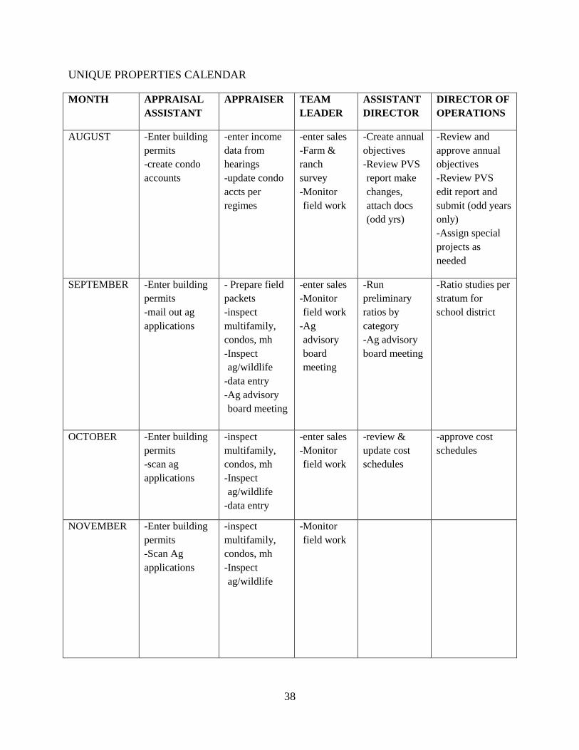
UNIQUE PROPERTIES CALENDAR
MONTH APPRAISAL
ASSISTANT
APPRAISER TEAM
LEADER
ASSISTANT
DIRECTOR
DIRECTOR OF
OPERATIONS
AUGUST
-Enter building
permits
-create condo
accounts
-enter income
data from
hearings
-update condo
accts per
regimes
-enter sales
-Farm &
ranch
survey
-Monitor
field work
-Create annual
objectives
-Review PVS
report make
changes,
attach docs
(odd yrs)
-Review and
approve annual
objectives
-Review PVS
edit report and
submit (odd years
only)
-Assign special
projects as
needed
SEPTEMBER -Enter building
permits
-mail out ag
applications
- Prepare field
packets
-inspect
multifamily,
condos, mh
-Inspect
ag/wildlife
-data entry
-Ag advisory
board meeting
-enter sales
-Monitor
field work
-Ag
advisory
board
meeting
-Run
preliminary
ratios by
category
-Ag advisory
board meeting
-Ratio studies per
stratum for
school district
OCTOBER -Enter building
permits
-scan ag
applications
-inspect
multifamily,
condos, mh
-Inspect
ag/wildlife
-data entry
-enter sales
-Monitor
field work
-review &
update cost
schedules
-approve cost
schedules
NOVEMBER -Enter building
permits
-Scan Ag
applications
-inspect
multifamily,
condos, mh
-Inspect
ag/wildlife
-Monitor
field work
39
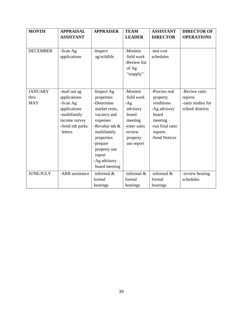
MONTH APPRAISAL
ASSISTANT
APPRAISER TEAM
LEADER
ASSISTANT
DIRECTOR
DIRECTOR OF
OPERATIONS
DECEMBER -Scan Ag
applications
-Inspect
ag/wildlife
-Monitor
field work
-Review list
of Ag
“reapply”
-test cost
schedules
JANUARY
thru
MAY
-mail out ag
applications
-Scan Ag
applications
-multifamily
income survey
-Send mh parks
letters
-Inspect Ag
properties
-Determine
market rents,
vacancy and
expenses
-Revalue mh &
multifamily
properties
-prepare
property use
report
-Ag advisory
board meeting
-Monitor
field work
-Ag
advisory
board
meeting
-enter sales
-review
property
use report
-Process real
property
renditions
-Ag advisory
board
meeting
-run final ratio
reports
-Send Notices
-Review ratio
reports
-ratio studies for
school districts
JUNE/JULY -ARB assistance -informal &
formal
hearings
-informal &
formal
hearings
-informal &
formal
hearings
-review hearing
schedules
40
COMMERCIAL PROPERTY PLAN
OPERATIONAL PLAN
The purpose of the appraisal district is to discover, list and value the property equitably and at
market value as of January 1st of each year. In the year 2015, the district will focus its field and
analysis effort to properties identified as being in area RA2. In the year 2016, the district will
focus its field effort and analysis to RA3. The properties that will be part of this reappraisal will
include those with a state code of F1.
The District will also review, field check, update data and/or change characteristics of any
property outside of the reappraisal area if the property sold, was rendered, recently platted,
and/or requires a field inspection due to an exemption application or building permit. Any
change in ownership or increase in property value will also generate a notice of appraised value.
PERFORMANCE OBJECTIVES & TARGET COMPLETION
The cost schedules for each of the commercial building types will be reviewed and updated as
needed for both 2015 & 2016.
Mini storage and boat storage facilities will be reappraised per cost, market and income
approach. This project should be completed by the 2015 appraisal year.
RV parks will be reappraised per cost, market and income approach. This project should be
completed by the 2015 appraisal year.
Motels will be reviewed both in 2015 and 2016.
Strip centers will be reviewed by 2016.
41
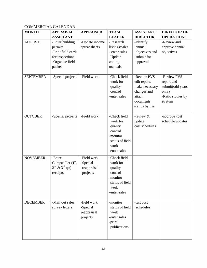
COMMERCIAL CALENDAR
MONTH APPRAISAL
ASSISTANT
APPRAISER TEAM
LEADER
ASSISTANT
DIRECTOR
DIRECTOR OF
OPERATIONS
AUGUST
-Enter building
permits
-Print field cards
for inspections
-Organize field
packets
-Update income
spreadsheets
-Research
listings/sales
- enter sales
-Update
zoning
manuals
-Identify
annual
objectives and
submit for
approval
-Review and
approve annual
objectives
SEPTEMBER -Special projects
-Field work -Check field
work for
quality
control
-enter sales
-Review PVS
edit report,
make necessary
changes and
attach
documents
-ratios by use
-Review PVS
report and
submit(odd years
only)
-Ratio studies by
stratum
OCTOBER -Special projects
-Field work -Check field
work for
quality
control
-monitor
status of field
work
-enter sales
-review &
update
cost schedules
-approve cost
schedule updates
NOVEMBER -Enter
Comptroller (1st,
2nd
& 3rd
qtr)
receipts
-Field work
-Special
reappraisal
projects
-Check field
work for
quality
control
-monitor
status of field
work
-enter sales
DECEMBER -Mail out sales
survey letters
-field work
-Special
reappraisal
projects
-monitor
status of field
work
-enter sales
publications
-test cost
schedules
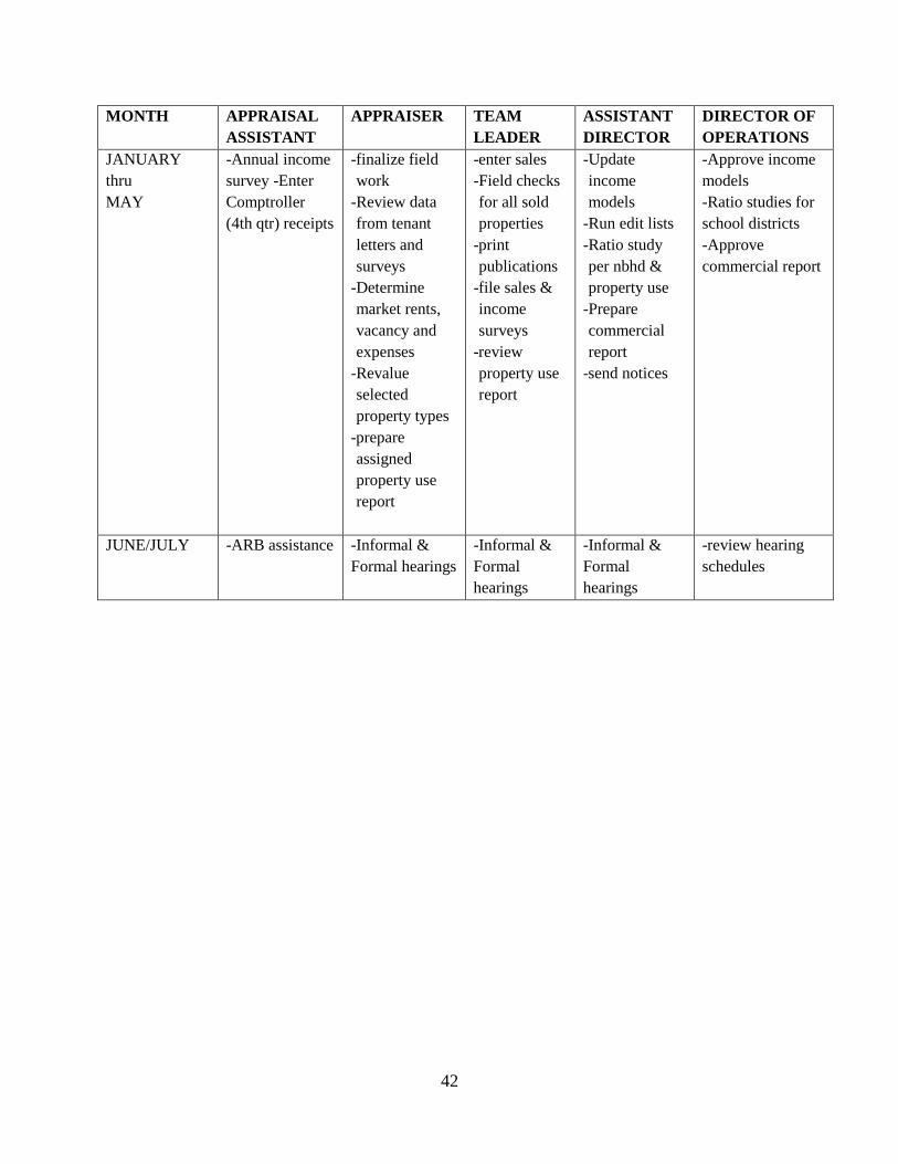
42
MONTH APPRAISAL
ASSISTANT
APPRAISER TEAM
LEADER
ASSISTANT
DIRECTOR
DIRECTOR OF
OPERATIONS
JANUARY
thru
MAY
-Annual income
survey -Enter
Comptroller
(4th qtr) receipts
-finalize field
work
-Review data
from tenant
letters and
surveys
-Determine
market rents,
vacancy and
expenses
-Revalue
selected
property types
-prepare
assigned
property use
report
-enter sales
-Field checks
for all sold
properties
publications
-file sales &
income
surveys
-review
property use
report
-Update
income
models
-Run edit lists
-Ratio study
per nbhd &
property use
-Prepare
commercial
report
-send notices
-Approve income
models
-Ratio studies for
school districts
-Approve
commercial report
JUNE/JULY -ARB assistance
-Informal &
Formal hearings
-Informal &
Formal
hearings
-Informal &
Formal
hearings
-review hearing
schedules

43
BUSINESS PERSONAL PROPERTY PLAN
OPERATIONAL PLAN
The purpose of the appraisal district is to discover, list and value the property equitably and at
market value as of January 1st of each year. All business personal property accounts are
monitored annually. The properties that will be part of this reappraisal will include those with a
state code of L1. Properties coded with the state code of L2 are valued by Capitol Appraisal
Group.
The District will also review, field check, and update data of any business personal property
outside of the reappraisal area if the business sold, closed or is a new, as well as any property
that has building permits issued.
PERFORMANCE OBJECTIVES & TARGET COMPLETION
Review and update all accounts that are not linked to their real property account. This should be
done annually.
Review depreciation schedules and update as necessary.
Check for accounts with no SIC code or situs and update.
Develop value schedule for fuel inventory by 2016.
The 2015 appraisal year will have a new appraiser working in the business personal property
department.
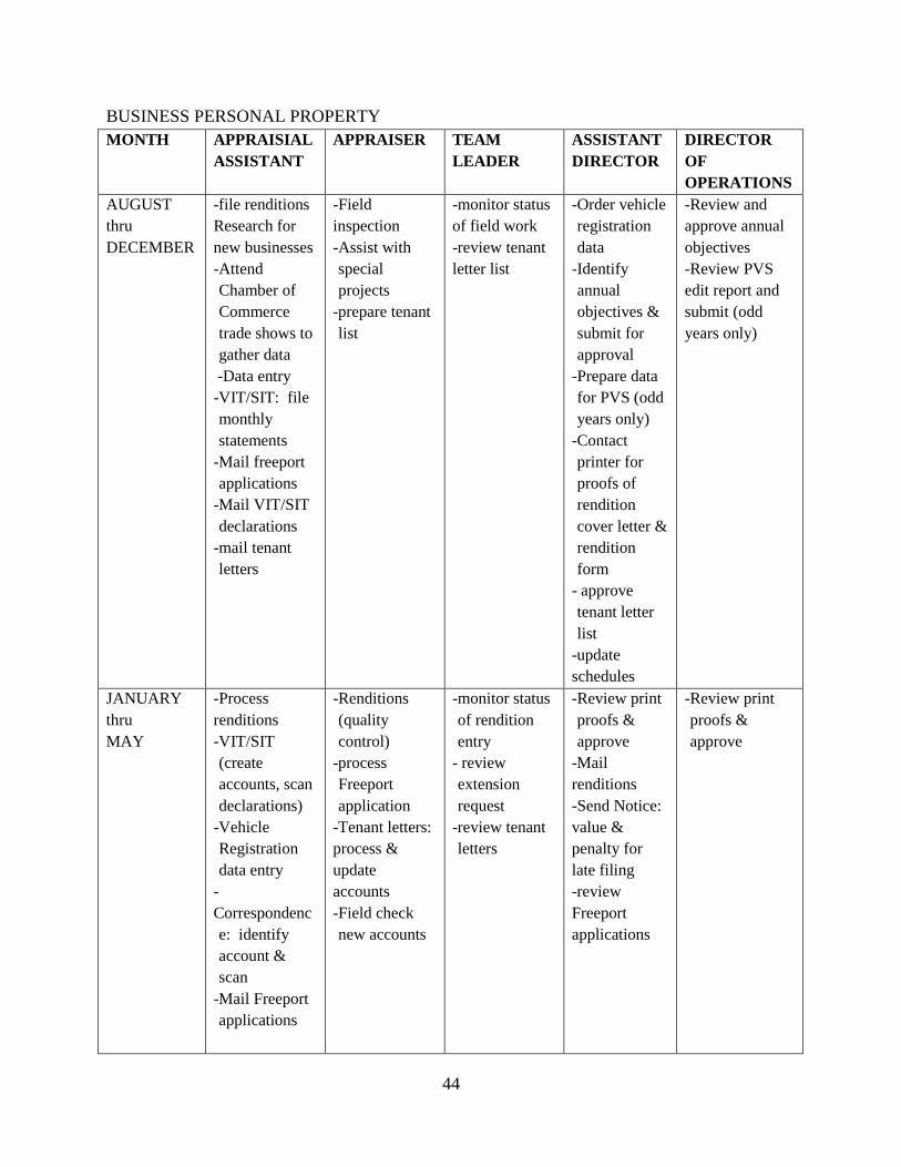
44
BUSINESS PERSONAL PROPERTY
MONTH APPRAISIAL
ASSISTANT
APPRAISER TEAM
LEADER
ASSISTANT
DIRECTOR
DIRECTOR
OF
OPERATIONS
AUGUST
thru
DECEMBER
-file renditions
Research for
new businesses
-Attend
Chamber of
Commerce
trade shows to
gather data
-Data entry
-VIT/SIT: file
monthly
statements
-Mail freeport
applications
-Mail VIT/SIT
declarations
-mail tenant
letters
-Field
inspection
-Assist with
special
projects
-prepare tenant
list
-monitor status
of field work
-review tenant
letter list
-Order vehicle
registration
data
-Identify
annual
objectives &
submit for
approval
-Prepare data
for PVS (odd
years only)
-Contact
printer for
proofs of
rendition
cover letter &
rendition
form
- approve
tenant letter
list
-update
schedules
-Review and
approve annual
objectives
-Review PVS
edit report and
submit (odd
years only)
JANUARY
thru
MAY
-Process
renditions
-VIT/SIT
(create
accounts, scan
declarations)
-Vehicle
Registration
data entry
-
Correspondenc
e: identify
account &
scan
-Mail Freeport
applications
-Renditions
(quality
control)
-process
Freeport
application
-Tenant letters:
process &
update
accounts
-Field check
new accounts
-monitor status
of rendition
entry
- review
extension
request
-review tenant
letters
-Review print
proofs &
approve
renditions
-Send Notice:
value &
penalty for
late filing
-review
Freeport
applications
-Review print
proofs &
approve
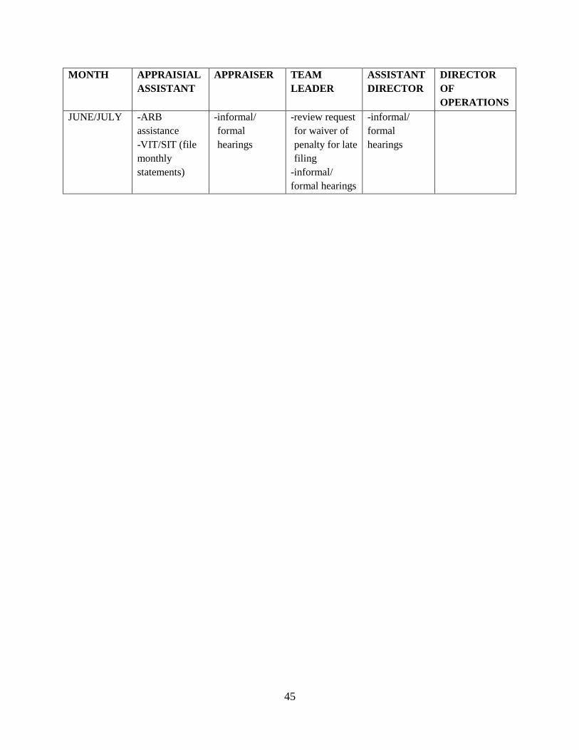
45
MONTH APPRAISIAL
ASSISTANT
APPRAISER TEAM
LEADER
ASSISTANT
DIRECTOR
DIRECTOR
OF
OPERATIONS
JUNE/JULY -ARB
assistance
-VIT/SIT (file
monthly
statements)
-informal/
formal
hearings
-review request
for waiver of
penalty for late
filing
-informal/
formal hearings
-informal/
formal
hearings
46
LAND PROPERTY PLAN
OPERATIONAL PLAN
The purpose of the appraisal district is to discover, list and value the property equitably and at
market value as of January 1st
of each year. In the year 2015, the district will focus its field and
analysis effort on properties identified as being in area RA2. In the year 2016, the district will
focus its field effort and analysis on RA3. The properties that will be part of this reappraisal will
include those within a subdivision.
The District will also review, field check, update data and/or change characteristics of any
property outside of the reappraisal area if the property sold, was rendered, recently platted,
and/or requires a field inspection due to an exemption application. Any change in ownership or
increase in property value will also generate a notice of appraised value.
PERFORMANCE OBJECTIVES & TARGET COMPLETION
The land schedules will be reviewed and updated for each of the neighborhoods in the
reappraisal area.
There are several land projects to be completed for the 2015 appraisal year. They include:
- Conduct sales analysis for commercial and industrial land in the city of Garden Ridge and
in the area known as Bracken.
- Conduct sales analysis for all the land along Hwy 281.
- Review vacant properties in the county set to ARB in prior years.
- Review value in quarries.
There are several residential projects to be completed for the 2016 appraisal year. They include:
- Verify type of utilities available for properties in neighborhood C322-CANYN.
- Review rural land sales and update land schedules.
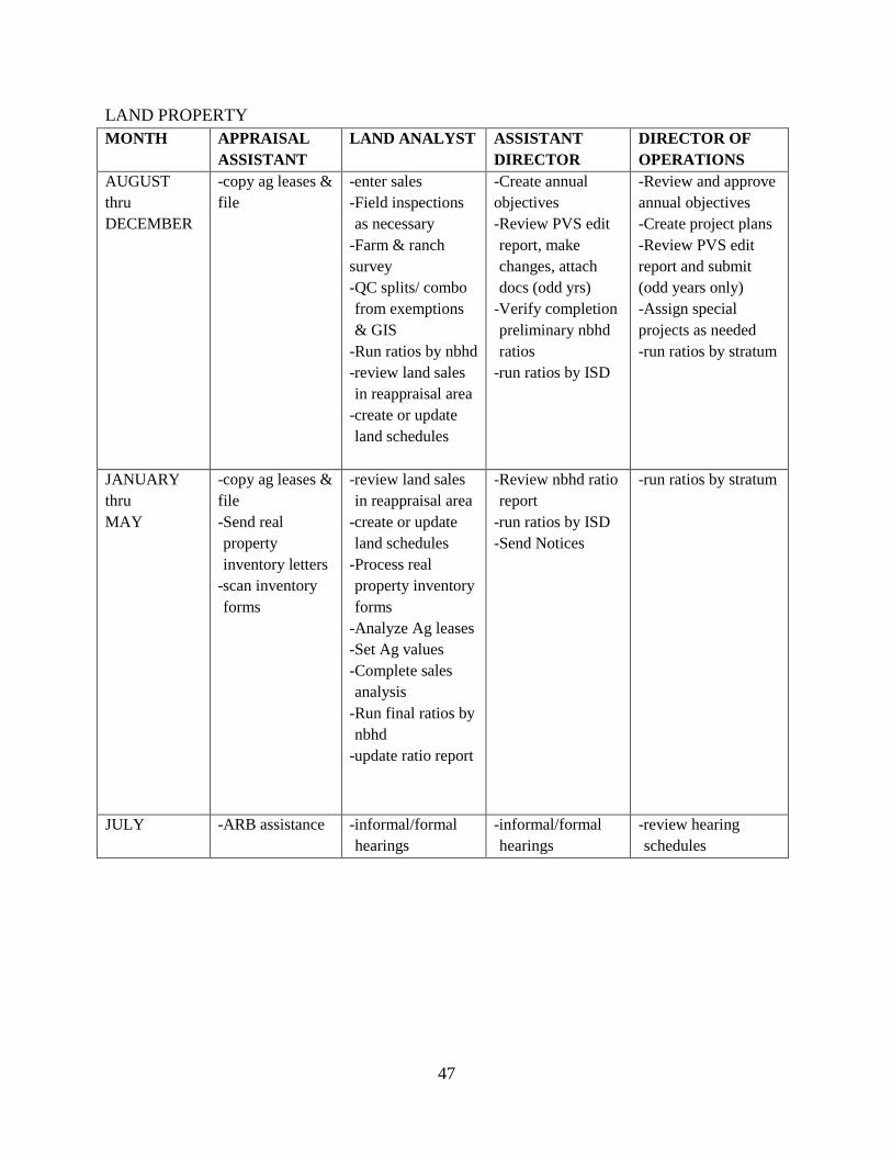
47
LAND PROPERTY
MONTH APPRAISAL
ASSISTANT
LAND ANALYST ASSISTANT
DIRECTOR
DIRECTOR OF
OPERATIONS
AUGUST
thru
DECEMBER
-copy ag leases &
file
-enter sales
-Field inspections
as necessary
-Farm & ranch
survey
-QC splits/ combo
from exemptions
& GIS
-Run ratios by nbhd
-review land sales
in reappraisal area
-create or update
land schedules
-Create annual
objectives
-Review PVS edit
report, make
changes, attach
docs (odd yrs)
-Verify completion
preliminary nbhd
ratios
-run ratios by ISD
-Review and approve
annual objectives
-Create project plans
-Review PVS edit
report and submit
(odd years only)
-Assign special
projects as needed
-run ratios by stratum
JANUARY
thru
MAY
-copy ag leases &
file
-Send real
property
inventory letters
-scan inventory
forms
-review land sales
in reappraisal area
-create or update
land schedules
-Process real
property inventory
forms
-Analyze Ag leases
-Set Ag values
-Complete sales
analysis
-Run final ratios by
nbhd
-update ratio report
-Review nbhd ratio
report
-run ratios by ISD
-Send Notices
-run ratios by stratum
JULY -ARB assistance
-informal/formal
hearings
-informal/formal
hearings
-review hearing
schedules