Embed Size (px)
Citation preview

Columbia Shear Mineral Property Au, Ag, Cu, Ni, Cr, Co, Pt and Pd
Vancouver Island, British Columbia Canada
Location
NTS 92F/2, 92C/15 - BCGS 92F008, 92C098
49°02' 13” N Latitude 124°34' 23” W Longitude
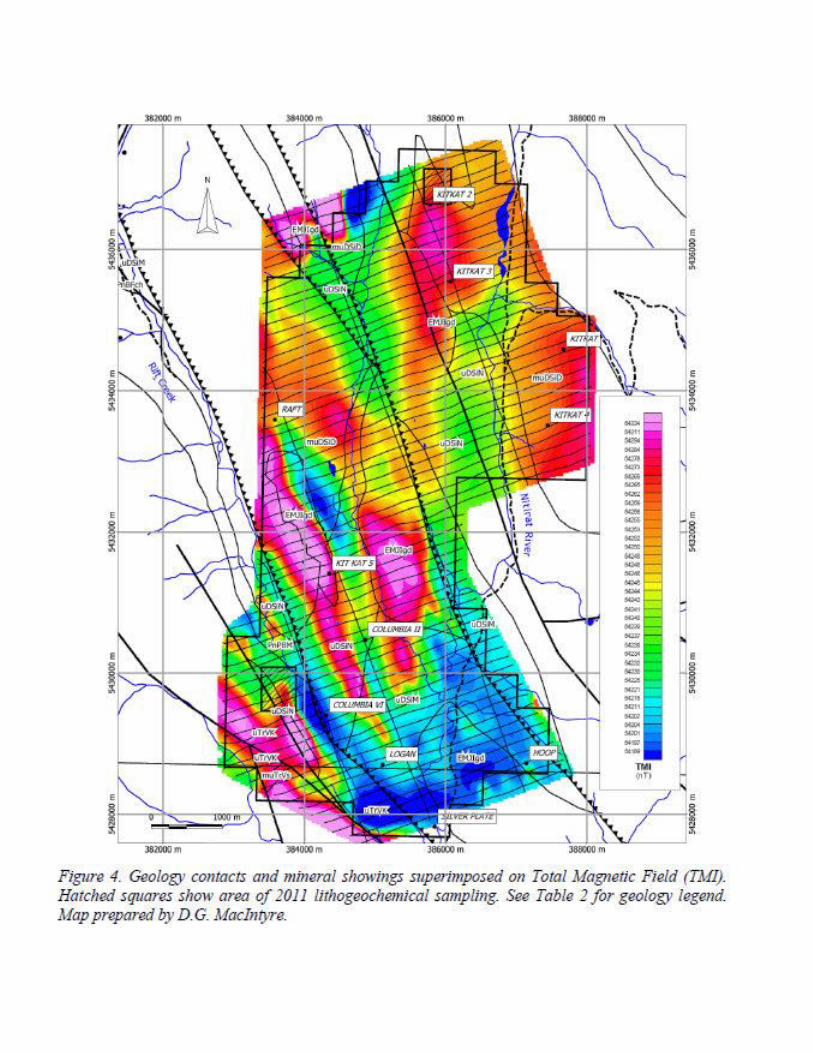
UTM 10 385034E, 5432757N
Victoria Mining Division
Mineral Titles
701043, 739602, 739622, 841870, 841872, 843546, 843559,
845143, 845209, 845221, 845223, 845242, 846577, 848002, 848003,
848004, 848434, 848437, 848438, 848462, 848463, 850730, 1049905
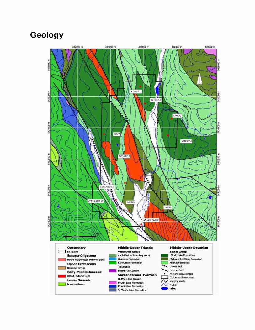
The Columbia Shear property is located on Vancouver Island, British Columbia, Canada,
approximately 30 kilometres southeast of the town of Port Alberni and 45 kilometres
northwest of the town of Lake Cowichan. The Property consists of twenty-three contiguous
mineral titles covering an area of 3346.20 hectares.
Access to the Columbia Shear Property is via logging roads from either the town of Port
Alberni (77 km) or the town of Youbou (34 km). Much of the Property has been logged at
one time or another over the past 100 years with many stands of second and third growth
timber interspersed with more recent clearcuts.
The Columbia Shear Property is underlain by the Duck Lake, Nitinat and McLauglin Ridge
formations of the Devonian age Sicker Group. These island arc volcanic rocks occur in two
southwest directed thrust plates that transect the Property. The Sicker rocks are cut by Early
to Middle Jurassic granodiorite intrusions of the Island Plutonic Suite. Triassic age
submarine basalts of the Karmutsen Formation occur in the south west corner of the
Property, in the footwall of a southwest directed thrust fault that follows the course of Rift
Creek.
The Columbia Shear Property covers prospective rocks of the Devonian Sicker group. These
island arc volcanic rocks are known to host significant volcanogenic massive sulphide
deposits elsewhere on Vancouver Island e.g. the Myra Falls mine at Buttle Lake (Walker,
1983).
There are 10 different mineral occurrences covered by the Columbia Shear Property.
The Kitkat, Kitkat 2, Kitkat 3, Kitkat 5 and Raft showings are all classified as volcanogenic.
This style of mineralization, which may occur as massive sulphide beds or stockwork
veining, is hosted by Devonian age Sicker Group island arc volcanic rocks.
The Kitkat 4, Columbia II, Columbia VI, Hoop and Logan showings are classified as epigenetic
Cu+/-Ag veins. These quartz bearing veins are probably related to the Jurassic Island Plutonic
Suite intrusions. Emplacement of veins typically occurs within shear zones and other zones of
weakness.
Several samples containing high grade Cu mineralization were collected from outcrop and float
in an area located north of the Logan showing. One of these samples returned 4.55% Cu. This
appears to be a new discovery on the Columbia Shear Property and additional follow up work is
recommended.
The area around the Kitkat 5 showing remains a primary target on the Property. Sampling
done in 2017 has confirmed the presence of high grade Cu-Ag mineralization at Kitkat 5
along with anomalous Ni, Cr, Co, Pt and Pd (sample 1735). It is recommended that a grid be
established over this showing and that geophysical, geochemical and geological surveys be
done on this grid to determine the significance and extent of this mineralization.
Geology

History
The Columbia Shear Property covers 10 different mineral showings each of which has its
own history of exploration. The following section describes this historical work. Information
on work done at each of the showings is derived from publicly available assessment
reports.
Silver Plate (St. Anthony) In 1987 Gracey Resources Ltd. collected 55 rock and 558 soil samples from a grid covering
the Silver Plate showing (Minfile #092C 148). They also did geological mapping at 1:5000
scale and 38.0 line km of VLF EM and magnetometer survey work on a new cut grid (Cukor
and Cukor, 1988). The highest assay result, 1.89 grams per tonne gold and 5.48 grams per
tonne silver, was from a rock chip sample (#1904) of a silicified shear containing quartz
veins and occasional hematite in gabbro (Cukor and Cukor, 1988).
In 1988 Gracey Resources Ltd. did an additional 4 km VLF and resistivity survey (Cukor,
1988).
Kitkat The first recorded work covering the Kitkat showings was done by Gunnex Ltd. between
1963 and 1966. This work involved limited prospecting and silt sampling over a large
portion of the E&N Land Grant. There is no mention of showings in the area of the original
Kitkat claims.
The original Kitkat 1-7 claims covered 5 different showings – Kitkat, Kitkat 2, Kitkat 3,
Kitkat 4 and Kitkat 5 all of which were located as a result of work done in 1984 and 1985. In
1984, JBL Resources contracted MPH Consulting Ltd. to do geological, geochemical, and
geophysical work on the Kitkat 1-7 claims. The results of this work are summarized below
and described in detail in assessment report 13945 (Neale and Hawkins, 1985).
The work done by MPH on the Kitkat claims in 1985 was divided into two phases. The
Phase I program consisted of geological mapping (1:10,000 scale), rock sampling and
prospecting covering the entire Property. Approximately 120 rock samples were collected
and analyzed for Au and by 30-element ICP during Phase I. Phase I work was carried out
from May 27 to June 13, 1985.
The Phase I1 program included detailed geological mapping of mineralized zones and
outcrops at scales of 1:75, 1:100 and 1:750, and soil sampling and VLF-EM and
magnetometer surveys carried out on two grids placed over target areas located during Phase
I.
Grid A consisted of a total of 18.1 line km of flagged lines at 100 m line spacing, while Grid
B consisted of 10.5 line km of flagged lines at 200 m line spacing. Soil samples were
collected at 25 m intervals along lines on Grid A and at 50 m intervals on Grid B. A total of
646 soil samples were collected from Grid A and 207 samples from Grid B. All soil samples
were analyzed for Cu, Ag and Zn. VLF-EM and magnetometer readings were taken at 25 m
intervals along lines on both grids. A total of about 89 rock samples was collected during
Phase II.

Soil geochemistry revealed two strongly anomalous zones as well as various smaller, weaker
zones in the northwestern portion of the Property (Grid A). Copper values fall into a range
from 144 to 1180 ppm, zinc values 92 to 820 ppm. All of these anomalous zones are along
the geological trends of north to northwest and coincide with the surface sampling that
revealed high copper and gold in rocks. Due to steep slopes, some displacement of
geochemical anomalies is also evident. Weakly anomalous zones were determined in the
southwestern portion of the Property (Grid B).
Geophysical surveys carried out over the soil sampling grids included VLF-EM and
magnetometer surveys. These surveys located a number of weak VLF-EM conductors and
magnetic anomalies, some of which could be subtle indications of mineralized zones.
Mineralized zones consisting of massive sulphide lenses (pyrite, lesser chalcopyrite,
magnetite, minor pyrrhotite) within narrow shear zones cutting Nitinat Formation rocks on
Grid A yielded grab sample results of up to 2940 ppb Au, greater than 9999 ppm Cu, 2364
ppm Mo, 1140 ppm Co, 360 ppm Pb , 960 ppm Zn, 3.0 ppm Ag, 530 ppm Ni, 145 ppb Pd
and 100 ppb Pt. The massive sulphide lenses occur along zones of shearing and can be
accompanied by hydrothermal alteration of the wallrocks. The mineralized zones are
semicontinuous over a strike length of at least 2000 m.
Soil sampling on Grid A outlined two main subparallel zones strongly anomalous in Cu
and/or Zn 800 m and 750 m long. Soil geochemical values range up to 1180 ppm Cu and up
to 820 ppm Zn. The soil anomalies are approximately parallel to the geological trend and
appear to reflect underlying mineralized zones. Numerous smaller anomalies are scattered
throughout the grid, mainly in the southern and eastern portions. There appears to be
generally good correlation between soil anomalies and the numerous surface Au and Cu
showings.
Samples collected from pyritic Myra Formation rocks near a small flow(?) on the eastern
end of the Kitkat 5 claim returned up to 6702 ppm Cu, 2012 ppm Ni, 4850 ppb Pd, 1650 ppb
Pt, 100 ppb Au, and 5.8 ppm Ag. It was felt that this represented a very high priority target
that should be followed up by extending Grid B to the west (Neale and Hawkins, 1985).
Mineralized zones consisting of wide, intense shear zones cutting Nitinat Formation rocks
on the east side of the Nitinat River and containing quartz-carbonate veins and veinlets
yielded grab sample results of up to 3420 ppb Au. Copper values of up to 9928 ppm were
also obtained from samples from this area, although no samples anomalous in Au were also
anomalous in Cu (or other base metals). All Zn results were low. These mineralized skarn
zones are short and discontinuous and occur in an area of at least 2500 m by 600 m in size.
In 1985-86 Angle Resources Ltd and Nexus Resource Corporation are reported to have
drilled 6 BQ diamond drill holes totalling 595 metres. They also did geological mapping at
1:5,000 scale, soil and rock sampling and IP and magnetometer surveys. The results of this
work are unknown. There does not appear to have been a filing for assessment credit for the
work that was done and consequently there is no publically available assessment report.

Raft The following description of work done in the vicinity of the Raft showing (Minfile #092F
311) is taken from assessment report 14993 (Neale and Hawkins, 1986).
Government geological work in the area includes mapping by C.H. Clapp (1912), J.E.
Muller and D.J.T. Carson (1969), J. E. Muller (1977 and 1980), and A. Sutherland Brown
(1986). A regional aeromagnetic survey flown by Hunting Survey Corp. Ltd. in 1962
included the area of the Raft Group. The results are not known.
From 1963 to 1966 Gunnex Ltd. carried out a regional mapping program over a large
portion of the E & N Land Grant with limited prospecting and silt sampling. They compiled a
list of 11 known mineral occurrences in the area and visited many of them. Silt samples
taken in the area of the present Raft Group returned some anomalous results, but were not
followed up by Gunnex.
In 1983 a program of reconnaissance silt and soil sampling on the Raft Group carried out for
Lode Resource Corporation outlined several areas of interest (House and Sawyer, 1984). A
subsequent follow-up silt sampling and geological mapping program indicated that the
Black Panther/Black Lion shear zone and Au-quartz veins apparently continue to the south,
on the west side of the ridge, while Cu and Zn anomalies occurring on the west side of the
ridge could be indicative of a volcanogenic massive sulphide deposit (Laanela , 1984) .
A rock sample collected by BP-Selco from a massive sulphide (pyrite) boulder on the Raft
claims returned values of 1510 ppb Au, 7.0 ppm Ag, 669 ppm Zn, 544 ppm Cu, 935 ppm
Pb, and 235 ppm As.
An engineering report on the Raft Property was prepared for Vanwin Resource Corporation
by Peter Christopher & Associates Inc. which outlined a recommended work proqram
(Christopher , 1985). No fie1d work was carried out.
In July 1985, reconnaissance geological mapping, prospecting and rock sampling was
carried out by MPH Consulting Ltd. for Vanwin Resource Corporation on the Raft 1 and 2
claims of the Raft Group (Neale and Hawkins, 1985). This work outlined two types of
mineralization occurring in Nitinat Formation (?) mafic volcanics: volcanogenic massive
sulphide mineralization exposed over 0.7m by 8m., and a large surrounding zone of
disseminated to stringer sulphide mineralization 500m. wide by about 5000m. long. The
massive sulphide showing returned values of 1379 ppm Cu and 1.0 ppm Ag from a grab
sample, while the stringer zone returned analyses of up to 6185 ppm Cu, 6570 ppm Zn, 4.0
ppm Ag, 80 ppb Au, 2291 ppm Mo, 32.5 ppm Cd, and 328 ppm Cr from various grab
samples.
Between November 1985 and February 1986, a grid was established on the Raft 1 and 2
claims, and 989 soil samples were collected for geochemical analysis by MPH Consulting
Limited for Vanwin Resource Corporation (Neale, 1986; Neale and Hawkins, 1986).
Geological mapping and sampling and a VLF-EM survey were also carried out during this
time period.
Columbia The following history of the Columbia II and VI showings is from an assessment report
prepared by T. Neale, MPH Consulting Ltd. for Payton Ventues Inc. in 1988 (Neale, 1988).
The first recorded exploration of the Columbia ground was in the early 1960’s, when
Hunting Survey Corp. Ltd. flew a regional aeromagnetic survey, followed by regional
mapping with limited prospecting and silt sampling carried out by Gunnex Ltd. over a large
portion of the old E&N Land Grant. Gunnex located a number of small, low-order Total

Heavy Metal anomalies on the ground now covered by the Columbia Shear claims, mainly
along the central ridge (Laanela, 1986).
The showings were originally staked as the Great Northern claim. No work on that claim is
recorded. Subsequently the Platinum Group claims were staked in July and September 1986.
A program of reconnaissance geological mapping and soil sampling was carried out in
October 1986 over the central and eastern parts of the Property in an effort to locate Pt-Pd
mineralization similar to that located on the Kitkat Property, to the north (Laanela, 1986).
Mapping located mafic Nitinat Formation volcanics with a small amount of later dioritic
intrusions in the northeast corner. Most of the rock sampling was carried out over the “Main
Zone”, a north-northwest trending, strongly silicified, locally sulphide bearing shear zone up
to 50 metres wide which runs along the ridge top across the entire Property.
contained elevated Cu contents, assaying up to 1.23% Cu. Two old drill sites and a pit were
discovered on the Main Zone. It is not known when this work was performed, or what the results
were. The only other significant results came from a rock sample collected from the eastern slope
of Rift Creek valley, of rusty, sheared, carbonatized basalt which ran 5.5 ppm Ag and 5055 ppm
Cu.
Soil sampling on a 200 m by 50 m grid located anomalous Au values in 2 areas on the east
slope of Rift Creek. Anomalous As values extend to the southeast from the western gold
anomaly while Cu and Zn anomalies are partially coincident with the Au anomaly. On the
eastern end of the Property several narrow, elongate Ag anomalies occur.
The 1987 exploration program consisted of reconnaissance geological mapping, prospecting,
rock sampling, soil sampling, and test magnetometer and VLF-EM surveys. A total of 74
rock samples and 253 soil samples were collected. Geological mapping was carried out over
an area of about 2 square kilometres at a scale of 1:5000. The test geophysical surveys were
carried out over 1.65 line km (VLF-EM) and 0.4 line km (magnetometer).
Rock sampling provided the most encouraging results west of Rift Creek. A thin (3-4 cm)
massive pyrite vein returned as assay of 16.22 g/t Au. Four other samples from within 200
m. returned elevated to anomalous values of 22 ppb Au to 2.06 g/t Au. Geochemical soil
sampling outlined a gold anomaly approximately following Rift Creek. It is 30-120 m. wide
by 1200 m. long and open on both ends. Zinc and arsenic anomalies occur near the south
end of the gold anomaly.
Hoop The following description of the history of the Hoop showing is taken from assessment
report 14461 prepared by T. Neal and T.G. Hawkins of MPH consulting for Gator Resources
Corp. (Neale and Hawkins, 1985).
A preliminary assessment of the property based on a limited amount of rock sampling and
geological mapping was done in 1985. Lithogeochemical analysis of the rock samples
returned values of up to 0.8 ppm Ag, 206 ppm Cu and 94 ppm Zn. Whole rock analysis of
five of the samples revealed indications of possible alteration typically associated with
volcanogenic massive sulphide deposits. An area of the property shown by government
mapping as being underlain by West Coast Complex intrusive and metamorphic rocks was
found to actually be underlain by andesitic (to dacitic) volcanics cut by dioritic sills and/or
dykes.

A major northwest trending heavily carbonatized shear zone up to at least 200 m wide
crosses the southwestern corner of the property. Anomalous gold values of up to 120 ppb
over 2 m. as well as some anomalous Cu, Ni and Cr results have been returned from the
shear zone and quartz veins in and near the shear. It is possible that a high-tonnage, lowgrade
Au deposit could be present in the shear zone area of the Hoop property.
Indications of possible volcanogenic massive sulphide mineralization on the Hoop include
anomalous Cu results (up to 364 ppm Cu) from samples containing pods of massive
sulphides and the presence of banded cherty tuff with bands of sulphides up to 3 cm wide.
Logan The area of the Logan showing was first explored by Gunnex Ltd. between 1963 and 1966.
This work involved regional silt sampling and prospecting. Between 1985 and 1987 JBL
Resources completed programs of geological mapping, geochemical sampling, prospecting
and VLF-EM and magnetometer surveys that also covered the area of the Logan showing.
Fourteen chip samples averaged 6.44 grams per tonne gold and 6.34 grams per tonne silver
(high of 12.75 grams per tonne gold and 10.97 grams per tonne silver) (Cukor and Cukor
1988).

Columbia Shear Project Massive Sulphide

This property is offered for sale by way of working option to purchase.
For further information please contact
Craig Lynes:
Rich River Exploration Ltd.
PO BOX 183, GRINDROD BC
V0E-1Y0
Cell: 250-804-6189
Email: [email protected]
Web: www.richriver.bc.ca