Embed Size (px)
Citation preview

Colorado Springs Airport

Colorado Springs Airport
Runways
Runway Length Width
17L-35R 13,501 150
17R-35L 11,022 150
*13-31 8,269 150
*31 Displaced 355 feet (terrain)

Colorado Springs Airport
Runway Safety Areas
All COS runway safety areas are 1,000 x 500
Colorado Springs Airport
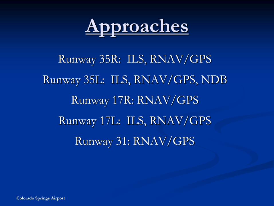
Approaches
Runway 35R: ILS, RNAV/GPS
Runway 35L: ILS, RNAV/GPS, NDB
Runway 17R: RNAV/GPS
Runway 17L: ILS, RNAV/GPS
Runway 31: RNAV/GPS

Colorado Springs Airport
Taxiways
All Taxiways on the movement area are
at least 75 feet wide.

Colorado Springs Airport
Taxiway Safety Areas
All Taxiway Safety Areas are
171 feet wide.

Colorado Springs Airport
Taxiway System
Parallels: A, B, C, E
Stubs: A1-A7, B1-B5, C1-C7, E1-E8
Stubs: M, N, P
Cross field: F, G, H
Mil/IMOS

Colorado Springs Airport
Ramps
Peterson
IMOS
Air carrier
ADACG
JHW & Falcon
Sky West
General Aviation
Colorado Springs Airport
Movement Areas
All Runways and Taxiways are controlled by
FAA ATC.

Colorado Springs Airport
Non-Movement Areas
All Taxilanes and Ramps
Not controlled by ATC

Colorado Springs Airport
Runway Markings
Rwy 17L-35R, 17R-35L
Threshold
Designation
Centerline
Touchdown Zone
Aiming Point
Fixed Distance
Edge
Rwy 13-31
Threshold
Designation
Centerline
Aiming Point
Edge
Displaced Threshold

Colorado Springs Airport
Runway Markings
20Threshold Markings
Runway Designation Markings
Centerline Markings
Aiming Point Markings
Touchdown Zone Markings

Colorado Springs Airport
Cont. Runway Markings
20
Displaced Threshold Markings

Colorado Springs Airport
LAHSO Markings
Runway 35L hold short of 13-31
10,250’ of runway available
Runway 31 hold short of 17R-35L
7,450 feet of runway available

Colorado Springs Airport
Taxiway Markings
Mandatory hold
Centerline
Enhanced centerline
Edge
ILS critical area
Movement area

Colorado Springs Airport
Taxilane Markings
Centerline
Mandatory Hold

Colorado Springs Airport
Taxiway Markings
Runway Hold
Position
Markings:Indicated by two solid and two
broken yellow lines.

Colorado Springs Airport
Cont. Taxiway Markings
Non-Movement
Area Boundary
Markings:Indicated by a solid and dashed
yellow line.
ILS Critical Area
Holding Position
Marking:Indicates location on a taxiway
where an aircraft or vehicle is to
stop when it does not have
clearance.

Colorado Springs Airport
Cont. Taxiway Markings
Taxiway
Markings:Indicated by yellow lines with
black outlines.
End of
Pavement

Colorado Springs Airport
Ramp Markings
Lead-in or J-line Markings

Colorado Springs Airport
Signs
Mandatory Hold (white on red)
Approach (white on red)
ILS (white on red)
Directional (black on yellow)
Location (yellow on black)
Inbound and Outbound Destination (black on yellow)
Runway Distance Remaining (white on black)

Colorado Springs Airport
Airfield Signage
Hold PositionIndicated by white numbers
on a red background.
Taxiway
Location :Indicated by yellow letters
on a black sign.

Colorado Springs Airport
Cont. Airfield Signage
Outbound
Destination
SignIndicates the direction
of runway for outbound
aircraft.
Inbound
Direction Sign:Indicates the direction of
destinations for pilots. This
sign indicates direction to
the Military installation.

Colorado Springs Airport
Cont. Airfield Signage
Mandatory Hold
Position Signs for
Runway:Do not proceed beyond this sign
without clearance from ATCT.
Hold Position
Signs for Runway
Approach Areas:Installed on Taxiways that are
located in the approach areas.

Colorado Springs Airport
Cont. Airfield Signage
Runway Distance
Remaining Sign:Sign number indicates the
length of runway remaining in
1,000 of feet.
ILS Critical
Area Mark the boundary of an ILS critical
area, and advice operators where to stop
to avoid interfering with aircraft
navigational signals.

Colorado Springs Airport
Cont. Airfield Signage
Direction Sign:Sign number indicates the
length of runway remaining in
1,000 of feet.

Colorado Springs Airport
Runway Lighting
Edge (white/amber)
Threshold (green/red)
LAHSO
In-pavement lights (17L-35R)
Centerline
Touchdown Zone

Colorado Springs Airport
Taxiway Lights
Edge (Blue)
TAXIWAY edges
are indicated by
Blue lights.

Colorado Springs Airport
Airfield Lighting
20
RUNWAY edges are
indicated by White
lights, followed by
Amber and then Red
as you move closer
to the end of the
runway.

Colorado Springs Airport
Visual Approach Aids
Rwy 17L: MALSR , PAPI
Rwy 35R: REIL , PAPI
Rwy 17R: REIL , PAPI
Rwy 35L: MALSR, PAPI
Rwy 13: REIL, PAPI
Rwy 31: REIL, PAPI

Colorado Springs Airport
View of VASI
from approach.
Visual Approach Slope Indicator (VASI)
The VASI is a system of lights on
the side of an airport runway that
provides visual descent guidance
information during the approach to
a runway

Colorado Springs Airport
Standard VASI
Consist of two sets of lights
Each set designed to appear either white or red depending on angle viewed.
If on “Glide Slope”, first set of lights will appear white and second set red.
If “High on Glide Slope”, both appear white.
If “Low on Glide Slope”, both appear red.
Most common type of VASI system
Standard VASI system
viewed from approach.

Colorado Springs Airport
Precision Approach Path Indicator
(PAPI)
A light system that consists of two,
three, or four boxes of lights that
provide a visual indication of an
aircraft’s position on the glidepath.
Depending on the angle, lights will
appear red or white.
On glidepath when two white and two
red lights are viewed.
If high more white lights will be visible.
If low more red lights will be visible.
Precision Approach Path Indicator (PAPI)

Colorado Springs Airport
Airport Information Phone Numbers
ATIS (Automatic Terminal Information Service): (719) 596-7040
ASOS (Airport Surface Observation Service): (719) 637-9696
Airfield Conditions Report (24 hours automated message): (719) 550-1942
COS Airport Communications Center: (719) 550-1918