Embed Size (px)
Citation preview
National Park Service U.S. Department of the Interior
Grand Canyon National Park Arizona
Colorado River Management Plan Record of Decision
Approved: Michael D. Snyder February 17, 2006 Intermountain Regional Director National Park Service


1
UNITED STATES DEPARTMENT OF THE INTERIOR NATIONAL PARK SERVICE
RECORD OF DECISION
COLORADO RIVER MANAGEMENT PLAN ENVIRONMENTAL IMPACT STATEMENT
Grand Canyon National Park
Arizona
The Department of the Interior, National Park Service (NPS) has prepared this Record of Decision on the Final Environmental Impact Statement/Colorado River Management Plan for Grand Canyon National Park. This Record of Decision includes a description of the background of the project, a synopsis of the alternatives considered, a description of the environmentally preferred alternatives, public and agency involvement, the decision making process, a statement of decision, the basis for the decision, and findings on impairment of park resources and values.
BACKGROUND OF THE PROJECT
The Colorado River Management Plan is primarily a visitor use management plan that specifies actions to conserve park resources and the visitor experience while enhancing recreational opportunities on the Colorado River through Grand Canyon National Park. The Final Environmental Impact Statement/ Colorado River Management Plan dated November 2005 evaluated a full range of alternatives for the identified issues, including visitor use levels, allocation between commercial and noncommercial sectors, levels of motorized raft use, and visitor use management options. It also evaluated impacts to natural and cultural resources, visitor experience and wilderness character from visitor uses on the Colorado River, and considered and analyzed the social and economic effects of the various alternatives on the Hualapai Tribe. This plan revises and updates a Colorado River Management Plan developed in 1980 and revised in 1981 and 1989.
A revised Colorado River Management Plan is needed to address both long-standing and recent issues concerning resource protection, visitor experience, and visitor services along the river; to consider the impacts of NPS river management on federally recognized American Indian tribes whose reservations adjoin Grand Canyon National Park; to implement objectives and visions in the park’s 1995 General Management Plan; and to fulfill the requirements of a 2002 agreement that settled a lawsuit concerning the river management plan.
For purposes of this plan, the Colorado River has been divided into two geographic sections, with a specific set of alternatives for each section. For the upper section from Lees Ferry (River Mile [RM] 0) to Diamond Creek (RM 226), the Final EIS (FEIS) considered eight alternatives, including a no-action alternative (Alternative A) and a preferred alternative (Modified Alternative H). For the Lower Gorge section from Diamond Creek (RM 226) to Lake Mead (RM 277), the FEIS considered five alternatives, including a no-action alternative (Alternative 1), a National Park Service preferred alternative (Modified Alternative 4), and a Hualapai Tribe proposed alternative (Alternative 5).

RECORD OF DECISION
2
Purpose of the Plan The purpose of the plan is: 1) to evaluate a range of reasonable alternatives and strategies to develop an improved framework for managing visitor use of the Colorado River corridor for at least the next 10 years and 2) to adopt a revised Colorado River Management Plan that ensures compliance with federal laws, regulations, policies, previous planning decisions, the park’s vision, and other mandates for the management of recreational use on the Colorado River through Grand Canyon National Park.
The park adjoins the Hualapai Reservation for 108 miles along the Lower Gorge of the Colorado River. Although the Department of the Interior and the Hualapai Tribe disagree as to the location of the reservation’s northern boundary (see Response to Comment T38 on pp. 285-87 in Volume III of the FEIS), the NPS’s management of the Colorado River within the park unquestionably affects tribal resources and values, and the tribe served as a cooperating agency in the preparation of the Environmental Impact Statement. According to the Hualapai Tribe, the purpose of the plan is to “preserve and protect tribal traditions, culture, sovereignty, and resources for future generations and to cooperate on a government-to-government basis with local, state, and federal governments”. The tribe is also a party to intergovernmental agreements with the NPS with respect to regulatory controls on adjoining federal and tribal lands.
DECISION (SELECTED ACTIONS)
The NPS will implement the preferred alternatives (Modified Alternative H and Modified Alternative 4) as described in the Final Environmental Impact Statement/Colorado River Management Plan. Together these two alternatives constitute the NPS’s selected action for the entire Colorado River corridor in Grand Canyon National Park.
Key Actions: Lees Ferry to Diamond Creek, Modified Alternative H Modified Alternative H is the NPS preferred alternative and the selected action for the section of river from Lees Ferry to Diamond Creek. This is a mixed motor/no-motor alternative that reduces the maximum group size for commercial groups; establishes use patterns based on daily, weekly, and seasonal launch limits; and increases noncommercial use primarily in the shoulder and winter months. Key features of this selected action for the Lees Ferry to Diamond Creek section are summarized in the tables and text below.
Summary of Modified Alternative H Mixed-Use Season 5.5 months (April 1 through September 15) No-Motor Season 6.5 months (Sept 16–March 31) Whitmore Exchanges (months allowed) April-Sept Maximum Group Size (Guides will be included in the commercial group size)
32 passengers (May–Aug)/24 passengers (Remainder) 16 passengers
Commercial Motor/Commercial Oar Noncommercial Standard Noncommercial Small 8 passengers Maximum Trip Length to Diamond Creek Summer
(May–August) Shoulder Seasons
(March–April/September–October) Winter
(November–February) 10 days 12 days N/A 16 days 18 days N/A 12 days 12 days N/A
Commercial Motor Commercial Oar Noncommercial Motor Noncommercial Oar 16 days 18 days(Sept 1-15), 21
(Remainder) 25 days
Maximum Number of Launches per Day
6 4 (April 16–30), 6 (Sept 1–15), 3 (Remainder)
1
Estimated Yearly Totals User Days 228,986
User Discretionary Time (Hours) 567,238
Passengers 24,657
Estimated Maximums Trips at One Time 60
Passengers at One Time 985
DECISION (SELECTED ACTIONS): Key Actions: Lees Ferry to Diamond Creek, Modified Alternative H
3
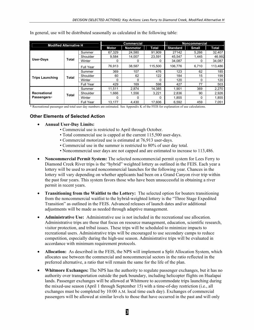
In general, use will be distributed seasonally as calculated in the following table:
* Recreational passenger and total user day numbers are estimated. See Appendix K of the FEIS for explanation of use calculations.
Other Elements of Selected Action
• Annual User-Day Limits: • Commercial use is restricted to April through October. • Total commercial use is capped at the current 115,500 user-days. • Commercial motorized use is estimated at 76,913 user-days. • Commercial use in the summer is restricted to 80% of user day total. • Noncommercial user days are not capped and are estimated to increase to 113,486.
• Noncommercial Permit System: The selected noncommercial permit system for Lees Ferry to Diamond Creek River trips is the “hybrid” weighted lottery as outlined in the FEIS. Each year a lottery will be used to award noncommercial launches for the following year. Chances in the lottery will vary depending on whether applicants had been on a Grand Canyon river trip within the past four years. This system favors those who have been unsuccessful in obtaining a river permit in recent years.
• Transitioning from the Waitlist to the Lottery: The selected option for boaters transitioning from the noncommercial waitlist to the hybrid-weighted lottery is the “Three Stage Expedited Transition” as outlined in the FEIS. Advanced releases of launch dates and/or additional adjustments will be made as needed through adaptive management.
• Administrative Use: Administrative use is not included in the recreational use allocation. Administrative trips are those that focus on resource management, education, scientific research, visitor protection, and tribal issues. These trips will be scheduled to minimize impacts to recreational users. Administrative trips will be encouraged to use secondary camps to reduce competition, especially during the high-use season. Administrative trips will be evaluated in accordance with minimum requirement protocols.
• Allocation: As described in the FEIS, the NPS will implement a Split Allocation System, which allocates use between the commercial and noncommercial sectors in the ratio reflected in the preferred alternative, a ratio that will remain the same for the life of the plan.
• Whitmore Exchanges: The NPS has the authority to regulate passenger exchanges, but it has no authority over transportation outside the park boundary, including helicopter flights on Hualapai lands. Passenger exchanges will be allowed at Whitmore to accommodate trips launching during the mixed-use season (April 1 through September 15) with a time-of-day restriction (i.e., all exchanges must be completed by 10:00 A.M. local time each day). Exchanges of commercial passengers will be allowed at similar levels to those that have occurred in the past and will only
Commercial Noncommercial Modified Alternative H Motor Nonmotor Total Standard Small Total
Summer 67,329 24,580 91,909 27142 5,266 32,407Shoulder 9,584 14,007 23,591 45,547 1,445 46.992Winter 0 0 0 34,087 0 34,087User-Days Total
Full Year 76,913 38,587 115,500 106,776 6,710 113,486Summer 369 107 476 123 62 185Shoulder 60 62 122 184 15 199Winter 0 0 0 120 0 120
Trips Launching Total
Full Year 429 169 598 427 77 503Summer 11,511 2,874 14,385 1,901 369 2,270Shoulder 1,666 1,556 3,221 2,836 90 2,926Winter 0 0 0 1,855 0 1,855
Recreational Passengers∗ Total
Full Year 13,177 4,430 17,606 6,592 459 7,051

RECORD OF DECISION
4
be allowed by companies currently conducting Whitmore exchanges (i.e., grandfather clause in contracts). It is assumed that all passengers exiting their trips at Whitmore will continue to be transported by helicopter. For passengers beginning their river trips at Whitmore, an estimated 3,635 will be transported in by helicopter and 400 will hike in for a total of 4,035 passengers entering the river corridor. Using the average total annual Lees Ferry passengers exchanging at Whitmore from 1998 through 2003, this will result in an estimated 5,715 passengers exiting the river corridor at Whitmore each year.
• Launches per Day: To reduce crowding and bottlenecks, a launch-based system will be instituted to distribute launches more evenly. There are a maximum of six launches per day. Allowable launches per day by trip type for each month are shown in the following figure.
FIGURE 1
Key Actions: Lower Gorge, Modified Alternative 4 Modified Alternative 4 is the NPS preferred alternative and the selected action for the section of river from Diamond Creek to Lake Mead. It represents agreement between the NPS and the Hualapai Tribe, achieved through extensive consultation, on most issues relating to the elements of use, specifically for trips launching at or continuing past Diamond Creek. However, agreement could not be reached after extensive consultation and incorporation of Hualapai tribal concerns, on the level of pontoon boat operations and upstream travel from Lake Mead. The NPS increased daily pontoon passenger levels in the Quartermaster area from 150 passengers per day in the DEIS to 480 passengers per day (potentially increasing to 600 passengers per day) in the FEIS to allow substantial growth in tribal activities. The higher levels of pontoon boat operations proposed by the Hualapai Tribe are reflected in Alternative 5 found on page 13. Another area of disagreement was the level of upriver, motorized trip takeouts. The NPS’s Modified alternative 4 will allow up to four takeouts per day during the peak season and one per day during the non-peak season up to RM240, while the Hualapai Tribe preferred no upriver, motorized trip takeouts beyond RM273.
0
1
2
3
4
5
6
7
8
9
Jan Feb Mar Apr1-15
Apr16-30
May Jun Jul Aug Sep1-15
Sep16-30
Oct Nov Dec
Month
Laun
ches
Non-commercial (small) Non-commercial (std) Commercial Oar Commercial motor
Maximum Launches per Day
Average Launches per Day
DECISION (SELECTED ACTIONS): Key Actions: Lower Gorge, Modified Alternative 4
5
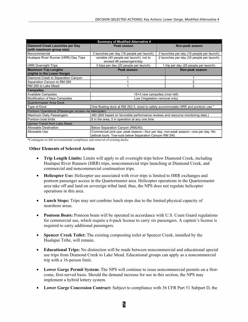
Summary of Modified Alternative 4 Diamond Creek Launches per Day (with maximum group size)
Peak season Non-peak season
Noncommercial 2 launches per day (16 people per launch) 2 launches per day (16 people per launch) Hualapai River Runner (HRR) Day Trips variable (40 people per launch), not to
exceed 96 passengers/day 2 launches per day (35 people per launch)
HRR Overnight Trips 3 trips per day (20 people per launch) 1 trip per day (20 people per launch) Maximum Trip Lengths (nights in the Lower Gorge)
Peak season Non-peak season
Diamond Creek to Separation Canyon 1 1 Separation Canyon to RM 260 1 2 RM 260 to Lake Mead 1 2 Campsites Available Campsites 15+3 new campsites (river left) Modification of New Campsites Low (Vegetation removal only) Quartermaster Area Dock Type of Dock One floating dock at RM 262.5, sized to safely accommodate HRR and pontoon use.* Pontoon Operations (Passenger access via helicopter) Maximum Daily Passengers 480 (600 based on favorable performance reviews and resource monitoring data.) Pontoon boat limits 6 in the area, 5 in operation at any one time Upriver Travel from Lake Mead Allowable Destination Below Separation Canyon (RM240). Allowable Use Commercial pick-ups: peak season—four per day; non-peak season—one per day. No
jetboat tours. Tow-outs below Separation Canyon RM 240. *Contingent on full environmental compliance and removal of existing docks. Other Elements of Selected Action
• Trip Length Limits: Limits will apply to all overnight trips below Diamond Creek, including Hualapai River Runners (HRR) trips, noncommercial trips launching at Diamond Creek, and commercial and noncommercial continuation trips.
• Helicopter Use: Helicopter use associated with river trips is limited to HRR exchanges and pontoon passenger access in the Quartermaster area. Helicopter operations in the Quartermaster area take off and land on sovereign tribal land; thus, the NPS does not regulate helicopter operations in this area.
• Lunch Stops: Trips may not combine lunch stops due to the limited physical capacity of nearshore areas.
• Pontoon Boats: Pontoon boats will be operated in accordance with U.S. Coast Guard regulations for commercial use, which require a 6-pack license to carry six passengers. A captain’s license is required to carry additional passengers.
• Spencer Creek Toilet: The existing composting toilet at Spencer Creek, installed by the Hualapai Tribe, will remain.
• Educational Trips: No distinction will be made between noncommercial and educational special use trips from Diamond Creek to Lake Mead. Educational groups can apply as a noncommercial trip with a 16-person limit.
• Lower Gorge Permit System: The NPS will continue to issue noncommercial permits on a first-come, first-served basis. Should the demand increase for use in this section, the NPS may implement a hybrid lottery system.
• Lower Gorge Concession Contract: Subject to compliance with 36 CFR Part 51 Subpart D, the

RECORD OF DECISION
6
NPS will award the Hualapai Tribe a temporary noncompetitive concession contract for a maximum of three years for Lower Gorge operations as described in the FEIS.
• Continuation Trips: Lees Ferry trips bypassing Diamond Creek (continuation trips) will have the same trip length limits as overnight trips launching at Diamond Creek. Operating requirements for continuation trips do not change below Diamond Creek. Visitation of Hualapai lands requires a permit from the Hualapai Tribe.
Other Elements of the Selected Actions (Applicable to the Entire Colorado River Corridor) • Life of the Plan: While this plan is intended to have a life of at least 10 years, park managers
may periodically review the plan, and if necessary, amend specific sections. If it is determined that the plan has continuing viability, then its effective life may be extended.
• Adaptive Management: As part of the monitoring and implementation plan to follow this Record of Decision, the limits of acceptable change indicators and standards from the 1989 Colorado River Management Plan will be updated and implemented, as appropriate. If resource conditions change sufficiently to adversely affect resources or visitor experiences (e.g., disappearing beaches), or if mitigation measures cannot be adequately funded or implemented or are unsuccessful, park managers will use an adaptive management approach to review and revise visitor use prescriptions in this plan.
• Management Zones: As described in the FEIS, the plan establishes management zones that reflect the variety and intensity of visitor activities, particularly in the river segments downstream from Diamond Creek where the Hualapai Tribe and Grand Canyon National Park share boundaries.
• Commercial Services: The Colorado River Management Plan addresses commercial activities on the river. Description and analysis of potential impacts on the affected environment resulting from commercial operations are found throughout the FEIS. Determination of the types and levels of commercial services that are necessary and appropriate for the Colorado River through Grand Canyon National Park were determined through these analyses. New contracts for commercial operations will be issued in 2006. These contracts will be issued in accordance with the National Park Service Concessions Management and Improvement Act of 1998 (16 USC 5951) and implementing regulations at 36 CFR 51. Concession contracts and operating plans will reflect management decisions reached in this Record of Decision and will provide quality visitor experiences consistent with the preservation of the park’s natural and cultural resources.
• Initiatives Related to Culturally Affiliated Indian Tribes: The NPS will implement three initiatives related to culturally affiliated American Indian tribes to enhance interpretation of the Grand Canyon from a Native American perspective:
1. In accordance with 36 CFR subsection 51.17(b)(2), the NPS will include in the prospectus for the commercial river-running concession contracts a secondary selection factor calling for the interpretation of the Grand Canyon from the perspective of American Indian tribes that have historical ties to the canyon and are culturally affiliated with it.
2. The NPS has initiated the requisite discussions with the Department of the Interior concerning the Hualapai Tribe’s efforts to obtain special legislation for the Tribe or a tribally owned enterprise to obtain a noncompetitive full-river concession contract. At an appropriate time and in response to a request from Congress, the Department will determine its official position with respect to any such legislative proposal.
DECISION (SELECTED ACTIONS): Mitigating Measures/Monitoring
7
3. The NPS will assist any federally recognized American Indian tribe that has historical ties to the canyon and is culturally affiliated with it in gaining the expertise and skills necessary to compete for procurement contracts to provide services and logistical support for administrative trips, including research trips. At the request of any tribe meeting those criteria, the NPS will provide such assistance.
• Operating Requirements: Commercial and noncommercial operating requirements will be revised to address safety and environmental concerns pursuant to the revised Colorado River Management Plan. Guidance for developing and revising the operating requirements, including public involvement and notification, is provided in the FEIS. Key revisions to operating requirements include:
o General (Commercial and Noncommercial)
• Recreational passengers will be limited to one river trip per year from Lees Ferry to Diamond Creek.
• Visitation at the mouth of Tapeats and Kanab Creeks will be restricted to day-use only.
• To protect humpback chub, visitation at the southern half of the Little Colorado River will be restricted seasonally (March 1 to November 30).
• Generator use will be limited to emergency situations and inflating rafts. The use of generators for other purposes will be evaluated through the minimum requirement process.
o Commercial Only
• To improve safety, commercial passengers must be accompanied by a NPS-approved guide on all trip-related hikes, including hiking exchanges into and out of the canyon.
• Regulations: The NPS will conduct appropriate rulemaking to implement this Record Of Decision, including, if necessary, rulemaking to amend the regulations currently found at 36 CFR subsection 7.4(b).
Mitigating Measures/Monitoring
Adaptive Management, Commercial Operating Requirements, Concessions Contracts, and Partnerships
Mitigation measures are embedded in the preferred alternatives in the CRMP, such as smaller group sizes, shorter trip lengths, trips at one time capped at 60, number of encounters per day less than seven, and number of launches per day six or less. However, impact analyses in the FEIS indicate that the preferred alternatives may still have moderate to major effects on some resources. In order to reduce impacts to levels that are acceptable within the framework of regulations, executive orders or policies while meeting legal requirements, mitigation measures beyond the actions described in the decision are necessary and were enumerated throughout Chapter 4 of the CRMP FEIS. These mitigations will be implemented as described below.
The selected alternatives also include a provision for adaptive management. Adaptive management provides for systematic feedback to park management and allows for adjustment of activities to mitigate unplanned or undesirable outcomes. For example if increased winter use is found to cause a significant decline in driftwood supplies, the NPS may institute a ban on the collection of firewood for campfires; if campsite competition above the takeout at Diamond Creek becomes a problem, the NPS may choose to schedule launches and take-outs at Diamond Creek and “last-night” camps above Diamond Creek and “first-night” camps below Diamond Creek.
RECORD OF DECISION
8
Another means through which unforeseen impacts can be mitigated is through administrative procedures that may be added to the commercial operating requirements (COR’s) as part of concessions contracts or as part of the noncommercial operating regulations. These may include site restrictions such as closures on a temporary, permanent or seasonal basis or use limits such as group size, number of parties, specific use types, or curfews on specific behaviors such as on the use of electronic devices.
The NPS will continue to utilize partnerships to cooperatively undertake mitigation measures on both NPS and adjacent lands. The NPS has developed partnerships with local, federal, state, tribal and volunteer organizations that are crucial to implementing mitigation measures. These partners assist the NPS in restoration activities, inventory and monitoring of resource conditions.
Overarching mitigations across all impact topics
Implicit in the implementation of the CRMP alternatives is the need to employ additional mitigations in order to reduce disclosed impacts to minor levels. Some mitigation measures reduce the effects of the alternatives on multiple resources as well as help to ensure a quality visitor experience.
Education
1. Create a multi-media educational program for all users that teaches users about river safety and etiquette, permitting requirements (on NPS and adjacent lands), park regulations, ways to avoid impacts to natural and cultural resources and crowding at camps and attraction sites, minimum impact practices, camping protocols (campsite map), appropriate uses in management zones, tribal/agency boundaries, and appropriate behavior at sacred sites.
2. Provide on-site education (e.g., interpretive staff).
Limits of Acceptable Change Standards
Revise existing and create new standards for each of the specific resources within the Limits of Acceptable Change framework. Prescribe management actions to avoid major and irreversible impacts to resources. In cooperation with the Hualapai Tribe, develop thresholds and standards, which would trigger mitigations and management actions at Lower Gorge sites.
Inventory Resources
Inventory natural and cultural resources to establish or update baseline data for the monitoring program as required by the National Parks Omnibus Act of 1998 and management policies.
Monitoring Program
Develop and implement a multi-resource monitoring program for the entire river corridor accounting for visitor experience and natural and cultural resource conditions as required by the National Parks Omnibus Act of 1998. The program will focus on areas affected by river recreation where visitor experience may be negatively affected and where the integrity of natural and cultural resources may be at risk. Develop a database to manage the data collected from the CRMP monitoring program.
Cyclic Maintenance
Implement a site-specific restoration program including trail maintenance, social trail obliteration, blocking access to sensitive sites, revegetation of denuded areas, invasive plant management, campsite delineation, soil stabilization, and erosion control, and explore new restoration techniques for desert environments.
DECISION (SELECTED ACTIONS): Mitigating Measures/Monitoring
9
Increase NPS Presence
Increase the level of law enforcement, resource management and maintenance presence to address the increased use in the shoulder and winter seasons, to educate and enforce environmental and boating regulations, and to support increased monitoring and restoration activities due to year round use of the river corridor.
Resource specific mitigations
In addition to the overarching mitigation measures, there are a number of mitigations that pertain to specific resources that are, in some instances, required by law.
Natural Resources
1. Biological Opinion: Implement conservation measures and reasonable and prudent measures as outlined in Attachment A: Conservation Measures and Reasonable and Prudent Measures from the Biological Opinion.
2. Environmental Protection Agency Water Quality: In cooperation with the Hualapai Tribe, develop and implement best management practices to prevent oil spills and discharges of wastes associated with recreational activities in the Lower Gorge. Work with the Hualapai Tribe, State, and other partners to obtain baseline and periodic water quality monitoring information so that activities affecting water quality can be adaptively managed.
Cultural Resources
1. Programmatic Agreement among the National Park Service, Advisory Council on Historic Preservation, Arizona State Historic Preservation Office, Hualapai Tribe and Navajo Nation.
To address these impacts, the NPS will develop an ongoing CRMP historic property monitoring and management program (CRMP Historic Property Program) to assess impacts to site condition and integrity from visitor use within the area of potential effect (APE) and determine and implement treatments to avoid, minimize, or mitigate these effects. This CRMP historic property program will be developed and implemented in consultation with all of the signatories and concurring parties to this agreement, as appropriate, and will provide a link to the ongoing Glen Canyon Dam monitoring and mitigation program (GCD/AMP). It will describe how NPS will:
a) Identify and evaluate historic properties within the CRMP APE,
b) Conduct historic property monitoring,
c) Maintain and analyze such data,
d) Make long-term and short-term management decisions regarding affected historic properties and consult on same and consider the views of the signatories and concurring parties,
e) Carry out treatment actions and protocols (e.g., minor trail work, revegetation, public interpretation, site closure, stabilization of landscape or structures, artifact collection, testing, and data recovery to be performed under this agreement or the GCD/AMP program),
f) Determine types of actions that require prior reporting and consultation in the annual report and those that do not require such consultation, and
g) Coordinate with and integrate the GCD/AMP cultural program. For tribal lands within the APE, the Tribe must provide its written concurrence with the portion of the Plan and recommendations pertaining to that Tribe’s lands within the APE.

RECORD OF DECISION
10
2. Traditional Cultural Property Access per Executive Order 13007:
a) Accommodate access to and ceremonial use of Indian sacred sites by Indian religious practitioners,
b) Avoid adversely affecting the physical integrity of such sacred sites,
c) Develop procedures for reasonable notification of proposed actions or land management policies that may restrict access to or ceremonial use of, or adversely affect sacred sites.
Visitor Experience
1. Sociological Monitoring Program: Implement a sociological monitoring program to assess key indicators of visitor experience including inter-group encounters at attraction sites, campsites, and on the river; campsite competition; and launch and take-out congestion.
2. Lower Gorge Visitor Use Studies: In cooperation with the Hualapai Tribe, conduct visitor use studies on Lower Gorge recreationists, including HRR and noncommercial trips launching from Diamond Creek, pontoon tourists, and Lake Mead boaters.
3. Visitor Satisfaction Surveys: Conduct visitor satisfaction surveys in all management zones.
Socioeconomics
Assign new franchise fees under new concessions contracts as needed to mitigate impacts to concessioners.
Adjacent Lands
1. Continue cooperative resource monitoring efforts with the Hualapai Tribe.
2. Work with the tribes that share boundaries with the NPS to educate users about permitting processes and resource impacts on adjacent lands.
3. Work with the Hualapai Tribe to evaluate administrative use (e.g., resource management, patrols, and research trips) launching from Diamond Creek.
4. Coordinate with adjacent land managers on issues of mutual concern.
OTHER ALTERNATIVES CONSIDERED
For the purposes of this plan, the Colorado River has been divided into two geographic sections that recognize the different management zones on the river, with a specific set of alternatives for each section.
Lees Ferry Alternatives (River Miles 0 to 226)
Eight alternatives were evaluated for the section of river from Lees Ferry (River Mile [RM] 0) to Diamond Creek (RM 226). The alternatives include a no-action alternative (Alternative A) plus Alternatives B through H. Modified Alternative H is the selected alternative. For alternatives that regulate helicopter or hiking exchanges, it is assumed that the NPS and the Hualapai Tribe would cooperatively establish a means to regulate the numbers and types of exchanges at Whitmore. Key features of the Lees Ferry alternatives are summarized as follows:
Alternative A: No Action (Current Management) Alternative A is the no-action alternative for the Colorado River section between Lees Ferry and Diamond Creek. The number of launches per day at Lees Ferry varies widely under current conditions,

OTHER ALTERNATIVES CONSIDERED: Lees Ferry Alternatives (River Miles 0 to 226)
11
and up to nine trips per day can launch during spikes in the peak season. This alternative allows for nine months of mixed use (both motorized and nonmotorized trip types) and three months of nonmotorized use. There would continue to be no limits on passenger exchanges at Whitmore, which currently average 6,630 passengers out and 3,635 in per year, with nearly all passengers accessing the exchange point via helicopter. The total number of commercial and noncommercial passengers averages 22,461.
Alternative B Alternative B is a no-motor alternative characterized by the lowest group sizes, the fewest maximum daily launches and yearly passengers (12,894), a limited increase in winter recreational use, and the elimination of passenger exchanges at Whitmore.
Alternative C Alternative C is a no-motor alternative characterized by smaller group sizes, fewer maximum daily launches (except in winter), and an increase in estimated yearly passengers (25,228), especially in the shoulder and winter seasons. Hiking exchanges at Whitmore would be allowed year-round (up to 2,500 out and 2,500 in), but helicopter exchanges would be eliminated.
Alternative D Alternative D is a mixed-motor/no-motor alternative characterized by the lowest allowable group sizes; fewer maximum daily launches, and reduced estimated yearly passengers (20,427). Motorize use would be allowed May–August and only hiking exchanges would be allowed at Whitmore (up to 2,500 out and 2,500 in).
Alternative E Alternative E is a mixed motor/no-motor alternative characterized by smaller group sizes, fewer launches per day (except in the winter season), and an increase in estimated yearly passengers (23,812). Motorized use and helicopter exchanges at Whitmore (up to 2,500 out and 2,500 in) would be allowed April to September. Hiking exchanges would be allowed year-round.
Alternative F Alternative F is a mixed motor/no-motor alternative characterized by smaller group sizes, fewer launches per day (except in the winter season), and an increase in estimated yearly passengers (25,415). Motorized use and helicopter exchanges at Whitmore (up to 6,600 out and 3,400 in) would be allowed January through June. Hiking exchanges would be allowed all year.
Alternative G Alternative G is a mixed motor/no-motor alternative characterized by a slight reduction in maximum commercial group size, the highest levels of allowable daily launches, and the highest number of estimated yearly passengers (28,680). Motorized use and helicopter exchanges (up to 7,200 out and 3,700 in) at Whitmore would be allowed January through August. Hiking exchanges would be allowed all year.

RECORD OF DECISION
12
Summary of Alternatives: Lees Ferry to Diamond A B C D E F G
Number of Motor/ No-Motor Months 9/3 0/12 0/12 8/4 6/6 6/6 8/4 Months with No Motors Sept 15–
Dec 15 All All Mar, Apr,
Sept, Oct Oct–Mar Jul–Dec Sept–Dec
Maximum Number of Launches per Day Summer 9 4 4 5 6 6 6 Shoulder 7 2 3 3 3 4 5 Winter 1 1 2 1 2 2 2 Maximum Group Size (including guides) Commercial Motor 43 N/A N/A 25 30 30 40
Commercial Oar 39 25 30 25 25 30 30 Noncommercial Standard 16 16 16 16 16 16 16 Noncommercial Small N/A 8 N/A 8 8 8 8 Maximum Trip Length to Diamond Creek (in number of days) Summer (May–August) Commercial Motor 18 N/A N/A 10 8 10 8 Commercial Oar 18 16 16 16 14 16 14 Noncommercial Motor 18 N/A N/A 16 16 16 14 Noncommercial Oar 18 16 16 16 16 16 14
Shoulder Seasons (March–April/September–October) Commercial Motor 18 N/A N/A 10 8 10 8 Commercial Oar 21 18 18 18 16 18 16 Noncommercial Motor 21 N/A N/A 18 18 18 16 Noncommercial Oar 21 18 18 18 18 18 16
Winter (November–February) Commercial Motor 30 N/A N/A 18 N/A 18 N/A Commercial Oar 30 N/A 21 21 N/A 21 N/A Noncommercial Motor 30 N/A N/A 18 N/A 18 18 Noncommercial Oar 30 18 21 30 21 21 21
Whitmore Exchanges (months allowed) Helicopter Exchanges** All None None None Apr–Sept Jan–Jun Jan–Aug Hiking Exchanges** All None All All All All All Estimated Total User-Days (Each day a passenger is on the river is a user-day) Commercial 113,083 97,694 166,814 137,368 115,500 128,689 115,500 Noncommercial 58,048 74,523 115,783 85,946 121,683 106,457 134,410
Total 171,131 172,218 282,598 223,314 237,183 235,146 249,910 Estimated Total Yearly Passengers Commercial 18,891 7,914 17,686 14,979 16,120 18,671 19,688 Noncommercial 3,571 4,980 7,543 5,449 7,693 6,745 8,992
Total 22,461 12,894 25,228 20,427 23,812 25,415 28,680 Opportunity for Winter Commercial Trips? Motor or
oar No Oar Motor, oar No Motor, oar No
User Discretionary Time (Total yearly hours) 355,081 576,754 752,496 710,079 569,603 518,889 421,073 Estimated Maximum Trips at One Time 70 60* 60* 58 60* 54 53 Estimated Maximum Passengers at One Time
1,095 877 900 890 972 972 895
* NPS would monitor and adaptively manage to ensure that actual TAOT remain at 60 or lower. **In cooperation with the Hualapai Tribe. The NPS has the authority to regulate passenger exchanges, but it has no authority over transportation outside the park boundary, including helicopter flights operating at Whitmore on Hualapai lands. NOTE: These are nearest whole numbers. Totals reflect cumulative fractional differences.
Lower Gorge Alternatives (River Miles 226 to 277)
Recreational use patterns change in this section of the river as a result of differing land management practices and road and boat access to the river by way of Hualapai tribal lands and Lake Mead. Management zones in this section of the river allow for increased densities and types of use. Five alternatives were evaluated for the section of river from Diamond Creek (RM 226) to Lake Mead National Recreation Area (RM 277). The alternatives include a no-action alternative (Alternative 1) plus

OTHER ALTERNATIVES CONSIDERED: Lower Gorge Alternatives (River Miles 226 to 277)
13
Alternatives 2 through 5. Modified Alternative 4 is the NPS selected alternative. Passengers for the pontoon boat excursions and the HRR trips enter and exit the river corridor by means of helicopters on Hualapai tribal land in the Quartermaster area. The National Park Service does not regulate helicopter operations on tribal land. Key features of the Lower Gorge alternatives are summarized as follows:
Alternative 1: No Action (Current Management) Alternative 1 is the No-Action alternative for the Lower Gorge. Current management is largely unregulated and is characterized by noncommercial trips, large Hualapai River Runner (HRR) day trips, and occasional HRR overnight trips launching at Diamond Creek, trips from Lees Ferry continuing below Diamond Creek, upriver travel for commercial pickups and tow-outs, and pontoon boat excursions in the Quartermaster area (RM 262).
Alternative 2 Alternative 2 would regulate trips launching from Diamond Creek and eliminate pontoon boat operations and associated facilities in the Quartermaster area. This alternative would provide for smaller group sizes and trip length limits, and a decrease in the number of people launching per day. Upriver trip takeouts would be allowed based on downriver continuation trip needs.
Alternative 3 Alternative 3 would regulate trips launching from Diamond Creek as well as pontoon boat operations. HRR day trips would be reduced, HRR overnight trips would increase to two trips per day year-round, and pontoon boat passengers would be capped at 400 per day. Takeouts for upriver trips would be allowed based on takeout needs for continuation trips. Jet boat tours would be allowed, with a maximum of two tours per day. A floating, formal dock would be allowed at RM 262.5, contingent on environmental compliance and the removal of the informal docks at RM 262 and 263.
Alternative 5 (Hualapai Tribe Proposed Action) Alternative 5 is the Hualapai Tribe’s proposed action for the Lower Gorge. It represents agreement between the NPS and the Hualapai Tribe, achieved through extensive consultation, on most issues relating to the elements of use, specifically for trips launching at or continuing past Diamond Creek. However, agreement could not be reached for the Hualapai Tribe’s proposed higher levels of pontoon boat use (960 passengers per day) in the Quartermaster area. As indicated on page 4, NPS’s modified preferred Alternative 4, selects pontoon passenger levels of 480 per day (to potentially increase to 600 passengers per day, based on favorable performance reviews of concession operations and resource monitoring data). As indicated on page 4, another area of disagreement was the level of upriver, motorized trip takeouts. Alternative 5 would prohibit upriver, motorized trip takeouts, except below the NPS/Hualapai boundary at RM273, while the NPS’s modified preferred Alternative 4 will allow up to four take-outs per day during the peak season and one per day during the non-peak season up to RM240.
Summary of Alternatives: Lower Gorge 1 2 3 5
Diamond Creek Launches (maximum group size, including guides) Noncommercial Maximum of two
launches per day (16 people each)
Same as alternative 1. Same as alternative 1. Same as alternative 1.
Hualapai River Runner (HRR) Day Trips
Average of one launch per day (up to 100 people)
Peak season: two launches per day (30 people). Non-peak season: one launch per day (30 people)
Peak season: three launches per day (30 people). Non-peak season: two launches per day (30 people)
Peak season: variable (40 people), not to exceed 96 passengers/day. Non-peak season: two launches per day (35 people)
HRR Overnight Trips
Average of one trip per week (34 people).
One trip per day (30 people). Two trips per day (30 people). Peak season: three trips per day (20 people). Non-peak season: one trip per day (20 people).

RECORD OF DECISION
14
Summary of Alternatives: Lower Gorge 1 2 3 5
Campsites Available Campsites
15 15+1 15+2 15+3
Modification of New Campsites*
N/A Low Medium Low
Quartermaster Area Dock Type of Dock Two small floating
docks (deteriorated). None One small floating dock at RM
262.5.** One large floating dock at RM 263.**
Pontoon Operations Maximum Daily Passengers†
Peak season: 188 Non-peak season: 130
0 400 960
Upriver Travel from Lake Mead Allowable Destination
Unlimited below Separation Canyon.
Below RM 262. Below Separation Canyon. Below RM 273.
Allowable Use Unrestricted com-mercial pick-ups, tow-outs, and non-commercial jetboats.
Commercial pick-ups: peak season —two per day; non-peak season —none. Tow-outs allowed below RM 262.
Four commercial pick-ups per day, year-round.‡ Two jetboat tours per day in the peak season. Tow-outs allowed below Separation Canyon.
Jetboat pickups and tow-outs below RM 273.
* Low —vegetation removal only; medium —vegetation removal and limited supply storage. ** Assumes removal of existing docks, and installation of a single dock at RM 262.5, contingent on full environmental compliance. † Passenger access occurs via helicopter. ‡ Commercial pickups would be allowed to shuttle kayak trips up to RM 273.
BASIS FOR DECISION
This section details the process and rationale for selecting Modified Alternative H and Modified Alternative 4 as the decision and the basis for recreational use on the Colorado River in Grand Canyon National Park. Federal laws, regulations, executive orders and agency policies, which relate to human uses of national parks and effects on resources and values, are the fundamental basis for the decision. The analyses of the effects of the alternatives on park resources and values, which are disclosed in the FEIS, further support the fundamental basis for the decision. The conclusions and findings of the analyses of effects are made in the context of protecting resources and values, providing for their enjoyment, and avoiding adverse impacts and impairment. Also analyzed are how well each of the alternatives meet park management objectives outlined in the 1995 General Management Plan and how well each of the alternatives meet the criteria in Section 101 of the National Environmental Policy Act.
Each of the alternatives for regulating commercial and noncommercial river running in Grand Canyon was evaluated by how it addressed the purpose and need for action (as explained in Chapter 1 of the FEIS) and how it responded to current resource conditions and visitor experiences. The impacts of each alternative were evaluated against the NPS mission to protect park resources and values, to provide for their enjoyment by future generations, and to reduce or prevent adverse impacts or impairment. Specifically considered was how each alternative would improve the condition of the resources and values in the river corridor and their enjoyment by visitors. Also considered were socioeconomic impacts, effects on adjacent lands, including tribal and other federal lands, impacts on local communities and governments, and all of the public comments received during scoping and on the Draft EIS.
Legislation
• The NPS Organic Act of 1916: directs the Department of the Interior and the NPS to manage units of the national park system “to conserve the scenery and the natural and historic objects and the
BASIS FOR DECISION: Management Policies
15
wildlife therein and to provide for the enjoyment of the same in such manner and by such means as will leave them unimpaired for the enjoyment of future generations” (16 USC 1). Courts have consistently interpreted the Organic Act and its amendments to elevate resource conservation above visitor recreation. The Organic Act also prohibits actions that permanently impair park resources unless a law directly and specifically allows for such actions (16 USC 1a-1).
• The General Authorities Act of 1970 amends the Organic Act to unite individual parks into the National Park System. The act states that areas of the National Park System, “though distinct in character, are united through their inter-related purposes and resources into one national park system as cumulative expressions of a single national heritage; that individually and collectively, these areas derive increased national dignity and recognition of their superb environmental quality through their inclusion jointly with each other in one national park system preserved and managed for the benefit and inspiration of all the people of the United States.”
• The Redwood National Park Expansion Act of 1978 reasserts system-wide protection standards for the National Park System and states that the NPS must conduct its actions in a manner that will ensure no “derogation of the values and purposes for which these various areas have been estab-lished, except as may have been or shall be directly and specifically directed by Congress” (16 USC 1a-1).
• Legislation specifically authorizing Grand Canyon National Park, codified at 16 USC §§ 221-228j (2000), sets apart as a public park for the benefit and enjoyment of the people the tract of land in the State of Arizona under the name of the “Grand Canyon National Park.”
Management Policies • In its Management Policies 2001 (NPS 2000a), the NPS recognizes that providing opportunities for
public enjoyment is a fundamental part of its mission. While the policies permit recreation and other activities, including NPS management activities, they are allowed only when they will not cause adverse impacts or impairment of park resources and values, and thus not jeopardize future enjoyment. Section 1.4.3 states, “when there is a conflict between conserving resources and values and providing for enjoyment of them, conservation is to be predominant.” Because conservation is predominant, the park service seeks to avoid or to minimize adverse impacts to park resources and values. Section 1.4.3 also recognizes that the NPS has discretion to allow negative impacts when necessary; however, the NPS cannot allow an adverse impact that constitutes resource impairment.
Director’s Orders
• Director’s Orders prescribe supplemental operating policies, specific instructions, requirements, and standards applicable to NPS functions, programs, and activities. They also delegate authority and assign responsibility. The FEIS conforms to the guidelines presented in Director’s Order #12: Conservation Planning, Environmental Impact Analysis and Decision-making and its implementing handbook (NPS 2001a).
• Director’s Order #55 defines the terms “resources and values” as the park’s scenery, natural and historic objects, and wildlife, including, to the extent present in the park: the ecological, biological and physical processes that created the park and that continue to act upon it; scenic features; natural visibility; natural landscapes; natural soundscapes and smells; water and air resources; soil; geological resources; paleontological resources; archeological resources; cultural landscapes; ethnographic resources; historic and prehistoric sites, structures, and objects; museum collections; and native plants and animals. The park’s resources and values also include the opportunity for enjoyment of these resources, to the extent that can be done without impairing them.
RECORD OF DECISION
16
The NPS encourages recreational activities that are consistent with applicable legislation and promote visitor enjoyment of park resources and values. Visitor enjoyment occurs through a direct association or relation to park resources and values so long as visitor use is consistent with the protection of the resources and values and is compatible with other visitor uses. NPS manages recreational use to protect park resources, provide for public enjoyment, promote public safety, and minimize conflicts with other visitor activities and park uses. Unless the activity is required by statute, NPS will not allow a recreational activity in a park if it would involve or result in:
• Inconsistency with the park’s enabling legislation or proclamation, or derogation of the values or purposes for which the park was established;
• Unacceptable impacts on visitor enjoyment due to interference or conflict with other visitor use activities;
• Consumptive use of park resources;
• Unacceptable impacts on park resources or natural processes; or
• Unacceptable levels of danger to the welfare or safety of the public, including participants.
Public use of parks is an important reason for creating and sustaining the National Park System. The goal of the Colorado River Management Plan and environmental impact statement was to provide for the opportunity for a wide range of people, not just the most physically fit, to enjoy a river running experience in Grand Canyon. Given the mandate of the Organic Act and subsequent laws to conserve and protect the resources and to provide for public enjoyment, some amount of adverse impact from visitor use is acceptable if the park mitigates the impacts to the greatest extent practicable. Should future monitoring disclose that the impacts are too much for the resources to sustain, it will be appropriate to further restrict river running in the park.
PROCESS FOR SELECTING PREFERRED ALTERNATIVES
The overarching vision for the plan was derived directly from the vision and management objectives in the park’s 1995 General Management Plan. The Hualapai Tribe’s vision statement relates to all areas adjacent to or including Hualapai tribal land, from approximately RM 165 (upstream of National Canyon) to RM 273 (Grand Wash Cliffs), including the Lower Gorge. The reasonable range of alternatives was defined using these vision statements to find the balance between resource protection and visitor enjoyment.
Scoping and Identification of Major Issues
Alternatives were developed for the Draft Colorado River Management Plan/Environmental Impact Statement to address the major issues and concerns raised during public and internal scoping meetings in 1997 and 2002 and to fulfill the vision, guiding principles, objectives, mandates, laws, and policies described in Chapter 1: Purpose of and Need for Action. Alternatives were developed during a series of meetings in 2003 and 2004 that involved the NPS river management planning team and interdisciplinary resource team, along with the Hualapai Tribe as a cooperating agency. Representatives of Lake Mead National Recreation Area, Grand Canyon Parashant National Monument, Grand Canyon National Park, and the Hualapai Tribe also met during this time to discuss management zoning and alternatives related to the Lower Gorge and Whitmore.

Process for Selecting Preferred Alternatives: Determination of Carrying Capacity
17
Determination of Carrying Capacity
The planning process for the Colorado River Management Plan generated several new ways to analyze visitor carrying capacity, visitor experience, and potential “visitor use impacts” on the resource. Visitor carrying capacity is defined as “the type and level of visitor use that can be accommodated while sustaining acceptable resource and social conditions that complement the park” (NPS 1997a). The concept of carrying capacity is intended to safeguard the quality of park resources and the visitor experience. Park resources in this context encompass all of the biophysical, aesthetic, and cultural elements and features contained in a park. Visitor use impacts are primarily attributable to visitor behavior, use levels, group size, types of use, and location and duration of use.
The primary factors that determine carrying capacity on the Colorado River in Grand Canyon are: • Number, size, distribution, and expected lifespan of camping beaches (physical);
• Number, types, and condition of natural and cultural resources (resource); and
• Contacts per day (on-river and attraction site encounters), campsite competition, number of trips in the canyon at one time (TAOT), number of people in the canyon at one time (PAOT), group size, trip length, and launch patterns (social).
To develop carrying capacity standards for the Lees Ferry alternatives, spreadsheets were used to estimate the number of TAOT, PAOT, and user discretionary time for all launch schedules (including trip type, size, and length). These spreadsheets allowed the planning team to test a wide range of possibilities and to eventually select the range of alternatives described in the FEIS.
The planning team concluded that a single standard could not be used to determine carrying capacity for recreational use in the river corridor. Rather, it was necessary to consider the interaction of user-days, the number of trips and people in the canyon at one time, and the amount of user discretionary time, and how they affect resources and visitor experiences. The following discussion summarizes how each of these key standards was used to determine carrying capacity.
• Trips at One Time (TAOT) — The number of TAOT is the maximum total number of trips in the canyon at one time under each alternative. TAOT is an indicator of trip crowding. The action alternatives reduce the maximum TAOT from the current maximum of 70 to between 53 and 60. TAOT was estimated by multiplying the number of launches by the trip length for each trip type; then divided by the number of days in the time period (e.g., month). The formula was based upon averages from actual trip data adjusted for the parameters of each alternative (e.g., group size and trip length limits).
• People at One Time (PAOT) — The number of people in the river corridor on any given day provides information similar to TAOT. PAOT is an indicator of people crowding. This variable applies to total recreational users (i.e., all people except commercial guides). The action alternatives reduce the maximum total number of people (passengers and crew) from the current maximum of 1,095 to between 877 and 985. PAOT was estimated by multiplying the estimated TAOT by the number of people per trip for each trip type; then divided by the number of days in the time period (e.g., month). The formula was based upon averages from actual trip data adjusted for the parameters of each alternative (e.g., group size and trip length limits).
• Social Impacts –– Multiple factors affect visitor experiences on the river in Grand Canyon, including river encounters, time in sight, attraction site and campsite encounters, campsite competition, congestion at the put in and take out, and other indicators of activity and encounters.

RECORD OF DECISION
18
The 1989 CRMP established standards for some of these factors. These factors were used to compare and evaluate each of the alternatives, and to assess the level of potential impact on visitor use and experience.
• User Discretionary Time (UDT) — User discretionary time is an indicator of the cumulative amount of time that visitors have to experience and explore the river corridor during their river trip. The type of trip, its length, and the time of year (seasonal availability of daylight) all affect the amount of time that recreationists have available to interact with the environment. Because several assumptions about human behavior on river trips were used to develop the quotient, UDT is a relative indicator rather than a definitive carrying capacity standard.
Management Objectives
Key management concerns and objectives relating to park resources and values, visitor experiences, adjacent lands, and park operations are presented in the table below. Management prescriptions were developed using key trip variables to provide a diverse range of quality visitor experiences while protecting resources and providing access that is appropriate and consistent with each management zone. These variables—launches per day, group size, trip length, seasonality, and user-day limits—are responsive to changing resource conditions.
Resource Colorado River Management Plan
Management Objectives Natural Resources Manage river recreation use in a manner that:
-preserves and protects natural soil conditions -minimizes adverse chemical, physical, and biological changes to the water quality in the main stem of the Colorado River and its tributaries, seeps, and springs. - ensures that exhaust emissions from river recreation related vessels do not degrade ambient air quality below EPA standards or causes major adverse impacts to air quality related values. - is consistent with management zoning while minimizing the adverse effects of human caused noise impacts to the natural soundscape or natural quiet. -ensures compliance with cave closures and provides for protection of caves and paleontological resources from adverse effects from visitation. - minimizes human-caused impacts to native vegetation, reduces the spread of exotic plant species, and preserves fundamental biological and physical processes. - protects native terrestrial wildlife and their habitats, and that preserves wildlife populations by minimizing human-caused wildlife disturbances and habitat alteration. - protects native aquatic organisms, reduces aquatic habitat alteration, and minimizes the spread of exotic species. - protects all special status species and their habitats from impacts associated with river recreational activities.
Cultural Resources Maintain the integrity of all significant cultural resources, with site preservation the optimal condition. If preservation is not possible, slow the rate at which their essential material qualities are lost.
Provide opportunities for present and future populations to understand, experience, and reflect the human history as evidenced through cultural resources in and near the river corridor; protect these resources from adverse effects from visitation.
Preserve the integrity and condition of cultural resources and provide opportunities for traditional access by neighboring American Indian tribal members.
Visitor Use and Experience
Provide a diverse range of quality recreational opportunities for visitors to experience and understand the environmental interrelationships, resources, and values of Grand Canyon National Park.
Levels and types of use enhance visitor experience and minimize crowding, conflicts, and resource impacts. Manage the Colorado River corridor through Grand Canyon National Park to protect and preserve the resource in a wild and primitive condition and provide a wilderness river experience (without affecting decisions regarding the use of motorboats on the river).
Socioeconomic Environment
Provide a diverse range of recreational opportunities while minimizing the impacts of actions to resources, user groups, and park neighbors.
Park Operations Ensure there are sufficient fiscal and human resources necessary to successfully implement the plan. Minimize the adverse effects of administrative use on natural and cultural resources, visitor experience, and wilderness character in the river corridor.

Process for Selecting Preferred Alternatives: Alternative Development
19
Resource Colorado River Management Plan
Management Objectives
Adjacent Lands Minimize adverse effects from river management to areas outside of the park. Minimize adverse effects of adjacent land activities on park resources and river activities. Work cooperatively with the Hualapai Tribe and other adjacent land managers on alternatives and implementation of a final Colorado River Management Plan.
Wilderness Character
Provide a range of recreational opportunities consistent with the preservation of wilderness character. Manage administrative use in a manner consistent with the preservation of the wilderness character of the river.
Alternative Development
The River Trip Simulator, a computer model using artificial intelligence applied to behavioral data collected from actual existing trips, was used to analyze existing conditions (e.g., trips at one time, campsite use, attraction site crowding, etc.) based on existing launch schedules. Preliminary alternatives (launch schedules, group sizes, trip lengths, etc.) were developed based on public and internal scoping, existing conditions, information from visitor use and resource surveys, and issues required to be addressed as part of a lawsuit agreement. Preliminary alternatives were consolidated based on similarities or eliminated based on failure to meet management objectives. The narrowed list of preliminary alternatives was analyzed using the river trip simulator, spreadsheet models, user discretionary time model, and resource maps and compared to existing conditions. Natural and cultural resource specialists and visitor experience specialists evaluated the preliminary alternatives and analyses for conformance to management objectives in the General Management Plan. Based on these analyses, the preliminary alternatives were refined in draft alternatives and mitigation measures were developed. The draft preferred alternatives for Lees Ferry to Diamond Creek and for the Lower Gorge were developed from the range of preliminary alternatives based on the level of protection of natural and cultural resources, maximization of the range and quality of visitor experiences, economic growth of the Hualapai Tribe, minimization of impacts on adjacent lands, consideration of issues identified in public scoping, and impacts on wilderness character and administrative operations. The draft preferred alternatives and mitigation measures were presented in the Draft EIS, which was published in 2004. The draft preferred alternatives and mitigation measures were modified and refined based on public comments, tribal consultations and agency consultations and reanalyzed. The preferred alternatives, mitigation measure and impacts analyses are presented in the FEIS.
Noncommercial Permit System
Even in 1973, the demand for noncommercial (private) river trips exceeded the supply of permits. The park implemented a waitlist for trip leaders for noncommercial permits in 1979; by 2003, there were more than 8,000 trip leaders on the waiting list. At the existing rate of about 240 permits per year, it could have taken 20 or more years to clear the waitlist. In the past, about 1,000 people joined the waitlist each year despite long waiting times and complicated regulations (the park stopped adding names to the waitlist in 2003). Each year 30% or more of the trip leaders offered permits turned them down. During public scoping, the park learned that almost everyone thought the noncommercial permit system needed to be overhauled. Because of this and other issues (e.g., the need for a secondary distribution system for permits offered but refused), the park intended to replace the existing waitlist regardless of which alternative was implemented.
Several options based on public and internal scoping were developed and presented in DEIS. They were revised and analyzed based on public comments and the preferred option was presented in FEIS. The objectives for the new permit system are: 1) allows new users the opportunity to obtain a permit; 2) favors those who have been unsuccessful in obtaining permits in previous years; 3) minimizes bureaucratic

RECORD OF DECISION
20
burden for applicants; 4) preserves group character of noncommercial trips (those who want to travel together in a group); and 5) encourages individuals to apply for launches when they are likely to go.
The NPS analyzed several options to replace the existing noncommercial permit system, including waitlists, lotteries and auctions. The preferred option is a hybrid-weighted lottery for trip leaders. Each year a lottery will be used to award noncommercial launches for the following year. Chances in the lottery will vary depending on whether applicants have been on a Grand Canyon river trip within the past four years. Lottery applications would list the applicant and all potential alternate trip leaders; potential trip leaders would automatically be eligible to qualify as alternate trip leaders (i.e., if the original trip leader drops out, the rest of the group could go). The table below shows how well the various options analyzed met the objectives (the Waitlist for Trip Leaders is the current system; the “Hybrid” Weighted Lottery for Trip Leaders is the preferred option).
Once a river permit is awarded, nonrefundable deposits will be charged. Trip deferments and/or swapping of permits will not be allowed. Trips can be passed to any potential leader on the lottery application and trip leaders can change their list of participants. Unclaimed or cancelled permits will be awarded through subsequent lottery drawings. Permits that are unclaimed 30 days before the launch date will be posted on the internet and awarded on a first-apply basis.
Objective Waitlist for Trip Leaders
Waitlist for Groups
Pure Lottery for Groups
Weighted Lottery for Groups
Point-Based Auctions for Groups
”Hybrid” Weighted Lottery for Trip Leaders
Offer opportunities for new noncommercial users to succeed in obtaining a permit.
No No Yes Yes No Yes
Favor requests from those who have been unsuccessful in previous years.
Yes Yes No Yes Yes Yes
Minimize complexity of application process for applicants. No No Yes Yes No Yes
Preserve the group character of noncommercial trips (those who want to travel together in a group).
Yes Yes Yes Yes Somewhat Yes
Encourage people to apply for launches only in years when they are really interested in going.
No No Yes No Somewhat Yes
As of May 2005, there were more than 7,000 trip leaders on the noncommercial waitlist (25% have been on the list 11–15 years, 38% 6–10 years and 37% 3–5 years). The transition from the current waitlist to the hybrid weighted lottery has the following objectives: 1) the transition will be expedited; 2) new users will have opportunities to obtain permits; 3) those on the waitlist will be treated fairly; and 4) those on the waitlist will have ample opportunities to obtain a launch permit. The following table shows how well the various transition options analyzed met these objectives.
Objective New Permit System Augments Frozen Waitlist System
Encourage People to Leave Waitlist and Reduce Waitlist Allocation
Encourage People to Leave Current Waitlist, Reduce Waitlist Allocation and Abandon List in 5 Years
Three Stage Expedited Transition
Expedite transition to the new permit system. No Somewhat Somewhat Yes
Offer opportunities for new noncommercial users to succeed in obtaining a permit.
Yes Yes Yes Yes

FINDINGS ON IMPAIRMENT OF PARK RESOURCES AND VALUES: Lees Ferry: Modified Alternative H (NPS Preferred Alternative)
21
Objective New Permit System Augments Frozen Waitlist System
Encourage People to Leave Waitlist and Reduce Waitlist Allocation
Encourage People to Leave Current Waitlist, Reduce Waitlist Allocation and Abandon List in 5 Years
Three Stage Expedited Transition
Ensure those on the waitlist are treated fairly. Yes Yes Yes Yes
Offer ample opportunities for those on the waitlist to succeed.
Yes Yes Yes Yes
The NPS preferred option is the three stage expedited transition option. In the first stage, 600 launch dates would be scheduled from 2007 to 2011. In the second stage, waitlist members could join together and advance up the list based on their combined waits. An additional 600 launch dates would be scheduled from 2007 to 2011. In the third stage, everyone remaining on the waitlist would give up their position and choose an extra chance in the lottery for each year they had been on the existing waitlist, or choose a refund of fees paid. About one-third of the trip leaders on the waitlist would receive launch dates immediately; most of the remaining trip leaders would obtain launch dates within 10 years.
FINDINGS ON IMPAIRMENT OF PARK RESOURCES AND VALUES
The National Park Service may not allow the impairment of park resources and values unless directly and specifically provided for by legislation or proclamation establishing the park. Impairment that is prohibited by the NPS Organic Act and the General Authorities Act is an impact that, in the professional judgment of the responsible NPS manager, would harm the integrity of park resources or values, including the opportunities that otherwise would be present for the enjoyment of those resources or values. In determining whether impairment would occur, park managers examine the duration, severity and magnitude of the impact; the resources and values affected; and direct, indirect, and cumulative effects of the action. According to NPS policy, “an impact would be more likely to constitute an impairment to the extent that it affects a resource or value whose conservation is: a) Necessary to fulfill specific purposes identified in the establishing legislation or proclamation of the park; b) Key to the natural or cultural integrity of the park or to opportunities for enjoyment of the park; or c) Identified as a goal in the park’s general management plan or other relevant NPS planning documents.”
This policy does not prohibit all impacts to park resources and values. The National Park Service has the discretion to allow impacts to park resources and values when necessary and appropriate to fulfill the purposes of a park, so long as the impacts do not constitute impairment. Moreover, an impact is less likely to constitute impairment if it is an unavoidable result, which cannot be further mitigated, of an action necessary to conserve or restore the integrity of park resources or values.
After analyzing the environmental impacts described in the Final Environmental Impact Statement/Colorado River Management Plan and public comments received, the National Park Service has determined that implementation of the preferred alternatives will not constitute an impairment to Grand Canyon National Park’s resources and values. The actions comprising the selected alternative are intended to protect and enhance the park’s natural and cultural resources, and provide for high-quality visitor experiences.
Lees Ferry: Modified Alternative H (NPS Preferred Alternative)
While impacts to natural resources will be reduced from current condition by reducing group sizes, trips at one time, trip lengths, and other factors that indicate or contribute to crowding and congestion, the range of impacts to natural resources will be adverse, localized to regional, short- to long-term, seasonal to year-round, and negligible to major. Biological soil crusts and native plants in the old high water zone,

RECORD OF DECISION
22
aquatic resources at attraction sites, special status species (especially bats), and cave and paleontological resources will be most vulnerable to these impacts; however, recreational impacts will be highly localized and dependent on accessibility of natural resources from the river. Impacts to natural soundscape will be highly localized and will be reduced in the summer season, but slightly increased in the shoulder and winter seasons due to increased use levels. Mitigations that will be needed to reduce impacts to natural resources to a minor rating are reasonable and attainable.
Based on projected changes in use patterns from current conditions, Modified Alternative H will directly contribute to the long-term protection and stabilization of individual cultural resource sites. Effects on traditional cultural properties, ethnobotanical resources, and other significant aspects of tribal assessments of the health of the canyon environment will be beneficial based on the reduction of months when boat and helicopter motors will be heard and on the reduction of crowding and congestion at key attraction sites. For example, visitation at the Little Colorado River and Deer Creek is not expected to ever exceed 100 visitors in a single day. This represents a substantial decrease from current condition. Adverse effects from visitation to nonrenewable cultural resources will continue to be measurable and could jeopardize the integrity of localized resources and their national register eligibility. However, because not all resources are accessible or recognizable from the river, these effects will be localized and highly dependent on accessibility from the river corridor. Impacts are anticipated to be adverse, localized, long-term, year-round, and minor to moderate; however, mitigations that will be needed to reduce these impacts to a minor rating are reasonable and attainable.
Under this alternative, adverse impacts to visitors’ experiences on Grand Canyon river trips will be mostly perceptible and measurable. Because of the variability of visitors’ perceptions, values, and their level of sensitivity to certain impacts, the intensity of impacts will be negligible to moderate, and adverse or beneficial depending on their perspective and desired experience. The even launch patterns, smaller group sizes, higher level of mixed motorized and nonmotorized opportunities, similar to current levels of Whitmore exchanges during the motorized season, and increased discretionary time throughout the year, but especially during the summer season, will likely be desirable to most people seeking both motorized and nonmotorized trips. For some visitors, impacts to experience will be adverse, localized to regional, short- to long-term, seasonal to year-round, and negligible to moderate, while impacts for other users will be beneficial, localized to regional, short- to long-term, seasonal to year-round, and minor to moderate. With an attainable level of reasonable mitigations, adverse impacts to visitor experience can be reduced to a minor intensity.
Modified Alternative H will require moderate to major changes from current conditions that will be apparent to park management and the public. This will result in adverse, short- to long-term, moderate impacts on park operations, requiring additional staff and funding to support visitor use management, routine monitoring, and resource monitoring programs. If adequate funding and staff are available to implement this alternative, there will be short-term adverse impacts for implementation, and long-term beneficial impacts to river management programs.
Under this alternative, impacts to wilderness character as described by the natural, undeveloped, and recreation opportunity characteristics will be detectable and measurable during most of the year, but more apparent during the higher mixed-use period, at the frequently visited areas and passenger exchange points along the river corridor. Natural conditions will predominate, although impacts to individual natural and cultural resources are affected differently by season and location. There will continue to be no permanent improvements along the river corridor in Zone 1 with the exception of the nonwilderness Phantom Ranch area. Overall, this alternative will provide a range of beneficial and adverse, localized to regional, short- to long-term, seasonal to year-round, negligible to moderate impacts on wilderness character in Zone 1. Impacts to the natural conditions (except soundscape) and undeveloped character will be of minor intensity. For visitors seeking outstanding opportunities for solitude or a primitive and
FINDINGS ON IMPAIRMENT OF PARK RESOURCES AND VALUES: Lower Gorge: Modified Alternative 4 (NPS Preferred Alternative)
23
unconfined type of experience, the impacts will be adverse and of moderate intensity during the peak-use motorized periods, with beneficial and negligible impacts during the longer nonmotorized use period with smaller group size.
Minor beneficial long-term impacts on commercial operators’ revenue and gross operating profit will result from Modified Alternative H. Bar 10 Ranch revenue will experience minor, adverse long-term impacts. Impacts to Hualapai tribal revenue will be negligible, beneficial, localized, and long-term. Impacts to the regional economy will be negligible, beneficial, and long-term.
Reductions in overall daily use and crowding at put-ins, exchange points, takeouts, and attraction sites on adjacent lands will result in beneficial effects to adjacent lands compared to current conditions. Although continuing use will result in adverse, short-term, minor to moderate effects, primarily from crowding and congestion and helicopter noise in the summer months, mitigations that will be needed to reduce impacts to a minor rating are reasonable and attainable.
Lower Gorge: Modified Alternative 4 (NPS Preferred Alternative)
Regionally, impacts to natural resources will be reduced from current condition because of smaller group sizes for Hualapai River Runner (HRR) trips, shorter trip lengths for downriver Lower Gorge boaters and a cap on jet boat pickups. Locally in the Quartermaster area and at specific Lower Gorge attraction sites, impacts to natural resources will increase due to an increase in the number of HRR day and overnight passengers, an increase in the number of pontoon boat passengers from 150 to 480 (and potentially 600) per day and the associated helicopter use, an increase in fuel storage areas and associated trails, and year-round use as opposed to seasonal. The range of impacts to natural resources will be adverse, localized to regional, short- to long-term, seasonal to year-round, and negligible to major. In the Lower Gorge, special status species (in particular birds and amphibians), biological soil crusts and native plants in the old high water zone, aquatic resources at attraction sites, water quality near RM 262.5, natural soundscape and cave and paleontological resources are most vulnerable to these impacts. An increase in staff and funding will be needed year-round to implement mitigation measures to reduce impacts to minor, but levels will be reasonable and attainable.
Daily limits on group sizes, trip lengths, and daily passenger limits for trips launching at Diamond Creek will directly contribute to the long-term protection and stabilization of individual cultural resource sites, especially in side canyons and sites frequented by HRR trips. Adverse effects from visitation to nonrenewable cultural resources will continue to be measurable and could jeopardize the integrity of localized resources and their national register eligibility. Thus, most of the effects from visitation will be direct, adverse, negligible to moderate, and irreversible. However, because not all cultural resources are accessible or recognizable from the river, these effects will be localized and highly dependent on accessibility from the river. Effects will continue to occur year-round, with most impacts during summer when more daylight allows additional opportunities for visitors to access sensitive resources. Impacts to cultural resources can be reduced to a minor intensity with reasonable mitigation.
Impacts to visitor use and experience will be adverse, localized to regional, short- to long-term, seasonal to year-round, and minor to major for some users, while impacts for other users will be beneficial, localized to regional, short- to long-term, seasonal to year-round, and minor to major. Restrictions and reductions on group size has short- to long-term, minor to moderate beneficial impacts. The increase in the number of daily launches increases river and attraction site encounters, the effects of which are adverse, short-term and moderate to major. The level and patterns of motorized jetboat, powerboat, and pontoon use have a moderate to major, long-term adverse impact to visitors seeking nonmotorized opportunities. The designation of three HRR campsites will have moderate, long-term beneficial impacts, reducing campsite competition for visitors on HRR trips. The number of camps available to other trips

RECORD OF DECISION
24
remains the same, with moderate, short-term adverse impacts to those river trips. A docking facility sized to accommodate the maximum number of pontoon boats and for HRR passenger loading and unloading will have moderate beneficial impacts to HRR and pontoon passengers. The placement of a facility in the river corridor will have minor to major, long-term adverse impacts to other river visitors, depending on visitors’ perspectives. For river runners, this alternative will provide a range of localized to regional, adverse, short- to long-term, minor to major impacts. For visitors seeking a variety of river trip opportunities and activities in the Lower Gorge, this alternative will provide a range of localized to regional, beneficial, short- to long-term, minor to major impacts. Although the cumulative effects of dam operations and vegetation encroachment will continue to diminish campsite size and availability, the mitigating actions of this alternative will offset visitor crowding. However, the cumulative effects of helicopter tours on Hualapai tribal lands will continue to exacerbate noise disturbances on visitors’ experiences.
There will be a substantial change in the river patrol operations due to the increased number of daily launches and pontoon tours. This will be a short-term, major, adverse impact on river patrol operations until more staff is secured to conduct additional patrols, especially in the Quartermaster area, and to manage the Lake Mead launch ramp. If two additional full-time equivalents (FTE) are secured, long-term impacts to park operation will be major and beneficial. The impact on resource management activities will be major, long-term and adverse due to the expected increase in camping and off-river activities, and the need for substantial increases in staffing and funding to manage resources in this area of the park. Installation of a dock at RM 262.5 for pontoon and HRR passengers will be a short-term major impact to the NPS and Hualapai Tribe that can be offset by long-term beneficial effects of protecting shoreline resources (reducing erosion) and ensuring visitor safety.
Impacts to wilderness character as described by natural, undeveloped, and recreation opportunity characteristics will be apparent in Zone 2 and Zone 3. Natural conditions will predominate in Zone 2, but it will be apparent that some areas in Zone 3 have been manipulated. Development in Zone 2 will be restricted to Diamond Creek and Spencer Canyon, and additional facilities including docks will be improved at the Quartermaster area (Zone 3). Overall, this alternative will provide a range of adverse, localized to regional, short- to long-term, seasonal to year-round, minor to major impacts on wilderness character in Zone 2 and moderate to major impacts in Zone 3. Impacts to the natural conditions and undeveloped character are moderate in Zone 2 and major in Zone 3. For visitors seeking outstanding opportunities for solitude or a primitive and unconfined type of experience, the impacts will be adverse and of major intensity during peak use periods in Zone 2 and Zone 3, and minor to moderate during nonpeak periods in Zone 2.
Under Modified Alternative 4 the projected increase in HRR and pontoon trip revenues totals more than 405% (with a potential increase to 450% if pontoon passenger levels increase based on favorable reviews of concession operations and resource monitoring). This represents a major, beneficial, localized and long-term impact on Hualapai tribal revenues. The impact will be greatest during the peak months of May through September. Impacts to the regional economy will be negligible, beneficial and long-term. Impacts to adjacent lands from the implementation of Modified Alternative 4 will be negligible.
ENVIRONMENTALLY PREFERRED ALTERNATIVE
The environmentally preferred alternative is determined by applying the criteria in the National Environmental Policy Act of 1969 (NEPA), which is guided by the Council on Environmental Quality (CEQ). The CEQ provides direction that “the environmentally preferable alternative is the alternative that will promote the national environmental policy as expressed in NEPA’s §101:

ENVIRONMENTALLY PREFERRED ALTERNATIVE: Lees Ferry Alternatives
25
1) Fulfill the responsibilities of each generation as trustee of the environment for succeeding generations
2) Assure for all Americans safe, healthful, productive, and aesthetically and culturally pleasing surroundings
3) Attain the widest range of beneficial uses of the environment without degradations, risk to health or safety, or other undesirable and unintended consequences
4) Preserve important historic, cultural, and natural aspects of our national heritage, and maintain, wherever possible, an environment that supports diversity, and variety, of individual choice
5) Achieve a balance between population and resource use that will permit high standards of living and a wide sharing of life’s amenities
6) Enhance the quality of renewable resources and approach the maximum attainable recycling of depletable resources”
Analysis of how well the alternatives meet each of these criterions is summarized in the following two tables. The environmentally preferred alternative for the Less Ferry alternatives and the Lower Gorge alternatives is the alternative that best meets or exceeds the requirements set forth in section 101(b) of the National Environmental Policy Act.
Lees Ferry Alternatives
The following is an evaluation of how well the Lees Ferry alternatives meet section 101(b) NEPA compliance criteria. Based on the analysis in the following table, Modified Alternative H best achieves the requirements of the NEPA Section 101(b) criteria. This alternative meets, and sometimes exceeds, each of the six criteria.

RECORD OF DECISION
26
Criterion Alternative A Alternative B Alternative C Alternative D Alternative E Alternative F Alternative G Modified Alternative H
1. Fulfill the responsibilities of each generation as trustee of the environment for succeeding generations.
Does not meet: Big groups, spikes in trips at one time and launches, long trips (in number of days).
Exceeds: Fewer trips and people, smaller groups, less crowding.
Meets: Fewer daily launches, smaller groups, less crowding.
Meets: Fewer daily launches, smaller groups, less crowding.
Meets: Fewer daily launches, smaller groups, less crowding.
Meets: Fewer daily launches, smaller groups, less crowding.
Meets: Fewer daily launches, smaller groups, less crowding.
Meets: Fewer daily launches, smaller groups, less crowding.
2. Assure for all Americans safe, healthful, productive, and aesthetically and culturally pleasing surroundings.
Does not meet: Crowding, large groups, spikes in number of launches. Unequal motor/no-motor seasons. Whitmore exchanges year-round.
Exceeds: Fewer daily launches, trips and people; smaller groups; substantially less crowding. No motorized river use. No Whitmore helicopter exchanges.
Exceeds: Fewer daily launches, smaller groups; less crowding. No motorized river use. No Whitmore helicopter exchanges.
Meets: Fewer daily launches, smaller groups, less crowding. Unequal motor/no-motor seasons. No Whitmore helicopter exchanges.
Meets: Fewer daily launches, smaller groups, less crowding. Equal motor/no-motor seasons. Whitmore helicopter ex-changes 6 months/year.
Meets: Fewer daily launches, smaller groups, less crowding. Equal motor/no-motor seasons. Whitmore helicopter ex-changes 6 months/year.
Does not meet: Large groups, little opportunity for solitude. Unequal motor/no-motor seasons. Whitmore helicopter ex-changes 8 months/year.
Meets: Fewer daily launches, smaller groups, less crowding. Nearly equal motor/no-motor seasons. Whitmore exchanges at least 6 months/year.
3. Attain the widest range of beneficial uses of the environment without degradations, risk to health or safety, or other undesirable and unintended consequences.
Does not meet: Big groups, spikes in trips at one time and launches, Long trips (in number of days), resource damage. Unequal motor/no-motor seasons. No small trips offered.
Does not meet: Limited trip type opportunities (compared to existing conditions).
Does not meet: Limited trip type opportunities (compared to existing conditions).
Meets: Fewer daily launches, small groups, less crowding. Variety of trip types, including winter commercial trips, but unequal motor/no-motor seasons. No Whitmore helicopter exchanges.
Meets: Fewer daily launches, small groups, less crowding. Short trips, variety of trip types. No winter commercial trips, equal motor/no-motor seasons. Whitmore helicopter ex-changes 6 months/year.
Exceeds: Fewer daily launches, smaller groups, less crowding. Variety of trip types, including commercial winter trips and equal motor/no-motor seasons. Whitmore helicopter ex-changes 6 months a year.
Does not meet: Fewer daily launches, short trips. Variety of trip types, no commercial winter trips, unequal motor/no-motor seasons. Whitmore helicopter ex-changes 8 months/year.
Exceeds: Fewer daily launches, smaller group sizes, various group sizes, less crowding. Variety of trip types, and nearly equal motor/no-motor seasons. Whitmore exchanges at least 6 months/year.
4. Preserve important historic, cultural, and natural aspects of our national heritage, and maintain, wherever possible, an environment, which supports diversity and variety, of individual choice.
Meets: Natural and cultural sites preserved (more so than if they were not in a park).Many trip choices. Continued Whitmore exchanges year-round.
Does not meet: Increased preservation. Decreased trip variety and exchange options.
Does not meet: Increased preservation Decreased trip variety and exchange options.
Meets: Fewer daily launches, small groups, less crowding. Variety of trip types, including winter commercial trips, but unequal motor/no-motor seasons. No Whitmore helicopter exchanges.
Meets: Fewer daily launches, small groups, less crowding. Variety of trip types, but no winter commercial trips; equal motor/no-motor seasons. Whitmore helicopter ex-changes 6 months/year.
Meets: Fewer daily launches, smaller groups, less crowding. Variety of trip types, including commercial winter trips, and equal motor/no-motor seasons. Whitmore helicopter exchanges 6 months/year.
Does not meet: Short trips, less opportunity for solitude, big groups. No commercial winter trips, and unequal motor/no-motor seasons. Whitmore helicopter exchanges 8 months/year.
Exceeds: Fewer daily launches, smaller group sizes, variety of commercial group sizes, less crowd-ing. Variety of trip types, no commercial winter trips; nearly equal motor/no-motor seasons. Whitmore exchanges at least 6 months/year.
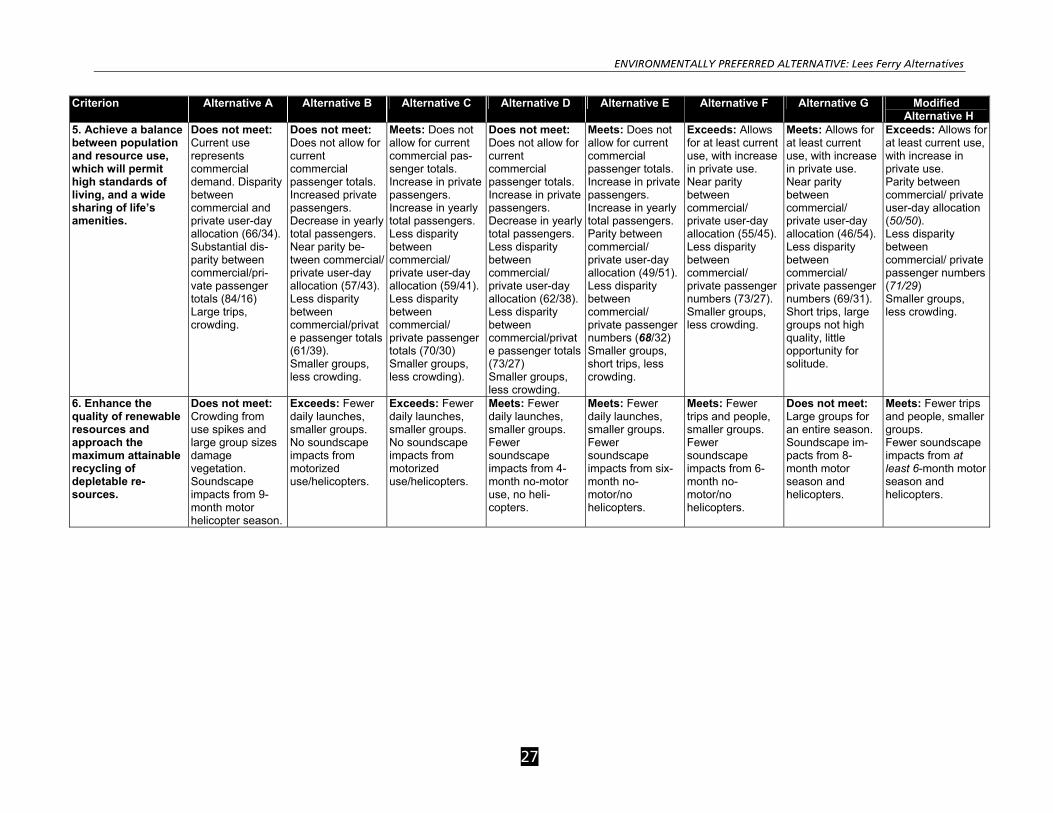
ENVIRONMENTALLY PREFERRED ALTERNATIVE: Lees Ferry Alternatives
27
Criterion Alternative A Alternative B Alternative C Alternative D Alternative E Alternative F Alternative G Modified Alternative H
5. Achieve a balance between population and resource use, which will permit high standards of living, and a wide sharing of life’s amenities.
Does not meet: Current use represents commercial demand. Disparity between commercial and private user-day allocation (66/34). Substantial dis-parity between commercial/pri-vate passenger totals (84/16) Large trips, crowding.
Does not meet: Does not allow for current commercial passenger totals. Increased private passengers. Decrease in yearly total passengers. Near parity be-tween commercial/ private user-day allocation (57/43). Less disparity between commercial/private passenger totals (61/39). Smaller groups, less crowding.
Meets: Does not allow for current commercial pas-senger totals. Increase in private passengers. Increase in yearly total passengers. Less disparity between commercial/ private user-day allocation (59/41). Less disparity between commercial/ private passenger totals (70/30) Smaller groups, less crowding).
Does not meet: Does not allow for current commercial passenger totals. Increase in private passengers. Decrease in yearly total passengers. Less disparity between commercial/ private user-day allocation (62/38). Less disparity between commercial/private passenger totals (73/27) Smaller groups, less crowding.
Meets: Does not allow for current commercial passenger totals. Increase in private passengers. Increase in yearly total passengers. Parity between commercial/ private user-day allocation (49/51). Less disparity between commercial/ private passenger numbers (68/32) Smaller groups, short trips, less crowding.
Exceeds: Allows for at least current use, with increase in private use. Near parity between commercial/ private user-day allocation (55/45). Less disparity between commercial/ private passenger numbers (73/27). Smaller groups, less crowding.
Meets: Allows for at least current use, with increase in private use. Near parity between commercial/ private user-day allocation (46/54). Less disparity between commercial/ private passenger numbers (69/31). Short trips, large groups not high quality, little opportunity for solitude.
Exceeds: Allows for at least current use, with increase in private use. Parity between commercial/ private user-day allocation (50/50). Less disparity between commercial/ private passenger numbers (71/29) Smaller groups, less crowding.
6. Enhance the quality of renewable resources and approach the maximum attainable recycling of depletable re-sources.
Does not meet: Crowding from use spikes and large group sizes damage vegetation. Soundscape impacts from 9-month motor helicopter season.
Exceeds: Fewer daily launches, smaller groups. No soundscape impacts from motorized use/helicopters.
Exceeds: Fewer daily launches, smaller groups. No soundscape impacts from motorized use/helicopters.
Meets: Fewer daily launches, smaller groups. Fewer soundscape impacts from 4-month no-motor use, no heli-copters.
Meets: Fewer daily launches, smaller groups. Fewer soundscape impacts from six-month no-motor/no helicopters.
Meets: Fewer trips and people, smaller groups. Fewer soundscape impacts from 6-month no-motor/no helicopters.
Does not meet: Large groups for an entire season. Soundscape im-pacts from 8-month motor season and helicopters.
Meets: Fewer trips and people, smaller groups. Fewer soundscape impacts from at least 6-month motor season and helicopters.
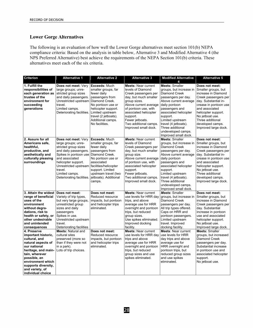
RECORD OF DECISION
28
Lower Gorge Alternatives
The following is an evaluation of how well the Lower Gorge alternatives meet section 101(b) NEPA compliance criteria: Based on the analysis in table below, Alternative 3 and Modified Alternative 4 (the NPS Preferred Alternative) best achieve the requirements of the NEPA Section 101(b) criteria. These alternatives meet each of the six criteria.
Criterion Alternative 1 Alternative 2 Alternative 3 Modified Alternative
4 Alternative 5
1. Fulfill the responsibilities of each generation as trustee of the environment for succeeding generations
Does not meet: Very large groups; unre-stricted group sizes and daily passengers. Unrestricted upstream travel. Limited camps. Deteriorating facilities.
Exceeds: Much smaller groups, far fewer daily passengers from Diamond Creek. No pontoon use or helicopter support. Limited upstream travel (2 jetboats). Additional camps. No facilities.
Meets: Near current levels of Diamond Creek passengers per day, but much smaller group sizes. Above current average of pontoon use, with associated helicopter support. Fewer jetboats. Two additional camps. Improved small dock.
Meets: Smaller groups, but increase in Diamond Creek passengers per day. Above current average daily pontoon passengers and associated helicopter support. Limited upstream travel (4 jetboats). Three additional undeveloped camps. Improved small dock.
Does not meet: Smaller groups, but increase in Diamond Creek passengers per day. Substantial in-crease in pontoon use and associated helicopter support. No jetboat use. Three additional developed camps. Improved large dock.
2. Assure for all Americans safe, healthful, productive, and aesthetically and culturally pleasing surroundings
Does not meet: Very large groups; unre-stricted group sizes and daily passengers. Spikes in pontoon use and associated helicopter support. Unrestricted upstream travel. Limited camps. Deteriorating facilities.
Exceeds: Much smaller groups, far fewer daily passengers from Diamond Creek. No pontoon use or associated facilities/helicopter support. Limited upstream travel (two jetboats). Additional camps.
Meets: Near current levels of Diamond Creek passengers per day, but much smaller group size. Above current average of pontoon use, with associated helicopter support. Fewer jetboats. Two additional camps. Improved small dock.
Meets: Smaller groups, but increase in Diamond Creek passengers per day. Above current average daily pontoon passengers and associated helicopter support. Limited upstream travel (4 jetboats). Three additional undeveloped camps. Improved small dock.
Does not meet: Smaller groups, but increase in Diamond Creek passengers per day. Substantial in-crease in pontoon use and associated helicopter support. No jetboat use. Three additional developed camps. Improved large dock.
3. Attain the widest range of beneficial uses of the environment without degra-dations, risk to health or safety, or other undesirable and unintended consequences
Does not meet: Variety of trip types, but very large groups, unrestricted group sizes and daily passengers Spikes in use. Unrestricted upstream travel. Deteriorating facilities
Does not meet: Reduced resource impacts, but pontoon and helicopter trips eliminated.
Meets: Near current use levels for HRR day trips, and above average use for HRR overnight and pontoon trips, but reduced group sizes. Use spikes eliminated. Improved docking facility.
Meets: Smaller groups, but increase in Diamond Creek passengers per day. All trip types offered. Caps on HRR and pontoon passengers. Limited upstream travel. Improved docking facility.
Does not meet: Smaller groups, but increase in Diamond Creek passengers per day. Substantial increase in pontoon use and associated helicopter support. No jetboat use. Improved large dock.
4. Preserve important historic, cultural, and natural aspects of our national heritage, and main-tain, wherever possible, an environment which supports diversity, and variety, of individual choice
Meets: Natural and cultural sites preserved (more so than if they were not in a park). Lots of trip choices.
Does not meet: Reduced resource impacts, but pontoon and helicopter trips eliminated.
Meets: Near current use levels for HRR day trips and above average use for HRR overnight and pontoon trips, but reduced group sizes and use spikes eliminated.
Meets: Near current use levels for HRR day trips and above average use for HRR overnight and pontoon trips, but reduced group sizes and use spikes eliminated.
Meets: Smaller groups, but increased Diamond Creek passengers per day. Substantial increase in pontoon use and associated helicopter support. No jetboat use.
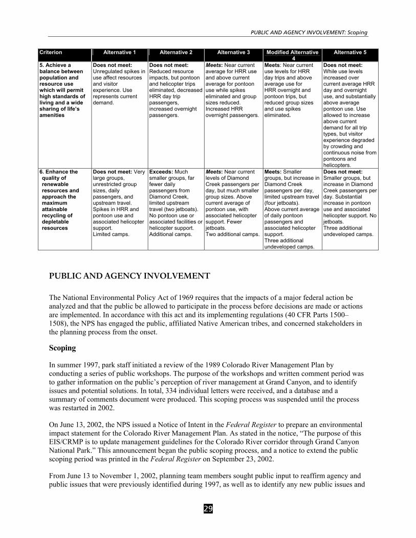
PUBLIC AND AGENCY INVOLVEMENT: Scoping
29
Criterion Alternative 1 Alternative 2 Alternative 3 Modified Alternative 4
Alternative 5
5. Achieve a balance between population and resource use which will permit high standards of living and a wide sharing of life’s amenities
Does not meet: Unregulated spikes in use affect resources and visitor experience. Use represents current demand.
Does not meet: Reduced resource impacts, but pontoon and helicopter trips eliminated, decreased HRR day trip passengers, increased overnight passengers.
Meets: Near current average for HRR use and above current average for pontoon use while spikes eliminated and group sizes reduced. Increased HRR overnight passengers.
Meets: Near current use levels for HRR day trips and above average use for HRR overnight and pontoon trips, but reduced group sizes and use spikes eliminated.
Does not meet: While use levels increased over current average HRR day and overnight use, and substantially above average pontoon use. Use allowed to increase above current demand for all trip types, but visitor experience degraded by crowding and continuous noise from pontoons and helicopters.
6. Enhance the quality of renewable resources and approach the maximum attainable recycling of depletable resources
Does not meet: Very large groups, unrestricted group sizes, daily passengers, and upstream travel. Spikes in HRR and pontoon use and associated helicopter support. Limited camps.
Exceeds: Much smaller groups, far fewer daily passengers from Diamond Creek, limited upstream travel (two jetboats). No pontoon use or associated facilities or helicopter support. Additional camps.
Meets: Near current levels of Diamond Creek passengers per day, but much smaller group sizes. Above current average of pontoon use, with associated helicopter support. Fewer jetboats. Two additional camps.
Meets: Smaller groups, but increase in Diamond Creek passengers per day, limited upstream travel (four jetboats). Above current average of daily pontoon passengers and associated helicopter support. Three additional undeveloped camps.
Does not meet: Smaller groups, but increase in Diamond Creek passengers per day. Substantial increase in pontoon use and associated helicopter support. No jetboats. Three additional undeveloped camps.
PUBLIC AND AGENCY INVOLVEMENT
The National Environmental Policy Act of 1969 requires that the impacts of a major federal action be analyzed and that the public be allowed to participate in the process before decisions are made or actions are implemented. In accordance with this act and its implementing regulations (40 CFR Parts 1500–1508), the NPS has engaged the public, affiliated Native American tribes, and concerned stakeholders in the planning process from the onset.
Scoping
In summer 1997, park staff initiated a review of the 1989 Colorado River Management Plan by conducting a series of public workshops. The purpose of the workshops and written comment period was to gather information on the public’s perception of river management at Grand Canyon, and to identify issues and potential solutions. In total, 334 individual letters were received, and a database and a summary of comments document were produced. This scoping process was suspended until the process was restarted in 2002.
On June 13, 2002, the NPS issued a Notice of Intent in the Federal Register to prepare an environmental impact statement for the Colorado River Management Plan. As stated in the notice, “The purpose of this EIS/CRMP is to update management guidelines for the Colorado River corridor through Grand Canyon National Park.” This announcement began the public scoping process, and a notice to extend the public scoping period was printed in the Federal Register on September 23, 2002.
From June 13 to November 1, 2002, planning team members sought public input to reaffirm agency and public issues that were previously identified during 1997, as well as to identify any new public issues and
RECORD OF DECISION
30
concerns. Press releases, mailings, and public meetings were used to request public input and to disseminate information. More than 1,000 people attended a total of seven public meetings, which were held in seven cities nationwide. All information was also posted on the park’s Colorado River Management Plan website. The park received 13,770 submissions at public meetings, by e-mail, and by regular mail, containing 55,165 individual comments as part of the public scoping effort. All comments received in the public scoping period were considered in the EIS. The Purpose of and Need for the Action, Background Information, and Appendix B: Public Scoping Summary sections of the FEIS detail the public scoping process and the issues and concerns raised in scoping.
Stakeholder Workshops
Two stakeholder workshops were conducted during the development of the Draft Environmental Impact Statement and involved representatives from nine stakeholder groups, including private boaters, outfitters, wilderness coalition representatives, those with ecological concerns, researchers, educators, commercial customers, commercial river guides, and people with disabilities. All of the affiliated tribes were invited to participate in the workshops. None of the tribes chose to have representatives participate in the workshops, but some tribal representatives did attend as observers.
Public Comment
The Draft CRMP Environmental Impact Statement (DEIS) was released for public review in the fall of 2004. A 90-day public comment period on the CRMP/DEIS began when a Notice of Availability of the Draft was published in the Federal Register on October 8, 2004. Public meetings were conducted in seven cities nationwide to present the DEIS and solicit public comment. Approximately 1,000 people attended these meetings. Press releases, website updates and public meetings were used to request public input and to disseminate information about draft alternatives and their impacts to natural and cultural resources and to visitor experience. Given the complexity of the document and the intense interest in it on behalf of the public, the 90-day public comment period was extended from the ending date of January 7, 2005 to February 1, 2005. During the public comment period, the NPS received nearly 10,000 submissions at public meetings, by email, via the CRMP website and by regular mail, containing about 6,000 substantive and 30,000 nonsubstantive comments representing a wide range of interests. Comments from the public and agencies have been addressed either as revised text in Volumes I or II, or as responses to comments summarized in Volume III of the Final Environmental Impact Statement.
Agency and American Indian Consultation and Coordination Agency Consultation
In compliance with Section 7 of the Endangered Species Act of 1973, as amended, a Biological Assessment was submitted and formal consultation was initiated on June 24, 2005 following determination of the two modified preferred alternatives. Informal consultations, initiated in March 2004, resulted in the identification of ten special status species (bald eagle, California condor, Mexican spotted owl, southwestern willow flycatcher, Yuma clapper rail, humpback chub, razorback sucker, Kanab ambersnail, desert tortoise, and California brown pelican) and two candidate species for listing as threatened or endangered species (yellow-billed cuckoo and relict leopard frog). The NPS has incorporated mitigations recommended by the US Fish and Wildlife Service into the FEIS in Section 4.2.9, Special Status Species. See Attachment A for a list of the conservation measures and reasonable and prudent measures from the Biological Opinion.
As part of the Arizona Strip Interagency Planning process, the planning staff made monthly progress reports to Grand Canyon-Parashant National Monument and Lake Mead National Recreation Area staff.

PUBLIC AND AGENCY INVOLVEMENT: Agency and American Indian Consultation and Coordination
31
The national monument staff was also consulted to develop alternatives and identify impacts for passenger exchanges at Whitmore.
Section 106 of the National Historic Preservation Act of 1966 (NHPA), as amended, requires federal agencies to consult with various interested parties, including the State Historic Preservation Officer (SHPO) and the Advisory Council on Historic Preservation (ACHP), regarding federally funded or licensed undertakings that may affect historic properties listed in, or eligible for listing in, the National Register of Historic Places. During the development of the DEIS, from August 2002 to October 2004, the NPS consulted informally with the Arizona SHPO, the ACHP, and other interested parties, including all federally recognized, culturally affiliated Indian tribes. By letter dated February 17, 2004, the NPS initiated formal consultation with the Arizona SHPO. Those consultations resulted in a determination that implementation of the revised Colorado River Management Plan may have an adverse effect on National Register-listed or -eligible historic properties in the river corridor.
This record of decision incorporates the measures to avoid, minimize, or mitigate the adverse effects on National Register-listed or -eligible historic properties that were developed during the NPS’s consultations with the various interested parties (see, e.g., 36 C.F.R. subsection 800.8(c)(4)). In an effort to monitor any potential adverse effects, the NPS has developed a section 106 “programmatic agreement” among interested parties under 36 C.F.R. subsection 800.14(b). The NPS will not take any action that may adversely affect any National Register-listed or -eligible historic properties in the river corridor before completing compliance with section 106 of the NHPA.
Tribal Consultation
In keeping with the provisions of the National Environmental Policy Act, National Historic Preservation Act, National Park Service Management Policies 2001, Executive Memorandum on Government-to-Government Relations with Native American Tribal Governments; Executive Order 13007; Executive Order 13175; 512 Department of the Interior Manual [DM] 2; and Director’s Order #71: Relationships with Indian Tribes, the NPS established regular consultation with American Indian tribes to address issues and concerns related to the current revisions of the Colorado River Management Plan. The following table lists the Tribal consultations that have occurred during the development of this document.
American Indian Tribes Consulted
Havasupai Tribe Postal updates, personal contacts with the cultural resource representative, and two meetings with tribal representatives. Request for review and comment on DEIS and invitation to participate in Section 106 programmatic agreement.
Hopi Tribe Postal updates, personal contacts with the cultural resource representative, and three meetings with tribal representatives. Request for review and comment on DEIS and invitation to participate in Section 106 programmatic agreement.
Pueblo of Zuni Postal updates and personal contacts with the cultural resource representative. Request for review and comment on DEIS and invitation to participate in Section 106 programmatic agreement.
Yavapai Apache Nation (representing White Mountain, Yavapai, San Carlos and Tonto Apache tribes)
Postal updates, meeting with tribal representatives, and personal contacts with the cultural resource representative. Request for review and comment on DEIS and invitation to participate in Section 106 programmatic agreement.
Southern Paiute Consortium Postal updates, personal contacts with the cultural resource representative, and two meetings with the tribal representatives. Request for review and comment on DEIS and invitation to participate in Section 106 programmatic agreement.
Moapa Band of Paiute Indians Personal briefing with tribal officials and transmittal of draft PA.
Las Vegas Paiute Tribe Personal briefing with tribal officials and transmittal of draft PA.
San Juan Southern Paiute Tribe Invitation to enter into consultation. Request for review and comment on DEIS and invitation to participate in Section 106 programmatic agreement.
RECORD OF DECISION
32
American Indian Tribes Consulted
Navajo Nation Postal updates, personal contacts with the cultural resource and tribal representatives, and numerous meetings with the Bodaway/Gap Planning Team and Chapter members and Navajo Nation representatives. Request for review and comment on DEIS and invitation to participate in Section 106 programmatic agreement.
Hualapai Tribe Cooperating agency. Frequent consultations, both in meetings and personal contacts via telephone and e-mail, included development of alternatives, impact identification, and review of administrative drafts. Review and comment on DEIS and invitation to participate in Section 106 programmatic agreement.
The Hualapai Indian Reservation and Grand Canyon National Park share a 108-mile-long boundary along the Colorado River in western Grand Canyon and the Hualapai Tribe requested and was granted Cooperating Agency status for the preparation of the Environmental Impact Statement. In accordance with the Council on Environmental Quality’s (CEQ) “Regulations for Implementing the National Environmental Policy Act” (40 CFR 1501.6), lead agencies “use the environmental analysis and proposals of cooperating agencies with jurisdiction by law or special expertise, to the maximum extent possible.” The Hualapai Tribe provided essential data on the affected environment, assisted in the development of alternatives and mitigation measures, and reviewed numerous drafts of the Environmental Impact Statement. Furthermore, the NPS and the Hualapai Tribe have entered into an agreement to cooperate and collaborate with each other to resolve issues of common concern in an “Area of Cooperation,” which the agreement defines as the area from high water mark to high water mark from about RM 165 (upstream of National Canyon) to Lake Mead National Recreation Area.
CONCLUSION
As described in the mitigation section, all practical means to avoid or minimize environmental harm from the selected alternatives have been adopted. Because there would be no major adverse impacts to resources whose conservation is: 1) necessary to fulfill specific purposes in the establishing legislation or proclamation for Grand Canyon National Park; 2) key to the natural or cultural integrity of the park or to opportunities for enjoyment of the park; or 3) identified as a goal in relevant National Park Service planning documents, there would be no impairment of the park's resources or values. After a review of these effects, the alternatives selected for implementation will not impair park resources or values and will not violate the NPS Organic Act.
The officials responsible for implementing the selected action are the Regional Director, Intermountain Region, and the Superintendent, Grand Canyon National Park.

CONCLUSION: Agency and American Indian Consultation and Coordination
33
ATTACHMENT A US FWS Conservation Measures and Reasonable and Prudent Measures for the CRMP
Conservation Measures: Bald Eagle: 1) In March of each year, river-running trips (commercial, private, and science) will avoid stopping near Nankoweap Creek (RM 52) if eagles are observed in the area. GRCA will provide educational material to all river runners about minimizing the potential harassment bald eagles in this area in March, and about the potential for bald eagles to occur in Grand Canyon at other places, and at other times of the year. GRCA will request that river runners report any eagle sightings. GRCA will report all eagle sightings by river runners or those observed during bird surveys to the U.S. Fish and Wildlife Service. 2) Roosting eagles in the vicinity of Phantom Ranch will be monitored for three years to determine the extent of recreational impacts.
California Condor: 1) River runners will receive educational information about condors during the beginning of their river running experience. This educational information will emphasize appropriate interactions with condors. 2) GRCA will work cooperatively with other condor recovery partners and the Hualapai Tribe to determine patterns of condor use (e.g., flight routes) of the Whitmore Canyon and Quartermaster Canyon areas. 3) GRCA will make condor information available to the Federal Aviation Administration (FAA) for training air tour (including helicopter) pilots at FAA-sponsored pilot safety meetings. GRCA will distribute brochures and make graphics of summer and winter flight routes available to the pilots. Pilots will be asked to actively watch for condors and to maintain safe distances between aircraft and condors. Mexican Spotted Owl and Mexican Spotted Owl Critical Habitat: 1) River access to MSO Protected Activity Centers (PACs) known to be occupied or PACs for which there is no occupancy information, will be restricted during the breeding season (March 1–August 31), where feasible and as determined by the GRCA wildlife biologist. The closures will include all reasonably accessible PACs, whether accessible by known trail or not, known to be occupied in a given year or for which occupancy is unknown. PACs will be closed during the breeding season unless doing so would significantly impact hikers from the rim or river. MSO PACs in side canyons will not be closed if they are not within day-hiking distance of the river or not likely to be impacted by recreational activity. PAC closures will be determined on a year-by-year basis by the GRCA wildlife biologist, and will therefore change annually based on occupancy information. A notice of seasonal closures of these areas will be provided to all noncommercial and commercial river runners and researchers prior to or just after the beginning of the peak season (March–April) and will be updated if necessary during the following months. 2) As resources allow, GRCA will continue to survey MSO habitat accessible by recreationists from the river.
3) Contingent upon availability of funding, GRCA will conduct regularly-scheduled vegetative monitoring in a representative number of accessible side canyons in which PACs have been designated (as well as equal number of “control” canyons, which are not considered easily accessible to river

RECORD OF DECISION
34
runners) to determine if recreational impacts are negatively affecting vegetation and other critical habitat primary constituent elements. 4) Contingent upon the availability of funding, GRCA will conduct a study of the impact of human disturbance on MSO within the Grand Canyon. 5) In consultation with the Hualapai Tribe, GRCA will work to determine the feasibility of surveying MSO habitat under helicopter flights associated with CRMP in the Quartermaster Canyon area. Contingent upon availability of funding, and if the Hualapai Tribe agrees, GRCA will work with the Tribe to conduct these MSO surveys. 6) If MSO are found as a result of the surveys, GRCA, in consultation with the Hualapai Tribe and the FAA, will work to determine the necessity and feasibility (i.e., economically, safety-wise) of adjusting helicopter flight routes to avoid resident MSO. If adjustments are deemed to be appropriate and feasible and the parties agree, they will work cooperatively to determine flight route adjustments. Southwestern Willow Flycatcher: 1) Contingent upon availability of funding, GRCA will strive to conduct annual southwestern willow flycatcher presence/absence and nest monitoring surveys (using the FWS recommended survey and nesting monitoring protocols) but no less than presence/absence surveys every other year in suitable flycatcher breeding habitat (nesting/foraging/dispersal, etc.) that may be affected by river recreationist activity. In order to determine the suitability of flycatcher breeding habitat that may be affected by river recreation, several methods may be appropriate. For example, habitat will be evaluated by a) on-the-ground evaluations of previous locations where flycatchers have been detected breeding or suspected of breeding (migrant detections), and/or b) application of the Arizona Game and Fish Department flycatcher habitat model, and/or c) continued annual on-the-ground monitoring of habitat throughout the action area. GRCA will place closures (with a 0.5-mile buffer) at flycatcher breeding locations or areas suspected as breeding locations encountered during surveys and from habitat evaluations if the sites are likely to receive recreation use (e.g., hiking, camping, river landings). Alternatively, if surveys cannot be funded, conducted, or completed as scheduled, then seasonal closures will be implemented at unsurveyed suitable flycatcher breeding habitat that may be impacted by river recreationists' activities. The closures will be determined by the GRCA wildlife biologist, will be in place from May 1 to August 15, and will include closure to visitor use including hiking, camping, and river landings, and will be annually reported and coordinated with the FWS. Brown Pelican: 1) GRCA will educate all river runners regarding the potential for brown pelicans to occur in the river corridor and that interactions with the birds are to be avoided and the birds are not to be harassed or harmed. Recreationists will be asked to report observations of the species to GRCA. GRCA will report any brown pelican sightings by river runners or any observed during bird surveys to the FWS. Humpback Chub and Humpback Chub Critical Habitat: 1) No boats will be allowed to enter or park in the Little Colorado River (LCR). To stop in the vicinity of the LCR, boats may park upstream or downstream of the river’s mouth. Swimming and wading in the LCR will be allowed year round in the northern half of the river. The southern half of the river from the confluence to the park boundary (located approximately two miles upstream) will be closed to river runner swimming and wading from March 1 to November 30. River runners hiking the Little Colorado River who need to cross between the north and south sides will be allowed to wade and cross at the

CONCLUSION: Agency and American Indian Consultation and Coordination
35
established crossing (marked by cairns), approximately 0.2miles upstream of the confluence. Camping and fishing bans will remain in place. The purpose of these restrictions is to protect native fish habitat (including Phragmites along the south bank of the LCR) and spawning and young of the year humpback chub.
2) Contingent upon availability of funding, GRCA will implement a contaminants study that examines levels of potentially toxic chemicals and PPCPs (pharmaceuticals and personal care products) present in the Colorado River, including the LCR at its confluence. Surrogate aquatic biota will be examined, primarily trout, and results will then be extrapolated to the humpback chub. Non-lethal sampling of humpback chub may also be included, but under separate permit. The study would complement existing water quality studies that look at the impacts of recreation within GRCA. 3) Contingent upon availability of funding, GRCA will implement a study to examine behavioral changes of humpback chub in response to recreation in the LCR (feeding, avoidance of predators, etc.). 4) Contingent upon availability of funding, GRCA will implement a study to determine recreational impacts to native fish habitat. Two or more tributaries (such as Shinumo) will be examined and factors such as changes in vegetation and abundance of invertebrates will be measured. Razorback Sucker and Razorback Sucker Critical Habitat: 1) Contingent upon availability of funding, GRCA will work cooperatively with Lake Mead National Recreation Area (LAME) to conduct surveys of backwaters and side channels in the Lower Gorge-Lake Mead interface, and that portion of LAME where project activities extend, for spawning razorback suckers (e.g., use of light traps to catch larvae may be an appropriate means of surveying). Recreational use of areas found to be used by razorback suckers during the spawning period will be avoided. Kanab Ambersnail: 1) GRCA will implement a program to educate recreational and commercial guides about protecting the Kanab ambersnails in Vaseys Paradise and Upper Elves Chasm. 2) Upper Elves Chasm will be closed to recreational access each year during the peak season (March through October) of river runner use. 3) GRCA will provide logistical support (e.g. boat trips) to the Arizona Game and Fish Department’s Kanab ambersnail monitoring program. 4) Contingent upon availability of funding, GRCA will implement a study to determine recreational impacts to Kanab Ambersnail at Vaseys paradise. Desert Tortoise: 1) River recreationists using the Whitmore Canyon area will be educated to not handle or otherwise disturb any desert tortoises they may encounter. Recreationists will be required to pack their trash out of the area. Yuma Clapper Rail: 1) Contingent upon availability of funding, GRCA will conduct surveys for the Yuma clapper rail in the Lower Gorge. Such surveys may be combined with surveys for breeding birds and/or willow flycatchers. Clapper rail surveys should be conducted once every 3 years for the life of the CRMP. 2) If Yuma clapper rails are found in GRCA during the breeding season or if nests are located and these sites are determined by the GRCA wildlife biologist to be impacted by river recreationists’ activities,

RECORD OF DECISION
36
GRCA will establish a closure of suitable breeding habitat at specific sites, with an appropriate buffer, during the length of the breeding season. In addition, any previously known Yuma clapper rail nest sites that are not surveyed or monitored, that are likely to be impacted by recreation activity, will also be closed. Reasonable and Prudent Measures: Humpback Chub: 1) GRCA will take measures to determine the actual impact of CRMP recreation activities on the humpback chub: A. GRCA will fund and/or conduct a research program designed to determine the actual effects of CRMP recreation activities on the humpback chub. The research should focus on the effects of recreation on humpback chub (e.g., disturbance of normal essential behavior) and their habitat at the confluence of the LCR and Colorado River. The research program will be initiated no later than three years after implementation of the CRMP, and GRCA will include the FWS in the development of its design. Research results regarding the extent of the effects of recreation will be used to develop appropriate protective measures and/or develop a long-term monitoring program. Kanab Ambersnail: 1) GRCA will take measures to determine the actual impact of CRMP recreation activities on the Kanab ambersnail. A. GRCA will fund and/or conduct a research program designed to determine the actual effects of CRMP recreation activities on the Kanab ambersnail. The research should focus on the effects of recreation on Kanab ambersnail (e.g., injury and mortality) and their habitat (e.g., loss of habitat) at Vaseys Paradise. The research program will be initiated no later than three years after implementation of the CRMP, and GRCA will include FWS in the development of the design. Research results regarding the extent of the effects of recreation will be used to develop appropriate protective measures and/or develop a long-term monitoring program.