Embed Size (px)
Citation preview
Insert document title
Location | Date
ATSB Transport Safety Report[Insert Mode] Occurrence InvestigationXX-YYYY-####Final
Investigation
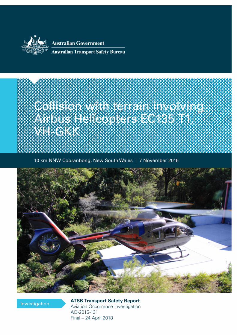
Collision with terrain involving Airbus Helicopters EC135 T1, VH-GKK
Investigation
10 km NNW Cooranbong, New South Wales | 7 November 2015
ATSB Transport Safety ReportAviation Occurrence InvestigationAO-2015-131Final – 24 April 2018
Cover photo: Supplied. Not to be reproduced
Released in accordance with section 25 of the Transport Safety Investigation Act 2003
Publishing information
Published by: Australian Transport Safety Bureau Postal address: PO Box 967, Civic Square ACT 2608 Office: 62 Northbourne Avenue Canberra, Australian Capital Territory 2601 Telephone: 1800 020 616, from overseas +61 2 6257 4150 (24 hours) Accident and incident notification: 1800 011 034 (24 hours) Facsimile: 02 6247 3117, from overseas +61 2 6247 3117 Email: [email protected] Internet: www.atsb.gov.au
© Commonwealth of Australia 2018
Ownership of intellectual property rights in this publication Unless otherwise noted, copyright (and any other intellectual property rights, if any) in this publication is owned by the Commonwealth of Australia.
Creative Commons licence With the exception of the Coat of Arms, ATSB logo, and photos and graphics in which a third party holds copyright, this publication is licensed under a Creative Commons Attribution 3.0 Australia licence.
Creative Commons Attribution 3.0 Australia Licence is a standard form license agreement that allows you to copy, distribute, transmit and adapt this publication provided that you attribute the work.
The ATSB’s preference is that you attribute this publication (and any material sourced from it) using the following wording: Source: Australian Transport Safety Bureau
Copyright in material obtained from other agencies, private individuals or organisations, belongs to those agencies, individuals or organisations. Where you want to use their material you will need to contact them directly. Addendum
Page Change Date
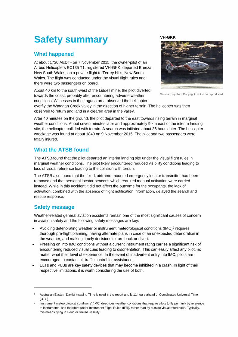
Safety summary What happened At about 1730 AEDT1 on 7 November 2015, the owner-pilot of an Airbus Helicopters EC135 T1, registered VH-GKK, departed Breeza, New South Wales, on a private flight to Terrey Hills, New South Wales. The flight was conducted under the visual flight rules and there were two passengers on board.
About 40 km to the south-west of the Liddell mine, the pilot diverted towards the coast, probably after encountering adverse weather conditions. Witnesses in the Laguna area observed the helicopter overfly the Watagan Creek valley in the direction of higher terrain. The helicopter was then observed to return and land in a cleared area in the valley.
After 40 minutes on the ground, the pilot departed to the east towards rising terrain in marginal weather conditions. About seven minutes later and approximately 9 km east of the interim landing site, the helicopter collided with terrain. A search was initiated about 36 hours later. The helicopter wreckage was found at about 1840 on 9 November 2015. The pilot and two passengers were fatally injured.
What the ATSB found The ATSB found that the pilot departed an interim landing site under the visual flight rules in marginal weather conditions. The pilot likely encountered reduced visibility conditions leading to loss of visual reference leading to the collision with terrain.
The ATSB also found that the fixed, airframe-mounted emergency locator transmitter had been removed and that personal locator beacons which required manual activation were carried instead. While in this accident it did not affect the outcome for the occupants, the lack of activation, combined with the absence of flight notification information, delayed the search and rescue response.
Safety message Weather-related general aviation accidents remain one of the most significant causes of concern in aviation safety and the following safety messages are key:
• Avoiding deteriorating weather or instrument meteorological conditions (IMC)2 requires thorough pre-flight planning, having alternate plans in case of an unexpected deterioration in the weather, and making timely decisions to turn back or divert.
• Pressing on into IMC conditions without a current instrument rating carries a significant risk of encountering reduced visual cues leading to disorientation. This can easily affect any pilot, no matter what their level of experience. In the event of inadvertent entry into IMC, pilots are encouraged to contact air traffic control for assistance.
• ELTs and PLBs are key safety devices that may become inhibited in a crash. In light of their respective limitations, it is worth considering the use of both.
1 Australian Eastern Daylight-saving Time is used in the report and is 11 hours ahead of Coordinated Universal Time
(UTC). 2 ‘Instrument meteorological conditions’ (IMC) describes weather conditions that require pilots to fly primarily by reference
to instruments, and therefore under Instrument Flight Rules (IFR), rather than by outside visual references. Typically, this means flying in cloud or limited visibility.
VH-GKK
Source: Supplied. Copyright: Not to be reproduced
Contents
Contents .................................................................................................................................... i The occurrence ........................................................................................................................1 Context ......................................................................................................................................6
Pilot information 6 Visual flight rules 7 Aviation-specific meteorological forecasts and warnings 7 Assessment of the weather conditions 10 Aircraft and maintenance 12 Wreckage and impact information 13 Emergency locator transmitters 14 Visual flight into Instrument Meteorological Conditions 15 Related occurrences 16
Safety analysis ...................................................................................................................... 18 Pre-flight weather assessment 18 Collision with terrain 18 Assessment of local conditions 19 Safety considerations 21
Findings ................................................................................................................................. 23 Contributing factor 23 Other findings 23
General details ...................................................................................................................... 24 Occurrence details 24 Pilot details 24 Aircraft details 24
Sources and submissions .................................................................................................. 25 Sources of information 25 References 25 Submissions 25
Australian Transport Safety Bureau .................................................................................. 27 Purpose of safety investigations 27 Developing safety action 27
› 1 ‹
ATSB – AO-2015-131
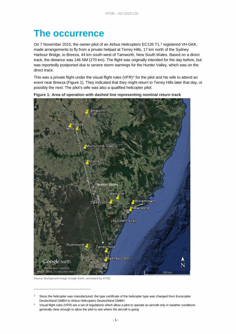
The occurrence On 7 November 2015, the owner-pilot of an Airbus Helicopters EC135 T1,3 registered VH-GKK, made arrangements to fly from a private helipad at Terrey Hills, 17 km north of the Sydney Harbour Bridge, to Breeza, 44 km south-west of Tamworth, New South Wales. Based on a direct track, the distance was 146 NM (270 km). The flight was originally intended for the day before, but was reportedly postponed due to severe storm warnings for the Hunter Valley, which was on the direct track.
This was a private flight under the visual flight rules (VFR)4 for the pilot and his wife to attend an event near Breeza (Figure 1). They indicated that they might return to Terrey Hills later that day, or possibly the next. The pilot’s wife was also a qualified helicopter pilot.
Figure 1: Area of operation with dashed line representing nominal return track
Source: Background image Google Earth, annotated by ATSB.
3 Since the helicopter was manufactured, the type certificate of the helicopter type was changed from Eurocopter
Deutschland GMBH to Airbus Helicopters Deutschland GMBH. 4 Visual flight rules (VFR) are a set of regulations which allow a pilot to operate an aircraft only in weather conditions
generally clear enough to allow the pilot to see where the aircraft is going
› 2 ‹
ATSB – AO-2015-131
The pilot did not submit a flight notification to Air Traffic Services and, as the flight was conducted under the VFR and outside controlled airspace, there was no requirement to do so. There was no record that the pilot accessed aviation-specific meteorological forecasts and reports in preparing for the flight. Given that there were multiple means of access to those products and other sources of weather information, the pilot may have obtained the weather through these sources.
There was limited recorded data available for the flight from Terrey Hills to Breeza. VH-GKK departed Terry Hills sometime after 0940 and arrived at Breeza at about 1100. It was arranged for an acquaintance, who was a documentary filmmaker, to join the pilot and his wife for the return flight. Their return track would take them over the Werris Creek coal mine where their intent was to film the mine and surrounds.
It appears that the pilot was hoping to leave at about 1700 but there was a delay associated with the event. Witnesses recalled that the helicopter lifted off at about 1730 and headed in a south-easterly direction, toward the general location of the mine. The weather at Breeza was warm and sunny, with predominantly clear skies and light winds.
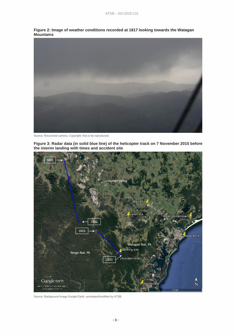
Based on photos recovered from the filmmaker’s camera, the pilot departed at 1735 and tracked to Werris Creek coal mine then southward in the general direction of Terrey Hills. At 1800, air traffic control radar detected the helicopter in the vicinity of the Liddell mine in the Hunter Valley, which was about the halfway point. On initial detection, the helicopter was at 2,800 ft above mean sea level,5 before climbing to 3,500 ft as it approached higher terrain. It had an average groundspeed of 116 kt and the pilot was maintaining a consistent track in the general direction of Terrey Hills (The radar data recorded between 1800 and 1821 is depicted in Figure 3).
From 1811, the radar data shows a descent and at 1812, the pilot made a turn to the left to track in a more easterly direction. Shortly after, the radar return dropped out when the helicopter was at 2,700 ft with a groundspeed of 125 kt.
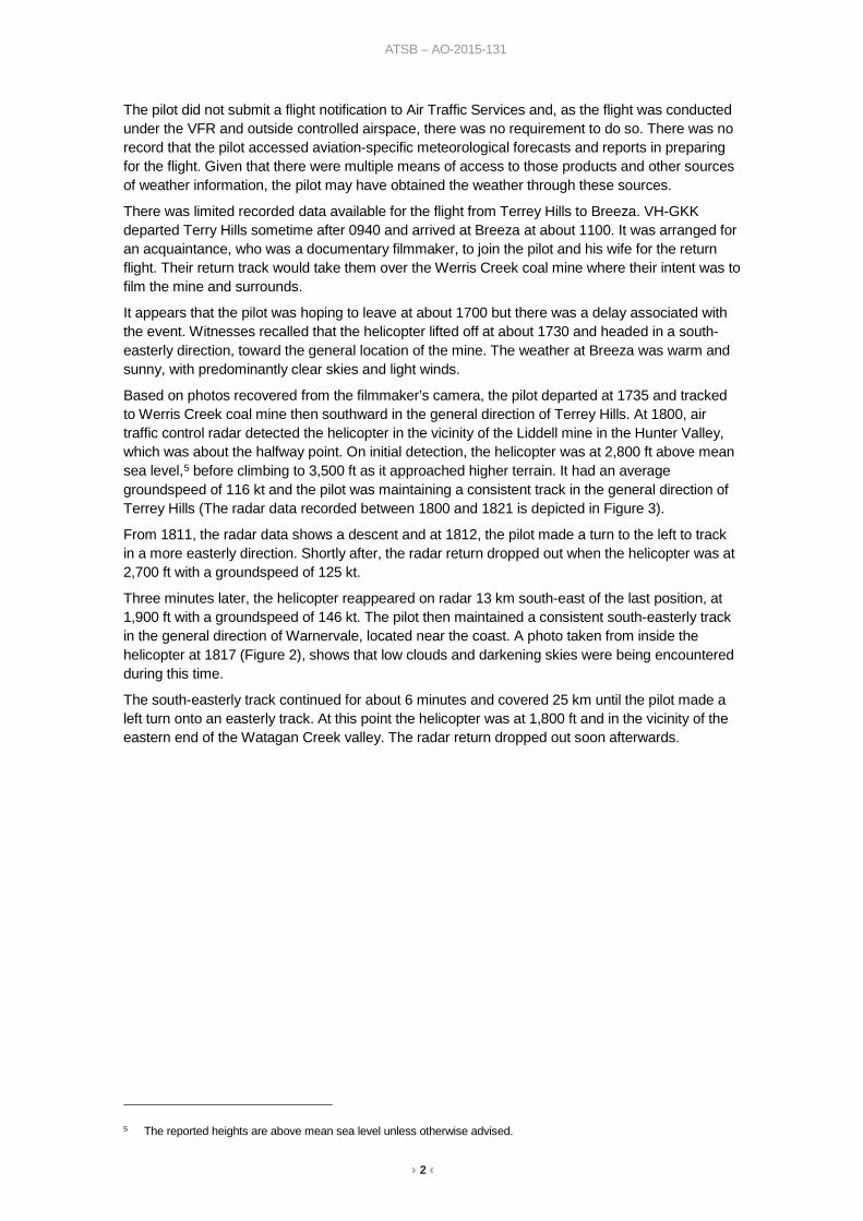
Three minutes later, the helicopter reappeared on radar 13 km south-east of the last position, at 1,900 ft with a groundspeed of 146 kt. The pilot then maintained a consistent south-easterly track in the general direction of Warnervale, located near the coast. A photo taken from inside the helicopter at 1817 (Figure 2), shows that low clouds and darkening skies were being encountered during this time.
The south-easterly track continued for about 6 minutes and covered 25 km until the pilot made a left turn onto an easterly track. At this point the helicopter was at 1,800 ft and in the vicinity of the eastern end of the Watagan Creek valley. The radar return dropped out soon afterwards.
5 The reported heights are above mean sea level unless otherwise advised.
› 3 ‹
ATSB – AO-2015-131
Figure 2: Image of weather conditions recorded at 1817 looking towards the Watagan Mountains
Source: Recovered camera. Copyright: Not to be reproduced.
Figure 3: Radar data (in solid blue line) of the helicopter track on 7 November 2015 before the interim landing with times and accident site
Source: Background image Google Earth, annotated/modified by ATSB.
› 4 ‹
ATSB – AO-2015-131
Witnesses reported that the helicopter crossed the valley and continued in an easterly direction, in conditions they described as overcast with low clouds and rain.
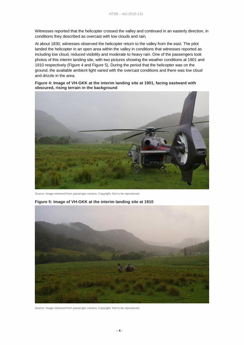
At about 1830, witnesses observed the helicopter return to the valley from the east. The pilot landed the helicopter in an open area within the valley in conditions that witnesses reported as including low cloud, reduced visibility and moderate to heavy rain. One of the passengers took photos of this interim landing site, with two pictures showing the weather conditions at 1901 and 1910 respectively (Figure 4 and Figure 5). During the period that the helicopter was on the ground, the available ambient light varied with the overcast conditions and there was low cloud and drizzle in the area.
Figure 4: Image of VH-GKK at the interim landing site at 1901, facing eastward with obscured, rising terrain in the background
Source: Image retrieved from passenger camera. Copyright: Not to be reproduced.
Figure 5: Image of VH-GKK at the interim landing site at 1910
Source: Image retrieved from passenger camera. Copyright: Not to be reproduced.
› 5 ‹
ATSB – AO-2015-131
The witnesses noted that the helicopter remained on the ground for about 40 minutes before departing at about 1915. By 1920, the helicopter was observed over a property to the east of the Watagan Creek valley, tracking east toward timbered, rising terrain. The witness reported that the heavy rain had abated to drizzle and the visibility remained low.
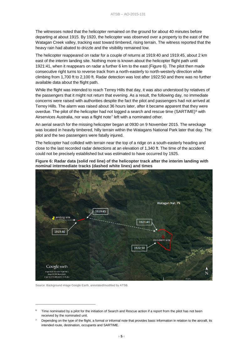
The helicopter reappeared on radar for a couple of returns at 1919:40 and 1919:45, about 2 km east of the interim landing site. Nothing more is known about the helicopter flight path until 1921:41, when it reappears on radar a further 6 km to the east (Figure 6). The pilot then made consecutive right turns to reverse track from a north-easterly to north-westerly direction while climbing from 1,700 ft to 2,100 ft. Radar detection was lost after 1922:50 and there was no further available data about the flight path.
While the flight was intended to reach Terrey Hills that day, it was also understood by relatives of the passengers that it might not return that evening. As a result, the following day, no immediate concerns were raised with authorities despite the fact the pilot and passengers had not arrived at Terrey Hills. The alarm was raised about 36 hours later, after it became apparent that they were overdue. The pilot of the helicopter had not logged a search and rescue time (SARTIME)6 with Airservices Australia, nor was a flight note7 left with a nominated other.
An aerial search for the missing helicopter began at 0930 on 9 November 2015. The wreckage was located in heavily timbered, hilly terrain within the Watagans National Park later that day. The pilot and the two passengers were fatally injured.
The helicopter had collided with terrain near the top of a ridge on a south-easterly heading and close to the last recorded radar detections at an elevation of 1,340 ft. The time of the accident could not be precisely established but was estimated to have occurred by 1925.
Figure 6: Radar data (solid red line) of the helicopter track after the interim landing with nominal intermediate tracks (dashed white lines) and times
Source: Background image Google Earth, annotated/modified by ATSB.
6 Time nominated by a pilot for the initiation of Search and Rescue action if a report from the pilot has not been
received by the nominated unit. 7 Depending on the type of the flight, a formal or informal note that provides basic information in relation to the aircraft, its
intended route, destination, occupants and SARTIME.
› 6 ‹
ATSB – AO-2015-131
Context Pilot information The pilot was issued with an Australian Private Pilot (Helicopter) Licence in January 1989, following acceptance of a licence issued in the United Kingdom in 1988. At the time of the accident, the pilot held endorsements for two types of piston-engine helicopter and three types of turbine-engine helicopter, including the EC135 type that the pilot was operating.
In 1991, the pilot was issued a Night VFR8 Helicopter rating and in 1992, the pilot completed low flying training. Between 2005 and 2008, the pilot was approved by the Civil Aviation Safety Authority (CASA) to give endorsement or conversion training in EC-135 helicopters. The pilot did not hold an instrument rating9 and there was no indication that he had sought to obtain one. This limited the pilot to visual flight operations.
The pilot’s logbook recorded a total aeronautical experience of 2,654 hours, which included 1,256 hours on the EC135 helicopter type. This included a total of 5 hours of simulator experience, 7.5 hours instrument flight time, and 8.1 hours in command at night. No night experience was logged since September 2010, so the pilot did not appear to meet the night-VFR recency requirements.
The most recent helicopter flight review was conducted by a CASA Flying Operations Inspector (FOI) in March 2014. This included a pre-flight assessment of the pilot’s interpretation and application of meteorological reports. It also included a bad weather navigation exercise and diversion. The FOI assessed that the pilot performed to a satisfactory standard overall, and displayed average flying skills and a high level of technical knowledge about the helicopter.
The pilot held a Class 2 Civil Aviation Medical Certificate that was due to expire in May 2016. He was required to wear distance vision correction and to have vision correction available for reading. Post-mortem and toxicological examination found no underlying medical disorder likely to lead to incapacitation of the pilot, however the medical examiner could not exclude hypertension as contributing to the accident.
A search of the ATSB database yielded notifications regarding two significant occurrences involving the pilot and VH-GKK: a weather-related event in December 2004 and a wire strike in November 2012. This earlier event is described in a book published by the pilot. As the book relates, the pilot became caught in cloud at low level over water then climbed to a safe altitude to continue in cloud with reference to a GPS10 moving map. The pilot advised air traffic services of the situation and sought information about the extent of the weather. Approaching land displayed on the moving map, the pilot slowed down and gradually descended until the coastline became visible. According to the book, to cope with this type of situation the pilot was night-rated and regularly practised flying on instruments, and the helicopter was equipped with an autopilot and instrumentation.
In the wire strike event, the helicopter was damaged and was subsequently operated in that condition for a short duration. This was investigated by CASA, as were other events:
• August 2006: main rotor blade contact with trees resulting in main rotor damage
8 A Night VFR rating permits a pilot to operate a suitably equipped aircraft at night in visual meteorological conditions. 9 Instrument Flight Rules (IFR) permit an aircraft to operate in instrument meteorological conditions (IMC), which have
much lower weather minimums than visual flight rules. Procedures and training are significantly more complex as a pilot must demonstrate competency in IMC conditions, while controlling the aircraft solely by reference to instruments. IFR-capable aircraft have greater equipment and maintenance requirements
10 The Global Positioning System (GPS) is a space-based global navigation satellite system (GNSS) that provides location and time information in all weather, anywhere on or near the Earth, where there is an unobstructed line of sight to four or more GPS satellites.
› 7 ‹
ATSB – AO-2015-131
• May 2012: operations at an aerodrome in close proximity to aircraft on the ground with risk of collision or damage from downwash
Although the pilot disputed the investigation findings, CASA undertook counselling in 2006 and licence suspension in 2013. Following the flight review conducted by a CASA FOI in March 2014, CASA reinstated the pilot’s licence.
The ATSB did not identify a connection between the incident history and the flight into terrain.
Visual flight rules The basic principle for VFR operations is for pilots to ensure that the flight is conducted in visual meteorological conditions (VMC), which provides for sufficient flight visibility and clearance from cloud. In non-controlled airspace (Class-G) and for operations at/below 1,000 ft above ground level (AGL), the general requirement is for 5,000 m visibility and clearance from cloud.
In the case of helicopters operated below 700 ft AGL, the minimum required visibility can be decreased to 800 m if certain conditions are met. The pilot must be operating during the day only and at a speed that allows adequate opportunity to see any obstructions or air traffic in sufficient time to avoid a collision.
Unless a pilot holds a current instrument or night visual flight rules rating, a departure must not take place unless the estimated time of arrival for the destination (or alternate destination) is at least 10 minutes before last light.11 However, the presence of cloud cover or poor visibility, may cause daylight to end at a time earlier than the time stated.
For a night-VFR flight, a pilot must be at or above the lowest safe altitude in conditions that provides at least 5,000 m visibility and specified clearance from cloud. In this case, the weather conditions were not suitable for night VFR so the pilot was restricted to daylight conditions.
Calculations based on an average groundspeed of 120 kt, taken from the approximate departure time from the interim landing site, indicated that an arrival at the Terrey Hills base would have occurred about 15 minutes before last light.
Aviation-specific meteorological forecasts and warnings Overview
The Bureau of Meteorology (BoM) produces observations, forecasts, warnings and advisories that are essential for safe and efficient aviation operations. For flight planning, aviation users were advised to obtain the applicable aviation meteorological products from Airservices Australia, the official provider of the Aeronautical Information Services. These products could be obtained through:
• Airservices NAIPS Internet Service (free registration required) • Airservices AVFAX (free registration required) • Airservices Pilot Briefing Services (free-call telephone) • Third party websites and apps with access to NAIPS. In addition, the BoM provided an unofficial copy of aviation meteorological products on their website and nominated a phone number on some forecasts for users requiring more information.
The pilot was not registered to access NAIPS or AVFAX directly and there was no indication that the pilot utilised the Airservices Pilot Briefing Service to obtain weather forecasts or reports on the day of the accident. The pilot did have mobile devices with internet access and was registered to
11 Last light is the time when the centre of the sun is at an angle of 6° below the ideal horizon following sunset. At this time
large objects are not definable but may be seen and the brightest stars are visible under clear atmospheric conditions. Last light can also be referred to as the end of evening civil twilight.
› 8 ‹
ATSB – AO-2015-131
use at least one app that provided aeronautical information sourced from NAIPS. That app did not record any details of the data obtained by a user.
On a ‘Useful data’ sheet dated 2013, the pilot noted the BoM website address and phone numbers as the only entries under the heading of weather. The ATSB did not have information about the pilot’s internet use and there was no record of the pilot calling the BoM on the day of the flight to Breeza.
Before departure from Terrey Hills, the pilot could have used a home computer or mobile device to access aviation forecasts and reports through the app or the BoM website. From then on, wherever there was mobile internet data available, the pilot could have used a mobile device to access weather information.
At the time of the occurrence, the BoM produced three general types of routine forecasts applicable to general aviation: an area forecast for a defined geographical region and aerodrome forecasts (TAF) 12 and trend forecasts (not relevant to the occurrence flight) for specified aerodromes/airports. The bureau generally issued these forecasts for a set validity period but would issue an amended forecast if there was a change to the expected weather conditions during the validity period.
The bureau also issued warnings if they became aware of un-forecast deterioration (AIRMET) and if there was significant weather expected (SIGMET). In addition to being available on demand from aeronautical information providers, these warnings were broadcast on relevant air traffic service frequencies.
It is noted that at the time of the occurrence, aviation meteorological forecasts were presented in a textual format. In November 2017, the area forecast was replaced with a Graphical Area Forecast and Grid Point Wind and Temperature Forecasts to make it easier to interpret and use the information.
Following is a summary of the decoded text of the relevant aviation-specific forecasts and warnings issued by the BoM. The times have been converted from UTC to AEDT.13
Area forecasts 7 November 2015
The direct track from Terrey Hills to Breeza and return was within the eastern half of Area 20 which covers north-eastern NSW. On the day of the flight, the initial Area 20 forecast was issued at 0253 and was valid from 0400 to 1600. This was the forecast valid in the period before the pilot’s departure from Terrey Hills.
Between 0400 and 1600, in the eastern half of Area 20, isolated thunderstorms were forecast from 0700 and isolated showers from 1000. There would be areas of broken low cloud and isolated fog/mist but these were expected to clear by 1100. As a surface trough moved up the coast from near Williamtown during the period, broken low cloud and light showers/drizzle were expected to form behind it. This low cloud would be between 1,000 and 3,000 ft AMSL but would lower to 500 ft in showers/drizzle. (There was also other cloud forecast at or above 3,000 ft but this was not relevant to the occurrence.)
For the critical locality of Murrurundi Gap, 53 km south-east of Breeza and close to the direct track, there would initially be broken cloud on the ground but in the period from 0900 to 1100 this would become scattered cloud at 6,000 ft (3,700 ft above ground) with light showers of rain.
The initial area forecast was superseded by an amended forecast issued at 0828, which was itself superseded by an amended forecast issued at 1439. Another amended forecast was issued at 1549, which was the forecast valid for the return flight from Breeza.
12 TAF: a statement of meteorological conditions expected for a specific period of time in the airspace within a radius of
5 NM (9 km) of the aerodrome reference point. 13 Australian Eastern Daylight-saving Time is 11 hours ahead of Coordinated Universal Time (UTC).
› 9 ‹
ATSB – AO-2015-131
In the overviews of all three amended area forecasts, isolated thunderstorms and rain showers were still forecast in the eastern half of the area throughout the period. The areas of broken low cloud that had been forecast to clear by 1100 were now forecast to redevelop after 1700. In the amended forecasts issued at 1439 and 1549, broken low cloud would be expected from the start of the respective validity periods over the sea/coast south of Williamtown Airport (near Newcastle) and in rain showers, and this would extend inland from 1600. From 2100, isolated fog and mist would be expected over land. From 2200, broken cloud would be on the ground at Murrurundi Gap.
Based on the forecast issued at 1549, by the time the pilot departed Breeza at 1730, there would be broken cloud between 1,000 ft and 8,000 ft over the sea and coast south of Williamtown Airport and extending. There would also be broken cloud between 2,000 ft and 5,000 ft with higher scattered cloud over the ranges and slopes that pilot intended to fly over in the latter part of the flight. Thunderstorms and rain showers may also have developed on or near the intended track with associated visibility down to 2,000 m and severe turbulence in the thunderstorm.
Aerodrome forecasts 7 November 2015
The pilot was operating between his private helipad at Terrey Hills and a private property at Breeza, neither of which are served by aerodrome forecasts (TAFs). In the case of such flights, pilots can refer to TAFs for aerodromes in the vicinity of the intended route. As well as providing a more localised forecast, these TAFs can inform contingency planning. The heights referenced in TAFs are heights above the aerodrome reference point (ground).
Although Sydney International Airport is the closest airport to Terrey Hills with a TAF (or equivalent), the TAF for RAAF Base Richmond, located 40 km to the west of the pilot’s helipad, would be a useful reference. Other TAFs of interest for this flight would be for Maitland and Scone aerodromes for the en route phase and Tamworth Airport for the arrival and departure at Breeza.
The TAFs issued early in the day for Richmond forecast light showers of rain and few cloud at 1,000 ft and broken at 2,000 ft. Although the cloud was due to lift after 1300 to 2,500 ft and 3,000 ft respectively, intermittent periods of broken cloud at 1,000 ft with rain showers up to 1500 and after 2000 were forecast.
Amended Richmond TAFs were issued at 1030, 1544, 1609 and 1734. Based on the 1544 and 1609 TAFs that were valid about an hour before the pilot’s intended departure from Breeza, the weather in the Terrey Hills local area could have been light showers of rain with scattered cloud at 1,500 ft and broken cloud at 2,500 ft. From 1700 onwards, there would be temporary periods up to 60 minutes duration where the cloud would be broken at 1,000 ft with rain showers.
The initial TAF for Maitland was issued at 0450 and was valid from 0600 to 1900. The cloud was scattered at 2,000 ft with rain showers. From 1100 onwards, there would be intermittent periods where the cloud would be broken at 1,000 ft with drizzle and visibility reduced to 4,000 m.
An amended Maitland TAF was issued at 1137 and was valid from 1300 to 0100 the next day. The conditions were the same as the initial forecast until 1900 when the intermittent periods would extend to temporary periods. Another amended TAF was issued at 1919 to include a 30% probability of a thunderstorm.
The TAF for Scone was issued at 0451 and was valid from 0600 to 1900. For the periods that the pilot was airborne, the cloud was forecast to be scattered at 1,000 ft and 4,000 ft with light showers of rain.
The TAFs for Tamworth were issued at 0942 and 1535. These were essentially the same and advised of scattered cloud at 5,000 ft and rain showers until 2300, when the cloud would change to ‘few’ at 1,000 ft.
› 10 ‹
ATSB – AO-2015-131
Warnings 7 November 2015
An AIRMET14 issued at 1543 indicated that isolated thunderstorms were observed at Richmond, NSW. An amended area forecast was subsequently issued at 1549 as described above.
Forecasts and warnings 6 November 2015
Given it was reported to the ATSB that the pilot intended to conduct the flight the day before but cancelled due to warnings of storms in the Hunter Valley, the ATSB reviewed the relevant forecasts and warnings issued by the BoM for the day before.
The area forecast for Area 20 issued early in the day forecast isolated thunderstorms throughout the area until 1600 when they were expected only in the Hunter Valley and northward. Broken low cloud would be on the ranges/slopes and sea/coast but would clear by 1300. Any isolated fog and mist was to clear by 0900.
For the critical locality of Murrurundi, broken cloud was forecast to be on the ground with light showers of rain until it improved between 1000 and 1200. From 1000 onwards, there would be temporary periods up to 60 minutes duration of thunderstorms with broken cloud on the ground.
The TAFs issued for Richmond forecast possible foggy conditions that would clear by 0900 followed by benign conditions for the rest of the day. For Maitland, Scone, and Tamworth, the morning conditions included a risk of fog, and scattered low cloud with light showers of rain. By late morning, intermittent or temporary periods of thunderstorm activity could be expected at the three locations until evening.
Assessment of the weather conditions 7 November 2015
To assess the weather conditions encountered by the pilot on the return flight to Terrey Hills, the ATSB obtained and integrated the following data:
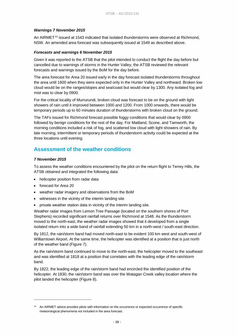
• helicopter position from radar data • forecast for Area 20 • weather radar imagery and observations from the BoM • witnesses in the vicinity of the interim landing site • private weather station data in vicinity of the interim landing site. Weather radar images from Lemon Tree Passage (located on the southern shores of Port Stephens) recorded significant rainfall returns over Richmond at 1548. As the thunderstorm moved to the north-east, the weather radar images showed that it developed from a single isolated return into a wide band of rainfall extending 50 km in a north-west / south-east direction.
By 1812, the rain/storm band had moved north-east to be evident 100 km west and south-west of Williamtown Airport. At the same time, the helicopter was identified at a position that is just north of the weather band (Figure 7).
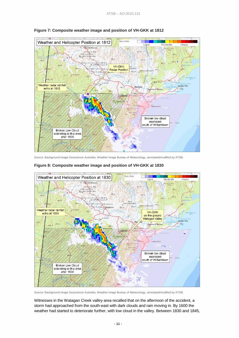
As the rain/storm band continued to move to the north-east, the helicopter moved to the southeast and was identified at 1818 at a position that correlates with the leading edge of the rain/storm band.
By 1822, the leading edge of the rain/storm band had encircled the identified position of the helicopter. At 1830, the rain/storm band was over the Watagan Creek valley location where the pilot landed the helicopter (Figure 8).
14 An AIRMET advice provides pilots with information on the occurrence or expected occurrence of specific
meteorological phenomena not included in the area forecast.
› 11 ‹
ATSB – AO-2015-131
Figure 7: Composite weather image and position of VH-GKK at 1812
Source: Background image Geoscience Australia, Weather image Bureau of Meteorology, annotated/modified by ATSB.
Figure 8: Composite weather image and position of VH-GKK at 1830
Source: Background image Geoscience Australia, Weather image Bureau of Meteorology, annotated/modified by ATSB.
Witnesses in the Watagan Creek valley area recalled that on the afternoon of the accident, a storm had approached from the south-east with dark clouds and rain moving in. By 1600 the weather had started to deteriorate further, with low cloud in the valley. Between 1830 and 1845,
› 12 ‹
ATSB – AO-2015-131
around the time when the helicopter landed in the valley, the witnesses reported that there was heavy rain and reduced visibility in the area. One witness, who advised he was a pilot, later reported that the conditions did not appear conducive to VFR flight.
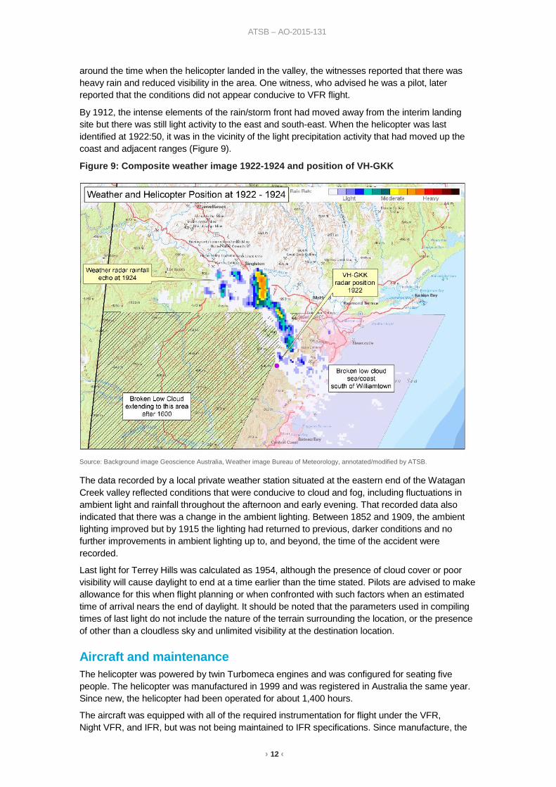
By 1912, the intense elements of the rain/storm front had moved away from the interim landing site but there was still light activity to the east and south-east. When the helicopter was last identified at 1922:50, it was in the vicinity of the light precipitation activity that had moved up the coast and adjacent ranges (Figure 9).
Figure 9: Composite weather image 1922-1924 and position of VH-GKK
Source: Background image Geoscience Australia, Weather image Bureau of Meteorology, annotated/modified by ATSB.
The data recorded by a local private weather station situated at the eastern end of the Watagan Creek valley reflected conditions that were conducive to cloud and fog, including fluctuations in ambient light and rainfall throughout the afternoon and early evening. That recorded data also indicated that there was a change in the ambient lighting. Between 1852 and 1909, the ambient lighting improved but by 1915 the lighting had returned to previous, darker conditions and no further improvements in ambient lighting up to, and beyond, the time of the accident were recorded.
Last light for Terrey Hills was calculated as 1954, although the presence of cloud cover or poor visibility will cause daylight to end at a time earlier than the time stated. Pilots are advised to make allowance for this when flight planning or when confronted with such factors when an estimated time of arrival nears the end of daylight. It should be noted that the parameters used in compiling times of last light do not include the nature of the terrain surrounding the location, or the presence of other than a cloudless sky and unlimited visibility at the destination location.
Aircraft and maintenance The helicopter was powered by twin Turbomeca engines and was configured for seating five people. The helicopter was manufactured in 1999 and was registered in Australia the same year. Since new, the helicopter had been operated for about 1,400 hours.
The aircraft was equipped with all of the required instrumentation for flight under the VFR, Night VFR, and IFR, but was not being maintained to IFR specifications. Since manufacture, the
› 13 ‹
ATSB – AO-2015-131
helicopter had been fitted with a 3-axis autopilot and Garmin GNS15 430 and GNS 530 units. These avionics were integrated and provided the capability to navigate IFR conditions in various autopilot modes. The GNS 530 could display terrain information or provide a Terrain Awareness and Warning System (TAWS), depending on the installed hardware and configuration. The status of the unit fitted to VH-GKK was not established.
The helicopter was also equipped with an auxiliary battery providing ground power for camping and photography equipment.
The helicopter was maintained primarily by the owner-pilot who held a CASA instrument of approval to perform and certify specific aspects of maintenance. There were no anomalies identified in the maintenance records.
Following a 12-monthly inspection, the owner-pilot issued a maintenance release in April 2015 for a period of 12 months and 200 hours of operation. No defects were recorded and maintenance due during the validity period was signed off. Since April 2015, some minor work had been recorded in the logbook, including removal of the fixed Emergency Locator Transmitter (ELT).
Two personal locator beacons (PLBs) were on board and both were found at the accident site within their respective cases. The PLBs were an appropriate regulatory substitute for the fixed unit that had been removed prior to the accident. Neither of the PLBs demonstrated evidence of manual or attempted activation.
At the time of the accident, the aircraft had been operating below its maximum gross weight and the centre of gravity was within the flight manual limits.
Wreckage and impact information Accident site assessment
The helicopter wreckage was distributed in a linear pattern along a distance of approximately 90 m on a heading of 143 degrees magnetic. The first items in the trail were parts from the tail, which indicated that the helicopter entered the tree canopy in a slightly nose up attitude. Tree upper limb damage about 40 metres from the start of the wreckage trail indicated that the helicopter was not banking during entry.
Along the wreckage trail, the trees were about 34 m high and a number of these had upper trunks and branches that were damaged, which was indicative of a relatively level trajectory. As the helicopter passed through the tree canopy, the helicopter cockpit and cabin progressively disintegrated.
All of the helicopter major subassemblies were identified at the accident site. A fragment of one of the main rotor blade tips was found 80 m to the west of the main wreckage along with remnants of tree-top foliage and light branches. There was insufficient evidence to determine how the foliage was dislodged.
The ATSB examined the wreckage and did not identify any pre-existing aircraft defects that may have contributed to the accident sequence.
Data download
The ATSB recovered various aircraft components with recorded data stored from the accident site. The helicopter was not equipped with a flight data recorder or cockpit voice recorder, nor were they required to be fitted in accordance with Australian regulations. The Garmin GNS 430 and 530 units did not record flight parameters.
The two engine control units recovered from the accident site recorded engine power parameters and related parameters such as collective pitch. To establish the functionality of the engines, the
15 Global Navigation System incorporating a communications radio, navigation radio and GPS (Global Positioning
System) receiver.
› 14 ‹
ATSB – AO-2015-131
ATSB arranged for the Bureau d'Enquêtes et d'Analyses (BEA) to work with the engine manufacturer in France to download data from the engine control units. This data showed that the engines were operating normally up to the time of the accident. A failure message, typically generated as a result of this type of accident, was recorded at the same time by both units, approximately 7 minutes after electrical power was turned on, prior to departure from the interim landing site.
The warning unit recovered from the accident site monitors the status of critical operating systems and provides warnings in case of abnormalities such as engine fire, fuel low level, battery malfunction, and low main rotor RPM. The ATSB downloaded data from the warning unit and arranged for the data to be decoded by the BEA and another independent agency. There were no anomalous recorded warnings from engine start until the end of the recorded data. At that point, the warning unit recorded autopilot and main rotor RPM decay warnings that were attributed to the collision with terrain.
The data recorded by the engine control units and the warning unit was not as comprehensive as that recorded by a flight data recorder and does not provide sufficient evidence that all of the helicopter systems were operating normally. However, based on the available data, it is almost certain that the engines were operating normally.
Mobile electronic devices
The ATSB recovered three mobile phones, three cameras, and one iPad from the accident site. The pilot’s iPhone was undamaged and had logged the last phone call at 0828 on the morning of the flight. A weather app was installed, but no data was available to indicate usage.
Another iPhone, belonging to the pilot’s wife, was undamaged and logged the last phone and text activity at 0935 on the morning of the flight. The phone belonging to the other passenger was too damaged to recover any data.
The stored data on the cameras was reviewed and images recorded during the return flight were retained and used in developing the sequence of events and weather information. The iPad did not have a SIM card and no information useful to the investigation was identified.
Emergency locator transmitters Civil Aviation Regulation (CAR) 252(A) requires the carriage of an emergency locator transmitter (ELT) on most flights in Australian airspace. This requirement can be satisfied by an ELT that is mounted on the helicopter and activates automatically when it senses an excessive force, such as a ground impact. An alternative means of compliance is the carriage of a portable personal locator beacon (PLB) that is activated manually.
On activation, an ELT or PLB transmits on two frequencies, one of which can be detected by orbiting satellites that transmit a signal to search and rescue coordinators. The other frequency can be picked up by overhead aircraft for detection and homing in on the activated beacon, or can be used by crews to alert relevant authorities.
The ATSB research report AR-2012-128: A review of the effectiveness of emergency locator transmitters in aviation accidents states that search and rescue personnel were alerted to aviation emergencies in a variety of ways including radio calls and phone calls and that ELT activation accounted for the first notification in only about 15 percent of incidents. To the date of the research report reference, ELT activations have been directly responsible for saving an average of four lives per year.
The research report noted that both fixed ELTs and personal portable beacons have limitations that include degraded signalling capability when the ELT aerial is damaged in a serious accident, and lack of activation when the impact force is not aligned with the orientation of the ELT or when the occupant is unable to activate a PLB due to injury. GPS-equipped ELTs significantly increase the accuracy of positional information and newer ELTs, incorporating 3-axis g-switches may
› 15 ‹
ATSB – AO-2015-131
improve the likelihood of activation upon impact. Carriage of a PLB in place of, or as well as a fixed ELT will be of most safety benefit if it is carried on the person.
Additionally, developments in tracking technology now allows for GPS supported or combined GPS/cellular network supported products enabling real time monitoring of an aircraft’s movements, with the provision of scheduled updates to nominated parties and immediate notification in case of an emergency. Automatic alert signals can also be provided in the event of loss of power or sudden change in altitude with the ability to manually activate in the event of an emergency.
Visual flight into Instrument Meteorological Conditions Accident data
The safety risks of VFR pilots flying from VMC conditions into instrument meteorological conditions (IMC)16 are well documented. This has been the focus of numerous ATSB reports and publications, as VFR pilots flying into IMC represent a significant cause of aircraft accidents and fatalities. In 2013, the ATSB Avoidable Accidents series was re-published. One of these publications, the booklet titled Accidents involving Visual Flight Rules pilots in Instrument Meteorological Conditions outlined that:
In the 5 years 2006–2010, there were 72 occurrences of visual flight rules (VFR) pilots flying in instrument meteorological conditions (IMC) reported to the ATSB…About one in ten VFR into IMC events result in a fatal outcome.
Additionally, a study conducted by the United States National Transportation Safety Board (2005) found that ‘about two-thirds of all general aviation accidents that occur in instrument meteorological conditions (IMC) are fatal’.
Wiggins and O’Hare (1995) explained that when pilots are not trained or qualified to fly in IMC and find themselves in these conditions, ‘the result will almost inevitably involve loss of control of the aircraft resulting in a fatal crash’.
Loss of visual cues and spatial disorientation in low visibility conditions
In a discussion of spatial disorientation, Benson (1999) defined the experience as follows:
Spatial disorientation is…[where] the pilot fails to sense correctly the position, motion or attitude of the aircraft or of him/herself [resulting in] errors in perception by the pilot of their position, motion or attitude with respect to their aircraft...
Gibb et al. (2010) explain that seeing the horizon is ‘crucial for orientation of the pilot’s sense of pitch and bank of the aircraft.’ In conditions of low visibility, the horizon may not be visible to the pilot, during which time they can become rapidly disorientated.
Extensive research on spatial disorientation indicates that loss of control will likely occur between 60 seconds (Benson, 1983 in Gibb et al., 2010) and 178 seconds (Newman, 2007) after the loss of visual reference. This is the case even when the aircraft is in straight and level flight at the time vision is lost, and is shorter still if the aircraft is in a turn. Gibb et al. (2010) state that ‘spatial disorientation accidents have fatality rates of 90–91 percent, which indicates how compelling the misperceptions can be’.
16 IMC: weather conditions that require pilots to fly primarily by reference to instruments, and therefore under Instrument
Flight Rules (IFR), rather than by outside visual reference. Typically, this means flying in cloud or limited visibility.
› 16 ‹
ATSB – AO-2015-131
Related occurrences ATSB investigation AO-2008-063: Controlled flight into terrain - Scone, New South Wales on 14 September 2008
On 14 September 2008, a Cessna Aircraft Co. U206A aircraft, registered VH-JDQ, with a pilot and two passengers on board, was on a private flight under the visual flight rules (VFR) from Bankstown, NSW to Archerfield, Qld with a planned stop at Scone, NSW. The aircraft was reported missing when it did not arrive at Archerfield as expected later that day.
Australian Search and Rescue were notified and, during the subsequent search, the wreckage of the aircraft was located the following day on top of a 3,800 ft ridge in rugged terrain, approximately 56 km (30 NM) north-north-east of Scone Airport. All three occupants were fatally injured and the aircraft was destroyed.
The weather in the area at the time of the occurrence was not suitable for VFR flight and included low cloud, rain showers and high winds. Inspection of the accident site indicated that the aircraft was tracking towards Scone prior to impact with terrain.
ATSB investigation AO-2009-077: Visual flight into instrument meteorological conditions - Dorrigo, New South Wales on 9 December 2009
On 9 December 2009, at about 1120 Eastern Daylight-saving Time, the pilot of a Bell Helicopter Company 206L-1 LongRanger, registered VH-MJO, was conducting a visual flight rules fire-fighting support flight in the area of Dorrigo, New South Wales with one passenger on board. Shortly after takeoff, the pilot encountered reduced visibility conditions due to low cloud. Subsequently, all visual reference with the horizon and the ground was lost. The pilot attempted to land, but the helicopter impacted the ground in an uncontrolled state and with significant vertical force. The passenger was fatally injured and the pilot was seriously injured. The helicopter was seriously damaged.
The investigation found that after the pilot established the hover, the helicopter entered the rapidly fluctuating cloud. The pilot lost visual reference and became spatially disoriented and the helicopter impacted the ground in an uncontrolled state. The at times rapidly-moving fog or low cloud in the vicinity of the helicopter landing area (HLA) increased the risk of visual operations encountering instrument meteorological conditions at the HLA.
ATSB investigation AO-2011-100: VFR flight into dark night conditions – Horsham, Victoria on 15 August 2011
On 15 August 2011, the pilot of a Piper PA-28-180 Cherokee aircraft, registered VH-POJ, was conducting a private flight transporting two passengers from Essendon to Nhill, Victoria under the VFR. The flight was arranged to return the passengers to their home location after medical treatment in Melbourne.
Global Positioning System data recovered from the aircraft indicated that when about 52 km from Nhill, the aircraft conducted a series of manoeuvres followed by a descending right turn. The aircraft subsequently impacted the ground at 1820 Eastern Standard Time, fatally injuring the pilot and one of the passengers. The second passenger later died in hospital as a result of complications from injuries sustained in the accident.
The ATSB found that the pilot landed at Bendigo and accessed a weather forecast before continuing towards Nhill. After recommencing the flight, the pilot probably encountered reduced visibility conditions while approaching Nhill due to low cloud, rain and diminishing daylight, leading to disorientation, loss of control and impact with terrain.
› 17 ‹
ATSB – AO-2015-131
ATSB investigation AO-2016-031: Collision with water – Cape Tribulation, Queensland on 7 April 2016
On 7 April 2016, the pilots of two Robinson R22 helicopters flew from Mossman, Queensland to various fishing locations to the north with a passenger in each helicopter. Late in the afternoon, the pilots commenced the direct return flight to Mossman.
Shortly after passing Cape Tribulation, in dark night conditions, one of the helicopters registered VH-YLY, collided with the sea. The passenger was injured in the accident but was able to reach the shore and notify emergency services. The pilot’s body was not located.
The ATSB found that the pilot, who was only qualified to operate in day-VFR conditions, departed on a night flight and continued towards the destination in deteriorating visibility until inadvertently allowing the helicopter to descend into water.
› 18 ‹
ATSB – AO-2015-131
Safety analysis The ATSB did not have access to recorded data that showed the helicopter flight path or key operational parameters, at, or immediately before the collision with terrain. There were no witnesses to, or video of, the accident sequence. As such, the ATSB was reliant on recorded engine parameters and system warnings along with interpretation of aircraft wreckage, the accident site and weather data, to determine the characteristics of the collision with terrain.
The following analysis examines the known flight path and considers elements that may have influenced the decision to depart the interim landing site and continue the flight. The analysis also examines safety considerations associated with VFR pilot decision making and the carriage of emergency locator transmitting devices.
Pre-flight weather assessment Although the pilot did not have a NAIPS account for access to aviation weather forecasts/reports, the pilot might have accessed equivalent weather information from other sources or referred to available non-aviation weather information.
Based on the Area 20 forecast and aerodrome forecasts (TAFs) available before the pilot’s departure from Terrey Hills, it would have been apparent that the flight to Breeza and return could be affected by isolated thunderstorms, and low cloud with light showers/drizzle near the coast south of Williamtown. Although the weather for the flight to Breeza was not reported to have presented a problem, the return flight was later in the day and the type of forecast weather was associated with a moist, unstable air mass.
If the Area 20 forecast issued about an hour before the intended departure from Breeza was taken into consideration, it would be apparent that the flight could be affected by isolated thunderstorms, and low cloud south of Williamtown that would have extended inland. The TAFs for aerodromes adjacent to the route were relatively benign, but the TAF for Richmond indicated that the weather in the Terrey Hills area could have temporary periods of low cloud and rain.
The forecasts were generally consistent with the conditions that developed in the area. The thunderstorm-related activity on the pilot’s intended route was more extensive than the isolated descriptor in the forecast might indicate. However, this type of weather was not precluded by the forecast and local conditions across a forecast area will vary.
Collision with terrain Data downloaded from the engine control and warning units indicated that there was no problem with the operation of the engines or other monitored helicopter systems up to the point of collision with terrain. There was also no radio transmission from the pilot, either heard or recorded, to advise of any problem. This was consistent with examination of the helicopter wreckage and review of the helicopter logbooks that did not identify any airworthiness concerns. Although these items of evidence are not conclusive, it is unlikely that there was a problem with the helicopter.
The ATSB accessed and analysed a variety of sources of meteorological data to ascertain the weather at the time of the accident. There was low cloud, drizzle and reduced visibility in the area. Although the conditions were marginal for VFR, there was likely to be some variability and it was not possible to establish if the weather in the latter stages of the flight allowed the pilot to operate clear of cloud and with a minimum of 800 m visibility, as per the helicopter visual meteorological conditions (VMC) requirements.
The last recorded radar data showed that the pilot conducted a series of right turns with a change of direction from south-east to north-west. During the turns, the pilot climbed from 1,700 to 2,100 ft, which correlated to an increase in height above terrain from about 350 to 750 ft.
It is almost certain that the pilot made the right turns in response to the weather conditions and it is possible that the pilot lost visual contact with the ground and climbed to ensure that he maintained
› 19 ‹
ATSB – AO-2015-131
terrain clearance. Given the weather conditions, at the point the radar returns dropped out, it is unlikely that the pilot was able to remain in VMC. It is possible that pilot was reversing track to return to the interim landing area.
Nothing more is known about the helicopter’s flight path until it collided with terrain shortly afterwards on a south-easterly bearing and close to the last recorded radar position. This bearing and position are consistent with a continuation of the original flight track; however, the ATSB could not determine if that was the pilot’s intention.
In the period from the last recorded radar return prior to the collision with terrain, the pilot descended about 700 ft. The ATSB was unable to determine if the pilot was taking advantage of a break in the cloud to descend visually or trying to descend through cloud to establish visual reference to the ground.
If the pilot had been descending through cloud in order to establish visual reference to the ground, this behaviour may have been consistent with the pilot’s experience in 2004, as related in the book published by the pilot. Although the book related the pilot’s descent in cloud until visual reference was established at low altitude, the context in this case was different. Instead of flying over water and coastline, the pilot was contending with terrain that was undulating, uniformly textured, and relatively high.
To fly visually in this environment with low visibility is difficult, as the situation requires that the pilot maintain reference to the ground to maintain control, avoid terrain, and avoid low cloud and other areas of reduced visibility. The pilot had GPS receivers and moving map displays to assist with navigation, and flight instruments and autopilot with IFR capability, but that equipment was of limited use if the pilot was attempting to maintain visual reference. Based on the data available to the ATSB, it was not possible to determine whether the accident was a result of controlled flight into terrain or loss of control due to spatial disorientation.
Assessment of local conditions It was not possible to establish if the manoeuvring before the collision with terrain indicated the pilot was attempting to return to the previous landing area or attempting to find a way through to the destination. Whatever the pilot’s intentions, at the time of the accident the pilot probably found himself in a situation where he was unable to negotiate the weather conditions with visual reference to the ground. In that context, the ATSB considered the pilot’s decision to lift off from the interim landing site and to continue the flight.
The ATSB was unable to identify all of the aspects relevant to the pilot’s decision to depart from the interim landing site but it is likely that the pilot was influenced by the following situational factors:
• an apparent improvement in the local weather • the expected flight time to the destination meant that the expected time of arrival was getting
increasingly closer to last light • the distance from the interim landing site to lower terrain was relatively short • the pilot may have been unaware of the actual weather along the prospective route or had
reasonable expectations of navigating the weather conditions. In considering a departure from the interim landing site, the pilot was able to assess the weather visible from the location and had the capability to access forecast and actual weather information via mobile devices. Although the pilot’s phone was not used, there were other devices available, and internet use for those devices could not be established.
The pilot’s decision to depart the interim landing site can be interpreted as likely taking advantage of a break in the severity of the local weather to proceed as far as the weather would allow. If the pilot had reached the lower terrain near the coast, there was a greater likelihood of being able to continue the flight to the destination or land at an airport with access to accommodation.
› 20 ‹
ATSB – AO-2015-131
Once airborne, the pilot would have been in a position to assess the in-flight visibility and cloud and rain in the intended direction of travel. In another occurrence investigation,17 the ATSB has found that the ‘continuation of flight towards an area of low cloud and rain was likely influenced by the inherent challenges of assessing low visibility conditions, particularly without instrument flying proficiency.’ This finding was based on the following references.
The United States National Transportation Safety Board (2005) found that ‘reduced-visibility weather represents a particularly high risk to [general aviation] operations’ and that ‘weather may…test the limits of pilot knowledge, training, and skill to the point that underlying issues are identified.’
Wiegmann and Goh (2000) explained that:
One reason why pilots may decide to continue a VFR flight into adverse weather is that they make errors when assessing the situation. That is, pilots are seen to engage in VFR flight into IMC [instrument meteorological conditions] because they do not accurately assess the hazard (i.e., the deteriorating weather conditions).
The previously-mentioned United States National Transportation Safety Board report (2005) added that in these cases, pilots who might appear to intentionally engage in risky behaviour may actually be making choices that they mistakenly believe to be safe:
Even if pilots are able to correctly assess current weather conditions, they may still underestimate the risk associated with continued flight under those conditions, or they may overestimate their ability to handle that risk.
Wiggins and O’Hare (1995) further explained how errors in assessment can take place, acknowledging that weather-related decision making can be highly complex and therefore more prone to errors:
Because of the variable nature of operations in the aviation environment, weather-related decision making is often considered a skill that cannot be prescribed during training. Rather it is expected to develop gradually through practical experience. However, in developing this type of experience, relatively inexperienced pilots may be exposed to hazardous situations with which they are ill-equipped to cope.
ATSB Aviation Research and Analysis Report B20070063, An overview of spatial disorientation as a factor in aviation accidents and incidents, stated that pilots should not attempt to fly into instrument meteorological conditions under the VFR. Pilots should develop a plan prior to take-off on what to do if the weather en route is different from that expected, or deteriorates. This plan should consider a requirement to divert or turn back prior to entering instrument meteorological conditions. However, this depends on a pilot correctly assessing the weather conditions. The United States National Transportation Safety Board (2005) noted that targeted weather-related training programs have had some success in teaching pilots to recognise and respond to deteriorating weather conditions.
Additionally, Wiggins and O’Hare (2003) evaluated the effectiveness of a cue-based training system called Weatherwise, which was designed to equip VFR pilots with the skills to recognise and respond to the cues associated with deteriorating weather conditions during flight. VFR pilots were more likely to use the cues following the training, with subsequent improvements in their weather-related decision-making. The Weatherwise program was made available to pilots by the Civil Aviation Safety Authority (CASA). Additionally, CASA produced a Weather to Fly education program which focuses on topics such as the importance of pre-flight preparation, making decisions early, and talking to ATC.
The ATSB was unable to determine the pilot’s understanding of the weather conditions ahead of him prior to entering an area of low visibility conditions. However, the pilot had demonstrated an awareness of the risk posed by the weather and the need to maintain visual reference by diverting
17 AO-2016-006 Loss of control and collision with water involving Piper Aircraft Corp PA-28-235, VH-PXD. A copy of this
report is available from www.atsb.gov.au
› 21 ‹
ATSB – AO-2015-131
from the original track from Breeza then turning back from the first attempt to cross the high terrain.
Until the conditions improved, the only safe option available to the VFR pilot was to leave the helicopter at the interim landing site or transit to another landing area in the valley as the conditions permitted.
Safety considerations VFR pilot decision-making
One of the ATSB’s SafetyWatch priorities concerns in-flight decision making in relation to VFR flight in environments with reduced visual references. As Avoidable Accidents No. 4 - Accidents involving Visual Flight Rules pilots in Instrument Meteorological Conditions relates:
Weather-related general aviation accidents remain one of the most significant causes for concern in aviation safety; the often-fatal outcomes of these accidents are usually all the more tragic because they are avoidable.
In the 5 years 2006–2010, there were 72 occurrences of visual flight rules (VFR) pilots flying in instrument meteorological conditions (IMC) reported to the ATSB. Seven of these resulted in fatal accidents, causing 14 fatalities. That is, about one in ten VFR into IMC events result in a fatal outcome.
Flying into IMC can occur in any phase of flight. However, a 2005 ATSB research publication General Aviation Pilot Behaviours in the Face of Adverse Weather concluded that the chances of a VFR into IMC encounter increased as the flight progressed, with the maximum chance occurring during the final 20 per cent of the flight distance.
The dangers of flying VFR into IMC have been recognised for a long time, yet VFR pilots still fly into deteriorating weather and IMC. This publication describes recent weather-related general aviation accidents and incidents that show that weather alone is never the only factor affecting pilot decisions that result in inadvertent IMC encounters. It has been produced solely with the intention of encouraging all pilots, no matter what their experience level, to develop the knowledge and skills required to avoid unintentional operations in IMC.
One of the key messages is for pilots to avoid deteriorating weather by conducting thorough pre-flight planning and to have alternate plans in case of an unexpected deterioration in the weather and making timely decisions to turn back or divert.
This principle applies to all aircraft operations, even though helicopters are inherently more flexible in terms of availability of landing areas and manoeuvrability. All pilots need to have a relevant and effective contingency plan that is based on the best available information in weather forecasts and reports.
Location of aircraft in an emergency
The pilot was operating with two Personal Locator Beacons (PLBs) and no fixed Emergency Locator Transmitter (ELT). Unlike a fixed ELT, the PLBs were not fitted with a ‘g’ switch and would require manual activation to transmit information. In this case, the occupants were fatally injured in the accident and no position information was transmitted from the beacons.
ATSB report AR-2012-128: A review of the effectiveness of emergency locator transmitters in aviation accidents references an Australian Maritime Safety Authority (AMSA) recommendation that occupants of an aircraft proactively activate an ELT (or PLB in this case also) when flying in dangerous weather conditions. This would greatly increase the likelihood of establishing the exact position of the aircraft if required. AMSA would need to be notified once the dangerous phase of the flight was complete and the ELT/PLB has been switched off. Activating a beacon under such circumstances requires an active decision on the part of the pilot. Additionally, in the event of inadvertent entry into IMC, pilots are encouraged to contact air traffic control for assistance, however on this occasion, no radio calls from the pilot to air traffic control were on record.

› 22 ‹
ATSB – AO-2015-131
The severity of an accident potentially restricts fixed or portable ELTs to be reliably activated due to impact forces that can render the units inoperable, with research noting that they save about four lives a year. Furthermore, search and rescue operations also place others at risk and a degree of uncertainty exists until a missing aircraft is located. The removal of the fixed ELT with the potential for self-activation, for manually operable PLBs was in accordance with the regulatory requirements. On this occasion, the absent transmission coupled with the uncertainty of when the group would return to Terrey Hills, delayed the search and rescue response.
› 23 ‹
ATSB – AO-2015-131
Findings From the evidence available, the following findings are made with respect to the collision with terrain involving Airbus Helicopters EC 135 T1, VH-GKK, that occurred near Cooranbong, NSW on 7 November 2015. These findings should not be read as apportioning blame or liability to any particular organisation or individual.
Contributing factor • The pilot departed an interim landing site for Terrey Hills under the visual flight rules with a high
risk of encountering forecast cloud and reduced visibility. Due to the likely presence of cloud, the pilot probably experienced a loss of visual reference leading to a collision with terrain.
Other findings • The personal locator beacons carried in lieu of a fixed emergency locator transmitter were
required to be activated in the case of an accident. While in this accident it did not affect the outcome for the occupants, the lack of activation, combined with the absence of flight notification information, delayed the search and rescue response.
› 24 ‹
ATSB – AO-2015-131
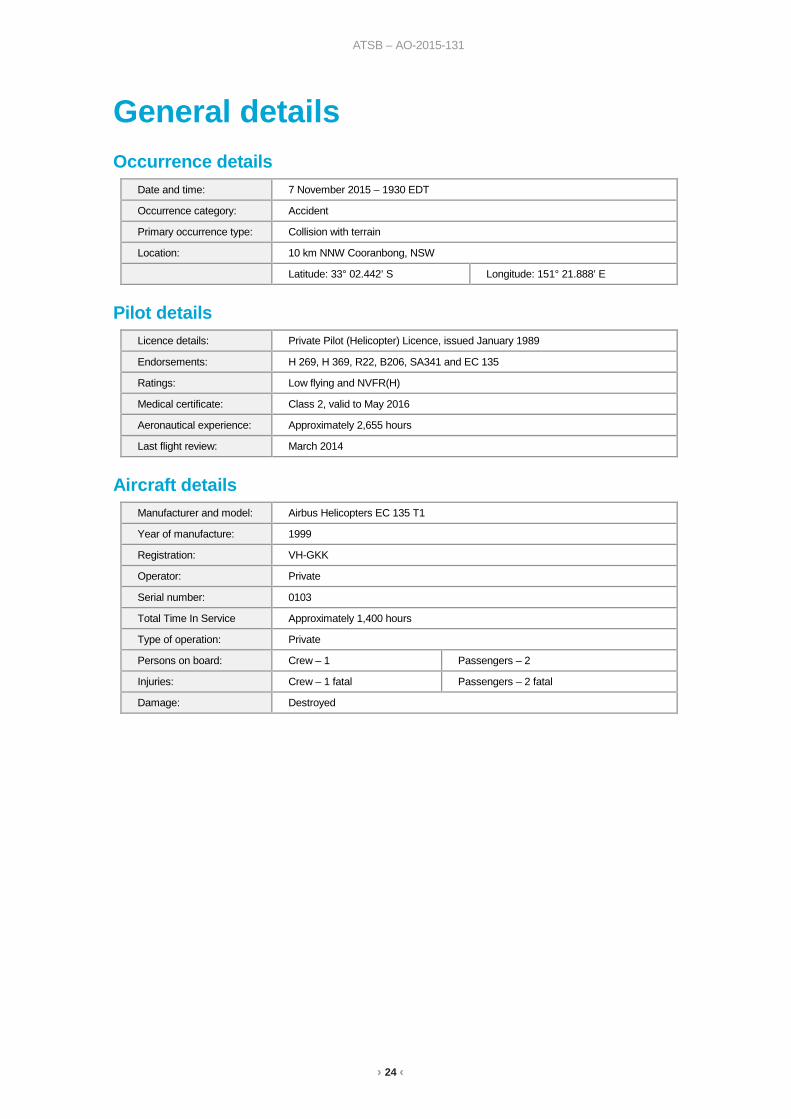
General details Occurrence details
Date and time: 7 November 2015 – 1930 EDT
Occurrence category: Accident
Primary occurrence type: Collision with terrain
Location: 10 km NNW Cooranbong, NSW
Latitude: 33° 02.442’ S Longitude: 151° 21.888’ E
Pilot details Licence details: Private Pilot (Helicopter) Licence, issued January 1989
Endorsements: H 269, H 369, R22, B206, SA341 and EC 135
Ratings: Low flying and NVFR(H)
Medical certificate: Class 2, valid to May 2016
Aeronautical experience: Approximately 2,655 hours
Last flight review: March 2014
Aircraft details Manufacturer and model: Airbus Helicopters EC 135 T1
Year of manufacture: 1999
Registration: VH-GKK
Operator: Private
Serial number: 0103
Total Time In Service Approximately 1,400 hours
Type of operation: Private
Persons on board: Crew – 1 Passengers – 2
Injuries: Crew – 1 fatal Passengers – 2 fatal
Damage: Destroyed
› 25 ‹
ATSB – AO-2015-131
Sources and submissions Sources of information The sources of information during the investigation included:
• the Civil Aviation Safety Authority • the Bureau of Meteorology • Airservices Australia • the French Bureau d'Enquêtes et d'Analyses • the German Federal Bureau of Aircraft Accident Investigation • SAFRAN – Turbomeca • a number of witnesses.
References Australian Transport Safety Bureau, 2011, Avoidable Accidents No. 4 Accidents involving Visual Flight Rules pilots in Instrument Meteorological Conditions, Aviation Research and Analysis publication AR-2011-050.
Australian Transport Safety Bureau, 2012, A review of the effectiveness of emergency locator transmitters in aviation accidents, Aviation Research and Analysis publication AR-2012-128.
Australian Transport Safety Bureau, 2017, Loss of control and collision with water involving Piper Aircraft Corporation, PA-28-235, VH-PXD, AO-2016-006.
Benson, AJ, 1999a, “Spatial disorientation – general aspects”, in J Ernsting, AN Nicholson & DJ Rainford (Eds.), Aviation Medicine (3rd ed.), Oxford, England, Butterworth Heinemann, pp. 419-436.
Gibb, R, Gray, R and Scharff, L, 2010, Aviation Visual Perception: Research, Misperceptions and Mishaps, Ashgate Publishing Limited, Surrey, United Kingdom.
Newman, DG, 2007, An overview of spatial disorientation as a factor in aviation accidents and incidents, Australian Transport Safety Bureau, Aviation Research and Analysis Report B2007/0063.
National Transportation Safety Board 2005, Risk Factors Associated with Weather-Related General Aviation Accidents, National Transportation Safety Board Safety Study NTSB/SS-05/01, Washington DC, United States.
Wiegmann, D and Goh, J, 2000, Visual Flight Rules (VFR) Flight into Adverse Weather: An Empirical Investigation of Factors Affecting Pilot Decision Making, Federal Aviation Administration research DTFA 00-G-010, Illinois, United States.
Wiggins, M and O’Hare, D, 1995, “Expertise in Aeronautical Weather-Related Decision Making: A Cross-Sectional Analysis of General Aviation Pilots”, Journal of Experimental Psychology: Applied Vol. 1 No. 4, pp. 305-320.
Wiggins, M and O’Hare, D, 2003, “Weatherwise: Evaluation of a cue-based training approach for the recognition of deteriorating weather conditions during flight”, The Journal of Human Factors and Ergonomics Society, pp.337-345.
Submissions Under Part 4, Division 2 (Investigation Reports), Section 26 of the Transport Safety Investigation Act 2003 (the Act), the Australian Transport Safety Bureau (ATSB) may provide a draft report, on a confidential basis, to any person whom the ATSB considers appropriate. Section 26 (1) (a) of
› 26 ‹
ATSB – AO-2015-131
the Act allows a person receiving a draft report to make submissions to the ATSB about the draft report.
A draft of this report was provided to the Civil Aviation Safety Authority and the German Federal Bureau of Aircraft Accident Investigation.
Submissions were received from both organisations. A review of those submissions did not result in any amendment to the text of the report.
› 27 ‹
ATSB – AO-2015-131
Australian Transport Safety Bureau The ATSB is an independent Commonwealth Government statutory agency. The ATSB is governed by a Commission and is entirely separate from transport regulators, policy makers and service providers. The ATSB’s function is to improve safety and public confidence in the aviation, marine and rail modes of transport through excellence in: independent investigation of transport accidents and other safety occurrences; safety data recording, analysis and research; fostering safety awareness, knowledge and action.
The ATSB is responsible for investigating accidents and other transport safety matters involving civil aviation, marine and rail operations in Australia that fall within Commonwealth jurisdiction, as well as participating in overseas investigations involving Australian registered aircraft and ships. A primary concern is the safety of commercial transport, with particular regard to operations involving the travelling public.
The ATSB performs its functions in accordance with the provisions of the Transport Safety Investigation Act 2003 and Regulations and, where applicable, relevant international agreements.
Purpose of safety investigations The object of a safety investigation is to identify and reduce safety-related risk. ATSB investigations determine and communicate the factors related to the transport safety matter being investigated.
It is not a function of the ATSB to apportion blame or determine liability. At the same time, an investigation report must include factual material of sufficient weight to support the analysis and findings. At all times the ATSB endeavours to balance the use of material that could imply adverse comment with the need to properly explain what happened, and why, in a fair and unbiased manner.
Developing safety action Central to the ATSB’s investigation of transport safety matters is the early identification of safety issues in the transport environment. The ATSB prefers to encourage the relevant organisation(s) to initiate proactive safety action that addresses safety issues. Nevertheless, the ATSB may use its power to make a formal safety recommendation either during or at the end of an investigation, depending on the level of risk associated with a safety issue and the extent of corrective action undertaken by the relevant organisation.
When safety recommendations are issued, they focus on clearly describing the safety issue of concern, rather than providing instructions or opinions on a preferred method of corrective action. As with equivalent overseas organisations, the ATSB has no power to enforce the implementation of its recommendations. It is a matter for the body to which an ATSB recommendation is directed to assess the costs and benefits of any particular means of addressing a safety issue.
When the ATSB issues a safety recommendation to a person, organisation or agency, they must provide a written response within 90 days. That response must indicate whether they accept the recommendation, any reasons for not accepting part or all of the recommendation, and details of any proposed safety action to give effect to the recommendation.
The ATSB can also issue safety advisory notices suggesting that an organisation or an industry sector consider a safety issue and take action where it believes it appropriate. There is no requirement for a formal response to an advisory notice, although the ATSB will publish any response it receives.
AT
SB
Transp
ort S
afety Rep
ort
Aviation O
ccurrence Investigation
Collision w
ith terrain involving Airbus H
elicopters EC
135 T1, V
H-G
KK
10 km N
NW
Cooranbong, N
ew S
outh Wales on
7 Novem
ber 2015
AO
-2015-131
Final – 24 April 2018
Investigatio
n
Australian Transport Safety Bureau
Enquiries 1800 020 616 Notifications 1800 011 034 REPCON 1800 020 505Web www.atsb.gov.auTwitter @ATSBinfoEmail [email protected] Facebook atsbgovau