Embed Size (px)
Citation preview
Contents
VAN HINSBERGEN, D. J. J., EDWARDS, M. A. & GOVERS, R. Geodynamics of collision andcollapse at the Africa–Arabia–Eurasia subduction zone – an introduction
1
ROBERTSON, A. H. F., PARLAK, O. & USTAOMER, T. Melange genesis and ophioliteemplacement related to subduction of the northern margin of the Tauride–Anatolide continent,central and western Turkey
9
KAYMAKCI, N., OZCELIK, Y., WHITE, S. H. & VAN DIJK, P. M. Tectono-stratigraphy of theCankırı Basin: Late Cretaceous to early Miocene evolution of the Neotethyan Suture Zone inTurkey
67
HUSING, S. K., ZACHARIASSE, W.-J., VAN HINSBERGEN, D. J. J., KRIJGSMAN, W., INCEOZ,M., HARZHAUSER, M., MANDIC, O. & KROH, A. Oligocene–Miocene basin evolution in SEAnatolia, Turkey: constraints on the closure of the eastern Tethys gateway
107
HUBERT-FERRARI, A., KING, G., VAN DER WOERD, J., VILLA, I., ALTUNEL, E. & ARMIJO, R.Long-term evolution of the North Anatolian Fault: new constraints from its eastern termination
133
EDWARDS, M. A. & GRASEMANN, B. Mediterranean snapshots of accelerated slab retreat:subduction instability in stalled continental collision
155
ARGNANI, A. Evolution of the southern Tyrrhenian slab tear and active tectonics along thewestern edge of the Tyrrhenian subducted slab
193
DILEK, Y. & ALTUNKAYNAK, S. Geochemical and temporal evolution of Cenozoic magmatismin western Turkey: mantle response to collision, slab break-off, and lithospheric tearing in anorogenic belt
213
VIGNAROLI, G., FACCENNA, C., ROSSETTI, F. & JOLIVET, L. Insights from the Apenninesmetamorphic complexes and their bearing on the kinematics evolution of the orogen
235
TIREL, C., GAUTIER, P., VAN HINSBERGEN, D. J. J. & WORTEL, M. J. R. Sequentialdevelopment of interfering metamorphic core complexes: numerical experiments andcomparison with the Cyclades, Greece
257
PAPANIKOLAOU, D., GOULIOTIS, L. & TRIANTAPHYLLOU, M. The Itea–Amfissa detachment:a pre-Corinth rift Miocene extensional structure in central Greece
293
VAN HINSBERGEN, D. J. J. & BOEKHOUT, F. Neogene brittle detachment faulting on Kos(E Greece): implications for a southern break-away fault of the Menderes metamorphic corecomplex (western Turkey)
311
SEN, S. & SEYITOGLU, G. Magnetostratigraphy of early–middle Miocene deposits fromeast–west trending Alasehir and Buyuk Menderes grabens in western Turkey, and its tectonicimplications
321
KOKINOU, E. & KAMBERIS, E. The structure of the Kythira–Antikythira strait, offshoreSW Greece (35.78–36.68N)
343
Index 361

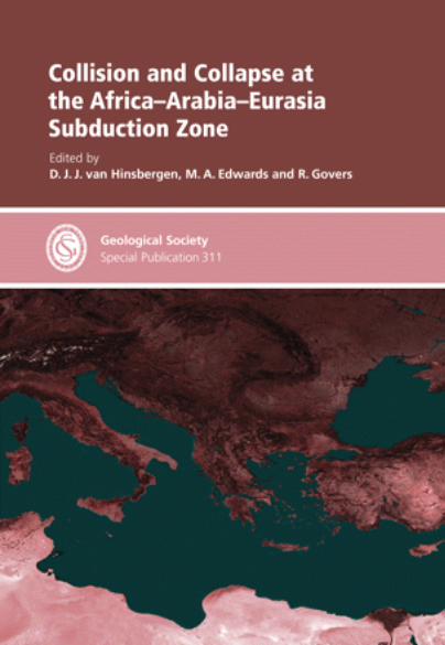
Collision and Collapse at the Africa–Arabia–Eurasia
Subduction Zone
The Geological Society of London
Books Editorial Committee
Chief Editor
BOB PANKHURST (UK)
Society Books Editors
JOHN GREGORY (UK)
JIM GRIFFITHS (UK)
JOHN HOWE (UK)
PHIL LEAT (UK)
NICK ROBINS (UK)
JONATHAN TURNER (UK)
Society Books Advisors
MIKE BROWN (USA)
ERIC BUFFETAUT (FRANCE)
JONATHAN CRAIG (ITALY)
RETO GIERE (GERMANY)
TOM MCCANN (GERMANY)
DOUG STEAD (CANADA)
RANDELL STEPHENSON (UK)
Geological Society books refereeing procedures
The Society makes every effort to ensure that the scientific and production quality of its books matches thatof its journals. Since 1997, all book proposals have been refereed by specialist reviewers as well as by theSociety’s Books Editorial Committee. If the referees identify weaknesses in the proposal, these must beaddressed before the proposal is accepted.
Once the book is accepted, the Society Book Editors ensure that the volume editors follow strictguidelines on refereeing and quality control. We insist that individual papers can only be accepted aftersatisfactory review by two independent referees. The questions on the review forms are similar to those forJournal of the Geological Society. The referees’ forms and comments must be available to the Society’sBook Editors on request.
Although many of the books result from meetings, the editors are expected to commission papers thatwere not presented at the meeting to ensure that the book provides a balanced coverage of the subject. Beingaccepted for presentation at the meeting does not guarantee inclusion in the book.
More information about submitting a proposal and producing a book for the Society can be found on itsweb site: www.geolsoc.org.uk.
It is recommended that reference to all or part of this book should be made in one of the following ways:
VAN HINSBERGEN, D. J. J., EDWARDS, M. A. & GOVERS, R. (eds) 2009. Collision and Collapse at theAfrica–Arabia–Eurasia Subduction Zone. Geological Society, London, Special Publications, 311.
ROBERTSON, A. H. F., PARLAK, O. & USTAOMER, T. 2009. Melange genesis and ophiolite emplacementrelated to subduction of the northern margin of the Tauride–Anatolide continent, central and westernTurkey. In: VAN HINSBERGEN, D. J. J., EDWARDS, M. A. & GOVERS, R. (eds) Collision and Collapseat the Africa–Arabia–Eurasia Subduction Zone. Geological Society, London, Special Publications,311, 9–66.
GEOLOGICAL SOCIETY SPECIAL PUBLICATION NO. 311
Collision and Collapse at the Africa–Arabia–Eurasia
Subduction Zone
EDITED BY
D. J. J. VAN HINSBERGEN
Utrecht University, The Netherlands
M. A. EDWARDS
University of Vienna, Austria
and
R. GOVERS
Utrecht University, The Netherlands
2009
Published by
The Geological Society
London
THE GEOLOGICAL SOCIETY
The Geological Society of London (GSL) was founded in 1807. It is the oldest national geological society in the worldand the largest in Europe. It was incorporated under Royal Charter in 1825 and is Registered Charity 210161.
The Society is the UK national learned and professional society for geology with a worldwide Fellowship (FGS) ofover 9000. The Society has the power to confer Chartered status on suitably qualified Fellows, and about 2000 of theFellowship carry the title (CGeol). Chartered Geologists may also obtain the equivalent European title, EuropeanGeologist (EurGeol). One fifth of the Society’s fellowship resides outside the UK. To find out more about the Society,log on to www.geolsoc.org.uk.
The Geological Society Publishing House (Bath, UK) produces the Society’s international journals and books,and acts as European distributor for selected publications of the American Association of Petroleum Geologists(AAPG), the Indonesian Petroleum Association (IPA), the Geological Society of America (GSA), the Society forSedimentary Geology (SEPM) and the Geologists’ Association (GA). Joint marketing agreements ensure that GSLFellows may purchase these societies’ publications at a discount. The Society’s online bookshop (accessible fromwww.geolsoc.org.uk) offers secure book purchasing with your credit or debit card.
To find out about joining the Society and benefiting from substantial discounts on publications of GSL and othersocieties worldwide, consult www.geolsoc.org.uk, or contact the Fellowship Department at: The Geological Society,Burlington House, Piccadilly, London W1J 0BG: Tel. þ44 (0)20 7434 9944; Fax þ44 (0)20 7439 8975; E-mail:[email protected].
For information about the Society’s meetings, consult Events on www.geolsoc.org.uk. To find out more about theSociety’s Corporate Affiliates Scheme, write to [email protected].
Published by The Geological Society from:The Geological Society Publishing House, Unit 7, Brassmill Enterprise Centre, Brassmill Lane, Bath BA1 3JN, UK
(Orders: Tel. þ44 (0)1225 445046, Fax þ44 (0)1225 442836)Online bookshop: www.geolsoc.org.uk/bookshop
The publishers make no representation, express or implied, with regard to the accuracy of the information contained inthis book and cannot accept any legal responsibility for any errors or omissions that may be made.
# The Geological Society of London 2009. All rights reserved. No reproduction, copy or transmission of thispublication may be made without written permission. No paragraph of this publication may be reproduced, copied ortransmitted save with the provisions of the Copyright Licensing Agency, 90 Tottenham Court Road, London W1P 9HE.Users registered with the Copyright Clearance Center, 27 Congress Street, Salem, MA 01970, USA: the item-fee codefor this publication is 0305-8719/09/$15.00.
British Library Cataloguing in Publication Data
A catalogue record for this book is available from the British Library.ISBN 978-1-86239-270-0
Typeset by Techset Composition Ltd., Salisbury, UKPrinted by MPG Books Ltd., Bodmin, UK
Distributors
North AmericaFor trade and institutional orders:The Geological Society, c/o AIDC, 82 Winter Sport Lane, Williston, VT 05495, USAOrders: Tel. þ1 800-972-9892
Fax þ1 802-864-7626E-mail: [email protected]
For individual and corporate orders:AAPG Bookstore, PO Box 979, Tulsa, OK 74101-0979, USAOrders: Tel. þ1 918-584-2555
Fax þ1 918-560-2652E-mail: [email protected]: http://bookstore.aapg.org
IndiaAffiliated East-West Press Private Ltd, Marketing Division, G-1/16 Ansari Road, Darya Ganj, New Delhi 110 002, IndiaOrders: Tel. þ91 11 2327-9113/2326-4180
Fax þ91 11 2326-0538E-mail: [email protected]

The Mediterranean and northern Arabian regions provide a unique natural laboratory to constrain
geodynamics associated with arc–continent and continent–continent collision and subsequent orogenic
collapse by analysing regional and temporal distributions of the various elements in the geological archive.
This book combines thirteen new contributions that highlight timing and distribution of the Cretaceous to
Recent evolution of the Calabrian, Carpathian, Aegean and Anatolian segments of the Africa–Arabia–
Eurasia subduction zone. These are subdivided into five papers documenting the timing and kinematics of
Cretaceous arc–continent collision, and Eocene and Miocene continent–continent collision in Anatolia, with
westward extrusion of Anatolia as a result. Eight papers provide an overview and new data from
stratigraphy, structure, metamorphism and magmatism, covering the geological consequences of the largely
Neogene collapse that characterizes the segments of interest, in response to late stage reorganization of the
subduction zone, and the roll-back and break-off of (segments of) the subducting slab.
Geodynamics of collision and collapse at the Africa–Arabia–Eurasia
subduction zone – an introduction
DOUWE J. J. VAN HINSBERGEN1*, MICHAEL A. EDWARDS2 & ROB GOVERS3
1Paleomagnetic Laboratory ‘Fort Hoofddijk’, Faculty of Geosciences, Utrecht University,
Budapestlaan 17, 3584 CD Utrecht, The Netherlands2Structural Processes Group, Department of Geological Sciences, University of Vienna,
Althanstrasse 14, Vienna A-1090, Austria3Tectonophysics Group, Faculty of Geosciences, Utrecht University,
Budapestlaan 4, 3584 CD Utrecht, The Netherlands
*Corresponding author (e-mail: [email protected])
Shortly after the recognition of plate-tectonics,Wilson (1966) proposed his now famous cycledescribing the creation and demise of oceanbasins. His original four stages still form the basisfor plate-tectonic discussions today: (1) rifting of acontinent; (2) continental drift, sea-floor spreadingand formation of ocean basins; (3) subductioninitiation and progressive closure of ocean basinsby subduction of oceanic lithosphere; and (4) con-tinent–continent collision and final closure of anocean basin. The Mediterranean basin constitutesthe westernmost extremity of the Tethyan domain(e.g. Stampfli & Borel 2002). Here, the lastremains of this former oceanic basin have nearlydisappeared, thus representing stage (4). This finalclosure phase is associated with rifting and driftingin the Western Mediterranean (Dercourt et al.1986), and with initiation of the Tyrrhenian–Calabrian and Alboran subduction zones, i.e. all ofWilson’s phases are occurring concurrently.
Imprints of previous Wilson stages are preservedin the geological record. Detailed geochemical andmetamorphic-petrological study of ophiolites –on-land relics of oceanic crust in mountain belts –(Spadea & D’Antonio 2006; Barth et al. 2008),paleogeographic reconstructions (Hall & Spakman2003), as well as numerical and analogue modelingexperiments (Chemenda et al. 2001; Toth & Gurnis1998) have revealed that initiation of oceanicsubduction, as the first part of Wilson’s phase 3,may start in various ways, e.g. by inversion of a mid-oceanic ridge or fracture zone, or subductionpolarity reversal. The subsequent oceanic subduc-tion stage closes the oceanic basin, eventuallyresulting in the arrival of a continental margin atthe trench (Dewey & Bird 1970; Robertson et al.2009). Small continental fragments may subductentirely (van Hinsbergen et al. 2005; Gerya et al.2002, De Franco et al. 2008). Subduction of
substantially large quantities of continental litho-sphere will inevitably lead to break-off of the sub-ducted slab (Wortel & Spakman 2000), relocationof the trench, and possibly a reversal in subductionpolarity (Chemenda et al. 2001; Kaymakci et al.2009).
Wilson’s phase 4 – continent–continent col-lision – eventually leads to the final arrest of plateconvergence. The orogen that formed near thesuture zone will be eroded and may experiencegravitational orogenic collapse (Dewey 1988;Gautier et al. 1999) and the cycle may start again.However, the opposing continental margins are fre-quently not parallel and irregular, and continent–continent collision may start in one place, whileremaining oceanic crust still present laterallyalong the active margin, forming land-lockedoceanic basins (Le Pichon 1982). It is this situationthat is presently characterizing the Africa–Arabia–Eurasia subduction zone(s). Whereas continent–continent collision between Arabia and Eurasiawas already followed by break-off of the subductedArabian slab in the Miocene (Keskin 2003;Faccenna et al. 2006; Hafkenscheid et al. 2006;Husing et al. 2009), the geodynamic situation inthe land-locked oceanic basin of the Mediterraneanregion yielded is much more complicated. Adecrease in convergence rate or a change in theplate motion direction may lead to readjustment inthe orientation of the subducted slab with roll-backas a logical consequence (Malinverno & Ryan 1986;Carminati et al. 1998; Jolivet & Faccenna 2000;Faccenna et al. 2001a, b). In the Tyrrhenian,Carpathian and Aegean regions, roll-back, slabbreak-off and activity of Subduction TransformEdge Propagating faults (STEPs; Govers & Wortel2005) occurred (Le Pichon et al. 1979; 1982; vander Meulen 1999; Wortel & Spakman 2000;Faccenna et al. 2001a; van de Zedde & Wortel
From: VAN HINSBERGEN, D. J. J., EDWARDS, M. A. & GOVERS, R. (eds) Collision and Collapse at theAfrica–Arabia–Eurasia Subduction Zone. The Geological Society, London, Special Publications, 311, 1–7.DOI: 10.1144/SP311.1 0305-8719/09/$15.00 # The Geological Society of London 2009.
2001; Argnani 2009), as well as lateral extrusionprocesses, that translate Anatolia westward parallelto the subduction zone along major strike-slip faults,notably the North Anatolian Fault as a result ofthe Arabia–Eurasia collision (Dewey & Sengor1979; Sengor et al. 1985, 2005; Hubert-Ferrariet al. 2002; 2009) These processes, which maybe specific for land-locked basins (Edwards &Grasemann 2009) have led to, or were associatedwith, a complex mosaic of geological terranes, fre-quently with distinct geological histories of exhu-mation, deformation, rotation and sedimentation.
The present-day tectonic setting reveals thatfrom east to west along the Africa–Arabia–Eurasia collision zone, a more or less gradual tran-sition exists between two extremities: in the east,continent–continent collision is a fact betweenArabia and Eurasia, and Anatolia is still beingextruded eastward (McClusky et al. 2000; Reilingeret al. 2006), whereas in the west, roll-back of thesubducted slab below the Tyrrhenian basin hasled to oceanization in the backarc. The Aegeanand western Anatolian regions form a mid-stagebetween these two extremes and experience conti-nental extension associated with exhumation ofmetamorphic core complexes (Lister et al. 1984;Gautier et al. 1993; Gautier & Brun 1994; Bozkurt& Oberhansli 2001; Gessner et al. 2001; Jolivet2001; Ring & Reishmann 2002; Jolivet et al.2003; Edwards & Grasemann 2009; Papanikolaouet al. 2009; Sen & Seyitoglu 2009; Tirel et al.2009; van Hinsbergen & Boekhout 2009) andmigration and compositional evolution of theassociated magmatic/volcanic response (Pe-Piper& Piper 2002; Dilek & Altunkaynak 2009). Theexhumation during extension of the overridingplate associated with these retreating subductionzones provides a unique opportunity to study thesubduction and exhumation processes within thesubduction channel prior to the onset of wide-spreadroll-back and stretching of the overriding plate.Jolivet et al. (2003) subdivided the exhumationprocesses of the Mediterranean metamorphic beltsinto two stages: the syn-orogenic extension phase,in which slices of HP/LT metamorphic rockstravel upward along the subducting slab, either bybuoyancy-driven upward flow, or by tectonicextrusion (see e.g. Ring et al. 2007), a subjectfurther studied by Vignaroli et al. (2009) and thepost-orogenic extension phase, which is related tostretching of the lithosphere and exhumation ofmetamorphic core complexes (see also Tirel et al.2009) upon roll-back or collapse.
To determine the causes and consequences ofcollision, extrusion and collapse at the Africa–Arabia–Eurasia subduction zone, it is most essen-tial to place all geological elements and processesin time. The contributions in this volume provide
essential new time constraints, and further constrainand define the fundamental, and regional processesrelated to collision and collapse in the Mediterra-nean and northern Arabian regions.
Research themes
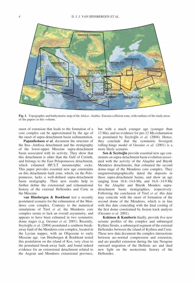
We subdivide this volume into two main parts: col-lision and collapse. The contributions in these parts(Fig. 1) span a wide range of techniques and pro-cesses, and cover a time span from the Cretaceousto the Present, but all contribute to the furtherdetailed understanding and identification of stages3 and 4 in Wilson’s cycle.
Collision
Four papers in this volume provide essential newdata that constrain the temporal and spatial evol-ution of arc–continent and continent–continentcollision processes from the Cretaceous to thePresent in the Arabia–Anatolia segment of thesubduction zone.
Robertson et al. document the earliest collisionphase in the Anatolian collage, represented by arc–continent collision between the Anatolide–Taurideblock and supra-subduction zone ophiolites andvolcanic arc-related rocks of the northern part ofthe Neotethyan ocean, following intra-oceanic sub-duction. Arc–continent collision in Turkeyoccurred in the late Cretaceous, with widespreadophiolite emplacement and high-pressure meta-morphism. Following this phase of arc–continentcollision, the authors suggest that the trenchmigrated northward, with final continent–continentcollision between the Taurides (and overlyingophiolites) and the Eurasia-related Pontides in thePaleocene–Eocene.
Kaymakci et al. studied the late Cretaceous toNeogene history of the Cankırı Basin, whichnicely documented the post-arc continent collisionhistory described by Robertson et al. The authorsshow that the Cankırı Basin, located on the southernpart of the Pontides and straddling the northernpart of the Taurides in the Paleogene part of its stra-tigraphy, has a history that can be subdivided in alate Cretaceous to Paleogene forearc basin stage,and a Paleocene–Eocene foreland basin history.The conclusion of these authors is in line with theconclusions of Robertson et al. and shows thatarc–continent collision between the Anatolide–Tauride block and the Pontides was followed byrelocation of the subduction thrust to the southernmargin of the Pontides, leading in the late Paleoceneto early Eocene to continent–continent collisionbetween Taurides and Pontides.
D. J. J. VAN HINSBERGEN ET AL.2
Husing et al. focused their paper on the finalcontinent–continent collision phase that character-izes the Africa–Arabia–Eurasia collision zone,concerning the collision of Arabia with theAnatolide–Tauride block, upon demise of thesouthern branch of the Neotethys (which is still rep-resented by the eastern Mediterranean basin and forexample, the Troodos ophiolite on Cyprus). Theystudied the foreland basin evolution on northernArabia and around the Bitlis–Poturge massif, andfound that the youngest foreland basin depositson Arabia below the southernmost thrust of theBitlis–Poturge massif has an age of 11 Ma. Theyinterpret this as the end of regular subduction ofthe Arabian plate, coinciding with slab break-offand the onset of northward penetration of theArabian continent into Anatolia, leading to its extru-sion, in line with earlier suggestions of Keskin(2003), Sengor et al. (2003) and Faccenna et al.(2006).
Hubert-Ferrari et al. provide essential new40Ar/39Ar age constraints on an offset volcanocrosscut by the North Anatolian Fault Zone, andshow that the majority of motion along the faultzone occurred after c. 2.5 Ma, with a slip rateof approximately 20 mm/a. They argue that thefirst phase of deformation, which establishedthe present-day 1300 km long fault trace followingthe onset of its activity around 12–10 Ma ago (inline with the conclusions of Husing et al.), wasassociated with a much smaller slip rate of 3 mm/a.
Collapse
Nine papers provide a detailed insight in the geody-namic evolution and the tectonic responses of theAnatolian, Aegean, Carpathian and Tyrrheniansegments of the subduction zone.
Edwards & Grasemann review the geophysicaland geological data concerning the evolution of thesubducted Tyrrhenian, Carpathian and Aegean slabsand their Neogene history of roll-back. They con-clude that upon decrease of the width of a slab asa result of its progressive decoupling, the slabretreat velocity increases and the tectonic responsein the overriding plate in terms of extension andexhumation intensify. Their paper provides a newoverview of the present-day state of the art of theevolution of the Mediterranean land-locked basinsince the Neogene.
Argnani connects the final demise of the Calab-rian slab to surface manifestations of these deeperprocesses in the southern central Mediterranean.He identifies periods of slab break-off and STEPfault activity (Govers & Wortel 2005) that aremodulated by the older structural grain in the sub-ducting African lithosphere.
Dilek & Altunkaynak review the post-collisional magmatic response in western Anatoliaand propose an elegant scenario placing themigration and compositional variation in post-Eocene magmatism in a timely geodynamic and tec-tonic scenario. They show that through time sincethe Eocene, just after continent–continent collisionbetween the Taurides and Pontides (see Robertsonet al. and Kaymakci et al.) volcanism and magma-tism in western Turkey has migrated southward,with changing compositions. They suggest thatvolcanism was initially caused by slab break-offafter continent–continent collision, followed bysouthward migrating volcanism associated withasthenospheric flow due to lithospheric delamina-tion. Middle Miocene volcanism is proposed toresult to a large extent from lithospheric extensionand formation of the Menderes metamorphic corecomplex. Finally, Quarternary alkaline volcanismnear Kula in central western Anatolia is explainedas the result of uncontaminated mantle, whichflowed in beneath the attenuated continental litho-sphere in the Aegean extensional province.
Vignaroli et al. integrate structural, meta-morphic and geochronological data into their recon-struction of the Apennine belt of the CentralMediterranean. Tying the plate-tectonic evolutionof the region to the geological observations, theytrack the evolution from oceanic subduction tocollision. Principal constraints involve stageswhen HP rocks were exhumed, followed by conti-nental collision that the authors infer to haveoccurred simultaneously with orogenic extensionin the backarc. Their geodynamic scenario involvesa principal role for slab rollback and mantledelamination processes.
Tirel et al. provide a new numerical model forthe evolution of sequential development of meta-morphic core complexes, and a thorough review ofthe Cycladic metamorphic core complexes as atest case. They conclude that provided the originallithosphere is thick and very hot, a sequence ofmetamorphic core complexes may develop. Thecore complexes are characterized by a two-stagedevelopment: first a symmetric stage, with grabendevelopment at the surface and lower crustal flowin the attenuating crust, followed by an asymmetricstage where one of the graben-bounding faults linksup with the opposite lower-crustal flow accom-modating shear zone to form an extensional detach-ment. If, upon cooling of the exhumed metamorphicdome, the crust is still hot and thick enough then asecond (or even third) dome may form above theremaining shear zone that accommodated lowercrustal flow in the first dome. This scenario is suc-cessfully tested in the Cyclades, where such pairedbelts are formed by e.g. Naxos and Ios, and Syrosand Tinos. Tirel et al. postulate that the timing of
INTRODUCTION 3
onset of extension that leads to the formation of acore complex can be approximated by the age ofthe onset of supra-detachment basin sedimentation.
Papanikolaou et al. document the structure ofthe Itea–Amfissa detachment and the stratigraphyof the lower-upper Miocene supra-detachmentbasin associated with its activity. They show thatthis detachment is older than the Gulf of Corinth,and belongs to the East Peloponnesos detachment,which exhumed HP/LT metamorphic rocks.This paper provides essential new age constraintson this detachment fault zone, which, on the Pelo-ponnesos, lacks a well-defined supra-detachmentbasin stratigraphy. Their new results help tofurther define the extensional and exhumationalhistory of the external Hellenides and Crete inthe Miocene.
van Hinsbergen & Boekhout test a recentlypostulated scenario for the exhumation of the Men-deres core complex. Contrary to the numericalsimulations of Tirel et al. the Menderes corecomplex seems to lack an overall asymmetry, andappears to have been exhumed in two symmetricdome stages (e.g. Gessner et al. 2001). Recently,Seyitoglu et al. (2004) postulated a southern break-away fault of the Menderes core complex, located inthe Lycian nappes, with an Oligocene to earlyMiocene age. van Hinsbergen & Boekhout testedthis postulation on the island of Kos, very close tothe postulated break-away fault, and found indeedevidence for an extensional detachment related tothe Aegean and Menderes extensional province,
but with a much younger age (younger than12 Ma), and no evidence for pre-12 Ma exhumationas postulated by Seyitoglu et al. (2004). Hence,they conclude that the symmetric bivergentrolling-hinge model of Gessner et al. (2001) is amore likely scenario.
Sen & Seyitoglu provide essential new age con-straints on supra-detachment basin evolution associ-ated with the activity of the Alasehir and BuyukMenderes detachments, that exhumed the seconddome-stage of the Menderes core complex. Theymagnetostratigraphically dated the deposits inthese supra-detachment basins, and show an ageranging from 16.6–14.6 Ma, and 16.0–14.9 Mafor the Alasehir and Buyuk Menders supra-detachment basin stratigraphies, respectively.Following the conclusion of Tirel et al. this datemay coincide with the onset of formation of thesecond dome of the Menderes, which is in linewith this date coinciding with the final cooling ofthe first dome constrained by fission track analysis(Gessner et al. 2001).
Kokinou & Kamberis finally, provide five newseismic profiles of the complex and submergedKythira Straits, a submerged segment of the externalHellenides between the island of Kythira and Crete.These new data document the complex interactionsbetween arc-normal compression and extension,and arc-parallel extension during the late Neogeneoutward migration of the Hellenic arc and shednew light on the neotectonic history of theHellenides.
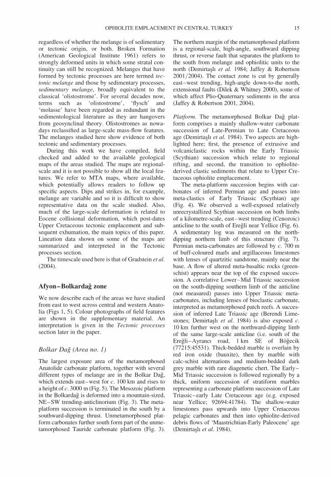
Fig. 1. Topographic and bathymetric map of the Africa–Arabia–Eurasia collision zone, with outlines of the study areasof the papers in this volume.
D. J. J. VAN HINSBERGEN ET AL.4
The contributions of DJJvH and RG were produced withinthe context of the Netherlands Research School of Inte-grated Solid Earth Sciences (ISES). DJJvH acknowledgesan NWO-VENI grant.
References
ARGNANI, A. 2009. Evolution of the southem Tyrrhenianslab tear and active tectonics along the western edge ofthe Tyrrhenian subducted slab. In: VAN HINSBERGEN,D. J. J., EDWARDS, M. A. & GOVERS, R. (eds)Collision and Collapse at the Africa–Arabia–Eurasia Subduction Zone. Geological Society,London, Special Publications, 311, 193–212.
BARTH, M. G., MASON, P. R. D., DAVIES, G. R. &DRURY, M. R. 2008. The Othris Ophiolite, Greece:A snapshot of subduction initiation at a mid-oceanridge. Lithos, 100, 234–254.
BOZKURT, E. & OBERHANSLI, R. 2001. Menderes Massif(Western Turkey): structural, metamorphic and mag-matic evolution – a synthesis. International Journalof Earth Sciences, 89, 679–708.
CARMINATI, E., WORTEL, M. J. R., MEIJER, P. T. &SABADINI, R. 1998. The two-stage opening ofthe western-central Mediterranean basins: a forwardmodeling test to a new evolutionary model. Earthand Planetary Science Letters, 160, 667–679.
CHEMENDA, A. I., HURPIN, D., TANG, J.-C., STEPHAN,J.-F. & BUFFET, G. 2001. Impact of arc-continentcollision on the conditions of burial and exhumationof UHP/LT rocks: experimental and numerical model-ling. Tectonophysics, 342, 137–161.
DE FRANCO, R., GOVERS, R. & WORTEL, M. J. R. 2008.Dynamics of continental collision: Influence of theplate contact. Geophysical Journal International,174, 1101–1120.
DERCOURT, J., ZONENSHAIN, L. P. & RICOU, L.-E. 1986.Geological evolution of the Tethys belt from theAtlantic to the Pamir since the Lias. Tectonophysics,123, 241–315.
DEWEY, J. F. 1988. Extensional Collapse of orogens.Tectonics, 7, 1123–1139.
DEWEY, J. F. & BIRD, J. M. 1970. Mountain belts and thenew global tectonics. Journal of GeophysicalResearch, 75, 2625–2647.
DEWEY, J. F. & SENGOR, A. M. C. 1979. Aegean and sur-rounding regions: Complex multiplate and continuumtectonics in a convergent zone. Geological Society ofAmerica Bulletin, 90, 84–92.
DILEK, Y. & ALTUNKAYNAK, S. 2009. Geochemicaland temporal evolution of Cenozoic magmatism inwestern Turkey: mantle response to collision, slabbreak-off, and lithospheric tearing in an orogenicbelt. In: VAN HINSBERGEN, D. J. J., EDWARDS,M. A. & GOVERS, R. (eds) Collision and Collapse atthe Africa–Arabia–Eurasia Subduction Zone. Geo-logical Society, London, Special Publications, 311,213–233.
EDWARDS, M. A. & GRASEMANN, B. 2009. Mediterra-nean snapshots of accelerated slab retreat: subductioninstability in stalled continental collision. In: VAN
HINSBERGEN, D. J. J., EDWARDS, M. A. &GOVERS, R. (eds) Collision and Collapse at the
Africa–Arabia–Eurasia Subduction Zone. GeologicalSociety, London, Special Publications, 311, 155–192.
FACCENNA, C., BECKER, T. W., PIO LUCENTE, F.,JOLIVET, L. & ROSSETTI, F. 2001a. History ofsubduction and back-arc extension in the CentralMediterranean. Geophysical Journal International,145, 809–820.
FACCENNA, C., FUNICIELLO, F., GIARDINI, D. &LUCENTE, P. 2001b. Episodic back-arc extensionduring restricted mantle convection in the CentralMediterranean. Earth and Planetary Science Letters,187, 105–116.
FACCENNA, C., BELLIER, O., MARTINOD, J.,PIROMALLO, C. & REGARD, V. 2006. Slab detach-ment beneath eastern Anatolia: A possible cause forthe formation of the North Anatolian Fault. Earthand Planetary Science Letters, 242, 85–97.
GAUTIER, P. & BRUN, J.-P. 1994. Ductile crust exhuma-tion and extensional detachments in the centralAegean (Cyclades and Evvia Islands). GeodinamicaActa, 7, 57–85.
GAUTIER, P., BRUN, J.-P. & JOLIVET, L. 1993. Structureand kinematics of Upper Cenozoic extensional detach-ment on Naxos and Paros. Tectonics, 12, 1180–1194.
GAUTIER, P., BRUN, J.-P., MORICEAU, R., SOKOUTIS,D., MARTINOD, J. & JOLIVET, L. 1999. Timing,kinematics and cause of Aegean extension: a scenariobased on a comparison with simple analogue exper-iments. Tectonophysics, 315, 31–72.
GERYA, T. V., STOCKHERT, B. & PERCHUCK, A. L.2002. Exhumation of high-pressure metamorphicrocks in a subduction channel: a numerical simulation,Tectonics, 21(6), 227–236.
GESSNER, K., RING, U., JOHNSON, C., HETZEL, R.,PASSCHIER, C. W. & GUNGOR, T. 2001. An activebivergent rolling-hinge detachment system: CentralMenderes metamorphic core complex in westernTurkey. Geology, 29, 611–614.
GOVERS, R. & WORTEL, M. J. R. 2005. Lithospheretearing at STEP faults: Response to edges of subduc-tion zones. Earth and Planetary Science Letters, 236,505–523.
HAFKENSCHEID, E., WORTEL, M. J. R. & SPAKMAN, W.2006. Subduction history of the Tethyan region derivedfrom seismic tomography and tectonic reconstructions.Journal of Geophysical Research, 111, B08401, doi:10.1029/2005JB003791.
HALL, R. & SPAKMAN, W. 2003. Defining Australia: TheAustralian Plate as part of Planet Earth. In: HILLIS, R.& MULLER, R. D. (eds) Geological Society of Austra-lia Special Publication, 22, 355–375.
HUSING, S. K., VAN ZACHARIASSE, W.-J., VAN
HINSBERGEN, D. J. J., KRIJGSMAN, W., INCEOZ,M., HARZHAUSER, M., MANDIC, O. & KROH, A.2009. Oligocene–Miocene basin evolution in SE Ana-tolia, Turkey: constraints on the closure of the easternTethys gateway. In: VAN HINSBERGEN, D. J. J.,EDWARDS, M. A. & GOVERS, R. (eds) Collision andCollapse at the Africa–Arabia–Eurasia SubductionZone. Geological Society, London, Special Publi-cations, 311, 107–132.
HUBERT-FERRARI, A., ARMIJO, R., KING, G., MEYER,B. & BARKA, A. 2002. Morphology, displacement,and slip rates along the North Anatolian Fault, Turkey.
INTRODUCTION 5
Journal of Geophysical Research, 107, 2235, doi;10.1029/2001JB000393.
HUBERT-FERRARI, A., KING, G., VAN DER WOERD, J.,VILLA, I., ALTUNEL, E. & ARMIJO, R. 2009.Long-term evolution of the North Anatolian Fault:new constraints from its eastern termination. In: VAN
HINSBERGEN, D. J. J., EDWARDS, M. A. &GOVERS, R. (eds) Collision and Collapse at theAfrica–Arabia–Eurasia Subduction Zone. GeologicalSociety, London, Special Publication, 311, 133–154.
JOLIVET, L. 2001. A comparison of geodetic andfinite strain pattern in the Aegean, geodynamic impli-cations. Earth and Planetary Science Letters, 187,95–104.
JOLIVET, L. & FACCENNA, C. 2000. Mediterranean exten-sion and the Africa–Eurasia collision. Tectonics, 19,1094–1106.
JOLIVET, L., FACENNA, C., GOFFE, B., BUROV, E. &AGARD, P. 2003. Subduction tectonics and exhuma-tion of high-pressure metamorphic rocks in theMediterranean orogen. American Journal of Science,303, 353–409.
KAYMAKCI, N., OZCELIK, Y., WHITE, S. H. & VAN
DIJK, P. M. 2009. Tectono-stratigraphy of theCankırı Basin: Late Cretaceous to early Mioceneevolution of the Neotethyan Suture Zone in Turkey.In: VAN HINSBERGEN, D. J. J., EDWARDS, M. A. &GOVERS, R. (eds) Collision and Collapse at theAfrica–Arabia–Eurasia Subduction Zone. GeologicalSociety, London, Special Publications, 311, 67–106.
KESKIN, M. 2003. Magma generation by slab steepeningand breakoff beneath a subduction-accretion complex:An alternative model for collision-related volcanismin Eastern Anatolia, Turkey. Geophysical ResearchLetters, 30, 8046, doi: 10.1029/2003GL018019.
KOKINOU, E. & KAMBERIS, E. 2009. The structure ofthe Kythira–Antikythira strait, offshore SW Greece(35.78–36.68N). In: VAN HINSBERGEN, D. J. J.,EDWARDS, M. A. & GOVERS, R. (eds) Collision andCollapse at the Africa–Arabia–Eurasia SubductionZone. Geological Society, London, Special Publi-cations, 311, 343–360.
LE PICHON, X. 1982. Land-locked oceanic basins andcontinental collision: the Eastern Mediterranean as acase example. In: HSU, K. J. (ed.) Mountain BuildingProcesses. London, Academic Press, 201–211.
LE PICHON, X., ANGELIER, J., AUBOUIN, J., LYBERIS,N., MONTI, S., RENARD, V. ET AL. 1979. From sub-duction to transform motion: a seabeam survey of theHellenic trench system. Earth and Planetary ScienceLetters, 44, 441–450.
LE PICHON, X., ANGELIER, J. & SIBUET, J.-C. 1982.Plate boundaries and extensional tectonics. Tectono-physics, 81, 239–256.
LISTER, G., BANGA, G. & FEENSTRA, A. 1984. Meta-morphic core complexes of Cordilleran type in theCyclades. Aegean Sea, Greece. Geology, 12, 221–225.
MALINVERNO, A. & RYAN, W. B. F. 1986. Extension inthe Tyrrhenian Sea and shortening in the Apenninesas result of arc migration driven by sinking of the litho-sphere. Tectonics, 5, 227–245.
MCCLUSKY, S., BALASSANIAN, S., BARKA, A., DEMIR,C., ERGINTAV, S., GEORGIEV, I. ET AL. 2000. GlobalPositioning System constraints on plate kinematics and
dynamics in the eastern Mediterranean and Caucasus.Journal of Geophysical Research, 105, 5695–5719.
PAPANIKOLAOU, D., GOULIOTIS, L. & TRIANTAPHYL-
LOU, M. 2009. The Itea–Amfissa detachment: a pre-Corinth rift Miocene extensional structure in centralGreece. In: VAN HINSBERGEN, D. J. J., EDWARDS,M. A. & GOVERS, R. (eds) Collision and Collapse atthe Africa–Arabia–Eurasia Subduction Zone. Geo-logical Society, London, Special Publications, 311,293–310.
PE-PIPER, G. & PIPER, D. J. W. 2002. The igneous rocksof Greece. The anatomy of an orogen. Berlin-Stuttgart,Gebruder Borntraeger.
REILINGER, R., MCCLUSKY, S., VERNANT, P.,LAWRENCE, S., ERGINTAV, S., CAKMAK, R. ET AL.2006. GPS constraints on continental deformationin the Africa–Arabia–Eurasia continental collisionzone and implications for the dynamics of plateinteractions. Journal of Geophysical Research, 111,V05411, doi:10.1029/2005JB004051.
RING, U. & REISHMANN, T. 2002. The weak and superfastCretan detachment, Greece: exhumation at subductionrates in extruding wedges. Journal of the GeologicalSociety of London, 159, 225–228.
RING, U., WILL, T., GLODNY, J., KUMERICS, C.,GESSNER, K., THOMSON, S. N. ET AL. 2007. Earlyexhumation of high-pressure rocks in extrusionwedges: The Cycladic blueschist unit in the easternAegean, Greece and Turkey. Tectonics, 26, TC2001,doi:10.1029/2005TC001872.
ROBERTSON, A. H. F., PARLAK, O. & USTAOMER, T.2009. Melange genesis and ophiolite emplacementrelated to subduction of the northern margin of theTauride–Anatolide continent, central and westernTurkey. In: VAN HINSBERGEN, D. J. J., EDWARDS,M. A. & GOVERS, R. (eds) Collision and Collapseat the Africa–Arabia–Eurasia Subduction Zone.Geological Society, London, Special Publications,311, 9–66.
SEN, S. & SEYITOGLU, G. 2009. Magnetostratigraphy ofearly–middle Miocene deposits from east–westtrending Alasehir and Buyuk Menderes grabens inwestern Turkey, and its tectonic implications. In:VAN HINSBERGEN, D. J. J., EDWARDS, M. A. &GOVERS, R. (eds) Collision and Collapse at theAfrica–Arabia–Eurasia Subduction Zone. GeologicalSociety, London, Special Publications, 311, 321–342.
SENGOR, A. M. C., GORUR, N. & SAROGLU, F. 1985.Strike-slip faulting and related basin formation inzones of tectonic escape: Turkey as a case study. In:BIDDLE, K. T. & CHRISTIE-BLICK, N. (eds) BasinFormation and Sedimentation, Society of EconomicPaleontologists and Mineralogists Special Publi-cations, 37, 227–264.
SENGOR, A. M. C., OZEREN, S., GENC, T. & ZOR, E.2003. East Anatolian high plateau as a mantle-supported, north-south shortened domal structure.Geophysical Research Letters, 30, 8045, doi:10.1029/2003GL017858.
SENGOR, A. M. C., TUYSUZ, O., IMREN, C., SAKINC, M.,EYIDOGAN, H., GORUR, N., LE PICHON, X. &RANGIN, C. 2005. The North Anatolian Fault: a newlook. Annual Reviews in Earth and Planetary Sciences,33, 37–112.
D. J. J. VAN HINSBERGEN ET AL.6
SEYITOGLU, G., ISIK, V. & CEMEN, I. 2004. CompleteTertiary exhumation history of the Menderes massif,western Turkey: an alternative working hypothesis.Terra Nova, 16, 358–364.
SPADEA, P. & D’ANTONIO, M. 2006. Initiation andevolution of intra-oceanic subduction in the Uralides:Geochemical and isotopic constraints from Devonianoceanic rocks of the Southern Urals, Russia. IslandArc, 15, 7–25.
STAMPFLI, G. M. & BOREL, G. D. 2002. A plate tectonicmodel for the Paleozoic and Mesozoic constrained bydynamic plate boundaries and restored syntheticoceanic isochrones. Earth and Planetary ScienceLetters, 196, 17–33.
TIREL, C., GAUTIER, P., VAN HINSBERGEN, D. J. J. &WORTEL, M. J. R. 2009. Sequential development ofinterfering metamorphic core complexes: numericalexperiments and comparison with the Cyclades,Greece. In: VAN HINSBERGEN, D. J. J., EDWARDS,M. A. & GOVERS, R. (eds) Collision and Collapse atthe Africa–Arabia–Eurasia Subduction Zone. Geo-logical Society, London, Special Publication, 311,257–292.
TOTH, J. & GURNIS, M. 1998. Dynamics of subductioninitiation at preexisting fault zones. Journal of Geophy-sical Research, 103(B8), 18063–18067.
VAN DE ZEDDE, D. M. A. & WORTEL, M. J. R.2001. Shallow slab detachment as a transient sourceof heat at midlithospheric depths. Tectonics, 20,868–882.
VAN DER MEULEN, M. J. 1999. Slab detachment and theevolution of the Apenninic Arc. Geologica Ultraiec-tina, 170, 136.
VAN HINSBERGEN, D. J. J., HAFKENSCHEID, E.,SPAKMAN, W., MEULENKAMP, J. E. & WORTEL,M. J. R. 2005. Nappe stacking resulting from subduc-tion of oceanic and continental lithosphere belowGreece. Geology, 33, 325–328.
VAN HINSBERGEN, D. J. J. & BOEKHOUT, F. 2009.Neogene brittle detachment faulting on Kos(E Greece): implications for a southern break-awayfault of the Menderes metamorphic core complex(western Turkey). In: VAN HINSBERGEN, D. J. J.,EDWARDS, M. A. & GOVERS, R. (eds) Collision andCollapse at the Africa–Arabia–Eurasia SubductionZone. Geological Society, London, Special Publi-cations, 311, 311–320.
VIGNAROLI, G., FACCENNA, C., ROSSETTI, F. &JOLIVET, L. 2009. Insights from the Apennines meta-morphic complexes and their bearing on the kinematicsevolution of the orogen. In: VAN HINSBERGEN,D. J. J., EDWARDS, M. A. & GOVERS, R. (eds)Collision and Collapse at the Africa–Arabia–Eurasia Subduction Zone. Geological Society,London, Special Publications, 311, 235–256.
WILSON, J. T. 1966. Did the Atlantic colse and thenre-open? Nature, 211, 676–681.
WORTEL, M. J. R. & SPAKMAN, W. 2000. Subduction andslab detachment in the Mediterranean-Carpathianregion. Science, 290, 1910–1917.
INTRODUCTION 7

Melange genesis and ophiolite emplacement related to subduction
of the northern margin of the Tauride–Anatolide continent,
central and western Turkey
ALASTAIR H. F. ROBERTSON1*, OSMAN PARLAK2,3 & TIMUR USTAOMER4
1School of GeoSciences, University of Edinburgh, West Mains Road, Edinbugh, EH9 3JW, UK2Jeoloji Muhendisligi Bolumu, Cukurova Universitesi, 01330-Balcalı, Adana, Turkey
3Mesleki ve Teknik Egitim Fakultesi, Adıyaman Universitesi, 02040 Adıyaman, Turkey4Jeoloji Muhendisligi Bolumu, Istanbul Universitesi, 34850-Avcılar, Istanbul, Turkey
*Corresponding author (e-mail: [email protected])
Abstract: The Tauride–Anatolide continent, stretching for c. 900 km across western and centralTurkey, is one of the world’s best example of a subducted, exhumed passive margin within a colli-sional orogen. Twelve widely separated areas were studied and correlated to develop a new plate-tectonic model. A metamorphosed, rifted continental margin of Triassic–Lower Cretaceous age(Tauride–Anatolide platform) is overlain by Upper Cretaceous (Cenomanian-Lower Maastrich-tian) pelagic sediments and then by both tectonic melange (subduction complexes) and sedimen-tary melange (foredeep gravity complexes). The melanges are overthrust by unmetamorphosedophiolitic rocks, commonly peridotites with swarms of diabase/gabbro dykes, and are underlainby metamorphic soles. New geochemical evidence from basaltic blocks in the melange indicatespredominantly subduction influenced, within-plate and mid-ocean ridge-type settings. The dykescutting the ophiolites were probably intruded during early-stage intra-oceanic arc genesis. Themetamorphosed continental margin, melanges and ophiolites in the north (Anatolides) are corre-lated with unmetamorphosed equivalents in the Taurides further south (e.g. Beysehir and Lyciannappes).
Oceanic crust of Triassic–Late Cretaceous age formed between the Gondwana-relatedTauride–Anatolide continent in the south and the Eurasia-related Sakarya microcontinent in thenorth. Following Late Triassic–Early Cretaceous passive margin subsidence, the continentalmargin was covered by Cenomanian-Turonian pelagic carbonates (c. 98–90 Ma). Ophiolitesformed in an intra-oceanic subduction zone setting in response to northward subduction, probablywithin a two-stranded ocean, with the Inner Tauride ocean in the SE and the Izmir–Ankara–Erzincan ocean in the north/NW. Metamorphic soles relate to intra-oceanic subduction (c. 95–90 Ma). Oceanic sedimentary/igneous rocks accreted to the advancing supra-subduction oceanicslab. The Tauride–Anatolide continental margin then underwent diachronous collision with thetrench (c. 85 Ma), deeply subducted and metamorphosed at HP/LT (c. 80 Ma). Accretionary,ophiolitic and exhumed HP/LT rocks were gravity reworked into a southward-migrating flexuralforedeep and progressively overridden (c. 70–63 Ma). Slices of the upper part of the platform andits margin detached and were thrust southwards as the (Tauride) Lycian and Beysehir nappes,together with regional-scale ophiolites. The continental margin and melange were simultaneouslyexhumed during Maastrichtian–Early Paleocene (70–63 Ma) and transgressed by shallow-watersediments, beginning in the Late Maastrichtian in the east (c. 64 Ma) and the Mid?-Late Paleocene(c. 60 Ma) further west. Remnant oceanic crust was consumed during Early Cenozoic time,followed by Mid Eocene (45–40 Ma) diachronous continental collision and a second phase ofregional deformation. Rather than being progressive there were two stages of collision: first,Upper Cretaceous ophiolite emplacement driven by continental margin-subduction trenchcollision, and secondly Eocene collision of the Tauride and Sakarya/Eurasian continents.
Supplementary material: Supplementary data are available at: http://www.geolsoc.org.uk/SUP18341.
An early assumption of plate-tectonic theory wasthat continental crust could not be subducted owingto its thickness and relative buoyancy. More
recently it has been accepted that continental crustcan be subducted in several tectonic settings,especially where a continental margin collides
From: VAN HINSBERGEN, D. J. J., EDWARDS, M. A. & GOVERS, R. (eds) Collision and Collapse at theAfrica–Arabia–Eurasia Subduction Zone. The Geological Society, London, Special Publications, 311, 9–66.DOI: 10.1144/SP311.2 0305-8719/09/$15.00 # The Geological Society of London 2009.
with a subduction trench and where continents for-cefully collide. Subducted material can be exhumedback to the surface in a geologically short period oftime. The Late Cretaceous of Oman is an excellentsample of a subducted, exhumed, passive margin,associated with ophiolite emplacement (Lippardet al. 1986; Robertson & Searle 1990; Goffe et al.1988). However, in Oman there is no agreement asto the regional plate-tectonic setting, with subduc-tion away from the passive margin (Searle & Cox1999; Searle et al. 2004, 2005) and towards thepassive margin (Gregory et al. 1998; Miller et al.1998), both being proposed. Other examples ofophiolites and related melanges that were emplacedonto continental margins related to subductioninclude the Mid-Jurassic of the Balkans (e.g.Robertson et al. 1991; Rassios & Smith 2000;Smith 2006; Robertson 2006) and the Ordovicianof Newfoundland (Williams & Stevens 1974).
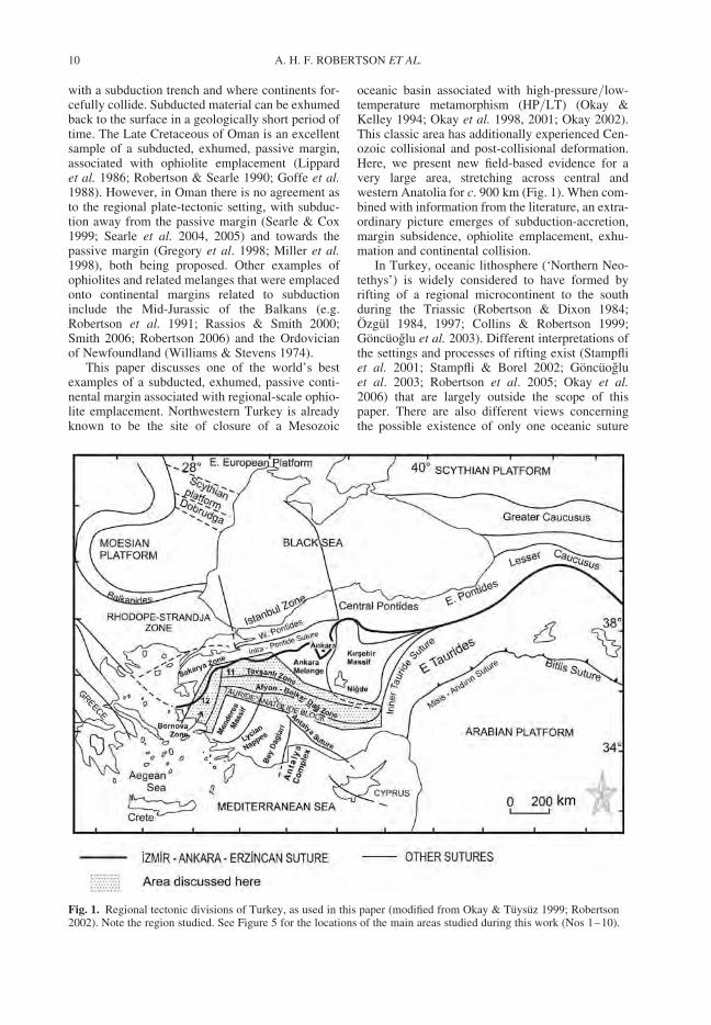
This paper discusses one of the world’s bestexamples of a subducted, exhumed, passive conti-nental margin associated with regional-scale ophio-lite emplacement. Northwestern Turkey is alreadyknown to be the site of closure of a Mesozoic
oceanic basin associated with high-pressure/low-temperature metamorphism (HP/LT) (Okay &Kelley 1994; Okay et al. 1998, 2001; Okay 2002).This classic area has additionally experienced Cen-ozoic collisional and post-collisional deformation.Here, we present new field-based evidence for avery large area, stretching across central andwestern Anatolia for c. 900 km (Fig. 1). When com-bined with information from the literature, an extra-ordinary picture emerges of subduction-accretion,margin subsidence, ophiolite emplacement, exhu-mation and continental collision.
In Turkey, oceanic lithosphere (‘Northern Neo-tethys’) is widely considered to have formed byrifting of a regional microcontinent to the southduring the Triassic (Robertson & Dixon 1984;Ozgul 1984, 1997; Collins & Robertson 1999;Goncuoglu et al. 2003). Different interpretations ofthe settings and processes of rifting exist (Stampfliet al. 2001; Stampfli & Borel 2002; Goncuogluet al. 2003; Robertson et al. 2005; Okay et al.2006) that are largely outside the scope of thispaper. There are also different views concerningthe possible existence of only one oceanic suture
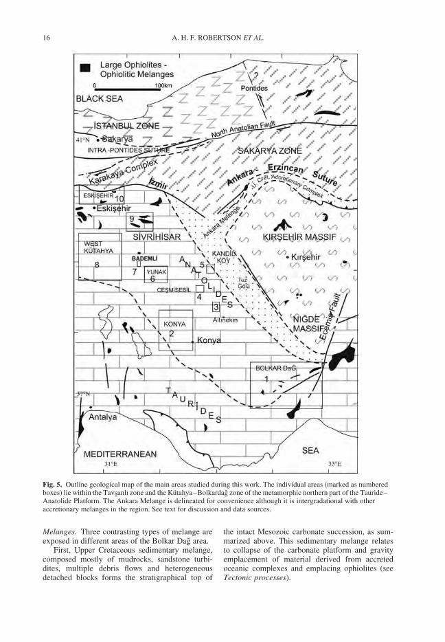
Fig. 1. Regional tectonic divisions of Turkey, as used in this paper (modified from Okay & Tuysuz 1999; Robertson2002). Note the region studied. See Figure 5 for the locations of the main areas studied during this work (Nos 1–10).
A. H. F. ROBERTSON ET AL.10
(e.g. Goncuoglu et al. 1996–1997), or severaloceanic sutures (Gorur et al. 1984, 1998) incentral and northern Turkey. However, there isgeneral consensus that Tethys in this region wasclosing during the Late Cretaceous associated withnorthward subduction and the development of anUpper Cretaceous accretionary prism (Kocyigit1991; Rojay et al. 2001, 2004; Fig. 2). Intra-oceanicsubduction is commonly believed to have triggeredthe genesis of ophiolites in a supra-subduction zonesetting (Collins & Robertson 1998; Parlak et al.2000; Robertson 2002; Yalınız et al. 1996, 2000).Subduction culminated in the collision of the sub-duction trench with the continent to the south andthis was the driving mechanism of latest Cretaceousophiolite emplacement. Final ‘hard’ collision andsuture tightening were delayed for up to 25 Ma,until Mid Eocene.
An advantage of the present study area is thatvarious parts of the continental margin areexposed across the tectonic strike for c. 900 kilo-metres east–west and several hundred kilometresnorth–south. Near the suture in the north thecontinental margin and some melanges have beenmetamorphosed under HP/LT conditions, whereasfurther south equivalent continental margin unitsare unmetamorphosed, allowing an overview ofthe convergent margin evolution.
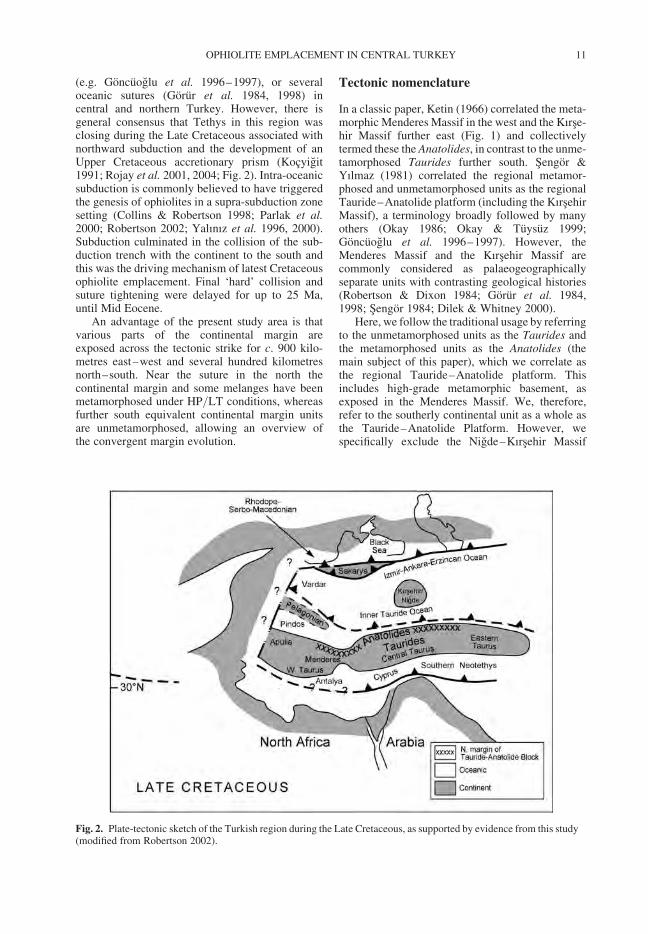
Tectonic nomenclature
In a classic paper, Ketin (1966) correlated the meta-morphic Menderes Massif in the west and the Kırse-hir Massif further east (Fig. 1) and collectivelytermed these the Anatolides, in contrast to the unme-tamorphosed Taurides further south. Sengor &Yılmaz (1981) correlated the regional metamor-phosed and unmetamorphosed units as the regionalTauride–Anatolide platform (including the KırsehirMassif), a terminology broadly followed by manyothers (Okay 1986; Okay & Tuysuz 1999;Goncuoglu et al. 1996–1997). However, theMenderes Massif and the Kırsehir Massif arecommonly considered as palaeogeographicallyseparate units with contrasting geological histories(Robertson & Dixon 1984; Gorur et al. 1984,1998; Sengor 1984; Dilek & Whitney 2000).
Here, we follow the traditional usage by referringto the unmetamorphosed units as the Taurides andthe metamorphosed units as the Anatolides (themain subject of this paper), which we correlate asthe regional Tauride–Anatolide platform. Thisincludes high-grade metamorphic basement, asexposed in the Menderes Massif. We, therefore,refer to the southerly continental unit as a whole asthe Tauride–Anatolide Platform. However, wespecifically exclude the Nigde–Kırsehir Massif
Fig. 2. Plate-tectonic sketch of the Turkish region during the Late Cretaceous, as supported by evidence from this study(modified from Robertson 2002).
OPHIOLITE EMPLACEMENT IN CENTRAL TURKEY 11
(also known as the Central Anatolian CrystallineComplex) from this definition.
The metamorphosed Anatolides were dividedinto two zones by Okay (1984). A more northerlyunit of highly recrystallized HP/LT metamorphicrocks, known as the Tavsanlı zone, is exposed inthe NW (Fig. 1). This was reported to be thrustover a more southerly unit of generally lowergrade, less recrystallized rocks exposed along theentire length of the Anatolides, known as theAfyon–Bolkardag zone (or Afyon zone). Okay’s(1984) nomenclature is retained here. By contrast,Goncuoglu et al. (1996–1997) used Okay’s (1984)definition of the Tavsanlı zone, but named the gen-erally lower grade, less recrystallized rocks to thesouth, the Kutahya–Bolkardag zone. The Afyon–Bolkardag zone, especially the deeper structurallevels, has also undergone HP/LT metamorphism,but to a lower grade that the Tavsanlı zone in thenorth (Blumenthal 1955; Kaaden 1966; Eren 2001;Dilek & Whitney 1997; Candan et al. 2005).
In this paper we define the Tavsanlı zone as thevery high-grade recrystallized platform carbonates,overlying melanges and ophiolites in the north, andthe Afyon–Bolkardag zone as generally lower-grade, less recrystallized rocks further south, alsooverlain by melanges and ophiolites. Candan et al.(2005) show the Tavsanlı zone as regionally thrustsouthwards over the Afyon–Bolkardag zone (e.g.NW of Afyon). Their summary log and sectionshow over-riding slices of Tavsanlı zone platformcarbonates, together with melanges and ophiolites.However, we could not confirm the existence of anexposed contact between these two zones, which,if it exists, is likely to underlie younger sediments.
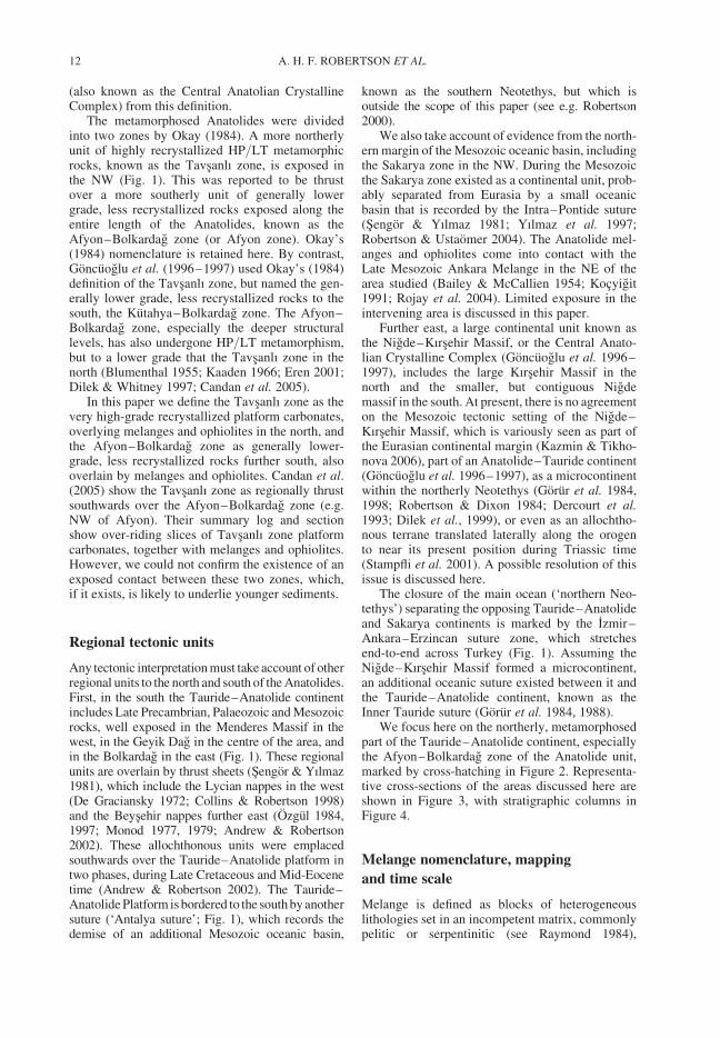
Regional tectonic units
Any tectonic interpretation must take account of otherregional units to the north and south of the Anatolides.First, in the south the Tauride–Anatolide continentincludes Late Precambrian, Palaeozoic and Mesozoicrocks, well exposed in the Menderes Massif in thewest, in the Geyik Dag in the centre of the area, andin the Bolkardag in the east (Fig. 1). These regionalunits are overlain by thrust sheets (Sengor & Yılmaz1981), which include the Lycian nappes in the west(De Graciansky 1972; Collins & Robertson 1998)and the Beysehir nappes further east (Ozgul 1984,1997; Monod 1977, 1979; Andrew & Robertson2002). These allochthonous units were emplacedsouthwards over the Tauride–Anatolide platform intwo phases, during Late Cretaceous and Mid-Eocenetime (Andrew & Robertson 2002). The Tauride–Anatolide Platform is bordered to the south by anothersuture (‘Antalya suture’; Fig. 1), which records thedemise of an additional Mesozoic oceanic basin,
known as the southern Neotethys, but which isoutside the scope of this paper (see e.g. Robertson2000).
We also take account of evidence from the north-ern margin of the Mesozoic oceanic basin, includingthe Sakarya zone in the NW. During the Mesozoicthe Sakarya zone existed as a continental unit, prob-ably separated from Eurasia by a small oceanicbasin that is recorded by the Intra–Pontide suture(Sengor & Yılmaz 1981; Yılmaz et al. 1997;Robertson & Ustaomer 2004). The Anatolide mel-anges and ophiolites come into contact with theLate Mesozoic Ankara Melange in the NE of thearea studied (Bailey & McCallien 1954; Kocyigit1991; Rojay et al. 2004). Limited exposure in theintervening area is discussed in this paper.
Further east, a large continental unit known asthe Nigde–Kırsehir Massif, or the Central Anato-lian Crystalline Complex (Goncuoglu et al. 1996–1997), includes the large Kırsehir Massif in thenorth and the smaller, but contiguous Nigdemassif in the south. At present, there is no agreementon the Mesozoic tectonic setting of the Nigde–Kırsehir Massif, which is variously seen as part ofthe Eurasian continental margin (Kazmin & Tikho-nova 2006), part of an Anatolide–Tauride continent(Goncuoglu et al. 1996–1997), as a microcontinentwithin the northerly Neotethys (Gorur et al. 1984,1998; Robertson & Dixon 1984; Dercourt et al.1993; Dilek et al., 1999), or even as an allochtho-nous terrane translated laterally along the orogento near its present position during Triassic time(Stampfli et al. 2001). A possible resolution of thisissue is discussed here.
The closure of the main ocean (‘northern Neo-tethys’) separating the opposing Tauride–Anatolideand Sakarya continents is marked by the Izmir–Ankara–Erzincan suture zone, which stretchesend-to-end across Turkey (Fig. 1). Assuming theNigde–Kırsehir Massif formed a microcontinent,an additional oceanic suture existed between it andthe Tauride–Anatolide continent, known as theInner Tauride suture (Gorur et al. 1984, 1988).
We focus here on the northerly, metamorphosedpart of the Tauride–Anatolide continent, especiallythe Afyon–Bolkardag zone of the Anatolide unit,marked by cross-hatching in Figure 2. Representa-tive cross-sections of the areas discussed here areshown in Figure 3, with stratigraphic columns inFigure 4.
Melange nomenclature, mapping
and time scale
Melange is defined as blocks of heterogeneouslithologies set in an incompetent matrix, commonlypelitic or serpentinitic (see Raymond 1984),
A. H. F. ROBERTSON ET AL.12
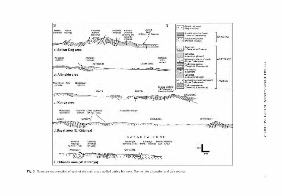
Fig. 3. Summary cross-section of each of the main areas studied during his work. See text for discussion and data sources.
OP
HIO
LIT
EE
MP
LA
CE
ME
NT
INC
EN
TR
AL
TU
RK
EY
13
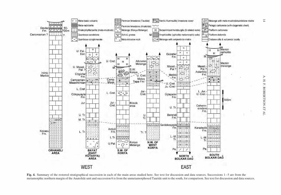
Fig. 4. Summary of the restored stratigraphical succession in each of the main areas studied here. See text for discussion and data sources. Successions 1–5 are from themetamorphic northern margin of the Anatolide unit and succession 6 is from the unmetamorphosed Tauride unit to the south, for comparison. See text for discussion and data sources.
A.
H.
F.
RO
BE
RT
SO
NE
TA
L.
14
regardless of whether the melange is of sedimentaryor tectonic origin, or both. Broken Formation(American Geological Institute 1961) refers tostrongly deformed units in which some stratal con-tinuity can still be recognized. Melanges that haveformed by tectonic processes are here termed tec-tonic melange and those by sedimentary processes,sedimentary melange, broadly equivalent to theclassical ‘olistostrome’. For several decades now,terms such as ‘olistostrome’, ‘flysch’ and‘molasse’ have been regarded as redundant in thesedimentological literature as they are hangoversfrom geosynclinal theory. Olistostromes as nowa-days reclassified as large-scale mass-flow features.The melanges studied here show evidence of bothtectonic and sedimentary processes.
During this work we have compiled, fieldchecked and added to the available geologicalmaps of the areas studied. The maps are regional-scale and it is not possible to show all the local fea-tures. We refer to MTA maps, where available,which potentially allows readers to follow upspecific aspects. Dips and strikes in, for example,melange are variable and so it is difficult to showrepresentative data on the scale studied. Also,much of the large-scale deformation is related toEocene collisional deformation, which post-datesUpper Cretaceous tectonic emplacement and sub-sequent exhumation, the main topics of this paper.Lineation data shown on some of the maps aresummarized and interpreted in the Tectonicprocesses section.
The timescale used here is that of Gradstein et al.(2004).
Afyon–Bolkardag zone
We now describe each of the areas we have studiedfrom east to west across central and western Anato-lia (Figs 1, 5). Colour photographs of field featuresare shown in the supplementary material. Aninterpretation is given in the Tectonic processessection later in the paper.
Bolkar Dag (Area no. 1)
The largest exposure area of the metamorphosedAnatolide carbonate platform, together with severaldifferent types of melange are in the Bolkar Dag,which extends east–west for c. 100 km and rises toa height of c. 3000 m (Fig. 5). The Mesozoic platformin the Bolkardag is deformed into a mountain-sized,NE–SW trending-anticlinorium (Fig. 3). The meta-platform succession is terminated in the south by asouthward-dipping thrust. Unmetamorphosed plat-form carbonates further south form part of the unme-tamorphosed Tauride carbonate platform (Fig. 3).
The northern margin of the metamorphosed platformis a regional-scale, high-angle, southward dippingthrust, or reverse fault that separates the platform tothe south from melange and ophiolitic units to thenorth (Demirtaslı et al. 1984; Jaffey & Robertson2001/2004). The contact zone is cut by generallyeast–west trending, high-angle down-to-the north,extensional faults (Dilek & Whitney 2000), some ofwhich affect Plio-Quaternary sediments in the area(Jaffey & Robertson 2001, 2004).
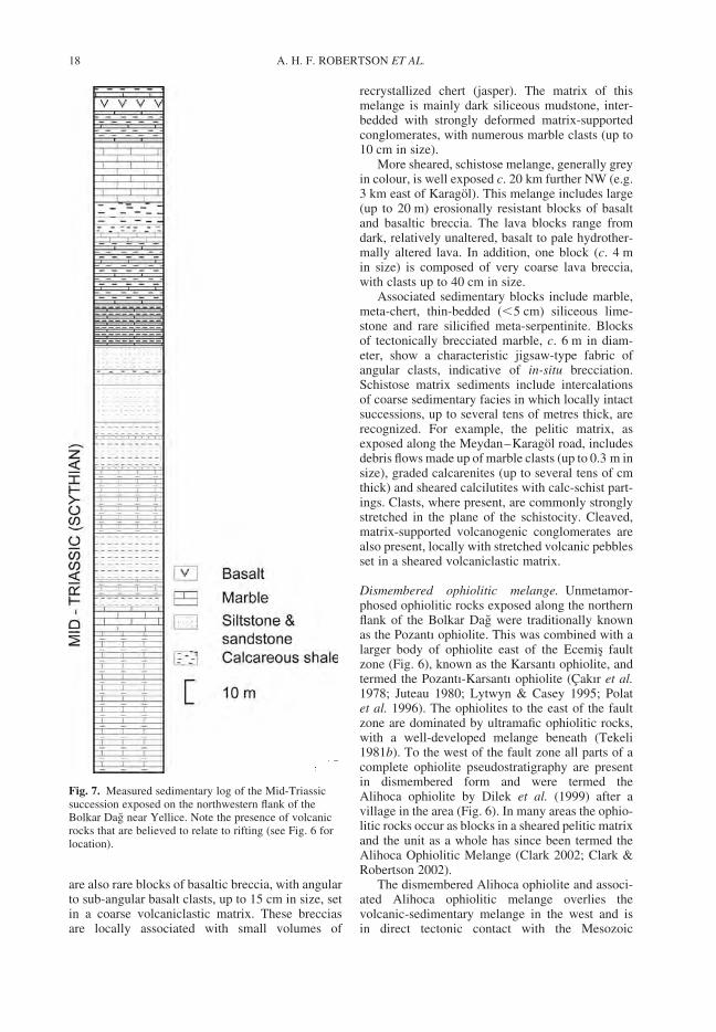
Platform. The metamorphosed Bolkar Dag plat-form comprises a mainly shallow-water carbonatesuccession of Late-Permian to Late Cretaceousage (Demirtaslı et al. 1984). Two aspects are high-lighted here; first, the presence of extrusive andvolcaniclastic rocks within the Early Triassic(Scythian) succession which relate to regionalrifting, and second, the transition to ophiolite-derived clastic sediments that relate to Upper Cre-taceous ophiolite emplacement.
The meta-platform succession begins with car-bonates of inferred Permian age and passes intometa-clastics of Early Triassic (Scythian) age(Fig. 4). We observed a well-exposed relativelyunrecrystallized Scythian succession on both limbsof a kilometre-scale, east–west trending (Cenozoic)anticline to the south of Eregli near Yellice (Fig. 6).A sedimentary log was measured on the north-dipping northern limb of this structure (Fig. 7).Permian meta-carbonates are followed by c. 700 mof buff-coloured marls and argillaceous limestoneswith lenses of quartzitic sandstone, mainly near thebase. A flow of altered meta-basaltic rocks (green-schist) appears near the top of the exposed succes-sion. A correlative Lower–Mid Triassic successionon the south-dipping southern limb of the anticline(not measured) passes into Upper Triassic meta-carbonates, including lenses of bioclastic carbonate,interpreted as metamorphosed patch reefs. A succes-sion of inferred Late Triassic age (Berendi Lime-stones; Demirtaslı et al. 1984) is also exposed c.10 km further west on the northward-dipping limbof the same large-scale anticline (i.e. south of theEregli–Ayrancı road, 1 km SE of Bogecik(77215:45531). Thick-bedded marble is overlain byred iron oxide (bauxite), then by marble withcalc-schist alternations and medium-bedded darkgrey marble with rare diagenetic chert. The Early–Mid Triassic succession is followed regionally by athick, uniform succession of stratiform marblesrepresenting a carbonate platform succession of LateTriassic–early Late Cretaceous age (e.g. exposednear Yellice; 92694:41784). The shallow-waterlimestones pass upwards into Upper Cretaceouspelagic carbonates and then into ophiolite-deriveddebris flows of ‘Maastrichtian-Early Paleocene’ age(Demirtaslı et al. 1984).
OPHIOLITE EMPLACEMENT IN CENTRAL TURKEY 15
Melanges. Three contrasting types of melange areexposed in different areas of the Bolkar Dag area.
First, Upper Cretaceous sedimentary melange,composed mostly of mudrocks, sandstone turbi-dites, multiple debris flows and heterogeneousdetached blocks forms the stratigraphical top of
the intact Mesozoic carbonate succession, as sum-marized above. This sedimentary melange relatesto collapse of the carbonate platform and gravityemplacement of material derived from accretedoceanic complexes and emplacing ophiolites (seeTectonic processes).
Fig. 5. Outline geological map of the main areas studied during this work. The individual areas (marked as numberedboxes) lie within the Tavsanlı zone and the Kutahya–Bolkardag zone of the metamorphic northern part of the Tauride–Anatolide Platform. The Ankara Melange is delineated for convenience although it is intergradational with otheraccretionary melanges in the region. See text for discussion and data sources.
A. H. F. ROBERTSON ET AL.16
Secondly, in the far west, near Berendi (Fig. 6),the Mesozoic platform is locally overlain byserpentinite-rich tectonic melange which containsnumerous blocks of crystalline marble (up to 4 min size), and smaller blocks of limestone, basalt,greenish chert and rare red chert. Both the ophioliticmelange and the Mesozoic platform are unconform-ably overlain by cream-to buff-coloured flaggy-bedded Nummulitic limestone of Late Palaeocene–Early Eocene age; this provides an upper time limiton ophiolite and melange emplacement in this area.These sediments pass upwards into weakly lithifiedsandstone, in turn unconformably overlain by theMiocene Mut Formation (MTA 2002).
Thirdly, an elongate exposure of metamorphosedvolcanic-sedimentary melange, up to several kilo-metres wide, is exposed for several tens of kilometreseast–west, bordering the northern margin of themetamorphosed Mesozoic carbonate platform. Inthe east (north of Horoz), the metamorphosed carbon-ate platform is backthrust directly against ophioliticlithologies (see below) with, at most, only a thinsliver of melange. Further west (south of Aktoprak)much thicker melange is present in contact with theplatform (Figs 3a, 6). This melange, described insome detail here for the first time, is depositionallyoverlainby an important unit of polymict debris flows,
discussed below, and then by Late Maastrichtian–Lower Eocene shallow-marine sediments and volca-nics (Demirtaslı et al. 1984; Clark & Robertson 2002,2004) that, thereby, constrain the timing of emplace-ment of this melange and related ophiolitic rocks.The melange and the latest Cretaceous–PaleogeneUlukısla Basin lithologies were strongly folded,thrust deformed and juxtaposed with the platform ata high angle during Mid-Eocene time (Clark &Robertson 2002, 2004).
The melange is best exposed within the centralpart of the outcrop, extending from near Meydanvillage for c. 20 km westwards. It is dominated bylarge blocks of volcanic rocks of basic to intermedi-ate composition, together with meta-limestones andmeta-cherts, set in a sheared sedimentary matrix.Exposures to the north, towards the ophiolitic mel-ange, are more sheared and exhibit a schistose fabric.
Where best exposed, near Meydan, the melangeis not greatly recrystallised but is generally reddish,owing to local mineralization (e.g. around Maden).The main types of block are grey marble, greenmeta-chert, pink pelagic limestone (thin to medium-bedded, with chert lenses) and pink siliceous pelagiclimestone (with abundant chert of replacementorigin). Volcanic blocks (several metres in size)are mainly relatively unaltered black basalt. There
Fig. 6. Outline geological map of the Bolkar Dag area (No. 1). See Figure 5 for location and the text for discussion. Datafrom Demirtaslı et al. (1984), the 1:500 000 geological map of Turkey (MTA 2002), Clark & Robertson (2002) andthis study. The map details are from the Turkish 1: 100 000 topographical maps Kozan M33 and N33.
OPHIOLITE EMPLACEMENT IN CENTRAL TURKEY 17
are also rare blocks of basaltic breccia, with angularto sub-angular basalt clasts, up to 15 cm in size, setin a coarse volcaniclastic matrix. These brecciasare locally associated with small volumes of
recrystallized chert (jasper). The matrix of thismelange is mainly dark siliceous mudstone, inter-bedded with strongly deformed matrix-supportedconglomerates, with numerous marble clasts (up to10 cm in size).
More sheared, schistose melange, generally greyin colour, is well exposed c. 20 km further NW (e.g.3 km east of Karagol). This melange includes large(up to 20 m) erosionally resistant blocks of basaltand basaltic breccia. The lava blocks range fromdark, relatively unaltered, basalt to pale hydrother-mally altered lava. In addition, one block (c. 4 min size) is composed of very coarse lava breccia,with clasts up to 40 cm in size.
Associated sedimentary blocks include marble,meta-chert, thin-bedded (,5 cm) siliceous lime-stone and rare silicified meta-serpentinite. Blocksof tectonically brecciated marble, c. 6 m in diam-eter, show a characteristic jigsaw-type fabric ofangular clasts, indicative of in-situ brecciation.Schistose matrix sediments include intercalationsof coarse sedimentary facies in which locally intactsuccessions, up to several tens of metres thick, arerecognized. For example, the pelitic matrix, asexposed along the Meydan–Karagol road, includesdebris flows made up of marble clasts (up to 0.3 m insize), graded calcarenites (up to several tens of cmthick) and sheared calcilutites with calc-schist part-ings. Clasts, where present, are commonly stronglystretched in the plane of the schistocity. Cleaved,matrix-supported volcanogenic conglomerates arealso present, locally with stretched volcanic pebblesset in a sheared volcaniclastic matrix.
Dismembered ophiolitic melange. Unmetamor-phosed ophiolitic rocks exposed along the northernflank of the Bolkar Dag were traditionally knownas the Pozantı ophiolite. This was combined with alarger body of ophiolite east of the Ecemis faultzone (Fig. 6), known as the Karsantı ophiolite, andtermed the Pozantı-Karsantı ophiolite (Cakır et al.1978; Juteau 1980; Lytwyn & Casey 1995; Polatet al. 1996). The ophiolites to the east of the faultzone are dominated by ultramafic ophiolitic rocks,with a well-developed melange beneath (Tekeli1981b). To the west of the fault zone all parts of acomplete ophiolite pseudostratigraphy are presentin dismembered form and were termed theAlihoca ophiolite by Dilek et al. (1999) after avillage in the area (Fig. 6). In many areas the ophio-litic rocks occur as blocks in a sheared pelitic matrixand the unit as a whole has since been termed theAlihoca Ophiolitic Melange (Clark 2002; Clark &Robertson 2002).
The dismembered Alihoca ophiolite and associ-ated Alihoca ophiolitic melange overlies thevolcanic-sedimentary melange in the west and isin direct tectonic contact with the Mesozoic
Fig. 7. Measured sedimentary log of the Mid-Triassicsuccession exposed on the northwestern flank of theBolkar Dag near Yellice. Note the presence of volcanicrocks that are believed to relate to rifting (see Fig. 6 forlocation).
A. H. F. ROBERTSON ET AL.18
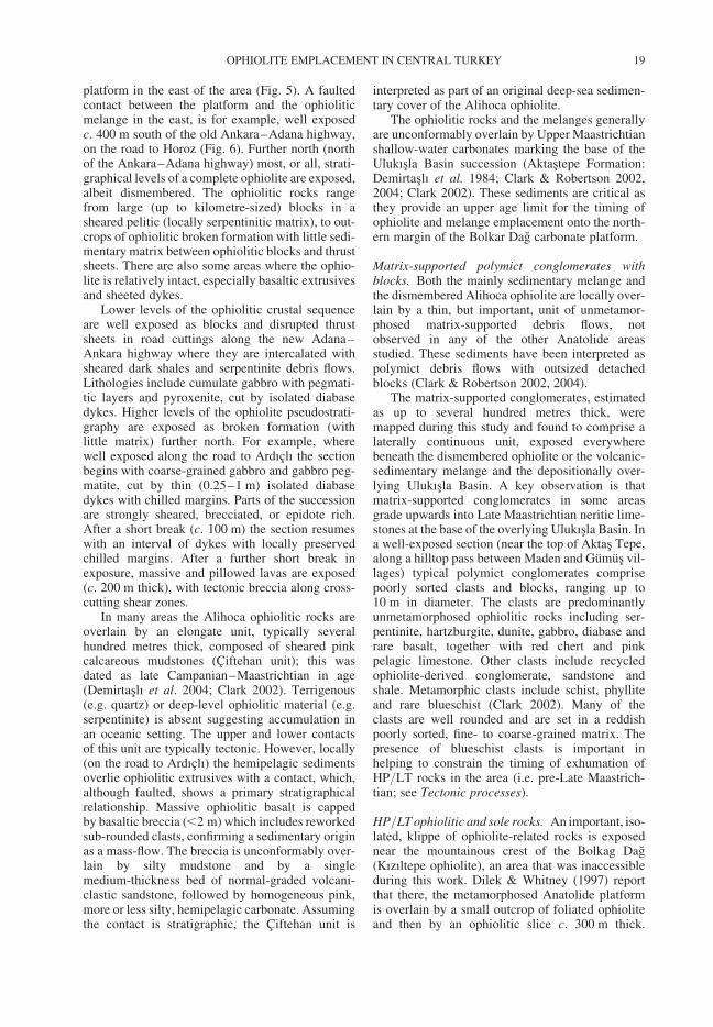
platform in the east of the area (Fig. 5). A faultedcontact between the platform and the ophioliticmelange in the east, is for example, well exposedc. 400 m south of the old Ankara–Adana highway,on the road to Horoz (Fig. 6). Further north (northof the Ankara–Adana highway) most, or all, strati-graphical levels of a complete ophiolite are exposed,albeit dismembered. The ophiolitic rocks rangefrom large (up to kilometre-sized) blocks in asheared pelitic (locally serpentinitic matrix), to out-crops of ophiolitic broken formation with little sedi-mentary matrix between ophiolitic blocks and thrustsheets. There are also some areas where the ophio-lite is relatively intact, especially basaltic extrusivesand sheeted dykes.
Lower levels of the ophiolitic crustal sequenceare well exposed as blocks and disrupted thrustsheets in road cuttings along the new Adana–Ankara highway where they are intercalated withsheared dark shales and serpentinite debris flows.Lithologies include cumulate gabbro with pegmati-tic layers and pyroxenite, cut by isolated diabasedykes. Higher levels of the ophiolite pseudostrati-graphy are exposed as broken formation (withlittle matrix) further north. For example, wherewell exposed along the road to Ardıclı the sectionbegins with coarse-grained gabbro and gabbro peg-matite, cut by thin (0.25–1 m) isolated diabasedykes with chilled margins. Parts of the successionare strongly sheared, brecciated, or epidote rich.After a short break (c. 100 m) the section resumeswith an interval of dykes with locally preservedchilled margins. After a further short break inexposure, massive and pillowed lavas are exposed(c. 200 m thick), with tectonic breccia along cross-cutting shear zones.
In many areas the Alihoca ophiolitic rocks areoverlain by an elongate unit, typically severalhundred metres thick, composed of sheared pinkcalcareous mudstones (Ciftehan unit); this wasdated as late Campanian–Maastrichtian in age(Demirtaslı et al. 2004; Clark 2002). Terrigenous(e.g. quartz) or deep-level ophiolitic material (e.g.serpentinite) is absent suggesting accumulation inan oceanic setting. The upper and lower contactsof this unit are typically tectonic. However, locally(on the road to Ardıclı) the hemipelagic sedimentsoverlie ophiolitic extrusives with a contact, which,although faulted, shows a primary stratigraphicalrelationship. Massive ophiolitic basalt is cappedby basaltic breccia (,2 m) which includes reworkedsub-rounded clasts, confirming a sedimentary originas a mass-flow. The breccia is unconformably over-lain by silty mudstone and by a singlemedium-thickness bed of normal-graded volcani-clastic sandstone, followed by homogeneous pink,more or less silty, hemipelagic carbonate. Assumingthe contact is stratigraphic, the Ciftehan unit is
interpreted as part of an original deep-sea sedimen-tary cover of the Alihoca ophiolite.
The ophiolitic rocks and the melanges generallyare unconformably overlain by Upper Maastrichtianshallow-water carbonates marking the base of theUlukısla Basin succession (Aktastepe Formation:Demirtaslı et al. 1984; Clark & Robertson 2002,2004; Clark 2002). These sediments are critical asthey provide an upper age limit for the timing ofophiolite and melange emplacement onto the north-ern margin of the Bolkar Dag carbonate platform.
Matrix-supported polymict conglomerates withblocks. Both the mainly sedimentary melange andthe dismembered Alihoca ophiolite are locally over-lain by a thin, but important, unit of unmetamor-phosed matrix-supported debris flows, notobserved in any of the other Anatolide areasstudied. These sediments have been interpreted aspolymict debris flows with outsized detachedblocks (Clark & Robertson 2002, 2004).
The matrix-supported conglomerates, estimatedas up to several hundred metres thick, weremapped during this study and found to comprise alaterally continuous unit, exposed everywherebeneath the dismembered ophiolite or the volcanic-sedimentary melange and the depositionally over-lying Ulukısla Basin. A key observation is thatmatrix-supported conglomerates in some areasgrade upwards into Late Maastrichtian neritic lime-stones at the base of the overlying Ulukısla Basin. Ina well-exposed section (near the top of Aktas Tepe,along a hilltop pass between Maden and Gumus vil-lages) typical polymict conglomerates comprisepoorly sorted clasts and blocks, ranging up to10 m in diameter. The clasts are predominantlyunmetamorphosed ophiolitic rocks including ser-pentinite, hartzburgite, dunite, gabbro, diabase andrare basalt, together with red chert and pinkpelagic limestone. Other clasts include recycledophiolite-derived conglomerate, sandstone andshale. Metamorphic clasts include schist, phylliteand rare blueschist (Clark 2002). Many of theclasts are well rounded and are set in a reddishpoorly sorted, fine- to coarse-grained matrix. Thepresence of blueschist clasts is important inhelping to constrain the timing of exhumation ofHP/LT rocks in the area (i.e. pre-Late Maastrich-tian; see Tectonic processes).
HP/LT ophiolitic and sole rocks. An important, iso-lated, klippe of ophiolite-related rocks is exposednear the mountainous crest of the Bolkag Dag(Kızıltepe ophiolite), an area that was inaccessibleduring this work. Dilek & Whitney (1997) reportthat there, the metamorphosed Anatolide platformis overlain by a small outcrop of foliated ophioliteand then by an ophiolitic slice c. 300 m thick.
OPHIOLITE EMPLACEMENT IN CENTRAL TURKEY 19
Blueschists were identified within amphibolites atthree localities. In two of these, Na-amphiboles(within shear zones) post-date the amphibolite foli-ation. At a third locality, slightly further east, cross-ite is associated with chlorite and muscovite. Ar/Ardating of hornblende yielded an age of 91 Ma(Turonian). The outcrop was interpreted as a frag-ment of an ophiolite and its metamorphic sole,which both experienced HP/LT metamorphism, incontrast to the dismembered Alihoca ophiolitefurther north that is unmetamorphosed.
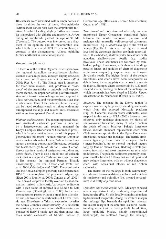
Konya area (Area 2)
To the NW of the Bolkar Dag area, discussed above,the regional Anatolide meta-carbonate platformextends over a huge area, although largely obscuredby a cover of Neogene–Recent deposits (MTA2002; Figs 3, 4, 5). The Konya area is importantfor three main reasons. First, pre-Permian ‘base-ment’ of the Anatolides is uniquely well exposedthere; second, the upper part of the platform succes-sion and a transition to melange are well exposed ina less recrystallized and metamorphosed state thanin other areas. Third, little-metamorphosed melangecan be traced southeastwards to link up with unme-tamorphosed melange and related units associatedwith unmetamorphosed Tauride units.
Platform and basement. The metamorphosed Meso-zoic Anatolide carbonate platform is underlainby a heterogeneous unit, recently renamed theKonya Complex (Robertson & Ustaomer in press),which is largely outside the scope of this paper. Ingeneral, this ‘basement’ includes Silurian-Devonianneritic meta-carbonates, Lower Carboniferous lime-stones, a melange composed of limestone, volcanicsand black chert (lydite) of Silurian–Lower Carbon-iferous age in a matrix of terrigenous turbidites anddebris flows. There is also a thick unit of volcanicrocks that is assigned a Carboniferous age becauseit lies beneath the regional Permian–Triassicunconformity (Eren 1993; Ozcan et al. 1988; Erenet al. 2004; Goncuoglu et al. 2007). These volcanicsand the Konya Complex generally have experiencedHP/LT metamorphism of presumed Alpine age(Eren 2001; Eren et al. 2004; Candan et al. 2005).The Konya Complex is locally overlain by shallow-marine, mixed siliciclastic/carbonate sedimentswith a rich fauna of inferred late Middle to LatePermian age (Goncuoglu et al. 2003). In the east,the succession passes without a break into siliciclas-tic and shallow-marine carbonates of Lower Trias-sic age. Elsewhere, a Triassic succession overliesthe Konya Complex unconformably. A siliciclasticsuccession grades upwards into shallow-water car-bonates of Early Triassic age and then passes intothick neritic carbonates of Middle Triassic to
Cretaceous age (Berriasian–Lower Maastrichtian;Ozcan et al. 1988).
Transitional unit. We observed relatively unmeta-morphosed Upper Cretaceous transitional faciesbetween the neritic carbonate platform andmelange with unusually well-preserved calcareousmicrofossils (e.g. Globotrunca sp.) to the west ofKonya (Fig. 8). In this area, the higher, exposedlevels of the carbonate platform are finely recrystal-lized, thick-bedded, shallow-water limestones withabundant shallow-water fossils (e.g. rudistbivalves). These sediments are followed by thin-bedded pelagic limestones, with abundant bedding-parallel lenses and nodules of chert of diageneticreplacement origin (e.g. exposed near the Konya–Seydisehir road). The highest levels of the pelagiclimestones and cherts have been redeposited asdebris flows, including platy chert clasts in a micri-tic matrix. Slumped cherts are overlain by c. 20 m ofsheared shales, marking the base of the melange, inwhich the matrix has been dated as Middle–UpperMaastrichtian to ?Paleocene (Ozcan et al. 1988).
Melange. The melange in the Konya region isexposed over a very large area, extending southeast-wards from the exposed Mesozoic platform(Fig. 8). Coherent shallow-water carbonates weremapped in this area by MTA (2002). However, weobserved only melange dominated by blocks ofshallow-water limestone, many of which containthe debris of rudist bivalves. Pelagic limestoneblocks include abundant replacement chert withGlobotruncana sp., similar to the Upper Cretaceouslimestones beneath the melange. The neritic lime-stones typically form trails of elongate blocks(‘mega-boudins’), up to several hundred metreslong by tens of metres thick. Bedding is well pre-served internally and most limestones are relativelyundeformed. The pelagic sediments generally com-prise smaller blocks (,10 m) that include pink andgrey pelagic limestone, with or without diageneticchert, with occasional blocks of red ribbonradiolarite.
The matrix of the melange is both sedimentary(i.e. sheared brown mudstone and local volcaniclas-tic sandstone) and ophiolitic (i.e. sheared serpenti-nite) in directly adjacent areas.
Ophiolite and metamorphic sole. Melange exposednear Konya is structurally overlain by serpentinizedhartzburgite (Fig. 8); this locally contains abundanthydrothermal magnesite. Along its western marginthe melange dips beneath the ophiolite, whereasthe eastern margin of the ophiolite is a north–south-trending neotectonic strike-slip fault. In addition,large ophiolitic blocks, mainly serpentinizedhartzburgite, are scattered through the melange,
A. H. F. ROBERTSON ET AL.20
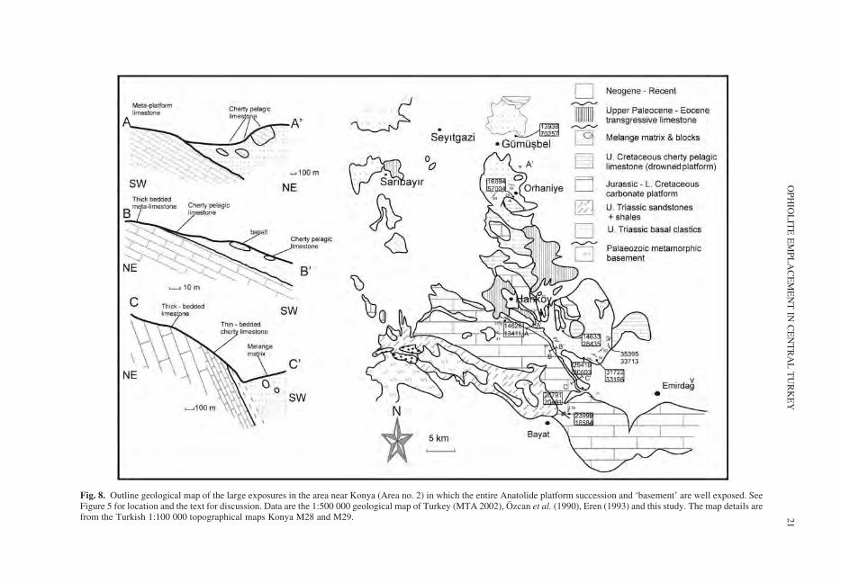
Fig. 8. Outline geological map of the large exposures in the area near Konya (Area no. 2) in which the entire Anatolide platform succession and ‘basement’ are well exposed. SeeFigure 5 for location and the text for discussion. Data are the 1:500 000 geological map of Turkey (MTA 2002), Ozcan et al. (1990), Eren (1993) and this study. The map details arefrom the Turkish 1:100 000 topographical maps Konya M28 and M29.
OP
HIO
LIT
EE
MP
LA
CE
ME
NT
INC
EN
TR
AL
TU
RK
EY
21
together with rare dunite, gabbro, sheeted dykes(commonly rhodingitized) and pillow lava. Hartz-burgite blocks, up to several hundred metres insize, locally include an attached metamorphic sole(near Karadigin; Dasci 2007). This is c. 450 m longby up to 35 m thick and comprises amphibolite,schist and garnet amphibolite, with interlayers ofpinkish meta-chert. Several smaller amphiboliteblocks (,10 m in size) are found within the adjacentmelange.
Altınekin (Area 3)
Lying to the NW of the Konya area, describedabove, this area is notable because geochemical evi-dence has been used to argue for a tectonic model inwhich all of the melange and related units werethrust from a far-distant suture zone (Izmir–Ankara–Erzincan suture zone) hundreds of kilo-metres away to the north of the Nigde–KırsehirMassif (Floyd et al. 2003).
Platform. There is no direct continuity of outcropfrom the metamorphosed Anatolide carbonateplatform exposed in the Konya area. However, theplatform is likely to be continuous beneath youngcover sediments (MTA 2002). The carbonateplatform in the Altınekin area is exposed on lowhills protruding above a young cover, as seen tothe south and SE of Altınekin (Figs 3d, 4 & 9).Thick-bedded meta-platform carbonates are wellexposed to the north of the Konya to Aksaraymain road. The platform in this area is folded intoseveral large open anticlines and synclines, gener-ally along WNW–ESW axes.
Relatively low stratigraphical levels of theplatform succession in the east (e.g. near05617:23370), of Triassic age (Ozcan et al. 1990),are dominated by alternating thinner- and thicker-bedded quartz-rich meta-sandstones, locally isoclin-ally folded. Individual sandstone beds, c. 20 cmthick, are interbedded with pelitic sediments (20–40 cm thick). The sandstones exhibit scouredbases and sharp, flat tops, suggestive of tractiondeposits. Elsewhere (05955:23988), thin- tomedium-bedded quartzose sandstones and phyllites,with local nodular chert horizons and lenses of blackmarble (2 m thick � 6 m long), pass upwards intodark marble, and then into thick-bedded dark dolo-mite with abundant stromatolites, of inferred Mid-Eocene Triassic age. A transition is well exposedon low hills in this area over c. 30 m. Similar darkmarble is seen on another low hill c. 1 km to theWNW (02829:25610), where a relatively sharpdepositional contact exists between dark dolomitebelow and grey thin-bedded marble above. Furthereast (e.g. near Kısoren 13319:19937) thick-bedded
carbonates locally pass upwards into calc-schistand phyllite.
Transitional unit. The meta-platform succession, ofTriassic–Early Cretaceous age, is followed north-wards by a contrasting sequence of meta-pelagiccarbonates, meta-calciturbidites and meta-shales,dated as Late Cretaceous (Ozcan et al. 1990). Meta-sediments to the north are folded and reversefaulted. Exposures in this area are again restrictedto low hills and ridges surrounded by young sedi-ments. Folded successions of mainly meta-pelagiccarbonates are seen on hills to the south of thearea shown in Figure 9 (near 32698:90125).Medium- to thick-bedded pinkish marbles c. 200 mthick there are overlain by thinner bedded siliceousmeta-limestones. Higher levels of the sequence areexposed on the southern limb of a large WNW–ESE-trending anticline; there, cherty meta-pelagiclimestones pass upwards into meta-clastic sediment(psammitic schist) c. 50 m thick, which exhibitslocal slump folding. An isolated hill to the SEexposes steeply dipping, very dark-coloured silic-eous limestone. Siliceous marble passes deposition-ally upwards into medium-to thick-bedded,well-laminated meta-sandstones and meta-shales,c. 60 m thick. These sediments are cleaved andfolded. Within the map area (Fig. 9) the contactwith the melange to the north is a normal fault,probably related to later-Cenozoic post-collisionaldeformation.
The area shown in Figure 9 is folded along nearlyeast–west axes, such that an original, unfaultedcontact is exposed in some areas between the plat-form and the melange (e.g. SW of KorkayakTepe). For example, in the east of the area (i.e.NW of Akcasar), thin- to medium-bedded pink silic-eous meta-pelagic limestones contain local darkorganic-rich layers and pass upwards into calc-schist and epidote-rich greenschist, interbeddedwith marble. Southwards, this is followed abruptlyby sheared serpentinite marking the base of themelange (Fig. 9).
Transitional facies between the carbonate plat-form and the melange are also locally exposedfurther NW around Altınekin town (Fig. 9). Well-bedded, folded, quartz-rich meta-sandstones(schists) occur as alternating darker and lighterlayers c. 1 km south of Altınekin. Slightly furthernorth (north of the road) folded meta-sandstones(up to 60 m thick locally) include an exceptionallythick massive sandstone bed (.8 m thick), inter-preted as deposits from a high-density turbiditycurrent. This is overlain by meta-serpentinitemarking the base of the melange.
Melange. Two different melanges have beenreported from this area: first, ‘Altınekin melange’
A. H. F. ROBERTSON ET AL.22
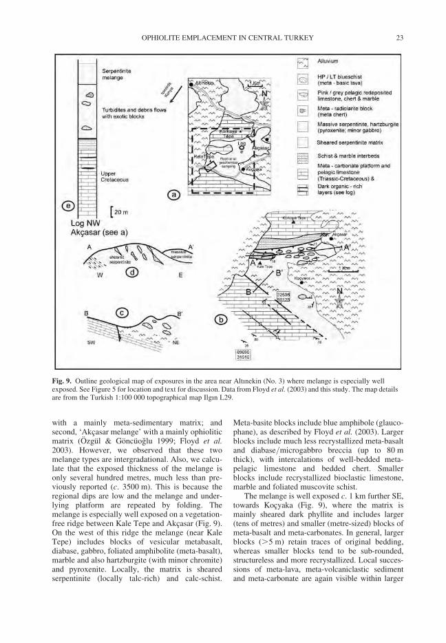
with a mainly meta-sedimentary matrix; andsecond, ‘Akcasar melange’ with a mainly ophioliticmatrix (Ozgul & Goncuoglu 1999; Floyd et al.2003). However, we observed that these twomelange types are intergradational. Also, we calcu-late that the exposed thickness of the melange isonly several hundred metres, much less than pre-viously reported (c. 3500 m). This is because theregional dips are low and the melange and under-lying platform are repeated by folding. Themelange is especially well exposed on a vegetation-free ridge between Kale Tepe and Akcasar (Fig. 9).On the west of this ridge the melange (near KaleTepe) includes blocks of vesicular metabasalt,diabase, gabbro, foliated amphibolite (meta-basalt),marble and also hartzburgite (with minor chromite)and pyroxenite. Locally, the matrix is shearedserpentinite (locally talc-rich) and calc-schist.
Meta-basite blocks include blue amphibole (glauco-phane), as described by Floyd et al. (2003). Largerblocks include much less recrystallized meta-basaltand diabase/microgabbro breccia (up to 80 mthick), with intercalations of well-bedded meta-pelagic limestone and bedded chert. Smallerblocks include recrystallized bioclastic limestone,marble and foliated muscovite schist.
The melange is well exposed c. 1 km further SE,towards Kocyaka (Fig. 9), where the matrix ismainly sheared dark phyllite and includes larger(tens of metres) and smaller (metre-sized) blocks ofmeta-basalt and meta-carbonates. In general, largerblocks (.5 m) retain traces of original bedding,whereas smaller blocks tend to be sub-rounded,structureless and more recrystallized. Local succes-sions of meta-lava, meta-volcaniclastic sedimentand meta-carbonate are again visible within larger
Fig. 9. Outline geological map of exposures in the area near Altınekin (No. 3) where melange is especially wellexposed. See Figure 5 for location and text for discussion. Data from Floyd et al. (2003) and this study. The map detailsare from the Turkish 1:100 000 topographical map Ilgın L29.
OPHIOLITE EMPLACEMENT IN CENTRAL TURKEY 23
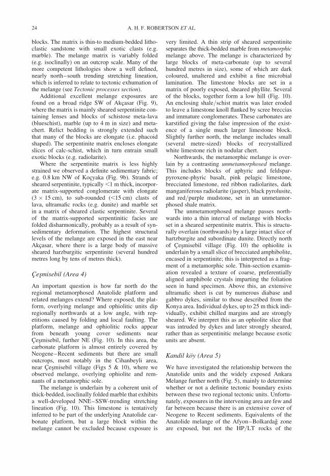
blocks. The matrix is thin-to medium-bedded litho-clastic sandstone with small exotic clasts (e.g.marble). The melange matrix is variably folded(e.g. isoclinally) on an outcrop scale. Many of themore competent lithologies show a well defined,nearly north–south trending stretching lineation,which is inferred to relate to tectonic exhumation ofthe melange (see Tectonic processes section).
Additional excellent melange exposures arefound on a broad ridge SW of Akcasar (Fig. 9),where the matrix is mainly sheared serpentinite con-taining lenses and blocks of schistose meta-lava(blueschist), marble (up to 4 m in size) and meta-chert. Relict bedding is strongly extended suchthat many of the blocks are elongate (i.e. phacoidshaped). The serpentinite matrix encloses elongateslices of calc-schist, which in turn entrain smallexotic blocks (e.g. radiolarite).
Where the serpentinite matrix is less highlystrained we observed a definite sedimentary fabric;e.g. 0.8 km NW of Kocyaka (Fig. 9b). Strands ofsheared serpentinite, typically ,1 m thick, incorpor-ate matrix-supported conglomerate with elongate(3 � 15 cm), to sub-rounded (,15 cm) clasts oflava, ultramafic rocks (e.g. dunite) and marble setin a matrix of sheared clastic serpentinite. Severalof the matrix-supported serpentinitic facies arefolded disharmonically, probably as a result of syn-sedimentary deformation. The highest structurallevels of the melange are exposed in the east nearAkcasar, where there is a large body of massivesheared harzburgitic serpentinite (several hundredmetres long by tens of metres thick).
Cesmisebil (Area 4)
An important question is how far north do theregional metamorphosed Anatolide platform andrelated melanges extend? Where exposed, the plat-form, overlying melange and ophiolitic units dipregionally northwards at a low angle, with rep-etitions caused by folding and local faulting. Theplatform, melange and ophiolitic rocks appearfrom beneath young cover sediments nearCesmisebil, further NE (Fig. 10). In this area, thecarbonate platform is almost entirely covered byNeogene–Recent sediments but there are smalloutcrops, most notably in the Cihanbeyli area,near Cesmisebil village (Figs 5 & 10), where weobserved melange, overlying ophiolite and rem-nants of a metamorphic sole.
The melange is underlain by a coherent unit ofthick-bedded, isoclinally folded marble that exhibitsa well-developed NNE–SSW-trending stretchinglineation (Fig. 10). This limestone is tentativelyinferred to be part of the underlying Anatolide car-bonate platform, but a large block within themelange cannot be excluded because exposure is
very limited. A thin strip of sheared serpentiniteseparates the thick-bedded marble from metamorphicmelange above. The melange is characterized bylarge blocks of meta-carbonate (up to severalhundred metres in size), some of which are darkcoloured, unaltered and exhibit a fine microbiallamination. The limestone blocks are set in amatrix of poorly exposed, sheared phyllite. Severalof the blocks, together form a low hill (Fig. 10).An enclosing shale/schist matrix was later erodedto leave a limestone knoll flanked by scree brecciasand immature conglomerates. These carbonates arekarstified giving the false impression of the exist-ence of a single much larger limestone block.Slightly further north, the melange includes small(several metre-sized) blocks of recrystallizedwhite limestone rich in nodular chert.
Northwards, the metamorphic melange is over-lain by a contrasting unmetamorphosed melange.This includes blocks of aphyric and feldspar-pyroxene-phyric basalt, pink pelagic limestone,brecciated limestone, red ribbon radiolarites, darkmanganiferous radiolarite (jasper), black pyrolusite,and red/purple mudstone, set in an unmetamor-phosed shale matrix.
The unmetamorphosed melange passes north-wards into a thin interval of melange with blocksset in a sheared serpentinite matrix. This is structu-rally overlain (northwards) by a large intact slice ofhartzburgite and subordinate dunite. Directly northof Cesmisebil village (Fig. 10) the ophiolite isunderlain by a small slice of brecciated amphibolite,encased in serpentinite; this is interpreted as a frag-ment of a metamorphic sole. Thin-section examin-ation revealed a texture of coarse, preferentiallyaligned amphibole crystals imparting the foliationseen in hand specimen. Above this, an extensiveultramafic sheet is cut by numerous diabase andgabbro dykes, similar to those described from theKonya area. Individual dykes, up to 25 m thick indi-vidually, exhibit chilled margins and are stronglysheared. We interpret this as an ophiolite slice thatwas intruded by dykes and later strongly sheared,rather than as serpentinitic melange because exoticunits are absent.
Kandil koy (Area 5)
We have investigated the relationship between theAnatolide units and the widely exposed AnkaraMelange further north (Fig. 5), mainly to determinewhether or not a definite tectonic boundary existsbetween these two regional tectonic units. Unfortu-nately, exposures in the intervening area are few andfar between because there is an extensive cover ofNeogene to Recent sediments. Equivalents of theAnatolide melange of the Afyon–Bolkardag zoneare exposed, but not the HP/LT rocks of the
A. H. F. ROBERTSON ET AL.24
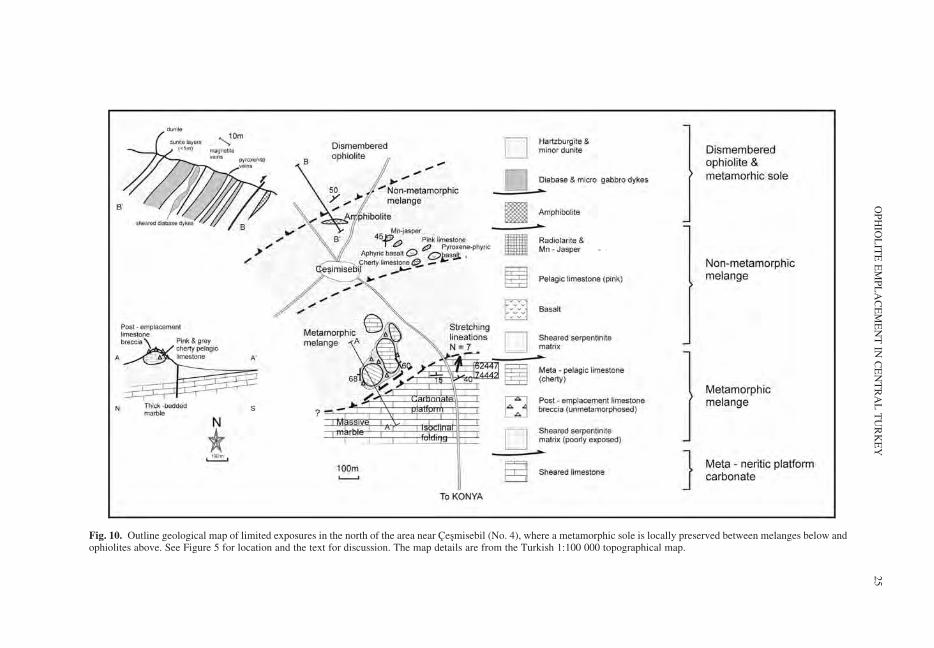
Fig. 10. Outline geological map of limited exposures in the north of the area near Cesmisebil (No. 4), where a metamorphic sole is locally preserved between melanges below andophiolites above. See Figure 5 for location and the text for discussion. The map details are from the Turkish 1:100 000 topographical map.
OP
HIO
LIT
EE
MP
LA
CE
ME
NT
INC
EN
TR
AL
TU
RK
EY
25
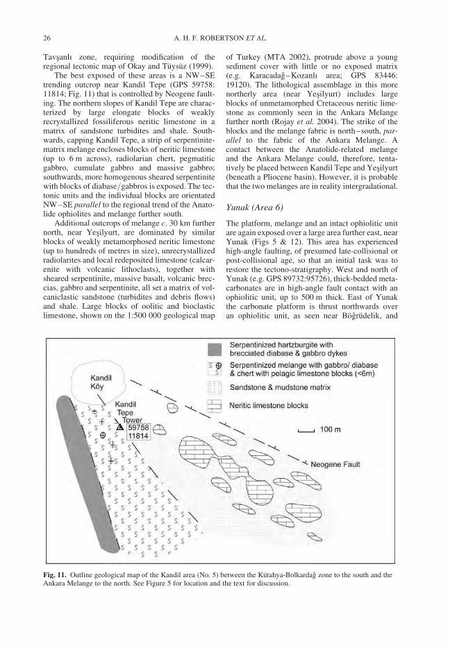
Tavsanlı zone, requiring modification of theregional tectonic map of Okay and Tuysuz (1999).
The best exposed of these areas is a NW–SEtrending outcrop near Kandil Tepe (GPS 59758:11814; Fig. 11) that is controlled by Neogene fault-ing. The northern slopes of Kandil Tepe are charac-terized by large elongate blocks of weaklyrecrystallized fossiliferous neritic limestone in amatrix of sandstone turbidites and shale. South-wards, capping Kandil Tepe, a strip of serpentinite-matrix melange encloses blocks of neritic limestone(up to 6 m across), radiolarian chert, pegmatiticgabbro, cumulate gabbro and massive gabbro;southwards, more homogenous sheared serpentinitewith blocks of diabase/gabbros is exposed. The tec-tonic units and the individual blocks are orientatedNW–SE parallel to the regional trend of the Anato-lide ophiolites and melange further south.
Additional outcrops of melange c. 30 km furthernorth, near Yesilyurt, are dominated by similarblocks of weakly metamorphosed neritic limestone(up to hundreds of metres in size), unrecrystallizedradiolarites and local redeposited limestone (calcar-enite with volcanic lithoclasts), together withsheared serpentinite, massive basalt, volcanic brec-cias, gabbro and serpentinite, all set a matrix of vol-caniclastic sandstone (turbidites and debris flows)and shale. Large blocks of oolitic and bioclasticlimestone, shown on the 1:500 000 geological map
of Turkey (MTA 2002), protrude above a youngsediment cover with little or no exposed matrix(e.g. Karacadag–Kozanlı area; GPS 83446:19120). The lithological assemblage in this morenortherly area (near Yesilyurt) includes largeblocks of unmetamorphed Cretaceous neritic lime-stone as commonly seen in the Ankara Melangefurther north (Rojay et al. 2004). The strike of theblocks and the melange fabric is north–south, par-allel to the fabric of the Ankara Melange. Acontact between the Anatolide-related melangeand the Ankara Melange could, therefore, tenta-tively be placed between Kandil Tepe and Yesilyurt(beneath a Pliocene basin). However, it is probablethat the two melanges are in reality intergradational.
Yunak (Area 6)
The platform, melange and an intact ophiolitic unitare again exposed over a large area further east, nearYunak (Figs 5 & 12). This area has experiencedhigh-angle faulting, of presumed late-collisional orpost-collisional age, so that an initial task was torestore the tectono-stratigraphy. West and north ofYunak (e.g. GPS 89732:95726), thick-bedded meta-carbonates are in high-angle fault contact with anophiolitic unit, up to 500 m thick. East of Yunakthe carbonate platform is thrust northwards overan ophiolitic unit, as seen near Bogrudelik, and
Fig. 11. Outline geological map of the Kandil area (No. 5) between the Kutahya-Bolkardag zone to the south and theAnkara Melange to the north. See Figure 5 for location and the text for discussion.
A. H. F. ROBERTSON ET AL.26
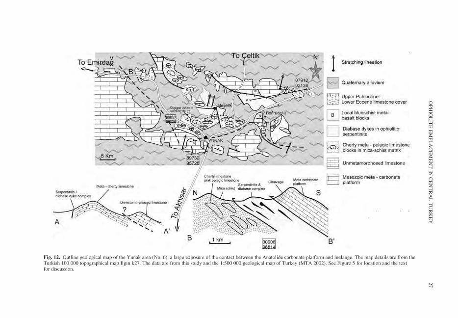
Fig. 12. Outline geological map of the Yunak area (No. 6), a large exposure of the contact between the Anatolide carbonate platform and melange. The map details are from theTurkish 100 000 topographical map Ilgın k27. The data are from this study and the 1:500 000 geological map of Turkey (MTA 2002). See Figure 5 for location and the textfor discussion.
OP
HIO
LIT
EE
MP
LA
CE
ME
NT
INC
EN
TR
AL
TU
RK
EY
27
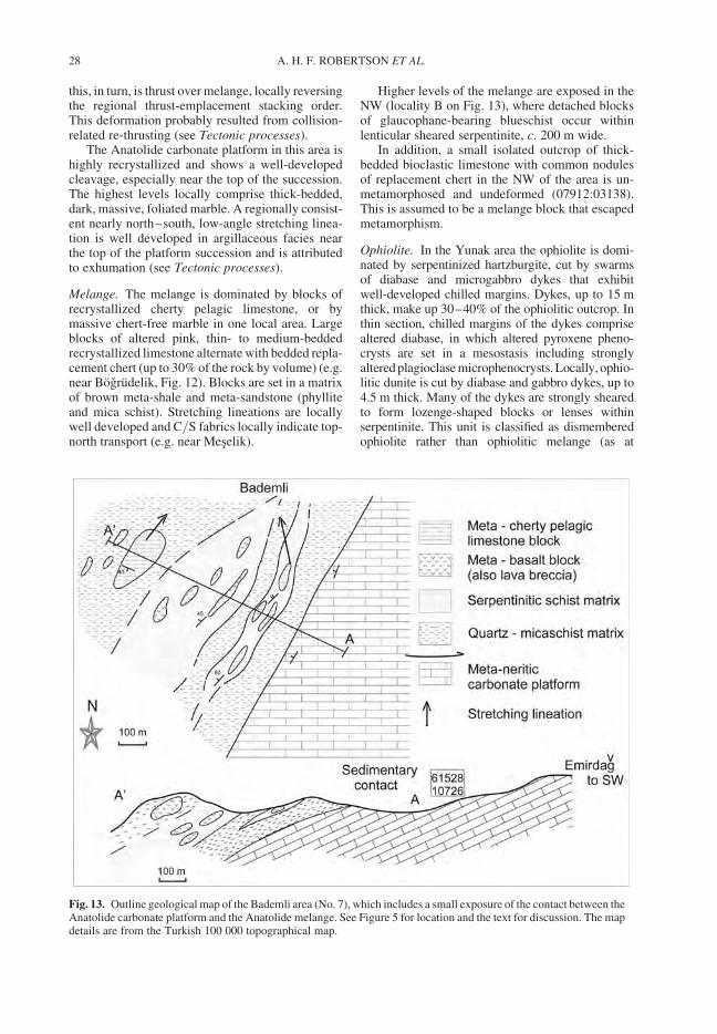
this, in turn, is thrust over melange, locally reversingthe regional thrust-emplacement stacking order.This deformation probably resulted from collision-related re-thrusting (see Tectonic processes).
The Anatolide carbonate platform in this area ishighly recrystallized and shows a well-developedcleavage, especially near the top of the succession.The highest levels locally comprise thick-bedded,dark, massive, foliated marble. A regionally consist-ent nearly north–south, low-angle stretching linea-tion is well developed in argillaceous facies nearthe top of the platform succession and is attributedto exhumation (see Tectonic processes).
Melange. The melange is dominated by blocks ofrecrystallized cherty pelagic limestone, or bymassive chert-free marble in one local area. Largeblocks of altered pink, thin- to medium-beddedrecrystallized limestone alternate with bedded repla-cement chert (up to 30% of the rock by volume) (e.g.near Bogrudelik, Fig. 12). Blocks are set in a matrixof brown meta-shale and meta-sandstone (phylliteand mica schist). Stretching lineations are locallywell developed and C/S fabrics locally indicate top-north transport (e.g. near Meselik).
Higher levels of the melange are exposed in theNW (locality B on Fig. 13), where detached blocksof glaucophane-bearing blueschist occur withinlenticular sheared serpentinite, c. 200 m wide.
In addition, a small isolated outcrop of thick-bedded bioclastic limestone with common nodulesof replacement chert in the NW of the area is un-metamorphosed and undeformed (07912:03138).This is assumed to be a melange block that escapedmetamorphism.
Ophiolite. In the Yunak area the ophiolite is domi-nated by serpentinized hartzburgite, cut by swarmsof diabase and microgabbro dykes that exhibitwell-developed chilled margins. Dykes, up to 15 mthick, make up 30–40% of the ophiolitic outcrop. Inthin section, chilled margins of the dykes comprisealtered diabase, in which altered pyroxene pheno-crysts are set in a mesostasis including stronglyaltered plagioclase microphenocrysts. Locally, ophio-litic dunite is cut by diabase and gabbro dykes, up to4.5 m thick. Many of the dykes are strongly shearedto form lozenge-shaped blocks or lenses withinserpentinite. This unit is classified as dismemberedophiolite rather than ophiolitic melange (as at
Fig. 13. Outline geological map of the Bademli area (No. 7), which includes a small exposure of the contact between theAnatolide carbonate platform and the Anatolide melange. See Figure 5 for location and the text for discussion. The mapdetails are from the Turkish 100 000 topographical map.
A. H. F. ROBERTSON ET AL.28
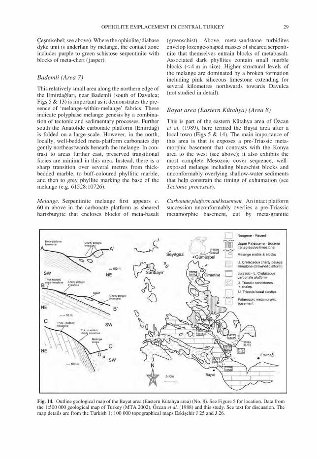
Cesmisebel; see above). Where the ophiolite/diabasedyke unit is underlain by melange, the contact zoneincludes purple to green schistose serpentinite withblocks of meta-chert ( jasper).
Bademli (Area 7)
This relatively small area along the northern edge ofthe Emirdagları, near Bademli (south of Davulca;Figs 5 & 13) is important as it demonstrates the pre-sence of ‘melange-within-melange’ fabrics. Theseindicate polyphase melange genesis by a combina-tion of tectonic and sedimentary processes. Furthersouth the Anatolide carbonate platform (Emirdag)is folded on a large-scale. However, in the north,locally, well-bedded meta-platform carbonates dipgently northeastwards beneath the melange. In con-trast to areas further east, preserved transitionalfacies are minimal in this area. Instead, there is asharp transition over several metres from thick-bedded marble, to buff-coloured phyllitic marble,and then to grey phyllite marking the base of themelange (e.g. 61528:10726).
Melange. Serpentinite melange first appears c.60 m above in the carbonate platform as shearedhartzburgite that encloses blocks of meta-basalt
(greenschist). Above, meta-sandstone turbiditesenvelop lozenge-shaped masses of sheared serpenti-nite that themselves entrain blocks of metabasalt.Associated dark phyllites contain small marbleblocks (,4 m in size). Higher structural levels ofthe melange are dominated by a broken formationincluding pink siliceous limestone extending forseveral kilometres northwards towards Davulca(not studied in detail).
Bayat area (Eastern Kutahya) (Area 8)
This is part of the eastern Kutahya area of Ozcanet al. (1989), here termed the Bayat area after alocal town (Figs 5 & 14). The main importance ofthis area is that is exposes a pre-Triassic meta-morphic basement that contrasts with the Konyaarea to the west (see above); it also exhibits themost complete Mesozoic cover sequence, well-exposed melange including blueschist blocks andunconformably overlying shallow-water sedimentsthat help constrain the timing of exhumation (seeTectonic processes).
Carbonate platform andbasement. An intact platformsuccession unconformably overlies a pre-Triassicmetamorphic basement, cut by meta-granitic
Fig. 14. Outline geological map of the Bayat area (Eastern Kutahya area) (No. 8). See Figure 5 for location. Data fromthe 1:500 000 geological map of Turkey (MTA 2002), Ozcan et al. (1988) and this study. See text for discussion. Themap details are from the Turkish 1: 100 000 topographical maps Eskisehir J 25 and J 26.
OPHIOLITE EMPLACEMENT IN CENTRAL TURKEY 29
rocks. This has been correlated with the Late Pre-cambrian basement of the metamorphic MenderesMassif (Candan et al. 2005; Dora et al. 2001). Theunconformably overlying succession begins withvaricoloured conglomerates, sandstones andshales, followed by dolomitic limestones (wackes-tones) with fossils of Early Triassic age (Induan–Olenekian) (Ozcan et al. 1988, 1989; Goncuogluet al. 2003). We observed that the successionpasses conformably upwards into dolomitic carbon-ates containing large bivalves (Megalodonts) andthen into thick-bedded mainly dolomitic meta-carbonates (marbles). The Triassic part of the suc-cession is repeated by a broad NW–SE-trendingkilometre-scale anticline (Fig. 14). The southernlimb c. 4 kilometres north of Bayat (23999:18584)exhibits alternations of thinly bedded, laminated,dolomite, dolomitic limestone, thick-bedded sugarydolomite and local lenses of carbonate conglomer-ate. Gently northward-dipping dark, well-laminateddolomitic and microbial carbonates platform ofMid-Late Triassic age (Anisian–Norian) are wellexposed on the northern limb of the anticline(26791:2046), followed by neritic carbonates ofLate Jurassic–Early Cretaceous age.
Transitional facies. Previously, the contact betweenthe Anatolide platform and the melange was reportedto be mainly a ductile shear zone in this area (Candanet al. 2005). However, we observed the existence ofsedimentary transitions, up to several tens of metresthick, from neritic platform carbonates, throughpelagic and redeposited facies (e.g. Eskigomu–Bayat road; 22452:26180), to melange (e.g. Sulukluarea; 24133:28435; Fig. 14). Planktonic foraminiferafrom the transitional units have yielded an EarlyMaastrichtian age, while the sedimentary matrix ofthe overlying melange is reported to be of EarlyMaastrichtian–Early Paleocene age (Ozcan et al.1989; Goncuoglu et al. 1992; Goncuoglu et al.2000; our unpublished data).
The thicknesses of Upper Cretaceous pelagicand redeposited facies above the neritic carbonatesvary markedly along strike. For example, severalkilometres south of Hankoy (14626:34111) thick-bedded neritic meta-carbonates pass depositionallyupwards into thin-bedded cherty pelagic limestone(,5 m thick) and then into grey phyllite withdetached blocks of siliceous limestone (up to severalmetres in size). Some of individual clasts are tecto-nically brecciated and reworked in a matrix of pinkpelagic limestone. Elsewhere, platform carbonatespass upwards into alternations of dark phyllites,thin- to medium-bedded meta-calciturbidites andmeta-pelagic carbonates with nodules and lensesof chert of diagenetic origin. Coarse calcarenite, inbeds up to 1 m thick, contain numerous shale (phyl-lite) clasts (,2 cm in size). Local interbeds of lime-stones conglomerate (up to c. 1 m thick) contain
flattened limestone clasts (up to 15 cm long � 5across). Individual sandstone beds near the top ofthe transitional unit are rich in quartz and muscovite,interbedded with cherty pelagic limestones andform depositional units up to 20 m thick. Thehighest levels of the transitional interval includequartz-rich turbidites, in beds up to 60 cm thick,often preserved as sheared-out lenses (‘phacoids’).Large subequant blocks (2 m � 6 m) of marble aresimilar to the underlying platform carbonate facies.Relatively thin-bedded facies are cleaved andisoclinally folded, commonly preserved as smallfold cores.
Melange. Melange in the Bayat area overlies thetransitional unit with a low-angle thrust contact. Inthe south the lowest part of the melange is domi-nated by large, elongate, detached blocks ofrecrystallized red ribbon radiolarite and marble(Fig. 14), set in a phyllitic matrix. Dark-colouredphyllites are interbedded with matrix-supportedconglomerate containing sub-rounded, to elongate,clasts of chert, limestone and siliceous limestone(4 � 28 m). An exotic slab of disrupted pelagiclimestone (up to 25 m thick), contains abundant len-ticular and nodular chert.
Northwards, the melange is repeated by twoWNW–ESE-trending large-scale open anticlines(Fig. 14). On a limb of the southerly of these folds(near Gedikevi koyu: 35395:33713), blocks of rela-tively unmetamorphosed lava and volcaniclasticsediments occur, together with large limestoneblocks (up to several hundred metres long by tensof metres thick), and also smaller blocks ofsheared limestone/radiolarite alternations. Meta-lava ranges from aphyric, to feldspar-phyric basalt(greenschists), either vesicular or non-vesicular.Larger blocks preserve short intact successions;e.g. well-bedded volcaniclastic sandstone passinginto pink pelagic limestone, with common mangani-ferous segregations. Primary volcanic texturesinclude dark glassy basalt with rare altered plagio-clase phenocrysts and feldspar microphenocrystsin a matrix of dark devitrified glassy basalt. Thematrix of the melange in this southerly fold structureincludes sheared interbeds of rubbly volcaniclastic,matrix-supported conglomerates with sub-angularclasts. These clasts are mainly pelagic limestone(up to 15 cm in size) with rare lava (both feldspar-phyric and aphyric). In this area, the matrix isdominated by medium-bedded, to thick-beddedquartzose sandstones, with sheared phacoidalfabrics and matrix-supported conglomerates, withsub-rounded clasts, up to 40 in size (e.g. nearKılıclar village; 31722:33196 and at 29439:30603).
Melange is again exposed in the more northerlyfold structure, where it directly overlies well-beddedmarble (near Orhaniye: 16084:57004). This isdominated by large blocks (up to 60 � 130 m) of
A. H. F. ROBERTSON ET AL.30
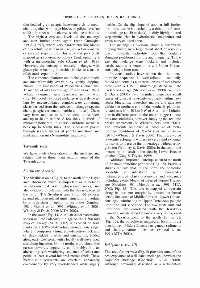
thin-bedded grey pelagic limestone rich in meta-chert, together with large blocks of pillow lava (upto 30 m in size) within cleaved sandstone turbidites.
The highest exposed levels of the melangeare seen further north again (near Gumusbel13938:70257), where very hard-weathering blocksof blueschist, up to 5 m in size, are set in a matrixof sheared serpentinite. This area was previouslymapped as a coherent ophiolite (‘Kınık ophiolite’),with a metamorphic sole (Ozcan et al. 1989).However, the outcrop is entirely melange, withglaucophane-bearing blueschist blocks in a matrixof sheared serpentinite.
The carbonate platform and melange combined,are unconformably overlain by gently dipping,Nummulitic limestones of Paleocene (Selandian–Thanetian)–Early Eocene age (Ozcan et al. 1989).Where examined, near Sarıbayır in the west(Fig. 14), poorly exposed melange is directly over-lain by unconsolidated conglomerate containingclasts derived from the subjacent melange (e.g. redchert, pelagic carbonate, marble and lavas). Clastsvary from angular, to sub-rounded, to rounded,and up to 40 cm in size. A few thick interbeds ofmicroconglomerate, to coarse sandstone occur, inbeds up to 60 cm thick. The succession passesthrough several metres of pebbly mudstone andmarl and then into Nummulitic limestone.
Tavsanlı zone
We have made observations on the melange andrelated unit in three main outcrop areas of theTavsanlı zone.
Sivrihisar (Area 9)
The Sivrihisar area (Fig. 5) to the north of the Bayatarea, discussed above, is important as it includeswell-documented very high-pressure rocks, andalso evidence of collision with the Sakarya zone tothe north. The Sivrihisar area (Fig. 15) exposesseveral platform-related units, structurally overlainby a large sheet of ophiolitic peridotite (Gauthier1984; Monod et al. 1991; Whitney et al. 2001;Whitney & Davis 2006; MTA 2002).
In the south (Fig. 14, A-A0) an intact succession,shown as Late Palaeozoic in age on the 1:500 000map of Turkey (MTA 2002) is exposed on bothflanks of a NW–SE-trending mountainous ridge,where it comprises a hundreds-of-metres-thick unitof thick-bedded marble and micaschist, foldedalong east–west axes, with a locally well-developedstretching lineation. On the northern dip slope, thispasses upwards, apparently conformably, into analternating, soft-weathering sequence of schist andpelite, at least several hundred metres thick. Thesemeta-clastic sediments are overlain, apparentlyconformably by very thick-bedded white sugary
marble. On the dip slope of another hill furthernorth this marble is overlain by a thin unit of tecto-nic melange (c. 50 m thick), mainly highly alteredserpentinite (rich in hydrothermal magnetite) andgreen recrystallized chert.
The melange is overlain, above a northward-dipping thrust, by a large thrust sheet of serpenti-nized ultramafic ophiolitic rock that containsabundant podiform chromite and magnetite. To theeast the melange zone thickens and includesbasalt, radiolarite serpentinite and Upper Cretac-eous pelagic limestone.
Previous studies have shown that the meta-morphic sequence is well-foliated, isoclinallyfolded and contains numerous lenses of meta-basicrocks with a HP/LT mineralogy dated as LateCretaceous in age (Sherlock et al. 1999). Whitney& Davis (2006) have identified numerous smalllenses of unusual lawsonite ecologite within law-sonite blueschist, blueschist marble and quartzitewithin the northern end of the southerly platform-related massif c. 40 km NW of Sivrihisar. Litholo-gies in different parts of the massif suggest lowerpressure conditions, however, implying that tectonicbreaks are present (D. Whitney, pers. com. 2007).The lawsonite blueschist is indicative of meta-morphic conditions of 21–24 kbar and c. 422–580 8C (Whitney & Davis 2006). The presence oflawsonite eclogite is witness to very rapid exhuma-tion so as to preserve the mineralogy without retro-gression (Whitney & Davis 2006). In the south, themetamorphic massif is intruded by Lower Eocenegranites (Okay & Tuysuz 1999).
Additional important outcrops occur to the northof the main ophiolitic peridotite (Fig. 15). Previousstudies indicate that, in the north, the ophioliticperidotite is intersliced with low-grade-metamorphosed clastic sediments and volcanicsincluding exotic blocks of inferred Permo-Triassicage (Gauthier 1984; Monod et al. 1991; MTA2002; Fig. 15). This unit is mapped as overlainalong its northern margin by unmetamorphosedneritic limestone of Middle Jurassic–Lower Cretac-eous age, culminating in Upper Cretaceous pelagiclimestone and sandstone. The low-grade unit andlimestones are correlated with the KarakayaComplex and its later-Mesozoic cover, as exposedin the Sakarya zone to the north. In the SE(Fig. 15), the ophiolite is mapped as locally thrustover Lower–Middle Eocene terrigenous sedimentsand shallow-marine limestones (Monod et al.1991; MTA 2002).
Eskisehir (Area 10)
This area further west (Fig. 5) provides some of thebest exposures of well-dated melange, known as theDagkuplu melange (Goncuoglu et al. 2000).Although previously described as a sedimentary
OPHIOLITE EMPLACEMENT IN CENTRAL TURKEY 31
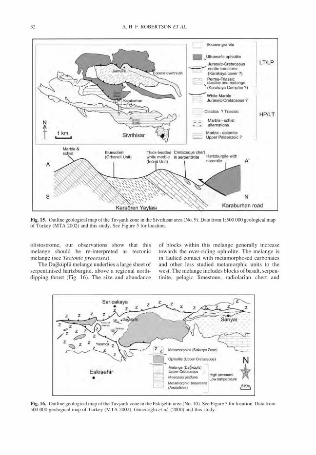
olistostrome, our observations show that thismelange should be re-interpreted as tectonicmelange (see Tectonic processes).
The Dagkuplu melange underlies a large sheet ofserpentinised hartzburgite, above a regional north-dipping thrust (Fig. 16). The size and abundance
of blocks within this melange generally increasetowards the over-riding ophiolite. The melange isin faulted contact with metamorphosed carbonatesand other less studied metamorphic units to thewest. The melange includes blocks of basalt, serpen-tinite, pelagic limestone, radiolarian chert and
Fig. 15. Outline geological map of the Tavsanlı zone in the Sivrihisar area (No. 9). Data from 1:500 000 geological mapof Turkey (MTA 2002) and this study. See Figure 5 for location.
Fig. 16. Outline geological map of the Tavsanlı zone in the Eskisehir area (No. 10). See Figure 5 for location. Data from500 000 geological map of Turkey (MTA 2002), Goncuoglu et al. (2000) and this study.
A. H. F. ROBERTSON ET AL.32
blueschists, set in a sandy and shaly matrix(Goncuoglu et al. 2000). The melange matrix andmany of the clasts experienced only limited recrys-tallization allowing radiolarian cherts to be dated asUpper Cretaceous (Goncuoglu et al. 2000). Furthereast in the same melange outcrop, near Sarıyar,radiolarians of Early Berriasian–Early Hauterivianhave been identified within OIB (ocean islandbasalt)-type basalts, and a Cenomanian age wasdetermined for nearby MOR (mid-ocean ridge)-typebasalts (Goncuoglu et al. 2006a, b).
We observed an excellent section of the melangenear the road north of Yarımca (Fig. 16) wherethe melange matrix is dominated by shales andlithoclastic sandstones that show intense layer-parallel extension. This feature is indicative ofassembly by tectonic rather than sedimentary pro-cesses. Individual sandstone beds (,1 m thick)show grading, parallel lamination and other featuresindicative of turbidites. Sandstone/shale melange iscut by serpentinite lenses, which show a pseudo-conglomeratic (i.e. tectonic) fabric.
The melange includes large blocks of exception-ally well-exposed, intact sequences of pillow basalt,massive basalt, red or green ribbon radiolarite andshale, up to several tens of metres thick. The datedUpper Cretaceous radiolarites come from scatteredelongate blocks and lenses of red radiolariteexposed near Dagkuplu, in close vicinity to largerblocks of volcanic and volcaniclastic rocks(Goncuoglu et al. 2000, 2006). Nearby blocksinclude well-cemented lava breccia of primaryorigin, with angular to sub-rounded clasts set in ared shale matrix. There are also several large(80 � 8 m) tabular blocks of hornblende-phyricandesite and elongate blocks of volcaniclastic sedi-ments, up to several tens of metres long. In addition,large (up to tens of metres in size) blocks of marble,of inferred neritic origin, occur locally. The blockymelange is overlain by thrust slices, which includedisrupted slices of red radiolarite, meta-carbonateand basalt, up to several hundred metres long.Sheared serpentinite is locally interleaved.
Structurally above, large bodies of ophioliticperidotite (Dagkuplu ophiolite) cover an area ofc. 200 km2; these comprise mantle peridotite,mafic-ultramafic cumulates and plagiogranites, inall c. 4 km thick. The mantle peridotite is mainlyhartzburgite and subordinate dunite, with inter-layered wehrlite, pyroxenite and massive gabbro.Unusually extensive plagiogranites (c. 20 km2) areassociated with massive gabbro (Sarıfakoglu 2006).
Orhaneli (Area 11)
The tectono-stratigraphy of this well-documentedarea (Figs 1 & 17) comprises a metamorphosedcarbonate platform, overlain by melange and then
by ophiolitic peridotite, with a locally preservedmetamorphic sole. Blueschist metamorphism inthis area was dated at c. 80 Ma (Campanian) basedon 40Ar/39Ar dating of phengites (Sherlock et al.1999). Several crosscutting undeformed granodior-ites were dated at c. 50 Ma (Early Eocene) by the40Ar/39Ar method (Harris et al. 1994; Figs 3a &14). To the north, the large ophiolitic bodies are instrike-slip contact with Permo-Triassic low-grademeta-sediments and meta-volcanics correlatedwith the Sakarya zone, including the TriassicKarakaya Complex and its Jurassic–Cretaceouscarbonate sediment cover.
Carbonate platform. The succession (e.g. Okay1986) begins with basal metaclastics (Kocasu For-mation), overlain by marbles and then by alterna-tions of sodic meta-pelites and meta-psammites, ofassumed Early Mesozoic age (Fig. 4). The meta-clastics are strongly recrystallized and exhibit apenetrative foliation with no preserved primarysedimentary structures. In addition to ubiquitousquartz and phengite many of the metaclastic rockscontain lawsonite, jadeite, glaucophane andchloritoid (Okay & Kelley 1994; Okay 2002). Themineral assemblages constrain peak pressures toc. 24 kbar and temperatures to c. 430 8C (Okay &Kelley 1994). The blueschists pass upwards intothick meta-carbonates (Inonu Marble) of inferredMiddle Triassic to Early Cretaceous age (Okay1986). The marbles are overlain by meta-basicigneous rocks and meta-shales that include rarechert intercalations (Devlez Formation). Thesemeta-basic rocks are classic blueschists with sodicamphibole, lawsonite and minor sodic pyroxene,chlorite and phengite (Okay 1986). The metachertscontain quartz, spessartine-rich garnet, hematite,lawsonite and sodic pyroxene. The blueschists arestrongly folded, with the axis of mainly isoclinalfolds oriented east–west. Fold axial planes are nearhorizontal, parallel to the foliations and there is awell-developed stretching lineation that is definedby sodic amphibole or calcite (Okay et al. 1998).
The top of the carbonate platform has beeninferred to be of Cenomanian age (Okay et al.1998) and this was taken as the time of initial col-lision of the Tauride–Anatolide continent withemplacing ophiolites (Candan et al. 2005; Okay &Altıner 2007). However, the Cenomanian age isnot constrained by fossil evidence and the youngestage of (pre-collisional) continental margin develop-ment is inferred as c. 80 Ma (Campanian) fromradiometric dating of the HP/LT metamorphicrocks (Sherlock et al. 1999).
Melange. The structurally overlying melange, orimbricate slice complex (Ovacık Complex), is gen-erally less recrystallized and less highly deformed;
OPHIOLITE EMPLACEMENT IN CENTRAL TURKEY 33
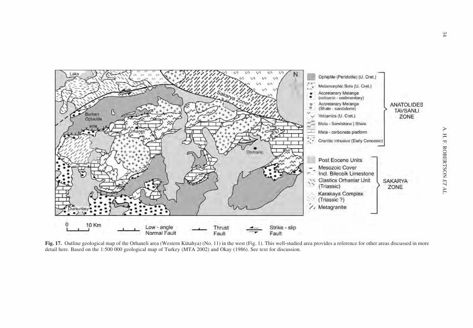
Fig. 17. Outline geological map of the Orhaneli area (Western Kutahya) (No. 11) in the west (Fig. 1). This well-studied area provides a reference for other areas discussed in moredetail here. Based on the 1:500 000 geological map of Turkey (MTA 2002) and Okay (1986). See text for discussion.
A.
H.
F.
RO
BE
RT
SO
NE
TA
L.
34
the rocks including basalt, radiolarian chert, pelagicshale, pelagic limestone and serpentinite (Okay &Kelley 1994; Okay et al. 1998). Some lithologieshave undergone incipient blueschist facies meta-morphism (Okay 1986). HP/LT mineral assem-blages (e.g. aragonite, sodic pyroxene andlawsonite) are commonly present in veins andamygdales within basalt. The basalts have experi-enced Na-metasomatism. Some of the basalts haveundergone HP/LT metamorphism, as recorded byaugite variably replaced by sodic pyroxene, chlorite,albite and lawsonite. Large units of basaltic agglom-erate envelop blocks of recrystallized limestone, upto several hundred metres in size. There are alsosmaller amounts of red radiolarian chert andpelagic shale, together with subordinate serpenti-nite, pelagic limestone and greywacke. Sparsefossil evidence indicates Jurassic and Cretaceousages for some radiolarian cherts and limestones,and an Upper Cretaceous age for pelagic limestone,based on the presence of Globotruncana sp.(Ozkocak 1969).
Ophiolite and metamorphic sole. The overlyingophiolitic rocks (Lisenbee 1971) are mainly serpen-tinised hartzburgite and dunite with rare gabbroand local crosscutting diabase dykes with chilledmargins. The ophiolite has not undergone theregional HP/LT metamorphism that affected theunderlying units (Onen & Hall 1993). Metamorphicsole rocks at the contact between the ophiolitic peri-dotites (Kınık ophiolite) and the melange below(Cogurler complex) range in thickness from 10–300 m and can be traced along strike for c. 40 km(Onen & Hall 1993, 2000; Onen 2003). The basalpart of the ophiolite is characterized by highlysheared serpentinite in thrust contact with amphibo-lites. The metamorphic sole (e.g. exposed in roadcuts near Kaynarca (Kutahya) shows a classicinverted metamorphic zonation from garnet amphi-bolites at the thrust contact with the ophiolite,throughamphibolites, togreenschistsbelow(Onen&Hall 2000). In detail, the upper part of the section is34 m thick and consists of steeply dipping, foliatedgarnet amphibolites with very thin non-garnetiferousamphibolites, and also plagioclase-rich and epidote-rich bands. Below are banded amphibolites withsmall-scale folding and faulting (122 m), intenselyfolded amphibole schist, and finally quartz-micaschist at the base of the section (139 m).
Similar relations are exposed in adjacent areas,including the Dagardı melange and the Harmancıkophiolite. The melange in these areas includesblocks of radiolarite, blueschist, greenschist andlimestone, together with shale and serpentinite.The lavas include enriched-MORB. The overlyingophiolitic peridotite is cut by swarms of diabase
dykes of island arc tholeiite type (Manav et al.2004).
Bornova zone (Area 12)
The importance of the Bornova zone is that it com-prises by far the largest single area of melangerelated to ophiolite emplacement and is also criticalto the timing of events as both clasts and matrix arewell dated. The Bornova zone (Bornova FlyschZone of Okay et al. 2001), 90 km long by 50 kmwide, trends southwestwards from the Kutahyaarea to near Izmir (Erdogan 1990; Okay & Siyako1993; Figs 1 & 18). Okay & Tuysuz (1999)suggested that this zone represents a transformsegment of the northern margin of the Tauride–Anatolide Block, linking the Vardar zone of north-ern Greece. This was mainly because of its unusualNE–SW trend, absence of HP/LT metamorphism(except possibly in the NE), and the presence ofcontinental margin-derived blocks. Here, we inter-pret the Bornova zone differently, as large-scalemainly sedimentary melanges that were emplacedinto a foredeep and then over-ridden by ophiolites(see Tectonic processes). No basement is exposedbut it is assumed that the Anatolide platformlies beneath.
In the north, the Bornova zone is bordered bythe Triassic Karakaya Complex (Nilufer unit)and Jurassic–Cretaceous limestones (e.g. in theBalıkesir and Balya areas in the NW). In the farNE of the area (near Kepsut), lithologies of theBornova zone are thrust northwards over theKarakaya Complex and related Triassic clastic sedi-ments of the Sakarya zone (Okay & Siyako 1993).
Our observations show that the Bornova zonecomprises two different, but interrelated types ofmelange. The first, here termed the Bornovasedimentary-volcanic melange, has a terrigenousmatrix and blocks of mainly sedimentary andoccasional volcanic lithologies. This melangevaries from essentially unmetamorphosed in thenorth, to (at least) greenschist facies in the south.The second type of melange, termed the Bornovaophiolitic melange, is dominated by ophiolitic andpelagic sedimentary blocks in a matrix of mainlyophiolite-derived clastic sediment. The contacts ofthe Bornova melange with underlying, and over-lying, units are mainly thrusts in the north but high-angle neotectonic faults in the south.
Crucially, in the Karaburun Peninsula in the farSW (Fig. 18) the Bornova sedimentary-volcanicmelange overlies an intact unmetamorphosedTauride-type carbonate platform succession with atransitional sedimentary relationship (Erdoganet al. 1990; Erdogan & Gungor 1992; Robertson &Pickett 2000). The Bornova melange is extensivelyexposed around Izmir and areas to the NE, where it
OPHIOLITE EMPLACEMENT IN CENTRAL TURKEY 35
Fig. 18. Outline tectonic map of the Bornova zone (Area no. 12). Simplified from the 1:500 000 geological map of Turkey (MTA 2002). See Figure 1 for location. The map detailsare from the Turkish 100 000 topographical maps, especially Izmir K 19.
A.
H.
F.
RO
BE
RT
SO
NE
TA
L.
36
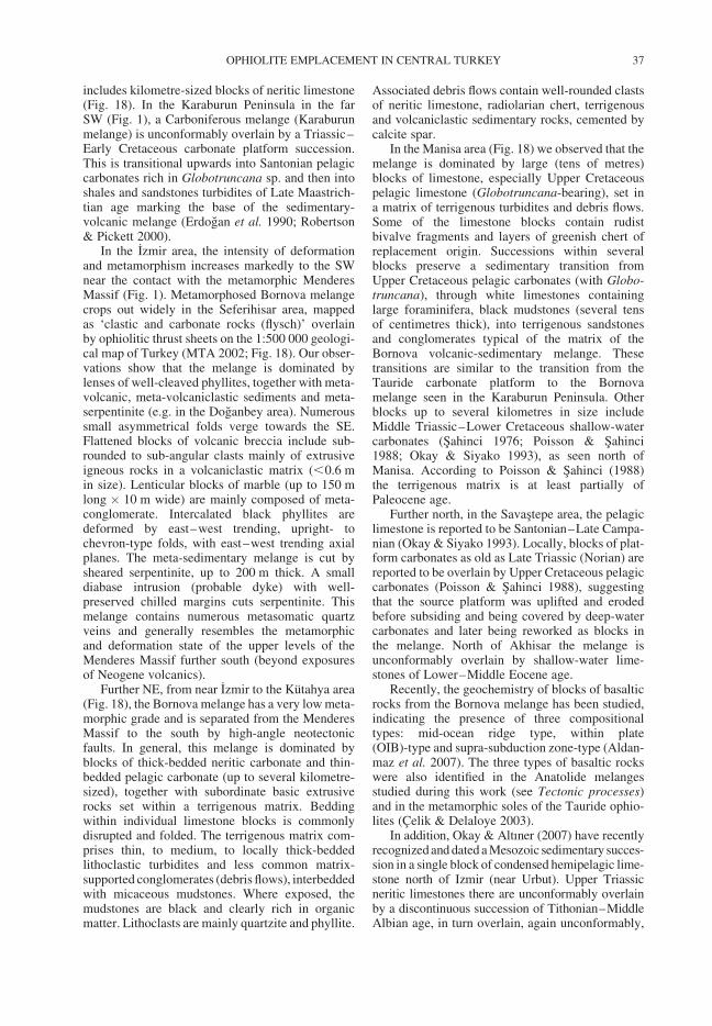
includes kilometre-sized blocks of neritic limestone(Fig. 18). In the Karaburun Peninsula in the farSW (Fig. 1), a Carboniferous melange (Karaburunmelange) is unconformably overlain by a Triassic–Early Cretaceous carbonate platform succession.This is transitional upwards into Santonian pelagiccarbonates rich in Globotruncana sp. and then intoshales and sandstones turbidites of Late Maastrich-tian age marking the base of the sedimentary-volcanic melange (Erdogan et al. 1990; Robertson& Pickett 2000).
In the Izmir area, the intensity of deformationand metamorphism increases markedly to the SWnear the contact with the metamorphic MenderesMassif (Fig. 1). Metamorphosed Bornova melangecrops out widely in the Seferihisar area, mappedas ‘clastic and carbonate rocks (flysch)’ overlainby ophiolitic thrust sheets on the 1:500 000 geologi-cal map of Turkey (MTA 2002; Fig. 18). Our obser-vations show that the melange is dominated bylenses of well-cleaved phyllites, together with meta-volcanic, meta-volcaniclastic sediments and meta-serpentinite (e.g. in the Doganbey area). Numeroussmall asymmetrical folds verge towards the SE.Flattened blocks of volcanic breccia include sub-rounded to sub-angular clasts mainly of extrusiveigneous rocks in a volcaniclastic matrix (,0.6 min size). Lenticular blocks of marble (up to 150 mlong � 10 m wide) are mainly composed of meta-conglomerate. Intercalated black phyllites aredeformed by east–west trending, upright- tochevron-type folds, with east–west trending axialplanes. The meta-sedimentary melange is cut bysheared serpentinite, up to 200 m thick. A smalldiabase intrusion (probable dyke) with well-preserved chilled margins cuts serpentinite. Thismelange contains numerous metasomatic quartzveins and generally resembles the metamorphicand deformation state of the upper levels of theMenderes Massif further south (beyond exposuresof Neogene volcanics).
Further NE, from near Izmir to the Kutahya area(Fig. 18), the Bornova melange has a very low meta-morphic grade and is separated from the MenderesMassif to the south by high-angle neotectonicfaults. In general, this melange is dominated byblocks of thick-bedded neritic carbonate and thin-bedded pelagic carbonate (up to several kilometre-sized), together with subordinate basic extrusiverocks set within a terrigenous matrix. Beddingwithin individual limestone blocks is commonlydisrupted and folded. The terrigenous matrix com-prises thin, to medium, to locally thick-beddedlithoclastic turbidites and less common matrix-supported conglomerates (debris flows), interbeddedwith micaceous mudstones. Where exposed, themudstones are black and clearly rich in organicmatter. Lithoclasts are mainly quartzite and phyllite.
Associated debris flows contain well-rounded clastsof neritic limestone, radiolarian chert, terrigenousand volcaniclastic sedimentary rocks, cemented bycalcite spar.
In the Manisa area (Fig. 18) we observed that themelange is dominated by large (tens of metres)blocks of limestone, especially Upper Cretaceouspelagic limestone (Globotruncana-bearing), set ina matrix of terrigenous turbidites and debris flows.Some of the limestone blocks contain rudistbivalve fragments and layers of greenish chert ofreplacement origin. Successions within severalblocks preserve a sedimentary transition fromUpper Cretaceous pelagic carbonates (with Globo-truncana), through white limestones containinglarge foraminifera, black mudstones (several tensof centimetres thick), into terrigenous sandstonesand conglomerates typical of the matrix of theBornova volcanic-sedimentary melange. Thesetransitions are similar to the transition from theTauride carbonate platform to the Bornovamelange seen in the Karaburun Peninsula. Otherblocks up to several kilometres in size includeMiddle Triassic–Lower Cretaceous shallow-watercarbonates (Sahinci 1976; Poisson & Sahinci1988; Okay & Siyako 1993), as seen north ofManisa. According to Poisson & Sahinci (1988)the terrigenous matrix is at least partially ofPaleocene age.
Further north, in the Savastepe area, the pelagiclimestone is reported to be Santonian–Late Campa-nian (Okay & Siyako 1993). Locally, blocks of plat-form carbonates as old as Late Triassic (Norian) arereported to be overlain by Upper Cretaceous pelagiccarbonates (Poisson & Sahinci 1988), suggestingthat the source platform was uplifted and erodedbefore subsiding and being covered by deep-watercarbonates and later being reworked as blocks inthe melange. North of Akhisar the melange isunconformably overlain by shallow-water lime-stones of Lower–Middle Eocene age.
Recently, the geochemistry of blocks of basalticrocks from the Bornova melange has been studied,indicating the presence of three compositionaltypes: mid-ocean ridge type, within plate(OIB)-type and supra-subduction zone-type (Aldan-maz et al. 2007). The three types of basaltic rockswere also identified in the Anatolide melangesstudied during this work (see Tectonic processes)and in the metamorphic soles of the Tauride ophio-lites (Celik & Delaloye 2003).
In addition, Okay & Altıner (2007) have recentlyrecognized and dated a Mesozoic sedimentary succes-sion in a single block of condensed hemipelagic lime-stone north of Izmir (near Urbut). Upper Triassicneritic limestones there are unconformably overlainby a discontinuous succession of Tithonian–MiddleAlbian age, in turn overlain, again unconformably,
OPHIOLITE EMPLACEMENT IN CENTRAL TURKEY 37
by Upper Cretaceous (Cenomanian–Turonian)pelagic limestones. The Upper Cetaceous sedimentscontain detached blocks (,1 m in size) of UpperTriassic, Turonian and Valanginian age. The suc-cession records Late Cenomanian (c. 95 Ma) flood-ing of the shelf, followed by pelagic deposition in anunstable setting, as indicated by input of blocksfrom the adjacent carbonate platform. The succes-sion overall can be correlated with the BoyalıTepe unit of the Beysehir nappes and the DomuzDag unit of the Lycian nappes further west(Andrew & Robertson 2002) or the Domuz Dagunit of the Lycian Nappes (Collins & Robertson1998). Okay & Altıner (2007) attribute the platformcollapse to initial ophiolite obduction onto thenorthern margin of the Tauride–Anatolide plat-form. However, we relate the Late Cenomanianevent to intra-oceanic subduction, ophiolite andsole formation that preceded ophiolite emplacementby up to 10 Ma (see Tectonic processes).
We observed that the Bornova sedimentary-volcanic melange is regionally overlain by theBornova ophiolitic melange with a locally exposedlow-angle tectonic contact (e.g. in the Cınarobaarea). The ophiolitic melange dominates the outcroptowards the NE and is locally underlain by HP/LTmeta-carbonates and meta-clastic sediments that arecorrelated with the eastern Kutahya zone (Okay &Tuysuz 1999; Fig. 18). Our observations show thatthe ophiolitic melange includes all the componentsof an ophiolite, including basalt, diabase, gabbroand various ultramafic rocks, together with numeroussedimentary rocks, especially ribbon radiolarite andpelagic limestone. The basalt ranges from pillowedto massive, vesicular, to non-vesicular and locallyincludes recrystallized inter-pillow carbonate.Occasional blocks of plagiogranite are also present(e.g. near Cınaroba). Other large (several hundredmetres) blocks of intrusive ophiolitic rocks includelayered gabbro, dunite and hartzburgite. Theseoccur at a high level and can be correlated withthe larger ophiolitic peridotite bodies exposed inthe Orhaneli area further NE. Sedimentary blockswithin the ophiolitic melange include pink pelagiclimestone and radiolarites, massif pelagic lime-stones with ammonites, limestone with Fe/Mncrusts, green feldspathic volcaniclastic sandstone(c. 10 m thick) and recrystallized pink carbonatein a matrix of sheared red shale and sandstone(e.g. Degnekler area).
The matrix of the ophiolitic melange includesthick-bedded, to massive, lithoclastic sandstonesthat are interbedded with lithoclastic grainstonesand pink calcareous mudstones (containing Globo-truncana). Locally, the matrix-supported conglom-erates are nearly monomict, with mainly angularclasts (,20 cm in size) of vesicular basalt set in amatrix of pale volcaniclastic sediments. These
conglomerates are interbedded with thin- to medium-bedded volcaniclastic sandstones. Associated matrix-supported conglomerates contain clasts of ophioliticlithologies (e.g. basalt, diabase, gabbro, serpentinite,pelagic limestone and radiolarite).
Taurides
The mainly metamorphosed melanges and otherAnatolide unit are here correlated with unmetamor-phosed equivalents in the Taurides further south, assummarized below.
In the SE, the unmetamorphosed Bolkar Dagcarbonate platform is overlain by the MersinMelange, which is topped by the Mersin Ophiolitewith a basal metamorphic sole (Parlak & Robertson2004; Moix et al. 2007). The Mesozoic platformcarbonate succession passes through pelagic car-bonates and redeposited facies with limestoneblocks into ophiolite-derived debris flows dated asLate Campanian–Maastrichtian (Demirtaslı et al.1984; Ozer et al. 2004; Taslı et al. 2006). Thisunit is interpreted to record the break-up andcollapse of the Tauride platform associated withophiolite emplacement (Parlak & Robertson 2004).
Further east, the succession in the relativelyautochthonous Mesozoic Geyik Dag carbonate plat-form continues into the Eocene (Monod 1977;Ozgul 1984, 1997) and is then overthrust by theBeysehir nappes, restored as part of the rifted north-ern passive margin of the Tauride–Anatolide plat-form (Andrew & Robertson 2002). These unitswere first emplaced onto the northern part of theTauride platform during the Upper Cretaceous(Campanian–Maastrichtian), associated with theemplacement of large ophiolites (e.g. Sarkikaraagacophiolite; Elitok 2002), melanges and fragmentarymetamorphic soles (Celik et al. 2006). These unitswere thrust further south over the Geyik Dagafter the Early Eocene (Mackintosh 2008). Theophiolites are locally underlain, or interthrust withmelange, including blocks of neritic limestone(locally with Permian limestone blocks), pelagiclimestone (locally dated as Maastrichtian), radio-larian chert, basic volcanic rocks, volcaniclasticsediments, gabbro and serpentinite in a matrix ofophiolite-derived sandstone and mudstone (Andrew& Robertson 2002). The melange largely formed assubaqueous debris flows that were strongly shearedduring emplacement. Geochemical studies indicatethat the basaltic extrusives were derived from MORB-type and subduction-influenced settings (Andrew &Robertson 2002).
Further east, the Menderes Massif, part of theTauride–Anatolide Block, has a Late Precambrianhigh-grade metamorphic ‘basement’ (e.g. Konaket al. 1987; Kroner & Sengor 1990; Dora et al. 2001;
A. H. F. ROBERTSON ET AL.38
Bozkurt & Oberhansli 2001), overlain by meta-shelf-type successions. Shallow-water carbonatedeposition persisted until Santonian–Campaniantime and was followed by flooding of the platformand the accumulation of pinkish pelagic carbonatesof Late Campanian–Late Maastrichtian age. Faciesof the Menderes Margin succession pass gradation-ally upwards through meta-litharenites into melange(‘flysch’). Blocks in overlying melange are mainlyrecrystallized limestone with chert nodules set in aterrigenous matrix, interpreted as turbidites anddebris flows (Collins 1997; Collins & Robertson1998). The matrix has been locally dated asMiddle Paleocene and early Middle Eocene indifferent areas (Ozer et al. 2001).
Ophiolites and continental margin sediments andvolcanics known as the Lycian nappes were emplacedsouthwards during the latest Cretaceous and re-thrustfurther south during the Late Eocene–Miocene(Senel 1991; Collins & Robertson 1998, 1999). Theregionally extensive Lycian ophiolite is located atthe highest structural levels of the allochthon in theSW of the region and is underlain by a metamorphicsole and several types of sedimentary and ophioliticmelange (Collins & Robertson 1997, 1998; Celik &Delaloye 2003; Celik et al. 2006). The Mesozoicsuccession of shallow to deep water, largely carbonatesediments and some volcanics was restored as thenorth-facing passive margin of the Menderes platform(Collins & Robertson 1999).
Several of the Lycian thrust sheets show upwardtransitions to Upper Cretaceous convergence-relatedsediments. The inferred most distal thrust sheet(Koycegiz Thrust Sheet) passes upwards fromCretaceous pelagic carbonates with chert nodules ofCenomanian–Turonian age (De Graciansky 1972).The section grades into litharenenite turbidites andshales of mainly volcaniclastic origin with limestoneblocks, followed above this by an incoming of blocksincluding pelagic limestone, radiolarian chert, basaltand gabbro. A Maastrichtian–Campanian age fromone of the limestone blocks implies this ophioliticmelange is of syn-post Maastrichtian age. In onelocal sequence of the Koycegiz Thrust Sheet (Seli-miye Flysch of Ersoy 1992), similar Upper Cretac-eous pelagic limestones pass upwards into c. 200 mof debris flows and turbidites with clasts of chert,pelagic limestone, redeposited limestone, sandstoneand neritic limestones. The clastic sedimentscontain schist, limestone, black chert and chloritebut no ophiolitic material. This is followed byc. 100 m of turbidites before the first appearance ofophiolitic clasts and blocks (Collins 1997; Collins &Robertson 1999).
The syn-emplacement sediments, as summarizedabove, are overlain by several types of melange.The lower Layered Tectonic Melange is dominatedby pelagic limestone and chert, intergradational
with broken formation and imbricate thrust sheetsand shows intense shear deformation. The overlyingOphiolitic Melange includes volcanics, volcaniclas-tics, peridotites and amphibolitic rocks set in asheared volcaniclastic matrix, suggesting a sedimen-tary origin as debris flows for this type of melange(Collins & Robertson 1998). The extrusives includeWPB-type lavas of inferred seamount origin(Collins & Robertson 1998). In addition, the northernmargin of the Menderes Massif is associated with amelange made up of blocks of limestone and rareophiolite-related rocks set in a clastic sedimentarymatrix. In places, Paleocene neritic limestones uncon-formably overlie the ‘Ophiolitic Melange’ (Senelet al. 1989), providing an upper limit for melangeemplacement (i.e. Maastrichtian). Locally, Paleocenesediments are intercalated between the Layered Tec-tonic Melange and the Ophiolitic Melange, giving aminimum age of amalgamation of these melangeunits. In the southern part of the Menderes Massifthe uppermost levels of the succession, of EarlyEocene age, are overlain by the ‘Menderes MarginMelange’. This shows that the final emplacement ofthis melange post-dates Early Miocene (Collins1997; Collins & Robertson 1998, 1999). The Lycianand Beysehir nappes and related melanges are con-sidered to have a two-stage history i.e. initial LateCretaceous (Maastrichtian) emplacement onto theTauride carbonate platform, followed by re-thrustingand further southward translation after the EarlyEocene (Collins & Robertson 1997; Andrew &Robertson 2002; Mackintosh 2008).
The northern part of the Menderes Massif isoverlain by several different volcanic-sedimentarymelanges. These were exposed following LateOligocene–Early Miocene exhumation (Hetzelet al. 1995; Purvis & Robertson 2004). The ophio-lites and melanges in this area were detached fromunderlying basement associated with low-angleextensional faulting, to form tectonic riders within,and around, several Neogene sedimentary basins(Purvis & Robertson 2004). Small isolated bodiesof melange (,1 km2) are exposed within theSelendi Basin. These consist of chert, recrystallizedlimestone, basalt and serpentinite. Larger outcropsof melange are seen along the western margin ofthe Gordes Basin (Seyitoglu et al. 1992; Purvis1998; Purvis & Robertson 2004) including pillowbasalt, pelagic limestone and ribbon radiolaritewith a shaly matrix. Small outcrops of melangeare also exposed around Neogene intrusive rocksin the central part of the Gordes Basin.
Northerly units
Any regional interpretation of the melanges needs totake account of the tectonic development of units tothe north, namely the Nigde–Kırsehir Massif
OPHIOLITE EMPLACEMENT IN CENTRAL TURKEY 39
(Central Anatolian Crystalline Complex), the AnkaraMelange and the Sakarya zone (Fig. 1). We focusedon the nature and timing of the contacts betweenthese units and the Anatolide units to the south.
Nigde–Kırsehir massif. In general, the Nigde–Kırsehir massif has a crystalline core of pre-Triassicbasement and a cover of metamorphosed carbo-nate platform rocks, of inferred Mesozoic age,best exposed in the Nigde massif in the SE (e.g.Goncuoglu 1986; Whitney & Dilek 1998). Thebasement and cover experienced relatively hightemperature-low pressure type metamorphismduring the Late Cretaceous (Fayon et al. 2001),and was exhumed from mid crustal to shallowcrustal levels. This partially took place by thelatest Maastrichtian because part of the NigdeMassif in the SE is transgressed by sediments ofthe Ulukısla basin (Goncuoglu et al. 2001; Jaffey& Robertson 2001; Clark & Robertson 2002).According to some authors ophiolites of inferredsupra-subduction zone type are exposed abovethe metamorphosed Mesozoic platform of theNigde–Kırsehir massif (Yalınız et al. 1996; Floydet al. 2000). However, these are controversial asthey are also interpreted as intrusions into themassif (Kadıoglu et al. 2006). In addition, theKırsehir Massif is cut by granitic plutons of LateCretaceous–Early Cenozoic age (see Tectonicprocesses).
Ankara Melange. The regionally extensive AnkaraMelange includes radiolarian cherts, pelagic/hemi-pelagic limestones, alkaline basalts interpreted asLower Cretaceous seamounts (Rojay et al. 2004),and also dismembered mainly ultramafic ophioliticrocks. Recent radiometric dating of crosscutting pla-giogranites (Tankut & Gorton 1990) suggests thatsome at least of the ultramafic rocks are of pre-Jurassic age (Dilek & Thy 2006). However, atpresent it seems likely that the ophiolitic rocks ofthe Anatolides, as studied during this work, are ofCretaceous age, although radiometric dating needsto be carried out of these rocks in the future.Further consideration of the Ankara Melange isoutside the scope of this paper.
Sakarya zone. The Sakarya zone in the west docu-ments the northwestern margin of the Mesozoicocean basin from which the Anatolide and Taurideophiolites and melanges were derived (Sengor &Yılmaz 1981). A rarely exposed high-grade meta-morphic basement is overlain by the Triassic Kara-kaya Complex, although contact relations aredebateable (Tekeli 1981a; Pickett & Robertson1996, 2004; Okay 2000; Okay & Goncuoglu 2004;Okay et al. 2006). The Karakaya Complex is uncon-formably overlain by conglomerates and sandstones
and then by shelf carbonates, ranging from EarlyJurassic to mid-Cretaceous age (Bilecik Limestone;Altıner et al. 1991).
Successions are reported to differ between thenorth and south of the Sakarya zone. In the south(Nallıhan area), pelagic carbonates extend toSantonian–Coniacian and pass into Santonian–Middle Maastrichtian sandstone turbidites andpelagic carbonates, then Upper Maastrichtianshallow-marine sandstone and Paleocene non-marinesandstone and conglomerate (Tansel 1980, 1990;Altıner et al. 1991). Ophiolite-derived debris flowsand ophiolitic thrust slices occur near the suturezone in the south (Yılmaz et al. 1997; Okay et al.2001).
In the more northerly part of the Sakarya zone,Jurassic–Lower Cretaceous shelf-type sedimentsare described as being overlain by Upper Cretaceoustuffs, sandstone turbidites, debris flows and pelagiclimestones (e.g. Mudurnu–Goynuk area; Saner1980; Meric & Senguler 1986; Altıner et al.1991). These facies may record the developmentof a volcanic arc and forearc basin related to north-ward subduction (Sengor & Yılmaz 1981). Clastsin debris flows include Lower Cretaceous neriticlimestones and Upper Cretaceous pelagic Globo-truncana-bearing limestone (Genc 1987). Blocksof serpentinite are reported from Maastrichtian tur-bidites (Saner 1980). An emergent accretionarywedge to the south was a possible source. Derivationfrom the Intra–Pontide suture to the north is unli-kely because the northern part of the Sakarya zoneis free of emplaced ophiolitic rocks.
The southerly part of the Sakarya continentalmargin exhibits shallowing-upwards and emer-gence during the Paleocene; it was then detachedfrom its basement and thrust southwards .50 kmrelated to continental collision, probably duringMid-Eocene time (Okay & Tuysuz 1999).
Granitic rocks cut the Sakarya zone and also thesuture zone to the south. As summarized by Altun-kaynak (2007), an east–west-trending southerlygroup of medium to high potassic calc-alkalineI-type granite plutons (e.g. Orhaneli, Topuk,Gurgenyayla and Goynukbelen) with ages ofc. 54–48 Ma (Early–Mid Eocene) cuts the suturezone including the Anatolide blueschists, melangeand ophiolitic rocks. The southern plutons aredated as 53–44 Ma and the northern ones as 48–35 Ma (Delaloye & Bingol 2000; Okay & Satır2006). A compositionally similar, more northerlygroup of generally younger (48–36 Ma) plutons(i.e. monzogranite, granodiorite and granite) cutsthe Sakarya zone (e.g. in the Marmara Sea area).Geochemical data from both the southerly andnortherly granitic plutons suggest the existence ofa metasomatized lithospheric mantle source, modi-fied by Late Cretaceous subduction. Mantle-derived
A. H. F. ROBERTSON ET AL.40
melts were modified by crustal contamination,assimilation and fractional crystallization duringmagma ascent (Altunkaynak 2007). Partial meltingof mantle lithosphere was facilitated by astheno-spheric upwelling and thermal perturbation, poss-ibly triggered by oceanic slab break-off. However,this alone is unlikely to have been sufficient to gen-erate large-scale pluton intrusion. The main drivingforce was clearly regional continental collision ofthe Tauride and Eurasian plates. However, furtherconsideration of this issue is outside the scope ofthis paper.
Tectonic processes
In this discussion we utilize new and publishedgeochemical analysis of basaltic rocks from theAnatolide and Tauride melanges. Details ofsample locations, analytical methods, data tablesand geochemical plots confirming the basaltic com-positions of the samples studied are given in thesupplementary material.
Restoration of rifted margin
The main tectonic units of the continental margincan be restored from south to north as follows:Geyik Dag (and Hadim/Bolkar nappe); MenderesMassif; Afyon–Bolkardag zone; Tavsanlı zone;Beysehir/Lycian nappes and ‘sedimentary-volcanicmelange’ (non-ophiolitic melange). The main con-siderations are regional stacking order, facies andlithology, metamorphism, recrystallization anddeformation, and the timing of emplacement ofmelange onto platform units. The Geyik Dag andover-riding Hadim/Bolkar nappe in the south areunmetamorphosed and were never deeply buried.The Mesozoic–Lower Cenozoic sedimentary unitsof the Menderes Massif were deformed and meta-morphosed under HP/LT conditions during theEocene, but the Precambrian crystalline basementdid not undergo this metamorphism (Candan et al.2005). The Afyon–Bolkardag zone is deformed,metamorphosed under HP/LT conditions but notgreatly recrystallized; and the Tavsanlı zone isstrongly deformed, recrystallized and metamor-phosed under very HP conditions (e.g. Okay &Kelley 1994). The unmetamorphosed Beysehirand Lycian nappes restore as the rifted northernmargin of the Tauride–Anatolide continent. The‘sedimentary-volcanic melange’ represents frag-ments of the rifted margin and more oceanic units(e.g. seamounts; volcanic arc related). Alterna-tively, Candan et al. (2005) suggested that theAfyon–Bolkardag zone restores as an intra-platform basin between the Menderes Massif tothe south and the Tavsanlı zone to the north.
Within the Lycian nappes in the south ‘flysch’ (Kar-abortlen unit) of Late Turonian–Early Senonian age(Bernoulli et al. 1974) was reported to be older thanthe Maastrichtian clastic sediments overlying theAfyon–Bolkardag carbonate platform furthernorth (e.g. in the eastern Kutahya area). The‘flysch’ was assumed to record the arrival ofallochthonous units; i.e. reaching far south beforefurther north, which would imply the existence ofan intra-platform basin which closed by the LateTuronian. However, this reconstruction is proble-matic for several reasons. First, the Jurassic–Cretaceous sediments of the Lycian nappes arepelagic (Collins & Robertson 1999) and so thisinterpretation would require the formation of adeep-water basin within the Tauride–Anatolideplatform for which there is no independent evidence(e.g. two clastic rifted margins). Second, slices ofunits similar to the Lycian nappes were not observedoverlying the Afyon–Bolkardag zone, as wouldbe expected for this model. Third, thetectono-stratigraphy and lithology of the Afyon–Bolkardag zone and the Tavsanlı zone are similar,consistent with them being contiguous platformunits. Fourth, the Turonian flysch of the LycianNappes (e.g. Koycegiz Thrust Sheet) compriseslithoclastic turbidites and debris flows, withoutophiolite-derived material (Collins & Robertson1999). This early clastic sedimentation can berelated to fault-controlled uplift of the passivemargin and related erosion of clastic material.Such erosion reached low stratigraphical levels inthe continental margin, as suggested by the presenceof schist and black chert (?Carboniferous) clasts.Elsewhere similar faulting and erosion affectedinboard parts of the Oman continental marginaround Cenomanian time (c. 95 Ma) prior to ophio-lite emplacement (Robertson 1987).
Triassic rifting and Jurassic-Lower
Cretaceous passive margin subsidence
Within the Afyon-Bolkardag zone ? Late Precam-brian basement (Bayat area) and Lower Carbonifer-ous melange (Konya area) are depositionallyoverlain by mixed shallow-water carbonate-clasticsuccessions of Permian and Early Triassic age indifferent areas (Ozcan et al. 1988; Eren 1993, 2001;Goncuoglu et al. 2003; Candan et al. 2005). In theBolkar Dag area further east the oldest known unitis Upper Permian neritic limestone (Demirtaslı et al.1984). Comparable facies in the Tavsanlı zone arehighly recrysytallized and undated.
Above a regional unconformity (N. Bolkar Dag,Altınekin, Konya, Bayat areas), the Early Triassicof the Afyon–Bolkardag zone comprises a gener-ally fining-upward sequence of metamorphosed
OPHIOLITE EMPLACEMENT IN CENTRAL TURKEY 41
terrigenous sandstones and shales, interbedded withshallow-water carbonates. Facies evidence andscarce fossils indicate non-marine, to lagoonal(paralic) deposition, passing into a relativelyshallow-open marine setting.
The Triassic mixed carbonate-clastic-volcano-genic successions exposed beneath the Mesozoicplatform succession (e.g. Bolkar Dag, Konya andBayat areas) are considered to record Early Triassicrifting of the Anatolide–Tauride continent followedby spreading prior to or during Late Triassic time. Inthis interpretation, rifted fragments drifted north-wards in front of a newly created Triassic spreadingaxis and were then subducted or incorporated into anaccretionary wedge (Karakaya complex; e.g. Calunit) bordering the Eurasian margin (Pickett &Robertson 1996, 2004; Robertson et al. 2005;Okay et al. 2006). The results of this study are con-sistent with a Triassic extensional setting along thenorthern margin of the Anatolide-Tauride continent(Robertson & Pickett 2000; Collins & Robertson1997, 1998; Goncuoglu et al. 2003; Robertson &Ustaomer in press; Mackintosh & Robertson inpress) rather than a compressional/collisionalsetting during Late Triassic time (Stampfli &Borel 2002; Eren et al. 2004). The rifted marginwas characterized by a mosaic of platforms andbasins with considerable palaeogeographic andfacies variation along and across the margin(Andrew & Robertson 2002).
The rift-related succession is transitionalupwards to a Mid–Late Triassic shallow-marinecarbonate platform, commonly dolomitic and stro-matolitic (N Bolkar Dag, Altınekin, Konya andBayat areas). Shallow-water carbonates accumu-lated regionally on a subsiding carbonate platformduring Late Triassic–Early Cretaceous time. Loca-lized conglomeratic intercalations (e.g. Konya andN Bolkar Dag) could reflect faulting of the platform,or storm activity.
Regional Upper Cretaceous platform
flooding and collapse
The Anatolide–Tauride platform was regionallyflooded and overlain by pelagic carbonates begin-ning in Late Cenomanian time. In the north (e.g.Altınekin) the presence of intercalations of pelagicand redeposited carbonates is suggestive of thedevelopment of a slope setting during the Late Cre-taceous. In the uppermost levels of the successiondark organic-rich carbonates accumulated locally(e.g. Altınekin area), perhaps within an oxygenminimum zone. Elsewhere (e.g. Yunak, Bademliareas) thick-bedded, neritic, carbonates form thetop of the preserved platform succession, probablybecause pelagic/redeposited facies, as seen
elsewhere, were tectonically excised during theemplacement of overlying melanges and ophiolites.The Cenomanian flooding is likely to record a com-bination of global sea-level high-stand (Hardenbolet al. 1998) and regional tectonics related to north-ward subduction of Neotethyan ocean furthernorth (i.e. c. 10 Ma prior to ophiolite obduction).
The submerged platform and /platform slopepass transitionally into Upper Cretaceous (EarlyMaastrichtian) turbidites and debris flows (e.g. Altı-nekin; Bayat areas). In places (e.g. Bayat area), thecarbonate platform passes transitionally upwardsinto turbidites and multiple debris flows with a terri-genous clastic matrix and includes clasts probablyderived from the subjacent carbonate platform.The terrigenous material is likely to have beenderived from an exposed continental hinterland tothe south, probably related to regional faulting andflexural uplift of the Tauride–Anatolide Platformthat accompanied initial ophiolite emplacementonto the margin. The record is closely comparablewith Upper Cretaceous ophiolite emplacement inOman (Robertson 1987), where fault-controlledupflexure to form an unconformity on the platform(Wasia–Aruma break) was followed by regionalsubsidence, clastic sediment deposition (Muti For-mation) and melange and ophiolite emplacement.
Within the Tavsanlı zone, the uppermost levelsof the platform are described as including strati-graphic intercalations of meta-basaltic rock andmeta-chert in several areas (e.g. Okay et al. 1998).Basaltic lavas are known to have been erupted incomparable settings related to the transition from acarbonate platform to a foredeep associated withophiolite emplacement, for example in the Omanand Balkan regions (e.g. Robertson 1987, 1991).
Genesis of MOR-type oceanic crust,
seamounts and arc-type volcanics
Evidence of the nature and age of oceanic litho-sphere and seamounts comes from blocks of extru-sive igneous rocks in the melanges of theAnatolides (including the Bornova zone) and Taur-ides. Presently, only a small number of the exoticunits are dated, mainly based on interbedded silic-eous or calcareous microfossils. The tectonic set-tings of the basaltic rocks within the melanges varyconsiderably, as inferred from geochemical data.
On chondrite-normalized REE (rare earthelements) diagrams and N-MORB (mid-oceanridge basalt)-normalized multi-element variationdiagrams (Figs 19 & 20) the basalts from theBayat and Bademli areas display flat to slightlyLREE (light rare earth element) enriched patterns.Those from the Yunak region show two distinctREE patterns; the first displays LREE-enriched,
A. H. F. ROBERTSON ET AL.42
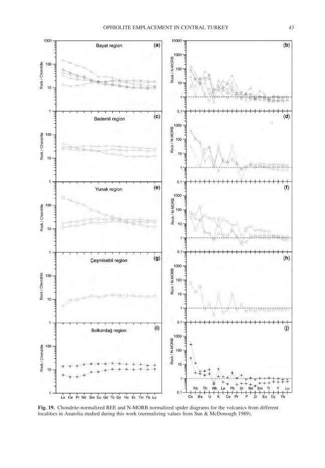
Fig. 19. Chondrite-normalized REE and N-MORB normalized spider diagrams for the volcanics from differentlocalities in Anatolia studied during this work (normalizing values from Sun & McDonough 1989).
OPHIOLITE EMPLACEMENT IN CENTRAL TURKEY 43
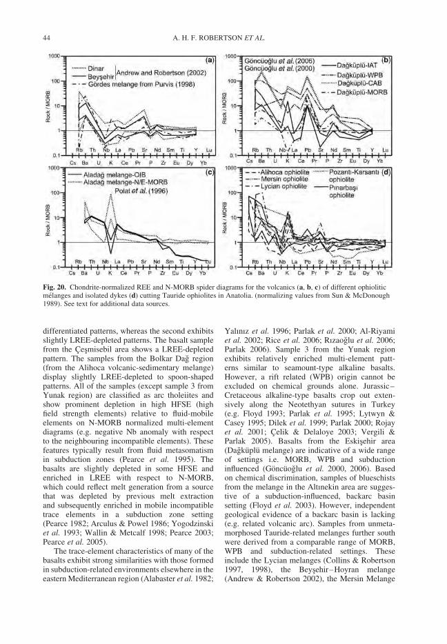
differentiated patterns, whereas the second exhibitsslightly LREE-depleted patterns. The basalt samplefrom the Cesmisebil area shows a LREE-depletedpattern. The samples from the Bolkar Dag region(from the Alihoca volcanic-sedimentary melange)display slightly LREE-depleted to spoon-shapedpatterns. All of the samples (except sample 3 fromYunak region) are classified as arc tholeiites andshow prominent depletion in high HFSE (highfield strength elements) relative to fluid-mobileelements on N-MORB normalized multi-elementdiagrams (e.g. negative Nb anomaly with respectto the neighbouring incompatible elements). Thesefeatures typically result from fluid metasomatismin subduction zones (Pearce et al. 1995). Thebasalts are slightly depleted in some HFSE andenriched in LREE with respect to N-MORB,which could reflect melt generation from a sourcethat was depleted by previous melt extractionand subsequently enriched in mobile incompatibletrace elements in a subduction zone setting(Pearce 1982; Arculus & Powel 1986; Yogodzinskiet al. 1993; Wallin & Metcalf 1998; Pearce 2003;Pearce et al. 2005).
The trace-element characteristics of many of thebasalts exhibit strong similarities with those formedin subduction-related environments elsewhere in theeastern Mediterranean region (Alabaster et al. 1982;
Yalınız et al. 1996; Parlak et al. 2000; Al-Riyamiet al. 2002; Rice et al. 2006; Rızaoglu et al. 2006;Parlak 2006). Sample 3 from the Yunak regionexhibits relatively enriched multi-element patt-erns similar to seamount-type alkaline basalts.However, a rift related (WPB) origin cannot beexcluded on chemical grounds alone. Jurassic–Cretaceous alkaline-type basalts crop out exten-sively along the Neotethyan sutures in Turkey(e.g. Floyd 1993; Parlak et al. 1995; Lytwyn &Casey 1995; Dilek et al. 1999; Parlak 2000; Rojayet al. 2001; Celik & Delaloye 2003; Vergili &Parlak 2005). Basalts from the Eskisehir area(Dagkuplu melange) are indicative of a wide rangeof settings i.e. MORB, WPB and subductioninfluenced (Goncuoglu et al. 2000, 2006). Basedon chemical discrimination, samples of blueschistsfrom the melange in the Altınekin area are sugges-tive of a subduction-influenced, backarc basinsetting (Floyd et al. 2003). However, independentgeological evidence of a backarc basin is lacking(e.g. related volcanic arc). Samples from unmeta-morphosed Tauride-related melanges further southwere derived from a comparable range of MORB,WPB and subduction-related settings. Theseinclude the Lycian melanges (Collins & Robertson1997, 1998), the Beysehir–Hoyran melange(Andrew & Robertson 2002), the Mersin Melange
Fig. 20. Chondrite-normalized REE and N-MORB spider diagrams for the volcanics (a, b, c) of different ophioliticmelanges and isolated dykes (d) cutting Tauride ophiolites in Anatolia. (normalizing values from Sun & McDonough1989). See text for additional data sources.
A. H. F. ROBERTSON ET AL.44
(Parlak & Robertson 2004), and melange overlyingthe Menderes Massif (Purvis 1998) (Fig. 20).
Many of the volcanic rocks are interpreted tohave come from a depleted mantle source region,modified by the addition of a subduction com-ponent. In contrast, the one sample of basalt frommelange in the Yunak region is from enrichedmantle without a subduction influence. In the Th/Yb vs. Ta/Yb diagram the samples mainly plotwith the field of volcanic arc rocks (Fig. 21a). Inthe ternary element plot, Hf–Th–Nb (Fig. 21b)the volcanics and dykes are classified as volcanicarc and within-plate type (OIB). In the Zr/Y vs Zrdiagram (Fig. 21c) these samples plot in the islandarc basalt (IAB) and within-plate basalt (WPB)fields.
Summarizing, rare MORB samples are inter-preted as oceanic crust. WPB is interpreted as sea-mount (OIB), rather than rift-related because theselavas are locally interbedded with radiolarite andpelagic carbonates rather than terrigenous sedi-ments, Also, subduction-influenced basalts are sur-prisingly common in the melange. Subductionrelated ‘volcanic-volcaniclastic rocks’ have beenreported to be interbedded with radiolarian sedi-ments of Turonian age in central Anatolia, althoughdetailed information on the occurrence is not pub-lished (Goncuoglu et al. 2006a). It is likely thatsubduction related basaltic rocks in the Anatolidemelange studied here, in the Bornova Melange(Aldanmaz et al. 2006) and in the metamorphicsoles of the Tauride ophiolites (Celik & Delaloye2003) are Late Cretaceous in age.
Several oceanic settings for the subduction-influenced basalts can be considered. First, thearc-type basalts were detached from over-ridingophiolites and incorporated into gravity flows (‘olis-tostromes’) as olistoliths (Goncuoglu et al. 2006b).However, some of the basalts can be interpreted asaccreted thrust slices (e.g. Orhaneli area) ratherthan gravity blocks (see below). Second, thebasalts were derived from an intra-oceanic arc, inde-pendent of the supra-subduction zone-type ophio-lites. Any such arc would have been located southof the Tauride ophiolites, because the Tauride mel-anges (e.g. Lycian melange) include these basalts(Celik & Delaloye 2003). However, independentevidence of an additional southerly subductionzone is lacking. Third, the subduction-influencedbasalts might have been erupted associated withearly arc magmatism above ophiolitic lithospherethat was created by supra-subduction zone spread-ing (possibly fed by isolated diabase dykes; seebelow). During convergence, the leading edge ofthe supra-subduction zone slab was dismemberedand partially transferred to the subducting plate(and partially subducted; see below), allowingophiolite-related lavas to be initially accreted as
melange blocks and later gravitationally reworkedin some areas. Fourth, the volcanics are accretedrift-related units (Triassic), in which the subductioncomponent was either coeval or inherited from anearlier subduction event. This is, however, unlikelyas these volcanics are not associated with terrige-nous rift-related sediments and are locally dated asLate Cretaceous in age.
The third option seems the most plausible. In thiscase, soon after the ophiolite was created by supra-subduction zone spreading, continuing subductionled to the initial stages of construction of anoceanic volcanic arc. During subduction, or col-lision with the passive margin the leading edgeof the over-riding ophiolite and the arc-type volca-nics were detached, over-ridden and dismemberedinto blocks within the melange. It has commonlybeen questioned as to what happened to ‘missing’forearc-type lithosphere that must have existedbetween the subduction trench and the finallyemplaced ophiolite (e.g. in Oman; Lippard et al.1986). The evidence from Anatolia partially answersthis question as ‘missing’ crustal units can be foundwithin the underlying melange.
The tectonic setting inferred for the basalts canbe combined with the known ages of interbeddedpelagic sediments to infer the tectonic history ofthe ocean basin. The available results from thesuture zone indicate that deep-water MOR-typevolcanism had begun by the Late Triassic (Bragin& Tekin 1996; Tekin et al. 2002; Goncuoglu et al.2006a, b) and was still forming as late as theCenomanian (Goncuoglu et al. 2006a, b). Asimilar timing has been inferred for Tauride unitsfurther south (Collins & Robertson 1998; Robertson& Pickett 2000; Danelian et al. 2006). When datafrom the Ankara Melange are included (Rojayet al. 2004) WPB-type basalts were erupted fromLate Callovian to Aptian time. However, it shouldbe noted that all of the MOR-type lavas are fromblocks in melange and not from coherent ophiolitesand so it is impossible to prove that they came fromoceanic crust formed by sea-floor spreadingalthough this is the most likely interpretation.
Supra-subduction zone ophiolite genesis
The Anatolide ophiolites (Tavsanlı and Afyon–Bolkardag zones) are interpreted as exposed rem-nants of regionally extensive, emplaced oceaniclithosphere. All of the ophiolitic rocks are inferred,based mainly of geochemical evidence, to haveformed by supra-subduction zone spreading. Noneare directly dated and the best indications of theircrystallization age come from the metamorphicsoles (see below). In contrast to the carbonate plat-form and much of the overlying melange, the over-riding ophiolites have mostly undergone only very
OPHIOLITE EMPLACEMENT IN CENTRAL TURKEY 45
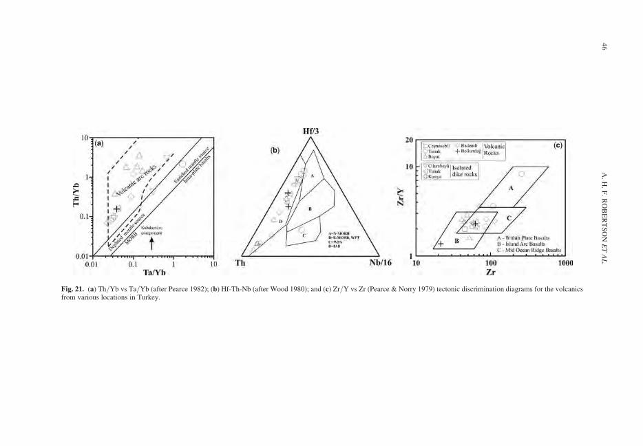
Fig. 21. (a) Th/Yb vs Ta/Yb (after Pearce 1982); (b) Hf-Th-Nb (after Wood 1980); and (c) Zr/Y vs Zr (Pearce & Norry 1979) tectonic discrimination diagrams for the volcanicsfrom various locations in Turkey.
A.
H.
F.
RO
BE
RT
SO
NE
TA
L.
46
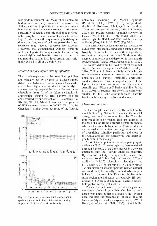
low-grade metamorphism. Many of the ophioliticbodies are internally coherent; however, theAlihoca (Karsantı) ophiolite in the west is dismem-bered, transitional to tectonic melange. Within morestructurally coherent ophiolitic bodies (e.g. Orha-neli, Eskisehir, Konya, Yunak, Cesmisebil areas;Fig. 5) only the mantle sequence (e.g. hartzburgite,dunite) and fragments of the lower part of the crustalsequence (e.g. layered gabbros) are exposed.However, the dismembered Alihoca ophioliteincludes all parts of a complete ophiolite, includingsheeted dykes and basaltic extrusive rocks. Thissuggests that similar high-level crustal units orig-inally existed in all of the ophiolites.
Isolated diabase dykes cutting ophiolite
The mantle sequences of the Anatolide ophiolitesare typically cut by swarms of diabase/gabbrodykes (e.g. Orhaneli, Konya, Yunak, Cesmisebiland Bolkar Dag areas). In addition, similar dykesare seen cutting serpentinite in the Bornova zone(Seferihisar area). All of the dykes are basaltic incomposition, exhibit flat REE patterns (and arecharacterized by enrichment of LIL elements (i.e.Rb, Ba, Th, K), Nb depletion, and flat patternsof HFS elements relative to MORB (Fig. 22a, b).Chemically similar dykes cut some of the Tauride
ophiolites, including the Mersin ophiolite(Parlak & Delaloye 1996), the Lycian peridotite(Collins & Robertson 1998; Celik & Delaloye2003), the Antalya ophiolites (Celik & Delaloye,2003), the Pozantı-Karsantı ophiolite (Lytwyn &Casey 1995; Dilek et al. 1999; Parlak 2000), theAlihoca ophiolite (Dilek et al. 1999) and the Pınarbasıophiolite (Vergili & Parlak 2005) (Fig. 20d).
The chemical evidence indicates that the isolateddykes were intruded in a subduction-related setting.Notably, Th is enriched in the mantle wedges abovesubduction zones, whereas Ta and Nb show similardegrees of enrichment and depletion in most mantlesource regions (Pearce 1982; Alabaster et al. 1982).The isolated dykes are believed to reflect the initialstages of ocean arc magmatism (Parlak & Delaloye1996; Collins & Robertson 1998). Although onlyrarely preserved within the Tauride and Anatolideophiolites (i.e. Parsantı ophiolite), chemicallysimilar extrusives form an important part of theUpper Cretaceous ophiolites in southeasternAnatolia (e.g. Goksun or N Berit) ophiolite (Parlaket al. 2004). In addition, the dykes are chemicallysimilar to the subduction-influenced basalticblocks in the melange, as discussed above.
Metamorphic soles
The hartzburgite sheets are locally underlain byamphibolites (e.g. Orhaneli, Konya and Cesmisebilareas), interpreted as metamorphic soles. The sole-type rocks of the Orhaneli area are attached tothe base of over-riding ultramafic ophiolite sheets,whereas the amphibolites in the Cesmisebil areaare encased in serpentinite melange near the baseof over-riding ophiolitic peridotite, and those inthe Konya area are associated with large hartzbur-gite blocks in the melange.
Most of the amphibolites show no petrographicevidence of HP/LT metamorphism; these remainedattached to the base of the ophiolites when they wereemplaced onto the Tauride–Anatolide platform.By contrast, sole-type amphibolites above themetamorphosed Bolkar Dag platform (Kızıl Tepe)exhibit a HP/LT blueschist mineralogy (i.e.8–12 Kbar c. 24–35 km burial) (Dilek & Whitney1997) indicating that some ophiolite-related materialwas subducted, then rapidly exhumed. Also, amphi-bolites from the sole of the Karsantı ophiolite in thesame region are indicative of relatively HP con-ditions (5–6 Kbar c. 15 km burial) based on amphi-bole geobarometry (Celik 2007).
The metamorphic soles also provide insights intothe nature of oceanic protoliths. Geochemical evi-dence from amphibolitic sole rocks in the Tavsanlızone indicates the presence of (at least) alkaline(seamount)-type basalts (Kaynarca area; SW ofKutahya) (Onen & Hall 1993). Amphibolite
Fig. 22. Chondrite-normalized REE and N-MORBspider diagrams for isolated diabase dykes cuttingserpentinized ultramafic rocks (this study).
OPHIOLITE EMPLACEMENT IN CENTRAL TURKEY 47
protoliths in the Afyon–Bolkardag zone are knownto include subduction-influenced (arc) and alkaline(seamount) type basalts (Konya area; Dascı 2007).There is extensive geochemical evidence of meta-morphic soles of the Tauride ophiolites (i.e. notincluding southern Neotethyan ophiolites that arenot discussed here). The protoliths of the Mersinophiolite sole are of within-plate (seamount)-type(Parlak et al. 1995), and those of the Lycian andBeysehir ophiolites further east record a range ofwithin-plate, mid-ocean ridge and arc-type chemicaltypes (Celik & Delaloye 2003).
Summarizing, taken together, the metamorphicsoles and the basalts in the melanges are chemicallyindicative of a similar range of seamount-type,arc-type and mid-ocean ridge type tectonic settings.
The metamorphic soles currently give the bestestimates of the ages of both the Anatolide andTauride ophiolites since the primary crystallizationage of these ophiolites is yet to be determined.This approach assumes that the metamorphic soleswere created related to overthrusting of young, hotoceanic mantle lithosphere, as in other areas (e.g.Oman; e.g. Hacker et al. 1996). Accordingly, theTavsanlı (Kutahya) ophiolites formed around 93 Ma(e.g. Onen 2003), and the Tauride ones around96–90 Ma; i.e. 91 Ma for the Bolkar Dag sole(Kızıl Tepe), Dilek et al. 1999; 92–90 Ma for thePozantı-Karsantı sole (Dilek et al. 1999; Celik et al.2006; and 96–91 Ma for the Mersin sole (Parlak &Delaloye 1999).
Ridge subduction or slab break-off?
Lytwyn & Casey (1995) noted the existence of arange of depleted, to enriched-composition, dykescutting the metamorphic sole and the overlyingultramafic ophiolitic rocks of the Karsantı ophiolite,which were explained by intrusion through an asth-enospheric slab window that was created by subduc-tion of a mid-ocean ridge. Chemically depletedcrosscutting dykes from the Alihoca (Pozantı)ophiolite further west were dated at c. 91 Ma(Dilek et al. 1999). The Karsantı ophiolite was laterre-interpreted as a typical supra-subduction zone(Parlak et al. 2000; Robertson 2002) but this neednot preclude the development of a slab windowwhen the SSZ-spreading axis was subducted.Alternatively, Celik (2007) reported enriched alkalinepyroxenite dykes cutting the metamorphic sole fromthe Pozantı-Karsantı ophiolite and explained theseby a mechanism in which an asthenospheric slabwindow formed during oceanic slab break-off.However, others propose slab break-off much laterin this region during Eocene continental collision(see below). One difficulty with slab break-off priorto emplacement of an ophiolite onto a passivemargin is that once detached from its downgoing
slab the margin is likely to have become buoyant,effectively preventing ophiolite emplacement ontothe continental margin. However, further evaluationof the possibilities of ridge subduction or slabbreak-off are beyond the scope of this paper.
Melange genesis
The timing of melange genesis is constrained asUpper Cretaceous (mainly Early Maastrichtian–Early Paleocene) from a combination of the young-est ages of the intact pelagic carbonate successionson the drowned carbonate platform beneath themelange (pre-Maastrichtian; e.g. Konya; Bayatareas), the youngest age of oceanic crust obtainedfrom melange blocks (Cenomanian; Eskisehirarea), direct dating of the melange matrix (EarlyMaastrichtian–Early Paleocene; Bayat area), andthe Late Maastrichtian or Paleocene–Early Eoceneage of local cover sediments (e.g. Bokardag andBayat areas; see below). Melange genesis andemplacement were to some extent diachronousalong and across the margin (Candan et al. 2005;Okay & Altıner 2007).
The melange is interpreted as remnants of Neo-tethyan oceanic lithosphere, deep-sea sediments,volcanic seamounts, and also of some rift-relatedand platform units that were emplaced by a combi-nation of tectonic and sedimentary processes. Werecognize three main intergradational stages ofmelange development (excluding the Bornovazone which differs in some respects). First, basalticrocks (MORB & WPB-type) were accreted to thebase of the overlying supra-subduction zone ophio-lite (c. 100–90 Ma; Fig. 23a). This melange is tec-tonic in origin, has little evidence of sedimentaryreworking, and includes material incorporatedfrom the over-riding ophiolite (e.g. serpentinite)and exhumed blueschists. Examples include rela-tively thick (10s–100s m) slices of basaltic rocks,radiolarites and pelagic carbonates in the upperlevels of the melange in the Tavsanlı zone (e.g.Orhaneli and Eskisehir areas).
Second, when the accretionary complexapproached the Tauride–Anatolide continent (UpperSantonian–Lower Maastrichtian) large volumes ofterrigenous sediments accumulated in a marginalsubduction trench and clastic material began toaccumulate as debris flows derived from the advan-cing accretionary wedge (Fig. 23b). It is importantto note that the rifted margin is restored as off-margin platforms and rift basins to the north of themain carbonate platform margin (Andrew &Robertson 2002). Parts of this rifted margin arenow preserved in the Taurides, as the Beysehirnappes (e.g. Boyalı Tepe and Huglu units), theLycian nappes (Domuzdag unit) and the MersinMelange. Moix et al. (2007, 2008) support the
A. H. F. ROBERTSON ET AL.48
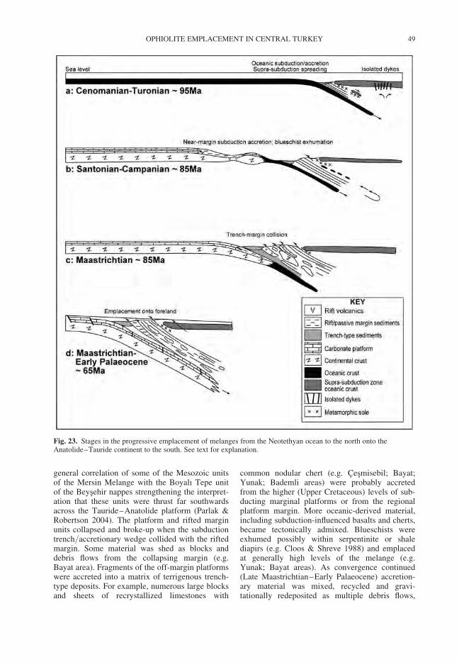
general correlation of some of the Mesozoic unitsof the Mersin Melange with the Boyalı Tepe unitof the Beysehir nappes strengthening the interpret-ation that these units were thrust far southwardsacross the Tauride–Anatolide platform (Parlak &Robertson 2004). The platform and rifted marginunits collapsed and broke-up when the subductiontrench/accretionary wedge collided with the riftedmargin. Some material was shed as blocks anddebris flows from the collapsing margin (e.g.Bayat area). Fragments of the off-margin platformswere accreted into a matrix of terrigenous trench-type deposits. For example, numerous large blocksand sheets of recrystallized limestones with
common nodular chert (e.g. Cesmisebil; Bayat;Yunak; Bademli areas) were probably accretedfrom the higher (Upper Cretaceous) levels of sub-ducting marginal platforms or from the regionalplatform margin. More oceanic-derived material,including subduction-influenced basalts and cherts,became tectonically admixed. Blueschists wereexhumed possibly within serpentinite or shalediapirs (e.g. Cloos & Shreve 1988) and emplacedat generally high levels of the melange (e.g.Yunak; Bayat areas). As convergence continued(Late Maastrichtian–Early Palaeocene) accretion-ary material was mixed, recycled and gravi-tationally redeposited as multiple debris flows,
Fig. 23. Stages in the progressive emplacement of melanges from the Neotethyan ocean to the north onto theAnatolide–Tauride continent to the south. See text for explanation.
OPHIOLITE EMPLACEMENT IN CENTRAL TURKEY 49
locally with either a shale or serpentinitic matrix(e.g. Altınekin; Bademli areas). For example, blues-chists, massive serpentinized peridotite, marble andmeta-chert were gravitationally reworked as blockswithin sedimentary serpentinite that was laterstrongly sheared (Altınekin area). Elsewhere,blocks of pelagic sedimentary rocks and volcanicrocks were incorporated into sedimentary ser-pentinite and later tectonically mixed with shalein a terrigenous (i.e. near-margin) setting (e.g.Bademli area).
Third, the entire Anatolide–Tauride margin wassubducted, associated with the development of afault-influenced flexural foredeep far to the south(.150 km; Fig. 23c). Accretionary material wasreworked southwards from the advancing accretion-ary wedge by a combination of gravity reworkingand bulldozing ahead of the advancing ophiolite.This led to the formation of the sedimentary mel-anges that are associated with the allochthonouscontinental margin units (e.g. Beysehir melange;Maastrichtian–?Paleocene) and with the relativelyautochthonous Menderes Massif (Maastrichian–Eocene locally). During the latest stages of conver-gence large slices of the former rifted margin (e.g.Mersin Melange and the Lycian Layered TectonicMelange) were overthrust by ophiolite-relatedmelange (e.g. Lycian Ophiolitic Melange) andthen by regional-scale ophiolites. These ophiolitesinclude the Lycian and Beysehir peridotites in theTaurides. The ophiolites of the Anatolides, dis-cussed here, were also emplaced southwards ontothe Tauride–Anatolide continental margin duringlatest Cretaceous time. However, these ophioliteswere translated relatively northwards above anextensional detachment as part of an upper platewhen the HP/LT-metamorphosed Anatolide conti-nental margin was exhumed from beneath (seebelow). In contrast, the Tauride ophiolites remainedas part of exhuming plate and so ended up relativelyfar to the south.
Most of the ophiolites in western and centralAnatolia lack an upper crustal sequence, includingsheeted dykes and overlying extrusive rocks. TheAlihoca (Pozantı) ophiolite is an exception becauseall of the units of an ophiolite are exposed there,albeit dismembered. Indeed, much of the Alihocaophiolite is made up of blocks in a sheared shalymatrix. The Alihoca ophiolite is likely to havebeen dismembered during emplacement and is thusintermediate between typically intact over-ridingophiolites and accretionary melange. The break-upof the ophiolites to form blocks in melange is evenmore pronounced in the Bornova Melange.
One possibility to explain the general absence ofupper crustal units is that these ophiolites, like thoseof the Alps, formed at a rifted spreading axis soonafter continental break-up, where sheeted dykes
never existed (e.g. Manatschal & Bernoulli 1999;Manatschal et al. 2003). However, the Alpine-typeophiolites are compositionally and structurally dis-similar to those of the Taurides–Anatolides. Onthe other hand, complete ophiolite sequencessimilar to the Tauride–Anatolide ophiolites, dis-cussed here, do exist on strike to the east, in theEastern Taurides (Robertson 2002; Parlak et al.2004). The likely explanation of the missingcrustal sequences is that they were eroded. Themost probable time for this erosion is during thePaleocene–Early Eocene, after initial emplacementonto the Tauride–Anatolide continental marginwhen ophiolites were located at the highestlevels of the regional thrust stack, put prior to conti-nental collision during the Mid-Eocene. During thiscollision some of the ophiolitic rocks, alreadylacking crustal sequences (e.g. Dipsiz Gol ophiolite;Central Taurides; e.g. Andrew & Robertson 2002),were incorporated into deeply buried thrust stacksand so were no longer available for erosion at theearth’s surface.
The Bornova melange differs from the other mel-anges because of its huge scale, different regionaltrend (NE–SW) and the presence of dismemberedophiolites mixed with an ophiolite-derived matrix.The Bornova melange is unlikely to restore simplyas a north–south transform-related termination ofthe Tauride–Anatolide rifted margin (Okay &Tuysuz 1999) because in this case there would belittle reason for large-melange accretion. We restorethe Bornova zone as a relatively SW–NE-trendingsegment of the Anatolide–Tauride continentalmargin, such that convergence in this area is likelyto have been oblique, which may in turn have influ-enced melange genesis in this area. The generallyhigher and more northeasterly Bornova ophioliticmelange accreted in an oceanic setting with exten-sive gravity reworking and mixing of over-ridingophiolites (e.g. Manisa area). The generally structu-rally lower Bornova sedimentary-volcanic melangerecords accretion and extensive gravity reworkingas gravity blocks and multiple debris flows witha matrix of terrigenous trench-type sediments.However, mixing also resulted from on-goingaccretion/collision. The blocks include marginal-platform sequences (Okay & Altıner 2007), similarto Tauride thrust units of the Beysehir nappes(Andrew & Robertson 2002), the Lycian nappes(e.g. Domuz Dag unit) (e.g. Collins & Robertson1997, 1998) and the Mersin Melange (Parlak &Robertson 2004). The structurally lowest part ofthe Bornova melange in the south near the Mend-eres Massif (e.g. Seferihisar area) is metamor-phosed, possibly as a result of deep burial beneathover-riding accretionary and ophiolitic units. Thecollapsed carbonate platform is exceptionallyexposed in the Karaburun Peninsula in the west.
A. H. F. ROBERTSON ET AL.50
This platform is unmetamorphosed unlike the Ana-tolide platform, possibly because this segment ofthe margin was located south of the region of sub-ducted continental margin, similar to the Tauridecarbonate platform.
Continental margin subduction and
exhumation
The LT/HP metamorphism of both the Tavsanlızone (e.g. Orhaneli and Sivrihisar areas) and theAfyon–Bolkardag zone (e.g. Bayat, Altınekin andBolkardag areas) resulted from very deep burial ofthe Mesozoic platform, some of the melange andfragments of ophiolite and metamorphic sole.Geothermobarometry indicates HP/LT metamorph-ism of the Anatoide platform at 20 + 2 kbar (c. 50–60 km depth) and 430 + 30 8C (Okay & Kelley1994), while Ar/Ar isotopic data most recently indi-cate a Campanian age (c. 80 Ma) for blueschistmetamorphism (Sherlock et al. 1999). Fe-Mgcarpholite-bearing assemblages of the Afyon–Bolkardag zone imply temperatures of c. 350 8Cand minimum pressures of 6–9 kbar (c. 30 km)(Candan et al. 2005), but have not yet been accu-rately dated radiometrically.
Candan et al. (2005) envisage that the leadingedge of the Tauride–Anatolide platform (Tavsanlızone) began to collide with obducting ophiolites inthe Cenomanian (c. 98 Ma) and that the continentalmargin progressively subducted until aroundend-Early Paleocene (c. 35 Ma). To maintain LT con-ditions suitable for blueschist preservation (withoutretrogression) they postulated simultaneous subduc-tion and exhumation (i.e. involving continental slabroll-back). The Tavsanlı zone platform is, indeed,internally imbricated as suggested by local meta-morphic grade variations (Whitney & Davis 2006).However, we observed that the Afyon–Bolkardagplatform is relatively intact without e.g. interslicingof melange. Rather than beginning at c. 98 Ma weinfer that collision and margin subduction beganaround c. 85 Ma (Late Santonian) and ended byc. 61 Ma (Middle Paleocene), when the exhumedHP/LT rocks of the Tavsanlı and Afyon–Bolkardagzones, the Menderes Massif and Tauride units werelocally transgressed by shallow-water sediments of?Mid–Late Paleocene to Early Eocene age. In thenorthern Bolkar Dag area exhumation occurred bythe Late Maastrichtian when shallow-water limestonesbegan to accumulate unconformably on melange andemplaced ophiolites. The presence of sedimentarymelange locally dated as Eocene in the southernMenderes Massif indicates later reworking of accre-tionary material, but this was possibly related tomuch-later regional continental collision (see below).
In the east, the thin unit of polymict debris flowswith isolated blocks, so far recorded only in the
Bolkar Dag area resulted from gravity reworkingof both HP- and LP-metamorphosed accretionarymelange and ophiolitic material as multiple debrisflows prior to covering by transgressive Maastrich-tian shallow-marine sediments. Some of thismaterial was reworked in a high-energy beachor fluvial settings because some of the clasts arevery well rounded and water-worn. The polymictdebris appear to a have formed actually duringexhumation of the Anatolide platform andmelange, followed by transgressive shallow-waterdeposition when this was complete. Further west,exhumation was complete before the Late Paleo-cene by the time when the melange was coveredby shallow-marine Nummulitic limestones (e.g.Bayat and Orhaneli areas).
Our work shows that generally north–southorientated, shallow-dipping stretching lineationsare commonly developed within the metamor-phosed Anatolide carbonate platform and the meta-morphic melange (e.g. the Yunak, Altınekın andCesmisebil areas). Stretching lineations are gener-ally most intense near the contact between thecarbonate platform and overlying melange. On theother hand, east–west-trending mineral lineationswere reported from further west, including Orhaneli(Okay & Tuysuz 1999). Studies of other areas indi-cate that stretching lineations in similar HP/LTmetamorphic rocks may develop either related toexhumation or to deep-burial unrelated to exhuma-tion (see Whitney & Davis 2006). Outcropsstudied by us rarely show clear kinematic indicators(e.g. asymmetrical ‘wing’ structures) and, wherepresent, locally suggest both northward and south-ward displacement. However, in general, we relatethe widely developed north–south stretchinglineations to regional exhumation of the Anatolidecarbonate platform, metamorphosed melange andrelated unit, followed by sub-parallel deposition oftransgressive sediments (e.g. Bayat area).
In addition, in the east the Ulukısla Basinincludes thick volcanic units of Paleocene–EarlyEocene age in which basaltic members exhibit‘enriched’ patterns of stable major and traceelements, combined with a subduction influence(e.g. negative Nb anomaly). The subduction influ-ence is seen as being inherited from Upper Cretac-eous subduction in the region. Further east, thePaleogene cover of the Lycian nappes (FaralyaFomation; Senel 1991) includes basaltic flows thatshow mild ‘enrichment’ and a subduction influence(Collins 1994; Collins & Robertson 1998). The vol-canics and the Ulukısla Basin generally are con-sidered to record an extensional or transtensionalsetting during Palaeogene time (Clark & Robertson2002, 2004).
The timing of exhumation in the west (e.g. Orha-neli area) is also constrained by the presence of
OPHIOLITE EMPLACEMENT IN CENTRAL TURKEY 51
several crosscutting granodiorite plutons of EarlyEocene age (52–48 Ma; Harris et al. 1994).The plutons cut the metamorphosed platform andophiolitic peridotite, but pre-date final southwardthrusting of the Sakarya zone over the Tavsanlızone (MTA 2002). In addition, evidence fromthe Taurides constrains the timing of melangeemplacement as mainly Campanian–Maastrich-tian–Paleocene in different areas. This is based ona combination of the age of the youngest pelagicsediments above the Tauride carbonate platform(Campanian–Maastrichtian of the Bolkar Dag),the locally determined age of the melange matrix(Maastrichtian–Paleocene) in the Beysehir andLycian Nappes (Andrew & Robertson 2002;Collins & Robertson 1998), and the age of thecover sequence, where exposed (Paleocene for theLycian Nappes; Senel, 1991; Collins & Robertson1998). Summarizing, the ages of emplacement inboth the Anatolides and Taurides is broadlysimilar, suggesting melange was rapidly emplacedover the regional platform (i.e. within c. 5 Ma)after initial trench-margin collision (c. 85–Ma).
Continental collision
All of the units, including the Anatolide–Tauridecontinent in the south and the Sakarya zone in thenorth, experienced pervasive folding and thrustingduring Mid–Late Eocene time. The maximumage of this deformation is given by the youngestages of intact sedimentary sequences overlyingexhumed units; i.e. Early Eocene in the UlukıslaBasin and further west (e.g. Bayat and Kutahyaareas). The minimum age of deformation is givenby the oldest age of unconformably overlying (non-marine) sediments in several areas (i.e. Oligocenein the Ulukısla Basin). We, therefore, infer thatcontinental collision (which was probably diachro-nous) mainly took place during Mid-Eocene time(c. 45 Ma) and was complete by Late Eocene time(c. 50 Ma; Bartonian).
In the east, the Mesozoic Bolkar Dag carbonateplatform was internally sliced and back-thrustnorthwards over melange and the Maastrichtian–Eocene Ulukisla Basin. Less intense reverse fault-ing also affected the Mesozoic platform and over-lying units further west (i.e. in the Altınekin area).Eocene polyphase folding is especially wellexposed in the Konya area (Eren 2001). TheBeysehir nappes were thrust southwards, takingwith them large slices of the Geyik Dag platformto form the Hadim Nappe (Ozgul 1997; Mackintosh2008). The Lycian Nappes and related melanges werealso rethrust southwards over the Menderes Massif.They were subsequently thrust to their most southerlyposition during the Mid-Miocene (Langhian,c. 15 Ma) (Flecker et al. 2005), a later history that is
outside the scope of this paper. Mesozoic–LowerCenozoic clastic meta-sedimentary rocks correlatedwith the Lycian nappes were imbricated and buriedto c. 30 km during Middle–Late Eocene (Rimmeleet al. 2003, 2006; Candan et al. 2005). This impliestwo stages of continental margin metamorphism inthis region, the first during latest Cretaceous–earlyCenozoic associated with trench-margin collisionwhich resulted in deep subduction of the Tauride–Anatolide continental margin, and the second duringEarly–Middle Eocene related to continental collisionwhen a very thick crustal pile was developed on top ofthe Menderes Massif.
The Sakarya zone was thrust southwards andimbricated with the Tavsanlı zone (e.g. Sivrihisararea) during the Mid-Eocene. However, the contactbetween the Tavsanlı zone and the Sakarya zone isgenerally a younger high-angle, strike-slip fault(e.g. Orhaneli area).
Regional palaeogeography: one or
several oceanic basins?
Any realistic plate-tectonic reconstruction is criti-cally dependent on determining the number andlocation of Mesozoic ocean basins betweenEurasia and the Tauride–Anatolide continent tothe south.
Two main alternatives can be considered(Fig. 24a, b). First, the Nigde–Kırsehir massifformed a promontory of the Tauride–Anatolidemicrocontinent, with a single Mesozoic ocean, theIzmir–Ankara–Erzican ocean to the north. In thisscenario, all of the Anatolide and Tauride ophio-lites formed above a single northward-dippingintra-oceanic subduction zone during the LateCretaceous. The Nigde–Kırsehir promontory latercollided with the intra-oceanic subduction zoneand ophiolites were emplaced southwards overthe Nigde–Kırsehir massif (where present), ontothe Tauride–Anatolide continent, reaching as farsouth as the Mersin ophiolite on the southerlyflanks of the Bolkar Dag (Yalınız et al. 1996,2000; Floyd et al. 2000). Remaining ocean to thenorth of the intra-oceanic subduction zone closedduring Early Cenozoic time. In a second alternativethe Nigde–Kırsehir massif rifted from the largerTauride–Anatolide continent during the Triassic,becoming a continental fragment capped by aMesozoic carbonate platform during later Mesozoictime. The inferred intervening ocean is known as theInner Tauride Ocean (Gorur et al. 1984, 1988).During the Late Cretaceous, regional convergencetriggered northward subduction within this oceanand Tauride ophiolites (e.g. Mersin; Alihoca;Karsantı; Pozantı) formed by spreading abovethis southerly subduction zone. Ophiolites were
A. H. F. ROBERTSON ET AL.52
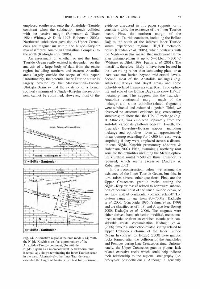
emplaced southwards onto the Anatolide–Tauridecontinent when the subduction trench collidedwith the passive margin (Robertson & Dixon1984; Whitney & Dilek 1997; Robertson 2002).Northward subduction gave rise to Upper Cretac-eous arc magmatism within the Nigde–Kırsehirmassif (Central Anatolian Crystalline Complex) tothe north (Kadıoglu et al. 2006).
An assessment of whether or not the InnerTauride Ocean really existed is dependent on theanalysis of a large body of data from the entireregion including northern and eastern Anatolia,areas largely outside the scope of this paper.Unfortunately, the potential Inner Tauride suture islargely covered by the Maastrichtian–EoceneUlukısla Basin so that the existence of a formersoutherly margin of a Nigde–Kırsehir microconti-nent cannot be confirmed. However, most of the
evidence discussed in this paper supports, or isconsistent with, the existence of the Inner Taurideocean. First, the northern margin of theAnatolide–Tauride continent, including the BolkarDag to the south of the inferred Inner Tauridesuture experienced regional HP/LT metamor-phism (Candan et al. 2005), which contrasts withthe Nigde–Kırsehir massif that underwent Barro-vian metamorphism at up to 5–6 kbar, .700 8C(Whitney & Dilek 1998; Fayon et al. 2001). Themassif is, therefore, likely to have been located inthe over-riding rather than subducting plate, or atleast was not buried beyond mid-crustal levels.Second, most of the Anatolide melanges (e.g.Altınekin; Konya and Bayat areas) and someophiolite-related fragments (e.g. Kızıl Tepe ophio-lite and sole of the Bolkar Dag) also show HP/LTmetamorphism. This suggests that the Tauride–Anatolide continental margin. much of themelange and some ophiolite-related fragmentswere subducted and exhumed together. Third, weobserved no structural evidence (e.g. crosscuttingstructures) to show that the HP/LT melange (e.g.at Altınekin) was emplaced separately from theAntolide carbonate platform beneath. Fourth, the(Tauride) Beysehir–Hoyran nappes, includingmelange and ophiolites, form an approximatelylinear outcrop extending for .500 km east–west,surprising if they were emplaced across a discon-tinuous Nigde–Kırsehir promontory (Andrew &Robertson 2002). Fifth, assuming a northerly rootzone for the ophiolites including the Mersin ophio-lite (furthest south) .500 km thrust transport isrequired, which seems excessive (Andrew &Robertson 2002).
In our reconstruction, below, we assume theexistence of the Inner Tauride Ocean, but this, inturn, raises several other questions. First, are theUpper Cretaceous granitic rocks cutting theNigde–Kırsehir massif related to northward subduc-tion of oceanic crust of the Inner Tauride ocean, orare they instead continental collision related? Theplutons range in age from 80–70 Ma (Kadıogluet al. 2006; Goncuoglu 1986; Yalınız et al. 1999)and are classified as of I-, S- and A-type (see Boztug2000; Kadıoglu et al. 2006). The magmas wereeither derived from subduction-modified, metasoma-tized mantle, or from an enriched mantle with con-siderable crustal contamination. Kadıoglu et al.(2006) favour a subduction-related setting related toUpper Cretaceous closure of the Inner TaurideOcean. In contrast, for Boztug (2000) these graniticrocks formed after the collision of the Anatolidesand Pontides during Late Cretaceous time. Unfortu-nately, the Upper Cretaceous granitic plutons lackrelated extrusive rocks which could help indicatetheir relationship to the regional stratigraphy (i.e.pre-syn-or post-collisional). Although a generally
Fig. 24. Alternative regional tectonic models. (a) Withthe Nigde-Kısehir massif as a promontory of theAnatolide–Tauride continent; (b) with theNigde-Kısehir as a microcontinent. A transform faultis tentatively shown terminating the Inner Tauride oceanin the west. Alternatively, the Inner Tauride oceanextended the length of Anatolia. See text for discussion.
OPHIOLITE EMPLACEMENT IN CENTRAL TURKEY 53
NW–SE-trending belt of granitic rocks exists alongthe western margin of the Kırsehir massif, theiroverall distribution is patchy, which questions theirorgin as a conventional subduction-related magmaticarc (cf. Kadıoglu et al. 2006). On the other hand,their Cretaceous age long predates regional continen-tal collision (i.e. Eocene) of the Eurasian (Pontide) andTauride–Anatolide continents, and thus the UpperCretaceous granitic rocks are unlikely to relate tocrustal thickening and deep-level anatexis (cf.Boztug 2000). Ilbeyli et al. (2004) suggested thatthese Upper Cretaceous granititc rock relate to slabbreak-off and delamination processes. The Upper Cre-taceous Nigde–Kırsehir granitic rocks are thereforelikely relate to closure of the Inner Tauride oceanand collision of the Anatolide and Nigde–Kırsehircontinental units.
Second, did oceanic crust exist to the north of theNigde–Kırsehir continental unit during the Meso-zoic. For example, Kazmin & Tikhonova (2006)consider Nigde–Kırsehir massif to be part of theEurasian margin during the Mesozoic. Also, Kadıo-glu et al. (2006) dispute the existence of emplacedophiolites above the Nigde–Kırsehir massif,which they instead interpret as Upper Cretaceousintra-continental intrusions (e.g. gabbros). Relatedto this controversy is the question of what causedthe Upper Cretaceous Barrovian metamorphism ofthe Nigde–Kırsehir massif (Whitney & Dilek1998; Fayon et al. 2001). Our own unpublishedstudies of the Cicekdag and Sarıkaraman, andother related, mainly igneous units, overlying theNigde–Kırsehir massif support their interpretationas supra-subduction zone-type ophiolites, emplacedfrom the Izmir–Ankara–Erzincan ocean to thenorth (Yalınız et al. 1996, 2000; Floyd et al.2000). Despite being dismembered, all of the maincomponents of an originally complete ophioliteare present, including well-dated (Upper Cretac-eous) pelagic sediments, basaltic extrusives,sheeted dykes, isotropic gabbro, plagiogranite andlayered gabbro. Assuming the existence of a sub-duction zone dipping northwards from the Nigde–Kırsehir massif, the Upper Cretaceous HT/LPmetamorphism of the Nigde–Kırsehir massifmight be explained by collision and shallow-levelunderplating of the microcontinent beneath aforearc to the north.
Assuming the existence of the Inner TaurideOcean, a remaining question is its original westward(and eastward) extent. One option is that the oceanterminated against a north–south transform nearthe western margin of the Nigde–Kırsehir micro-continent, in which case only one oceanic basinexisted to the west of this, and all of the Anatolideand Tauride ophiolites (west of the inferred trans-form) represent parts of a single regionally emplacedsupra-subduction zone ophiolite. Alternatively, two
spreading axes developed the length of Anatolia. Inthis case, Cretaceous regional compression triggerednorthward subduction of both of these oceanicdomains; the Tauride ophiolites were emplacedfrom the Inner Tauride ocean, whereas the Anatolideones were emplaced from the more northerly Izmir–Ankara–Erzincan ocean. In Figure 24b, we suggesta transform termination as two subduction zonesare not documented west of the Nigde–Kırsehirmassif. Figure 25 shows corresponding plate-tectonicsketches, with a single ocean in the west in (a), and anInner Tauride ocean to the south of the Nigde–Kırse-hir massif in (b).
Plate-tectonic summary
This incorporates our favoured tectonic interpret-ations and timing of events as above (Figs 25 &26). Triassic rifting was followed by passivemargin subsidence during Jurassic–Early Cretac-eous. During Triassic–Late Cretaceous (Cenoma-nian, c. 100 Ma) MOR-type oceanic lithosphereformed at spreading axes, while seamounts formedrelated to hot-spot activity (Late Jurassic–EarlyCretaceous). Common arc-type basalts record anintra-oceanic arc, possibly ophiolite related, andpreserved only as accreted blocks in the melange.During the Cenomanian (c. 100 Ma) the entireTauride–Anatolide platform was flooded andcovered by pelagic sediments until the Santonian(c. 85 Ma). After northward subduction began allof the ophiolites formed by supra-subduction zonespreading. Swarms of subduction-influenced dykescutting many of the ophiolites reflect incipient arcmagmatism, eventually terminated by collisionwith the continental margin to the south. Meta-morphic soles formed during intra-oceanic sub-duction prior to obduction onto the continentalmargin (c. 100–90 Ma; Cenomanian–Turonian).The soles probably relate to initial displacement ofstill-hot lithosphere within the ocean (Jones et al.1991; Garfunkel 2006) rather than to steady-stateoceanic subduction, or initial obduction onto themargin. Oceanic crust and seamounts, collectivelyof Late Triassic–Cenomanian age, were accretedin a trench/forearc setting, together with oceanicradiolarites and pelagic limestones. Some of thismaterial was soon exhumed and recycled as mul-tiple debris flows during Upper Maastrichtian–Lower Paleocene in different areas. The subductiontrench began to collide with the Anatolide–Tauridecontinental margin around late Santonian time(c. 85 Ma), with regional diachroneity. The platformflexurally up-warped and then collapsed to form aforedeep into which accreted oceanic material wasemplaced as gravity flows and thrust units aheadof the advancing ophiolite. The platform then
A. H. F. ROBERTSON ET AL.54
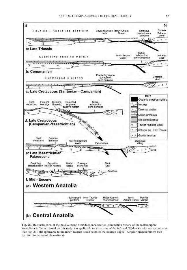
Fig. 25. Reconstruction of the passive margin-subduction/accretion-exhumation history of the metamorphicAnatolides in Turkey based on this study. (a) applicable to areas west of the inferred Nigde–Kırsehir microcontinent(see Fig. 23); (b) applicable to the Inner Tauride ocean south of the inferred Nigde–Kırsehir microcontinent (seetext for discussion of alternatives).
OPHIOLITE EMPLACEMENT IN CENTRAL TURKEY 55
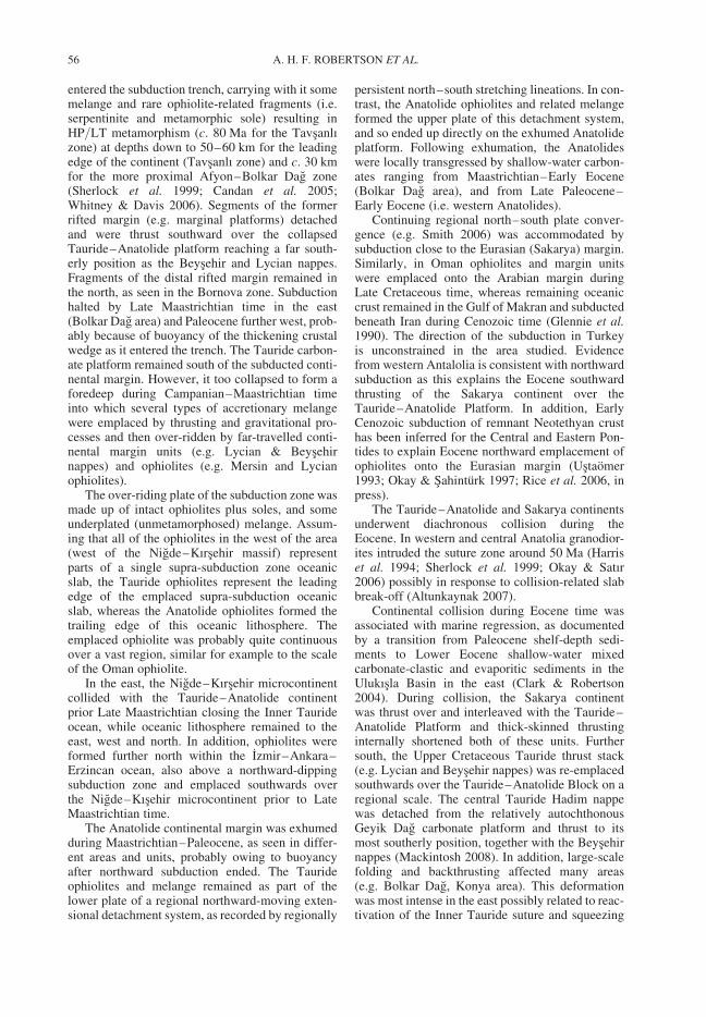
entered the subduction trench, carrying with it somemelange and rare ophiolite-related fragments (i.e.serpentinite and metamorphic sole) resulting inHP/LT metamorphism (c. 80 Ma for the Tavsanlızone) at depths down to 50–60 km for the leadingedge of the continent (Tavsanlı zone) and c. 30 kmfor the more proximal Afyon–Bolkar Dag zone(Sherlock et al. 1999; Candan et al. 2005;Whitney & Davis 2006). Segments of the formerrifted margin (e.g. marginal platforms) detachedand were thrust southward over the collapsedTauride–Anatolide platform reaching a far south-erly position as the Beysehir and Lycian nappes.Fragments of the distal rifted margin remained inthe north, as seen in the Bornova zone. Subductionhalted by Late Maastrichtian time in the east(Bolkar Dag area) and Paleocene further west, prob-ably because of buoyancy of the thickening crustalwedge as it entered the trench. The Tauride carbon-ate platform remained south of the subducted conti-nental margin. However, it too collapsed to form aforedeep during Campanian–Maastrichtian timeinto which several types of accretionary melangewere emplaced by thrusting and gravitational pro-cesses and then over-ridden by far-travelled conti-nental margin units (e.g. Lycian & Beysehirnappes) and ophiolites (e.g. Mersin and Lycianophiolites).
The over-riding plate of the subduction zone wasmade up of intact ophiolites plus soles, and someunderplated (unmetamorphosed) melange. Assum-ing that all of the ophiolites in the west of the area(west of the Nigde–Kırsehir massif) representparts of a single supra-subduction zone oceanicslab, the Tauride ophiolites represent the leadingedge of the emplaced supra-subduction oceanicslab, whereas the Anatolide ophiolites formed thetrailing edge of this oceanic lithosphere. Theemplaced ophiolite was probably quite continuousover a vast region, similar for example to the scaleof the Oman ophiolite.
In the east, the Nigde–Kırsehir microcontinentcollided with the Tauride–Anatolide continentprior Late Maastrichtian closing the Inner Taurideocean, while oceanic lithosphere remained to theeast, west and north. In addition, ophiolites wereformed further north within the Izmir–Ankara–Erzincan ocean, also above a northward-dippingsubduction zone and emplaced southwards overthe Nigde–Kısehir microcontinent prior to LateMaastrichtian time.
The Anatolide continental margin was exhumedduring Maastrichtian–Paleocene, as seen in differ-ent areas and units, probably owing to buoyancyafter northward subduction ended. The Taurideophiolites and melange remained as part of thelower plate of a regional northward-moving exten-sional detachment system, as recorded by regionally
persistent north–south stretching lineations. In con-trast, the Anatolide ophiolites and related melangeformed the upper plate of this detachment system,and so ended up directly on the exhumed Anatolideplatform. Following exhumation, the Anatolideswere locally transgressed by shallow-water carbon-ates ranging from Maastrichtian–Early Eocene(Bolkar Dag area), and from Late Paleocene–Early Eocene (i.e. western Anatolides).
Continuing regional north–south plate conver-gence (e.g. Smith 2006) was accommodated bysubduction close to the Eurasian (Sakarya) margin.Similarly, in Oman ophiolites and margin unitswere emplaced onto the Arabian margin duringLate Cretaceous time, whereas remaining oceaniccrust remained in the Gulf of Makran and subductedbeneath Iran during Cenozoic time (Glennie et al.1990). The direction of the subduction in Turkeyis unconstrained in the area studied. Evidencefrom western Antalolia is consistent with northwardsubduction as this explains the Eocene southwardthrusting of the Sakarya continent over theTauride–Anatolide Platform. In addition, EarlyCenozoic subduction of remnant Neotethyan crusthas been inferred for the Central and Eastern Pon-tides to explain Eocene northward emplacement ofophiolites onto the Eurasian margin (Ustaomer1993; Okay & Sahinturk 1997; Rice et al. 2006, inpress).
The Tauride–Anatolide and Sakarya continentsunderwent diachronous collision during theEocene. In western and central Anatolia granodior-ites intruded the suture zone around 50 Ma (Harriset al. 1994; Sherlock et al. 1999; Okay & Satır2006) possibly in response to collision-related slabbreak-off (Altunkaynak 2007).
Continental collision during Eocene time wasassociated with marine regression, as documentedby a transition from Paleocene shelf-depth sedi-ments to Lower Eocene shallow-water mixedcarbonate-clastic and evaporitic sediments in theUlukısla Basin in the east (Clark & Robertson2004). During collision, the Sakarya continentwas thrust over and interleaved with the Tauride–Anatolide Platform and thick-skinned thrustinginternally shortened both of these units. Furthersouth, the Upper Cretaceous Tauride thrust stack(e.g. Lycian and Beysehir nappes) was re-emplacedsouthwards over the Tauride–Anatolide Block on aregional scale. The central Tauride Hadim nappewas detached from the relatively autochthonousGeyik Dag carbonate platform and thrust to itsmost southerly position, together with the Beysehirnappes (Mackintosh 2008). In addition, large-scalefolding and backthrusting affected many areas(e.g. Bolkar Dag, Konya area). This deformationwas most intense in the east possibly related to reac-tivation of the Inner Tauride suture and squeezing
A. H. F. ROBERTSON ET AL.56
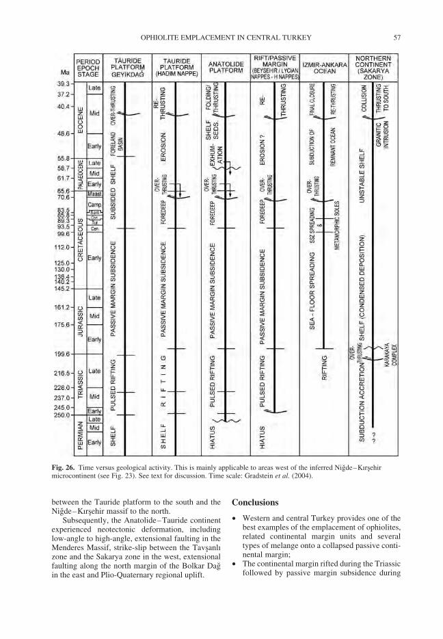
between the Tauride platform to the south and theNigde–Kırsehir massif to the north.
Subsequently, the Anatolide–Tauride continentexperienced neotectonic deformation, includinglow-angle to high-angle, extensional faulting in theMenderes Massif, strike-slip between the Tavsanlızone and the Sakarya zone in the west, extensionalfaulting along the north margin of the Bolkar Dagin the east and Plio-Quaternary regional uplift.
Conclusions
† Western and central Turkey provides one of thebest examples of the emplacement of ophiolites,related continental margin units and severaltypes of melange onto a collapsed passive conti-nental margin;
† The continental margin rifted during the Triassicfollowed by passive margin subsidence during
Fig. 26. Time versus geological activity. This is mainly applicable to areas west of the inferred Nigde–Kırsehirmicrocontinent (see Fig. 23). See text for discussion. Time scale: Gradstein et al. (2004).
OPHIOLITE EMPLACEMENT IN CENTRAL TURKEY 57
Jurassic–Early Cretaceous, and regional flood-ing during the Late Cretaceous (Cenomanian–Campanian).
† Four main convergent phases are recorded:intra-oceanic subduction (Cenomanian-Santonianc. 95–85 Ma); trench-margin collision leadingto ophiolite, rifted margin and melange empla-cement (Santonian–Early Paleocene c. 85–65 Ma); subduction of remnant oceanic crust(Middle Paleocene–Early Eocene c. 60–50 Ma),and final continental collision and crustal thick-ening (Middle Eocene c. 45–40 Ma);
† All of the ophiolites formed by spreading relatedto northward-dipping subduction;
† Isolated diabase dykes record the earlier stagesof oceanic arc magmatism that was haltedby obduction,
† Metamorphic soles preserve remnants of sea-mount, arc-type and rarely mid-ocean ridgetype crust;
† Underlying melanges preserve remnants of asimilar range of oceanic-derived igneous rocks;
† Subduction influenced tholeiitic basalts of prob-able Late Cretaceous age record remnants of anoceanic arc that probably began to develop onsupra-subduction-type oceanic crust. Thearc-type basalts are likely to have been detachedfrom the leading edge of the emplacing ophioliteand emplaced as blocks within the melangebeneath;
† Melanges formed by both tectonic and sedimen-tary processes. Initially-formed oceanic accre-tionary complexes are mainly tectonic inorigin, whereas, at the other end of a spectrum,the farthest-travelled melange on the collapsedplatform includes large-scale debris flows;
† Slices of the rifted margin were emplaced largedistances (up to several hundred kilometres)onto the continental margin as regional-scalethrust sheets;
† The leading edge of the subducted continentalmargin in the north underwent high pressure/lowtemperature metamorphism (i.e. Tavsanlı zone c.80 Ma; Afyon–Bolkardag zone Maastrichtian–Paleocene), whereas areas further south experi-enced either low-grade metamorphism (MenderesMassif) or escaped metamorphism altogether(i.e. Taurides).
† The emplacement of ophiolites, continentalmargin units and melanges was accompaniedby exhumation of the HP/LT units, as recordedby transgressive sediments of Maastrichtian–Paleocene age in different areas;
† Remnant oceanic lithosphere was subductedduring Paleocene–Early Eocene, followed bycontinental collision during Mid Eocene;
† Similar Upper Cretaceous supra-subductionzone-type oceanic lithosphere appears to have
formed both south and north of a rifted micro-continent, known as the Nigde–Kırsehir Massif(Central Anatolian Crystalline Complex). Thisimplies the near-coeval formation of ophiolitesin several oceanic areas with a palaeogeographi-cal complexity similar to the modern SW Pacificregion; and
† Finally, rather than progressive collision, atwo-stage emplacement model is advocatedinvolving, first latest Cretaceous southwardemplacement onto the Tauride–Anatolide conti-nental margin (followed by exhumation of themargin), and second continental collisionduring the Mid Eocene.
The authors thank the Carnegie Trust for the Scottish Uni-versities for financial assistance for carrying out the field-work. We thank Prof. U. Unlugenc for participating insome of the fieldwork and for assistance with logisticalaspects. We thank P. Mackintosh for helpful discussion.The manuscript benefited from helpful reviews byA. Okay and Y. Dilek and the advice of the editor,Dr M. Edwards.
References
ALABASTER, T., PEARCE, J. A. & MALPAS, J. 1982. Thevolcanic stratigraphy and petrogenesis of the Omanophiolite complex. Contributions to Mineralogy andPetrology, 81, 168–183.
ALDANMAZ, E., YALINIZ, M. K., GUCTEKIN, A. &GONCUOGLU, M. C. 2007. Geochemical character-istics of mafic lavas from the Neotethyan ophiolitesin western Turkey: implications for heterogeneoussource contributions during variable stages of oceaniccrust generation. Geological Magazine, 145, 37–54.
AL-RIYAMI, K., ROBERTSON, A. H. F., DIXON, J. &XENOPHONTOS, C. 2002. Origin and emplacementof the Late Cretaceous Baer-Bassit ophiolite and itsmetamorphic sole in NW Syria. Lithos, 65, 225–260.
ALTINER, D., KOCYIGIT, A., FARINACCI, A., NICOSIA,U. & CONTI, M. A. 1991. Jurassic, Lower Cretaceousstratigraphy, palaeogeographic evolution of thesouthern part of north-western Anatolia. GeologicaRomana, 27, 13–80.
ALTUNKAYAK, D. E. 2007. Collision-driven slab breakoffmagmatism in northwestern Anatolia, Turkey. Journalof Geology, 115, 63–82.
American Geological Institute. 1961. Dictionary of Geo-logical Terms. New York, Dolphin Books.
ANDREW, T. & ROBERTSON, A. H. F. 2002. TheBeysehir-Hoyran-Hadim Nappes: genesis and empla-cement of Mesozoic marginal and oceanic units ofthe northern Neotethys in southern Turkey. Journalof the Geological Society, London, 159, 529–543.
ARCULUS, R. J. & POWEL, R. 1986. Source componentmixing in the regions of arc magma generation.Journal of Geophysical Research, 91, 5913–5926.
BAILEY, E. B. & MCCALLIEN, W. J. 1954. Serpentinitelavas, the Ankara Melange, the Anatolian thrust.
A. H. F. ROBERTSON ET AL.58
Transactions of the Royal Society of Edinburgh, 62,403–442.
BERNOULLI, D., DE GRACIANSKY, P. C. & MONOD, O.1974. The extension of the Lycian Nappes (SWTurkey) into the southeastern Aegean Islands.Eclogae Geologicae Helvetiae, 67, 39–90.
BLUMENTHAL, M. M. 1955. Geology of the border andwestward areas in the north of high Bolkardag. MTAYayınları, Seri D, 7, Ankara [in Turkish].
BOZKURT, E. & OBERHANSLI, R. 2001. Menderes Massif(Western Turkey): structural, metamorphic and mag-matic evolution–a synthesis. International Journal ofEarth Science, 89, 679–708.
BOZTUG, D. 2000. S-I-A type intrusive associations: geo-dynamic significance of synchronism between meta-morphism and magmatism in Central Anatolia,Turkey. In: BOZKURT, E., WINCHESTER, J. A. &PIPER, J. A. D. (eds) Tectonics and Magmatism inTurkey and the Surrounding Area. GeologicalSociety, London, Special Publication, 173, 441–458.
BRAGIN, N. Y. & TEKIN, U. K. 1996. Age of radiolarian-chert blocks from the Senonian Ophiolitic Melange(Ankara, Turkey). Island Arc, 5, 114–122.
CAKIR, U., JUTEAU, T. & WHITECHURCH, H. 1978. Nou-velles preuves de l’ ecaillage intra-oceanique precocedes opiolites tethesiennes: les roches metamorphiquesintra-periditiques du massif de Pozanti-Karsantı(Turquie). Bulletin de la Societe geologique deFrance, 20(1), 61–70.
CANDAN, O., CETINKAPLAN, M., OBERHANSLI, R.,RIMMELE, G. & AKAL, C. 2005. Alpine high-P/low-T metamorphism of the Afyon Zone and impli-cations for the metamorphic evolution of WesternAnatolia, Turkey. Lithos, 84, 102–124.
CELIK, O. F. 2007. Metamorphic sole rocks and theirmafic dykes in the eastern Tauride belt ophiolites(southern Turkey): implications for OIB-type magmageneration following slab break-off. Geological Maga-zine, 144, 849–866.
CELIK, O. F. & DELALOYE, M. 2003. Origin of meta-morphic soles and their post-kinematic mafic dykeswarms in the Antalya and Lycian ophiolites, SWTurkey. Geological Journal, 38, 235–256.
CELIK, O. F., DELALOYE, M. & FERAUD, G. 2006.Precise Ar-Ar ages from the metamorphic sole rocksof the Tauride Belt Ophiolites, southern Turkey: impli-cations for the rapid cooling history. Geological Maga-zine, 143, 213–227.
CLARK, M. 2002. The latest Cretaceous-Early TertiaryUlukısla Basin, S. Turkey: sedimentation and tectonicsof an evolving suture zone. Unpublished PhD thesis,University of Edinburgh.
CLARK, M. & ROBERTSON, A. H. F. 2002. The role of theEarly Tertiary Ulukısla Basin, southern Turkey, insuturing of the Mesozoic Tethys ocean. Journal ofthe Geological Society, 159, 673–690.
CLARK, M. & ROBERTSON, A. H. F. 2004. UppermostCretaceous-Lower Tertiary Ulukısla Basin, south-central Turkey: sedimentary evolution of part of aunified basin complex within an evolving Neotethyansuture zone. Sedimentary Geology, 173, 15–52.
CLOOS, M. & SHREVE, R. L. 1988. Subduction-channelmodel of prism accretion, melange formation, sedi-ment subduction, and subduction erosion at convergent
plate margins: 2. Implications and discussion. Pure andApplied Geophysics, 128, 501–545.
COLLINS, A. S. 1997. Tectonic evolution of Tethys in theLycian Taurides, southwestern Anatolia. UnpublishedPhD thesis, University of Edinburgh.
COLLINS, A. & ROBERTSON, A. H. F. 1997. Lycianmelange, southwestern Turkey: an emplaced Late Cre-taceous accretionary complex. Geology, 25, 25–258.
COLLINS, A. & ROBERTSON, A. H. F. 1998. Processes ofLate Cretaceous to Late Miocene episodic thrust-sheettranslation in the Lycian Taurides, southwesternTurkey. Journal of the Geological Society, London,155, 759–772.
COLLINS, A. & ROBERTSON, A. H. F. 1999. Evolution ofthe Lycian allochthon, western Turkey, as a north-facing Late Palaeozoic-Mesozoic rift and passive con-tinental margin. Geological Journal, 34, 107–138.
DE GRACIANSKY, P. C. 1972. Recherches geologiquesdans le Taurus lycien. These Universite Paris-Sud, Paris.
DANELIAN, T., ROBERTSON, A. H. F., COLLINS, A. S. &POISSON, A. 2006. Biochnonology of Jurassic andEarly Cretaceous radiolarites from the LycianMelange (SW Turkey) and implications for the evol-ution of the Northern Neotethys ocean. In: ROBERT-
SON, A. H. F. & MOUNTRAKIS, D. (eds) TectonicDevelopment of the Eastern Mediterranean Region.Geological Society of London Special Publication,260, 229–236.
DASCI, H. T. 2007. Origin of amphibolites within theKoyna Melange. Unpublished MSc thesis, CukurovaUniversity, Adana, Turkey [in Turkish].
DELALOYE, M. & BINGOL, E. 2000. Granitoids fromwestern and northwestern Anatolia: Geochemistryand modeling of geodynamic evolution. InternationalGeology Review, 42, 241–268.
DEMIRTASLI, E., TURHAN, N., BILGIN, A. Z. & SELIM,M. 1984. Geology of the Bolkar Mountains. In:TEKELI, O. & GONCUOGLU, M. C. (eds) Geology ofthe Taurus Belt. Proceedings International Symposiumon the Geology of the Taurus Belt, Ankara, Turkey.Mineral Resources and Exploration Institute ofTurkey, 12–141.
DERCOURT, J., RICOU, L. E. & VRIELYNCK, B. (eds)1993. Atlas Tethys Palaeoenvironmental Maps. Com-mission pour le Carte Geologique du Monde/Commis-sion for the Geological Map of the World, Paris.
DILEK, Y. & THY, P. 2006. Age and petrogenesis of pla-giogranite intrusions in the Ankara Melange, CentralTurkey. The Island Arc, 15, 44–57.
DILEK, Y. & WHITNEY, D. L. 1997. CounterclockwiseP-T-t trajectory from the metamorphic sole of a Neo-tethyan ophiolite (Turkey). Tectonophysics, 280,295–310.
DILEK, Y. & WHITNEY, D. L. 2000. Cenozoic crustalevolution in Central Anatolia: extension, magmatismand landscape development. In: PANAYIDES, I.,XENOPHONTOS, C. & MALPAS, J. (eds) Proceedingsof the Third International Congress on the Geologyof the Eastern Mediterranean, 183–192.
DILEK, Y., THY, P., HACKER, B. & GRUNDVIK, S. 1999.Structure and petrology of Tauride ophiolites andmafic dyke intrusions (Turkey): implications for theNeotethyan ocean. Geological Society of America Bul-letin, 111, 1192–1216.
OPHIOLITE EMPLACEMENT IN CENTRAL TURKEY 59
DORA, O. O., CANADAN, O., KAYA, O., KORALAY, E. &DURR, S. 2001. Revision of the so-called ‘leptitegneisses’ in the Menderes Massif: a supra-crustal meta-sedimentary origin. International Journal of EarthScience (Geologische Rundschau), 89/4, 836–851.
ELITOK, O. 2002. Geochemistry and tectonic significanceof the Sarkikaraagac Ophiolite in the Beysehir-HoyranNappes, S.W. Turkey. In: Proceedings of 4th Inter-national Symposium on Eastern MediterraneanGeology, Isparta, Turkey, 181–196.
ERDOGAN, B. 1990. Stratigraphic features and tectonicevolution of of the Izmir-Ankara Zone in the regionbetween Izmir and Seferihisar (in Turkish). Bulletinof Turkish Petroleum Geologists Association, 2, 1–20.
ERDOGAN, B. & GUNGOR, T. 1992. Stratigraphy and tec-tonic evolution of the northern margin of the MenderesMassif. Turkish Association of Petroleum GeologistsBulletin, 4, 9–34.
ERDOGAN, B., ALTINER, D., GUNGOR, T. & OZER, S.1990. Stratigraphy of the Karaburun Peninsula.Mineral Research and Exploration Institute of Turkey(MTA) Bulletin, 111, 1–20.
EREN, Y. 1993. Startigraphy of autochthonous cover unitsof the Bozdaglar massif, NW Konya) Geological Bul-letin of Turkey, 36, 7–23 [in Turkish].
EREN, Y. 2001. Polyphase Alpine deformation at thenorthern edge of the Menderes-Taurus block, NorthKonya, Central Turkey. Journal of Asian EarthSciences, 19, 737–749.
EREN, Y., KURT, H., ROSSELET, F. & STAMPFLI, G. M.2004. Paleozoic deformation and magmatism in thenorthern area of the Anatolide block (Konya),witness of the Palaeotethys active margin. EclogaeGeologicae Helvetiae, 97, 293–306.
ERSOY, S. 1992. The stratigraphy and environmentalinterpretation of the tectonic and neotectonic unitsDirmil, Burdur (and its southern side). TurkiyeJeoloji Bullteni, 35, 9–24 [in Turkish].
FAYON, A. K., WHITNEY, D. L., TESSIER, C., CARVER,J. I. & DILEK, Y. 2001. Effects of plate convergenceobliquity on timing and mechanisms of exhumationof a mid-crustal terrain, the Central Anatolian Crystal-line Complex. Earth and Planetary Science Letters,192, 191–205.
FLECKER, R., POISSON, A. & ROBERTSON, A. H. F.2005. Facies and palaeogeographic evidence forthe Miocene evolution of the Isparta Angle in itsregional Eastern Mediterranean context. SedimentaryGeology, 172, 277–315.
FLOYD, P. A. 1993. Geochemical discrimination and pet-rogenesis of alkalic basalt sequences in part of theAnkara melange, central Turkey. Journal of Geologi-cal Society London, 150, 541–550.
FLOYD, P. A., GONCUOGLU, M. C., WINCHERSTER, J. A.& Y YALINIZ, M. K. 2000. Geochemical character ofand tectonic environment of Neotethyan ophioliticfragments and metabasites in the Central AnatolianCrystalline Complex, Turkey. In: BOZKURT, E.,WINCHESTER, J. A. & PIPER, J. D. A. (eds) Tectonicsand Magmatism in Turkey and the Surrounding Area.Geological Society, London, Special Publication,173, 183–202.
FLOYD, P. A., OZGUL, L. & GONCUOGLU, M. C. 2003.Metabasite blocks from the Kocyaka HP-LT
metamorphic rocks, Konya, Central Anatolia: Geo-chemical evidence for an arc-back-arc pair? TurkishJournal of Earth Science, 12, 157–174.
GAUTHIER, Y. 1984. Deformations et metamorphismsassociees a la fermeture tethysienne en AnatolieCentrale (Region de Sivrihisar, Turquie). PhD thesis,Universite de Paris-Sud, Centre d’Orsay.
GARFUNKEL, Z. 2006. Neotethyan ophiolites: formationand obduction within the life cycle of the host basins.In: ROBERTSON, A. H. F. & MOUNTRAKIS, D. (eds)Tectonic Development of the Eastern MediterraneanRegion. Geological Society, London, Special Publi-cation, 260, 301–326.
GENC, S 1987. Geology of the region between Uludag andIznik Lake, guidebook for the field excursion alongWestern Anatolia, Turkey. Mineral Research andExploration Institute MTA, Ankara, 19–25.
GLENNIE, K. W., HUGHES-CLARKE, M. W., BOEUF,M. G. A., PILAAR, W. F. H. & REINHARDT, B. M.1990. Inter-relationship of the Makran-Oman Mountainbelts of convergence. In: ROBERTSON, A. H. F.,SEARLE, M. P. & RIES, A. C. (eds) 1990. TheGeology and Tectonics of the Oman Region. GeologicalSociety of London, Special Publication, 49, 773–786.
GOFFE, B., MICHARD, A., KIENAST, J. R. & LE MER, O1988. A case of obduction-related high-pressure, low-temperature metamorphism in upper crustalnappes, Arabian continental margin, Oman: P-Tpaths and kinematic interpretation. Tectonophysics,151, 363–386.
GONCUOGLU, M. C. 1986. Geochronologic data from thesouthern part (Nigde area) of the Central AnatolianMassif. Maden Tetkik ve Arama Dergisi, 105/106,83–96.
GONCUOGLU, M. C., OZCAN, A., TURHAN, N. & ISIK, A.1992. Stratigraphy of the Kutahya Region. ISGB-92.Field Guide Book 3, MTA Publications, Ankara,Turkey.
GONCUOGLU, M. C., DIRIK, K. & KOZLU, H. 1996–1997. Pre-alpine and alpine terranes in Turkey: expla-natory notes to the terrane map of Turkey. AnnallesGeologiques des Pays Hellenique, 37, 1–3.
GONCUOGLU, M., TURHAN, N., SENTURK, K., OZCAN,A. & UYSAL, S. 2000. A geotraverse across NWTurkey: tectonic units of the Central Sakarya regionand their tectonic evolution. In: BOZKURT, E.,WINCHESTER, J.A. & PIPER, J.D. (eds) Tectonicsand Magmatism in Turkey and the Surrounding Area.Special Publication of the Geological Society,London, 173, 139–162.
GONCUOGLU, M. C., TURHAN, N. & TEKIN, U. K. 2003.Evidence of Triassic rifting and opening of the Neo-tethyan Izmir-Ankara Ocean and discussion on the pre-sence of Cimmerian events at the northern edge of theTuaride-Anatolide Platform, Turkey. Bolletino dellaSocieta Geologica Italiano Special volume, 2,203–212.
GONCUOGLU, M. C., YALINIZ, M. K. & TEKIN, U. K.2006a. Geochemical features and radiolarian ages ofvolcanic rocks from the Izmir-Ankara suture belt,Western Turkey. In: GERZINA, N., RESIMIC-SARIC,K., KARAMATA, S., SUDAR, M. & HRVATOVIC, H.(eds) International symposium on Mesozoic ophiolitebelts of northern part of the Balkan Peninsula,
A. H. F. ROBERTSON ET AL.60
International Symposium, Belgrade-Banja Luka, May31–June 6, 41–44.
GONCUOGLU, M. C., YALINIZ, M. K. & TEKIN, U. K.2006b. Geochemistry, tectono-magmatic discrimi-nation and radiolarian ages of basic extrusives fromthe Izmir-Ankara suture belt (NW Turkey): time con-straints for the Neotethyan evolution. Ofioliti, 31,25–38.
GONCUOGLU, M. C., CAPKINOGLU, S., GURSU, S.,NOBLE, P., TURHAN, N., TEKIN, U. K., OKUYUCU,C. & GONCUOGLU, Y. 2007. The Mississippian inthe Central and Eastern Taurides (Turkey): constraintson the tectonic setting of the Tauride–Anatolide Plat-form. Geologica Carpathica, 58, 427–442.
GORUR, N., OKTAY, F. Y., SEYMEN, I. & SENGOR,A. M. C. 1984. Paleotectonic evolution of Tuz GoluBasin complex, central Turkey In: DIXON, J. E. &ROBERTSON, A. H. F. (eds) The Geological Evolutionof the Eastern Mediterranean. Geological Society,London Special Publication, 17, 81–96.
GORUR, N., TUYSUZ, O. & SENGOR, A. M. C. 1998. Tec-tonic evolution of the central Anatolian basins. Inter-national Geology Review, 40, 831–850.
GRADSTEIN, F. M., OGG, J. G., SMITH, A. G. ET AL. 2004.A Geological Time Scale 2004. Cambridge UniversityPress.
GREGORY, R. T., GRAY, D. R. & MILLER, J. M. 1998.Tectonics of the Arabian margin associated with theformation and exhumation of high-pressure rocks,Sultanate of Oman. Tectonics, 17, 657–670.
HACKER, B. R., MOSENFELDER, J. F. & GNOES, E. 1996.Rapid emplacement of the Oman ophiolite: thermaland geochronologic constraints. Tectonics, 15,1230–1247.
HARRIS, N. B. W., KELLEY, S. P. & OKAY, A. I. 1994.Post-collision magmatism and tectonics in northwestTurkey. Contributions to Mineralogy and Petrology,117, 241–252.
HETZEL, R., RING, U., AKAL, C. & DORA, O. 1995.Bivergent extension in orpgenic belt: the MenderesMassif (Southwestern Turkey). Geology, 23, 455–458.
ILBEYLI, N., PEARCE, J. A., THIRWALL, M. F. &MITCHELL, J. G. 2004. Petrogenesis of collision-related plutonics in Central Anatolia, Turkey, Lithos,72, 163–182.
JAFFEY, M. & ROBERTSON, A. H. F. 2001. Newsedimentological and structural data from the EcemisFault Zone, southern Turkey; implications for itstiming and offset and the Cenozoic tectonic escape ofAnatolia. Journal of the Geological Society, 18,367–378.
JAFFEY, M. & ROBERTSON, A. H. F. 2004. Non-marinesedimentation associated with Oligocene-Recent exhu-mation and uplift of the Central Taurus Mountains,S.Turkey. Sedimentary Geology, 173, 53–89.
JONES, G., ROBERTSON, A. H. F. & CANN, J. R. 1991.Genesis and emplacement of the supra-subductionzone Pindos ophiolite, northwestern Greece. In:PETERS, T., NICOLAS, A. & COLEMAN, G. (eds)Ophiolite genesis and the evolution of oceanic litho-sphere. Proceedings International Conference,Muscat, Sultanate of Oman, 771–800.
JUTEAU, T. 1980. Ophiolites of Turkey. Ofioliti, 2,199–238.
HARDENBOL, J., THIERRY, J., FARLEY, M. B., JACQUIN,T., DE GRACIANSKY, P.-C. & VAIL, P. R. 1998.Mesozoic and Cenozoic sequence chronostratigraphicframework of European basins. In: DE GRACIANSKY,P. C., HARDENBOL, J., JACQUIN, T. & VAIL, P. R.(eds) Mesozoic and Cenozoic Sequence Stratigraphyof European Basins. SEPM Special Publication, 60,Tulsa, Oklahoma, 3–29, plus 8 separate charts.
KAADEN, G. VANDER. 1966. Importance and distributionof glaucophane bearing rocks in Turkey. MTA Dergisi,67, 38–69 [in Turkish].
KADIOGLU, Y. K., DILEK, Y. & FOLAND, K. A. 2006.Slab break-off and syncollisional origin of the LateCretaceous magmatism in the Central Anatolian crys-talline complex, Turkey. In: DILEK, Y. & PAVLIDES,S. (eds) Postcollisional Tectonics and Magmatism inthe Mediterranean Region and Asia. GeologicalAmerica Special Paper, 409, 381–415.
KAZMIN, V. G. & TIKHONOVA, N. F. 2006. Evolution ofearly Mesozoic back-arc basins in the Black Sea-Caucasus segment of a Tethyan active margin. In:ROBERTSON, A. H. F. & MOUNTRAKIS, M. (eds) Tec-tonic Development of the Eastern MediterraneanRegion. Geological Society, London, Special Publi-cation, 260, 179–200.
KETIN, I. 1966. Tectonic units of Anatolia (Asia Minor).Bulletin Mineral Research Exploration Institute, 66,23–34.
KOCYIGIT, A. 1991. An example of an accretionaryforearc basin from North Central Anatolia and itsimplications for the history of subduction of Neo-Tethys in Turkey. Geological Society of America Bul-letin, 103, 22–36.
KONAK, N., AKDENIZ, N. & OZTURK, E. M. 1987.Geology of the south of the Menderes Massif,I.G.C.P. Project No. 5. Correlations of Variscan andPre-Variscan events of the Alpine-Mediterraneanmountain belt. Field Meeting. Mineral Research andExploration Institute of Turkey (MTA), 42–53.
KRONER, A. & SENGOR, A. M. C. 1990. Archean and Pro-terozoic ancestry in lower Pre-Cambrian to earlyPalaeozoic crustal elements of southern Turkey asrevealed by single zircon dating. Geology, 18,1186–90.
LIPPARD, S. J., SHELTON, A. W. & GASS, I. G. 1986. TheOphiolite of Northern Oman. Geological Society,London, Memoir, 11.
LISENBEE, A. 1971. The Orhaneli ultramafic-gabbrothrust sheet and its surroundings. In: CAMPBELL,A. S. (ed.) Geology and History of Turkey. PetroleumExploration Society of Libya, Tripoli, 349–360.
LYTWYN, J. N. & CASEY, J. F. 1995. The geochemistry ofpost-kinematic mafic dyke swarms and subophioliticmetabasites, Pozantı-Karsantı ophiolite, Turkey: evi-dence for ridge subduction. Geological Society ofAmerica Bulletin, 107, 830–850.
MACKINTOSH, P. W. 2008. Tectonic-sedimentary evol-ution of the northern margin of Gondwana duringLate Palaeocene-Early Eocene time in the EasternMediterranean region: evidence from the CentralTaurus Mountains. Unpublished PhD thesis, Univer-sity of Edinburgh.
MACKINTOSH, P. W. & ROBERTSON, A. H. F. Structuraland sedimentary evidence from the northern margin of
OPHIOLITE EMPLACEMENT IN CENTRAL TURKEY 61
the Tauride platform: testing models of Late Triassic“Cimmerian” uplift and deformation in southernTurkey. Tectonophysics, in press.
MANAV, H., GULTEKIN, A. H. & UZ, B. M. 2004. Geo-chemical evidence for the tectonic setting of the Har-mancik ophiolites, NW Turkey. Journal of AsianEarth Science, 24, 1–9.
MERIC, E. & SENGULER, I. 1986. New observations onthe stratigraphy of Upper Cretaceous-Paleocenearound Goynuk (Bolu, northwest Anatolia). JeolojiMuhendisligi, 29, 61–64 [in Turkish].
MILLER, J. M., GRAY, D. R. & GREGORY, R. T. 1998.Exhumation of high-pressure rocks of northeasternOman. Geology, 26, 235–238.
MANATSHAL, G. & BERNOULLI, D. 1999. Architectureand tectonic evolution of non-volcanic margins:present-day Galicia and ancient Adria. Tectonics, 18,1099–1199.
MANATSCHAL, G., MUNTENER, O., DESMURS, L. &BERNOULLI, D. 2003. An ancient ocean-continentaltransition in the Alps: the totalp, Err-Plata, andMalenco units in the Eastern Alps (Graubunden andnorthern Italy). Eclogae Geologicae Helvetiae, 96,131–146.
MOIX, P., KOZUR, H. W., STAMPFLI, G. M. & MOSTLER,H. 2007. New palaeontological, biostratigraphic andpalaeogeographic results from the Triassic of theMersin Melange. In: LUCAS, S. G. & SPIELMAN, J. A.(eds) The Global Triassic. New Mexico Museum andNatural History and Science, 41, 282–311.
MOIX, P., BECCALETTO, L., KOZUR, H. W., HOCHARD,C., ROSSELET, F. & STAMPFLI, G. M. 2008. A newclassification of the Turkish terranes and sutures andits implication for paleotectonic history of the region.Tectonophysics, 451, 7–39, doi: 10.1016/j.tecto.2007.11.044.
MONOD, O. 1977. Recherches geologique dans les Taurusoccidental au sud de Beysehir (Turquie). These deDoctorat de Science, Universite de Paris-Sud, Orsay,France.
MONOD, O. 1979. Carte geologique au sud de Beysehir.1/100,000. Editions CNRS, Paris.
MONOD, O., ANDRIEUX, J., GAUTIER, Y. & KIENAST,J. R. 1991. Pontides-Taurides relationships in theregion of Eskisehir (NW Turkey). Bulletin TechnicalUniversity Istanbul, 44, 212–224.
MTA 2002. Geological Map of Turkey, 1:500,000 (MadenTektik ve Arama Genel Mudurlugu) (General Directo-rate of Mineral Research and Exploration), Ankara.
OKAY, A. I. 1984, Distribution and characteristics of thenorthwest Turkish blueschists. In: DIXON, J. E. &ROBERTSON, A. H. F. (eds) The Geological Evolutionof the Eastern Mediterranean. Geological Society,London, Special Publication, 17, 455–466.
OKAY, A. I. 1986. High-pressure/low-temperature meta-morphic rocks of Turkey. Geological Society ofAmerica, Memoir, 164, 333–347.
OKAY, A. I. 2000. Was the Late Triassic orogeny inTurkey caused by the collision of an oceanic plateau?In: BOZKURT, B., WINCHESTER, J. A. & PIPER,J. D. A. (eds) Tectonics and Magmatism in Turkeyand the Surrounding Area. Geological Society,London, Special Publication, 173, 25–42.
OKAY, A. I. 2002. Jadeite-chloritoid-glaucophane-lawso-nite blueschists in north-west Turkey: unusually
high P/T ratios in continental crust. Journal of Meta-morphic Geology, 20, 757–768.
OKAY, A. I. & ALTINER, D. 2007. A condensed Mesozoicsection in the Bornova Flysch Zone: A fragment ofthe Anatolide-Tauride carbonate platform. TurkishJournal of Earth Sciences, 16, 257–279.
OKAY, A. I. & KELLEY, S. P. 1994. Tectonic setting, pet-rology and geochronology of jadeiteþ glaucophaneand chloritoidþ glaucophane schists from northwestTurkey. Journal of Metamorphic Geology, 12,455–466.
OKAY, A. I. & GONCUOGLU, M. 2004. The KarakayaComplex: A review of data and concepts. TurkishJournal of Earth Sciences, 13, 77–76.
OKAY, A. I. & SAHINTURK, O 1997. Geology of theEastern Pontides. In: ROBINSON, A. G. (ed.) Regionaland Petroleum Geology of the Black Sea andSurrounding Region. American Association ofPetroleum Geologists Memoir, 68, Tulsa, Oklahoma,291–311.
OKAY, A. & SATIR, M. 2006. Geochronology of Eoceneplutonism and metamorphism in northwest Turkey:evidence for a possible magmatic arc. GeodinamicaActa, 19, 251–266.
OKAY, A. I. & TUYSUZ, O. 1999. Tethyan sutures ofnorthern Turkey. In: MASCLE, A. & LOLIVET, L.(eds) The Mediterranean Basins: Tertiary extensionwithin the Alpine orogeny. Geological Society,London, Special Publication, 156, 475–516.
OKAY, A. I. & SIYAKO, M. 1993. Izmir Balıkesir arasındaIzmir Ankara Neo-Tetis kenedinin yuni konumu (thenew position of the Izmir-Ankara Neo-Tethyansuture between Izmir and Balikesir). In: TURGUET,S. (ed.) Proceedings of the Ozen Sungurlu Symposium,Tectonics and Hydrocarbon Potential of Anatolia.Akara, 333–354.
OKAY, A. I., HARRIS, N. B. W. & KELLEY, S. P. 1998.Exhumation of blueschists along a Tethyan suture innorthwest Turkey. Tectonophysics, 285, 275–299.
OKAY, A. I., TANSEL, I. & TUYSUZ, O. 2001. Obduction,subduction and collision as reflected in the UpperCretaceous-Lower Eocene sedimentary record ofwestern Turkey. Geological Magazine, 138, 117–142.
OKAY, A. I., SATIR, I. & SIEBEL, W. 2006. Pre-AlpidePalaeozoic and Mesozoic orogenic events in Turkey.In: GEE, D. G. & STEPHENSON, R. A. (eds) 2006.European Lithosphere Dynamics, Geological SocietyMemoir, 32, 355–388.
ONEN, P. 2003. Neotethyan ophiolitic rocks of the Anato-lides of NW Turkey and comparison with Taurideophiolites. Journal of the Geological Society,London, 160, 947–962.
ONEN, P. & HALL, R. 1993. Ophiolites and related meta-morphic rocks from the Kutahya region, northwestTurkey. Geological Journal, 28, 399–412.
ONEN, P. & HALL, R. 2000. Sub-ophiolite metamorphicrocks from NW Anatolia, Turkey. Journal of Meta-morphic Geology, 18, 483–495.
OZCAN, A., GONCUOGLU, M. C., TURHAN, N., UYSAL,S. & SENTURK, K. 1988. Late Palaeozoic evolutionof the Kutahya-Bolkardag Belt. METU Journal ofPure and Applied Science, 21, 211–220.
OZCAN, A., GONCUOGLU, M. C. & TURHAN, N. 1989.Basic Geology of the Kutahya-Cifteler-Bayat-IhsaniyeRegions (in Turkish). General Directorate of Mineral
A. H. F. ROBERTSON ET AL.62
Research and Exploration (MTA), Report, 8118,1–142 [unpublished; in Turkish].
OZCAN, A., GONCUOGLU, M. C., TURHAN, N.,SENTURK, K., UYSAL, S. & ISIK, A. 1990. Geologyof Konya-Kadınhanı-Ilgın Dolayının Region (inTurkish). General Directorate of Mineral Researchand Exploration (MTA), Report 9535.
OZER, S., SOZBILIR, H., OZKAR, I., TOKET, V. & SARI,B. 2001. Stratigraphy of the Upper Cretaceous-Palaeogene sequences in the southern and eastern Men-deres Massif (Western Turkey). International Journalof Earth Science, 89, 852–866.
OZER, E., KOC, H. & OZSAYAR, T. Y. 2004. Stratigraphi-cal evidence for the depression of the northernmargin of Menderes-Taurus Block (Turkey) duringLate Cretaceous. Journal of Asian Earth Sciences, 2,401–412.
OZGUL, N. 1984. Stratigraphy and tectonic evolution ofthe central Taurides. In: TEKELI, O. & GONCUOGLU,M. C. (eds) Geology of the Taurus Belt. Maden Tetkikve Arama Dergisi, Ankara, 77–90.
OZGUL, N. 1997. Stratigraphy of the tectono-stratigraphicunits in the region Bozkır-Hadim-Taskent (northerncentral Taurides). Maden Tetkik ve Arama Dergisi,119, 113–174 [in Turkish].
OZGUL, L. & GONCUOGLU, M. C. 1999. Metamorphicevolution of Kockaya Metamorphic Complex: a HP/LT tectonic slice in west-central Anatolia. AnnualMeeting of Geological Society of Turkey, Proceedings,52, 279–286, [in Turkish].
OZKOCAK, O. 1969. Etude geologique du massif ultraba-sique d’Orhaneli et de sa proche bordure (Bursa,Turquie). PhD thesis, Universite de Paris.
PARLAK, O. 2000. Geochemistry and significance of maficdyke swarms in the Pozantı-Karsantı ophiolite(southern Turkey). Turkish Journal of Earth Sciences,24, 29–38.
PARLAK, O. 2006. Petrology of Neotethyan ophiolites inTurkey: Distinct magma generations and their tectonicsignificance. Mesozoic Ophiolite Belts of NorthernPart of the Balkan Peninsula. International Sym-posium, 31 May–6 June 2006, Belgrade-Banja Luka,106–109.
PARLAK, O. & DELALOYE, M. 1996. Geochemistry andtiming of post-metamorphic dike emplacement in theMersin ophiolite (southern Turkey): new age con-straints from 40Ar/39Ar geochronology. Terra Nova,8, 585–592.
PARLAK, O. & DELALOYE, M. 1999. Precise 40Ar/39Arages from the metamorphic sole of the Mersinophiolite (Southern Turkey). Tectonophysics, 301,145–158.
PARLAK, O. & ROBERTSON, A. H. F. 2004. Theophiolite-related Mersin Melange, southern Turkey:its role in the tectono-sedimentary setting of Tethysin the Eastern Mediterranean region. GeologicalMagazine, 141, 257–286.
PARLAK, O., DELALOYE, M. & BINGOL, E. 1995. Originof subophiolitic metamorphic rocks beneath theMersin ophiolite, southern Turkey. Ofioliti, 20,97–110.
PARLAK, O., HOCK, V. & DELALOYE, M. 2000. Supra-subduction zone origin of the Pozantı-Karsantı ophio-lite (southern Turkey) deduced from whole-rockand mineral chemistry of the gabbroic cumulates.
In: BOZKURT, E., WINCHESTER, J. A. & PIPER, J.D. (eds) Tectonics and Magmatism in Turkey and theSurrounding Area. Special Publication of the Geologi-cal Society, London, 173, 219–234.
PARLAK, O., HOCK, V., KOZLU, H. & DELALOYE, M.2004. Oceanic crust generation in an island arc tectonicsetting, SE Anatolian Orogenic Belt (Turkey). Geo-logical Magazine, 141, 583–603.
PEARCE, J. A. 1982. Trace element characteristicsof lavas from destructive plate boundaries. In:THORPE, R. S. (ed.) Andesites. Wiley, New York,525–548.
PEARCE, J. A. 2003. Suprasubduction zone ophiolites: Thesearch for modern analogues. In: DILEK, Y. &NEWCOMB, S. (eds) Ophiolite Concept and Evolutionof Geological Thought. Geological Society ofAmerica, Special Publication, 373, 269–293.
PEARCE, J. A. & NORRY, M. J. 1979. Petrogenetic impli-cations of Ti, Zr, Y and Nb variations in volcanic rocks.Contributions to Mineralogy and Petrology, 69,33–47.
PEARCE, J. A., BAKER, P. E., HARVEY, P. K. & LUFF, I. W.1995. Geochemical evidence for subduction fluxes,mantle melting and fractional crystallization beneath theSouth Sandwich arc. Journal of Petrology, 36,1073–1109.
PEARCE, J. A., STERN, R. J., BLOOMER, S. H. & FRYER,P. 2005. Geochemical mapping of the Mariana arc-basin system: Implication for the nature and distri-bution of the subduction component. GeochemistryGeophysics Geosystems, 6, Q07006, doi: 10.1029/2004GC000895.
PICKETT, E. A. & ROBERTSON, A. H. F. 1996. Formationof the Late Palaeozoic-Early Mesozoic KarakayaComplex and reltated ophiolites in NW Turkey byPalaeotethyn subduction-accretion. Journal of theGeological Society London, 153, 995–1009.
PICKETT, E. A. & ROBERTSON, A. H. F. 2004. Signifi-cance of the volcanogenic Nilufer Unit and relatedcomponents of the Triassic Karakaya Complex forTethyan subduction/accretion processes in NWTurkey. Turkish Journal of Earth Sciences, 13(2),97–143.
POISSON, A. & SAHINCI, A. 1988. La serie Mesozoique deKemalpasa et le flysch paleocene de Izmir sunord-ouest du Menderes (Anatolie occidentale,Turquie). Un jalon du microcontinent taurique.Comptes Rendus de l’Academie. des Sciences, Paris,307, 1075–1080.
POLAT, P. A., CASEY, J. F. & KERRICH, R. 1996. Geo-chemical characteristics of accreted material beneaththe Pozantı-Karsantı ophiolite, Turkey: Intra-oceanicdetachment, assembly and obduction. Tectonophysics263, 249–276.
PURVIS, M. 1998. The Late Tertiary-Recent tectonic-sedimentary evolution of extensional sedimentarybasins of the northern Menderes Massif. UnpublishedPhD thesis, University of Edinburgh.
PURVIS, M. & ROBERTSON, A. H. F. 2004. A pulsedextension model for the Neogene-Recent E-W trendingAlasehir (Gediz) Graben and the NW-SE trendingSelendi and Gordes Basins, W Turkey. Tectonophy-sics, 391, 171–201.
RASSIOS, A. & SMITH, A. G. 2000. Constraints on the for-mation and emplacement of western Greek ophiolites
OPHIOLITE EMPLACEMENT IN CENTRAL TURKEY 63

(Vourinos-Pindos, and Othris inferred from defor-mation structures in peridotites. In: DILEK, T. Y.,MOORES, E. M., ELTHON, D. A. & NICOLAS, A.(eds) Ophiolies and Oceanic Crust: New Insightsfrom Field Studies and Ocean Drilling Program.Geological Society of America. Special Papers, 349,473–483.
RAYMOND, L. A. 1984. (ed.) Melanges: Their Nature,Origin and Significance. Geological Society ofAmerica. Special Paper, 198.
RIMMELE, G., OBERHANSLI, R., GOFFE, B., JOLIVET, L.,CANDAN, O. & CETINKAPLAN, M. 2003. First evi-dence of high-pressure in the cover series of thesouthern Menderes Massif. Tectonic and metamorphicimplications for the evolution of SW Turkey. Lithos,71, 19–46.
RIMMELE, G., OBERHANSLI, R., CANDAN, O, GOFFE, B.& JOLIVET, L. 2006. The wide distributon ofHP-LT rocks of the Eurasian active margin in theCentral and Eastern Pontides, northern Turkey. In:ROBERTSON, A. H. F. & MOUNTRAKIS, D. (eds)Tectonic Development of the Eastern MediterraneanRegion. Geological Society, London, SpecialPublication, 260, 447–467.
RICE, S., ROBERTSON, A. H. F. & USTAOMER, T. 2006.Late Cretaceous-Early Cenozoic tectonic evolution ofthe Eurasian active margin in the central and EasternPontides, Northern Turkey. In: ROBERTSON,A. H. F. & MOUNTRAKIS, D. (eds) Tectonic Develop-ment of the Eastern Mediterranean Region. GeologicalSociety, London, Special Publication, 260, 413–445.
RICE, S. P., ROBERTSON, A. H. F., USTAOMER, T., INAN,N. & TASLI, K. in press. Upper Cretaceous–LowerEocene tectonic development of the Tethyan SutureZone in the Erzincan area, Eastern Pontides, Turkey.Geological Magazine, in press.
RIZAOGLU, T., PARLAK, O., HOCK, V. & ISLER, F. 2006.Nature and significance of Late Cretaceous ophioliticrocks and its relation to the Baskil granitoid in Elazıgregion, SE Turkey. In: ROBERTSON, A. H. F. &MOUNTRAKIS, D. (eds) Tectonic Development of theEastern Mediterranean Region, Geological Society,London, Special Publication, 260, 327–350.
ROBERTSON, A. H. F. 1987. Upper Cretaceous Muti For-mation: transition of a Mesozoic carbonate platform toa foreland basin in the Oman Mountains. Sedimentol-ogy, 34, 1123–1142.
ROBERTSON, A. H. F. 1991. Origin and emplacement ofan inferred late Jurassic subduction-accretioncomplex, Euboea, eastern Greece. Geological Maga-zine, 128, 27–41.
ROBERTSON, A. H. F. 2000. Mesozoic-Tertiarytectono-sedimentary evolution of a south-Tethyanoceanic basin and its margins in southern Turkey.In: BOZKURT, E., WINCHESTER, J. A. & PIPER,J. D. A. (eds) Tectonics and Magmatism in Turkeyand Surrounding Area. Geological Society ofLondon, Special Publication, 173, 97–138.
ROBERTSON, A. H. F. 2002. Overview of the genesis andemplacement of Mesozoic ophiolites in the EasternMediterranean Tethyan region, Lithos, 65, 1–67.
ROBERTSON, A. H. F. 2006. Processes of tectonic empla-cement of Mesozoic Tethyan ophiolites. In: GEE, D. G.& STEPHENSON, R. A. (eds) European Lithosphere
Dynamics. Geological Society, London, Memoirs, 32,235–261.
ROBERTSON, A. H. F. & DIXON, J. D. 1984. Inroduction:aspects of the Geological Evolution of the EasternMediterranean. In: DIXON, J. E. & ROBERTSON,A. H. F. (eds) The Geological Evolution of theEastern Mediterranean. Geological Society, London,Special Publication, 17, 1–74.
ROBERTSON, A. H. F. & PICKETT, E. A. 2000.Palaeozoic-early Tertiary Tethyan evolution in theKaraburun Peninsula (western Turkey) and ChiosIsland (Greece). In: BOZKURT, E., WINCHESTER,J. A. & PIPER, J. D. (eds) Tectonics and Magmatismin Turkey and the Surrounding Area. GeologicalSociety, London, Special Publication, 173, 25–42.
ROBERTSON, A. H. F. & SEARLE, M. P. 1990. The north-ern Oman Tethyan continental margin: stratigraphy,structure, concepts and controversies, In: ROBERT-
SON, A. H. F., SEARLE, M. P. & RIES, A. C. (eds)The Geology and Tectonics of the Oman Region. Geo-logical Society, London, Special Publication, 49,3–25.
ROBERTSON, A. H. F. & USTAOMER, T. 2004. Tectonicevolution of the Intra-Pontide suture in the ArmautluPeninsula, NW Turkey. Tectonophysics, 381,175–209.
ROBERTSON, A. H. F. & USTAOMER, T. in press. Role ofCarboniferous subduction-accretion in tectonic devel-opment of the Konya Complex and related units incentral and southern Turkey. Tectonophysics, in press.
ROBERTSON, A. H. F., CLIFT, P. D., DEGNAN, P. J. &JONES, G. 1991. Palaeogeographical and palaeo-tectomic evolution of the Eastern MediterraneanNeotethys. Palaeoceanography, Palaeoclimatology,Palaeoecology, 87, 289–343.
ROBERTSON, A. H. F., USTAOMER, T., PICKETT, E. A.,COLLINS, A. S., ANDREW, T. & DIXON, J. E. 2005.Testing models of Late Palaeozoic-Early Mesozoicorogeny in Western Turkey: support for an evolvingopen-Tethyan model. Journal of the GeologicalSociety, London, 161, 501–511.
ROJAY, B., YALINIZ, M.K. & ATINER, D. 2001. Tectonicimplications of some Cretaceous pillow basalts fromthe northern Anatolian ophiolitic melange (CentralAnatolia-Turkey) to the evolution of Neotethys.Turkish Journal of Earth Science, 10, 93–102.
ROJAY, B., ALTINER, D., OZKAN-ALTINER, S., ONEN,P. A., JAMES, S. & THIRLWALL, M. W. 2004.Geodynamic significance of the Cretaceous pillowlavas from North Anatolian Ophiolitic Melange Belt(Central Anatolia, Turkey): geochemical and pale-ontological constraints. Geodynamica Acta, 17(5),349–361.
SARIFAKOGLU, E. 2006. Petrology and origin of plagio-granites from the Dagkuplu (Eskisehir) ophiolitealong the Izmir-Ankara-erzincan suture zone, Turkey.Ofioliti, 32, 39–51.
SAHINCI, A. 1976. Le serie du Boztepe au nord de Manisa(Anatolie occidentale-Turquie). Norien superieur neri-tique et Senonian inferieur pelagique, Comptes Rendusde l’Academie des Sciences, Paris, 283, 1019–1022.
SANER, S. 1980. Palaeogeographic interpretation of theJurassic and younger sediments of the Mudurnu-Goynuk Basin based on the depositional features of
A. H. F. ROBERTSON ET AL.64
Jurassic and younger ages. Turkiye Jeoloji KurumuBulteni, 23, 39–52 [in Turkish].
SEARLE, M. P. & COX, J. 1999. Tectonic setting, originand obduction of the Oman ophiolite. GeologicalSociety of America Bulletin, 111, 104–122.
SEARLE, M. P., WARREN, C. L., WATERS, D. J. &PARRISH, R. R. 2004. Structural evolution, meta-morphism and restoration of the Arabian continentalmargin, Saih Hatat region, Oman Mountains. Journalof Structural Geology, 26, 451–473.
SEARLE, M. P., WARREN, C. J. & WALTERS, D. J. 2005.Reply to Comment by Gray, Gregory and Miller onStructural evolution, metamorphism and restorationof the Arabian continental margin, Saih Hatat region,Oman Mountains. Journal of Structural Geology, 27,375–377.
SENEL, Y. M. 1991. Palaeocene-Eocene sediments inter-bedded with volcanics within the Lycian Nappes:Faralya Formation. Mineral Exploration Institute ofTurkey (MTA), Bulletin, 113, 1–14.
SENGOR, A. M. C. 1984. The Cimmeride orogenic systemand the tectonics of Eurasia. Geological Society ofAmerica, Special Paper, 195.
SENGOR, A. M. C. & YILMAZ, Y. 1981. Tethyan evol-ution of Turkey, a plate tectonic approach. Tectono-physics, 75, 181–241.
SEYITOGLU, G., SCOTT, B. C. & RUNDLE, C. C. 1992.Timing of Cenozoic extension in west Turkey.Journal of the Geological Society, London, 149,533–538.
SHERLOCK, S., KELLEY, S. P., INGER, S., HARRIS, N. &OKAY, A. I. 1999. 40Ar-39Ar and Rb-Sr geochronologyof high-pressure metamorphism and exhumationhistory of the Tavsanli Zone, NW Turkey. Contri-butions to Mineralgy and Petrology, 137, 46–58.
SMITH, A. G. 2006. Tethyan ophiolite emplacement,Africa to Eurasia motions, and Atlantic spreading. In:ROBERTSON, A. H. F. & MOUNTRAKIS, D. (eds) Tec-tonic Development of the Eastern MediterraneanRegion. Geological Society of London, Special Publi-cation, 260, 11–35.
STAMPFLI, G. M. & BOREL, G. D. 2002. A plate tectonicmodel for the Palaeozoic and Mesozoic constrained bydynamic plate boundaries and restored syntheticoceanic isochrones. Earth and Planetary ScienceLetters, 169, 17–33.
STAMPFLI, G., MOSAR, J., FAURE, P., PILLEVUIT, A. &VANNAY, J. C. 2001. Permo-Mesozoic evolution ofthe western Tethys real: the Neotethys East Mediterra-nean basin connection, In: ZIEGLER, P., CAVAZZA,W., ROBERTSON, A. H. F. & CRASQUIN-SOLEAU, S.(eds) Peri-Tethys Memoir no. 5 Peri-Tethyan Rift/Wrench Basins and Passive Margins. Memoirs duMuseum National D’Histoire Naturelle, 51–108.
SUN, S. S. & MCDONOUGH, W. F. 1989. Chemical andisotopic systematics of oceanic basalts: implicationsfor mantle composition and processes. In: SAUNDERS,A. D. & NORRY, M. J. (eds) Magmatism in the OceanBasins. Geological Society, London, Special Publi-cations, 42, 313–347.
TANKUT, A. & GORTON, M. P. 1990. Geochemistry of amafic-ultramafic body in the Ankara melange,Anatolia, Turkey: evidence for a fragment of oceaniclithosphere. In: MOORES, E. M., MALPAS, J.,
PANAYIOTOU, A. & XENOPHONTOS, C. (eds) Ophio-lites, Oceanic Crustal Analogues. Proceedings of theSymposium TROODOS 1987, 339–349.
TANSEL, I. 1980. Biostratigraphical investigations of theNallıhan region. Yerbilmleri, 5/6, 31–47 [in Turkish].
TANSEL, I. 1990. Age of the Balıklıova Formation accord-ing to planktonic foraminfera. Bulletin, 41–50 [InTurkish with an English summary].
TASLI, K., OZER, E. & KOC, H. 2006. Benthic foraminif-eral assemblages of the Cretaceous platform carbonatesuccession in the Yavca area (Bolkar Mountains, STurkey): biostratigraphy and palaeoenvironments.Geobios, 39, 521–533.
TEKELI, O. 1981a. Subduction complex of pre-Jurassicage, northern Anatolia, Turkey. Geology, 9, 68–72.
TEKELI, O. 1981b. The characteristic features of theAladag ophiolitic melange (Taurus Mountains). Bulle-tin of the Geological Society of Turkey, 24, 57–63 [InTurkish with an English summary].
TEKIN, U. K., GONCUOGLU, M. C. & TURHAN, N. 2002.First evidence of Late Carnian radiolarian fauna fromthe Izmir-Ankara Suture Complex, Central Sakarya,Turkey: Implications for the opening age of the Izmir-Ankara branch of Neotethys. Geobios, 35, 127–135.
VERGILI, O. & PARLAK, O. 2005. Geochemistry and tec-tonic setting of metamorphic sole rocks and maficdikes from the Pınarbası (Kayseri) ophiolite, CentralAnatolia. Ofioliti, 30, 37–52.
WHITNEY, D. L. & DAVIS, P. B. 2006. Why is lawsoniteeclogite so rare? Metamorphism and preservation oflawsonite eclogite, Sivrihisar, Turkey. Geology, 34,473–476.
WHITNEY, D. L. & DILEK, Y. 1998. Metamorphismduring Alpine crustal thickening and extension ofCentral Anatolia, Turkey: the Nigde Massif corecomplex. Journal of Petrology, 39, 1385–1403.
WHITNEY, D. L., TEYSSIER, C., DILEK, Y. & FAYON,A. K. 2001. Metamorphism of the Central AnatolianCrystalline Complex, Turkey: influence of orogen-normalcollision vs. wrench dominated tectonics on P-T-t paths.Journal of Metamorphic Geology, 19, 411–432.
WILLIAMS, H. & STEVENS, R. K. 1974. The ancientcontinental margin of eastern North America. In:BURK, C. A. & DRAKE, C. L. (eds) The Geology ofContinental Margins. Springer-Verlag, New York,781–796.
WALLIN, E. T. & METCALF, R. V. 1998. Supra-subduction zone ophiolites formed in an extensionalforearc: Trinity Terrane, Klamath Mountains,California. Journal of Geology, 106, 591–608.
WOOD, D. A. 1980. The application of a Th-Hf-Tadiagram to problems of tectonomagmatic classificationand to establishing the nature of crustal contaminationof basaltic lavas of the British Tertiary volcanic pro-vince. Earth and Planetary Science Letters, 56, 11–30.
YALINIZ, K. M., FLOYD, P. & GONCUOGLU, M. C. 1996.Supra-subduction zone ophiolites of Central Anatolia:geochemical evidence from the Sarikaraman ophiolite,Aksaray, Turkey. Mineralogical Magazine, 60,697–710.
YILMAZ, Y., TUYSUZ, O., YIGITBAS, E., GENC, S. C. &SENGOR, A. M. C. 1997. Geology and tectonic evol-ution of the Pontides. In: ROBINSON, A. G. (ed.)Regional and Petroleum Geology of the Black Sea
OPHIOLITE EMPLACEMENT IN CENTRAL TURKEY 65

and Surrounding Region. American Association ofPetroleum Geologists Memoir, 68, 183–226.
YALINIZ, M. K., AYDIN, N. S., GONCUOGLU, M. C. &PARLAK, O. 1999. Terlemez quartz monzonite ofCentral Anatolia (Aksaray-Sarikaraman): age, petro-genesis and geotectonic implications for ophioliteemplacement. Geological Journal, 34, 33–242.
YALINIZ, K. M., FLOYD, P. & GONCUOGLU, M. C. 2000.Geochemistry of volcanic rocks from the CicekdagOphiolite, Central Anatolia, Turkey, and the theirinferred tectonic setting within the northern branch of
the Neotethyan Ocean. In: BOZKURT, E., WINCHE-
STER, J. A. & PIPER, J. D. A. (eds) Tectonics and Man-gamism in Turkey and the Surrounding Area.Geological Society, London, Special Publication,173, 203–218.
YOGODZINSKI, G. M., VOLYNETS, O. N., KOLOSKOV,A. V., SELIVERSTOV, N. I. & MATVENKOV, V. V.1993. Magnesian andesites and the subduction com-ponent in strongly calc-alkaline series at Piipvolcano, far western Aleutians. Journal of Petrology,35, 163–204.
A. H. F. ROBERTSON ET AL.66
Tectono-stratigraphy of the Cankırı Basin: Late Cretaceous to early
Miocene evolution of the Neotethyan Suture Zone in Turkey
NURETDIN KAYMAKCI1*, YAKUP OZCELIK2, STANLEY H. WHITE3 &
PAUL M. VAN DIJK4
1Middle East Technical University, Department of Geological Engineering, 06531-Ankara
Turkey; Current address: Utrecht University, Forth Hoofddik Paleomag Lab.
Budapestlaan 17, 3584 CD Utrecht, The Netherlands2Turkish International Petroleum Company, Sogutozu Cad. No: 27,
06520-Sogutozu/ANKARA, Turkey3Faculty of Geosciences, Budapestlaan 4 3584 CD Utrecht, The Netherlands
4ITC, Hengelosestraat 99, 7514 AE Enschede, The Netherlands
*Corresponding author (e-mail: [email protected])
Abstract: The Cankırı Basin straddles the Izmir–Ankara–Erzincan Suture Zone which demar-cates the former position of the northern branch of the Neotethys. It includes more than 3 km ofpre-Middle Miocene in-fill related to late Cretaceous to pre-Middle Miocene evolution of theregion. The basin has developed on the upper Cretaceous subduction complex and arc relatedbasins of the Neotethys Ocean. The basin fill includes an upper Cretaceous forearc sequence over-lain by Paleocene with a local unconformity. The upper Cretaceous configuration of the Cankırıbasin is interpreted as a part of a forearc basin. The Paleocene and younger history is interpretedas a foreland sequence dominated by progressively southwards migrated depocenters in front ofsouthward migrating thrust faults upon which a series of piggy-back basins were developed. Ter-mination of the forearc setting and beginning of foreland basin conditions indicates complete sub-duction of the Neotethyan oceanic crust and onset of collision between the Pontides (Laurasia) andthe Taurides (Gondwana) in the Paleocene. Thrusting and related sedimentation continued until theAquitanian (Early Miocene).
The Izmir–Ankara–Erzincan Suture Zone (IAESZ;Ketin 1966) demarcates the former position ofthe Northern Neotethys Ocean (Sengor & Yılmaz1981) along which the Sakarya Continent in thenorth, and the Anatolide–Tauride block (in thestudy region represented by the Kırsehir Block, orthe Central Anatolian Crystalline Complex; Fig. 1)collided. The subduction history, commencementage and collision history are still under debate.
Along the Izmir Ankara Zone, and to its south,there are two distinct ophiolitic units. The ophiolitesexposed in the southern margin of the Cankırı Basinand on the Kırsehir Block are intruded by variousupper Cretaceous to lower Cenozoic granitic plut-ons belonging to various tectono-magmatic settings(Erler & Bayhan 1995; Boztug & Jonckhere 2007;Boztug et al. 2007; Ilbeyli et al. 2004). Most ofthe ophiolites do not contain pillow lavas and haveNMORB to supra-subduction zone geochemicalsignatures (Yalınız & Goncuoglu 1996; Yalınızet al. 1998, 2000). The ophiolites defining the north-ern margin of the Cankırı Basin (north of the suture
zone) generally have NMORB geochemicalsignatures, are not intruded by granitoids, andhave a very well developed epi-ophiolitic coverand associated forearc sequence (Rojay & Suzen1997; Rice et al. 2006). These characteristics, incombination with time-constraints from the strati-graphy associated with the two different ophioliticbelts, suggests a multiphase closure of the Neo-tethys. The oldest phase is an intra-oceanic subduc-tion along which the southern half of the Neotethysis consumed northwards and gave way to under-thrusting of the Kirsehir Block that resulted in meta-morphism. Underthrusting and metamorphism ofthe Kırsehir Block must be older than the graniticintrusions, which range in age from 90 to 57 Ma.(Gulec 1994; Erler Bayhan 1995; Boztug &Jonckheere 2007; Boztug et al. 2007). Followingunderthrusting, the Kirsehir Block was exhumedpossibly during the granitic intrusion history,and came close to the surface some time between72–57 Ma (Boztug & Jonckhere 2007). In the meantime the northern part of the Cankırı Basin was
From: VAN HINSBERGEN, D. J. J., EDWARDS, M. A. & GOVERS, R. (eds) Collision and Collapse at theAfrica–Arabia–Eurasia Subduction Zone. The Geological Society, London, Special Publications, 311, 67–106.DOI: 10.1144/SP311.3 0305-8719/09/$15.00 # The Geological Society of London 2009.
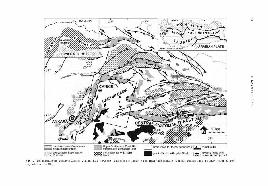
Fig. 1. Tectonostratigraphic map of Central Anatolia. Box shows the location of the Cankırı Basin. Inset maps indicate the major tectonic units in Turkey (modified fromKaymakci et al. 2000).
N.
KA
YM
AK
CI
ET
AL
.68
closing under compressional deformation. Recentstudies in the southern tip of the Kırsheir Blockin Nigde Massif indicates that the exhumation of theKırsehir Block took place in the early Cenozoic(Whitney et al. 2001; Gautier et al. 2002). Exhuma-tion of the Kırsehir Block during compressional defor-mation to its northern margin raises a questionwhether: (1) there are two different collisionalphases separated by a period of extension whichexhumed the Kırsehir Block; or (2) exhumation tookplace during a continuous compressional deformation,due to collision, throughout the Paleocene to earliestMiocene, despite the exhumation of Kırsehir Block.In order to solve this problem, we here study theCankırı basin, which has a continuous sedimentaryhistory from Campanian to Miocene. Therefore, ithas a sedimentary sequence that was depositedduring the arc-continent collision, exhumation andfinal closure of the Neotethys, and may thus provideessential time constraints for the complex closure-history of the Neotethys Ocean. Therefore, thescope of this paper is documenting the tectonostrati-graphy of the Cankırı Basin in order to understandits evolution, which will, subsequently, shed light onthe terminal subduction of the Neotethys, timing ofcollision of the Kırsehir Block and the Pontides, andevents related to post-collisional convergence inthe region.
Geological setting
The Cankırı Basin is located within the Izmir–Ankara–Erzincan Suture Zone and is underlain byan upper Cretaceous ophiolitic melange and grani-toids of the Kırsehir Block (Figs 1, 2).
The ophiolitic melange can be considered as thesubduction complex that resulted from accretion ofvarious lithologies during the subduction of theNeotethys oceanic crust. It includes lithologiesderived from both the overriding and subductingplates, together with trench deposits. It also com-prises ensimatic island arc and ocean island materialembedded within the ophiolitc melange (Tuysuzet al. 1995; Rojay et al. 2001, 2004; Rice et al.2006), which formed during the late Cretaceous. Pre-sently, the western, northern and eastern margins ofthe basin are delimited by the ophiolitic melange andthe Karakaya Complex which belongs to the SakaryaContinent and are collectively called as ‘rim’ of thebasin in an omega shape, while, in the south, it isdelimited by the granitoids of the Kırsehir Block(Fig. 1).
In the southern part of the basin, there are iso-lated outcrops of ophiolite-related rocks whichinclude pelagic limestones, radiolarites andsheeted dyke complexes (Fig. 2), intruded by thegranitoids (e.g. Sulakyurt Granitoid) of the Kırsehir
Block. Briefly, the basin is floored by the NAOMand the Sulakyurt Granitoid; therefore, they aredesignated as the basement of the Cankırı Basin inthis study.
Stratigraphy
In the Cankırı Basin two depositional sequences areexposed. These sequences are separated from eachother with a local unconformity. Stratigraphically,there is no major depositional break between theupper Cretaceous and the Cenozoic units of theCankırı Basin, despite the fact that the lower tomiddle Paleocene is missing in its southwesternand eastern margins. In the northwestern and north-ern parts of the basin, however, local unconformitiesare very common, the upper Cretaceous and Ceno-zoic units can be regarded as stratigraphically con-formable as biostratigraphically no hiatus can bedemonstrated between these sequences (Fig. 3).
Basement
North Anatolian Ophiolitic Melange
(NAOM, upper Cretaceous)
Northern central Anatolia is dominated by a numberof ophiolitic belts with various rock constituents.Previous researchers named these ophiolitic unitsbased on their present day geographic locations,the rock constituents and inferred oceanic domainof their origin. Rojay (1993, 1995) proposed a gen-eralized and descriptive nomenclature for all of theophiolite bearing units in north-central Anatoliawithout consideration of local constituent litholo-gies, age and inferred tectonic setting. For simpli-city, the nomenclature of Rojay (1995) is adoptedin this study.
The NAOM is exposed along all the margins ofthe Cankırı Basin including the southern marginwhere it is intruded by the Sulakyurt granitoid andexposed as patchy outcrops overlying the meta-morphic continental basement rocks of the KirsehirBlock (see Fig. 2). In the central part of the basin, theNOAM is encountered in an exploration well at adepth of 3566 m (Topuzsaray-I, Fig. 2). Therefore,it is underlying most of the Cankırı Basin. Boundaryrelationships of the NAOM with other units of theCankırı Basin are summarized in Figure 4.
Lithologically, the NAOM is composed of a tec-tonic mixture mainly of spilites, pillow lavas,diabase dykes, red to purple radiolarian chert,cherty limestone, reddish pelagic mudstone andvarious serpentinized ultramafic rocks includingperidotites, harzburgites and pyroxenites. TheNAOM also includes layered gabbros, plagiogra-nites and various limestones derived from nearby
CANKIRI BASIN AND THE NEOTETHYAN SUTURE 69
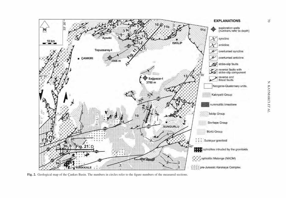
Fig. 2. Geological map of the Cankırı Basin. The numbers in circles refer to the figure numbers of the measured sections.
N.
KA
YM
AK
CI
ET
AL
.70
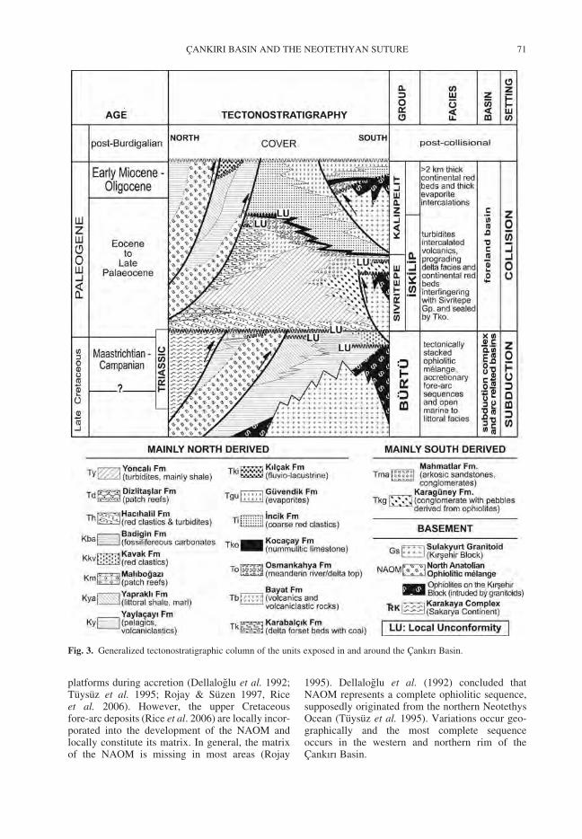
platforms during accretion (Dellaloglu et al. 1992;Tuysuz et al. 1995; Rojay & Suzen 1997, Riceet al. 2006). However, the upper Cretaceousfore-arc deposits (Rice et al. 2006) are locally incor-porated into the development of the NAOM andlocally constitute its matrix. In general, the matrixof the NAOM is missing in most areas (Rojay
1995). Dellaloglu et al. (1992) concluded thatNAOM represents a complete ophiolitic sequence,supposedly originated from the northern NeotethysOcean (Tuysuz et al. 1995). Variations occur geo-graphically and the most complete sequenceoccurs in the western and northern rim of theCankırı Basin.
Fig. 3. Generalized tectonostratigraphic column of the units exposed in and around the Cankırı Basin.
CANKIRI BASIN AND THE NEOTETHYAN SUTURE 71
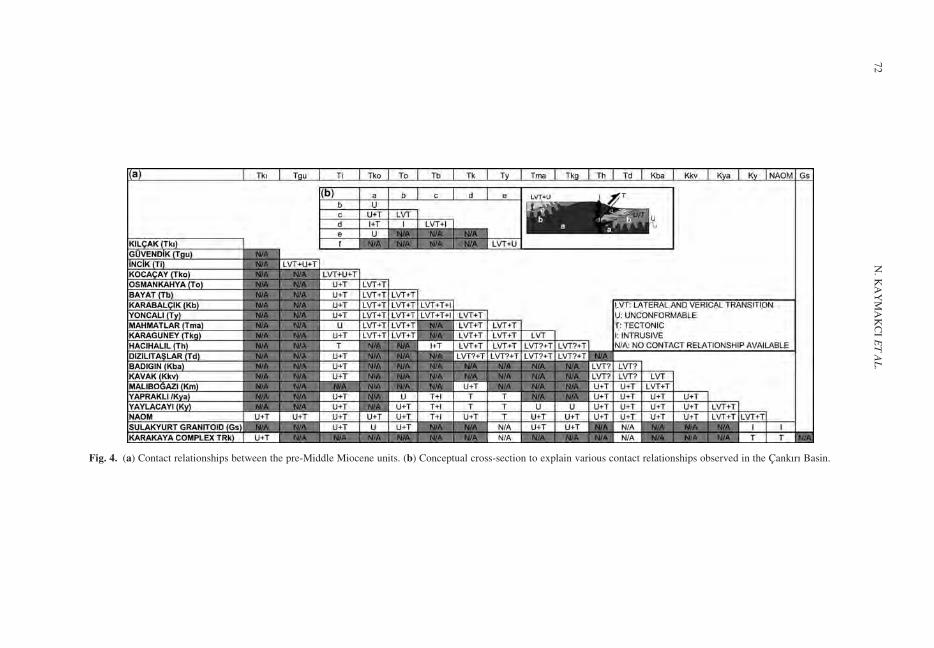
Fig. 4. (a) Contact relationships between the pre-Middle Miocene units. (b) Conceptual cross-section to explain various contact relationships observed in the Cankırı Basin.
N.
KA
YM
AK
CI
ET
AL
.72
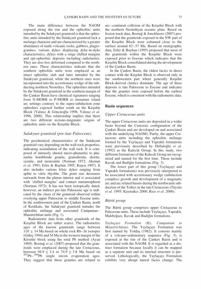
The main difference between the NAOMexposed along the rim and the ophiolitic unitsintruded by the Sulakyurt granitoid is that the ophio-litic units intruded by the Sulakyurt granitoid lack amelange character and are characterized by a greaterabundance of mafic volcanic rocks, gabbros, plagio-granites, various dykes displaying dyke-in-dykecharacteristics, dykes with a singe chilled marginsand epi-ophiolitic deposits including radiolarites.They are also less deformed compared to the north-ern ones. These characteristics indicate that thesouthern ophiolitic units were emplaced as anintact ophiolitic slab and later intruded by theSulakyurt granitoid, while the northern ones wereincorporated into the accretionary wedge of the sub-ducting northern Neotethys. The ophiolites intrudedby the Sulakyurt granitoid in the southern margin ofthe Cankırı Basin have chemical signatures rangingfrom N-MORB to P-MORB to immature islandarc settings contrary to the supra-subduction zoneophiolites exposed further south on the KırsehirBlock (Yalınız & Goncuoglu 1998; Yalınız et al.1996, 2000). This relationship implies that thereare two different tectono-magmatic origins ofophiolitic units on the Kırsehir Block.
Sulakyurt granitoid (pre-late Paleocene)
The geochemical characteristics of the Sulakyurtgranitoid vary depending on the wall-rock properties,indicating assimilation of the wall rock. It is com-posed of intensely altered micro-phanaritic to pha-naritic hornblende granite, granodiorite, diorite,syenite, and monzonite (Norman 1972; Akımanet al. 1993; Erler & Bayhan 1995; Kuscu 1997). Italso includes various felsic dykes ranging fromaplite to vitric rhyolite. The grain size decreasesoutwards from the pluton interior and is associatedwith ‘chilled margins’ and contact metamorphism(Norman 1972). It has not been isotopically dated,however, an indirect pre-late Paleocene age is indi-cated by the clasts of the granitoid observed withinoverlying upper Paleocene to middle Eocene units.In the southwestern part of the Cankırı Basin, northof Kırıkkale, the Sulakyurt granitoid intrudes theophiolitic melange and associated Campanian–Maastrichtian units (Fig. 1).
Radiometric data from other granitoids of theKırsehir Block are rather scarce. The radiometricages of the known granitoids range between110 + 14 Ma based on whole rock Rb–Sr isotopes(Gulec 1994) and 54 Ma in the western margin of theKirsehir block using the total Pb method (Ayan1969). Boztug et al. (2007) proposed that the gran-itoids were emplaced during the late Cretaceous,between 94.9 + 3.4 to 74.9 + 3.8 Ma based on207Pb–206Pb single zircon evaporation ages.They suggest that these granites are related to
arc–continent collision of the Kırsehir Block withthe northern Neotethyan oceanic plate. Based onfission track data, Boztug & Jonckheere (2007) pro-posed that the granitoids exposed in the NW part ofthe Kırsehir Block were exhumed close to thesurface around 62–57 Ma. Based on stratigraphicdata, Erler & Bayhan (1995) proposed that most ofthe granitoids within the Kırsehir Block wereexposed prior to Eocene which indicates that theKırsehir Block consolidated during the developmentof the Cankırı Basin.
In the Cankırı Basin, the oldest facies in directcontact with the Kırsehir Block is observed only inthe southwestern part where generally KırsehirBlock-derived clastics dominate. The age of thesedeposits is late Paleocene to Eocene and indicatesthat the granites were exposed before the earliestEocene, which is consistent with the radiometric data.
Basin sequences
Upper Cretaceous units
The upper Cretaceous units are deposited in a widerbasin beyond the Cenozoic configuration of theCankırı Basin and are developed on and associatedwith the underlying NAOM). Partly, the upper Cre-taceous units including the ophiolitic melangeformed by the Yaylacayı and Yapraklı formationswere previously described by Dellaloglu et al.(1992) as the Kalecik Group. In this study, twodifferent formations of the Kalecik Group are recog-nized and named for the first time. These includeKavak and Badigin formations (Fig. 3).
The lower part of this group (Yaylacayi andYapraklı formations) was previously interpreted tobe associated with accretionary wedge (subductioncomplex) growth and development of a magmaticarc and arc related basins during the northwards sub-duction of the Tethys in the late Cretaceous (Tuysuzet al. 1995; Kaymakcı 2000; Rice et al. 2006).
Burtu group
The Burtu group comprises upper Cretaceous toPaleocene units. These include Yaylacayı, Yapraklı,Malıbogazı, Kavak and Badigin formations.
Yaylacayı Formation (Ky, Campanian toMaastrichtian). The Yaylacayı Formation wasfirst named by Yoldas (1982). It consists mainlyof a volcano-sedimentary sequence (Fig. 5), isexposed at the rim of the Cankırı Basin and isassociated with the NAOM. It is regarded as a dis-tinct formation because locally it can be mappedas a separate unit and its internal structure is pre-served. Lithologically, the Yaylacayı Formationexhibits very abrupt lateral facies change. The
CANKIRI BASIN AND THE NEOTETHYAN SUTURE 73
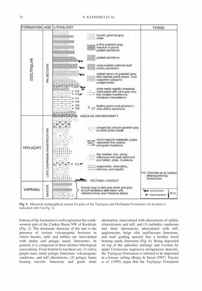
bottom of the formation is well exposed at the south-western part of the Cankırı Basin NW of Kırıkkale(Fig. 2). The dominant character of the unit is thepresence of various volcanogenic horizons inwhich basalts, tuffs and tuffites are intercalatedwith shales and pelagic marly limestones. Ingeneral, it is composed of three distinct lithologicalassociations. From bottom to top these are: (1) red topurple marl, marly pelagic limestone, volcanogenicsandstone, and tuff alternations; (2) pelagic faunabearing micritic limestone and green shale
alternation, intercalated with alternations of spiliticolistostromes and tuff; and (3) turbiditic sandstoneand shale alternations intercalated with tuff,agglomerate, beige silty argillaceous limestone,and marl grading upward into a benthic fossilbearing sandy limestone (Fig. 6). Being depositedon top of the ophiolitic melange and overlain byupper Cretaceous regressive terrigeneous deposits,the Yaylacayı Formation is inferred to be depositedin a forearc setting (Rojay & Suzen 1997). Tuysuzet al. (1995) argue that the Yaylacayı Formation
Fig. 5. Measured stratigraphical section for parts of the Yaylacayı and Dizilitaslar Formations (its location isindicated with 5 in Fig. 2).
N. KAYMAKCI ET AL.74
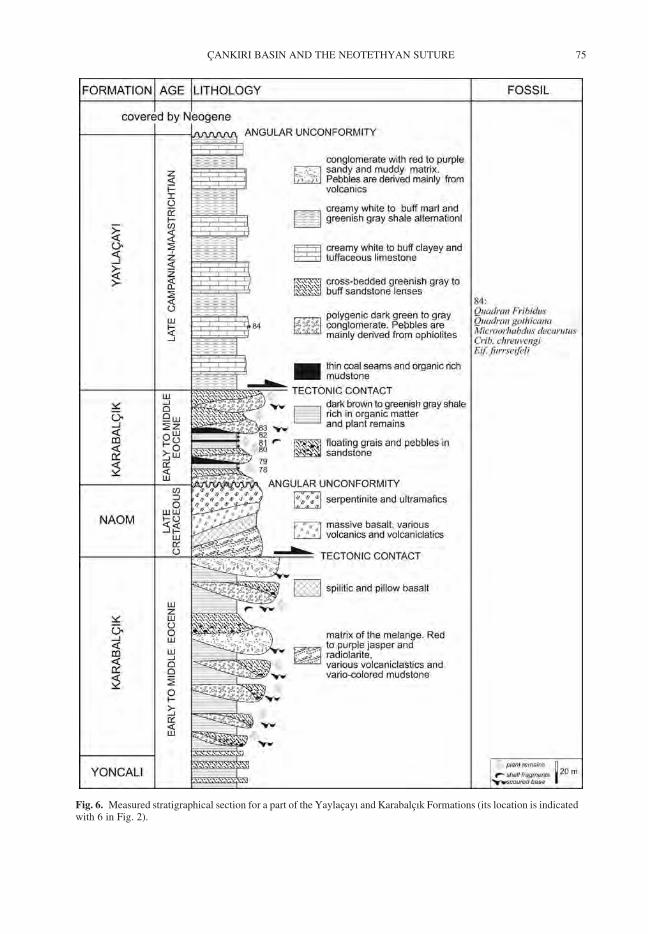
Fig. 6. Measured stratigraphical section for a part of the Yaylacayı and Karabalcık Formations (its location is indicatedwith 6 in Fig. 2).
CANKIRI BASIN AND THE NEOTETHYAN SUTURE 75
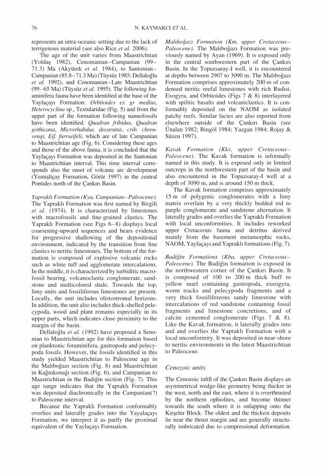
represents an intra-oceanic setting due to the lack ofterrigenous material (see also Rice et al. 2006).
The age of the unit varies from Maastrichtian(Yoldas 1982), Cenomanian–Campanian (99–71.3) Ma (Akyurek et al. 1984), to Santonian–Campanian (85.8–71.3 Ma) (Tuysuz 1985; Dellalogluet al. 1992), and Cenomanian–Late Maastrichtian(99–65 Ma) (Tuysuz et al. 1995). The following for-aminifera fauna have been identified at the base of theYaylacayı Formation: Orbitoides ex gr medius,Heterocyclina sp., Textularidae (Fig. 5) and from theupper part of the formation following nannofossilshave been identified: Quadran fribidus, Quadrangothicana, Microrhabdus, decarutus, crib. chreu-vengi, Eif. furrseifeli, which are of late Campanianto Maastrichtian age (Fig. 6). Considering these agesand those of the above fauna, it is concluded that theYaylacayı Formation was deposited in the Santonianto Maastrichtian interval. This time interval corre-sponds also the onset of volcanic arc development(Yemislicay Formation, Gorur 1997) in the centralPontides north of the Cankırı Basin.
Yapraklı Formation (Kya, Campanian–Paleocene).The Yapraklı Formation was first named by Birgiliet al. (1974). It is characterized by limestoneswith macrofossils and fine-grained clastics. TheYapraklı Formation (see Figs 6–8) displays localcoarsening-upward sequences and bears evidencefor progressive shallowing of the depositionalenvironment, indicated by the transition from fineclastics to neritic limestones. The bottom of the for-mation is composed of explosive volcanic rockssuch as white tuff and agglomerate intercalations.In the middle, it is characterized by turbiditic macro-fossil bearing, volcanoclastic conglomerate, sand-stone and multicolored shale. Towards the top,limy units and fossiliferous limestones are present.Locally, the unit includes olistostromal horizons.In addition, the unit also includes thick-shelled pele-cypoda, wood and plant remains especially in itsupper parts, which indicates close proximity to themargin of the basin.
Dellaloglu et al. (1992) have proposed a Seno-nian to Maastrichtian age for this formation basedon planktonic foraminifera, gastropoda and pelecy-poda fossils. However, the fossils identified in thisstudy yielded Maastrichtian to Paleocene age inthe Malıbogazı section (Fig. 8) and Maastrichtianin Kagnıkonagı section (Fig. 6), and Campanian toMaastrichtian in the Badigin section (Fig. 7). Thisage range indicates that the Yapraklı Formationwas deposited diachronically in the Campanian(?)to Paleocene interval.
Because the Yapraklı Formation conformablyoverlies and laterally grades into the YayalacayıFormation, we interpret it as partly the proximalequivalent of the Yaylacayı Formation.
Malıbogazı Formation (Km, upper Cretaceous–Paleocene). The Malıbogazı Formation was pre-viously named by Ayan (1969). It is exposed onlyin the central southwestern part of the CankırıBasin. In the Topuzsaray-I well, it is encounteredat depths between 2907 to 3090 m. The MalıbogazıFormation comprises approximately 200 m of con-densed neritic reefal limestones with rich Rudist,Exogyra, and Orbitoides (Figs 7 & 8) interlayeredwith spilitic basalts and volcaniclastics. It is con-formably deposited on the NAOM as isolatedpatchy reefs. Similar facies are also reported fromelsewhere outside of the Cankırı Basin (seeUnalan 1982; Bingol 1984; Yazgan 1984; Rojay &Suzen 1997).
Kavak Formation (Kkv, upper Cretaceous–Paleocene). The Kavak formation is informallynamed in this study. It is exposed only in limitedoutcrops in the northwestern part of the basin andalso encountered in the Topuzsaray-I well at adepth of 3090 m, and is around 150 m thick.
The Kavak formation comprises approximately15 m of polygenic conglomerates with a limymatrix overlain by a very thickly bedded red topurple conglomerate and sandstone alternation. Itlaterally grades and overlies the Yapraklı Formationwith local unconformities. It includes reworkedupper Cretaceous fauna and detritus derivedmainly from the basement metamorphic rocks,NAOM, Yaylacayı and Yapraklı formations (Fig. 7).
Badigin Formations (Kba, upper Cretaceous–Paleocene). The Badigin formation is exposed inthe northwestern corner of the Cankırı Basin. Itis composed of 100 to 200 m thick buff toyellow marl containing gastropoda, exeogyra,worm tracks and pelecypoda fragments and avery thick fossilifereous sandy limestone withintercalations of red sandstone containing fossilfragments and limestone concretions, and ofcalcite cemented conglomerate (Figs 7 & 8).Like the Kavak formation, it laterally grades intoand and overlies the Yapraklı Formation with alocal unconformity. It was deposited in near-shoreto neritic environments in the latest Maastrichtianto Paleocene.
Cenozoic units
The Cenozoic infill of the Cankırı Basin displays anasymmetrical wedge-like geometry being thicker inthe west, north and the east, where it is overthrustedby the northern ophiolites, and become thinnertowards the south where it is onlapping onto theKırsehir Block. The oldest and the thickest depositslie near the thrust margin and are generally structu-rally imbricated due to compressional deformation.
N. KAYMAKCI ET AL.76
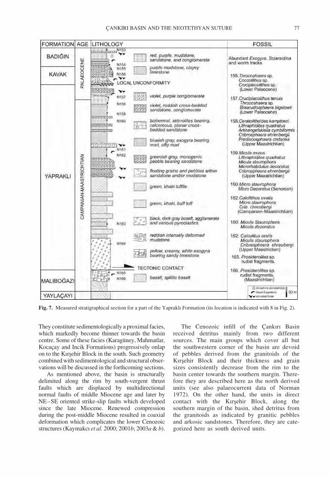
They constitute sedimentologically a proximal facies,which markedly become thinner towards the basincentre. Some of these facies (Karaguney, Mahmatlar,Kocacay and Incik Formations) progressively onlapon to the Kırsehir Block in the south. Such geometrycombined with sedimentological and structural obser-vations will be discussed in the forthcoming sections.
As mentioned above, the basin is structurallydelimited along the rim by south-vergent thrustfaults which are displaced by multidirectionalnormal faults of middle Miocene age and later byNE–SE oriented strike-slip faults which developedsince the late Miocene. Renewed compressionduring the post-middle Miocene resulted in coaxialdeformation which complicates the lower Cenozoicstructures (Kaymakcı et al. 2000; 2001b; 2003a & b).
The Cenozoic infill of the Cankırı Basinreceived detritus mainly from two differentsources. The main groups which cover all butthe southwestern corner of the basin are devoidof pebbles derived from the granitoids of theKırsehir Block and their thickness and grainsizes consistently decrease from the rim to thebasin center towards the southern margin. There-fore they are described here as the north derivedunits (see also palaeocurrent data of Norman1972). On the other hand, the units in directcontact with the Kırsehir Block, along thesouthern margin of the basin, shed detritus fromthe granitoids as indicated by granitic pebblesand arkosic sandstones. Therefore, they are cate-gorized here as south derived units.
Fig. 7. Measured stratigraphical section for a part of the Yapraklı Formation (its location is indicated with 8 in Fig. 2).
CANKIRI BASIN AND THE NEOTETHYAN SUTURE 77
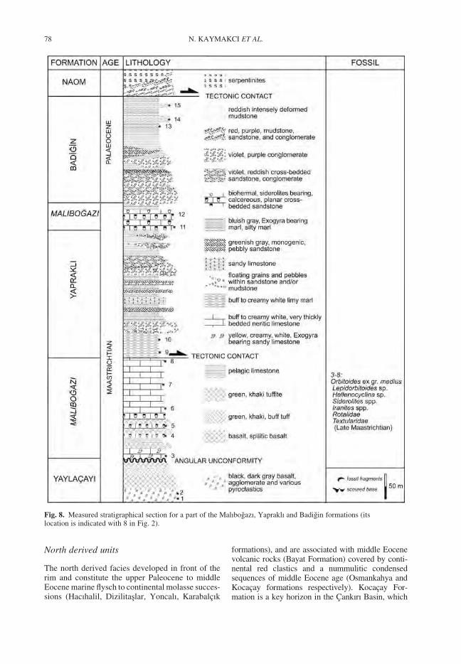
North derived units
The north derived facies developed in front of therim and constitute the upper Paleocene to middleEocene marine flysch to continental molasse succes-sions (Hacıhalil, Dizilitaslar, Yoncalı, Karabalcık
formations), and are associated with middle Eocenevolcanic rocks (Bayat Formation) covered by conti-nental red clastics and a nummulitic condensedsequences of middle Eocene age (Osmankahya andKocacay formations respectively). Kocacay For-mation is a key horizon in the Cankırı Basin, which
Fig. 8. Measured stratigraphical section for a part of the Malıbogazı, Yapraklı and Badigin formations (itslocation is indicated with 8 in Fig. 2).
N. KAYMAKCI ET AL.78
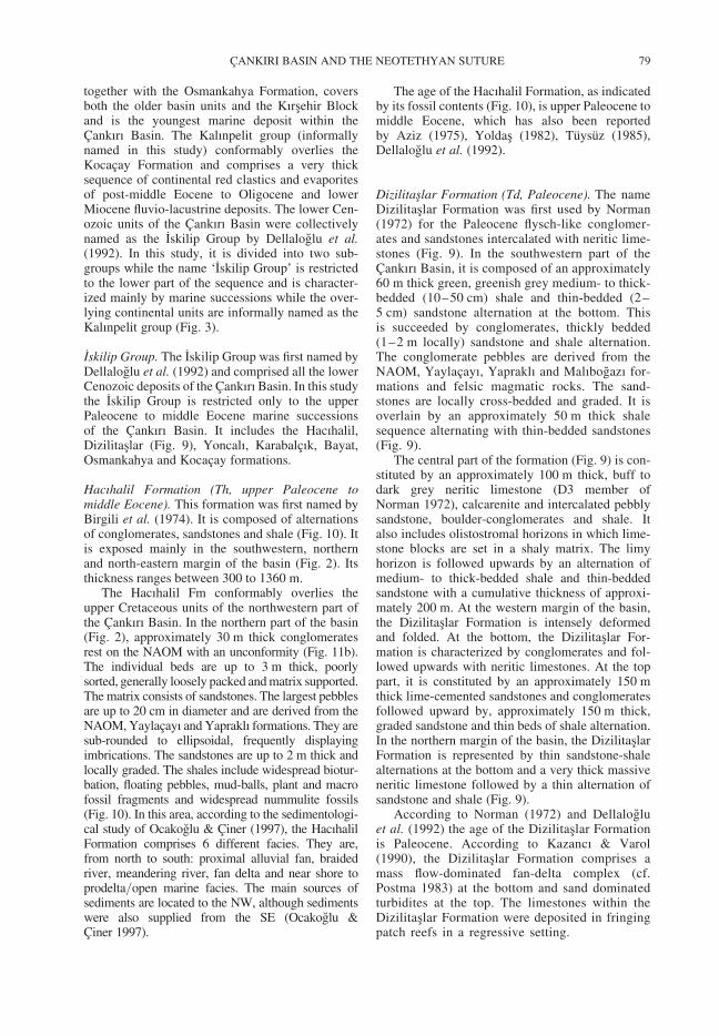
together with the Osmankahya Formation, coversboth the older basin units and the Kırsehir Blockand is the youngest marine deposit within theCankırı Basin. The Kalınpelit group (informallynamed in this study) conformably overlies theKocacay Formation and comprises a very thicksequence of continental red clastics and evaporitesof post-middle Eocene to Oligocene and lowerMiocene fluvio-lacustrine deposits. The lower Cen-ozoic units of the Cankırı Basin were collectivelynamed as the Iskilip Group by Dellaloglu et al.(1992). In this study, it is divided into two sub-groups while the name ‘Iskilip Group’ is restrictedto the lower part of the sequence and is character-ized mainly by marine successions while the over-lying continental units are informally named as theKalınpelit group (Fig. 3).
Iskilip Group. The Iskilip Group was first named byDellaloglu et al. (1992) and comprised all the lowerCenozoic deposits of the Cankırı Basin. In this studythe Iskilip Group is restricted only to the upperPaleocene to middle Eocene marine successionsof the Cankırı Basin. It includes the Hacıhalil,Dizilitaslar (Fig. 9), Yoncalı, Karabalcık, Bayat,Osmankahya and Kocacay formations.
Hacıhalil Formation (Th, upper Paleocene tomiddle Eocene). This formation was first named byBirgili et al. (1974). It is composed of alternationsof conglomerates, sandstones and shale (Fig. 10). Itis exposed mainly in the southwestern, northernand north-eastern margin of the basin (Fig. 2). Itsthickness ranges between 300 to 1360 m.
The Hacıhalil Fm conformably overlies theupper Cretaceous units of the northwestern part ofthe Cankırı Basin. In the northern part of the basin(Fig. 2), approximately 30 m thick conglomeratesrest on the NAOM with an unconformity (Fig. 11b).The individual beds are up to 3 m thick, poorlysorted, generally loosely packed and matrix supported.The matrix consists of sandstones. The largest pebblesare up to 20 cm in diameter and are derived from theNAOM, Yaylacayı and Yapraklı formations. They aresub-rounded to ellipsoidal, frequently displayingimbrications. The sandstones are up to 2 m thick andlocally graded. The shales include widespread biotur-bation, floating pebbles, mud-balls, plant and macrofossil fragments and widespread nummulite fossils(Fig. 10). In this area, according to the sedimentologi-cal study of Ocakoglu & Ciner (1997), the HacıhalilFormation comprises 6 different facies. They are,from north to south: proximal alluvial fan, braidedriver, meandering river, fan delta and near shore toprodelta/open marine facies. The main sources ofsediments are located to the NW, although sedimentswere also supplied from the SE (Ocakoglu &Ciner 1997).
The age of the Hacıhalil Formation, as indicatedby its fossil contents (Fig. 10), is upper Paleocene tomiddle Eocene, which has also been reportedby Aziz (1975), Yoldas (1982), Tuysuz (1985),Dellaloglu et al. (1992).
Dizilitaslar Formation (Td, Paleocene). The nameDizilitaslar Formation was first used by Norman(1972) for the Paleocene flysch-like conglomer-ates and sandstones intercalated with neritic lime-stones (Fig. 9). In the southwestern part of theCankırı Basin, it is composed of an approximately60 m thick green, greenish grey medium- to thick-bedded (10–50 cm) shale and thin-bedded (2–5 cm) sandstone alternation at the bottom. Thisis succeeded by conglomerates, thickly bedded(1–2 m locally) sandstone and shale alternation.The conglomerate pebbles are derived from theNAOM, Yaylacayı, Yapraklı and Malıbogazı for-mations and felsic magmatic rocks. The sand-stones are locally cross-bedded and graded. It isoverlain by an approximately 50 m thick shalesequence alternating with thin-bedded sandstones(Fig. 9).
The central part of the formation (Fig. 9) is con-stituted by an approximately 100 m thick, buff todark grey neritic limestone (D3 member ofNorman 1972), calcarenite and intercalated pebblysandstone, boulder-conglomerates and shale. Italso includes olistostromal horizons in which lime-stone blocks are set in a shaly matrix. The limyhorizon is followed upwards by an alternation ofmedium- to thick-bedded shale and thin-beddedsandstone with a cumulative thickness of approxi-mately 200 m. At the western margin of the basin,the Dizilitaslar Formation is intensely deformedand folded. At the bottom, the Dizilitaslar For-mation is characterized by conglomerates and fol-lowed upwards with neritic limestones. At the toppart, it is constituted by an approximately 150 mthick lime-cemented sandstones and conglomeratesfollowed upward by, approximately 150 m thick,graded sandstone and thin beds of shale alternation.In the northern margin of the basin, the DizilitaslarFormation is represented by thin sandstone-shalealternations at the bottom and a very thick massiveneritic limestone followed by a thin alternation ofsandstone and shale (Fig. 9).
According to Norman (1972) and Dellalogluet al. (1992) the age of the Dizilitaslar Formationis Paleocene. According to Kazancı & Varol(1990), the Dizilitaslar Formation comprises amass flow-dominated fan-delta complex (cf.Postma 1983) at the bottom and sand dominatedturbidites at the top. The limestones within theDizilitaslar Formation were deposited in fringingpatch reefs in a regressive setting.
CANKIRI BASIN AND THE NEOTETHYAN SUTURE 79
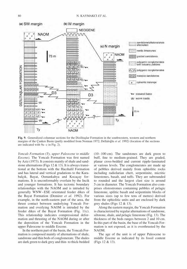
Yoncalı Formation (Ty, upper Paleocene to middleEocene). The Yoncalı Formation was first namedby Aziz (1973). It consists mainly of shale and sand-stone alternations (Figs 12 & 13). It is always transi-tional at the bottom with the Hacıhalil Formationand has lateral and vertical gradations to the Kara-balcık, Bayat, Osmankahya and Kocacay for-mations. It is unconformably overlain by the Incikand younger formations. It has tectonic boundaryrelationships with the NAOM and is intruded bygenerally WNW–ESE orientated feeder dikes ofthe Bayat Formation (Demirer et al. 1992). Forexample, in the north-eastern part of the area, thethrust contact between underlying Yoncalı For-mation and overlying NAOM is intruded by thefeeder dikes of the Bayat Formation (Fig. 11c).This relationship indicates compressional defor-mation and thrusting of the NAOM during or afterthe deposition of the Yoncalı Formation in theupper Paleocene to middle Eocene.
In the northern part of the basin, the Yoncalı For-mation is composed mainly of alternations of shale,sandstone and thin beds of conglomerate. The shalesare dark green to dark grey and thin- to thick-bedded
(10–100 cm). The sandstones are dark green tobuff, fine to medium-grained. They are graded,planar cross-bedded and current ripple-laminatedat various levels. The conglomerates are made upof pebbles derived mainly from ophiolitic rocksincluding radiolarian chert, serpentinite, micriticlimestones, basalt, and tuffs. They are subroundedto rounded and the largest clast size is around5 cm in diameter. The Yoncalı Formation also com-prises olistostromes containing pebbles of pelagiclimestone, spilitic basalt and serpentinite blocks ofvarious sizes (up to few tens of metres) derivedfrom the ophiolitic units and are enclosed by darkgrey shales (Figs 12 & 13).
Along the eastern margin, the Yoncalı Formationis characterized by regular alternations of sandstone,siltstone, shale, and pelagic limestone (Fig. 13). Thethickness of the beds ranges between 2 and 10 cm.In this part of the basin, the base of the Yoncalı For-mation is not exposed, as it is overthrusted by theNAOM.
The age of the unit is of upper Paleocene tomiddle Eocene as indicated by its fossil content(Figs 12 & 13).
Fig. 9. Generalized columnar sections for the Dizilitaslar Formation in the southwestern, western and northernmargins of the Cankırı Basin (partly modified from Norman 1972; Dellaloglu et al. 1992) (location of the sectionsare indicated with 9a–c in Fig. 2).
N. KAYMAKCI ET AL.80
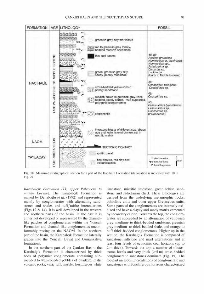
Karabalcık Formation (Tk, upper Paleocene tomiddle Eocene). The Karabalcık Formation isnamed by Dellaloglu et al. (1992) and representedmainly by conglomerates with alternating sand-stones and shales and tuff/tuffite intercalations(Figs 12 & 14). It is well developed in the westernand northern parts of the basin. In the east it iseither not developed or represented by the channel-like patches of conglomerates within the YoncalıFormation and channel-like conglomerates uncon-formably resting on the NAOM. In the northernpart of the basin, the Karabalcık Formation laterallygrades into the Yoncalı, Bayat and Osmankahyaformations.
In the northern part of the Cankırı Basin, theKarabalcık Formation is characterized by thickbeds of polymict conglomerate containing sub-rounded to well-rounded pebbles of quartzite, maficvolcanic rocks, vitric tuff, marble, fossiliferous white
limestone, micritic limestone, green schist, sand-stone and radiolarian chert. These lithologies arederived from the underlying metamorphic rocks,ophiolitic units and other upper Cretaceous units.Some parts of the conglomerates are intensely oxi-dized and have a clayey and sandy matrix cementedby secondary calcite. Towards the top, the conglom-erates are succeeded by an alternation of yellowishgrey, medium- to thick-bedded sandstone, greenishgrey medium- to thick-bedded shale, and orange tobuff thick-bedded conglomerates. Higher up in thesection, the Karabalcık Formation is composed ofsandstone, siltstone and marl alternations and atleast four levels of economic coal horizons (up to2 m thick). Towards the top, a number of olistos-trome levels and very thick (.5 m) cross-beddedconglomeratic sandstones dominate (Fig. 15). Thetop part includes intercalations of conglomerate andsandstones with fossiliferous horizons characterized
Fig. 10. Measured stratigraphical section for a part of the Hacıhalil Formation (its location is indicated with 10 inFig. 2).
CANKIRI BASIN AND THE NEOTETHYAN SUTURE 81
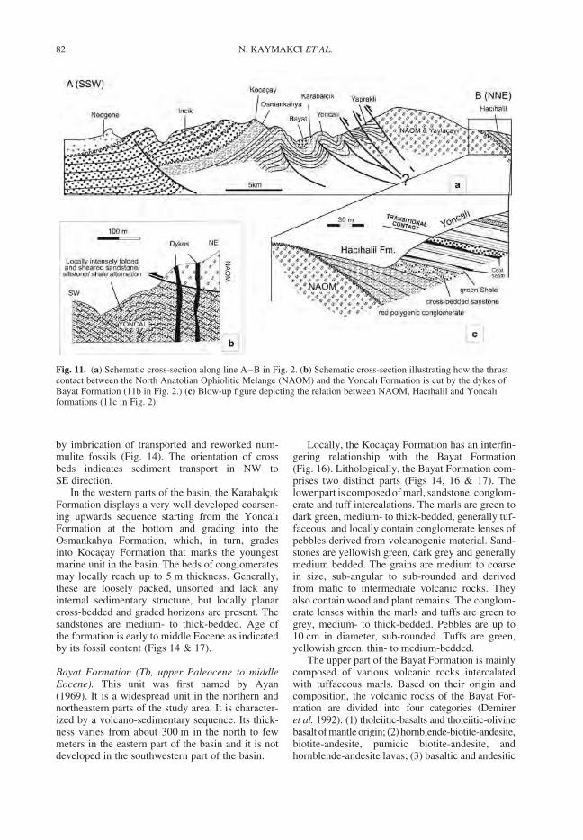
by imbrication of transported and reworked num-mulite fossils (Fig. 14). The orientation of crossbeds indicates sediment transport in NW toSE direction.
In the western parts of the basin, the KarabalcıkFormation displays a very well developed coarsen-ing upwards sequence starting from the YoncalıFormation at the bottom and grading into theOsmankahya Formation, which, in turn, gradesinto Kocacay Formation that marks the youngestmarine unit in the basin. The beds of conglomeratesmay locally reach up to 5 m thickness. Generally,these are loosely packed, unsorted and lack anyinternal sedimentary structure, but locally planarcross-bedded and graded horizons are present. Thesandstones are medium- to thick-bedded. Age ofthe formation is early to middle Eocene as indicatedby its fossil content (Figs 14 & 17).
Bayat Formation (Tb, upper Paleocene to middleEocene). This unit was first named by Ayan(1969). It is a widespread unit in the northern andnortheastern parts of the study area. It is character-ized by a volcano-sedimentary sequence. Its thick-ness varies from about 300 m in the north to fewmeters in the eastern part of the basin and it is notdeveloped in the southwestern part of the basin.
Locally, the Kocacay Formation has an interfin-gering relationship with the Bayat Formation(Fig. 16). Lithologically, the Bayat Formation com-prises two distinct parts (Figs 14, 16 & 17). Thelower part is composed of marl, sandstone, conglom-erate and tuff intercalations. The marls are green todark green, medium- to thick-bedded, generally tuf-faceous, and locally contain conglomerate lenses ofpebbles derived from volcanogenic material. Sand-stones are yellowish green, dark grey and generallymedium bedded. The grains are medium to coarsein size, sub-angular to sub-rounded and derivedfrom mafic to intermediate volcanic rocks. Theyalso contain wood and plant remains. The conglom-erate lenses within the marls and tuffs are green togrey, medium- to thick-bedded. Pebbles are up to10 cm in diameter, sub-rounded. Tuffs are green,yellowish green, thin- to medium-bedded.
The upper part of the Bayat Formation is mainlycomposed of various volcanic rocks intercalatedwith tuffaceous marls. Based on their origin andcomposition, the volcanic rocks of the Bayat For-mation are divided into four categories (Demireret al. 1992): (1) tholeiitic-basalts and tholeiitic-olivinebasalt of mantle origin; (2) hornblende-biotite-andesite,biotite-andesite, pumicic biotite-andesite, andhornblende-andesite lavas; (3) basaltic and andesitic
Fig. 11. (a) Schematic cross-section along line A–B in Fig. 2. (b) Schematic cross-section illustrating how the thrustcontact between the North Anatolian Ophiolitic Melange (NAOM) and the Yoncalı Formation is cut by the dykes ofBayat Formation (11b in Fig. 2.) (c) Blow-up figure depicting the relation between NAOM, Hacıhalil and Yoncalıformations (11c in Fig. 2).
N. KAYMAKCI ET AL.82
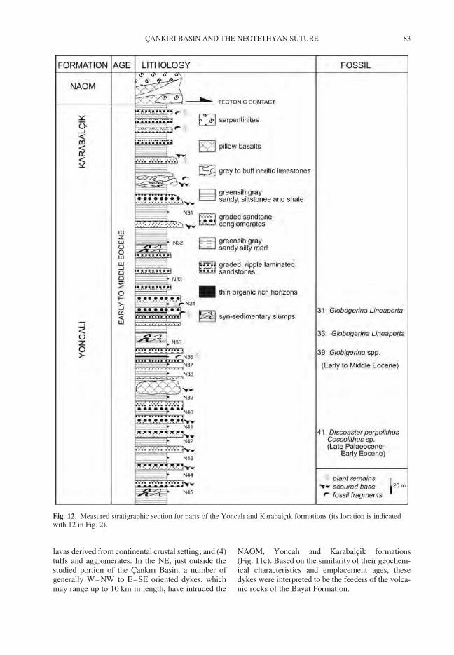
lavas derived from continental crustal setting; and (4)tuffs and agglomerates. In the NE, just outside thestudied portion of the Cankırı Basin, a number ofgenerally W–NW to E–SE oriented dykes, whichmay range up to 10 km in length, have intruded the
NAOM, Yoncalı and Karabalcik formations(Fig. 11c). Based on the similarity of their geochem-ical characteristics and emplacement ages, thesedykes were interpreted to be the feeders of the volca-nic rocks of the Bayat Formation.
Fig. 12. Measured stratigraphic section for parts of the Yoncalı and Karabalcık formations (its location is indicatedwith 12 in Fig. 2).
CANKIRI BASIN AND THE NEOTETHYAN SUTURE 83
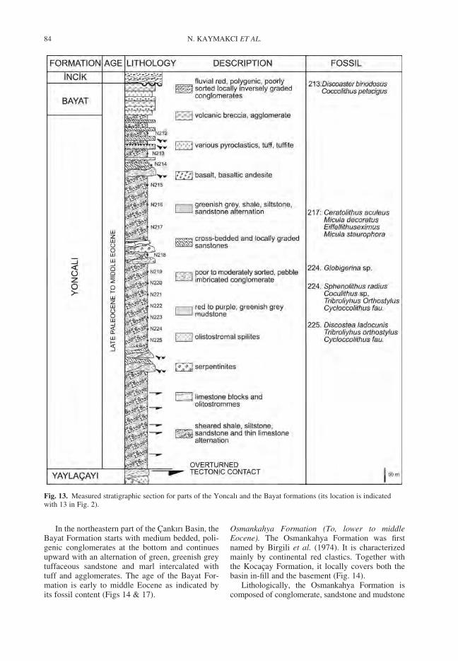
In the northeastern part of the Cankırı Basin, theBayat Formation starts with medium bedded, poli-genic conglomerates at the bottom and continuesupward with an alternation of green, greenish greytuffaceous sandstone and marl intercalated withtuff and agglomerates. The age of the Bayat For-mation is early to middle Eocene as indicated byits fossil content (Figs 14 & 17).
Osmankahya Formation (To, lower to middleEocene). The Osmankahya Formation was firstnamed by Birgili et al. (1974). It is characterizedmainly by continental red clastics. Together withthe Kocacay Formation, it locally covers both thebasin in-fill and the basement (Fig. 14).
Lithologically, the Osmankahya Formation iscomposed of conglomerate, sandstone and mudstone
Fig. 13. Measured stratigraphic section for parts of the Yoncalı and the Bayat formations (its location is indicatedwith 13 in Fig. 2).
N. KAYMAKCI ET AL.84
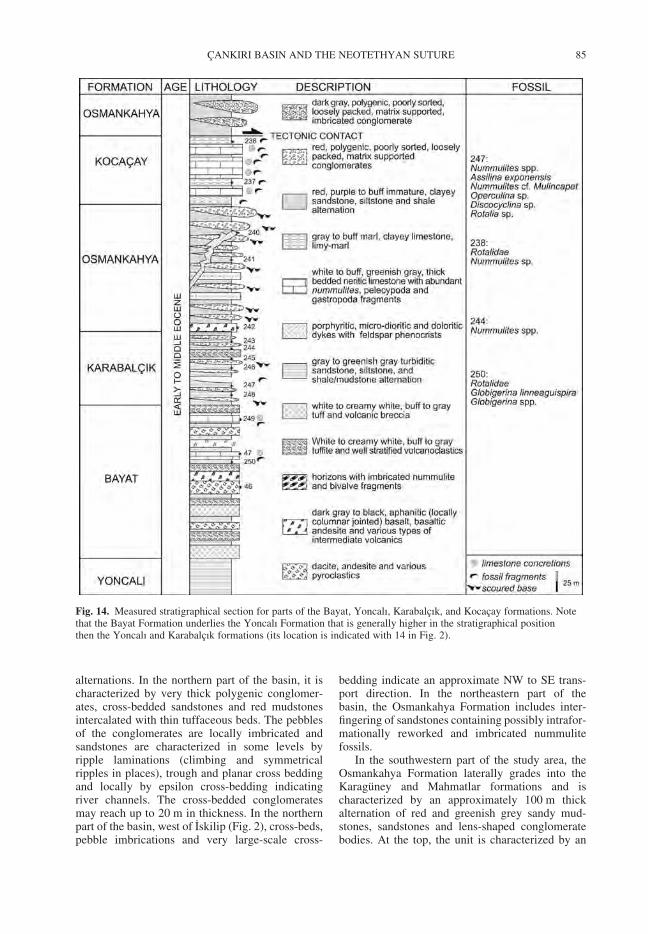
alternations. In the northern part of the basin, it ischaracterized by very thick polygenic conglomer-ates, cross-bedded sandstones and red mudstonesintercalated with thin tuffaceous beds. The pebblesof the conglomerates are locally imbricated andsandstones are characterized in some levels byripple laminations (climbing and symmetricalripples in places), trough and planar cross beddingand locally by epsilon cross-bedding indicatingriver channels. The cross-bedded conglomeratesmay reach up to 20 m in thickness. In the northernpart of the basin, west of Iskilip (Fig. 2), cross-beds,pebble imbrications and very large-scale cross-
bedding indicate an approximate NW to SE trans-port direction. In the northeastern part of thebasin, the Osmankahya Formation includes inter-fingering of sandstones containing possibly intrafor-mationally reworked and imbricated nummulitefossils.
In the southwestern part of the study area, theOsmankahya Formation laterally grades into theKaraguney and Mahmatlar formations and ischaracterized by an approximately 100 m thickalternation of red and greenish grey sandy mud-stones, sandstones and lens-shaped conglomeratebodies. At the top, the unit is characterized by an
Fig. 14. Measured stratigraphical section for parts of the Bayat, Yoncalı, Karabalcık, and Kocacay formations. Notethat the Bayat Formation underlies the Yoncalı Formation that is generally higher in the stratigraphical positionthen the Yoncalı and Karabalcık formations (its location is indicated with 14 in Fig. 2).
CANKIRI BASIN AND THE NEOTETHYAN SUTURE 85
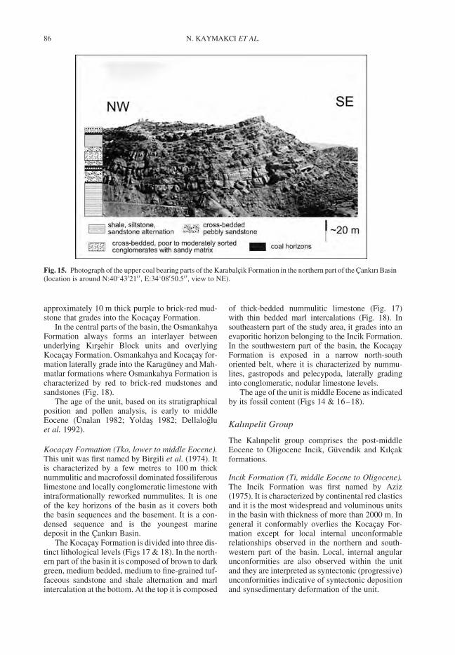
approximately 10 m thick purple to brick-red mud-stone that grades into the Kocacay Formation.
In the central parts of the basin, the OsmankahyaFormation always forms an interlayer betweenunderlying Kırsehir Block units and overlyingKocacay Formation. Osmankahya and Kocacay for-mation laterally grade into the Karaguney and Mah-matlar formations where Osmankahya Formation ischaracterized by red to brick-red mudstones andsandstones (Fig. 18).
The age of the unit, based on its stratigraphicalposition and pollen analysis, is early to middleEocene (Unalan 1982; Yoldas 1982; Dellalogluet al. 1992).
Kocacay Formation (Tko, lower to middle Eocene).This unit was first named by Birgili et al. (1974). Itis characterized by a few metres to 100 m thicknummulitic and macrofossil dominated fossiliferouslimestone and locally conglomeratic limestone withintraformationally reworked nummulites. It is oneof the key horizons of the basin as it covers boththe basin sequences and the basement. It is a con-densed sequence and is the youngest marinedeposit in the Cankırı Basin.
The Kocacay Formation is divided into three dis-tinct lithological levels (Figs 17 & 18). In the north-ern part of the basin it is composed of brown to darkgreen, medium bedded, medium to fine-grained tuf-faceous sandstone and shale alternation and marlintercalation at the bottom. At the top it is composed
of thick-bedded nummulitic limestone (Fig. 17)with thin bedded marl intercalations (Fig. 18). Insoutheastern part of the study area, it grades into anevaporitic horizon belonging to the Incik Formation.In the southwestern part of the basin, the KocacayFormation is exposed in a narrow north-southoriented belt, where it is characterized by nummu-lites, gastropods and pelecypoda, laterally gradinginto conglomeratic, nodular limestone levels.
The age of the unit is middle Eocene as indicatedby its fossil content (Figs 14 & 16–18).
Kalınpelit Group
The Kalınpelit group comprises the post-middleEocene to Oligocene Incik, Guvendik and Kılcakformations.
Incik Formation (Ti, middle Eocene to Oligocene).The Incik Formation was first named by Aziz(1975). It is characterized by continental red clasticsand it is the most widespread and voluminous unitsin the basin with thickness of more than 2000 m. Ingeneral it conformably overlies the Kocacay For-mation except for local internal unconformablerelationships observed in the northern and south-western part of the basin. Local, internal angularunconformities are also observed within the unitand they are interpreted as syntectonic (progressive)unconformities indicative of syntectonic depositionand synsedimentary deformation of the unit.
Fig. 15. Photograph of the upper coal bearing parts of the Karabalcik Formation in the northern part of the Cankırı Basin(location is around N:408430210 0, E:34808050.50 0, view to NE).
N. KAYMAKCI ET AL.86
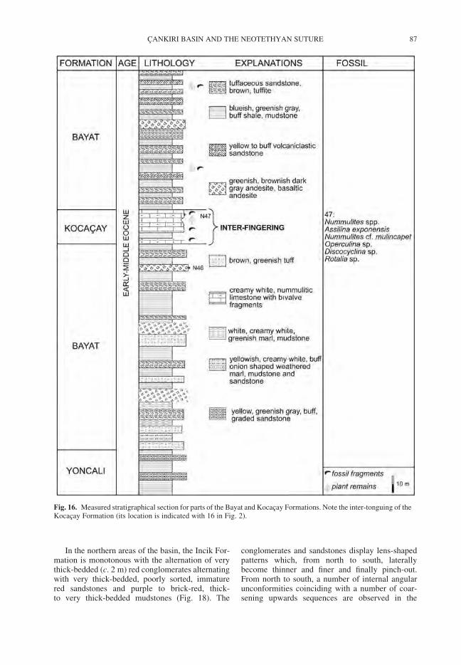
In the northern areas of the basin, the Incik For-mation is monotonous with the alternation of verythick-bedded (c. 2 m) red conglomerates alternatingwith very thick-bedded, poorly sorted, immaturered sandstones and purple to brick-red, thick-to very thick-bedded mudstones (Fig. 18). The
conglomerates and sandstones display lens-shapedpatterns which, from north to south, laterallybecome thinner and finer and finally pinch-out.From north to south, a number of internal angularunconformities coinciding with a number of coar-sening upwards sequences are observed in the
Fig. 16. Measured stratigraphical section for parts of the Bayat and Kocacay Formations. Note the inter-tonguing of theKocacay Formation (its location is indicated with 16 in Fig. 2).
CANKIRI BASIN AND THE NEOTETHYAN SUTURE 87
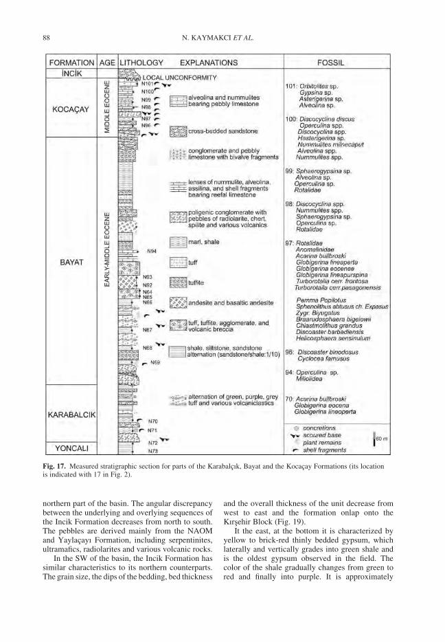
northern part of the basin. The angular discrepancybetween the underlying and overlying sequences ofthe Incik Formation decreases from north to south.The pebbles are derived mainly from the NAOMand Yaylacayı Formation, including serpentinites,ultramafics, radiolarites and various volcanic rocks.
In the SW of the basin, the Incik Formation hassimilar characteristics to its northern counterparts.The grain size, the dips of the bedding, bed thickness
and the overall thickness of the unit decrease fromwest to east and the formation onlap onto theKırsehir Block (Fig. 19).
It the east, at the bottom it is characterized byyellow to brick-red thinly bedded gypsum, whichlaterally and vertically grades into green shale andis the oldest gypsum observed in the field. Thecolor of the shale gradually changes from green tored and finally into purple. It is approximately
Fig. 17. Measured stratigraphic section for parts of the Karabalcık, Bayat and the Kocacay Formations (its locationis indicated with 17 in Fig. 2).
N. KAYMAKCI ET AL.88
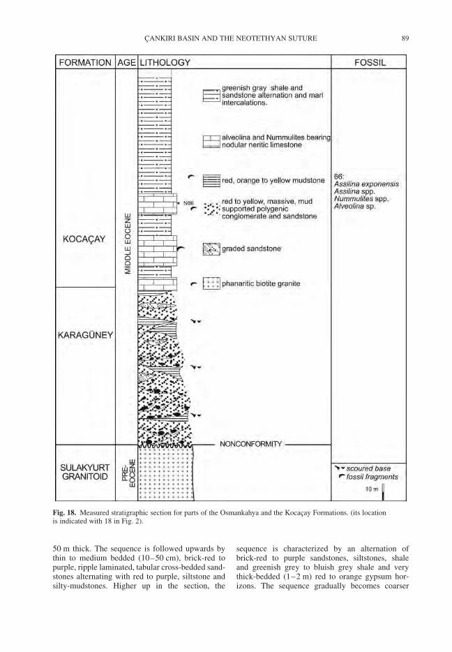
50 m thick. The sequence is followed upwards bythin to medium bedded (10–50 cm), brick-red topurple, ripple laminated, tabular cross-bedded sand-stones alternating with red to purple, siltstone andsilty-mudstones. Higher up in the section, the
sequence is characterized by an alternation ofbrick-red to purple sandstones, siltstones, shaleand greenish grey to bluish grey shale and verythick-bedded (1–2 m) red to orange gypsum hor-izons. The sequence gradually becomes coarser
Fig. 18. Measured stratigraphic section for parts of the Osmankahya and the Kocacay Formations. (its locationis indicated with 18 in Fig. 2).
CANKIRI BASIN AND THE NEOTETHYAN SUTURE 89
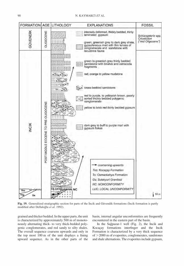
grained and thicker bedded. In the upper parts, the unitis characterized by approximately 500 m of monoto-nously alternating thick- to very thick-bedded poly-genic conglomerates, and red sandy to silty shales.The overall sequence coarsens upwards and only inthe top most 100 m of the unit displays a finingupward sequence. As in the other parts of the
basin, internal angular unconformities are frequentlyencountered in the eastern part of the basin.
In the Sagpazar-1 well (Fig. 2), the Incik andKocacay formations interfinger and the IncikFormation is characterized by a very thick sequenceof .2000 m of evaporites, conglomerates, sandstonesand shale alternations. The evaporites include gypsum,
Fig. 19. Generalized stratigraphic section for parts of the Incik and Guvendik formations (Incik formation is partlymodified after Dellaloglu et al. 1992).
N. KAYMAKCI ET AL.90
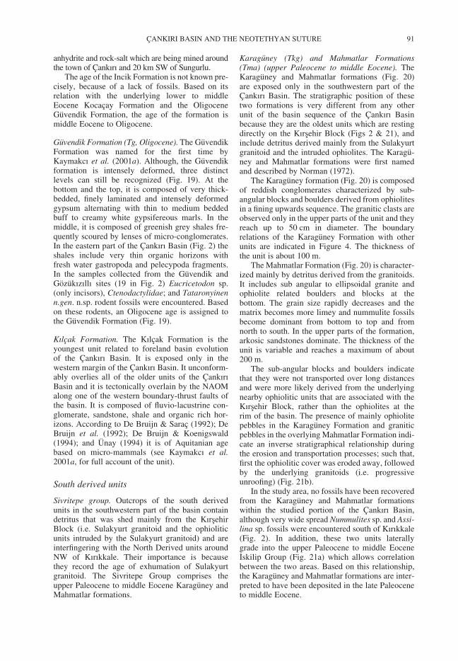
anhydrite and rock-salt which are being mined aroundthe town of Cankırı and 20 km SW of Sungurlu.
The age of the Incik Formation is not known pre-cisely, because of a lack of fossils. Based on itsrelation with the underlying lower to middleEocene Kocacay Formation and the OligoceneGuvendik Formation, the age of the formation ismiddle Eocene to Oligocene.
Guvendik Formation (Tg, Oligocene). The GuvendikFormation was named for the first time byKaymakcı et al. (2001a). Although, the Guvendikformation is intensely deformed, three distinctlevels can still be recognized (Fig. 19). At thebottom and the top, it is composed of very thick-bedded, finely laminated and intensely deformedgypsum alternating with thin to medium beddedbuff to creamy white gypsifereous marls. In themiddle, it is composed of greenish grey shales fre-quently scoured by lenses of micro-conglomerates.In the eastern part of the Cankırı Basin (Fig. 2) theshales include very thin organic horizons withfresh water gastropoda and pelecypoda fragments.In the samples collected from the Guvendik andGozukızıllı sites (19 in Fig. 2) Eucricetodon sp.(only incisors), Ctenodactylidae; and Tataronyinenn.gen. n.sp. rodent fossils were encountered. Basedon these rodents, an Oligocene age is assigned tothe Guvendik Formation (Fig. 19).
Kılcak Formation. The Kılcak Formation is theyoungest unit related to foreland basin evolutionof the Cankırı Basin. It is exposed only in thewestern margin of the Cankırı Basin. It unconform-ably overlies all of the older units of the CankırıBasin and it is tectonically overlain by the NAOMalong one of the western boundary-thrust faults ofthe basin. It is composed of fluvio-lacustrine con-glomerate, sandstone, shale and organic rich hor-izons. According to De Bruijn & Sarac (1992); DeBruijn et al. (1992); De Bruijn & Koenigswald(1994); and Unay (1994) it is of Aquitanian agebased on micro-mammals (see Kaymakcı et al.2001a, for full account of the unit).
South derived units
Sivritepe group. Outcrops of the south derivedunits in the southwestern part of the basin containdetritus that was shed mainly from the KırsehirBlock (i.e. Sulakyurt granitoid and the ophioliticunits intruded by the Sulakyurt granitoid) and areinterfingering with the North Derived units aroundNW of Kırıkkale. Their importance is becausethey record the age of exhumation of Sulakyurtgranitoid. The Sivritepe Group comprises theupper Paleocene to middle Eocene Karaguney andMahmatlar formations.
Karaguney (Tkg) and Mahmatlar Formations(Tma) (upper Paleocene to middle Eocene). TheKaraguney and Mahmatlar formations (Fig. 20)are exposed only in the southwestern part of theCankırı Basin. The stratigraphic position of thesetwo formations is very different from any otherunit of the basin sequence of the Cankırı Basinbecause they are the oldest units which are restingdirectly on the Kırsehir Block (Figs 2 & 21), andinclude detritus derived mainly from the Sulakyurtgranitoid and the intruded ophiolites. The Karagu-ney and Mahmatlar formations were first namedand described by Norman (1972).
The Karaguney formation (Fig. 20) is composedof reddish conglomerates characterized by sub-angular blocks and boulders derived from ophiolitesin a fining upwards sequence. The granitic clasts areobserved only in the upper parts of the unit and theyreach up to 50 cm in diameter. The boundaryrelations of the Karaguney Formation with otherunits are indicated in Figure 4. The thickness ofthe unit is about 100 m.
The Mahmatlar Formation (Fig. 20) is character-ized mainly by detritus derived from the granitoids.It includes sub angular to ellipsoidal granite andophiolite related boulders and blocks at thebottom. The grain size rapidly decreases and thematrix becomes more limey and nummulite fossilsbecome dominant from bottom to top and fromnorth to south. In the upper parts of the formation,arkosic sandstones dominate. The thickness of theunit is variable and reaches a maximum of about200 m.
The sub-angular blocks and boulders indicatethat they were not transported over long distancesand were more likely derived from the underlyingnearby ophiolitic units that are associated with theKırsehir Block, rather than the ophiolites at therim of the basin. The presence of mainly ophiolitepebbles in the Karaguney Formation and graniticpebbles in the overlying Mahmatlar Formation indi-cate an inverse stratigraphical relationship duringthe erosion and transportation processes; such that,first the ophiolitic cover was eroded away, followedby the underlying granitoids (i.e. progressiveunroofing) (Fig. 21b).
In the study area, no fossils have been recoveredfrom the Karaguney and Mahmatlar formationswithin the studied portion of the Cankırı Basin,although very wide spread Nummulites sp. and Assi-lina sp. fossils were encountered south of Kırıkkale(Fig. 2). In addition, these two units laterallygrade into the upper Paleocene to middle EoceneIskilip Group (Fig. 21a) which allows correlationbetween the two areas. Based on this relationship,the Karaguney and Mahmatlar formations are inter-preted to have been deposited in the late Paleoceneto middle Eocene.
CANKIRI BASIN AND THE NEOTETHYAN SUTURE 91
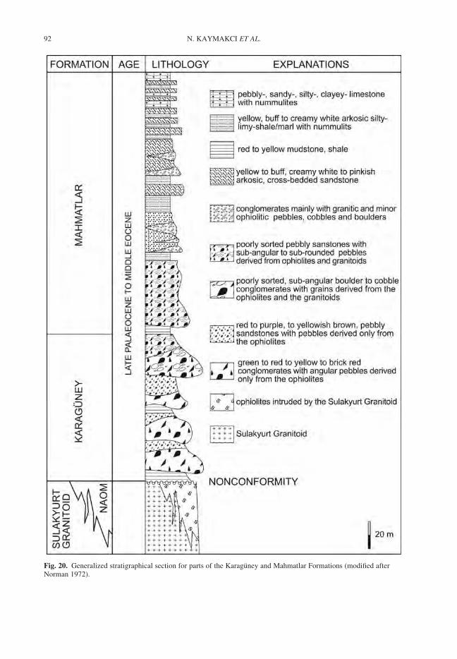
Fig. 20. Generalized stratigraphical section for parts of the Karaguney and Mahmatlar Formations (modified afterNorman 1972).
N. KAYMAKCI ET AL.92
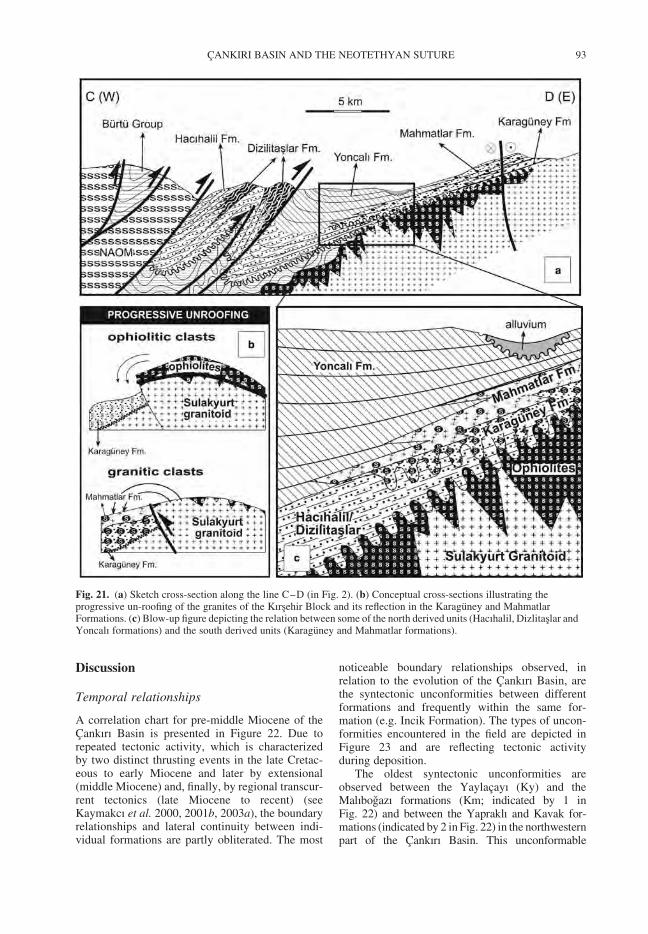
Discussion
Temporal relationships
A correlation chart for pre-middle Miocene of theCankırı Basin is presented in Figure 22. Due torepeated tectonic activity, which is characterizedby two distinct thrusting events in the late Cretac-eous to early Miocene and later by extensional(middle Miocene) and, finally, by regional transcur-rent tectonics (late Miocene to recent) (seeKaymakcı et al. 2000, 2001b, 2003a), the boundaryrelationships and lateral continuity between indi-vidual formations are partly obliterated. The most
noticeable boundary relationships observed, inrelation to the evolution of the Cankırı Basin, arethe syntectonic unconformities between differentformations and frequently within the same for-mation (e.g. Incik Formation). The types of uncon-formities encountered in the field are depicted inFigure 23 and are reflecting tectonic activityduring deposition.
The oldest syntectonic unconformities areobserved between the Yaylacayı (Ky) and theMalıbogazı formations (Km; indicated by 1 inFig. 22) and between the Yapraklı and Kavak for-mations (indicated by 2 in Fig. 22) in the northwesternpart of the Cankırı Basin. This unconformable
Fig. 21. (a) Sketch cross-section along the line C–D (in Fig. 2). (b) Conceptual cross-sections illustrating theprogressive un-roofing of the granites of the Kırsehir Block and its reflection in the Karaguney and MahmatlarFormations. (c) Blow-up figure depicting the relation between some of the north derived units (Hacıhalil, Dizlitaslar andYoncalı formations) and the south derived units (Karaguney and Mahmatlar formations).
CANKIRI BASIN AND THE NEOTETHYAN SUTURE 93
boundary in turn is angular unconformably overlainby the Incik Formation (Fig. 23a). The Kavak For-mation unconformably overlies the thrust contactbetween Yapraklı and Yaylacayı formations (indi-cated by 3 in Fig. 22) and Yaylacayı and Yapraklı for-mations are unconformably overlain by the Hacıhaliland Dizlitaslar Formations (indicated by 4 in Fig. 22).These relationships are interpreted as the indication ofsyn-depositional thrusting during the deposition ofthe Yapraklı and Kavak formations in which generaltectonic transport direction occurred from NW toSE (in present day orientations) (Figs 2 & 22).
The same relations are also observed in the upperPaleocene to lower Miocene units. The oldestunconformity is observed between the Sulakyurtgranitoid and the upper Paleocene–middle Eoceneunits in the southwestern part of the basin (5 inFig. 22). A very well developed syntectonic uncon-formity is also observed within the Incik Formationitself and between Incik and the formations of the
Iskilip Group (6 in Figs 22 & 23b & c). Theserelationships are indicative of differential upliftdue to tectonic activity and contemporaneous sedi-mentation during the late Paleocene to middleearly Miocene. Having syntectonic unconformitieswithin the Iskilip and Kalınpelit Groups near therim of the Cankırı Basin and onlap of these unitsonto the basement indicate progressive migrationof the depocenter southwards onto the KırsehirBlock from the late Paleocene onwards.
The most evident boundary relationship withrespect to timing of thrusting is observed in the north-eastern corner outside of the study area (11c inFig. 22). There, a number of North–NWto South–SWoriented feeder dykes for the volcanic rocks ofthe Bayat Formation cut the thrust contact betweenthe underlying Yoncalı Formation and the overlyingNAOM (Fig. 11c). This indicates that thrustingoccurred before and/or during the deposition of theBayat Formation in the early to middle Eocene.
Fig. 22. Correlation chart for pre-middle Miocene formations of the Cakırı Basin (see text for discussion).
N. KAYMAKCI ET AL.94
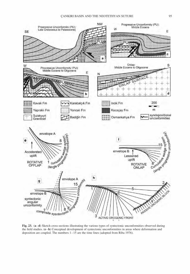
Fig. 23. (a–d) Sketch cross-sections illustrating the various types of syntectonic unconformities observed duringthe field studies. (e–h) Conceptual development of syntectonic unconformities in areas where deformation anddeposition are coupled. The numbers 1–15 are the time lines (adopted from Riba 1976).
CANKIRI BASIN AND THE NEOTETHYAN SUTURE 95
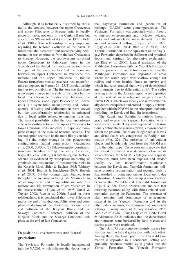
Although, it is tectonically disturbed by thrustfaults, the contacts between the upper Cretaceousand upper Paleocene to Eocene units is locallyunconformable, not only in the Cankırı Basin butalso further SW outside of it (Norman 1972; Goruret al. 1984). This relationship is very importantregarding the tectonic evolution of the basin. Itinfers that the tectonism and accompanying sedi-mentation was continuous from the late Cretaceousto Eocene. However, the southwestern reworkedupper Cretaceous to Paleocene fauna in theYoncalı and Karabalcık formations in the southwes-tern part of the basin implies that the boundarybetween the upper Cretaceous to Paleocene for-mations and the upper Paleocene to middleEocene formations must at least be a local unconfor-mity as depicted in Figures 21–23. This relationshipimplies two possibilities. The first one was that thereis no major change in the style of tectonics but thelocal unconformable relationship between theupper Cretaceous and upper Paleocene to Eoceneunits is a syntectonic unconformity and, conse-quently, thrusting and sedimentation were coevalbut the unconformably relationship is enhanceddue to local uplifts related to ongoing thrusting.The second possibility is that the local unconform-able relationship between the upper Cretaceous tolower Cenozoic units indicates a major and com-plete change in the style of tectonic activity. Thesecond option seems to be the more likely consider-ing: (1) the major change in the palaeostressconfigurations (radial compression) (Kaymakcıet al. 2000, 2003a); (2) Palaeomagnetic constraints(oroclinal bending during the early Cenozoic,Kaymakcı et al. 2003b); (3) and the regional tectonicscheme as evidenced by widespread un-roofing ofgranitoids and exhumation of metamorphic rocks inthe Kırsehir Block (Erler & Bayhan 1995; Whitneyet al. 2001; Boztug & Jonckheere 2007; Boztuget al. 2007); (4) the youngest age obtained fromthe ophiolitic melange as being late Maastrichtianwhich implies an end of ophiolitic melange for-mation; and (5) termination of arc volcanism inthe Maastrichtian (Tuyuz et al. 1995; Sunal &Tuysuz 2002; Rice et al. 2006). Based on theserelationships, it is concluded that lower Paleocenemarks the end of subduction, obliteration and com-plete subduction of the Neotethyan oceanic crustand collision of the Kırsehir Block and theSakarya Continent. Therefore, collision of theKırsehir Block and the Sakarya Continent tookplace at the end of late Cretaceous.
Depositional environments and lateral
gradations
The Yaylacayı Formation is locally incorporatedinto the NAOM, which indicates that deposition of
the Yaylacayı Formation and generation ofmelange (NAOM) were contemporaneous. TheYaylacayı Formation was deposited within forearcto interarc environments and includes volcanicrocks and volcanoclastic rocks derived from thearc and seamount setting (Tuysuz et al. 1995;Rojay et al. 2001, 2004; Rice et al. 2006). TheYapraklı Formation is time equivalent of the Yayla-cayı Formation deposited in shallower and proximaldepositional settings (for alternative explanation,see Rice et al. 2006). Lateral gradation of theMalıbogazı Formation with the Yapraklı Formationand the presence of rudist fossils indicate that theMalıbogazı Formation was deposited in areaswhere the water depth was shallow enough forrudists and other benthic fauna to survive andwhich indicates gradual shallowing of depositionalenvironments due to differential uplift. The rudistbearing units, in the Ankara region, were depositedat the crest of an accretionary wedge (Rojay &Suzen 1997), which was locally and intraformation-ally deposited uplifted and eroded to supply detritus,together with the NAOM, to the other proximal unitsincluding the Kavak and Badigin formations.
The Kavak and Badigin formations laterallygrade and overlie the Yapraklı Formation with alocal unconformity. They were deposited in a transi-tional continental to marine (mixed) environment inwhich the proximal facies are categorized as Kavakand distal facies are categorized as Badigin for-mation (Fig. 22). The presence of sub-angularblocks and boulders derived from the NAOM andfrom the other upper Cretaceous units indicate thatthe Kavak formation was deposited close to itssource whence the NAOM, Yaylacayı and Yapraklıformations must have been exposed and erodedlocally. A local unconformable relationshipbetween the Kavak and Yapraklı formations indi-cates ongoing sedimentation and tectonic activitythat resulted in contemporaneous local uplift dueto thrusting. A similar relationship is also observedbetween the Yapraklı and Hacıhalil formations(Figs 5 & 22). These observations indicate thatthrusting occurred along with thrust-related sedi-mentation during the Paleocene. The presence ofplant remains and dominance of terrigeneousmaterial in the Yapraklı Formation and in theother Paleocene units, the dominance of continentalsettings in many areas of Turkey (Gokten 1983;Gorur et al. 1984, 1998; Okay et al. 1996; Gurer& Aldanmaz 2002) indicates that the depositionalenvironments were bordered by land masses andmarine areas were restricted.
The Iskilip Group comprises mainly marine for-mations and has lateral gradations with each other.Among these, the lower part of the Hacıhalil For-mation is deposited in a continental setting andgradually becomes marine as it grades into theYoncalı Formation. The Yoncalı Formation
N. KAYMAKCI ET AL.96
represents the more basinal facies of the group and ischaracterized by a turbiditic sequence and deepermarine shales and clays. The Karabalcık Formationis represented by conglomerates with local coarsen-ing upwards sequences. The Osmankahya For-mation overlies the Karabalcık Formation and wasdeposited mainly in continental settings interfinge-ring with marine settings. The Kocacay Formationcovers all of these units and is characterized by acondensed sequence of nummulitic limestones.The Bayat Formation is represented mainly byvolcanic and volcanogenic units embedded withinthe Iskilip Group (upper Paleocene to middleEocene). The Incik Formation is characterizedmainly by continental deposits that laterally gradesand overlies all the other formations of the IskilipGroup. It also includes local unconformities devel-oped progressively during the activity along thethrust faults and is associated with coarseningupwards sequences. The Guvendik formation wasdeposited within lacustrine settings as evidencedby the presence of lacustrine fauna. The Kılcak For-matin is deposited in fluvio-lacustrine settings.
The organization of facies and structures indi-cate presence of thrust regime in the early Cenozoic.These include mezoscopic syn-sedimentary thrustfaults (Kaymakcı et al. 2000, 2003a), wedge-likeinfill patterns which contain progressive syntectonicunconformities, facies and major thrust faultsbecome younger from the basin rim towards thecentre, and southwards migrated depocenters.
Based on the information discussed above, inassociation with seismic data (see Kaymakcı2000), the depositional environments of the lowerCenozoic in-fill of the Cankırı Basin has been recon-structed (Fig. 24). It has already been discussed thatthe palaeocurrent directions in the Hacıhalil sectorof the Cankırı Basin indicates mainly southeast-ward, with minor northward, sediment transportdirections, which indicate that the basin rim wasexposed locally in the northeastern part of theCankırı Basin (11c in Fig. 2) during the depositionof the Hacıhalil Formation. The local unconformi-ties, southward transport of the thrusts, which wasaccompanied by deposition both in the front andthe rear of the thrust faults, indicates that theCankırı Basin evolved within a thrust regime withassociated piggy-back basins (terminology afterOri & Friend 1984), in the late Paleocene to earlyMiocene (Fig. 24).
Evolutionary scenarios of the
Cankırı Basin
As discussed previously tectonically there are twodistinct episodes in the evolution of the region.The first one took place in the Late Cretaceousto Paleocene interval and related to the subduction
of the Neotethys oceanic crust, whilst the secondone belongs to collision and post-collisional con-vergence period in the late Paleocene to earlyMiocene.
Late Cretaceous to middle Paleocene
Northward subduction of the Neotethys oceaniccrust below the Pontides commenced earlier thanCenomanian (Saner 1980; Sengor & Yılmaz 1981;Okay 1984; Dellaloglu et al. 1992; Okay et al.1994, 1996, 2001; Tuysuz et al. 1995; Kaymakcı2000; Robertson 2002; Clark & Robertson 2005;Rice et al. 2006), possibly in the early Cretaceousregarding the opening of the Western Black Sea asa backarc basin (Gorur 1988, 1997; Okay et al.1994, 2006; Robinson et al. 1997; Tuysuz 1999;Tuysuz & Tekin 2007). The subduction occurredalong two trenches (Fig 25a–c). The southern oneis an intra-oceanic subduction zone associatedwith an ensimatic arc (Fig 25a & b). During theTuronian, obduction of the N-Morb ophioliticcrust commenced during which supra-subductionzone ophiolites begin to form (Yalınız et al. 2000)while the ensimatic arc split and rifted away(Fig. 25c). Supra-subduction zone ophiolite gener-ation is thought to be the consequence of decreasein convergence rates of Taurides (including theKırsehir Block) and the Pontides (including theSakarya Continent) and possibly slab roll-back.These processes may also account for the backarcextension and opening of the western Black SeaBasin. During the end of the Santonian (83.5 Ma),a new northwards subduction started (Fig. 25d) inthe north along which the supra-subduction zoneophiolitic crust was consumed and later obductedon to the Kırsehir Block (Fig. 25 d & e) (Yalınızet al. 1996). This new subduction event mighthave given way to formation of an ensialic arcdevelopment (Yemislicay Formation of Tuysuzet al. 1995, and Tuysuz 1999) and formation of aforearc basin south of it (Rice et al. 2006), inwhich the Yaylacayı and Yapraklı formations weredeposited. The Yapraklı Formation represents theproximal facies of the forearc basin as implied byneritic carbonates and terrigeneous clastics, whilethe Yaylacayı Formation represents more basinalfacies (Figs 25a–c).
In the Campanian, the supra-subduction zoneophiolites obducted onto the Kırsehir Block andgave rise to the thickening and main metamorphismin the Kırsehir Block crust during which oldest gran-itoids in the Kırsehir Block intruded (Akıman et al.1995; Ilbeyli et al. 2004; Boztug et al. 2007), whilein the north, around the Cankırı Basin and itswestern (towards the Tuzgolu Basin) and easternextensions (towards the Sivas Basin) the basinnarrowed and deep sea conditions were progress-ively replaced by shallower conditions along the
CANKIRI BASIN AND THE NEOTETHYAN SUTURE 97
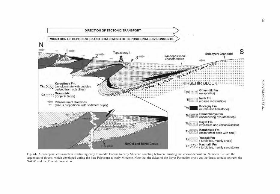
Fig. 24. A conceptual cross-section illustrating early to middle Eocene to early Miocene coupling between thrusting and coeval deposition. Numbers 1–3 are thesequences of thrusts, which developed during the kate Paleocene to early Miocene. Note that the dykes of the Bayat Formation cross-cut the thrust contact between theNAOM and the Yoncalı Formation.
N.
KA
YM
AK
CI
ET
AL
.98
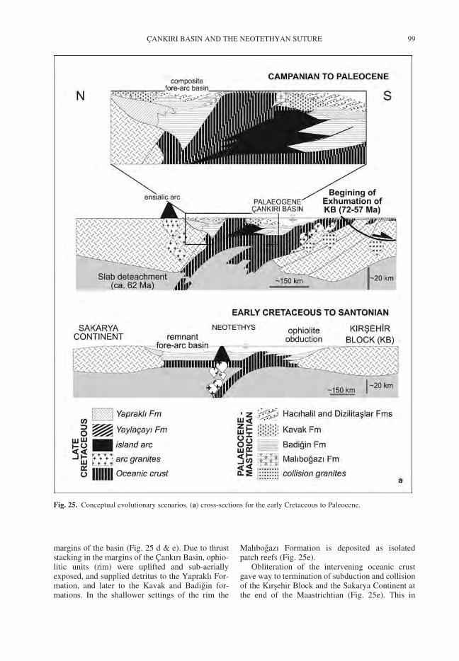
margins of the basin (Fig. 25 d & e). Due to thruststacking in the margins of the Cankırı Basin, ophio-litic units (rim) were uplifted and sub-aeriallyexposed, and supplied detritus to the Yapraklı For-mation, and later to the Kavak and Badigin for-mations. In the shallower settings of the rim the
Malıbogazı Formation is deposited as isolatedpatch reefs (Fig. 25e).
Obliteration of the intervening oceanic crustgave way to termination of subduction and collisionof the Kırsehir Block and the Sakarya Continent atthe end of the Maastrichtian (Fig. 25e). This in
Fig. 25. Conceptual evolutionary scenarios. (a) cross-sections for the early Cretaceous to Paleocene.
CANKIRI BASIN AND THE NEOTETHYAN SUTURE 99
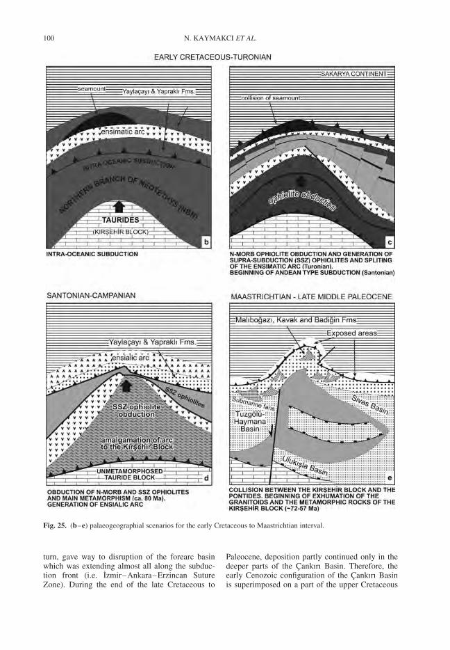
turn, gave way to disruption of the forearc basinwhich was extending almost all along the subduc-tion front (i.e. Izmir–Ankara–Erzincan SutureZone). During the end of the late Cretaceous to
Paleocene, deposition partly continued only in thedeeper parts of the Cankırı Basin. Therefore, theearly Cenozoic configuration of the Cankırı Basinis superimposed on a part of the upper Cretaceous
Fig. 25. (b–e) palaeogeographial scenarios for the early Cretaceous to Maastrichtian interval.
N. KAYMAKCI ET AL.100
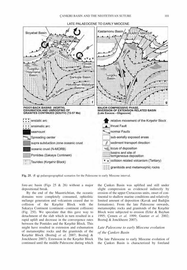
fore-arc basin (Figs 25 & 26) without a majordepositional break.
By the end of the Maastrichtian, the oceanicdomains were completely consumed, ophioliticmelange generation and volcanism ceased due tocollision of the Kırsehir Block with theSakarya Continent (continent–continent collision)(Fig. 25f). We speculate that this gave way todetachment of the slab which in turn resulted in arapid uplift and decrease in the convergence ratesbetween the Pontides and the Kırsehir Block. Thismight have resulted in extension and exhumationof metamorphic rocks and the granitoids of theKırsehir Block (Boztug et al. 2007; Boztug &Jonckheere 2007). Extension in the Kırsehir Blockcontinued until the middle Paleocene during which
the Cankırı Basin was uplifted and still underslight compression as evidenced indirectly byerosion of the upper Cretaceous units, onset of con-tinental to shallow marine conditions and relativelylimited amount of deposition (Kavak and Badiginformations). From the late Paleocene onwards,metamorphic rocks and granitoids of the KırsehirBlock were subjected to erosion (Erler & Bayhan1995; Cemen et al. 1999; Gautier et al. 2002;Boztug & Jonckheere 2007).
Late Paleocene to early Miocene evolution
of the Cankırı Basin
The late Paleocene to early Miocene evolution ofthe Cankırı Basin is characterized by foreland
Fig. 25. (f–g) palaeogeographial scenarios for the Paleocene to early Miocene interval.
CANKIRI BASIN AND THE NEOTETHYAN SUTURE 101
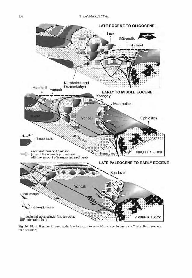
Fig. 26. Block diagrams illustrating the late Paleocene to early Miocene evolution of the Cankırı Basin (see textfor discussion).
N. KAYMAKCI ET AL.102
basin deposition due to collision and further conver-gence of the Sakarya Continent and the KırsehirBlock (Figs 25f, g & 26). The reconstruction ofthe depositional environments for the upper Paleo-cene to lower Miocene sequences of the CankırıBasin is illustrated in Figure 26. The upper Paleo-cene to Eocene is characterized by very rapidlateral and vertical facies changes, a consistent rela-tive younging of units from the rim towards thebasin centre which onlap progressively onto theflexurally subsiding Kırsehir Block. Deposition ofthe Hacıhalil and Dizlitaslar Formations continuedduring the late Paleocene and they display faciesassociations ranging from proximal alluvial fan, tobraided river, to meandering river, to fan delta, tonear shore and to prodelta/open marine facies(Ocakoglu & Ciner 1997). The Hacıhalil Formationis laterally transitional and always underlies theYoncalı Formation. This relationship may indicatea gradual relative rise of the sea level (Weijerset al. 2007) that caused fining upwards sequencesand a relative deepening of depositional environ-ments from continental to a deeper marine facies.Alternation of graded sandstone, siltstone, shaleand the presence of current ripples indicate thatthe Yoncalı Formation was deposited by turbiditycurrents. Considering its position relative to theKarabalcık and Osmankahya formations, it may rep-resent prodelta clays, near shore clastic settings todeep marine settings (cf. Reading & Collinson1996). The presence of benthic fauna, plantremains and coal seams indicate that the KarabalcıkFormation was deposited in relatively shallowmarine conditions, which laterally and/or tem-porally changed into marshy conditions. Thelarge-scale cross-bedding and the presence ofboulders and blocks within the conglomerates, aswell as the presence of channels of conglomeratesof the Karabalcık Formation within the Yoncalı For-mation indicates that the Karabalcık Formation con-stitutes the foreset beds of a south facing delta. Thechannels in the Yoncalı Formation may indicate adistributary channel system of this delta (cf.Postma & Roep 1985; Johnson & Baldwin 1996;Reading & Collinson 1996). The Osmankahya For-mation was deposited in a prograding near shoresetting where fluvial deposition was the dominatingagent. The Kocacay Formation laterally gradesover, and covers all the Eocene units. The presenceof benthic foraminifera (e.g. nummulites, alveolinaeetc.) and bivalves and locally presence of conglom-erates and sandstones indicates that the KocacayFormation was deposited in a very shallow waterconditions. The Incik Formation is deposited in con-tinental settings. Its lateral gradation to the KocacayFormation and the presence of greenish grey shalewith marine fauna indicate a continental to marine
transition (mixed environment). The presence ofevaporates indicates arid climate conditions.
The youngest depositional unit related to post-collisional convergence and hence foreland basindevelopment is continued until the Aquitanian andis represented by the Kılcak Formation.
Conclusions
The tectonostratigraphical evolution of the CankırıBasin occurred mainly in two main episodes. Thefirst one took place in the late Cretaceous to Paleo-cene and the second in the late Paleocene to earliestMiocene.
The late Cretaceous to Paleocene evolution ofthe basin was associated with the northwards sub-duction of the northern Neotethys under theSakarya Continent. Two different subductionevents took place in the region. The oldest event isan intra-oceanic subduction that resulted in an ensi-matic arc and supra-subduction zone ophiolite gen-eration that in turn obducted onto the KırsehirBlock. The second subduction event took placeduring the Santonian–Maastrichtian interval andproduced an ensialic arc on the Sakarya Continent.The earliest sub-aerial emergence of the rimoccurred in the Maastrichtian. It is thought that theemergence of the rim was associated with the accre-tionary wedge growth enhanced by collision of thesea mount with the Sakarya Continent. In thesouth of the sea mount, the Cankırı Basin continuedto its evolution as a remnant basin which was rela-tively narrowed due to subduction. During theMaastrichtian, in the periphery of the emergentareas, the Malıbogazı, Kavak and Badigin for-mations were deposited while in the relativelydeeper parts, deposition of Yaylacayı and Yapraklıformations continued. Rapid uplift and emergenceoccurred during the Paleocene which gave way toincreased sediment supply and development ofturbiditiy currents.
By the beginning of the Paleocene, the over-thickened Kırsehir Block due to obduction andnappe stacking, began to collapse which sub-sequently gave way to un-roofing of the granitoidsand exhumation of the metamorphic rocks of theKırsehir Block. Un-roofing and exhumation is evi-denced by presence of granitic and metamorphicpebbles in the Paleocene deposits in the CankırıBasin and elsewhere.
By the late Paleocene, indentation of the KırsehirBlock into the Sakarya Continent began (Kaymakcıet al. 2003b). This gave way to development of aforeland basin system characterized by a seriesof piggy-back basins. Due to southwards migrationof the thrust faults and the depocenters, the
CANKIRI BASIN AND THE NEOTETHYAN SUTURE 103
depositional environments became shallower andfinally passed into continental settings by the endof the middle Eocene. During the post- middleEocene to early Miocene, the basin became comple-tely restricted and the sea withdrew perpetuallyfrom the region. Since the end of the middleEocene continental conditions have been prevailingin the region. The collision and indentation relatedconvergence and basin development in the CankırıBasin lasted until the Aquitanian (early Miocene,c. 20 Ma). From the Burdigalian onwards a new tec-tonic regime established in the Cankırı Basin (seeKaymakcı et al. 2001b).
We thank D. J. J. Hinsbergen, S. Rice and O. Tuysuz forcritical reviews. This study is supported by Turkish Gov-ernment under YLS – grant and Turkish Petroleum Co.The authors would like to thank Y. Oztas for fieldsupport. H. de Bruijn, E. Unay and G. Sarac are acknowl-edged for micro-mammal sampling and identifications.
References
AKIMAN, O., ERLER, A., GONCUOGLU, M. C., GULEC,N., GEVEN, A., TURELI, T. K. & KADIOGLU, Y. K.1993. Geochemical characteristics of granitoids alongthe western margin of the Central Anatolian Crystal-line Complex and their tectonic implications. Geologi-cal Journal, 28, 371–382.
AKYUREK, B., BILGINER, E., AKBAS, B., HEPSEN,N., PEHLIVAN, S., SUNU, O., SOYSAL, Y., DAGER,Z., CATAL, E., SOZERI, B., YILDIRIM, H. &HAKYEMEZ, H. 1984. The geology of the Ankara-Elmadag-Kalecik region. Chamber of GeologicalEngineers of Turkey Bulletin. 20, 31–46.
AYAN, T. 1969. Cankırı-Yerkoy havzası petrol imkanları:Jeolojik ve Tektonik etudu. Egeran Musavirlik Muhen-dislik Firması. TPAO Rap. No: 469 (unpublished).
AZIZ, A. 1975. Iskilip civarı ile guney ve guneybatısınındetay jeolojisi ve petrol olanakları. M.T.A. Ars. Rap.No: 6132 (unpublished).
BINGOL, A. F. 1984. Geology of the Elazig area in theEastern Taurus Region. Proceed. of the Geology ofthe Taurus Belt, MTA, Ankara, 209–216.
BIRGILI, S., YOLDAS, R. & UNALAN, G. 1974. Cankırı-Corum havzası jeolojisi ve petrol olanakları onraporu. TPAO Rap. No: 1216 (unpublished).
BOZTUG, D. & JONCKHEERE, R. C. , 2007. Apatitefission-track data from central-Anatolian granitoids(Turkey: constraints on Neo-Tethyan closure. Tec-tonics, 26, TC3011, doi:10.1029/2006TC001988.
BOZTUG, D., TICHOMIROWA, M. & BOMBACH, K. 2007.207Pb–206Pb single-zircon evaporation ages of somegranitoid rocks reveal continent-oceanic island arc col-lision during the Cretaceous geodynamic evolution ofthe central Anatolian crust, Turkey. Journal of AsianEarth Sciences, 31, 71–86.
CEMEN, I., GONCUOGLU, M. C. & DIRIK, K. 1999,Structural Evolution of the Tuzgolu Basin in CentralAnatolia, Turkey. Journal of Geology, 107, 693–706.
CLARK, M. & ROBERTSON, A. 2005. Uppermost Cretac-eous–Lower Cenozoic Ulukısla Basin, south-central
Turkey: sedimentary evolution of part of a unifiedbasin complex within an evolving Neotethyan suturezone. Sedimentary Geology, 173, 15–51.
DE BRUIJN, H. & SARAC, G. , 1992. Early Miocene rodentfaunas from eastern Mediterranean area. Part II.Mirabella (Paracricetodontinae, Muroidea). Proceed-ings of the Koninklijke Nederlandse Akademie VanWetenschappen, Amsterdam, B95, 25–40.
DE BRUIJN & KOENIGSWALD, W. 1994. Early Miocenerodent faunas from eastern Mediterranean area. PartV. The genus Enginia (Muroidea) with a discussionof the structure of the incisor enamel. Proceedings ofthe Koninklijke Nederlandse Akademie VanWetenschappen, Amsterdam, B97, 381–405.
DE BRUIJN, H., DAAMS, R., DAXNER-HOCK, G.,FAHLBUSCH, V., GINSBURG, L., MEIN, P. &MORALES, J. 1992. Report of the RCMNSWorking Group on fossil mammals. Reisensburg1990. Newsletter on Stratigraphy, 26, 65–118,Berlin, Stuttgart.
DELLALOGLU, A. A., TUYSUZ, O., KAYA, O. H. &HARPUT, B. 1992. Kalecik (Ankara)-Eldivan-Yapraklı(Cankırı)-Iskilip (Corum) ve Devrez Cayı arasindakialanın jeolojisi ve petrol olanakları. TPAO Rap. No.3194 (unpublished).
DEMIRER, A., OZCELIK, Y. & OZKAN, R. 1992. Cankırı-Corum basenindeki Eosen volkanitlerinin petrografisi.TPAO Rap. No. 1810 (unpublished).
DICKINSON, W. R. & SEELY, D. R. 1979. Structure andstratigraphy of forearc regions. AAPG Bulletin, 63,2–31.
DIRIK, K., GONCUOGLU, M. C. & KOZLU, H. 1999.Tectonic evolution of the southwestern part of theSivas Basin. Geological Journal, 34, 303–319.
ERLER, A. & BAYHAN, H. 1995. Orta AnadoluGranitoidleri’nin genel degerlendirilmesi ve sorunları.Hacettepe Universitesi Yerbilimleri, 17, 49–67.
GAUTIER, P., BOZKURT, E., HALLOT, E. & DIRIK, K.2002. Pre-Eocene exhumation of the Nigde Massif,Central Anatolia, Turkey. Geological Magazine, 139,559–576.
GOKTEN, E. 1983. Sarkısla (Sivas) guney-guneydogusununstratigrafisi ve jeolojik evrimi. Turkiye JeolojiKurumuBulteni. 26, 167–176.
GORUR, N. 1988. Timing of opening of the Black SeaBasin. Tectonophysics, 147, 247–262.
GORUR, N. 1997. Cretaceous syn- to postrift sedimen-tation on the southern continental margin of thewestern Black Sea Basin. In: ROBINSON, A. G. (ed.)Regional and Petroleum Geology of the Black Seaand Surrounding Region. American Association ofPetroleum Geologists, Memoir, 68, 227–240.
GORUR, N., TUYSUZ, O. & SENGOR, A. M. C. 1998.Tectonic evolution of the central Anatolian basins.International Geological Review, 40, 831–50.
GORUR, N., OKTAY, F. Y., SEYMEN, I. & SENGOR,A. M. C. 1984. Palaeotectonic evolution of theTuzgolu basin complex, Central Turkey: Sedimentaryrecord of a neotethyan closure. In: DIXON, J. E. &ROBERTSON, A. H. F. (eds) The Geological Evolutionof the Eastern Mediterranean. Blackwell Publishing,Oxford, London.
GULEC, N. 1994. Rb-Sr isotope data from the AgacorenGranitoid (East of Tuz Golu): geochronological and
N. KAYMAKCI ET AL.104
genetical implications. Turkish Journal of EarthSciences, 3, 39–43.
GURER, O. F. & ALDANMAZ, E. 2002. Origin of the UpperCretaceous-Cenozoic sedimentary basins within theTauride-Anatolide platform in Turkey. GeologicalMagazine, 139, 191–197.
ILBEYLI, N., PEARCE, J. A., THIRLWALL, M. F. &MITCHELL, J. G. 2004. Petrogenesis of collision-related plutonics in Central Anatolia, Turkey. Lithos,72, 163– 182.
JOHNSON, H. D. & BALDWIN, C. T. 1996. Shallow clasticseas. In: READING, H. G. (ed.) Sedimentary Environ-ments: Process, Facies and Stratigraphy. BlackwellPublishing, Oxford. 232–280.
KAYMAKCI, N. 2000. Tectono-stratigraphical evolutionof the Cankiri Basin (Central Anatolia, Turkey). Ph.DThesis, Geologica Ultraiectina. No. 190, Utrecht Uni-versity Faculty of Earth Sciences, The Netherlands.
KAYMAKCI, N., WHITE, S. H. & VAN DIJK, P. M. 2000.Paleostress inversion in a multiphase deformed area:kinematic and structural evolution of the CankiriBasin (central Turkey), Part 1. In: BOZKURT, E.,WINCHESTER, J. A. & PIPER, J. A. D. (eds) Tectonicsand Magmatism in Turkey and the Surrounding area.Geological Society, London, Special Publication,173, 445–473.
KAYMAKCI, N., WHITE, S. H. & VAN DIJK, P. M. 2003a.Kinematic and structural development of the CankiriBasin (Central Anatolia, Turkey): a paleostress inver-sion study. Tectonophysics, 364, 85–113.
KAYMAKCI, N., DE BRUIJN, H., WHITE, S. H., VAN
DIJK, M., SARAC, G. & UNAY, E. 2001a. Tectonicimplications of the Neogene stratigraphy of theCankiri basin with special reference to the Candirlocality (North-Central Anatolia, Turkey).In: GULEC, E., BEGUN, D. R. & GERAADS, D. (eds)Geology and Vertebrate Paleontology of the Miocenehominoid locality of Candir. Courier ForschugsinstitutSenckenberg, 240, 9–28.
KAYMAKCI, N., OZCELIK, Y., WHITE, S. H. & VAN
DIJK, P. M. 2001b. Neogene Tectonics of the CankiriBasin (north Central Turkey), Turkish Association ofPetroleum Geologists Bulletin, 13, 27–56.
KAYMAKCI, N., DUERMEIJER, C. E., LANGEREIS, C.,WHITE, S. H. & VAN DIJK, P. M. 2003b. Oroclinalbending due to indentation: a paleomagnetic studyfor the early Cenozoic evolution of the Cankiri Basin(central Anatolia, Turkey). Geological Magazine.140, 343–355.
KAZANCI, N. & VAROL, B. 1990. Development of a massflow-dominated fan-delta complex and associated car-bonate reefs within a transgressive Paleocene succes-sion, Central Anatolia, Turkey. Sedimentary Geology,68, 261–278.
KETIN, I. 1966. Anadolu’nun tektonik birlikleri. MadenTetkik ve Arama Enstitusu Dergisi, 66, 20–34.
KUSCU, I. 1997. Mineralogical and geochemical compari-son of skarns in the Akdagmadeni, Akcakısla andKeskin districts, Central Anatolia, Turkey. Ph.D.Thesis, Middle East Technical University, Ankara(unpublished).
NORMAN, T. 1972. Ankara dogusunda Yahsihan bolge-sinde Ust Kretase-Alt Tersiyer yaslı arazinin jeolojisi.Maden Tetkik ve Arama Enstitusu Dergisi, Ankara.
OCAKOGLU, F. & CINER, A. 1997. Fay denetimli birhavzada sedimanter dolgunun niteligi ve evrimi:Cankırı havzası kuzeyinden Lutesiyen yaslı birornek. Hecettepe Universitesi Yerbilimleri, 19,89–108.
OKAY, A. I. 1984. Distribution and characteristics of thenorthwest Turkish blueschists, In: DIXON, J. E. &ROBERTSON, A. H. F. (eds), The Geological Evolutionof the Eastern Mediterranean, Blackwell Publishing,Oxford, London.
OKAY, A. I., TANSEL, I. & TUYUSZ, O. 2001. Obduction,subduction and collision as reflected in the UpperCretaceous–Lower Eocene sedimentary record ofwestern Turkey. Geological Magazine, 138, 117–142.
OKAY, A. I., SENGOR, A. M. C. & GORUR, N. 1994.Kinematic history of the opening of the Black Seaand its effect on the surrounding regions. Geology,22, 267–270.
OKAY, A. I., SATIR, M., MALUSKI, H., SIYAKO, M.,MONIE, P., METZGER, R. & AKYUZ, S. 1996.Paleo- and Neo-Tethyan events in northwestTurkey: geological and geochronological constraints.In: YIN, A. & HARRISON, M. (eds) Tectonics ofAsia. Cambridge University Press, 420–441.
OKAY, A. I., TUYSUZ, O., SATIR, M., OZKAN-ALTINER,S., ALTINER, D., SHERLOCK, S. & EREN, R. H. , 2006.Cretaceous and Triassic subduction-accretion, high-pressure–low-temperature metamorphism, andcontinental growth in the Central Pontides, Turkey.Geological Society America Bulletin, 118, 1247–1269.
ORI, G. G. & FRIEND, P. F. 1984. Sedimentary basinsformed and carried piggyback on active thrust sheets.Geology, 12, 475–478.
POSTMA, G. 1983. Water escape structures in the contextof depositional model of a mass-flow dominatedconglomeratic fan delta (Abrioja Formation,Pliocene, America basin, SE Spain). Sedimentology,30, 91–104.
POSTMA, G. & ROEP, T. B. 1985. Resedimented conglom-erates in the bottom set of a Gilbert-type gravel delta.Journal of Sedimentary Petrology, 55, 874–885.
READING, H. G. & COLLINSON, J. D. 1996. Clastic coasts.In: READING, H. G. (ed.) Sedimentary Environments:Process, Facies and Stratigraphy. Blackwell Science,Oxford, 154–231.
RIBA, O. 1976. Syntectonic unconformities of the AltoCardener, Spanish Pyrenees: a genetic interpretation.Sedimentary Geology, 15, 213–33.
RICE, S. P., ROBERTSON, A. H. F. & USTAOMER, T.2006. Late Cretaceous-Early Cenozoic tectonic evol-ution of the Eurasian active margin in theCentral and Eastern Pontides, northern Turkey. In:ROBERSTON, A. H. F. & MOUNTRAKIS, D. (eds) Tec-tonic Development of the Eastern MediterraneanRegion. Geological Society, London, Special Publi-cations, 260, 413–445.
ROBERTSON, A. H. F. 2002. Overview of the genesis andemplacement of Mesozoic ophiolites in the EasternMediterranean Tethyan region. Lithos, 65, 1–67.
ROBINSON, A. 1997. Introduction: Tectonic elements ofthe Black Sea region. In: ROBINSON, A. (ed.),Regional and petroleum geology of the Black Seaand surrounding region. American Association ofPetroleum Geologists Memoir, 68, 1–6.
CANKIRI BASIN AND THE NEOTETHYAN SUTURE 105
ROJAY, B. F. 1993. Tectonostratigraphy and neotectoniccharacteristics of the southern margin of Merzifon-Suluova basin (Central Pontides, Amasya). Ph.D.Thesis, METU Geological Engineering Department(Ankara, Turkey), (unpublished.)
ROJAY, B. F. 1995. Post-Triassic evolution of central Pon-tides: Evidence from Amasya region, Northern Anato-lia. Geologica Romana, 31, 329–350.
ROJAY, B. F. & SUZEN, L. 1997. Tectonostratigraphicevolution of an arc-trench basin on accretionaryophiolitic melange prism, Central Anatolia, Turkey.Turkish Association of Petroleum Geologist Bulletin,9, 1–12.
ROJAY, B., ALTINER, D., OZKAN ALTINER, S., ONEN,P., JAMES, S. & THIRWALL, M. 2004. Geodynamicsignificance of the Cretaceous pillow basalts fromNorth Anatolian Ophiolitic Melange Belt (CentralAnatolia, Turkey): geochemical and paleontologicalconstrains. Geodinamica Acta, 17, 349–361.
ROJAY, B., YALINIZ, K. & ALTINER, D. 2001. Age andorigin of some pillow basalts from Ankara melangeand their tectonic implications to the evolution ofnorthern branch of Neotethys, Central Anatolia.Turkish Journal of Earth Sciences, 10, 93–102.
SANVER, M. & PONAT, E. 1981. Kırsehir ve dolaylarinailiskin paleomagnetik bulgular. Kirsehir Masifininrotasyonu. Istanbul Yerbilimleri, 2, 2–8.
SENGOR, A. M. C. & YILMAZ, Y. 1981. Tethyan evol-ution of Turkey: a plate tectonic approach. Tectono-physics, 75, 181–241.
SUNAL, G. & TUYSUZ, O. 2002. Palaeostress analysis ofTertiairy post-collosional structures in the WesternPontides, northern Turkey. Geological Magazine,139, 343–359.
TUYSUZ, O. 1985. Kargı Masifi ve dolayındaki tektonikbirliklerin ayırdı ve arastırılması (petrolojik ince-leme). Istanbul Univ. Jeoloji Muhendisligi Bolumu,Doktora Tezi. (unpublished PhD Thesis)
TUYSUZ, O. 1999. Geology of the Cretaceous sedimentarybasins of the Western Pontides, Geological Journal,34, 75–93.
TUYSUZ, O. & TEKIN, U. K. 2007. Timing of imbricationof an active continental margin facing the northern
branch of Neotethys, Kargı Massif, northern Turkey.Cretaceous Research, 28, 754–764.
TUYSUZ, O., DELLALOGLU, A. A. & TERZIOGLU, N.1995. A magmatic belt within the Neo-Tethyansuture zone and its role in the tectonic evolution ofnorthern Turkey. Tectonophysics, 243, 173–191.
UNALAN, G. 1982. Ankara Guneyindeki Ankara Melanji-nin stratigrafisi. In: Proceedings of the Symposium onthe Geology of Central Anatolia, Geological Society ofTurkey, 35th Annual Meeting, 46–52 [in Turkish withEnglish abstract].
UNAY, E. 1994. Early Miocene rodent faunas from easternMediterranean area. Part IV. The Gliridae. Proceed-ings of the Koninklijke Nederlandse Akademie VanWetenschappen, Amsterdam, B97, 445–490.
WEIJERS, J. W. H., SCHOUTEN, S., SLUIJS, A.,BRINKHUIS, H. & DAMSTE, J. S. S. 2007. Warmarctic continents during the Paleocene–Eocenethermal maximum. Earth and Planetary ScienceLetters, 261, 230–238.
WHITNEY, D. L., TEYSSIER, C., DILEK, Y. & FAYON, K.2001. Metamorphism of the Central Anatolian Crystal-line Complex, Turkey: influence of orogen-normal col-lision vs. Wrench-dominated tectonics on P-T-t paths.Journal of Metamorphic Geology, 19, 411–432.
YALINIZ, K. & GONCUOGLU, M. C. 1998. General geo-logical characterictics and distribution of Central Ana-tolian Ophiolites. Hacettepe University Earth ScienceBulletin, 19, 1–15.
YALINIZ, M. K., GONCUOGLU, M. C. & OZKAN-ALTINER, S. 2000. Formation and EmplacementAges of the SSZ-type Neotethyan Ophiolites inCentral Anatolia, Turkey: Paleotectonic Implications.Geological Journal, 35, 53–68.
YAZGAN, E. 1984. Geodynamic Evolution of the easternTaurus Region (Malatya-Elazıg area, Turkey). In:Geology of Taurus Belt, Proceedings of InternationalSymposium, Mineral Research and Exploration Insti-tute, (MTA, Ankara) Publication, 199–208.
YOLDAS, R. 1982. Tosya (Kastamonu) ile Bayat (Corum)arasındaki bolgenin jeolojisi. Doktora Tezi. IstanbulUniversitesi Fen Fakultesi, Genel Jeoloji Kursusu,(unpublished).
N. KAYMAKCI ET AL.106
Oligocene–Miocene basin evolution in SE Anatolia,
Turkey: constraints on the closure of the eastern Tethys gateway
SILJA K. HUSING1*, WILLEM-JAN ZACHARIASSE2, DOUWE J. J. VAN HINSBERGEN1,
WOUT KRIJGSMAN1, MURAT INCEOZ3, MATHIAS HARZHAUSER4,
OLEG MANDIC4 & ANDREAS KROH4
1Paleomagnetic Laboratory “Fort Hoofddijk”, Department of Earth Sciences, Utrecht
University, Budapestlaan 4, 3584 CD Utrecht, The Netherlands2Stratigraphy and Paleontology Group, Department of Earth Sciences, Utrecht University,
The Netherlands3Department of Geology, Fırat University, Elazıg, Turkey
4Natural History Museum Vienna, Austria
*Corresponding author (e-mail: [email protected])
Abstract: The Oligocene–Miocene was a time characterized by major climate changes as well aschanging plate configurations. The Middle Miocene Climate Transition (17 to 11 Ma) may evenhave been triggered by a plate tectonic event: the closure of the eastern Tethys gateway, themarine connection between the Mediterranean and Indian Ocean. To address this idea, we focuson the evolution of Oligocene and Miocene foreland basins in the southernmost part of Turkey,the most likely candidates to have formed this gateway. In addition, we take the geodynamic evol-ution of the Arabian–Eurasian collision into account.
The Mus and Elazıg basins, located to the north of the Bitlis–Zagros suture zone, were mostlikely connected during the Oligocene. The deepening of both basins is biostratigraphicallydated by us to occur during the Rupelian (Early Oligocene). Deep marine conditions (between350 and 750 m) prevailed until the Chattian (Late Oligocene), when the basins shoaled rapidlyto subtidal/intertidal environment in tropical to subtropical conditions, as indicated by the macro-fossil assemblages. We conclude that the emergence of this basin during the Chattian severelyrestricted the marine connection between an eastern (Indian Ocean) and western (Mediterranean)marine domain. If a connection persisted it was likely located south of the Bitlis–Zagros suturezone. The Kahramanmaras basin, located on the northern Arabian promontory south of theBitlis–Zagros suture zone, was a foreland basin during the Middle and Late Miocene, possiblylinked to the Hatay basin to the west and the Lice basin to the east. Our data indicates that this fore-land basin experienced shallow marine conditions during the Langhian, followed by a rapid dee-pening during Langhian/Serravallian and prevailing deep marine conditions (between 350 and750 m) until the early Tortonian. We have dated the youngest sediments underneath a subduc-tion-related thrust at c. 11 Ma and suggest that this corresponds to the end of underthrusting inthe Kahramanmaras region, i.e. the end of subduction of Arabia. This age coincides in time withthe onset of eastern Anatolian volcanism, uplift of the East Anatolian Accretionary Complex,and the onset of the North and East Anatolian Fault Zones accommodating westward escape tec-tonics of Anatolia. After c. 11 Ma, the foreland basin south of the Bitlis formed not (or no longer) adeep marine connection along the northern margin of Arabia between the Mediterranean Sea andthe Indian Ocean. We finally conclude that a causal link between gateway closure and globalclimate change to a cooler mode, recorded in the Mi3b event (d18O increase) dated at 13.82 Ma,cannot be supported.
Tectonic closure and opening of marine gateways issuggested to have led to substantial reorganizationof surface and deep ocean water currents and mayhave caused important changes in global climate.The closure of the Panama Isthmus between 3.0and 2.5 Ma has influenced the Gulf Stream, trigger-ing major Northern Hemisphere glaciations (Bartoli
et al. 2005; Schneider & Schmittner 2006). Theopening of the Drake Passage allowed the start ofthe Antarctic Circumpolar Current which mighthave initiated the abrupt climate cooling aroundthe Eocene/Oligocene boundary and the extensivegrowth of Antarctic ice sheets (Livermore et al.2005). The restriction of water exchange across
From: VAN HINSBERGEN, D. J. J., EDWARDS, M. A. & GOVERS, R. (eds) Collision and Collapse at theAfrica–Arabia–Eurasia Subduction Zone. The Geological Society, London, Special Publications, 311, 107–132.DOI: 10.1144/SP311.4 0305-8719/09/$15.00 # The Geological Society of London 2009.
the former straits between Spain and Moroccoresulted in the desiccation of the MediterraneanSea during its Messinian Salinity Crisis (Hsu et al.1973). Likewise, the disconnection of the IndianOcean and the Atlantic/Mediterranean watermasses has been suggested to have caused a majormiddle Miocene climate change, widely recognizedin both the marine (Woodruff & Savin 1989; Flower& Kennett 1994; Zachos et al. 2001; Bicchi et al.2003) and the terrestrial record (Krijgsman et al.1994). It is this disconnection that forms the scopeof this paper.
The middle Miocene is a period characterized bymajor environmental changes during which theEarth’s climate gradually progressed into a coldermode (Zachos et al. 2001). The Miocene ClimateOptimum between 17 to 15 Ma was followed byan interval of global climate variability between15 and 14 Ma, marked by atmospheric and oceaniccooling, East Antarctic Ice Sheet growth, andcarbon cycle variability (Woodruff & Savin 1989;Flower & Kennett 1994; Zachos et al. 2001).Seven major d18O shifts, Mi1 to Mi7, to higher(¼ colder) values documented in marine recordsof the Atlantic reflect brief periods of increasedglaciations (Miller et al. 1991; Wright et al. 1992;Miller et al. 2005). The Mi3a, Mi3b and Mi4events between about 14.5 and 12.5 Ma representthe middle Miocene d18O increase, leading theglobal climate into a colder mode at the same timeas the onset of the Antarctic glaciations (van derZwaan & Gudjonsson 1986; Abels et al. 2005;Miller et al. 2005).
A direct relationship between the MiddleMiocene Climate change, whether recorded inoxygen or carbon isotopes, marine or terrestrialfauna, and the closure of the eastern Tethysgateway has so far never been proven, althoughmany studies suggest a causal link between thetwo events (e.g. Woodruff & Savin 1989; Rogl1999; Flower & Kennett 1993). Part of theproblem is that the sediments that were depositedin the eastern Tethys gateway have on manyoccasions not been recognized or properly dated.In addition, the chronological sequence of tectonicprocesses involved in the convergence of theEurasia and African–Arabian plates is complexand actively debated (see Garfunkel 1998, 2004;Golonka 2004). To assess the timing of gatewayclosure along the northern Arabian promontory,the major geodynamic processes of the Arabia–Eurasia collision and their tectonic responses haveto be taken into account. According to reconstruc-tions of Jolivet & Faccenna (2000) and Bellahsenet al. (2003), Arabia collided first in the easternAnatolian/western Iranian region around 30 Maago. Consequently, it gradually rotated counter-clockwise leading to diachronous collision eastwardfrom Southeastern Anatolia towards the Persian
Gulf (Hessami et al. 2001). Therefore, we decidedto study the southernmost flysch deposits ineastern Anatolia (Fig. 1), these being the mostlikely candidates to represent the youngest sedi-ments deposited just prior to the disconnection ofthe Indian–Arabian gateway.
Geodynamic and geological context
The continental collision of the African–Arabianplate with the Eurasian plate resulted in a tectoniccollage in eastern Anatolia that is generally subdi-vided into: (1) the eastern Rhodope–Pontide Arcin the north; (2) the East Anatolian AccretionaryComplex consisting of an ophiolitic melange over-lain by Paleocene to upper Oligocene sediments;and (3) the Bitlis–Poturge Massif tectonically over-lying the northern part of the Arabian margin(Fig. 1) (Sengor & Yılmaz 1981; Yılmaz 1993;Tuysuz & Erler 1995; Robertson 2000; Sengoret al. 2003; Agard et al. 2005). As north–southshortening continued between the converging Eura-sian and Arabian plate, the relatively soft and irre-sistant East Anatolian Accretionary Complex tookup most of the initial post-collisional convergentstrain by shortening and thickening (Yılmaz et al.1998). Around 13–11 Ma, eastern Anatolia under-went rapid uplift and was confronted with onset ofwidespread volcanism (Dewey et al. 1986; Pearceet al. 1990; Keskin 2003; Sengor et al. 2003),which has been associated with detachment ofnorthward dipping subducted lithosphere (Keskin2003; Faccenna et al. 2006; Hafkenscheid et al.2006). From this moment onward, the ongoingnorthward motion of Arabia (still continuing today)(McClusky et al. 2000; Reilinger et al. 2006;Allmendinger et al. 2007), and the retreat of theHellenic subduction zone to the west (Berckhemer1977; Le Pichon et al. 1982; Jolivet 2001) led towestward tectonic escape of Anatolia along theNorth and East Anatolian Faults (Dewey & Sengor1979; Sengor et al. 1985).
The present-day plate boundary of the Africanand Eurasian plates is determined by the Bitlis–Zagros suture zone (Robertson 2000 and referencestherein; Westaway 2003). On the Arabian plate, tothe south of the suture zone, Eocene and younger(volcano-) sediments are relatively flat lying. Northof the Bitlis–Poturge zone, Tertiary marine sedi-ments crop out rarely and the geology is dominatedby pre-Neogene basement rocks (metamorphicrocks) and Neogene volcanic rocks. The Bitlis–Poturge Massif itself is characterized by a stack ofnappes originated on the Eurasian side of theNeotethys (Robertson 2000; Robertson et al. 2004).
The Bitlis–Poturge Massif runs from southeast-ern Turkey to the eastern Mediterranean basin intothe Cyprus arc, where it meets the East Anatolian
S. K. HUSING ET AL.108
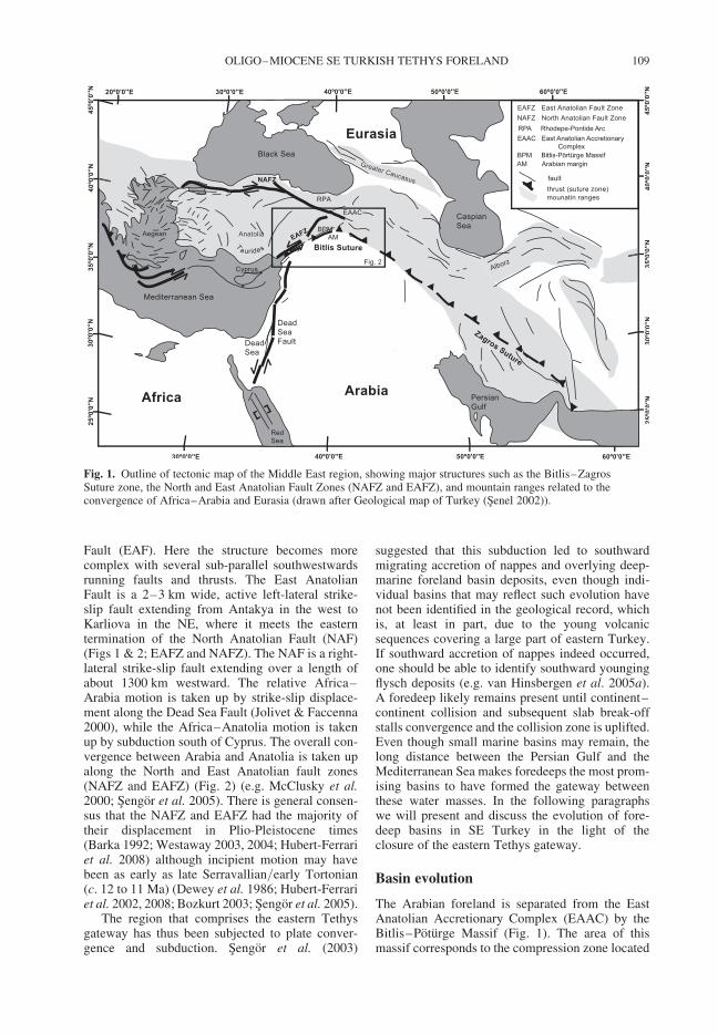
Fault (EAF). Here the structure becomes morecomplex with several sub-parallel southwestwardsrunning faults and thrusts. The East AnatolianFault is a 2–3 km wide, active left-lateral strike-slip fault extending from Antakya in the west toKarliova in the NE, where it meets the easterntermination of the North Anatolian Fault (NAF)(Figs 1 & 2; EAFZ and NAFZ). The NAF is a right-lateral strike-slip fault extending over a length ofabout 1300 km westward. The relative Africa–Arabia motion is taken up by strike-slip displace-ment along the Dead Sea Fault (Jolivet & Faccenna2000), while the Africa–Anatolia motion is takenup by subduction south of Cyprus. The overall con-vergence between Arabia and Anatolia is taken upalong the North and East Anatolian fault zones(NAFZ and EAFZ) (Fig. 2) (e.g. McClusky et al.2000; Sengor et al. 2005). There is general consen-sus that the NAFZ and EAFZ had the majority oftheir displacement in Plio-Pleistocene times(Barka 1992; Westaway 2003, 2004; Hubert-Ferrariet al. 2008) although incipient motion may havebeen as early as late Serravallian/early Tortonian(c. 12 to 11 Ma) (Dewey et al. 1986; Hubert-Ferrariet al. 2002, 2008; Bozkurt 2003; Sengor et al. 2005).
The region that comprises the eastern Tethysgateway has thus been subjected to plate conver-gence and subduction. Sengor et al. (2003)
suggested that this subduction led to southwardmigrating accretion of nappes and overlying deep-marine foreland basin deposits, even though indi-vidual basins that may reflect such evolution havenot been identified in the geological record, whichis, at least in part, due to the young volcanicsequences covering a large part of eastern Turkey.If southward accretion of nappes indeed occurred,one should be able to identify southward youngingflysch deposits (e.g. van Hinsbergen et al. 2005a).A foredeep likely remains present until continent–continent collision and subsequent slab break-offstalls convergence and the collision zone is uplifted.Even though small marine basins may remain, thelong distance between the Persian Gulf and theMediterranean Sea makes foredeeps the most prom-ising basins to have formed the gateway betweenthese water masses. In the following paragraphswe will present and discuss the evolution of fore-deep basins in SE Turkey in the light of theclosure of the eastern Tethys gateway.
Basin evolution
The Arabian foreland is separated from the EastAnatolian Accretionary Complex (EAAC) by theBitlis–Poturge Massif (Fig. 1). The area of thismassif corresponds to the compression zone located
Fig. 1. Outline of tectonic map of the Middle East region, showing major structures such as the Bitlis–ZagrosSuture zone, the North and East Anatolian Fault Zones (NAFZ and EAFZ), and mountain ranges related to theconvergence of Africa–Arabia and Eurasia (drawn after Geological map of Turkey (Senel 2002)).
OLIGO–MIOCENE SE TURKISH TETHYS FORELAND 109
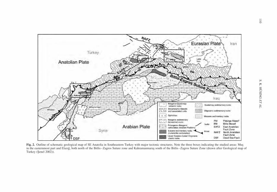
Fig. 2. Outline of schematic geological map of SE Anatolia in Southeastern Turkey with major tectonic structures. Note the three boxes indicating the studied areas: Musin the easternmost part and Elazıg, both north of the Bitlis–Zagros Suture zone and Kahramanmaras south of the Bitlis–Zagros Suture Zone (drawn after Geological map ofTurkey (Senel 2002)).
S.
K.
HU
SIN
GE
TA
L.
110
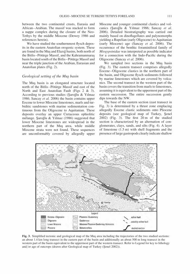
between the two continental crusts, Eurasia andAfrican–Arabian. The massif was stacked to forma nappe complex during the closure of the Neo-Tethys by the middle Miocene (Dewey 1986 andreferences herein).
We have studied the southernmost flysch depos-its in the eastern Anatolian orogenic system. Theseare found in the Mus and Elazıg basins, both north ofthe Bitlis–Poturge Massif, and the Kahramanmarasbasin located south of the Bitlis–Poturge Massif andnear the triple junction of the Arabian, Eurasian andAnatolian plates (Fig. 2).
Geological setting of the Mus basin
The Mus basin is an elongated structure locatednorth of the Bitlis–Poturge Massif and east of theNorth and East Anatolian Fault (Figs 2 & 3).According to previous studies (Saroglu & Yılmaz1986; Sancay et al. 2006) the basin contains upperEocene to lower Miocene limestones, marls and tur-biditic sandstones with marine sedimentation con-tinuous from the Oligocene to Aquitanian. Thesedeposits overlay an upper Cretaceous ophioliticmelange. Saroglu & Yılmaz (1986) suggested thatlower Miocene limestones are widespread in thenorthern part of the Mus area, while middleMiocene strata were not found. These sequencesare unconformably covered by allegedly upper
Miocene and younger continental clastics and vol-canics (Saroglu & Yılmaz 1986; Sancay et al.2006). Detailed biostratigraphy was carried outmainly based on dinoflagellates and palynomorphsyielding a Rupelian (early Oligocene) to Aquitanian(early Miocene) age (Sancay et al. 2006). Theoccurrence of the benthic foraminiferal family ofMiogypsinidae was interpreted as possible indicatorfor a connection with the Indo-Pacific during theOligocene (Sancay et al. 2006).
We sampled two sections in the Mus basin(Fig. 3). The eastern transect comprises allegedlyEocene–Oligocene clastics in the northern part ofthe basin, and Oligocene flysch sediments followedby marine limestones which are covered by volca-nics. The second transect in the western part of thebasin covers the transition from marls to limestones,assuming it is equivalent to the uppermost part of theeastern succession. The entire succession gentlydips towards the NW.
The base of the eastern section (east transect inFig. 3) is determined by a thrust zone emplacingallegedly Eocene clastic sediments onto Pliocenedeposits (see geological map of Turkey, Senel2002) (Fig. 3). The first 20 m of the studiedsection is characterized by an alternation of con-glomerates, clays, sands, and silts (Fig. 4). A layerof limestone (1.5 m) with shell fragments and thepresence of large gastropods clearly indicate shallow
Fig. 3. Simplified tectonic and geological map of the Mus area including the trajectories of the two studied sections:an about 1.4 km long transect in the eastern part of the basin and additionally an about 500 m long transect in thewestern part of the basin equivalent to the uppermost part of the western transect. Refer to Legend for key to lithologyand/or age of outcrops (drawn after Geological map of Turkey (Senel 2002)).
OLIGO–MIOCENE SE TURKISH TETHYS FORELAND 111
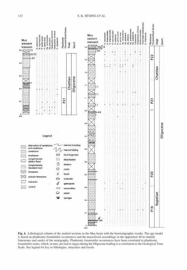
Fig. 4. Lithological column of the studied sections in the Mus basin with the biostratigraphic results. The age modelis based on planktonic foraminifer occurrences and the macrofossil assemblage in the uppermost 40 m (mainlylimestones and sands) of the stratigraphy. Planktonic foraminifer occurrences have been correlated to planktonicforaminifer zones, which, in turn, are tied to stages during the Oligocene leading to a correlation to the Geological TimeScale. See legend for key to lithologies, structures and fossils.
S. K. HUSING ET AL.112
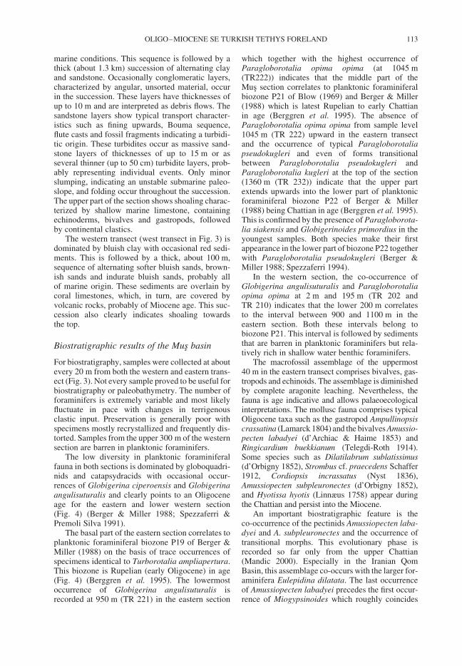
marine conditions. This sequence is followed by athick (about 1.3 km) succession of alternating clayand sandstone. Occasionally conglomeratic layers,characterized by angular, unsorted material, occurin the succession. These layers have thicknesses ofup to 10 m and are interpreted as debris flows. Thesandstone layers show typical transport character-istics such as fining upwards, Bouma sequence,flute casts and fossil fragments indicating a turbidi-tic origin. These turbidites occur as massive sand-stone layers of thicknesses of up to 15 m or asseveral thinner (up to 50 cm) turbidite layers, prob-ably representing individual events. Only minorslumping, indicating an unstable submarine paleo-slope, and folding occur throughout the succession.The upper part of the section shows shoaling charac-terized by shallow marine limestone, containingechinoderms, bivalves and gastropods, followedby continental clastics.
The western transect (west transect in Fig. 3) isdominated by bluish clay with occasional red sedi-ments. This is followed by a thick, about 100 m,sequence of alternating softer bluish sands, brown-ish sands and indurate bluish sands, probably allof marine origin. These sediments are overlain bycoral limestones, which, in turn, are covered byvolcanic rocks, probably of Miocene age. This suc-cession also clearly indicates shoaling towardsthe top.
Biostratigraphic results of the Mus basin
For biostratigraphy, samples were collected at aboutevery 20 m from both the western and eastern trans-ect (Fig. 3). Not every sample proved to be useful forbiostratigraphy or paleobathymetry. The number offoraminifers is extremely variable and most likelyfluctuate in pace with changes in terrigenousclastic input. Preservation is generally poor withspecimens mostly recrystallized and frequently dis-torted. Samples from the upper 300 m of the westernsection are barren in planktonic foraminifers.
The low diversity in planktonic foraminiferalfauna in both sections is dominated by globoquadri-nids and catapsydracids with occasional occur-rences of Globigerina ciperoensis and Globigerinaangulisuturalis and clearly points to an Oligoceneage for the eastern and lower western section(Fig. 4) (Berger & Miller 1988; Spezzaferri &Premoli Silva 1991).
The basal part of the eastern section correlates toplanktonic foraminiferal biozone P19 of Berger &Miller (1988) on the basis of trace occurrences ofspecimens identical to Turborotalia ampliapertura.This biozone is Rupelian (early Oligocene) in age(Fig. 4) (Berggren et al. 1995). The lowermostoccurrence of Globigerina angulisuturalis isrecorded at 950 m (TR 221) in the eastern section
which together with the highest occurrence ofParagloborotalia opima opima (at 1045 m(TR222)) indicates that the middle part of theMus section correlates to planktonic foraminiferalbiozone P21 of Blow (1969) and Berger & Miller(1988) which is latest Rupelian to early Chattianin age (Berggren et al. 1995). The absence ofParagloborotalia opima opima from sample level1045 m (TR 222) upward in the eastern transectand the occurrence of typical Paragloborotaliapseudokugleri and even of forms transitionalbetween Paragloborotalia pseudokugleri andParagloborotalia kugleri at the top of the section(1360 m (TR 232)) indicate that the upper partextends upwards into the lower part of planktonicforaminiferal biozone P22 of Berger & Miller(1988) being Chattian in age (Berggren et al. 1995).This is confirmed by the presence of Paragloborota-lia siakensis and Globigerinoides primordius in theyoungest samples. Both species make their firstappearance in the lower part of biozone P22 togetherwith Paragloborotalia pseudokugleri (Berger &Miller 1988; Spezzaferri 1994).
In the western section, the co-occurrence ofGlobigerina angulisuturalis and Paragloborotaliaopima opima at 2 m and 195 m (TR 202 andTR 210) indicates that the lower 200 m correlatesto the interval between 900 and 1100 m in theeastern section. Both these intervals belong tobiozone P21. This interval is followed by sedimentsthat are barren in planktonic foraminifers but rela-tively rich in shallow water benthic foraminifers.
The macrofossil assemblage of the uppermost40 m in the eastern transect comprises bivalves, gas-tropods and echinoids. The assemblage is diminishedby complete aragonite leaching. Nevertheless, thefauna is age indicative and allows palaeoecologicalinterpretations. The mollusc fauna comprises typicalOligocene taxa such as the gastropod Ampullinopsiscrassatina (Lamarck 1804) and the bivalves Amussio-pecten labadyei (d’Archiac & Haime 1853) andRingicardium buekkianum (Telegdi-Roth 1914).Some species such as Dilatilabrum sublatissimus(d’Orbigny 1852), Strombus cf. praecedens Schaffer1912, Cordiopsis incrassatus (Nyst 1836),Amussiopecten subpleuronectes (d’Orbigny 1852),and Hyotissa hyotis (Linnæus 1758) appear duringthe Chattian and persist into the Miocene.
An important biostratigraphic feature is theco-occurrence of the pectinids Amussiopecten laba-dyei and A. subpleuronectes and the occurrence oftransitional morphs. This evolutionary phase isrecorded so far only from the upper Chattian(Mandic 2000). Especially in the Iranian QomBasin, this assemblage co-occurs with the larger for-aminifera Eulepidina dilatata. The last occurrenceof Amussiopecten labadyei precedes the first occur-rence of Miogypsinoides which roughly coincides
OLIGO–MIOCENE SE TURKISH TETHYS FORELAND 113
with the base of the early Miocene. The entiremollusc assemblage is therefore pointing to a lateChattian age. This dating is supported by theechinoid fauna. Parascutella subrotundaeformis(Schauroth 1865), a sand dollar which occurs mostcommonly in Northern Italy, is restricted to theChattian and Aquitanian.
Comparable assemblages are described from theupper Chattian of the central Iranian Qom For-mation (Mandic 2000; Harzhauser 2004; Reuteret al. 2007) and along the entire northern coast ofthe Western Tethys (Harzhauser et al. 2002). Arelation to the Central Paratethys is indicated bythe occurrence of Ringicardium buekkianum,which is known from the Lower Egerian (UpperChattian) deposits of Hungary (Baldi 1973). Thefaunistic relations towards the east are low. OnlyDilatilabrum sublatissimus (d’Orbigny 1852)reaches to the Zagros Basin and the Arabian shelfduring the Aquitanian (Harzhauser et al. 2007).The echinoderm Clypeaster waageni (Duncan &Sladen 1883), in contrast, represents ties with theechinoid fauna of the Lower Indus Basin.
Numerical ages for the basin fill are provided bythree planktonic foraminiferal bioevents. However,equating highest and lowest occurrences (ho andlo) with the Last Occurrence (LO) and First Occur-rence (FO) of theses species should be accepted withreservation because the positions are poorly deli-neated due to large sampling distances in combi-nation with scarcity and poor preservation of theage diagnostic species.
The oldest bioevent in the Mus section is thelowest occurrence of Turborotalia ampliaperturasome 300 m above the base of the eastern section(TR 190). The LO of this species is calibrated at30.3 Ma (Berggren et al. 1995) providing aminimum age for the base of the Mus section. Theage for the top of the eastern section should beslightly younger than the age of 25.9 Ma for the FOof Paragloborotalia pseudokugleri (Berggren et al.1995) because of the presence of paragloborotalidsbeing transitional between Paragloborotalia pseu-dokugleri and Paragloborotalia kugleri. The ho ofParagloborotalia opima opima at 1045 m (TR 222)in the eastern section provides an extra age cali-bration point of 27.456 Ma being the calibrated agefor the LO of Paragloborotalia opima opima atODP Site 1218 (Wade et al. 2007). The dating ofthe top of the section is in accordance with the macro-fauna which strongly indicates a late Chattian age forthe upper 40 m the eastern transect.
No numerical ages are provided for the westernsection. However, based on the co-occurrence ofGlobigerina angulisuturalis and Paragloborotaliaopima opima in the lower 200 m, this interval corre-lates to the biozone P21. The upper 300 m lack anyage diagnostic planktonic foraminifer.
Palaeoenvironmental interpretations
for the Mus basin
Benthic foraminifers in the sections were further-more used to estimate the depositional depth. Thecommonly used method of calculating depth bydetermining the ratio between planktonic andbenthic foraminifers (van der Zwaan et al. 1990;van Hinsbergen et al. 2005b) is not reliable heredue to significant downslope transport (seen in pre-sence of notorious epifytes and shallow waterbenthic foraminifers such as Pararotalia andAmphistegina) and poor preservation. Instead, wefocus on the deepest water benthic foraminiferaldepth markers (for list see van Hinsbergen et al.2005b) and the macrofossils. In the easternsection, the depositional environment of the lower20 m is characterized by shallow marine conditions,indicated by shell fragments in the limestone.However, a rapid deepening trend occurs at about50 m indicated by the presence of benthic foramini-feral depth markers (typically Cibicides (pseudo)ungerianus, Gyroidina spp. Uvigerina spp. andoccasionally Oridorsalis spp.), and the absence ofmarkers for deeper water, which points at a deposi-tional depth range of 350 to 750 m (the upper limit isconstraint by the occurrence of Oridorsalis spp.after van Hinsbergen et al. 2005b). Towards thetop of the eastern section rapid shoaling is evidentfrom the presence of macrofossils. Both the mol-luscs and echinoderms of the uppermost 40 m indi-cate a shallow marine, tropical to subtropical,depositional environment with sand bottoms andalgal or sea grass patches. Giant conchs such asDilatilabrum sublatissimus (d’Orbigny 1852) arefound today in sea grass meadows and shelteredlagoons, where they live partly buried in the softsubstrate (Bandel & Wedler 1987). Similarly, theextant representatives of the oyster Hyotissa hyotisprefer shallow subtidal habitats where they areattached to rocks and corals (Slack-Smith 1998).Extant Echinolampas and Clypeaster, too, occurmost commonly on sandy sediments with sea grasspatches (Hendler et al. 1995).
In the western section a shoaling trend in theupper 250 m is observed by the relatively richoccurrence of shallow water benthic foraminifersand occasional red sediments. The differencesbetween west and east suggest that the westernpart of the Mus basin shoaled more rapidly orearlier during the Chattian than the eastern part.
Implications for the Mus basin
Based on the occurrence of turbidites, slumpingand minor folding, this about 1.5 km thick marinesuccession is interpreted as deposits of a deepmarine basin.
S. K. HUSING ET AL.114
Shallow marine conditions during the Rupelian(P19) were replaced by rapid deepening of thebasin during biozone P22, late Chattian. The endof the flysch deposition during the Chattian marksthe emergence of the basin which probablyremained shallow marine until the late Chattian.
Considering the biostratigraphic ages, a sedimen-tation rate between 15 and 27 cm/ka is calculated.The constant water depth of 350 to 750 m duringdeposition indicates approximately 2 km of subsi-dence throughout the Oligocene, followed by rapiduplift and exposure of the succession after the lateChattian. Our biostratigraphic dates based on plank-tonic foraminifers in the flysch deposits corroboratethe ages published previously based on dinoflagel-lates and palynomorphs (Sancay et al. 2006).
Geological setting of the Elazıg basin
The studied Gevla section is situated in the eastern-most part of the Elazıg basin, about 40 km NE ofElazıg (Fig. 2). The basin has been studied byseveral workers; however, the literature has beenpublished mostly in Turkish (see Aksoy et al.2005) and no detailed information is available forthe easternmost part of the basin. At present, thebasin fill is exposed in an NE–SW belt in theeastern Taurides of Anatolia. The generalized strati-graphy of the Tertiary sediments has been describedas: lower Paleocene continental deposits at the base,followed by upper Paleocene to lower Miocenemarine deposits and finally Pliocene to Quaternarycontinental deposits. The basement of the Elazıgbasin is formed by Permo-Triassic metamorphicrocks, namely Keban Metamorphics, which wereemplaced over upper Cretaceous magmatic rocksnorth of Elazıg (Perincek 1979; Perincek &Ozkaya 1981; Aktas & Robertson 1984; Bingol1984; Aksoy et al. 2005).
Detailed stratigraphic, sedimentological andtectonic characteristics of the Elazıg area havebeen discussed elsewhere (e.g. Perincek 1979;Perincek & Ozkaya 1981; Aktas & Robertson1984; Bingol 1984; Cronin et al. 2000a, b; Aksoyet al. 2005). From the late Paleocene, shallowmarine carbonates, deposited in an extensionalback-arc setting, were accumulated when the basinfurther subsided until Middle to Late Eocene(Aksoy et al. 2005). During Oligocene to earlyMiocene, after reaching its maximum extendduring the Middle to Late Eocene, deposition wasrestricted to the N–NW and became progressivelyshallower, indicated by Oligocene reefal limestonesuntil the final subaerial exposure at the end ofOligocene. Marine Miocene deposits are restrictedto small areas in the basin and more widespreadnorth of the basin. From Middle Miocene onwardsthe basin was affected by a strong, north–south,
compression. Later, Pliocene to Pleistocene alluvialfan, fluvial and lacustrine sediments were depositedcovering Early Miocene sediments (Cronin et al.2000a, b; Aksoy et al. 2005).
In this setting, we studied a section situated in theeasternmost part of the Elazıg basin. According tothe geological map of Turkey (Senel 2002), in thearea east of the town Basyurt (Fig. 5), Lower toMiddle Eocene continental clastics unconformablyoverly Mesozoic ophiolitic melange. These clasticsediments are, in turn, overlain by either Miocene–Pliocene clastic or volcanic rocks.
The basal part of the studied Gevla succession,about 15 km NE of Basyurt, starts with bluishmarine clay containing bivalves, followed by analternation of clay and sandstone (the sandstonesare up to 50 cm thick or about 5 m thick withcross bedding) (Fig. 6). A distinct layer with abun-dant bivalves and gastropods is located at about50 m stratigraphic position. Three distinct limestonelayers occur between about 100 m and 260 m strati-graphic level. The first one, at about 100 m, is anodular limestone with shell fragments, sponges(up to 30 cm) and corals, followed by two nummu-litic limestone horizons, at 244 m and 255 m. This isfollowed by about 400 m of blue clay grading intoa 600 m thick succession of alternating clay andsandstone, whereby the sand layers show typicaltransport characteristics, such as shell fragments,
Fig. 5. Simplified tectonic and geological map of theeasternmost part of the Elazıg basin. The trajectory of thestudied section, called Gevla, is about 15 km NE of thecity Basyurt and covers the interval between Eocenelimestones and Miocene volcanics to the north. For keyto the lithologies and/or ages refer to Legend (drawnafter Geological map of Turkey (Senel 2002)).
OLIGO–MIOCENE SE TURKISH TETHYS FORELAND 115
displaced nummulites and gastropods (for instanceat 663 m and 1158 m), fining upward sequencesand cross bedding. These layers are interpreted asturbiditic in origin. This succession is followed byabout 300 m of blue clay, and the section endswith a 50 m thick limestone with bivalves (up to5 cm), and clayey intervals with well preservedechinoderms, sponges and corals. These limestones,in turn, are covered by Miocene volcanic rocks. Intotal, the section is about 1.6 km thick.
Slumping at several levels within the successionindicates an unstable submarine slope. Internalfolding is not observed within the succession. Theentire succession gently dips towards the NW.
Biostratigraphic results of the Elazıg basin
Hand samples were collected from about every 20 mthroughout the entire section, but not every samplecontained (diagnostic) planktonic and/or benthicforaminifers. The number of foraminifers is extre-mely variable and most likely fluctuates withchanges in terrigenous clastic input. Preservationis generally poor, with specimens mostly recrystal-lized and frequently distorted. The overall aspectsof the planktonic foraminiferal fauna in thissection is similar to that of the Mus section, whichmeans that the foraminiferal fauna is dominatedby globoquadrinids and catapsydracids withoccasional occurrences of Globigerina ciperoensisand Globigerina angulisuturalis pointing to anOligocene age for this section (Fig. 6) (Berger &Miller 1988; Spezzaferri & Premoli Silva 1991).The presence of Turborotalia ampliapertura up toand including level 287 m (TR 244) providesevidence that the lower part of the section correlateswith planktonic foraminiferal biozone P19 ofBerger & Miller (1988), which is late Rupelian,early Oligocene, in age (Berggren et al. 1995).The lowest occurrence of Globigerina angulisutur-alis is recorded at 477 m (TR 250) which in termsof the zonal scheme of Berger & Miller (1988)would mark the top of biozone P20 although itshould be noted that Globigerina angulisuturalis isneither frequent in this section nor does it displayvery prominent U-shaped sutures. Typical Paraglo-borotalia opima opima is present from level 317 m(TR 245) up to and including level 1445 m (TR 293)indicating that the larger part of the Gevla sectioncorrelates with planktonic foraminiferal biozone
Fig. 6. Lithological column of the studied Gevla sectionin the Elazıg basin with the biostratigraphic results.The age model is based on planktonic foraminifers andmacrofossil assemblage in the 50 m of stratigraphy.Planktonic foraminifer occurrences have been correlated
Fig. 6. (Continued) to planktonic foraminifer zones,which, in turn, are tied to stages during the Oligoceneresulting into a correlation to the Geological Time Scale.Refer to Legend in Figure 4 for key to lithologies,structures and fossils.
S. K. HUSING ET AL.116
P21 of Blow (1969) and Berggren et al. (1995)which in terms of chronostratigraphy is latestRupelian to early Chattian in age (Berggren et al.1995). The top of the section post-dates the highestoccurrence of Paragloborotalia opima opima, andcorrelates to the basal part of the late Chattian plank-tonic foraminiferal biozone P22 (Berger & Miller1988), which is evidenced by the joint presence ofParagloborotalia opima nana, Globigerina ciper-oensis, Globigerina angulisuturalis and Globigeri-noides primordius.
The macrofossil assemblage from the upper50 m in this section is similar to the assemblage inthe uppermost 40 m of the eastern transect in theMus basin (Figs 3 & 4). Both assemblages bear atypical late Chattian pectinid fauna with Amussio-pecten labadyei and A. subpleuronectes. Pectenarcuatus (Brocchi 1814), a widespread Oligocenespecies, a typical Western Tethys element, ispresent as well, along with the thin-shelled lucinidbivalve Anodontia globulosa (Deshayes, 1830).The dominance of such thin shelled species mightindicate a slightly deeper environment than in thecorresponding section of the Mus basin, yet notdeeper than the medium deep sublittoral environ-ment (Mandic and Piller 2001).
The LO of Turborotalia ampliapertura has beencalibrated to 30.3 Ma within Chron 11r (Berggrenet al. 1995). The highest occurrence of this speciesin level 287 m (TR 244) therefore suggests an ageolder than 30.3 Ma for the bottom of the section.The LO of Paragloborotalia opima opima in level1445 m (TR 293) has been recently recalibrated to27.456 Ma within Chron 9n at ODP Site 1218(Wade et al. 2007). This age provides a maximumage for the top of the section since the highest occur-rence of Paragloborotalia opima opima occurs nearthe top of the section (TR 293). A correlation of theupper 50 m of the section to biozone P22 is sup-ported by the mollusc fauna which indicates a lateChattian age.
Paleoenvironmental interpretations
for the Elazıg basin
The depositional environment during the lowerRupelian (biozone P19) was first shallow marineas indicated by the occurrence of limestone withcorals, bivalves and gastropods.
However, the depositional environment rapidlydeepened as indicated by benthic foraminiferaldepth marker species (Cibicides (pseudo-)ungerianus,Gyroidina spp. Uvigerina spp. and occasionallyOridorsalis spp.). Their presence up to the top indi-cates that the basin was 350 to 700 m deep duringmuch of the Oligocene. The benthic foraminifersdo not give any evidence for shoaling, although
the limestone deposits at the top of the section andtheir macrofossils indicates a medium to shallowsubtidal environment for the late Chattian.
Implications for the Elazıg basin
The first 260 m of the studied section was depositedunder shallow marine conditions during Rupelian(biozone P19). This was followed by a rapid deepen-ing during the Rupelian and the deposition of about1.3 km in a relatively deep marine (300 to 750 m)environment. During the late Chattian (biozoneP22), the basin experienced rapid shoaling tomedium deep sublittoral conditions, preferred con-ditions for echinoids and bivalves. The inferredlate Chattian age of the macrofossils in the top ofthe section indicates that the final emergence ofthe basin must have occurred shortly after the Chat-tian followed by widespread Miocene volcanism.
The numerous internal slumping and sandstonelayers, referred to as turbidites, indicate a submar-ine, unstable slope. The entire succession is inter-preted as flysch deposited in a deep marine basin,comparable to the Mus basin. Thus, during theOligocene, rapid (15–30 cm/ka) sedimentation ofclay and turbidites dominated the basin evolution.
These new biostratigraphic ages differ signifi-cantly from the geological map of Turkey (Senel2002) where these sediments are indicated as Lowerto Middle Eocene. Our data suggests instead thatthese sediments were deposited under deep marineconditions during the Oligocene, from the Rupelianuntil the late Chattian, and, additionally, the shallowmarine limestones at the top of the section are lateChattian in age. This data also differs from previousstudies in the area (e.g. see Aksoy et al. 2005 for acompilation of data from the Elazıg basin) wherethe Eocene time has been identified as the mainperiod of deep marine deposition and in the Oligo-cene time shallow marine deposits were restrictedto the NW of the Elazıg basin. Our data howeverindicates that at least the eastern part of the Elazıgbasin was deep marine throughout the Oligoceneand shoaled and emerged only in the late Chattian,latest Oligocene.
Geological setting of the Kahramanmaras
basin
The Kahramanmaras basin is located near the triplejunction of the Arabian, African and Anatolianplates. As a result of the collision of Arabia andEurasia along the Bitlis Suture a trough formed infront of the thrust sheets and was consequentlyfilled by thick alluvial sediments and thick turbiditicflyschsequences (LiceFormation) (Sengor&Yılmaz1981; Perincek & Kozlu 1983; Karig & Kozlu 1990;
OLIGO–MIOCENE SE TURKISH TETHYS FORELAND 117
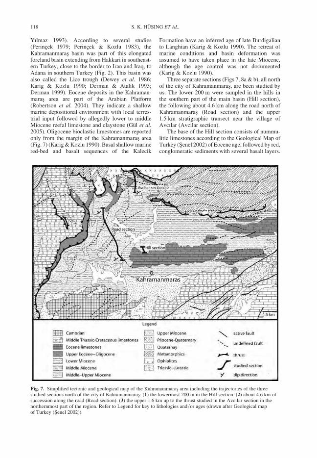
Yılmaz 1993). According to several studies(Perincek 1979; Perincek & Kozlu 1983), theKahramanmaras basin was part of this elongatedforeland basin extending from Hakkari in southeast-ern Turkey, close to the border to Iran and Iraq, toAdana in southern Turkey (Fig. 2). This basin wasalso called the Lice trough (Dewey et al. 1986;Karig & Kozlu 1990; Derman & Atalik 1993;Derman 1999). Eocene deposits in the Kahraman-maras area are part of the Arabian Platform(Robertson et al. 2004). They indicate a shallowmarine depositional environment with local terres-trial input followed by allegedly lower to middleMiocene reefal limestone and claystone (Gul et al.2005). Oligocene bioclastic limestones are reportedonly from the margin of the Kahramanmaras area(Fig. 7) (Karig & Kozlu 1990). Basal shallow marinered-bed and basalt sequences of the Kalecik
Formation have an inferred age of late Burdigalianto Langhian (Karig & Kozlu 1990). The retreat ofmarine conditions and basin deformation wasassumed to have taken place in the late Miocene,although the age control was not documented(Karig & Kozlu 1990).
Three separate sections (Figs 7, 8a & b), all northof the city of Kahramanmaras, are been studied byus. The lower 200 m were sampled in the hills inthe southern part of the main basin (Hill section),the following about 4.6 km along the road north ofKahramanmaras (Road section) and the upper1.5 km stratigraphic transect near the village ofAvcılar (Avcılar section).
The base of the Hill section consists of nummu-litic limestones according to the Geological Map ofTurkey (Senel 2002) of Eocene age, followed by red,conglomeratic sediments with several basalt layers.
Fig. 7. Simplified tectonic and geological map of the Kahramanmaras area including the trajectories of the threestudied sections north of the city of Kahramanmaras: (1) the lowermost 200 m in the Hill section. (2) about 4.6 km ofsuccession along the road (Road section). (3) the upper 1.6 km up to the thrust studied in the Avcılar section in thenorthernmost part of the region. Refer to Legend for key to lithologies and/or ages (drawn after Geological mapof Turkey (Senel 2002)).
S. K. HUSING ET AL.118
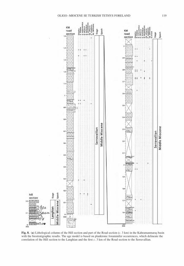
Fig. 8. (a) Lithological column of the Hill section and part of the Road section (c. 3 km) in the Kahramanmaras basinwith the biostratigraphic results. The age model is based on planktonic foraminifer occurrences, which delineate thecorrelation of the Hill section to the Langhian and the first c. 3 km of the Road section to the Serravallian.
OLIGO–MIOCENE SE TURKISH TETHYS FORELAND 119
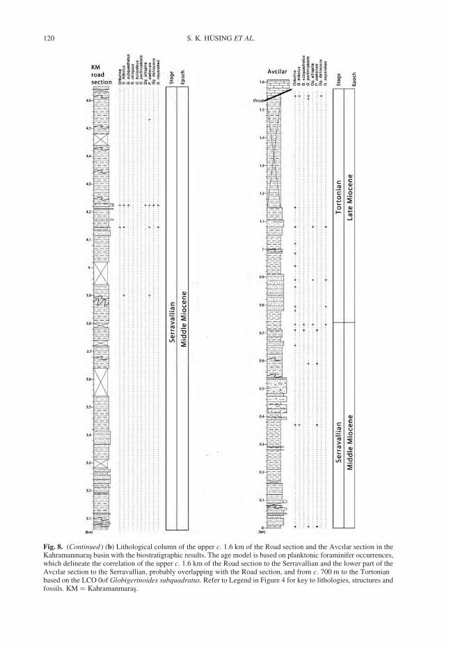
Fig. 8. (Continued ) (b) Lithological column of the upper c. 1.6 km of the Road section and the Avcılar section in theKahramanmaras basin with the biostratigraphic results. The age model is based on planktonic foraminifer occurrences,which delineate the correlation of the upper c. 1.6 km of the Road section to the Serravallian and the lower part of theAvcılar section to the Serravallian, probably overlapping with the Road section, and from c. 700 m to the Tortonianbased on the LCO 0of Globigerinoides subquadratus. Refer to Legend in Figure 4 for key to lithologies, structures andfossils. KM ¼ Kahramanmaras.
S. K. HUSING ET AL.120
The studied section begins with a 200 m thick suc-cession of nodular limestone (10–15 m thick) alter-nating with bluish marls. The limestones containmacrofossils such as corals, sponges, echinoderms,bivalves and gastropods, indicating a shallowmarine environment. This succession grades intoan alternation of marl and sandstones layers,which show typical Bouma sequences and flutecasts, which are indicative for a turbiditic origin.
The base of the Road section, however, exposesa strongly different succession, where almost 1 kmof the stratigraphy is dominated by large conglomer-ate lenses. This thick succession of conglomeratescontains sand lenses showing cross bedding, indica-tive of interfingering of braided river channels. Thisthick fluvial succession probably forms, at least inpart, the lateral equivalent of the shallow marinesuccession in the Hill section. This conglomeraticsuccession is followed by a level rich in oysters,indicating a transition into shallow marine con-ditions. This then grades quickly into a very thicksuccession of alternating marl and sandstone (asmentioned above) with occasional conglomeraticlayers, interpreted as debris flows, which cutthrough the stratigraphy. The sandstones showtypical characteristics for turbidites, such as flutecasts and Bouma sequences. Some intervals aredominated by massive sandstone layers and/ordebris flows, while others are characterized bymainly clay. Slumping can be easily differentiatedfrom (minor) internal folding, both occurringthroughout the section. Internal folding, however,does not occur often. The Road section ends at thehighest point in the topography along the roadgoing NNW from Kahramanmaras and since thestratigraphy dips to the NW, a continuation of thestratigraphy was found to the NE, the Avcılarsection (Fig. 7). This section was sampled assumingsufficient overlap with the Road section, until thestratigraphy was cut unconformably by carbonates(Figs 8a & b). The stratigraphy of the Avcılarsection also consists of a thick succession (about1.5 km) of mudstone and sandstone with occasionalconglomeratic layers, interpreted as debris flows.No shoaling trend based on sedimentologicalcharacteristics has been observed towards the topof the section, which ends abruptly with the over-thrusting of pre-Neogene carbonates, which wereemplaced roughly from North. The upper 400 mwere not exposed, except for a few meters justunderneath the thrust (Fig. 8b).
Biostratigraphic results of the
Kahramanmaras basin
About every 20 m hand samples were taken for bios-tratigraphy. Only few samples, however, turned out
to be useful for biostratigraphy and/or paleobathy-metry. Benthic foraminifers in the lower part ofthe Kahramanmaras basin, from the Hill section(Fig. 8a) are dominated by milliolids and represen-tatives of Ammonia, Textularia, Nonion andElphidium indicating shallow marine (inner shelf)conditions although some samples, at 146, 182 and198 m (TR 9, 12 and 14), respectively, containfew planktonic foraminifers such as Globigeri-noides trilobus, Globigerinoides obliquus andOrbulina. Their presence would indicate that thelower part of the Kahramanmaras sequence post-dates the Orbulina datum at 14.74 Ma (Lourenset al. 2004). This age assignment is further con-straint by the presence of the calcareous nannofossilCyclicargolithus abisectus and rare Spenolithusheteromorphus along with the absence of Helico-sphaera ampliaperta. This assemblage is tentativelyassigned to NN5 (Martini 1971) indicating aLanghian age.
Orbulina is common in the samples from theRoad section. The rare occurrences of Globorataliapartimlabiata in the Road section at 165, 175, 2725,2788 and 2875 m (TR 20, 21, 71, 73 and 77),respectively, are remarkable because they representthe first recording of this species in Turkey. It hasbeen first described from the middle Miocene ofSicily (Ruggieri & Sprovieri 1970) and since thenreported from the Mediterranean (amongst othersForesi et al. 1998 and references herein; Hilgenet al. 2000; Turco et al. 2001; Foresi et al. 2002a,b; Hilgen et al. 2003; Abels et al. 2005) and adjacentNorth Atlantic (Chamley et al. 1986) and even fromthe Indian Ocean off NW Australia (Zachariasse1992). Ages of FO and LO of Globoratalia partim-labiata in the Mediterranean have recently beenrecalibrated at 12.771 and 9.934 Ma (Husing et al.2007). Its presence in the basal part of the Roadsection along with Globigerinoides subquadratusat 4224 m (TR 114) indicates that the larger partof the Road section, up to 4200 m, is Serravallian,Middle Miocene, in age, since the base of the Torto-nian has been defined at a level close to the LastCommon Occurrence (LCO) of Globigerinoidessubquadratus (Hilgen et al. 2000, 2005) with anew astronomical age of 11.625 Ma (Husing et al.2007). It cannot be excluded that the Road sectionterminates into the lowermost Tortonian sinceParagloborotalia siakensis at 4532 m (TR 120) isthe only biostratigraphic marker species presentabove 4200 m.
In the Avcılar section, the occasional occur-rences of Paragloborotalia siakensis up to 710 m(TR151) along with Globorotalia partimlabiata at590 m and Globigerinoides subquadratus at 710and 730 m, respectively, (TR 151 and 152) indicatethat the lower 700 m of this section is also Serraval-lian in age. The absence of Globigerinoides
OLIGO–MIOCENE SE TURKISH TETHYS FORELAND 121
subquadratus and Paragloborotalia siakensis in theupper part of the Avcılar section along with the pre-sence of Globorotalia partimlabiata near the top ofthe section (TR 169 and 172) suggests that thesection extends up into the Tortonian.
The Avcılar section has been sampled assuminga significant overlap with the Road section and if theuppermost part of the Road section indeed extendsinto the Tortonian, we might assume an overlapof up to 1 km between these two sections. Themaximum age range of the road section andAvcılar section is indicated by the age range ofGloboratalia partimlabiata of 12.771–9.934 Ma(Husing et al. 2007).
Paleoenvironmental interpretations
for the Kahramanmaras basin
Deposition of the lower 200 m occurred in shallowmarine conditions, as indicated by the occurrenceof benthic foraminifers, calcareous nannofossils,poorly preserved echinoderms, gastropods and thelarge estuarine oyster Crassostrea gryphoides(Schlotheim, 1820). This large-sized Oligocene toMiocene species is restricted to brackish waterenvironments with a high nutrient input andprefers building colonies on mud flats of outer estu-aries (Slack-Smith 1998). Benthic foraminiferalspecies of the flysch succession from the road andAvcılar, such as Cibicides (pseudo-)ungerianus,Gyroidina spp., Uvigerina spp., Oridorsalis spp.and occasionally Siphonina reticulata, suggestwater depths between 350 and 750 m during depo-sition of this section without evidence for shoalingtowards the top, which is, in turn, cut by the thrustin the Avcılar section.
Implications for the Kahramanmaras basin
During the Langhian – early Serravallian, shallowmarine conditions prevailed in the Kahramanmarasbasin. The basin deepened during late Langhian/early Serravallian as indicated by the change fromlimestones and/or conglomerates to an alternationof marl and turbidites. Since neither in the lithology,nor in the biostratigraphic data, a shoaling trendtowards the top of the section is observed, deepmarine conditions (350–750 m) prevailed in thebasin until the early Tortonian.
We interpret the whole section as a characteristicforeland basin flysch succession (as Dewey 1986;Karig & Kozlu 1990; Derman & Atalik 1993;Derman 1999). Assuming the Road and Avcılar sec-tions were sampled with no overlap, the maximumthickness is about 6.1 km, but assuming an overlapof up to 1 km, the maximum thickness is about5.1 km. It is very difficult to estimate a
sedimentation rate for this basin, because three sec-tions were sampled with an unknowing overlap.Secondly the accuracy of the age indicative biostra-tigraphic events is uncertain due to poor preser-vation and poor sampling resolution. Furthermore,the age indicative biostratigraphic events, LCO ofGlobigerinoides subquadratus and LO of Globoro-talia partimlabiata are recorded in different sec-tions, which makes the determination of thesedimentation rate between these two calibrationpoints nearly impossible. The sedimentation ratesthus vary much, between 50 and 450 cm/ka, butincluding slumps, debris flows and turbidites depos-ited in front of and during the activity of the thrustthat now covers the top of the sequence. Taking aconservative estimate of 100 to 200 cm/ka, alsobecause the LO of Globigerinoides subquadratusmight not correspond to the true LCO, dated at11.625 Ma (Husing et al. 2007), but might behigher in the stratigraphy, the age of the youngestflysch is about 11 Ma.
This age range, from Langhian to early Torto-nian, differs significantly from the assigned Oligo-cene age of the open marine flysch and limestonedeposits in the Mus and Elazıg basins. The continu-ous marine sedimentation in the Kahramanmarasbasin from Langhian to early Tortonian at a constantdepth indicates that tectonic subsidence, possibly upto the order of 5 km, dominated the evolution ofthe basin.
Discussion
Evolution of the east Anatolian basins
The stratigraphic results from the east Anatolianbasins are summarized in Figure 9, and are corre-lated to the Geological Time Scale (Gradsteinet al. 2005). This figure schematically illustratesthat the individual basins belong to two different,major basins: (1) a basin north of the Bitlis–Poturge Massif, encompassing the Elazıg and Musbasins, which was filled with clastic mass flowdeposits during the Rupelian and Chattian (Oligo-cene); (2) a basin south of the Bitlis–PoturgeMassif, a foreland basin which was filled withclastic sediments during the Langhian, Serravallianand early Tortonian (Middle and early LateMiocene).
The Mus and Elazıg basin, both north of theBitlis–Poturge Massif, show similar stratigraphicevolution during the Oligocene: Deepening of thebasin occurred during the Rupelian and deepmarine conditions (350–750 m) prevailed until theChattian. Both basins evidence a shoaling trendduring the Chattian. The macrofossil assemblagein the sandy limestones, such as molluscs and
S. K. HUSING ET AL.122
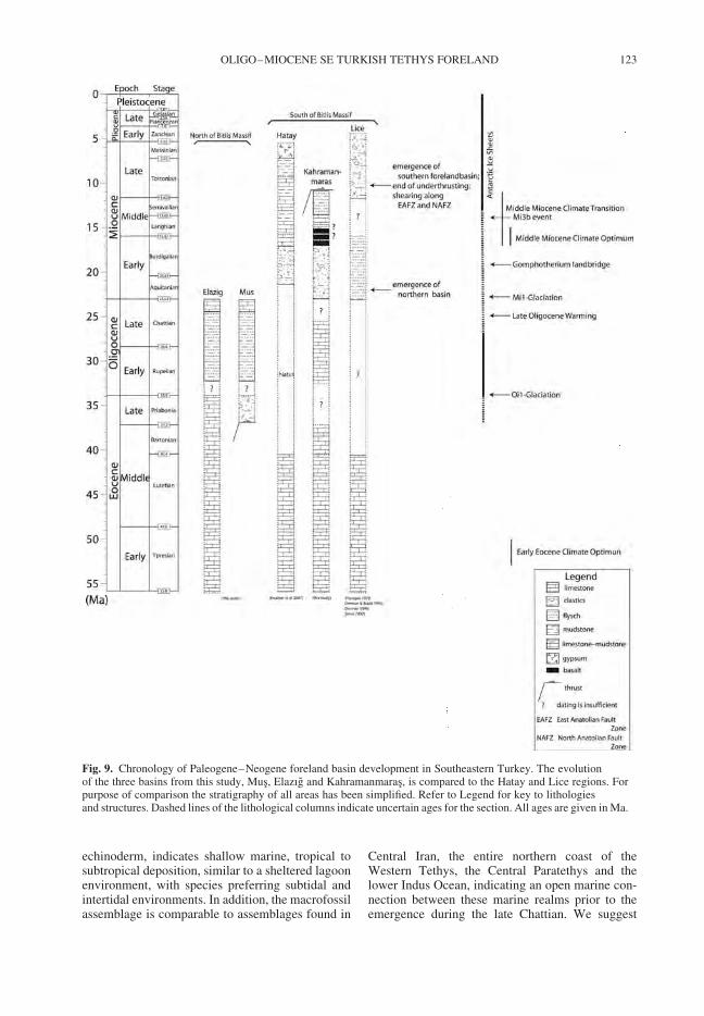
echinoderm, indicates shallow marine, tropical tosubtropical deposition, similar to a sheltered lagoonenvironment, with species preferring subtidal andintertidal environments. In addition, the macrofossilassemblage is comparable to assemblages found in
Central Iran, the entire northern coast of theWestern Tethys, the Central Paratethys and thelower Indus Ocean, indicating an open marine con-nection between these marine realms prior to theemergence during the late Chattian. We suggest
Fig. 9. Chronology of Paleogene–Neogene foreland basin development in Southeastern Turkey. The evolutionof the three basins from this study, Mus, Elazıg and Kahramanmaras, is compared to the Hatay and Lice regions. Forpurpose of comparison the stratigraphy of all areas has been simplified. Refer to Legend for key to lithologiesand structures. Dashed lines of the lithological columns indicate uncertain ages for the section. All ages are given in Ma.
OLIGO–MIOCENE SE TURKISH TETHYS FORELAND 123
that the Mus and Elazıg basins were connectedforming a large east–west elongated deep marinebasin during Rupelian and Chattian.
The rapid deepening of the basin north of theBitlis Massif may be related either to onset offlexural subsidence associated with (northward)underthrusting within the prevailing overall com-pressional regime (e.g. for the Elazıg basin Cronin(2000a, b)) or to the late stages of an extensionaldeformation period that persisted in the Paleoceneand Eocene (e.g. in the Malatya basin (Kaymakciet al. 2006) and in the Mus area (Sengor et al.1985)). These two scenarios are controversial andour data provide age and depth constraints on theMus and Elazıg basins, which do not allow to elim-inate or prefer either of these scenarios.
In the Kahramanmaras basin, south of theBitlis–Poturge Massif, shallow marine sedimentswere deposited during the Langhian. A rapid dee-pening during the Langhian to Serravallian indi-cated by the rapid transition to deep marine (350to 750 m) flysch deposits, was followed by depo-sition of continuously deep marine sediments untilthe early Tortonian. Since no shoaling trend isobserved we suggest that the age of the youngestflysch underneath the thrust, biostratigraphicallydated as early Tortonian, at about 11 Ma, coincideswith the end of underthrusting.
The rapid deepening of the foreland basin southof the Bitlis–Poturge Massif during the Langhian toSerravallian, followed by the deposition of a thickdeep marine flysch succession, can be interpretedas northern Arabia and more specifically the areaof the Kahramanmaras basin, entering into the sub-duction zone underneath Anatolia. The end of flyschdeposition and thus the youngest flysch underneaththe thrust of the overriding Bitlis–Poturge Massifcould be envisaged as the end of subduction, thusunderthrusting, at about 11 Ma (Tortonian), whichis likely followed by rapid uplift in the region.Such episodes of very rapid uplift and folding offoreland basins associated with the stalling of under-thrusting is, for example, also well documented inthe western Aegean region (Richter et al. 1978;van Hinsbergen et al. 2005a, c, d).
Our new results of the Kahramanmaras basin canbe compared to previously published data from theHatay (around Antakya) and Lice regions (seeFigs 2 & 9), which have been interpreted as forelandbasins related to southward thrusting of the Taurusallochton over the Arabian continental marginbelonging to an east–west elongated forelandbasin overlying the Arabian promontory (e.gPerincek 1979; Karig & Kozlu 1990; Derman andAtalik 1993; Derman 1999; Robertson et al. 2004).
The stratigraphy and chronology of the Hatayarea is very similar to the evolution of the Kahra-manmaras basin. The chronology in the Hatay area
has recently been redefined based on micropaleon-tological dating (Boulton et al. 2007) and we cantherefore correlate the evolution of the Kahraman-maras basin to the Hatay area. The stratigraphy inthe Hatay area is characterized by a pronouncedangular unconformity between middle Eocene andoverlying lower Miocene sediments, with a hiatusin the Oligocene (Boulton & Robertson 2007).Sedimentation resumed during the Aquitanian toBurdigalian (Early Miocene) with deposition ofconglomerates and mudstones. In the Kahraman-maras area, Derman & Atalik (1993) and Derman(1999) assigned a lower Miocene age to the about1 km thick series of fluvial deposits, which precedethe thick flysch deposits. We, however, have no ageconstraints on the fluvial deposits and can thereforenot confirm an Early Miocene age. During theLanghian both basins experienced shallow marinelimestone deposition and the basin progressivelydeepened during Serravallian to Tortonian (Boultonet al. 2007; Boulton & Robertson 2007). The depo-sition of shallow marine limestones in the Hatayarea have been interpreted to be related to furtherloading of the lithosphere in response to flexuralsubsidence and the progressive deepening to flex-ural control (Boulton & Robertson 2007). Whereflexural subsidence exceeded the build up of a car-bonate platform hemipelagic sediments were depos-ited (Boulton et al. 2007; Boulton & Robertson2007). A similar scenario can be envisaged for theKahramanmaras basin indicated by coarseningupwards in the thick flysch deposition. In the Hatayarea, by the end of the Miocene, the tectonic regimechanged and the Pliocene–Quaternary HatayGraben structure was formed in a transtensionalsetting related to the EAF (Perincek & Cemen1990; Boulton et al. 2007; Boulton & Robertson2007), while deep marine sediments in the Kahra-manmaras basin were overthrusted already duringthe early Tortonian. This comparison might indicatea diachronous evolution of these two basins with theKahramanmaras basin emerging during the Torto-nian and the Hatay area remaining open marineuntil the deposition of Messinian evaporites, ordifferent basin evolutions due to the relativelywestern position of the Hatay area thus closer tothe present-day extent of the eastern Mediterranean.
A comparison to the Lice basin, which is situatedto the east of the Kahramanmaras basin, would evi-dently give constraints on the syn- or diachronousevolution of the southernmost, Arabian forelandbasin. However, the chronology of sediments inthe Lice basin is scarcely documented in the litera-ture (e.g. Perincek 1979; Dewey 1986; Karig &Kozlu 1990; Robertson et al. 2004). On the geologi-cal map of Turkey (Senel 2002) shallow marineclastic and carbonatic sediments have been indi-cated as Early Miocene in age and continental
S. K. HUSING ET AL.124
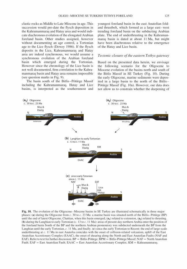
clastic rocks as Middle to Late Miocene in age. Thissuccession would pre-date the flysch deposition inthe Kahramanmaras and Hatay area and would indi-cate diachronous evolution of the elongated Arabianforeland basin. Other studies assigned, howeverwithout documenting an age control, a Tortonianage to the Lice flysch (Dewey 1986). If the flyschdeposits in the Lice, Kahramanmaras and Hatayarea are indeed synchronous, we would assume asynchronous evolution of the Arabian forelandbasin which emerged during the Tortonian.However since the chronology of the Lice basin isnot well documented, firm correlation to the Kahra-manmaras basin and Hatay area remains impossible(see question marks in Fig. 9).
The basin south of the Bitlis–Poturge Massifincluding the Kahramanmaras, Hatay and Licebasins, is interpreted as the southernmost and
youngest foreland basin in the east Anatolian fold-and thrustbelt, which formed as a large east–westtrending foreland basin on the subducting Arabianplate. The end of underthrusting in the Kahraman-maras basin is dated at about 11 Ma, but mighthave been diachronous relative to the emergenceof the Hatay and Lice basin.
Tectonic closure of the eastern Tethys gateway
Based on the presented data herein, we envisagethe following scenario for the Oligocene toMiocene evolution of the basins north and south ofthe Bitlis Massif in SE Turkey (Fig. 10). Duringthe early Oligocene, marine sediments were depos-ited in a large basin to the north of the Bitlis–Poturge Massif (Fig. 10a). However, our data doesnot allow us to constrain whether the deepening of
c .
c . c .
c .
c . c . c .(a1) (a2)
(b)
(c)
Fig. 10. The evolution of the Oligocene–Miocene basins in SE Turkey are illustrated schematically in three majorphases: (a) during the Oligocene from c. 30 to c. 23 Ma: a marine basin was situated north of the Bitlis–Poturge (BP)until the end of latest Oligocene, Chattian, when this basin emerged; (a1) related to extension, (a2) related to thrusting.(b) during the Langhian to early Tortonian (c. 13 to c. 11 Ma): areas of present-day northern Arabia enter the position ofthe foreland basin South of the BP and the northern Arabian promontory was subducted underneath the BP from theLanghian until the early Tortonian, c. 11 Ma, and finally. (c) since the early Tortonian to Recent: the end of large-scaleunderthrusting at c. 11 Ma in east Anatolia coincides with the onset of collision-related volcanism, uplift of the EastAnatolian Accretionary Complex (EAAC), the onset of shearing along the North and East Anatolian Faults (NAF andEAF). Refer to text for further discussion. BP ¼ Bitlis-Poturge; BPM ¼ Bitlis-Poturge Massif; NAF ¼ North AnatolianFault; EAF ¼ East Anatolian Fault; EAAC ¼ East Anatolian Accretionary Complex; KM ¼ Kahramanmaras.
OLIGO–MIOCENE SE TURKISH TETHYS FORELAND 125
the basin during the Rupelian was related to eitherlarge scale extension (Fig. 10a1) or thrusting(Fig. 10a2), with the Bitlis–Poturge Massif situatedon the overriding plate. Nevertheless, our datasuggest that until the Chattian, flysch was depositedin a deep marine environment, as recorded in thearea of Mus and Elazıg. The emergence of thebasin north of the Bitlis–Poturge Massif duringthe late Chattian (see also Fig. 9) probably coincideswith the accretion of the Bitlis–Poturge Massif tothe Anatolian plate.
On the southern side of the Bitlis–PoturgeMassif, oceanic subduction was probably ongoingdue to Africa/Arabian’s relative distal position(e.g. Besse & Courtillot 2002).
During the Langhian to Serravallian the basinsouth of the Bitlis–Poturge Massif deepened rapidly,which might be related to the northern Arabian pro-montory, the present-day northern margin of theArabian plate (Kahramanmaras, Hatay and Licebasins), entering into the subduction zone (Fig. 10b)below the Bitlis–Poturge Massif. During the Serra-vallian and early Tortonian, the Kahramanmarasbasins remained deep marine indicated by thickflysch deposition until, at least, the early Tortonian.The youngest flysch underneath the thrust in the Kah-ramanmaras area, biostratigraphically dated at about11 Ma, might be linked to the end of the large-scaleunderthrusting (subduction) in eastern Anatolia(Fig. 10c). In models proposed by Keskin (2003)and Sengor (2003), it is assumed that the Bitlis–Poturge Massif was accreted with Arabia during lateEocene, while Robertson et al. (2004) suggestedLate Oligocene–earliest Miocene time. Our data, onthe other hand, indicate the presence of a deepmarine realm between the Bitlis–Poturge Massifand Arabia during Serravallian and early Tortonian,which we suggest is associated with the continuoussubduction of Arabia underneath the Anatolian plate.
The timing of the end of thrusting agrees with theonset of the collision-related volcanism at about11 Ma north of the present-day suture line (Keskin2003), the uplift of the East Anatolian AccretionaryComplex inferred to start around 11 Ma onwards(Sengor et al. 2003) and the onset of the Northand East Anatolian Fault (Dewey 1986; Hubert-Ferrari et al. 2002; Sengor et al. 2005) (Fig. 10c).Collision-related volcanism and uplift of the EastAnatolian High Plateau despite the relatively thincrust (45 km) has been related to an anomalouslyhot mantle underneath the eastern Anatolia(Keskin 2003; Sengor et al. 2003). This, as well asthe onset of westward extrusion of Anatolia andthe onset of formation of the North and East Anato-lian faults, have been explained by slab detachmentat about 11 Ma in eastern Anatolia (Keskin 2003;Sengor et al. 2003; Sengor et al. 2005; Faccennaet al. 2006), which is in line with a recent tomogra-phy study of Hafkenscheid et al. (2006). Our new
results from the Kahramanmaras area can thus beconsidered in line with the previously suggestedscenarios, the end of underthrusting and the onsetof extrusion of Anatolia in the Late Miocene (atabout 11 Ma) (Fig. 10c).
Constraints on the closure of the eastern
Tethys gateway
The continuous northward migration of the African–Arabian plate led to the disruption of the Tethysseaway and the final closure related to continentalcollision of Arabia and Eurasia. The paleogeographicextent of the Tethys during the Paleogene andNeogene thus underwent significant changes untilthe connection was finally closed. Several authorssuggested that the final closure of the easternTethys gateway may have resulted in significantchanges in the paleoceanographic circulation andconsequently in a major change in global climate(e.g. Woodruff & Savin 1989, 1991; Jacobs et al.1996; Flower & Kennett 1993; Yılmaz 1993).
Our data from eastern Anatolia indicate that adeep marine connection was present north of theBitlis–Poturge Massif from Rupelian to late Chat-tian. The shoaling of this northern basin during thelate Chattian led to severe disruption between aneastern (Indian Ocean) and western (Mediterranean)marine domain; particularly the deep-water circula-tion was disrupted during the Chattian. The emer-gence of this basin after the late Chattian resultedin the closure of at least this branch of the southernNeotethys and coincides with the late Oligocenewarming, reducing the extent of the Antarctic ice,which was punctuated by the Mi-1 glaciationsaround the Oligocene–Miocene boundary (Zachoset al. 2001).
Other studies suggest that the Tethys seaway wasopen until the early Miocene and became severelyrestricted during the Burdigalian (c. 19 Ma), whenmammal fauna and shallow marine macrofaunalrecords from the eastern Mediterranean region indi-cate the existence a landbridge (Gomphotheriumlandbridge) connecting Africa/Arabia and Eurasia(Popov 1993; Rogl 1998, 1999; Harzhauser et al.2002, 2007). These authors claim that, sincec. 19 Ma, biogeographic separation between theMediterranean-Atlantic and Indo-Pacific regionspersisted; despite some short-lived periodic marineconnections between the two domains until themiddle Miocene (Rogl 1999; Meulenkamp &Sissingh 2003; Golonka 2004; Harzhauser et al.2007). If a causal link between the closure of theeastern Tethys gateway and global climate coolingexists, a major change in global, or at least local,climate must be expected during the Burdigaliantime. The most significant climatic change duringthe Burdigalian, as evidenced in both the d18O and
S. K. HUSING ET AL.126
d13C record, indicates a change from a cooling to awarming trend which led into the Mid-Miocene Cli-matic Optimum (Zachos et al. 2001).
Our data suggest that if a deep marine connectionbetween the eastern and western marine realm per-sisted after the late Chattian, it was probablylocated south of the Bitlis–Poturge Massif. Thestudied basins along the south Bitlis suture zone ineastern Anatolia, however, do not comprise thestratigraphic interval between late Chattian andLanghian (25–15 Ma). Consequently, it is not poss-ible to constrain the tectonic evolution and thepalaeogeographic extent of the Tethys seawayduring this time interval from the stratigraphicrecord of the east Anatolian basins.
In the context of global climate change, the mainoxygen and carbon isotope shift corresponds to thesecond and major step (Mi3b) of the middleMiocene global cooling, and has recently beenastronomically dated at 13.82 Ma, close to theLanghian–Serravallian boundary, in a section onMalta (Abels et al. 2005). The middle Miocenedecrease in d18O values was previously attributed,amongst other hypotheses, to a possible localexpression of the isolation of the MediterraneanSea from the Indo-Pacific Ocean (van der Zwaan& Gudjonsson 1986; Jacobs et al. 1996). Abelset al. (2005), however, show that this eventcoincides with a period of minimum amplitudesobliquity related to the 1.2-Ma cycle andminimum values of eccentricity as part of both the400– and 100-ka eccentricity cycle, thus suggestingastronomical forcing (see Abels et al. 2005).
If a link between gateway closure and middleMiocene climate change exists, the south Bitlisgateway must have re-opened to finally close inthe middle Miocene, which is very unlikely in anoverall converging setting. Moreover, our datadoes not show evidences for a final closure of theseaway in the middle Miocene. In contrast, thedata from Kahramanmaras indicates rapid deepen-ing during the Langhian to Serravallian and prevail-ing deep marine conditions until the earlyTortonian. This has been interpreted as related tocontinuous northward subduction underneath theBitlis–Poturge Massif and finally continental col-lision during the Serravallian to early Tortonian.Our data suggest that a deep marine connectionlocated between the Bitlis–Poturge Massif andArabia, whether periodic or not, was disrupted atlatest during the early Tortonian, giving an upperlimit of c. 11 Ma to the final closure between theIndian Ocean and the Mediterranean along thenorthern Arabian. The above analysis shows thatthe end of foreland basin existence in SE Turkey –and therefore the closure of the southern Tethyangateway – can not straightforwardly be linked tothe middle Miocene climate change. Future assess-ment of the timing of the Tethys gateway closure
should focus on detailed stratigraphy of the young-est foreland basins in SE Turkey, NW Iran, Syriaand N Iraq, the region of the Bitlis–Zagrossuture zone.
Conclusions
The marine basin north of the Bitlis–Poturge Massifencompassing the Elazıg and Mus basins emergedduring Chattian, which was followed by shallowmarine limestone deposition during the late Chattianand finally closed after the late Chattian. This marksthe disruption of the Tethys gateway north of theBitlis–Poturge Massif connecting an eastern(Indian Ocean) and western (Mediterranean Sea)domain.
The Kahramanmaras basin south of the Bitlis–Poturge Massif, probably linked to the Hatay andLice basins, experienced shallow marine conditionsduring Langhian, rapidly deepened during Langhianto Serravallian and remained deep marine during theSerravallian and early Tortonian. No shoaling trendhas been observed in the Kahramanmaras basin andthe age of the youngest flysch underneath thesubduction-related thrust has been biostratigraphi-cally dated at early Tortonian, at about 11 Ma. Theend of flysch deposition in the Kahramanmarasarea is probably related to the end of subduction,thus the end of underthrusting. The age coincideswith the onset of collision-related volcanism, upliftof the East Anatolian Accretionary Complex, andthe timing of shearing along the NAF and EAF.Our new results suggest a strong link between theprocesses outlined above, which have beenexplained by slab detachment at about 11 Ma ineastern Anatolia.
This age, early Tortonian, about 11 Ma, is theyoungest possible age for a deep marine connectionbetween the Mediterranean-Atlantic and Indo-Pacific regions. We can thus constrain the timingof the final closure of a deep marine Tethysgateway to an upper limit of about 11 Ma. The emer-gence of the basin north of the Bitlis–Poturge Massifduring the late Chattian thus provides a lower limit ofthe closure of the eastern Tethys gateway.
In the southern basins marine foreland depo-sition was continuous during Serravallian andearly Tortonian and our data does not support alink between the Middle Miocene climate coolingdated at 13.82 Ma and the closure of the easternTethys gateway. In contrast, the age of the youngestflysch deposits, thus the youngest foreland basin inSE Turkey is early Tortonian, about 11 Ma.
We thank C. Langereis, N. Kaymakci and E. Yılmaz fortheir help in the field and M. Triantaphyllou for the deter-mination of nannofossils in the Kahramanmaras section.We are also grateful for the constructive comments ofE. Turco and N. Kaymakci, which led to a significantly
OLIGO–MIOCENE SE TURKISH TETHYS FORELAND 127
improved manuscript. We acknowledge support by theNetherlands Research Centre for Integrated Solid EarthSciences (ISES) and by the Netherlands GeosciencesFoundations (ALW) with financial aid from theNetherlands Organization for Scientific Research (NWO).This work was carried out under the program of theVening Meinesz Research School of Geodynamics(VMSG) and the Netherlands Research School of Sedi-mentary Geology (NSG).
References
ABELS, H. A., HILGEN, F. J., KRIJGSMAN, W., KRUK,R. W., RAFFI, I., TURCO, E. & ZACHARIASSE, W. J.2005. Long-period orbital control on middle Mioceneglobal cooling: Integrated stratigraphy and astronomi-cal tuning of the Blue Clay Formation on Malta. Paleo-ceanography, 20, 1–17.
AGARD, P., OMRANI, J., JOLIVET, L. & MOUTHEREAU, F.2005. Convergence history across Zagros (Iran):constraints from collisional and earlier deformation.International Journal of Earth Sciences, 94, 401–419.
AKSOY, E., TURKMEN, I. & TURAN, M. 2005. Tectonicsand sedimentation in convergent margin basins: anexample from the Tertiary Elazig basin, EasternTurkey. Journal of Asian Earth Science, 25, 459–492.
AKTAS, G. & ROBERTSON, A. H. F. 1984. The MadenComplex, SE Turkey: evolution of a Neotethyanactive margin. In: DIXON, J. E. & ROBERTSON,A. H. F. (eds) The Geological Evolution of theEastern Mediterranean. Blackwell Scientific Publi-cations, Oxford, 375–402.
ALLMENDINGER, R. W., REILINGER, R. & LOVELESS, J.2007. Strain and rotation rate from GPS in Tibet,Anatolia and the Altiplano. Tectonics, 26, TC3013,doi: 10.1029/2006TC002030.
BALDI, T. 1973. Mollusc fauna of the Hungarian Oligo-cene (Egerian). Budapest, Akademiai Kiado.
BANDEL, K. & WEDLER, E. 1987. Hydroid, amphineuranand gastropod zonation in the littoral of the CaribbeanSea, Colombia. Senckenbergiana maritima, 19,1–130.
BARKA, A. 1992. The North Anatolian fault zone. AnnalesTectonicae, 6, 164–195.
BARTOLI, G., SARNTHEIN, M., WEINELT, M.,ERLENKEUSER, H., GARBE-SCHONBERG, D. &LEA, D. W. 2005. Final closure of Panama and theonset of northern hemisphere glaciation. Earth andPlanetary Science Letters, 237, 33–44.
BELLAHSEN, N., FACCENNA, C., FUNICIELLO, F.,DANIEL, J.-M. & JOLIVET, L. 2003. Why did Arabiaseparate from Africa? Insights from 3-D laboratoryexperiments. Earth and Planetary Science Letters,216, 365–381.
BERCKHEMER, H. 1977. Some aspects of the evolution ofmarginal seas deduced from observations in theAegean region. In: MONTADERT, L. (ed.) StructuralHistory of the Mediterranean Basins. Technip. Paris,Split, Yugoslavia, 303–313.
BERGER, W. H. & MILLER, K. G. 1988. Paleogenetropical planktonic foraminiferal biostratigraphy andmagnetobiostratigraphy. Micropaleontology, 34,362–380.
BERGGREN, W. A., KENT, D. V., SWISHER III, C. C. &AUBRY, M. P. 1995. A revised Cenozoic Geochro-nology and Chronostratigraphy. SEPM Special Publi-cation, 54, 129–212.
BESSE, J. & COURTILLOT, V. 2002. Apparent and truepolar wander and the geometry of the geomagnetic fieldover the last 200 Ma. Journal Geophysical Research,107 (B11), 2300, doi:10.1029/2000JB000050.
BICCHI, E., FERRERO, E. & GONERA, M. 2003. Paleocli-matic interpretation based on Middle Miocene plank-tonic foraminifera: the Silesia Basin (Paratethys) andMonferrato (Tethys) records. Paleogeography, Paleo-climatology, Paleoecology, 196, 265–303.
BINGOL, E. 1984. Geology of the Elazig area in theEastern Taurus region. In: Geology of the TaurusBelt. MTA (Turkish Geological Survey), Ankara,209–216.
BLOW, W. H. 1969. Late middle Eocene to Recent plank-tonic foraminiferal biostratigraphy. In: BRONNIMANN,P. & RENZ, H. H. (eds) Proceedings of the First Inter-national Conference on Planktonic Microfossils(Geneva, 1967), Volume 1: E. J. Brill, Leiden,199–421.
BOULTON, S. J. & ROBERTSON, A. H. F. 2007. TheMiocene of the Hatay area, S Turkey: Transitionform the Arabian passive margin to an underfilledforeland basin related to the closure of the SouthernNeotethys Ocean. Sedimentary Geology, 198, 93–124.
BOULTON, S. J., ROBERTS, A. H. F., ELLAM, R. M.,SAFAK, U. & UNLUGENC, U. C. 2007. Strontiumisotopic and micropaleontological dating used to helpredefine the stratigraphy of the neotectonic HatayGraben, Southern Turkey. Turkish Journal of EarthSciences, 16, 141–179.
BOZKURT, E. 2003. Origin of NE-trending basins inwestern Turkey. Geodinamica Acta, 16, 61–81.
BROCCHI, G. B. 1814. Conchiologia fossile subappenina,con osservazioni geologiche sugli Appennini e sulsuolo adiacente. Milano.
CHAMLEY, H., MEULENKAMP, J. E., ZACHARIASSE,W. J. & VAN DER ZWAAN, G. J. 1986. Middle tolate Miocene marine ecostratigraphy: clay mineral,planktonic foraminifera and stable isotopes fromSicily. Oceanological Acta, 9, 227–238.
CRONIN, B. T., HARTLEY, A. J., CELIK, H., HURST, A.,TURKMEN, I. & KEREY, E. 2000a. Equilibriumprofile development in graded deep-water slopes:Eocene, Eastern Turkey. Journal of the GeologicalSociety, London, 157, 946–955.
CRONIN, B. T., HURST, A., CELIK, H. & TURKMEN, I.2000b. Superb exposure of a channel, levee and over-bank complex in an ancient deep-water slope environ-ment. Sedimentary Geology, 132, 205–216.
D’ARCHIAC, A. S. & HAIME, J. 1853. Description desanimaux fossiles du groupe nummulitique de l’Indeprecede d’un resumee geologique et d’une mono-graphie de Nummulites. Gide & Baudry, Paris.
D’ORBIGNY, A. 1852. Prodrome de Paleontologie Strati-graphique Universelle des Animaux Mollusques &Rayonnes faisant suite au Cours Elementaire dePaleontologie et de Geologie Stratigraphique. 2,Paris, Masson, 1–427.
DERMAN, A. S. 1999. Braided river deposits related toprogressive Miocene surface uplift in Kahraman
S. K. HUSING ET AL.128
Maras area, SE Turkey. Geological Journal, 34,159–174.
DERMAN, A. S. & ATALIK, E. 1993. Sequence Strati-graphic Analysis of Miocene Sediments in MarasMiocene Basin and Effect of Tectonism in the Devel-opment of Sequences. Special Publications SequenceStratigraphy, Sedimentology Study Group, 1, 43–52[in Turkish].
DESHAYES, G.-P. 1824–1837. Description des coquillesfossiles des environs de Paris. Part I. Paris.
DEWEY, J. F. & SENGOR, A. M. C. 1979. Aegean and sur-rounding regions: Complex multiplate and continuumtectonics in a convergent zone. Geological Society ofAmerica Bulletin, 90, 84–92.
DEWEY, F. J., HEMPTON, M. R., KIDD, W. S. F.,SAROGLU, F. & SENGOR, A. M. C. 1986. Shorteningof continental lithosphere: the neotectonics of easternAnatolia – a young collision zone, In: COWARD,M. P. & RIES, A. C. (eds) Collision Tectonics,Geological Society, London, Special Publication,19, 3–36.
DUNCAN, P. M. & SLADEN, W. P. 1883. The Fossil Echi-noidea of Kachh and Kattywar. Palaeontologia Indica,Ser. XIV, 1/4, 1–91.
FACCENNA, C., BELLIER, O., MARTINOD, J.,PIROMALLO, C. & REGARD, V. 2006. Slab detach-ment beneath eastern Anatolia: A possible cause forthe formation of the North Anatolian Fault. Earthand Planetary Science Letters, 242, 85–97.
FLOWER, B. P. & KENNETT, J. 1993. Middle MioceneOcean-Climate Transition: High-Resolution Oxygenand Carbon Isotopic Records from Deep Sea DrillingProject Site 558A, Southwest Pacific. Paleoceanogra-phy, 8, 811–843.
FLOWER, B. P. & KENNETT, J. P. 1994. The middleMiocene climate transition, East Antarctic ice sheetdevelopment, deep ocean circulation and globalcarbon cycle. Paleogeography, Paleoclimatology,Paleoecology, 108, 537–555.
FORESI, L. M., IACCARINO, S., MAZZEI, R. &SALVATORINI, G. 1998. New data on calcareousplankton biostratigraphy of the middle-late Miocene(Serravallian/Tortonian) of the Mediterranean area.Rivista Italiana di Paleontologia e Stratigrafia, 104,95–114.
FORESI, L. M., BONOMO, S., CARUSO, A., DI STEFANO,E., SALVATORINI, G. & SPROVIERI, R. 2002a.Calcareous plankton high resolution biostratigraphy(foraminifera and nannofossils) of the uppermostLanghian-lower Serravallian ‘Ras-il-Pellegrin’section (Malta). Rivista Italiana di Paleontologia eStratigrafia, 337–353.
FORESI, L. M., CARUSO, A., DI STEFANO, E., LIRER, F.,IACCARINO, S., SALVATORINI, G. & SPROVIERI, R.2002b. High-resolution biostratigraphy of the upperSerravallian/lower Tortonian sequence of the TremitiIslands. Rivista Italiana di Paleontologia e Stratigra-fia, 108, 257–253.
GARFUNKEL, Z. 1998. Constrains on the origin andhistory of the Eastern Mediterranean basin. Tectono-physics, 298, 5–35.
GARFUNKEL, Z. 2004. Origin of the Eastern Mediterra-nean basin: a re-evaluation. Tectonophysics, 391,11–34.
GOLONKA, J. 2004. Plate tectonic evolution of thesouthern margin of Eurasia in the Mesozoic and Ceno-zoic. Tectonophysics, 381, 235–273.
GRADSTEIN, F. M., OGG, J. G. & SMITH, A. G. (eds)2005. A Geological Time Scale 2004. CambridgeUniversity Press.
GUL, M., DARBAS, G. & GURBUS, K. 2005.Tectono-Stratigraphic position of Alacik Formation(Latest Middle Eocene – Early Miocene) in theKahraman Maras Basin. In Turkish with Englishabstract and summary. Istanbul University Muhendi-slik Fakultesi Yerbilimleri Dergisi, 18, 183–197.
HAFKENSCHEID, E., WORTEL, M. J. R. & SPAKMAN, W.2006. Subduction history of the Tethyan region derivedfrom seismic tomography and tectonic reconstructions.Journal Geophysical Research, 111, doi: 10.1029/2005JB003791.
HARZHAUSER, M. 2004. Oligocene Gastropod Faunas ofthe Eastern Mediterranean (Mesohellinic Trough/Greece and Esfahan-Sirjan Basin/Central Iran).Courier Forschungsinstitut Senckenberg, 248, 93–181.
HARZHAUSER, M., KROH, A., MANDIC, O., PILLER,W. E., GOHLICH, U., REUTER, M. & BERNING, B.2007. Biogeographic responses to geodynamics: Akey study all around the Oligo-Miocene TethyanSeaway. Zoologischer Anzeiger, doi: 10.1016/j.jcz.2007.05.001.
HARZHAUSER, M., PILLER, W. E. & STEININGER,F. F. 2002. Circum-Mediterranean Oligo-Miocenebiostratigraphic evolution – the gastropods’ point ofview. Paleogeography, Paleoclimatology, Paleoecol-ogy, 183, 103–133.
HENDLER, G., MILLER, J. E., PAWSON, D. L. & KIER,P. M. 1995. Sea Stars, Sea Urchins and Allies –Echinoderms of Florida and the Carribbean. Smitho-nian Institute Press, Washington, London, 1–390.
HESSAMI, K., KOYI, H. A., TALBOT, C. J., TABASI, H. &SHABANIAN, E. 2001. Progressive unconformitieswithin an evolving foreland fold-thrust belt, ZagrosMountains. Journal of the Geological Society,London, 158, 969–981.
HILGEN, F. J., KRIJGSMAN, W., RAFFI, I., TURCO, E. &ZACHARIASSE, W. J. 2000. Integrated stratigraphyand astronomical calibration of the Serravallian/Tortonian boundary section at Monte Gibliscemi(Sicily, Italy). Marine Micropaleontology, 38, 181–211.
HILGEN, F. J., ABDUL AZIZ, H., KRIJGSMAN, W., RAFFI,I. & TURCO, E. 2003. Integrated stratigraphy andastronomical tuning of the Serravallian and lowerTortonian at Monte dei Corvi (Middle-UpperMiocene, northern Italy). Paleogeography, Paleocli-matology, Paleoecology, 199, 229–264.
HILGEN, F. J., ABDUL AZIZ, H., BICE, D., IACCARINO, S.,KRIJGSMAN, W., KUIPER, K. F., MONTANARI, A.,RAFFI, I., TURCO, E. & ZACHARIASSE, W. J. 2005.The Global Boundary Stratotype Section and Point(GSSP) of the Tortonian Stage (Upper Miocene) atMonte dei Corvi. Episodes, 28, 6–17.
HSU, K. J., RYAN, W. B. F. & CITA, M. B. 1973. LateMiocene desiccation of the Mediterranean. Nature,242, 240–244.
HUBERT-FERRARI, A., ARMIJO, R., KING, G. C. P.,MEYER, B. & BARKA, A. 2002. Morphology, displa-cement and slip rates along the North Anatolian Fault
OLIGO–MIOCENE SE TURKISH TETHYS FORELAND 129
(Turkey). Journal Geophysical Research, 107,101029–101059.
HUSING, S. K., HILGEN, F. J., ABDUL AZIZ, H. &KRIJGSMAN, W. 2007. Completing the Neogene geo-logical time scale between 8.5 and 12.5 Ma. Earthand Planetary Science Letters, 253, 340–358.
HUBERT-FERRARI, A., KING, G., VAN DER WOERD, J.,VILLA, I., ALTUNEL, E. & ARMIJO, R. 2009.Long-term evolution of the North Anatolian Fault.In: VAN HINSBERGEN, D. J. J., EDWARDS, M. A. &GOVERS, R. (eds) Collision and Collapse of theAfrica–Arabia–Eurasia Subduction Zone. GeologicalSociety, London, Special Publications, 311, 133–154.
IGRS-IFP, 1966. Etude Geologique de l’Epire (Grecenord-occidentale). Paris, Institut Francais du Petrol.
JACOBS, E., WEISSERT, H. & SHIELDS, G. 1996. TheMonterey event in the Mediterranean: A record fromshelf sediments of Malta. Paleoceanography, 11,717–728.
JOLIVET, L. 2001. A comparison of geodetic and finitestrain pattern in the Aegean, geodynamic implications.Earth and Planetary Science Letters, 187, 95–104.
JOLIVET, L. & FACCENNA, C. 2000. Mediterranean exten-sion and the Africa-Eurasia collision. Tectonics, 19,1094–1106.
KARIG, D. E. & KOZLU, H. 1990. Late Paleogene–Neogene evolution of the triple junction region nearMaras, south-central Turkey. Journal of the GeologicalSociety, London, 147, 1023–1034.
KAYMAKCI, N., INCEOZ, M. & ERTEPINAR, P. 2006.3D-Architecture and Neogene Evolution of theMalatya Basin: Inferences from the Kinematics of theMalatya and Ovacik Fault Zones. Turkish Journal ofEarth Sciences, 15, 123–154.
KESKIN, M. 2003. Magma generation by slab steepeningand breakoff beneath a subduction-accretion complex:An alternative model for collision-related volcanismin Eastern Anatolia, Turkey. Geophysical ResearchLetters, 30, doi:10.1029/2003GL018019, 2003.
KRIJGSMAN, W., LANGEREIS, C. G., DAAMS, R. &VAN DER MEULEN, A. J. 1994. Magnetostratigraphicdating of the middle Miocene change in the continentaldeposits of the Aragonian type area in the Calayud-Terueal basin (Central Spain). Earth and PlanetaryScience Letters, 128, 513–526.
LAMARCK, J.-B. P. A. DE M. 1804. Suite des memoires surles fossiles des environs de Paris. Annales de MuseumHistoire Naturelle, 5, 179–357.
LE PICHON, X., ANGELIER, J. & SIBUET, J.-C. 1982.Plate boundaries and extensional tectonics. Tectono-physics, 81, 239–256.
LINNAEUS, C. 1758. Systema naturae per regna trianaturae, secundum classes, ordines, genera, species,cum characteribus, differentiis, synonymis, locis. –Editio decima, reformata. Holmiae.
LIVERMORE, R., NANKIVELL, A., EAGLES, G. &MORRIS, P. 2005. Paleogene opening of DrakePassage. Earth and Planetary Science Letters, 236,459–470.
LOURENS, L. J., HILGEN, F. J., SHACKLETON, N. J.,LASKAR, J. & WILSON, D. 2004. The NeogenePeriod. In: GRADSTEIN, F. M., OGG, J. G. & SMITH,A. G. (eds) A geological time scale 2004. CambridgeUniversity Press, 409–440.
MANDIC, O. 2000. Oligocene to Early Miocene pectinidbivalves of Western Tethys (N-Greece, S-Turkey,Central Iran and NE-Egypt) – taxonomy and paleobio-geography. Unpubl. PhD thesis, University of Vienna.
MANDIC, O. & PILLER, W. E. 2001. Pectinid coquinas andtheir paleoenvironmental implications – examplesfrom the early Miocene of northeastern Egypt. Paleo-geography, Paleoclimatology, Paleoecology, 172,171–191.
MARTINI, E. 1971. Standard Tertiary and Quaternary cal-careous nannoplankton zonation. In: FARINACCI, A.(ed.) Proceedings of the Second Planktonic ConferenceRoma, Edizioni Technoscienza, Roma. 739–785.
MCCLUSKY, S., BALASSANIAN, S., BARKA, A., DEMIR,A., ERGINTAV, S., GEORGIEV, I. ET AL. 2000. GlobalPositioning System constrains on plate kinematics anddynamics in the eastern Mediterranean and Caucasus.Journal Geophysical Research, 105, 5695–5719.
MEULENKAMP, J. E. & SISSINGH, W. 2003. Tertiarypaleogeography and tectonostratigraphic evolution ofthe Northern and Southern Peri-Tethys platforms andthe intermediate domains of the African-Eurasian con-vergent plate boundary zone. Paleogeography, Paleo-climatology, Paleoecology, 196, 209–228.
MILLER, K. G., WRIGHT, J. D. & FAIRBANKS, R. G.1991. Unlocking the Ice House: Oligocene–Mioceneoxygen isotopes, eustacy, and margin erosion.Journal Geophysical Research, 96, 6829–6848.
MILLER, K. G., WRIGHT, J. D. & BROWNING, J. V. 2005.Visions of ice sheets in a greenhouse world. MarineGeology, 217, 215–231.
NYST, H. 1836. Recherches sur les coquilles fossiles deKleyn–Spauwen et Housselt (Province du Limbourg).Messager des Sciences et des Arts de la Belgique, ouNouvelles Archives Historiques, Litteraires et Scienti-fiques, 4, 139–180.
PEARCE, J. A., BENDER, J. F., DE LONG, S. E., KIDD,W. S. F., LOW, P. J., GUNER, Y., SAROGLU, F.,YILMAZ, Y., MOORBATH, S. & MITCHELL, J. G.1990. Genesis of collision volcanism in Eastern Anato-lia, Turkey. Journal of Volcanology and GeothermalResearch, 44, 189–229.
PERINCEK, D. 1979. The geology of Hazro–Korudag–Cungus–Maden–Ergani–Hazar–Elazig–MalatyaArea. The Geological Society of Turkey.
PERINCEK, D. & CEMEN, I. 1990. The Structural relation-ship between the Eastern Anatolian and Dead Sea faultzones in southeastern Turkey. Tectonophysics, 172,331–340.
PERINCEK, D. & KOZLU, H. 1983. Stratigraphy andstructural relations of the units in the Afsin-Elbistan-Dogansehir region (Eastern Taurus). In: TEKELI, O.& GONCUOGLU, M. C. (eds) Proceedings of the inter-national symposium, Geology of Taurus Belt, MTA,Ankara, Turkey, 181–198.
PERINCEK, D. & OZKAYA, I. 1981. Arabistan LevhasiKuyzey Kenari Tektonik evrimi. Tectonic evolutionof the northern margin of Arabian plate. Yerbilimleri,Hacettepe Universitesi, Bulletin of Institute of EarthSciences of Hacettepe University Beytepe Ankara,8, 91–101.
POPOV, S. V. 1993. Zoogeography of the Late EoceneBasins of Western Eurasia Based on Bivalve Mollusks.Stratigraphy and Geological Correlation, 2, 103–118.
S. K. HUSING ET AL.130
REILINGER, R., MCCLUSKY, S., VERNANT, P.,LAWRENCE, S., ERGINTAV, S., CAKMAK, R. ET AL.2006. GPS constraints on continental deformation inthe Africa–Arabia–Eurasia continental collision zoneand implications for the dynamics of plate interactions.Journal of Geophysical Research, 111, V05411,doi:10.1029/2005JB004051.
REUTER, M., PILLER, W. E., HARZHAUSER, M.,MANDIC, O., BERNING, B., ROGEL, F. ET AL. 2007.The Oligo-/Miocene Qom Formation (Iran): evidencefor an early Burdigalian restriction of the TethyanSeaway and closure of its Iranian gateways. Inter-national Journal of Earth Sciences, doi 10.1007/s00531-007-0269-9.
RICHTER, D., MARIOLAKOS, I. & RISCH, H. 1978. Themain flysch stages of the Hellenides. In: CLOSS, H.,ROEDER, D. & SCHMIDT, K. (eds) Alps, Apennines,Hellenides. Inter-Union Commission on GeodynamicsScientific Report, 38, 434–438.
ROBERTSON, A. H. F. 2000. Mesozoic-Tertiary tectonic-sedimentary evolution of a south Tethyan oceanicbasin and its margins in southern Turkey. In:BOZKURT, E., WINCHESTER, J. A. & PIPER,J. D. A. (eds) Tectonics and Magmatism in Turkeyand the Surrounding Area. Geological Society,London, Special Publication, 173, 97–138.
ROBERTSON, A. H. F., UNLUGENC, U. C., INAN, N. &TASLI, K. 2004. The Misis-Andirin Complex: a Mid-tertiary melange related to late-stage subduction ofthe Southern Neotethys in S Turkey. Journal of AsianEarth Science, 22, 413–453.
ROGL, F. 1998. Paleogeographic considerations forMediterranean and Paratethys Seaways (Oligocene toMiocene). Annalen des Naturhistorischen Museumsin Wien, 99, 279–310.
ROGL, F. 1999. Circum-Mediterranean Miocene Paleo-geography. In: ROSSNER, G. & HEISSIG, K. (eds)The Miocene Land Mammals of Europe. Dr. FritzPfeil Verlag, Munchen, 39–48.
RUGGIERI, G. & SPROVIERI, R. 1970. I microforaminiferidelle ‘marne di S. Cipirello’ Translated Title: Forami-nifera of the San Cipirello marls. Lavori IstitutoGeologia Palermo, 10, 1.
SANCAY, R. H., BATI, Z., ISIK, U., KIRICI, S. & AKCA,N. 2006. Palynomorph, Foraminifera, and CalcareousNannoplankton Biostratigraphy of Oligo-MioceneSediments in the Mus Basin, Eastern Anatolia,Turkey. Turkish Journal of Earth Sciences, 15,259–319.
SAROGLU, F. & YILMAZ, Y. 1986. Geological evolutionand basin models during neotectonic episode in theEastern Anatolia. Bulletin Mineral Research andExploration Institute of Turkey, 107, 61–83.
SCHAFFER, F. X. 1912. Das Miozan von Eggenburg.Die Fauna der ersten Mediterranstufe des WienerBeckens und die geologischen Verhaltnisse der Umge-bung des Manhartsberges in Niederosterreich. DieGastropoden der Miocanbildungen von Eggenburg.Jahrbuch der k.k. geologischen Reichsanstalt, 22,127–193.
SCHAUROTH, F. FREIHERR VON, 1865. Verzeichnis derVersteinerungen in Herzoglichen Naturaliencabinettzu Coburg: mit Angabe der Synonyme und Beschrei-bung Vieler Neuer Arten, Sowie der Letzteren
Abbildung auf 30 Tafeln. Coburg, Dietz’scheHofbuchdruckerei.
SCHLOTHEIM, E. F. von. 1820. Die Petrefactenkunde aufihrem jetzigen Standpunkte durch die Beschreibungseiner Sammlung versteinerter und fossiler Uberrestedes Thier-und Pflanzenreichs der Vorwelt erlautert.Gotha, Beckersche Buchhandlung.
SCHNEIDER, B. & SCHMITTNER, A. 2006. Simulatingthe impact of the Panamanian seaway closure onocean circulation, marine productivity and nutrientcycling. Earth and Planetary Science Letters, 246,367–380.
SENEL, M. 2002. Geological Map of Turkey, Ankara,MTA.
SENGOR, A. M. C. & YILMAZ, Y. 1981. Tethyan evol-ution of Turkey: a plate tectonic approach. Tectono-physics, 75, 181–241.
SENGOR, A. M. C., GORUR, N. & SAROGLU, F. 1985.Strike-slip faulting and related basin formation inzones of tectonic escape: Turkey as a case study. In:CHRISTIE-BLICK, N. (ed.) Basin Formation andSedimentation. Society of Economic Paleontologistsand Mineralogists Special Publications, 37, 227–264.
SENGOR, A. M. C., OZEREN, S., GENC, T. & ZOR, E.2003. East Anatolian high plateau as a mantle-support, North–South shortened domal structure.Geophysical Research Letters, 30, doi: 10.1029/2003GL017858.
SENGOR, A. M. C., TUYSUZ, O., IMREN, C., SAKINC, M.,EYIDOGAN, H., GORUR, N., LE PICHON, X. &RANGIN, C. 2005. The North Anatolian Fault: a newlook. Annual Reviews in Earth and Planetary Sciences,33, 37–112.
SLACK-SMITH, S. M. 1998. Ostreoidea. In: BEESLEY,P. L., ROSS, G. J. B. & WELLS, A. (eds) Mollusca:The southern synthesis. Fauna of Australia, CSIROPublishing, Melbourne, 5, Part A, CSIRO Publishing,Melbourne, 268–274.
SPEZZAFERRI, S. 1994. Planktonic foraminiferal biostrati-graphy of the Oligocene and lower Miocene in theoceanic record. An overview. PaleontographiaItalica, 81, 1–187.
SPEZZAFERRI, S. & PREMOLI SILVA, I. 1991. Oligoceneplanktonic foraminiferal biostratigraphy and paleocli-matic interpretation from Hole 538A, DSDP Leg 77,Gulf of Mexico. Paleogeography, Paleoclimatology,Paleoecology, 83, 217–263.
TELEGDI-ROTH, K. V. 1914. Eine oberoligozane Faunaaus Ungarn. Geologica Hungaria, 1, 1–77.
TURCO, E., HILGEN, F. J., LOURENS, L. J., SHACKLE-
TON, N. J. & ZACHARIASSE, W. J. 2001, Punctuatedevolution of global climate cooling during the lateMiddle to early Late Miocene: High-resolutionplanktonic foraminiferal, oxygen isotope recordsfrom the Mediterranean. Paleoceanography, 16,405–423.
TUYSUZ, N. & ERLER, A. 1995. Geology and geotectonicimplications of Kazikkaya area, Kagizman-Kars(Turkey). In: ORCEN, S. (ed.) Geology of the BlackSea Region. Proceedings of the Internationalsymposium on the Geology of the Black sea Region,7–11 September 1995, Ankara, Turkey. Generaldirectorate of mineral research and exploration andchamber of geological engineering, Ankara, 76–81.
OLIGO–MIOCENE SE TURKISH TETHYS FORELAND 131
VAN DER ZWAAN, G. J. & GUDJONSSON, L. 1986. MiddleMiocene–Pliocene stable isotope stratigraphy andpaleoceanography of the Mediterranean. MarineMicropaleontology, 10, 71–90.
VAN DER ZWAAN, G. J., JORISSEN, F. J. & STIGTER,H. C. 1990. The depth dependency of planktonic/benthic foraminiferal ratios: Constrains and appli-cations. Marine Geology, 95, 1–16.
VAN HINSBERGEN, D. J. J., HAFKENSCHEID, E.,SPAKMAN, W., MEULENKAMP, J. E. & WORTEL,M. J. R. 2005a. Nappe stacking resulting from subduc-tion of oceanic and continental lithosphere belowGreece. Geology, 33, 325–328.
VAN HINSBERGEN, D. J. J., KOUWENHOVEN, T. J. & VAN
DER ZWAAN, G. J. 2005b. Paleobathymetry in thebackstripping procedure: Correction for oxygenationeffects on depth estimates. Paleogeography, Paleocli-matology, Paleoecology, 221, 245–265.
VAN HINSBERGEN, D. J. J., LANGEREIS, C. G. &MEULENKAMP, J. E. 2005c. Revision of the timing,magnitude and distribution of Neogene rotations inthe western Aegean region. Tectonophysics, 369, 1–34.
VAN HINSBERGEN, D. J. J., ZACHARIASSE, W. J.,WORTEL, M. J. R. & MEULENKAMP, J. E. 2005d.Underthrusting and exhumation: A comparisonbetween the External Hellenides and the ‘hot’ Cycladicand ‘cold’ South Aegean core complexes (Greece).Tectonics, 24, doi: 10.1029/2004TC001692.
WADE, B. S., BERGGREN, W. A. & OLSSON, R. K. 2007.The biostratigraphy and paleobiology of Oligoceneplanktonic foraminifera from the equatorial PacificOcean (ODP Site 1218). Marine Micropaleontology,62, 167–179.
WESTAWAY, R. 2003. Kinematics of the Middle East andeastern Mediterranean updated. Turkish Journal ofEarth Sciences, 12, 5–46.
WESTAWAY, R. 2004. Kinematic consistency between theDead Sea Fault Zone and the Neogene and Quaternaryleft-lateral faulting in SE Turkey. Tectonophysics, 391,203–237.
WOODRUFF, F. & SAVIN, S. M. 1989. Miocene deepwateroceanography. Paleoceanography, 4, 87–140.
WOODRUFF, F. & SAVIN, S. M. 1991. Mid-Miocene isotope stratigraphy in the deep sea: highresolution correlations, paleoclimatic cycles, andsediment preservation. Paleoceanography, 6,755–806.
WRIGHT, J. D., MILLER, K. G. & FAIRBANKS, R. G.1992. Early and Middle Miocene stable isotopes:implications for deepwater circulation and climate.Paleoceanography, 7, 357–389.
YILMAZ, Y. 1993. New evidences and model on the evol-ution of the southeast Anatolian orogen. GeologicalSociety of America Bulletin, 105, 251–271.
YILMAZ, Y., GUNER, Y. & SAROGLU, F. 1998. Geologyof the quaternary volcanic centers of east Anatolia.Journal of volcanology and geothermal research, 85,173–210.
ZACHARIASSE, W. J. 1992. Neogene planktonic foramini-fers from Sites 761 and 762 off NorthwesternAustralia. Proceedings of the Ocean DrillingProgram, Scientific Results, 122, 665–675.
ZACHOS, J., PAGANI, M., SLOAN, L., THOMAS, E. &BILLUPS, K. 2001. Trends, rhythms, and aberrationsin global climate 65 Ma to present. Science, 292,686–693.
S. K. HUSING ET AL.132
Long-term evolution of the North Anatolian Fault:
new constraints from its eastern termination
AURELIA HUBERT-FERRARI1,*, GEOFFREY KING2, JEROME VAN DER WOERD3,
IGOR VILLA4, ERHAN ALTUNEL5 & ROLANDO ARMIJO2
1Section de Sismologie, Observatoire Royal de Belgique, rue circulaire 3,
B-1180 Brussels, Belgium2Laboratoire de Tectonique, Institut de Physique du Globe de Paris, UMR, 4 place Jussieu,
Paris, 75252 Cedex 05, France3IPGS-EOST, UMR CNRS/ULP 7516, 5, rue Rene Descartes,
Strasbourg, 67084 Cedex, France4Institute of Geological Sciences, University of Bern, Baltzerstrasse 1-3,
CH-3012 Bern, Switzerland5Dept. of Geology, Engineering Faculty, Osmangazi University, Eskisehir, Turkey
*Corresponding author (e-mail: [email protected])
Abstract: The deformation and 40Ar–39Ar dating of recent volcanism, that remarkably sits acrossthe North Anatolian Fault eastern termination in Turkey, together with previous studies, put strongconstraints on the long-term evolution of the fault. We argue that after a first phase of 10 Ma,characterized by a slip rate of about 3 mm/a, and during which most of the trace was established,the slip rate jumped to about 20 mm/a on average over the last 2.5 Ma, without substantial increaseof the fault length. The transition correlates with a change in the geometry at the junction with theEast Anatolian Fault that makes the extrusion process more efficient.
The right-lateral North Anatolian Fault (NAF),together with the conjugate East Anatolian Fault(EAF), accommodates the westward extrusion ofthe Anatolian block toward the Aegean SubductionZone (Fig. 1; McKenzie 1972; Tapponnier 1977).This process started most probably 12 Ma agoduring a late phase of collision between Arabiaand Eurasia (Dewey et al. 1986; McQuarrie et al.2003) characterized by the uplift of the AnatolianPlateau, the end of marine sedimentation (Gelati1975; Sengor et al. 1985), the onset of volcanismin eastern Anatolia (Yılmaz et al. 1987; Pearceet al. 1990) and the onset of motion of the NorthAnatolian Fault (Sengor et al. 1985; Barka 1992).Indeed biostratigraphic data unequivocally con-strain a Late Miocene age for all basins locatedalong the North Anatolian eastern strand (seeSengor et al. (2005) for a review). Some stillpropose a later initiation time around 5 + 2 Ma(Barka & Kadinsky-Cade 1988; Bozkurt & Kocyigit1996; Bozhurt 2001). The present-day kinematics ofthe extrusion, constrained by GPS measurements(McClusky et al. 2000; Reilinger et al. 2006),shows that deformation is localized along a single
narrow zone and that the internal deformation ofAnatolia though existing (Tatar et al. 1996;Gursoy et al. 1997; Jaffey et al. 2004) is negligible(Fig. 1). The present geodetic slip rate of the NorthAnatolian Fault (22 + 3 mm/a: McClusky et al.(2000); 24 + 1 mm/a: Reilinger et al. (2006)is not significantly different from its Holoceneslip rate (18.5 + 3.5 mm/a; Hubert-Ferrari et al.(2002)) deduced from offset geomorphologicalmarkers. The study of the offset morphology at awide range of scales (Hubert-Ferrari et al. 2002)suggests that deformation has remained localizedalong the present fault zone for several millionyears. Barka & Hancock (1984) further suggestthat a broad right-lateral shear zone was existingbefore deformation fully localized in early Pliocenetime on the present strand of the North AnatolianFault. The present North Anatolian Fault has alsoa nearly uniform total displacement of c. 85 kmalong most of the fault (Armijo et al. 1999;Bozkurt 2001; Westaway & Aeger 2001; Hubert-Ferrari et al. 2002; Sengor et al. 2005) and is thussimilar to a transform boundary. The total displace-ment of the North Anatolian Fault, together with the
From: VAN HINSBERGEN, D. J. J., EDWARDS, M. A. & GOVERS, R. (eds) Collision and Collapse at theAfrica–Arabia–Eurasia Subduction Zone. The Geological Society, London, Special Publications, 311, 133–154.DOI: 10.1144/SP311.5 0305-8719/09/$15.00 # The Geological Society of London 2009.
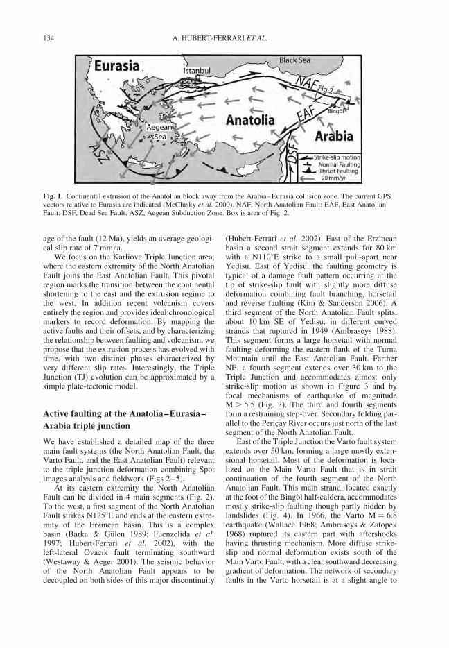
age of the fault (12 Ma), yields an average geologi-cal slip rate of 7 mm/a.
We focus on the Karliova Triple Junction area,where the eastern extremity of the North AnatolianFault joins the East Anatolian Fault. This pivotalregion marks the transition between the continentalshortening to the east and the extrusion regime tothe west. In addition recent volcanism coversentirely the region and provides ideal chronologicalmarkers to record deformation. By mapping theactive faults and their offsets, and by characterizingthe relationship between faulting and volcanism, wepropose that the extrusion process has evolved withtime, with two distinct phases characterized byvery different slip rates. Interestingly, the TripleJunction (TJ) evolution can be approximated by asimple plate-tectonic model.
Active faulting at the Anatolia–Eurasia–
Arabia triple junction
We have established a detailed map of the threemain fault systems (the North Anatolian Fault, theVarto Fault, and the East Anatolian Fault) relevantto the triple junction deformation combining Spotimages analysis and fieldwork (Figs 2–5).
At its eastern extremity the North AnatolianFault can be divided in 4 main segments (Fig. 2).To the west, a first segment of the North AnatolianFault strikes N1258E and ends at the eastern extre-mity of the Erzincan basin. This is a complexbasin (Barka & Gulen 1989; Fuenzelida et al.1997; Hubert-Ferrari et al. 2002), with theleft-lateral Ovacık fault terminating southward(Westaway & Aeger 2001). The seismic behaviorof the North Anatolian Fault appears to bedecoupled on both sides of this major discontinuity
(Hubert-Ferrari et al. 2002). East of the Erzincanbasin a second strait segment extends for 80 kmwith a N1108E strike to a small pull-apart nearYedisu. East of Yedisu, the faulting geometry istypical of a damage fault pattern occurring at thetip of strike-slip fault with slightly more diffusedeformation combining fault branching, horsetailand reverse faulting (Kim & Sanderson 2006). Athird segment of the North Anatolian Fault splits,about 10 km SE of Yedisu, in different curvedstrands that ruptured in 1949 (Ambraseys 1988).This segment forms a large horsetail with normalfaulting deforming the eastern flank of the TurnaMountain until the East Anatolian Fault. FartherNE, a fourth segment extends over 30 km to theTriple Junction and accommodates almost onlystrike-slip motion as shown in Figure 3 and byfocal mechanisms of earthquake of magnitudeM . 5.5 (Fig. 2). The third and fourth segmentsform a restraining step-over. Secondary folding par-allel to the Pericay River occurs just north of the lastsegment of the North Anatolian Fault.
East of the Triple Junction the Varto fault systemextends over 50 km, forming a large mostly exten-sional horsetail. Most of the deformation is loca-lized on the Main Varto Fault that is in straitcontinuation of the fourth segment of the NorthAnatolian Fault. This main strand, located exactlyat the foot of the Bingol half-caldera, accommodatesmostly strike-slip faulting though partly hidden bylandslides (Fig. 4). In 1966, the Varto M ¼ 6.8earthquake (Wallace 1968; Ambraseys & Zatopek1968) ruptured its eastern part with aftershockshaving thrusting mechanism. More diffuse strike-slip and normal deformation exists south of theMain Varto Fault, with a clear southward decreasinggradient of deformation. The network of secondaryfaults in the Varto horsetail is at a slight angle to
Fig. 1. Continental extrusion of the Anatolian block away from the Arabia–Eurasia collision zone. The current GPSvectors relative to Eurasia are indicated (McClusky et al. 2000). NAF, North Anatolian Fault; EAF, East AnatolianFault; DSF, Dead Sea Fault; ASZ, Aegean Subduction Zone. Box is area of Fig. 2.
A. HUBERT-FERRARI ET AL.134
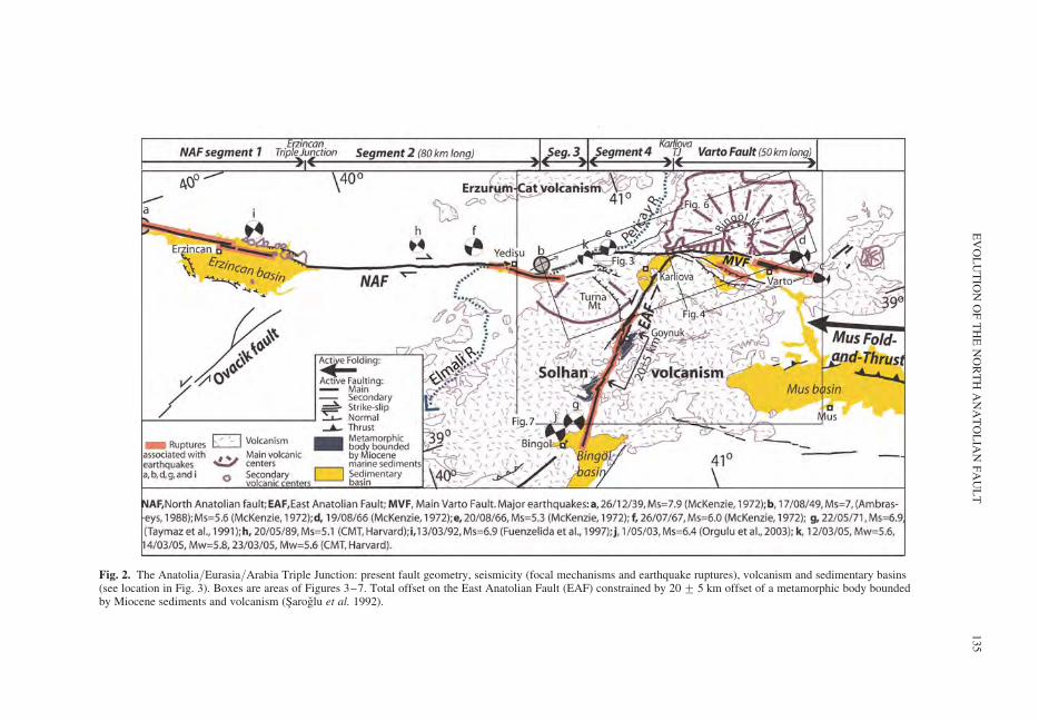
Fig. 2. The Anatolia/Eurasia/Arabia Triple Junction: present fault geometry, seismicity (focal mechanisms and earthquake ruptures), volcanism and sedimentary basins(see location in Fig. 3). Boxes are areas of Figures 3–7. Total offset on the East Anatolian Fault (EAF) constrained by 20 + 5 km offset of a metamorphic body boundedby Miocene sediments and volcanism (Saroglu et al. 1992).
EV
OL
UT
ION
OF
TH
EN
OR
TH
AN
AT
OL
IAN
FA
UL
T135
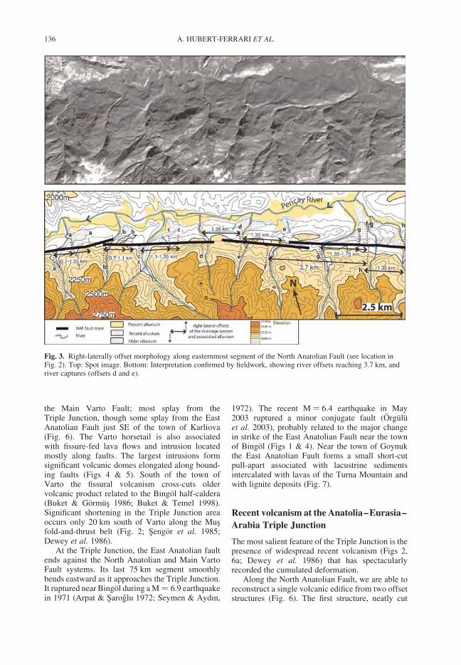
the Main Varto Fault; most splay from theTriple Junction, though some splay from the EastAnatolian Fault just SE of the town of Karliova(Fig. 6). The Varto horsetail is also associatedwith fissure-fed lava flows and intrusion locatedmostly along faults. The largest intrusions formsignificant volcanic domes elongated along bound-ing faults (Figs 4 & 5). South of the town ofVarto the fissural volcanism cross-cuts oldervolcanic product related to the Bingol half-caldera(Buket & Gormus 1986; Buket & Temel 1998).Significant shortening in the Triple Junction areaoccurs only 20 km south of Varto along the Musfold-and-thrust belt (Fig. 2; Sengor et al. 1985;Dewey et al. 1986).
At the Triple Junction, the East Anatolian faultends against the North Anatolian and Main VartoFault systems. Its last 75 km segment smoothlybends eastward as it approaches the Triple Junction.It ruptured near Bingol during a M ¼ 6.9 earthquakein 1971 (Arpat & Saroglu 1972; Seymen & Aydın,
1972). The recent M ¼ 6.4 earthquake in May2003 ruptured a minor conjugate fault (Orguluet al. 2003), probably related to the major changein strike of the East Anatolian Fault near the townof Bingol (Figs 1 & 4). Near the town of Goynukthe East Anatolian Fault forms a small short-cutpull-apart associated with lacustrine sedimentsintercalated with lavas of the Turna Mountain andwith lignite deposits (Fig. 7).
Recent volcanism at the Anatolia–Eurasia–
Arabia Triple Junction
The most salient feature of the Triple Junction is thepresence of widespread recent volcanism (Figs 2,6a; Dewey et al. 1986) that has spectacularlyrecorded the cumulated deformation.
Along the North Anatolian Fault, we are able toreconstruct a single volcanic edifice from two offsetstructures (Fig. 6). The first structure, neatly cut
Fig. 3. Right-laterally offset morphology along easternmost segment of the North Anatolian Fault (see location inFig. 2). Top: Spot image. Bottom: Interpretation confirmed by fieldwork, showing river offsets reaching 3.7 km, andriver captures (offsets d and e).
A. HUBERT-FERRARI ET AL.136
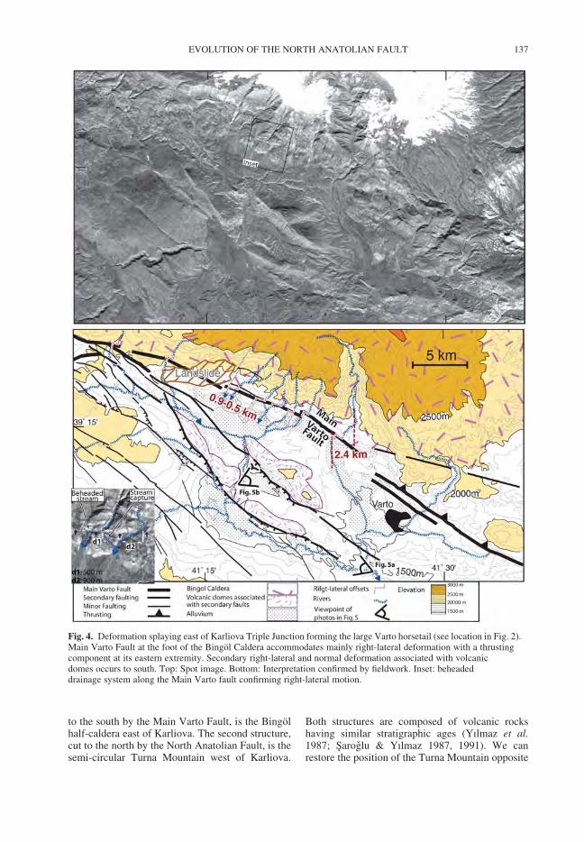
to the south by the Main Varto Fault, is the Bingolhalf-caldera east of Karliova. The second structure,cut to the north by the North Anatolian Fault, is thesemi-circular Turna Mountain west of Karliova.
Both structures are composed of volcanic rockshaving similar stratigraphic ages (Yılmaz et al.1987; Saroglu & Yılmaz 1987, 1991). We canrestore the position of the Turna Mountain opposite
Fig. 4. Deformation splaying east of Karliova Triple Junction forming the large Varto horsetail (see location in Fig. 2).Main Varto Fault at the foot of the Bingol Caldera accommodates mainly right-lateral deformation with a thrustingcomponent at its eastern extremity. Secondary right-lateral and normal deformation associated with volcanicdomes occurs to south. Top: Spot image. Bottom: Interpretation confirmed by fieldwork. Inset: beheadeddrainage system along the Main Varto fault confirming right-lateral motion.
EVOLUTION OF THE NORTH ANATOLIAN FAULT 137
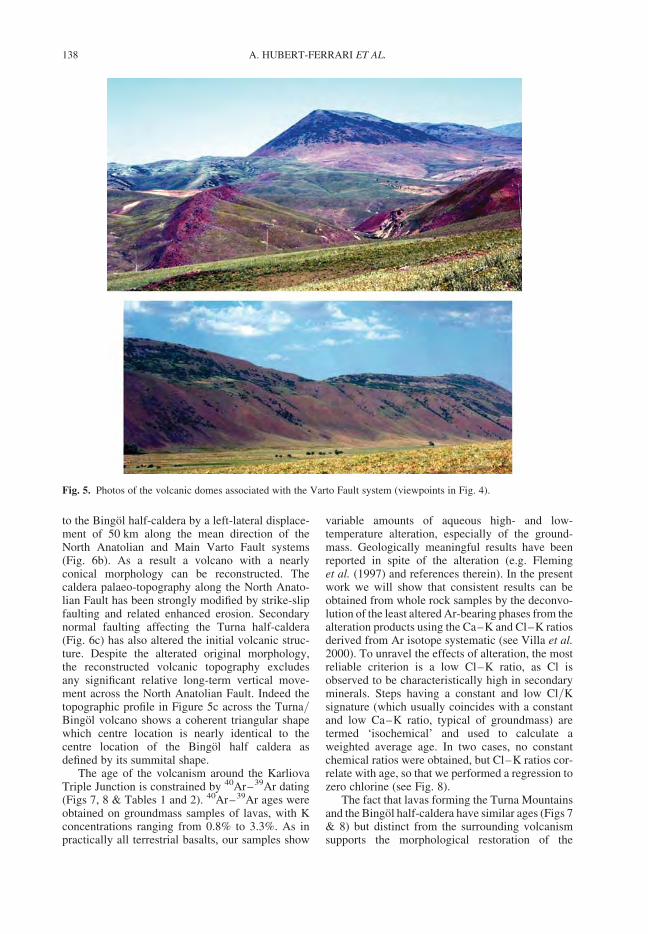
to the Bingol half-caldera by a left-lateral displace-ment of 50 km along the mean direction of theNorth Anatolian and Main Varto Fault systems(Fig. 6b). As a result a volcano with a nearlyconical morphology can be reconstructed. Thecaldera palaeo-topography along the North Anato-lian Fault has been strongly modified by strike-slipfaulting and related enhanced erosion. Secondarynormal faulting affecting the Turna half-caldera(Fig. 6c) has also altered the initial volcanic struc-ture. Despite the alterated original morphology,the reconstructed volcanic topography excludesany significant relative long-term vertical move-ment across the North Anatolian Fault. Indeed thetopographic profile in Figure 5c across the Turna/Bingol volcano shows a coherent triangular shapewhich centre location is nearly identical to thecentre location of the Bingol half caldera asdefined by its summital shape.
The age of the volcanism around the KarliovaTriple Junction is constrained by 40Ar–39Ar dating(Figs 7, 8 & Tables 1 and 2). 40Ar–39Ar ages wereobtained on groundmass samples of lavas, with Kconcentrations ranging from 0.8% to 3.3%. As inpractically all terrestrial basalts, our samples show
variable amounts of aqueous high- and low-temperature alteration, especially of the ground-mass. Geologically meaningful results have beenreported in spite of the alteration (e.g. Fleminget al. (1997) and references therein). In the presentwork we will show that consistent results can beobtained from whole rock samples by the deconvo-lution of the least altered Ar-bearing phases from thealteration products using the Ca–K and Cl–K ratiosderived from Ar isotope systematic (see Villa et al.2000). To unravel the effects of alteration, the mostreliable criterion is a low Cl–K ratio, as Cl isobserved to be characteristically high in secondaryminerals. Steps having a constant and low Cl/Ksignature (which usually coincides with a constantand low Ca–K ratio, typical of groundmass) aretermed ‘isochemical’ and used to calculate aweighted average age. In two cases, no constantchemical ratios were obtained, but Cl–K ratios cor-relate with age, so that we performed a regression tozero chlorine (see Fig. 8).
The fact that lavas forming the Turna Mountainsand the Bingol half-caldera have similar ages (Figs 7& 8) but distinct from the surrounding volcanismsupports the morphological restoration of the
Fig. 5. Photos of the volcanic domes associated with the Varto Fault system (viewpoints in Fig. 4).
A. HUBERT-FERRARI ET AL.138
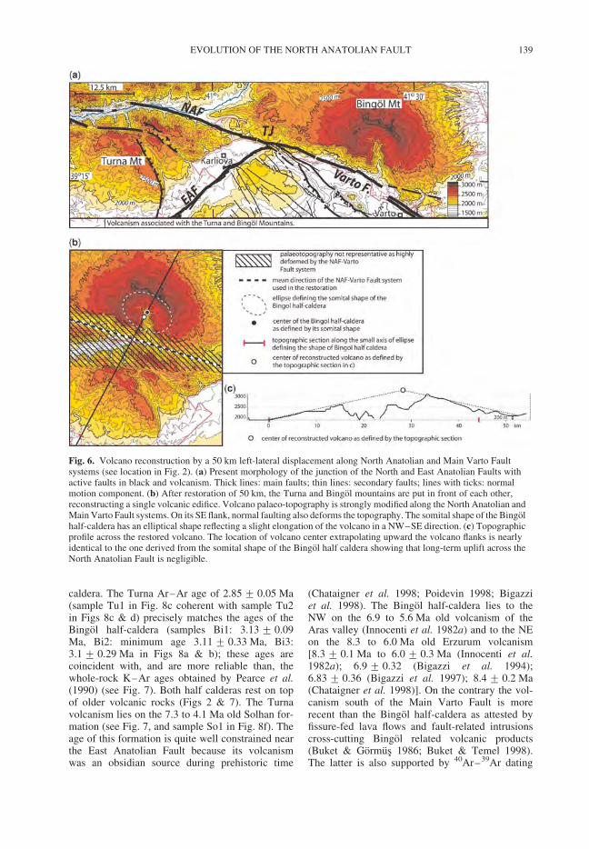
caldera. The Turna Ar–Ar age of 2.85 + 0.05 Ma(sample Tu1 in Fig. 8c coherent with sample Tu2in Figs 8c & d) precisely matches the ages of theBingol half-caldera (samples Bi1: 3.13 + 0.09Ma, Bi2: minimum age 3.11 + 0.33 Ma, Bi3:3.1 + 0.29 Ma in Figs 8a & b); these ages arecoincident with, and are more reliable than, thewhole-rock K–Ar ages obtained by Pearce et al.(1990) (see Fig. 7). Both half calderas rest on topof older volcanic rocks (Figs 2 & 7). The Turnavolcanism lies on the 7.3 to 4.1 Ma old Solhan for-mation (see Fig. 7, and sample So1 in Fig. 8f). Theage of this formation is quite well constrained nearthe East Anatolian Fault because its volcanismwas an obsidian source during prehistoric time
(Chataigner et al. 1998; Poidevin 1998; Bigazziet al. 1998). The Bingol half-caldera lies to theNW on the 6.9 to 5.6 Ma old volcanism of theAras valley (Innocenti et al. 1982a) and to the NEon the 8.3 to 6.0 Ma old Erzurum volcanism[8.3 + 0.1 Ma to 6.0 + 0.3 Ma (Innocenti et al.1982a); 6.9 + 0.32 (Bigazzi et al. 1994);6.83 + 0.36 (Bigazzi et al. 1997); 8.4 + 0.2 Ma(Chataigner et al. 1998)]. On the contrary the vol-canism south of the Main Varto Fault is morerecent than the Bingol half-caldera as attested byfissure-fed lava flows and fault-related intrusionscross-cutting Bingol related volcanic products(Buket & Gormus 1986; Buket & Temel 1998).The latter is also supported by 40Ar–39Ar dating
Fig. 6. Volcano reconstruction by a 50 km left-lateral displacement along North Anatolian and Main Varto Faultsystems (see location in Fig. 2). (a) Present morphology of the junction of the North and East Anatolian Faults withactive faults in black and volcanism. Thick lines: main faults; thin lines: secondary faults; lines with ticks: normalmotion component. (b) After restoration of 50 km, the Turna and Bingol mountains are put in front of each other,reconstructing a single volcanic edifice. Volcano palaeo-topography is strongly modified along the North Anatolian andMain Varto Fault systems. On its SE flank, normal faulting also deforms the topography. The somital shape of the Bingolhalf-caldera has an elliptical shape reflecting a slight elongation of the volcano in a NW–SE direction. (c) Topographicprofile across the restored volcano. The location of volcano center extrapolating upward the volcano flanks is nearlyidentical to the one derived from the somital shape of the Bingol half caldera showing that long-term uplift across theNorth Anatolian Fault is negligible.
EVOLUTION OF THE NORTH ANATOLIAN FAULT 139
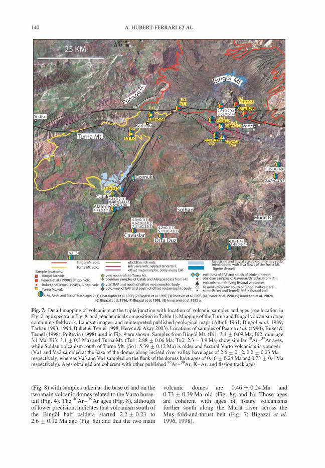
(Fig. 8) with samples taken at the base of and on thetwo main volcanic domes related to the Varto horse-tail (Fig. 4). The 40Ar–39Ar ages (Fig. 8), althoughof lower precision, indicates that volcanism south ofthe Bingol half caldera started 2.2 + 0.23 to2.6 + 0.12 Ma ago (Fig. 8e) and that the two main
volcanic domes are 0.46 + 0.24 Ma and0.73 + 0.39 Ma old (Fig. 8g and h). Those agesare coherent with ages of fissure volcanismsfurther south along the Murat river across theMus fold-and-thrust belt (Fig. 7; Bigazzi et al.1996, 1998).
Fig. 7. Detail mapping of volcanism at the triple junction with location of volcanic samples and ages (see location inFig. 2, age spectra in Fig. 8, and geochemical composition in Table 1). Mapping of the Turna and Bingol volcanism donecombining fieldwork, Landsat images, and reinterpreted published geological maps (Altinli 1961; Bingol et al. 1989;Tarhan 1993, 1994; Buket & Temel 1998; Herece & Akay 2003). Locations of samples of Pearce et al. (1990), Buket &Temel (1998), Poitevin (1998) used in Fig. 9 are shown. Samples from Bingol Mt. (Bi1: 3.1 + 0.09 Ma; Bi2: min. age3.1 Ma; Bi3: 3.1 + 0.3 Ma) and Turna Mt. (Tu1: 2.88 + 0.06 Ma; Tu2: 2.3 2 3.9 Ma) show similar 40Ar–39Ar ages,while Sohlan volcanism south of Turna Mt. (So1: 5.39 + 0.12 Ma) is older and fissural Varto volcanism is younger(Va1 and Va2 sampled at the base of the domes along incised river valley have ages of 2.6 + 0.12, 2.2 + 0.23 Marespectively, whereas Va3 and Va4 sampled on the flank of the domes have ages of 0.46 + 0.24 Ma and 0.73 + 0.4 Marespectively). Ages obtained are coherent with other published 40Ar–39Ar, K–Ar, and fission track ages.
A. HUBERT-FERRARI ET AL.140
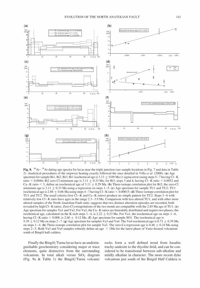
Finally the Bingol/Turna lavas have an undistin-guishable geochemistry considering major or traceelements, quite distinctive from the surroundingvolcanism. In total alkali versus SiO2 diagram(Fig. 9a & Table 1) the Bingol/Turna volcanic
rocks form a well defined trend from basaltictrachy-andesite to the rhyolite field, and can be con-sidered to be transitional between sub-alkaline andmildly alkaline in character. The more recent dykevolcanism just south of the Bingol Half Caldera is
0
2
4
6
8
0 20 40 60 80 100
Age(Ma)
% 39 Ar% 39 Ar
So1, isochemical age is 5.39±0.12 Ma
0
2
4
6
8
0 20 40 60 80 100
Va4, isochemical age is 0.73 ±0.39 MaVa3,Cl/K-Zero-Caregression age is 0.46 ±0.24
Age(Ma)
% 39 Ar
0
2
4
6
8
0 20 40 60 80 100
Age(Ma)
% 39 Ar
Bi1, isochemical age is 3.13 ±0.09 Ma
Bi2, minimum age is 3.11 ± 0.33 Bi3, isochemical age 3.1 ± 0.29 Ma
Age(Ma)
% 39 Ar0
2
4
6
8
0 20 40 60 80 100
Tu2, alterations but age in the range of 2.3-3.9 MaTu1, isochemical age 2.88±0.06 Ma
(a)
(c)
(e)
(g)
(b)
(d)
(f)
(h)
Tu2,Tu1,
0
1
2
3
0 2 4 6 8 10 12 14Ca/K
Va4,Zero-Caregression age is 0.46 ±0.24 Age(Ma)
alteration trend
0 0,0005 0,001 0,0015 0,002
Bi2,zeroCl minimum age is 3.11 ± 0.33
0
2
4
6
8
0
2
4
6
8
Age(Ma)
Age(Ma)
Cl/K
0.0020.00101
3
5
Cl/K
0
2
4
6
8
0 20 40 60 80 100
Va1, isochemical age is 2.60 ± 0.12 MaVa2, isochemical age is 2.22 ± 0.23 Ma
Age(Ma)
Fig. 8. 40Ar–39Ar dating age spectra for lavas near the triple junction (see sample locations in Fig. 7 and data in Table2). Analytical procedures of the stepwize heating exactly followed the ones detailed in Villa et al. (2000). (a) Agespectrum for sample Bi1, Bi2, Bi3; Bi1 isochemical age is 3.13 + 0.09 Ma (1 sigma error) using steps 5–7 having Cl–Kratio , 0.0046; Bi2 zero Cl minimum age is 3.11 + 0.33 Ma; for Bi3, steps 3 and 4, having Cl–K ratio , 0.0052 andCa–K ratio , 3, define an isochemical age of 3.11 + 0.29 Ma. (b) Three-isotope correlation plot for Bi2; the zero-Clminimum age is 3.11 + 0.33 Ma using a regression on steps 1–5. (c) Age spectrum for sample TU1 and TU2; TU1isochemical age is 2.88 + 0.06 Ma using steps 4–7 having Cl–K ratio , 0.00015. (d) Three-isotope correlation plot forTU1 and TU2. The usual criteria (low Cl–K and Ca–K ratios) produce no simple pattern for TU2. Steps 3–6 withrelatively low Cl–K ratio have ages in the range 2.3–3.9 Ma. Comparison with less altered TU1, and with other morealtered samples of the North Anatolian Fault suite, suggests that two distinct alteration episodes are recorded, bothrevealed by high Cl–K ratios. Zero-Cl extrapolations of the two trends are compatible with the 2.85 Ma age of TU1. (e)Age spectrum for samples Va1 and Va2. For Va2, the Ca–K ratios are bimodally distributed and require two phases; theisochemical age, calculated on the K-rich steps 1–4, is 2.22 + 0.23 Ma. For Va1, the isochemical age on steps 1–6,having Cl–K ratio , 0.008, is 2.60 + 0.12 Ma. (f) Age spectrum for sample SO1. The isochemical age is5.39 + 0.12 Ma on steps 2–7. (g) Age spectrum for samples Va3 and Va4. The Va4 isochemical age is 0.73 + 0.39 Maon steps 1–4. (h) Three-isotope correlation plot for sample Va3. The zero-Ca regression age is 0.46 + 0.24 Ma usingsteps 2–5. Both Va3 and Va4 samples robustly define an age , 1Ma for the latest phase of Varto fissural volcanismsouth of Bingol half-caldera.
EVOLUTION OF THE NORTH ANATOLIAN FAULT 141
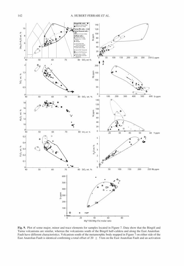
Ni p
pm
Cr ppm0
20
40
60
80
100
120
140
0 50 100 150 200 250 300 350
Sr ppm
Rb p
pm
0
50
100
150
200
0 100 200 300 400 500 600
Ni p
pm
Y ppm0
20
40
60
80
100
120
140
20 30 40 50 60
K2O
wt.
%
Rb ppm0
1
2
3
4
5
050 100 150 200 250
Mg*100/(Mg+Fe) molar ratio
Sr p
pm
0
100
200
300
400
500
600
0 20 40 60 80
0
0,5
1
1,5
2
40 50 60 70 80 SiO2 wt. %
TiO
2 w
t. %
8
10
12
14
16
18
40 50 60 70 80
Al 2
O2
wt.
%
SiO2 wt. %
0
0,1
0,2
0,3
0,4
0,5
40 50 60 70 80
P 2O
3 w
t. %
SiO2 wt. %
2
4
6
8
10
40 50 60 70 80
(Na 2
O+
K2O
) wt.
%
SiO2 wt. %
Bingol Mt. volc. :
Varto fissural volc. :
CatakAlatepe
Solhan volc. :south of Turn Mt.
east of the EAF,south meta. body
west of the EAF,south meta. body
east of EAF(Karliova)
east of EAF (Cavular-Orta Duz)
east of EAF (Goynuk)
Buket et Temel (1998)Pearce et al. (1990)
Buket et Temel (1998)
Poitevin et al. (1998):
Poitevin et al. (1998):
Turna Mt. volc. :
Fig. 9. Plot of some major, minor and trace elements for samples located in Figure 7. Data show that the Bingol andTurna volcanisms are similar, whereas the volcanisms south of the Bingol half-caldera and along the East AnatolianFault have different characteristics. Volcanism south of the metamorphic body mapped in Figure 7 on either side of theEast Anatolian Fault is identical confirming a total offset of 20 + 5 km on the East Anatolian Fault and an activation
A. HUBERT-FERRARI ET AL.142
mostly subalkaline but relative to the Bingol/Turnaone it has less alkali, is enriched in K, Ni and Sr anddepleted in Rb. Furthermore Buket & Temel (1998)have clearly demonstrated that this volcanism is iso-topically distinct from the Bingol samples. The lavasjust south of Turna Mountain, rich in obsidians(Catak-Alatepe sites of the Solhan formation) are rhyo-lites to be considered transitional between sub-alkalineand mildly alkaline trend. Compared to the Bingol/Turna volcanism these lavas have more alkali, lessAl2O3, less TiO2, a high Rb/Sr ratio, high Ba andlow Zn. Other volcanic rocks around the East Anato-lian Fault–Solhan Formation are mostly basalts witha transitional character similar to the Bingol/Turnavolcanism but with less alkali, higher Mg, Ti, Ni andCr content, lower Nb and Zr, and a very low Rb/Sr ratio.
Together with the fact that the two structures aretruncated to the south and to the north by a continu-ous right-lateral fault system, all these observationsstrongly suggest that the Turna Mountain and theBingol half-caldera have a common origin, and arepresently offset by about 50 km along the NorthAnatolian Fault.
Independently, one can also use the volcanismalong the East Anatolian fault to further constrainits age and total offset. We estimate the total displa-cement of the East Anatolian fault by evaluating theoffset of a metamorphic/Miocene body surroundedby volcanism (Fig. 2; Saroglu et al. 1992). A singlestructure can be reconstructed by a right-lateral dis-placement of 20 + 5 km (Arpat & Saroglu 1972;Seymen & Aydın 1972; Saroglu et al. 1992;Westaway 1994, 2003). The Solhan volcanism justsouth of the so-reconstructed structure has similarage, and undistinguishable geochemistry acrossthe East Anatolian Fault (samples represented withblue diamond in Fig. 7 and in Fig. 9 white andlight grey diamonds limited by a thin black line).In addition, the boundary of the single structure soobtained with the surrounding Solhan formation(6–4.1 Ma old) is smooth across the fault: this for-mation is not related to movement along the EastAnatolian Fault and is clearly cross-cut by thelater fault (Fig. 7). This shows that the age of theEast Anatolian Fault should be less than 4 Ma asalready proposed by others (e.g. Saroglu et al.1992; Westaway & Aeger 2001). On the contrary,the lacustrine sediments and lignite depositsnear Goynuk are most probably related to the exten-sional step-over of the East Anatolian Fault in thatarea (Fig. 7). The fact that those sediments are
interbedded with the most recent volcanicproducts of the Turna Mountain suggests that theEast Anatolian Fault was active in that area2.88 Ma ago.
Evolution of the Anatolia–Eurasia–Arabia
Triple Junction
The following scenario emerges. The completeTurna–Bingol caldera was formed from 3.6 to2.8 Ma ago, before being cut and right-laterallyoffset 50 km by the North Anatolian Fault. Thisoffset is equal to the Varto fault system totallength and is similar to: (1) the geological offsetof the North Anatolian Fault near Yedisu – offsetof a thrust contact between ophiolitic melange andvolcanoclastic units (Herece & Akay 2003, appen-dix 13; Sengor et al. 2005) and to (2) the offset ofthe Elmal-Pericay river system (Fig. 2). Fissuralvolcanism related to the birth of the Varto faultsystem started 2.6 Ma ago. The volcano offset andvolcanism age thus imply that the easternmostsegment of the North Anatolian Fault and thepresent Triple Junction are younger than 2.8 Ma,establishing around 2.6 Ma ago. The deducedaverage slip rate of the North Anatolian Fault overthe last 2.6 Ma of about 20 mm/a roughly corre-sponds to its present-day rate. The later rate ishowever a lower bound as secondary deformationexists. With a complete formation of the EastAnatolian Fault 2.8 to 3 Ma ago, we get aminimum geological slip rate of the East AnatolianFault of 7 mm/a, which is comparable to the9–10 mm/a GPS derived rate (McClusky et al.2000; Reilinger et al. 2006) and to the11 + 1 mm/a geomorphological rate determinedfurther south (Cetin et al. 2003). The main puzzleremains the strong mismatch between the East Ana-tolian Fault (c. 3 Ma) and North Anatolian (12 Ma)ages that we discuss below.
It is well known that a two-phase extrusionprocess characterizes the India/Eurasia collision(Tapponnier et al. 1982). Westaway & Aeger(1996) suggest that a similar scenario is valid forthe Anatolia extrusion, with a southward jump ofthe East Anatolian Fault. The North AnatolianFault would have kept the same location becausethe stable Black Sea oceanic lithosphere preventsany new large fault propagation north of itspresent trace. The Anatolian extrusion would firstoccur between the North Anatolian Fault and aproto East Anatolian Fault, which can be identified
Fig. 9. (Continued) of the East Anatolian Fault after the deposition of the Solhan volcanism that ends 4.4 Ma ago. VartoFissural volcanism (dark dashed line group) has slightly evolved (see black arrow) through time. Dark filledtriangles represent lavas at the base of the fissural volcanism, open triangles lavas of the domes, and black crossesvolcanism at the eastern end of the Varto fault system.
EVOLUTION OF THE NORTH ANATOLIAN FAULT 143
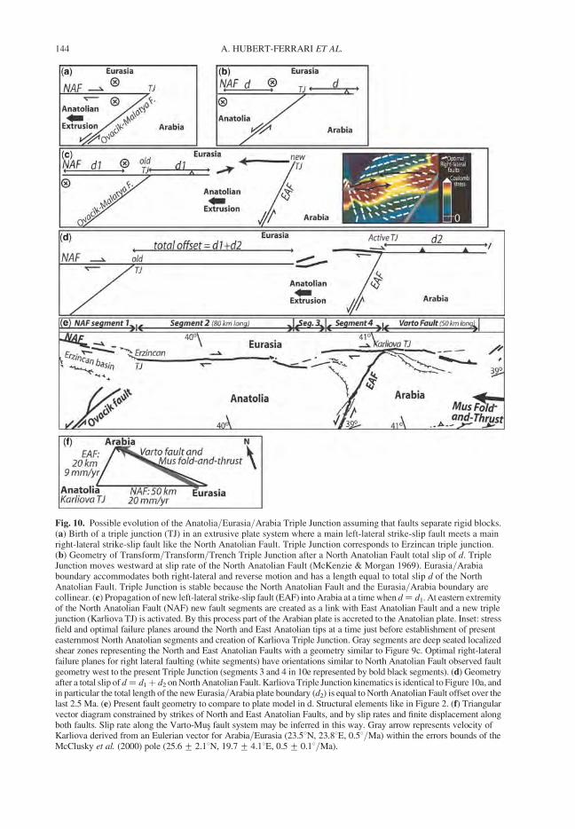
Fig. 10. Possible evolution of the Anatolia/Eurasia/Arabia Triple Junction assuming that faults separate rigid blocks.(a) Birth of a triple junction (TJ) in an extrusive plate system where a main left-lateral strike-slip fault meets a mainright-lateral strike-slip fault like the North Anatolian Fault. Triple Junction corresponds to Erzincan triple junction.(b) Geometry of Transform/Transform/Trench Triple Junction after a North Anatolian Fault total slip of d. TripleJunction moves westward at slip rate of the North Anatolian Fault (McKenzie & Morgan 1969). Eurasia/Arabiaboundary accommodates both right-lateral and reverse motion and has a length equal to total slip d of the NorthAnatolian Fault. Triple Junction is stable because the North Anatolian Fault and the Eurasia/Arabia boundary arecollinear. (c) Propagation of new left-lateral strike-slip fault (EAF) into Arabia at a time when d ¼ d1. At eastern extremityof the North Anatolian Fault (NAF) new fault segments are created as a link with East Anatolian Fault and a new triplejunction (Karliova TJ) is activated. By this process part of the Arabian plate is accreted to the Anatolian plate. Inset: stressfield and optimal failure planes around the North and East Anatolian tips at a time just before establishment of presenteasternmost North Anatolian segments and creation of Karliova Triple Junction. Gray segments are deep seated localizedshear zones representing the North and East Anatolian Faults with a geometry similar to Figure 9c. Optimal right-lateralfailure planes for right lateral faulting (white segments) have orientations similar to North Anatolian Fault observed faultgeometry west to the present Triple Junction (segments 3 and 4 in 10e represented by bold black segments). (d) Geometryafter a total slip of d ¼ d1þ d2 on North Anatolian Fault. Karliova Triple Junction kinematics is identical to Figure 10a, andin particular the total length of the new Eurasia/Arabia plate boundary (d2) is equal to North Anatolian Fault offset over thelast 2.5 Ma. (e) Present fault geometry to compare to plate model in d. Structural elements like in Figure 2. (f) Triangularvector diagram constrained by strikes of North and East Anatolian Faults, and by slip rates and finite displacement alongboth faults. Slip rate along the Varto-Mus fault system may be inferred in this way. Gray arrow represents velocity ofKarliova derived from an Eulerian vector for Arabia/Eurasia (23.58N, 23.88E, 0.58/Ma) within the errors bounds of theMcClusky et al. (2000) pole (25.6+ 2.18N, 19.7+ 4.18E, 0.5+ 0.18/Ma).
A. HUBERT-FERRARI ET AL.144
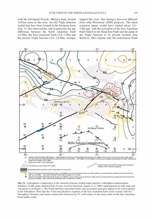
with the left-lateral Ovacık–Malatya fault, located110 km more to the west. An old Triple Junctionwould thus have been located in the Erzincan basin(Fig. 2). Our observations, and in particular the agedifference between the North Anatolian Fault(12 Ma), the East Anatolian Fault (2.8–3 Ma) andthe present Triple Junction (2.6–2.8 Ma), strongly
support this view. Our timing is however differentfrom what Westaway (2004) proposes. The latestextrusion phase would have started about 2.6–3 Ma ago, with the activation of the East AnatolianFault linked to the Dead Sea Fault and the jump ofthe Triple Junction to its present location nearKarliova. This explains why the easternmost North
Fig. 11. Lithospheric complexities at the Anatolia/Eurasia/Arabia triple junction. Lithosphere-asthenosphereboundary (LAB) maps obtained from S-wave receiver functions (Angus et al. 2006) superimposed on fault map andvolcanism as in Figure 2. The North and East Anatolian Faults, and associated structures appear to be rooted deeplyin the lithosphere. Note that the 75 km long Karliova segment of the East Anatolian Fault scales exactly with thelithospheric thickness and seems rotated anti-clockwise by 258 with respect to the mean strike of the East AnatolianFault farther south.
EVOLUTION OF THE NORTH ANATOLIAN FAULT 145
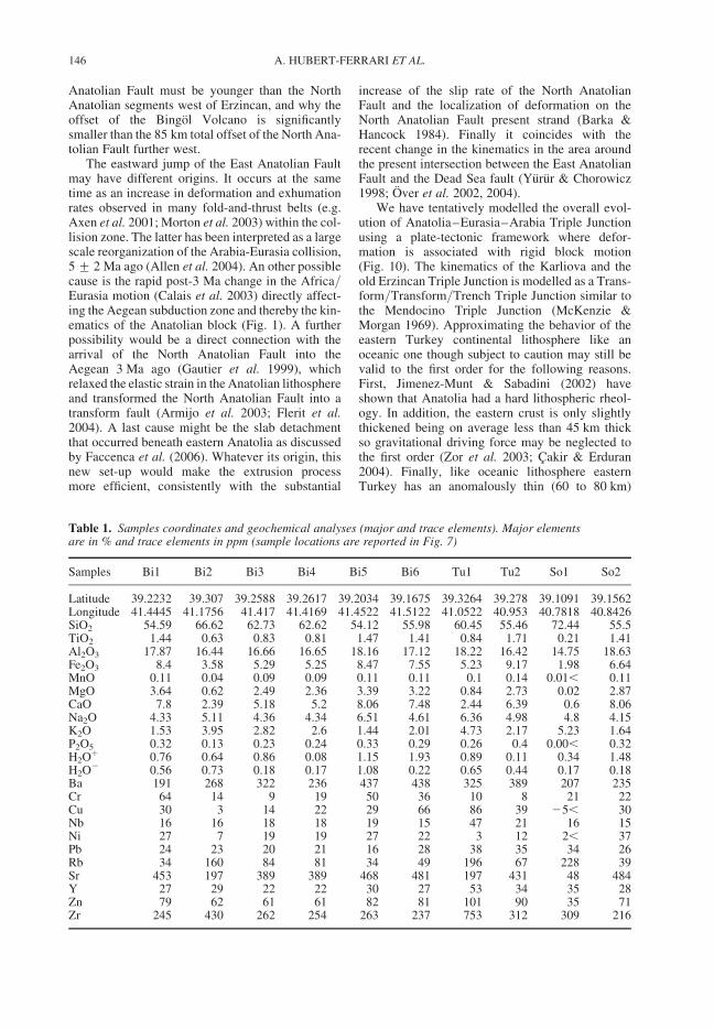
Anatolian Fault must be younger than the NorthAnatolian segments west of Erzincan, and why theoffset of the Bingol Volcano is significantlysmaller than the 85 km total offset of the North Ana-tolian Fault further west.
The eastward jump of the East Anatolian Faultmay have different origins. It occurs at the sametime as an increase in deformation and exhumationrates observed in many fold-and-thrust belts (e.g.Axen et al. 2001; Morton et al. 2003) within the col-lision zone. The latter has been interpreted as a largescale reorganization of the Arabia-Eurasia collision,5 + 2 Ma ago (Allen et al. 2004). An other possiblecause is the rapid post-3 Ma change in the Africa/Eurasia motion (Calais et al. 2003) directly affect-ing the Aegean subduction zone and thereby the kin-ematics of the Anatolian block (Fig. 1). A furtherpossibility would be a direct connection with thearrival of the North Anatolian Fault into theAegean 3 Ma ago (Gautier et al. 1999), whichrelaxed the elastic strain in the Anatolian lithosphereand transformed the North Anatolian Fault into atransform fault (Armijo et al. 2003; Flerit et al.2004). A last cause might be the slab detachmentthat occurred beneath eastern Anatolia as discussedby Faccenca et al. (2006). Whatever its origin, thisnew set-up would make the extrusion processmore efficient, consistently with the substantial
increase of the slip rate of the North AnatolianFault and the localization of deformation on theNorth Anatolian Fault present strand (Barka &Hancock 1984). Finally it coincides with therecent change in the kinematics in the area aroundthe present intersection between the East AnatolianFault and the Dead Sea fault (Yurur & Chorowicz1998; Over et al. 2002, 2004).
We have tentatively modelled the overall evol-ution of Anatolia–Eurasia–Arabia Triple Junctionusing a plate-tectonic framework where defor-mation is associated with rigid block motion(Fig. 10). The kinematics of the Karliova and theold Erzincan Triple Junction is modelled as a Trans-form/Transform/Trench Triple Junction similar tothe Mendocino Triple Junction (McKenzie &Morgan 1969). Approximating the behavior of theeastern Turkey continental lithosphere like anoceanic one though subject to caution may still bevalid to the first order for the following reasons.First, Jimenez-Munt & Sabadini (2002) haveshown that Anatolia had a hard lithospheric rheol-ogy. In addition, the eastern crust is only slightlythickened being on average less than 45 km thickso gravitational driving force may be neglected tothe first order (Zor et al. 2003; Cakir & Erduran2004). Finally, like oceanic lithosphere easternTurkey has an anomalously thin (60 to 80 km)
Table 1. Samples coordinates and geochemical analyses (major and trace elements). Major elementsare in % and trace elements in ppm (sample locations are reported in Fig. 7)
Samples Bi1 Bi2 Bi3 Bi4 Bi5 Bi6 Tu1 Tu2 So1 So2
Latitude 39.2232 39.307 39.2588 39.2617 39.2034 39.1675 39.3264 39.278 39.1091 39.1562Longitude 41.4445 41.1756 41.417 41.4169 41.4522 41.5122 41.0522 40.953 40.7818 40.8426SiO2 54.59 66.62 62.73 62.62 54.12 55.98 60.45 55.46 72.44 55.5TiO2 1.44 0.63 0.83 0.81 1.47 1.41 0.84 1.71 0.21 1.41Al2O3 17.87 16.44 16.66 16.65 18.16 17.12 18.22 16.42 14.75 18.63Fe2O3 8.4 3.58 5.29 5.25 8.47 7.55 5.23 9.17 1.98 6.64MnO 0.11 0.04 0.09 0.09 0.11 0.11 0.1 0.14 0.01, 0.11MgO 3.64 0.62 2.49 2.36 3.39 3.22 0.84 2.73 0.02 2.87CaO 7.8 2.39 5.18 5.2 8.06 7.48 2.44 6.39 0.6 8.06Na2O 4.33 5.11 4.36 4.34 6.51 4.61 6.36 4.98 4.8 4.15K2O 1.53 3.95 2.82 2.6 1.44 2.01 4.73 2.17 5.23 1.64P2O5 0.32 0.13 0.23 0.24 0.33 0.29 0.26 0.4 0.00, 0.32H2Oþ 0.76 0.64 0.86 0.08 1.15 1.93 0.89 0.11 0.34 1.48H2O2 0.56 0.73 0.18 0.17 1.08 0.22 0.65 0.44 0.17 0.18Ba 191 268 322 236 437 438 325 389 207 235Cr 64 14 9 19 50 36 10 8 21 22Cu 30 3 14 22 29 66 86 39 25, 30Nb 16 16 18 18 19 15 47 21 16 15Ni 27 7 19 19 27 22 3 12 2, 37Pb 24 23 20 21 16 28 38 35 34 26Rb 34 160 84 81 34 49 196 67 228 39Sr 453 197 389 389 468 481 197 431 48 484Y 27 29 22 22 30 27 53 34 35 28Zn 79 62 61 61 82 81 101 90 35 71Zr 245 430 262 254 263 237 753 312 309 216
A. HUBERT-FERRARI ET AL.146
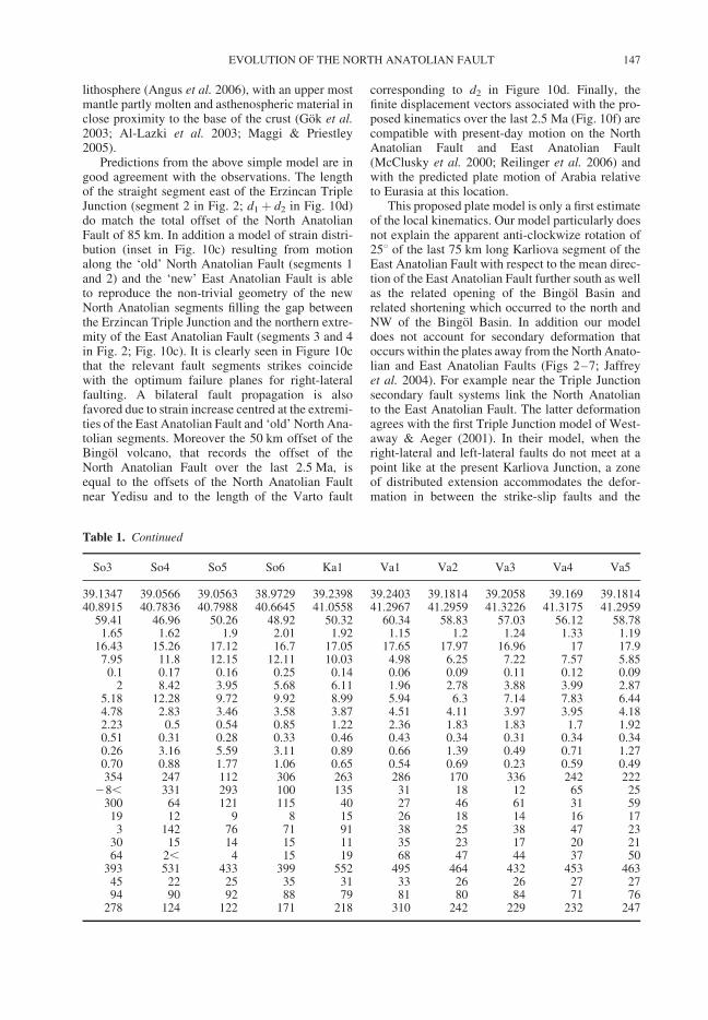
lithosphere (Angus et al. 2006), with an upper mostmantle partly molten and asthenospheric material inclose proximity to the base of the crust (Gok et al.2003; Al-Lazki et al. 2003; Maggi & Priestley2005).
Predictions from the above simple model are ingood agreement with the observations. The lengthof the straight segment east of the Erzincan TripleJunction (segment 2 in Fig. 2; d1þ d2 in Fig. 10d)do match the total offset of the North AnatolianFault of 85 km. In addition a model of strain distri-bution (inset in Fig. 10c) resulting from motionalong the ‘old’ North Anatolian Fault (segments 1and 2) and the ‘new’ East Anatolian Fault is ableto reproduce the non-trivial geometry of the newNorth Anatolian segments filling the gap betweenthe Erzincan Triple Junction and the northern extre-mity of the East Anatolian Fault (segments 3 and 4in Fig. 2; Fig. 10c). It is clearly seen in Figure 10cthat the relevant fault segments strikes coincidewith the optimum failure planes for right-lateralfaulting. A bilateral fault propagation is alsofavored due to strain increase centred at the extremi-ties of the East Anatolian Fault and ‘old’ North Ana-tolian segments. Moreover the 50 km offset of theBingol volcano, that records the offset of theNorth Anatolian Fault over the last 2.5 Ma, isequal to the offsets of the North Anatolian Faultnear Yedisu and to the length of the Varto fault
corresponding to d2 in Figure 10d. Finally, thefinite displacement vectors associated with the pro-posed kinematics over the last 2.5 Ma (Fig. 10f) arecompatible with present-day motion on the NorthAnatolian Fault and East Anatolian Fault(McClusky et al. 2000; Reilinger et al. 2006) andwith the predicted plate motion of Arabia relativeto Eurasia at this location.
This proposed plate model is only a first estimateof the local kinematics. Our model particularly doesnot explain the apparent anti-clockwize rotation of258 of the last 75 km long Karliova segment of theEast Anatolian Fault with respect to the mean direc-tion of the East Anatolian Fault further south as wellas the related opening of the Bingol Basin andrelated shortening which occurred to the north andNW of the Bingol Basin. In addition our modeldoes not account for secondary deformation thatoccurs within the plates away from the North Anato-lian and East Anatolian Faults (Figs 2–7; Jaffreyet al. 2004). For example near the Triple Junctionsecondary fault systems link the North Anatolianto the East Anatolian Fault. The latter deformationagrees with the first Triple Junction model of West-away & Aeger (2001). In their model, when theright-lateral and left-lateral faults do not meet at apoint like at the present Karliova Junction, a zoneof distributed extension accommodates the defor-mation in between the strike-slip faults and the
Table 1. Continued
So3 So4 So5 So6 Ka1 Va1 Va2 Va3 Va4 Va5
39.1347 39.0566 39.0563 38.9729 39.2398 39.2403 39.1814 39.2058 39.169 39.181440.8915 40.7836 40.7988 40.6645 41.0558 41.2967 41.2959 41.3226 41.3175 41.2959
59.41 46.96 50.26 48.92 50.32 60.34 58.83 57.03 56.12 58.781.65 1.62 1.9 2.01 1.92 1.15 1.2 1.24 1.33 1.19
16.43 15.26 17.12 16.7 17.05 17.65 17.97 16.96 17 17.97.95 11.8 12.15 12.11 10.03 4.98 6.25 7.22 7.57 5.850.1 0.17 0.16 0.25 0.14 0.06 0.09 0.11 0.12 0.09
2 8.42 3.95 5.68 6.11 1.96 2.78 3.88 3.99 2.875.18 12.28 9.72 9.92 8.99 5.94 6.3 7.14 7.83 6.444.78 2.83 3.46 3.58 3.87 4.51 4.11 3.97 3.95 4.182.23 0.5 0.54 0.85 1.22 2.36 1.83 1.83 1.7 1.920.51 0.31 0.28 0.33 0.46 0.43 0.34 0.31 0.34 0.340.26 3.16 5.59 3.11 0.89 0.66 1.39 0.49 0.71 1.270.70 0.88 1.77 1.06 0.65 0.54 0.69 0.23 0.59 0.49354 247 112 306 263 286 170 336 242 222
28, 331 293 100 135 31 18 12 65 25300 64 121 115 40 27 46 61 31 5919 12 9 8 15 26 18 14 16 173 142 76 71 91 38 25 38 47 23
30 15 14 15 11 35 23 17 20 2164 2, 4 15 19 68 47 44 37 50
393 531 433 399 552 495 464 432 453 46345 22 25 35 31 33 26 26 27 2794 90 92 88 79 81 80 84 71 76
278 124 122 171 218 310 242 229 232 247
EVOLUTION OF THE NORTH ANATOLIAN FAULT 147
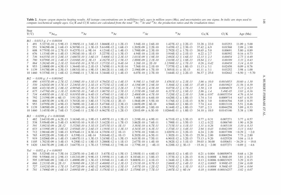
Table 2. Argon–argon stepwise heating results. All isotope concentrations are in millilitres (ml), ages in million years (Ma), and uncertainties are one sigma. In italic are steps used tocompute isochemical sample ages. Ca/K and Cl/K ratios are calculated from the total 39Ar, 37Ar and 38Ar, the production ratios and the irradiation times
StepT(8C) 40Artot
39Ar 38Ar 37Ar 36Ar Ca/K Cl/K Age (Ma)
Bi1 – 0.0313 g; J ¼ 0.001041 491 5.3271E-10 + 5.9E-13 2.3985E-11 + 3.6E-13 3.8660E-12 + 1.2E-13 3.94E-10 + 2.6E-10 1.427E-12 + 2.2E-13 33.28 + 22.0 0.03253 11.09 + 5.002 551 9.9629E-08 + 1.6E-13 6.5078E-11 + 1.3E-13 5.6149E-12 + 1.6E-13 1.202E-09 + 2.2E-10 3.435E-12 + 2.3E-13 37.42 + 6.9 0.01568 2.09 + 1.903 608 9.7793E-10 + 2.7E-13 9.4257E-11 + 9E-14 4.1216E-12 + 1.4E-13 1.798E-09 + 2.3E-10 2.792E-12 + 1.7E-13 38.65 + 5.0 0.00691 5.80 + 0.894 676 1.1334E-09 + 1.4E-13 1.5924E-10 + 1E-13 5.2275E-12 + 1.3E-13 4.94E-10 + 2.1E-10 3.916E-12 + 2.1E-13 6.22 + 2.7 0.00392 0.16 + 0.735 736 9.6355E-10 + 2.8E-13 1.6807E-10 + 1.6E-13 5.600E-12 + 2.3E-13 1.031E-09 + 1.9E-10 2.692E-12 + 1.6E-13 12.33 + 2.3 0.00454 2.75 + 0.496 790 9.8799E-10 + 1.4E-13 2.0168E-10 + 3E-13 4.1627E-12 + 1.5E-13 1.888E-09 + 2.1E-10 2.618E-12 + 1.8E-13 18.84 + 2.1 0.00189 3.33 + 0.437 864 5.2624E-09 + 2.1E-12 9.6145E-10 + 8.7E-13 3.2732E-11 + 9.4E-14 1.26E-10 + 2E-10 1.2398E-11 + 1.7E-13 0.26 + 0.42 0.00458 3.14 + 0.108 953 2.1880E-09 + 4.5E-13 1.3644E-10 + 2.1E-13 1.7458E-11 + 9.1E-14 7.56E-10 + 2.1E-10 7.575E-12 + 1.8E-13 11.13 + 3.1 0.02458 0.09 + 0.769 1139 3.9178E-09 + 2.5E-13 1.0831E-10 + 1.9E-13 1.8612E-11 + 1.6E-13 2.196E-09 + 1.7E-10 1.3051E-11 + 1E-13 41.11 + 3.1 0.03252 3.98 + 1.0010 1460 9.3376E-10 + 1.6E-12 2.1946E-11 + 7.3E-14 3.3444E-12 + 1.4E-13 6.07E-10 + 2.7E-10 3.644E-12 + 2.2E-13 56.37 + 25.0 0.02642 28.50 + 25.70
Bi2 2 0.036 g; J ¼ 0.0010421 490 4.9357E-09 + 2.7E-12 1.1306E-10 + 3.1E-13 4.7642E-12 + 1.4E-13 9.39E-11 + 5.6E-10 1.4561E-11 + 2.3E-13 1.66 + 10.0 0.0014853 10.60 + 1.302 550 2.6202E-09 + 3.7E-13 2.2365E-10 + 2.1E-13 4.7725E-12 + 1.8E-13 4.139E-09 + 2.9E-10 5.304E-12 + 1.8E-13 37.48 + 2.6 0.0019923 11.56 + 0.393 608 4.0213E-09 + 1.8E-12 4.9954E-10 + 7.3E-13 8.5184E-12 + 2.2E-13 3.73E-10 + 4.5E-10 9.075E-12 + 1.7E-13 1.50 + 1.8 0.0004678 5.13 + 0.234 675 3.4776E-09 + 1.1E-12 8.0915E-10 + 7.4E-13 1.0675E-11 + 1.5E-13 1.155E-09 + 5.6E-10 6.327E-12 + 1.9E-13 2.86 + 1.4 5.49E-05 3.93 + 0.165 734 4.4085E-09 + 1.1E-12 9.8195E-09 + 9.4E-13 1.4784E-11 + 1.8E-13 2.480E-09 + 4.7E-10 7.128E-12 + 2.3E-13 5.06 + 0.97 0.00055554 4.76 + 0.146 792 2.3159E-09 + 6E-13 3.9112E-10 + 3.7E-13 7.0536E-12 + 2.9E-13 3.40E-10 + 6.6E-10 4.628E-12 + 1.8E-13 1.74 + 3.4 0.0009714 4.67 + 0.357 866 2.4053E-09 + 4.5E-13 3.7032E-10 + 3.8E-13 7.7123E-12 + 2E-13 1.584E-09 + 5.5E-10 5.176E-12 + 2.1E-13 8.58 + 3.0 0.0016704 5.05 + 0.358 953 2.0795E-09 + 4.9E-13 2.7609E-10 + 2.4E-13 5.4736E-12 + 2.3E-13 1.065E-09 + 6E-10 4.566E-12 + 1.8E-13 7.74 + 4.4 0.0013118 5.51 + 0.469 1139 3.0058E-09 + 2.4E-13 3.3158E-10 + 4.6E-13 1.1581E-11 + 1.2E-13 1.169E-09 + 3.8E-10 8.144E-12 + 1.8E-13 7.07 + 2.3 0.0044258 3.89 + 0.3310 1460 3.1453E-09 + 7.6E-13 7.1244E-11 + 2.5E-13 6.9627E-12 + 1.2E-13 1201E-09 + 6.3E-10 1.02664E-11 + 1.8E-13 34.10 + 18.0 0.0143146 5.38 + 1.90
Bi3 2 0.0299 g; J ¼ 0.0010461 482 2.6431E-09 + 6.2E-13 3.1634E-10 + 3.9E-13 1.4957E-11 + 1.3E-13 1.219E-10 + 4.9E-11 6.731E-12 + 3.3E-13 0.77 + 0.31 0.007271 3.77 + 0.572 538 5.9564E-09 + 5.4E-13 6.9031E-10 + 9.1E-13 3.1622E-11 + 1.7E-13 3.862E-10 + 7.6E-11 1.790E-11 + 3.5E-13 1.12 + 0.22 0.006740 1.90 + 0.283 591 5.8921E-09 + 2E-12 5.1528E-10 + 5.1E-13 2.0715E-11 + 1E-13 3.383E-10 + 6.7E-11 1.715E-11 + 3.1E-13 1.31 + 0.26 0.005138 3.10 + 0.334 653 4.5199E-09 + 1.8E-12 2.9584E-10 + 2.6E-13 1.1393E-11 + 1.3E-13 4.341E-10 + 6.3E-11 1.374E-11 + 3.4E-13 2.94 + 0.43 0.0042189 3.13 + 0.635 712 2.9816E-09 + 3.8E-13 8.9764E-11 + 8.3E-14 4.3703E-12 + 1E-13 2.797E-10 + 9.8E-11 1.0207E-11 + 3.2E-13 6.24 + 2.20 0.0037398 20.29 + 22.06 765 4.0522E-09 + 5.8E-13 6.539E-11 + 6E-14 5.0164E-12 + 1E-13 8.202E-10 + 6.5E-11 1.302E-11 + 3.3E-13 25.30 + 2.00 0.0069294 7.75 + 2.807 919 2.0206E-09 + 1.4E-13 1.6847E-11 + 1.3E-13 3.2438E-12 + 1.5E-13 6.013E-10 + 7.5E-11 6.901E-12 + 3.2E-13 73.13 + 9.20 0.025528 3.04 + 11.08 1105 1.7021E-09 + 3.4E-13 9.250E-12 + 1.8E-13 3.2880E-12 + 1.1E-13 2.677E-10 + 1.4E-10 6.382E-12 + 3.1E-13 59.03 + 30.00 0.050651 234.29 + 219.09 1420 1.8417E-09 + 2.8E-13 3.6477E-11 + 1.7E-13 7.5556E-12 + 7.9E-14 22.779E-10 + 24E-11 6.220E-12 + 3E-13 215.16 + 22.00 0.037271 20.89 + 24.6
Tu1 2 0.052 g; J ¼ 0.003851 501 5.5254E-10 + 7.5E-14 2.2207E-10 + 2.4E-13 3.437E-12 + 1.5E-13 2.3503E-11 + 4.8E-13 1.801E-12 + 1.4E-13 0.21 + 0.004 0.00050974 0.68 + 1.202 550 9.5506E-10 + 2.9E-13 1.0121E-09 + 9.9E-13 1.1955E-11 + 1.4E-13 8.1834E-11 + 3.8E-13 1.373E-12 + 1.2E-13 0.16 + 0.0008 4.386E-05 3.81 + 0.233 595 1.09768E-09 + 3.8E-13 1.4909E-09 + 1.3E-12 1.9194E-11 + 1.4E-13 9.8085E-11 + 4.1E-13 1.344E-12 + 1.2E-13 0.13 + 0.0006 0.00021925 3.29 + 0.154 666 2.2333E-09 + 2E-13 3.5699E-09 + 3.2E-12 4.4008E-11 + 1.3E-13 2.1511E-10 + 8.7E-13 2.660E-12 + 1.4E-13 0.12 + 0.0005 9.998E-05 2.84 + 0.085 727 3.0321E-09 + 1.7E-13 5.4572E-09 + 4.9E-12 6.6928E-11 + 1.5E-13 3.457E-10 + 1.2E-12 2.795E-12 + 1.3E-13 0.13 + 0.0004 9.566E-05 2.84 + 0.046 781 1.7496E-09 + 1.6E-13 2.6995E-09 + 2.4E-12 3.3763E-11 + 1.8E-13 2.3709E-10 + 7.7E-13 2.007E-12 + 9E-14 0.18 + 0.0006 0.00014257 3.02 + 0.07
A.
HU
BE
RT
-FE
RR
AR
IE
TA
L.
148
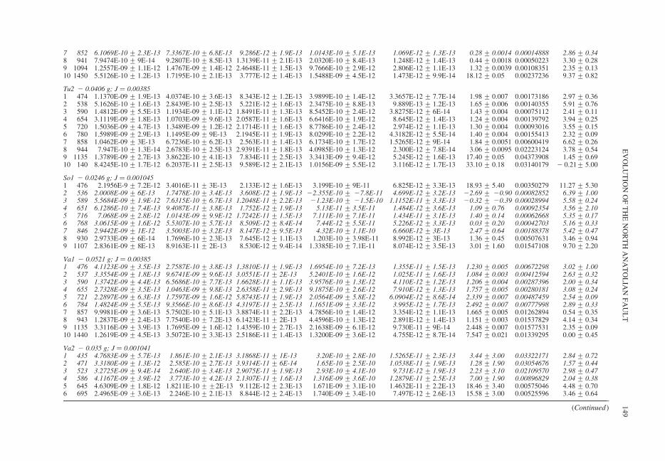
7 852 6.1069E-10 + 2.3E-13 7.3367E-10 + 6.8E-13 9.286E-12 + 1.9E-13 1.0143E-10 + 5.1E-13 1.069E-12 + 1.3E-13 0.28 + 0.0014 0.00014888 2.86 + 0.348 941 7.9474E-10 + 9E-14 9.2807E-10 + 8.5E-13 1.3139E-11 + 2.1E-13 2.0320E-10 + 8.4E-13 1.248E-12 + 1.4E-13 0.44 + 0.0018 0.00050223 3.30 + 0.289 1094 1.2557E-09 + 1.1E-12 1.4767E-09 + 1.4E-12 2.4648E-11 + 1.5E-13 9.7666E-10 + 2.9E-12 2.806E-12 + 1.1E-13 1.32 + 0.0039 0.00108351 2.35 + 0.1310 1450 5.5126E-10 + 1.2E-13 1.7195E-10 + 2.1E-13 3.777E-12 + 1.4E-13 1.5488E-09 + 4.5E-12 1.473E-12 + 9.9E-14 18.12 + 0.05 0.00237236 9.37 + 0.82
Tu2 2 0.0406 g; J ¼ 0.003851 474 1.1370E-09 + 1.9E-13 4.0374E-10 + 3.6E-13 8.343E-12 + 1.2E-13 3.9899E-10 + 1.4E-12 3.3657E-12 + 7.7E-14 1.98 + 0.007 0.00173186 2.97 + 0.362 538 5.1626E-10 + 1.6E-13 2.8439E-10 + 2.5E-13 5.221E-12 + 1.6E-13 2.3475E-10 + 8.8E-13 9.889E-13 + 1.2E-13 1.65 + 0.006 0.00140355 5.91 + 0.763 590 1.4812E-09 + 5.5E-13 1.1934E-09 + 1.1E-12 1.8491E-11 + 1.3E-13 8.5452E-10 + 2.4E-12 3.8275E-12 + 6E-14 1.43 + 0.004 0.00075112 2.41 + 0.114 654 3.1119E-09 + 1.8E-13 1.0703E-09 + 9.6E-13 2.0587E-11 + 1.6E-13 6.6416E-10 + 1.9E-12 8.645E-12 + 1.4E-13 1.24 + 0.004 0.00139792 3.94 + 0.255 720 1.5036E-09 + 4.7E-13 1.3489E-09 + 1.2E-12 2.1714E-11 + 1.6E-13 8.7786E-10 + 2.4E-12 2.974E-12 + 1.1E-13 1.30 + 0.004 0.00093016 3.55 + 0.156 780 1.5989E-09 + 2.9E-13 1.1495E-09 + 9E-13 2.1945E-11 + 1.9E-13 8.0299E-10 + 2.2E-12 4.3182E-12 + 5.5E-14 1.40 + 0.004 0.00155413 2.32 + 0.097 858 1.0462E-09 + 3E-13 6.7236E-10 + 6.2E-13 2.563E-11 + 1.4E-13 6.1734E-10 + 1.7E-12 1.5265E-12 + 9E-14 1.84 + 0.0051 0.00600419 6.62 + 0.268 944 7.947E-10 + 1.3E-14 2.6783E-10 + 2.5E-13 2.9391E-11 + 1.8E-13 4.0985E-10 + 1.3E-12 2.300E-12 + 7.8E-14 3.06 + 0.0095 0.02223124 3.78 + 0.549 1135 1.3789E-09 + 2.7E-13 3.8622E-10 + 4.1E-13 7.834E-11 + 2.5E-13 3.3413E-09 + 9.4E-12 5.245E-12 + 1.6E-13 17.40 + 0.05 0.04373908 1.45 + 0.6910 140 8.4245E-10 + 1.7E-12 6.2037E-11 + 2.5E-13 9.589E-12 + 2.1E-13 1.0156E-09 + 5.5E-12 3.116E-12 + 1.7E-13 33.10 + 0.18 0.03140179 2 0.21+ 5.00
So1 2 0.0246 g; J ¼ 0.0010451 476 2.1956E-9 + 7.2E-12 3.4016E-11 + 3E-13 2.133E-12 + 1.6E-13 3.199E-10 + 9E-11 6.825E-12 + 3.3E-13 18.93 + 5.40 0.00350279 11.27 + 5.302 536 2.0008E-09 + 6E-13 1.7478E-10 + 3.4E-13 3.608E-12 + 1.9E-13 22.355E-10 + 27.8E-11 4.699E-12 + 3.2E-13 22.69 + 20.90 0.00082852 6.39 + 1.003 589 5.5684E-09 + 1.9E-12 7.6315E-10 + 6.7E-13 1.2048E-11 + 2.2E-13 21.23E-10 + 21.5E-10 1.1152E-11 + 3.3E-13 20.32 + 20.39 0.00028994 5.58 + 0.244 651 6.1286E-10 + 7.4E-13 9.4087E-11 + 3.8E-13 1.752E-12 + 1.9E-13 5.13E-11 + 3.5E-11 1.484E-12 + 3.6E-13 1.09 + 0.76 0.00092354 3.56 + 2.105 716 7.068E-09 + 2.8E-12 1.0143E-09 + 9.9E-12 1.7242E-11 + 1.5E-13 7.111E-10 + 7.1E-11 1.434E-11 + 3.1E-13 1.40 + 0.14 0.00062668 5.35 + 0.176 768 3.0615E-09 + 1.6E-12 5.5307E-10 + 5.7E-13 8.509E-12 + 8.4E-14 7.44E-12 + 5.5E-11 5.226E-12 + 3.3E-13 0.03 + 0.20 0.00042703 5.16 + 0.337 846 2.9442E-09 + 1E-12 3.5003E-10 + 3.2E-13 8.147E-12 + 9.5E-13 4.32E-10 + 1.1E-10 6.660E-12 + 3E-13 2.47 + 0.64 0.00188378 5.42 + 0.478 930 2.9733E-09 + 6E-14 1.7696E-10 + 2.3E-13 7.645E-12 + 1.1E-13 1.203E-10 + 3.98E-11 8.992E-12 + 3E-13 1.36 + 0.45 0.00507631 3.46 + 0.949 1107 2.8361E-09 + 8E-13 8.9163E-11 + 2E-13 8.530E-12 + 9.4E-14 1.3385E-10 + 7.1E-11 8.074E-12 + 3.5E-13 3.01 + 1.60 0.01547108 9.70 + 2.20
Va1 2 0.0521 g; J ¼ 0.003851 476 4.1123E-09 + 3.5E-13 2.7587E-10 + 3.8E-13 1.3810E-11 + 1.9E-13 1.6954E-10 + 7.2E-13 1.355E-11 + 1.5E-13 1.230 + 0.005 0.00672298 3.02 + 1.002 537 3.3554E-09 + 1.8E-13 9.6741E-09 + 9.6E-13 3.0551E-11 + 2E-13 5.2401E-10 + 1.6E-12 1.025E-11 + 1.6E-13 1.084 + 0.003 0.00412594 2.63 + 0.323 590 1.3742E-09 + 4.4E-13 6.5686E-10 + 7.7E-13 1.6628E-11 + 1.1E-13 3.9576E-10 + 1.3E-12 4.110E-12 + 1.2E-13 1.206 + 0.004 0.00287396 2.00 + 0.344 655 2.7328E-09 + 3.5E-13 1.0463E-09 + 9.8E-13 2.6358E-11 + 2.9E-13 9.1875E-10 + 2.6E-12 7.910E-12 + 1.3E-13 1.757 + 0.005 0.00280181 3.08 + 0.245 721 2.2897E-09 + 6.3E-13 1.7597E-09 + 1.6E-12 5.8743E-11 + 1.9E-13 2.0564E-09 + 5.8E-12 6.0904E-12 + 8.6E-14 2.339 + 0.007 0.00487459 2.54 + 0.096 784 1.4824E-09 + 5.5E-13 9.3566E-10 + 8.6E-13 4.3197E-11 + 2.5E-13 1.1651E-09 + 3.3E-12 3.995E-12 + 1.7E-13 2.492 + 0.007 0.00777998 2.89 + 0.337 857 9.9981E-09 + 3.6E-13 5.7502E-10 + 5.1E-13 3.8874E-11 + 2.2E-13 4.7856E-10 + 1.4E-12 3.354E-12 + 1.1E-13 1.665 + 0.005 0.01262894 0.54 + 0.358 943 1.2837E-09 + 2.4E-13 7.7540E-10 + 7.2E-13 6.1423E-11 + 2E-13 4.4596E-10 + 1.3E-12 2.891E-12 + 1.4E-13 1.151 + 0.003 0.01537829 4.14 + 0.349 1135 3.3116E-09 + 3.9E-13 1.7695E-09 + 1.6E-12 1.4359E-10 + 2.7E-13 2.1638E-09 + 6.1E-12 9.730E-11 + 9E-14 2.448 + 0.007 0.01577531 2.35 + 0.0910 1440 1.2619E-09 + 4.5E-13 3.5072E-10 + 3.3E-13 2.5186E-11 + 1.4E-13 1.3200E-09 + 3.6E-12 4.755E-12 + 8.7E-14 7.547 + 0.021 0.01339295 0.00 + 0.45
Va2 2 0.035 g; J ¼ 0.0010411 435 4.7683E-09 + 5.7E-13 1.861E-10 + 2.1E-13 3.1868E-11 + 1E-13 3.20E-10 + 2.8E-10 1.5265E-11 + 2.3E-13 3.44 + 3.00 0.03322171 2.84 + 0.722 471 3.3180E-09 + 1.3E-12 2.585E-10 + 2.7E-13 3.9314E-11 + 6E-14 1.65E-10 + 2.5E-10 1.0538E-11 + 1.9E-13 1.28 + 1.90 0.03054676 1.57 + 0.443 523 3.2725E-09 + 9.4E-14 2.640E-10 + 3.4E-13 2.9075E-11 + 1.9E-13 2.93E-10 + 4.1E-10 9.731E-12 + 1.9E-13 2.23 + 3.10 0.02109570 2.98 + 0.474 586 4.1167E-09 + 3.9E-12 3.773E-10 + 4.2E-13 2.1307E-11 + 1.6E-13 1.316E-09 + 3.6E-10 1.2879E-11 + 2.5E-13 7.00 + 1.90 0.00896829 2.04 + 0.385 645 4.6309E-09 + 1.8E-12 1.8211E-10 ++2E-13 9.112E-12 + 2.3E-13 1.671E-09 + 3.1E-10 1.4632E-11 + 2.2E-13 18.46 + 3.40 0.00575046 4.48 + 0.706 695 2.4965E-09 + 3.6E-13 2.246E-10 + 2.1E-13 8.844E-12 + 2.4E-13 1.740E-09 + 3.4E-10 7.497E-12 + 2.6E-13 15.58 + 3.00 0.00525596 3.46 + 0.64
(Continued)
EV
OL
UT
ION
OF
TH
EN
OR
TH
AN
AT
OL
IAN
FA
UL
T149
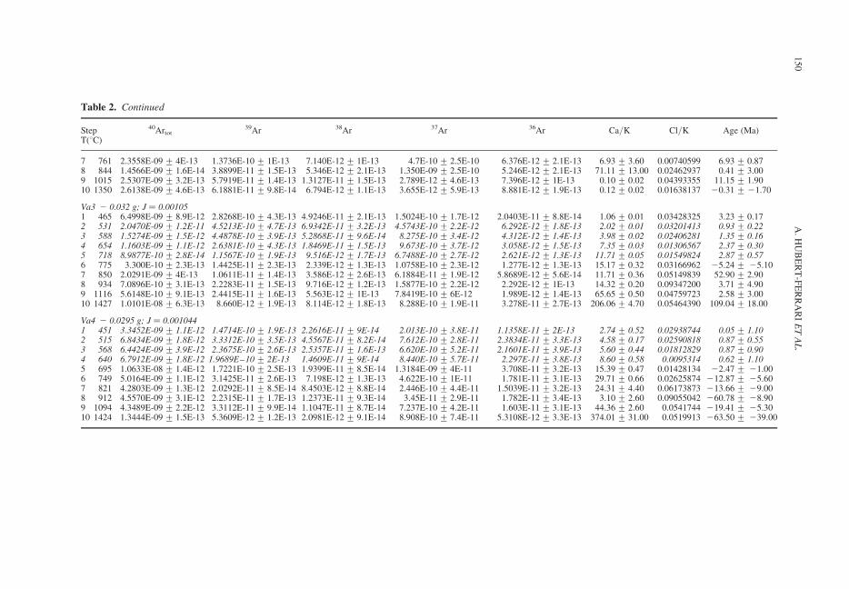
Table 2. Continued
StepT(8C)
40Artot39Ar 38Ar 37Ar 36Ar Ca/K Cl/K Age (Ma)
7 761 2.3558E-09 + 4E-13 1.3736E-10 + 1E-13 7.140E-12 + 1E-13 4.7E-10 + 2.5E-10 6.376E-12 + 2.1E-13 6.93 + 3.60 0.00740599 6.93 + 0.878 844 1.4566E-09 + 1.6E-14 3.8899E-11 + 1.5E-13 5.346E-12 + 2.1E-13 1.350E-09 + 2.5E-10 5.246E-12 + 2.1E-13 71.11 + 13.00 0.02462937 0.41 + 3.009 1015 2.5307E-09 + 3.2E-13 5.7919E-11 + 1.4E-13 1.3127E-11 + 1.5E-13 2.789E-12 + 4.6E-13 7.396E-12 + 1E-13 0.10 + 0.02 0.04393355 11.15 + 1.9010 1350 2.6138E-09 + 4.6E-13 6.1881E-11 + 9.8E-14 6.794E-12 + 1.1E-13 3.655E-12 + 5.9E-13 8.881E-12 + 1.9E-13 0.12 + 0.02 0.01638137 20.31 + 21.70
Va3 2 0.032 g; J ¼ 0.001051 465 6.4998E-09 + 8.9E-12 2.8268E-10 + 4.3E-13 4.9246E-11 + 2.1E-13 1.5024E-10 + 1.7E-12 2.0403E-11 + 8.8E-14 1.06 + 0.01 0.03428325 3.23 + 0.172 531 2.0470E-09 + 1.2E-11 4.5213E-10 + 4.7E-13 6.9342E-11 + 3.2E-13 4.5743E-10 + 2.2E-12 6.292E-12 + 1.8E-13 2.02 + 0.01 0.03201413 0.93 + 0.223 588 1.5274E-09 + 1.5E-12 4.4878E-10 + 3.9E-13 5.2868E-11 + 9.6E-14 8.275E-10 + 3.4E-12 4.312E-12 + 1.4E-13 3.98 + 0.02 0.02406281 1.35 + 0.164 654 1.1603E-09 + 1.1E-12 2.6381E-10 + 4.3E-13 1.8469E-11 + 1.5E-13 9.673E-10 + 3.7E-12 3.058E-12 + 1.5E-13 7.35 + 0.03 0.01306567 2.37 + 0.305 718 8.9877E-10 + 2.8E-14 1.1567E-10 + 1.9E-13 9.516E-12 + 1.7E-13 6.7488E-10 + 2.7E-12 2.621E-12 + 1.3E-13 11.71 + 0.05 0.01549824 2.87 + 0.576 775 3.300E-10 + 2.3E-13 1.4425E-11 + 2.3E-13 2.339E-12 + 1.3E-13 1.0758E-10 + 2.3E-12 1.277E-12 + 1.3E-13 15.17 + 0.32 0.03166962 25.24 + 25.107 850 2.0291E-09 + 4E-13 1.0611E-11 + 1.4E-13 3.586E-12 + 2.6E-13 6.1884E-11 + 1.9E-12 5.8689E-12 + 5.6E-14 11.71 + 0.36 0.05149839 52.90 + 2.908 934 7.0896E-10 + 3.1E-13 2.2283E-11 + 1.5E-13 9.716E-12 + 1.2E-13 1.5877E-10 + 2.2E-12 2.292E-12 + 1E-13 14.32 + 0.20 0.09347200 3.71 + 4.909 1116 5.6148E-10 + 9.1E-13 2.4415E-11 + 1.6E-13 5.563E-12 + 1E-13 7.8419E-10 + 6E-12 1.989E-12 + 1.4E-13 65.65 + 0.50 0.04759723 2.58 + 3.0010 1427 1.0101E-08 + 6.3E-13 8.660E-12 + 1.9E-13 8.114E-12 + 1.8E-13 8.288E-10 + 1.9E-11 3.278E-11 + 2.7E-13 206.06 + 4.70 0.05464390 109.04 + 18.00
Va4 2 0.0295 g; J ¼ 0.0010441 451 3.3452E-09 + 1.1E-12 1.4714E-10 + 1.9E-13 2.2616E-11 + 9E-14 2.013E-10 + 3.8E-11 1.1358E-11 + 2E-13 2.74 + 0.52 0.02938744 0.05 + 1.102 515 6.8434E-09 + 1.8E-12 3.3312E-10 + 3.5E-13 4.5567E-11 + 8.2E-14 7.612E-10 + 2.8E-11 2.3834E-11 + 3.3E-13 4.58 + 0.17 0.02590818 0.87 + 0.553 568 6.4424E-09 + 3.9E-12 2.3675E-10 + 2.6E-13 2.5357E-11 + 1.6E-13 6.620E-10 + 5.2E-11 2.1601E-11 + 3.9E-13 5.60 + 0.44 0.01812829 0.87 + 0.904 640 6.7912E-09 + 1.8E-12 1.9689E–10 + 2E-13 1.4609E-11 + 9E-14 8.440E-10 + 5.7E-11 2.297E-11 + 3.8E-13 8.60 + 0.58 0.0095314 0.62 + 1.105 695 1.0633E-08 + 1.4E-12 1.7221E-10 + 2.5E-13 1.9399E-11 + 8.5E-14 1.3184E-09 + 4E-11 3.708E-11 + 3.2E-13 15.39 + 0.47 0.01428134 22.47 + 21.006 749 5.0164E-09 + 1.1E-12 3.1425E-11 + 2.6E-13 7.198E-12 + 1.3E-13 4.622E-10 + 1E-11 1.781E-11 + 3.1E-13 29.71 + 0.66 0.02625874 212.87 + 25.607 821 4.2803E-09 + 1.3E-12 2.0292E-11 + 8.5E-14 8.4503E-12 + 8.8E-14 2.446E-10 + 4.4E-11 1.5039E-11 + 3.2E-13 24.31 + 4.40 0.06173873 213.66 + 29.008 912 4.5570E-09 + 3.1E-12 2.2315E-11 + 1.7E-13 1.2373E-11 + 9.3E-14 3.45E-11 + 2.9E-11 1.782E-11 + 3.4E-13 3.10 + 2.60 0.09055042 260.78 + 28.909 1094 4.3489E-09 + 2.2E-12 3.3112E-11 + 9.9E-14 1.1047E-11 + 8.7E-14 7.237E-10 + 4.2E-11 1.603E-11 + 3.1E-13 44.36 + 2.60 0.0541744 219.41 + 25.3010 1424 1.3444E-09 + 1.5E-13 5.3609E-12 + 1.2E-13 2.0981E-12 + 9.1E-14 8.908E-10 + 7.4E-11 5.3108E-12 + 3.3E-13 374.01 + 31.00 0.0519913 263.50 + 239.00
A.
HU
BE
RT
-FE
RR
AR
IE
TA
L.
150
opening of the Karliova Basin. This situation mayhave prevailed just before the creation of the Kar-liova Triple Junction (Fig. 10c), and the observednormal faults and Karliova basin may be inheritedfrom that time. Finally a unique trench system asmodelled in Figure 10 does not exist. The defor-mation is partitioned with mostly right-lateral defor-mation along the Main Varto Fault and shortening tothe south along the Mus fold-and-thrust belt. Presentactive shortening is attested in the field by upliftedalluvial fans and thrust fault scarps. Recent seismi-city does not show any thrusting events despite thedense coverage of the temporary seismic network(Orgulu et al. 2003), but the critical factor remainsthe short period of observation compared to theseismic cycle.
Finally to fully understand for the Triple Junc-tion evolution one must account for the lithosphericcomplexities existing at the boundaries betweenthe Arabian, Eurasian and Anatolian blocks(Fig. 11). S-wave receiver functions (Angus et al.2006) have shown that near the triple junction thesignatures of at least three or four lithosphere-asthenosphere boundaries (LAB) can be found: theLAB of East Anatolian Accretionary Complex andRhodope-Pontide continental fragment (calledhere ‘East Anatolian’ LAB), the LAB of AnatolianBlock (called here ‘Anatolian’ LAB) and the LABof the Arabian Shield (called here ‘Arabian’LAB). The Anatolian Faults and associated struc-tures all have deep lithospheric signatures: alongthe North Anatolian Fault, an apparent lithosphericright-lateral offset corresponds to the Turna/Bingol offset (see the isothickness line: 66 km inFig. 11); across the East Anatolian Fault until,Bingol Basin, a lithospheric step exists betweenthe northern 70 km deep ‘East Anatolian’ LAB,and the southern 80 km deep ‘Anatolian’ and115 km deep ‘Arabian’ LAB. The Erzincan Basin,Bingol Basin and Mus Basin are also deeplyrooted: major lithospheric thinning is found in theErzincan area, the location of the former triple junc-tion; lithospheric thickening exists north and NW ofthe Bingol Basin where shortening occurred due tothe 258 change in strike of the East AnatolianFault; the Bingol Basin and Mus-basin-and-thrust-zone form at the junction between the ‘Arabian’LAB and the ‘East Anatolian’ LAB, the Musthrust zone being also limited to the north by alow velocity zone. A three dimensional mechanicalmodel including fault discontinuity affecting thewhole lithosphere is thus needed to understand indetails the kinematics at the junction betweenArabia, Anatolia and Eurasia.
Conclusion
The availability of a set of relevant data, togetherwith the relative simplicity of the Anatolian fault
system makes it a unique laboratory to study thelong-term evolution of major strike-slip fault. Inter-estingly, the resulting picture is reminiscent ofsmaller scale faults or cracks evolution, as describedin Hubert-Ferrari et al. (2003). The history of theNorth Anatolian Fault propagation is particularlyrich and can be summarized as follows. From12 Ma to 2.5 Ma, it has grown in length westwardover 1300 km from Erzincan in eastern Turkey tothe Aegan Sea with a slip rate of 3 mm/a, and apropagation speed of 120 mm/a (Armijo et al.2003; Flerit et al. 2004). A similar propagationspeed was computed for the Altyn Tagh fault, amain strike-slip fault in the extrusion systemrelated to the India–Eurasia collision (Meyer et al.1998; Metivier et al. 1998). Rift propagation canalso have speed exceeding 100 mm/a (e.g. Wilson& Hey 1995; Manighetti et al. 1997), as well as thelateral propagation of the Himalaya front (Meigset al. 1995; Husson et al. 2004). This propagationphenomenon is consistently associated with differentages of the fault (Sengor et al. 2005): c. 12 Ma inthe east (Sengor et al. 1985; Barka 1992), c. 8.5 to5 Ma in its central part (Hubert-Ferrari et al. 2002),c. 5 Ma in the western Marmara sea (Straub et al.1997; Armijo et al. 1999), c. 3 Ma in the AegeanSea (Gautier et al. 1999), c. 1 Ma in the Gulf ofCorinth at the westernmost end of the fault (Armijoet al. 1996). The most dramatic event in this longhistory is described in the present paper: 2.5 to 3 Maago, the slip rate along the North Anatolian Fault sud-denly increases from about 3 mm/a averaged in10 Ma to about 20 mm/a, at a time when part of theArabian plate was accreted to Eurasia with theinitiation of a new East Anatolian Fault. The Whaka-tane Graben (New Zealand) behaved in a similar way,fault growth was first characterized by tip propagationand relatively slow displacements, and then after faultlinkage the average fault increased by almost threefold(Taylor et al. 2004).
Swiss National Science Foundation Grant, No.21-65197.01 funded this work. The data bank ofINSU-CNRS gave us access to the satellite imagery.V. Serneels (University of Fribourg, Switzerland) didXRF element analyses. Field work was successfullyconducted with the help of M. Burkhard and A. Devrim.We thank P. Claeys for fruitful discussions. Reviewsfrom C. Sengor and another anonymous reviewerimproved the manuscript.
References
ALLEN, A., JACKSON, J. & WALKER, R. 2004. Late Ceno-zoic reorganization of the Arabia–Eurasia collisionand the comparison of short-term and long-term defor-mation rates. Tectonics, 23, TC2008, doi:10.1029/2003TC001530.
AL-LAZKI, A. I., SEGER, D., SANDVOL, E., TURKELLI,N., MOHAMAD, R. & BARAZANGI, M. 2003.
EVOLUTION OF THE NORTH ANATOLIAN FAULT 151
Tomographic Pn velocity and anisotropy structurebeneath the Anatolian plateau (eastern Turkey) andthe surrounding regions. Geophysical ResearchLetters, 30, 8043, doi:10.1029/2003GL017391.
ALTINLI, E. 1961. Geological map of Turkey, ErzurumQuadrangle, General Directorate of Mineral Researchand Exploration (eds.), Ankara.
AMBRASEYS, N. N. & ZATOPEK, A. 1968. The VartoUstukran earthquake of 19 August 1966. Bulletin ofthe Seismological Society of America, 58, 47–102.
AMBRASEYS, N. 1988. Engineering seismology. Journalof Earthquake and Engeneering and StructuralDynamics, 17, 1–106.
ANGUS, D. A., WILSON, D. C., SANDVOL, E. & NI, J. F.2006. Lithospheric structure of the Arabian and Eurasiancollision zone in eastern Turkey from S-wave receiverfunctions. Geophysical Journal International, 166,1335–1346 doi: 10.1111/j.1365–246X.2006.03070.x.
ARMIJO, R., MEYER, B., KING, G. C. P., RIGO, A. &PAPANASTASSIOU, D. 1996. Quaternary evolution ofthe Corinth rift and its implications. GeophysicalJournal International, 126, 11–53.
ARMIJO, R., MEYER, B., HUBERT-FERRARI, A. &BARKA, A. A. 1999. Propagation of the North Anato-lian Fault into the Northern Aegean: Timing and Kin-ematics. Geology, 27, 267–270.
ARMIJO, R., FLERIT, F., KING, G. C. P. & MEYER, B.2003. Linear elastic fracture mechanics explains thepast and present evolution of the Aegean. Earth andPlanetary Science Letters, 217, 85–95.
ARPAT, E. & SAROGLU, F. 1972. The East AnatolianFault system: thoughts on its development. GeneralDirectorate of Mineral research and Exploration(MTA) Bulletin, 78, 33–39.
AXEN, G. J., LAM, P. S., GROVE, M., STOCKLI, D. F. &HASSANZADEH, J. 2001. Exhumation of the west-central Alborz Mountains, Iran, Caspian subsidence,and collision-related tectonics. Geology, 29, 559–562.
BARKA, A. A. & HANCOCK, P. L. 1984. Neotectonicdeformation patterns in the convex-northwards arc ofthe North Anatolian fault. In: DIXON, J. G. & ROBERT-
SON, A. H. F. The Geological Evolution of the easternMediterranean. Geological Society, London, SpecialPublication, 17, 763–773.
BARKA, A. A. & KADINSKY-CADE, K. 1988. Strike-slipfault geometry in Turkey and its influence on earth-quake activity. Tectonics, 7, 663–684.
BARKA, A. A. & GULEN, L. 1989. Complex evolution ofthe Erzincan basin (eastern Turkey). Journal of Struc-tural Geology, 11, 275–283.
BARKA, A. A. 1992. The North Anatolian fault zone.Annales Tectonicae (Supplement), 6, 164–195.
BIGAZZI, G., YEGINGIL, Z., ERCAN, T., ODDONE, M. &OZDOGAN, M. 1994. Provenance studies of prehistoricartefacts in Eastern Anatolia: first results of an interdis-ciplinary research. Mineralogica et PetrographicaActa, XXXVII, 17–36.
BIGAZZI, G., YEGINGIL, Z., ERCAN, T., ODDONE, M. &OZDOGAN, M. 1996. The Pisa-Adana joint project ofprehistoric obsidian artifacts; first results from easternAnatolia using fission track dating method: an overview.In: DIMIRCI, S., OVER, A. M. & SUMMERS, G. D. (eds)Proceedings of the 29th symposium on Archaeometry.Ankara, 9–14, May 1994, 521–528.
BIGAZZI, G., YEGINGIL, Z., ERCAN, T., ODDONE, M. &OZDOGAN, M. 1997. Age determination of obsidianbearing volcanics in Eastern Anatolia using thefission track dating method. Geological Bulletin ofTurkey, 40, 57–72.
BIGAZZI, G., POUPEAU, G., YEGINGIL, Z. & BELLOT-GURLET, L. 1998. Provenance studies of obsidian arte-facts in Anatolia using the fission track dating method.An overview. In: GOURGAUD, A., GRATUZE, B.,POUPEAU, G., POIDEVIN, J. L. & CAUVIN, M. C.(eds) L’Obsidienne au Proche et Moyen Orient, duVolcan a l’Outil. BAR International Series HadrianBooks, 738, 69–89.
BINGOL, E., BAL, I. & CAN, N. (eds) 1989. Geologicalmap of Turkey, scale 1:2000000, General Directo-rates of Mineral Research and Exploration, Ankara,Turkey.
BOZKURT, E. & KOCYIGIT, A. , 1996. The Kazova Basin:an active flower structure on the Almus Fault Zone, asplay fault system of the North Anatolian Fault Zone,Turkey. Tectonophysics, 265, 239–254.
BOZKURT, E. 2001. Neotectonics of Turkey—a synthesis.Geodinamica Acta, 14, 3–30.
BUKET, E. & GORMUS, S. 1986. Varto (Mus) havzasın-daki Tersiyer yaslı istifin stratigrafisi. Yerbilimleri 13,17–29 [in Turkish with English abstract].
BUKET, E. & TEMEL, A. 1998. Major-element, traceelement, and Sr-Nd isotopic geochemistry andgenesis of Varto (Mus) volcanic rocks, EasternTurkey. Journal of Volcanology and GeothermalResearch, 85, 405–422.
CAKIR, O. & ERDURAN, M. 2004. Constraining crustaland uppermost mantle structure beneath station TBZ(Trabzon, Turkey) by receiver function and dispersionanalyses. Geophysical Journal International, 158,955–971.
CALAIS, E., DEMETS, C. & NOCQUET, J.-M. 2003.Evidence for a post-3.16-Ma change in Nubia-Eurasia-North America plate motions? Earth and PlanetaryScience Letters, 216, 81–92.
CETIN, H., GUNEYLI, H. & MAYER, L. 2003. Paleoseis-mology of the Palu-Lake Hazar segment of the EastAnatolian Fault Zone, Turkey. Tectonophysics, 374,163–197.
CHATAIGNER, C., POIDEVIN, J. L. & ARNAUD, N. O.1998. Turkish occurrences of obsidian and use by pre-historic peoples in the Near East from 14,000 to6000 BP. Journal of Volcanology and GeothermalResearch, 85, 517–537.
DEWEY, J. F., HEMPTON, M. R., KIDD, W. S. F.,SAROGLU, F. & SENGOR, A. M. C. 1986. Shorteningof continental lithosphere: the neotectonics of easternAnatolia-A young collision Zone. In: COWARD,M. P. & RIES, A. C. (eds) Collision Tectonics. Geo-logical Society of London, Special Publication, 19,3–36.
FACCENNA, C., BELLIER, O., MARTINOD, J., PIRO-
MALLO, C. & REGARD, V. 2006. Slab detachmentbeneath eastern Anatolia. Earth and PlanetaryScience Letters, 242, 85–97.
FLEMING, T. H., HEIMANN, A., FOLAND, K. A. &ELLIOT, D. H. 1997. Ar-40/Ar-39 geochronology ofFerrar Dolerite sills from the Transantarctic mountains,Antarctica: Implications for the age and origin of the
A. HUBERT-FERRARI ET AL.152
Ferrar magmatic province. Geological Society ofAmerica Bulletin, 109, 533–546.
FLERIT, F., ARMIJO, A., KING, G. & MEYER, B. 2004.The mechanical interaction between the propagatingNorth Anatolian Fault and the back-arc extension inthe Aegean. Earth and Planetary Science Letters,224, 347–362.
FUENZELIDA, H., DORBATH, L., CISTERNAS, A.,RIVERA, L., EYIDOGAN, H., BARKA, A. A., HAESS-
LER, H., PHILIP, H. & LYBERIS, N. 1997. Mechanismof the Erzincan earthquake and its aftershocks, tec-tonics of the Erzincan basin and decoupling on theNorth Anatolian Fault. Geophysical Journal Inter-national, 129, 1–28.
GAUTIER, P., BRUN, J.-P., RICHARD, M., DIMITRIOS, S.,MARTINOD, J. & JOLIVET, L. 1999. Timing, kin-ematics and cause of Aegean extension: a scenariobased on a comparison with simple analogue exper-iments. Tectonophysics, 315, 31–72.
GELATI, R. 1975. Miocene marine sequence from lakeVan eastern Turkey. Rivista Italiana di Paleontologiae stratigraphia, 81, 477–490.
GOK, R., SANDVOL, E., TUKELLI, N., SEBER, D. &BARAZANGI, M. 2003. Sn attenuation in the Anatolianand Iranian plateau and surrounding regions. Geophysi-cal Research Letters, 30, 8042, doi:10.1029/2003GL018020.
GURSOY, H., PIPER, J. D. A., TATAR, O. & TEMIZ, H.1997. A palaeomagnetic study of the Sivas basin,Central Turkey: Crustal deformation during lateralextrusion of the Anatolian block. Tectonophysics,271, 89–105.
HERECE, E. & AKAY, E. 2003. Kyzey Anadolu Fayi (KAF)Atlasi/Atlas of North Anatolian Fault (NAF). OzelYayın. Ser. 2, Maden Tetk. Arama Genl Mudurlugu,Ankara, [IV], 61 pp.þ 13 appendices as separatemaps.
HUBERT-FERRARI, A., ARMIJO, R., KING, G. C. P.,MEYER, B. & BARKA, A. 2002. Morphology, displa-cement and slip rates along the North Anatolian Fault(Turkey). Journal of Geophysical Research, 107,101029–101059.
HUBERT-FERRARI, A., KING, G. C. P., MANIGHETTI, I.,ARMIJO, R., MEYER, B. & TAPPONNIER, P. 2003.Long-term Elasticity in the Continental Lithosphere;Modelling the Aden Ridge Propagation and the Anato-lian Extrusion Process. Geophysical Journal Inter-national, 153, 111–132.
HUSSON, L., MUGNIER, J.-L., LETURMY, P. & VIDAL, G.2004. Kinematics and sedimentary balance of the Sub-himalayan range, W. Nepal. In: MACCLAY, K. (ed.)Thrust Tectonics and Hydrocarbon Systems. AAPGMemoir, 82, 115–130.
INNOCENTI, F., MAZZUOLI, R., PASQUARE, G., RADI-
CATI DI BROZOL, F. & VILLARI, L. 1982a. Tertiaryand Quaternary volcanism of the Erzurum-Kars areaEastern Turkey: geochronological data and geo-dynamic evolution. Journal of Volcanology andGeothermal Research, 13, 223–240.
INNOCENTI, F., MANETTI, P., MAZZUOLI, R.,PASQUARE, G. & VILLARI, L. 1982b. Anatolia andNorth-western Iran. In: THORPE, R. S. (ed.) Andesites;orogenic andesites and related rocks. John Wiley andSons, 327–349.
JAFFEY, N., ROBERTSON, A. & PRINGLE, M. 2004. LatestMiocene and Pleistocene ages of faulting, determinedby 40Ar-39Ar single-crystal dating of air fall tuff andsilicic extrusives of the Erciyes Basin, central Turkey:evidence for intraplate deformation related to thetectonic escape of Anatolia. Terra Nova, 16, 45–53.
JIMENEZ-MUNT, I. & SABADINI, R. 2002. The block-likebehavior of Anatolia envisaged in the modeled andgeodetic strain rates. Geophysical Research Letters,29, doi: 10.1029/2002GL015995, 2002.
KIM, Y.-S. & SANDERSON, D. J. 2006. Structural simi-larity and variety at the tips in a wide range of strike-slip faults: a review. Terra Nova, 18, 330–344, doi:10.1111/j.1365–3121.2006.00697.x.
MANIGHETTI, I., TAPPONNIER, P., COURTILLOT, V.,GRUSZOW, S. & GILLOT, P. 1997. Propagation ofrifting along the Arabia-Somalia plate boundary: theGulfs of Aden and Tadjoura. Journal of GeophysicalResearch, 102, 2681–2710.
MAGGI, A. & PRIESTLEY, K. 2005. Surface waveformtomography of the Turkish-Iranian plateau. Geophysi-cal Journal International, 160, 1068–1080.
MCCLUSKY, S., BALASSANIAN, S., BARKA, A., DEMIR,C., ERGINTAV, S., GEORGIEV, I. ET AL. 2000. GPSconstraints on plate motion and deformation inthe eastern Mediteranean: Implication for platedynamics. Journal of Geophysical Research, 105,5695–5719.
MCKENZIE, D. P. & MORGAN, W. J. 1969. Evolution oftriple junctions. Nature, 224, 125–133.
MCKENZIE, D. P. 1972. Active tectonics of the Mediterra-nean region. Geophysical Journal of the Royal Astro-nomical Society, 30, 109–185.
MCQUARRIE, N., STOCK, J. M., VERDEL, C. & WER-
NICKE, B. P. 2003. Cenozoic ecolution of neotethysand implications for the causes of plate motions. Geo-physical Research Letters, 30, 2036, doi:10.1029/2003GL017992.
MEIGS, A. J., BURBANK, D. W. & BECK, R. A. 1995.Middle-late Miocene (.10 Ma) formation of theMain Boundary Thrust in the western Himalaya.Geology, 23, 423–426.
METIVIER, F., GAUDEMER, Y., TAPPONNIER, P. &MEYER, B. 1998. Northeastward growth of the Tibetplateau deduced from balanced reconstruction of twodepositional areas: The Qaidam and Hexi Corridorbasins, China. Tectonics, 17, 823–842.
MEYER, B., TAPPONNIER, P., BOURJOT, L., METIVIER,F., GAUDEMER, Y., PELTZER, G. ET AL. 1998.Crustal thickening in Gansu-Qinghai, lithosphericmantle subduction and oblique, strike-slip controlledgrowth of the Tibetan Plateau. Geophysical JournalInternational, 135, 1–47.
MORTON, A., ALLEN, M., SIMMONS, M.,SPATHOPOULOS, F., STILL, J., HINDS, D. ET AL.2003. Provenance patterns in a neotectonic basin: Plio-cene and Quaternary sediment supply to the SouthCaspian. Basin Research, 15, 321–337.
ORGULU, G., AKTAR, M., TURKELLI, N., SANDVOL, E.& BARAZANGI, M. 2003. Contribution to the seismo-tectonics of Eastern Turkey from moderate and smallsize events. Geophysical Research Letters, 30, 8040.
OVER, S., OZDEN, S. & UNLUGENC, U. C. 2004. LateCenozoic stress distribution along the Misis Range in
EVOLUTION OF THE NORTH ANATOLIAN FAULT 153

the Anatolian, Arabian, and African Plate intersectionregion, SE Turkey. Tectonics, 23, TC3008,doi:10.1029/2002TC001455.
OVER, S., UNLUGENC, U. C. & BELLIER, O. 2002.Quaternary stress regime change in the Hatay region(southeastern Turkey). Geophysical JournalInternational, 148, 649–662.
PEARCE, J. A., BENDER, J. F., DE LONG, S. E., KIDD
WILLIAM, S. F., LOW, P. J., GUNER, Y. ET AL.1990. Genesis of collision volcanism in eastern Anato-lia, Turkey. Journal of Volcanology and GeothermalResearch, 44, 189–229.
POIDEVIN, J. L. 1998. Provenance studies of obsidian arte-facts in Anatolia using the fission track dating method.An overview. In: GOURGAUD, A., GRATUZE, B.,POUPEAU, G., POIDEVIN, J. L. & CAUVIN, M. C.(eds) L’Obsidienne au Proche et Moyen Orient, duVolcan a l’Outil. BAR International Series HadrianBooks, 738, 105–156.
REILINGER, R., MCCLUSKY, S., VERNANT, P.,LAWRENCE, S., ERGINTAV, S., CAKMAK, R. ET AL.2006. GPS constraints on continental deformation inthe Africa–Arabia–Eurasia continental collisionzone and implications for the dynamics of plate inter-actions. Journal Geophysical Research, 111, B05411,doi:10.1029/2005JB004051.
SAROGLU, F. & YILMAZ, Y. 1987. Geological evolutionand basin models during neotectonic episode in theeastern Anatolia. Bulletin Mineral Research andExploration, 107, 61–83.
SAROGLU, F. & YILMAZ, Y. 1991. Geology of the Kar-liova region: intersection of the North Anatolian andEast Anatolian Transform Faults. Bulletin of the Tech-nical University of Istanbul, 44, 475–493.
SAROGLU, F., EMRE, O. & KUSCU, I. 1992. The east Ana-tolian fault zone of Turkey. Annales Tectonicae,Special Issue, 6, 99–125.
SENGOR, A. M. C., GORUR, N. & SAROGLU, F. 1985.Strike-slip faulting and related basin formation inzones of tectonic escape: Turkey as a case study. In:BIDDLE, K. T. & CHRISTIE-BLICK, N. (eds) Strike-slip faulting and Basin formation. Society of EconomicPaleontologists and Mineralogist, Special Publication,37, 227–267.
SENGOR, A. M. C., TUYSUZ, O., IMREN, C., SAKINC, M.,EYIDOGAN, H., GORUR, N. ET AL. 2005. The NorthAnatolian Fault: A new look. Annual Review ofEarth and Planetary Science, 33, 1–75.
SEYMEN, I. & AYDIN, A. 1972. The Bingol earthquakefault and its relation to the North Anatolian FaultZone. General Directorate of Mineral research andExploration (MTA) Bulletin, 79, 1–8 [in Turkishwith English abstract].
STRAUB, C., KHALE, H. G. & SCHINDLER, C. 1997. GPSand geological estimates of the tectonic activity in theMarmara Sea region, NW Anatolia. Journal Geophysi-cal Research, 102, 27587–27601.
TAPPONNIER, P. 1977. Evolution tetonique du SystemeAlpin en Mediterranee: poinconnement et ecrasementrigide-plastique, Bulletin de la Societe Geologique deFrance, 7, 437–460.
TAPPONNIER, P., PELTZER, G., LE DAIN, A. Y., ARMIJO,R. & COBBOLD, P., 1982. Propagating extrusion tec-tonics in Asia: new insights from simple experimentswith plasticine. Geology, 10, 611–616.
TARHAN, N. 1993. Geological Map of the Erzurum.General Directorate of Mineral Research and Explora-tion, Ankara, G32 Quadrangle.
TARHAN, N. 1994. Geological Map of the Erzurum.General Directorate of Mineral Research and Explora-tion, Ankara, G31 Quadrangle.
TATAR, O., PIPER, J. D. A., GURSOY, H. & TEMIZ, H.,1996. Regional significance of neotectonic anticlock-wise rotation in central Turkey. InternationalGeology Review, 38, 692–700.
TAYLOR, S. K., BULL, J. M., LAMARCHE, G. & BARNES,P. M. 2004. Normal fault growth and linkage in theWhakatane Graben, New Zealand, during the last 1.3Myr. Journal of Geophysical Research, 109, B02408,doi:10.1029/2003JB002412.
VILLA, I. M., HERMANN, J., MUNTENER, O. &TROMMSDORFF, V. 2000. 39Ar-40Ar dating of multi-ply zoned amphibole generations (Malenco, ItalianAlps). Contributions to Mineralogy and Petrology,140, 363–381.
WALLACE, R. E. 1968. Earthquake of august 19, 1966.Varto Area, Eastern Turkey. Bulletin of the Seismo-logical Society of America, 58, 11–45.
WESTAWAY, R. 1994. Present-day kinematics of theMiddle East and eastern Mediterranean. Journal ofGeophysical Research, 99, 12071–12090.
WESTAWAY, R. & AEGER, J. 1996. The Golbasi basin,Southern Turkey: a complex discontinuity in a majorstrike-slip fault zone. Journal Geological Society ofLondon, 153, 729–744.
WESTAWAY, R. & AEGER, J. 2001. The kinematics of theMalatya-Ovacik Fault zone. Geodinamica Acta, 14,103–131.
WESTAWAY, R. 2003. Kinematics of the Middle East andEastern Mediterranean Updated. Turkish Journal ofEarth Sciences, 12, 5–46.
WESTAWAY, R. 2004. Kinematic consistency between theDead Sea Fault Zone and the Neogene and Quaternaryleft-lateral faulting in SE Turkey. Tectonophysics, 391,203–237.
WILSON, D. S. & HEY, R. N. 1995. History of rift propa-gation and magnetization intensity for the Cocos-Nazca spreading center. Journal of GeophysicalResearch, 100, 10041–10056.
YILMAZ, Y., SAROGLU, F. & GUNER, Y. 1987. Initiationof the neomagmatism in East Anatolia. Tectono-physics, 134, 177–199.
YURUR, M. T. & CHOROWICZ, J. , 1998. Recent volca-nism, tectonics and plate kinematics near the junctionof the African, Arabian and Anatolian plates in theeastern Mediterranean. Journal of Volcanology andGeothermal Research, 85, 1–15.
ZOR, E., SANDVOL, E., GURBUZ, C., TURKELLI, N.,SEBER, D. & BARAZANGI, M. 2003. Thecrustal structure of the East Anatolian plateau (Turkey)from receiver functions. Geophysical Research Letters,30, 8044, doi:10.1029/2003GL018192.
A. HUBERT-FERRARI ET AL.154
Mediterranean snapshots of accelerated slab retreat:
subduction instability in stalled continental collision
M. A. EDWARDS* & B. GRASEMANN
Structural Processes Group, Dept. of Geodynamics and Sedimentology,
University of Vienna, Althanstrasse 14, Vienna A-1090, Austria
*Corresponding author (e-mail: [email protected])
Abstract: This review of Mediterranean geodynamics highlights that the Mediterranean regioncaptures at a fortuitous moment in time, a picture of the fate of foundering, old, cold oceanic litho-sphere of limited area due to being landlocked in an all-but-stalled continental collision (Africawith Europe). We synthesize the geological spatial and temporal data for stretched crust as wellas the 3D distribution of old abyssal plains and new oceanic lithosphere segments in concertwith heat flow, palaeomagnetic data, geodetic velocity data, earthquake hypocentre distributionsand seismic tomography. We use three Mediterranean subduction system settings (the westernMediterranean, the Hellenic and the Pannonian–Carpathian) that nicely reflect the slab instabilityand retreat. We assume that mantle slab dynamics best explains the observations. The dispersal andsegmentation of the foundering landlocked ocean results in a series of discontinuous subductionzones whose individual lengths gradually diminish while retreat accelerates as slab progressivelynarrow and tear (i.e. along-strike laterally-propagating slab break-off) due to imminent total con-sumption of available oceanic lithosphere. We suggest that the Mediterranean region offers a lucidseries of snapshots of accelerated slab retreat that, additionally, is globally unique as the onlypresent day example of what we term intra-collisional landlocked ocean subduction.
This contribution focuses on three examples ofsubduction–collision boundaries (which we willterm ‘snapshots’) in the Mediterranean andsurrounding regions. It starts with an overview ofthe orogen at large. It then examines the role ofmantle dynamics in slab and subduction zone evol-ution to outline those key processes that we willattempt to highlight for the snapshot examples.Highlighting of these key processes then under-pins, for each snapshot example, a synthesis ofobservations of, and interpretations concerning,known subduction geodynamics elements. Thisthen additionally provides the reader with a moregeneral review of each snapshot area. All thesethen further serve to illustrate the snapshots’active and young (largely Oligo-Miocene)histories.
This contribution is, in part, motivated by recentwork (Gemmer & Houseman 2007; Houseman &Gemmer 2007) that seeks to explain observationssurrounding subduction geodynamics via numericalexperiments which show the theoretical feasibilityof mantle lithosphere downwelling (‘drip off’) thatis engendered by lower lithosphere instability(with the notable absence of any subducting litho-sphere). While this intriguing hypothesis offers anon-plate-tectonic based alternative (initiallymainly applicable to the Carpathian–Pannoniansnapshot), we keep with the hitherto postulated
idea (e.g. Wortel & Spakman 2000) that subductingslab mantle dynamics provide the most elegantexplanation (the simplest hypothesis that simul-taneously accounts for the majority of the obser-vations) for the actively migrating and evolvingMediterranean subduction–collision boundaries.Many of the ideas that we present here are hintedat or otherwise partly implicit in earlier reviews,syntheses or overview articles on the greater Medi-terranean region (e.g. Dercourt et al. 1986; Jolivet &Faccenna 2000; Wortel & Spakman 2000; Cavazzaet al. 2004). We build on these, incorporatingknowledge that has subsequently emerged toprovide a new review of Mediterranean subductionzone geodynamics for this volume that also servesto highlight two key themes: firstly, the fortuitousstatus quo of the greater Mediterranean; that eachof the three snapshots captures at a differentmoment in time (and for slightly differing con-ditions) the fate of one of a handful of subductionzones that have developed due to the founderingand consumption of oceanic crust trapped in an(almost) stalled continental collision (‘landlocked’of Le Pichon 1982) and, secondly, that this land-locked setting for actively evolving subductionzones represents a situation that would appear tobe presently globally unique yet must be extremelycommon through geological time; the foundering ofa landlocked basin before the complete closure of
From: VAN HINSBERGEN, D. J. J., EDWARDS, M. A. & GOVERS, R. (eds) Collision and Collapse at theAfrica–Arabia–Eurasia Subduction Zone. The Geological Society, London, Special Publications, 311, 155–192.DOI: 10.1144/SP311.6 0305-8719/09/$15.00 # The Geological Society of London 2009.
the associated ocean and corresponding wholesalecollision of the two attendant major converging con-tinental plates (in this case, Africa and Europe whileviewing the Mediterranean as part of the Eurasiangreater orogenic belt).
The Eurasian greater orogenic belt
Over geological time, continental collision as part ofthe global scale Wilson-cycle (Wilson 1966) hasrepeatedly generated major collisional belts(1000s km in length) that arise from the completecollision and suturing together of two or moremajor (106) continents. This is evident both innot-yet-fully-dissected belts like the .5000 kmlong Palaeozoic Appalachians of North America(e.g. Cloos 1940) as well as in Archean and Proter-ozoic lower crustal roots such as those seen in mul-tiple instances in the North American Shield (e.g.Hoffman 1988). We focus here on the Eurasiangreater orogenic belt.
The greater orogenic belt system that is beinggenerated from the continental collisional of theEurasian plate with the partnership of the African,Arabian and Indian plates (Fig. 1) provides theEarth Science community with the state of the artnatural laboratory in which to observe active oronly recently terminated crustal and mantle geo-dynamics processes associated with convergingcontinental lithosphere (Argand 1924). In additionto profiting from the often very complete preser-vation of rocks spanning a range of conditions andsettings from unconsolidated recent sediments toexhumed ultra high pressure suites (that, moreover,are frequently within the framework of a coherenttectono-/metamorpho-stratigraphic architecture), theregion encompassing the greater orogenic belt alsoprofits immensely from the immediate traces andresidual evidence that are attendant to the collisionalprocesses (that are otherwise quickly removed fromthe geological record with the procession of time).For example, recent kinematics and tectonic bound-ary conditions of the colliding plates are well con-strainable through both: (1) ocean floor magneticanomaly data plus palaeomagnetic/stratigraphicstudies that afford palinspastic/palaeogeographicreconstructions (e.g. Achache et al. 1984; Patriat& Achache 1984; Dercourt et al. 1986; Deweyet al. 1989a; Garfunkel 1998; Stampfli & Borel2002; Kissel et al. 2003; Robertson et al. 2004;Schmid et al. 2004; van Hinsbergen et al. 2005b):and (2) consumed surface lithosphere magnitudesthat may be derived from subducted slab down-dip(or palaeo-convergence direction) lengths as wellas overall post- (or inter-) collisional consumedsurface lithosphere geometries and associatedmantle flow patterns (in their wake) – all of whichare increasingly better imaged through upper
mantle seismic tomographic and shear wave aniso-tropy models (e.g. Spakman et al. 1988; Kosarevet al. 1999; Duermeijer et al. 2000; Wortel &Spakman 2000; Kind et al. 2002; Faccenna et al.2003; Sandvol et al. 2003; Tilmann et al. 2003;Piromallo & Faccenna 2004; Pondrelli et al. 2004;Wittlinger et al. 2004; van Hinsbergen et al.2005b; Hafkenscheid et al. 2006; Sol et al. 2007)as well as through geochemical evidence of sub-ducted slab/mantle relationships from young vol-canism (e.g. Csontos 1995; Turner et al. 1996;Schiano et al. 2001). Meanwhile, at the other endof the system, exogenic signatures such as sedimen-tary processes often provide such extremes as: (1)comprehensive chemo-sedimentary records of thematerial eroded from regions of active shortening,surface uplift, topographic ruggedness, andenhanced precipitation that may accompany mount-ain building, stored in the form of orogen-adjacentbasins such as the Bengal and Indus fans sourcedfrom the Himalaya (e.g. Copeland & Harrison1990; Burbank et al. 1992; France-Lanord et al.1993; Einsele et al. 1996; Galy et al. 1996); or con-trastingly (2) in portions of the active orogen wherewhile climate-quiescent exogenic signatures of longperiods of sedimentary process inactivity or insig-nificance (e.g. low erosion and deposition con-ditions) have prevailed, information can bepreserved regarding, for example, the governingrole of subduction-dynamics on exhumation withconvergence, in the absence of extreme topographyand enhanced sedimentary processes such as the lateMiocene of the Cycladic extended continental litho-sphere (Jolivet & Faccenna 2000; Vanderhaegheet al. 2003b; Kuhlemann et al. 2004).
Within this above outlined textbook catalogueof first rate Earth Science research opportunitiesafforded by the composite Eurasian greater orogenicbelt active collisional system, there exist a numberof first order differences over the entire stretch(from the outboard Atlantic exposure at thewestern extremes of the European portions (e.g.the Rif) through the Arabian blocks, Makransubduction and Himalayas to the continental blockescape, displacement and shuffling out into SEIndochina – Fig. 1). Of key relevance to this syn-thesis on Mediterranean geodynamics is the firstorder observation that this area (the Africa–Europe collision) preserves a far more piecemealand, at first glance, less straightforward collisionalorogenic belt than its along-strike associates; theArabia–, and India–Asia portions.
Mediterranean snapshots
Philosophically, our Mediterranean snapshots thesisadopts the idea that, viewed from the global Wilsoncycle of total collision and unequivocal suturing
M. A. EDWARDS & B. GRASEMANN156
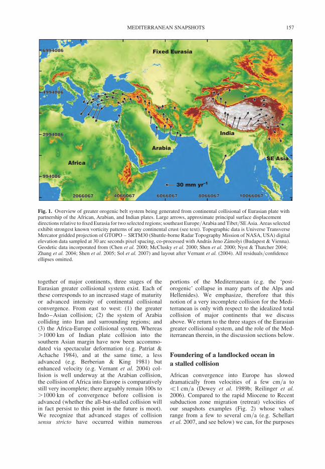
together of major continents, three stages of theEurasian greater collisional system exist. Each ofthese corresponds to an increased stage of maturityor advanced intensity of continental collisionalconvergence. From east to west: (1) the greaterIndo–Asian collision; (2) the system of Arabiacolliding into Iran and surrounding regions; and(3) the Africa-Europe collisional system. Whereas.1000 km of Indian plate collision into thesouthern Asian margin have now been accommo-dated via spectacular deformation (e.g. Patriat &Achache 1984), and at the same time, a lessadvanced (e.g. Berberian & King 1981) butenhanced velocity (e.g. Vernant et al. 2004) col-lision is well underway at the Arabian collision,the collision of Africa into Europe is comparativelystill very incomplete; there arguably remain 100s to.1000 km of convergence before collision isadvanced (whether the all-but-stalled collision willin fact persist to this point in the future is moot).We recognize that advanced stages of collisionsensu stricto have occurred within numerous
portions of the Mediterranean (e.g. the ‘post-orogenic’ collapse in many parts of the Alps andHellenides). We emphasize, therefore that thisnotion of a very incomplete collision for the Medi-terranean is only with respect to the idealized totalcollision of major continents that we discussabove. We return to the three stages of the Eurasiangreater collisional system, and the role of the Med-iterranean therein, in the discussion sections below.
Foundering of a landlocked ocean in
a stalled collision
African convergence into Europe has sloweddramatically from velocities of a few cm/a to�1 cm/a (Dewey et al. 1989b; Reilinger et al.2006). Compared to the rapid Miocene to Recentsubduction zone migration (retreat) velocities ofour snapshots examples (Fig. 2) whose valuesrange from a few to several cm/a (e.g. Schellartet al. 2007, and see below) we can, for the purposes
20660672066067 40660674066067 60660676066067 80660678066067 1006606710066067
994086994086
29940862994086
49940864994086
69940866994086 Fixed Eurasia
Africa
India
SE Asia
Arabia
30 mm yr–1
Fig. 1. Overview of greater orogenic belt system being generated from continental collisional of Eurasian plate withpartnership of the African, Arabian, and Indian plates. Large arrows, approximate principal surface displacementdirections relative to fixed Eurasia for two selected regions; southeast Europe/Arabia and Tibet/SE Asia. Areas selectedexhibit strongest known vorticity patterns of any continental crust (see text). Topographic data is Universe TransverseMercator gridded projection of GTOPO – SRTM30 (Shuttle-borne Radar Topography Mission of NASA, USA) digitalelevation data sampled at 30 arc seconds pixel spacing, co-processed with Andras Jeno Zamolyi (Budapest & Vienna).Geodetic data incorporated from (Chen et al. 2000; McClusky et al. 2000; Shen et al. 2000; Nyst & Thatcher 2004;Zhang et al. 2004; Shen et al. 2005; Sol et al. 2007) and layout after Vernant et al. (2004). All residuals/confidenceellipses omitted.
MEDITERRANEAN SNAPSHOTS 157
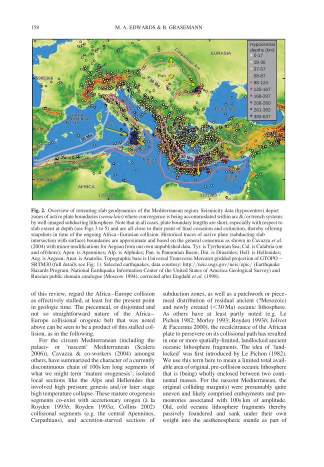
of this review, regard the Africa–Europe collisionas effectively stalled, at least for the present pointin geologic time. The piecemeal, or disjointed andnot so straightforward nature of the Africa–Europe collisional orogenic belt that was notedabove can be seen to be a product of this stalled col-lision, as in the following.
For the circum Mediterranean (including thepalaeo- or ‘nascent’ Mediterranean (Scalera2006)), Cavazza & co-workers (2004) amongstothers, have summarized the character of a currentlydiscontinuous chain of 100s km long segments ofwhat we might term ‘mature orogenesis’; isolatedlocal sections like the Alps and Hellenides thatinvolved high pressure genesis and/or later stagehigh temperature collapse. These mature orogenesissegments co-exist with accretionary orogen (a laRoyden 1993b; Royden 1993a; Collins 2002)collisional segments (e.g. the central Apennines,Carpathians), and accretion-starved sections of
subduction zones, as well as a patchwork or piece-meal distribution of residual ancient (?Mesozoic)and newly created (,30 Ma) oceanic lithosphere.As others have at least partly noted (e.g. LePichon 1982; Morley 1993; Royden 1993b; Jolivet& Faccenna 2000), the recalcitrance of the Africanplate to persevere on its collisional path has resultedin one or more spatially-limited, landlocked ancientoceanic lithosphere fragments. The idea of ‘land-locked’ was first introduced by Le Pichon (1982).We use this term here to mean a limited total avail-able area of original, pre-collision oceanic lithospherethat is (being) wholly enclosed between two conti-nental masses. For the nascent Mediterranean, theoriginal colliding margin(s) were presumably quiteuneven and likely comprised embayments and pro-montories associated with 100s km of amplitude.Old, cold oceanic lithosphere fragments therebypassively foundered and sank under their ownweight into the aesthenospheric mantle as part of
11912291191229 31912293191229
59053665905366
Liguro-Liguro- ProvencalProvencalBasinBasin
Calab
TyrTyr
Apen
LevantBasinBasin
AegHell
IonianIonian SeaSea
Adriatic
Adriatic
AlpAlp
Black SeaBlack Sea
EURASIAEURASIA
AFRICAAFRICA
AnatAnat
PanPan
DinDin
Maghrebides
BeticsBetics
Carpathian Arc
49053664905366
39053663905366
30 Ma
30 Ma
30 Ma
a
CC
0-17
Hypocentraldepths (km)
18-36
37-57
58-87
88-124
125-167
168-207
208-260
261-392
393-637
Fig. 2. Overview of retreating slab geodynamics of the Mediterranean region. Seismicity data (hypocentres) depictzones of active plate boundaries (sensu lato) where convergence is being accommodated within arc &/or trench systemsby well-imaged subducting lithosphere. Note that in all cases, plate boundary lengths are short, especially with respect toslab extent at depth (see Figs 3 to 5) and are all close to their point of final cessation and extinction, thereby offeringsnapshots in time of the ongoing Africa–Eurasian collision. Historical traces of active plate (subducting slabintersection with surface) boundaries are approximate and based on the general consensus as shown in Cavazza et al.(2004) with minor modifications for Aegean from our own unpublished data. Tyr. is Tyrrhenian Sea; Cal. is Calabria (onand offshore); Apen. is Apennines; Alp. is Alphides; Pan. is Pannonian Basin; Din. is Dinarides; Hell. is Hellenides;Aeg. is Aegean; Anat. is Anatolia. Topographic base is Universal Transverse Mercator gridded projection of GTOPO –SRTM30 (full details see Fig. 1). Selected earthquakes, data courtesy: http://neic.usgs.gov/neis/epic/ (EarthquakeHazards Program, National Earthquake Information Center of the United States of America Geological Survey) andRussian public domain catalogue (Moscow 1994), corrected after Engdahl et al. (1998).
M. A. EDWARDS & B. GRASEMANN158
the progression to imminent total consumption of thesteadily diminishing oceanic lithosphere (portions).Of relevance to the (nascent) Mediterranean is thatthe landlocked segment was (is) trapped between twoslowly converging (or in this case effectively stalled)continental masses thereby enabling the originaloceanic lithosphere sufficient time to steadily founder(i.e. expire via sinking into the aesthenosphere underits own unstable mass). In the absence of superiorplate kinematic forces, this foundering causes subduc-tion zone retreat via the mantle dynamics of slab roll-back (e.g. Andrews & Sleep 1974; Royden 1993b;Funiciello et al. 2003; Husson 2006).
For the three snapshot examples and indeed for allthe Mediterranean and surrounding region subductionzones (including ancient subduction zone, now-collided continental mass type convergent bound-aries), we propose the term ‘Intra-Collisional Land-locked Ocean Subduction’, or ICLO subduction.This discriminates such subduction from (e.g.) SWPacific-type, purely intra oceanic (and/or Andean-arccollision) settings; although both types involve mantledynamics associated with small area oceanic platesegments whose plate boundary lengths are short(commonly ,1000 km), the circumstances differgreatly. Complete consumption of a small (e.g.,1 � 105 km2) portions of oceanic lithosphere isexpected to occur for both scenarios. In SW Pacific-type settings, however, such a piece of smalloceanic lithosphere is likely to be bounded on many,if not all, sides by plates also composed (mostly) ofmore oceanic lithosphere. The collision then com-prises of piling up of island arc(s) whose preservationis determinate upon accretion to continental material.Accreted Pacific-type terranes such as those of theNorth American Pacific margin are expected to berelatively straightforward to identify; in addition todifferences identifiable via geochemical discrimi-nation of volcanics, a key difference is that foraccreted Pacific-type terranes, accretions may repeat-edly occur, and so accumulate over long periods suchthat their number is virtually ‘unlimited’. ICLO sub-duction is by definition limited; restricted in spaceand time. Identification of fossil examples of ICLOsubduction in ancient orogens may indeed be difficult.This theme is considered further in the discussion.
Mantle dynamics of slab rollback and
subduction zone retreat
The phenomena of mechanisms associated with,and interactions between, slab retreat, break-offand tearing emerge in numerous references and forpurely oceanic settings even emerge quite early inthe literature (e.g. Barker 1970; Andrews & Sleep1974; Karig 1974). The instability potential of thedescending slab in the situation of ICLO subduction,
like the Mediterranean, obviates the need to drivethe evolution of the Mediterranean via plate kin-ematic forces alone (e.g. Mantovani et al. 2000;Mantovani et al. 2001) or self-instigated down-welling or ‘drip off’ of the mantle lithosphere(Gemmer & Houseman 2007; Houseman &Gemmer 2007). As we noted above, we regard thedynamics of slab involvement in the aestheno-spheric mantle as the critical mechanism at largein the Mediterranean (e.g. Le Pichon 1982; Wortel& Spakman 2000) and keep with this for our situ-ation of a landlocked ocean.
Key characteristics that we will highlight fromour snapshot examples are: (1) that all are character-ized by short (which we define as typically,1000 km but cf. �1500 km in Schellart et al.2007 define as �1500 km) plate boundary length;(2) the arcuate geometry of the active convergentboundary becomes more pronounced as it matures(as noted by numerous authors – see specific snap-shot examples below); (3) the slab retreat does seemto accelerate with decreasing slab width (which wedefine as the measurement roughly perpendicular tothe slab dip direction, not always equivalent to sub-duction zone length); and (4) that there is someassociation with slab break-off and/or tearing.This is all suggestive of the instability of founderingancient oceanic lithosphere. Many authors havenoted that a narrow slab (where width is typicallyless than length) is more susceptible to instability.For example, Dvorkin et al. (1993) remarked thatthe hydrodynamic suction created by the downdipmotion of a wide slab is sufficient to balance thedownward pull of gravity (that exists due to thegreat density of the slab). However for a narrowslab, sideways asthenospheric flow into the slab/overriding plate corner effectively eliminates thesuction, which results in the rapid sinking of theslab. The corner flow notion is more recentlytaken up by Govers & Wortel (2005). The extremelength/width proportions were noted for marginalbasins of large oceans (Karig 1971; Sleep &Toksoz 1971; Karig 1974). The notion of shortplate boundary length instability to explain verylong (�1000 km) transform boundary margins ofthese back-arc spreading basins/marginal sea por-tions was entertained by Andrews & Sleep (1974),as well as Uyeda & Kanamori (1979), while thegeneral, more critical thermal situation for micro-plates in a convecting mantle was noted byParsons & McKenzie (1978) and, in a morecomplete summary, by Taylor & Karner (1983).The South Sandwich Islands island arc and thelong tongue of rapidly retreating subducting slabthat is generating the Scotia Plate backarc spreadinghas long drawn much attention, not least due to theintriguing geochemistry of sub-slab mantle flowaround the subducting slab edge (e.g. Barker 1970;
MEDITERRANEAN SNAPSHOTS 159
Royden 1993b; Leat et al. 2004). This is also true tosome extent for the Caribbean plate (e.g. Mann &Burke 1984; Pindell et al. 1988).
For the Mediterranean and surrounding area, it isfrequently recognizable that subduction zones (orspecifically, their traces) have, over time, developeda pronounced curvature with segments dramaticallyrotating as they have migrated and retreated. Theapproximate historical and present day traces ofthe Mediterranean convergent boundaries areshown on Fig. 2. The ensuing convergent plateboundary retreat and rearrangement that was (andis still being) attained generates thereby an ever-more irregular and discontinuous chain (or series)of classical plate-tectonic boundaries (as perIsacks et al. 1968; Dewey & Bird 1970); i.e., sub-duction zones plus, locally, accretionary orogenesisor continental crust collision that we noted above.During migration, the subduction zone portions ofthe plate boundaries may temporarily lengthen, butat one point the length of the subduction zone inquestion will begin to progressively shorten as orig-inal oceanic lithosphere is increasingly spent. As aresult, continental crust will frequently begin toenter part of the subduction system giving rise tolocal orogenesis. The nature of orogenesis mayattain various levels of intensity (i.e. thin-skinnedfolding with thrusting lower temperature accretion,or high pressure genesis and exhumation, or evenhigh grade metamorphism with anatexis, plus col-lapse before convergence becomes arrested, orbecomes greatly attenuated with respect to theneighbouring, along-strike oceanic subduction).
Typically, breaking-off or tearing of the slab canbe expected at such continental to oceanic subduc-tion transitions either with break-off progressivelypropagating laterally along strike or with the devel-opment of a tear in the approximate downdip direc-tion, possibly even giving rise to a STEP fault typearchitecture (Gırbacea & Frisch 1998; Nemcok1998b; Wortel & Spakman 2000; Funiciello et al.2003; Govers & Wortel 2005; Faccenna et al.2006). Tear off can also, of course, occur in theabsence of any continental crust (e.g. the cata-strophic slab loss of Levin et al. 2002). We expectthat tearing of the slab, whether as a steepdowndip oriented feature or laterally progressing,along-strike break-off, is expected to enhance therollback velocity and the extremity of subductionzone curvature. This type of association has beenpartly illustrated by Schellart et al. (2007) as partof a global database of length – curvature versusretreat (also advance) velocity for oceanic subduc-tion zones along with numerical representations.These authors note that trench migration rate isinversely related to slab width and curvature inten-sity is dependent on proximity to a lateral slabedge, where narrow slabs (�1500 km) retreat fastestand develop curved geometries. Although these
authors’ models cannot incorporate specifics suchas the repeated piecemeal arrival of continentalmargin into the system that is highly likely in aICLO subduction setting such as the Mediterranean,it gives a strong indication of the likelihood for slabrollback. Subduction zone retreat is thereby seen tobe a key phenomenon in the Mediterranean and sur-rounding area that is not only engendered by thevery nature of foundering of the instable ancientoceanic lithosphere but that, moreover, is predictedto accelerate as the most recently subducted slabincrements widths become progressively narrowerand slabs tear and/or break-off. We then have apicture where the width of subducting oceanic litho-sphere is an ever narrowing tongue – probablyeither due to the progression towards complete con-sumption of oceanic lithosphere and tearing, orsimply due to increased extremity of curvature fora very narrow (few 100 km) slab – as would be pre-dicted by Schellart et al. (2007). Because the near-surface slab width is less than the slab width atdepth, there is an ‘apron’ (or concave up, beheadedtriangular surface) geometry. This geometryimposes great concentration of slab pull. With theever smaller slab width, asthenospheric flowaround the sides becomes easier and so diminishesthe suction force noted above (Dvorkin et al.1993). This is further diminished as the slabbecomes even steeper (frequently approaching ver-tical, as we will vividly see in the snapshot examplesbelow). The result is an ever accelerating retreat asthe point of final expiration of the slab approaches.
The three snapshot examples
One of the many attractions of the Mediterraneanand surrounding region is that the plate evolutionboundary conditions are relatively- to very-wellknown (e.g. Jolivet & Brun 2008). For each of thethree snapshot areas, decades of geological studyin the Mediterranean, in concert with modern geo-physics including heat flow, gravity & Mohodepth studies, surface displacement geodesy(Fig. 1), distributions of moment tensors from, aswell as surface or depth localization of, seismicity(Fig. 2), and upper mantle seismic tomography allbeautifully reveal the active geodynamic processesassociated with, and the immediate results of: (1)the piecemeal slab detachment with (2) generalslab retreat that (3) over time becomes more loca-lized and (4) in many cases significantly acceler-ated, and that is (5) synchronous with localconvergence plus ‘back-arc’ extension. As we willsee for the three snapshot areas, back-arc extensionis very common and, at critical periods, is oftennotably intense in the wake of enhanced (and fre-quently late stage accelerated) subduction zoneretreat. Back-arc extension may be associated with
M. A. EDWARDS & B. GRASEMANN160
either extreme thinning such as the Pannonian orAegean, or entire rupture of continental lithospherewith new oceanic lithosphere production such as theLigurian–Provencal and Tyrrhenian basins.
The various collisional products of the Mediter-ranean and surrounding regions include: the Betics,the Maghrebides, the Apennines, the Alps, the Car-pathians, and the Dinarides-Rhodopes-Hellenides(including the ‘Balkides’). Their young back-arcbasins include: the Alboran Sea, the Aegean, thePannonian, and the Ligurian–Provencal plus Tyr-rhenian basins (notable for their Oligocene toRecent oceanic lithosphere production). The thirdpiece to the landlocked hypotheses is the now seg-mented abyssal plain, represented by lingeringancient (?Mesozoic) oceanic lithosphere remnantsthat include: the Ionian Sea, the Hellenic abyssalplain, and the Levantine Basin (although for theIonian Sea remnant cf. Hieke et al. (2005) versusCatalano et al. (2001)). These abyssal plain remnantsrepresent the last intact vestiges of the foundering ofthe land-locked ancient oceanic lithosphereregion(s) and are awaiting the final consumptioninto the aesthenosphere. Taken together, all theseelements equate to three or four discrete settings,or snapshots, that capture different moments in thefinal stages of accelerated slab retreat where subduc-tion has ceased (or all but ceased) as most availableoceanic lithosphere has been completely, or all butcompletely, consumed. We review three of these:the western Mediterranean, the Hellenic subductionzone system, and the Pannonian–Carpathiansystem. For the western Mediterranean we excludethe Betics/Rif/Western Maghrebides – AlboranSea area and concentrate our focus on the Calab-rian–Apennine accretionary belt and its back-arc,the Ligurian–Provencal plus Tyrrhenian basins. Asdiscussed by many authors (e.g. Morley 1993;Royden 1993b; Platt et al. 1996; Lonergan &White 1997; Faccenna et al. 2004; Serpelloni et al.2007), there is ample convincing evidence that agreat deal of the tectonic evolution (e.g. conver-gence, deep exhumation, thickening and later col-lapse) of the two opposing-vergence orogenic pairportions of the Betics vis a vis the Rif/WesternMaghrebides can be adequately explained by slabrollback dynamics (e.g. Wortel & Spakman 2000;Cavazza et al. 2004). In comparison to our threechosen snapshot areas, however, the story is lesselegant and, particularly for the Miocene andyounger history, the story is significantly more upfor discussion. We therefore choose to omit theBetics/Rif/Western Maghrebides – Alboran Seaarea from the snapshots examples.
The western Mediterranean
In the western Mediterranean (Fig. 3), our focus isthe Calabrian–Apennine accretionary belt and its
backarc, the Ligurian–Provencal plus Tyrrhenianbasin(s). As noted above, we exclude the Betics/Rif – Alboran Sea to facilitate the snapshotexample. This area offers an exciting example ofcontinental lithosphere that has been stretched andfailed completely leading to widespread newoceanic lithosphere production as the backarcspreading system of a convergence zone (e.g.Malinverno & Ryan 1986). The subducting slab, atleast up until recently, has rapidly retreated, acceler-ated while progressively narrowing, with subduc-tion gradually terminating (+ slab tear-off – seebelow) and thus the length of the active plate bound-ary continually diminishing. This is borne out by (1)the migration pattern revealed by the distribution ofyoung back-arc oceanic crust production as well as(2) the spatio-temporal distribution of both subduc-tion related volcanism & active versus historicalfaulting trends, and (3) seismicity surface anddepth distributions – see below). This is all reflectedin Figure 2 as part of the broadly agreed consensusof a west to east retreat of the subduction zone/convergent plate boundary over the last 30 Ma.Overall calculations suggest a total of c. 775 kmof ‘eastward’ migration of the convergence zonefrom Oligocence to Present (Gueguen et al. 1998).Since latest Eocene time (Beccaluva et al. 1981;and see also Rossetti et al. 2004), Adria oceaniclithosphere (also called the Apennine Slab) has sub-ducted westwards (or NW- or SW-wards) beneathItaly, culminating in the Apennines and beingassociated with 80 to 200 km of shortening that islargely Neogene–Quaternary (Malinverno & Ryan1986; Giuseppe et al. 1997; Gueguen et al. 1998;Galadini & Galli 1999). Palaeomagnetic data andhistorical stress field rotations indicate that theApennines have rotated anticlockwise from orig-inally NE- trending (Scheepers et al. 1993; Matteiet al. 1995; Muttoni 1998; Hippolyte 2001)growing as an accretionary wedge plus fragmentsripped off the Main Alpine chain, to finally collideinto the Adrian continental lithosphere platform(see extensive references in Cavazza et al. 2004).This final stage collision modified the original foldand thrust belt geometry of the Apennines (albeitmainly only in the south) to become morecomplex and out-of-sequence, coinciding also withthe steady southwards younging termination ofvolcanics. The collision has not been intense; defor-mation is mainly thin-skinned and heat flow valuesin the Adriatic continental crust (away from volca-nic centres) rarely exceed 50 mW/m2. Total exhu-mation is estimated at 2.5 km and up to 5 kmsubsidence in foredeeps such as the Po basin (e.g.Cloetingh et al. 2007). Loading of the Adriatic con-tinental promontory via the Apennines on the(south) west side and the Dinarides on the (north)east causes a bowing up of the plate and shallowingin the Adriatic Sea.
MEDITERRANEAN SNAPSHOTS 161
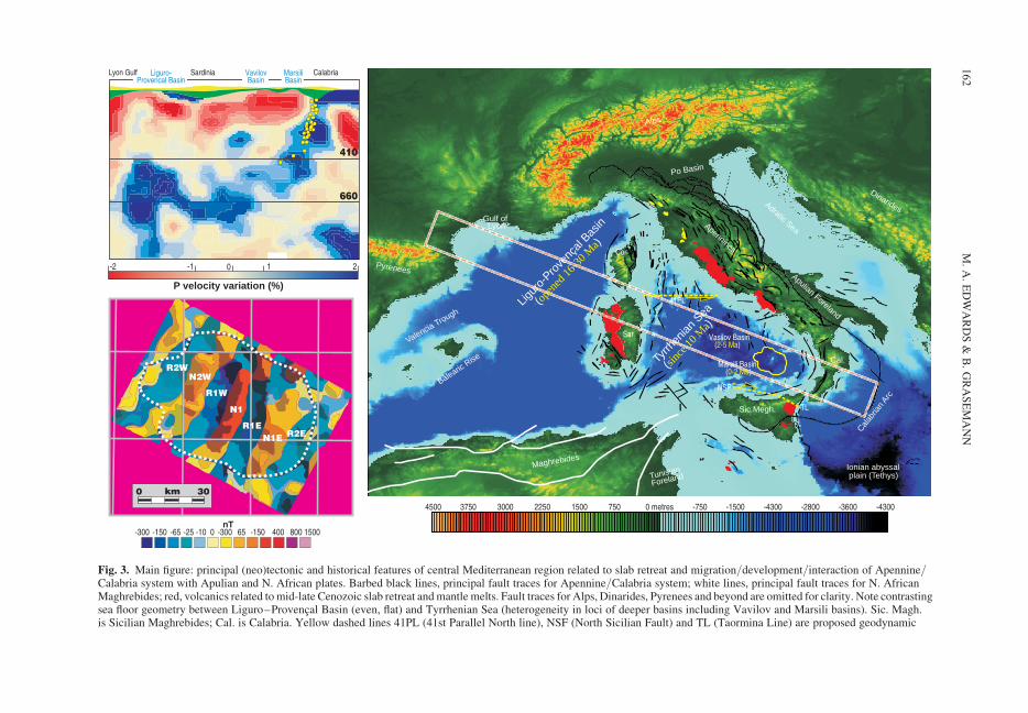
410
660
P velocity variation (%)
-2 -1 0 1 2
Lyon Gulf Sardinia VavilovBasin
Liguro-Provencal Basin
MarsiliBasin
Calabria
-300 -150 -65 -25 -10 0 -300 65 -150 400 800 1500nT
R2WN2W
R1W
N1
R1EN1E R2E
km0 30
4500 3750 3000 2250 1500 750 0 metres -750 -1500 -4300 -2800 -3600 -4300
Marsili Basin ( )0-2 Ma
41PL
NSF
TL
Vasilov Basin ( )2-5 Ma
Cor
Sar
Tyrrh
enian
Sea
(
)
since
10 M
a
Ligur
o-Pro
venç
al Bas
in
(
)
open
ed 16
-30 M
a
Valencia Trough
Maghrebides
Tunisian
Foreland
Calab
rian
Arc
Sic.Megh.
Cal.
Apulian Foreland
Adratic SeaApennines
Dinarides
Alps
Pyrenees
Gulf of Lyon
Balearic Rise
Ionian abyssal plain (Tethys)
Po Basin
Fig. 3. Main figure: principal (neo)tectonic and historical features of central Mediterranean region related to slab retreat and migration/development/interaction of Apennine/Calabria system with Apulian and N. African plates. Barbed black lines, principal fault traces for Apennine/Calabria system; white lines, principal fault traces for N. AfricanMaghrebides; red, volcanics related to mid-late Cenozoic slab retreat and mantle melts. Fault traces for Alps, Dinarides, Pyrenees and beyond are omitted for clarity. Note contrastingsea floor geometry between Liguro–Provencal Basin (even, flat) and Tyrrhenian Sea (heterogeneity in loci of deeper basins including Vavilov and Marsili basins). Sic. Magh.is Sicilian Maghrebides; Cal. is Calabria. Yellow dashed lines 41PL (41st Parallel North line), NSF (North Sicilian Fault) and TL (Taormina Line) are proposed geodynamic
M.
A.
ED
WA
RD
S&
B.
GR
AS
EM
AN
N162
Within the Western Mediterranean, back-arcextension, crustal stretching and ocean openingwere, of course, associated with this system ofApennines rotation and convergence throughouttheir existence. Backarc extension began in Vari-scan basement that was already rifted (and thus pre-sumably sufficiently weakened; rifts offeringpreferred loci for rift fault nucleation and linkage)via a series of wrench fault systems, part of awestern Europe-wide process. This is evidencedby syn-rift deposits in basins related to suchwrench fault systems at c. 35 Ma (e.g. Jolivet & Fac-cenna 2000; Lacombe & Jolivet 2005 and referencestherein). Ligurian–Provencal basin opening properinitiates about 30 Ma and proceeds to c. 16 Ma, asevident from the ages of syn-rifting sedimentationin the Gulf of Lyon and volcanism and rift flankuplift cooling ages from the Corsica–Sardiniablock (Martini et al. 1992; Sowerbutts 2000).Helbing et al. (2006) similarly draw attention toreactivation of Palaeozoic basement structures inSardinia that give evidence for a transtensionalback-arc setting during Ligurian–Provencalopening and related western Mediterranean subduc-tion rollback. That this is a back-arc system isattested to the presence of the basaltic-andesiticchemistry volcanics – the volcanic arc to the (pre-sumably) NW dipping Oligocene slab (e.g.Faccenna et al. 1997 and references therein).Faccenna et al. (1997) draw attention to the pointthat the Ligurian–Provencal Basin (conspicuousfor its very even bathymetry – as visible in Fig. 3)is due to rifting of a cold, not relatively weakenedcontinental crust with a shallow Moho (Tirel et al.2009 and see discussion). Although this notion iscredible, the thermal state of the pre-rifted continen-tal crust is not completely clear; in Corsica, Danisik
and co-workers (2007) note evidence for a pre-Jurassic to early Cretaceous long-lived Tethyanthermal event related to rifting and the early stagesof Jurassic opening of the Ligurian-PiedmontOcean. Moreover, Fellin and co-workers (2006)observe Oligocene collapse of the Alpine nappestack and rifting prior to opening of the Ligurian-Provencal Basin. They interpret a zircon fission-track age population of c. 24 Ma to indicate somecooling after Tertiary thermal events that can beassociated with the main Alpine metamorphismand the opening of the Ligurian–Provencal basin.Such incomplete Alpine orogenesis overprint oforiginal Variscan deformed and metamorphosedcontinental crust is typical of much of the nascentMediterranean (e.g. Zentralgneiss of Austria, Tatri-cum of Slovakia, etc). The Corsica–Sardinia blockis however both the margin of the Faccenna et al.(1997) ‘cold’ Ligurian–Provencal Basin systemand the margin of their ‘warm’ Tyrrhenian Basinsystem and thus is likely to record some signatureof crustal stretching already at its Oligoceneinitiation – albeit that the only complete lithosphericfailure at this time is West of the Corsica–Sardiniablock in the form of the Ligurian–ProvencalBasin. Either way, the Corsica–Sardinia block is akey source of evidence for the entire evolution ofthe Western Mediterranean ICLO subductionsystem. The crustal fragments of the main Alpineevent in the Corsica–Sardinia block are famous(e.g. Mattauer et al. 1981; Faccenna et al. 2002;Lacombe & Jolivet 2005; Rosenbaum et al. 2005;Fellin et al. 2006; Molli et al. 2006; Danisik et al.2007). These and various other authors have docu-mented that the main Alpine event wasfollowed by a period of core-complex generation.As noted by Rosenbaum & Lister (2005), however,
Fig. 3. (Continued) accommodators of Rosenbaum & Lister (2004) see text. Red dashed on white line forming box isapproximate trace of swath of seismic tomography profile (see inset). Irregular closed shape yellow line labelled MarsiliBasin is location of lower inset (to left of main figure) and area of Chiappini et al. (2000) seafloor magnetic survey.Shallow area in centre of this marked region (identifiable by paler blue bathymetric scale tone) is bathymetric high ofMarsili Seamount, and represents mid-ocean ridge segment associated with sea-floor spreading since late Pliocene.Topographic and bathymetric data from SRTM30 V.2 (topopography) with Smith and Sandwell global 2-minute grid(bathymetry) processed (with Andras Jeno Zamolyi of Budapest & Vienna) from: ftp://topex.ucsd.edu/pub/srtm30_plus and www.ngs.noaa.gov. Features drawn after Jolivet et al. (2000; 2003), Faccenna et al. (1997; 2001; 2003;2004), Rosenbaum & Lister (2004) and own data.
Upper left inset: Tomographic profile model (PM 05) from Piromallo and Morelli, (2003) redrawn from Faccenna(2003; 2004) and Lucente et al. (2006). Subsurface position and continuity of remaining portion of Tethyan lithosphericslab is clearly visible from rapid P-wave velocity (blue) region. Depth scale is given by 410 and 660 km acoustictransitions (discontinuities). (Note contrast between steep upper portion of slab (in wake of rapidly-opened TyrrhenianSea) and deeper, more distal portions of slab (now bottoming out and rotating over on 660 discontinuity). At surface ofprofile, yellow (crust) and green (mantle) lithosphere thicknesses are freely interpreted from gravity and Moho depth datasummarized in Cavazza et al. (2004). Yellow dots, hypocentres are selected earthquakes (note persistence as far as 410discontinuity – some events omitted for clarity) from: http://neic.usgs.gov/neis/epic/ (Earthquake Hazards Program,National Earthquake Information Center of the United States of America Geological Survey) and Russian public domaincatalogue (Moscow 1994), corrected after Engdahl et al. (1998).
Lower left inset: Detail of Marsili Basin magnetic survey data (from Chiappini et al. 2000), re-drawn after Nicolosiet al. (2006). Identification of chrons symmetry provides further snapshot of ultra fast ocean spreading (up to 19 cm/a)during 0–2 Ma pulse of slab retreat (see text).
MEDITERRANEAN SNAPSHOTS 163
this cannot be large, may simply be gravitational col-lapse of the Alpine over-thickened body, and somight not be a true part of the mantle dynamicsassociated with slab rollback and arc spreadingmechanisms (but see also Jolivet et al. 1998). Instark contrast then, to the Pannonian and to theAttic Cycladic – western Turkey and Rhodopesystems (see below), here in the Western Mediterra-nean, complete lithospheric failure with break-upand drift apart of continental blocks and fragmentshave prevented the distributed shear and extremecrustal stretch that is associated with major sedimen-tary basin development or core complex-bearingextended terranes. The Corsica–Sardinia block, inaddition gives us key rotation evidence. Palaeomag-netic data (e.g. Scheepers et al. 1993; Vigliotti &Langenheim 1995; Rosenbaum & Lister 2004;Cifelli et al. 2007; Gattaccecaa et al. 2007) showthat the block more or less rotated in tandem withthe central Apennines by as much as 458 anticlock-wise up until 10–15 Ma, at which time the two riftapart to create the Tyrrhenian Basin(s) (e.g.Malinverno & Ryan 1986). Jolivet & Goffe (2000)note a pre-rift thickness of c. 50 km for the now dis-bursed Alpine orogenic pile of Corsica, Calabria(Peloritani) and Tuscany.
Geodynamic phenomena in the Tyrrhenian, aswell as their interpretations, are a bit livelier thanfor the Ligurian–Provencal. The Tyrrhenian Seahas more complex bathymetry (Fig. 3) characterizedby shallower depths and lower heat flow values inthe northern Tyrrhenian Sea Basin that contrastswith deeper basin depths and higher heat flowvalues for the southern Tyrrhenian Sea Basin (upto 120 mW/m2 – see e.g. Cavazza et al. 2004 forreviews). The southern Tyrrhenian Sea Basin isfurther composed of two distinct basins; theVavilov (which opened between 2 and 5 Ma) andthe Marsili (which opened between 0 and 2 Ma).In addition, there are a range of volcanics (e.g. thePliocene of Sardinia in Lustrino et al. 2000) andonshore and offshore geometrical features (opento interpretation as to fault type, e.g. Helbing andco-workers (2006) propose the left-lateral NuoroFault in central Sardinia as initially being a radialtransfer between the west Sardinian rift and northernTyrrhenian basin which thereafter contributed toextension gash pattern opening of the southernTyrrhenian basin). More comprehensive overviewsof these (with varying perspectives) are offered byRosenbaum & Lister (2004) and Faccenna et al.(2004). Differences between the Vavilov andMarsili have led to various remarks and conclusions;the persistence of mid-ocean ridge back-arc spreadingonly in the southern Tyrrhenian Sea is certainlycoupled to the reduction of the active subductionzone length as part of the gradual move southwardof termination of deep active subduction along the
Apennines. There is debate as to their degree of sig-nificance, but processes including: (1) a horizontalN(NW) to S(SE) laterally propagating tearing – i.e.migrating slab breakoff such as Wortel & Spakman(2000) or Govers & Wortel (2005) as part of the com-plete consumption of cold, heavy oceanic lithosphere;(2) subduction zone lockup caused by an incomingcarbonate platform at 6–7 Ma (Rosenbaum & Lister2004); and (3) eastward and northeastward mantleflow as part of a more global regime (e.g. Doglioniet al. 1999) may all have played some role in theevolution of the active arc and slab to its restrictedfinal position around Calabria.
As well as this west to east retreat of the sub-duction zone/convergent plate boundary, Figure 2shows the present distribution of hypocentres. Forthe northern and central Apennines, it is clear thatthere is shallow seismicity (,40 km) typical offold and thrust belt behaviour with only a smallportion of the seismicity at intermediate depth(80–110 km); significant seismicity in the accre-tionary wedge is not present down through tomantle depths. Models for seismic tomography(e.g. Lucente et al. 1999; Wortel & Spakman2000; Piromallo & Morelli 2003; Montuori et al.2007) across this portion of the belt (data not repro-duced in this review) differ on whether or not thereis a discontinuity from the deeper slab to the uppersurface i.e. no connection between high velocityregions in the uppermost aesthenospheric mantleand the larger layer of slab (high velocity) materialaccumulating onto the 660 km global discontinuity.Slab break-off would be the generally interpretedstatus quo (e.g. Spakman & Wortel 2003). In con-trast, across the Calabrian portion, Figure 2 showsthe ‘shotgun’ distribution of hypocentres from 100to 400 km depth defining a more or less verticalBenioff–Wadati Zone (Anderson & Jackson1987). This seismicity partly reflects that the Calab-rian arc is the only part of the collisional belt wherearc-related volcanism has not ceased. The BenioffZone is more clearly seen on the display of earth-quake source points on the lower left inset inFigure 3, rendered on top of the seismic tomogramreproduced from Faccenna et al. (2003) afterPiromallo & Morelli (2003). Although there issome uncertainty (see Wortel & Spakman 2000 forfurther discussion), there is good evidence for anintact lithospheric slab (one that has not yet experi-enced break-off) continuing from the surface all theway to the 660 km accumulation. Our snapshot herethe captures the moment just before (or in the act of)break(ing)-off. The Adriatic continental lithosphereis just entering the system here (whereby it hasalready collided further NW up the Apennines)and the last vestiges of old Mesozoic oceanic litho-sphere (manifest as the abyssal plain beneath theIonian Sea on Fig. 2) are not yet consumed.
M. A. EDWARDS & B. GRASEMANN164
Crucially, we now have dramatic evidence fromNicolosi and co-workers (2006) of very fastbackarc spreading above the slab in the formof the Marsili Basin in the Southern TyrrhenianSea (Fig. 2, main field) of up to 19 cm/a thathas been calculated from the magnetic patternsassociated with new oceanic lithosphere produc-tion (from the Chiappini et al. 2000 seafloormagnetic survey). This would seem to require atleast an equivalent magnitude of velocity for slabretreat-engendered trench migration (during thefinal intensification of the arcuate geometry of thepresent Calabrian plate boundary). More than this,however, to add to our captured-in-time aspect isthat this pulse or period of accelerated retreat hasnow mostly ceased. Geodetic motion observations(e.g. Oldow et al. 2002; Serpelloni et al. 2005;D’Anastasio et al. 2006; Serpelloni et al. 2006)and seismic moment studies (Pondrelli et al. 2004)of the Calabria orogenic belt with respect toSardinia/Corsica and Franco–Iberia show that thebelt (i.e. southern Italian mainland with Sicily)closely tracks North Africa (,1 cm/a), has only aminor eastwards component and, importantly, thatthe Corsica–Sardinia block moves according toEurasian Plate motions. There appears to be nocurrently resolvable divergence between Corsica–Sardinia and peninsular Italy and there is no indi-cation that the opening of the Tyrrhenian is stillactive (Serpelloni et al. 2005). More criticallyPondrelli et al. (2004) show that the TyrrhenianBasin has now a north–south compressional stressstate. It really would then appear that via thevarious geophysical, structural and volcanic rocksdatasets we have captured the final moments ofICLO subduction.
Hellenic subduction zone system
On the eastern side of the Adriatic Sea (theAdriatic promontory or platform) facing theWestern Mediterranean theatre, is a fairly con-tinuous and throughgoing orogenic chainarising from Tertiary collision of the Adriaticpromontory into Eurasia. From the eastern Alps,the chain comprises (from NW to SE) theDinarides (including the external Dinarides orBalkanides), Albides & Rhodopes (also Serbo-macedonian-rhodope block) and the Hellenides.Figure 2 shows the active seismicity definingthe NE- to North-dipping Benioff–Wadati zoneportion of subducted slab architecture for muchof this system. Figure 4 highlights the keyelements of the active and recent processes inthe greater area of the Hellenic subduction zonesystem (including the surrounding mainlandareas), the focus of our second snapshot.
Active geodynamics
The active geodynamics of this region are impress-ive. They comprise: (1) by far the highest present-day seismic activity in Europe (e.g. Papazachos1973; Mercier 1979; Ambraseys & Jackson 1990;Taymaz et al. 1991; Jackson et al. 1992; Bakeret al. 1997; Giardini 1999; Hatzfeld 1999;Papaionnou & Papazachos 2000; Bohnhoff et al.2004); (2) surface displacement kinematics ident-ified from SLR/GPS-data (Fig. 4) that have someof the highest vorticity expressions known for anycontinental crust (comparable only to the EasternHimalayan syntaxis) and that constrain the presentday, relative to Eurasia westward movement‘escape’ plus rotation of the Anatolian region, andsouthward extension of the Aegean region,(Noomen et al. 1996; Reilinger et al. 1997; Clarkeet al. 1998; Cocard et al. 1999; Briole et al. 2000;McClusky et al. 2000; Ayhan et al. 2002; Meadeet al. 2002; Nyst & Thatcher 2004; Reilinger et al.2006); (3) dramatically extended/thinned litho-sphere of the back-arc that is associated with heatflow values of up to 100 mW/m2, Moho depths asshallow as 24 km, and extension at the Gulf ofCorinth rift that is the fastest known spreading forany continental crust (Makris 1978; Bohnhoffet al. 2001; Li et al. 2003; Bohnhoff et al. 2004;Tirel et al. 2004; Endrun et al. 2005); (4) the associ-ation of these plate kinematics with active subduc-tion and widely-recognized dramatic slab retreatof African lithosphere beneath the Aegean (micro)-plate at the Hellenic trench system (e.g. McKenzie1972; Le Pichon & Angelier 1979; Angelier et al.1982; Papazachos et al. 2000); (5) present daymantle dynamics and subduction history of theslab over time that is strikingly evident from thelucid slab architecture portrayed via Benioff–Wadati surface geometry (seen dipping NNE to c.180 km in Fig. 4) and via seismic tomographymodels with definitive imagery (Fig. 4) showingdeep mantle architecture down to 1200 km for theentire SE European region (e.g. Makropoulos &Burton 1984; Spakman et al. 1988; Taymaz et al.1991; Hatzfeld 1994; Papazachos et al. 1995;Hatzfeld 1999; Karason & van der Hilst 2000;Wortel & Spakman 2000; Faccenna et al. 2003;Piromallo & Morelli 2003; Bohnhoff et al. 2004;Faccenna et al. 2004; Endrun et al. 2005; van Hins-bergen et al. 2005b; Bohnhoff et al. 2006); and (6)calc-alkaline volcanism most prominently rep-resented by the island volcanoes of Milos, Santorini,and notably Kos. As is visible on Figure 2, theisland area of Kos plus 10–20 km surroundingradius is, furthermore, spatially associated withdeeper (non Benioff-Wadati zone) seismicity downto 150 km (Zellmer et al. 2000; Mocek 2001;Bohnhoff et al. 2006; Coban 2007).
MEDITERRANEAN SNAPSHOTS 165
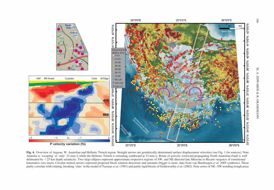
Rhodope
extensional
massifFaultAnatolian
North Hellenides
Black Sea
Cretan Sea
Crete
Abyssal plain
(Tethys)
Mediterranean
(accrentionary prism)
Ridge
0-13
Hypocentraldepths (km)
13-25
25-36
36-46
46-58
58-75
75-96
96-120
120-146
146-171
P velocity variation (%)
–2 –1 0 1 2
CreteCycladesNW Anatol. NAF M.Ridge
410
660
3333333333333333333333333333333333333333
3333333333333333333333333333333333333333333333 333333333333333333333333333333333
2222222222222
2222222222222222222222222222222222222222
Seaaa
N
Serifos
Kea
SirosKythnos
Lavrio
South EviaSouth Evia
Andros
Tinos
Mykonos
Naxos
Paros
Ios
NNNNNNParosarosaros
G. Of Corinth
Edremit-Skiro
s Trough
Lesbos-Psara Trough
Menderes Massif
Dodecanese Volcanism
Lycian Nappes
Izmir - A
nkara Sut.
Thrace
Basin
Fig. 4. Overview of Aegean, W. Anatolian and Hellenic Trench region. Straight arrows are geodetically determined surface displacement velocities (see Fig. 1 for sources). NoteAnatolia is ‘escaping’ at ‘only’ 22 mm/a while the Hellenic Trench is retreating southward at 33 mm/a. Route of actively westward propagating North Anatolian Fault is welldelineated by ,25 km depth seismicity. Two large ellipses represent approximate respective regions of SW, and NE-directed late Miocene to Recent vergence of extensionalkinematics (see inset). Circular motion arrows represent proposed block rotation directions and amounts (bigger is more, data from van Hinsbergen et al. 2005 synthesis). Thesepartly correlate with rotating, breaking ‘slats’ in the model of Taymaz et al. (1991) and partly rigid blocks of Goldsworthy et al. (2002). Note series of NE–SW trending trough areas
M.
A.
ED
WA
RD
S&
B.
GR
AS
EM
AN
N166
Historical geodynamics
The historical geodynamics are dominated by majorthinning and extension of the continental litho-sphere that has co-existed with orogenic collisionalconvergence since at least the Eocene (Brun &Sokoutis 2007; Grasemann & Petrakakis 2007).The main evidence comes from core complex devel-opment and associated melting and mid- to lower-crustal metamorphism products. This extensionhas focussed in the Rhodope, Cyclades and Men-deres Massif-Lycian Nappes areas, migrating laterto the Crete region where extension thereafter per-sisted – albeit switching to arc-parallel at c. 9 Ma(e.g. van Hinsbergen & Meulenkamp 2006); the vel-ocity arrows on Figure 4 show that the Aegean arc ismoving 20% faster than (and thus away from) theAnatolian block (30 mm/a versus 24 mm/a)(Noomen et al. 1996; McClusky et al. 2000;Wortel & Spakman 2000; Nyst & Thatcher 2004).Extension in the Rhodope Massif was between 26and 13 Ma (Dinter & Royden 1993; Sokoutis et al.1993; Wawrzenitz & Krohe 1998), possibly as
early as 50 Ma in the SW and N margins (Brun &Sokoutis 2007). In the Menderes, extension beganaround the Oligo-Miocene (Hetzel et al. 1995;Collins & Robertson 2003; Gessner et al. 2004;Jolivet et al. 2004a). In the Cyclades, extensiveresearch provides a more comprehensive picture,and we focus on this further (Fig. 4 inset, upper).
Cycladic Islands
Central Cyclades studies have established keygeodynamic events in space and time by constrain-ing pressure–temperature–time–deformation (P–T–t–d) paths that identify two key Cenozoiccomponents (M1, M2). M1, Cycladic blueschistformation (well-constrained on Tinos, Syros,Naxos and Sifnos) was a, for the most part, discrete,largely early Tertiary, decompression deformationat 40–80 km depth (i.e. 0.8–1.5 GPa) (e.g. Altherret al. 1982; Okrusch & Brocker 1990; Wijbranset al. 1990; Avigad & Garfunkel 1991; Avigad1993; Brocker et al. 1993; Patzak et al. 1994;
Fig. 4. (Continued) that are identifiable from bathymetry contrasts and are also strikingly delineated by lines ofdense upper crustal (,25 km depth) seismicity (these are proposed anti-clockwise rotating eastern half of the (broken)slats and also partly correlate to the localized deformation zones of Armijo et al. (1996) within their linear elasticfracture mechanics model for present deformation transfer between the North Anatolian Fault and the Gulf of CorinthRift – see discussion in text). Approximately crescent-shaped brown areas are historical progressive loci of ‘geologicalextension’ proposed by Armijo et al. (2003). Also shown is proposed ‘mid-cycladic lineament’ of Walcott & White(1998). Not yet subducted Mesozoic oceanic lithosphere is identifiable from abyssal plain just south of southernsubduction zone boundary. NNE-dipping Benioff zone geometry is clear from surface distribution of hypocentres.Inside of this arc is volcanic arc, picked out by mantle seismicity (typically .100 km), most conspicuous in the SEDodecanese. Cyclades are otherwise aseismic. Box in centre shows area of upper inset map. Red dashed on white lineforming box is approximate trace of swath of seismic tomography profile (see inset). Topographic and bathymetric dataare Mercator SRTM 30 gridded in degrees, coloured for 1500–2500 m relief emphasis (otherwise as per Fig. 1). Activeand young faults summarized from Morelli & Barrier (2004. Geodynamic map of the Mediterranean. Commission forthe Geological Map of the World, Limoges, France), Athanassios Ganas (pers. comm) and our own data. Modern Greekcoastline provided by: Athanassios Ganas (National Observatory, Athens, Greece). Selected earthquakes, data courtesy:http://neic.usgs.gov/neis/epic/ (Earthquake Hazards Program, National Earthquake Information Center of the UnitedStates of America Geological Survey), Russian public domain catalogue Moscow (1994), and Endrun et al. (2005);Bohnhoff et al. (2006), corrected after Engdahl et al. (1998).
Upper left inset: Lithotectonic summary map of Cyclades and greater extended lithospheric region of centralAegean. Data compiled from Lister et al. (1984); Altherr et al. (1988); Henjes-Kunst et al. (1988); Wijbrans &McDougall (1988); Buick & Holland (1989); Urai et al. (1990); Avigad (1993); Gautier et al. (1993); Pe-Piper et al.(1997); Avigad et al. (1998); Jolivet & Faccenna (2000); Pe-Piper (2000); Altherr & Siebel (2002); Pe-Piper & Piper(2002); Jolivet et al. (2004b). Red stars are S-type plutonism; Red pentagons are I-type plutonism; Arrows showprincipal lineation orientations and sense of shear directions (for low angle displacement/detachment structures) onlyfor those of main tectonic fabrics generated under Greenschist facies conditions dynamic recrystallization (‘M2’).Symbols are ommitted for those islands with strong principal lineation fabrics developed at higher P & T conditions,reflecting at least in part a non-sub horizontal, probably non-2D resolvable kinematics associated only with deep burialand exhumation to mid-crustal levels (see text). Black lines are major steep (offshore) faults of the horst and grabensystems that are associated with the Cyclades (summarized from Morelli & Barrier (2004)).
Lower left inset: Seismic tomographic profile model (PM 05) from Piromallo & Morelli (2003) redrawn fromFaccenna et al. (2003; 2004). Position and continuity of forerunner portion of African (Tethyan) lithospheric slab isclearly visible from rapid P-wave velocity (blue) region. Depth scale is given by 410 and 660 km acoustic transition(discontinuities). Slab persists to .1000 km. Note that tomographic mantle model profile compares well with first orderfeatures of Wortel and Spakman (2000) above 660 acoustic transition. Yellow (crust) and green (mantle) are freelyinterpreted from crust/mantle lithosphere thickeness data (mainly Moho depths, some gravity data) from Cavazza et al.(2004); Tirel et al. (2004); Endrun et al. (2005); Bohnhoff et al. (2006). Yellow dots: hypocentres for selectedearthquakes. Some events omitted for clarity (Benioff–Wadati Zone geometry is well depicted by map view distributionof hypocentral depths in main figure), otherwise seismic data sources as per main figure.
MEDITERRANEAN SNAPSHOTS 167
Avigad et al. 1997; Brocker & Franz 1998; Ring &Layer 2003; Brocker et al. 2006; Brocker & Pidgeon2007; Tirel et al. 2009). The M1 metamorphic fabricis on many islands conspicuously overprinted byM2, a late Oligocene/early Miocene extension,typically at mid-crustal conditions (i.e. greenschistfacies, 200–700 MPa but locally of sufficientlyhigh grade to generate migmatite, e.g. Naxos) thatis well constrained on the islands of Tinos, Naxos,Ios and Mykonos (e.g. Jansen 1973; Lister et al.1984; Feenstra 1985; Wijbrans & McDougall1988; Urai et al. 1990; Buick 1991a; Gautier et al.1993; Gautier & Brun 1994; Jolivet et al. 1994;Forster & Lister 1999; Jolivet & Patriat 1999;Keay et al. 2001). M2 is typically associated withmid-late Miocene, predominantly I-type granitoidplutonism on several of the islands (pink pentagonson Figure 4 inset, upper left) whose final intrusionstages are syn- to post-kinematic with respect tothe pervasive deformation fabric (e.g. Durr et al.1978; Andriessen et al. 1979; Altherr et al. 1982;Brocker et al. 1993; Brocker & Franz 2000). Atight pan-Cycladic discrimination of M1 from M2is not always forthcoming; temporal overlapsbetween the two (‘M1.5’) have been entertainedby various of the above authors, depending on thetectonic significance attributed to the relevantvarious radiogenic isotope system(s) employed.
Cyclades deformation and core complex
genesis
On many of the Cycladic islands (Tinos, Mykonos,Naxos, Paros, Ios), the regional deformation fabricis focused into large (often island-wide), low-angle,extensional, mylonitic high strain zones (termed byseveral authors ‘detachments’) of several 10s to100s m thickness that are frequently syn-magmaticand domed. These high strain zones are associatedwith progressive footwall cooling, retrograde P–Tpaths, and ductile to brittle changes in deformation,as well as in some cases, juxtaposition of overlyinglow-grade sedimentary rocks (corresponding to alarge metamorphic gap that indicates excision of amajor [10s km] crustal section). This key suite ofrelationships, together with the above noted stronggeodynamic expression of present day extension,has led workers to attribute the M2 metamorphicevent to late Alpine exhumation via lithospheric-scale high strain zone accommodation of the backarc extension of the retreating Hellenic subductionzone. Recognized thereby are ‘metamorphic corecomplex’ (MCC) province settings for theseislands, similar to the dozens of examples in the1000s km long extensional province of the westernNorth American continent (Durr et al. 1978;Coney 1980; Altherr et al. 1982; Lister et al.
1984; Buick & Holland 1989; Buick 1991a, b;Pe-Piper et al. 2002). Relevant to the accelerated(or at least enhanced) slab retreat setting is that therapid exhumation required to expose the MCC’sseems to have been entirely related to crustalstretching dynamics (no glacial ‘sculpting’ etc. hasprevailed in contrast to the exhumation in theHimalaya, Aleutians, Cascadia, Andes, etc). OnNaxos, sedimentologic features suggest a transitionfrom marine deep turibiditic to continental environ-ment during Miocene (Vanderhaeghe et al. 2003b)and Kuhlemann et al. (2004) note clastic debris indi-cate a depositional environment and provenance ofsignificant persistence. From these, we see thatthere were no long lasting highland areas in theCyclades and the exhumation process is effectivelydue to mantle dynamic processes alone.
Deformation fabric trends
The prevailing deformation (and metamorphic)fabric on the islands where M2 is well developedis typically a homogeneously dynamically recrystal-lized mylonitic foliation that is ubiquitous forcrustal scale shear zones associated with ductilelydeformed mid-crustal rocks. Preferred (‘stretching’)mineral orientations in the studied Cycladic MCC’sdefine a lineation that, on any given island, typicallyis spatially strongly uniform in orientation anddirection for much of the rocks of M2 deformation.This is despite frequently spanning large intervals ofdeformation temperatures that often persist to temp-eratures well below (i.e. depths well above) the mid-crustal realm (e.g. �200 8C). Using these fabric,Jolivet et al. (2004b) have proposed a further classi-fication of the Cycladic core complexes into twoclasses of domes (A and B) based upon the presenceor absence of lower crustal rocks and the geometri-cal relationship of the domal long axis to the princi-pal (usually M2 and usually greenschist faciesdeformation conditions) stretching lineation, i.e.,parallel with or perpendicular to. Although thisseems to not be universally true (e.g. Kea andKythnos, discussed below, would be A-typedomes but incorporate no significant lower crustmaterial), something mechanistic to the process ofCycladic MMC genesis in Hellenic back arc exten-sion is certainly lurking in the observation that thedomes have a prevailing lineation either quite paral-lel with or quite perpendicular to the island long axis(and rarely something in-between).
It is important to separate M2 at large from theearlier high pressure – low temperature fabric ofM1. M2 fabrics in some cases fully transpose/re-crystallize and retro-metamorphose M1 fabrics,in other cases they deform new material (migmatite,granitiods, vein systems, etc.). A strong sense ofshear associated with the prevailing M2 lineation
M. A. EDWARDS & B. GRASEMANN168
together with a shallow plunge allows allocation ofan overall ‘tectonic shear direction’ for each island.This is highlighted for key islands in Figure 4 (inset,upper). Our recent work (Iglseder et al. 2008;Zamolyi 2006; Grasemann & Petrakakis 2007;Rambousek 2007; Petrakakis et al. 2008) hasobtained equivalent M2 datasets for the westernCyclades that newly identify a realm of S–SWdirected crustal extension that (1) was coeval withlocal anatexis and (2) included more than oneepisode of crustal failure apparently protractedfrom Eocene to late Miocene (Grasemann et al.2006) perceptibly much earlier than for the centraland western Cyclades. We have constrained thisfor Serifos island; P/T conditions (from petrologyand deformation mechanisms), zircon U–Pb TIMScrystallization ages, Rb–Sr cooling ages and struc-tural surveying reveal that a major granodioriteintrusion syn- to post-dates a top-to-SSW, mid-upper crustal, mylonitic lithospheric-scale exten-sional low angle shear zone. This entire packagefurther cross-cuts an earlier top-to-SSW, lower-midcrustal, high strain zone that mylonitises an S-typegranite whose zircons yield an ion microprobe U–Pb late Eocene crystallization age (probably broad-ening the interval of known Cycladic granitic plu-tonism to Eocene – Grasemann et al. 2006). Afurther top-to-SW high-strain low angle fabric dis-covered on Kea and Kithnos and consistent kin-ematics from compiled data for Lavrio reveal thatthe entire western Cyclades are a hitherto unrecog-nised, roughly 200 � 100 km in area, lithosphericextension region. It appears that this discreteregion was persistent in space and time since theEocene and, critically, has opposing vergence tothe NNE-directed Hellenic nappe stacking anddetachment kinematics of the E-Cyclades region(arrows in Fig. 4 inset, upper right). These tworealms of apparently fundamentally opposing kine-matics would seem to render illusive (or at leastover interpretatory) the proposal of Walcott &White (1998) for a mid-Cycladic lineament thatruns right through the north of Paros (thick orangeline in Fig. 4 inset, upper right) to explain twogroups of ‘lineation’ orientations between the north-ern and southern Central Cyclades. We suggest thatthere is some confusion of true M2 fabric withincompletely transposed M1 fabric. Even if this isnot so, and all prevailing lineations that are typicallyreported (or reproduced) are true M2 deformationconditions stretching lineations, the differences invergence direction (NNE versus ENE) between thenorthern and southern Central Cyclades are nowseen to be minor in comparison to our newwestern Cyclades results. Palaeomagnetic data sup-porting island rotations (Kissel & Laj 1988; e.g.Morris & Anderson 1996; Morris 2000; vanHinsbergen et al. 2005a) is most simply interpreted
as a Lagrangian reference frame local view (‘rigidblock behaviour’) of a non-rigid block continuumin the Eulerian reference frame. The Eulerian viewersees the strain patterns for the Hellenic back arcextension (and the expanding arc, and south- andsouthwestward retreating trench) whereby stretch-ing regions must gradually rotate to accommodatethe increasingly arcuate form of the HellenicTrench. Of use in constraining this back arc exten-sion evolution are those islands where the M2fabric incorporates elements formed at significantlylower temperatures (i.e. formed below the Curietemperature of the mineral at hand). Such excludesthe possibility of transposition of an early-in-M2fabric and provides a critical constraint on rotations;either the far field strain pattern (in the Eulerianreference frame) has rotated throughout the M2genesis or the rotation identified through palaeo-magnetic data predates the M2 lineation. It is inthe last instance worth keeping in mind that theM1, M2 characteristics recorded on the Cycladicislands may not be a fair representation of the tec-tonic history. The majority of the islands areupdomed areas of enhanced stretching and thinning,akin to the co-location of metamorphic domes andfocused tectonics with high topography in morelofty orogenic belts like the Nyainqentanghla,Nanga Parbat, the Shuswaps, (e.g. Pan & Kidd1992; Schneider et al. 1999; Vanderhaeghe et al.2003a; Brown 2007); in the absence of water andsedimentary cover, both the palaeomagnetic (rigidblock) picture as well as the overall tectonicpicture might look very different.
Present day deformation
Figure 4 also shows some of the key geodynamicelements proposed by various workers to explainthe more recent history. Early geodynamicmodels seeking to explain the Cenozoic colli-sional/extensional history of the greater Aegeanregion use a thin viscous sheet lithosphere typeapproach that later integrate rigid internal smallblocks involving diffuse, bookshelf or ‘brokenslat’ intra-block plate deformation (e.g. McKenzie1972; McKenzie 1978; Le Pichon & Angelier1979; Taymaz et al. 1991; Jackson et al. 1992;Le Pichon et al. 1995). Modern geodetic (SLR &GPS) and improved elastic deformation tensor con-straints from dense seismicity measurement datacontinue to refine such (semi)-continuum typemodels (e.g. the Skiros 2001 event refining theTaymaz et al. 1991 broken slat model). Competingalternatives further include: completely rigid litho-sphere/microplate to fit block models (Noomenet al. 1996; McClusky et al. 2000), thin elasticshell type (e.g. Meijer & Wortel 1997), distributedcrack tip strain linear elastic fracture (e.g. Armijo
MEDITERRANEAN SNAPSHOTS 169
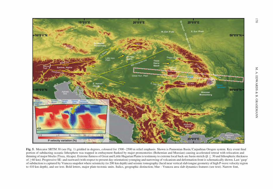
P velocity variation (%)
-1.5 -1 0 1 1.5
410
FocsaniDepression
Vrancea Zone
Transylv. Basin
Apuseni Massif
GreatHungarian Plain
Eastern Alp Alppine
Dinarides
Balkides
Bohemian Massif
Great Hun. Plain
Rhodope Massif
Apuseni Massif
Transyl- vanian. Basin
MoeoesianPPrroomontory
TisTisza-DaciciaaBlock
BoheBoheeemianmianmianmianmiaPPPPrrrromoomoomontoryy
AlcAlAAAllA apaaaBloBloBloBlBloBlocck
EE. AdAdriannBlolock k kk
E. Eur. PlateW. Eur. Plate
Southern Carp.
E. Carp
Tatra
W. Carp.
TeTTissey
re–ToTT rn
quququqisi
t ZonZo
e
Little Hun. Plain
Adriatic Sea
Marmara Sea
V. Basin
Focsani Depression
Vrancea
Zone
Trotus Line
S. Carp. Fault
Dragos-Voda F.
SEMP Line
Mid - Hungarian Line
Periadriatic Line
BrennerFault
Fig. 5. Mercator SRTM 30 (see Fig. 1) gridded in degrees, coloured for 1500–2500 m relief emphasis. Shown is Pannonian Basin/Carpathian Orogen system. Key event finalportion of subducting oceanic lithosphere was trapped in embayment flanked by major promontories (Bohemian and Moesian) causing accelerated retreat with relocation andthinning of major blocks (Tisza, Alcapa). Extreme flatness of Great and Little Hugarian Plains is testimony to extreme local back-arc basin stretch (b � 30 and lithospheric thicknessof�60 km). Progressive SE- and eastward (with respect to present day orientation) younging and narrowing of volcanism and deformation front is schematically shown. Last ‘gasp’of subduction is captured by Vrancea snapshot where seismicity (to 200 km depth) and seismic tomography (lucid near vertical slab tongue geometry of high P-wave velocity regionto 410 km depth), and see text. Bold letters, major plate-tectonic units. Italics, geographic distinction; blue - Vrancea area slab dynamics features (see text). Narrow font,
M.
A.
ED
WA
RD
S&
B.
GR
AS
EM
AN
N170
et al. 2003), or, separate from these, divergent freesouthward flow of the Aegean (Gautier et al.1999). Most of the rigid block models howeveromit the elegance of linear elastic fracture mech-anics approaches in incorporating tips of deform-ing zones where displacement dies out. The rigidblock proponents instead require non- model-able‘hit and miss’ zones of distributed deformationbetween the blocks (best fit scenarios). Thisapproach does provide solutions for the presentday instantaneous geodynamics but these modelscannot usefully be played back elegantly throughtime (i.e. they cannot make predictions regardingspecific spatio-temporal historical deformation).For example, the youngest historical intervalbetween the present day and the post-M2 (mid-Miocene) is a critical period of change in the gov-erning kinematics of the greater Hellenicsubduction zone system. In this period, the NorthAnatolian Fault, initiating from deep withineastern Turkey, propagates to the site of theMarmara Sea by c. 5 Ma thereby beginning theimposition of escaping Anatolia upon the exten-sional regime of the greater Aegean (Okay et al.1994; Armijo et al. 1996; Armijo et al. 1999).The northernmost branch of the north Anatolianfault becomes thereafter the (micro) plate bound-ary of the Hellenic system with fixed Eurasia(Armijo et al. 2003; van Hinsbergen et al. 2006).Although the detailed datasets on individual sliprates and ages for the myriad of Aegean faultsare still relatively few, it appears that the increas-ing westward impingement of the North AnatolianFault caused stepwise (re)activation of deformationlocalization (or significantly increased displace-ment) at the successive trough regions of theNorth Aegean Trough, the Skiros Trough, theLesbos–Psaras Trough, and later the North EvviaBasin and the Evvia Graben and then finally theGulf of Corinth Rift at c. 1 Ma (see Armijo et al.1996 for a review). It therefore becomes clearthat, despite the appealing instantaneous rotatingblock type geometries suggested by the bathyme-try, seismicity and geodetic displacement, thesnapshot of the evolution of the Hellenicback-arc requires the longer view.
A snapshot of accelerated retreat
In summary, we can see that the Hellenic subductionzone system has, for most of the Cenozoic, beenassociated with a dynamic backarc system relatedto the persistent convergence of the subductingAfrican lithosphere that has experienced significant(if not continuous) rollback since the Oligocene.The pulses of back (or within) arc extensionrelated to the enhanced periods of exhumation inthe Rhodopes, followed by the Cyclades–Menderes, then Crete and finally the present dayPeleponese with Corinth in the West and the Dode-canese in the East testify to periods of enhancedrates of rollback (albeit not as convincing as ourother snapshots of clear acceleration with time).Good evidence for tearing (and thereby narrowing)of the slab that is likely associated with enhancedrates of rollback (particularly in the Miocene) isseen in the Dodecanese (the seismic moment anddepths of seismicity, the volcanic chemistry, andthe tomographic contrast) as well as (to a lesserdegree) Peleponese and Corinth, although the signa-ture here is very much defocused by the recentpropagation of the North Anatolian Fault. Thepresent day migration velocity of the HellenicTrench towards the SSW at 3.3 cm/a is, albeitrapid, much less than is likely to have prevailedfor the major extensional phases in the past. Thisfits well with the observations from (for example)modern cross section across the Hellenic Trench(Papanikolaou in Jolivet & Brun 2008); the arrivalof the Mediterranean Ridge at the Hellenic Trenchis the beginning of the end of the availableoceanic crust – our snapshot.
Pannonian–Carpathian system
The Carpathians
The Carpathian Mountains (Fig. 5) comprise (1) anouter portion of largely later Cretaceous and Ceno-zoic age nappes assembled from predominantlythin-skinned fold and thrust belt type deformationof flysch and molasse which arose through accre-tionary orogenesis, and (2) an inner portion, which
Fig. 5. (Continued) names of geodynamic discontinuities (faults, lines, etc); no font emphasis – orogen (range)portions. Red dashed on white line forming box is trace of swath of tomographic profile (see inset). Trace oftomographic profile swath is approximate; continues approximately 200 km to east beyond limit of map. Patch labelled‘Vrancea zone’, surface location of hypocentres displayed on tomographic profile on inset; yellow dashed lines,geodynamic discontinuities; arrows, general block motion direction or relative fault displacement (half arrows).
Inset: Tomographic profile re-drawn after Wortel & Spakman 2000. Yellow (crust) and green (mantle) lithospherethickness are freely interpreted via Moho depth, basin fills, etc. from Royden et al. (1983b); Lillie et al. (1994); Bertottiet al. (2003); Cloetingh et al. (2004, 2005a). Depth scale is given by 410 km acoustic transition. Yellow dots:hypocentres from selected earthquakes, data courtesy: http://neic.usgs.gov/neis/epic/ (Earthquake Hazards Program,National Earthquake Information Center of the United States of America Geological Survey) and Russian public domaincatalogue (Moscow 1994), corrected after Engdahl et al. (1998).
MEDITERRANEAN SNAPSHOTS 171
consists of crystalline basement nappes plus Meso-zoic sedimentary cover and whose deformation ispredominantly Alpine of Cretaceous age; the com-posite architecture of both portions (3) interruptedby widespread volcanics of andesitic and otherchemistry (e.g. Jirıcek 1979; Royden et al. 1983a;Zweigel et al. 1997; Pecskay et al. 2006; Kovacs& Szabo 2008), as well as local Cenozoic reworkedcrystalline massifs that are also present (e.g. Pana &Erdmer 1994; Dallmeyer et al. 1996; Faryad &Henjes-Kunst 1997; Schmid et al. 2004;Fugenschuh & Schmid 2005). The Carpathians arenoteworthy for being a long (.1000 km) yet coher-ent throughgoing orogenic belt that all the whileexhibits a .190 degree strike rotation (termed a‘double loop’ by some authors), the foreland ofwhich forms an embayment of .300 km amplitude(labelled Bohemian Promontory, Eur. Plate andMoesian Promontory in Fig. 5). Nested behind theCarpathians is the Pannonian Basin, effectivelyEurope’s largest modern sedimentary basin that isnot part of the Atlantic break-up rifted continentalmargin network (e.g. Stegena et al. 1975). The Car-pathian fold and thrust kinematics (Jirıcek 1979;Decker & Peresson 1996; Linzer 1996; Linzeret al. 1998; Nemcok 1998a, c; Sperner et al. 2002)record propagation towards the convex-out direc-tion of the Carpathian loop (i.e. in the North,towards the North; in the NE, towards the NE,etc.) with accretionary thrust wedge growth termi-nating (in a steady progression to the east and SE)as the thrust wedge was ultimately emplaced (over-thrust) in stepwise fashion onto the foreland (thecontinental passive margin of European platform)in the Mio-Pliocene. This gives a critical insightinto the overall north-, then southeastwardmigration of, along with reduction in the length of,the subduction accretion wedge thrust front. The1908 bend and 300 km embayment additionallygives a nice indication of the nature of the pre-existing European margin geometry and the poten-tial that existed to isolate a landlocked piece ofoceanic lithosphere. This pre-existing geometryhas been dictated since the end of the Cretaceousby the Moesian and Bohemian promontories(Fig. 5) and has changed little, as indicated byabsence of significant Cenozoic deformation withinthese portions of the European margin both in thesurface (e.g. Hamilton et al. 1990; Linzer et al.1998; Haas et al. 2000) and the subsurface – asreflected (!), e.g. in the CELEBRATION results(e.g. Grad et al. 2006).
Volcanism
It is generally held that the Carpathian accretionaryfold and thrust belt and volcanic interludeswere built from east and southeast retreating
oceanic lithosphere subduction that dominatedsince the Oligo–Miocene (e.g. Royden 1983a, band several of the other above noted authors)although there are variants and other ideas (seebelow). Oddities such as the absence of ophioliticassemblages have prompted some debate onindeed whether or not during the Cenozoic, themajority of the forearc (i.e. incoming crust that inpresent day co-ordinates would be north and eastof the Carpathians) to the growing Carpathian Arcwas indeed ever a truly oceanic (or maybe ‘sub-oceanic’) crust composed embayment (Gırbacea &Frisch 1998; Linzer et al. 1998; Sperner et al.2004; Tischler et al. 2007). As these and numerousother studies discuss, however, there is much evi-dence that the Carpathian–Pannonian system doesindeed represent an accretionary wedge born of arapidly retreating (foundering) slab of old oceaniclithosphere flysch basin that was an embayment inthe Alpine (sensu lato) collision. Observed (Fig. 5)is the trend of andesitic (i.e. arc-associated) volcan-ism whose ages range from the Miocene up to thepresent day and whose individual instances werelocal occurrences of short-lived duration. Theserepresent a progressive (south)eastward migrationthat thereby constrains the historical retreat and/or progressive lateral tearing away of the slab (e.g.Jirıcek 1979; Royden et al. 1983a; Csontos 1995;Zweigel et al. 1997; Linzer et al. 1998; Pecskayet al. 2006; Kovacs & Szabo 2008). Although thetracking of the (south)eastward advance of arc-associated volcanism is impressive, the spatial aswell as temporal precision of the volcanismtimetable that emerges from the present state ofknowledge is insufficient (especially along thesouthern Carpathians) to exclude variants on ourpreferred theme of the accelerated retreat of an ever-narrowing slab width. Some version of the stepfaulting notion (Govers & Wortel 2005) or an obli-quely propagating slab tear-off could (also) haveoperated for either the eastern or, even more so,for the southern Carpathians. In addition, for thecalc- alkaline transition described by the variousstudies noted above, the geochemical characteristicsto discriminate volcanism related to standard sub-ducting oceanic lithosphere-engendered melting ofaesthenosphere above the slab versus melting ofaesthenospheric material related to a tear or partialbreak-off are, for the so far obtained Carpathiansvolcanic rocks database, insufficiently discrete.This is in many instances thought to be due tocomplex contamination of continental crust thathas already experienced portions of multiple vol-canism episodes due to late Cretaceous or otherrifting (e.g. above studies and see also Kozur1991; Channell & Kozur 1997) followed byoverlap with one or both of the above meltingphenomena. Further complicating the issue, albeit
M. A. EDWARDS & B. GRASEMANN172
mainly in more central portions of the PannonianBasin network, is the aesthenospheric melting andupwelling (whether related to a plume, deep diapir-ism, or other – see below) that is associated withlithospheric stretch plus accompanying thermal sub-sidence and corresponding basin growth.
Pannonian basin sedimentation
and subsidence history
The Pannonian basin network (including the ViennaBasin, the Little & Great Hungarian Planes and theTransylvanian Basin – see Fig. 5) attests to severelystretched (+ wrench offset) and thinned continentallithosphere with b factors of typically around 3 butlocally as high as 30 (below the key depocentres ofthe Little and Great Hungarian Planes); this is mostvividly expressed by the contrasts between theancient European Margin (Bohemian and Moesianplatforms) and within the Pannonian basin networkthat are seen in (1) values of lithosphere thickness(150–200 km versus 60–80 km) and (2) Mohodepths (�45 km beneath Polish Trough or �40 kmbeneath Carpathians versus �27 km beneath thePannonian basin), as well as (3) heat flow (55 mW/m2 versus 90 mW/m2), and (4) the basin network‘syn- to post-rift’ sedimentation history revealed bythe various gravity, seismology (reflection profiling,velocity & receiver function forward modelling),and subsidence & back-stripping studies (e.g.Sclater et al. 1980; Royden et al. 1983b; Tari et al.1992; Lillie et al. 1994; Meulenkamp et al. 1996;Hauser et al. 2001; Huismans et al. 2001; Sachsenho-fer 2001; Sperner et al. 2004; Cloetingh et al. 2005a;Bielik et al. 2006; Grad et al. 2006; Sroda et al. 2006;Szafian & Horvath 2006; Cloetingh et al. 2007;Matenco et al. 2007). In keeping then with thewidely held hypotheses that the Carpathian–Pannonian system owes is existence to an east andSE retreating oceanic lithosphere subduction setting,the Pannonian basin network is correspondinglyseen to be the backarc basin area to the eastwardretreating (or retreated, van der Hoeven et al. 2005)slab. It is noteworthy that although parts of thePannonian basin networks have sediment thicknessesof up to 6–8 km (e.g. Transylvanian Basin), thedeepest basin is outwith the Pannonian; the FocsaniDepression is a .10-km-thick foredeep basinformed in Tertiary to Quaternary times in the SE fore-land and frontal thrust piggy-back basins to theCarpathians. Focsani subsidence is still active(Bertotti et al. 2003; van der Hoeven et al. 2005)and has been intimately associated with the Vranceaseismogenesis zone (be this a vertical slab tongue orlithospheric downwelling and/or delamination –see Fig. 5 and below).
A number of studies contribute to the presentknowledge on the Pannonian basin network
sedimentation history (e.g. Royden et al. 1983b;Tari et al. 1992; Meulenkamp et al. 1996; Csontos& Nagymarosy 1998; Cloetingh & Lankreijer2001; Huismans et al. 2001; Szafian & Horvath2006). As these authors show, the sedimentationhistory is typically identifiable as a 2-stage affair:the initial Early-Middle Miocene syn-rifting phaseis associated with a brief, rifting-active subsidenceperiod that can be broadly correlated with the begin-nings of acceleration of foredeep depocentremigration in the latest early Miocene. Basin geome-tries that develop at this stage are very muchnon-2D. This is, at least in part, the result of hetero-geneously distributed extension that was accommo-dated by transfer faults. Evolution of a network oftransfer and accommodation faults as well as thecreation of associated basins with their character-istic triangular (sensu lato) geometries is seen tobe a condition of the stretching, rotation, andre-ordering of the composite microplate amalgama-tion in the Carpathian backarc. This is indicated inFigure 5 in the present position of the Alcapa (orNorth Pannonian), and the Tisza- (or Tisia-) Daciablocks (or microplates). These converged andwere differentially displaced about the Mid-Hungarian Line as part of the backarc basinevolution to the south-, and eastward migrating Car-pathian Arc. This can be regarded as the ‘passiveextension’ phase in terms of basin evolutionmantle dynamics. The subsequent late Miocene toPliocene post-rifting phase is associated with aprotracted subsidence history whose progress iscomplicated by perturbation of the thermal bound-ary layer, ‘active’ aesthenospheric mantle thinningand convective (or buoyancy-induced flow, or diapi-ric, or other) upwelling along with widespreadPannonian region volcanism including that relatedto shallow mantle decompression (‘fertile’), aswell as late regional doming, and flank uplift (poss-ibly due to aesthenospheric mantle flow to themargins of the thinned lithosphere).
Plumes and aesthenospheric upwelling
Because (1) the upwelling magnitude is greater thanthat expected by, and (2) the volcanic rocks have ageochemistry that in many cases is inconsistentwith, the straightforward rollback pursuant to a sub-ducting slab model, we require a more complexgeodynamic explanation or, at minimum, somemodification to the foundering, subducting slabmodel. In addition to the andesitic Carpathianarc-related volcanics noted above, felsic to inter-mediate calc-alkaline volcanics are distributedthroughout much of the Pannonian. Respectively,these are generally inferred to be associated withthe initial- to advanced-stages of backarc extension(and associated initial decompression melting of
MEDITERRANEAN SNAPSHOTS 173
fertile mantle that has welled up via some mechan-ism). Furthermore, various alkali basaltic magma-tism products are present that contain, amongstothers, ultramafic (e.g. spinel peridotite) mantlexenoliths. The latter have LREE-depleted bulk-rockcompositions and have been one source for mantleplumes theories (via, e.g. noble gas and Pb–Sr–Nd isotopes as well as the rare earth element compo-sitions (e.g. Rosenbaum et al. 1997; Buikin et al.2005)) although continental lower crust contami-nated by tectonically emplaced oceanic crust canalso explain the LREE trends to some degree (e.g.Dobosi et al. 2003). The debate and distinctionsbetween mantle upwelling, mantle diapirism, anda shallow or even deep (?core-mantle boundary)mantle-sourced plume lie well outside the scope ofthis paper – but see Lustrino & Wilson (2007) con-cerning this issue expressly for the Mediterraneanback-arc snapshot settings. It seems, however thatmantle plume type hypotheses are not required;Kovacs & Szabo (2008), for example, note thatalthough the spatio-temporal distribution of(amongst others) granulite and clinopyroxenitexenolith-bearing mid-Miocene intermediate calc-alkaline volcanics that straddle the Mid-HungarianLine cannot be (solely) related to a modified (e.g.metasomatized) mantle via the southward directedsubduction (e.g. Kovacs & Szabo 2008), they canbe convincingly explained via crustal compositionthat is modified by the incorporation of either theBudva-Pindos or Vardar (also Meliata) Oceanduring the Mesozoic–Paleogene plus (any) relatedminor subduction volcanism during the evolutionof the Alcapa block. They further note that this isconsistent with the emerging geophysical evidence(e.g. Grad et al. 2006) and provides an alternativeto plume models.
Tectonic block and microcontinent motions
The translation and re-ordering of the Alcapa andTisza–Dacia blocks as well their neighbours, theEastern Alps and the East Adrian block (Fig. 5)are an integral part of the initial history and the pro-gressive migration of the Carpathian AccretionaryBelt, as well as the attendant growth of the Panno-nian Basin, and thereby retreat of the slab. The Mid-Hungarian Line is the subsurface tectonic contactwhere the Alcapa and Tisza–Dacia blocks arejoined via a wrenching plus thrusting (largely south-wards) history whose age should be late Eocene tono later than Oligocene (see Csontos 1995; butalso Csontos & Nagymarosy 1998). Rotationswere large as these two blocks moved around theEuropean platform promontories (i.e. Moesian,Bohemian) into their present position. The Alcapablock rotated 5 to 158 anticlockwise during theMiocene while the Tisza–Dacia block, initially
having rotated as much as 1208 rotated anticlock-wise in the Oligocene, rotated 40–608 clockwiseduring the Miocene – in part responding to thenorthwestwards, then northwards convergence of the(still) rotating Adria block (Kovac et al. 1993;Csontos 1995; Linzer 1996; Fodor et al. 1998;Plasienka & Kovac 1999; Marton et al. 2000; Martonet al. 2003; Marton & Fodor 2003; Sperner et al.2004; van der Hoeven et al. 2005; Kovac et al.2007; Lesic et al. 2007; Marton et al. 2007).These and other (Dupont-Nivet et al. 2005; Tischleret al. 2007) studies show that the Carpathians them-selves also rotated and bent, starting at least in theMiocene, seen (e.g.) as c. 308 clockwise rotationbetween 5–13 Ma in the southern Carpathian. Thelast 5 m/a have been the exclusive focus ofrotation (and also volcanism, as well as presentday seismicity - see below) located at the ‘bend’of the Carpathian arc between the Vrancea Zone(Fig. 5) and the Transylvania Basin, south of theTrotus Line (Linzer et al. 1998; Dupont-Nivetet al. 2005)
Another key player in the tectonic blockre-ordering phenomenon is the westernmost blockto the system, the Eastern Alps (Fig. 5). Thisblock is bounded by the Brenner normal fault, thePeriadriatic and the SEMP Lines and representsthe hypothesized Miocene (possibly up to presentday) ‘escape’ off to the east of the collapsing, grav-itationally unstable, over-thickened Austrian Alps(riding above flowing crystalline basement) as aresult of the free margin (within the main alpine col-lisional system) offered by the Carpathian retreatand/or as a result of the northward indenter pushof Adria (Ratschbacher et al. 1990, 1991; Fodoret al. 1998; Nemcok 1998a; Grenerczy et al. 2000;Haas et al. 2000; Linzer et al. 2002; Sperner et al.2002). Note that the role of the mechanism ofindenter Adria’s push in to East Alps is sometimescast as a ‘chicken-and-egg’ question – as is alsosometimes done for Anatolia (i.e. ‘forced’ escapeof Anatolia due to indenter push of Arabia versus‘attracted’ Anatolia escape towards the freemargin created by the Hellenic slab rollback andthus the collapse of the Anatolian plateau).
Basin inversion
The translation and re-ordering of the microblocksalso must play some role in the phenomenon ofbasin inversion. All of the basins in the Pannonianbasin network (to a greater or lesser degree) aremodified by a locally Miocene but largely Plio-Pleistocene (and even Holocene) ‘inversion’ withshortening in various forms (amongst others: (1)local reverse reactivation of earlier normal faultsthat originally grew during mainly the Miocenesyn- and post-rift phases; (2) basin-wide buckling;
M. A. EDWARDS & B. GRASEMANN174
(3) Holocene landform flank uplift; and even (4)local reactivation of original Alcalpa againstTisza–Dacia thrust (or oblique wrench) displace-ment systems along the Mid-Hungarian Line) thatis evident on exposed basin margins and seismicreflection profiles, and is further revealed by apresent day compressive stress regime that isobserved in borehole and other in-situ stress data(Peresson & Decker 1997; Csontos & Nagymarosy1998; Nemcok 1998a; Bada et al. 1999; Fodoret al. 2005; Plasienka & Kovac 1999; Bertottiet al. 2003; Cloetingh et al. 2005a, b; Bada et al.2007; Matenco et al. 2007). These studies generallyinterpret the inversion to be due to the compressivestress regime engendered by the final cessation ofback-arc extension to the Carpathians that is conco-mitant with the corresponding halt of the eastwardretreat of the Carpathian subduction zone whilethe Pannonian region is simultaneously exposed tothe continued anti-clockwise rotation and north-NE-directed indentation of the Adriatic microplate(push of Adria) against the (Eastern) Alps and thedextral ‘transpressional’ inner Dinaride zone(Fig. 5). Modern differential GPS surface displace-ment studies both at the east Carpathians andaround the Dinarides are consistent with thisnotion (e.g. van der Hoeven et al. 2005; Vrabec &Fodor 2006). The dominant style of deformationgradually changes from pure contraction, throughsome type of transpression to strike-slip faultingfrom west to east. The magnitude of the contributionto the compressive stress regime related to the basin-wide inversion that can be imparted by the contin-ued eastward escape of the collapsing EasternAlpine over-thickened lithosphere is probably notlarge. Nevertheless, the stress trajectories from theEastern Alps out to the east in the PannonianBasin must play some significant role and at leastlocally modify those of the push of Adria. Thestress conditions that provide this basin-wide inver-sion have also been attributed, by some, to be associ-ated with folding of the lithosphere (e.g. Cloetinghet al. 2005a, b) albeit it is unclear how the litho-sphere can support the elastic stresses necessaryfor folding.
Geophysical constraints
The preferred model of a now almost totallyretreated, very narrow slab is very well supportedby the geophysics. Figure 5, inset, shows a repro-duction of a seismic tomography model profilefrom Wortel & Spakman (2000) that vividlyimages a high velocity anomaly directly below theVrancea zone which is readily interpreted as thedowngoing slab (with a vertical tongue geometry).Notable is the fairly convincing continuity in the
anomaly architecture (cold lithosphere) from thesurface down to .400 km depth suggesting thatthe slab is intact throughout this depth interval.Moreover, the distribution of earthquake hypocen-tres (almost vertical, down to 200 km depth)within the Vrancea zone provides critical detail tothe notion of the continuity in the high velocityarchitecture; an equivalent continuity is shown bymechanical coupling all the way up to the (near-)surface; most focal mechanisms for intermediateand deep events have downward oriented extensionaxes (Oncescu 1987). Contrastingly, seismic tom-ography profiles that cross the Carpathians,150 km further north (where there is no active seis-micity) show a clear depth interval gap in the highvelocity structure that is present within the upper-most 100 km of the Earth (Spakman & Wortel2003; Cloetingh et al. 2004) suggesting that theslab in these areas is now broken- or torn-off. Offurther importance to the subduction retreat hypoth-esis is that the constrainable distances/depths ofsubducted slab that can be inferred from the tomo-graphic model velocity anomaly architecturerequire 100s km (West–East) of oceanic lithosphereto have been trapped in the original embayment loop,at least by the end of the Cretaceous.
Retreating subduction models caveats
and alternatives
Despite the powerful support to the acceleratedretreating slab hypothesis that is provided by thesub-surface geophysical data, there are a fewcaveats arising from the Vrancea slab (or Vrancea‘feature’). Sperner et al. (2004) note the lack ofco-location between the (present day) Vranceaslab seismicity (plus high velocity tomographyanomaly) and the Tisia–Dacia Miocene ‘suture’(and arguable volcanic arc). They propose variousmodels to explain this, one of which includes a per-sistence since the Miocene of the present day pos-ition of subduction below the Focsani foredeep.They note that because this cannot explain thelocation (�100 km to the West) of the accretionarywedge (lacking as it does the otherwise necessarysystem of backthrusts), the only reasonable modelinvolves post-Miocene lower lithospheric (presum-ably mantle) delamination, an idea also raised byKnapp et al. (2005). Delamination and downwellingare also the processes in the Houseman group’s(Gemmer & Houseman 2007; Houseman &Gemmer 2007) lithospheric instability model(s) toexplain the Vrancea observations. This modelsimultaneously can elegantly account for theabove discussed phenomena of inversion, mid-basin aesthenosphere upwelling with melting andsuspect plume-type chemistry. We note, however,
MEDITERRANEAN SNAPSHOTS 175
this model does not exclude that the Carpathian–Pannonian system owes its existence to acceleratedretreat of an east and SE retreating oceaniclithosphere subduction setting.
Accelerated retreat snapshot
With the exception of the Houseman group drip-offmodel, the aggregate picture that emerges for thePannonian–Carpathian system spectacularly illus-trates a caught-in-the-last-moments snapshot ofretreated subduction, the likelihood of which isdiminished neither by the Sperner et al. (2004) dela-mination nor by the various geochemical complex-ities of the volcanics and back-arc aesthenosphericupwelling. Moreover, the key historical evidencefor a retreat that has accelerated over time as thelength of the subduction zone has lessened, whilethe slab has narrowed and steepened, is nicelyrecorded by the above discussed spatio-temporaldistribution of the (southeastward migrating) ande-sitic volcanics as well as the accelerated eastwardmigration of the sedimentation depocentres of thePannonian Basin network. Similar to the other twosnapshots, we see here an along-strike lateralpropagation of the termination of active collisionthat is almost certainly associated with agradual horizontal tearing off of the slab as thelast portions of the foundering, heavy, Mesozoicage oceanic lithosphere are progressively con-sumed; the final narrow vertical tongue of subduct-ing lithosphere at Vrancea is caught as a snapshot ofthe accelerated subduction retreat within ICLOsubduction.
Other mechanisms
Doglioni & colleagues (e.g. Doglioni 1994;Doglioni et al. 1991, 1999) emphasise that ‘east-ward (and NE) mantle flow can account for themain tectonic directions of compression or exten-sion for many of the (nascent) Mediterranean con-vergence systems, whereby the main tectonicregime is considered to be more east–west ratherthan north–south. These authors have gone on tocompile an impressive dataset to make a globalcase for an eastward mantle flow (and adopt asimple fluid-model for the entire planet). As theseauthors note, ‘the numerous extensional basinswith very high heat flow, and sometimes oceaniza-tion, are difficult to explain in the classical schemeof north–south compression.’ If such a phenom-enon as globally active eastward mantle flow doesexist, it is conceivable that this would influencethe ultimate geometry of ICLO subduction for asetting like the Mediterranean, and we find theidea intriguing.
Mantovani and colleagues (Mantovani et al.2000, 2001, 2002) tend to disregard slab pull andmantle dynamics at large, appealing instead toplate–kinematically induced forces to explainall Mediterranean regional tectonics. We preferour model.
Discussion
Three stages of continent-continent collision
As we noted, our Mediterranean snapshots thesisphilosophically adopts the idea that three basiclevels of this collision exist, when the entire colli-sional system of Eurasia with Africa/Arabia/Indiais considered in the broad scale. Each of these corre-sponds to an increased stage of maturity or advancedintensity of continental collisional convergence: (1)the greater Indo–Asian collision: (2) the system ofArabia colliding into Iran and surrounding regions;and (3) the Africa–Europe collisional system. Wedo not urge that the Arabia– and Africa–Eurasiacollisional portions must proceed to Himalayalevels but suggest this is highly probable.
In stage one, the Indo–Asian collision includesthe Himalaya, Tibet (a stack of pre-Indian plate col-lided terranes) & surrounding belts (Hindu Kush &Pamir, Tien Shan), and SE China plus greaterIndochina. Here, it has long been known (e.g.Argand 1924; Tapponnier et al. 1981; Allegreet al. 1984; Tapponnier et al. 1986; Coward et al.1988; Dewey et al. 1988; Kidd et al. 1988; Yin &Harrison 2000) that full collision is underway andthe orogen enjoys an advanced state of convergencebetween two major continental plates. Platekinematic evolution restorations (as Wortel &Spakman 2000 note, often called tectonic recon-structions) have shown us, for some decades now,the Cenozoic progress of �1000 km of the Indianplate ploughing into the southern Asian margin(e.g. Patriat & Achache 1984), wracking up a highplateau, pushing up ranges on the far sides of rigidblocks like the Tien Shan and Altai and drivingoff crustal blocks on the eastern free margin in itspath and wake. Although this region benefits fromthe insight into collisional geodynamics affordedby active and recent orogenesis as we notedabove, there remain key uncertainties that mayprofit from comparison with the Mediterranean.The interpretation of mapped ophiolitic material,blueschists, interarc- or forearc-like flysch ormolasse deposits, and other potential indicators of‘sutures’ between, or local instances of rifting andoceanic crustal production within, the collage ofaccreted terranes is not always unambiguous. Theotherwise strikingly west to east cylindrical and2D-redenderable coherency (often .2000 km) in
M. A. EDWARDS & B. GRASEMANN176
the terrane collage tectono-stratigraphy has discour-aged (in most cases thankfully) less elegant platekinematics interpretations that require a myriad ofpiecemeal sutures, small basins, and brief openingsand closings, local meltings, late flare-ups and so on.But despite this cylindrical style, it may well be thatthe geometry of the pre-collisional margin(s) was(highly) irregular and consisted of 100s km ampli-tude embayments and promontories that have nowbeen all but transposed into the governing fabricof the orogen. And indeed, there may be instances,especially within the pre-India collided blocks ofTibet (i.e. Lhasa, Qiangtang), where a ‘Mediterra-nean solution’ (local instances of rifting andoceanic crustal production) are preferable tomodels invoking many 100s km long cylindrical,2D-redenderable collision phases. For example,the California Franciscan-influenced model for theQiangtang terrane blueschists (Kapp et al. 2000)requires that the Qiangtang was always a singleblock. Although intriguing, this model is notsupported by tectonostratigraphic evidence (e.g.Zhang 2001; Zhang et al. 2006) and thus a lessspectacular interpretation involving some type ofrifting and re-convergence with high pressure exhum-ing subduction zone processes is maybe more likely.Indeed, a Mediterranean setting at least for the north-ern Qiangtang Block has recently been suggested(Pullen et al. 2008). We re-emphasize, however,that the dramatic (with respect to the Africa plate)velocity of the Indian plate from at least themid-Cretaceous to the onset of collision and eventhereafter (e.g. Patriat & Achache 1984) left littletime for sluggish foundering with collapse and con-sumption of significant volumes of oceanic litho-sphere. We accordingly advocate for the India–Asiasystem neither the existence of widespread trappedorogenic lithosphere pieces nor significant ICLOsubduction in contrast to our three Mediterraneansnapshots illustrated here.
Stage two, the system of Arabia colliding intoIran and surrounding regions, is characterized byan actively and rapidly growing frontal fold andthrust belt (the Zagros) responding to the incomingcolliding Nubian plate which is presently movingwith a lively pace (e.g. Gansser 1955; Stocklin1968; Berberian & King 1981; Sella et al. 2002;McClusky et al. 2003; Vernant et al. 2004;Masson et al. 2005; Reilinger et al. 2006). Thesegeodetic data (and models) and seismicity hypo-centre distributions (e.g. Jackson & McKenzie1988; Tatar et al. 2005; Jackson et al. 2006;Hollingsworth et al. 2007) show an actively deform-ing region that comprises the Caucasus, Zagros,Makran (and historically, Oman), Talesh, Alborzand Kopet Dagh ranges (and any sub-blocks of theIran collage). Like in the India-Asia collision (theGangdese), a fossil Andean arc with flysch and
ophiolite-bearing suture elements is present (e.g.Gansser 1955; Stocklin 1968), but not (yet) signifi-cantly dissected, in contrast to the India-Asiacollision (e.g. Scharer et al. 1984). A similar com-parison exists within evidence for some lithosphericmantle delamination in eastern Anatolia (e.g.Barazangi et al. 2006) in contrast, again, to themore advanced stage of this state under the Tibetplateau (e.g. Kosarev et al. 1999). Furthermore,there are various rigid blocks and deforming‘boundaries’ and local instances of ophiolitic rocksand possible candidate sutures within the easternportions of the, relatively little investigated,‘Iranian Plateau’, and again this may be seen as aforerunner to attaining a high plateau region(albeit for a smaller geographic region than that ofTibet). Parallels such as these have led many topropose that this system is a good analogue (albeitof shorter orogen length) for the earlier stages ofthe India collision. Once again, it may or maynot be that local land-locked oceanic lithosphericsegments had sufficient time to founder and gener-ate significant ICLO subduction belts (that wouldnow be transposed into the Arabia collisionalbelt). The historical velocity of the Nubian platewas also fairly rapid (Dewey et al. 1989b; Allen2004), however, and, at least for the Zagros belt,significant ICLO subduction belt incorporation isnot so likely.
Stage three, the Mediterranean, includes ofcourse the ‘palaeo-Mediterranean’ e.g. the last-stage Tethys ocean closures of the Pannonian – Car-pathian system. Once the presently recalcitrantAfrica does fully collide into Europe, the currentpreservation of those last vestiges of intra-convergence oceanic lithosphere awaiting subduc-tion will be obliterated. Once stage three goes tocompletion, it might well be difficult to identifyfossil examples in the future exposed roots of theby-that-time transposed to orogen-parallel, spatiallyand heterogeneously restricted, short duration,intra-orogenic piecemeal collision (e.g. along-strikerestricted, across-strike repeated local orogenesisevents such as the Apennines piled up behind theDinarides, or scattered, short (�50 km) belts withblueschist occurrences (such would be the futureequivalent to that which is currently beneath theCalabrian subduction) to become underplated,exhumed once the system is shutoff, and transposedand incorporated somewhere between collidedAfrica and Europe). ICLO subduction in ancientorogens may indeed only be resolvable through adense network of basement geochronology and ther-mochronology. In the Variscan Sudetes, forexample, multiple sequential collisions (a discretehistory of burial followed by exhumation in eachinstance) within a spatially limited row of rockpackages (,100 km swath – effectively a ‘spot’)
MEDITERRANEAN SNAPSHOTS 177
are recorded by successively younger discrete P–Tloops (Matte 2001; Franke & Zelazniewicz 2002;Schneider et al. 2006). The lack of any alongstrike continuity for each of these sequential col-lisions excludes simple interpretation through theapplication of classical 2D cylindrical orogenesisaggregation of terranes (e.g. Tibet plateau). Apply-ing ICLO subduction (as seen in the Mediterranean)as a modern analogue provides a tangible and elegantmechanism by which the otherwise confusing geo-metries of numerous local collisions within such ashort section of orogen can be explained.
The fact that Africa may or may not collide intoEurope as discussed above is not important for thesnapshot thesis. Afar mantle plume theories not-withstanding, it is not clear why Africa has stalled(or slowed), but it has, and we are fortunate togain this insight into ICLO subduction and there-fore to have captured these snapshots that wouldotherwise be unlikely to survive.
Collapse as a competing model
As noted by various authors over the last few years(e.g. Jolivet & Faccenna 2000; Wortel & Spakman2000), it is important to separate the larger scale(upper mantle) process of slab foundering, retreat,and piecemeal breakup, from the more general,now well-established phenomenon of extensionalsyn-convergence (or ‘post-orogenic’) collapse. Wekeep the term syn-convergence (e.g. Burg 1983;Pecher et al. 1991; Edwards et al. 1996) ratherthan ‘post-orogenic’ collapse for our large scaleconsideration of the major collision of Europe andAfrica, in view of the fact that the collision is stillongoing, if albeit stalled. We recognize that,at least for the circum-Mediterranean, multiplemature orogenic elements exist (e.g. Alps,Hellenides, etc.) where there has been a protractedsequence of syn-thickening high pressure exhuma-tion followed by post-thickening collapse (on thistopic see also Tirel et al., 2009). Collapse inthickened crust in mature portions of orogens suchas the now classic syn-convergence, syn-thrust ver-gence normal faulting in the Himalaya (southernTibet detachment system, e.g. Burg et al. 1981;Burg 1983; Burchfiel et al. 1992; Edwards et al.1996) with accompanying (typically high tempera-ture) events such as core complex formation, oper-ation of a widespread crustal scale detachment(system), mid-crustal melting, etc., are attributableto various mechanisms that are not directly relatedto upper mantle slab dynamics (e.g. enhanced slabpull, accelerated retreat). Numerous authors havehighlighted, for example, the roles of collapse-engendering, gravitational body forces that may bestored in the over-thickened crust (e.g. Dewey
1988; Platt & Vissers 1989), with the possibleadditional roles of, for example, mid-lower crustalweakening with attendant flow, sudden break-off/delamination or convective removal of lithosphericmantle, etc. In a general sense, the process ofsyn-convergence collapse clearly has been, or stillis, in operation in our three snapshot examples(irrespective of which mechanisms are dominant,be it mantle lithosphere removal and/or aestheno-spheric upwelling, mid/lower crustal flow, etc.),and this is clearly evident both in the heart of theretreating system – the locus of core complex &detachment systems of the Attic–Cycladicmassif (Cyclades, Menderes/Lycian) or MainAlpine (Sardinia/Corisca, Calabria for the Liguro–Provencal–Tyrrhenian setting) as well as at themargins of the retreating system (the escape kin-ematics of the ‘collapse’ of the Anatolian orEastern Alps crustal blocks). Certainly the variousdifferences in character between our three snapshotsettings, and more so between specific portions (inspace and or time) within the settings, reflect differ-ing mixtures of influences by these processes (e.g.the intensity and overall quantity (and quality!) ofblueschists and other high pressure exhumation pro-ducts, chemistry and relative timing of plutonismand volcanism, etc.). We re-emphasise however,that the range of options and variants ofsyn-convergence collapse mechanisms are notcompeting models to upper mantle slab dynamicspursuant to a single process that explains all of ourMediterranean snapshot settings. Competingmodels that exist would include, for example Man-tovani et al. (2000).
Stretched continental lithosphere versus
rifted continental lithosphere
Of considerable interest for backarc extensionwithin the continental lithosphere is the questionof why in some cases there is complete rifting andnew oceanic lithosphere creation while in othersthere is extreme stretching. For each of our threesnapshots the main features arising from slab roll-back are very similar yet each experienced adifferent back arc extension phenomenon: (1) forthe Tyrrhenian/Ligurian–Provencal system, backarc extension fully rifted the continental lithosphereand proceeded almost solely via oceanization; (2)for the Hellenic subduction system, back arcextension massively stretched, but did not split,the continental lithosphere and proceeded via (a)widespread system(s) of throughgoing crustal highstrain zones, detachments, metamorphic corecomplex development, and relative rock uplift;and (3) for the Pannonian–Carpathian subductionsystem, back arc extension rifted (but not to
M. A. EDWARDS & B. GRASEMANN178
failure), and massively stretched, the continentallithosphere resulting in basin subsidence and upwel-ling of the aesthenospheric mantle. What are theparameters, for example, surrounding the alterna-tive scenarios that dictate whether stretching willlead to extreme ductile flow but not rifting and soextensional failure will take the form of neitheroceanisation nor major basin growth but (networksof) detachment-type systems (+ magmatism) astypified by core-complex rich extended settings(such as the Basin and Range or Aegean-Menderes)?
For scenarios whose boundary conditions incor-porate high velocities (several cm/a) applied tolimited along strike distances (a few 100 km) suchas the Western Mediterranean and the HellenicArc, this critical issue is a surprisingly littleaddressed question – mainly in model studies (e.g.Buck et al. 1988; Faccenna et al. 1997; Rosenbaumet al. 2005; Tirel et al. 2007, 2009). It would appearthat, in addition to the rollback velocity (and itsvariation through time), of key importance for theoriginal continental crust (and mantle lithosphere)is: (1) the initial thickness; and (2) the initialthermal condition. Pre-existing tectonic fabric mayalso play an important role. Particularly when theage of the original fabric is young relative to theinitiation of stretching, the orientation of the fabriccan be key (i.e. if the trench migration and slabretreat vector(s) are close to perpendicular to thestrike of the main orogenic belt (if indeed any ispresent). Platt (2007) interestingly, suggests thatthickened, warm hinterland plateaus (future backarc) could ultimately evolve into oceanic back-arc basins.
For the Pannonian Basin, widespread syn-extensional sedimentary cover upon the pre-existingcontinental crust renders difficult an extraction ofdetailed P–T–t–d (pressure, temperature, time,deformation) history as has been possible in theTyrrhenian/Ligurian–Provencal and Hellenic backarc systems. For the comparison of these two lattersystems, it would appear that the initial distributionratio of landlocked oceanic lithosphere to segmentsof collided continental lithosphere (and therebyorogen pieces, i.e. thickened, weakened, thermallyperturbed) contrasts greatly between these two snap-shots. As we noted above, the total volume of scrapsof ripped-off Alpine orogen that are identifiable inthe otherwise low-grade Western Mediterraneancollisional products (portions of Corsica, Calabriaand Tuscany) is small and most of the parturientun-rifted continental crust was thermally stable(Tirel et al. (2007), for example, allow in this case30 km initial crustal thickness and a Moho tempera-ture of only 500 8C). Meanwhile the Hellenides owemuch of their history to collision with a significantpromontory of, or terrane in front of, Africa (and are
the aggregate of at least two additional terrane col-lisions) and the thickening, weakening, and thermalupheaval are attested to by the pressure and tempera-ture conditions recorded by, for example, the worldclass blueschists (and here for example, Tirel et al.(this issue) allow 45 km initial crustal thickness anda Moho temperature of �1000 8C). Moreover,Hellenic trench retreat velocities seem to have beensomewhat lower than for the Tyrrhenian (cf. Schellartet al. 2007) and have enjoyed, for much of the time, ahigh angle to much of the orogenic fabric (see vanHinsbergen (2005b) for an overview of all these keyconditions). As we noted, Pannonian Basin pre-existing continental crust conditions are less clear.There was certainly thickening due to the Alpine(sensu lato) events and tectonic block aggregationbut to what extent this engendered a widespreadtemperature elevation throughout the entire crustalthickness (a la the Cyclades) is elusive. Additionally,the trench retreat direction seems to have varied sig-nificantly (from northwards to southeastwards) overthe oceanic lithosphere consumption history andthus the system has only partially benefited from aretreat direction orientation that was at a high angleto main the orogenic fabric. Heat input relatedmantle convection has clearly played a key role inthe enhancing lithospheric stretch and suppressingoceanization, but it is unclear how soon in theback-arc extension history anomalous aestheno-spheric mantle convection (assuming this was notpre-existing) might have been operational.
Conclusions
1. The Mediterranean region offers a possiblyunique series of snapshots of the acceleratedretreat that accompanies geodynamic instabil-ity of narrowing slab widths fostered via thepiecemeal subduction of oceanic lithospherethat has been landlocked between stalled orslowed continental orogenesis; and
2. ICLO – Subduction (‘Intra-Collisional Land-locked Ocean’ subduction) is a key part ofthe plate-tectonic cycle that must be very fre-quent over geological time but is uniquelyrepresented on the Earth at present by theMediterranean.
This research is partly supported through an FWF (Fondsder Wissenschaft – Austrian Research Council) researchgrant (Project ACCEL). We thank G. Vignaroli, G. Badaand D. van Hinsbergen for reviews and Zamolyi Andrasfor help with GIS processing. Numerous of our ViennaEGU 2007 special session conveners and participants pro-vided discussion and feedback. Kostas Petrakakis firstintroduced us to Mediterranean geodynamics, beginningwith a small island south of the Greek mainland.
MEDITERRANEAN SNAPSHOTS 179
References
ACHACHE, J., COURTILLOT, V. & ZHOU YAO, X. 1984.Paleogeographic and tectonic evolution of southernTibet since Middle Cretaceous time; new paleomag-netic data and synthesis. Journal of GeophysicalResearch, B89, 10311–10339.
ALLEGRE, C. J., COURTILLOT, V., TAPPONNIER, P.,HIRN, A., MATTAUER, M. & COULON, C. ET AL.1984. Structure and evolution of the Himalaya-Tibetorogenic belt. Nature, 307, 17–22.
ALLEN, M. B. 2004. Late Cenozoic reorganization of theArabia-Eurasia collision and the comparison of short-term and long-term deformation rates. Tectonics, 23,doi:10.1029/2003TC001530.
ALTHERR, R. & SIEBEL, W. 2002. I-type plutonism ina continental back-arc setting: Miocene granitoidsand monzonites from the central Aegean Sea, Greece.Contributions to Mineralogy and Petrology, 143,397–415.
ALTHERR, R., KREUZER, H., WENDT, I., LENZ, H.,WAGNER, G. A., KELLER, J., HARRE, W. &HOHNSDORF, A. 1982. A Late Oligocene/EarlyMiocene high temperature belt in the Attic-Cycladiccrystalline complex (SE Pelagonian, Greece). Geo-logisches Jahrbuch, E23, 97–164.
ALTHERR, R., HENJES-KUNST, F., MATTHEWS, A.,FRIEDRICHSEN, H. & TAUBER HANSEN, B. 1988.O-Sr isotopic variation in Miocene granitoids fromthe Aegean: evidence for an origin by combined assim-ilation and fractional crystallization. Contributions toMineralogy and Petrology, 100, 528–541.
AMBRASEYS, N. N. & JACKSON, J. A. 1990. Seismicityand associated strain of central Greece between 1890and 1988. Geophysical Journal International, 101,663–708.
ANDERSON, H. & JACKSON, J. 1987. The deep seismicityof the Tyrrhenian Sea Geophysical Journal of theRoyal Astronomical Society, 91, 613–637.
ANDREWS, D. J. & SLEEP, N. H. 1974. Numerical model-ling of tectonic flow behind island arcs. GeophysicalJournal of the Royal Astronomical Society, 38, 237–251.
ANDRIESSEN, P. A. M., BOELRIJK, N. A. I. M., HEBEDA,E. H., PRIEM, H. N. A., VERDURMEN, E. A. T. &VERSCHURE, R. H. 1979. Dating the events of meta-morphism and granitic magmatism in the AlpineOrogen of Naxos (Cyclades, Greece). Contributionsto Mineralogy and Petrology, 69, 215–225.
ANGELIER, J., LYBERIS, N., LE PICHON, X., BARRIER,E. & HUCHON, P. 1982. The tectonic developmentof the Hellenic Arc and the Sea of Crete: a synthesis.Tectonophysics, 86, 159–163.
ARGAND, E. 1924. Le tectonique de L’Asie. ComptesRendus, Congres Internationale Geologique,(session. XIII 922), 171–372.
ARMIJO, R., MEYER, B., KING, G. C. P., RIGO, A. &PAPANASTASSIOU, D. 1996. Quaternary evolution ofthe Corinth Rift and its implications for the LateCenozoic evolution of the Aegean. GeophysicalJournal International, 126, 11–53.
ARMIJO, R., MEYER, B., HUBERT, A. & BARKA, A. 1999.Westward propagation of the North Anatolian faultinto the northern Aegean: timing and kinematics.Geology, 27, 267–270.
ARMIJO, R., FLERIT, F., KING, G. & MEYER, B. 2003.Linear elastic fracture mechanics explains the pastand present evolution of the Aegean. Earth and Plane-tary Science Letters, 217, 85–95.
AVIGAD, D. 1993. Tectonic juxtaposition of blueschistsand greenschists in Sifnos Island (Aegean Sea);implications for the structure of the Cycladicblueschist belt. Journal of Structural Geology, 15,1459–1469.
AVIGAD, D. & GARFUNKEL, Z. 1991. Uplift and exhuma-tion of high-pressure metamorphic terrains: theexample of the Cycladic blueshist belt (Aegean Sea).Tectonophysics, 188, 357–372.
AVIGAD, D., GARFUNKEL, Z., JOLIVET, L. & AZANON,J. M. 1997. Back arc extension and denudation ofMediterranean eclogites. Tectonics, 16, 924–941.
AVIGAD, D., BAER, G. & HEIMANN, A. 1998. Blockrotations and continental extension in the centralAegean Sea: palaeomagnetic and structural evidencefrom Tinos and Mykonos (Cyclades, Greece). Earthand Planetary Science Letters, 157, 23–40.
AYHAN, M. E., DEMIR, C., LENK, O., KILICOGLU, A.,ALTINER, Y., BARKA, A. A., ERGINTAV, S. &OZENER, H. 2002. Interseismic strain accumulationin the Marmara Sea region. Bulletin of the Seismologi-cal Society of America, 92, 216–229.
BADA, G., HORVATH, F., GERNER, P. & FEJES, I. 1999.Review of the present-day geodynamics of thePannonian basin: progress and problems. Journal ofGeodynamics, 27, 501–527.
BADA, G., HORVATH, F., DOVENYI, P., SZAFIAN, P.,WINDHOFFER, G. & CLOETINGH, S. 2007.Present-day stress field and tectonic inversion inthe Pannonian basin. Global and Planetary Change,58, 165–180.
BAKER, D., HATZFELD, D., LYON-CAEN, H.,PAPADIMITRIOU, E. & RIGO, A. 1997. Earthquakemechanisms of the Adriatic Sea and western Greece:implications for the oceanic subduction-continentalcollision transition. Geophysical Journal Inter-national, 131, 559–594.
BARAZANGI, M., SANDVOL, E. & SEBER, D. 2006. Struc-ture and tectonic evolution of the Anatolian plateau ineastern Turkey. In: DILEK, Y. & PAVLIDES, S. (eds)Postcollisional Tectonics and Magmatism in theMediterranean Region and Asia. Geological Societyof America, 409, 463–473.
BARKER, P. F. 1970. Plate Tectonics of the Scotia SeaRegion. Nature, 228, 1293–1296.
BECCALUVA, L., CHIESA, S. & DELALOYE, M. 1981.K/Ar age determinations on some Tethyanophiolites. Rendiconti della Societa Italiana diMineralogia e Petrologia, 37, 869–880.
BERBERIAN, M. & KING, G. C. P. 1981. Towards a paleo-geography and tectonic evolution of Iran. CanadianJournal of Earth Sciences, 18, 210–265.
BERTOTTI, G., MATENCO, L. & CLOETINGH, S. 2003.Vertical movements in and around the south-eastCarpathian foredeep: lithospheric memory and stressfield control. Terra Nova, 15, 299–305.
BIELIK, M., KLOSKA, K., MEURERS, B., SVANCARA, J.,WYBRANIEC, S., FANCSIK, T. ET AL. 2006. Gravityanomaly map of the CELEBRATION 2000 region.Geologica Carpathica, 57, 145–156.
M. A. EDWARDS & B. GRASEMANN180
BOHNHOFF, M., MAKRIS, J., PAPANIKOLAOU, D. &STAVRAKAKIS, G. 2001. Crustal investigation of theHellenic subduction zone using wide aperture seismicdata. Tectonophysics, 343, 239–262.
BOHNHOFF, M., RISCHE, M., MEIER, T., ENDRUN, B.,BECKER, D. & HARJES, H.-P. 2004. CYC-NET: atemporary seismic network on the Cyclades (AegeanSea, Greece). Seismological Research Letters, 75,352–359.
BOHNHOFF, M., RISCHE, M., MEIER, T., BECKER, D.,STAVRAKAKIS, G. & HARJES, H.-P. 2006. Micro-seismic activity in the Hellenic Volcanic Arc, Greece,with emphasis on the seismotectonic setting of theSantorini-Amorgos zone. Tectonophysics, 423, 1–4.
BRIOLE, P., RIGO, A., LYON-CAEN, H., RUEGG, J. C.,PAPAZISSI, K., MITSAKAKI, C., BALODIMOU, A.ET AL. 2000. Active deformation of the Corinth rift,Greece: results from repeated Global PositioningSystem surveys between 1990 and 1995. Journal ofGeophysical Research, 105, 25605–25626.
BROCKER, M. & FRANZ, L. 1998. Rb-Sr isotope studieson Tinos Island (Cyclades, Greece): additional timeconstraints for metamorphism, extent of infiltration-controlled overprinting and deformational activity.Geological Magazine, 135, 369–382.
BROCKER, M. & FRANZ, L. 2000. The contact aureole onTinos (Cyclades, Greece): tourmaline-biotite geother-mometry and Rb-Sr geochronology. Mineralogy andPetrology, 70, 257–283.
BROCKER, W. S. & PIDGEON, R. T. 2007. Protolith Agesof Meta-igneous and Metatuffaceous Rocks from theCycladic Blueschist Unit, Greece: results of a Recon-naissance U-Pb Zircon Study. The Journal ofGeology, 115, 83–98.
BROCKER, M., KREUZER, H., MATTHEWS, A. &OKRUSCH, M. 1993. 40Ar/39Ar and oxygen isotopestudies of polymetamorphism from Tinos Island,Cycladic blueschist belt, Greece. Journal of Meta-morphic Geology, 11, 223–240.
BROCKER, W. S., CKER, M. & KEASLING, A. 2006. Ion-probe U-Pb zircon ages from the high-pressure/low-temperature melange of Syros, Greece: age diversityand the importance of pre-Eocene subduction.Journal of Metamorphic Geology, 24, 615–631.
BROWN, M. 2007. Metamorphic conditions in orogenicbelts: A record of secular change. InternationalGeology Review, 49, 193–234.
BRUN, J.-P. & SOKOUTIS, D. 2007. Kinematics of theSouthern Rhodope Core Complex (North Greece).International Journal of Earth Sciences, 96, 1079–1099.
BUCK, W. R., MERTINEZ, F., STECKLER, M. S. &COCHRAN, J. R. 1988. Thermal consequences oflithospheric extension: pure and simple. Tectonics, 7,213–234.
BUICK, I. S. 1991a. Mylonitic fabric development onNaxos. Journal of Structural Geology, 13, 643–655.
BUICK, I. S. 1991b. The late Alpine evolution of an exten-sional shear zone, Naxos, Greece. Journal of theGeological Society, London, 148, 93–103.
BUICK, I. S. & HOLLAND, J. B. 1989. The P-T-t pathassociated with crustal extension, Naxos, Cyclades.In: DALY, J. S., CLIFF, R. A. & YARDLEY, B. W. D.(eds) Evolution of metamorphic belts. GeologicalSociety London, Special Publications, 43, 365–369.
BUIKIN, A., TRIELOFF, M., HOPP, J., ALTHAUS, T.,KOROCHANTSEVA, E., SCHWARZ, W. H. &ALTHERR, R. 2005. Noble gas isotopes suggest deepmantle plume source of late Cenozoic mafic alkalinevolcanism in Europe. Earth and Planetary ScienceLetters, 230, 143–162.
BURBANK, W. D., DERRY, L. A. & FRANCE-LANORD, C.1992. Reduced Himalayan sediment production 8 Myrago despite an intensified monsoon. Nature, 364,48–50.
BURCHFIEL, B. C., ZHILIANG, C., HODGES, K. V.,YUPING, L., ROYDEN, L. H., CHANGRONG, D. &JIENE, X. 1992. The south Tibetan detachmentsystem, Himalayan orogen: extension contempora-neous with and parallel to shortening in a collisionalmountain belt. Geological Society of America SpecialPaper, 269, 1–41.
BURG, J.-P. 1983. Tectogenese comparee de deux segmentsde chaıne de collision: le Sud du Tibet (suture duTsangpo); la chaıne hercynienne en Europe (suturedu Massif-Central). PhD Thesis, Universite Montpel-lier, France.
BURG, J.-P., BRUNEL, M., CHEN, G. M. & LIU, G. H.1981. Deformation of the leucogranites of the Crystal-line Main Central Thrust sheet in southern Tibet(China). Mitteilungen aus dem Geologischen Institutder Eidgenossischen Technischen Hochschule undder Universitat Zurich, Neue Folge, 239a, 49–51.
CATALANO, R., DOGLIONI, C. & MERLINI, S. 2001. Onthe Mesozoic Ionian Basin. Geophysical Journal Inter-national, 144, 49–64.
CAVAZZA, W., ROURE, F., SPAKMAN, W., STAMPFLI,G. M. & ZIEGLER, P. A. 2004. The TRANSMEDatlas – the Mediterranean region from crust tomantle geological and geophysical framework of theMediterranean and the surrounding areas. Springer-Verlag Berlin, Heidelberg, New York, NY.
CHANNELL, J. E. T. & KOZUR, H. W. 1997. How manyoceans? Meliata, Vadar, and Pindos oceans in Meso-zoic Alpine paleogeography. Geology, 25, 183–186.
CHEN, Z., BURCHFIEL, B. C., LIU, Y., KING, R. W.,ROYDEN, L. H., TANG, W. ET AL. 2000. Global Posi-tioning System measurements from eastern Tibet andtheir implications for India/Eurasia intercontinentaldeformation. Journal of Geophysical Research, 105,16215–16227.
CHIAPPINI, M., MELONI, A., BOSCHI, E., FAGGIONI, O.,BEVERINI, N., CARMISCIANO, C. & MARSON, I.2000. Shaded relief magnetic anomaly map of Italyand surrounding marine areas. Annali Geofisicae, 43,983–989.
CIFELLI, F., ROSSETTI, F. & MATTEI, M. 2007. Thearchitecture of brittle postorogenic extension: resultsfrom an integrated structural and paleomagneticstudy in north Calabria (southern Italy). GeologicalSociety of America Bulletin, 119, 221–239.
CLARKE, D. B., HENRY, A. S. & WHITE, M. A. 1998.Exploding xenoliths and the absence of “elephants’graveyards” in granite batholiths. Journal of StructuralGeology, 20, 1325–1344.
CLOETINGH, S. & LANKREIJER, A. 2001. Lithosphericmemory and stress field controls on polyphase defor-mation of the Pannonian basin-Carpathian system.Marine and Petroleum Geology, 18, 3–11.
MEDITERRANEAN SNAPSHOTS 181
CLOETINGH, S., BUROV, E., MATENCO, L., TOUSSAINT,G., BERTOTTI, G., ANDRIESSEN, P. A. M. ET AL.2004. Thermo-mechanical controls on the mode ofcontinental collision in the SE Carpathians(Romania). Earth and Planetary Science Letters,218, 57–76.
CLOETINGH, S., MATENCO, L., BADA, G., DINU, C. &MOCANU, V. 2005a. The evolution of theCarpathians-Pannonian system: interaction betweenneotectonics, deep structure, polyphase orogeny andsedimentary basins in a source to sink natural labora-tory. Tectonophysics, 410, 1–14.
CLOETINGH, S., ZIEGLER, P. A., BEEKMAN, F.,ANDRIESSEN, P. A. M., MATENCO, L., BADA, G.ET AL. 2005b. Lithospheric memory, state of stressand rheology: neotectonic controls on Europe’s intra-plate continental topography. Quaternary ScienceReviews, 24, 241–304.
CLOETINGH, S., ZIEGLER, P. A., BOGAARD, P. J. F.,ANDRIESSEN, P. A. M., ARTEMIEVA, I. M., BADA,G. ET AL. 2007. TOPO-EUROPE: the geoscience ofcoupled deep Earth-surface processes. Global andPlanetary Change, 58, 1–118.
CLOOS, E. 1940. Crustal shortening and axial divergencein the Appalachians of southeastern Pennsylvania andMaryland. Geological Society of America Bulletin,51, 845–872.
COBAN, H. 2007. Basalt magma genesis and fractionationin collision- and extension-related provinces: a com-parison between eastern, central and western Anatolia.Earth-Science Reviews, 80, 219–238.
COCARD, M., KAHLE, H. G., PETER, Y., GEIGER, A.,VEIS, G., FELEKIS, S. ET AL. 1999. New constraintson the rapid crustal motion of the Aegean region:recent results inferred from GPS measurements(1993–1998) across the West Hellenic Arc, Greece.Earth and Planetary Science Letters, 172, 39–47.
COLLINS, W. J. 2002. Nature of extensional accretionaryorogens. Tectonics, 21, no.4, 12.
COLLINS, A. S. & ROBERTSON, A. H. F. 2003. Kinematicevidence for Late Mesozoic-Miocene emplacementof the Lycian Allochthon over the WesternAnatolide Belt, SW Turkey. Geological Journal, 38,295–310.
CONEY, P. J. 1980. Cordilleran metamorphic core com-plexes; an overview. In: CONEY, P. J. & REYNOLDS,S. J. (eds) Cordilleran metamorphic core complexesand their uranium favorability. US Department ofEnergy Open-File Report GJBX-258(80), 25–64.
COPELAND, P. & HARRISON, T. M. 1990. Episodic rapiduplift in the Himalaya revealed by 40Ar/39Ar analysisof detrital K-feldspar and muscovite, Bengal fan.Geology, 18, 354–357.
COWARD, M. P., KIDD, W. S. F., PAN, Y., SHACKLETON,R. M., ZHANG, H., CHANG, C., DEWEY, J. F. & YIN, J.1988. The structure of the 1985 Tibet Geotraverse,Lhasa to Golmud. Philosophical Transactions of theRoyal Society of London, A327, 307–336.
CSONTOS, L. 1995. Tertiary tectonic evolution of theIntra-Carpathian area: a review. Acta Vulcanologica,7, 1–13.
CSONTOS, L. & NAGYMAROSY, A. 1998. The mid-Hungarian line: a zone of repeated tectonic inversions.Tectonophysics, 297, 51–71.
D‘ANASTASIO, E., DE MARTINI, P. M., SELVAGGI, G.,PANTOSTI, D., MARCHIONI, A. & MASEROLI, R.2006. Short-term vertical velocity field in the Apen-nines (Italy) revealed by geodetic levelling data. Tecto-nophysics, 418, 219–234.
DALLMEYER, R. D., NEUBAUER, F., HANDLER, R.,FRITZ, H., MULLER, W., PANA, D. & PUTIS, M.1996. Tectonothermal evolution of the internalAlps and Carathians: evidence from 40Ar/39Ar mineraland whole-rock data. Eclogae Geologicae Helvetiae,89, 203–227.
DANISIK, M., KUHLEMANN, J., DUNKL, I., SZEKELEY, B.& FRISCH, W. 2007. Burial and exhumation of Corsica(France) in the light of fission track data. Tectonics, 26.
DECKER, K. & PERESSON, H. 1996. Tertiary kinematicsin the Alpine-Carpathian-Pannonian system: linkbetween thrusting, transform faulting and crustalextension. In: WESSELY, G. & LIEBL, W. (eds) Oiland Gas in Alpidic Thrustbelts and Basins of Centraland Eastern Europe. EAGE Special Publication, 5,69–77.
DERCOURT, J., ZONENSHAIN, L. P., RICOU, L. E.,KAZMIN, V. G., LE PICHON, X., KNIPPER, A. L.ET AL. 1986. Geological evolution of the tethys beltfrom the atlantic to the pamirs since the Lias. Tectono-physics, 123, 241–315.
DEWEY, J. F. 1988. Extensional collapse of orogens. Tec-tonics, 7, 1123–1139.
DEWEY, J. F. & BIRD, J. M. 1970. Mountain belts andthe new global tectonics. Journal of GeophysicalResearch, 75, 2625–2647.
DEWEY, J. F., SHACKLETON, R. M., CHENFA, C. &YIYIN, S. 1988. The tectonic evolution of theTibetan plateau. Philosophical Transactions of theRoyal Society of London, 379–413.
DEWEY, J. F., CANDE, S. & PITMAN III, W. C. 1989a.Tectonic evolution of the India/Eurasia CollisionZone. Eclogae geologicae Helvetiae, 82, 717–734.
DEWEY, J. F., HELMAN, M. L., TURCO, E., HUTTON,D. H. W. & KNOTT, S. D. 1989b. Kinematics of thewestern Mediterranean. In: COWARD, M. P.,DIETRICH, D. & PARKER, R. G. (eds) AlpineTectonics. Geological Society, London, SpecialPublication, 45, 265–283.
DINTER, D. A. & ROYDEN, L. 1993. Late Cenozoic exten-sion in northeastern Greece; Strymon Valley detach-ment system and Rhodope metamorphic corecomplex. Geology, 21, 45–48.
DOBOSI, G., KEMPTON, P. D., DOWNES, H.,EMBEY-ISZTIN, A., THIRLWALL, M. & GREEN-
WOOD, P. 2003. Lower crustal granulite xenolithsfrom the Pannonian Basin, Hungary, Part 2:Sr-Nd-Pb-Hf and O isotope evidence for formation ofcontinental lower crust by tectonic emplacement ofoceanic crust. Contributions to Mineralogy and Petrol-ogy, 144, 671–683.
DOGLIONI, C. 1994. Foredeeps versus subduction zones.Geology, 22, 271–274.
DOGLIONI, C., MORETTI, I. & ROURE, F. 1991. Basallithospheric detachment, eastward mantle flow andmediterranean geodynamics – a discussion. Journalof Geodynamics, 13, 47–65.
DOGLIONI, C., HARABAGLIA, P., MERLINI, S.,MONGELLI, F., PECCERILLO, A. & PIROMALLO, C.
M. A. EDWARDS & B. GRASEMANN182
1999. Orogens and slabs vs. their direction of subduc-tion. Earth-Science Reviews, 45, 167–208.
DUERMEIJER, C. E., NYST, M., MEIJER, C. G.,LANGEREIS, C. G. & SPAKMAN, W. 2000. Neogeneevolution of the Aegean arc: paleomagnetic andgeodetic evidence for a rapid and young rotation phase.Earth and Planetary Science Letters, 176, 509–525.
DUPONT-NIVET, G., VASILIEV, I., LANGEREIS, C. G.,KRIJGSMAN, W. & PANAIOTU, C. 2005. Neogene tec-tonic evolution of the southern and eastern Carpathiansconstrained by paleomagnetism. Earth and PlanetaryScience Letters, 236, 374–387.
DURR, S., ALTHERR, R., KELLER, J., OKRUSCH, M. &SEIDEL, E. 1978. The Median Aegean Crystallinebelt:stratigraphy, structure, metamorphism, magma-tism. In: CLOOS, H., ROEDER, D. & SCHMIDT, K.(eds) Alps, Appenines, Hellenides. Schweitzerbart,455–477.
DVORKIN, J., NUR, A., MAVKO, G. & BEN-AVRAHAM, Z.1993. Narrow subducting slabs and the origin of backarcbasins. Tectonophysics, 227, 63–79.
EDWARDS, M. A., KIDD, W. S. F., LI, J., YUE, Y. &CLARK, M. 1996. Multi-stage development of thesouthern Tibet detachment system near KhulaKangri. New data from Gonto La. Tectonophysics,260, 1–19.
EINSELE, G., RATSCHBACHER, L. & WETZEL, A. 1996.The Himalaya-Bengal Fan Denudation-AccumulationSystem during the past 20 Ma. Journal of Geology,104, 163–184.
ENDRUN, L. T. C., MEIER, M., BOHNHOFF, M. &HARJES, H.-P. 2005. Modeling the influence ofMoho topography on receiver functions: a case studyfrom the central Hellenic subduction zone. Geophysi-cal Research Letters, L12311.
ENGDAHL, E. R., VAN DER HILST, R. & BULAND, R.1998. Global teleseismic earthquake relocation withimproved travel times and procedures for depth deter-mination. Bulletin of the Seismological Society ofAmerica, 88, 722–743.
FACCENNA, C., MATTEI, M., FUNICIELLO, R. &JOLIVET, L. 1997. Styles of back-arc extension in theCentral Mediterranean. Terra Nova, 9, 126–130.
FACCENNA, C., FUNICIELLO, F., GIARDINI, D. &LUCENTE, P. 2001. Episodic back-arc extensionduring restricted mantle convection in the CentralMediterranean. Earth and Planetary Science Letters,187, 105–116.
FACCENNA, C., SPERANZA, F., CARACCIOLO, F. D.,MATTEI, M. & OGGIANO, G. 2002. Extensional tec-tonics on Sardinia (Italy): insights into the arc-back-arctransitional regime. Tectonophysics, 356, 213–232.
FACCENNA, C., JOLIVET, L., PIROMALLO, C. &MORELLI, A. 2003. Subduction and the depth ofconvection in the Mediterranean mantle. JournalGeophysical Research, 108, 2099, doi:10.1029/2001JB001690.
FACCENNA, C., PIROMALLO, C., CRESPO-BLANC, A.,JOLIVET, L. & ROSSETTI, F. 2004. Lateral slab defor-mation and the origin of the western Mediterraneanarcs. Tectonics, 23.
FACCENNA, C., BELLIER, O., MARTINOD, J.,PIROMALLO, C. & REGARD, V. 2006. Slab detach-ment beneath eastern Anatolia: a possible cause for
the formation of the North Anatolian fault. Earth andPlanetary Science Letters, 242, 85–97.
FARYAD, S. W. & HENJES-KUNST, F. 1997. Petrologicaland K–Ar and 40Ar–39Ar age constraints for the tecto-nothermal evolution of the high-pressure Meliata unit,Western Carpathians (Slovakia). Tectonophysics, 280,141–156.
FEENSTRA, A. 1985. Metamorphism of bauxites on Naxos,Greece. offsetdrukkerij Kanters B.V., Alblasserdam,Netherlands.
FELLIN, M. G., VANCE, J. A., GARVER, J. I. & ZATTIN, M.2006. The thermal evolution of Corsica asrecorded by zircon fission-tracks. Tectonophysics, 421,299–317.
FODOR, L., JELEN, B., MARTON, E., SKABERNE, D.,CAR, J. & VRABEC, M. 1998. Miocene-Pliocene tec-tonic evolution of the Slovenian Periadriatic fault:implications for Alpine-Carpathian extrusion models.Tectonics, 17, 690–709.
FODOR, L., BADA, G., CSILLAG, G., HORVATH, E.,RUSZKICZAY-RUDIGER, Z., PALOTAS, K. ET AL.2005. An outline of neotectonic structures and morpho-tectonics of the western and central Pannonian Basin.Tectonophysics, 410, 15–41.
FORSTER, M. A. & LISTER, G. S. 1999. Detachment faultsin the Aegean core complex of Ios, Cyclades, Greece. In:RING, U., BRANDON, M. T., LISTER, G. S. & WILLET,S. D. (eds) Exhumation Processes: Normal Faulting,Ductile Flow and Erosion. Geological Society,London, Special Publication, 154, 305–323.
FRANCE-LANORD, C., DERRY, L. & MICHARD, A. 1993.Evolution of the Himalaya since Miocene time: isoto-pic and sedimentological evidcncc from the Bengalfan. In: TRELOAR, P. J. & SEARLE, M. P. (eds) Hima-layan Tectonics. Geological Society, London, SpecialPublication, 74, 605–622.
FRANKE, W. & ZELAZNIEWICZ, A. 2002. Structure andevolution of the Bohemian Arc. In: WINCHESTER,J. A., PHARAOH, T. C. & VERNIERS, J. (eds)Paleozoic Amalgamation of Central Europe. GeologicalSociety, London, Special Publication, 201, 279–293.
FUGENSCHUH, B. & SCHMID, S. M. 2005. Age and sig-nificance of core complex formation in a very curvedorogen: evidence from fission track studies in theSouth Carpathians (Romania). Tectonophysics, 404,33–53.
FUNICIELLO, F., FACCENNA, C., GIARDINI, D. ®ENAUER-LIEB, K. 2003. Dynamics of retreatingslabs: 2. Insights from three-dimensional laboratoryexperiments. Journal of Geophysical Research B:Solid Earth, 108.
GALADINI, F. & GALLI, P. 1999. The Holocenepaleoearthquakes on the 1915 Avezzano earthquakefaults (central Italy): implications for active tectonicsin the central Apennines. Tectonophysics, 308,143–170.
GALY, A., FRANCE-LONARD, C. & DERRY, L. A. 1996.The Late Oligocene-Early Miocene Himalayan beltconstraints deduced from isotopic compositions ofEarly Miocene turbidites in the Bengal Fan. Tectono-physics, 260, 109–118.
GANSSER, A. 1955. New Aspects of the Geology ofCentral Iran. 4th World Petroleum Congress.C. Colombo, Rome, 279–300.
MEDITERRANEAN SNAPSHOTS 183
GARFUNKEL, Z. 1998. Constrains on the origin andhistory of the Eastern Mediterranean basin. Tectono-physics, 298, 5–35.
GATTACCECAA, J., DEINO, A., RIZZO, R. ET AL. 2007.Miocene rotation of Sardinia: new paleomagnetic andgeochronological constraints and geodynamic impli-cation. Earth and Planetary Science Letters, 258,359–377.
GAUTIER, P. & BRUN, J.-P. 1994. Crustal-scale geometryand kinematics of late-orogenic extension in the centralAegean (Cyclades and Ewia Island). Tectonophysics,238, 399–424.
GAUTIER, P., BRUN, J.-P. & JOLIVET, L. 1993. Structureand kinematics of upper Cenozoic extensional detach-ment on Naxos and Paros (Cyclades Islands, Greece).Tectonics, 12, 1180–1194.
GAUTIER, P., BRUN, J.-P., MORICEAU, R., SOKOUTIS,D., MARTINOD, J. & JOLIVET, L. 1999. Timing, kin-ematics and cause of Aegean extension: a scenariobased on a comparison with simple analogue exper-iments. Tectonophysics, 315, 31–72.
GEMMER, L. & HOUSEMAN, G. A. 2007. Convergenceand extension driven by lithospheric gravitationalinstability: evolution of the Alpine-Carpathian-Pannonian system. Geophysical Journal International,168, 1276–1290.
GESSNER, K., COLLINS, A. S., RING, U. & GUNGOR, T.2004. Structural and thermal history of poly-orogenic basement: U-Pb geochronology of granitoidrocks in the southern Menderes Massif, WesternTurkey. Journal of the Geological Society, 161, 93–101.
GIARDINI, D. 1999. The Global Seismic Hazard Asses-ment Program (GSHAP); 1992–1999. Annali Geofisi-cae, 42, 957–974.
GIRBACEA, R. & FRISCH, W. 1998. Slab in the wrongplace: lower lithospheric mantle delamination in thelast stage of the Eastern Carpathian subductionretreat. Geology, 26, 611–614.
GIUSEPPE, C., MAZZOLI, S., TONDI, E. & TURCO, E.1997. Active tectonics in the central Apennines andpossible implications for seismic hazard analysis inpeninsular Italy. Tectonophysics, 272, 43–68.
GOLDSWORTHY, M., JACKSON, J. & HAINES, A. J. 2002.The continuity of active fault systems in Greece.Geophysical Journal International, 148, 596–618.
GOVERS, R. & WORTEL, M. J. R. 2005. Lithospheretearing at STEP faults: response to edges of subductionzones. Earth and Planetary Science Letters, 236,505–523.
GRAD, M., GUTERCH, A., KELLER, G. R., JANIK, T.,HEGEDUS, E., VOZAR, J. ET AL. 2006. Lithosphericstructure beneath trans-Carpathian transect fromPrecambrian platform to Pannonian basin: CELEBRA-TION 2000 seismic profile CEL05. Journal of Geophy-sical Research-Solid Earth, 111.
GRASEMANN, B. & PETRAKAKIS, K. 2007. Evolution ofthe Serifos Metamorphic Core Complex. In: LISTER,G., FORSTER, M. & RING, U. (eds) Inside theAegean Metamorphic Core Complexes. Journal of theVirtual Explorer, 28, Paper 2.
GRASEMANN, B., EDWARDS, M. A., SCHNEIDER, D. A.ET AL. 2006. A newly-identified, opposite senseAegean crustal block persistent since the Eocenerequires key revisions to Eastern Mediterranean
Geodynamics model. Geological Society of AmericaAbstracts with Programs, Vol. 38, 238.
GRENERCZY, G., KENYERES, A. & FEJES, I. 2000.Present crustal movement and strain distribution inCentral Europe inferred from GPS measurements.Journal of Geophysical Research, 105, 21835–21846.
GUEGUEN, E., DOGLIONI, C. & FERNANDEZ, M. 1998.On the post-25 Ma geodynamic evolution of thewestern Mediterranean. Tectonophysics, 298, 259–269.
HAAS, J., MIOC, P., PAMIC, J., TOMLJENOVIC, B.,ARKAI, P., BERCZI-MAKK, A., KOROKNAI, B.,KOVACS, S. & FELGENHAUER, E. R. 2000.Complex structural pattern of the Alpine-Dinaridic-Pannonian triple junction. International Journal ofEarth Sciences, 89, 377–389.
HAFKENSCHEID, E., WORTEL, M. J. R. & SPAKMAN, W.2006. Subduction history of the Tethyan region derivedfrom seismic tomography and tectonic reconstructions.Journal of Geophysical Research-Solid Earth, 111.
HAMILTON, W., JIRICEK, R. & WESSELY, G. 1990. TheAlpine-Carpathian floor of the Vienna Basin inAustria and CSSR. Festive Volume: Thirty Years ofGeological Cooperation between Austria andCzechoslovakia. Ust Ustav Geol Prague, 23–32.
HATZFELD, D. 1994. On the shape of the subducting slabbeneath the Peleponnese, Greece. GeophysicalResearch Letters, 21, 173–176.
HATZFELD, D. 1999. The present-day tectonics of theAegean as deduced from seismicity. In: DURAND, B.,JOLIVET, L., HORVATH, F. & SERANNE, M. (eds)The Mediterranean basins: tertiary extension withinthe Alpine orogen. Geological Society, London,Special Publications, 156, 415–426.
HAUSER, F., RAILEANU, V., FIELITZ, W., BALA, A.,PRODEHL, C., POLONIC, G. & SCHULZE, A. 2001.VRANCEA99—the crustal structure beneath thesoutheastern Carpathians and the Moesian Platform.Tectonophysics, 340, 233–248.
HELBING, H., FRISCH, W., BONS, P. D. & KUHLEMANN,J. 2006. Tension gash-like back-arc basin opening andits control on subduction rollback inferred from Ter-tiary faulting in Sardinia. Tectonics, 25.
HENJES-KUNST, F., ALTHERR, R., KREUZER, H. &TAUBER HANSEN, B. 1988. Disturbed U-Th-Pb sys-tematics of young zircons and uranothorites: Thecase of the Miocene Aegean granitoids (Greece).Chemical Geology, 73, 125–145.
HETZEL, R., RING, U., AKAL, C. & TROESCH, M. 1995.Miocene NNE-directed extensional unroofing in theMenderes Massif, southwestern Turkey. Journal ofthe Geological Society of London, 152, 639–654.
HIEKE, W., HIRSCHLEBER, H. B. & DEHGHANI, G. A.2005. The Ionian Abyssal Plain (central MediterraneanSea): morphology, subbottom structures and geo-dynamic history an inventory. Marine GeophysicalResearches, 24, 279–310.
HIPPOLYTE, J.-C. 2001. Palaeostress and neotectonicanalysis of sheared conglomerates: Southwest Alpsand Southern Apennines. Journal of StructuralGeology, 23, 421–429.
HOFFMAN, P. F. 1988. United plates of America, the birthof a craton; early Proterozoic assembly and growth ofLaurentia. Annual Review of Earth and PlanetarySciences, 16, 543–603.
M. A. EDWARDS & B. GRASEMANN184
HOLLINGSWORTH, J., JACKSON, J., ALARCON, J. E.,BOMMER, J. J. & BOLOURCHI, M. J. 2007. The 4thFebruary 1997 Bojnurd (Garmkhan) earthquake inNE Iran: field, teleseismic, and strong-motion evidencefor rupture directivity effects on a strike-slip fault.Journal of Earthquake Engineering, 11, 193–214.
HOUSEMAN, G. A. & GEMMER, L. 2007. Intra-orogenicextension driven by gravitational instability: Carpathian-Pannonian orogeny. Geology, 35, 1135–1138.
HUISMANS, R. S., PODLADCHIKOV, Y. Y. &CLOETINGH, S. 2001. Dynamic modeling of the tran-sition from passive to active rifting, application to thePannonian basin. Tectonics, 20, 1021–1039.
HUSSON, L. 2006. Dynamic topography above retreatingsubduction zones. Geology, 34, 741–744.
IGLSEDER, C. 2005. Fold-structures in the tectono-metamorphic evolution of the Serifos MetamorphicCore Complex, Cyclades, Greece. Pages 130. Univer-sity of Vienna, Vienna.
IGLSEDER, C., GRASEMANN, B., SCHNEIDER, D. A.,PETRAKAKIS, K., MILLER, C. & KLOTZLI, U. 2008.Tertiary I and S-type plutonism on Serifos (W. Cyclades,Greece). In: ROBERTSON, A. H. F., PARLAK, O. &KOLLER, F. (eds) Tectonics of the Eastern Mediterra-nean. Tectonophysics Special Volume, Elsevier, inpress, doi:10.1016/j.tecto.2008.09.021.
ISACKS, B., OLIVER, J. & SYKES, L. R. 1968. Seismologyand the New Global Tectonics. Journal of GeophysicalResearch, 73, 5855–5899.
JACKSON, J. & MCKENZIE, D. 1988. The relationshipbetween plate motions and seismic moment tensors,and the rates of active deformation in the Mediterra-nean and Middle-East. Geophysical Journal-Oxford,93, 45–73.
JACKSON, J., BOUCHON, M., FIELDING, E., FUNNING, G.,GHORASHI, M., HATZFELD, D., NAZARI, H.,PARSONS, B., PRIESTLEY, K., TALEBIAN, M.,TATAR, M., WALKER, R. & WRIGHT, T. 2006. Seis-motectonic, rupture process, and earthquake-hazardaspects of the 2003 December 26 Bam, Iran, earthquake.Geophysical Journal International, 166, 1270–1292.
JACKSON, J. A., HAINES, J. & HOLT, W. E. 1992. Thehorizontal velocity field in the deforming Aegean Searegion determined from the moment tensors or earth-quakes. Journal of Geophysical Research, 97,17657–17684.
JANSEN, J. B. H. 1973. The geology of Greece, Island ofNaxos. Institute for Geology and Mineral Exploration,Athens, Greece.
JIRICEK, R. 1979. Tectogenetic development of the Car-pathian arc in the Oligocene and Neogene. Tectonicprofiles of the West Carpathians. Geologicky UstavDionyza Stura, Bratislava, 205–214.
JOLIVET, L. & PATRIAT, M. 1999. Ductile extension andthe formation of the Aegean Sea. In: DURAND, B.,JOLIVET, L., HORVATH, F. & SERANNE, M. (eds)The Mediterranean Basins; Tertiary Extension withinAlpine Orogen. Geological Society of London,Special Publication, 156, 427–456,
JOLIVET, L. & FACCENNA, C. 2000. Mediterranean exten-sion and the Africa-Eurasia collision. Tectonics, 19,1095–1107.
JOLIVET, L.& GOFFE, B. 2000.Les domes metamorphiquesextensifs dans les chaınes de montagnes: extension
syn-orogenique et post-orogenique. Comptes Rendus del’Academie des Sciences (D), 330, 739–751.
JOLIVET, L. & BRUN, J.-P. 2008. Cenozoic geodynamicevolution of the Aegean. Austrian Journal of EarthSciences, in press.
JOLIVET, L., BRUN, J. P., GAUTIER, P., LALLEMAND, S.& PATRIAT, P. 1994. 3D Kinematics of extension inthe Aegean from the early Miocene to the Present,insights from the ductile crust. Bulletin de la SocieteGeologique de France, 165, 195–209.
JOLIVET, L., FACCENNA, C., GOFFE, B. ET AL. 1998.Midcrustal shear zones in post-orogenic extension:example from the northern Tyrrhenian Sea (Italy).Journal of Geophysical Research, 103, 12123–12160.
JOLIVET, L., FACCENNA, C., GOFFE, B., BUROV, E. B. &AGARD, P. 2003. Subduction tectonics and exhuma-tion of high-pressure metamorphic rocks in the Medi-terranean orogen. American Journal of Science, 303,353–409.
JOLIVET, L., RIMMELE, G., OBERHANSLI, R., GOFFE, B.& CANDAN, O. 2004a. Correlation of syn-orogenictectonic and metamorphic events in the Cyclades, theLycian Nappes and the Menderes Massif: Geodynamicimplications. Bulletin de la Societe Geologique deFrance, 175.
JOLIVET, L., FAMIN, V., MEHL, C., PARRA, T.,AUBOURG, C., HEBERT, R. & PHILIPPOT, P. 2004b.Progressive strain localization, boudinage and exten-sional metamorphic complexes: the Aegean Sea case.In: WHITNEY, D. L., TEYSSIER, C. & SIDDOWAY,C. S. (eds) Gneiss Domes in Orogeny. GeologicalSociety of America, Special Publication, 380, 185–210.
KAPP, P., YIN, A., MANNING, C. E., MURPHY, M.,HARRISON, T. M., SPURLIN, M., LIN, D. ET AL.2000. Blueschist-bearing metamorphic core complexesin the Qiangtang block reveal deep crustal structure ofnorthern Tibet. Geology, 28, 19–22.
KARASON, H. & VAN DER HILST, R. D. 2000. Constraintson mantle convection from seismic tomography. In:RICHARDS, M. R., GORDON, R. & VAN DER HILST,R. D. (eds) The history and dynamics of global platemotion. American Geophysical Union, 121, 277.
KARIG, D. E. 1971. Origin and development of marginalbasins in Western Pacific. Journal of GeophysicalResearch, 76, 2542-&.
KARIG, D. E. 1974. Evolution of arc systems in westernpacific. Annual Review of Earth and PlanetarySciences, 2, 51–75.
KEAY, S., LISTER, G. & BUICK, I. 2001. The timing ofpartial melting, Barrovian metamorphism and graniteintrusion in the Naxos metamorphic core complex,Cyclades, Aegean Sea, Greece. Tectonophysics, 342,275–312.
KIDD, W. S. F., PAN, Y., CHANG, C., COWARD, M. P.,DEWEY, J. F., GANSSER, A. ET AL. 1988. Geologicalmapping of the 1985 Chinese-British Tibetan (Xizang-Qinghai) Plateau geotraverse route. PhilosophicalTransactions of the Royal Society of London, A327,287–305.
KIND, R., YUAN, X., SAUL, J., NELSON, D., SOBOLEV,S. V., MECHIE, J. ET AL. 2002. Seismic Imagesof Crust and Upper Mantle Beneath Tibet: evidencefor Eurasian Plate Subduction. Science, 298,1219–1221.
MEDITERRANEAN SNAPSHOTS 185
KISSEL, C. & LAJ, C. 1988. The Tertiary geodynamicalevolution of the Aegean arc: a paleomagnetic recon-struction. Tectonophysics, 146, 183–201.
KISSEL, C., LAJ, C., POISSON, A. & GORUR, N. 2003.Paleomagnetic reconstruction of the Cenozoic evol-ution of the Eastern Mediterranean. Tectonophysics,362, 199–217.
KNAPP, J. H., KNAPP, C. C., RAILEANU, V., MATENCO,L., MOCANU, V. & DINU, C. 2005. Crustal constraintson the origin of mantle seismicity in the Vrancea zone,Romania: the case for active continental lithosphericdelamination. Tectonophysics, 410, 311–323.
KOSAREV, G., KIND, R., SOBOLEV, S. V., YUAN, X.,HANKA, W. & ORESHIN, S. 1999. Seismic Evidencefor a Detached Indian Lithospheric Mantle BeneathTibet. Science, 283, 1306–1309.
KOVAC, M., NAGYMAROSY, A., SOTAK, J. &SUTOVSKA, K. 1993. Late Tertiary paleogeographicevolution of the western Carpathians. Tectonophysics,226, 401–415.
KOVAC, M., ANDREYEVA-GRIGOROVICH, A.,BAJRAKTAREVIC, Z., BRZOBOHATY, R., FILIPESCU,S., FODOR, L. ET AL. 2007. Badenian evolution of theCentral Paratethys Sea: paleogeography, climate andeustatic sea-level changes. Geologica Carpathica, 58,579–606.
KOVACS, I. & SZABO, C. 2008. Middle Miocene volcan-ism in the vicinity of the Middle Hungarian zone:evidence for an inherited enriched mantle source.Journal of Geodynamics, 45, 1–17.
KOZUR, H. W. 1991. The evolution of the Hallstattocean and its significance for the early evolution ofthe Eastern Alps and western Carpathians. Palaeogeo-graphy Palaeoclimatology Palaeoecology, 87,109–135.
KUHLEMANN, J., FRISCH, W., DUNKL, I., KAZMER, M.& SCHMIEDL, G. 2004. Miocene siliciclastic depositsof Naxos Island: geodynamic and environmental impli-cations for the evolution of the southern Aegean Sea.In: BERNET, M. & SPIEGEL, C. (eds) Detrital thermo-chronology – Provenance analysis, exhumation, andlandscape evolution of mountain belts. GeologicalSociety of America, 378, 51–65.
LACOMBE, O. & JOLIVET, L. 2005. Structural andkinematic relationships between Corsica and thePyrenees-Provence domain at the time of the Pyreneanorogeny. Tectonics, 24.
LE PICHON, X. 1982. Land-locked oceanic basins andcontinental collision; the eastern Mediterranean as acase example. In: HSU, K. J. (ed.) Mountain buildingprocesses. Academic Press, 210–211.
LE PICHON, X. & ANGELIER, J. 1979. The Hellenic arcand trench system; a key to the neotectonic evolutionof the eastern Mediterranean area. Tectonophysics,60, 1–42.
LE PICHON, X., CHAMOT-ROOKE, N., LALLEMANT, S.,NOOMEN, R. & VEIS, G. 1995. Geodetic determi-nation of the kinematics of central Greece withrespect to Europe: implications for eastern Mediterra-nean tectonics. Journal of Geophysical Research,100, 12675–12690.
LEAT, P. T., PEARCE, J. A., BARKER, P. F., MILLAR, I. L.,BARRY, T. L. & LARTER, R. D. 2004. Magma genesisand mantle flow at a subducting slab edge: the South
Sandwich arc-basin system. Earth and PlanetaryScience Letters, 227, 17–35.
LESIC, V., MARTON, E. & CVETKOV, V. 2007. Paleo-magnetic detection of Tertiary rotations in theSouthern Pannonian Basin (Fruska Gora). GeologicaCarpathica, 58, 185–193.
LEVIN, V., SHAPIRO, N. M., PARK, J. & RITZWOLLER,M. H. 2002. Seismic evidence for catastrophic slabloss beneath Kamchatka. Nature, 418, 763–766.
LI, X., BOCK, G., VAFIDIS, A., KIND, R., HARJES, H.-P.,HANKA, W. ET AL. 2003. Receiver function study ofthe Hellenic subduction zone: imaging crustal thick-ness variations and the oceanic Moho of the descendingAfrican lithosphere. Geophysical Journal International,155, 733–748.
LILLIE, R. J., BIELIK, M., BABUSKA, V. & PLOMEROVA,J. 1994. Gravity modelling of the lithosphere in theEastern Alpine-Western Carpathian-Pannonian region.Tectonophysics, 231, 215–235.
LINZER, H. G. 1996. Kinematics of retreating subductionalong the Carpathian arc, Romania. Geology, 24,167–170.
LINZER, H.-G., DECKER, K., PERESSON, H.,DELL’MOUR, R. & FRISCH, W. 2002. Balancinglateral orogenic float of the Eastern Alps. Tectonophysics,354, 211–237.
LINZER, H.-G., FRISCH, W., ZWEIGEL, P., GIRBACEA,R., HANN, H.-P. & MOSER, F. 1998. Kinematic evol-ution of the Romanian Carpathians. Tectonophysics,297, 133–156.
LISTER, G. S., BANGA, G. & FEENSTRA, A. 1984.Metamorphic core complexes of Cordilleran type inthe Cyclades, Aegean Sea, Greece. Geology, 12,221–225.
LONERGAN, L. & WHITE, N. 1997. Origin of the Betic-Rifmountain belt. Tectonics, 16, 504–522.
LUCENTE, F. P., CHIARABBA, C., CIMINI, G. B. &GIARDINI, D. 1999. Tomographic constraints onthe geodynamic evolution of the Italian region.Journal of Geophysical Research-Solid Earth, 104,20307–20327.
LUCENTE, F. P., MARGHERITI, L., PIROMALLO, C. &BARRUOL, G. 2006. Seismic anisotropy reveals thelong route of the slab through the western-centralMediterranean mantle. Earth and Planetary ScienceLetters, 241, 517–529.
LUSTRINO, M. & WILSON, M. 2007. The circum-Mediterranean anorogenic Cenozoic igneous province.Earth Science Reviews, 81, 1–65.
LUSTRINO, M., MELLUSO, L. & MORRA, V. 2000. Therole of lower continental crust and lithosphericmantle in the genesis of Plio-Pleistocene volcanicrocks from Sardinia (Italy). Earth and PlanetaryScience Letters, 180, 259–270.
MAKRIS, J. 1978. The crust and upper mantle of theAegean region from deep seismic soundings. Tectono-physics, 46, 269–284.
MAKROPOULOS, K. C. & BURTON, P. W. 1984. Greektectonics and seismicity. Tectonophysics, 106,275–304.
MALINVERNO, A. & RYAN, W. B. F. 1986. Extension inthe Tyrrhenian Sea and shortening in the apenninesas result of arc migration driven by sinking of thelithosphere Tectonics, 5, 227–245.
M. A. EDWARDS & B. GRASEMANN186
MANN, P. & BURKE, K. 1984. Neotectonics of theCaribbean. Reviews of Geophysics & Space Physics,22, 309–362.
MANTOVANI, E., VITI, M., ALBARELLO, D.,TAMBURELLI, C., BABBUCCI, D. & CENNI, N.2000. Role of kinematically induced horizontalforces in Mediterranean tectonics: insights fromnumerical modeling. Journal of Geodynamics, 30,287–320.
MANTOVANI, E., VITI, M., BABBUCCI, D.,TAMBURELLI, C. & ALBARELLO, D. 2001. Back arcextension: which driving mechanism? Journal of theVirtual Explorer, 3, 17–44.
MANTOVANI, E., ALBARELLO, D., BABBUCCI, D.,TAMBURELLI, C. & VITI, M. 2002. Trench-Arc-BackArc systems in the Mediterranean area: Examplesof Extrusion Tectonics. In: ROSENBAUM, G. &LISTER, G. (eds) Reconstruction of the evolution ofthe Alpine-Himalayan Orogen. Journal of the VirtualExplorer, 8, 131–147.
MARTINI, I. P., OGGIANO, G. & MAZZEI, R. 1992.Siliciclastic-carbonate sequences of Miocene grabensof northern Sardinia, western Mediterranean Sea.Sedimentary Geology, 76, 63–78.
MARTON, E. & FODOR, L. 2003. Tertiary paleo-magnetic results and structural analysis from theTransdanubian Range (Hungary): rotational disinte-gration of the Alcapa unit. Tectonophysics, 363,201–224.
MARTON, E., KUHLEMANN, J., FRISCH, W. & DUNKL, I.2000. Miocene rotations in the Eastern Alps – palaeo-magnetic results from intramontane basin sediments.Tectonophysics, 323, 163–182.
MARTON, E., DROBNE, K., COSOVIC, V. & MORO, A.2003. Palaeomagnetic evidence for Tertiary counter-clockwise rotation of Adria. Tectonophysics, 377,143–156.
MARTON, E., TISCHLER, M., CSONTOS, L.,FUEGENSCHUH, B. & SCHMID, S. M. 2007. Thecontact zone between the ALCAPA and Tisza–Daciamegatectonic units of Northern Romania in the lightof new paleomagnetic data. Swiss Journal of Geo-sciences, 100, 109–124.
MASSON, F., CHERY, J., HATZFELD, D., MARTINOD, J.,VERNANT, P., TAVAKOLI, F. & GHAFORY-ASHTIANI, M. 2005. Seismic versus aseismicdeformation in Iran inferred from earthquakes andgeodetic data. Geophysical Journal International, 160,217–226.
MATENCO, L., BERTOTTI, G., LEEVER, K., CLOETINGH,S., SCHMID, S. M., TARAPOANCA, M. & DINU, C.2007. Large-scale deformation in a locked collisionalboundary: interplay between subsidence and uplift,intraplate stress, and inherited lithospheric structurein the late stage of the SE Carpathians evolution.Tectonics, 26.
MATTAUER, M., FAURE, M. & MALAVIEILLE, J. 1981.Transverse lineation and large-scale structures relatedto Alpine obduction in Corsica. Journal of StructuralGeology, 3, 401–409.
MATTE, P. 2001. The Variscan collage and orogeny(480–290 Ma) and the tectonic definition of theArmorica microplate: a review. Terra Nova, 13,122–128.
MATTEI, M., FUNICIELLO, R. & KISSEL, C. 1995.Paleomagnetic and structural evidence for neogeneblock rotations in the central Apennines Italy.Journal of Geophysical Research-Solid Earth, 100,17863–17883.
MCCLUSKY, S. C., BALASSANIAN, S., BARKA, A.,DEMIR, C., ERGINTA V, S., GEORGIEV, I. ET AL.2000. Global Positioning System constraints on platekinematics and dynamics in the eastern Mediterraneanand Caucasus. Journal of Geophysical Research, 105,5695–5719.
MCCLUSKY, S., REILINGER, R., MAHMOUD, S., BEN
SARI, D. & TEALEB, A. 2003. GPS constraints onAfrica (Nubia) and Arabia plate motions. GeophysicalJournal International, 155, 126–138.
MCKENZIE, D. P. 1972. Active tectonics of the Mediterra-nean region. Geophysical Journal of the RoyalAstronomical Society, 30, 109–185.
MCKENZIE, D. P. 1978. Active tectonics of the Alpine-Himalayan belt: the Aegean Sea and surroundingregions. Geophysical Journal of the Royal Astronomi-cal Society, 55, 217–254.
MEADE, B. J., HAGER, B. H., MCCLUSKY, S. C.,REILINGER, R., ERGINTAV, S., LENK, O. ET AL.2002. Estimates of seismic potential in the MarmaraSea region from block models of secular deformationconstrained by global positioning system measure-ments. Bulletin of the Seismological Society ofAmerica, 92, 208–215.
MEIJER, P. T. & WORTEL, M. J. R. 1997. Present-daydynamics of the Aegean region: A model analysis ofthe horizontal pattern of stress and deformation. Tec-tonics, 16, 879–895.
MERCIER, J.-L. 1979. Signification neotectonique de l’ArcEgeen; une revue des idees. A review of theneotectonic significance of the Aegean Arc. Revue deGeographie Physique et de Geologie Dynamique, 21,5–15.
MEULENKAMP, J. E., KOVAC, M. & CICHA, I. 1996. OnLate Oligocene to Pliocene depocentre migrations andthe evolution of the Carpathian-Pannonian system.Tectonophysics, 266, 301–317.
MOCEK, B. 2001. Geochemical evidence forarc-type volcanism in the Aegean Sea: the blueschistunit of Siphnos, Cyclades (Greece). Lithos, 57,263–289.
MOLLI, G., TRIBUZIO, R. & MARQUER, D. 2006. Defor-mation and metamorphism at the eastern border of theTenda Massif (NE Corsica): a record of subduction andexhumation of continental crust. Journal of StructuralGeology, 28, 1748–1766.
MONTUORI, C., CIMINI, G. B. & FAVALI, P. 2007. Tele-seismic tomography of the southern Tyrrhenian sub-duction zone: new results from seafloor and landrecordings. Journal of Geophysical Research-SolidEarth, 112.
MORELLI, A. & BARRIER, E. 2004. Geodynamic map ofthe Mediterranean. Commission for the GeologicalMap of the World, Limoges, France.
MORLEY, C. K. 1993. Discussion of origins of hinterlandbasins to the Rif-Betic Cordillera and Carpathians.Tectonophysics, 226, 359–376.
MORRIS, A. 2000. Magnetic fabric and palaeomagneticanalyses of the Plio–Quaternary calc–alkaline
MEDITERRANEAN SNAPSHOTS 187
series of Aegina Island, South Aegean volcanic arc,Greece. Earth and Planetary Science Letters, 176,91–105.
MORRIS, A. & ANDERSON, M. 1996. First palaeo-magnetic results from the Cycladic Massif,Greece, and their implications for Mioceneextension directions and tectonic models in theAegean. Earth and Planetary Science Letters, 142,397–408.
MUTTONI, G. 1998. Paleomagnetic evidence for Neogenetectonic rotations in the northern Apennines, Italy.Earth and Planetary Science Letters, 154, 25–40.
NEMCOK, M. 1998a. Tertiary extension development andextension/compression interplay in the West Car-pathian mountain belt. Tectonophysics, 290, 137–167.
NEMCOK, M. 1998b. Tertiary subduction and slab break-off model of the Carpathian-Pannonian region. Tecto-nophysics, 295, 307–340.
NEMCOK, M. 1998c. Strain partitioning along the westernmargin of the Carpathians. Tectonophysics, 292,119–143.
NICOLOSI, I., SPERANZA, F. & CHIAPPINI, M. 2006.Ultrafast oceanic spreading of the Marsili Basin,southern Tyrrhenian Sea: Evidence from magneticanomaly analysis. Geology, 34, 717–720.
NOOMEN, R., SPRINGER, T. A., AMBROSIUS, B. A. C.,HERZBERGER, K., KUIJPER, D. C., METS, G.-J.ET AL. 1996. Crustal deformations in the mediterraneanarea computed from SLR and GPS observations.Journal of Geodynamics, 21, 73–96.
NYST, M. & THATCHER, W. 2004. New constraints on theactive tectonic deformation of the Aegean. Journal ofGeophysical Research, 109.
OKAY, A. I., SENGOR, A. M. C. & GORUR, N. 1994.Kinematic history of the opening of the Black Sea andits effect on the surrounding regions. Geology, 22,267–270.
OKRUSCH, M. & BROCKER, M. 1990. Eclogites associ-ated with high-grade blueschists in the Cyclades archi-pelago, Greece: a review. European Journal ofMineralogy, 2, 451–478.
OLDOW, J. S., FERRANTI, L., LEWIS, D. S., CAMPBELL,J. K., D’ARGENIO, B., CATALANO, R., PAPPONE, G.,CARMIGNANI, L., CONTI, P. & AIKEN, C. L. V. 2002.Active fragmentation of Adria, the north African pro-montory, central Mediterranean orogen. Geology, 30,779–782.
ONCESCU, M. C. 1987. On the stress tensor in Vrancearegion. Journal of Geophysics, 62, 62–65.
PAN, Y. & KIDD, W. S. F. 1992. Nyainqentanglha shearzone; a late Miocene extensional detachment in thesouthern Tibetan Plateau. Geology, 20, 775–778.
PANA, D. & ERDMER, P. 1994. Alpine crustal shear zonesand pre-Alpine basement terranes in the RomanianCarpathians and Apuseni Mountains. Geology, 22,807–810.
PAPAIONNOU, C. & PAPAZACHOS, C. B. 2000. Time-independent and time-dependent seismic hazard inGreece based upon seisomogenic sources. Bulletin ofthe Seismological Society of America, 90, 22–33.
PAPAZACHOS, B. C. 1973. Distribution of seismic foci inthe Mediterranean and surrounding area and its tec-tonic implication. Geophysical Journal of the RoyalAstronomical Society, 33, 419–428.
PAPAZACHOS, B. C., HATZIDIMITRIOU, P. M.,PANAGIOTOPOULOS, D. G. & TSOKAS, G. N. 1995.Tomography of the crust and upper mantle in southeastEurope. Journal of Geophysical Research, 100,12405–12422.
PAPAZACHOS, B. C., KARAKOSTAS, V. G.,PAPAZACHOS, C. B. & SCORDILIS, E. M. 2000. Thegeometry of the Wadati-Benioff zone and lithospherickinematics in the Hellenic arc. Tectonophysics, 319,275–300.
PARSONS, B. & MCKENZIE, D. 1978. Mantle convectionand thermal structure of plates. Journal of GeophysicalResearch, 83, 4485–4496.
PATRIAT, P. & ACHACHE, J. 1984. India-Eurasia collisionchronology has implications for crustal shorteningand driving mechanism of plates. Nature, 311,615–621.
PATZAK, M., OKRUSCH, M. & KREUZER, H. 1994. TheAkrotiri unit on the island of Tinos, Cyclades, Greece:witness of a lost terrane of Late Cretaceous age. NeuesJahrbuch fur Geologie und Palaeontologie, 194.
PE-PIPER, G. 2000. Origin of S-type granites coeval withI-type granites in the Hellenic subduction system,Miocene of Naxos, Greece. European Journal ofMineralogy, 12, 859–875.
PE-PIPER, G. & PIPER, D. J. W. 2002. The igneous rocksof Greece. Borntraeger, Berlin.
PE-PIPER, G., KOTOPOULI, C. N. & PIPER, D. J. W. 1997.Granitoid rocks of Naxos, Greece; regional geologyand petrology. Geological Journal, 32, 153–171.
PE-PIPER, G., PIPER, D. J. W. & MATARANGAS, D. 2002.Regional implications of geochemistry and style ofemplacement of Miocene I-type diorite and granite,Delos, Cyclades, Greece. Lithos, 60, 47–66.
PECHER, A., BOUCHEZ, J. L. & LE FORT, P. 1991.Miocene dextral shearing between Himalaya andTibet. Geology, 19, 683–685.
PECSKAY, Z., LEXA, J., SZAKACS, A., SEGHEDI, I.,BALOGH, K., KONECNY, V. ET AL. 2006. Geochronol-ogy of Neogene magmatism in the Carpathian arc andintra-Carpathian area. Geologica Carpathica, 57,511–530.
PERESSON, H. & DECKER, K. 1997. Far-field effects ofLate Miocene subduction in the Eastern Carpathians:E-W compression and inversion of structures in theAlpine-Carpathian-Pannonian region. Tectonics, 16,38–56.
PETRAKAKIS, K., ZAMOLYI, A., IGLSEDER, C.,RAMBOUSEK, C., GRASEMANN, B., DRAGANITS, E.& PHOTIADIS, A. (eds) 2008. Geological Map ofGreece: Serifos Island in IGME 1:50 000 Cycladic maps.
PINDELL, J. L., CANDE, S. C., PITMAN, W. C., ROWLEY,D. B., DEWEY, J. F., LABRECQUE, J. & HAXBY, W.1988. A plate-kinematic framework for models ofCaribbean evolution. Tectonophysics, 155, 121–138.
PIROMALLO, C. & MORELLI, A. 2003. P wave tomographyof the mantle under the Alpine-Mediterranean area.Journal of Geophysical Research-Solid Earth, 108.
PIROMALLO, C. & FACCENNA, C. 2004. How deep canwe find the traces of Alpine subduction? GeophysicalResearch Letters, 31, L06605, doi:10.1029/2003GL019288.
PLASIENKA, D. & KOVAC, M. 1999. How to loop Car-pathians – An attempt to reconstruct Mesocenozoic
M. A. EDWARDS & B. GRASEMANN188
palinspastic history of the Carpathian orocline. Geolo-gica Carpathica, 50, 163–165.
PLATT, J. P. 2007. From orogenic hinterlands toMediterranean-style back-arc basins: a comparativeanalysis. Journal of the Geological Society, 164,297–311.
PLATT, J. P. & VISSERS, R. L. M. 1989. Extensional col-lapse of thickened continental lithosphere – a workinghypothesis for the alboran sea and Gibraltar Arc.Geology, 17, 540–543.
PLATT, J. P., SOTO, J. I. & COMAS, M. C. 1996. Decom-pression and high-temperature-low-pressure meta-morphism in the exhumed floor of an extensionalbasin, Alboran Sea, western Mediterranean. Geology,24, 447–450.
PONDRELLI, S., PIROMALLO, C. & SERPELLONI, E.2004. Convergence vs. retreat in Southern TyrrhenianSea: Insights from kinematics. Geophysical ResearchLetters, 31, L06611, doi:10.1029/2003GL01922.
PULLEN, A., KAPP, P., GEHRELS, G. E., VERVOORT, J.D. & DING, L. 2008. Triassic continental subductionin central Tibet and Mediterranean-style closure ofthe Paleo-Tethys Ocean. Geology, 36, 351–354.
RAMBOUSEK, C. 2007. Low temperature deformation of adetachment on Serifos Metamorphic Core Complex,Cyclades, Greece. Pages 140. University of Vienna,Vienna.
RATSCHBACHER, L., BEHRMANN, J. H. & PAHR, A.1990. Penninic windows at the eastern end of theAlps and their relation to the intra-Carpathian basins.Tectonophysics, 172, 91–105.
RATSCHBACHER, L., FRISCH, W. & LINZER, H. G. 1991.Lateral extrusion in the Eastern Alps. Part 2: structuralanalysis. Tectonics, 10, 257–271.
REILINGER, R. E., MCCLUSKY, S. C., ORAL, M. B.,KING, R. W. & TOKSOZ, M. N. 1997. Global position-ing systems measurements of present-day crustalmovements in the Arabia-Africa-Eurasia plate col-lision zone. Journal of Geophysical Research, 102,9983–9999.
REILINGER, R., MCCLUSKY, S., VERNANT, P.,LAWRENCE, S., ERGINTAV, S., CAKMAK, R. ET AL.2006. GPS constraints on continental deformationin the Africa-Arabia-Eurasia continental collisionzone and implications for the dynamics of plate inter-actions. Journal of Geophysical Research-SolidEarth, 111.
RING, U. & LAYER, P. W. 2003. High-pressure meta-morphism in the Aegean, eastern Mediterranean:Underplating and exhumation from the Late Cretac-eous until the Miocene to Recent above the retreatingHellenic subduction zone. Tectonics, 22.
ROBERTSON, A. H. F., USTAOMER, T., PICKETT, E. A.,COLLINS, A. S., ANDREW, T. & DIXON, J. E. 2004.Testing models of Late Palaeozoic Early Mesozoicorogeny in Western Turkey: support for an evolvingopen-Tethys model. Journal of the GeologicalSociety, 161, 501–511.
ROSENBAUM, G. & LISTER, G. S. 2004. Neogene andQuaternary rollback evolution of the Tyrrhenian Sea,the Apennines, and the Sicilian Maghrebides. Tec-tonics, 23.
ROSENBAUM, J. M., WILSON, M. & DOWNES, H. 1997.Multiple enrichment of the Carpathian-Pannonian
mantle: Pb-Sr-Nd isotope and trace element con-straints. Journal of Geophysical Research-SolidEarth, 102, 14947–14961.
ROSENBAUM, G., REGENAUER-LIEB, K. & WEINBERG,R. 2005. Continental extension: from core complexesto rigid block faulting. Geology, 33, 609–612.
ROSSETTI, F., GOFFE, B., MONIE, P., FACCENNA, C. &VIGNAROLI, G. 2004. Alpine orogenic P-T-t-deformation history of the Catena Costiera area andsurrounding regions (Calabrian Arc, southern Italy):the nappe edifice of north Calabria revised withinsights on the Tyrrhenian-Apennine system forma-tion. Tectonics, 23, 1–26.
ROYDEN, L. H., HORVATH, F. & RUMPLER, J. 1983a.Evolution of the Pannonian basin system, 1: tectonics.Tectonics, 2, 63–90.
ROYDEN, L. H., HORVATH, F., NAGYMAROSY, A. &STEGENA, L. 1983b. Evolution of the Pannonianbasin system, 2: subsidence and thermal history Tec-tonics, 2, 91–137.
ROYDEN, L. H. 1993a. The steady state thermal structureof eroding orogenic belts and accretionary prism.Journal of Geophysical Research, 98, 4487–4507.
ROYDEN, L. H. 1993b. Evolution of retreating subductionboundaries formed during continental collision. Tec-tonics, 12, 629–638.
SACHSENHOFER, R. F. 2001. Syn- and post-collisionalheat flow in the Cenozoic Eastern Alps. InternationalJournal of Earth Sciences, 90, 579–592.
SANDVOL, E., TURKELLI, N., ZOR, E., GOK, R.,BEKLER, T., GURBUZ, C. ET AL. 2003. Shear WaveSplitting in a Young Continent-Continent Collision:An Example from Eastern Turkey. GeophysicalResearch Letters, 30, 8041 – doi:10.1029/2003GL018912.
SCALERA, G. 2006. The Mediterranean as a slowlynascent ocean. Annals of Geophysics, 49, 451–482.
SCHARER, U., HAMET, J. & ALLEGRE, C. J. 1984. TheTans-Himalaya (Gangdese) plutonic belt in theLadakh region: a U-Pb and Rb-Sr study. Earth andPlanetary Science Letters, 67, 327–339.
SCHEEPERS, P. J. J., LANGEREIS, C. G. & HILGEN, F. J.1993. Counter-clockwise rotations in the southernApennines during the Pleistocene - paleomagnetic evi-dence from the Matera area. Tectonophysics, 225,379–410.
SCHELLART, W. P., FREEMAN, J., STEGMAN, D. R.,MORESI, L. & MAY, D. 2007. Evolution and diversityof subduction zones controlled by slab width. Nature,446, 308–311.
SCHIANO, P., CLOCCHIATTI, R., OTTOLINI, L. & BUSA,T. 2001. Transition of Mount Etna lavas from a mantle-plume to an island-arc magmatic source. Nature, 412,900–904.
SCHMID, S. M., FUGENSCHUH, B., KISSLING, E. &SCHUSTER, R. 2004. Tectonic map and overall archi-tecture of the Alpine orogen. Eclogae geologicaeHelvetiae, 97, 93–117.
SCHNEIDER, D. A., EDWARDS, M. A., KIDD, W. S. F.,KHAN, A. M., SEEBER, L. & ZEITLER, P. K. 1999.Tectonics of Nanga Parbat, western Himalaya: Synki-nematic plutonism within the doubly vergent shearzones of a crustal-scale pop-up structure. Geology,27, 999–1002.
MEDITERRANEAN SNAPSHOTS 189
SCHNEIDER, D. A., ZAHNISER, S. J., GLASCOCK, J. M.,GORDON, S. M. & MANECKI, M. 2006. Thermochro-nology of the west Sudetes (Bohemian Massif): rapidand repeated eduction in the eastern Variscides,Poland and Czech Republic. American Journal ofScience, 306, 846–873.
SCLATER, J. G., ROYDEN, L., HORVATH, F.,BURCHFIEL, B. C., SEMKEN, S. & STEGENA, L.1980. The formation of the intra-Carpathian basins asdetermined from subsidence data. Earth and PlanetaryScience Letters, 51, 139–162.
SELLA, G. F., DIXON, T. H. & MAO, A. L. 2002. REVEL: Amodel for Recent plate velocities from space geodesy.Journal of Geophysical Research-Solid Earth, 107.
SERPELLONI, E., ANZIDEI, M., BALDI, P., CASULA, G. &GALVANI, A. 2005. Crustal velocity and strain-ratefields in Italy and surrounding regions: new resultsfrom the analysis of permanent and non-permanentGPS networks. Geophysical Journal International,161, 861–880.
SERPELLONI, E., ANZIDEI, M., BALDI, P., CASULA, G. &GALVANIA, A. 2006. GPS measurement of activestrains across the Apennines; Frontiers in earthsciences; new ideas and new interpretations. Annalsof Geophysics, 49, 319–329.
SERPELLONI, E., VANNUCCI, G., PONDRELLI, S.,ARGNANI, A., CASULA, G., ANZIDEI, M., BALDI,P. & GASPERINI, P. 2007. Kinematics of theWestern Africa-Eurasia plate boundary from focalmechanisms and GPS data. Geophysical Journal Inter-national, 169, 1180–1200.
SHEN, Z. K., ZHAO, C. K., YIN, A., LI, Y. X., JACKSON,D. D., FANG, P. & DONG, D. N. 2000. Contemporarycrustal deformation in east Asia constrained byGlobal Positioning System measurements. Journalof Geophysical Research-Solid Earth, 105,5721–5734.
SHEN, Z. K., LU, J. N., WANG, M. & BURGMANN, R.2005. Contemporary crustal deformation around thesoutheast borderland of the Tibetan Plateau. Journalof Geophysical Research-Solid Earth, 110.
SLEEP, N. & TOKSOZ, M. N. 1971. Evolution of MarginalBasins. Nature, 233, 548–550.
SOKOUTIS, D., BRUN, J. P., VAN DEN DRIESSCHE, J. &PAVLIDES, S. 1993. A major Oligo-Miocene detach-ment in southern Rhodope controlling north Aegeanextension. Journal of the Geological Society, 150,243–246.
SOL, S., MELTZER, A., BURGMANN, R., VAN DER HILST,R. D., KING, R., CHEN, Z. ET AL. 2007. Geodynamicsof the southeastern Tibetan Plateau from seismic aniso-tropy and geodesy. Geology, 35, 563–566.
SOWERBUTTS, A. 2000. Sedimentation and volcanismlinked to multiphase rifting in an Oligo-Mioceneintra-arc basin, Anglona, Sardinia. Geological Maga-zine, 137, 395–418.
SPAKMAN, W. & WORTEL, M. J. R. 2003. A tomographicview on Western Mediterranean geodynamics. In:CAVAZZA, W., ROURE, F., SPAKMAN, W., STAMPFLI,G. M. & ZIEGLER, P. A. (eds) The TRANSMEDatlas – the Mediterranean region from crust to mantle:geological and geophysical framework of the Mediterra-nean and the surrounding areas. Springer-Verlag Berlin,Heidelberg, 31–52.
SPAKMAN, W., WORTEL, M. J. R. & VLAAR, N. J. 1988.The Hellenic subduction zone: a tomographic imageand its geodynamic implications. Geophysical ResearchLetters, 15, 60–63.
SPERNER, B., RATSCHBACHER, L. & NEMCOK, M. 2002.Interplay between subduction retreat and lateralextrusion: Tectonics of the Western Carpathians.Tectonics, 21.
SPERNER, B., IOANE, D. & LILLIE, R. J. 2004. Slab beha-viour and its surface expression: new insights fromgravity modelling in the SE-Carpathians. Tectonophy-sics, 382, 51–84.
SRODA, P. ET AL. 2006. Crustal and upper mantle structureof the Western Carpathians from CELEBRATION2000 profiles CEL01 and CEL04: seismic models andgeological implications. Geophysical Journal Inter-national, 167, 737–760.
STAMPFLI, G. M. & BOREL, G. D. 2002. A plate tectonicmodel for the Paleozoic and Mesozoic constrained bydynamic plate boundaries and restored syntheticoceanic isochrons. Earth and Planetary ScienceLetters, 196, 17–33.
STEGENA, L., GECZY, B. & HORVATH, F. 1975. LateCenozoic evolution of the Pannonian basin. Tectono-physics, 26, 71–90.
STOCKLIN, J. 1968. Structural history and tectonics ofIran: a review. Bulletin of the American Associationof Petroleum Geologists, 52, 1229–1258.
SZAFIAN, P. & HORVATH, F. 2006. Crustal structure inthe Carpatho-Pannonian region: insights from three-dimensional gravity modelling and their geodynamicsignificance. International Journal of Earth Sciences,95, 50–67.
TAPPONNIER, P., MERCIER, J.-L., PROUST, F.,ANDRIEUX, J., ARMIJO, R., BASSOULLET, J. P.ET AL. 1981. The Tibetan side of the India-Eurasia col-lision. Nature, 294, 405–410.
TAPPONNIER, P., PELTZER, G. & ARMIJO, R. 1986. On themechanics of the collision between India and Asia. In:COWARD, M. P. & RIES, A. C. (eds) CollisionalTectonics. Geological Society, London, SpecialPublications, 19, 115–157.
TARI, G., HORVATH, F. & RUMPLER, J. 1992. Styles ofextension in the Pannonian basin Tectonophysics,208, 203–219.
TATAR, M., HATZFELD, D., MORADI, A. S. & PAUL, A.2005. The 2003 December 26 Bam earthquake (Iran),Mw 6.6, aftershock sequence. Geophysical JournalInternational, 163, 90–105.
TAYLOR, B. & KARNER, G. D. 1983. On the evolution ofmarginal basins. Reviews of Geophysics, 21,1727–1741.
TAYMAZ, T., JACKSON, J. A. & MCKENZIE, D.1991. Active tectonics of the north and central AegeanSea. Geophysical Journal International, 106, 433–490.
TILMANN, F., NI, J. & INDEPTH III SEISMIC TEAM. 2003.Seismic Imaging of the Downwelling Indian LithosphereBeneath Central Tibet. Science, 300, 1424–1427,http://pangea.stanford.edu/research/groups/crustal/docs/Tilmann.IN3tomography.science.2003.pdf.
TIREL, C., GUEYDAN, F., TIBERI, C. & BRUN, J. P. 2004.Aegean crustal thickness inferred from gravity inver-sion. Geodynamical implications. Earth and PlanetaryScience Letters, 228, 267–280.
M. A. EDWARDS & B. GRASEMANN190
TIREL, C., WORTEL, M. J. R., BRUN, J. B., GOVERS, R. &BUROV, E. 2007. Back-arc extension in theAegean Sea. EGU2007-A-09683; TS10.5/GD12/SM19-1WE4P-0967.
TIREL, C., GAUTIER, P., VAN HINSBERGEN, D. J. J. &WORTEL, M. J. R. 2009. Sequential development ofinterfering metamorphic core complexes: numericalexperiments and comparison with the Cyclades,Greece. In: VAN HINSBERGEN, D. J. J., EDWARDS,M. A. & GOVERS, R. (eds) Geodynamics of collisionand collapse at the Africa–Arabia–Eurasia subduction-zone. Geological Society, London, Special Publica-tions, 311, 257–292.
TISCHLER, M., GROGER, H. R., FUGENSCHUH, B. &SCHMID, S. M. 2007. Miocene tectonics of the Mara-mures area (Northern Romania): implications for theMid-Hungarian fault zone. International Journal ofEarth Sciences, 96, 473–496.
TURNER, S., ARNAUD, N., LIU, J., ROGERS, N.,HAWKESWORTH, C., HARRIS, N., KELLEY, S., VAN
CALSTEREN, P. & DENG, W. 1996. Post-collision,shoshonitic volcanism on the Tibetan Plateau: impli-cations for convective thinning of the lithosphere andthe source of ocean island basalts. Journal of Petrol-ogy, 37, 45–71.
URAI, J. L., SCHUILING, R. D. & JANSEN, J. B. H. 1990.Alpine deformation on Naxos (Greece). In: KNIPE,R. J. & RUTTER, E. H. (eds) Deformation mechanisms,rheology and tectonics. Geological Society, London,Special Publications, 54, 509–522.
UYEDA, S. & KANAMORI, H. 1979. Back-arc opening andthe mode of subduction. Journal of GeophysicalResearch, 84, 1049–1061.
VAN DER HOEVEN, A. G. A., MOCANU, V., SPAKMAN,W., NUTTO, M., NUCKELT, A., MATENCO, L.ET AL. 2005. Observation of present-day tectonicmotions in the Southeastern Carpathians: results ofthe ISES/CRC-461 GPS measurements. Earth andPlanetary Science Letters, 239, 177–184.
VAN HINSBERGEN, D. J. J. & MEULENKAMP, J. E.2006. Neogene supradetachment basin developmenton Crete (Greece) during exhumation of the SouthAegean core complex. Basin Research, 18,103–124.
VAN HINSBERGEN, D. J. J., LANGEREIS, C. G. &MEULENKAMP, J. E. 2005a. Revision of the timing,magnitude and distribution of Neogene rotations inthe western Aegean region. Tectonophysics, 396, 1–34.
VAN HINSBERGEN, D. J. J., HAFKENSCHEID, E.,SPAKMAN, W., MEULENKAMP, J. E. & WORTEL, R.2005b. Nappe stacking resulting from subduction ofoceanic and continental lithosphere below Greece.Geology, 33, 325–328.
VAN HINSBERGEN, D. J. J., VAN DER MEER, D. G.,ZACHARIASSE, W. J. & MEULENKAMP, J. E. 2006.Deformation of western Greece during Neogene clock-wise rotation and collision with Apulia. InternationalJournal of Earth Sciences, 95, 463–490.
VANDERHAEGHE, O., TEYSSIER, C., MCDOUGALL, I. &DUNLAP, W. J. 2003a. Cooling and exhumation ofthe Shuswap Metamorphic Core Complex con-strained by Ar-40/Ar-39 thermochronology.Geological Society of America Bulletin, 115,200–216.
VANDERHAEGHE, O., DUCHENE, S., HIBSCH, C.,MARTIN, L., MALARTRE, F., AISSA, R. ET AL.2003b. Tectonic evolution of Naxos (Cyclades): arecord of heat and mass transfer during orogeny. Euro-pean Geophysical Society Geophysical ResearchAbstracts, 5, 05015.
VERNANT, P., NILFOROUSHAN, F., HATZFELD, D.,ABBASI, M. R., VIGNY, C., MASSON, F. ET AL.2004. Present-day crustal deformation and plate kin-ematics in the Middle East constrained by GPSmeasurements in Iran and northern Oman. GeophysicalJournal International, 157, 381–398.
VIGLIOTTI, L. & LANGENHEIM, V. E. 1995. When didSardinia stop rotating – new paleomagnetic results.Terra Nova, 7, 424–435.
VRABEC, M. & FODOR, L. 2006. Late cenozoictectonics of slovenia: structural styles at thenortheastern corner of the adriatic microplate. In:PINTER, N. & GYULA, G. (eds) The Adria Microplate:GPS Geodesy, Tectonics and Hazards, Springer,Netherlands, 151–168.
WALCOTT, C. R. & WHITE, S. H. 1998. Constraints on thekinematics of post-orogenic extension imposed bystretching lineations in the Aegean region. Tectono-physics, 298, 155–175.
WAWRZENITZ, N. & KROHE, A. 1998. Exhumation anddoming of the Thasos metamorphic core complex (SRhodope, Greece): structural and geochronologicalconstraints. Tectonophysics, 285, 301–332.
WIJBRANS, J. R. & MCDOUGALL, I. 1988. Metamorphicevolution of the Attic Cycladic metamorphic belt onNaxos (Cyclades, Greece) utilizing 40Ar/39Ar agespectrum measurements. Journal of MetamorphicGeology, 6, 571–594.
WIJBRANS, J. R., SCHLIESTEDT, M. & YORK, D. 1990.Single grain argon laser probe dating of phengitesfrom the blueschist to greenschist transition on Sifnos(Cyclades, Greece). Contributions to Mineralogy andPetrology, 104, 582–593.
WILSON, J. T. 1966. Did the Atlantic close and thenre-open? Nature, 211, 676–681.
WITTLINGER, G., FARRA, V. & VERGNE, J. 2004. Litho-spheric and upper mantle stratifications beneath Tibet:new insights from Sp conversions. GeophysicalResearch Letters, 31.
WORTEL, M. J. R. & SPAKMAN, W. 2000. Subduction andSlab Detachment in the Mediterranean-CarpathianRegion. Science, 290, 1910–1917.
YIN, A. & HARRISON, T. M. 2000. Geologic Evolution ofthe Himalayan-Tibetan Orogen. Annual Review ofEarth and Planetary Sciences, 28, 211–280.
ZAMOLYI, A. 2006. Geomorphological signal of theSerifos Metamorphic Core Complex, Cyclades,Greece. University of Vienna, Vienna.
ZELLMER, G., TURNER, S. & HAWKESWORTH, C. 2000.Timescales of destructive plate margin magmatism: newinsights from Santorini, Aegean volcanic arc. Earth andPlanetary Science Letters, 174, 247–263.
ZHANG, K. J. 2001. Blueschist-bearing metamorphic corecomplexes in the Qiangtang block reveal deep crustalstructure of northern Tibet: Comment and Reply:COMMENT. Geology, 29, 663–664.
ZHANG, P. Z., SHEN, Z., WANG, M., GAN, W. J., BURG-
MANN, R. & MOLNAR, P. 2004. Continuous
MEDITERRANEAN SNAPSHOTS 191

deformation of the Tibetan Plateau from global posi-tioning system data. Geology, 32, 809–812.
ZHANG, K. J., ZHANG, Y. X., LI, B., ZHU, Y. T. & WEI,R. Z. 2006. The blueschist-bearing Qiangtang meta-morphic belt (northern Tibet, China) as anin situ suture zone: Evidence from geochemical
comparison with the Jinsa suture. Geology, 34,493–496.
ZWEIGEL, P., RATSCHBACHER, L. & FRISCH, W. 1997.Kinematics of an arcuate fold–thrust belt: the southernEastern Carpathians (Romania). Tectonophysics, 297,177–207.
M. A. EDWARDS & B. GRASEMANN192
Evolution of the southern Tyrrhenian slab tear and active tectonics
along the western edge of the Tyrrhenian subducted slab
ANDREA ARGNANI*
ISMAR–CNR, Sede di Bologna, Via Gobetti 101, 40129 Bologna, Italy
*Corresponding author (e-mail: [email protected])
Abstract: The evolution of the southern Tyrrhenian subduction has been possibly controlled bydistinct episodes of slab break-off as indicated by a critical review of the geological literatureand by the analysis of purposely acquired multichannel seismic profiles. Within the proposedinterpretation the first episode occurred from 8.5 to 4.0 Ma and affected the segment of the slablocated in the Sardinia Channel, causing the abandonment of the Adventure thrust front inwestern Sicily. The second episode occurred between 2.5 and 1.6 Ma, affecting the segment ofslab located north of Sicily, and was preceeded by rifting in the Strait of Sicily. The space andtime location of these episodes appear controlled by discontinuities pre-existing within the sub-ducted African plate that trend at high angle to the advancing subduction front. These discontinu-ities delimit segment of subducted slab that can be affected by slab break-off and can act as wayoutsfor magma and mantle derived He. The major of these discontinuities, the Malta Escarpment, hasbeen reactivated in the Quaternary as a trench-perpendicular tear (STEP faults). Ultimately, thehierarchy in strength of these trench-perpendicular features could have affected the timing andamount of trench retreat and backarc opening.
The Africa–Eurasia plate boundary along thesouthern Tyrrhenian region is characterized by alateral change from soft-collision in Sicily tooceanic subduction underneath Calabria (Fig. 1).The occurrence of a continent-to-ocean transitionwithin the subducted plate (Africa), where theIonian oceanic lithosphere passes to the west tothe continental lithosphere of Sicily, is responsiblefor these two different geodynamic regimes beingadjacent along the same convergent boundary.
The distribution of seismicity with depth (e.g.Chiarabba et al. 2005) and P-wave seismic tomogra-phy (Lucente et al. 1999; Wortel & Spakman 2000;Piromallo & Morelli 2003; Spakman & Wortel2004; Montuori et al. 2007) support the occurrenceof a deep and narrow Ionian slab located beneathCalabria. On the other hand, P-wave seismic tom-ography suggests that lithospheric slab is absentunderneath Sicily and the southern Apennines, tosupport the occurrence of slab tears affecting thesubducted African lithosphere (e.g. Wortel &Spakman 2000), and S-wave propagation fromintermediate to deep earthquakes located withinthe Tyrrhenian slab indicates that S-waves couldnot efficiently reach many stations located in theSouthern Apennines and western Sicily, on eitherside of the slab, because they were attenuatedwhen travelling through the asthenosphere (Mele1998). Theoretical work and laboratory modelsstrongly suggest that tears within the subductedlithosphere play a major role in the dynamic beha-viour of subducted slab, particularly in controlling
the extent and velocity of trench retreat, togetherwith slab width (Dvorkin et al. 1993; Kincaid &Griffiths 2003; Funiciello et al. 2006; Schellartet al. 2007). The conceptual implications of slabtears have been widely applied to the tectonic evol-ution of the Mediterranean, with the slab windowimaged by tomography in the southern Tyrrhenianas a chief example (Carminati et al. 1998; Wortel& Spakman 2000; Argnani 2000; Faccenna et al.2004; Goes et al. 2004; Rosenbaum & Lister2004). Moreover, recent studies on SKS splittingin the central Mediterranean show some indicationof the toroidal flow that is expected on the westernside of the Tyrrhenian slab to compensate for itsrollback (Civello & Margheriti 2004; Faccennaet al. 2005: Baccheschi et al. 2007).
The peculiar tectonic regime resulting from thepropagation of a lithospheric tear that cuts a sub-ducted slab has been conceptually explored byGovers & Wortel (2005) who proposed the nameSubduction-Transform Edge Propagator (STEP)fault. Their numerical modelling indicates that sig-nificant deformation and rotation of the strain axesare expected along such STEP faults, althoughacknowledging that these processes are geologicallypoorly documented.
Several lines of evidence suggest that the Ionianlithosphere is passively sinking and torn apart fromthe buoyant Hyblean–Pelagian lithosphere duringthe final stage of the southern Tyrrhenian backarcopening (e.g. Gvirtzman & Nur 1999a; Argnani2000; Doglioni et al. 2001). In fact, the western
From: VAN HINSBERGEN, D. J. J., EDWARDS, M. A. & GOVERS, R. (eds) Collision and Collapse at theAfrica–Arabia–Eurasia Subduction Zone. The Geological Society, London, Special Publications, 311, 193–212.DOI: 10.1144/SP311.7 0305-8719/09/$15.00 # The Geological Society of London 2009.
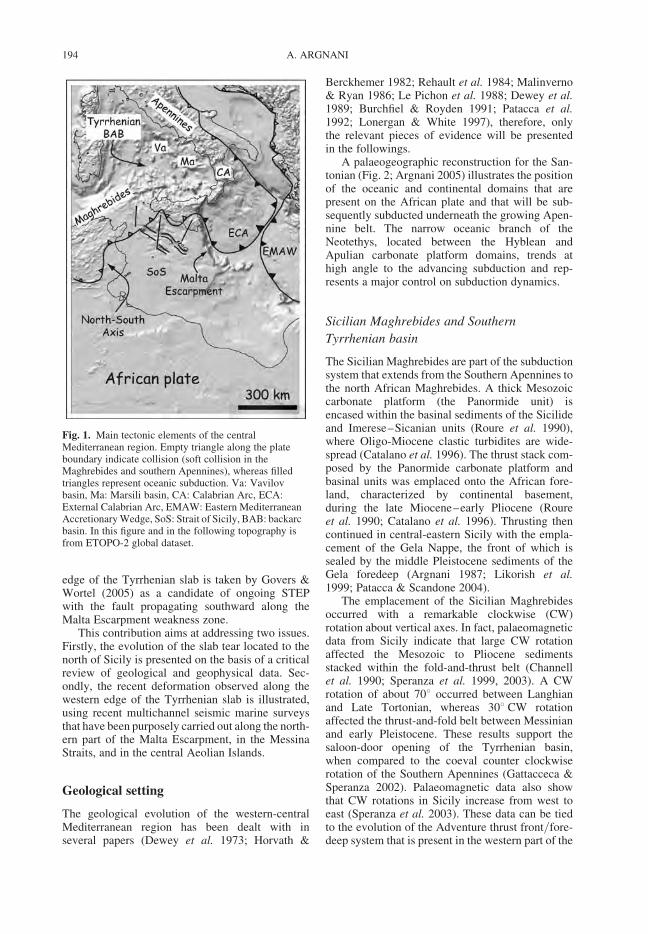
edge of the Tyrrhenian slab is taken by Govers &Wortel (2005) as a candidate of ongoing STEPwith the fault propagating southward along theMalta Escarpment weakness zone.
This contribution aims at addressing two issues.Firstly, the evolution of the slab tear located to thenorth of Sicily is presented on the basis of a criticalreview of geological and geophysical data. Sec-ondly, the recent deformation observed along thewestern edge of the Tyrrhenian slab is illustrated,using recent multichannel seismic marine surveysthat have been purposely carried out along the north-ern part of the Malta Escarpment, in the MessinaStraits, and in the central Aeolian Islands.
Geological setting
The geological evolution of the western-centralMediterranean region has been dealt with inseveral papers (Dewey et al. 1973; Horvath &
Berckhemer 1982; Rehault et al. 1984; Malinverno& Ryan 1986; Le Pichon et al. 1988; Dewey et al.1989; Burchfiel & Royden 1991; Patacca et al.1992; Lonergan & White 1997), therefore, onlythe relevant pieces of evidence will be presentedin the followings.
A palaeogeographic reconstruction for the San-tonian (Fig. 2; Argnani 2005) illustrates the positionof the oceanic and continental domains that arepresent on the African plate and that will be sub-sequently subducted underneath the growing Apen-nine belt. The narrow oceanic branch of theNeotethys, located between the Hyblean andApulian carbonate platform domains, trends athigh angle to the advancing subduction and rep-resents a major control on subduction dynamics.
Sicilian Maghrebides and Southern
Tyrrhenian basin
The Sicilian Maghrebides are part of the subductionsystem that extends from the Southern Apennines tothe north African Maghrebides. A thick Mesozoiccarbonate platform (the Panormide unit) isencased within the basinal sediments of the Sicilideand Imerese–Sicanian units (Roure et al. 1990),where Oligo-Miocene clastic turbidites are wide-spread (Catalano et al. 1996). The thrust stack com-posed by the Panormide carbonate platform andbasinal units was emplaced onto the African fore-land, characterized by continental basement,during the late Miocene–early Pliocene (Roureet al. 1990; Catalano et al. 1996). Thrusting thencontinued in central-eastern Sicily with the empla-cement of the Gela Nappe, the front of which issealed by the middle Pleistocene sediments of theGela foredeep (Argnani 1987; Likorish et al.1999; Patacca & Scandone 2004).
The emplacement of the Sicilian Maghrebidesoccurred with a remarkable clockwise (CW)rotation about vertical axes. In fact, palaeomagneticdata from Sicily indicate that large CW rotationaffected the Mesozoic to Pliocene sedimentsstacked within the fold-and-thrust belt (Channellet al. 1990; Speranza et al. 1999, 2003). A CWrotation of about 708 occurred between Langhianand Late Tortonian, whereas 308 CW rotationaffected the thrust-and-fold belt between Messinianand early Pleistocene. These results support thesaloon-door opening of the Tyrrhenian basin,when compared to the coeval counter clockwiserotation of the Southern Apennines (Gattacceca &Speranza 2002). Palaeomagnetic data also showthat CW rotations in Sicily increase from west toeast (Speranza et al. 2003). These data can be tiedto the evolution of the Adventure thrust front/fore-deep system that is present in the western part of the
Fig. 1. Main tectonic elements of the centralMediterranean region. Empty triangle along the plateboundary indicate collision (soft collision in theMaghrebides and southern Apennines), whereas filledtriangles represent oceanic subduction. Va: Vavilovbasin, Ma: Marsili basin, CA: Calabrian Arc, ECA:External Calabrian Arc, EMAW: Eastern MediterraneanAccretionary Wedge, SoS: Strait of Sicily, BAB: backarcbasin. In this figure and in the following topography isfrom ETOPO-2 global dataset.
A. ARGNANI194

Strait of Sicily (Argnani et al. 1987; Argnani1993).A CW rotation of about 708 occurred during theemplacement of the Adventure thrust stack whichended in late Tortonian, as indicated by theTortonian-early Messinian sedimentary fill of theAdventure foredeep that suffered only little defor-mation, subsequently. Thrusting continued incentral-eastern Sicily, accomplishing a CW rotationof about 308 until the early Pleistocene. Therefore,the Adventure thrust front/foredeep system allowsto constrain the position of the Tortonian plateboundary within the African plate.
The thin-crust Vavilov and Marsili sub-basins,that represent the deeper portions of the southernTyrrenian sea, are filled by 600 m thick sedimentsand are characterized by large volcanic seamounts,20–45 km long and elongated roughly north–south (Kastens et al. 1988).
The western Tyrrhenian margin shows tiltedfault blocks and its thinned crust, resembling atypical stretched passive margin. ODP stratigraphyand stratal relationships within half grabens
suggest that stretching occurred from late Tortonianto early Pliocene (Argnani & Savelli 1999). Datingsof basalts recovered in the Vavilov sub-basin fallwithin the same time interval (8 to 4 Ma), indicatingthat emplacement of MOR-type basalts occurredduring extension in the western Sardinia margin(Argnani & Savelli 1999, 2001). This extensionaltectonics was followed by some calc-alkalineactivity in the central Tyrrhenian arc and, mainly,by within-plate volcanism in Sardinia and inthe Magnaghi seamount. A second extensionalepisode led to the opening of the Marsili sub-basin.Sediments from well ODP 650 (Kastens et al. 1988),single-channel seismic profiles (Argnani & Savelli2001), and work on magnetic anomalies (Nicolosiet al. 2006) allow to infer a late Pliocene–earlyPleistocene age for the opening of the Marsilibasin. As for the Vavilov sub-basin, the stretchingin the Marsili sub-basin was followed by major cal-calkaline volcanism in the Aeolian arc and bywithin-plate activity in Sardinia and in the Tyrrhe-nian basin (Fig. 4).
Fig. 2. Palaeogeographic reconstruction for the Santonian time (modified after Argnanic 2005). The oceaniclithosphere subducted beneath the Calabrian Arc has been repositioned on the surface, resulting in a W-ward extensionof the Ionian oceanic domain, together with the Alpine Tethys oceanic lithosphere subducted underneathCorsica-Sardinia during Late Oligocene – Early Miocene. The Apennine Platform and the African platforms (Hyblean,Apulian and Dinaride) and pelagic basins of the articulated continental margin are also represented (grey pattern). Thepresent coastline of Italy is for reference and outlines the Adria promontory.
EVOLUTION OF SOUTHERN TYRRHENIAN SLAB 195
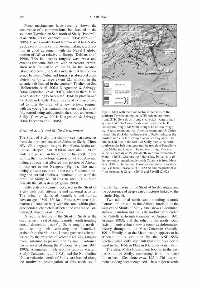
Focal mechanisms have recently shown theoccurrence of a compressional belt located in thesouthern Tyrrrhenian Sea, north of Sicily (Pondrelliet al. 2004, 2006; Vannucci et al. 2004; Neri et al.2005). P axes mostly trend North–West to NNW–SSE, except in the central Aeolian Islands, a direc-tion in good agreement with the Nuvel-1 globalmotion of Africa relative to Europe (DeMets et al.1990). This belt trends roughly wast–west andextends for some 200 km, with an eastern termin-ation near the Island of Salina, in the AeolianIsland. Moreover, GPS data indicate that the conver-gence between Nubia and Eurasia is absorbed com-pletely, or by a large extent (2.1 mm/a), in theseismic belt located in the southern Tyrrhenian Sea(Hollenstein et al. 2003; D’Agostino & Selvaggi2004; Serpelloni et al. 2007), whereas there is noactive shortening between the Hyblean plateau andthe Aeolian Islands. These pieces of evidence haveled to infer the onset of a new tectonic regime,with the young Tyrrhenian lithosphere that has poss-ibly started being subducted to the south, underneathSicily (Goes et al. 2004; D’Agostino & Selvaggi2004; Faccenna et al. 2005).
Strait of Sicily and Malta Escarpment
The Strait of Sicily is a shallow sea that stretchesfrom the northern coasts of Africa to Sicily. ThreeNW–SE elongated troughs, Pantelleria, Malta andLinosa, deeper than 1000 m and about 20 kmwide, are present in the centre of the shelf, repre-senting the morphologic expression of a continentalrifting episode that affected this portion of Africanlithosphere in the Neogene (Fig. 3). The mainrifting episode occurred in the early Pliocene, thin-ning the normal thickness continental crust of theStrait of Sicily (c. 30 km) to about 10–15 kmbeneath the rift system (Argnani 1990).
Rift-related volcanism occurred in the Strait ofSicily with both submarine and subaerial activity.The volcanic islands of Pantelleria and Linosahave an age of 300–150 ka to Present, whereas sub-marine volcanic activity with the same within-plategeochemical characters affected the area since Tor-tonian (Calanchi et al. 1989).
A peculiar feature of the Strait of Sicily is theoccurrence of a set of roughly north–south-trendingcrustal discontinuities (Fig. 3). A roughly north–south-trending belt separating the Pantelleriagraben from the Malta and Linosa grabens is charac-terized by the presence of volcanic activity, rangingfrom Tortonian to present, and by small Tortonianbasins inverted during the Pliocene (Argnani 1990,1993). Anomalies in He isotope ratio in westernSicily (Caracausi et al. 2005), and the Na-alkalineUstica volcanics, north of Sicily, are located alongthe northward prolongation of this north–south
transfer fault zone of the Strait of Sicily, suggestingthe occurrence of deep-seated fractures linked to themantle (Fig. 3).
Two additional north–south trending tectonicfeatures are present in the African foreland to thewest of the Straits of Sicily. One shows a dominantstrike-slip motion and limits the northwestern end ofthe Pantelleria trough (Gamberi & Argnani 1995;Argnani 2003), and the other is the north–southAxis of Tunisia that shows a complex deformationhistory throughout the Meso-Cenozoic (Burollet1991). Finally, also the Malta trough appears to beaffected in its evolution by the NNE–SSWScicli-Ragusa strike slip fault that continues north-ward in the Hyblean Plateau (Gardiner et al. 1995).
The steep Malta Escarpment bounds to the eastthe Strait of Sicily, connecting it to the deepIonian basin (Scandone et al. 1981). This escarp-ment has long been recognized to be a major tectonic
Fig. 3. Map with the main tectonic elements of thesouthern Tyrrhenian region. ATF: Adventure thrustfront, GTF: Gela thrust front, S-R: Scicli–Ragusa faultsystem, CW: clockwise rotation of thrust sheets, P:Pantelleria trough, M: Malta trough, L: Linosa trough,Ac: Aceste seamount, An: Anchise seamount, U: UsticaIsland. The thick dashed line north of Sicily indicates theposition of the belt of compressional earthquakes. Thethin dashed line in the Strait of Sicily marks the north–south transfer belt that separates the trough of Pantelleriafrom Malta and Linosa. The regions of high P-wavevelocity anomaly at 150 km depth are from Piromallo &Morelli (2003), whereas the field of low Pn velocity ofthe uppermost mantle underneath Calabria is from Meleet al. (1998). The area of He isotopes anomaly in westernSicily is from Caracausi et al. (2005) and magmatism isfrom Argnani & Savelli (2001) and Savelli (2002).
A. ARGNANI196
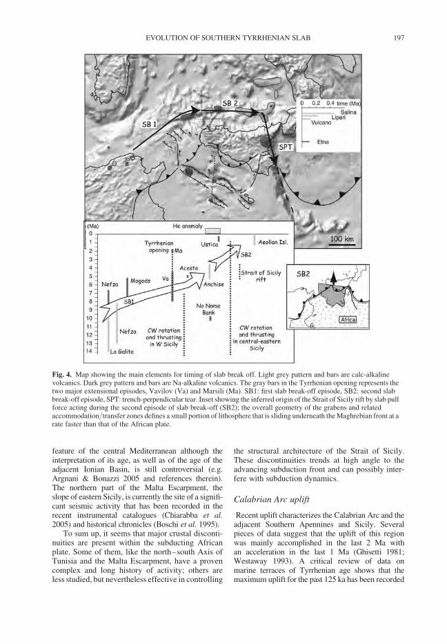
feature of the central Mediterranean although theinterpretation of its age, as well as of the age of theadjacent Ionian Basin, is still controversial (e.g.Argnani & Bonazzi 2005 and references therein).The northern part of the Malta Escarpment, theslope of eastern Sicily, is currently the site of a signifi-cant seismic activity that has been recorded in therecent instrumental catalogues (Chiarabba et al.2005) and historical chronicles (Boschi et al. 1995).
To sum up, it seems that major crustal disconti-nuities are present within the subducting Africanplate. Some of them, like the north–south Axis ofTunisia and the Malta Escarpment, have a provencomplex and long history of activity; others areless studied, but nevertheless effective in controlling
the structural architecture of the Strait of Sicily.These discontinuities trends at high angle to theadvancing subduction front and can possibly inter-fere with subduction dynamics.
Calabrian Arc uplift
Recent uplift characterizes the Calabrian Arc and theadjacent Southern Apennines and Sicily. Severalpieces of data suggest that the uplift of this regionwas mainly accomplished in the last 2 Ma withan acceleration in the last 1 Ma (Ghisetti 1981;Westaway 1993). A critical review of data onmarine terraces of Tyrrhenian age shows that themaximum uplift for the past 125 ka has been recorded
Fig. 4. Map showing the main elements for timing of slab break off. Light grey pattern and bars are calc-alkalinevolcanics. Dark grey pattern and bars are Na-alkaline volcanics. The gray bars in the Tyrrhenian opening represents thetwo major extensional episodes, Vavilov (Va) and Marsili (Ma). SB1: first slab break-off episode, SB2: second slabbreak-off episode, SPT: trench-perpendicular tear. Inset showing the inferred origin of the Strait of Sicily rift by slab pullforce acting during the second episode of slab break-off (SB2); the overall geometry of the grabens and relatedaccommodation/transfer zones defines a small portion of lithosphere that is sliding underneath the Maghrebian front at arate faster than that of the African plate.
EVOLUTION OF SOUTHERN TYRRHENIAN SLAB 197
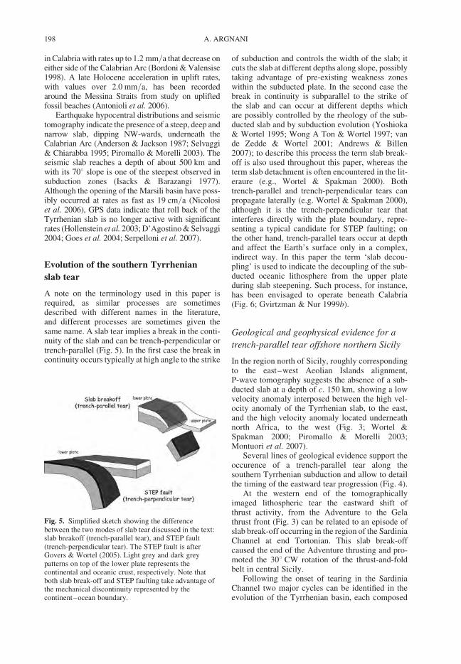
in Calabria with rates up to 1.2 mm/a that decrease oneither side of the Calabrian Arc (Bordoni & Valensise1998). A late Holocene acceleration in uplift rates,with values over 2.0 mm/a, has been recordedaround the Messina Straits from study on upliftedfossil beaches (Antonioli et al. 2006).
Earthquake hypocentral distributions and seismictomography indicate the presence of a steep, deep andnarrow slab, dipping NW-wards, underneath theCalabrian Arc (Anderson & Jackson 1987; Selvaggi& Chiarabba 1995; Piromallo & Morelli 2003). Theseismic slab reaches a depth of about 500 km andwith its 708 slope is one of the steepest observed insubduction zones (Isacks & Barazangi 1977).Although the opening of the Marsili basin have poss-ibly occurred at rates as fast as 19 cm/a (Nicolosiet al. 2006), GPS data indicate that roll back of theTyrrhenian slab is no longer active with significantrates (Hollenstein et al. 2003; D’Agostino & Selvaggi2004; Goes et al. 2004; Serpelloni et al. 2007).
Evolution of the southern Tyrrhenian
slab tear
A note on the terminology used in this paper isrequired, as similar processes are sometimesdescribed with different names in the literature,and different processes are sometimes given thesame name. A slab tear implies a break in the conti-nuity of the slab and can be trench-perpendicular ortrench-parallel (Fig. 5). In the first case the break incontinuity occurs typically at high angle to the strike
of subduction and controls the width of the slab; itcuts the slab at different depths along slope, possiblytaking advantage of pre-existing weakness zoneswithin the subducted plate. In the second case thebreak in continuity is subparallel to the strike ofthe slab and can occur at different depths whichare possibly controlled by the rheology of the sub-ducted slab and by subduction evolution (Yoshioka& Wortel 1995; Wong A Ton & Wortel 1997; vande Zedde & Wortel 2001; Andrews & Billen2007); to describe this process the term slab break-off is also used throughout this paper, whereas theterm slab detachment is often encountered in the lit-eraure (e.g., Wortel & Spakman 2000). Bothtrench-parallel and trench-perpendicular tears canpropagate laterally (e.g. Wortel & Spakman 2000),although it is the trench-perpendicular tear thatinterferes directly with the plate boundary, repre-senting a typical candidate for STEP faulting; onthe other hand, trench-parallel tears occur at depthand affect the Earth’s surface only in a complex,indirect way. In this paper the term ‘slab decou-pling’ is used to indicate the decoupling of the sub-ducted oceanic lithosphere from the upper plateduring slab steepening. Such process, for instance,has been envisaged to operate beneath Calabria(Fig. 6; Gvirtzman & Nur 1999b).
Geological and geophysical evidence for a
trench-parallel tear offshore northern Sicily
In the region north of Sicily, roughly correspondingto the east–west Aeolian Islands alignment,P-wave tomography suggests the absence of a sub-ducted slab at a depth of c. 150 km, showing a lowvelocity anomaly interposed between the high vel-ocity anomaly of the Tyrrhenian slab, to the east,and the high velocity anomaly located underneathnorth Africa, to the west (Fig. 3; Wortel &Spakman 2000; Piromallo & Morelli 2003;Montuori et al. 2007).
Several lines of geological evidence support theoccurence of a trench-parallel tear along thesouthern Tyrrhenian subduction and allow to detailthe timing of the eastward tear progression (Fig. 4).
At the western end of the tomographicallyimaged lithospheric tear the eastward shift ofthrust activity, from the Adventure to the Gelathrust front (Fig. 3) can be related to an episode ofslab break-off occurring in the region of the SardiniaChannel at end Tortonian. This slab break-offcaused the end of the Adventure thrusting and pro-moted the 308 CW rotation of the thrust-and-foldbelt in central Sicily.
Following the onset of tearing in the SardiniaChannel two major cycles can be identified in theevolution of the Tyrrhenian basin, each composed
Fig. 5. Simplified sketch showing the differencebetween the two modes of slab tear discussed in the text:slab breakoff (trench-parallel tear), and STEP fault(trench-perpendicular tear). The STEP fault is afterGovers & Wortel (2005). Light grey and dark greypatterns on top of the lower plate represents thecontinental and oceanic crust, respectively. Note thatboth slab break-off and STEP faulting take advantage ofthe mechanical discontinuity represented by thecontinent–ocean boundary.
A. ARGNANI198
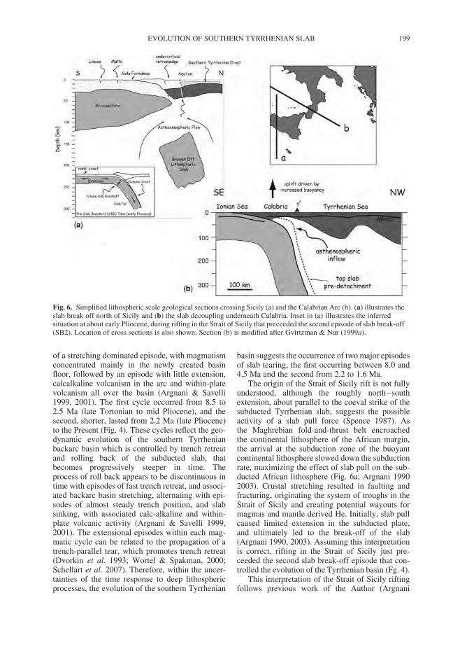
of a stretching dominated episode, with magmatismconcentrated mainly in the newly created basinfloor, followed by an episode with little extension,calcalkaline volcanism in the arc and within-platevolcanism all over the basin (Argnani & Savelli1999, 2001). The first cycle occurred from 8.5 to2.5 Ma (late Tortonian to mid Pliocene), and thesecond, shorter, lasted from 2.2 Ma (late Pliocene)to the Present (Fig. 4). These cycles reflect the geo-dynamic evolution of the southern Tyrrhenianbackarc basin which is controlled by trench retreatand rolling back of the subducted slab, thatbecomes progressively steeper in time. Theprocess of roll back appears to be discontinuous intime with episodes of fast trench retreat, and associ-ated backarc basin stretching, alternating with epi-sodes of almost steady trench position, and slabsinking, with associated calc-alkaline and within-plate volcanic activity (Argnani & Savelli 1999,2001). The extensional episodes within each mag-matic cycle can be related to the propagation of atrench-parallel tear, which promotes trench retreat(Dvorkin et al. 1993; Wortel & Spakman, 2000;Schellart et al. 2007). Therefore, within the uncer-tainties of the time response to deep lithosphericprocesses, the evolution of the southern Tyrrhenian
basin suggests the occurrence of two major episodesof slab tearing, the first occurring between 8.0 and4.5 Ma and the second from 2.2 to 1.6 Ma.
The origin of the Strait of Sicily rift is not fullyunderstood, although the roughly north–southextension, about parallel to the coeval strike of thesubducted Tyrrhenian slab, suggests the possibleactivity of a slab pull force (Spence 1987). Asthe Maghrebian fold-and-thrust belt encroachedthe continental lithosphere of the African margin,the arrival at the subduction zone of the buoyantcontinental lithosphere slowed down the subductionrate, maximizing the effect of slab pull on the sub-ducted African lithosphere (Fig. 6a; Argnani 19902003). Crustal stretching resulted in faulting andfracturing, originating the system of troughs in theStrait of Sicily and creating potential wayouts formagmas and mantle derived He. Initially, slab pullcaused limited extension in the subducted plate,and ultimately led to the break-off of the slab(Argnani 1990, 2003). Assuming this interpretationis correct, rifting in the Strait of Sicily just pre-ceeded the second slab break-off episode that con-trolled the evolution of the Tyrrhenian basin (Fg. 4).
This interpretation of the Strait of Sicily riftingfollows previous work of the Author (Argnani
Fig. 6. Simplified lithospheric scale geological sections crossing Sicily (a) and the Calabrian Arc (b). (a) illustrates theslab break off north of Sicily and (b) the slab decoupling underneath Calabria. Inset in (a) illustrates the inferredsituation at about early Pliocene, during rifting in the Strait of Sicily that preceeded the second episode of slab break-off(SB2). Location of cross sections is also shown. Section (b) is modified after Gvirtzman & Nur (1999a).
EVOLUTION OF SOUTHERN TYRRHENIAN SLAB 199
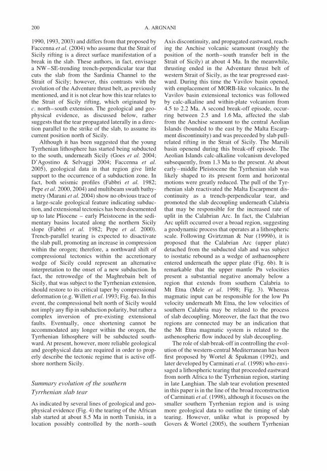
1990, 1993, 2003) and differs from that proposed byFaccenna et al. (2004) who assume that the Strait ofSicily rifting is a direct surface manifestation of abreak in the slab. These authors, in fact, envisagea NW–SE-trending trench-perpendicular tear thatcuts the slab from the Sardinia Channel to theStrait of Sicily; however, this contrasts with theevolution of the Adventure thrust belt, as previouslymentioned, and it is not clear how this tear relates tothe Strait of Sicily rifting, which originated byc. north–south extension. The geological and geo-physical evidence, as discussed below, rathersuggests that the tear propagated laterally in a direc-tion parallel to the strike of the slab, to assume itscurrent position north of Sicily.
Although it has been suggested that the youngTyrrhenian lithosphere has started being subductedto the south, underneath Sicily (Goes et al. 2004;D’Agostino & Selvaggi 2004; Faccenna et al.2005), geological data in that region give littlesupport to the occurrence of a subduction zone. Infact, both seismic profiles (Fabbri et al. 1982;Pepe et al. 2000, 2004) and multibeam swath bathy-metry (Marani et al. 2004) show no obvious trace ofa large-scale geological feature indicating subduc-tion, and extensional tectonics has been documentedup to late Pliocene – early Pleistocene in the sedi-mentary basins located along the northern Sicilyslope (Fabbri et al. 1982; Pepe et al. 2000).Trench-parallel tearing is expected to disactivatethe slab pull, promoting an increase in compressionwithin the orogen; therefore, a northward shift ofcompressional tectonics within the accretionarywedge of Sicily could represent an alternativeinterpretation to the onset of a new subduction. Infact, the retrowedge of the Maghrebain belt ofSicily, that was subject to the Tyrrhenian extension,should restore to its critical taper by compressionaldeformation (e.g. Willett et al. 1993; Fig. 6a). In thisevent, the compressional belt north of Sicily wouldnot imply any flip in subduction polarity, but rather acomplex inversion of pre-existing extensionalfaults. Eventually, once shortening cannot beaccommodated any longer within the orogen, theTyrrhenian lithosphere will be subducted south-ward. At present, however, more reliable geologicaland geophysical data are required in order to prop-erly describe the tectonic regime that is active off-shore northern Sicily.
Summary evolution of the southern
Tyrrhenian slab tear
As indicated by several lines of geological and geo-physical evidence (Fig. 4) the tearing of the Africanslab started at about 8.5 Ma in north Tunisia, in alocation possibly controlled by the north–south
Axis discontinuity, and propagated eastward, reach-ing the Anchise volcanic seamount (roughly theposition of the north–south transfer belt in theStrait of Sicily) at about 4 Ma. In the meanwhile,thrusting ended in the Adventure thrust belt ofwestern Strait of Sicily, as the tear progressed east-ward. During this time the Vavilov basin opened,with emplacement of MORB-like volcanics. In theVavilov basin extensional tectonics was followedby calc-alkaline and within-plate volcanism from4.5 to 2.2 Ma. A second break-off episode, occur-ring between 2.5 and 1.6 Ma, affected the slabfrom the Anchise seamount to the central AeolianIslands (bounded to the east by the Malta Escarp-ment discontinuity) and was preceeded by slab pull-related rifting in the Strait of Sicily. The Marsilibasin openend during this break-off episode. TheAeolian Islands calc-alkaline volcanism developedsubsequently, from 1.3 Ma to the present. At aboutearly–middle Pleistocene the Tyrrhenian slab waslikely shaped to its present form and horizontalmotions were greatly reduced. The pull of the Tyr-rhenian slab reactivated the Malta Escarpment dis-continuity as a trench-perpendicular tear, andpromoted the slab decoupling underneath Calabriathat may be responsible for the increased rate ofuplit in the Calabrian Arc. In fact, the CalabrianArc uplift occurred over a broad region, suggestinga geodynamic process that operates at a lithosphericscale. Following Gvirtzman & Nur (1999b), it isproposed that the Calabrian Arc (upper plate)detached from the subducted slab and was subjectto isostatic rebound as a wedge of asthaenosphereentered underneath the upper plate (Fig. 6b). It isremarkable that the upper mantle Pn velocitiespresent a substantial negative anomaly below aregion that extends from southern Calabria toMt Etna (Mele et al. 1998; Fig. 3). Whereasmagmatic input can be responsible for the low Pnvelocity underneath Mt Etna, the low velocities ofsouthern Calabria may be related to the processof slab decoupling. Moreover, the fact that the tworegions are connected may be an indication thatthe Mt Etna magmatic system is related to theasthenospheric flow induced by slab decoupling.
The role of slab break-off in controlling the evol-ution of the western-central Mediterranean has beenfirst proposed by Wortel & Spakman (1992), andlater developed by Carminati et al. (1998) who envi-saged a lithospheric tearing that proceeded eastwardfrom north Africa to the Tyrrhenian region, startingin late Langhian. The slab tear evolution presentedin this paper is in the line of the broad reconstructionof Carminati et al. (1998), although it focuses on thesmaller southern Tyrrhenian region and is usingmore geological data to outline the timing of slabtearing. However, unlike what is proposed byGovers & Wortel (2005), the southern Tyrrhenian
A. ARGNANI200
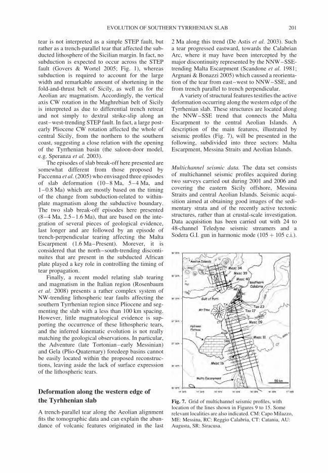
tear is not interpreted as a simple STEP fault, butrather as a trench-parallel tear that affected the sub-ducted lithosphere of the Sicilian margin. In fact, nosubduction is expected to occur across the STEPfault (Govers & Wortel 2005; Fig. 1), whereassubduction is required to account for the largewidth and remarkable amount of shortening in thefold-and-thrust belt of Sicily, as well as for theAeolian arc magmatism. Accordingly, the verticalaxis CW rotation in the Maghrebian belt of Sicilyis interpreted as due to differential trench retreatand not simply to dextral strike-slip along aneast–west-trending STEP fault. In fact, a large post-early Pliocene CW rotation affected the whole ofcentral Sicily, from the northern to the southerncoast, suggesting a close relation with the openingof the Tyrrhenian basin (the saloon-door model,e.g. Speranza et al. 2003).
The episodes of slab break-off here presented aresomewhat different from those proposed byFaccenna et al. (2005) who envisaged three episodesof slab deformation (10–8 Ma, 5–4 Ma, and1–0.8 Ma) which are mostly based on the timingof the change from subduction-related to within-plate magmatism along the subductive boundary.The two slab break-off episodes here presented(8–4 Ma, 2.5–1.6 Ma), that are based on the inte-gration of several pieces of geological evidence,last longer and are followed by an episode oftrench-perpendicular tearing affecting the MaltaEscarpment (1.6 Ma–Present). Morever, it isconsidered that the north–south-trending disconti-nuites that are present in the subducted Africanplate played a key role in controlling the timing oftear propagation.
Finally, a recent model relating slab tearingand magmatism in the Italian region (Rosenbaumet al. 2008) presents a rather complex system ofNW-trending lithospheric tear faults affecting thesouthern Tyrrhenian region since Pliocene and seg-menting the slab with a less than 100 km spacing.However, little magmatological evidence is sup-porting the occurrence of these lithospheric tears,and the inferred kinematic evolution is not reallymatching the geological observations. In particular,the Adventure (late Tortonian–early Messinian)and Gela (Plio-Quaternary) foredeep basins cannotbe easily located within the proposed reconstruc-tions, leaving aside the lack of surface expressionof the lithospheric tears.
Deformation along the western edge of
the Tyrhhenian slab
A trench-parallel tear along the Aeolian alignmentfits the tomographic data and can explain the abun-dance of volcanic features originated in the last
2 Ma along this trend (De Astis et al. 2003). Sucha tear progressed eastward, towards the CalabrianArc, where it may have been intercepted by themajor discontinuity represented by the NNW–SSE-trending Malta Escarpment (Scandone et al. 1981;Argnani & Bonazzi 2005) which caused a reorienta-tion of the tear from east–west to NNW–SSE, andfrom trench parallel to trench perpendicular.
A variety of structural features testifies the activedeformation occurring along the western edge of theTyrrhenian slab. These structures are located alongthe NNW–SSE trend that connects the MaltaEscarpment to the central Aeolian Islands. Adescription of the main features, illustrated byseismic profiles (Fig. 7), will be presented in thefollowing, subdivided into three sectors: MaltaEscarpment, Messina Straits and Aeolian Islands.
Multichannel seismic data. The data set consistsof multichannel seismic profiles acquired duringtwo surveys carried out during 2001 and 2006 andcovering the eastern Sicily offshore, MessinaStraits and central Aeolian Islands. Seismic acqui-sition aimed at obtaining good images of the sedi-mentary strata and of the recently active tectonicstructures, rather than at crustal-scale investigation.Data acquisition has been carried out with 24 to48-channel Teledyne seismic streamers and aSodera G.I. gun in harmonic mode (105þ 105 c.i.).
Fig. 7. Grid of multichannel seismic profiles, withlocation of the lines shown in Figures 9 to 15. Somerelevant localities are also indicated. CM: Capo Milazzo,ME: Messina, RC: Reggio Calabria, CT: Catania, AU:Augusta, SR: Siracusa.
EVOLUTION OF SOUTHERN TYRRHENIAN SLAB 201
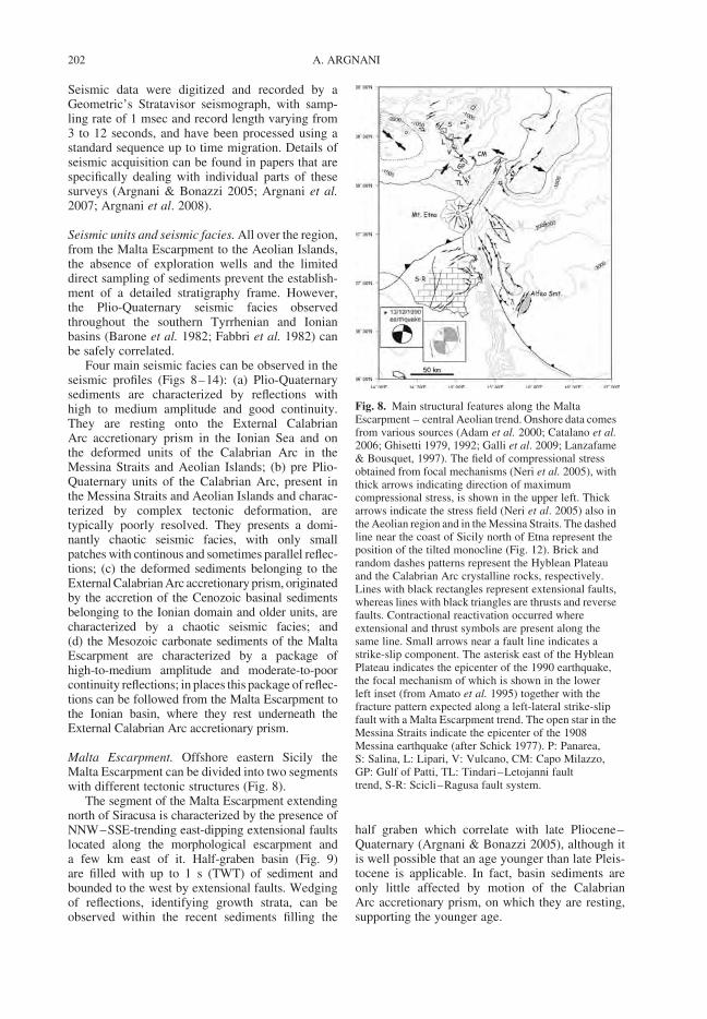
Seismic data were digitized and recorded by aGeometric’s Stratavisor seismograph, with samp-ling rate of 1 msec and record length varying from3 to 12 seconds, and have been processed using astandard sequence up to time migration. Details ofseismic acquisition can be found in papers that arespecifically dealing with individual parts of thesesurveys (Argnani & Bonazzi 2005; Argnani et al.2007; Argnani et al. 2008).
Seismic units and seismic facies. All over the region,from the Malta Escarpment to the Aeolian Islands,the absence of exploration wells and the limiteddirect sampling of sediments prevent the establish-ment of a detailed stratigraphy frame. However,the Plio-Quaternary seismic facies observedthroughout the southern Tyrrhenian and Ionianbasins (Barone et al. 1982; Fabbri et al. 1982) canbe safely correlated.
Four main seismic facies can be observed in theseismic profiles (Figs 8–14): (a) Plio-Quaternarysediments are characterized by reflections withhigh to medium amplitude and good continuity.They are resting onto the External CalabrianArc accretionary prism in the Ionian Sea and onthe deformed units of the Calabrian Arc in theMessina Straits and Aeolian Islands; (b) pre Plio-Quaternary units of the Calabrian Arc, present inthe Messina Straits and Aeolian Islands and charac-terized by complex tectonic deformation, aretypically poorly resolved. They presents a domi-nantly chaotic seismic facies, with only smallpatches with continous and sometimes parallel reflec-tions; (c) the deformed sediments belonging to theExternal Calabrian Arc accretionary prism, originatedby the accretion of the Cenozoic basinal sedimentsbelonging to the Ionian domain and older units, arecharacterized by a chaotic seismic facies; and(d) the Mesozoic carbonate sediments of the MaltaEscarpment are characterized by a package ofhigh-to-medium amplitude and moderate-to-poorcontinuity reflections; in places this package of reflec-tions can be followed from the Malta Escarpment tothe Ionian basin, where they rest underneath theExternal Calabrian Arc accretionary prism.
Malta Escarpment. Offshore eastern Sicily theMalta Escarpment can be divided into two segmentswith different tectonic structures (Fig. 8).
The segment of the Malta Escarpment extendingnorth of Siracusa is characterized by the presence ofNNW–SSE-trending east-dipping extensional faultslocated along the morphological escarpment anda few km east of it. Half-graben basin (Fig. 9)are filled with up to 1 s (TWT) of sediment andbounded to the west by extensional faults. Wedgingof reflections, identifying growth strata, can beobserved within the recent sediments filling the
half graben which correlate with late Pliocene–Quaternary (Argnani & Bonazzi 2005), although itis well possible that an age younger than late Pleis-tocene is applicable. In fact, basin sediments areonly little affected by motion of the CalabrianArc accretionary prism, on which they are resting,supporting the younger age.
Fig. 8. Main structural features along the MaltaEscarpment – central Aeolian trend. Onshore data comesfrom various sources (Adam et al. 2000; Catalano et al.2006; Ghisetti 1979, 1992; Galli et al. 2009; Lanzafame& Bousquet, 1997). The field of compressional stressobtained from focal mechanisms (Neri et al. 2005), withthick arrows indicating direction of maximumcompressional stress, is shown in the upper left. Thickarrows indicate the stress field (Neri et al. 2005) also inthe Aeolian region and in the Messina Straits. The dashedline near the coast of Sicily north of Etna represent theposition of the tilted monocline (Fig. 12). Brick andrandom dashes patterns represent the Hyblean Plateauand the Calabrian Arc crystalline rocks, respectively.Lines with black rectangles represent extensional faults,whereas lines with black triangles are thrusts and reversefaults. Contractional reactivation occurred whereextensional and thrust symbols are present along thesame line. Small arrows near a fault line indicates astrike-slip component. The asterisk east of the HybleanPlateau indicates the epicenter of the 1990 earthquake,the focal mechanism of which is shown in the lowerleft inset (from Amato et al. 1995) together with thefracture pattern expected along a left-lateral strike-slipfault with a Malta Escarpment trend. The open star in theMessina Straits indicate the epicenter of the 1908Messina earthquake (after Schick 1977). P: Panarea,S: Salina, L: Lipari, V: Vulcano, CM: Capo Milazzo,GP: Gulf of Patti, TL: Tindari–Letojanni faulttrend, S-R: Scicli–Ragusa fault system.
A. ARGNANI202
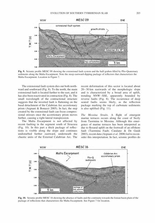
The extensional fault system dies out both north-ward and southward (Fig. 8). To the north, the mainextensional fault is located further to the east, and ithas also been reactivated in contraction (Fig. 8). Thesmall wavelength of the contractional structuresuggests that the inverted fault is flattening on thebasal detachment of the Calabrian Arc accretionaryprism (Argnani & Bonazzi 2005). In fact, the stepcreated by the extensional fault can focus compres-sional stresses once the accretionary prism movesfurther, causing a right-lateral transpression.
The Malta Escarpment is not affected byrecent faulting in the segment south of Siracusa(Fig. 10). In this part a thick package of reflec-tions is visible along the slope and continuesundisturbed further eastward, underneath thechaotic units of the External Calabrian Arc. The
recent deformation of this sector is located about20–30 km eastwards of the morphologic slopeand is characterized by a broad area of uplift,trending NNW–SSE, apparently bounded byreverse faults (Fig. 8). The occurrence of deepseated faults seems likely, as the reflectionpackage marking the top of carbonate sedimentsis also uplifted (Fig. 11).
The Messina Straits. A flight of emergentmarine terraces occurs along the coast of Sicilyfrom Taormina to Messina. Although this emer-gence of marine terraces has been interpreted asdue to flexural uplift on the footwall of an offshorefault (Taormina Fault; Catalano & De Guidi2003), recent data (Argnani et al. 2008) led to recon-sider this interpretation. In fact, seismic profiles do
Fig. 9. Seismic profile MESC 09 showing the extensional fault system and the half-graben filled by Plio-Quaternarysediments along the Malta Escarpment. Note the steep eastward-dipping package of reflectors that characterizes theMalta Escarpment. Location in Figure 7.
Fig. 10. Seismic profile MESC 16 showing the absence of faults and the continuity towards the Ionian basin plain of thepackage of reflections that characterizes the Malta Escarpment. See Figure 7 for location.
EVOLUTION OF SOUTHERN TYRRHENIAN SLAB 203
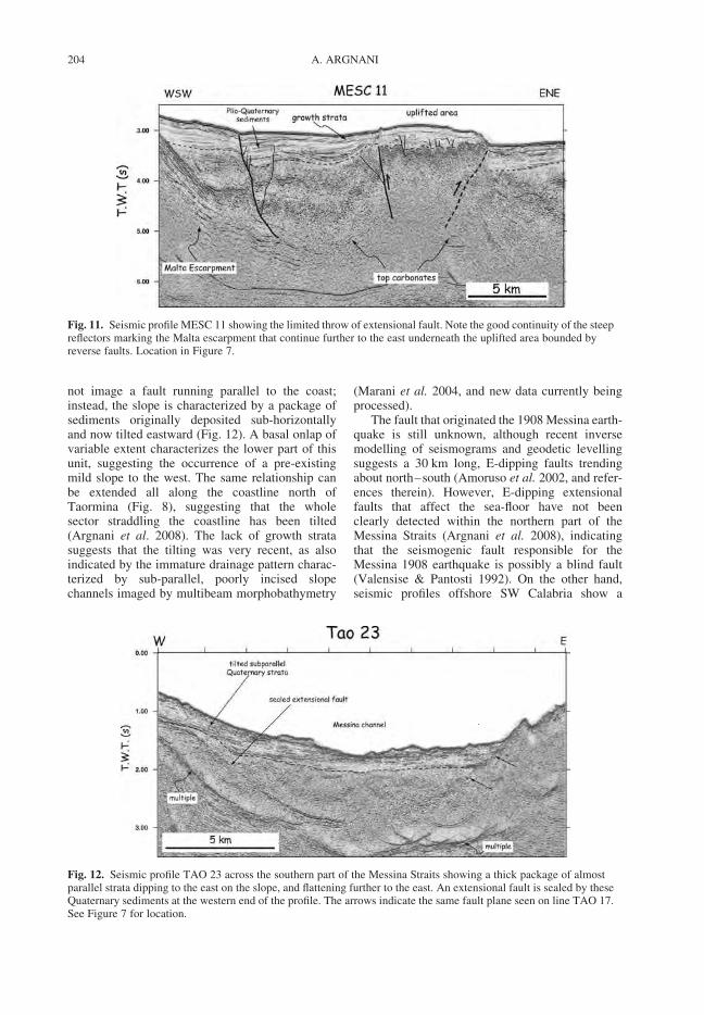
not image a fault running parallel to the coast;instead, the slope is characterized by a package ofsediments originally deposited sub-horizontallyand now tilted eastward (Fig. 12). A basal onlap ofvariable extent characterizes the lower part of thisunit, suggesting the occurrence of a pre-existingmild slope to the west. The same relationship canbe extended all along the coastline north ofTaormina (Fig. 8), suggesting that the wholesector straddling the coastline has been tilted(Argnani et al. 2008). The lack of growth stratasuggests that the tilting was very recent, as alsoindicated by the immature drainage pattern charac-terized by sub-parallel, poorly incised slopechannels imaged by multibeam morphobathymetry
(Marani et al. 2004, and new data currently beingprocessed).
The fault that originated the 1908 Messina earth-quake is still unknown, although recent inversemodelling of seismograms and geodetic levellingsuggests a 30 km long, E-dipping faults trendingabout north–south (Amoruso et al. 2002, and refer-ences therein). However, E-dipping extensionalfaults that affect the sea-floor have not beenclearly detected within the northern part of theMessina Straits (Argnani et al. 2008), indicatingthat the seismogenic fault responsible for theMessina 1908 earthquake is possibly a blind fault(Valensise & Pantosti 1992). On the other hand,seismic profiles offshore SW Calabria show a
Fig. 12. Seismic profile TAO 23 across the southern part of the Messina Straits showing a thick package of almostparallel strata dipping to the east on the slope, and flattening further to the east. An extensional fault is sealed by theseQuaternary sediments at the western end of the profile. The arrows indicate the same fault plane seen on line TAO 17.See Figure 7 for location.
Fig. 11. Seismic profile MESC 11 showing the limited throw of extensional fault. Note the good continuity of the steepreflectors marking the Malta escarpment that continue further to the east underneath the uplifted area bounded byreverse faults. Location in Figure 7.
A. ARGNANI204
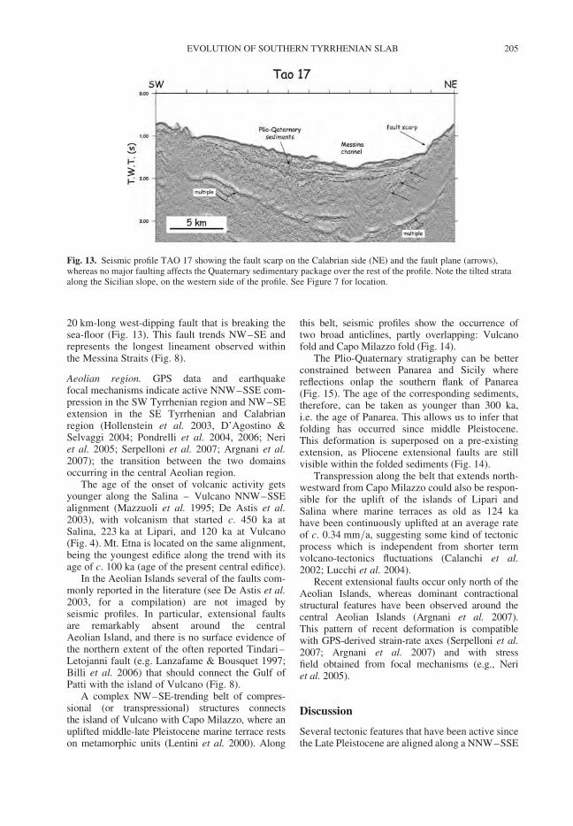
20 km-long west-dipping fault that is breaking thesea-floor (Fig. 13). This fault trends NW–SE andrepresents the longest lineament observed withinthe Messina Straits (Fig. 8).
Aeolian region. GPS data and earthquakefocal mechanisms indicate active NNW–SSE com-pression in the SW Tyrrhenian region and NW–SEextension in the SE Tyrrhenian and Calabrianregion (Hollenstein et al. 2003, D’Agostino &Selvaggi 2004; Pondrelli et al. 2004, 2006; Neriet al. 2005; Serpelloni et al. 2007; Argnani et al.2007); the transition between the two domainsoccurring in the central Aeolian region.
The age of the onset of volcanic activity getsyounger along the Salina – Vulcano NNW–SSEalignment (Mazzuoli et al. 1995; De Astis et al.2003), with volcanism that started c. 450 ka atSalina, 223 ka at Lipari, and 120 ka at Vulcano(Fig. 4). Mt. Etna is located on the same alignment,being the youngest edifice along the trend with itsage of c. 100 ka (age of the present central edifice).
In the Aeolian Islands several of the faults com-monly reported in the literature (see De Astis et al.2003, for a compilation) are not imaged byseismic profiles. In particular, extensional faultsare remarkably absent around the centralAeolian Island, and there is no surface evidence ofthe northern extent of the often reported Tindari–Letojanni fault (e.g. Lanzafame & Bousquet 1997;Billi et al. 2006) that should connect the Gulf ofPatti with the island of Vulcano (Fig. 8).
A complex NW–SE-trending belt of compres-sional (or transpressional) structures connectsthe island of Vulcano with Capo Milazzo, where anuplifted middle-late Pleistocene marine terrace restson metamorphic units (Lentini et al. 2000). Along
this belt, seismic profiles show the occurrence oftwo broad anticlines, partly overlapping: Vulcanofold and Capo Milazzo fold (Fig. 14).
The Plio-Quaternary stratigraphy can be betterconstrained between Panarea and Sicily wherereflections onlap the southern flank of Panarea(Fig. 15). The age of the corresponding sediments,therefore, can be taken as younger than 300 ka,i.e. the age of Panarea. This allows us to infer thatfolding has occurred since middle Pleistocene.This deformation is superposed on a pre-existingextension, as Pliocene extensional faults are stillvisible within the folded sediments (Fig. 14).
Transpression along the belt that extends north-westward from Capo Milazzo could also be respon-sible for the uplift of the islands of Lipari andSalina where marine terraces as old as 124 kahave been continuously uplifted at an average rateof c. 0.34 mm/a, suggesting some kind of tectonicprocess which is independent from shorter termvolcano-tectonics fluctuations (Calanchi et al.2002; Lucchi et al. 2004).
Recent extensional faults occur only north of theAeolian Islands, whereas dominant contractionalstructural features have been observed around thecentral Aeolian Islands (Argnani et al. 2007).This pattern of recent deformation is compatiblewith GPS-derived strain-rate axes (Serpelloni et al.2007; Argnani et al. 2007) and with stressfield obtained from focal mechanisms (e.g., Neriet al. 2005).
Discussion
Several tectonic features that have been active sincethe Late Pleistocene are aligned along a NNW–SSE
Fig. 13. Seismic profile TAO 17 showing the fault scarp on the Calabrian side (NE) and the fault plane (arrows),whereas no major faulting affects the Quaternary sedimentary package over the rest of the profile. Note the tilted strataalong the Sicilian slope, on the western side of the profile. See Figure 7 for location.
EVOLUTION OF SOUTHERN TYRRHENIAN SLAB 205
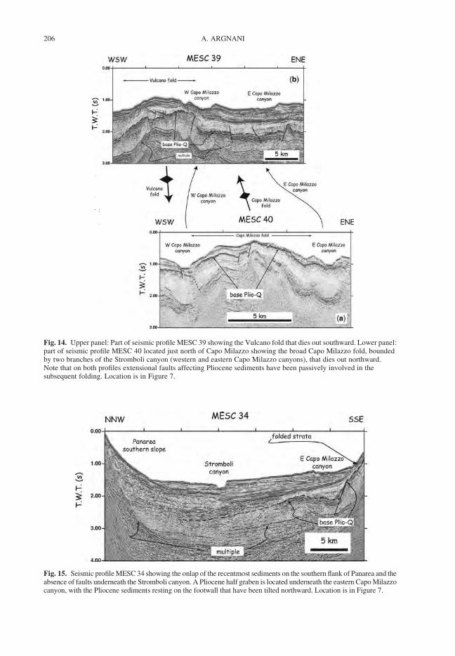
Fig. 15. Seismic profile MESC 34 showing the onlap of the recentmost sediments on the southern flank of Panarea and theabsence of faults underneath the Stromboli canyon. A Pliocene half graben is located underneath the eastern Capo Milazzocanyon, with the Pliocene sediments resting on the footwall that have been tilted northward. Location is in Figure 7.
Fig. 14. Upper panel: Part of seismic profile MESC 39 showing the Vulcano fold that dies out southward. Lower panel:part of seismic profile MESC 40 located just north of Capo Milazzo showing the broad Capo Milazzo fold, boundedby two branches of the Stromboli canyon (western and eastern Capo Milazzo canyons), that dies out northward.Note that on both profiles extensional faults affecting Pliocene sediments have been passively involved in thesubsequent folding. Location is in Figure 7.
A. ARGNANI206
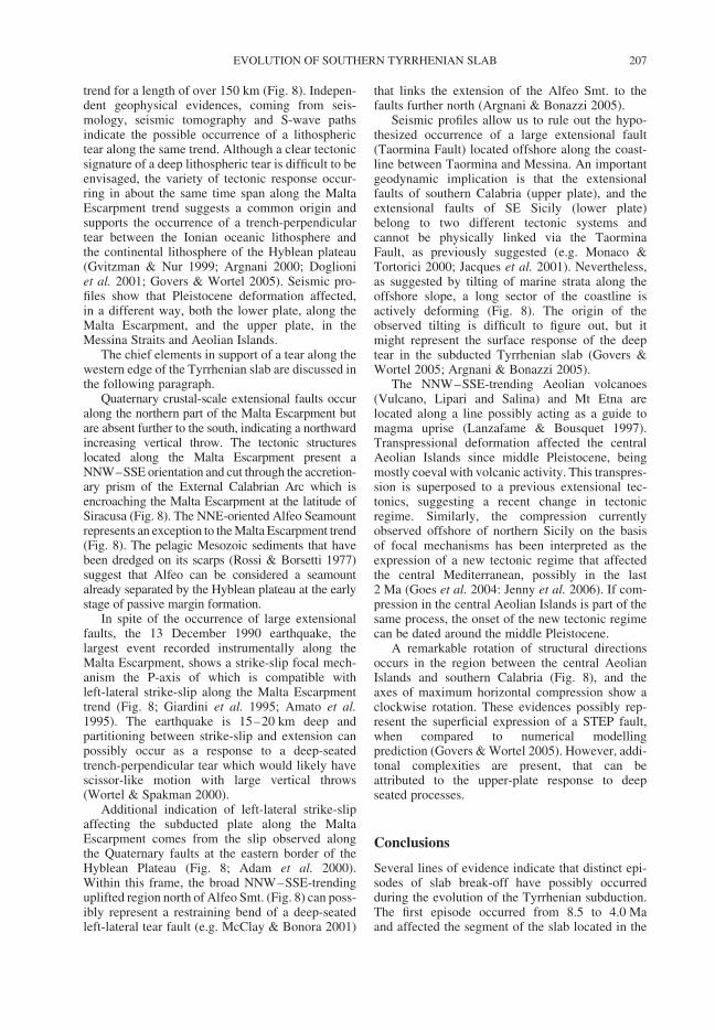
trend for a length of over 150 km (Fig. 8). Indepen-dent geophysical evidences, coming from seis-mology, seismic tomography and S-wave pathsindicate the possible occurrence of a lithospherictear along the same trend. Although a clear tectonicsignature of a deep lithospheric tear is difficult to beenvisaged, the variety of tectonic response occur-ring in about the same time span along the MaltaEscarpment trend suggests a common origin andsupports the occurrence of a trench-perpendiculartear between the Ionian oceanic lithosphere andthe continental lithosphere of the Hyblean plateau(Gvitzman & Nur 1999; Argnani 2000; Doglioniet al. 2001; Govers & Wortel 2005). Seismic pro-files show that Pleistocene deformation affected,in a different way, both the lower plate, along theMalta Escarpment, and the upper plate, in theMessina Straits and Aeolian Islands.
The chief elements in support of a tear along thewestern edge of the Tyrrhenian slab are discussed inthe following paragraph.
Quaternary crustal-scale extensional faults occuralong the northern part of the Malta Escarpment butare absent further to the south, indicating a northwardincreasing vertical throw. The tectonic structureslocated along the Malta Escarpment present aNNW–SSE orientation and cut through the accretion-ary prism of the External Calabrian Arc which isencroaching the Malta Escarpment at the latitude ofSiracusa (Fig. 8). The NNE-oriented Alfeo Seamountrepresents an exception to the Malta Escarpment trend(Fig. 8). The pelagic Mesozoic sediments that havebeen dredged on its scarps (Rossi & Borsetti 1977)suggest that Alfeo can be considered a seamountalready separated by the Hyblean plateau at the earlystage of passive margin formation.
In spite of the occurrence of large extensionalfaults, the 13 December 1990 earthquake, thelargest event recorded instrumentally along theMalta Escarpment, shows a strike-slip focal mech-anism the P-axis of which is compatible withleft-lateral strike-slip along the Malta Escarpmenttrend (Fig. 8; Giardini et al. 1995; Amato et al.1995). The earthquake is 15–20 km deep andpartitioning between strike-slip and extension canpossibly occur as a response to a deep-seatedtrench-perpendicular tear which would likely havescissor-like motion with large vertical throws(Wortel & Spakman 2000).
Additional indication of left-lateral strike-slipaffecting the subducted plate along the MaltaEscarpment comes from the slip observed alongthe Quaternary faults at the eastern border of theHyblean Plateau (Fig. 8; Adam et al. 2000).Within this frame, the broad NNW–SSE-trendinguplifted region north of Alfeo Smt. (Fig. 8) can poss-ibly represent a restraining bend of a deep-seatedleft-lateral tear fault (e.g. McClay & Bonora 2001)
that links the extension of the Alfeo Smt. to thefaults further north (Argnani & Bonazzi 2005).
Seismic profiles allow us to rule out the hypo-thesized occurrence of a large extensional fault(Taormina Fault) located offshore along the coast-line between Taormina and Messina. An importantgeodynamic implication is that the extensionalfaults of southern Calabria (upper plate), and theextensional faults of SE Sicily (lower plate)belong to two different tectonic systems andcannot be physically linked via the TaorminaFault, as previously suggested (e.g. Monaco &Tortorici 2000; Jacques et al. 2001). Nevertheless,as suggested by tilting of marine strata along theoffshore slope, a long sector of the coastline isactively deforming (Fig. 8). The origin of theobserved tilting is difficult to figure out, but itmight represent the surface response of the deeptear in the subducted Tyrrhenian slab (Govers &Wortel 2005; Argnani & Bonazzi 2005).
The NNW–SSE-trending Aeolian volcanoes(Vulcano, Lipari and Salina) and Mt Etna arelocated along a line possibly acting as a guide tomagma uprise (Lanzafame & Bousquet 1997).Transpressional deformation affected the centralAeolian Islands since middle Pleistocene, beingmostly coeval with volcanic activity. This transpres-sion is superposed to a previous extensional tec-tonics, suggesting a recent change in tectonicregime. Similarly, the compression currentlyobserved offshore of northern Sicily on the basisof focal mechanisms has been interpreted as theexpression of a new tectonic regime that affectedthe central Mediterranean, possibly in the last2 Ma (Goes et al. 2004: Jenny et al. 2006). If com-pression in the central Aeolian Islands is part of thesame process, the onset of the new tectonic regimecan be dated around the middle Pleistocene.
A remarkable rotation of structural directionsoccurs in the region between the central AeolianIslands and southern Calabria (Fig. 8), and theaxes of maximum horizontal compression show aclockwise rotation. These evidences possibly rep-resent the superficial expression of a STEP fault,when compared to numerical modellingprediction (Govers & Wortel 2005). However, addi-tonal complexities are present, that can beattributed to the upper-plate response to deepseated processes.
Conclusions
Several lines of evidence indicate that distinct epi-sodes of slab break-off have possibly occurredduring the evolution of the Tyrrhenian subduction.The first episode occurred from 8.5 to 4.0 Maand affected the segment of the slab located in the
EVOLUTION OF SOUTHERN TYRRHENIAN SLAB 207
Sardinia Channel. This espisode can be related tothe abandonment of the Adventure thrust frontand to the opening of the Vavilov basin. Thesecond episode occurred between 2.5 and 1.6 Maand affected the segment of slab located north ofSicily. This espisode can be related to the openingof the Marsili basin and was preceeded by riftingin the Strait of Sicily. The space and time locationof these episodes appear controlled by discontinu-ities that are pre-existing within the subductedAfrican plate and that trend at high angle to theadvancing subduction front. These discontinuitiesdelimit segments of subducted slab that can beaffected by slab break-off at different times and, inplaces, can act as way out for magma and mantle-derived He. Depending upon their degree of weak-ness they can be activated as trench-perpendiculartear (STEP faults). Several lines of geological andgeophysical evidence indicate that the northernpart of the NNW–SSE-trending Malta Escarpment,that represents the major discontinuity within thesubducted African plate, has been reactivated as aSTEP fault since middle Pleistocene. The volcanicactivity along the Salina–Vulcano–Etna alignmentwhich becomes younger SE-ward (Mazzuoli et al.1995), the recent NNW–SSE trending extensionalfaults on the eastern flank of Mt Etna (Lanzafame& Bousquet, 1997), and the Quaternary faultingalong the Malta Escarpment, offshore the Hybleanplateau (Argnani & Bonazzi 2005), with theirassociated earthquakes (Chiarabba et al. 2005), allindicate that a reorientation of the lithospheric tearis presently occurring.
Finally, taking into account the evolution ofslab tearing along the southern Tyrrhenian sub-duction, it seems that the hierarchy in strength,of these trench-perpendicular features which arepresent in the subducted plate, greatly affectedthe timing and amount of trench retreat andbackarc opening.
Discussions with E. Serpelloni, S. Pondrelli andG. Vannucci helped to shape the ideas presented inthis contribution. The useful suggestions of A. Billiand an anonymous reviewer helped greatly to improvethe manuscript. A special thanks to C. Bonazzi, whocarried out the processing of seismic data. Financialsupport from DPC-INGV project S2, coordinated byG. Valensise and D. Slejko, is kindly acknowledged.
References
ADAM, J., REUTHER, C.-D., GRASSO, M. & TORELLI, L.2000. Active fault kinematics and crustal stresses alongthe Ionian margin of the southeastern Sicily. Tectono-physics, 326, 217–239.
AMATO, A., AZZARA, R., BASILI, A., CHIARABBA, C.,COCCO, M., DI BONA, M. & SELVAGGI, G. 1995.Main shock and after shocks of the December 13,
1990 Eastern Sicily earthquake. Annali di Geofisica,38, 255–266.
AMORUSO, A., CRESCENTINI, L. & SCARPA, R. 2002.Source parameters of the 1908 Messina Straits, Italy,earthquake from geodetic and seismic data. Journal ofGeophysical Research, 107, 10.1029/2001JB000434.
ANDERSON, H. & JACKSON, J. 1987. The deep seismicityof the Tyrrhenian Sea. Geophysical Journal RoyalAstronomical Society, 91, 613–637.
ANDREWS, E. & BILLEN, M. I. 2007. Rheologic controlson the dynamics of slab detachment. Tectonophysics,in press.
ANTONIOLI, F., FERRANTI, L., LAMBECK, K.,KERSHAW, S., VERRUBI, V. & DAI PRA, G. 2006.Late Pleistocene to Holocene record of changinguplift rates in southern Calabria and northeasternSicily (southern Italy, Central Mediterranean Sea).Tectonophysics, 422, 23–40.
ARGNANI, A. 1987. The Gela Nappe: evidence of accre-tionary melange in the Maghrebian foredeep ofSicily. Memorie della Societa Geologica Italiana, 38,419–428.
ARGNANI, A. 1990. The Strait of Sicily Rift Zone: fore-land deformation related to the evolution of aback-arc basin. Journal of Geodynamics, 12, 311–331.
ARGNANI, A. 1993. Neogene basins in the Strait of Sicily(Central Mediterranean): tectonic settings and geody-namic implications. In: BOSCHI, E. ET AL. (eds)Recent Evolution and Seismicity of the MediterraneanRegion. Kluwer Academic Publication, 173–187.
ARGNANI, A. 2000. The Southern Tyrrhenian SubductionSystem: Recent Evolution and Neotectonic Impli-cations. Annali di Geofisica, 43, 585–607.
ARGNANI, A. 2003. Central Mediterranean evolution andForeland Tectonics: The Straits of Sicily – PelagianSea (North African Continental Margin). In: SALEM,M. J., OUN, K. M. & SEDDIQ, H. M. (eds) TheGeology of Northwest Libya, Vol. III. Second Sym-posium on the Sedimentary Basins of Lybia, 139–153.
ARGNANI, A. 2005. Possible record of a Triassic ocean inthe southern Apennines. Bollettino della Societa Geo-logica Italiana, 124, 109–121.
ARGNANI, A. & BONAZZI, C. 2005. Tectonics of EasternSicily Offshore. Tectonics, 24, TC4009, doi:10.1029/2004TC001656.
ARGNANI, A. & SAVELLI, C. 1999. Cenozoic volcano-tectonics in the southern Tyrrhenian Sea: space-timedistribution and geodynamic significance. Journal ofGeodynamics, 27, 409–432.
ARGNANI, A. & SAVELLI, C. 2001. Magmatic signatureof episodic backarc rifting in the southern Tyrrheniansea. In: ZIEGLER, P., CAVAZZA, W., ROBERTSON,A. H. F. & CRASQUIN-SOLEAU, S. (eds) PeriTethysMemoir 6: Rift/Wrench Basins and Passive Margins.Memoires du Museum National d’Historie Naturelle,186, 735–754.
ARGNANI, A., CORNINI, S., TORELLI, L. & ZITELLINI,N. 1987. Diachronous Foredeep-System in theNeogene-Quaternary of the Strait of Sicily. Memoriedella Societa Geologica Italiana, 38, 407–417.
ARGNANI, A., SERPELLONI, E. & BONAZZI, C. 2007.Pattern of deformation around the central AeolianIslands: evidence from multichannel seismics andGPS data. Terra Nova, 19, 317–323.
A. ARGNANI208
ARGNANI, A., BRANCOLINI, G., ROVERE, M., ACCAINO,F., ZGUR, F., GROSSI, M. ET AL. 2008. Hints on activetectonics in the Messina Straits and surroundings: pre-liminary results from the TAORMINA-2006 seismiccruise. Bollettino di Geofisica Teorica e Applicata,49, 163–176.
BACCHESCHI, P., MARGHERITI, L. & STECKLER, M.2007. Seismic anisotropy reveals focussed mantleflow around the Calabrian slab (Southern Italy). Geo-physical Research Letters, 34, L05302, doi:10.1029/2006GL028899.
BARONE, A., FABBRI, A., ROSSI, S. & SARTORI, R. 1982.Geological structure and evolution of the marine areasadjacent to the Calabrian arc. Earth EvolutionSciences, 3, 207–221.
BILLI, A., BARBERI, G., FACCENNA, C., NERI, G., PEPE,F. & SULLI, A. 2006. Tectonics and seismicity ofthe Tindary Fault System, southern Italy: crustaldeformations at the transition between ongoingcontractional and extensional domains locatedabove the edge of a subducting slab. Tectonics, 25,doi:10.1029/2004TC001763.
BORDONI, P. & VALENSISE, G. 1998. Deformation of the125 ka marine terrace in Italy: tectonic implications.In: STEWART, I. S. & VITA FINZI, C. (eds) CoastalTectonics. Geological Society, London, Special Publi-cation, 146, 71–110.
BOSCHI, E., GUIDOBONI, E. & MARIOTTI, D. 1995.Seismic effect of the strongest historical earthquakesin the Syracuse area. Annali di Geofisica, 38, 223–252.
BURCHFIEL, B. C. & ROYDEN, L. H. 1991. Antlerorogeny: A Mediterranean-type orogeny. Geology,19, 66–69.
BUROLLET, P. F. 1991. Structure and tectonics of Tunisia.Tectonophysics, 359–369.
CALANCHI, N., COLANTONI, P., ROSSI, P. L., SAITTA,M. & SERRI, G. 1989. The Strait of Sicily continentalrift system: physiography and petrochemistry of thesubmarine volcanic centres. Marine Geology, 87,55–83.
CALANCHI, N., LUCCHI, F., PIRAZZOLI, P. A.,ROMAGNOLI, C., TRANNE, C. A., RADTKE, U.,REYSS, J. L. & ROSSI, P. L. 2002. Late Quaternaryrelative sea-level changes and vertical movements atLipari (Aeolian Islands). Journal of QuaternaryScience, 17, 459–467.
CARACAUSI, A., FAVARA, R., ITALIANO, F., NUCCIO,P. M., PAONITA, A. & RIZZO, A. 2005. Active geody-namics of the central Mediterranean Sea: Tensionaltectonic evidences in western Sicily from mantle-derived helium. Geophysical Research Letters, 32,L04312, doi:10.1029/2004GL021608.
CARMINATI, E., WORTEL, M. J. R., SPAKMAN, W. &SABADINI, R. 1998. The role of slab detachmentprocesses in the opening of the western-centralMediterranean basins: some geological and geophysi-cal evidence. Earth and Planetary Science Letters,160, 651–665.
CATALANO, S. & DE GUIDI, G. 2003. Late Quaternaryuplift of northeastern Sicily: relation with the activenormal faulting deformation. Journal of Geodynamics36, 445–467.
CATALANO, R., DI STEFANO, P., SULLI, A. & VITALE,F. P. 1996. Paleogeography and structure of the
central Mediterranean: Sicily and its offshore area.Tectonophysics, 260, 291–323.
CATALANO, S., DE GUIDI, G., LANZAFAME, G.,MONACO, C., TORRISI, S., TORTORICI, G. &TORTORICI, L. 2006. Inversione tettonica positivatardo-quaternaria nel Plateau Ibleo (Sicilia SE). Rendi-conti della Societa Geologica Italiana, 2, 118–120.
CHANNELL, J. E. T., OLDOW, J. S., CATALANO, R. &D’ARGENIO, B. 1990. Paleomagnetically determinedrotations in the western Sicilian fold and thrust belt.Tectonics, 9, 641–660.
CHIARABBA, C., JOVANE, L. & DI STEFANO, R. 2005. Anew view of Italian seismicity using 20 years of instru-mental recordings. Tectonophysics, 395, 251–268.
CIVELLO, S. & MARGHERITI, L. 2004. Toroidal mantleflow around the Calabrian slab (Italy) from SKS split-ting. Geophysical Research Letters, 31, L10601,doi:10.1029/2004GL019607.
D’AGOSTINO, N. & SELVAGGI, G. 2004. Crustal motionalong the Eurasia–Nubia plate boundary in the Calab-rian Arc and Sicily and active extension in theMessina Straits from GPS measurements. Journal ofGeophysical Research, 109, B11402, doi:10.1029/2004JB002998.
DE ASTIS, G., VENTURA, G. & VILARDO, G. 2003. Geo-dynamic significance if the Aeolian volcanism(Southern Tyrrhenian Sea, Italy) in light of structural,seismological, and geochemical data. Tectonics, 22,1040, doi:10.1029/2003TC001506.
DEMETS, C., GORDON, R. G., ARGUS, D. F. & STEIN, S.1990. Current plate motions. Geophysical JournalInternational, 101, 425–478.
DEWEY, J. F., PITMAN, W. C., III, RYAN, W. B. F. &BONNIN, J. 1973. Plate tectonics and the evolution ofthe Alpine systems. Geological Society AmericanBulletin, 84, 137–180.
DEWEY, J. F., HELMAN, M. L., TURCO, E., HUTTON,D. H. W. & KNOTT, S. D. 1989. Kinematics of thewestern Mediterranean. In: COWARD, M. P., DIETRICH,D. & PARK, R. G. (eds) Alpine Tectonics. GeologicalSociety, London, Special Publication, 45, 265–283.
DOGLIONI, C., INNOCENTI, F. & MARIOTTI, G. 2001.Why Mt Etna? Terra Nova, 13, 25–31.
DVORKIN, J., NUR, A., MAVKO, G. & BEN-AVRAHAM,Z. 1993. Narrow subduction slabs and the origin ofbackarc basins. Tectonophysics, 227, 63–79.
FABBRI, A., ROSSI, S., SARTORI, R. & BARONE, A.1982. Evoluzione neogenica dei margini marinidell’Arco Calabro-Peloritano: implicazioni geodina-miche. Memorie della Societa Geologica Italiana,24, 357–366.
FACCENNA, C., PIROMALLO, C., CRESPO-BLAC, A.,JOLIVET, L. & ROSSETTI, F. 2004. Lateral slabdeformation and the origin of the western Medi-terranean arcs. Tectonics, 23, TC1012, doi:10.1029/2002TC001488.
FACCENNA, C., CIVETTA, L., D’ANTONIO, M.,FUNICIELLO, F., MARGHERITI, L. & PIROMALLO,C. 2005. Constraints on mantle circulation around thedeforming Calabrian slab. Geophysical ResearchLetters, 32, L06311, doi:10.1029/2004GL021874.
FUNICIELLO, F., MORONI, M., PIROMALLO, C.,FACCENNA, C., CENEDESE, A. & BUI, H. A.2006. Mapping mantle flow during retreating
EVOLUTION OF SOUTHERN TYRRHENIAN SLAB 209
subduction: laboratory models analayzed by featuretracking. Journal of Geophysical Research, 111,B03402, doi:10.1029/2005JB003792.
GALLI, P., SCIONTI, V. & SPINA, V. 2007. New paleo-seismic data from the Lakes and Serre faults:seismotectonic implications for Calabria (SouthernItaly). Bollettino della Societa Geologica Italiana,126, 347–364.
GAMBERI, F. & ARGNANI, A. 1995. Basin formation andinversion tectonics on top of the Egadi foreland thrustbelt (NW Strait fo Sicily). Tectonophysics, 252,285–294.
GARDINER, W., GRASSO, M. & SEDGELY, D. 1995. Plio-Pleistocene fault movement as evidence for mega-block kinematics within the Hyblean–Malta Plateau,Central Mediterranean. Journal of Geodynamics, 19,35–51.
GATTACCECA, J. & SPERANZA, F. 2002. Paleomagnetismof Jurassic to Miocene sediments from the Apenniniccarbonate platform (Southern Apennines, Italy); evi-dence for a 60 degrees counterclockwise Miocenerotation. Earth and Planetary Science Letters, 201,19–34.
GHISETTI, F. 1979. Relazioni tra strutture e fasi trascor-renti e distensive lungo i sistemi Messina-Fiumefreddo, Tindari-Letojanni e Alia-Malvagna(Sicilia nord-orientale); uno studio microtettonico.Geologica Romana, 18, 23–58.
GHISETTI, F. 1981. Upper Pliocene-Pleistocene upliftrates as indicators of neotectonic pattern: an examplefrom southern Calabria (Italy). Zeitschrift fuer Geo-morphologie, Supplementband, 40, 93–118.
GHISETTI, F. 1992. Fault parameters in the Messina Strait(southern Italy) and relations with the seismogenicsource. Tectonophysics, 210, 117–133.
GIARDINI, D., PALOMBO, B. & PINO, N. A. 1995. Long-period modelling of MEDNET waveforms for theDecember 13, 1990 Eastern Sicily earthquake. AnnaliGeofisica, 38, 267–282.
GOES, S., GIARDINI, D., JENNY, S., HOLLENSTEIN, C.,KAHLE, H.-G. & GEIGER, A. 2004. A recent reorgan-ization in the south-central Mediterranean. EPSL, 226,335–345.
GOVERS, R. & WORTEL, M. J. R. 2005. Lithospheretearing at STEP faults: response to edges of subductionzones. EPSL, 236, 505–523.
GVIRTZMAN, Z. & NUR, A. 1999a. Plate detachment,asthenosphere upwelling, and topography acrosssubduction zones. Geology, 27, 563–566.
GVIRTZMAN, Z. & NUR, A. 1999b. The formation ofMount Etna as the consequence of slab rollback.Nature, 401, 782–785.
HOLLENSTEIN, C., KAHLE, H.-G., GEIGER, A., JENNY,S., GOES, S. & GIARDINI, D. 2003. New GPS con-straints on the Africa–Eurasia plate boundary zone insouthern Italy. Geophysical Research Letters, 30,doi:10.1029/2003GL017554.
HORVATH, F. & BERCKHEMER, H. 1982. MediterraneanBackarc Basins. In: BERCKHEMER, H. & HSU, K.(eds) Alpine-Mediterranean Geodynamics, AGU Geo-dynamic Series, 7, 141–173.
ISACKS, B. L. & BARAZANGI, M. 1977. Geometry ofBenioff zones: lateral segmentation and downwardsbending of the subducted lithosphere. In: TALWANI,
M. & PITMAN, W. C. (eds) Island arcs, deep-seatrenches and back-arc basins. A. G. U. MauriceEwing Series, 1, 99–114.
JACQUES, E., MONACO, C., TAPPONIER, P., TORTORICI,L. & WINTER, T. 2001. Faulting and earthquaketriggering during the 1783 Calabria seismic sequence.Geophysical Journal International, 147, 499–516.
JENNY, S., GOES, S., GIARDINI, D. & KAHLE, H.-G.2006. Seismic potential of Southern Italy. Tectono-physics, 415, 81–101.
KASTENS, K., MASCLE, J. ET AL. 1988. ODP Leg 107 inthe Tyrrhenian sea: Insights into passive margin andback-arc basin evolution. Geological Society AmericaBulletin, 100, 1140–1156.
KINCAID, C. & GRIFFITHS, R. W. 2003. Laboratorymodels of the thermal evolution of the mantle duringrollback subduction. Nature, 425, p58, 62.
LANZAFAME, G. & BOUSQUET, J. C. 1997. The Malteseescarpment and its extension from Mt. Etna to theAeolian Islands (Sicily): importance and evolutionof a lithosphere discontinuity. Acta. Vulcanlogica, 9,113–120.
LENTINI, F., CATALANO, S. & CARBONE, S. 2000. CartaGeologica della provicnia di Messina. Scale 1:50000,S. E. L. C. A. Firenze.
LE PICHON, X., BERGERAT, F. & ROULET, M. J. 1988.Plate kinematics and tectonics leading to the Alpinebelt formation; A new analysis. Geological Society ofAmerica, Special Paper, 218, 111–131.
LICKORISH, W. H., GRASSO, M., BUTLER, R. W. H.,ARGNANI, A. & MANISCALCO, R. 1999. Structuralstyles and regional tectonic setting of the Gela Nappe(SE Sicily). Tectonics, 18, 655–668.
LONERGAN, L. & WHITE, N. 1997. Origin of the Betic-Rifmountain belt. Tectonics, 16, 504–522.
LUCCHI, F., TRANNE, C. A., CALANCHI, N., PIRAZZOLI,P. A., ROMAGNOLI, C., RADTKE, U., REYSS, J. L. &ROSSI, P. L. 2004. Late-Quaternary ancient shorelinesat Lipari (Aeolian Islands). Stratigraphical constraintsto reconstruct geological evolution and verticalmovements. Quaternary International, 115–116,105–115.
LUCENTE, F. P., CHIARABBA, C., CIMINI, G. B. &GIARDINI, D. 1999. Tomographic constraints on thegeodynamic evolution of the Italian region. Journalof Geophysical Research, 104, 20,307–20,327.
MALINVERNO, A. & RYAN, W. B. F. 1986. Extension inthe Tyrrhenian Sea and shortening in the Apenninesas result of arc migration driven by sinking in the litho-sphere. Tectonics, 5, 227–245.
MARANI, M. P., GAMBERI, F., BORTOLUZZI, G.,CARRARA, G., LIGI, M. & PENITENTI, D. 2004. Sea-floor bathymetry of the Ionian Sea. In: MARANI, M. P.,GAMBERI, F. & BONATTI, E. (eds) From seafloor todeep mantle: architecture of the Tyrrhenian backarcbasin. Memorie Descrittive della Carta GeologicaD’Italia, 44, Plate 3.
MAZZUOLI, R., TORTORICI, L. & VENTURA, G. 1995.Oblique rifting in Salina, Lipari and Vulcano islands(Aeolian islands, southern Italy). Terra Nova, 7,444–452.
MCCLAY, K. & BONORA, M. 2001. Analog models ofrestraining stepovers in strike-slip fault systems.AAPG Bulletin, 85, 233–260.
A. ARGNANI210
MELE, G. 1998. High-frequency wave propagation frommantle earthquakes in the Tyrrhenian Sea: New con-straints for the geometry of the South Tyrrhenian sub-duction zone. Geophysical Research Letters, 25,2877–2880.
MELE, G., ROVELLI, A., SEBER, D., HEARN, T. &BARAZANGI, M. 1998. Compressional velocity struc-ture and anisotropy in the uppermost mantle beneathItaly and surrounding regions. Journal GeophysicalResearch, 103(B6), 12,529–12,543, 1998.
MONACO, C. & TORTORICI, L. 2000. Active faulting inthe Calabrian arc and eastern Sicily. Journal Geody-namics, 29, 407–424.
MONTUORI, C., CIMINI, G. B. & FAVALI, P. 2007.Teleseismic tomography of the southern Tyrrheniansubduction zone; New results from seafloor and landrecordings. Journal Geophysical Research, 112,B03311, doi:10.1029/2005JB004114, 2007.
NERI, G., BARBERI, G., OLIVA, G. & ORECCHIO, B.2005. Spatial variations of seismogenic stress orien-tations in Sicily, south Italy. Physics of the Earth andPlanetary Interiors, 148, 175–191.
NICOLOSI, I. F., SPERANZA, F. & CHIAPPINI, M. 2006.Ultrafast oceanic spreading of the Marsili Basin,southern Tyrrhenian Sea: Evidence from magneticanomaly analysis. Geology, 34, 717–720.
PATACCA, E. & SCANDONE, P. 2004. The Plio-Pleistocene thrust belt – foredeep system in theSouthern Apennines and Sicily (Italy). Bollettinodella Societa Geologica Italiana, 32, 93–129.
PATACCA, E., SARTORI, R. & SCANDONE, P. 1992. Tyr-rhenian basin and Apenninic arcs. Kinematic relationssince late Tortonian times. Memorie della SocietaGeologica Italiana, 45, 425–451.
PEPE, F., BERTOTTI, G., CELLA, F. & MARSELLA, E.2000. Rifted margin formation in the south TyrrhenianSea: A high-resolution seismic profile across the northSicily passive continental margin. Tectonics, 19,241–257.
PEPE, F., BERTOTTI, G. & CLOETINGH, S. 2004.Tectono-stratigraphic modelling of the North Sicilycontinental margin (southern Tyrrhenian Sea). Tecto-nophysics, 384, 257–273.
PIROMALLO, C. & MORELLI, A. 2003. P-wave tomogra-phy of the mantle under the Alpine-Mediterraneanarea. Journal Geophysical Research, 108, B2, doi:10.1029/2002JB001757.
PONDRELLI, S., PIROMALLO, C. & SERPELLONI, E.2004. Convergence vs. retreat in Southern TyrrhenianSea: Insights from kinematics. Geophysical Rese-arch Letters, 31, L06611, doi:10.1029/2003GL019223.
PONDRELLI, S., SALIMBENI, S., EKSTROM, G., MORELLI,A., GASPERINI, P. & VANNUCCI, G. 2006. TheItalian CMT dataset from 1977 to the present. Physicsof the Earth and Planetary Interiors, doi:10.1016/j.pepi.2006.07.008,159/3–4, pp. 286–303.
REHAULT, J.-P., BOILLOT, G. & MAUFFRET, A. (1984):The western Mediterranean Basin geological evol-ution. Marine Geology, 55, 447–477.
ROSENBAUM, G. & LISTER, G. S. 2004. Neogene and Qua-ternary rollback evolution of the Tyrrhenian Sea, theApennines, and the Sicilian Maghrebides. Tectonics,223, TC1013, doi:10.1029/2003TC001518.
ROSENBAUM, G., GASPARON, M., LUCENTE, F. P.,PECCERILLO, A. & MILLER, S. 2008. Kinematics ofslab tear faults during subduction segmentation andimplication for Italian magmatism. Tectonics, 27,doi:10.1029/2007TC002143.
ROSSI, S. & BORSETTI, A. M. 1977. Dati preliminari distratigrafia e di sismica del Mare Ionio settentrionale.Memorie della Societa Geologica Italiana, 13,251–259.
ROURE, F., HOWELL, D. G., MUELLER, C. & MORETTI,I. 1990. Late Cenozoic subduction complex of Sicily.Journal of Structural Geology, 22, 259–266.
SAVELLI, C. 2002. Time-space distribution of magmaticactivity in the western Mediterranean and peripheralorogens during the past 30 Ma (a stimulus to geody-namic considerations). Journal of Geodynamics, 34,99–126.
SCANDONE, P., PATACCA, E., RADOICIC, R., RYAN,W. B., CITA, M. B., RAWSON, M., CHEZAR, H.,MILLER, E., MACKENZIE, J. & ROSSI, S. 1981. Meso-zoic and Cenozoic rocks from Malta Escarpment (centralMediterranean). AAPG Bulletin, 65, 1299–1319.
SCHELLART, W. P., FREEMAN, J., STEGMAN, D. R.,MORESI, L. & MAY, D. 2007. Evolution and diversityof subduction zones controlled by slab width. Nature,446, 308–311, doi:10.1038/nature05615.
SCHICK, R. 1977. Eine seismotektonische Bearbeitung desErdbebens von Messina im Jahre 1908. GeologischesJahrbuch. Reihe E: Geophysik, 11, 3–74.
SELVAGGI, G. & CHIARABBA, C. 1995. Seismicity andP-wave image of the southern Tyrrhenian subductionzone. Geophysical Journal International, 121,818–826.
SERPELLONI, E., VANNUCCI, G., PONDRELLI, S.,ARGNANI, A., CASULA, G., ANZIDEI, M., BALDI,P. & GASPERINI, P. 2007. Kinematics of the WesternAfrica-Eurasia plate boundary from focal mechanismsand GPS data. Geophysical Journal International, 169,1180–1200.
SPAKMAN, W. & WORTEL, M. J. R. 2004. A tomographicview on western Mediterranean geodynamics.In: CAVAZZA, W., ROURE, F., SPAKMAN, W.,STAMPFLI, G. M. & ZIEGLE, P. A. (eds) TheTRANSMED Atlas – The Mediterranean region fromcrust to mantle. Springer Verlag, 31–52.
SPENCE, W. 1987. Slab pull and the seismotectonics ofsubducting lithosphere. Review of Geophysics, 25,55–69.
SPERANZA, F., MANISCALCO, R., MATTEI, M., DI
STEFANO, A., BUTLER, R. W. H. & FUNICIELLO,R. 1999. Timing and magnitude of rotations in thefrontal thrust systems of southwestern Sicily.Tectonics, 18, 1178–1197.
SPERANZA, F., MANISCALCO, R. & GRASSO, M. 2003.Pattern of orogenic rotation in central-eastern Sicily:implications for the timing of spreading in the Tyrrhe-nian Sea. Journal of the Geological Society London,160, 183–195.
VALENSISE, G. & PANTOSTI, D. 1992. A 125 Kyr-longgeological record of seismic source repeatability: theMessina Straits (southern Italy) and the 1908 earth-quake (Ms 7 1/2). Terra Nova, 4, 472–483.
VAN DE ZEDDE, D. M. A. & WORTEL, M. J. R. 2001.Shallow slab detachment as a transient source
EVOLUTION OF SOUTHERN TYRRHENIAN SLAB 211

of heat at midlithospheric depth. Tectonics, 20,868–882.
VANNUCCI, G., PONDRELLI, S., ARGNANI, A.,MORELLI, A., GASPERINI, P. & BOSCHI, E. 2004.An Atlas of Mediterranean Seismicity. Annali di Geo-fisica, supplementary, 47, 247–306.
WESTAWAY, R. 1993. Quaternary uplift of southern Italy.Journal of Geophysical Research, 97, 15437–15464.
WILLETT, S., BEAUMONT, C. & FULLSACK, P. 1993.Mechanical model for the tectonics of doubly vergentcompressional orogen. Geology, 21, 371–374.
WONG, A., TON, S. Y. M. & WORTEL, M. J. R. 1997. Slabdetachment in continental collsion zones: an analysis
of controlling parameters. Geophysical ResearchLetters, 24, 2095–2098.
WORTEL, M. J. R. & SPAKMAN, W. 1992. Structureand dynamics of subducted lithosphere in the Mediter-ranean region. Proceedings of the Koninklijke Neder-landse Akademie van Wetenschappen, 95, 325–347.
WORTEL, M. J. R. & SPAKMAN, W. 2000. Subduction andSlab Detachment in the Mediterranean-CarpathianRegion. Science, 290, 1920–1917.
YOSHIOKA, S. & WORTEL, M. J. R. 1995. Three-dimensional numerical modeling of detachmentof subducted lithosphere. Journal of GeophysicalResearch, 100, 20223–20244.
A. ARGNANI212
Geochemical and temporal evolution of Cenozoic magmatism
in western Turkey: mantle response to collision, slab break-off,
and lithospheric tearing in an orogenic belt
YILDIRIM DILEK1* & SAFAK ALTUNKAYNAK2
1Dept. of Geology, Miami University, Oxford, OH 45056, USA2Dept. of Geological Engineering, Istanbul Technical University, Maslak 80626,
Istanbul, Turkey
*Corresponding author (e-mail: [email protected])
Abstract: Post-collisional magmatism in western Anatolia began in the Eocene, and has occurredin discrete pulses throughout the Cenozoic as it propagated from north to south, producing volcano-plutonic associations with varying chemical compositions. This apparent SW migration of magma-tism and accompanying extension through time was a result of the thermally induced collapse ofthe western Anatolian orogenic belt, which formed during the collision of the Sakarya andTauride–Anatolide continental blocks in the late Paleocene. The thermal input and melt sourcesfor this prolonged magmatism were provided first by slab break-off-generated aesthenosphericflow, then by lithospheric delamination-related aesthenospheric flow, followed by tectonicextension-driven upward aesthenospheric flow. The first magmatic episode is represented byEocene granitoid plutons and their extrusive carapace that are linearly distributed along theIzmir–Ankara suture zone south of the Marmara Sea. These suites show moderately evolved com-positions enriched in incompatible elements similar to subduction zone-influenced subalkalinemagmas. Widespread Oligo-Miocene volcanic and plutonic rocks with medium- to high-K calc-alkaline compositions represent the next magmatic episode. Partial melting and assimilation-fractional crystallization of enriched subcontinental lithospheric mantle-derived magmas wereimportant processes in the genesis and evolution of the parental magmas, which experienceddecreasing subduction influence and increasing crustal contamination during the evolution ofthe Eocene and Oligo-Miocene volcano-plutonic rocks. Collision-induced lithospheric slabbreak-off provided an influx of aesthenospheric heat and melts that resulted in partial melting ofthe previously subduction-metasomatized mantle lithosphere beneath the suture zone, producingthe Eocene and Oligo-Miocene igneous suites. The following magmatic phase during the middleMiocene (16–14 Ma) developed mildly alkaline bimodal volcanic rocks that show a decreasingamount of crustal contamination and subduction influence in time. Both melting of a subduc-tion-modified lithospheric mantle and aesthenospheric mantle-derived melt contribution playeda significant role in the generation of the magmas of these rocks. This magmatic episode wasattended by region-wide extension that led to the formation of metamorphic core complexes andgraben systems. Aesthenospheric upwelling caused by partial delamination of the lithosphericroot beneath the western Anatolian orogenic belt was likely responsible for the melt evolutionof these mildly alkaline volcanics. Lithospheric delamination may have been caused by ‘peelingoff’ during slab rollback. The last major phase of magmatism in the region, starting c.12 Ma, isrepresented by late Miocene to Quaternary alkaline to super-alkaline volcanic rocks that showOIB-like geochemical features with progressively more potassic compositions increasing towardsouth in time. These rocks are spatially associated with major extensional fault systems thatacted as natural conduits for the transport of uncontaminated alkaline magmas to the surface.The melt source for this magmatic phase carried little or no subduction component and was pro-duced by the decompressional melting of aesthenospheric mantle, which flowed in beneath the atte-nuated continental lithosphere in the Aegean extensional province. This time-progressiveevolution of Cenozoic magmatism and extension in western Anatolia has been strongly controlledby the interplay between regional plate-tectonic events and the mantle dynamics, and provides arealistic template for post-collisional magmatism and crustal extension in many orogenic belts.
Western Anatolia (Turkey) is part of the Aegeanextensional province, which is situated in an activeconvergent zone between the African and EurasianPlates (Fig. 1a). One of the most seismically
active and rapidly deforming domains of theAlpine–Himalayan mountain belt, the Aegean pro-vince is also a site of widespread magmatism sincethe early Eocene (c. 54 Ma) although the tectonic
From: VAN HINSBERGEN, D. J. J., EDWARDS, M. A. & GOVERS, R. (eds) Collision and Collapse at theAfrica–Arabia–Eurasia Subduction Zone. The Geological Society, London, Special Publications, 311, 213–233.DOI: 10.1144/SP311.8 0305-8719/09/$15.00 # The Geological Society of London 2009.
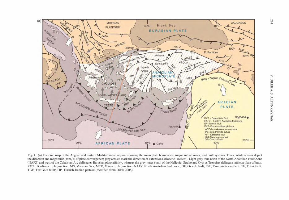
Fig. 1. (a) Tectonic map of the Aegean and eastern Mediterranean region, showing the main plate boundaries, major suture zones, and fault systems. Thick, white arrows depictthe direction and magnitude (mm/a) of plate convergence; grey arrows mark the direction of extension (Miocene–Recent). Light-grey tone north of the North Anatolian Fault Zone(NAFZ) and west of the Calabrian Arc delineates Eurasian plate affinity, whereas the grey tones south of the Hellenic, Strabo and Cyprus Trenches delineate African plate affinity.KOTJ, Karliova triple junction; MS, Marmara Sea; MTR, Maras triple junction; NAFZ, North Anatolian fault zone; OF, Ovacik fault; PSF, Pampak-Sevan fault; TF, Tutak fault;TGF, Tuz Golu fault; TIP, Turkish-Iranian plateau (modified from Dilek 2006).
Y.
DIL
EK
&S
.A
LT
UN
KA
YN
AK
214
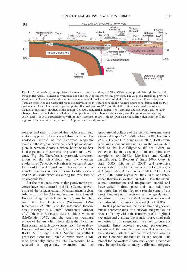
settings and melt sources of this widespread mag-matism appear to have varied through time. Thegeological record of the Cenozoic magmaticevents in the Aegean province is perhaps most com-plete in western Anatolia, where both the modernlandscape and surface rocks are predominantly vol-canic (Fig. 1b). Therefore, a systematic documen-tation of the chronology and the chemicalevolution of Cenozoic volcanism in western Anato-lia should reveal significant information on themantle dynamics and its response to lithospheric-and crustal-scale processes during the evolution ofan orogenic belt.
For the most part, three major geodynamic pro-cesses have been controlling the late Cenozoic evol-ution of the broader eastern Mediterranean region:subduction of the African/Arabian plate beneathEurasia along the Hellenic and Cyprus trenchessince the late Cretaceous (Westaway 1994;Kreemer et al. 2003 and the references therein;van Hinsbergen et al. 2005), continental collisionof Arabia with Eurasia since the middle Miocene(McKenzie 1978), and the resulting westwardescape of the Anatolian block along the North andEast Anatolian fault zones away from the Arabia–Eurasia collision zone (Fig. 1; Dewey et al. 1986;Barka & Reilinger 1997). Subduction rollbackprocesses along the Hellenic trench since 30 Ma(and potentially since the late Cretaceous) haveresulted in upper-plate extension and the
gravitational collapse of the Tethyan orogenic crust(Meulenkamp et al. 1988; Jolivet 2001; Faccennaet al. 2003; van Hinsbergen et al. 2005). Both exten-sion and attendant magmatism in the region dateback to the late Oligocene (if not older), asevidenced by the existence of metamorphic corecomplexes (c. 26 Ma; Menderes and Kazdagmassifs; Fig. 2; Bozkurt & Satir 2000; Okay &Satir 2000; Isik et al. 2004) and extensivecalc-alkaline to alkaline volcanic rocks (Savascin& Oyman 1998; Aldanmaz et al. 2000, 2006; Aliciet al. 2002; Altunkaynak & Dilek 2006, and refer-ences therein) in western Anatolia. How the exten-sional deformation and magmatism started andhave varied in time, space, and magnitude sincethe beginning of the Neogene remain some of themost fundamental questions in the geodynamicevolution of the eastern Mediterranean region andin continental tectonics in general (Dilek 2006).
In this paper we review the nature and geoche-mical characteristics of Cenozoic magmatism inwestern Turkey within the framework of its regionaltectonics and evaluate the mantle sources and meltevolution of this magmatism. We then discuss thepotential links between regional plate-tectonicevents and the mantle dynamics that appear tohave strongly affected and controlled the evolutionof the Cenozoic magmatism in the region. Ourmodel for the western Anatolian Cenozoic tectonicsmay be applicable to many collisional orogens,
Fig. 1. (Continued) (b) Interpretative tectonic cross-section along a NNE-SSW-trending profile (straight line in 1a)through the Africa–Eurasia convergence zone and the Aegean extensional province. The Aegean extensional provincestraddles the Anatolide-Tauride and Sakarya continental blocks, which collided in the Paleocene. The CretaceousTethyan ophiolites and blueschist rocks are derived from the suture zone (Izmir-Ankara suture zone) between these twocontinental blocks. Eocene–Oligocene post-collisional plutons (PCP) north of this suture zone mark the oldestCenozoic magmatic products in the region. Cenozoic magmatism appears to have migrated southward and to havechanged from calc-alkaline to alkaline in composition. Lithospheric-scale necking and decompressional meltingassociated with aesthenospheric upwelling may have been responsible for Quaternary alkaline volcanism (i.e. Kularegion) in the south-central part of the Aegean extensional province.
CENOZOIC MAGMATISM IN WESTERN TURKEY 215
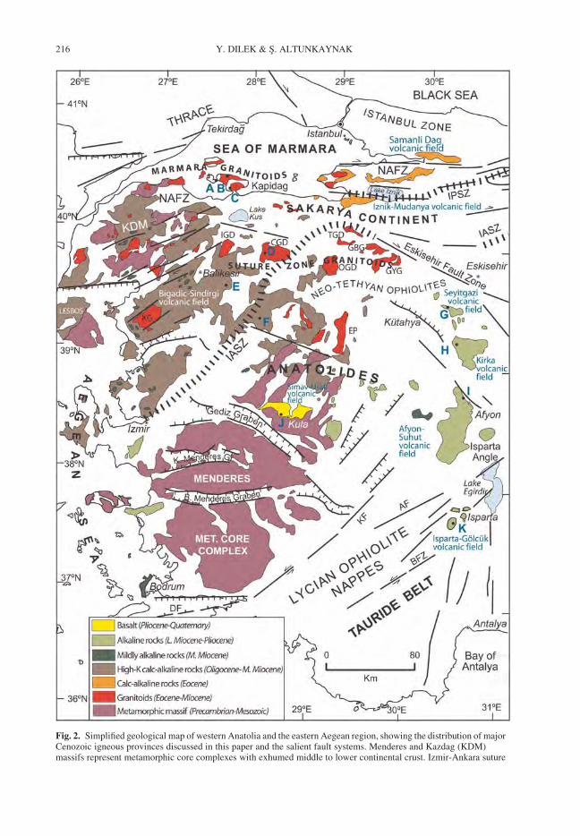
Fig. 2. Simplified geological map of western Anatolia and the eastern Aegean region, showing the distribution of majorCenozoic igneous provinces discussed in this paper and the salient fault systems. Menderes and Kazdag (KDM)massifs represent metamorphic core complexes with exhumed middle to lower continental crust. Izmir-Ankara suture
Y. DILEK & S. ALTUNKAYNAK216
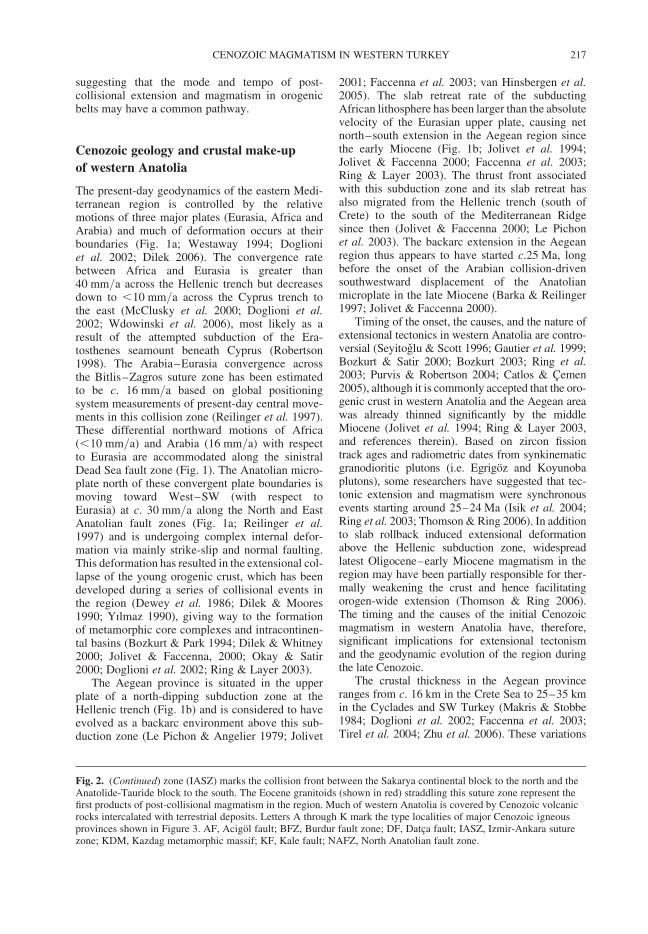
suggesting that the mode and tempo of post-collisional extension and magmatism in orogenicbelts may have a common pathway.
Cenozoic geology and crustal make-up
of western Anatolia
The present-day geodynamics of the eastern Medi-terranean region is controlled by the relativemotions of three major plates (Eurasia, Africa andArabia) and much of deformation occurs at theirboundaries (Fig. 1a; Westaway 1994; Doglioniet al. 2002; Dilek 2006). The convergence ratebetween Africa and Eurasia is greater than40 mm/a across the Hellenic trench but decreasesdown to ,10 mm/a across the Cyprus trench tothe east (McClusky et al. 2000; Doglioni et al.2002; Wdowinski et al. 2006), most likely as aresult of the attempted subduction of the Era-tosthenes seamount beneath Cyprus (Robertson1998). The Arabia–Eurasia convergence acrossthe Bitlis–Zagros suture zone has been estimatedto be c. 16 mm/a based on global positioningsystem measurements of present-day central move-ments in this collision zone (Reilinger et al. 1997).These differential northward motions of Africa(,10 mm/a) and Arabia (16 mm/a) with respectto Eurasia are accommodated along the sinistralDead Sea fault zone (Fig. 1). The Anatolian micro-plate north of these convergent plate boundaries ismoving toward West–SW (with respect toEurasia) at c. 30 mm/a along the North and EastAnatolian fault zones (Fig. 1a; Reilinger et al.1997) and is undergoing complex internal defor-mation via mainly strike-slip and normal faulting.This deformation has resulted in the extensional col-lapse of the young orogenic crust, which has beendeveloped during a series of collisional events inthe region (Dewey et al. 1986; Dilek & Moores1990; Yılmaz 1990), giving way to the formationof metamorphic core complexes and intracontinen-tal basins (Bozkurt & Park 1994; Dilek & Whitney2000; Jolivet & Faccenna, 2000; Okay & Satir2000; Doglioni et al. 2002; Ring & Layer 2003).
The Aegean province is situated in the upperplate of a north-dipping subduction zone at theHellenic trench (Fig. 1b) and is considered to haveevolved as a backarc environment above this sub-duction zone (Le Pichon & Angelier 1979; Jolivet
2001; Faccenna et al. 2003; van Hinsbergen et al.2005). The slab retreat rate of the subductingAfrican lithosphere has been larger than the absolutevelocity of the Eurasian upper plate, causing netnorth–south extension in the Aegean region sincethe early Miocene (Fig. 1b; Jolivet et al. 1994;Jolivet & Faccenna 2000; Faccenna et al. 2003;Ring & Layer 2003). The thrust front associatedwith this subduction zone and its slab retreat hasalso migrated from the Hellenic trench (south ofCrete) to the south of the Mediterranean Ridgesince then (Jolivet & Faccenna 2000; Le Pichonet al. 2003). The backarc extension in the Aegeanregion thus appears to have started c.25 Ma, longbefore the onset of the Arabian collision-drivensouthwestward displacement of the Anatolianmicroplate in the late Miocene (Barka & Reilinger1997; Jolivet & Faccenna 2000).
Timing of the onset, the causes, and the nature ofextensional tectonics in western Anatolia are contro-versial (Seyitoglu & Scott 1996; Gautier et al. 1999;Bozkurt & Satir 2000; Bozkurt 2003; Ring et al.2003; Purvis & Robertson 2004; Catlos & Cemen2005), although it is commonly accepted that the oro-genic crust in western Anatolia and the Aegean areawas already thinned significantly by the middleMiocene (Jolivet et al. 1994; Ring & Layer 2003,and references therein). Based on zircon fissiontrack ages and radiometric dates from synkinematicgranodioritic plutons (i.e. Egrigoz and Koyunobaplutons), some researchers have suggested that tec-tonic extension and magmatism were synchronousevents starting around 25–24 Ma (Isik et al. 2004;Ring et al. 2003; Thomson & Ring 2006). In additionto slab rollback induced extensional deformationabove the Hellenic subduction zone, widespreadlatest Oligocene–early Miocene magmatism in theregion may have been partially responsible for ther-mally weakening the crust and hence facilitatingorogen-wide extension (Thomson & Ring 2006).The timing and the causes of the initial Cenozoicmagmatism in western Anatolia have, therefore,significant implications for extensional tectonismand the geodynamic evolution of the region duringthe late Cenozoic.
The crustal thickness in the Aegean provinceranges from c. 16 km in the Crete Sea to 25–35 kmin the Cyclades and SW Turkey (Makris & Stobbe1984; Doglioni et al. 2002; Faccenna et al. 2003;Tirel et al. 2004; Zhu et al. 2006). These variations
Fig. 2. (Continued) zone (IASZ) marks the collision front between the Sakarya continental block to the north and theAnatolide-Tauride block to the south. The Eocene granitoids (shown in red) straddling this suture zone represent thefirst products of post-collisional magmatism in the region. Much of western Anatolia is covered by Cenozoic volcanicrocks intercalated with terrestrial deposits. Letters A through K mark the type localities of major Cenozoic igneousprovinces shown in Figure 3. AF, Acigol fault; BFZ, Burdur fault zone; DF, Datca fault; IASZ, Izmir-Ankara suturezone; KDM, Kazdag metamorphic massif; KF, Kale fault; NAFZ, North Anatolian fault zone.
CENOZOIC MAGMATISM IN WESTERN TURKEY 217
in crustal thickness may indicate that extensionalthinning has not been uniform in the general north–south direction, assuming that the initial crustal thick-ness was consistent throughout the region. Recentseismic experiment studies in the region haveshown that significant amount of crustal attenuationappears to coincide with the occurrence of the meta-morphic core complexes (i.e. Menderes and Cycladicmassifs; Figs 1 & 2), in which high-grade intermedi-ate to lower-crustal rocks have been exhumed in thefootwalls of large-scale, low-angle detachmentsurfaces and in the rift shoulders of mostly east–west-trending major grabens (Lister et al. 1984; Avigad &Garfunkel 1991; Gautier et al. 1999; Bozkurt & Satir2000; Yılmaz et al. 2000; Keay et al. 2002; Ring &Layer 2003).
The continental crust making up the upper plateof the Hellenic subduction zone south of the NorthAnatolian fault is composed of the Sakarya conti-nent and the Anatolide and Tauride blocks (Fig. 2).The Sakarya continent consists of a Palaeozoic crys-talline basement with its Permo-Carboniferous sedi-mentary cover and Permo-Triassic ophiolitic andrift or accretionary-type melange units (Karakayacomplex) that collectively form a composite conti-nental block (Tekeli 1981; Okay et al. 1996).These Sakarya continental rocks and the ophioliticunits of the Izmir-Ankara suture zone (IASZ) areintruded by a series of east–west trending Eoceneand Oligo-Miocene granitoid plutons (Fig. 2;Altunkaynak 2007). The Kazdag massif within thewestern part of the Sakarya continent (KDM inFig. 2) represents a metamorphic core complex,which is inferred to have been exhumed starting atc. 24 Ma from a depth of c. 14 km along a north-dipping mylonitic shear zone (Okay & Satir 2000).
The western Anatolian orogenic belt consists of,from north to south, two tectonic zones: (1) theIzmir-Ankara suture zone (IASZ); and (2) theMenderes metamorphic core complex. TheMenderes metamorphic massif and the IASZ rockscollectively constitute the Anatolide block inwestern Turkey. The IASZ south of the Sakaryacontinent includes dismembered Tethyan ophio-lites, high-pressure low-temperature (HP/LT)blueschist-bearing rocks, and flysch depositsmainly occurring in south-directed thrust sheets(Figs 1b, 2; Onen & Hall 1993; Okay et al. 1998;Sherlock et al. 1999). Late-stage diabasic dykescrosscutting the ophiolitic units in the Kutahyaarea are dated at c. 92–90 Ma (40Ar/39Ar hornble-nde ages; Onen 2003) indicating a minimum lateCretaceous igneous age of the ophiolites, whereasthe blueschist rocks along the suture zone in theTavsanli area have revealed 40Ar/39Ar coolingages (phengite crystallization during exhumation)of 79.7 + 1.6 2 82.8 + 1.7 Ma (Sherlock et al.1999) suggesting a latest Cretaceous timing of the
HP/LT metamorphism in the region. The Lyciannappes, including the ophiolites, structurallyoverlie the platform carbonates of the Tauride blockfarther south (Figs 1b & 2; Collins & Robertson1999; Ring & Layer 2003) and represent the tectonicoutliers of the Cretaceous oceanic crust derivedfrom the IASZ. These Lycian nappes are inferredto have once covered the Menderes metamorphicmassif, and then to have been removed due to thetectonic uplift and erosion associated with the exhu-mation of the Menderes core complex during thelate Cenozoic (Ring & Layer 2003; Thomson &Ring 2006).
The Menderes core complex comprises severalnappe systems composed of high-grade metamor-phic rocks of Pan-African affinity that are intrudedby synkinematic granitoid plutons (Hetzel &Reischmann 1996; Bozkurt & Satir 2000; Bozkurt2004; Gessner et al. 2004). Rimmele et al. (2003)estimated the P-T conditions of the metamorphicpeak for the Menderes massif rocks at .10 kbarand .440 8C. The main episode of metamorphismis inferred to have resulted from the burial regimeassociated with the emplacement of the Lyciannappes and ophiolitic thrust sheets (Yılmaz 2002).Imbricate stacking of the Menderes nappesbeneath the Lycian nappes and ophiolitic thrustsheets appears to have migrated southwardsthroughout the Paleocene – middle Eocene (Ozeret al. 2001; Candan et al. 2005). The unroofingand exhumation of the Menderes massif may havestarted as early as in the Oligocene (25–21 Ma) asconstrained by the cooling ages of thesyn-extensional granitoid intrusions crosscuttingthe metamorphic rocks (Ring & Collins 2005;Thomson & Ring 2006; Bozkurt & Satir 2000;Catlos et al. 2002). This timing may signal theonset of the initial post-collisional tectonic exten-sion in the Aegean region.
The Tauride block to the south consists ofPrecambrian–Ordovician to Lower Cretaceous car-bonate rocks intercalated with volcano-sedimentaryand epiclastic rocks (Ricou et al. 1975; Demirtasliet al. 1984; Ozgul 1984; Gursu et al. 2004) thatare tectonically overlain by the Tethyan ophiolites(i.e. Lycian, Beysehir-Hoyran, Alihoca and Aladagophiolites) along south-directed thrust sheets(Collins & Robertson 2003; Dilek et al. 1999a;Elitok & Druppel 2008). Underthrusting of theTauride carbonate platform beneath the Tethyanoceanic crust and its partial subduction at a north-dipping subduction zone in the Inner-Taurideocean resulted in high-P/low-T metamorphism(Dilek & Whitney 1997; Okay et al. 1998). Contin-ued convergence caused crustal imbrication andthickening within the platform and resulted in thedevelopment of several major overthrusts through-out the Tauride block (Demirtasli et al. 1984;
Y. DILEK & S. ALTUNKAYNAK218
Dilek et al. 1999b). The buoyancy of the Tauridecontinental crust in the lower plate eventuallyarrested the subduction process and caused the iso-static rebound of the partially subducted platformedge, leading to block-fault uplifting of the Tauridesduring the latest Cenozoic (Dilek & Whitney 1997,2000).
Cenozoic magmatism: distribution
and geochemistry
The post-collisional Cenozoic magmatism inwestern Anatolia started after the collision of theSakarya and Anatolide–Tauride continental blocksin the late Paleocene (Okay et al. 1998). The colli-sional front is today marked by the IASZ (Fig. 2),along which the Upper Cretaceous ophiolites tecto-nically overlie the high-grade metamorphic rocks ofthe Anatolides. The earliest products of this post-collisional magmatism are represented by I-typecalc-alkaline granitoids that are linearly distributed(c. east–west) in a narrow belt along the IASZ.These plutons are intrusive into the Cretaceousophiolites, the blueschist rock assemblages and thebasement rocks of the Sakarya continent and areplastically to brittlely deformed by extensionalshear zones and normal faults (i.e. Kapidag andCataldag plutons; Fig. 3a–d). Those plutons closerto the IASZ (the suture zone granitoids, SZG, ofAltunkaynak 2007) range in composition fromdiorite, quartz diorite, and granodiorite to syenite(Orhaneli, Topuk, Gurgenyayla and Goynukbelenplutons) and have ages around 54–48 Ma (Ataman1972; Bingol et al. 1982, 1994; Harris et al. 1994;Delaloye & Bingol 2000; Yılmaz et al. 2001). Theplutons farther north along the Marmara Sea(Marma granitoids, MG, of Altunkaynak 2007) arecomposed of monzogranite, granodiorite andgranite (Armutlu, Lapseki and Kapidag plutons)and have ages around 48–34 Ma (Bingol et al.1994; Harris et al. 1994; Ercan et al. 1985; Genc& Yılmaz 1997; Delaloye & Bingol 2000;Koprubasi et al. 2000; Koprubasi & Aldanmaz2004), slightly younger than the SZGs. Volcanicequivalents of these Marmara granitoids arelocally represented by basaltic to andesitic lavasand pyroclastic rocks (Genc & Yılmaz 1997).
Although the geochemical features of the SZGand MG plutons show some similarities, theirmagmas may have undergone different magnitudesof fractional crystallization and crustal contami-nation. Both the SZGs and MGs show medium-to high-K calc-alkaline characteristics with theirsilica contents ranging from c. 76 to 64 wt.%(Altunkaynak 2007). Their trace-element abundancesexhibit large variations (e.g. Ba: 57–1150 ppm;Th: 2–13 ppm; La: 2.01–57.1 ppm), suggesting
that these rocks were moderately enriched in incom-patible elements and that their melts were moder-ately evolved (Pearce 1982). They displayenrichment in large ion lithophile elements(LILEs; K, Rb, Ba, Th) over light rare earthelements (LREEs) and medium REEs, and depletionin high field strength elements (Zr, Nb, Ti and P)with respect to the adjacent LILE on MORB-normalized multi-element variation diagrams.Whereas the SZGs show no distinct Eu anomalies(with Eu*/Eu ¼ 0.89–0.98), the MGs displaynegative Eu anomalies, the magnitude of whichincreases with increasing SiO2 contents; theconcave upward REE patterns also become moreprominent with increasing SiO2 contents from theSZGs in the south to the MGs in the north, indicatingstrongly fractionated REE patterns regardless ofrock type (Altunkaynak 2007). Stronger depletionof the MG rocks in Eu, Ba, Sr, and P and theirhigher contents of Pb, K, Ni, and SiO2 in compari-son to the SZG rocks suggest greater amounts ofcrustal contamination during the ascent of theirmagmas through the Sakarya continental crust.
The next magmatic pulse in the region is rep-resented by Oligo-Miocene granitoid plutons andvolcanic units (ranging from andesite to dacite,rhyodacite and rhyolite) that are overlain by ignim-brite flows, pumiceous air-fall, and mudflow depo-sits, intercalated with lower to middle Miocenelacustrine rocks and coal seams (Fig. 3e–f; Bingolet al. 1982, 1994; Erkul et al. 2005; Yucel-Ozturket al. 2005). These Oligo-Miocene volcanoplutoniccomplexes have silica contents ranging from 63 to48 wt.%, medium to high Al2O3 abundances, andvery low TiO2 (,1 wt.%), with their MgO contentsslightly higher than those of the Eocene volcano-plutonic assemblages. They are made of shoshoniticto high-K calc-alkaline rocks, showing enrichmentin the most incompatible elements (Ba, Rb, Th,K, La, Ce) and depletion in Nb, Ta, P, and Tion MORB-normalized multi-element diagrams(Altunkaynak & Dilek 2006). These features, com-bined with their LREE enrichment and relativelyflat HREE patterns, and minor Eu anomalies(Eu*/Eu ¼ 0.75–0.91) on chondrite-normalizedREE diagrams, collectively suggest derivation oftheir magmas from moderately to strongly evolvedmelts (Frey et al. 1978) with subduction zone geo-chemical signatures (Thirwall et al. 1994; Pearce& Peate 1995).
The ensuing middle Miocene volcanism pro-duced mildly alkaline lavas that are spatially associ-ated with NNE-trending transtensional fault systems(Fig. 2). Volcanic rocks of this phase consist ofandesitic, trachy-andesitic and pyroclastic rocksintercalated with mildly alkaline basaltic lavas andhave no plutonic equivalents exposed at the surfacein the region (Akay & Erdogan 2004). The SiO2
CENOZOIC MAGMATISM IN WESTERN TURKEY 219
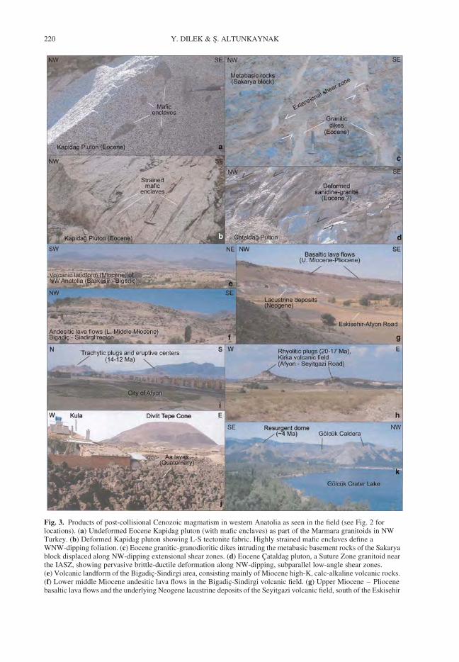
Fig. 3. Products of post-collisional Cenozoic magmatism in western Anatolia as seen in the field (see Fig. 2 forlocations). (a) Undeformed Eocene Kapidag pluton (with mafic enclaves) as part of the Marmara granitoids in NWTurkey. (b) Deformed Kapidag pluton showing L-S tectonite fabric. Highly strained mafic enclaves define aWNW-dipping foliation. (c) Eocene granitic-granodioritic dikes intruding the metabasic basement rocks of the Sakaryablock displaced along NW-dipping extensional shear zones. (d) Eocene Cataldag pluton, a Suture Zone granitoid nearthe IASZ, showing pervasive brittle-ductile deformation along NW-dipping, subparallel low-angle shear zones.(e) Volcanic landform of the Bigadic-Sindirgi area, consisting mainly of Miocene high-K, calc-alkaline volcanic rocks.(f) Lower middle Miocene andesitic lava flows in the Bigadic-Sindirgi volcanic field. (g) Upper Miocene – Pliocenebasaltic lava flows and the underlying Neogene lacustrine deposits of the Seyitgazi volcanic field, south of the Eskisehir
Y. DILEK & S. ALTUNKAYNAK220
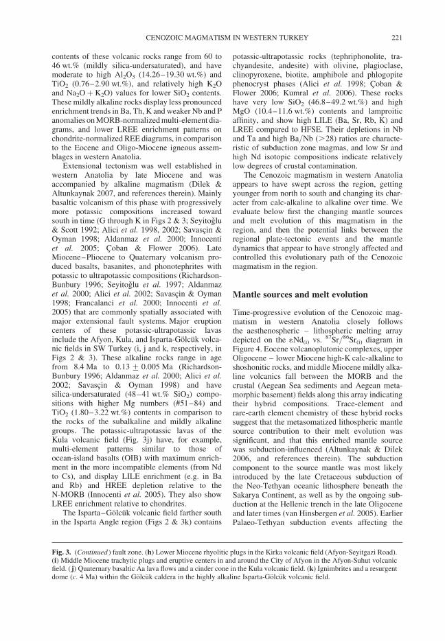
contents of these volcanic rocks range from 60 to46 wt.% (mildly silica-undersaturated), and havemoderate to high Al2O3 (14.26–19.30 wt.%) andTiO2 (0.76–2.90 wt.%), and relatively high K2Oand Na2OþK2O) values for lower SiO2 contents.These mildly alkaline rocks display less pronouncedenrichment trends in Ba, Th, K and weaker Nb and Panomalies on MORB-normalized multi-element dia-grams, and lower LREE enrichment patterns onchondrite-normalized REE diagrams, in comparisonto the Eocene and Oligo-Miocene igneous assem-blages in western Anatolia.
Extensional tectonism was well established inwestern Anatolia by late Miocene and wasaccompanied by alkaline magmatism (Dilek &Altunkaynak 2007, and references therein). Mainlybasaltic volcanism of this phase with progressivelymore potassic compositions increased towardsouth in time (G through K in Figs 2 & 3; Seyitoglu& Scott 1992; Alici et al. 1998, 2002; Savascin &Oyman 1998; Aldanmaz et al. 2000; Innocentiet al. 2005; Coban & Flower 2006). LateMiocene–Pliocene to Quaternary volcanism pro-duced basalts, basanites, and phonotephrites withpotassic to ultrapotassic compositions (Richardson-Bunbury 1996; Seyitoglu et al. 1997; Aldanmazet al. 2000; Alici et al. 2002; Savascin & Oyman1998; Francalanci et al. 2000; Innocenti et al.2005) that are commonly spatially associated withmajor extensional fault systems. Major eruptioncenters of these potassic-ultrapotassic lavasinclude the Afyon, Kula, and Isparta-Golcuk volca-nic fields in SW Turkey (i, j and k, respectively, inFigs 2 & 3). These alkaline rocks range in agefrom 8.4 Ma to 0.13 + 0.005 Ma (Richardson-Bunbury 1996; Aldanmaz et al. 2000; Alici et al.2002; Savascin & Oyman 1998) and havesilica-undersaturated (48–41 wt.% SiO2) compo-sitions with higher Mg numbers (#51–84) andTiO2 (1.80–3.22 wt.%) contents in comparison tothe rocks of the subalkaline and mildly alkalinegroups. The potassic-ultrapotassic lavas of theKula volcanic field (Fig. 3j) have, for example,multi-element patterns similar to those ofocean-island basalts (OIB) with maximum enrich-ment in the more incompatible elements (from Ndto Cs), and display LILE enrichment (e.g. in Baand Rb) and HREE depletion relative to theN-MORB (Innocenti et al. 2005). They also showLREE enrichment relative to chondrites.
The Isparta–Golcuk volcanic field farther southin the Isparta Angle region (Figs 2 & 3k) contains
potassic-ultrapotassic rocks (tephriphonolite, tra-chyandesite, andesite) with olivine, plagioclase,clinopyroxene, biotite, amphibole and phlogopitephenocryst phases (Alici et al. 1998; Coban &Flower 2006; Kumral et al. 2006). These rockshave very low SiO2 (46.8–49.2 wt.%) and highMgO (10.4–11.6 wt.%) contents and lamproiticaffinity, and show high LILE (Ba, Sr, Rb, K) andLREE compared to HFSE. Their depletions in Nband Ta and high Ba/Nb (.28) ratios are characte-ristic of subduction zone magmas, and low Sr andhigh Nd isotopic compositions indicate relativelylow degrees of crustal contamination.
The Cenozoic magmatism in western Anatoliaappears to have swept across the region, gettingyounger from north to south and changing its char-acter from calc-alkaline to alkaline over time. Weevaluate below first the changing mantle sourcesand melt evolution of this magmatism in theregion, and then the potential links between theregional plate-tectonic events and the mantledynamics that appear to have strongly affected andcontrolled this evolutionary path of the Cenozoicmagmatism in the region.
Mantle sources and melt evolution
Time-progressive evolution of the Cenozoic mag-matism in western Anatolia closely followsthe aesthenospheric – lithospheric melting arraydepicted on the 1Nd(i) vs. 87Sr/86Sr(i) diagram inFigure 4. Eocene volcanoplutonic complexes, upperOligocene – lower Miocene high-K calc-alkaline toshoshonitic rocks, and middle Miocene mildly alka-line volcanics fall between the MORB and thecrustal (Aegean Sea sediments and Aegean meta-morphic basement) fields along this array indicatingtheir hybrid compositions. Trace-element andrare-earth element chemistry of these hybrid rockssuggest that the metasomatized lithospheric mantlesource contribution to their melt evolution wassignificant, and that this enriched mantle sourcewas subduction-influenced (Altunkaynak & Dilek2006, and references therein). The subductioncomponent to the source mantle was most likelyintroduced by the late Cretaceous subduction ofthe Neo-Tethyan oceanic lithosphere beneath theSakarya Continent, as well as by the ongoing sub-duction at the Hellenic trench in the late Oligoceneand later times (van Hinsbergen et al. 2005). EarlierPalaeo-Tethyan subduction events affecting the
Fig. 3. (Continued ) fault zone. (h) Lower Miocene rhyolitic plugs in the Kirka volcanic field (Afyon-Seyitgazi Road).(i) Middle Miocene trachytic plugs and eruptive centers in and around the City of Afyon in the Afyon-Suhut volcanicfield. ( j) Quaternary basaltic Aa lava flows and a cinder cone in the Kula volcanic field. (k) Ignimbrites and a resurgentdome (c. 4 Ma) within the Golcuk caldera in the highly alkaline Isparta-Golcuk volcanic field.
CENOZOIC MAGMATISM IN WESTERN TURKEY 221
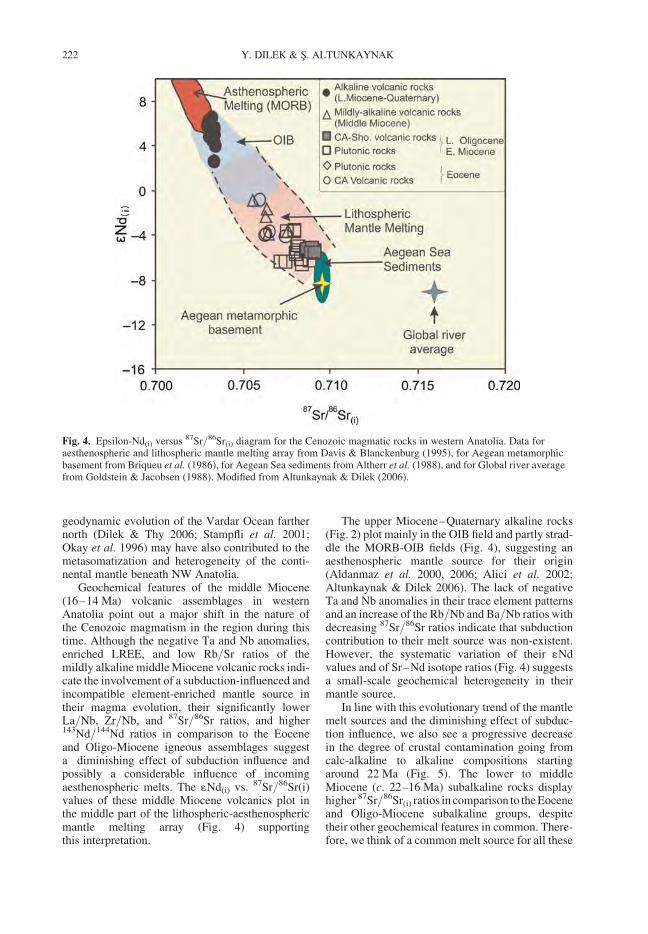
geodynamic evolution of the Vardar Ocean farthernorth (Dilek & Thy 2006; Stampfli et al. 2001;Okay et al. 1996) may have also contributed to themetasomatization and heterogeneity of the conti-nental mantle beneath NW Anatolia.
Geochemical features of the middle Miocene(16–14 Ma) volcanic assemblages in westernAnatolia point out a major shift in the nature ofthe Cenozoic magmatism in the region during thistime. Although the negative Ta and Nb anomalies,enriched LREE, and low Rb/Sr ratios of themildly alkaline middle Miocene volcanic rocks indi-cate the involvement of a subduction-influenced andincompatible element-enriched mantle source intheir magma evolution, their significantly lowerLa/Nb, Zr/Nb, and 87Sr/86Sr ratios, and higher143Nd/144Nd ratios in comparison to the Eoceneand Oligo-Miocene igneous assemblages suggesta diminishing effect of subduction influence andpossibly a considerable influence of incomingaesthenospheric melts. The 1Nd(i) vs. 87Sr/86Sr(i)values of these middle Miocene volcanics plot inthe middle part of the lithospheric-aesthenosphericmantle melting array (Fig. 4) supportingthis interpretation.
The upper Miocene–Quaternary alkaline rocks(Fig. 2) plot mainly in the OIB field and partly strad-dle the MORB-OIB fields (Fig. 4), suggesting anaesthenospheric mantle source for their origin(Aldanmaz et al. 2000, 2006; Alici et al. 2002;Altunkaynak & Dilek 2006). The lack of negativeTa and Nb anomalies in their trace element patternsand an increase of the Rb/Nb and Ba/Nb ratios withdecreasing 87Sr/86Sr ratios indicate that subductioncontribution to their melt source was non-existent.However, the systematic variation of their 1Ndvalues and of Sr–Nd isotope ratios (Fig. 4) suggestsa small-scale geochemical heterogeneity in theirmantle source.
In line with this evolutionary trend of the mantlemelt sources and the diminishing effect of subduc-tion influence, we also see a progressive decreasein the degree of crustal contamination going fromcalc-alkaline to alkaline compositions startingaround 22 Ma (Fig. 5). The lower to middleMiocene (c. 22–16 Ma) subalkaline rocks displayhigher 87Sr/86Sr(i) ratios in comparison to the Eoceneand Oligo-Miocene subalkaline groups, despitetheir other geochemical features in common. There-fore, we think of a common melt source for all these
Fig. 4. Epsilon-Nd(i) versus 87Sr/86Sr(i) diagram for the Cenozoic magmatic rocks in western Anatolia. Data foraesthenospheric and lithospheric mantle melting array from Davis & Blanckenburg (1995), for Aegean metamorphicbasement from Briqueu et al. (1986), for Aegean Sea sediments from Altherr et al. (1988), and for Global river averagefrom Goldstein & Jacobsen (1988). Modified from Altunkaynak & Dilek (2006).
Y. DILEK & S. ALTUNKAYNAK222
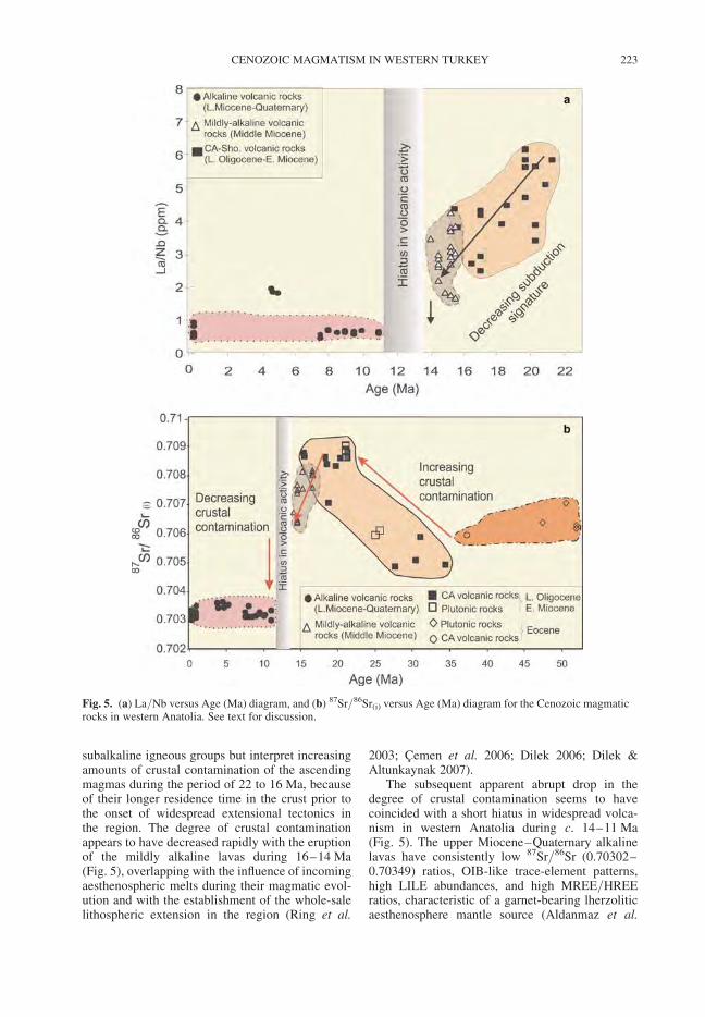
subalkaline igneous groups but interpret increasingamounts of crustal contamination of the ascendingmagmas during the period of 22 to 16 Ma, becauseof their longer residence time in the crust prior tothe onset of widespread extensional tectonics inthe region. The degree of crustal contaminationappears to have decreased rapidly with the eruptionof the mildly alkaline lavas during 16–14 Ma(Fig. 5), overlapping with the influence of incomingaesthenospheric melts during their magmatic evol-ution and with the establishment of the whole-salelithospheric extension in the region (Ring et al.
2003; Cemen et al. 2006; Dilek 2006; Dilek &Altunkaynak 2007).
The subsequent apparent abrupt drop in thedegree of crustal contamination seems to havecoincided with a short hiatus in widespread volca-nism in western Anatolia during c. 14–11 Ma(Fig. 5). The upper Miocene–Quaternary alkalinelavas have consistently low 87Sr/86Sr (0.70302–0.70349) ratios, OIB-like trace-element patterns,high LILE abundances, and high MREE/HREEratios, characteristic of a garnet-bearing lherzoliticaesthenosphere mantle source (Aldanmaz et al.
Fig. 5. (a) La/Nb versus Age (Ma) diagram, and (b) 87Sr/86Sr(i) versus Age (Ma) diagram for the Cenozoic magmaticrocks in western Anatolia. See text for discussion.
CENOZOIC MAGMATISM IN WESTERN TURKEY 223
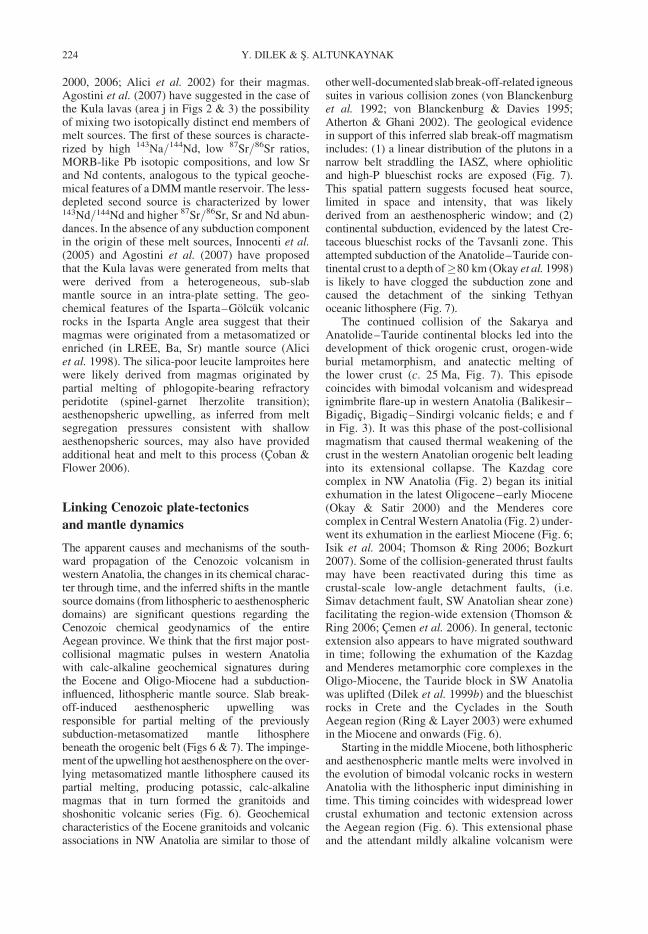
2000, 2006; Alici et al. 2002) for their magmas.Agostini et al. (2007) have suggested in the case ofthe Kula lavas (area j in Figs 2 & 3) the possibilityof mixing two isotopically distinct end members ofmelt sources. The first of these sources is characte-rized by high 143Na/144Nd, low 87Sr/86Sr ratios,MORB-like Pb isotopic compositions, and low Srand Nd contents, analogous to the typical geoche-mical features of a DMM mantle reservoir. The less-depleted second source is characterized by lower143Nd/144Nd and higher 87Sr/86Sr, Sr and Nd abun-dances. In the absence of any subduction componentin the origin of these melt sources, Innocenti et al.(2005) and Agostini et al. (2007) have proposedthat the Kula lavas were generated from melts thatwere derived from a heterogeneous, sub-slabmantle source in an intra-plate setting. The geo-chemical features of the Isparta–Golcuk volcanicrocks in the Isparta Angle area suggest that theirmagmas were originated from a metasomatized orenriched (in LREE, Ba, Sr) mantle source (Aliciet al. 1998). The silica-poor leucite lamproites herewere likely derived from magmas originated bypartial melting of phlogopite-bearing refractoryperidotite (spinel-garnet lherzolite transition);aesthenopsheric upwelling, as inferred from meltsegregation pressures consistent with shallowaesthenopsheric sources, may also have providedadditional heat and melt to this process (Coban &Flower 2006).
Linking Cenozoic plate-tectonics
and mantle dynamics
The apparent causes and mechanisms of the south-ward propagation of the Cenozoic volcanism inwestern Anatolia, the changes in its chemical charac-ter through time, and the inferred shifts in the mantlesource domains (from lithospheric to aesthenosphericdomains) are significant questions regarding theCenozoic chemical geodynamics of the entireAegean province. We think that the first major post-collisional magmatic pulses in western Anatoliawith calc-alkaline geochemical signatures duringthe Eocene and Oligo-Miocene had a subduction-influenced, lithospheric mantle source. Slab break-off-induced aesthenospheric upwelling wasresponsible for partial melting of the previouslysubduction-metasomatized mantle lithospherebeneath the orogenic belt (Figs 6 & 7). The impinge-ment of the upwelling hot aesthenosphere on the over-lying metasomatized mantle lithosphere caused itspartial melting, producing potassic, calc-alkalinemagmas that in turn formed the granitoids andshoshonitic volcanic series (Fig. 6). Geochemicalcharacteristics of the Eocene granitoids and volcanicassociations in NW Anatolia are similar to those of
other well-documented slab break-off-related igneoussuites in various collision zones (von Blanckenburget al. 1992; von Blanckenburg & Davies 1995;Atherton & Ghani 2002). The geological evidencein support of this inferred slab break-off magmatismincludes: (1) a linear distribution of the plutons in anarrow belt straddling the IASZ, where ophioliticand high-P blueschist rocks are exposed (Fig. 7).This spatial pattern suggests focused heat source,limited in space and intensity, that was likelyderived from an aesthenospheric window; and (2)continental subduction, evidenced by the latest Cre-taceous blueschist rocks of the Tavsanli zone. Thisattempted subduction of the Anatolide–Tauride con-tinental crust to a depth of�80 km (Okay et al. 1998)is likely to have clogged the subduction zone andcaused the detachment of the sinking Tethyanoceanic lithosphere (Fig. 7).
The continued collision of the Sakarya andAnatolide–Tauride continental blocks led into thedevelopment of thick orogenic crust, orogen-wideburial metamorphism, and anatectic melting ofthe lower crust (c. 25 Ma, Fig. 7). This episodecoincides with bimodal volcanism and widespreadignimbrite flare-up in western Anatolia (Balikesir–Bigadic, Bigadic–Sindirgi volcanic fields; e and fin Fig. 3). It was this phase of the post-collisionalmagmatism that caused thermal weakening of thecrust in the western Anatolian orogenic belt leadinginto its extensional collapse. The Kazdag corecomplex in NW Anatolia (Fig. 2) began its initialexhumation in the latest Oligocene–early Miocene(Okay & Satir 2000) and the Menderes corecomplex in Central Western Anatolia (Fig. 2) under-went its exhumation in the earliest Miocene (Fig. 6;Isik et al. 2004; Thomson & Ring 2006; Bozkurt2007). Some of the collision-generated thrust faultsmay have been reactivated during this time ascrustal-scale low-angle detachment faults, (i.e.Simav detachment fault, SW Anatolian shear zone)facilitating the region-wide extension (Thomson &Ring 2006; Cemen et al. 2006). In general, tectonicextension also appears to have migrated southwardin time; following the exhumation of the Kazdagand Menderes metamorphic core complexes in theOligo-Miocene, the Tauride block in SW Anatoliawas uplifted (Dilek et al. 1999b) and the blueschistrocks in Crete and the Cyclades in the SouthAegean region (Ring & Layer 2003) were exhumedin the Miocene and onwards (Fig. 6).
Starting in the middle Miocene, both lithosphericand aesthenospheric mantle melts were involved inthe evolution of bimodal volcanic rocks in westernAnatolia with the lithospheric input diminishing intime. This timing coincides with widespread lowercrustal exhumation and tectonic extension acrossthe Aegean region (Fig. 6). This extensional phaseand the attendant mildly alkaline volcanism were
Y. DILEK & S. ALTUNKAYNAK224
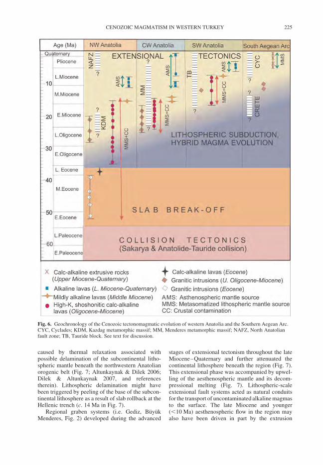
caused by thermal relaxation associated withpossible delamination of the subcontinental litho-spheric mantle beneath the northwestern Anatolianorogenic belt (Fig. 7; Altunkaynak & Dilek 2006;Dilek & Altunkaynak 2007, and referencestherein). Lithospheric delamination might havebeen triggered by peeling of the base of the subcon-tinental lithosphere as a result of slab rollback at theHellenic trench (c. 14 Ma in Fig. 7).
Regional graben systems (i.e. Gediz, BuyukMenderes, Fig. 2) developed during the advanced
stages of extensional tectonism throughout the lateMiocene–Quaternary and further attenuated thecontinental lithosphere beneath the region (Fig. 7).This extensional phase was accompanied by upwel-ling of the aesthenospheric mantle and its decom-pressional melting (Fig. 7). Lithospheric-scaleextensional fault systems acted as natural conduitsfor the transport of uncontaminated alkaline magmasto the surface. The late Miocene and younger(,10 Ma) aesthenospheric flow in the region mayalso have been driven in part by the extrusion
Fig. 6. Geochronology of the Cenozoic tectonomagmatic evolution of western Anatolia and the Southern Aegean Arc.CYC, Cyclades; KDM, Kazdag metamorphic massif; MM, Menderes metamorphic massif; NAFZ, North Anatolianfault zone; TB, Tauride block. See text for discussion.
CENOZOIC MAGMATISM IN WESTERN TURKEY 225
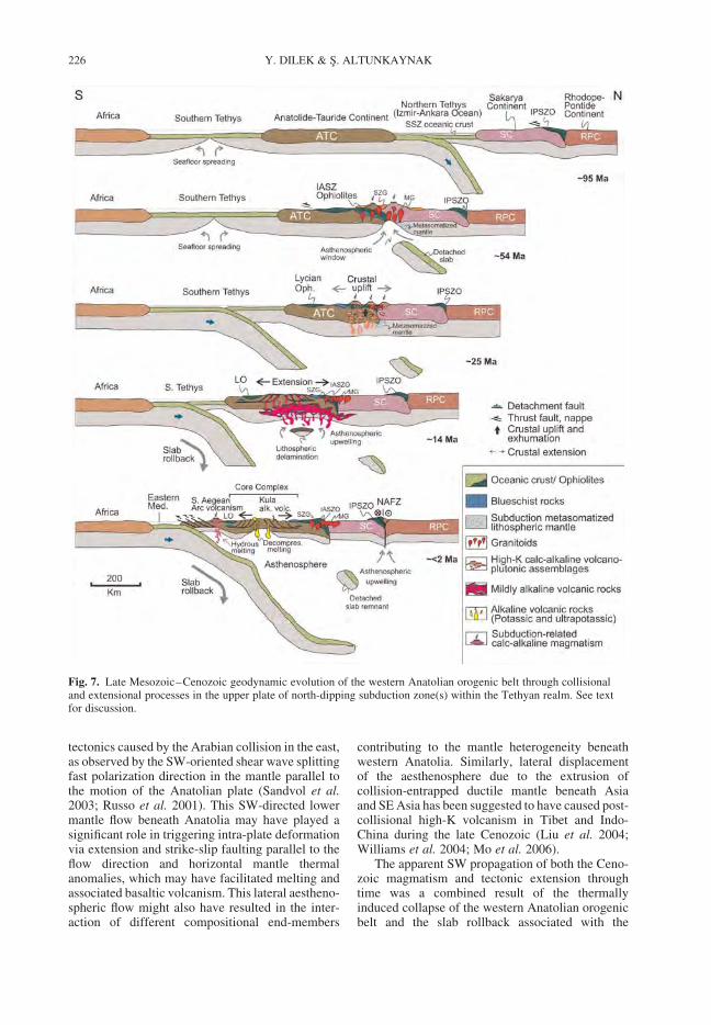
tectonics caused by the Arabian collision in the east,as observed by the SW-oriented shear wave splittingfast polarization direction in the mantle parallel tothe motion of the Anatolian plate (Sandvol et al.2003; Russo et al. 2001). This SW-directed lowermantle flow beneath Anatolia may have played asignificant role in triggering intra-plate deformationvia extension and strike-slip faulting parallel to theflow direction and horizontal mantle thermalanomalies, which may have facilitated melting andassociated basaltic volcanism. This lateral aestheno-spheric flow might also have resulted in the inter-action of different compositional end-members
contributing to the mantle heterogeneity beneathwestern Anatolia. Similarly, lateral displacementof the aesthenosphere due to the extrusion ofcollision-entrapped ductile mantle beneath Asiaand SE Asia has been suggested to have caused post-collisional high-K volcanism in Tibet and Indo-China during the late Cenozoic (Liu et al. 2004;Williams et al. 2004; Mo et al. 2006).
The apparent SW propagation of both the Ceno-zoic magmatism and tectonic extension throughtime was a combined result of the thermallyinduced collapse of the western Anatolian orogenicbelt and the slab rollback associated with the
Fig. 7. Late Mesozoic–Cenozoic geodynamic evolution of the western Anatolian orogenic belt through collisionaland extensional processes in the upper plate of north-dipping subduction zone(s) within the Tethyan realm. See textfor discussion.
Y. DILEK & S. ALTUNKAYNAK226
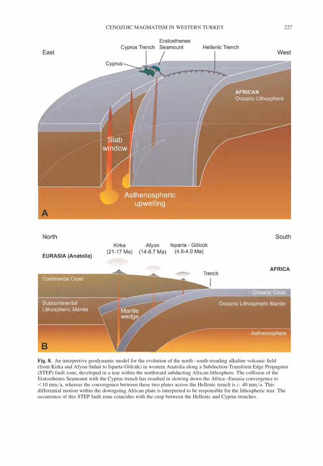
Fig. 8. An interpretive geodynamic model for the evolution of the north–south-trending alkaline volcanic field(from Kirka and Afyon-Suhut to Isparta-Golcuk) in western Anatolia along a Subduction-Transform Edge Propagator(STEP) fault zone, developed in a tear within the northward subducting African lithosphere. The collision of theEratosthenes Seamount with the Cyprus trench has resulted in slowing down the Africa–Eurasia convergence to,10 mm/a, whereas the convergence between these two plates across the Hellenic trench is c. 40 mm/a. Thisdifferential motion within the downgoing African plate is interpreted to be responsible for the lithospheric tear. Theoccurrence of this STEP fault zone coincides with the cusp between the Hellenic and Cyprus trenches.
CENOZOIC MAGMATISM IN WESTERN TURKEY 227
subduction of the Southern Tethys ocean floor at theHellenic trench (Figs 6 & 7). The thermal input andmelt sources were provided first by slabbreak-off-generated aesthenospheric flow, then bylithospheric delamination-related aesthenosphericflow, followed by tectonic extension-drivenupward aesthenospheric flow and collision-induced(Arabia–Eurasia collision) lateral (westward)mantle flow. The inferred lithospheric delaminationaround the middle Miocene may have been causedby slab rollback-induced peeling off of the litho-spheric root beneath the orogenic belt. The Plio-Quaternary tectonic uplift, crustal exhumation, andyoung volcanism along the North Anatolian faultzone in the northern Aegean region (Figs 6 & 7;Agostini et al. 2007) are most likely associatedwith transform plate boundary processes and therelated aesthenospheric flow.
The subduction zone magmatism related to theretreating Hellenic trench has been responsible forthe progressive southward migration of the SouthAegean Arc since the late Miocene (Figs 6 & 7;Pe-Piper & Piper 2006). The exhumation ofhigh-P rocks in the Cyclades was likely driven byupper plate extension and channel flow associatedwith this subduction (Jolivet et al. 2003; Ring &Layer 2003). The sharp cusp between the Hellenicand Cyprus trenches (Fig. 1) and the significantdifferences in the convergence velocities of theAfrican lithosphere at these trenches (c. 40 mm/avs. ,10 mm/a at the Hellenic and Cyprus trenches,respectively) are likely to have resulted in a litho-spheric tear in the downgoing African plate thatallowed the aesthenospheric mantle to rise beneathSW Anatolia (Fig. 8; Doglioni et al. 2002; Agostiniet al. 2007). This scenario is analogous to litho-spheric tearing at Subduction-Transform Edge Pro-pagator (STEP) faults described by Govers &Wortel (2005) from the Ionian and Calabrian arcs,the New Hebrides trench, the southern edge of theLesser Antilles trench, and the northern end of theSouth Sandwich trench. In all these cases, STEPspropagate in a direction opposite to the subductiondirection, and aesthenospheric upwelling occursbehind and beneath their propagating tips. Thisupwelling induces decompressional melting ofshallow aesthenosphere, leading to linearly distribu-ted alkaline magmatism younging in the direction oftear propagation. The north–south-trending potas-sic and ultra-potassic volcanic fields stretchingfrom the Kirka and Afyon–Suhut region in thenorth to the Isparta–Golcuk area in the southshows an age progression from 21–17 Ma to 4.6–4.0 Ma that is consistent with this pattern and sup-ports a STEP model for their origin (Fig. 8). Aesthe-nospheric low velocities detected through Pntomographic imaging in this region (Al-Lazkiet al. 2004) support the existence of shallow
aesthenosphere beneath the Isparta Angle atpresent. We infer, therefore, that magmas of theKirka, Afyon–Suhut, and Isparta–Golcuk fieldswere produced by melting of the sub-slab (aestheno-spheric) mantle, which was metasomatized byrecent subduction events in the region (Fig. 8).They were slightly contaminated during theirascent through the crust along the transtensionalfault systems within the Kirka–Isparta STEP.
Discussion and conclusions
The geochemical and temporal evolution of theCenozoic magmatism in western Anatolia clearlyshows that plate-tectonic events, mantle dynamicsand magmatism are closely linked during the late-stage evolution of orogenic belts. The mantleresponds to collision-driven crustal thickening,slab break-off, delamination, and lithospherictearing swiftly, within geologically short timescales (few million years). This results in lateralmantle flow, whole-sale extension and accompany-ing magmatism that in turn cause the collapse of tec-tonically and magmatically weakened orogeniccrust. Initial stages of post-collisional magmatismthermally weaken the orogenic crust in continentalcollision zones giving way into large-scale exten-sion and lower crustal exhumation via corecomplex formation. These cause-effect relationsbetween magmatism and extension and betweenthe crustal processes and mantle dynamics, and thetemporal and chemical evolution of the post-collisional magmatism in western Anatolia, as docu-mented in this study, are common to many orogenicbelts (Dilek 2006; Dilek & Altunkaynak 2007, andreferences therein). This observation suggests tous that the mode and nature of post-collisional mag-matism in mountain belts may follow a commonpathway with some minor deviations. The existenceof active lithospheric subduction and associated slabrollback processes play a significant role, however,in the mode and nature of deformation in orogenicbelts that are situated in the upper plates of post-collisional subduction zones (Le Pichon et al. 2003).
Slab break-off appears to be the most commondriving force for the early stages of post-collisionalmagmatism in many collisional orogenic belts(Wortel & Spakman 2000; Kohn & Parkinson 2002;Cloos et al. 2005). The rocks produced at this stageare represented by calc-alkaline to transitional (incomposition) igneous suites. Subsequent lithosphericdelamination or partial convective removal of the sub-continental lithospheric mantle in collision-induced,overthickened orogenic lithosphere causes decom-pressional melting of the upwelling aesthenospherethat in turn results in alkaline basaltic magmatism.Attendant crustal extension and widespread thinning
Y. DILEK & S. ALTUNKAYNAK228
of the lithosphere facilitates rapid ascent of basalticmagmas without much residence time in the crustand hence the eruption of relatively uncontaminated,aesthenosphere-derived magmas at the surface (i.e.Kula lavas in SW Anatolia). Regional geodynamicsand other plate boundary processes at work in thevicinity of the collision zones may strongly control,however, the mode and nature of slab break-off andlithospheric delamination events in orogenic beltsand hence the suggested pathway of post-collisionalmagmatism.
This study was supported by research grants from theScientific & Technical Research Council of Turkey(TUBITAK-CAYDAG-101Y006), Istanbul TechnicalUniversity, and Miami University Committee on FacultyResearch. Constructive and thorough reviews byC. Busby, G. Lister, P. A. Ustaomer, and D. van Hinsb-ergen helped us improve the paper greatly. We particularlyacknowledge our lively discussions and exchange on theCenozoic geodynamics of the Aegean region with Editorvan Hinsbergen during the preparation of this paper.
References
AGOSTINI, S., DOGLIONI, C., INNOCENTI, F., MANETTI,P., TONARINI, S. & SAVASCIN, M. Y. 2007. The tran-sition from subduction-related to intraplate Neogenemagmatism in the Western Anatolia and Aegean area.In: BECCALUVA, L., BIANCHINI, G. & WILSON, M.(eds) Cenozoic Volcanism in the MediterraneanArea. Geological Society of America Special Paper,418, 1–16.
AKAY, E. & ERDOGAN, B. 2004. Evolution of Neogenecalc-alkaline to alkaline volcanism in the Aliaga-Foca region (Western Anatolia, Turkey). Journal ofAsian Earth Science, 24, 367–387.
ALDANMAZ, E., PEARCE, J. A., THIRWALL, M. F. &MITCHELL, J. 2000. Petrogenetic evolution of lateCenozoic, post-collision volcanism in western Anato-lia, Turkey. Journal of Volcanology & GeothermalResearch, 102, 67–95.
ALDANMAZ, E., KOPRUBASI, N., GURER, O. F.,KAYMAKCI, N. & GOURGAUD, A. 2006. Geochem-ical constraints on the Cenozoic, OIB-type alkalinevolcanic rocks of NW Turkey: Implications formantle sources and melting processes. Lithos, 86,50–76.
ALICI, P., TEMEL, A., GOURGAUD, A., KIEFFER, G. &GUNDOGDU, M. N. 1998. Petrology and geochemistryof potassic rocks in the Golcuk area (Isparta, SWTurkey): genesis of enriched alkaline magmas.Journal of Volcanology and Geothermal Research,85, 423–446.
ALICI, P., TEMEL, A. & GOURGAUD, A. 2002. Pb-Nd-Srisotope and trace element geochemistry of Quaternaryextension-related alkaline volcanism: a case studyof Kula region (western Anatolia, Turkey). Journalof Volcanology & Geothermal Research, 115,487–510.
AL-LAZKI, A. I., SANDVOL, E., SEBER, D., BARAZANGI,M., TURKELLI, N. & MOHAMMAD, R. 2004. Pn
tomographic imaging of mantle lid velocity and aniso-tropy at the junction of the Arabian, Eurasian andAfrican plates. Geophysical Journal International,158, 1024–1040.
ALTHERR, R., HENJES-KUNST, F. J., MATTHEWS, A.,FIREDRICHSEN, H. & HANSEN, B. T. 1988. O-Srisotopic variations in Miocene granitoids from theAegean: evidence for an origin by combined assimila-tion and fractional crystallization. Contributions toMineralogy & Petrology, 100, 528–541.
ALTUNKAYNAK, S. 2007. Collision-driven slab breakoffmagmatism in northwestern Anatolia, Turkey.Journal of Geology, 115, 63–82.
ALTUNKAYNAK, S. & DILEK, Y. 2006. Timing andnature of postcollisional volcanism in western Anatoliaand geodynamic implications. In: DILEK, Y. &PAVLIDES, S. (eds) Postcollisional tectonics andmagmatism in the Mediterranean region and Asia.Geological Society of America Special Paper, 409,321–351.
ATAMAN, G. 1972. L’age radiometrique du massif grano-dioritique d’Orhaneli. Bulletin of the GeologicalSociety of Turkey, 15, 125–130.
ATHERTON, M. P. & GHANI, A. A. 2002. Slab breakoff: amodel for Caledonian, Late Granite syn-collisionalmagmatism in the orthotectonic (metamorphic) zoneof Scotland and Donegal, Ireland. Lithos, 62, 65–85.
AVIGAD, D. & GARFUNKEL, Z. 1991. Uplift and exhuma-tion of high-pressure metamorphic terranes: theexample of the Cycladic blueschist belt (AegeanSea). Tectonophysics, 188, 357–372.
BARKA, A. & REILINGER, R. 1997. Active tectonics of theEastern Mediterranean region: deduced from GPS,neotectonic and seismicity data. Annali Di Geofisica,XL, 587–610.
BINGOL, E., DELALOYE, M. & ATAMAN, G. 1982.Granitic intrusions in Western Anatolia: A contributionof the geodynamic study of this area. Eclogae Geolo-gische Helvetica, 75, 437–446.
BINGOL, E., DELALOYE, M. & GENC, S. 1994. Magmatismof northwestern Anatolia. International VolcanologicalCongress, IAVCEI 1994, Excursion Guide (A3).
BOZKURT, E. 2003. Origin of NE-trending basins inwestern Turkey. Geodinamica Acta, 14, 61–81.
BOZKURT, E. 2004. Granitoid rocks of the southernMenderes Massif (Southwest Turkey): field evidencefor Tertiary magmatism in an extensional shearzone. International Journal of Earth Sciences, 93,52–71.
BOZKURT, E. 2007. Extensional v. contractional origin forthe southern Menderes shear zone, SW Turkey: tec-tonic and metamorphic implications. GeologicalMagazine, 144, 191–210.
BOZKURT, E. & PARK, R. G. 1994. Southern MenderesMassif: an incipient metamorphic core complex inwestern Anatolia, Turkey. Journal of the GeologicalSociety, London, 151, 213–216.
BOZKURT, E. & SATIR, M. 2000. The southern MenderesMassif (western Turkey): geochronology and exhuma-tion history. Geological Journal, 35, 285–296.
BRIQUEU, L., JAVOY, M., LANCELOT, J. R. &TATSUMATO, M. 1986. Isotope geochemistry ofrecent magmatism in the Aegean arc: Sr, Nd, Hfand O isotopic ratios in the lavas of Milos and
CENOZOIC MAGMATISM IN WESTERN TURKEY 229
Santorini: geodynamic implications. Earth and Plane-tary Science Letters, 80, 41–54.
CANDAN, O., CETINKAPLAN, M., OBERHANSLI, R.,RIMMELE, G. & AKAL, C. 2005. Alpine high-P/low-T metamorphism of the Afyon Zone and implicationsfor the metamorphic evolution of Western Anatolia,Turkey. Lithos, 84, 102–124.
CATLOS, E. J. & CEMEN, I. 2005. Monazite ages andthe evolution of the Menderes Massif, western Turkey.International Journal of Earth Sciences, 94, 204–217.
CATLOS, E. J., CEMEN, I., ISIK, V. & SEYITOGLU, G.2002. In situ timing constraints from the Menderesmassif, western Turkey. Geological Society ofAmerica Abstracts with Programs, 34 (6), 180.
CEMEN, I., CATLOS, E. J., GOGUS, O. & OZERDEM, C.2006. Postcollisional extensional tectonics andexhumation of the Menderes massif in the WesternAnatolia extended terrane. In: DILEK, Y. &PAVLIDES, S. (eds) Postcollisional tectonics and mag-matism in the Mediterranean region and Asia. Geo-logical Society of America Special Paper, 409,353–379.
CLOOS, M., SAPIIE, B., VAN UFFORD, A. Q., WEILAND,R. J., WARREN, P. Q. & MCMAHON, T. P. 2005. Colli-sional delamination in New Guinea: The Geotectonicsof subducting slab breakoff. Geological Society ofAmerica Special Paper, 400, 1–51.
COBAN, H. & FLOWER, M. F. J. 2006. Mineral phase com-positions in silica-undersaturated ‘leucite’ lamproitesfrom the Bucak area, Isparta, SW Turkey. Lithos, 89,275–299.
COLLINS, A. & ROBERTSON, A. H. F. 2003. Kinematicevidence for Late Mesozoic – Miocene emplacementof the Lycian Allochthon over the Western AnatolideBelt, SW Turkey. Geological Journal, 38, 295–310.
DAVIS, J. H. & VON BLANCKENBURG, F. 1995. Slabbreakoff: a model of lithosphere detachment and itstest in the magmatism and deformation of collisionalorogens. Earth and Planetary Science Letters, 129,85–102.
DELALOYE, M. & BINGOL, E. 2000. Granitoids fromwestern and northwestern Anatolia: Geochemistryand modeling of geodynamic evolution. InternationalGeology Review, 42, 241–268.
DEMIRTASLI, E., TURHAN, N., BILGIN, A. Z. &SELIM, M. 1984. Geology of the Bolkar Mountains:In: TEKELI, O. & GONCUOGLU, M. C. (eds) Geologyof the Taurus Belt. Proceedings of the InternationalSymposium, Ankara, 125–141.
DEWEY, J. F., HEMPTON, M. R., KIDD, W. S. F.,SAROGLU, F. & SENGOR, A. M. C. 1986. Shorteningof continental lithosphere: the neotectonics ofEastern Anatolia – a young collision zone: In:COWARD, M. P. & RIES, A. C. (eds) Collision ZoneTectonics. Geological Society, London, Special Publi-cation, 19, 3–36.
DILEK, Y. 2006. Collision tectonics of the Mediterraneanregion: causes and consequences. In: DILEK, Y. &PAVLIDES, S. (eds) Postcollisional tectonics andmagmatism in the Mediterranean region and Asia.Geological Society of America Special Paper, 409,1–13.
DILEK, Y. & ALTUNKAYNAK, S. 2007. Cenozoic crustalevolution and mantle dynamics of post-collisional
magmatism in western Anatolia. InternationalGeology Review, 49, 431–453.
DILEK, Y. & MOORES, E. M. 1990. Regional Tectonics ofthe Eastern Mediterranean ophiolites. In: MALPAS, J.,MOORES, E. M., PANAYIOTOU, A. & XENOPHONTOS,C. (eds) Ophiolites, Oceanic Crustal Analogues.Proceedings of the Symposium ‘Troodos 1987’, TheGeological Survey Department, Nicosia, Cyprus,295–309.
DILEK, Y. & THY, P. 2006. Age and petrogenesis of pla-giogranite intrusions in the Ankara melange, centralTurkey. Island Arc, 15, 44–57.
DILEK, Y & WHITNEY, D. L. 1997. CounterclockwiseP-T-t trajectory from the metamorphic sole of a Neo-Tethyan ophiolite (Turkey). Tectonophysics, 280,295–310.
DILEK, Y & WHITNEY, D. L. 2000. Cenozoic crustalevolution in central Anatolia: Extension, magmatismand landscape development. In: PANAYIDES, I.,XENOPHONTOS, C. & MALPAS, J. (eds) Proceedingsof the Third International Conference on the Geologyof the Eastern Mediterranean. Geological SurveyDepartment, September 1998, Nicosia – Cyprus,183–192.
DILEK, Y., THY, P., HACKER, B. & GRUNDVIG, S. 1999a.Structure and petrology of Tauride ophiolites andmafic dike intrusions (Turkey): Implications for theNeo-Tethyan ocean. Bulletin of the GeologicalSociety of America, 111, 1192–1216.
DILEK, Y., WHITNEY, D. L. & TEKELI, O. 1999b. LinksBetween Tectonic Processes and Landscape Morphologyin an Alpine Collision Zone, South-Central Turkey.Annals of Geomorphology, 118, 147–164.
DOGLIONI, C., AGOSTINI, S., CRESPI, M., INNOCENTI,F., MANETTI, P., RIGUZZI, F. & SAVASCIN, Y.2002. On the extension in western Anatolia and theAegean Sea. In: ROSENBAUM, G. & LISTER, G. S.(eds) Reconstruction of the evolution of the Alpine-Himalayan Orogen. Journal of the Virtual Explorer,8, 169–183.
ELITOK, O. & DRUPPEL, K. 2008. Geochemistry and tec-tonic significance of metamorphic sole rocks beneaththe Beysehir-Hoyran ophiolite (SW Turkey). Lithos,100, 322–353.
ERCAN, T., SATIR, M., KREUZER, H., TURKECAN, A.,GUNAY, E., CEVIKBAS, A., ATES, M. & CAN, B.1985. Bati Anadolu Senozoyik volkanitlerine ait yenikimyasal, izotopik ve radyometrik verilerin yorumu.Bulletin of the Geological Society of Turkey, 28,121–136 (in Turkish).
ERKUL, F., HELVACI, C. & SOZBILIR, H. 2005. Stratigra-phy and geochronology of the Early Miocene volcanicunits in the Bigadic Borate Basin, western Turkey.Turkish Journal of Earth Sciences, 14, 227–253.
FACCENNA, C., JOLIVET, L., PIROMALLO, C. &MORELLI, A. 2003. Subduction and the depth ofconvection in the Mediterranean mantle. Journal ofGeophysical Research, 108, 2099, doi:1029/2001JB001690.
FRANCALANCI, L., INNOCENTI, F., MANETTI, P. &SAVASCIN, M. Y. 2000. Neogene alkaline volcanismof the Afyon-Isparta area, Turkey: petrogenesis andgeodynamic implications. Mineralogy & Petrology,70, 285–312.
Y. DILEK & S. ALTUNKAYNAK230
FREY, F. A., GRENN, D. H. & ROY, S. D. 1978. Integratedmodels of basalt petrogenesis: a study of Quartz tho-leiite to olivine melililites from south eastern Australiautilizing geochemical and experimental data. Journalof Petrology, 19, 463–513.
GAUTIER, P., BRUN, J.-P., MORICEAU, R., SOKOUTIS,D., MARTINOD, J. & JOLIVET, L. 1999. Timing,kinematics and cause of Aegean extension: a scenariobased on a comparison with simple analogue experi-ments. Tectonophysics, 315, 31–72.
GENC, S. C. & YILMAZ, Y. 1997. An example of post-collisional magmatim in northwestern Anatolia: theKizderbent Volcanics (Armutlu Peninsula, Turkey).Turkish Journal of Earth Sciences, 6, 33–42.
GESSNER, K., COLLINS, A. S., RING, U. & GUNGOR, T.2004. Structural and thermal history of poly-orogenicbasement: U-Pb geochronology of granitoid rocks inthe southern Menderes Massif, western Turkey.Journal of the Geological Society of London, 161,93–101.
GOLDSTEIN, S. J. & JACOBSEN, S. B. 1988. Nd and Sr iso-topic systematics of river-water suspended material:implications for crustal evolution. Earth and PlanetaryScience Letters, 87, 249–265.
GOVERS, R. & WORTEL, M. J. R. 2005. Lithospheretearing at STEP faults: Response to edges of subduc-tion zones. Earth and Planetary Science Letters, 236,505–523.
GURSU, S., GONCUOGLU, M. C. & BAYHAN, H. 2004.Geology and geochemistry of the Pre-early Cambrianrocks in the Sandikli area: implications for the Pan-African evolution of NW Gondwanaland. GondwanaResearch, 7, 923–935.
HARRIS, N. B. W., KELLEY, S. & OKAY, A. I. 1994. Post-collisional magmatism and tectonics in northwest Ana-tolia. Contributions to Mineralogy and Petrology, 117,241–252.
HETZEL, R. & REISCHMANN, T. 1996. Intrusion age ofPan-African augen gneisses in the southern MenderesMassif and the age of cooling after Alpine ductileextensional deformation. Geological Magazine, 133,565–572.
INNOCENTI, F., AGOSTINI, S., DI VINCENZO, G.,DOGLIONI, C., MANETTI, P., SAVASCIN, M. Y. &TONARINI, S. 2005. Neogene and Quaternary volca-nism in Western Anatolia: Magma sources and geody-namic evolution. Marine Geology, 221, 397–421.
ISIK, V., TEKELI, O. & SEYITOGLU, G. 2004. The40Ar/39Ar age of extensional ductile deformation andgranitoid intrusion in the northern Menderes corecomplex: implications for the initiation of extensionaltectonics in western Turkey. Journal of Asian EarthSciences, 23, 555–566.
JOLIVET, L. 2001. A comparison of geodetic and finitestrain pattern in the Aegean, geodynamic implications.Earth and Planetary Science Letters, 187, 95–104.
JOLIVET, L. & FACCENNA, C. 2000. Mediterranean exten-sion and the Africa-Eurasia collision. Tectonics, 19,1095–1106.
JOLIVET, L., FACCENNA, C., GOFFE, B., BUROV, E. &AGARD, P. 2003. Subduction tectonics and exhuma-tion of high-pressure metamorphic rocks in the Medi-terranean orogen. American Journal of Science, 303,353–409.
JOLIVET, L., BRUN, J. P., GAUTIER, S., LELLEMAND, S.& PATRIAT, M. 1994. 3-D kinematics of extension inthe Aegean from the early Miocene to the present:insight from the ductile crust. Bulletin de la SocieteGeologique de France, 165, 195–209.
KEAY, S., LISTER, G. & BUICK, I. 2002. The timing ofpartial melting, Barrovian metamorphism and graniteintrusion in the Naxos metamorphic core complex,Cyclades, Aegean Sea, Greece. Tectonophysics, 342,275–312.
KOHN, M. J. & PARKINSON, C. D. 2002. Petrologic casefor Eocene slab breakoff during the Indo-Asiancollision. Geology, 7, 591–594.
KOPRUBASI, N. & ALDANMAZ, E. 2004. Geochemicalconstraints on the petrogenesis of Cenozoic I-typegranitoids in Northwest Anatolia, Turkey: Evidencefor magma generation by lithospheric delaminationin a post-collisional setting. International GeologyReview, 46, 705–729.
KOPRUBASI, N., SEN, C. & KOPRUBASI, N. 2000. Fistikli(Armutlu-Yalova) granitoinin jeokimyasi [Geochem-istry of the Fistikli (Armutlu-Yalova) granitoid].Earth Sciences, 22, 32–42.
KREEMER, C., HOLT, W. E. & HAINES, A. H. 2003. Anintegrated global model of present-day plate motionsand plate boundary deformation. GeophysicalJournal International, 154, 8–34.
KUMRAL, M., COBAN, H., GEDIKOGLU, A. & KILINC, A.2006. Petrology and geochemistry of augite trachytesand porphyritic trachytes from the Golcuk volcanicregion, SW Turkey: A case study. Journal of AsianEarth Sciences, 27, 707–716.
LE PICHON, X. & ANGELIER, J. 1979. The Hellenic arcand trench system: a key to the evolution of theEastern Mediterranean area. Tectonophysics, 60,1–42.
LE PICHON, X., LALLEMANT, S. J., CHAMOT-ROOKE,N., LEMEUR, D. & PASCAL, G. 2003. The Mediterra-nean Ridge backstop and the Hellenic nappes. MarineGeology, 186, 111–125.
LIU, M., CUI, X. & LIU, F. 2004. Cenozoic rifting and vol-canism in eastern China: A mantle dynamic link to theIndo-Asian collision? Tectonophysics, 393, 29–42,doi: 10.1016/j.tecto.2004.07.029.
LISTER, G., BANGA, G. & FEENSTRA, A. 1984. Meta-morphic core complexes of Cordilleran type in theCyclades, Aegean Sea, Greece. Geology, 12, 221–225.
MAKRIS, J. & STOBBE, C. 1984. Physical properties andstate of the crust and upper mantle of the easternMediterranean Sea deduced from geophysical data.Marine Geology, 55, 347–363.
MCCLUSKY, S., BALASSANIAN, S., BARKA, A., DEMIR,C., ERGINTAV, S. & GEORGIEV, I. 2000. GlobalPositioning System constraints on plate kinematicsand dynamics in the eastern Mediterranean and Cauca-sus. Journal of Geophysical Research, 105,5695–5719.
MCKENZIE, D. 1978. Active tectonics of the Alpine-Himalayan belt, the Aegean Sea and surroundingregions. Geophysical Journal of the Royal Astronomi-cal Society, 55, 217–254.
MEULENKAMP, J. E., WORTEL, W. J. R., VAN WAMEL,W. A., SPAKMAN, W. & HOOGERDUYN STRATING,E. 1988. On the Hellenic subduction zone and
CENOZOIC MAGMATISM IN WESTERN TURKEY 231
geodynamic evolution of Crete since the late MiddleMiocene. Tectonophysics, 146, 203–215.
MO, X., ZHAO, Z., DENG, J., FLOWER, M., YU, X.,LUO, Z., LI, Y., ZHOU, S., DONG, G., ZHU, D. &WANG, L. 2006. Petrology and geochemistry ofpostcollisional volcanic rocks from the Tibetanplateau: Implications for lithospheric heterogeneityand collision-induced asthenospheric mantle flow.In: DILEK, Y. & PAVLIDES, S. (eds) Postcollisionaltectonics and magmatism in the Mediterraneanregion and Asia. Geological Society of AmericaSpecial Paper, 409, 507–530.
OKAY, A. I. & SATIR, M. 2000. Coeval plutonism andmetamorphism in a latest Oligocene metamorphiccore complex in northwest Turkey. Geological Maga-zine, 137, 495–516.
OKAY, A. I., SATIR, M., MALUSKI, H., SIYAKO, M.,MONIE, P., METZGER, R. & AKYUZ, S. 1996.Paleo- and Neo-Tethyan events in northwest Turkey:geological and geochronological constraints. In:YIN, A. & HARRISON, M. T. (eds) Tectonics ofAsia. Cambridge University Press, 420–441.
OKAY, A. I., HARRIS, N. B. W. & KELLEY, S. P. 1998.Exhumatioin of blueschists along a Tethyan suture innorthwest Turkey. Tectonophysics, 285, 275–299.
ONEN, A. P. 2003. Neotethyan ophiolitic rocks of the Ana-tolides of NW Turkey and comparison with Taurideophiolites. Journal of the Geological Society,London, 160, 947–962.
ONEN, A. P. & HALL, R. 1993. Ophiolites and relatedmetamorphic rocks from the Kutahya region, north-west Turkey. Geological Journal, 28, 399–412.
OZER, S., SOZBILIR, H., OZKAR, I., TOKER, V. & SARI, B.2001. Stratigraphy of Upper Cretaceous – Palaeogenesequences in the southern and eastern Menderes Massif(Western Turkey). International Journal of EarthSciences, 89, 852–866.
OZGUL, N. 1984. Stratigraphy and tectonic evolution ofthe Central Taurides. In: TEKELI, O. & GONCUOGLU,M. C. (eds) Geology of the Taurus Belt. Proceedings ofthe International Symposium on the Geology of theTaurus Belt, 1983, Ankara – Turkey, MineralResearch and Exploration Institute of Turkey,Ankara, 77–90.
PEARCE, J. A. 1982. Trace element characteristics of lavasfrom destructive plate boundaries: In: THORPE, R. S.(ed.) Andesites. John Wiley & Sons, 525–248.
PEARCE, J. A. & PEATE, D. W. 1995. Tectonic implicationsof the composition of volcanic arc magmas. AnnualReview of Earth Planetary Sciences, 23, 251–285.
PE-PIPER, G. & PIPER, D. J. W. 2006. Unique features ofthe Cenozoic igneous rocks of Greece. In: DILEK, Y. &PAVLIDES, S. (eds) Postcollisional tectonics andmagmatism in the Mediterranean region and Asia.Geological Society of America Special Paper, 409,259–282.
PURVIS, M. & ROBERTSON, A. H. F. 2004. A pulsedextension model for the Neogene-Recent E-W-trending Alasehir Graben and the NE-SW-trendingSelendi and Gordes Basins, western Turkey. Tectono-physics, 391, 171–201.
REILINGER, R. E., MCCLUSKY, S. C. & ORAL, M. B.1997. Global positioning system measurements ofpresent-day crustal movements in the Arabia-Africa-
Eurasia plate collision zone. Journal of GeophysicalResearch, 102, 9983–9999.
RICHARDSON-BUNBURY, J. M. 1996. The Kula volcanicfield, western Turkey: the development of a Holocenealkali basalt province and the adjacent normal-faultinggraben. Geological Magazine, 133, 275–283.
RICOU, L. E., ARGYRIADIS, I. & MARCOUX, J. 1975.L’axe calcaire du Taurus, un alignement de fenetresarabo-africaines sous des nappes radiolaritiques,ophiolitiques et metamorphiques. Bulletin de laSociete de Geologie de France, 16, 107–111.
RIMMELE, G., OBERHANSLI, R., GOFFE, B., JOLIVET, L.,CANDAN, O. & CETINKAPLAN, M. 2003. Firstevidence of high-pressure metamorphism in the‘Cover Series’ of the Southern Menderes Massif.Tectonic and metamorphic implications for the evol-ution of SW Turkey. Lithos, 71, 19–46.
RING, U. & COLLINS, A. S. 2005. U-Pb SIMS datingof synkinematic granites: timing of core-complexformation in the northern Anatolide belt of westernTurkey. Journal of the Geological Society of London,162, 289–298.
RING, U. & LAYER, P. W. 2003. High-pressure meta-morphism in the Aegean, eastern Mediterranean:Underplating and exhumation from the Late Cretac-eous until the Miocene to Recent above the retreatingHellenic subduction zone. Tectonics, 22, 1–23, doi:10.1029/2001TC001350.
RING, U., JOHNSON, C., HETZEL, R. & GESSNER, K.2003. Tectonic denudation of a Late Cretaceous-Tertiary collisional belt: regionally symmetriccooling patterns and their relation to extensionalfaults in the Anatolide belt of western Turkey. Geologi-cal Magazine, 140, 421–441.
ROBERTSON, A. H. F. 1998. Tectonic significance ofthe Eratosthenes Seamount: a continental fragment inthe process of collision with a subduction zone in theeastern Mediterranean (Ocean Drilling Program Leg160). Tectonophysics, 298, 63–82.
RUSSO, R. M., DILEK, Y. & FLOWER, M. F. J. 2001.Collision-driven mantle flow and crustal response inthe eastern Mediterranean region during the lateCenozoic. 4th International Turkish GeologySymposium, Work in Progress on the Geology ofTurkey and Its Surroundings, Adana,Turkey, 24–28September 2001, p. 98.
SANDVOL, E., TURKELLI, N., ZOR, E., GOK, R.,BEKLER, T., GURBUZ, C., SEBER, D. & BARAZANGI,M. 2003. Shear wave splitting in a young continent-continent collision: An example from eastern Turkey.Geophysical Research Letters, 30, DOI: 10.1029/2003GL017390.
SAVASCIN, M. Y. & OYMAN, T. 1998. Tectono-magmatic evolution of alkaline volcanics at theKirka-Afyon-Isparta structural trend, SW Turkey.Turkish Journal of Earth Sciences, 7, 201–214.
SEYITOGLU, G. & SCOTT, B. 1992. Late Cenozoic volca-nic evolution of the northeastern Aegean region.Journal of Volcanology and Geothermal Research,54, 157–176.
SEYITOGLU, G. & SCOTT, B. 1996. The cause of N-Sextensional tectonics in western Turkey: Tectonicescape vs. backarc spreading vs. orogenic collapse.Journal of Geodynamics, 22, 145–153.
Y. DILEK & S. ALTUNKAYNAK232
SEYITOGLU, G., ANDERSON, D., NOWELL, G. &SCOTT, B. 1997. The evolution from Miocenepotassic to Quaternary sodic magmatism in westernTurkey: implications for enrichment processes in thelithospheric mantle. Journal of Volcanology andGeothermal Research, 76, 127–147.
SHERLOCK, S., KELLEY, S. P., INGER, S., HARRIS, N. &OKAY, A. I. 1999. 40Ar-39Ar and Rb-Sr geo-chronology of high-pressure metamorphism and exhu-mation history of the Tavsanli Zone, NW Turkey.Contributions to Mineralogy and Petrology, 137,46–58.
STAMPFLI, G. M., BOREL, G. D., CAVAZZA, W.,MOSAR, J. & ZIEGLER, P. A. 2001. The paleotectonicatlas of the Peritethyan domain (CD-ROM). EuropeanGeophysical Society.
TEKELI, O. 1981. Subduction complex of pre-Jurassic age,northern Anatolia, Turkey. Geology, 9, 68–72.
THIRWALL, M. F., SMITH, T. E., GRAHAM, A. M.,THEODORU, N., HOLLINGS, P., DAVIDSON, J. P. &ARCULUS, R. D. 1994. High field strength elementanomalies in arc lavas: source or processes. Journalof Petrology, 35, 819–838.
THOMSON, S. N. & RING, U. 2006. Thermochronologicevaluation of postcollision extension in the Anatolideorogen, western Turkey. Tectonics, 25, TC3005, doi:10.1029/2005TC001833.
TIREL, C., GUEYDAN, F., TIBERI, C. & BRUN, J.-P. 2004.Aegean crustal thickness inferred from gravity inver-sion. Geodynamical implications. Earth and PlanetaryScience Letters, 228, 267–280.
VAN HINSBERGEN, D. J. J., HAFKENSCHEID, E.,SPAKMAN, W., MEULENKAMP, J. E. & WORTEL, R.2005. Nappe stacking resulting from subduction ofoceanic and continental lithosphere below Greece.Geology, 33, 325–328.
VON BLANCKENBURG, F., FRUH-GREEN, G.,DIETHELM, K. & STILLE, P. 1992. Nd-, Sr-, andO-isotopic and chemical evidence for a two-stage con-tamination history of mantle magma in the central-Alpine Bergell intrusion. Contributions to Mineralogyand Petrology, 110, 33–45.
VON BLANCKENBURG, F. & DAVIES, J. H. 1995. Slabbreakoff: A model for syncollisional magmatism andtectonics in the Alps. Tectonics, 14, 120–131.
WDOWINSKI, S., BEN-AVRAHAM, Z., ARVIDSSON, R. &EKSTROM, G. 2006. Seismotectonics of the CyprianArc. Geophysical Journal International, 164,176–181.
WESTAWAY, B. 1994. Present-day kinematics of theMiddle East and eastern Mediterranean. Journal ofGeophysical Research, 99, 12071–12090.
WILLIAMS, H. M., TURNER, S. P., PEARCE, J. A.,KELLEY, S. P. & HARRIS, N. B. W. 2004. Nature ofthe source regions for post-collisional, potassic mag-matism in southern and northern Tibet from geochem-ical variations and inverse trace element modelling.Journal of Petrology, 45, 555–607.
WORTEL, M. J. R. & SPAKMAN, W. 2000. Subduction andslab detachment in the Mediterranean-Carpathianregion. Science, 290, 1910–1917.
YILMAZ, Y. 1990. Comparison of young volcanic associ-ations of western and eastern Anatolia under compres-sional regime; a review. Journal of Volcanology andGeothermal Research, 44, 69–87.
YILMAZ, Y. 2002. Tectonic evolution of western Anato-lian extensional province during the Neogene and Qua-ternary. Geological Society of America Abstracts withPrograms, 34(6), 179.
YILMAZ, Y., GENC, S. C., GURER, O. F. ET AL. 2000.When did the western Anatolian grabens begin todevelop? In: BOZKURT, E., WINCHESTER, J. A. &PIPER, J. A. D. (eds) Tectonics and Magmatism inTurkey and the Surrounding Area. GeologicalSociety, London, Special Publication, 173, 353–384.
YILMAZ, Y., GENC, S. C., KARACIK, Z. &ALTUNKAYNAK, S. 2001. Two contrasting magmaticassociations of NW Anatolia and their tectonic signifi-cance. Journal of Geodynamics, 31, 243–271.
YUCEL-OZTURK, Y., HELVACI, C. & SATIR, M. 2005.Genetic relations between skarn mineralization andpetrogenesis of the Evciler Granitoid, Kazdag,Canakkale, Turkey and comparison with world skarngranitoids. Turkish Journal of Earth Sciences, 14,255–280.
ZHU, L., MITCHELL, B. J., AKYOL, N., CEMEN, I. &KEKOVALI, K. 2006. Crustal thickness variations inthe Aegean region and implications for the extensionof continental crust. Journal of Geophysical Research,111, B01301, doi:10.1029/2005JB003770.
CENOZOIC MAGMATISM IN WESTERN TURKEY 233
Insights from the Apennines metamorphic complexes and their
bearing on the kinematics evolution of the orogen
GIANLUCA VIGNAROLI1*, CLAUDIO FACCENNA1, FEDERICO ROSSETTI1 &
LAURENT JOLIVET2
1Dipartimento di Scienze Geologiche, Universita Roma Tre, Largo S.L. Murialdo 1, Roma, Italy2Laboratoire de Tectonique, Universite Pierre et Marie Curie, 4 Place Jussieu, T 26-0 E1,
Case 129, UMR CNRS 7072, 75252 Paris Cedex 05, France
*Corresponding author (e-mail: [email protected])
Abstract: The Apennine belt represents a typical orogenic segment of the western Mediterranean,characterized by the tectonic convergence between European and Africa plates after oceanic sub-duction. Both oceanic- and continent-derived metamorphic complexes, considered as the remnantsof the subduction-exhumation cycle, crop out in the inner sectors of the Apennine belt, whereextensional deformation has dominated since the Early Oligocene. We review the available struc-tural, metamorphic and geochronological data coming from these metamorphic complexes in orderto provide a kinematics reconstruction accounting for the tectono-metamorphic evolution of theApennines, from oceanic subduction to final extensional reworking. During the Eocene, oceanicrocks were progressively subducted down to eclogite-facies conditions following a subduction-type metamorphic gradient. The transition from oceanic- to continental-subduction was coevalwith a transition from subduction-type to Barrovian-type metamorphic gradient. Continental col-lision, at the Eocene–Oligocene boundary, post-dated the syn-orogenic exhumation of HP-rocksand was synchronous with the onset of post-orogenic extension in the hinterland domains.Extensional deformation migrated to the east, following the forelandward migration of thethrust system at the trench. The concomitance of extension and compression is here related tofast rollback of the subducting plate and delamination of the lithospheric mantle below the sub-ducted continental crust. Implications on how the subduction tectonics, syn-orogenic exhumationand post-orogenic extension could have controlled the circulation of HP-rocks in the developingApennines are also discussed.
The Alpine belt, in the western Mediterraneanregion, results from the Meso-Cenozoic tectonicconvergence between the European and Africanplates (or the Adria promontory), during the con-sumption of the interposed Liguro–Piedmontoceanic domain (e.g. Dercourt et al. 1986; Deweyet al. 1989; Platt et al. 1989; Stampfli et al. 1998;Wortel & Spakman 2000). Presently (Fig. 1), theAlpine belt consists of irregular and arc-shaped oro-genic segments (that are, from west to east: Betics,Rif, Atlas, Tell, Calabria–Peloritani Arc, Apen-nines, Alps, Carpathians) dispersed and fragmentedby the occurrence of newly-formed extensionalregions (from west to east: Alboran Sea, AlgerianBasin, Liguro–Provencal Basin, Tyrrhenian Sea,Pannonian Basin) (e.g. Dewey 1988; Dewey et al.1989; Platt & Vissers 1989; Avigad et al. 1997;Jolivet et al. 2003; Rosenbaum & Lister 2004a).
Focusing our attention on the Tyrrhenian–Apennines system, the subduction process wascharacterized by Tertiary eastward rollback of thesubducting plate and progressive retreat of thetrench system (Royden et al. 1987; Royden 1993;
Faccenna et al. 2004; Rosenbaum & Lister 2004b)inducing: (i) migration of the thrust front in theeastern external zones (the Adriatic foreland)(e.g. Patacca et al. 1990; Massoli et al. 2006); (ii)distinct episodes of subduction-related calcalkalinevolcanism in the upper plate (e.g. Kastens et al.1988; Argnani & Savelli 1999; Savelli 2002); and(iii) large scale ductile extension in the internalregion (Tyrrhenian Sea) (e.g. Malinverno & Ryan1986; Dewey 1988; Jolivet et al. 1998) and itsprogressive migration toward the Apennine belt(e.g. Lavecchia et al. 1994; Pauselli et al. 2006).Orogenic construction and deep underthrustingoccurred at the expense of both oceanic and conti-nental domains, whose remnants, metamorphosedunder high/pressure-low/temperature (HP-LT)conditions are now exposed in the Tyrrhenian Seamargin in the footwall of regional-scale extensionaldetachment systems (e.g. Jolivet et al. 2003, andreference therein). Although detailed works havedescribed both compressional and extensional struc-tures within metamorphic complexes cropping outin the Apennine belt, the published kinematics
From: VAN HINSBERGEN, D. J. J., EDWARDS, M. A. & GOVERS, R. (eds) Collision and Collapse at theAfrica-Arabia-Eurasia Subduction Zone. The Geological Society, London, Special Publications, 311, 235–256.DOI: 10.1144/SP311.9 0305-8719/09/$15.00 # The Geological Society of London 2009.
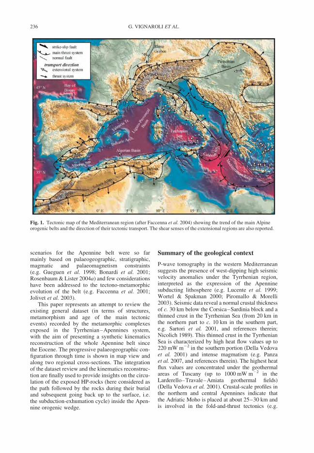
scenarios for the Apennine belt were so farmainly based on palaeogeographic, stratigraphic,magmatic and palaeomagnetism constraints(e.g. Gueguen et al. 1998; Bonardi et al. 2001;Rosenbaum & Lister 2004a) and few considerationshave been addressed to the tectono-metamorphicevolution of the belt (e.g. Faccenna et al. 2001;Jolivet et al. 2003).
This paper represents an attempt to review theexisting general dataset (in terms of structures,metamorphism and age of the main tectonicevents) recorded by the metamorphic complexesexposed in the Tyrrhenian–Apennines system,with the aim of presenting a synthetic kinematicsreconstruction of the whole Apennine belt sincethe Eocene. The progressive palaeogeographic con-figuration through time is shown in map view andalong two regional cross-sections. The integrationof the dataset review and the kinematics reconstruc-tion are finally used to provide insights on the circu-lation of the exposed HP-rocks (here considered asthe path followed by the rocks during their burialand subsequent going back up to the surface, i.e.the subduction-exhumation cycle) inside the Apen-nine orogenic wedge.
Summary of the geological context
P-wave tomography in the western Mediterraneansuggests the presence of west-dipping high seismicvelocity anomalies under the Tyrrhenian region,interpreted as the expression of the Apenninesubducting lithosphere (e.g. Lucente et al. 1999;Wortel & Spakman 2000; Piromallo & Morelli2003). Seismic data reveal a normal crustal thicknessof c. 30 km below the Corsica–Sardinia block and athinned crust in the Tyrrhenian Sea (from 20 km inthe northern part to c. 10 km in the southern part,e.g. Sartori et al. 2001, and references therein;Nicolich 1989). This thinned crust in the TyrrhenianSea is characterized by high heat flow values up to220 mW m22 in the southern portion (Della Vedovaet al. 2001) and intense magmatism (e.g. Panzaet al. 2007, and references therein). The highest heatflux values are concentrated under the geothermalareas of Tuscany (up to 1000 mW m22 in theLarderello–Travale–Amiata geothermal fields)(Della Vedova et al. 2001). Crustal-scale profiles inthe northern and central Apennines indicate thatthe Adriatic Moho is placed at about 25–30 km andis involved in the fold-and-thrust tectonics (e.g.
Fig. 1. Tectonic map of the Mediterranean region (after Faccenna et al. 2004) showing the trend of the main Alpineorogenic belts and the direction of their tectonic transport. The shear senses of the extensional regions are also reported.
G. VIGNAROLI ET AL.236
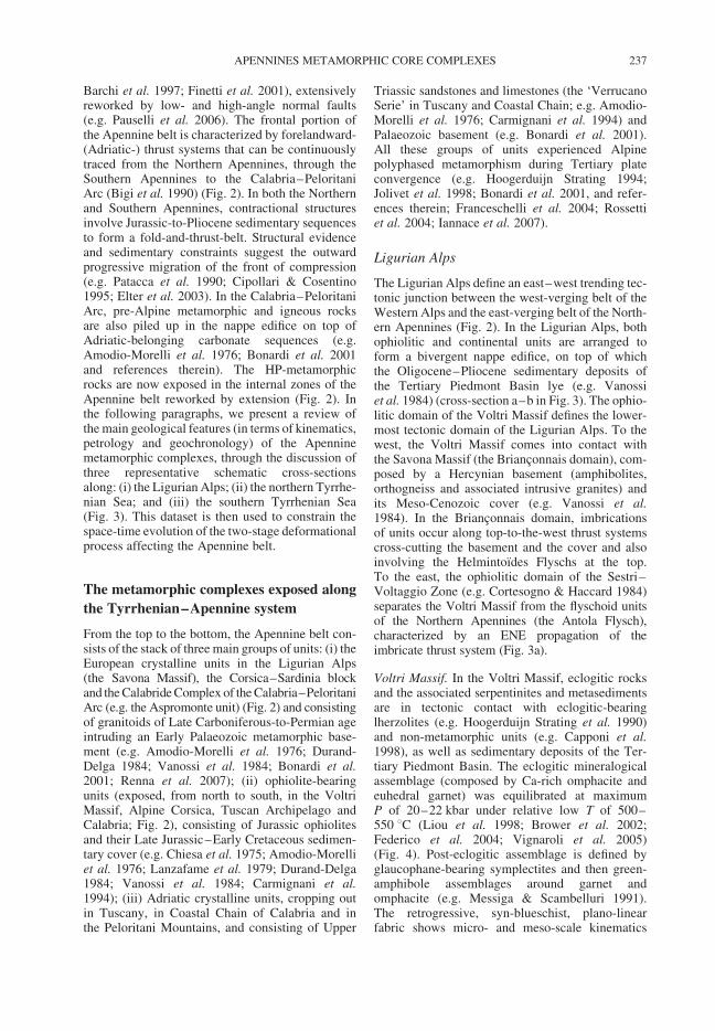
Barchi et al. 1997; Finetti et al. 2001), extensivelyreworked by low- and high-angle normal faults(e.g. Pauselli et al. 2006). The frontal portion ofthe Apennine belt is characterized by forelandward-(Adriatic-) thrust systems that can be continuouslytraced from the Northern Apennines, through theSouthern Apennines to the Calabria–PeloritaniArc (Bigi et al. 1990) (Fig. 2). In both the Northernand Southern Apennines, contractional structuresinvolve Jurassic-to-Pliocene sedimentary sequencesto form a fold-and-thrust-belt. Structural evidenceand sedimentary constraints suggest the outwardprogressive migration of the front of compression(e.g. Patacca et al. 1990; Cipollari & Cosentino1995; Elter et al. 2003). In the Calabria–PeloritaniArc, pre-Alpine metamorphic and igneous rocksare also piled up in the nappe edifice on top ofAdriatic-belonging carbonate sequences (e.g.Amodio-Morelli et al. 1976; Bonardi et al. 2001and references therein). The HP-metamorphicrocks are now exposed in the internal zones of theApennine belt reworked by extension (Fig. 2). Inthe following paragraphs, we present a review ofthe main geological features (in terms of kinematics,petrology and geochronology) of the Apenninemetamorphic complexes, through the discussion ofthree representative schematic cross-sectionsalong: (i) the Ligurian Alps; (ii) the northern Tyrrhe-nian Sea; and (iii) the southern Tyrrhenian Sea(Fig. 3). This dataset is then used to constrain thespace-time evolution of the two-stage deformationalprocess affecting the Apennine belt.
The metamorphic complexes exposed along
the Tyrrhenian–Apennine system
From the top to the bottom, the Apennine belt con-sists of the stack of three main groups of units: (i) theEuropean crystalline units in the Ligurian Alps(the Savona Massif), the Corsica–Sardinia blockand the Calabride Complex of the Calabria–PeloritaniArc (e.g. the Aspromonte unit) (Fig. 2) and consistingof granitoids of Late Carboniferous-to-Permian ageintruding an Early Palaeozoic metamorphic base-ment (e.g. Amodio-Morelli et al. 1976; Durand-Delga 1984; Vanossi et al. 1984; Bonardi et al.2001; Renna et al. 2007); (ii) ophiolite-bearingunits (exposed, from north to south, in the VoltriMassif, Alpine Corsica, Tuscan Archipelago andCalabria; Fig. 2), consisting of Jurassic ophiolitesand their Late Jurassic–Early Cretaceous sedimen-tary cover (e.g. Chiesa et al. 1975; Amodio-Morelliet al. 1976; Lanzafame et al. 1979; Durand-Delga1984; Vanossi et al. 1984; Carmignani et al.1994); (iii) Adriatic crystalline units, cropping outin Tuscany, in Coastal Chain of Calabria and inthe Peloritani Mountains, and consisting of Upper
Triassic sandstones and limestones (the ‘VerrucanoSerie’ in Tuscany and Coastal Chain; e.g. Amodio-Morelli et al. 1976; Carmignani et al. 1994) andPalaeozoic basement (e.g. Bonardi et al. 2001).All these groups of units experienced Alpinepolyphased metamorphism during Tertiary plateconvergence (e.g. Hoogerduijn Strating 1994;Jolivet et al. 1998; Bonardi et al. 2001, and refer-ences therein; Franceschelli et al. 2004; Rossettiet al. 2004; Iannace et al. 2007).
Ligurian Alps
The Ligurian Alps define an east–west trending tec-tonic junction between the west-verging belt of theWestern Alps and the east-verging belt of the North-ern Apennines (Fig. 2). In the Ligurian Alps, bothophiolitic and continental units are arranged toform a bivergent nappe edifice, on top of whichthe Oligocene–Pliocene sedimentary deposits ofthe Tertiary Piedmont Basin lye (e.g. Vanossiet al. 1984) (cross-section a–b in Fig. 3). The ophio-litic domain of the Voltri Massif defines the lower-most tectonic domain of the Ligurian Alps. To thewest, the Voltri Massif comes into contact withthe Savona Massif (the Brianconnais domain), com-posed by a Hercynian basement (amphibolites,orthogneiss and associated intrusive granites) andits Meso-Cenozoic cover (e.g. Vanossi et al.1984). In the Brianconnais domain, imbricationsof units occur along top-to-the-west thrust systemscross-cutting the basement and the cover and alsoinvolving the Helmintoıdes Flyschs at the top.To the east, the ophiolitic domain of the Sestri–Voltaggio Zone (e.g. Cortesogno & Haccard 1984)separates the Voltri Massif from the flyschoid unitsof the Northern Apennines (the Antola Flysch),characterized by an ENE propagation of theimbricate thrust system (Fig. 3a).
Voltri Massif. In the Voltri Massif, eclogitic rocksand the associated serpentinites and metasedimentsare in tectonic contact with eclogitic-bearinglherzolites (e.g. Hoogerduijn Strating et al. 1990)and non-metamorphic units (e.g. Capponi et al.1998), as well as sedimentary deposits of the Ter-tiary Piedmont Basin. The eclogitic mineralogicalassemblage (composed by Ca-rich omphacite andeuhedral garnet) was equilibrated at maximumP of 20–22 kbar under relative low T of 500–550 8C (Liou et al. 1998; Brower et al. 2002;Federico et al. 2004; Vignaroli et al. 2005)(Fig. 4). Post-eclogitic assemblage is defined byglaucophane-bearing symplectites and then green-amphibole assemblages around garnet andomphacite (e.g. Messiga & Scambelluri 1991).The retrogressive, syn-blueschist, plano-linearfabric shows micro- and meso-scale kinematics
APENNINES METAMORPHIC CORE COMPLEXES 237
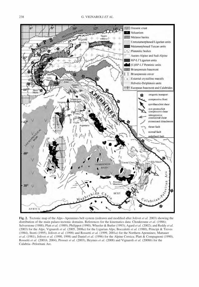
Fig. 2. Tectonic map of the Alps–Apennines belt system (redrawn and modified after Jolivet et al. 2003) showing thedistribution of the main palaeo-tectonic domains. References for the kinematics data: Choukroune et al. (1986);Selverstone (1988); Platt et al. (1989); Philippot (1990); Wheeler & Butler (1993); Agard et al. (2002); and Reddy et al.(2003) for the Alps; Vignaroli et al. (2005, 2008a) for the Ligurian Alps; Boccaletti et al. (1980), Principi & Treves(1984), Storti (1995), Jolivet et al. (1998) and Rossetti et al. (1999, 2001a) for the Northern Apennines; Mattaueret al. (1981), Jolivet et al. (1990, 1998) and Daniel et al. (1996) for the Alpine Corsica; Platt & Compagnoni (1990),Rossetti et al. (2001b, 2004), Prosser et al. (2003), Heymes et al. (2008) and Vignaroli et al. (2008b) for theCalabria–Peloritani Arc.
G. VIGNAROLI ET AL.238
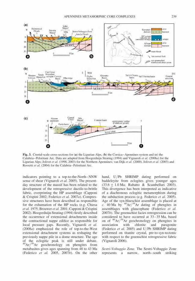
indicators pointing to a top-to-the-North–NNWsense of shear (Vignaroli et al. 2005). The present-day structure of the massif has been related to thedevelopment of the retrogressive ductile-to-brittlefabric, overprinting the HP assemblage (Capponi& Crispini 2002; Federico et al. 2007a). Compres-sive structures have been described as responsiblefor the exhumation of the HP rocks (e.g. Chiesaet al. 1975; Brouwer et al. 2001; Capponi & Crispini2002). Hoogerduijn Strating (1994) firstly describedthe occurrence of extensional detachments insidethe contractional nappe edifice as responsible forlocal pressure gaps. Recently, Vignaroli et al.(2008a) emphasized the role of top-to-the-Westextensional detachment systems as reshaping thepreviously nappe pile in a dome structure. The ageof the eclogitic peak is still under debate.40Ar/39Ar geochronology on phengites frommetabasites gives ages spanning from 48 to 43 Ma(Federico et al. 2005, 2007b). On the other
hand, U/Pb SHRIMP dating performed onbaddeleyite from eclogites gives younger ages(33.6 + 1.0 Ma; Rubatto & Scambelluri 2003).This divergence has been interpreted as indicativeof a diachronous eclogitic metamorphism duringthe subduction process (e.g. Federico et al. 2005).Age of the syn-blueschist assemblage is placed atc. 40 Ma by 40Ar/39Ar dating of phengites inassemblages with glaucophane (Federico et al.2007b). The greenschist facies retrogression can beconsidered to have occurred at 33–35 Ma, basedon of 40Ar/39Ar geochronology on phengites inassociation with chlorite and paragonite(Federico et al. 2005) and U/Pb SHRIMP datingperformed on titanite crystal, pre-to-syn-tectonicwith respect to the greenschist retrogressive fabric(Vignaroli 2006).
Sestri-Voltaggio Zone. The Sestri-Voltaggio Zonerepresents a narrow, north–south striking
Fig. 3. Crustal-scale cross-sections for (a) the Ligurian Alps, (b) the Corsica–Apennines system and (c) theCalabria–Peloritani Arc. Data are adapted from Hoogerduijn Strating (1994) and Vignaroli et al. (2008a) for theLigurian Alps; Jolivet et al. (1998, 2003) for the Northern Apennines; van Dijk et al. (2000), Jolivet et al. (2003) andRossetti et al. (2004) for the Calabria–Peloritani Arc.
APENNINES METAMORPHIC CORE COMPLEXES 239
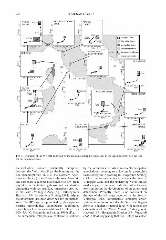
metaophiolitic domain structurally interposedbetween the Voltri Massif (at the bottom) and thenon-metamorphosed units of the Northern Apen-nines (at the top). Late Triassic–Jurassic dolomiticand carbonate sequences associated with low-gradephyllites, serpentinites, gabbros and metabasitesalternating with recrystallized limestones crop outin the Sestri–Voltaggio Zone (e.g. Cortesogno &Haccard 1984; Hoogerduin Strating 1994). Alpinemetamorphism has been described for the metaba-sites. The HP stage is represented by glaucophane-bearing mineralogical assemblages equilibratedunder blueschist facies conditions (7–8 kbar over300–350 8C; Hoogerduijn Strating 1994) (Fig. 4).The subsequent retrogressive evolution is testified
by the occurrence of white mica-chlorite-epidoteassociations, pointing to a low-grade greenschistfacies overprint. According to Hoogerduin Strating(1994), the tectonic contact between the Sestri–Voltaggio Zone and the underlying Voltri Massifmarks a gap in pressure, indicative of a tectonicexcision during the development of an extensionaldetachment. Presently, there is no constraint onthe age of the HP stage recorded in the Sestri–Voltaggio Zone. Nevertheless, structural obser-vations allow us to consider the Sestri–VoltaggioZone as a higher structural level with respect theexhumation of the Voltri Massif (Cortesogno &Haccard 1984; Hoogerduin Strating 1994; Vignaroliet al. 2008a), suggesting that its HP stage was older
Fig. 4. Synthesis of the P-T path followed by the main metamorphic complexes in the Apennine belt. See the textfor the data references.
G. VIGNAROLI ET AL.240
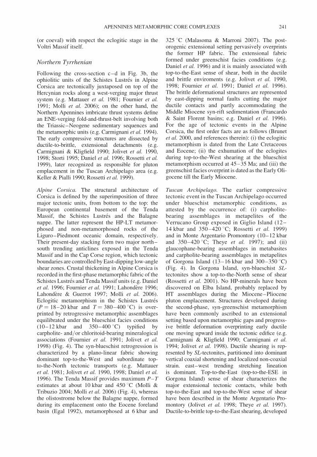
(or coeval) with respect the eclogitic stage in theVoltri Massif itself.
Northern Tyrrhenian
Following the cross-section c–d in Fig. 3b, theophiolitic units of the Schistes Lustres in AlpineCorsica are tectonically juxtaposed on top of theHercynian rocks along a west-verging major thrustsystem (e.g. Mattauer et al. 1981; Fournier et al.1991; Molli et al. 2006); on the other hand, theNorthern Apennines imbricate thrust systems definean ENE-verging fold-and-thrust-belt involving boththe Triassic–Neogene sedimentary sequences andthe metamorphic units (e.g. Carmignani et al. 1994).The early compressive structures are dissected byductile-to-brittle, extensional detachments (e.g.Carmignani & Kligfield 1990; Jolivet et al. 1990,1998; Storti 1995; Daniel et al. 1996; Rossetti et al.1999), later recognized as responsible for plutonemplacement in the Tuscan Archipelago area (e.g.Keller & Pialli 1990; Rossetti et al. 1999).
Alpine Corsica. The structural architecture ofCorsica is defined by the superimposition of threemajor tectonic units, from bottom to the top: theEuropean continental basement of the TendaMassif, the Schistes Lustres and the Balagnenappe. The latter represent the HP-LT metamor-phosed and non-metamorphosed rocks of theLiguro–Piedmont oceanic domain, respectively.Their present-day stacking form two major north–south trending anticlines exposed in the TendaMassif and in the Cap Corse region, which tectonicboundaries are controlled by East-dipping low-angleshear zones. Crustal thickening in Alpine Corsica isrecorded in the first-phase metamorphic fabric of theSchistes Lustres and Tenda Massif units (e.g. Danielet al. 1996; Fournier et al. 1991; Lahondere 1996;Lahondere & Guerrot 1997; Molli et al. 2006).Eclogitic metamorphism in the Schistes Lustres(P ¼ 18–20 kbar and T ¼ 380–400 8C) is over-printed by retrogressive metamorphic assemblagesequilibrated under the blueschist facies conditions(10–12 kbar and 350–400 8C) typified bycarpholite- and/or chloritoid-bearing mineralogicalassociations (Fournier et al. 1991; Jolivet et al.1998) (Fig. 4). The syn-blueschist retrogression ischaracterized by a plano-linear fabric showingdominant top-to-the-West and subordinate top-to-the-North tectonic transports (e.g. Mattaueret al. 1981; Jolivet et al. 1990, 1998; Daniel et al.1996). The Tenda Massif provides maximum P–Testimates at about 10 kbar and 450 8C (Molli &Tribuzio 2004; Molli et al. 2006) (Fig. 4), whereasthe olistostrome below the Balagne nappe, formedduring its emplacement onto the Eocene forelandbasin (Egal 1992), metamorphosed at 6 kbar and
325 8C (Malasoma & Marroni 2007). The post-orogenic extensional setting pervasively overprintsthe former HP fabric. The extensional fabricformed under greenschist facies conditions (e.g.Daniel et al. 1996) and it is mainly associated withtop-to-the-East sense of shear, both in the ductileand brittle enviroments (e.g. Jolivet et al. 1990,1998; Fournier et al. 1991; Daniel et al. 1996).The brittle deformational structures are representedby east-dipping normal faults cutting the majorductile contacts and partly accommodating theMiddle Miocene syn-rift sedimentation (Francardo& Saint Florent basins; e.g. Daniel et al. 1996).For the age of tectonic events in the AlpineCorsica, the first order facts are as follows (Brunetet al. 2000, and references therein): (i) the eclogiticmetamorphism is dated from the Late Cretaceousand Eocene; (ii) the exhumation of the eclogitesduring top-to-the-West shearing at the blueschistmetamorphism occurred at 45–35 Ma; and (iii) thegreenschist facies overprint is dated as the Early Oli-gocene till the Early Miocene.
Tuscan Archipelago. The earlier compressivetectonic event in the Tuscan Archipelago occurredunder blueschist metamorphic conditions, asattested by the occurrence of: (i) carpholite-bearing assemblages in metapelites of theVerrucano Group exposed in Giglio Island (12–14 kbar and 350–420 8C; Rossetti et al. 1999)and in Monte Argentario Promontory (10–12 kbarand 350–420 8C; Theye et al. 1997); and (ii)glaucophane-bearing assemblages in metabasitesand carpholite-bearing assemblages in metapelitesof Gorgona Island (13–16 kbar and 300–350 8C)(Fig. 4). In Gorgona Island, syn-blueschist SL-tectonites show a top-to-the-North sense of shear(Rossetti et al. 2001). No HP-minerals have beendiscovered on Elba Island, probably replaced byHT assemblages during the Miocene–Pliocenepluton emplacement. Structures developed duringthe second-phase, syn-greenschist metamorphismhave been commonly ascribed to an extensionalsetting based upon metamorphic gaps and progress-ive brittle deformation overprinting early ductileone moving upward inside the tectonic edifice (e.g.Carmignani & Kligfield 1990; Carmignani et al.1994; Jolivet et al. 1998). Ductile shearing is rep-resented by SL-tectonites, partitioned into dominantvertical coaxial shortening and localized non-coaxialstrain. east–west trending stretching lineationis dominant. Top-to-the-East (top-to-the-ESE inGorgona Island) sense of shear characterizes themajor extensional tectonic contacts, while bothtop-to-the-East and top-to-the-West sense of shearhave been described in the Monte Argentario Pro-montory (Jolivet et al. 1998; Theye et al. 1997).Ductile-to-brittle top-to-the-East shearing, developed
APENNINES METAMORPHIC CORE COMPLEXES 241
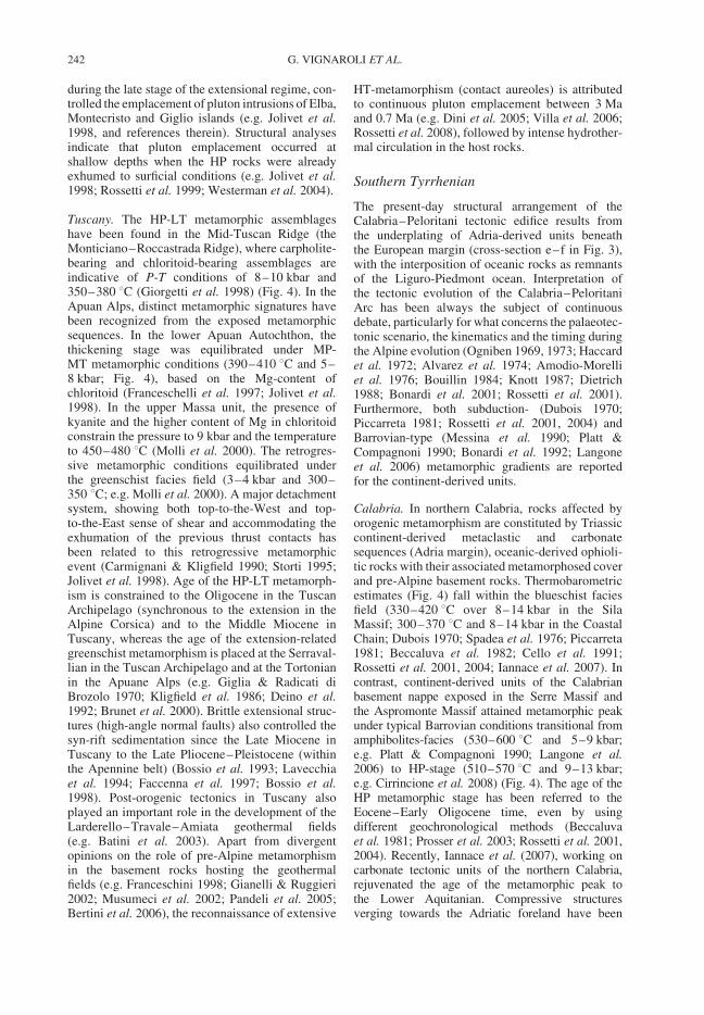
during the late stage of the extensional regime, con-trolled the emplacement of pluton intrusions of Elba,Montecristo and Giglio islands (e.g. Jolivet et al.1998, and references therein). Structural analysesindicate that pluton emplacement occurred atshallow depths when the HP rocks were alreadyexhumed to surficial conditions (e.g. Jolivet et al.1998; Rossetti et al. 1999; Westerman et al. 2004).
Tuscany. The HP-LT metamorphic assemblageshave been found in the Mid-Tuscan Ridge (theMonticiano–Roccastrada Ridge), where carpholite-bearing and chloritoid-bearing assemblages areindicative of P-T conditions of 8–10 kbar and350–380 8C (Giorgetti et al. 1998) (Fig. 4). In theApuan Alps, distinct metamorphic signatures havebeen recognized from the exposed metamorphicsequences. In the lower Apuan Autochthon, thethickening stage was equilibrated under MP-MT metamorphic conditions (390–410 8C and 5–8 kbar; Fig. 4), based on the Mg-content ofchloritoid (Franceschelli et al. 1997; Jolivet et al.1998). In the upper Massa unit, the presence ofkyanite and the higher content of Mg in chloritoidconstrain the pressure to 9 kbar and the temperatureto 450–480 8C (Molli et al. 2000). The retrogres-sive metamorphic conditions equilibrated underthe greenschist facies field (3–4 kbar and 300–350 8C; e.g. Molli et al. 2000). A major detachmentsystem, showing both top-to-the-West and top-to-the-East sense of shear and accommodating theexhumation of the previous thrust contacts hasbeen related to this retrogressive metamorphicevent (Carmignani & Kligfield 1990; Storti 1995;Jolivet et al. 1998). Age of the HP-LT metamorph-ism is constrained to the Oligocene in the TuscanArchipelago (synchronous to the extension in theAlpine Corsica) and to the Middle Miocene inTuscany, whereas the age of the extension-relatedgreenschist metamorphism is placed at the Serraval-lian in the Tuscan Archipelago and at the Tortonianin the Apuane Alps (e.g. Giglia & Radicati diBrozolo 1970; Kligfield et al. 1986; Deino et al.1992; Brunet et al. 2000). Brittle extensional struc-tures (high-angle normal faults) also controlled thesyn-rift sedimentation since the Late Miocene inTuscany to the Late Pliocene–Pleistocene (withinthe Apennine belt) (Bossio et al. 1993; Lavecchiaet al. 1994; Faccenna et al. 1997; Bossio et al.1998). Post-orogenic tectonics in Tuscany alsoplayed an important role in the development of theLarderello–Travale–Amiata geothermal fields(e.g. Batini et al. 2003). Apart from divergentopinions on the role of pre-Alpine metamorphismin the basement rocks hosting the geothermalfields (e.g. Franceschini 1998; Gianelli & Ruggieri2002; Musumeci et al. 2002; Pandeli et al. 2005;Bertini et al. 2006), the reconnaissance of extensive
HT-metamorphism (contact aureoles) is attributedto continuous pluton emplacement between 3 Maand 0.7 Ma (e.g. Dini et al. 2005; Villa et al. 2006;Rossetti et al. 2008), followed by intense hydrother-mal circulation in the host rocks.
Southern Tyrrhenian
The present-day structural arrangement of theCalabria–Peloritani tectonic edifice results fromthe underplating of Adria-derived units beneaththe European margin (cross-section e–f in Fig. 3),with the interposition of oceanic rocks as remnantsof the Liguro-Piedmont ocean. Interpretation ofthe tectonic evolution of the Calabria–PeloritaniArc has been always the subject of continuousdebate, particularly for what concerns the palaeotec-tonic scenario, the kinematics and the timing duringthe Alpine evolution (Ogniben 1969, 1973; Haccardet al. 1972; Alvarez et al. 1974; Amodio-Morelliet al. 1976; Bouillin 1984; Knott 1987; Dietrich1988; Bonardi et al. 2001; Rossetti et al. 2001).Furthermore, both subduction- (Dubois 1970;Piccarreta 1981; Rossetti et al. 2001, 2004) andBarrovian-type (Messina et al. 1990; Platt &Compagnoni 1990; Bonardi et al. 1992; Langoneet al. 2006) metamorphic gradients are reportedfor the continent-derived units.
Calabria. In northern Calabria, rocks affected byorogenic metamorphism are constituted by Triassiccontinent-derived metaclastic and carbonatesequences (Adria margin), oceanic-derived ophioli-tic rocks with their associated metamorphosed coverand pre-Alpine basement rocks. Thermobarometricestimates (Fig. 4) fall within the blueschist faciesfield (330–420 8C over 8–14 kbar in the SilaMassif; 300–370 8C and 8–14 kbar in the CoastalChain; Dubois 1970; Spadea et al. 1976; Piccarreta1981; Beccaluva et al. 1982; Cello et al. 1991;Rossetti et al. 2001, 2004; Iannace et al. 2007). Incontrast, continent-derived units of the Calabrianbasement nappe exposed in the Serre Massif andthe Aspromonte Massif attained metamorphic peakunder typical Barrovian conditions transitional fromamphibolites-facies (530–600 8C and 5–9 kbar;e.g. Platt & Compagnoni 1990; Langone et al.2006) to HP-stage (510–570 8C and 9–13 kbar;e.g. Cirrincione et al. 2008) (Fig. 4). The age of theHP metamorphic stage has been referred to theEocene–Early Oligocene time, even by usingdifferent geochronological methods (Beccaluvaet al. 1981; Prosser et al. 2003; Rossetti et al. 2001,2004). Recently, Iannace et al. (2007), working oncarbonate tectonic units of the northern Calabria,rejuvenated the age of the metamorphic peak tothe Lower Aquitanian. Compressive structuresverging towards the Adriatic foreland have been
G. VIGNAROLI ET AL.242
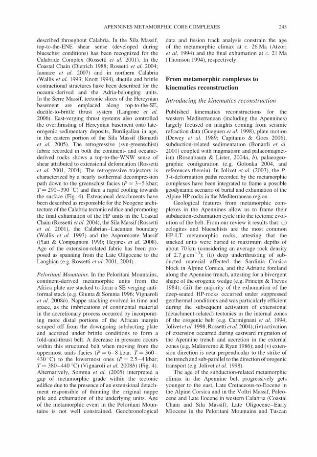
described throughout Calabria. In the Sila Massif,top-to-the-ENE shear sense (developed duringblueschist conditions) has been recognized for theCalabride Complex (Rossetti et al. 2001). In theCoastal Chain (Dietrich 1988; Rossetti et al. 2004;Iannace et al. 2007) and in northern Calabria(Wallis et al. 1993; Knott 1994), ductile and brittlecontractional structures have been described for theoceanic-derived and the Adria-belonging units.In the Serre Massif, tectonic slices of the Hercynianbasement are emplaced along top-to-the-SE,ductile-to-brittle thrust system (Langone et al.2006). East-verging thrust systems also controlledthe overthrusting of Hercynian basement onto late-orogenic sedimentary deposits, Burdigalian in age,in the eastern portion of the Sila Massif (Bonardiet al. 2005). The retrogressive (syn-greenschist)fabric recorded in both the continent- and oceanic-derived rocks shows a top-to-the-WNW sense ofshear attributed to extensional deformation (Rossettiet al. 2001, 2004). The retrogressive trajectory ischaracterized by a nearly isothermal decompressionpath down to the greenschist facies (P ¼ 3–5 kbar;T ¼ 290–390 8C) and then a rapid cooling towardsthe surface (Fig. 4). Extensional detachments havebeen described as responsible for the Neogene archi-tecture of the Calabria tectonic edifice and promotingthe final exhumation of the HP units in the CoastalChain (Rossetti et al. 2004), the Sila Massif (Rossettiet al. 2001), the Calabrian–Lucanian boundary(Wallis et al. 1993) and the Aspromonte Massif(Platt & Compagnoni 1990; Heymes et al. 2008).Age of the extension-related fabric has been pro-posed as spanning from the Late Oligocene to theLanghian (e.g. Rossetti et al. 2001, 2004).
Peloritani Mountains. In the Peloritani Mountains,continent-derived metamorphic units from theAfrica plate are stacked to form a SE-verging anti-formal stack (e.g. Giunta & Somma 1996; Vignaroliet al. 2008b). Nappe stacking evolved in time andspace, as the imbrications of continental materialin the accretionary process occurred by incorporat-ing more distal portions of the African marginscraped off from the downgoing subducting plateand accreted under brittle conditions to form afold-and-thrust belt. A decrease in pressure occurswithin this structured belt when moving from theuppermost units facies (P ¼ 6–8 kbar; T ¼ 360–430 8C) to the lowermost ones (P ¼ 2.5–4 kbar;T ¼ 380–440 8C) (Vignaroli et al. 2008b) (Fig. 4).Alternatively, Somma et al. (2005) interpreted agap of metamorphic grade within the tectonicedifice due to the presence of an extensional detach-ment responsible of thinning the original nappepile and exhumation of the underlying units. Ageof the metamorphic event in the Peloritani Moun-tains is not well constrained. Geochronological
data and fission track analysis constrain the ageof the metamorphic climax at c. 26 Ma (Atzoriet al. 1994) and the final exhumation at c. 21 Ma(Thomson 1994), respectively.
From metamorphic complexes to
kinematics reconstruction
Introducing the kinematics reconstruction
Published kinematics reconstructions for thewestern Mediterranean (including the Apennines)largely focused on insights coming from seismicrefraction data (Gueguen et al. 1998), plate motion(Dewey et al. 1989; Capitanio & Goes 2006),subduction-related sedimentation (Bonardi et al.2001) coupled with magmatism and palaeomagnet-ism (Rosenbaum & Lister, 2004a, b), palaeogeo-graphic configuration (e.g. Golonka 2004, andreferences therein). In Jolivet et al. (2003), the P-T-t-deformation paths recorded by the metamorphiccomplexes have been integrated to frame a possiblegeodynamic scenario of burial and exhumation of theAlpine HP rocks in the Mediterranean region.
Geological features from metamorphic com-plexes in the Apennines allow us to frame theirsubduction-exhumation cycle into the tectonic evol-ution of the belt. From our review it results that: (i)eclogites and blueschists are the most commonHP-LT metamorphic rocks, attesting that thestacked units were buried to maximum depths ofabout 70 km (considering an average rock densityof 2.7 g cm23); (ii) deep underthrusting of sub-ducted material affected the Sardinia–Corsicablock in Alpine Corsica, and the Adriatic forelandalong the Apennine trench, attesting for a bivergentshape of the orogenic wedge (e.g. Principi & Treves1984); (iii) the majority of the exhumation of thedeep-seated HP-rocks occurred under suppressedgeothermal conditions and was particularly efficientduring the subsequent activation of extensional(detachment-related) tectonics in the internal zonesof the orogenic belt (e.g. Carmignani et al. 1994;Jolivet et al. 1998; Rossetti et al. 2004); (iv) activationof extension occurred during eastward migration ofthe Apennine trench and accretion in the externalzones (e.g. Malinverno & Ryan 1986); and (v) exten-sion direction is near perpendicular to the strike ofthe trench and sub-parallel to the direction of orogenictransport (e.g. Jolivet et al. 1998).
The age of the subduction-related metamorphicclimax in the Apennine belt progressively getsyounger to the east, Late Cretaceous-to-Eocene inthe Alpine Corsica and in the Voltri Massif, Paleo-cene and Late Eocene in western Calabria (CoastalChain and Sila Massif), Late Oligocene–EarlyMiocene in the Peloritani Mountains and Tuscan
APENNINES METAMORPHIC CORE COMPLEXES 243
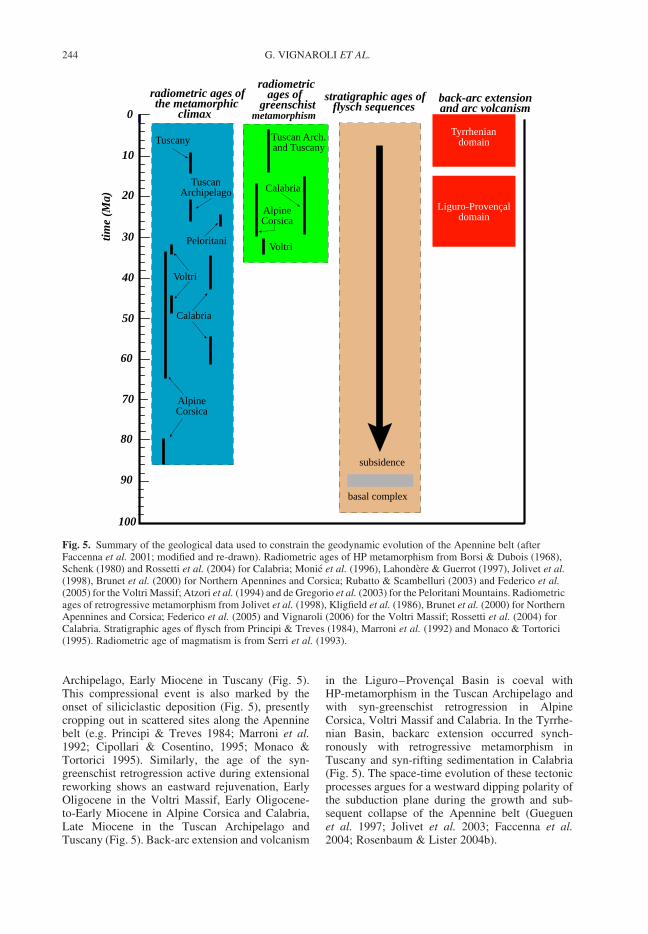
Archipelago, Early Miocene in Tuscany (Fig. 5).This compressional event is also marked by theonset of siliciclastic deposition (Fig. 5), presentlycropping out in scattered sites along the Apenninebelt (e.g. Principi & Treves 1984; Marroni et al.1992; Cipollari & Cosentino, 1995; Monaco &Tortorici 1995). Similarly, the age of the syn-greenschist retrogression active during extensionalreworking shows an eastward rejuvenation, EarlyOligocene in the Voltri Massif, Early Oligocene-to-Early Miocene in Alpine Corsica and Calabria,Late Miocene in the Tuscan Archipelago andTuscany (Fig. 5). Back-arc extension and volcanism
in the Liguro–Provencal Basin is coeval withHP-metamorphism in the Tuscan Archipelago andwith syn-greenschist retrogression in AlpineCorsica, Voltri Massif and Calabria. In the Tyrrhe-nian Basin, backarc extension occurred synch-ronously with retrogressive metamorphism inTuscany and syn-rifting sedimentation in Calabria(Fig. 5). The space-time evolution of these tectonicprocesses argues for a westward dipping polarity ofthe subduction plane during the growth and sub-sequent collapse of the Apennine belt (Gueguenet al. 1997; Jolivet et al. 2003; Faccenna et al.2004; Rosenbaum & Lister 2004b).
0
10
20
30time
(Ma)
40
50
60
70
80
90
100
stratigraphic ages offlysch sequences
subsidence
basal complex
back-arc extensionand arc volcanism
Tyrrheniandomain
Liguro-Provençaldomain
radiometric ages of the metamorphic
climax
TuscanArchipelago
Calabria
AlpineCorsica
Peloritani
Tuscany
radiometric ages of
greenschistmetamorphism
Tuscan Arch.and Tuscany
Calabria
AlpineCorsica
Voltri
Voltri
Fig. 5. Summary of the geological data used to constrain the geodynamic evolution of the Apennine belt (afterFaccenna et al. 2001; modified and re-drawn). Radiometric ages of HP metamorphism from Borsi & Dubois (1968),Schenk (1980) and Rossetti et al. (2004) for Calabria; Monie et al. (1996), Lahondere & Guerrot (1997), Jolivet et al.(1998), Brunet et al. (2000) for Northern Apennines and Corsica; Rubatto & Scambelluri (2003) and Federico et al.(2005) for the Voltri Massif; Atzori et al. (1994) and de Gregorio et al. (2003) for the Peloritani Mountains. Radiometricages of retrogressive metamorphism from Jolivet et al. (1998), Kligfield et al. (1986), Brunet et al. (2000) for NorthernApennines and Corsica; Federico et al. (2005) and Vignaroli (2006) for the Voltri Massif; Rossetti et al. (2004) forCalabria. Stratigraphic ages of flysch from Principi & Treves (1984), Marroni et al. (1992) and Monaco & Tortorici(1995). Radiometric age of magmatism is from Serri et al. (1993).
G. VIGNAROLI ET AL.244
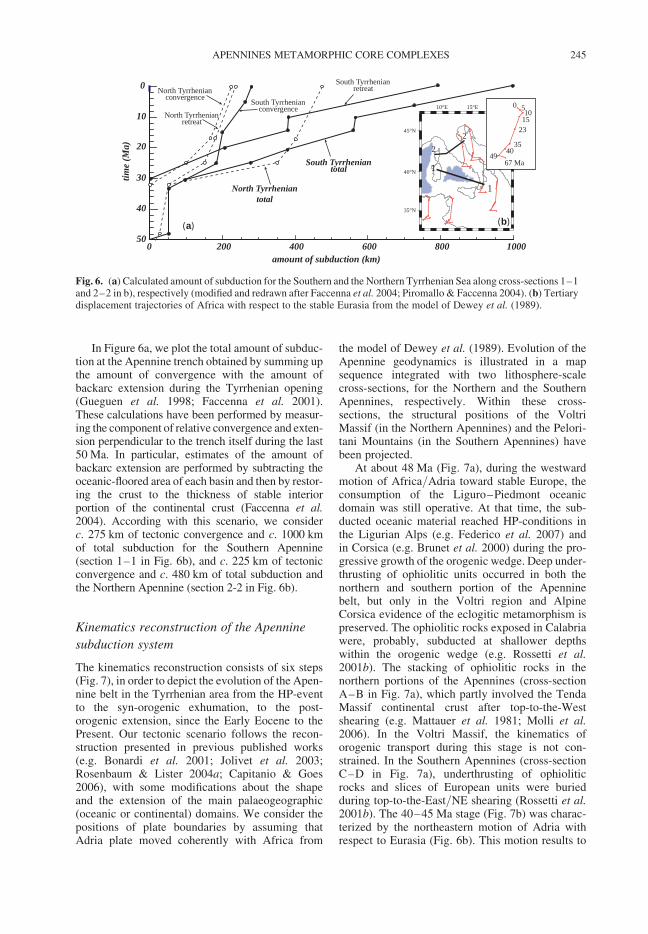
In Figure 6a, we plot the total amount of subduc-tion at the Apennine trench obtained by summing upthe amount of convergence with the amount ofbackarc extension during the Tyrrhenian opening(Gueguen et al. 1998; Faccenna et al. 2001).These calculations have been performed by measur-ing the component of relative convergence and exten-sion perpendicular to the trench itself during the last50 Ma. In particular, estimates of the amount ofbackarc extension are performed by subtracting theoceanic-floored area of each basin and then by restor-ing the crust to the thickness of stable interiorportion of the continental crust (Faccenna et al.2004). According with this scenario, we considerc. 275 km of tectonic convergence and c. 1000 kmof total subduction for the Southern Apennine(section 1–1 in Fig. 6b), and c. 225 km of tectonicconvergence and c. 480 km of total subduction andthe Northern Apennine (section 2-2 in Fig. 6b).
Kinematics reconstruction of the Apennine
subduction system
The kinematics reconstruction consists of six steps(Fig. 7), in order to depict the evolution of the Apen-nine belt in the Tyrrhenian area from the HP-eventto the syn-orogenic exhumation, to the post-orogenic extension, since the Early Eocene to thePresent. Our tectonic scenario follows the recon-struction presented in previous published works(e.g. Bonardi et al. 2001; Jolivet et al. 2003;Rosenbaum & Lister 2004a; Capitanio & Goes2006), with some modifications about the shapeand the extension of the main palaeogeographic(oceanic or continental) domains. We consider thepositions of plate boundaries by assuming thatAdria plate moved coherently with Africa from
the model of Dewey et al. (1989). Evolution of theApennine geodynamics is illustrated in a mapsequence integrated with two lithosphere-scalecross-sections, for the Northern and the SouthernApennines, respectively. Within these cross-sections, the structural positions of the VoltriMassif (in the Northern Apennines) and the Pelori-tani Mountains (in the Southern Apennines) havebeen projected.
At about 48 Ma (Fig. 7a), during the westwardmotion of Africa/Adria toward stable Europe, theconsumption of the Liguro–Piedmont oceanicdomain was still operative. At that time, the sub-ducted oceanic material reached HP-conditions inthe Ligurian Alps (e.g. Federico et al. 2007) andin Corsica (e.g. Brunet et al. 2000) during the pro-gressive growth of the orogenic wedge. Deep under-thrusting of ophiolitic units occurred in both thenorthern and southern portion of the Apenninebelt, but only in the Voltri region and AlpineCorsica evidence of the eclogitic metamorphism ispreserved. The ophiolitic rocks exposed in Calabriawere, probably, subducted at shallower depthswithin the orogenic wedge (e.g. Rossetti et al.2001b). The stacking of ophiolitic rocks in thenorthern portions of the Apennines (cross-sectionA–B in Fig. 7a), which partly involved the TendaMassif continental crust after top-to-the-Westshearing (e.g. Mattauer et al. 1981; Molli et al.2006). In the Voltri Massif, the kinematics oforogenic transport during this stage is not con-strained. In the Southern Apennines (cross-sectionC–D in Fig. 7a), underthrusting of ophioliticrocks and slices of European units were buriedduring top-to-the-East/NE shearing (Rossetti et al.2001b). The 40–45 Ma stage (Fig. 7b) was charac-terized by the northeastern motion of Adria withrespect to Eurasia (Fig. 6b). This motion results to
200 400
0
10
20
30
amount of subduction (km)
time
(Ma)
600 800 1000
40
500
(a)
10°E 15°E 20E
35°N
40°N
45°N
(b)
22
1
1
67 Ma49
50
35
231510
40
North Tyrrhenianretreat
North Tyrrheniantotal
North Tyrrhenianconvergence South Tyrrhenian
convergence
South Tyrrhenianretreat
South Tyrrheniantotal
Fig. 6. (a) Calculated amount of subduction for the Southern and the Northern Tyrrhenian Sea along cross-sections 1–1and 2–2 in b), respectively (modified and redrawn after Faccenna et al. 2004; Piromallo & Faccenna 2004). (b) Tertiarydisplacement trajectories of Africa with respect to the stable Eurasia from the model of Dewey et al. (1989).
APENNINES METAMORPHIC CORE COMPLEXES 245
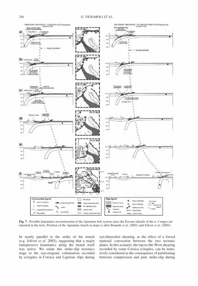
be nearly parallel to the strike of the trench(e.g. Jolivet et al. 2003), suggesting that a majortranspressive kinematics along the trench itselfwas active. We relate this strike-slip tectonicsstage to the syn-orogenic exhumation recordedby eclogites in Corsica and Ligurian Alps during
syn-blueschist shearing, as the effect of a forcedmaterial convection between the two tectonicplates. In this scenario, the top-to-the-West shearingrecorded by some Corsica eclogites, can be tenta-tively considered as the consequence of partitioningbetween compression and pure strike-slip during
Fig. 7. Possible kinematics reconstruction of the Apennine belt system since the Eocene (details of the a–f stages arereported in the text). Position of the Apennine trench in maps is after Bonardi et al. (2001) and Jolivet et al. (2003).
G. VIGNAROLI ET AL.246
transpressive kinematics. In the 35 Ma stage(Fig. 7c), subduction stopped in the Western Alpsand westward migration of the Alpine thrust frontsstarted. Meanwhile, in the Apennine trench,oceanic subduction was chocked by the entering insubduction of Africa-belonging continental slices(e.g. in Coastal Chain and Peloritani Mountains).The progression of the subduction is attested bycalc-alkaline volcanism in Provence and Sardiniaregions (e.g. Serri et al. 1993; Argnani & Savelli1999; Savelli 2002) and HP-metamorphism inboth oceanic and continental units of NorthernApennines and Calabria (Jolivet et al. 1998;Brunet et al. 2000; Rossetti et al. 2004). Fromabout 30 Ma, eastward trench retreat dominatedthe Apennine subduction (Faccenna et al. 2001).In the Voltri Massif and Alpine Corsica, the oppo-site migration of the Alpine and Apennine thrustfronts was coeval with the stretching of thedomain in between. Blueschists still formed andwere exhumed in the frontal accretionary complexes(Tuscany and Calabria), while continental subduc-tion continued in the Peloritani Mountains. Theentering in subduction of some continental slicesin both the Northern and Southern Apenninetrenches (Fig. 7c) seems to coincide with an increasein the retreating velocity of the compressive trench(Fig. 6a) and with the onset of the development ofextensional setting in the internal domains in theApennines (Fig. 5). After this stage, the fast rollbackmotion of the subducting plate occurred (Fig. 7d)(e.g. Faccenna et al. 2004; Rosenbaum & Lister2004b) concomitant with: (i) the eastward drift ofthe Sardinia-Corsica continental block (e.g.Speranza et al. 2002); and (ii) the opening ofLiguro–Provencal backarc basin (e.g. Faccennaet al. 1997). The extensional setting extensivelydeveloped in the inner portions of the Apennines(Fig. 7d), (e.g. Jolivet et al. 1998, 2003; Faccennaet al. 2001), where syn-greenschist normal-sensedetachments induced crustal thinning and post-orogenic exhumation of the HP-rocks fromgreenschist conditions to the surface. The directionof extension was perpendicular to trenches, exceptin the Voltri Massif where it trends nearly parallelto the arching of the Western Alps and the North-ern Apennines. Concomitant top-to-the-East andtop-to-the-West extensional detachments in AlpineCorsica and Calabria, respectively, suggest acrustal-scale pure-shear extensional style. Normalfaults accommodated the sedimentation of theoldest syn-rift deposits (10–20 Ma) on the easternmargin of the Sardinia–Corsica block and they getyounger towards the east (Sartori 1990).
Meanwhile, in the outer portions of theCalabria–Peloritani Arc (eastern Sila Massif,Serre Massif and Peloritani Mountains), thrustinginvolved continental units and syn-orogenic
sedimentary deposits to form a general East-vergingnappe-stack (Bonardi et al. 2005; Langone et al.2006; Vignaroli et al. 2008b). Since 15 Ma(Fig. 7e), as the eastward migration of the Apenninefront continued, the Sardinia–Corsica block rotatedtoward its present-day position and the narrowoceanic part of the Tyrrhenian Sea started to openat very high rates (e.g. Faccenna et al. 1997). Thevelocity of the eastward retreat is not homogeneousall along the Apennine trench. In the southern por-tions, retreat is at least twice as fast as in the north-ern part (Fig. 6a), probably due to the drag of thesubduction of the Ionian plate. Thrust fronts werestill migrating toward the external zones and exten-sion was active in the whole Apennines, as shown bythe occurrence of active volcanism in the internalpart of the Apennine belt and by the exhumationof HP rocks concomitant with Late Mioceneplutonism in the northern Tyrrhenian Sea (e.g.Jolivet et al. 1998; Rossetti et al. 1999). In Calabria,extensional setting also controlled the evolution ofsedimentary basins (e.g. Mattei et al. 2002; Cifelliet al. 2007). The present-day stage (Fig. 7f) isthe result of the continuous eastward migrationof the compression–extension system, as oceanicdomains of the westernmost part of the Ionianplate are subducting with a westward polarity.Brittle extension propagated all along the Tyrrhe-nian margin accomplishing for magmatic activityand hydrothermal circulation (Argnani & Savelli1999; Panza et al. 2007) and controlling sedimen-tation in grabens within the Apennine belt (e.g.Lavecchia et al. 1994).
Discussion
Any tectonic reconstruction for the evolution of theApennine orogenic system has to take into consider-ations the following major constraints:
† both oceanic- and continent-derived rocks wereburied and accreted to form the Apennine oro-genic wedge. These rocks reached metamorphicclimax at different structural levels, spanningfrom eclogitic (Schistes Lustres in VoltriMassif and Alpine Corsica) to LP-greenschist(Coastal Chain and Peloritani Mountains)facies fields, with different P/T ratios. Thesevalues, plotted against the major metamorphicfacies series in a P-T diagram (e.g. Spear1993), are representative of a progressive tran-sition from subduction- to Barrovian-type meta-morphism (Fig. 8) evolving both in space(moving eastward from the internal portions ofthe orogen) and in time (from the Late Cretac-eous in the Alpine Corsica to the MiddleMiocene in Tuscany);
APENNINES METAMORPHIC CORE COMPLEXES 247
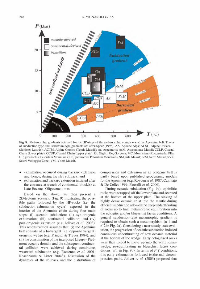
† exhumation occurred during backarc extensionand, hence, during the slab rollback; and
† exhumation and backarc extension initiated afterthe entrance at trench of continental block(s) atLate Eocene–Oligocene times.
Based on the above, we then present a2D-tectonic scenario (Fig. 9) illustrating the poss-ible paths followed by the HP-rocks (i.e. thesubduction-exhumation cycle) exposed in theinterior of the Apennine chain during four mainsteps: (i) oceanic subduction; (ii) syn-orogenicexhumation; (iii) continental collision; and (iv)post-orogenic extension (e.g. Jolivet et al. 2003).This reconstruction assumes that: (i) the Apenninebelt consists of a bi-vergent (i.e. opposite vergent)orogenic wedge (e.g. Principi & Treves 1984); and(ii) the consumption of the interposed Liguro–Pied-mont oceanic domain and the subsequent continen-tal collision were achieved during continuouswestward subduction (e.g. Faccenna et al. 2001;Rosenbaum & Lister 2004b). Discussion of thedynamics of the rollback and the distribution of
compression and extension in an orogenic belt ispartly based upon published geodynamic modelsfor the Apennines (e.g. Royden et al. 1987; Cavinato& De Celles 1999; Pauselli et al. 2006).
During oceanic subduction (Fig. 9a), ophioliticrocks were scrapped off the lower plate and accretedat the bottom of the upper plate. The sinking ofhighly dense oceanic crust into the mantle duringefficient subduction allowed the deep underthrustingof rocks up to final metamorphic equilibration intothe eclogitic and/or blueschist facies conditions. Ageneral subduction-type metamorphic gradient isrequired to obtain such a metamorphism (n81 andn82 in Fig. 9a). Considering a near steady-state evol-ution, the progression of oceanic subduction inducedcontinuous underthrusting of new oceanic materialat the bottom of the wedge. Early eclogitized rockswere then forced to move up into the accretionarywedge, re-equilibrating in blueschist facies con-ditions (n81 in Fig. 9b). In terms of P-T conditions,this early exhumation followed isothermal decom-pression paths. Jolivet et al. (2003) proposed that
Fig. 8. Metamorphic gradients obtained for the HP-stage of the metamorphic complexes of the Apennine belt. Tracesof subduction-type and Barrovian-type gradients are after Spear (1993). AA, Apuane Alps; ACSL, Alpine Corsica(Schistes Lustres); ACTM, Alpine Corsica (Tenda Massif); Ar, Argentario; AsM, Aspromonte Massif; CCLP, CoastalChain (lower plate); CCUP, Coastal Chain (upper plate); Gi, Giglio; Go, Gorgona; MC, Monticiano-Roccastrada; PEa,HP, greenschist Peloritani Mountains; LP, greenschist Peloritani Mountains; SM, Sila Massif; SeM, Serre Massif; SVZ,Sestri-Voltaggio Zone; VM, Voltri Massif.
G. VIGNAROLI ET AL.248
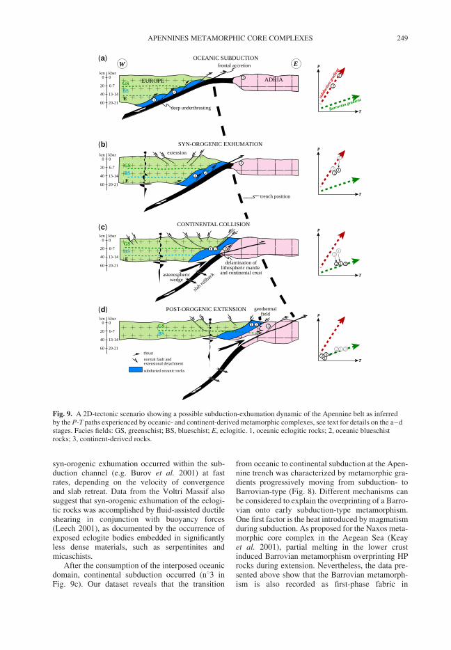
syn-orogenic exhumation occurred within the sub-duction channel (e.g. Burov et al. 2001) at fastrates, depending on the velocity of convergenceand slab retreat. Data from the Voltri Massif alsosuggest that syn-orogenic exhumation of the eclogi-tic rocks was accomplished by fluid-assisted ductileshearing in conjunction with buoyancy forces(Leech 2001), as documented by the occurrence ofexposed eclogite bodies embedded in significantlyless dense materials, such as serpentinites andmicaschists.
After the consumption of the interposed oceanicdomain, continental subduction occurred (n83 inFig. 9c). Our dataset reveals that the transition
from oceanic to continental subduction at the Apen-nine trench was characterized by metamorphic gra-dients progressively moving from subduction- toBarrovian-type (Fig. 8). Different mechanisms canbe considered to explain the overprinting of a Barro-vian onto early subduction-type metamorphism.One first factor is the heat introduced by magmatismduring subduction. As proposed for the Naxos meta-morphic core complex in the Aegean Sea (Keayet al. 2001), partial melting in the lower crustinduced Barrovian metamorphism overprinting HProcks during extension. Nevertheless, the data pre-sented above show that the Barrovian metamorph-ism is also recorded as first-phase fabric in
0 0
20 6-7
40 13-14
60 20-21
km kbar
GSBSE
EUROPE ADRIA
W E
1
2
3
frontal accretionOCEANIC SUBDUCTION
deep underthrusting
trench position
SYN-OROGENIC EXHUMATION
0 0
20 6-7
40 13-14
60 20-21
km kbar
1 2
3
extension
GSBSE
0 0
20 6-7
40 13-14
60 20-21
km kbar
CONTINENTAL COLLISION
1 2 3
slab ro
llback
delamination oflithospheric mantle and continental crustastenospheric
wedge
GSBSE
0 0
20 6-7
40 13-14
60 20-21
km kbar
POST-OROGENIC EXTENSION
3
geothermalfield
1 2GSBS
T
P
subd
uctio
n gr
adien
t
Barrovian gradient
1
2
T
P
1
2 12
T
P
12
12 3
T
P
12 3
12 3thrustnormal fault and extensional detachment
subducted oceanic rocks
(a)
(b)
(c)
(d)
Fig. 9. A 2D-tectonic scenario showing a possible subduction-exhumation dynamic of the Apennine belt as inferredby the P-T paths experienced by oceanic- and continent-derived metamorphic complexes, see text for details on the a–dstages. Facies fields: GS, greenschist; BS, blueschist; E, eclogitic. 1, oceanic eclogitic rocks; 2, oceanic blueschistrocks; 3, continent-derived rocks.
APENNINES METAMORPHIC CORE COMPLEXES 249
subducted rocks. These rocks were thus along awarm gradient when they entered the subductionzone, not during their exhumation path toward thesurface. Alternatively, thermomechanical modelsshow that the effect of the lithosphere composition(oceanic and continental) represents a feasible par-ameter to condition the metamorphic gradientduring subduction: less dense continental crust inhi-bits the deep circulation of the material within theorogenic wedge and, then, the underthrusting ofthe continental slices works at more superficiallevels (e.g. Burov et al. 2001; Goffe et al. 2003).In our case, the evolution from subduction- toBarrovian-type metamorphism seems to reflect theprogressive transition from oceanic to continentalsubduction at the Apennine trench. The increaseof the metamorphic gradient (,10 8C km21 to21–36 8C km21; Fig. 8) may be associated withthe difficulty in sinking of less dense continentalmaterial (Thompson & England 1984; Goffe et al.2003).
The onset of the continental subduction wassynchronous with a dramatic change in dynamicsof the Apennine wedge, attested by: (i) eastwardretreat of the Apennine front and outwardmigration of the compressional fronts (n83 inFig. 9c); and (ii) pervasive extension in the innerregion by means of ductile-to-brittle detachmentsproducing thinning of the previously thickened tec-tonic edifice and controlling the syn-greenschistexhumation of HP-rocks (n81 and n82 in Fig. 9c).The most recurrent models explaining the conco-mitance of extension in the upper-plate back-arcdomains with the burial of significant portions ofcontinental crust at the Apennine trench are: (i)mantle upwelling coming from foundering ofthickened lithospheric root without any active sub-duction (e.g. Decandia et al. 1998); (ii) eastwarddrifting of the compressive thrust system, with sub-ordinate crustal extension (e.g. Finetti et al. 2001);(iii) inversion of the subduction polarity (Gueguenet al. 1998); and (iv) rollback of the subductingslab (Royden et al. 1987; Cavinato & De Celles1999; Rosenbaum & Lister 2004b) accomplishedby delamination of the lower crust into the litho-spheric mantle (Faccenna et al. 2004; Pauselliet al. 2006). In agreement with the latter model,we propose that slab rollback and the consequentHP-rock exhumation occurred in response to litho-spheric delamination below the accreted orogenicwedge (Bird 1979; Brun & Faccenna 2008) afterthe entering in subduction of some continentalslices (Figs 7c & 9c). In this view, delaminationprovides an efficient mechanism to decouple thefrontal accreting part of the wedge (where thrust-ing propagates into upper crustal units) andthe post-orogenic extensional-hinterland domains(where HP-rocks are progressively exposed at the
footwall of ductile-to-brittle detachments) (n81,n82 and n83 in Fig. 9d). Thinning of the previouslythickened lithosphere during continuous delamina-tion allows the upward movement of an astheno-spheric wedge localized at the base of the crust(see also Pauselli et al. 2006). Magmatic underplat-ing induces partial melting in the lower crust gener-ating granitic magmas and hydrothermal circulationinside the stretched upper crust (Rossetti et al. 2008).Localization of geothermal fields and volcanismalong the Tyrrhenian margin of Italy may reflectthe surface manifestation of the edge of the asteno-spheric wedge under the continental crust (cf. withscenario in Panza et al. 2007 for the Central andSouthern Apennines).
Conclusions
Geological constraints from the metamorphic com-plexes outcropping in the Apennines provideinsights on the tectono-metamorphic evolution (sub-duction–exhumation cycle) of the orogenic belt.Metamorphism during oceanic subduction occurredunder subduction-type metamorphic gradients andeclogites and blueschists formed. Exhumation ofHP-rocks occurred in two main stages: syn-orogenicand post-orogenic. In particular, syn-orogenic exhu-mation is claimed for explaining the upward move-ment, under suppressed geothermal conditions, ofHP-rocks up to depths corresponding to the greens-chist facies field. After the consumption of the inter-posed oceanic domain, continental subductionoccurred and a transition from subduction- toBarrovian-type metamorphic climax was recordedby the metamorphic complexes in the orogenicgrowth. The entering in subduction of some conti-nental slices was coeval with the onset of post-orogenic extensional setting in the internaldomains of the Apennine belt. Delamination ofcontinental crust from the lithospheric mantleaccommodates the rollback and contributes to theefficiency of continental subduction and the conco-mitant extension and magmatism in the hinterlandregion of the belt. We propose that fast rollback ofthe subducting plane is partly the consequence ofentering of continental crust in the subduction zone.
The authors are grateful to the Editor (R. Govers) and twoanonymous reviewers for their comments and suggestions.The manuscript has also benefited from extensive andhelpful reviews by R. Vissers.
References
AGARD, P., MONIE, P., JOLIVET, L. & GOFFE, B. 2002.Exhumation of the Schistes Lustres complex: in situlaser probe 40Ar/39Ar constraints and implications
G. VIGNAROLI ET AL.250
for the Western Alps. Journal of MetamorphicGeology, 20, 599–618.
ALVAREZ, W., COCOZZA, T. & WEZEL, F. C. 1974. Frag-mentation of the Alpine orogenic belt by microplatedispersal. Nature, 248, 309–314.
AMODIO-MORELLI, L., BONARDI, G., COLONNA, V.,DIETRICH, D., GIUNTA, G., IPPOLITO, F. ET AL.1976. L’Arco Calabro-Peloritano nell’orogeneAppenninico-Maghrebide. Memorie della SocietaGeologica Italiana, 17, 1–60.
ARGNANI, A. & SAVELLI, C. 1999. Cenozoic volcanismand tectonics in the southern Tyrrhenian sea: space-time distribution and geodynamic significance.Journal of Geodynamics, 27, 409–432.
ATZORI, P., CIRRINCIONE, R., DEL MORO, A. &PEZZINO, A. 1994. Structural, metamorphic andgeochronologic features of the Alpine event in thesouth-eastern sector of the Peloritani mountains(Sicily). Periodico di Mineralogia, 63, 113–125.
AVIGAD, D., GARFUNKEL, Z., JOLIVET, L. & AZANON,J. M. 1997. Back arc extension and denudation ofMediterranean eclogites. Tectonics, 16, 924–941.
BARCHI, M., MINELLI, G. & PIALLI, G. 1997. The CROP03 profile: a synthesis of results on deep structures ofthe Northern Apennines. Memorie della SocietaGeologica Italiana, 52, 383–400.
BATINI, F., BROGI, A., LAZZARETTO, A., LOTTA, D. &PANDELI, E. 2003. Geological features of theLarderello-Travale and Mt. Amiata geothermal areas(southern Tuscany, Italy). Episodes, 26, 239–244.
BECCALUVA, L., CHIESA, S. & DELALOYE, M. 1981.K/Ar age determinations on some Tethyan ophio-lites. Rendiconti della Societa Italiana di Mineralo-gia e Petrologia, 37, 869–880.
BECCALUVA, L., MACCIOTTA, L. & SPADEA, P. 1982.Petrology and geodynamic significance of theCalabria-Lucania ophiolites. Rendiconti della SocietaItaliana di Mineralogia e Petrologia, 38, 937–982.
BERTINI, G., CASINI, G., GIANELLI, G. & PANDELI, E.2006. Geological structure of the Larderello geother-mal field. Terra Nova, 18, 163–169.
BIGI, G., COSENTINO, D., PAROTTO, M., SARTORI, R. &SCANDONE, P. (eds) 1990. Structural model of Italyand gravity map. Scale 1 : 500,000. Progetto Finaliz-zato Geodinamica, Quaderni de ‘La Ricerca Scienti-fica’, CNR, 114.
BIRD, P. 1979. Continental delamination of the ColoradoPlateau. Journal of Geophysical Research, 84,7561–7571.
BOCCALETTI, M., COLI, M., DECANDIA, F. A.,GIANNINI, E. & LAZZARETTO, A. 1980. Evoluzionedell’Appennino Settentrionale secondo un nuovomodello strutturale. Memorie della Societa GeologicaItaliana, 21, 359–373.
BONARDI, G., COMPAGNONI, R., MESSINA, A.,PERRONE, V., RUSSO, S., DE FRANCESCO, A. M.ET AL. 1992. Sovrimpronta metamorfica alpina nell’U-nita dell’Aspromonte (settore meridionale dell’ArcoCalabro-Peloritano). Bollettino della Societa Geolo-gica Italiana, 111, 81–108.
BONARDI, G., CAVAZZA, W., PERRONE, V. & ROSSI, S.2001. Calabria-Peloritani terrane and northernIonian Sea. In: VAI, G. B. & MARTINI, I. P. (eds)Anatomy of an Orogen: the Apennines and Adjacent
Mediterranean Basins. Kluwer Academic Publisher,287–306.
BONARDI, G., DE CAPOA, P., DI STASO, A., PERRONE,V., SONNINO, M. & TRAMONTANA, M. 2005. Theage of the Paludi Formation: a major constraint to thebeginning of the Apulia-verging orogenic transport inthe northern sector of the Calabria–Peloritani Arc.Terra Nova, 17, 331–337.
BORSI, S. & R. DUBOIS, R. 1968. Donnees geochronolo-giques sur l’histoire hercynienne et Alpine de laCalabre Centrale. Comptes Rendus de l’AcademieScience, Ser. D, 266, 72–75.
BOSSIO, A., COSTANTINI, A., LAZZAROTTO, A., LOTTA,D., MOZZANTI, R., MAZZEI, R., SALVATORINI, G. &SANDRELLI, F. 1993. Rassegna delle conoscenze sullastratigrafia del neoautoctono toscano. Memorie dellaSocieta Geologica Italiana, 49, 17–98.
BOUILLIN, J. P. 1984. Nouvelle interpretation de la liasonApennin-Maghrebides en Calabre: consequences sur lapaleogeographie tethysienne entre Gibraltar et lesAlpes. Revue de Geologie Dynamique et de GeographiePhysique, 25, 321–338.
BROUWER, F. M., VISSERS, R. L. M. & LAMB, W. M.2002. Metamorphic history of eclogitic metagabbroblocks from a tectonic melange in the Voltri Massif,Ligurian Alps, Italy. Ofioliti, 27, 1–16.
BRUN, J. P. & FACCENNA, C. 2008. Exhumation of high-pressure rocks driven by slab rollback. Earth andPlanetary Science Letters, 272, 1–7.
BRUNET, C., MONIE, P., JOLIVET, L. & CADET, J. P.2000. Migration of compression and extension in theTyrrhenian Sea, insights from 40Ar/39Ar ages onmicas along a transect from Corsica to Tuscany. Tecto-nophysics, 321, 127–155.
BUROV, E., JOLIVET, L., LE LEPOURHIET, L. &POLIAKOV, A. 2001. A thermomechanical model ofexhumation of HP and UHP metamorphic rocks inAlpine mountain belt. Tectonophysics, 342, 113–136.
CAPITANIO, F. A. & GOES, S. 2006. Mesozoic spreadingkinematics: consequences for Cenozoic Central andWestern Mediterranean subduction. GeophysicalJournal International, 165, 804–816.
CAPPONI, G. & CRISPINI, L. 2002. Structural and meta-morphic signature of alpine tectonics in the VoltriMassif (Ligurian Alps, Noth-Western Italy). EclogaeGeologicae Helvetiae, 95, 31–42.
CAPPONI, G., CRISPINI, L. & FERRARAZZO, I. 1998. Newfield data on the Case Ferrere area (Voltri Massif,Ligurian Alps). Bollettino della Societa GeologicaItaliana, 117, 87–92.
CARMIGNANI, L. & KLIGFIELD, R. 1990. Crustal exten-sion in the Northern Apennines: the transition fromcompression to extension in the Alpi Apuane corecomplex. Tectonics, 9, 1275–1303.
CARMIGNANI, L., DECANDIA, F. A., FANTOZZI, P. L.,LAZZAROTTO, A., LOTTA, D. & MECCHERI, M.1994. Tertiary extensional tectonics in Tuscany(Northern Apennines, Italy). Tectonophysics, 238,295–315.
CAVINATO, G. P. & DE CELLES, P. G. 1999. Extensionalbasins in the tectonically bimodal central Apenninesfold-thrust belt, Italy: response to corner flow abovea subducting slab in retrograde motion. Geology, 27,955–958.
APENNINES METAMORPHIC CORE COMPLEXES 251
CELLO, G., MORTEN, L. & DE FRANCESCO, A. M. 1991.The tectonic significance of the Diamante-Terranovaunit (Calabria, southern Italy) in the Alpine evolutionof the northern sector of the Calabrian Arc. Bollettinodella Societa Geologica Italiana, 110, 685–694.
CHIESA, S., CORTESOGNO, L., FORCELLA, F., GALLI,M., MESSIGA, B., PASQUARE, G., PEDEMONTE,G. M., PICCARDO, G. B. & ROSSI, P. M. 1975.Assetto strutturale ed interpretazione geodinamicadel Gruppo di Voltri. Bollettino della Societa Geolo-gica Italiana, 94, 555–581.
CHOUKROUNE, P., BALLEVRE, M., COBBOLD, P.,GUATIER, Y., MERLE, O. & VUICHARD, J. P. 1986.Deformation and motion in the Western Alps.Tectonics, 5, 215–226.
CIFELLI, F., ROSSETI, F. & MATTEI, M. 2007. The archi-tecture of brittle postorogenic extension: results froman integrated structural and palaeomagnetic study innorth Calabria (southern Italy). Geological Society ofAmerican Bullettin, 119, 221–239.
CIPOLLARI, P. & COSENTINO, D. 1995. Miocene uncon-formities in the Central Apennines: geodynamicsignificance and sedimentary basin evolution. Tectono-physics, 252, 375–389.
CIRRINCIONE, R., ORTOLANO, G., PEZZINO, A. &PUNTURO, R. 2008. Poly-orogenic multi-stage meta-morphic evolution inferred via P-T pseudosections:an example from Aspromonte Massif basement rocks(Southern Calabria, Italy). Lithos, 103, 466–502.
CORTESOGNO, L. & HACCARD, D. 1984. Note illustrativealla carta geologica della Zona Sestri-Voltaggio.Memorie della Societa Geologica Italiana, 28, 115–150.
DANIEL, J. M., JOLIVET, L., GOFFE, B. & POINSSOT, C.1996. Crustal-scale strain partitioning: footwalldeformation below the Alpine Oligo-Miocene detach-ment of Corsica. Journal of Structural Geology, 18,41–59.
DE GREGORIO, S., ROTOLO, S. G. & VILLA, I. M. 2003.Geochronology of the medium to high grade meta-morphic units of the Peloritani Mts, Italy. InternationalJournal of Earth Sciences, 92, 852–872.
DECANDIA, F. A., LAZZAROTTO, A., LIOTTA, D.,CERNOBORI, L. & NICOLICH, R. 1998. TheCROP03 traverse: insights on post-collision evolutionof northern Apennines. Memorie della Societa Geolo-gica Italiana, 52, 427–439.
DEINO, A., KELLER, J. V. A., MINELLI, G. & PIALLI, G.1992. Datazioni 40Ar-39Ar del metamorfismo dell’u-nita Ortano–RioMarina (Isola d’Elba): Risultatipreliminari. Studi Geologici Camerti, SpecialVolume, 2, 187–192.
DELLA VEDOVA, B., BELLANI, S., PELLIS, G. &SQUARCI, P. 2001. Deep temperatures and surface heatflow distribution. In: VAI, G. B. & MARTINI, I. P.(eds) Anatomy of an Orogen: the Apennines and AdjacentMediterranean Basins. Kluwer Academic Publisher,65–76.
DERCOURT, J., ZONENSHAIN, L. P., RICOU, L. E.,KAZMIN, V. G., LE PICHON, X., KNIPPER, A. L.ET AL. 1986. Geological evolution of the Tethys beltfrom the Atlantic to the Pamirs since the Lias. Tectono-physics, 123, 241–315.
DEWEY, J. F. 1988. Extensional collapse of orogens.Tectonics, 7, 1123–1139.
DEWEY, J. F., HELMAN, M. L., TURCO, E., HUTTON,D. H. W. & KNOTT, S. D. 1989. Kinematics of thewestern Mediterranean. In: COWARD, M. P. &DIETRICH, D. (eds) Alpine Tectonic GeologicalSociety, London, Special Publication, 45, 265–283.
DIETRICH, D. 1988. Sense of overthrust shear in theAlpine nappes of Calabria (southern Italy). Journalof Structural Geology, 10, 373–381.
DINI, A., GIANELLI, G., PUXEDDU, M. & RUGGIERI, G.2005. Origin and evolution of Pliocene–Pleistocene granites from the Larderello geothermalfield (Tuscan Magmatic Province, Italy). Lithos, 81,1–31.
DUBOIS, R. 1970. Phases de serrage, nappes de socleet metamorphisme alpin a la junction Calabre-Apennin: Sur la suture calabro-apenninique. Revuede Geologie Dynamique et de Geographie Physique,12, 221–254.
DURAND-DELGA, M. 1984. Principaux traits de laCorse Alpine et correlations avec les Alpes Ligures.Memorie della Societa Geologica Italiana, 28,285–329.
EGAL, E. 1992. Structures and tectonic evolution of theexternal zone of Alpine Corsica. Journal of StructuralGeology, 14, 1215–1228.
ELTER, P., GRASSO, M., PAROTTO, M. & MEZZANI, L.2003. Structural setting of the Apennine-Maghrebianthrust belt. Episodes, 26(3), 205–211.
FACCENNA, C., MATTEI, M., FUNICIELLO, R. &JOLIVET, L. 1997. Styles of back-arc extension in theCentral Mediterranean. Terra Nova, 9, 126–130.
FACCENNA, C., BECKER, T. W., LUCENTE, F. P. &ROSSETTI, F. 2001. History of subduction andback-arc extension in the central Mediterranean. Geo-physical Journal International, 145, 809–820.
FACCENNA, C., PIROMALLO, C., CRESPO-BLANC, A.,JOLIVET, L. & ROSSETTI, F. 2004. Lateral slab defor-mation and the origin of the western Mediterraneanarcs. Tectonics, 23, TC1012, doi:10.1029/2002TC001488.
FEDERICO, L., CAPPONI, G., CRISPINI, L. &SCAMBELLURI, M. 2004. Exhumation of alpine high-pressure rocks: insights from petrology of eclogiteclasts in the Tertiary Piedmontese basin (LigurianAlps, Italy). Lithos, 74, 21–40.
FEDERICO, L., CAPPONI, G., CRISPINI, L.,SCAMBELLURI, M. & VILLA, I. M. 2005. 39Ar/40Ardating of high-pressure rocks from the Ligurian Alps:evidence for a continuous subduction-exhumationcycle. Earth Planetary Science Letters, 240, 668–680.
FEDERICO, L., CRISPINI, L., SCAMBELLURI, M. &CAPPONI, G. 2007a. Different PT paths recorded in atectonic melange (Voltri Massif, NW Italy): impli-cations for the exhumation of HP rocks. GeodinamicaActa, 20, 3–19.
FEDERICO, L., CRISPINI, L., SCAMBELLURI, M. &CAPPONI, G. 2007b. Ophiolite melange zone recordsexhumation in a fossil subduction channel. Geology,35, 499–502.
FINETTI, I. R., BOCCALETTI, M., BOVINI, M., DEL BEN,A., GELETTI, R., PIPAN, M. & SANI, F. 2001. Crustalsection based on CROP seismic data across theNorth Tyrrhenian-Northern Apennines-Adriatic Sea.Tectonophysics, 343, 135–163.
G. VIGNAROLI ET AL.252
FOURNIER, M., JOLIVET, L., GOFFE, B. & DUBOIS, R.1991. The Alpine Corsica metamorphic core complex.Tectonics, 10, 1173–1186.
FRANCESCHELLI, M., MEMMI, I., CARCANGIU, G. &GIANELLI, G. 1997. Prograde and retrograde chlori-toid zoning in low temperature metamorphism, AlpiApuane, Italy. Schweizerische Mineralogische undPetrographische Mitteilungen, 77, 41–50.
FRANCESCHELLI, M., GRANELLI, G., PANDELI, E. &PUXEDDU, M. 2004. Variscan and Alpine meta-morphic events in the northern Apennines (Italy): areview. Periodico di Mineralogia, 73, 43–56.
FRANCESCHINI, F. 1998. Evidence of an extensivePliocene–Quaternary contact metamorphism insouthern Tuscany. Memorie della Societa GeologicaItaliana, 52, 479–492.
GIANELLI, G. & RUGGIERI, G. 2002. Evidence of acontact metamorphic aureole with high-temperaturemetasomatism in the deepest part of the active geother-mal field of Larderello, Italy. Geothermics, 4,443–474.
GIGLIA, G. & RADICATI DI BROZOLO, F. 1970. K/Ar ageof metamorphism in the Apuane Alps (NorthernTuscany). Bollettino della Societa Geologica Italiana,89, 485–497.
GIORGETTI, G., GOFFE, B., MEMMI, I. & NIETO, F.1998. Metamorphic evolution of Verrucano meta-sediments in northern Apennines: new petrologicalconstraints. European Journal of Mineralogy, 10,1295–1308.
GIUNTA, G. & SOMMA, R. 1996. Nuove osservazioni sullastruttura dell’Unita di Alı (M.ti Peloritani, Sicilia).Bollettino della Societa Geologica Italiana, 115,489–500.
GOFFE, B., BOUSQUET, R., HENRY, P. & LE PICHON, X.,2003. Effect of the chemical composition of the cruston the metamorphic evolution of orogenic wedges.Journal of Metamorphic Geology, 21, 123–141.
GOLONKA, J. 2004. Plate tectonic evolution of thesouthern margin of Eurasia in the Mesozoic andCenozoic. Tectonophysics, 381, 235–273.
GUEGUEN, E., DOGLIONI, C. & FERNANDEZ, M. 1998.On the post-25 Ma geodynamic evolution of thewestern Mediterranea. Tectonophysics, 298, 259–269.
HACCARD, D. C., LORENZ, C. & GRANDJACQUET, C.1972. Essai sur l’evolution tectogenetique de laliasion Alpes-Apennines (de la Ligurie a la Calabre).Memorie della Societa Geologica Italiana, 11,309–341.
HEYMES, T., BOUILLIN, J. P., PECHER, A., MONIE, P. &COMPAGNONI, R. 2008. Middle Oligocene extensionin the Mediterranean Calabro-Peloritan belt (southernItaly): Insights from the Aspromonte nappes pile.Tectonics, 27, TC2006, doi: 10.1029/2007TC002157.
HOOGERDUIJN STRATING, E. H. 1994. Extensional fault-ing in an intraoceanic subduction complex – workinghypothesis for the Palaeogene of the Alps-Apenninesystem. Tectonophysics, 238, 255–273.
HOOGERDUIJN STRATING, E. H., PICCARDO, G. B.,RAMPONE, E., SCAMBELLURI, M. & VISSERS,R. L. M. 1990. The structure of the Erro–Tobbioperidotite (Voltri Massif, Ligurian Alps); a two dayexcursion with emphasis on processes in the uppermantle. Ofioliti, 15, 119–184.
IANNACE, A., VITALE, S., D’ERRICO, M., MAZZOLI, S.,DI STASO, A., MACAIONE, E. ET AL. 2007. Thecarbonate tectonic units of northern Calabria (Italy):a record of Apulian palaeomargin evolution andMiocene convergence, continental crust subduction,and exhumation of HP–LT rocks. Journal of theGeological Society, London, 164, 1165–1186.
JOLIVET, L., DUBOIS, R., FOURNIER, M., GOFFE, B.,MICHARD, A. & JOURDAN, C. 1990. Ductile exten-sion in Alpine Corsica. Geology, 18, 1007–1010.
JOLIVET, L., FACCENNA, C., GOFFE, B., MATTEI, M.,ROSSETTI, F., BRUNET, C. ET AL. 1998. Midcrustalshear zones in post-orogenic extension: Examplefrom the northern Tyrrhenian Sea (Italy). Journal ofGeophysical Research, 103, 12123–12160.
JOLIVET, L., FACCENNA, C., GOFFE, B., BUROV, E. &AGARD, P. 2003. Subduction tectonics and exhuma-tion of High-Pressure metamorphic rocks in theMediterranean orogens. American Journal of Science,303, 353–409.
KASTENS, K., MASCLE, J., AUROUX, C. A. ET AL. 1988.ODP Leg 107 in the Tyrrhenian sea: insights intopassive margin and back-arc basin evolution. Geologi-cal Society America Bulletin, 100, 1140–1156.
KEAY, S., LISTER, G. & BUICK, I. 2001. The timing ofpartial melting, Barrovian metamorphism and graniteintrusion in the Naxos metamorphic core complex,Cyclades, Aegean Sea, Greece. Tectonophysics, 342,275–312.
KELLER, J. V. & PIALLI, G. 1990. Tectonics of the Islandof Elba: a reappraisal. Bollettino della SocietaGeologica Italiana, 109, 413–425.
KLIGFIELD, R., HUNZIKER, J., DALLMEYER, R. D. &SCHAMEL, S. 1986. Dating of deformation phasesusing K–Ar and 40Ar-39Ar techniques: results fromthe Northern Apennines. Journal of StructuralGeology, 8, 781–798.
KNOTT, S. D. 1987. The Liguride Complex of SouthernItaly – a Cretaceous to Paleogene accretionarywedge. Tectonophysics, 142, 217–226.
KNOTT, S. D. 1994. Structure, kinematics and metamorph-ism in the Liguride Complex of southern Apennines,Italy. Journal of Structural Geology, 16, 1107–1120.
LAHONDERE, D. 1996. Les schistes bleus et les eclogites alawsonite des unites continentales et oceaniques de laCorse alpine. Bur. de Rech. Geol. et Min., eans, France.
LAHONDERE, D. & GUERROT, C. 1997. Datation Sm-Nddu metamorphisme eclogitique en Corse alpine: unargument pour l’existence au Cretace superieur d’unezone de subduction active localisee sous le bloc corso-sarde. Geologie de la France, 3, 3–11.
LANGONE, A., GUEGUEN, E., PROSSER, G.,CAGGIANELLI, A. & ROTTURA, A. 2006. TheCuringa-Girifalco fault zone (northern Serre, Calabria)and its significance within the Alpine tectonic evol-ution of the western Mediterranean. Journal of Geo-dynamics, 42, 140–158.
LANZAFAME, G., SPADEA, P. & TORTORICI, L. 1979.Mesozoic ophiolites of northern Calabria and LucanianApennines (Southern Italy). Ofioliti, 4, 173–82.
LAVECCHIA, G., BROZZETTI, F., BARCHI, M.,MENICHETTI, M. & KELLER, J. V. A. 1994. Seismo-tectonic zoning in east-central Italy deduced from ananalysis of the Neogene to present deformations and
APENNINES METAMORPHIC CORE COMPLEXES 253
related stress fields. Geological Society of AmericaBulletin, 106, 1107–1120.
LEECH, M. L. 2001. Arrested orogenic development: eclo-gitization, delamination, and tectonic collapse. Earthand Planetary Science Letters, 185, 149–159.
LIOU, J. G., ZHANG, R., ERNST, W. G., LIU, J. &MCLIMANS, R. 1998. Mineral parageneses in thePiampaludo eclogitic body, Gruppo di Voltri, westernLigurian Alps. Schweizerische Mineralogische undPetrographische Mitteilungen, 78, 317–355.
LUCENTE, F. P., CHIARABBA, C., CIMINI, G. B. &GIARDINI, D. 1999. Tomographic constraints on thegeodynamic evolution of the Italian region. Journalof Geophysical Research, 104, 20307–20328.
MALASOMA, A. & MARRONI, M. 2007. HP/LT meta-morphism in the Volparone Breccia (NorthernCorsica, France): evidence for involvement of theEurope/Corsica continental margin in the Alpine sub-duction zone. Journal of Metamorphic Geology, 25,529–545.
MALINVERNO, A. & RYAN, W. 1986. Extension in theTyrrhenian sea and shortening in the Apennines asresult of arc migration driven by sinking of the litho-sphere. Tectonics, 5, 227–245.
MARRONI, M., MONECHI, S., PERILLI, N., PRINCIPI, G.& TREVES, B. 1992. Late Cretaceous flysch depositsof the Northern Apennines Italy: age of inception oforogenesis-controlled sedimentation. CretaceousResearch, 13, 487–504.
MASSOLI, D., KOYI, H. A. & BARCHI, M. R. 2006. Struc-tural evolution of a fold and thrust belt generated bymultiple decollements: Analogue models and naturalexamples from the Northern Apennines (Italy).Journal of Structural Geology, 28, 185–199.
MATTAUER, M., FAURE, M. & MALAVIEILLE, J. 1981.Transverse lineation and large scale structures relatedto Alpine obduction in Corsica. Journal of StructuralGeology, 3, 401–409.
MATTEI, M., CIPOLLARI, P., COSENTINO, D.,ARGENTIERI, A., ROSSETTI, F. & SPERANZA, F.2002. The Miocene tectonic evolution of the southernTyrrhenian Sea: stratigraphy, structural and palaeo-magnetic data from the on-shore Amantea Basin(Calabrian arc, Italy). Basin Research, 14, 147–168,doi: 10.1046/j.1365-2117.2002.00173.x.
MESSIGA, B. & SCAMBELLURI, M. 1991. RetrogradeP-T-t path for the Voltri Massif eclogites (LigurianAlps, Italy): some tectonic implications. Journal ofMetamorphic Geology, 9, 93–109.
MESSINA, A., COMPAGNONI, R., RUSSO, S.,DE FRANCESCO, A. M. & GIACOBBE, A. 1990.Alpine metamorphic overprint in the Aspromontenappe of the northeastern Peloritani Mts (Calabria-Peloritani Arc, southern Italy). Bollettino dellaSocieta Geologica Italiana, 109, 655–673.
MOLLI, G. & TRIBUZIO, R. 2004. Shear zones and meta-morphic signature of subducted continental crust astracers of the evolution of the Corsica/Northern Apen-nine orogenic system. Alsop. In: ALSOP, G. I. (ed.)Flow processes in faults and shear zones. GeologicalSociety, London, Special publication, 321–335.
MOLLI, G., GIORGETTI, G. & MECCHERI, M. 2000.Structural and petrological constraints on the tectono-metamorphic evolution of the Massa Unit (Alpi
Apuane, NW Tuscany, Italy). Geological Journal,35, 251–264.
MOLLI, G., TRIBUZIO, R. & MARQUER, D. 2006. Defor-mation and metamorphism at the eastern border of theTenda massif (NE Corsica) a record of subduction andexhumation of continental crust. Journal of StructuralGeology, 28, 1748–1766.
MONACO, C. & TORTORICI, L. 1995. Tectonic role ofophiolite-bearing terranes in the development of theSouthern Apennines orogenic belt. Terra Nova, 7,153–160.
MONIE, P., JOLIVET, L., BRUNET, C., TORRES-ROLDAN,R. L., CABY, R., GOFFE, B. & DUBOIS, R. 1996.Cooling paths of metamorphic rocks in the westernMediterranean region and tectonic implications. In:The Mediterranean Basins: Tertiary Extension withinthe Alpine Orogen. An International Workshop,Abstacts, Universite Cergy-Pontoise, Cergy-Pontoise.
MUSUMECI, G., BOCINI, L. & CORSI, R. 2002. Alpinetectonothermal evolution of the Tuscan MetamorphicComplex in the Larderello geothermal field (northernApennines, Italy). Journal of the Geological Society,London, 159, 443–456.
NICOLICH, R. 1989. Crustal structures from seismicstudies in the frame of the European Geotraverse(southern segment) and CROP project. In: BORIANI,A., BONAFEDE, M., PICCARDO, G. B. & VAI, G. B.(eds), The lithosphere in Italy. Accademia Nazionaledei Lincei, Roma, 41–61.
OGNIBEN, L. 1969. Schema introduttivo alla geologia delconfine calabro-lucano. Memorie della Societa Geolo-gica Italiana, 8, 453–763.
OGNIBEN, L. 1973. Schema geologico della Calabria inbase ai dati odierni. Geologica Romana, 12, 243–585.
PANDELI, E., GIANELLI, G. & MORELLI, M. 2005. Thecrystalline units of the middle–upper crust of theLarderello geothermal region (southern Tuscany,Italy): new data for their classification and tectono-metamorphic evolution. Bollettino della SocietaGeologica Italiana, Special Volume, 3, 136–159.
PANZA, G. F., PECCERILLO, A., AOUDIA, A. & FARINA,B. 2007. Geophysical and petrological modelling ofthe structure and composition of the crust and uppermantle in complex geodynamic settings: theTyrrhenian Sea and surroundings. Earth-ScienceReviews, 80, 1–46.
PATACCA, E., SARTORI, R. & SCANDONE, P. 1990.Tyrrhenian basin and Apenninic arcs: kinematicrelation since late Tortonian times. Memorie dellaSocieta Geologica Italiana, 45, 425–451.
PAUSELLI, C., BARCHI, M. R., FEDERICO, C.,MAGNANI, B. & MINELLI, G. 2006. The crustal struc-ture of the Northern Apennines (central Italy): aninsight by the CROP03 seismic line. AmericanJournal of Science, 306, 428–450.
PHILIPPOT, P. 1990. Opposite vergence of nappes andcrustal extension in the French-Italian western Alps.Tectonics, 9, 1143–1164.
PICCARRETA, G. 1981. Deep-rooted overthrusting andblueschist metamorphism in compressive continentalmargins: An example from Calabria (southern Italy).Geological Magazine, 118, 539–544.
PIROMALLO, C. & FACCENNA, C. 2004. How deep canwe find the traces of Alpine subduction? Geophysical
G. VIGNAROLI ET AL.254
Research Letters, 31, L06605, doi:10.1029/2003GL019288.
PIROMALLO, C. & MORELLI, A. 2003. P-wave tomogra-phy of the mantle under the Alpine-Mediterraneanarea. Journal of Geophysical Research, 108(B2),2065, doi:10.1029/2002JB001757.
PLATT, J. P., BEHRMANN, J. H., CUNNINGHAM, P. C.,DEWEY, J. F., HELMAN, M., PARISH, M., SHEPLEY,M. G., WALLIS, S. & WESTON, P. J. 1989. Kinematicsof the Alpine arc and the motion history of the Adria.Nature, 337, 158–161.
PLATT, J. P. & COMPAGNONI, R. 1990. Alpine ductiledeformation and metamorphism in a Calabriabasement nappe (Aspromonte, South Italy). EclogaeGeologicae Helvetiae, 83, 41–58.
PLATT, J. P. & VISSERS, R. L. M. 1989. Extensional col-lapse of thickened continental lithosphere: a workinghypothesis for the Alboran Sea and Gibraltar arc.Geology, 17, 540–543.
PLATT, J. P., BEHRMANN, J. H., CUNNINGHAM, P. C.ET AL. 1989. Kinematics of the Alpine arc and themotion history of the Adria. Nature, 337, 158–161.
PRINCIPI, G. & TREVES, B. 1984. Il sistema corso- appen-ninico come prisma di accrezione. Riflessi sul pro-blema generale del limite Alpi-Appennini. Memoriedella Societa Geologica Italiana, 28, 549–576.
PROSSER, G., CAGGIANELLI, A., ROTTURA, A. &DEL MORO, A. 2003. Strain localisation driven bymarble layers: the Palmi shear zone (Calabria-Peloritani terrane, southern Italy). GeoActa, 2,155–166.
REDDY, S. M., WHEELER, J., BUTLER, R. W. H.,CLIFF, R. A., FREEMAN, S., INGER, S., PICKLES,C. & KELLEY, S. P. 2003. Kinematic reworkingand exhumation within the convergent AlpineOrogen. Tectonophysics, 365, 77–102.
RENNA, M. R., TRIBUZIO, R. & TIEPOLO, M. 2007.Origin and timing of the post-Variscan gabbro–granite complex of Porto (Western Corsica). Contri-butions to Mineralogy and Petrology, 154, 493–517.
ROSENBAUM, G. & LISTER, G. S. 2004a. Formation of thearcuate orogenic belts in the western Mediterraneanregion. Geological Society of America Special Paper,383, 41–56.
ROSENBAUM, G. & LISTER, G. S. 2004b. Neogene andQuaternary rollback evolution of the Tyrrhenian Sea,the Apennines, and the Sicilian Maghrebides.Tectonics, 23, TC1013, doi: 10.1029/2003TC001518.
ROSSETTI, F., FACCENNA, C., JOLIVET, L., FUNICIELLO,R., GOFFE, B., TECCE, F., BRUNET, C., MONIE, P. &VIDAL, O. 2001a. Structural signature and exhumationP-T-t path of the Gorgona blueschist sequence (TuscanArchipelago, Italy). Ofioliti, 26, 175–186.
ROSSETTI, F., FACCENNA, C., GOFFE, B., MONIE, P.,ARGENTIERI, A., FUNICIELLO, R. & MATTEI, M.2001b. Alpine structural and metamorphic signatureof the Sila Piccola Massif nappe stack (Calabria,Italy): insights for the tectonic evolution of the Calab-rian Arc. Tectonics, 20, 112–133.
ROSSETTI, F., FACCENNA, C., JOLIVET, L., TECCE, F.,FUNICIELLO, R. & BRUNET, C. 1999. Syn- versuspost-orogenic extension in the Tyrrhenian Sea, thecase study of Giglio Island (Northern Tyrrhenian Sea,Italy). Tectonophysics, 304, 71–93.
ROSSETTI, F., GOFFE, B., MONIE, P., FACCENNA, C. &VIGNAROLI, G. 2004. Alpine orogenic P-T-t-deformation history of the Catena Costiera area andsurrounding regions (Calabrian Arc, southern Italy):the nappe edifice of north Calabria revised withinsights on the Tyrrhenian-Apennine system for-mation. Tectonics, 23, 1–26.
ROYDEN, L. H. 1993. Evolution of retreating subductionboundaries formed during continental collision.Tectonics, 12, 629–638.
ROYDEN, L., PATACCA, E. & SCANDONE, P. 1987. Seg-mentation and configuration of subducted lithospherein Italy: an important control on thrust belt andforedeep-basins evolution. Geology, 15, 714–717.
RUBATTO, D. & SCAMBELLURI, M. 2003. U-Pb dating ofmagmatic zircon and metamorphic baddeleyte in theLigurian eclogites (Voltri Massif, Western Alps).Contributions to Mineralogy and Petrology, 146,341–355.
SARTORI, R., CARRARA, G., TORELLI, L. & ZITELLINI,N. 2001. Neogene evolution of the southwesternTyrrhenian Sea (Sardinia Basin and western Bathyalplain). Marine Geology, 175, 47–66.
SAVELLI, C. 2002. Time–space distribution of magmaticactivity in the western Mediterranean and peripheralorogens during the past 30 Ma (a stimulus to geody-namic considerations). Journal of Geodynamics, 34,99–126.
SCHENK, V. 1980. U-Pb and Radiometric Dates and theirCorrelation with Metamorphic Events in the Granulite-Facies Basement of the Serre, southern Calabria(Italy). Contributions to Mineralogy and Petrology,73, 23–38.
SELVERSTONE, J. 1988. Evidence for east-west crustalextension in the Eastern Alps: implication for theunroofing history of the Tauern Window. Tectonics,7, 87–105.
SERRI, G., INNOCENTI, F. & MANETTI, P. 1993.Geochemical and petrological evidence of the subduc-tion of delaminated Adriatic continental lithosphere inthe genesis of the Neogene-Quaternary magmatism ofcentral Italy. Tectonophysics, 223, 117–147.
SOMMA, R., MESSINA, A. & MAZZOLI, S. 2005.Syn-orogenic extension in the Peloritani AlpineThrust Belt (NE Sicily, Italy): evidence from the AlıUnit. Comptes Rendus Geoscience, 337, 861–871.
SPADEA, P., TORTORICI, L. & LANZAFAME, G. 1976.Serie ofiolitifere fra Tarsia e Spezzano Albanese(Calabria): Stratigrafia, petrografia, rapporti strutturali.Memorie della Societa Geologica Italiana, 17,135–174.
SPADEA, P. 1982. Continental crust rocks associated withophiolites in Lucanian Apennines (southern Italy).Ofioliti, 2, 501–522.
SPEAR, F. S. 1993. Metamorphic Phase Equilibria andPressure-Temperature-Time Paths, 799 p., Mineralogi-cal Society of America, Washington, D.C.
SPERANZA, F., VILLA, I. M., SAGNOTTI, L., FLORINDO,F., COSENTINO, D., CIPOLLARI, P. & MATTEI, M.2002. Age of the Corsica-Sardinia rotation and Liguro-Provencal Basin spreading: new palaeomagnetic andAr/Ar evidence. Tectonophysics, 347, 231–251.
STAMPFLI, G. M., MOSAR, J., MARQUER, D.,MARCHANT, R., BAUDIN, T. & BOREL, G. 1998.
APENNINES METAMORPHIC CORE COMPLEXES 255
Subduction and obduction processes in the Swiss Alps.Tectonophysics, 296, 159–204.
STORTI, F. 1995. Tectonics of the Punta Bianca promontory:Insights for the evolution of the Northern Apennines-Northern Tyrrhenian Sea basin. Tectonics, 14, 832–847.
THEYE, T., REINHARDT, J., GOFFE, B., JOLIVET, L. &BRUNET, C. 1997. Ferro- and magnesiocarpholitefrom the Monte Argentario (Italy); first evidence forhigh-pressure metamorphism of the metasedimentaryVerrucano sequence, and significance for P-T pathreconstruction. European Journal of Mineralogy, 9,859–873.
THOMPSON, A. B. & ENGLAND, P. C. 1984.Pressure-Temperature-time paths of regional meta-morphism II. Their interference and interpretationusing mineral assemblages in metamorphic rocks.Journal of Petrology, 25, 929–955.
THOMSON, S. N. 1994. Fission track analysis of the crystal-line basement rocks of the Calabrian Arc, southern Italy:evidence of Oligo-Miocene late orogenic extension anderosion. Tectonophysics, 238, 331–352.
VAN DIJK, J. P., BELLO, M., BRANCALEONI, G. P.,CANTARELLA, G., COSTA, V. & FRIXA, A. ET AL.2000. A regional structural model for the northernsector of the Calabrian Arc (southern Italy). Tectono-physics, 324, 267–320.
VANOSSI, M., CORTESOGNO, L., GALBIATI, B.,MESSIGA, B., PICCARDO, G. & VANNUCCI, R.1984. Geologia delle Alpi Liguri: dati, problemi,ipotesi. Memorie della Societa Geologica Italiana,28, 5–75.
VIGNAROLI, G. 2006. Structural-metamorphic evolutionof the Voltri Massif (Ligurian Alps, Italy). TectonicImplications for the Alps-Apennines linkage. PhDThesis Universita Roma Tre, 166 pp.
VIGNAROLI, G., ROSSETTI, F., BOUYBAOUENE, M.,MASSONNE, H. J., THEYE, T., FACCENNA, C. &FUNICIELLO, R. 2005. A counter-clockwise P-T path
for the Voltri Massif eclogites (Ligurian Alps, Italy).Journal of Metamorphic Geology, 23, 533–555.
VIGNAROLI, G., ROSSETTI, F. & FACCENNA, C. 2008a.Retrogressive fabric development during exhumationof the Voltri Massif (Ligurian Alps, Italy): argumentsfor an extensional origin and implications for theAlps-Apennine linkage. International Journal ofEarth Sciences, doi 10.1007/S00531-008-0305-4.
VIGNAROLI, G., ROSSETTI, F., THEYE, T. & FACCENNA,C. 2008b. Styles and regimes of orogenic thickening inthe Peloritani Mountains (Sicily, Italy): new con-straints on the tectono-metamorphic evolution of theApennine belt. Geological Magazine, doi:10.1017/S0016756807004293.
VILLA, I. M., RUGGIERI, G., PUXEDDU, M. & BERTINI,G. 2006. Geochronology and isotope transport sys-tematics in a subsurface granite from the Larderello–Travale geothermal system (Italy). Journal of Volca-nology and Geothermal Research, 152, 20–50.
WALLIS, S. R., PLATT, J. P. & KNOTT, S. D. 1993.Recognition of syn-convergence extension in accre-tionary wedges with examples from the CalabrianArc and the eastern Alps. American Journal ofScience 293, 463–495.
WESTERMAN, D. S., DINI, A., INNOCENTI, F. & ROCCHI,S. 2004. Rise and fall of a nested Christmas-tree lacco-lith complex, Elba Island, Italy. In: BREITKREUZ, C. &PETFORD, N. (eds), Physical Geology of High LevelMagmatic Systems. Geological Society, London,Special Publications, 234, 195–213.
WHEELER, J. & BUTLER, R. W. H. 1993. Evidence forextension in the western Alpine orogen: the contactbetween the oceanic Piemonte and overlying continen-tal Sesia units. Earth Planetary Science Letters, 117,457–474.
WORTEL, M. J. R. & SPAKMAN, W. 2000. Subduction andslab detachment in the Mediterranean-Carpathianregion. Science, 290, 1910–1917.
G. VIGNAROLI ET AL.256
Sequential development of interfering metamorphic core
complexes: numerical experiments and comparison with
the Cyclades, Greece
C. TIREL1,2*, P. GAUTIER3, D. J. J. VAN HINSBERGEN4 & M. J. R. WORTEL1
1Department of Earth Sciences, Faculty of Geosciences, Utrecht University,
Budapestlaan 4, 3584 CD Utrecht, The Netherlands2Current address: Dublin Institute for Advanced Studies, Geophysics Section,
5 Merrion Square, Dublin 2, Ireland3Universite Rennes 1, Geosciences Rennes UMR 6118 CNRS, Campus de Beaulieu,
35042 Rennes, France4Paleomagnetic Laboratory ‘Fort Hoofddijk’, Faculty of Geosciences, Department of Earth
Sciences, Utrecht University, Budapestlaan 17, 3584 CD Utrecht, The Netherlands
*Corresponding author (e-mail: [email protected])
Abstract: The mechanics of metamorphic core complex (MCC) development and the associatedprocess of lower crustal flow have been the topic of several modelling studies. The model setupusually includes a local heterogeneity forcing deformation to localize at a given site, enablingonly one MCC to develop. This paper presents numerical lithospheric-scale experiments inwhich deformation is not a priori localized in a specific place, in order to examine whether multipleMCCs could develop during extension, at which conditions, and how. Configurations with either asingle MCC or several far-distant MCCs aligned in the section parallel to extension are obtained fora relatively wide range of initial conditions, the only firm requirement being that the lower crust andthe sub-Moho mantle both have very low strengths. In contrast, only a narrow range of conditionsleads to the development of closely spaced MCCs. In this case, the MCCs interfere with oneanother (the domes are partly superimposed or/and share a shear zone in common) and developin sequence. This configuration is compared with the Cyclades archipelago, where closelyspaced chains of MCCs have been described in the literature. A review of available data on theislands documents a good agreement with the experiments in terms of final depth of the Moho, geo-metry and kinematic pattern of the MCCs, and timing of exhumation of the metamorphic rocks.Based on this agreement, we tentatively deduce from the numerical results some of the conditionsthat prevailed at the initiation of, and during, post-orogenic MCC-type extension in the Cyclades.The most likely initial thickness of the crust is between 40 and 44 km. A thermal lithospheric thick-ness of only c. 60 km is also likely, which might be a condition at the onset of extension or mayhave been obtained during early stages of extension while the lithosphere was warmed up.Either a backarc subduction setting or a process of mantle delamination may account for this situ-ation. The numerical results also suggest a boundary velocity of 2.0–2.3 cm/a, which should basi-cally reflect the rate at which the South Hellenic subduction zone retreated. Considering c. 500 kmas an upper bound for the amount of retreat balanced by Aegean extension and assuming that thisretreat mostly occurred during MCC-type extension in the Cyclades, we find that the boundaryvelocity could have been as high as 2.1 cm/a if MCC-type extension lasted 24 Ma, starting atc. 30 Ma and finishing at c. 6 Ma, as suggested by available geochronological data. A velocityof 2.1 cm/a agrees well with the numerical results.
Metamorphic core complexes (MCCs) are typicalstructures in regions made up of highly extendedcontinental lithosphere (e.g. Coney 1980; Listeret al. 1984; Burg et al. 1994; Jolivet et al. 1998).They constitute metamorphic domes capped byone or several low-angle normal-sense shear zones(or ‘detachment’ zones) that separate a highlyfaulted hanging wall made up of superficial rocksfrom a footwall made up of rocks exhumed from
the middle or lower crust and recording a progress-ive change from ductile to brittle behaviour (Fig. 1).As such, MCCs reflect highly localized extensionalstrain on the scale of the crust. As a result, thecorresponding region could be expected to showpronounced lateral variations of the Moho depth.Yet, in regions where MCCs are found, the Mohocommonly displays a flat geometry, like in theBasin and Range province (Hauser et al. 1987;
From: VAN HINSBERGEN, D. J. J., EDWARDS, M. A. & GOVERS, R. (eds) Collision and Collapse at theAfrica–Arabia–Eurasia Subduction Zone. The Geological Society, London, Special Publications, 311, 257–292.DOI: 10.1144/SP311.10 0305-8719/09/$15.00 # The Geological Society of London 2009.
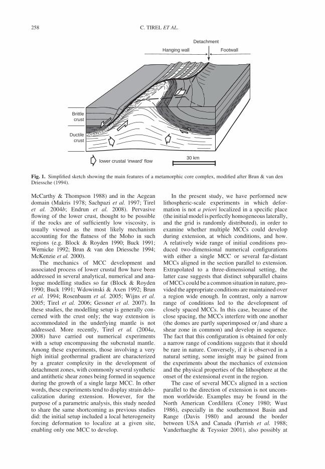
McCarthy & Thompson 1988) and in the Aegeandomain (Makris 1978; Sachpazi et al. 1997; Tirelet al. 2004b; Endrun et al. 2008). Pervasiveflowing of the lower crust, thought to be possibleif the rocks are of sufficiently low viscosity, isusually viewed as the most likely mechanismaccounting for the flatness of the Moho in suchregions (e.g. Block & Royden 1990; Buck 1991;Wernicke 1992; Brun & van den Driessche 1994;McKenzie et al. 2000).
The mechanics of MCC development andassociated process of lower crustal flow have beenaddressed in several analytical, numerical and ana-logue modelling studies so far (Block & Royden1990; Buck 1991; Wdowinski & Axen 1992; Brunet al. 1994; Rosenbaum et al. 2005; Wijns et al.2005; Tirel et al. 2006; Gessner et al. 2007). Inthese studies, the modelling setup is generally con-cerned with the crust only; the way extension isaccommodated in the underlying mantle is notaddressed. More recently, Tirel et al. (2004a,2008) have carried out numerical experimentswith a setup encompassing the subcrustal mantle.Among these experiments, those involving a veryhigh initial geothermal gradient are characterizedby a greater complexity in the development ofdetachment zones, with commonly several syntheticand antithetic shear zones being formed in sequenceduring the growth of a single large MCC. In otherwords, these experiments tend to display strain delo-calization during extension. However, for thepurpose of a parametric analysis, this study neededto share the same shortcoming as previous studiesdid: the initial setup included a local heterogeneityforcing deformation to localize at a given site,enabling only one MCC to develop.
In the present study, we have performed newlithospheric-scale experiments in which defor-mation is not a priori localized in a specific place(the initial model is perfectly homogeneous laterally,and the grid is randomly distributed), in order toexamine whether multiple MCCs could developduring extension, at which conditions, and how.A relatively wide range of initial conditions pro-duced two-dimensional numerical configurationswith either a single MCC or several far-distantMCCs aligned in the section parallel to extension.Extrapolated to a three-dimensional setting, thelatter case suggests that distinct subparallel chainsof MCCs could be a common situation in nature, pro-vided the appropriate conditions are maintained overa region wide enough. In contrast, only a narrowrange of conditions led to the development ofclosely spaced MCCs. In this case, because of theclose spacing, the MCCs interfere with one another(the domes are partly superimposed or/and share ashear zone in common) and develop in sequence.The fact that this configuration is obtained for onlya narrow range of conditions suggests that it shouldbe rare in nature. Conversely, if it is observed in anatural setting, some insight may be gained fromthe experiments about the mechanics of extensionand the physical properties of the lithosphere at theonset of the extensional event in the region.
The case of several MCCs aligned in a sectionparallel to the direction of extension is not uncom-mon worldwide. Examples may be found in theNorth American Cordillera (Coney 1980; Wust1986), especially in the southernmost Basin andRange (Davis 1980) and around the borderbetween USA and Canada (Parrish et al. 1988;Vanderhaeghe & Teyssier 2001), also possibly at
Hanging wall Footwall
Brittlecrust
Ductilecrust
lower crustal ‘inward’ flow30 km
Detachment
Fig. 1. Simplified sketch showing the main features of a metamorphic core complex, modified after Brun & van denDriessche (1994).
C. TIREL ET AL.258
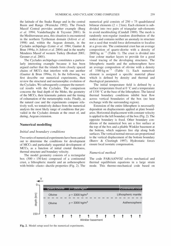
the latitude of the Snake Range and in the centralBasin and Range (Wernicke 1992). The FrenchMassif Central provides another example (Burget al. 1994; Vanderhaeghe & Teyssier 2001). Inthe Mediterranean area, this situation is encounteredin the northern Tyrrhenian domain (Jolivet et al.1998) and, within the Aegean domain, in theCyclades archipelago (Lister et al. 1984; Gautier &Brun 1994a, b; Jolivet et al. 2004) and in the nearbyMenderes Massif of western Turkey (Bozkurt 2001;Gessner et al. 2001).
The Cyclades archipelago constitutes a particu-larly interesting example because it has beenargued earlier that the islands form closely spacedchains of MCCs that interfere with one another(Gautier & Brun 1994a, b). In the following, wefirst describe our numerical experiments, thenreview the structural and metamorphic evolution ofthe Cyclades. We subsequently compare the numeri-cal results with the Cyclades. The comparisonconcerns the final depth of the Moho, the geometryof the MCCs, their kinematic pattern and the timingof exhumation of the metamorphic rocks. Finally, asthe natural case and the experiments compare rela-tively well, we tentatively deduce from the numericalanalysis the most likely range of conditions that pre-vailed in the Cyclades domain at the onset of, andduring, Aegean extension.
Numerical modelling
Initial and boundary conditions
Two series of numerical experiments have been carriedout to determine the conditions for developmentof MCCs and particularly sequential development ofMCCs, as a function of initial crustal thickness,thermal structure and boundary velocity.
The model geometry consists of a rectangularbox (500 � 150 km) composed of a continentalcrust, a lithospheric mantle and an asthenospherewith brittle–elasto–ductile properties (Fig. 2). The
numerical grid consists of 250 � 75 quadrilateralbilinear elements (2 � 2 km). Each element is sub-divided into two pairs of triangular sub-elementsto avoid meshlocking (Cundall 1989). The mesh israndomly non-regular (random distribution of thenodes) and contains neither an anomaly in structurenor a seed that would force deformation to localizeat a given site. The continental crust has an averagecomposition of quartz-diorite with a density of2800 kg m23 (Table 1). The crust is divided intofour colour marker layers to provide for a goodvisual tracing of the developing structures. Thelithospheric mantle and the asthenosphere havean average composition of olivine with a densityof 3300 kg m23 (Table 1). Each numericalelement is assigned a specific material phasewhich is defined by density and thermal andrheological parameters.
The initial temperature field is defined by asurface temperature fixed at 0 8C and a temperatureof 1330 8C at the base of the lithosphere. The lateralthermal boundary conditions inhibit heat flowacross vertical boundaries of the box (no heatexchange with the surrounding region).
Extension of the entire lithosphere is necessarilydependent on displacements applied at plate bound-aries. Horizontal displacement with constant velocityis applied to the left boundary of the box (Fig. 2). Theopposite boundary is fixed. Other boundary con-ditions of the numerical box are a free surface atthe top of the box and a pliable Winkler basement atthe bottom, which supposes free slip along bothsurfaces. The vertical normal stresses are proportionalto the vertical displacement of the bottom boundary(Burov & Cloetingh 1997). Hydrostatic forcesensure local isostatic compensation.
Numerical method
The code PAR(A)OVOZ solves mechanical andthermal equilibrium equations in a large strainmode. This thermo-mechanical code based on
0
150
Lithospheric mantle
Continental crust
Asthenosphere
Quartz-Diorite
Olivine
Olivine
{ρ = 2800 kg/m3
ρ = 3300 kg/m3
ρ = 3300 kg/m3
dept
h (k
m)
Winkler basement
V
Fig. 2. Model setup used for the numerical experiments.
NUMERICAL AND CYCLADIC CORE COMPLEXES 259
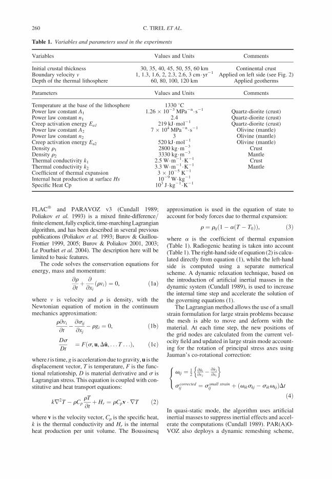
FLACw and PARAVOZ v3 (Cundall 1989;Poliakov et al. 1993) is a mixed finite-difference/finite element, fullyexplicit, time-marchingLagrangianalgorithm, and has been described in several previouspublications (Poliakov et al. 1993; Burov & Guillou-Frottier 1999, 2005; Burov & Poliakov 2001, 2003;Le Pourhiet et al. 2004). The description here will belimited to basic features.
The code solves the conservation equations forenergy, mass and momentum:
@r
@tþ @
@xi
ðrviÞ ¼ 0, ð1aÞ
where v is velocity and r is density, with theNewtonian equation of motion in the continuummechanics approximation:
r@vi
@t� @sij
@xj
� rgi ¼ 0, ð1bÞ
Ds
Dt¼ Fðs, u,Du, . . . T . . .Þ, ð1cÞ
where t is time, g is acceleration due to gravity, u is thedisplacement vector, T is temperature, F is the func-tional relationship, D is material derivative and s isLagrangian stress. This equation is coupled with con-stitutive and heat transport equations:
kr2T � rCp
rT
@tþ Hr ¼ rCpv � rT ð2Þ
where v is the velocity vector, Cp is the specific heat,k is the thermal conductivity and Hr is the internalheat production per unit volume. The Boussinesq
approximation is used in the equation of state toaccount for body forces due to thermal expansion:
r ¼ r0ð1� aðT � T0ÞÞ, ð3Þ
where a is the coefficient of thermal expansion(Table 1). Radiogenic heating is taken into account(Table 1). The right-hand side of equation (2) is calcu-lated directly from equation (1), whilst the left-handside is computed using a separate numericalscheme. A dynamic relaxation technique, based onthe introduction of artificial inertial masses in thedynamic system (Cundall 1989), is used to increasethe internal time step and accelerate the solution ofthe governing equations (1).
The Lagrangian method allows the use of a smallstrain formulation for large strain problems becausethe mesh is able to move and deform with thematerial. At each time step, the new positions ofthe grid nodes are calculated from the current vel-ocity field and updated in large strain mode account-ing for the rotation of principal stress axes usingJauman’s co-rotational correction:
vij ¼ 12
@ _ui
@x j� @ _u j
@xi
n o
s correctedij ¼ s small strain
ij þ ðvikskj � sikvkjÞDt
8<:
ð4Þ
In quasi-static mode, the algorithm uses artificialinertial masses to suppress inertial effects and accel-erate the computations (Cundall 1989). PAR(A)O-VOZ also deploys a dynamic remeshing scheme,
Table 1. Variables and parameters used in the experiments
Variables Values and Units Comments
Initial crustal thickness 30, 35, 40, 45, 50, 55, 60 km Continental crustBoundary velocity v 1, 1.3, 1.6, 2, 2.3, 2.6, 3 cm.yr21 Applied on left side (see Fig. 2)Depth of the thermal lithosphere 60, 80, 100, 120 km Applied geotherms
Parameters Values and Units Comments
Temperature at the base of the lithosphere 1330 8CPower law constant A1 1.26 � 1023 MPa2n .s21 Quartz-diorite (crust)Power law constant n1 2.4 Quartz-diorite (crust)Creep activation energy Ea1 219 kJ.mol21 Quartz-diorite (crust)Power law constant A2 7 � 104 MPa2n .s21 Olivine (mantle)Power law constant n2 3 Olivine (mantle)Creep activation energy Ea2 520 kJ.mol21 Olivine (mantle)Density r1 2800 kg.m23 CrustDensity r2 3330 kg.m23 MantleThermal conductivity k1 2.5 W.m21 .K21 CrustThermal conductivity k2 3.3 W.m21 .K21 MantleCoefficient of thermal expansion 3 � 1025 K21
Internal heat production at surface Hs 1029 W.kg21
Specific Heat Cp 103 J .kg21 .K21
C. TIREL ET AL.260
which makes it possible to model very largedisplacements.
Each grid element simultaneously handles threerheological terms: brittle, elastic and ductile; thusthe local deformation mode may change from dom-inantly brittle to dominantly ductile or elastic,depending on mechanical and temperature con-ditions. Material parameters for ductile creep areobtained from Hansen & Carter (1982) for quartzdiorite and Goetze (1978) for olivine (Table 1).
The brittle (plastic) behaviour is described by theexperimental Byerlee’s law (Byerlee 1978) which isreproduced by non-associative Mohr–Coulombplasticity with a friction angle f ¼ 308, cohesionC0 ¼ 20 MPa and dilatation angle c ¼ 08 (Gerbaultet al. 1999):
jtj ¼ C0 � sn tanf, ð5Þ
where t is shear stress and sn is normal stress.Plastic failure occurs if the two following conditionsare satisfied; shear failure criterion f ¼ t�II þ s�1sinf� C0 cosf ¼ 0 and @f/@t ¼ 0 (Vermeer &de Borst 1984). In 2D formulation, t�II ¼ffiffiffiffiffiffiffiffiffiffiffiffiffiffiffiffiffiffiffiffiffiffiffiffiffiffiffiffiffiffiffiffiffiffiffiffiffiffiffiffiðt11 � t22Þ2=4þ t2
12
qand s�1 ¼ ðs11 þ s22Þ=2.
In terms of principal stresses, the equivalentof the yield criterion (5) is: s1 � s3 ¼ � sinfðs1 þ s3 � 2C0= tanfÞ.
The elastic behaviour is described by the linearHooke’s law:
1ij ¼ E�1sij � yE�1skkdij, ð6Þ
where repeating indexes mean summation and dis Kronecker’s operator. The values for the elasticmoduli are E ¼ 80 GPa (Young’s modulus) andy ¼ 0.25 (Poisson’s ratio) (Turcotte & Schubert2002).
The viscous (ductile) behaviour is described byan experimental uni-axial power law relationshipbetween strain rate and stress (Kirby & Kronenberg1987; Ranalli 1987):
edij ¼ Aðs1 � s3Þn expð�H=RTÞ, ð7Þ
where, H ¼ Eaþ PV, eijd is the shear strain rate
tensor, T is the temperature in K, s1 and s3 are theprincipal Cauchy stresses (compression is negative),P is the pressure, V is the activation volume. A, H,Ea, and n are the material constants (Table 1) andR is the universal gas constant. The effective vis-cosity meff for this law is:
meff ¼ edð1�nÞ=nij A�1=n expðHðnRTÞ�1Þ: ð8Þ
For non-uniaxial deformation, the uniaxial relation-ship (7) is converted to a triaxial form using theinvariant of strain rate ed
II ¼ ½InvIIðeijÞ�1=2and geo-
metrical proportionality factors (e.g. Burov et al.2003). This is needed because the rotations due to
deformation can be large, and hence the invariantform of strain tensor has to be used:
meff ¼ edð1�nÞ=nII ðA�Þ�1=n
expðHðnRTÞ�1Þ, ð9Þ
where A* ¼ 12A0
. 3(n+1)/2.The general constitutive viscoplastic model of
the code is characterized by a visco–elasto–plastic deviatoric behavior and an elasto–plasticvolumetric behaviour, with the following strainrate partitioning (M ¼ ‘Maxwell’, P ¼ ‘Plastic’):
_1ij ¼ _1Mij þ _1P
ij ð10Þ
The visco-elastic and plastic strain-rate componentsare thus assumed to act in series. The visco-elasticconstitutive law corresponds to a Maxwell com-ponent, and the plastic constitutive law correspondsto the above-described Mohr–Coulomb model. Inthis implementation, the new global stress com-ponents are calculated, assuming that the principaldirections have not been affected by the occurrenceof plastic flow.
Numerical experiments
Exploring the conditions for MCC-type
extension
To establish the initial and boundary conditions atthe onset of extension, a series of experiments hasbeen performed in order to encompass end-membersituations of continental extension.
Experiments on the effects of initial crustalthickness and initial geotherms (determining theinitial depth of the 1330 8C isotherm) have beencarried out. Twenty-eight experiments have beenperformed with initial crustal thicknesses of 30 to60 km and initial thermal lithospheric thicknessesof 60 to 120 km (Table 1). A constant horizontal dis-placement is applied at the left vertical boundarywith v ¼ 2.0 cm/a for each of these simulations.Figure 3a shows the initial geotherm and strengthprofile of the experiments with an initial crustalthickness of 30, 44 and 60 km and an initial depthof the 1330 8C isotherm at 60, 80, 100 and120 km. The classification of three basic domains(Fig. 3b) has been made on account of the firsttype of structure observed in the experiments(during the first c. 20 Ma of extension). They arecharacterized by: (i) the formation of ocean floor;or (ii) the development of MCCs (considering thatthe main features defining a MCC are the exhuma-tion of middle to lower crustal rocks, a detachmentzone at the surface, and a flat Moho at depth); or(iii) a combination of these two processes (transi-tional mode). The experiments identified with
NUMERICAL AND CYCLADIC CORE COMPLEXES 261
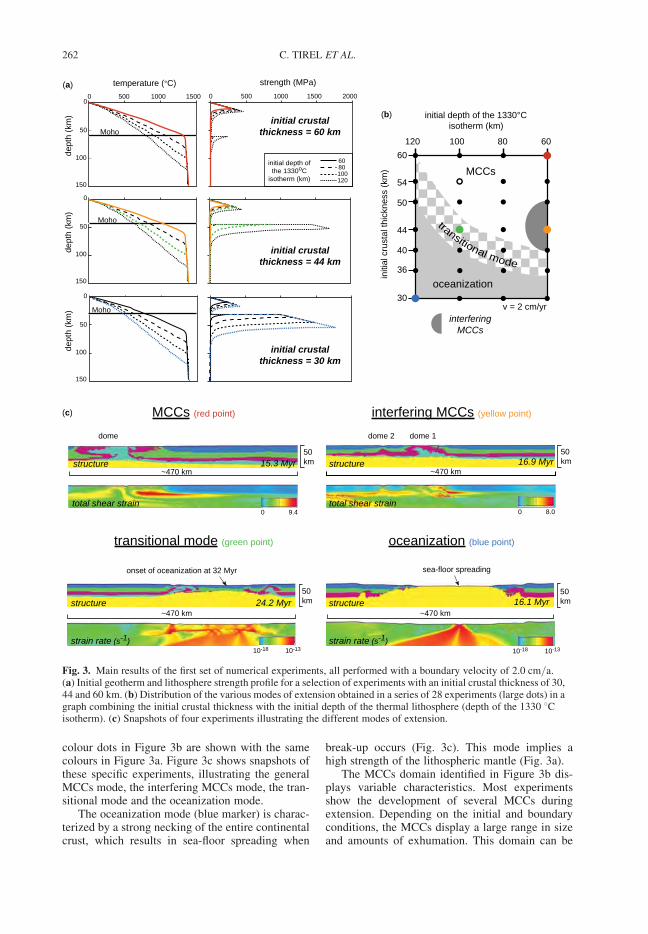
colour dots in Figure 3b are shown with the samecolours in Figure 3a. Figure 3c shows snapshots ofthese specific experiments, illustrating the generalMCCs mode, the interfering MCCs mode, the tran-sitional mode and the oceanization mode.
The oceanization mode (blue marker) is charac-terized by a strong necking of the entire continentalcrust, which results in sea-floor spreading when
break-up occurs (Fig. 3c). This mode implies ahigh strength of the lithospheric mantle (Fig. 3a).
The MCCs domain identified in Figure 3b dis-plays variable characteristics. Most experimentsshow the development of several MCCs duringextension. Depending on the initial and boundaryconditions, the MCCs display a large range in sizeand amounts of exhumation. This domain can be
initial depth ofthe 1330oC
isotherm (km)
6080100120
Moho
0 500 1000 1500 20000
50
100
150
0 500 1000 1500
Moho
0
50
100
150
Moho
0
50
100
150
~470 km
MCCs (red point)
dome
0 9.4total shear strain
structure 15.3 Myr~470 km
interfering MCCs (yellow point)
dome 1dome 2
0 8.0total shear strain
structure 16.9 Myr
~470 km
transitional mode (green point)
onset of oceanization at 32 Myr
24.2 Myr
strain rate (s-1)
structure
10-18 10-13
oceanization (blue point)
sea-floor spreading
~470 km16.1 Myr
strain rate (s-1)
structure
10-18 10-13
temperature (°C)(a)
(b)
(c)
strength (MPa)
dept
h (k
m)
dept
h (k
m)
dept
h (k
m)
initial crustalthickness = 60 km
initial crustalthickness = 44 km
initial crustalthickness = 30 km
50km
50km
50km
50km
120 100 80 60
30
36
40
44
50
54
60
initi
al c
rust
al th
ickn
ess
(km
) MCCs
oceanization
interferingMCCs
initial depth of the 1330°Cisotherm (km)
transitional mode
v = 2 cm/yr
Fig. 3. Main results of the first set of numerical experiments, all performed with a boundary velocity of 2.0 cm/a.(a) Initial geotherm and lithosphere strength profile for a selection of experiments with an initial crustal thickness of 30,44 and 60 km. (b) Distribution of the various modes of extension obtained in a series of 28 experiments (large dots) in agraph combining the initial crustal thickness with the initial depth of the thermal lithosphere (depth of the 1330 8Cisotherm). (c) Snapshots of four experiments illustrating the different modes of extension.
C. TIREL ET AL.262
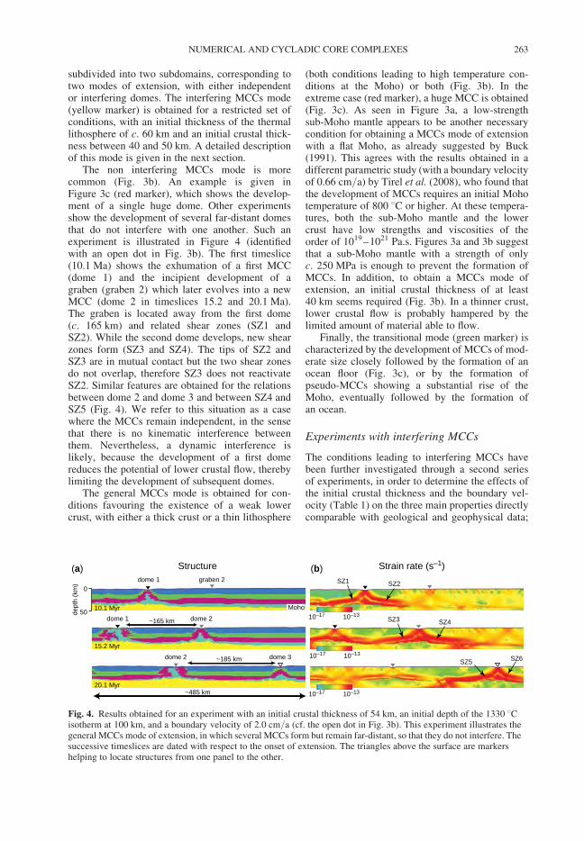
subdivided into two subdomains, corresponding totwo modes of extension, with either independentor interfering domes. The interfering MCCs mode(yellow marker) is obtained for a restricted set ofconditions, with an initial thickness of the thermallithosphere of c. 60 km and an initial crustal thick-ness between 40 and 50 km. A detailed descriptionof this mode is given in the next section.
The non interfering MCCs mode is morecommon (Fig. 3b). An example is given inFigure 3c (red marker), which shows the develop-ment of a single huge dome. Other experimentsshow the development of several far-distant domesthat do not interfere with one another. Such anexperiment is illustrated in Figure 4 (identifiedwith an open dot in Fig. 3b). The first timeslice(10.1 Ma) shows the exhumation of a first MCC(dome 1) and the incipient development of agraben (graben 2) which later evolves into a newMCC (dome 2 in timeslices 15.2 and 20.1 Ma).The graben is located away from the first dome(c. 165 km) and related shear zones (SZ1 andSZ2). While the second dome develops, new shearzones form (SZ3 and SZ4). The tips of SZ2 andSZ3 are in mutual contact but the two shear zonesdo not overlap, therefore SZ3 does not reactivateSZ2. Similar features are obtained for the relationsbetween dome 2 and dome 3 and between SZ4 andSZ5 (Fig. 4). We refer to this situation as a casewhere the MCCs remain independent, in the sensethat there is no kinematic interference betweenthem. Nevertheless, a dynamic interference islikely, because the development of a first domereduces the potential of lower crustal flow, therebylimiting the development of subsequent domes.
The general MCCs mode is obtained for con-ditions favouring the existence of a weak lowercrust, with either a thick crust or a thin lithosphere
(both conditions leading to high temperature con-ditions at the Moho) or both (Fig. 3b). In theextreme case (red marker), a huge MCC is obtained(Fig. 3c). As seen in Figure 3a, a low-strengthsub-Moho mantle appears to be another necessarycondition for obtaining a MCCs mode of extensionwith a flat Moho, as already suggested by Buck(1991). This agrees with the results obtained in adifferent parametric study (with a boundary velocityof 0.66 cm/a) by Tirel et al. (2008), who found thatthe development of MCCs requires an initial Mohotemperature of 800 8C or higher. At these tempera-tures, both the sub-Moho mantle and the lowercrust have low strengths and viscosities of theorder of 1019–1021 Pa.s. Figures 3a and 3b suggestthat a sub-Moho mantle with a strength of onlyc. 250 MPa is enough to prevent the formation ofMCCs. In addition, to obtain a MCCs mode ofextension, an initial crustal thickness of at least40 km seems required (Fig. 3b). In a thinner crust,lower crustal flow is probably hampered by thelimited amount of material able to flow.
Finally, the transitional mode (green marker) ischaracterized by the development of MCCs of mod-erate size closely followed by the formation of anocean floor (Fig. 3c), or by the formation ofpseudo-MCCs showing a substantial rise of theMoho, eventually followed by the formation ofan ocean.
Experiments with interfering MCCs
The conditions leading to interfering MCCs havebeen further investigated through a second seriesof experiments, in order to determine the effects ofthe initial crustal thickness and the boundary vel-ocity (Table 1) on the three main properties directlycomparable with geological and geophysical data;
Strain rate (s–1)Structure
10.1 Myr
15.2 Myr
20.1 Myr
~165 km
~185 km
Moho
0
50dept
h (k
m)
dome 1
(a) (b)
dome 1 dome 2
dome 2 dome 3
SZ1 SZ2
SZ3 SZ4
SZ5 SZ6
~485 km
10–17 10–13
10–17 10–13
10–17 10–13
graben 2
Fig. 4. Results obtained for an experiment with an initial crustal thickness of 54 km, an initial depth of the 1330 8Cisotherm at 100 km, and a boundary velocity of 2.0 cm/a (cf. the open dot in Fig. 3b). This experiment illustrates thegeneral MCCs mode of extension, in which several MCCs form but remain far-distant, so that they do not interfere. Thesuccessive timeslices are dated with respect to the onset of extension. The triangles above the surface are markershelping to locate structures from one panel to the other.
NUMERICAL AND CYCLADIC CORE COMPLEXES 263
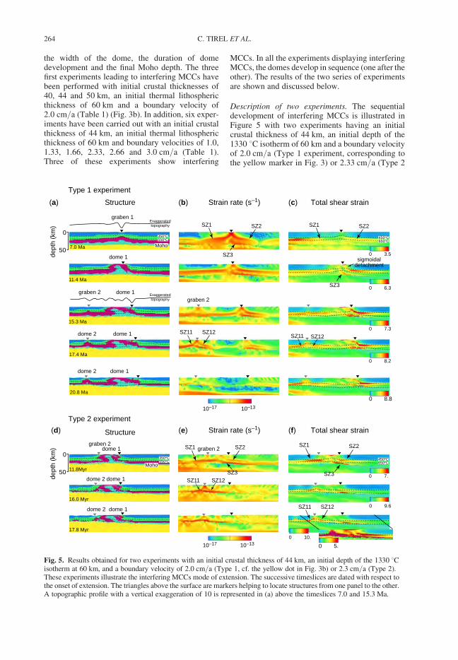
the width of the dome, the duration of domedevelopment and the final Moho depth. The threefirst experiments leading to interfering MCCs havebeen performed with initial crustal thicknesses of40, 44 and 50 km, an initial thermal lithosphericthickness of 60 km and a boundary velocity of2.0 cm/a (Table 1) (Fig. 3b). In addition, six exper-iments have been carried out with an initial crustalthickness of 44 km, an initial thermal lithosphericthickness of 60 km and boundary velocities of 1.0,1.33, 1.66, 2.33, 2.66 and 3.0 cm/a (Table 1).Three of these experiments show interfering
MCCs. In all the experiments displaying interferingMCCs, the domes develop in sequence (one after theother). The results of the two series of experimentsare shown and discussed below.
Description of two experiments. The sequentialdevelopment of interfering MCCs is illustrated inFigure 5 with two experiments having an initialcrustal thickness of 44 km, an initial depth of the1330 8C isotherm of 60 km and a boundary velocityof 2.0 cm/a (Type 1 experiment, corresponding tothe yellow marker in Fig. 3) or 2.33 cm/a (Type 2
Structure Total shear strainStrain rate (s–1)
Moho
Moho
Structure Total shear strainStrain rate (s–1)
graben 1
graben 2
dome 1
dome 2
dome 2
dome 1
dome 1
dome 1
7.0 Ma
11.4 Ma
17.4 Ma
20.8 Ma
15.3 Ma
350oC550oC 450oC
650oC
450oC650oC
350oC550oC
0
50
dept
h (k
m)
17.8 Myr
16.0 Myr
11.8Myr
0 3.5
0 6.3
0 7.3
0 8.2
0 8.8
0
50
dept
h (k
m)
10–17 10–13
10–17 10–13
sigmoidaldetachment
0 7.
0 9.6
0 10.
0 5.
SZ1 SZ2
SZ3
dome 1
dome 2 dome 1
SZ1 SZ2
SZ3
dome 2 dome 1
Type 1 experiment
(a) (b) (c)
(d) (e) (f)
Type 2 experiment
SZ1 SZ2
SZ3
graben 2
SZ11 SZ12SZ11 SZ12
SZ11 SZ12
graben 2
SZ11 SZ12
SZ1 SZ2
SZ3
graben 2
Exaggeratedtopography
Exaggeratedtopography
Fig. 5. Results obtained for two experiments with an initial crustal thickness of 44 km, an initial depth of the 1330 8Cisotherm at 60 km, and a boundary velocity of 2.0 cm/a (Type 1, cf. the yellow dot in Fig. 3b) or 2.3 cm/a (Type 2).These experiments illustrate the interfering MCCs mode of extension. The successive timeslices are dated with respect tothe onset of extension. The triangles above the surface are markers helping to locate structures from one panel to the other.A topographic profile with a vertical exaggeration of 10 is represented in (a) above the timeslices 7.0 and 15.3 Ma.
C. TIREL ET AL.264
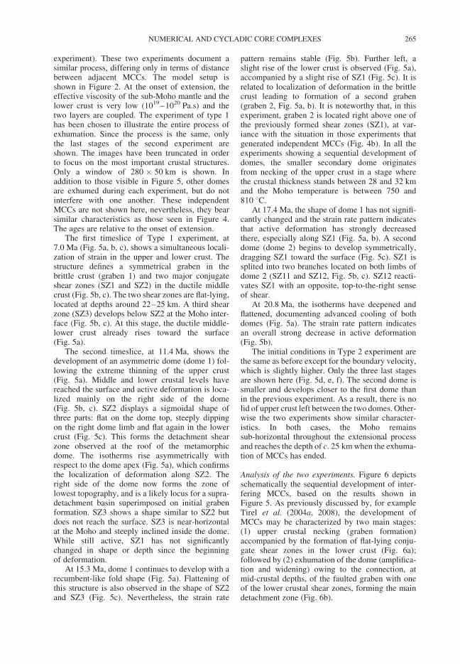
experiment). These two experiments document asimilar process, differing only in terms of distancebetween adjacent MCCs. The model setup isshown in Figure 2. At the onset of extension, theeffective viscosity of the sub-Moho mantle and thelower crust is very low (1019–1020 Pa.s) and thetwo layers are coupled. The experiment of type 1has been chosen to illustrate the entire process ofexhumation. Since the process is the same, onlythe last stages of the second experiment areshown. The images have been truncated in orderto focus on the most important crustal structures.Only a window of 280 � 50 km is shown. Inaddition to those visible in Figure 5, other domesare exhumed during each experiment, but do notinterfere with one another. These independentMCCs are not shown here, nevertheless, they bearsimilar characteristics as those seen in Figure 4.The ages are relative to the onset of extension.
The first timeslice of Type 1 experiment, at7.0 Ma (Fig. 5a, b, c), shows a simultaneous locali-zation of strain in the upper and lower crust. Thestructure defines a symmetrical graben in thebrittle crust (graben 1) and two major conjugateshear zones (SZ1 and SZ2) in the ductile middlecrust (Fig. 5b, c). The two shear zones are flat-lying,located at depths around 22–25 km. A third shearzone (SZ3) develops below SZ2 at the Moho inter-face (Fig. 5b, c). At this stage, the ductile middle-lower crust already rises toward the surface(Fig. 5a).
The second timeslice, at 11.4 Ma, shows thedevelopment of an asymmetric dome (dome 1) fol-lowing the extreme thinning of the upper crust(Fig. 5a). Middle and lower crustal levels havereached the surface and active deformation is loca-lized mainly on the right side of the dome(Fig. 5b, c). SZ2 displays a sigmoidal shape ofthree parts: flat on the dome top, steeply dippingon the right dome limb and flat again in the lowercrust (Fig. 5c). This forms the detachment shearzone observed at the roof of the metamorphicdome. The isotherms rise asymmetrically withrespect to the dome apex (Fig. 5a), which confirmsthe localization of deformation along SZ2. Theright side of the dome now forms the zone oflowest topography, and is a likely locus for a supra-detachment basin superimposed on initial grabenformation. SZ3 shows a shape similar to SZ2 butdoes not reach the surface. SZ3 is near-horizontalat the Moho and steeply inclined inside the dome.While still active, SZ1 has not significantlychanged in shape or depth since the beginningof deformation.
At 15.3 Ma, dome 1 continues to develop with arecumbent-like fold shape (Fig. 5a). Flattening ofthis structure is also observed in the shape of SZ2and SZ3 (Fig. 5c). Nevertheless, the strain rate
pattern remains stable (Fig. 5b). Further left, aslight rise of the lower crust is observed (Fig. 5a),accompanied by a slight rise of SZ1 (Fig. 5c). It isrelated to localization of deformation in the brittlecrust leading to formation of a second graben(graben 2, Fig. 5a, b). It is noteworthy that, in thisexperiment, graben 2 is located right above one ofthe previously formed shear zones (SZ1), at var-iance with the situation in those experiments thatgenerated independent MCCs (Fig. 4b). In all theexperiments showing a sequential development ofdomes, the smaller secondary dome originatesfrom necking of the upper crust in a stage wherethe crustal thickness stands between 28 and 32 kmand the Moho temperature is between 750 and810 8C.
At 17.4 Ma, the shape of dome 1 has not signifi-cantly changed and the strain rate pattern indicatesthat active deformation has strongly decreasedthere, especially along SZ1 (Fig. 5a, b). A seconddome (dome 2) begins to develop symmetrically,dragging SZ1 toward the surface (Fig. 5c). SZ1 issplited into two branches located on both limbs ofdome 2 (SZ11 and SZ12, Fig. 5b, c). SZ12 reacti-vates SZ1 with an opposite, top-to-the-right senseof shear.
At 20.8 Ma, the isotherms have deepened andflattened, documenting advanced cooling of bothdomes (Fig. 5a). The strain rate pattern indicatesan overall strong decrease in active deformation(Fig. 5b).
The initial conditions in Type 2 experiment arethe same as before except for the boundary velocity,which is slightly higher. Only the three last stagesare shown here (Fig. 5d, e, f). The second dome issmaller and develops closer to the first dome thanin the previous experiment. As a result, there is nolid of upper crust left between the two domes. Other-wise the two experiments show similar character-istics. In both cases, the Moho remainssub-horizontal throughout the extensional processand reaches the depth of c. 25 km when the exhuma-tion of MCCs has ended.
Analysis of the two experiments. Figure 6 depictsschematically the sequential development of inter-fering MCCs, based on the results shown inFigure 5. As previously discussed by, for exampleTirel et al. (2004a, 2008), the development ofMCCs may be characterized by two main stages:(1) upper crustal necking (graben formation)accompanied by the formation of flat-lying conju-gate shear zones in the lower crust (Fig. 6a);followed by (2) exhumation of the dome (amplifica-tion and widening) owing to the connection, atmid-crustal depths, of the faulted graben with oneof the lower crustal shear zones, forming the maindetachment zone (Fig. 6b).
NUMERICAL AND CYCLADIC CORE COMPLEXES 265
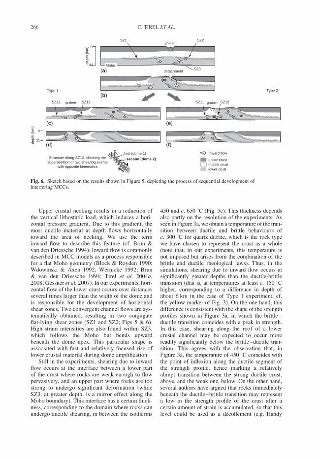
Upper crustal necking results in a reduction ofthe vertical lithostatic load, which induces a hori-zontal pressure gradient. Due to this gradient, themost ductile material at depth flows horizontallytoward the area of necking. We use the terminward flow to describe this feature (cf. Brun &van den Driessche 1994). Inward flow is commonlydescribed in MCC models as a process responsiblefor a flat Moho geometry (Block & Royden 1990;Wdowinski & Axen 1992; Wernicke 1992; Brun& van den Driessche 1994; Tirel et al. 2004a,2008; Gessner et al. 2007). In our experiments, hori-zontal flow of the lower crust occurs over distancesseveral times larger than the width of the dome andis responsible for the development of horizontalshear zones. Two convergent channel flows are sys-tematically obtained, resulting in two conjugateflat-lying shear zones (SZ1 and SZ2; Figs 5 & 6).High strain intensities are also found within SZ3,which follows the Moho but bends upwardbeneath the dome apex. This particular shape isassociated with fast and relatively focused rise oflower crustal material during dome amplification.
Still in the experiments, shearing due to inwardflow occurs at the interface between a lower partof the crust where rocks are weak enough to flowpervasively, and an upper part where rocks are toostrong to undergo significant deformation (whileSZ3, at greater depth, is a mirror effect along theMoho boundary). This interface has a certain thick-ness, corresponding to the domain where rocks canundergo ductile shearing, in between the isotherms
450 and c. 650 8C (Fig. 5c). This thickness dependsalso partly on the resolution of the experiments. Asseen in Figure 3a, we obtain a temperature of the tran-sition between ductile and brittle behaviours ofc. 300 8C for quartz diorite, which is the rock typewe have chosen to represent the crust as a whole(note that, in our experiments, this temperature isnot imposed but arises from the combination of thebrittle and ductile rheological laws). Thus, in thesimulations, shearing due to inward flow occurs atsignificantly greater depths than the ductile-brittletransition (that is, at temperatures at least c. 150 8Chigher, corresponding to a difference in depth ofabout 6 km in the case of Type 1 experiment, cf.the yellow marker of Fig. 3). On the one hand, thisdifference is consistent with the shape of the strengthprofiles shown in Figure 3a, in which the brittle–ductile transition coincides with a peak in strength.In this case, shearing along the roof of a lowercrustal channel may be expected to occur morereadily significantly below the brittle–ductile tran-sition. This agrees with the observation that, inFigure 3a, the temperature of 450 8C coincides withthe point of inflexion along the ductile segment ofthe strength profile, hence marking a relativelyabrupt transition between the strong ductile crust,above, and the weak one, below. On the other hand,several authors have argued that rocks immediatelybeneath the ductile–brittle transition may representa low in the strength profile of the crust after acertain amount of strain is accumulated, so that thislevel could be used as a decollement (e.g. Handy
inward flow
upper crustmiddle crustlower crust
Moho
0
44dept
h (k
m)
0
25
dept
h (k
m)
graben
detachment
SZ1
(a)
(b)
(c)
(d)
(e)
(f)
SZ2
SZ3
graben grabenSZ11 SZ12 SZ11 SZ12
Structure along SZ12, showing thesuperposition of two shearing events
with opposite kinematics
first (dome 1)
second (dome 2)
Type 1 Type 2
Fig. 6. Sketch based on the results shown in Figure 5, depicting the process of sequential development ofinterfering MCCs.
C. TIREL ET AL.266
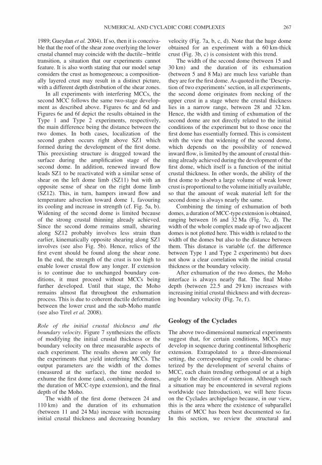
1989; Gueydan et al. 2004). If so, then it is conceiva-ble that the roof of the shear zone overlying the lowercrustal channel may coincide with the ductile–brittletransition, a situation that our experiments cannotfeature. It is also worth stating that our model setupconsiders the crust as homogeneous; a composition-ally layered crust may result in a distinct picture,with a different depth distribution of the shear zones.
In all experiments with interfering MCCs, thesecond MCC follows the same two-stage develop-ment as described above. Figures 6c and 6d andFigures 6e and 6f depict the results obtained in theType 1 and Type 2 experiments, respectively,the main difference being the distance between thetwo domes. In both cases, localization of thesecond graben occurs right above SZ1 whichformed during the development of the first dome.This preexisting structure is dragged toward thesurface during the amplification stage of thesecond dome. In addition, renewed inward flowleads SZ1 to be reactivated with a similar sense ofshear on the left dome limb (SZ11) but with anopposite sense of shear on the right dome limb(SZ12). This, in turn, hampers inward flow andtemperature advection toward dome 1, favouringits cooling and increase in strength (cf. Fig. 5a, b).Widening of the second dome is limited becauseof the strong crustal thinning already achieved.Since the second dome remains small, shearingalong SZ12 probably involves less strain thanearlier, kinematically opposite shearing along SZ1involves (see also Fig. 5b). Hence, relics of thefirst event should be found along the shear zone.In the end, the strength of the crust is too high toenable lower crustal flow any longer. If extensionis to continue due to unchanged boundary con-ditions, it must proceed without MCCs beingfurther developed. Until that stage, the Mohoremains almost flat throughout the exhumationprocess. This is due to coherent ductile deformationbetween the lower crust and the sub-Moho mantle(see also Tirel et al. 2008).
Role of the initial crustal thickness and theboundary velocity. Figure 7 synthesizes the effectsof modifying the initial crustal thickness or theboundary velocity on three measurable aspects ofeach experiment. The results shown are only forthe experiments that yield interfering MCCs. Theoutput parameters are the width of the domes(measured at the surface), the time needed toexhume the first dome (and, combining the domes,the duration of MCC-type extension), and the finaldepth of the Moho.
The width of the first dome (between 24 and110 km) and the duration of its exhumation(between 11 and 24 Ma) increase with increasinginitial crustal thickness and decreasing boundary
velocity (Fig. 7a, b, c, d). Note that the huge domeobtained for an experiment with a 60 km-thickcrust (Fig. 3b, c) is consistent with this trend.
The width of the second dome (between 15 and30 km) and the duration of its exhumation(between 5 and 8 Ma) are much less variable thanthey are for the first dome. As quoted in the ‘Descrip-tion of two experiments’ section, in all experiments,the second dome originates from necking of theupper crust in a stage where the crustal thicknesslies in a narrow range, between 28 and 32 km.Hence, the width and timing of exhumation of thesecond dome are not directly related to the initialconditions of the experiment but to those once thefirst dome has essentially formed. This is consistentwith the view that widening of the second dome,which depends on the possibility of renewedinward flow, is limited by the amount of crustal thin-ning already achieved during the development of thefirst dome, which itself is a function of the initialcrustal thickness. In other words, the ability of thefirst dome to absorb a large volume of weak lowercrust is proportional to the volume initially available,so that the amount of weak material left for thesecond dome is always nearly the same.
Combining the timing of exhumation of bothdomes, a duration of MCC-type extension is obtained,ranging between 16 and 32 Ma (Fig. 7c, d). Thewidth of the whole complex made up of two adjacentdomes is not plotted here. This width is related to thewidth of the domes but also to the distance betweenthem. This distance is variable (cf. the differencebetween Type 1 and Type 2 experiments) but doesnot show a clear correlation with the initial crustalthickness or the boundary velocity.
After exhumation of the two domes, the Mohointerface is always nearly flat. The final Mohodepth (between 22.5 and 29 km) increases withincreasing initial crustal thickness and with decreas-ing boundary velocity (Fig. 7e, f ).
Geology of the Cyclades
The above two-dimensional numerical experimentssuggest that, for certain conditions, MCCs maydevelop in sequence during continental lithosphericextension. Extrapolated to a three-dimensionalsetting, the corresponding region could be charac-terized by the development of several chains ofMCC, each chain trending orthogonal or at a highangle to the direction of extension. Although sucha situation may be encountered in several regionsworldwide (see Introduction), we will here focuson the Cyclades archipelago because, in our view,this is the area where the existence of subparallelchains of MCC has been best documented so far.In this section, we review the structural and
NUMERICAL AND CYCLADIC CORE COMPLEXES 267
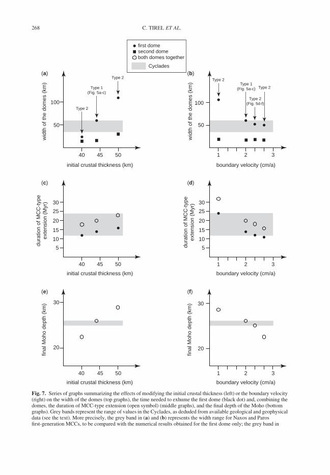
Cyclades
50
100
(a) (b)
(c) (d)
(e) (f)
40 45 50
5
10
40 45 50
15
1 2 3
1 2 3
50
100
initial crustal thickness (km)
wid
th o
f the
dom
es (
km)
wid
th o
f the
dom
es (
km)
initial crustal thickness (km)
boundary velocity (cm/a)
boundary velocity (cm/a)
1 2 3
boundary velocity (cm/a)
dura
tion
of M
CC
-typ
eex
tens
ion
(Myr
)
20
30
40 45 50
20
30
initial crustal thickness (km)
final
Moh
o de
pth
(km
)
final
Moh
o de
pth
(km
)
20
25
30
5
10
15
20
25
30
both domes together
first dome second dome
dura
tion
of M
CC
-typ
eex
tens
ion
(Myr
)
Type 1 (Fig. 5a-c)
T ype 2
T ype 2
T ype 1 (Fig. 5a-c)
T ype 2
T ype 2 (Fig. 5d-f)
T ype 2
Fig. 7. Series of graphs summarizing the effects of modifying the initial crustal thickness (left) or the boundary velocity(right) on the width of the domes (top graphs), the time needed to exhume the first dome (black dot) and, combining thedomes, the duration of MCC-type extension (open symbol) (middle graphs), and the final depth of the Moho (bottomgraphs). Grey bands represent the range of values in the Cyclades, as deduded from available geological and geophysicaldata (see the text). More precisely, the grey band in (a) and (b) represents the width range for Naxos and Parosfirst-generation MCCs, to be compared with the numerical results obtained for the first dome only; the grey band in
C. TIREL ET AL.268
metamorphic evolution of the Cyclades (see alsoFig. 8), focusing on features that allow comparisonwith our numerical results.
Since the seminal paper of Lister et al. (1984),many studies have focused on the identification ofextensional detachments and metamorphic corecomplexes in the Cyclades (e.g. Urai et al. 1990;Buick 1991; Gautier et al. 1993; Gautier & Brun1994a; Vandenberg & Lister 1996; Forster &Lister 1999; Jolivet & Patriat 1999; Kumericset al. 2005; Iglseder et al. 2006; Muller et al.2006). During extension, rocks that previouslyrecrystallized in high-pressure/low-temperatureconditions were exhumed from the conditions of agreenschist facies or higher grade overprint to theconditions of brittle deformation. Granitoid intru-sions were also emplaced during extension (e.g.Altherr et al. 1982). Time constraints indicate thatthese structures are broadly Miocene in age, mostauthors agreeing on the view that they formedduring Aegean ‘backarc’ (or post-orogenic/post-thickening) extension. Lister et al. (1984) initiallyproposed that extension was controlled by a singlesouth-dipping detachment zone on the scale of theCyclades archipelago, however subsequent studieshave documented a more complex structuralpattern.
The Cyclades as a coherent domain during
Miocene extension
Because the orientation of extension-related stretch-ing lineations and subsequent normal faults shows afairly abrupt change across the archipelago, it istempting to subdivide the Cyclades into twodomains. The direction of maximum stretching isNE–SW to ENE–WSW in the northwesternislands, and north–south in the southeasternislands (Gautier & Brun 1994a) as well as onIkaria (Kumerics et al. 2005). The boundarybetween these two domains coincides with a NE–SW-trending fault zone extending from west ofIkaria to east of Sifnos, with probably a significantwrench (dextral) component of movement along it(Gautier & Brun 1994a; Gautier 1995). This faultzone has been named the Mid-Cycladic Lineament(MCL) by Walcott & White (1998). Oppositerotations across the fault zone, as documented bypalaeomagnetic data on middle Miocene intrusions
on Naxos, Mykonos and Tinos (Morris & Anderson1996; Avigad et al. 1998), confirm the importanceof the MCL and are consistent with the view thatthe divergent pattern of lineations seen on thescale of the Cyclades relates originally to auniform NNE–SSW direction of stretching(Gautier & Brun 1994b; Walcott & White 1998;Gautier et al. 1999; Jolivet et al. 2004). This viewis also consistent with the pattern of rotations onthe scale of the whole Aegean region (van Hinsber-gen et al. 2005b). Gautier & Brun (1994b) suggestedthat a rectilinear horst-and-graben system initiallyoccupied the Central Aegean region and underwentprogressive bending due to radial spreading of theAegean lithosphere. Analogue experiments furthershowed that the presence of a thin layer of sand(simulating the brittle behaviour of the uppercrust) at the top of a spreading sheet is a conditionsufficient to produce a pattern of oppositelyrotated blocks separated by a sharp boundary equiv-alent to the MCL (Gautier et al. 1999). Therefore,the MCL can be seen as a structure accommodatinglateral variations in the rotation field of the CentralAegean region during regional extension. In con-trast, Pe-Piper & Piper (2006) recently proposed aseries of palinspastic reconstructions of theAegean domain in which they assume c. 100 kmof sinistral displacement along the MCL duringthe Miocene (from 17 to 5 Ma, mostly). Thiswould imply that the Central Aegean region actuallyconsists of two domains that were far distant fromeach other during early stages of core complex-typeextension (Pe-Piper & Piper 2006, Figs 2 & 13).However, on account of the similarity of lithologies,tectonometamorphic evolution, and timing of exhu-mation of rocks on both sides of the MCL, ouropinion is that the total offset across the MCLmust be minor, in agreement with Walcott &White (1998).
How many MCC and detachment systems
in the Cyclades?
A number of observations imply that several MCCscoexist in the Cyclades. Most islands have the geo-metry of a metamorphic dome defined by the orien-tation of foliations, occasionally also by lithologicalcontours, and more rarely by a concentric pattern ofisograds (Naxos and Paros). On several islands, a
Fig. 7. (Continued) (c) and (d) represents the duration of MCC-type extension in the Cyclades. The time laps forexhuming the first dome and the duration of MCC-type extension are given with respect to the onset of post-orogenicextension. Somehow arbitrarily, the time at which the first dome finishes its exhumation is taken as the time at which thesecond dome starts to form. Figure 5a–b shows that their developments may slightly overlap in time (i.e. shearing is stillactive along the frontal detachment of the first dome while the second dome rises) but also that far much of the exhumationof the first dome has occurred before the second dome forms. The time difference between the black dot and the opensymbol represents the time laps for exhuming the second dome. It shows little variation, between 5 and 8 Ma.
NUMERICAL AND CYCLADIC CORE COMPLEXES 269
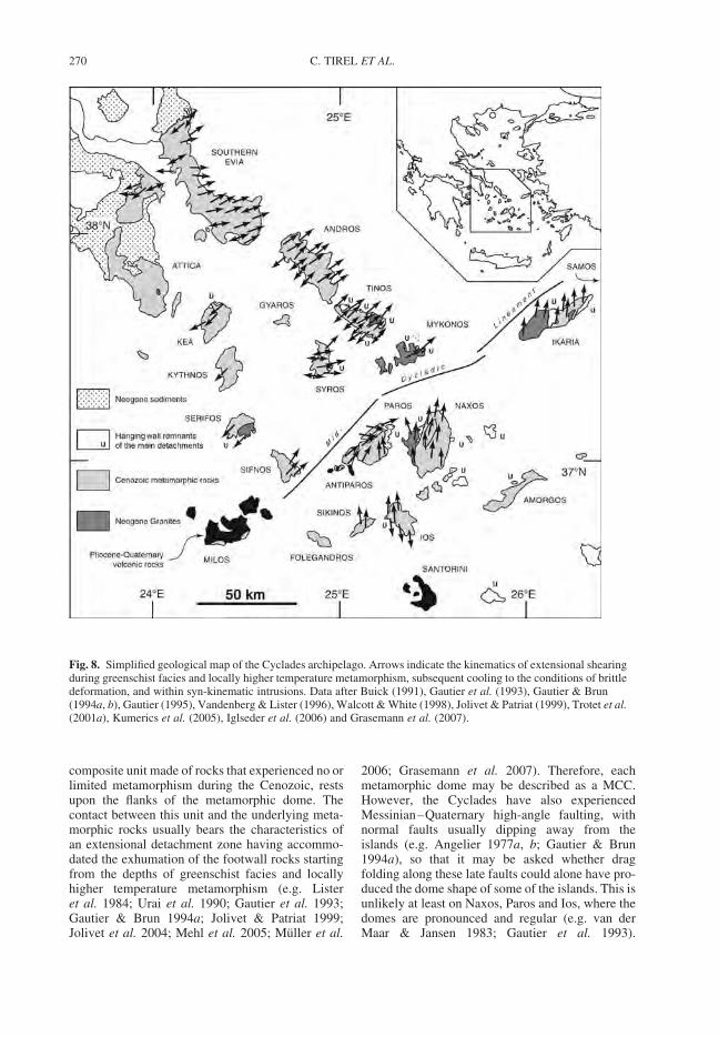
composite unit made of rocks that experienced no orlimited metamorphism during the Cenozoic, restsupon the flanks of the metamorphic dome. Thecontact between this unit and the underlying meta-morphic rocks usually bears the characteristics ofan extensional detachment zone having accommo-dated the exhumation of the footwall rocks startingfrom the depths of greenschist facies and locallyhigher temperature metamorphism (e.g. Listeret al. 1984; Urai et al. 1990; Gautier et al. 1993;Gautier & Brun 1994a; Jolivet & Patriat 1999;Jolivet et al. 2004; Mehl et al. 2005; Muller et al.
2006; Grasemann et al. 2007). Therefore, eachmetamorphic dome may be described as a MCC.However, the Cyclades have also experiencedMessinian–Quaternary high-angle faulting, withnormal faults usually dipping away from theislands (e.g. Angelier 1977a, b; Gautier & Brun1994a), so that it may be asked whether dragfolding along these late faults could alone have pro-duced the dome shape of some of the islands. This isunlikely at least on Naxos, Paros and Ios, where thedomes are pronounced and regular (e.g. van derMaar & Jansen 1983; Gautier et al. 1993).
Fig. 8. Simplified geological map of the Cyclades archipelago. Arrows indicate the kinematics of extensional shearingduring greenschist facies and locally higher temperature metamorphism, subsequent cooling to the conditions of brittledeformation, and within syn-kinematic intrusions. Data after Buick (1991), Gautier et al. (1993), Gautier & Brun(1994a, b), Gautier (1995), Vandenberg & Lister (1996), Walcott & White (1998), Jolivet & Patriat (1999), Trotet et al.(2001a), Kumerics et al. (2005), Iglseder et al. (2006) and Grasemann et al. (2007).
C. TIREL ET AL.270
Occasionally, low-angle normal faults also dissectthe islands and make the identification of a meta-morphic dome more difficult, like on Syros(Ridley 1984).
A critical question is whether distinct MCCsfound along a section parallel to extension wereinitially associated with a single detachment zone,as Lister et al. (1984) suggested, or formedbeneath distinct detachment zones (Gautier &Brun 1994b). Gautier & Brun (1994a, b) andGautier (1995) argued that, on several islands, aspecific distribution of kinematic indicators couldbe seen, like on Tinos, Andros, central southernEvia, Ios and, to a lesser extent, Syros. Theydescribed the ductile deformation associated withgreenschist facies metamorphism as non-coaxial,with a top-to-north (or NE) sense of shear in thenorthern (or northeastern) part of these islands,and a top-to-south (or SW) sense of shear in thesouthern (or southwestern) part. On Tinos andAndros, the domain with top-to-SW shearing isrestricted to a few outcrops along the southwesterncoast, so that the corresponding domes appear asym-metric with respect to the shear sense pattern (i.e.top-to-NE shearing dominates). According toGautier & Brun (1994a, b), the sense of shear isinverted across a c. 1 km-wide zone trending sub-perpendicular to the mean stretching lineation.Within it, conjugate patterns of shear bands andsymmetric boudinage structures dominate, so thatthis zone may be viewed as a narrow domain ofcoaxial strain at the transition between twodomains with opposite kinematics. Further investi-gations on Tinos and Andros led Jolivet & Patriat(1999) to modify this description (see also Jolivetet al. 2004; Mehl et al. 2005). According to theseauthors, the coastal outcrops showing top-to-SWshearing should not be considered as a distinctentity but belong to a domain of coaxial strain sig-nificantly wider than previously presumed, besidethe domain showing uniform top-to-NE shearing.Gautier & Brun (1994a, b) interpreted the abovepattern as reflecting the dynamics of the ductilelower crust in response to isostatic rebound anddome amplification beneath a contemporaneousdetachment zone (that is, the process of ‘inwardflow’ discussed herein). A different opinion isshared by Jolivet & Patriat (1999) and Jolivetet al. (2004), who interpret the juxtaposeddomains of coaxial and non-coaxial strain as reflect-ing the configuration in the middle crust, around thebrittle–ductile transition zone, during early stagesof extension. With further extension, the mainextensional shear zones of the middle crust evolveinto typical extensional detachments (Jolivet et al.2004). A potential problem with this interpretationis the presence, in southern Tinos, of a largeklippe (or ‘extensional allochton’) of the same unit
that forms the hanging wall of the detachmentzone in the northeastern part of the island. Thisklippe rests entirely onto the domain of coaxialstrain defined by Jolivet & Patriat (1999). Whilethis feature is normal in the model invoked byGautier & Brun (1994a, b) (see also Brun & vanden Driessche 1994), it is unexpected in that ofJolivet & Patriat (1999), even after a large amountof displacement is achieved along the detachment(cf. Jolivet et al. 2004, Fig. 13). Because well pre-served eclogites and blueschists are found slightlybeneath the klippe, and by analogy with the situationon Syros (see next section), Trotet et al. (2001a) andMehl et al. (2005) suggested that the interveningcontact represents an extensional detachment sig-nificantly older than that seen in the northeasternpart of the island (at a distance of only 5 km).However, since the rocks in between belong to thesame footwall unit with low-dipping foliations,this hypothesis does not readily solve the problem:the contact in the south and the northeastern detach-ment occupy the same structural position, thereforethe former should have been reactivated (if notentirely developed) during greenschist facies shear-ing along the latter and is most probably connectedwith it. Due to this problematic issue, and onaccount of the numerical results obtained in thisstudy, our opinion is that the interpretation ofGautier & Brun (1994a) remains a viable alternativeto the one of Jolivet & Patriat (1999).
Regardless, taking into account the report oftop-to-NE/ENE shearing in northern and easternSyros during greenschist facies metamorphism(Gautier 1995; Trotet et al. 2001a; Rosenbaumet al. 2002), the domain of coaxial strain in south-western Tinos strongly suggests that Tinos andSyros islands already coincided with distinct meta-morphic domes during that stage of the meta-morphic evolution. As a consequence, the Tinosdetachment and the detachment seen in southeasternSyros, bearing a similar hangingwall rock content(Maluski et al. 1987; Patzak et al. 1994), werealso probably distinct shear zones at that time(Gautier & Brun 1994b).
By analogy, it can be proposed that three paralleldetachment systems have developed in the north-western Cyclades during Miocene extension,coinciding with the three NW–SE-trending chainsof islands seen at present, namely southernEvia–Mykonos, Gyaros–Syros, and Kea–Sifnos(Gautier & Brun 1994a; Jolivet et al. 2004). TheEvia–Mykonos chain is clearly dominated bytop-to-NE ductile to brittle shearing, therefore itwas controlled by a NE-dipping detachment zone.In contrast, the kinematics of extensional defor-mation are not so clearly asymmetric in the caseof the Gyaros–Syros chain. While top-to-NE/ENE shearing dominates in the eastern part of
NUMERICAL AND CYCLADIC CORE COMPLEXES 271
Syros, there is no consensus among authorsconcerning the island as a whole. According toTrotet et al. (2001a), a continuum of top-to-ENEshearing is recorded throughout the island fromthe conditions of high-pressure metamorphism tothose of an uneven greenschist facies overprint.A few major shear zones would have localizedextensional shearing to the point that interlayeredmetamorphic subunits record significant differencesin their pressure-temperature path (Trotet et al.2001b). According to Trotet et al. (2001a, b), thesame holds for Sifnos Island. While agreeing witha continuum of extensional deformation from blues-chist to greenschist facies conditions, Bond et al.(2007) recently questioned the existence of theseprominent shear zones on Syros and argued thatextensional deformation was dominantly coaxialthroughout the synmetamorphic exhumationhistory. Kinematic data reported by Gautier (1995)and Trotet et al. (2001a) do not show a dominantsense of shear on the scale of Syros Island (apartfrom dominantly top-to-NE/ENE shearing in theeastern part), apparently supporting the hypothesisof Bond et al. (2007). Finally, the southwesternchain of islands, from Kea to Sifnos, is the leastknown of the Cyclades (Sifnos excluded). Neverthe-less, according to Walcott & White (1998) andrecent work by Grasemann et al. (2007), Miocenetop-to-SW/SSW extensional shearing dominateson Kea, Kythnos and Serifos: these three islandsare, hence, probably controlled by a majorSW-dipping detachment zone. In contrast, accord-ing to Trotet et al. (2001a), Sifnos displays domi-nantly top-to-NE extensional shearing, hence it isprobably unrelated to this detachment.
In the southeastern Cyclades, no domain ofcoaxial deformation has been found on Naxos andParos Islands, where extensional shearing is consist-ently top-to-north (Urai et al. 1990; Buick 1991;Gautier et al. 1993). Moving toward northwesternParos, a strong (c. 708) but progressive clockwiserotation of the stretching lineation is observed(Gautier et al. 1993), which is thought to relate todextral shearing along the Mid-Cycladic Lineament(Gautier & Brun 1994a). On Ikaria, almost all kin-ematic data reported by Kumerics et al. (2005)also indicate top-to-north shearing.
In contrast, the case of Ios appears morecomplex. Lister et al. (1984) initially reported mylo-nitic rocks, with top-to-south kinematic indicators,which they attributed to a ductile extensionaldetachment named the South Cyclades shear zone.Lister et al. (1984) and, more recently, Vandenberg& Lister (1996) and Forster & Lister (1999) haveconsidered that this c. 200 m-thick shear zone isthe main structure accommodating Neogene exten-sion on Ios. If this hypothesis is correct, then theIos and Naxos MCCs clearly relate to two distinct
(antithetic) detachment zones. However, Gautier& Brun (1994a) have shown that large domainswith top-to-north kinematic indicators are alsofound in the northern limb of Ios dome. Whileacknowledging that the sense of shear is dominantlytop-to-south on Ios (at variance with the case onmost islands), Gautier & Brun (1994b) favouredan interpretation in which the Ios MCC formed inthe footwall of a north-dipping detachment. Theyargued that, even in this case, the Ios and NaxosMCCs are probably related to two distinct (thoughsynthetic) detachments, because: (1) the twodomes are well defined, so that drag folding alonga late normal fault in between the two islands is unli-kely to have produced this division (especially sincethere is no evidence for such a fault in the bathy-metry nor in the Messinian–Quaternary sedi-mentary record; and (2) pressure conditionsassociated with greenschist facies metamorphismare similar from southern Naxos to Ios, and areprobably even lower on Antiparos, an unexpectedfeature in the hypothesis of a single north-dippingdetachment. Therefore, along a section going fromNaxos to Ios, two distinct detachment systems arerequired. But was Ios truly dominated by non-coaxial deformation during Miocene extension,with either a south-dipping (Lister et al. 1984;Forster & Lister 1999) or a north-dipping (Gautier& Brun 1994b) main detachment zone? Thetop-to-north kinematic indicators reported byGautier & Brun (1994a) are associated with high-strain ductile deformation and are found bothbeneath and above the south-vergent SouthCyclades shear zone of Lister et al. (1984). Vanden-berg & Lister (1996) and Forster & Lister (1999)admit that top-to-north shear zones do exist in north-ern Ios, associated with mylonitic fabrics. Forster &Lister (1999) report these shear zones as cuttingacross the South Cyclades shear zone and interpretthem as reflecting downdip shearing along the back-tilted flank of the MCC after significant arching ofthe main shear zone (cf. Reynolds & Lister 1990).This interpretation is questionable, however,because Forster & Lister (1999) indicate that thesecrosscutting relations are observed within augen-gneiss that occupy the core of the Ios MCC, inwhich the main fabric may well relate to pre-extensional events (e.g. Vandenberg & Lister 1996).Conversely, Vandenberg & Lister (1996) suggestedthat the South Cyclades shear zone cuts across thenorth-dipping detachment zone of Naxos, yetacknowledging that available geochronological dataon synkinematic intrusions do not support this scen-ario. Altogether, these features suggest thattop-to-north and top-to-south extensional shearzones on Ios are broadly contemporaneous, and thatthere may be no dominant sense of shear on thescale of the island during Miocene extension.
C. TIREL ET AL.272
Furthermore, Vandenberg & Lister (1996) andForster & Lister (1999) mapped a series of low-angle normal faults capping the South Cycladesshear zone, associated with chloritization and brec-ciation (the Ios Detachment Fault system of Forster& Lister 1999). They consider that this fault systemreflects ongoing shearing along the South Cycladesshear zone during cooling and exhumation, so thatthe faults are reported to have the same top-to-southkinematics. However, field evidence in favour ofthis interpretation is scarce. The fault system isrecognized mainly in the northern limb of thedome, where the normal faults dip northward andare thus assumed to have been tilted into the attitudeof apparent thrust faults during subsequent arching.However, if the top-to-north ductile shear zones alsodeveloped in response to arching, as argued byForster & Lister (1999), then arching was alreadyeffective while the rocks were still in the conditionsof ductile deformation, therefore later brittle normalfault zones could hardly have rotated through thesame process. We conclude that further work isneeded to check whether the ‘Ios DetachmentFault system’ is associated with top-to-south ortop-to-north kinematics.
Summarizing, like the northwestern Cyclades,the southeastern Cyclades seem to include threeparallel detachment systems developed duringMiocene extension, coinciding with the threeeast–west-trending chains of islands seen atpresent, namely Ikaria–Samos, Paros–Naxos, andFolegandros–Ios (Gautier & Brun 1994a). Thetwo northern chains are controlled by a north-dipping detachment zone, while the deformationpattern on Ios suggests that the southern chain hasno marked asymmetry. The central chain (i.e. theislands of Naxos and Paros) displays the deepeststructural levels of the Cyclades, in the form oftwo large domes cored with migmatites (e.g.Gautier et al. 1993; Jolivet et al. 2004).
Interfering detachment systems
Using available pressure estimates for greenschistfacies and locally higher temperature metamorph-ism and taking into account the present geometryand distribution of metamorphic domes in theCyclades, Gautier & Brun (1994b) and Gautier(1995) came to the conclusion that, along at leastthree transects parallel to stretching (Tinos–Syros,Paros–Sikinos, Naxos–Ios), the different detach-ment zones and associated MCCs are partly super-imposed and, therefore, probably interfere withone another. They discussed two possible evolution-ary models incorporating a genetic link betweensuccessive synthetic detachment zones. A scenariowas finally favoured in which a second detachmentdevelops in the footwall of the first one, giving rise
to a secondary MCC formed in the rear flank of thefirst one (Gautier & Brun 1994b, fig. 10). It is worthnoting that this scenario bears some resemblancewith the numerical simulations obtained in thisstudy. Nevertheless, it has specific aspects thatdeserve a few comments. Firstly, the second detach-ment zone was thought to arise from prolongedshearing along a fault zone formed during the devel-opment of the first MCC (the ‘Listric Accommo-dation Fault’ (LAF) seen in the analogueexperiments of Brun et al. 1994). As a result, thesecondary MCC was expected to show a markedasymmetry. It is not clear whether the presentnumerical approach is precise enough to feature aLAF in the brittle upper crust, therefore the mechan-ical background for the development of a secondaryMCC in the simulations may be quite different;coincidentally, we obtain no marked asymmetryfor the secondary MCC. Secondly, the scenario ofGautier & Brun (1994b) incorporated the fact thatthe two MCCs should interfere, with reference tothe three studied transects (for this reason, theLAF was drawn closer to the first detachment thanit is in the experiments of Brun et al. 1994).
Gautier & Brun (1994b) further pointed out that,with ongoing extension, this ‘second footwalldetachment’ scenario may ultimately result in acomplete omission of the wedge of upper crustalrocks that initially formed in the rearmost part ofthe first MCC. They claimed that this feature com-pares well with the situation in the Cyclades,where no such wedge of upper crustal rocks isexposed on the islands. However, the latter pointdepends on the interpretation that is made of seg-ments of the metamorphic pile exposing well-preserved eclogites and blueschists, as on Syrosand Sifnos. Following the opinion of Avigad(1993) and Wijbrans et al. (1993) for the case ofSifnos, Trotet et al. (2001a) have proposed thathigh levels of the metamorphic pile on these twoislands escaped pervasive retrogression becausethey were exhumed earlier. An apparent support tothis interpretation is the fact that, on Sifnos, radio-metric data from these rocks provide significantlyolder ages than lower levels with intense greenschistfacies retrogression (Altherr et al. 1979; Wijbranset al. 1990). As a result, high levels of the meta-morphic pile may have been part of the uppercrust by the time the rest of the pile underwentextensional deformation associated with greenschistfacies metamorphism (Avigad 1993; Trotet et al.2001a; Parra et al. 2002). If so, the claiming ofGautier & Brun (1994b) that no wedge of uppercrustal rocks exists in the Cyclades is incorrect,and it is not so clear whether adjacent MCCs inter-fere or not. For instance, much of Syros would rep-resent such upper crustal rocks, and the same mayapply to Ios, where high-pressure rocks are
NUMERICAL AND CYCLADIC CORE COMPLEXES 273
relatively abundant in the envelope of the dome,above the South Cyclades shear zone of Listeret al. (1984), displaying similarly ‘old’ ages as onSyros and Sifnos (van der Maar & Jansen 1983).Due to its potential implications, this hypothesisneeds to be further discussed.
According to the interpretation of Trotet et al.(2001a, b), important extensional shear zonesshould exist (and are reported to do so) within themetamorphic pile of Syros and Sifnos (see alsoAvigad 1993). In addition, the topmost detachmentfault seen in southeastern Syros, with Cretaceousmetamorphic rocks in the hanging wall (Maluskiet al. 1987) and well preserved high-pressurerocks in the near footwall, should represent a rela-tively old structure. However, in the case of Syros,Bond et al. (2007) claim that the intermediate exten-sional shear zones do not exist and, like otherauthors have argued for Sifnos and Tinos Islands(Schliestedt & Matthews 1987; Brocker 1990;Ganor et al. 1996), consider that the degree of pres-ervation of the high-pressure assemblages reflectsprimarily the extent of fluid infiltration duringgreenschist facies retrogression. Limited fluid infil-tration and deformation in the least retrogressedrocks may also account for the preservation ofolder ages by the time rocks passed through P–Tconditions of the greenschist facies, as proposedby Wijbrans et al. (1990) in the case of Sifnos (seehowever Wijbrans et al. 1993). This is especiallyclear on Tinos, where the rocks with the best pre-served high-pressure assemblages (with agesaround 45–37 Ma) lie at the same structural levelas those showing a complete greenschist overprint(with ages around 33–21 Ma; Brocker & Franz1998; Parra et al. 2002). In this particular case, theextent of retrogression is apparently linked withthe intensity of shearing during greenschist faciesmetamorphism (Jolivet & Patriat 1999; Parra et al.2002). The same may hold for Syros (Bondet al. 2007) and, eventually, Sifnos (Wijbranset al. 1990). Rosenbaum et al. (2002) also considerthat, in northern Syros, at high levels of the meta-morphic pile, greenschist facies overprint is loca-lized into top-to-NE shear zones that arecontemporaneous with Miocene extensional shear-ing in neighbouring islands. As for the detachmentin southeastern Syros, its timing is poorly con-strained. Trotet et al. (2001a) used a 40Ar/39Arwhite mica age obtained close to the contact(30.3 + 0.9 Ma; Maluski et al. 1987) to infer thatthe detachment was active at that time. Maluskiet al. (1987) reported this age from an omphaciticmetagabbro and pointed out that the obtained spec-trum shows evidence for an inherited component. Inaddition, Trotet et al. (2001a) indicate that theactual detachment contact is marked by brecciasreworking eclogites retrograded into the greenschist
facies. This strongly suggests that at least part of thedisplacement along the detachment occurred signifi-cantly later than 30 Ma, that is, at about the sametime as in other islands (e.g. Gautier & Brun1994a). Altogether, the above features suggestthat, in the Cyclades as a whole, well-preservedhigh-pressure rock assemblages represent low-strain lenses of variable size embedded into asingle layer of greenschist facies metamorphismdating from the late Oligocene–early Miocene.This interpretation may apply to most islands (e.g.Wijbrans et al. 1990; Parra et al. 2002; Bond et al.2007), Ios included (Forster & Lister 1999). As aresult, the inference that no wedge of upper crustalrocks exists in the Cyclades (Gautier & Brun1994b) remains probably valid, which, in turn, sup-ports the view that detachment zones and associatedMCCs do interfere with one another in this region. Itremains that, on Syros and Sifnos, an upward gradi-ent of preservation of the high-pressure assemblagesexists across the c. 3 km-thick metamorphic pile(e.g. Wijbrans et al. 1990; Trotet et al. 2001a).We suggest that this gradient reflects the transitionfrom pervasive deformation, below, to more loca-lized deformation, above, within the layer of greens-chist facies metamorphism. In other words,greenschist facies metamorphism in the middlecrust would coincide with the broad transitionfrom pervasive (ductile) to localized (ductile tobrittle) deformation across the thickness of thecrust, in good agreement with the views of Jolivet& Patriat (1999) and Jolivet et al. (2004).
Post-orogenic versus syn-orogenic extension
The numerical simulations presented in this paperare concerned with the case of whole-lithosphereextension. As stated above, most authors havingidentified extensional detachments and meta-morphic core complexes in the Cyclades interpretedthem as resulting from Aegean ‘backarc’ extension(Lister et al. 1984; Buick 1991; Gautier & Brun1994b; Jolivet & Patriat 1999), thus apparentlyfitting the experimental setup. These structuresdeveloped within metamorphic rocks thatpreviously experienced high-pressure/low-temperature conditions, therefore extension mayalso be described as ‘late-orogenic’ (Gautier &Brun 1994b). However, for the purpose of a com-parison with the numerical results, it needs to bediscussed whether the extensional structures devel-oped strictly after crustal thickening or/and duringongoing thrusting beneath the locus of extension.In the Aegean, these two cases have been referedto as post vs. syn-thickening, or post vs. syn-collisional, extension (Gautier & Brun 1994b), orpost vs. syn-orogenic extension/exhumation(Jolivet & Patriat 1999; Trotet et al. 2001a; Parra
C. TIREL ET AL.274
et al. 2002; Jolivet et al. 2003), the latter terminol-ogy being now widely accepted. In the following,we prefer to use extension rather than exhumationbecause exhumation may also result from erosion,eventhough erosion in the Cyclades has probablybeen limited during the Cenozoic (e.g. Gautier &Brun 1994a). We emphasize that extension doesnot necessarily mean that the whole lithosphere, oreven the whole crust, is stretched horizontally.This is obvious in the case of syn-orogenic exten-sion, where plate convergence is the leadingprocess and horizontal shortening the dominantregime on the lithospheric scale. Syn-orogenicextension is sometimes described as correspondingto the development of an extrusion wedge (e.g.Ring & Reischmann 2002; Ring et al. 2007a).
The distinction between post and syn-orogenicextension is a difficult task, especially because theassociated faults and shear zones may have thesame kinematics (Jolivet & Patriat 1999; Trotetet al. 2001a). Gautier & Brun (1994b) and Gautieret al. (1999) have argued that, because extensionwith a direction of stretching parallel to plate con-vergence was active at the same time (i.e. since atleast the Aquitanian) across a wide part of theAegean, from the Rhodope to Crete, this extensionwas necessarily post-orogenic, based on a compari-son with the case of syn-orogenic lateral extensionin the Himalaya–Tibet orogen. However, thisassessment may be incorrect in the case of a signifi-cant retreat of the underthrusted slab duringorogeny. As discussed by Jolivet et al. (2003), ifthe dynamics of the orogen is basically that of aretreating subduction, then extension can be every-where parallel to convergence, including in thearea lying above the frontal thrust zone. In asense, such an orogen is not strictly collisional,therefore the description of extension as post or syn-collisional (Gautier & Brun 1994b) is unadapted inthis case.
Even if only extensional structures are observedin a late-orogenic setting, it is usually difficult todemonstrate that their formation was strictly post-orogenic, because it can always be argued thatcoeval thrusting possibly occurred beneath thedeepest exposed rocks. Conversely, syn-orogenicextension is demonstrated if a thrust zone can beshown to have been active while extension occurred,or had already started, at shallower levels. Avigad &Garfunkel (1989) and Avigad et al. (1997) tenta-tively argued for the latter case on Tinos and Eviaislands, however their arguments have been criti-cized by Gautier (2000) and Brocker & Franz(2005). Moreover, in the scenario of Avigad et al.(1997) for the Cyclades, coeval thrusting andinferred syn-orogenic extension are restricted tothe Oligocene period, while post-orogenic extensionstarted at about 25 Ma, associated with a pervasive
greenschist facies overprint, as in the commonview (see above). Avigad et al. (1997) alsoacknowledged that the identification of structuresassociated with the period of syn-orogenic exten-sion is problematic.
The shape of the pressure–temperature path fol-lowed by metamorphic rocks may help to decipherbetween syn-orogenic and post-orogenic extension.Following Wijbrans et al. (1993), Jolivet andco-workers have proposed that, among the meta-morphic rocks of the Cyclades, those having fol-lowed a cold geotherm during exhumation shouldhave done so owing to syn-orogenic extension(Jolivet & Patriat 1999; Trotet et al. 2001a, b;Parra et al. 2002; Jolivet et al. 2003). A critical ques-tion is how cold this geotherm should be, given thatexhumation beneath a detachment also helps toprevent heating. The best answer probably comesfrom the study of Parra et al. (2002), showing that,on Tinos, rocks in the footwall of the NE-dippingdetachment experienced an episode of isobaricheating (a temperature increase from 4008–550 8Cat about 9 kbar) between two episodes of exhuma-tion. Parra et al. (2002) convincingly proposedthat the first and second episodes reflect syn-orogenic and post-orogenic extension, respectively(see also Jolivet et al. 2004). As a result, on Tinosat least, only post-orogenic extension would berecorded since rocks moved out of the conditionsof blueschist facies metamorphism. In otherwords, all the structures developed at greenschistfacies and subsequent lower grade conditions areexpected to relate to post-orogenic extension, inagreement with earlier proposals (Gautier & Brun1994a; Jolivet & Patriat 1999). There does notseem to be a significant diachronism of greenschistfacies metamorphism on the scale of the Cyclades(including at high levels of the metamorphic pileon Syros, see previous section), therefore thewhole set of detachment zones and associatedMCCs described before have probably developedduring post-orogenic extension.
It is difficult to determine when this extensionstarted. Using the data of Brocker & Franz (1998),Parra et al. (2002) have suggested that the beginningof the second episode of exhumation and, therefore,the onset of post-orogenic extension in the Cycladestook place at 30 Ma (see also Jolivet et al. 2003,2004). Based on the data of Wijbrans et al. (1990),Wijbrans et al. (1993) have proposed a P–T pathfor lower levels of the metamorphic pile on Sifnosthat resembles the one of Parra et al. (2002) forTinos. However, in this case, isobaric heating(at 6.5 kbar) would have occurred from 30 Ma to22 Ma, so that the second episode of exhumationwould start at 22 Ma. Nevertheless, the scenario ofWijbrans et al. (1993) assumes that post-thickeningextension started at 30 Ma, being first confined to
NUMERICAL AND CYCLADIC CORE COMPLEXES 275
crustal levels beneath the presently exposed rockpile, then migrating into this pile. Therefore, bothinterpretations (Wijbrans et al. 1993; Parra et al.2002) concur in the idea that post-orogenic exten-sion was active in the Cyclades during the earliestMiocene (e.g. Gautier & Brun 1994a); they evensuggest that it was already active during the lateOligocene.
In contrast, Ring and co-workers have putforward an extreme alternative scenario, in whicha context of syn-orogenic extension would havebeen maintained in the Cyclades until c. 21 Ma(Ring et al. 2001; Ring & Reischmann 2002;Ring & Layer 2003; Ring et al. 2007a). Thiswould have been followed by an episode of post-orogenic extension starting later than c. 15 Ma(Ring et al. 2007a), probably at c. 12 Ma (Ring &Layer 2003), and resulting from thermal weakeningat the time the Aegean magmatic arc would havereached the Cyclades. If this scenario is correct,then extensional structures associated with greens-chist facies and higher temperature metamorphismshould largely date from an episode of syn-orogenicextension, as, for instance, on Naxos (e.g. Gautieret al. 1993; Keay et al. 2001), Tinos (e.g. Gautier& Brun 1994a; Brocker & Franz 1998, 2000;Jolivet et al. 2004) and Andros (Gautier & Brun1994b; Brocker & Franz 2006). As a result, ourattempt to compare our numerical simulations andthe Cycladic case would be questionable.
According to Ring and co-workers, the CentralAegean region is floored by the poorly exposedparautochtonous Basal unit, coinciding with theAlmyropotamos unit in central southern Evia (e.g.Dubois & Bignot 1979); this unit would have beenunderthrusted while extensional shearing developedat higher levels of the metamorphic pile. Thisinterpretation follows Avigad et al. (1997) exceptfor the timing of the episode of syn-orogenic exten-sion (before about 25 Ma for Avigad et al. as late as21 Ma for Ring and co-workers). We think that thisscenario is unlikely, especially its timing, for thethree following reasons:
† Rb–Sr and 40Ar/39Ar dating of phengitesfrom samples of the Basal unit has yieldedages mostly between 21 and 24 Ma (Ringet al. 2001; Ring & Reischmann 2002; Ring &Layer 2003). While they coincide with thetiming of greenschist facies metamorphism inthe overlying unit, these ages were interpretedas reflecting high-pressure metamorphism inthe Basal unit (hence constraining the age ofunderthrusting) because the dated phengiteshave a high Si content (�3.3 per formulaunit). However, as thoroughly discussed byBrocker et al. (2004) and Brocker & Franz(2005), this interpretation is questionable and
the obtained ages are more likely to reflectthe timing of post-high-pressure greenschistfacies retrogression, as in the overlying unit.Further support to the objections of Brockeret al. (2004) is found in the recent Rb–Srstudy of Wegmann (2006) on rocks from south-easternmost Evia, at higher levels of the meta-morphic pile, far above the Basal unit. In onerock repeatedly dated with a microsamplingmethod, phengites have a Si content rangingfrom 3.36 to 3.74 pfu and yield Rb–Sr agesranging from 21 to 11 Ma. Following the lineof reasoning of Ring and co-workers, thiswould mean that higher levels of the meta-morphic pile were still experiencing high-pressure conditions at that time. This is atodds with the report from the neighbouringnorthwestern Cyclades (Brocker & Franz1998, 2006) and from southern Evia itselfwhere, according to Ring et al. (2007a), suchrocks experienced greenschist facies conditionsas early as 21 Ma. It should also be stressed thatthe youngest fossils found so far in the Almyr-opotamos unit represent the lower or middleEocene (Dubois & Bignot 1979), not theupper Eocene–Oligocene as commonlyreported (e.g. Ring et al. 2007a), thereforethis unit may have started to underthrust asearly as during the early Eocene;
† According to the scenario of Ring and co-workers, the Central Aegean region shouldhave been characterized by a depressedgeotherm as late as around 21 Ma (i.e. aslong as underthrusting and inferred high-pressure metamorphism were developing),and no significant thermal overprint isexpected before about 14 Ma, when arc mag-matism is considered to have reached theCyclades. However, this does not take intoaccount the case of the migmatite domes onNaxos and Paros Islands. U–Pb dating ofzircons from the migmatitic core of Naxosindicates that partial melting mostly occurredat c. 17.5 Ma and was already under way at20 Ma (Keay et al. 2001), in good agreementwith time constraints provided by other radio-metric methods (e.g. Andriessen et al. 1979;Wijbrans & McDougall 1988). This showsthat at least part of the Central Aegeanregion was actually characterized by a highgeotherm at about 20 Ma. The Basal unit isunlikely to lie underneath the migmatitedomes, because if it had been underthrusteduntil 21 Ma, migmatization in the hangingwall of this thrust could hardly have beenmaintained until c. 17 Ma (cf. Keay et al.2001). Hence, the migmatite domes probablycut across the contact and, as stated before,
C. TIREL ET AL.276
represent the deepest structural levels of theCyclades. It is not known whether the migma-tites seen on Naxos and Paros expand laterallybeneath the other islands, although there arechemical data to suggest so (Gautier & Brun1994a). Regardless, the area of Naxos andParos was hot at 20 Ma, and we do notsee how this can be reconciled with thehypothesis of regional underthrusting as lateas 21 Ma; and
† Post-orogenic extension is accompanied by theformation of grabens (as also illustrated by ournumerical experiments) which may evolve intosupra-detachment basins. Thus, the base ofthe supradetachment basin stratigraphy mayprovide a minimum age for the onset of post-orogenic extension. The oldest supra-detachment sediments known in the Cyclades,on Naxos and Paros, are Aquitanian (23.0–20.4 Ma; Lourens et al. 2004) and form thebasis of a nearly continuous stratigraphy reach-ing the upper Miocene (Angelier et al. 1978;Roesler 1978; Sanchez-Gomez et al. 2002).This documents continuous formation of accom-odation space from the Aquitanian onward,suggesting no fundamental change in the tec-tonic setting since that time (Gautier et al.1993; Gautier & Brun 1994a; Sanchez-Gomezet al. 2002). In addition, the Aquitanian and Bur-digalian sediments are marine deposits (e.g.Angelier et al. 1978), while it may be arguedthat sedimentation beneath sea level is unex-pected during (or immediately after) an episodeof extension coeval with underthrusting, as inthe scenario of Ring et co-workers.
To conclude on this part, our opinion is that acontext of syn-orogenic extension could hardlyhave existed in the Cyclades later than about25 Ma, considering that at least a few millionyears are necessary to enhance partial meltingafter underthrusting, whatever the exact origin ofthe heating event. Syn-orogenic extension finishingat c. 37 Ma, as suggested by Parra et al. (2002),would fit this condition. We also note that theonset of post-orogenic extension at c. 30 Ma in theCyclades, as suggested by Wijbrans et al. (1993)and Parra et al. (2002), is fully compatible withthe timing of events reported by Thomson & Ring(2006) and Ring et al. (2007b) in the nearby Men-deres massif, where the allochtonous position ofthe ‘blueschist’ unit of the Cyclades iswell established.
Did extension in the Cyclades significantly
deviate from plane strain deformation?
Finally, before comparing the Cyclades and ournumerical experiments, we should examine
whether crustal extension in the Cyclades closelyapproximated plane strain deformation, asassumed when extrapolating the two-dimensionalsimulations to a three-dimensional setting, or not.Based on the presence of folds with axes parallelto the mean stretching lineation on several islands(Naxos, Paros, Tinos and Andros), some authorshave argued that a significant component of trans-verse (c. east–west) shortening has accompaniedMCC-type extension in the Cyclades (Urai et al.1990; Buick 1991; Avigad et al. 2001; Jolivetet al. 2004). According to Avigad et al. (2001),the magnitude of this lateral contraction was highenough to maintain the thickness of the crustroughly constant despite intense extensional defor-mation. Transverse shortening may be viewed as anormal response to the three-dimensional displace-ment field of the Aegean lithosphere during exten-sional spreading (Gautier et al. 1999; Jolivet et al.2004), nevertheless our opinion is that its contri-bution to crustal strain has never been significantin the Cyclades. Most of the folds taken as evidencefor strong lateral shortening are either isoclinal totight folds with low-dipping axial planes subparallelto the main foliation (therefore they do not properlydocument horizontal shortening) or upright openfolds (documenting limited shortening). On Naxos,which is reported as the island where transverseshortening is best seen, Vanderhaeghe (2004) hasshown that subvertical granitic dikes have emplacedthroughout the inner envelope of the migmatitedome during extension. About one half of thesedikes trend parallel to the c. north–south stretchinglineation and another half perpendicular to it, there-fore bulk flattening strain and horizontal stretchingin the east–west direction are actually documented(Vanderhaeghe 2004). The relatively steep attitudeof foliations within and around the migmatiticcore of the Naxos dome may reflect the diapiricascent of the migmatites (Vanderhaeghe 2004)rather than folding and horizontal shortening (e.g.Jolivet et al. 2004).
In analogue experiments simulating the spread-ing of a weak lithosphere toward a free boundary,transverse shortening is present but is confined tothe inner (northern in an Aegean frame) part of thedeforming sheet (Gautier et al. 1999). The Cycladesare unlikely to have occupied such a inner positionduring Aegean extension, at least until the lateMiocene, therefore the lack of clear evidence forsignificant transverse shortening in the ductilerecord of the islands is not surprising. The situationis possibly different since around the Pliocene (since,3 Ma according to Gautier et al. 1999, but moreprobably since ,8 Ma according to the paleo-magnetic results of van Hinsbergen et al. 2005b),when a southward jump of the northwestern tip ofthe Aegean arc brought the Cyclades in a more
NUMERICAL AND CYCLADIC CORE COMPLEXES 277
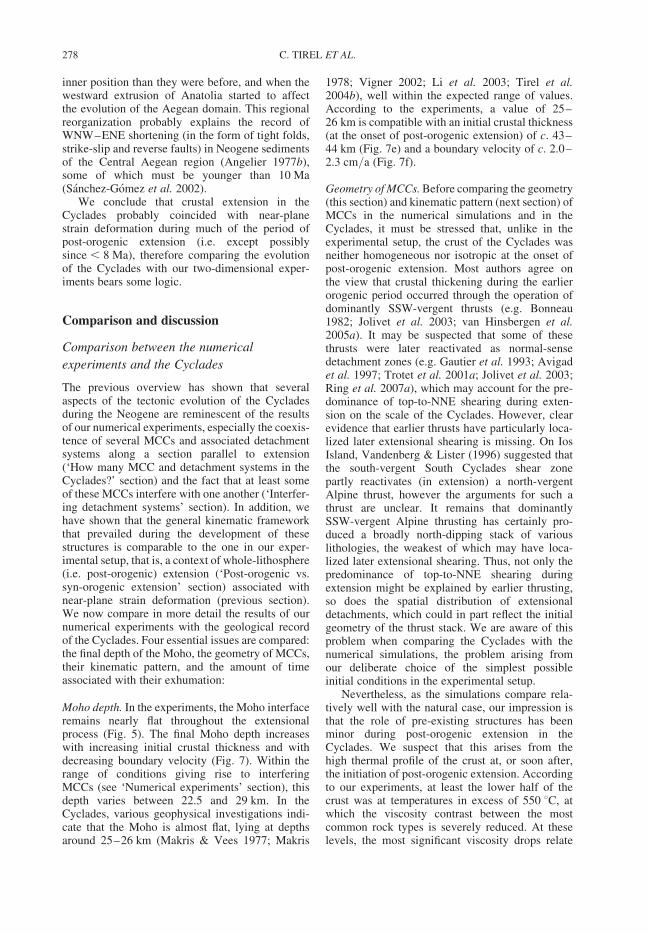
inner position than they were before, and when thewestward extrusion of Anatolia started to affectthe evolution of the Aegean domain. This regionalreorganization probably explains the record ofWNW–ENE shortening (in the form of tight folds,strike-slip and reverse faults) in Neogene sedimentsof the Central Aegean region (Angelier 1977b),some of which must be younger than 10 Ma(Sanchez-Gomez et al. 2002).
We conclude that crustal extension in theCyclades probably coincided with near-planestrain deformation during much of the period ofpost-orogenic extension (i.e. except possiblysince , 8 Ma), therefore comparing the evolutionof the Cyclades with our two-dimensional exper-iments bears some logic.
Comparison and discussion
Comparison between the numerical
experiments and the Cyclades
The previous overview has shown that severalaspects of the tectonic evolution of the Cycladesduring the Neogene are reminescent of the resultsof our numerical experiments, especially the coexis-tence of several MCCs and associated detachmentsystems along a section parallel to extension(‘How many MCC and detachment systems in theCyclades?’ section) and the fact that at least someof these MCCs interfere with one another (‘Interfer-ing detachment systems’ section). In addition, wehave shown that the general kinematic frameworkthat prevailed during the development of thesestructures is comparable to the one in our exper-imental setup, that is, a context of whole-lithosphere(i.e. post-orogenic) extension (‘Post-orogenic vs.syn-orogenic extension’ section) associated withnear-plane strain deformation (previous section).We now compare in more detail the results of ournumerical experiments with the geological recordof the Cyclades. Four essential issues are compared:the final depth of the Moho, the geometry of MCCs,their kinematic pattern, and the amount of timeassociated with their exhumation:
Moho depth. In the experiments, the Moho interfaceremains nearly flat throughout the extensionalprocess (Fig. 5). The final Moho depth increaseswith increasing initial crustal thickness and withdecreasing boundary velocity (Fig. 7). Within therange of conditions giving rise to interferingMCCs (see ‘Numerical experiments’ section), thisdepth varies between 22.5 and 29 km. In theCyclades, various geophysical investigations indi-cate that the Moho is almost flat, lying at depthsaround 25–26 km (Makris & Vees 1977; Makris
1978; Vigner 2002; Li et al. 2003; Tirel et al.2004b), well within the expected range of values.According to the experiments, a value of 25–26 km is compatible with an initial crustal thickness(at the onset of post-orogenic extension) of c. 43–44 km (Fig. 7e) and a boundary velocity of c. 2.0–2.3 cm/a (Fig. 7f).
Geometry of MCCs. Before comparing the geometry(this section) and kinematic pattern (next section) ofMCCs in the numerical simulations and in theCyclades, it must be stressed that, unlike in theexperimental setup, the crust of the Cyclades wasneither homogeneous nor isotropic at the onset ofpost-orogenic extension. Most authors agree onthe view that crustal thickening during the earlierorogenic period occurred through the operation ofdominantly SSW-vergent thrusts (e.g. Bonneau1982; Jolivet et al. 2003; van Hinsbergen et al.2005a). It may be suspected that some of thesethrusts were later reactivated as normal-sensedetachment zones (e.g. Gautier et al. 1993; Avigadet al. 1997; Trotet et al. 2001a; Jolivet et al. 2003;Ring et al. 2007a), which may account for the pre-dominance of top-to-NNE shearing during exten-sion on the scale of the Cyclades. However, clearevidence that earlier thrusts have particularly loca-lized later extensional shearing is missing. On IosIsland, Vandenberg & Lister (1996) suggested thatthe south-vergent South Cyclades shear zonepartly reactivates (in extension) a north-vergentAlpine thrust, however the arguments for such athrust are unclear. It remains that dominantlySSW-vergent Alpine thrusting has certainly pro-duced a broadly north-dipping stack of variouslithologies, the weakest of which may have loca-lized later extensional shearing. Thus, not only thepredominance of top-to-NNE shearing duringextension might be explained by earlier thrusting,so does the spatial distribution of extensionaldetachments, which could in part reflect the initialgeometry of the thrust stack. We are aware of thisproblem when comparing the Cyclades with thenumerical simulations, the problem arising fromour deliberate choice of the simplest possibleinitial conditions in the experimental setup.
Nevertheless, as the simulations compare rela-tively well with the natural case, our impression isthat the role of pre-existing structures has beenminor during post-orogenic extension in theCyclades. We suspect that this arises from thehigh thermal profile of the crust at, or soon after,the initiation of post-orogenic extension. Accordingto our experiments, at least the lower half of thecrust was at temperatures in excess of 550 8C, atwhich the viscosity contrast between the mostcommon rock types is severely reduced. At theselevels, the most significant viscosity drops relate
C. TIREL ET AL.278
to the progress of anatexis, which depends onlypartly on the geometry of earlier thrusting.
A number of observations imply that severalMCCs coexist in the Cyclades (see ‘How manyMCC . . .’ section). Structural data suggest thatthree detachment systems and associated MCCshave developed in both the northwerstern Cyclades(coinciding with the Evia–Mykonos, Gyaros–Syros and Kea–Sifnos island chains) and thesoutheastern Cyclades (coinciding with theIkaria–Samos, Paros–Naxos and Folegandros–Iosisland chains). As discussed by Gautier & Brun(1994b), the MCCs of at least two of these chainsapparently interfere with one another, based on therelationships between Naxos and Ios, Paros andSikinos, and Tinos and Syros (see ‘Interferingdetachment systems’ section). We now focus on acomparison between the numerical simulationsand the Naxos–Ios and Tinos–Syros island pairs,leaving Paros–Sikinos aside because it repeats thecase of Naxos–Ios without an equivalent structuralor geochronological dataset being available.
We find striking similarities between the simu-lations and the selected island pairs in terms of geo-metry (Fig. 9). Naxos constitues a large MCC with apronounced asymmetry, exhuming high-temperaturelower crustal rocks (e.g. Gautier et al. 1993). Iosconstitutes another MCC (e.g. Vandenberg &Lister 1996) formed in the direction opposite tothe slope of the Naxos detachment. The Ios domeseems symmetric (at least, its asymmetry is not aspronounced as on Naxos or Paros). It is appparentlynarrower than the Naxos dome (although both are
partly hidden beneath sea level) and exposes lowergrade rocks (e.g. van der Maar & Jansen 1983), indi-cating that the Ios MCC is less developed. The Iosdome is superimposed on the southern flank of theNaxos dome (Gautier & Brun 1994b). Althoughless clearly expressed, the Tinos–Syros island pairdisplays a similar geometry. Tinos is an asymmetricMCC exhuming rocks with a pervasive greenschistfacies overprint (Gautier & Brun 1994a; Jolivet &Patriat 1999; Parra et al. 2002). Syros is anotherMCC formed in the direction opposite to the slopeof the Tinos detachment. However, Syros does notshow a regular dome, which may be due to the mod-erate size of the island and to the influence of largenormal faults cutting across the metamorphic series(Ridley 1984). It exposes rocks with broadly a lessintense greenschist facies overprint than on Tinos(e.g. Trotet et al. 2001a). We have discussed inthe ‘Interfering detachment systems’ section thepossible interpretations of this feature, suggestingthat the upward gradient of preservation of the high-pressure assemblages across the metamorphic pileof Syros (and Sifnos) may reflect the transitionfrom pervasive deformation, below, to more loca-lized deformation, above, within a coherent layerof greenschist facies metamorphism. If so, then atleast part of Syros exposes rocks of slightly shal-lower origin than on Tinos. This hypothesis is sup-ported by a comparison of the P–T paths of thedeepest rocks on Syros (Trotet et al. 2001b) andTinos (Parra et al. 2002), showing that, along thegreenschist facies segment of the exhumation path,temperatures were �508 higher in the case of
NAXOS IOS
shape of the MCC symmetric dome asymmetric dome
kinematics of extension no dominant sense (?) top-to-north
post-HP highest metamorphic grade
greenschist anatexis
radiometric record of extension ~ 20-13 Ma >20-10 Ma
main period of exhumation ? 17-12 Ma
N/NE S/SW
SYROS TINOS
shape of the MCC domal ? asymmetric dome
22-1 1 Ma
kinematics of extension no dominant sense (?) top-to-northeast
post-HP highest metamorphic grade
greenschist greenschist (T>50°C or more / Syros)
radiometric record of extension ~ <30-1 1 Ma
22-15 Ma (?) main period of exhumation ?
Fig. 9. Comparison between a crustal-scale cross-section showing interfering MCCs, as deduced from the numericalanalysis, and relevant data from two transects in the Cyclades showing closely spaced MCCs, as discussed in thetext. The comparison reveals a good agreement.
NUMERICAL AND CYCLADIC CORE COMPLEXES 279
Tinos. In our experiments, the isotherms are carriedupward during the earlier stages of MCC develop-ment, therefore we expect a rock of deeper originto experience higher temperatures during exhuma-tion, as also clearly illustrated by the numericalexperiments of Gessner et al. (2007). Thus, theTinos MCC has apparently accommodated moreexhumation than the Syros MCC has. Note thatthe same process of upward heat transport duringMCC development might also account for thedifferent P–T paths obtained by Trotet et al.(2001b) across the metamorphic pile of Syros andSifnos (see e.g. Gessner et al. 2007, Fig. 6). As dis-cussed by Gautier & Brun (1994b), the Syros MCCis probably superimposed on the southwestern flankof the Tinos MCC.
Summing up, the geometry of MCCs alongthe Naxos–Ios transect and, to a less extent, theTinos–Syros transect, compares well with thenumerical simulations (Fig. 9). The comparisonis more convincing with type 2 experiment, inwhich the second dome develops in the immedi-ate vicinity of the first dome, so that the twoMCCs are partly superimposed (Figs 5d, e, fand 6). In this case, no wedge of upper crustalrock is preserved between the MCCs, a featurethat Gautier & Brun (1994b) have claimed tocharacterize the Cyclades. If, alternatively,higher levels of the metamorphic pile on Syros(and Sifnos) represent rocks that were exhumedto upper crustal conditions before the onset ofpost-orogenic extension (e.g. Trotet et al.2001a; see discussion in ‘Interfering detachmentsystems’ section), then the structure is broadlythe same, with only the Syros MCC being lessdeveloped (i.e., leaving a cap of upper crustalrocks near the apex of the dome).
In addition, special attention should be paid tothe width of the two largest MCCs of theCyclades, on Naxos and Paros. According to theabove comparison, these two domes representMCCs of the first generation. In the experiments,depending on the initial conditions, the width ofthe first dome is quite variable (Fig. 7a, b). Thewidth of Naxos and Paros domes, measured inthe same way as in the experiments (from thefront of the detachment, plunging northward, tothe rearmost part of the dome, before reaching awedge of brittle upper crust) is at least 35 kmand most probably less than 60 km. This rangeis compatible with an initial crustal thicknessbetween c. 41 and 44 km, and seems to excludegreater values (Fig. 7a). It also seems toexclude a boundary velocity lower than c.2 cm/a (Fig. 7b). Thus, the width of the MCCsof the first generation suggests broadly the samerange of initial conditions as the final Mohodepth does (see ‘Moho depth’ section).
Kinematic pattern. Similarities are also foundbetween the simulations and the Naxos–Ios andTinos–Syros island pairs in terms of kinematicdevelopment of the MCCs. However, beforeattempting a comparison, we should keep in mindthe origin of shear zones in the numerical exper-iments, and address the question whether the sameprocess could have operated in the Cyclades. Inthe experiments, faulting occurs in the upper crustdue to the imposed horizontal stretching; a majorfault (i.e., a detachment) ultimately develops atthis level if stretching is strong enough (see ‘Analy-sis of the two experiments’ section; see also Tirelet al. 2004a). In the lower crust, ductile shearzones develop as a by-product of the process ofinward flow. In the Cyclades, Gautier and Brun(1994a, b) have interpreted the shear zone patternof some of the islands (especially Tinos, Andros,Ios) as reflecting such a process of inward flow(see ‘How many MCC. . .’ section). On Tinos andAndros, there is good evidence that this shear zonepattern developed during greenschist facies meta-morphism and subsequent cooling to conditions cor-responding to the transition from pervasive ductileto localized semi-brittle behaviour (Gautier &Brun 1994a; Gautier 1995; Jolivet & Patriat 1999;Jolivet et al. 2004; Mehl et al. 2005). In our exper-iments, shearing due to inward flow occurs signifi-cantly below the ductile–brittle transition (i.e., attemperatures at least c. 150 8C higher than the temp-erature of c. 300 8C obtained for the transition),nevertheless it is conceivable that shearing may pro-pagate up to this interface if the ductile–brittle tran-sition is to become a low-strength horizon after acertain amount of crustal extension is achieved(see ‘Analysis of the two experiments’ section).The structural record on Tinos and Andros showsthat this situation may hold in the Cyclades. Inaddition, as micaschists and marbles dominateamong the various rock types found in the islands,shearing due to inward flow may propagate ateven shallower depths (that is, along an isothermof less than 300 8C) if the proper rheologicallaws were used, instead of that of quartz-diorite.Nevertheless, orthogneisses apparently dominateat lower levels of the Cyclades rock pile, as seenon Naxos, Paros and Ios (e.g. van der Maar &Jansen 1983; Gautier et al. 1993), therefore thechoice of quartz diorite as the representative rocktype for the Central Aegean crust as a wholeseems justified (see also Jolivet et al. 2003, 2004).
As mentioned before, Naxos and Paros Islandsare asymmetric domes that consistently displaytop-to-north shear criteria. These kinematics areobserved from the envelope of the domes (Gautieret al. 1993) down to the migmatitic core of Naxos(Buick 1991) and the poorly defined migmatiticdomain of Paros (Gautier et al. 1993). Hence, in
C. TIREL ET AL.280
the Cyclades, the largest MCCs, associated with themost pronounced exhumation, do not display evi-dence of inward flow emanating from the rear partof the dome (that is, inward flow that wouldproduce shearing antithetic to the main detachmentzone) whereas, according to the interpretation ofGautier & Brun (1994a, b), less mature MCCs doso. This may be viewed as a paradox, however,the present experiments show that it is not. Asseen on Figure 5, SZ1, which relates to this anti-thetic inward flow toward the main dome, is pro-nounced but confined to great depths and, unlikeSZ2, never reaches the surface. In contrast, in thecase of the secondary dome, the two limbs coincidewith antithetic shear zones that extend upward thetwo flat-lying shear zones (SZ11 and SZ12) devel-oped in response to renewed inward flow. As a con-sequence, the secondary dome tends to besymmetric, and it can be expected that no dominantsense of shear will be found around its apex. Thesefeatures compare relatively well with the case of Iosand Syros Islands (see ‘How many MCC. . .’section). As mentioned in ‘Analysis of the twoexperiments’ section, SZ12 reactivates SZ1 in oppo-site sense but with less strain accumulated, thereforeit can be expected that relics of the first kinematicswill be found along SZ12. While assuming thatthe Ios MCC was controlled by a north-dippingdetachment, Gautier & Brun (1994b) suggestedthat this feature may explain the predominance oftop-to-south shearing across the Ios dome (that is,top-to-south shearing would in part reflect earlyinward flow in the rear flank of the Naxos MCC).However, because the relations betweentop-to-south and top-to-north shearing are unclearon Ios (see ‘How many MCC. . .’ section), weleave it open whether this hypothesis makes sense.The same applies to Syros, which is possibly domi-nated by coaxial deformation, but where there is noindication of an early top-to-SW shearing event thatwould be overprinted by top-to-NE shearing (e.g.Trotet et al. 2001a; see ‘How many MCC. . .’section).
Summarizing, both the geometry (cf. previoussection) and the kinematic pattern of MCCscompare well between the experiments and theNaxos–Ios and Tinos–Syros island pairs (Fig. 9).In both cases, the comparison holds for twoamong three chains of islands, and, thus, seems toignore the Ikaria–Samos and Kea–Sifnos chains.It should be reminded that, in the experimentswith interfering MCCs, additional MCCs dodevelop (see ‘Description of two experiments’section), located at far distance from the MCCsunder discussion, so that the former do not interferewith the latter (i.e. they are not superimposed northey rework earlier shear zones). We tentativelysuggest that the Ikaria–Samos and Kea–Sifnos
chains, which lie relatively far from the otherchains, coincide with these non-interfering MCCs.
Timing of exhumation. The simulations and theCyclades are now compared in terms of chronologyusing two approaches. Firstly, the comparison mayconcern the total time elapsed from the onset ofpost-orogenic extension until the time the develop-ment of all MCCs has reached an end. The latterbound is not equivalent to the end of the extensionalprocess because lithospheric stretching may persistdue to unchanged boundary conditions. However,due to crustal thinning, the style of extension isexpected to change, and the development ofMCCs to be arrested (e.g. Buck 1991), which isindeed what we observe in the experiments (seealso Tirel et al. 2008). The amount of time definedin this way is here termed the duration ofMCC-type extension. In the experiments, withinthe range of conditions giving rise to interferingMCCs, the duration of MCC-type extension variesbetween 16 and 32 Ma (Fig. 7). In the Cyclades, itcan be estimated as follows: for the onset of post-orogenic extension, following the discussion in‘Post-orogenic vs. syn-orogenic extension’ section,we take 30 Ma (e.g. Parra et al. 2002; Jolivet et al.2004) as the earliest possible date, which is consist-ent with the record in the nearby Menderes massif(Thomson & Ring 2006; Ring et al. 2007b). Thelatest possible date is c. 23 Ma (Gautier & Brun1994a; Brocker & Franz 1998, 2005, 2006). As forthe end of MCC-type extension, a change in struc-tural style seems indeed recorded in the Cycladesduring the late Miocene, when regional-scale high-angle faulting, bounding Messinian–Quaternarybasins, succeeded to fast cooling of the meta-morphic domes, vanishing in the time range c.11–6 Ma (Gautier & Brun 1994a; Sanchez-Gomezet al. 2002; Hejl et al. 2002, 2003; Kumerics et al.2005; Iglseder et al. 2006; Brichau et al. 2006,2007). This is in line with the Messinian age forthe oldest sediments nonconformably covering themetamorphic series on Milos (van Hinsbergenet al. 2004). We thus set the end of MCC-type exten-sion in between 11 and 6 Ma. It is worth noting thatthe youngest evidence of fast cooling in the footwallof a low-dipping detachment is provided by islandslargely made up of a young I-type intrusion, likeIkaria, Serifos, Mykonos and the western part ofNaxos (Altherr et al. 1982; Hejl et al. 2002, 2003;Kumerics et al. 2005; Iglseder et al. 2006; Brichauet al. 2006). It is therefore possible that arc magma-tism locally had the capacity of delaying the end ofMCC-type extension by a few million years,although Brichau et al. (2006) argue that, onNaxos, the intrusion of the c. 12 Ma-old granodioritehad a negligible effect on the kinetics of the detach-ment system. Combining the above dates, the
NUMERICAL AND CYCLADIC CORE COMPLEXES 281
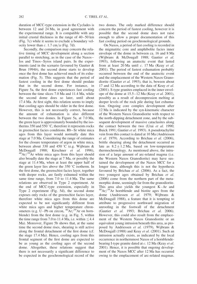
duration of MCC-type extension in the Cyclades isbetween 12 and 24 Ma, in good agreement withthe experimental range. It is compatible with anyinitial crustal thickness in the range of 40–50 km(Fig. 7c) while it seems to exclude a boundary vel-ocity lower than c. 1.7 cm/a (Fig. 7d).
Secondly, the comparison may concern the rela-tive timing of MCC development along a sectionparallel to stretching, as in the case of the Naxos–Ios and Tinos–Syros island pairs. In the exper-iments (and in the scenario favoured by Gautier &Brun 1994b), the second dome starts to developonce the first dome has achieved much of its exhu-mation (Fig. 5). This suggests that the period offastest cooling in the first dome should predatethat in the second dome. For instance, inFigure 5a, the first dome experiences fast coolingbetween the time slices 7.0 Ma and 11.4 Ma, whilethe second dome does so later, until about17.4 Ma. At first sight, this relation seems to implythat cooling ages should be older in the first dome.However, this is not necessarily correct, becausethe amount of exhumation is also differentbetween the two domes. In Figure 5a, at 7.0 Ma,the green layer is approximately bounded by the iso-therms 350 and 550 8C, therefore it represents rocksin greenschist facies conditions. Rb–Sr white micaages from this layer would normally date thisstage at 7.0 Ma. Considering the range of estimatesfor the closure temperature of argon in white mica,between about 330 and 450 8C (e.g. Wijbrans &McDougall 1988; Kirschner et al. 1996),40Ar/39Ar white mica ages from this layer shouldalso broadly date the stage at 7 Ma, or possibly thestage at 11.4 Ma, when at least the upper half ofthe green layer lies above the 350 8C isotherm. Inthe first dome, the greenschist facies layer, togetherwith deeper rocks, are fastly exhumed within thesame time range, from 7.0 to 11.4 Ma. The samerelations are observed in Type 2 experiment. Atthe end of MCC-type extension, especially inType 2 experiment (Fig. 5d), the second domeexposes only rocks of the greenschist facies layer,therefore white mica ages from this dome areexpected to be not significantly different fromwhite mica ages and higher temperature chron-ometers (e.g. U–Pb on zircon, 40Ar/39Ar on horn-blende) from the first dome (e.g. in Fig. 5, withinthe time range from 7.0 to 11.4 Ma, i.e. within �4.4Ma). Moreover, Figure 5b shows that, at the sametime the second dome rises, shearing is still activealong the frontal detachment of the first dome (cf.the stage 17.4 Ma). Hence, cooling ages from thisfrontal segment of the first dome are expected tobe as young as the cooling ages of the seconddome. Altogether, these relations suggest thatthere is not necessarily a significant difference tobe expected in the geochronological record of the
two domes. The only marked difference shouldconcern the period of fastest cooling, however it ispossible that the second dome does not raiseenough to allow a proper documentation of thisfast cooling period on geochronological grounds.
On Naxos, a period of fast cooling is recorded inthe migmatitic core and amphibolite facies innerenvelope of the dome in between ca. 16 and 8 Ma(Wijbrans & McDougall 1988; Gautier et al.1993), following an anatectic event that lastedfrom at least 20 Ma until c. 17 Ma (Keay et al.2001). The period of fastest exhumation probablyoccurred between the end of the anatectic eventand the emplacement of the Western Naxos Grano-diorite (Gautier et al. 1993), that is, beween about17 and 12 Ma according to the data of Keay et al.(2001). S-type granites emplaced in the inner envel-ope of the dome at 15.5–12 Ma (Keay et al. 2001),possibly as a result of decompression melting atdeeper levels of the rock pile during fast exhuma-tion. Ongoing core complex development after12 Ma is indicated by the syn-kinematic characterof the Western Naxos Granodiorite with respect tothe north-dipping detachment zone, and by the sub-sequent development of massive cataclasites alongthe contact between the two (Urai et al. 1990;Buick 1991; Gautier et al. 1993). A pseudotachylitevein from this contact is dated at 10 Ma (Andriessenet al. 1979). According to Brichau et al. (2006),brittle shearing along the detachment occurred aslate as 8.2+1.2 Ma, based on low-temperaturethermochronology. As mentioned above, the intru-sion of a large amount of arc-related magma (i.e.the Western Naxos Granodiorite) may have sus-tained the development of the Naxos MCC for alonger time, although this is not the hypothesisfavoured by Brichau et al. (2006). As a fact, thetwo youngest ages obtained by Brichau et al.(2006) come from the northern part of the meta-morphic dome, seemingly far from the granodiorite.This area also yields the youngest K–Ar and40Ar/39Ar hornblende and biotite ages from thedome (Andriessen et al. 1979; Wijbrans &McDougall 1988), a feature that it is tempting toattribute to progressive northward migration ofunroofing in the footwall of the detachment(Gautier et al. 1993; Brichau et al. 2006).However, this could also result from the emplace-ment of the Western Naxos Granodiorite or anequivalent young intrusion beneath this area, as pro-posed by Andriessen et al. (1979), Wijbrans &McDougall (1988) and Keay et al. (2001). Such anintrusion actually exists, as indicated by the localoccurrence in northernmost Naxos of a hornblende-bearing I-type granite dated at c. 12 Ma (Keay et al.2001). Hence, it is possible that ongoing develop-ment of the Naxos MCC after 12 Ma has occurredowing to the emplacement of arc-related magmas.
C. TIREL ET AL.282
In the rear part of the dome, rocks that did notexperience temperatures higher than 550 8C wereat about 500 8C at c. 22.5–20 Ma and cooled toabout 300 8C at c. 14–11 Ma (Andriessen et al.1979; Wijbrans & McDougall 1988; Andriessen1991).
The cooling history of the Ios MCC is not well con-strained. A 40Ar/39Ar white mica pseudo-plateau ageat about 20.5 Ma is considered to date shearing alongthe South Cyclades shear zone (Baldwin & Lister1998). A Rb-Sr white mica age from a deformedaplitic vein at 13.2+ 0.4 Ma (Henjes-Kunst &Kreuzer 1982) together with 40Ar/39Ar potassiumfeldspar minimum apparent ages at about 14 Mafrom mylonitic augengneiss (Baldwin & Lister 1998)date another (distinct?) shearing event (vandenberg& Lister 1996; Baldwin & Lister 1998). Thissecond event is suspected to reflect the influence ofthe mid-Miocene magmatism of the Cyclades, yet,so far, there is no clear evidence for any Mioceneintrusion on Ios. Hence, the ages at 13–14 Ma mayrelate to deformation without a specific thermalevent. Apatite fission track ages indicate coolingbelow about 100 8C between 13.3 + 1.1 and8.3 + 1.1 Ma (Hejl et al. 2003). Comparing the geo-chronological record on Naxos and Ios, we find nosignificant diachronism. As explained above,because the Ios MCC is associated with much lessexhumation, this observation is not incompatiblewith the Ios dome having formed later.
On Tinos, 40Ar/39Ar and Rb–Sr ages on whitemica indicate that greenschist facies top-to-NEextensional shearing occurred at about 24–21 Ma(Brocker & Franz 1998, 2005). The detachmentzone is crosscut by the Tinos composite intrusionand associated thermal aureole (Altherr et al.1982; Avigad & Garfunkel 1989; Brocker & Franz2000). Rb–Sr and K–Ar ages from the mainI-type granite (Altherr et al. 1982; Avigad et al.1998) and its thermal aureole (Brocker & Franz2000) suggest an early cooling at 15.5–14 Ma.Whole-rock Rb–Sr dating indicates that marginalS-type intrusions emplaced at the same time(Altherr et al. 1982; Brocker & Franz 1998).Altherr et al. (1982) originally argued that themain granite probably emplaced before 17 Ma,however available radiometric data are compatiblewith the view that it did so at around 15 Ma (see dis-cussion in Brocker & Franz 2000). Recent U–Pbdating of zircons from the main intrusion hasyielded an age of 14.6 + 0.2 Ma (Brichau et al.2007), supporting the latter view. On the onehand, this indicates that much of the displacementalong the detachment zone occurred before 15 Ma.On the other hand, the margins of the plutoniccomplex show evidence of top-to-NE shearingduring and subsequent to emplacement (Gautier &Brun 1994a; Brocker & Franz 1998; Jolivet &
Patriat 1999; Brichau et al. 2007). A series of sub-vertical NW–SE-trending dykes dated at 12–11 Ma (Avigad et al. 1998) documents ongoingNE–SW stretching once the rocks reached thebrittle upper crust (see also Mehl et al. 2005).Final cooling at around 12–9 Ma is documentedby apatite fission track ages from the main intrusion(Altherr et al. 1982; Hejl et al. 2002; Brichau et al.2007). It is difficult to establish whether, and when,a period of fastest exhumation occurred on Tinos,especially because it is not clear where the ages of24–21 Ma should be plotted along the greenschistfacies segment of the pressure–temperature path.If, however, a closure temperature of about 500 8Cis accepted for the Rb–Sr system in white mica(Brocker & Franz 1998, 2005), then, using thepath obtained by Parra et al. (2002), this age rangeshould coincide with pressures around 6 kbar. Press-ures associated with the thermal aureole of the c. 15Ma-old Tinos intrusion are around 2–3 kbars (e.g.Brocker & Franz 2000). Taken together, using afactor of 3.64 to convert pressures (kbar) intodepths (km), these values yield a mean exhumationrate around 1.5–2 mm/a during the period fromc. 22 to 15 Ma. The apatite fission track ages indi-cate that later exhumation was slower. If theearlier episode of heating at about 9 kbar ended atc. 30 Ma, as suggested by Parra et al. (2002) (see‘Post-orogenic versus syn-orogenic extension’section), then a mean exhumation rate around1.4 mm/a is suggested for the period from c. 30 to22 Ma. These estimates are crude, neverthelessthey suggest that exhumation proceeded either atconstant rate from c. 30 Ma to 15 Ma, or was a bitfaster during the 22–15 Ma interval.
The cooling history of Syros is very poorlyknown. At least part of the displacement along thedetachment seen in southeastern Syros occurredlater than 30 Ma (see ‘Interfering detachmentsystems’ section). Zircon fission track ages arearound 20 Ma in the hanging wall and around11 Ma in the footwall, suggesting that the detach-ment was active at c. 11 Ma (Ring et al. 2003).All the footwall samples come from northernSyros, so that it is not clear whether the age gap of9 Ma reflects displacement along the detachmentitself or/and along one of the low-angle normalfaults that dissect the footwall (Ridley 1984).Summing up, a sound comparison between Tinosand Syros is out of reach so far, nevertheless avail-able radiometric data leave it possible that the TinosMCC formed earlier.
The above review also indicates that the two islandpairs (Naxos–Ios and Tinos–Syros) may haveformed contemporaneously. The Naxos MCC experi-enced its fastest exhumation between c. 17 and 12 Ma,while the Tinos MCC may have done so between c. 22and 15 Ma. Thus, the two MCCs could be broadly
NUMERICAL AND CYCLADIC CORE COMPLEXES 283
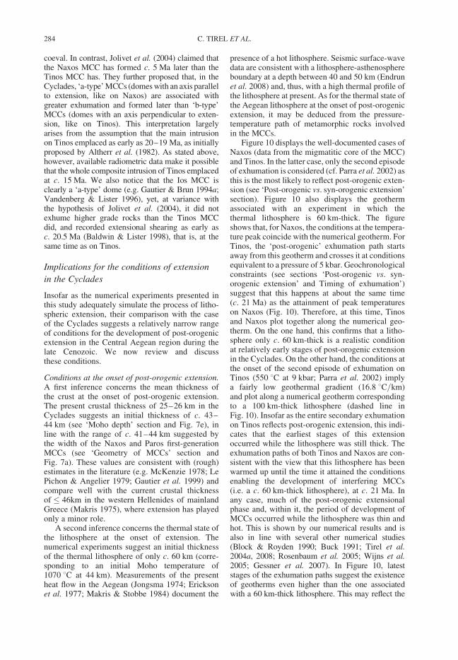
coeval. In contrast, Jolivet et al. (2004) claimed thatthe Naxos MCC has formed c. 5 Ma later than theTinos MCC has. They further proposed that, in theCyclades, ‘a-type’ MCCs (domes with an axis parallelto extension, like on Naxos) are associated withgreater exhumation and formed later than ‘b-type’MCCs (domes with an axis perpendicular to exten-sion, like on Tinos). This interpretation largelyarises from the assumption that the main intrusionon Tinos emplaced as early as 20–19 Ma, as initiallyproposed by Altherr et al. (1982). As stated above,however, available radiometric data make it possiblethat the whole composite intrusion of Tinos emplacedat c. 15 Ma. We also notice that the Ios MCC isclearly a ‘a-type’ dome (e.g. Gautier & Brun 1994a;Vandenberg & Lister 1996), yet, at variance withthe hypothesis of Jolivet et al. (2004), it did notexhume higher grade rocks than the Tinos MCCdid, and recorded extensional shearing as early asc. 20.5 Ma (Baldwin & Lister 1998), that is, at thesame time as on Tinos.
Implications for the conditions of extension
in the Cyclades
Insofar as the numerical experiments presented inthis study adequately simulate the process of litho-spheric extension, their comparison with the caseof the Cyclades suggests a relatively narrow rangeof conditions for the development of post-orogenicextension in the Central Aegean region during thelate Cenozoic. We now review and discussthese conditions.
Conditions at the onset of post-orogenic extension.A first inference concerns the mean thickness ofthe crust at the onset of post-orogenic extension.The present crustal thickness of 25–26 km in theCyclades suggests an initial thickness of c. 43–44 km (see ‘Moho depth’ section and Fig. 7e), inline with the range of c. 41–44 km suggested bythe width of the Naxos and Paros first-generationMCCs (see ‘Geometry of MCCs’ section andFig. 7a). These values are consistent with (rough)estimates in the literature (e.g. McKenzie 1978; LePichon & Angelier 1979; Gautier et al. 1999) andcompare well with the current crustal thicknessof � 46km in the western Hellenides of mainlandGreece (Makris 1975), where extension has playedonly a minor role.
A second inference concerns the thermal state ofthe lithosphere at the onset of extension. Thenumerical experiments suggest an initial thicknessof the thermal lithosphere of only c. 60 km (corre-sponding to an initial Moho temperature of1070 8C at 44 km). Measurements of the presentheat flow in the Aegean (Jongsma 1974; Ericksonet al. 1977; Makris & Stobbe 1984) document the
presence of a hot lithosphere. Seismic surface-wavedata are consistent with a lithosphere-asthenosphereboundary at a depth between 40 and 50 km (Endrunet al. 2008) and, thus, with a high thermal profile ofthe lithosphere at present. As for the thermal state ofthe Aegean lithosphere at the onset of post-orogenicextension, it may be deduced from the pressure-temperature path of metamorphic rocks involvedin the MCCs.
Figure 10 displays the well-documented cases ofNaxos (data from the migmatitic core of the MCC)and Tinos. In the latter case, only the second episodeof exhumation is considered (cf. Parra et al. 2002) asthis is the most likely to reflect post-orogenic exten-sion (see ‘Post-orogenic vs. syn-orogenic extension’section). Figure 10 also displays the geothermassociated with an experiment in which thethermal lithosphere is 60 km-thick. The figureshows that, for Naxos, the conditions at the tempera-ture peak coincide with the numerical geotherm. ForTinos, the ‘post-orogenic’ exhumation path startsaway from this geotherm and crosses it at conditionsequivalent to a pressure of 5 kbar. Geochronologicalconstraints (see sections ‘Post-orogenic vs. syn-orogenic extension’ and Timing of exhumation’)suggest that this happens at about the same time(c. 21 Ma) as the attainment of peak temperatureson Naxos (Fig. 10). Therefore, at this time, Tinosand Naxos plot together along the numerical geo-therm. On the one hand, this confirms that a litho-sphere only c. 60 km-thick is a realistic conditionat relatively early stages of post-orogenic extensionin the Cyclades. On the other hand, the conditions atthe onset of the second episode of exhumation onTinos (550 8C at 9 kbar; Parra et al. 2002) implya fairly low geothermal gradient (16.8 8C/km)and plot along a numerical geotherm correspondingto a 100 km-thick lithosphere (dashed line inFig. 10). Insofar as the entire secondary exhumationon Tinos reflects post-orogenic extension, this indi-cates that the earliest stages of this extensionoccurred while the lithosphere was still thick. Theexhumation paths of both Tinos and Naxos are con-sistent with the view that this lithosphere has beenwarmed up until the time it attained the conditionsenabling the development of interfering MCCs(i.e. a c. 60 km-thick lithosphere), at c. 21 Ma. Inany case, much of the post-orogenic extensionalphase and, within it, the period of development ofMCCs occurred while the lithosphere was thin andhot. This is shown by our numerical results and isalso in line with several other numerical studies(Block & Royden 1990; Buck 1991; Tirel et al.2004a, 2008; Rosenbaum et al. 2005; Wijns et al.2005; Gessner et al. 2007). In Figure 10, lateststages of the exhumation paths suggest the existenceof geotherms even higher than the one associatedwith a 60 km-thick lithosphere. This may reflect the
C. TIREL ET AL.284
ongoing increase of the regional geothermal gradientor/and the local rise of isotherms during MCC devel-opment (see ‘Geometry of MCCs’ section andGessner et al. 2007).
Recently, several studies have shown evidencefor a high temperature regime in the shallowmantle and a thin lithosphere (1200 8C at a depthof c. 60 km) over widths of 250 to .900 km inseveral subduction zone back-arc domains unaf-fected by extensional processes (Currie et al.2004; Hyndman et al. 2005; Currie & Hyndman2006). The authors suggest that heat is rapidlycarried upward by vigorous thermal convection inthe upper mantle below the overriding plate. Thissmall-scale convection could be promoted by thelow viscosities associated with the addition ofwater, resulting in a reduction of the strength ofthe base of the lithosphere and its rapid ‘erosion’(Arcay et al. 2005, 2006). The Cyclades areamay have been affected by such processes prior toc. 21 Ma (i.e. while warming the lithosphere untilits thickness was reduced to c. 60 km, cf. Fig. 10)provided it was already lying in the back-arcdomain of the South Hellenic subduction zoneat that time, which is a matter of debate (e.g.Ring & Layer 2003; Jolivet et al. 2004; Pe-Piper& Piper 2006).
Alternatively, the pioneering suggestion of Bird(1978) concerning continental mantle delaminationas a cause of strong heating of the crust appearsattractive. In the Aegean, this process was firstsuggested by Zeilinga de Boer (1989) and hasbeen explicitely invoked in a number of recentstudies (Thomson et al. 1999; Jolivet et al. 2003;
Faccenna et al. 2003; Ring & Layer 2003). Supportto this hypothesis is found in a recent review of thelate Cenozoic magmatism of the Aegean byPe-Piper & Piper (2006), as discussed below.
Boundary velocity during MCC-type extension inthe Cyclades. In the experiments, the range ofboundary velocities which succesfully led to asequential development of interfering MCCs liesbetween 1 and 2.7 cm/a. In addition, the presentcrustal thickness of 25–26 km in the Cycladessuggests a velocity of c. 2.0–2.3 cm/a (see ‘Mohodepth’ section and Fig. 7f), while the width of theNaxos and Paros first-generation MCCs (see ‘Geo-metry of MCCs’ section) and the duration ofMCC-type extension in the Cyclades (see ‘Timingof exhumation’ section) seem to exclude valueslower than c. 2 cm/a (Fig. 7b) and c. 1.7 cm/a(Fig. 7d), respectively. Hence, the experimentalresults predict a velocity at the boundary of thestretching domain around 2.0–2.3 cm/a, whilelower values seem excluded.
In the case of the Cyclades, this velocity shouldcorrespond to the rate at which the South Hellenicsubduction retreated during MCC-type extension.In addition, as MCC-type extension in the Cycladeslasted between about 12 and 24 Ma (from 30–23 to11–6–Ma, see ‘Timing of exhumation’ section),the associated amount of retreat is predicted to liebetween about 240 km (for 12 Ma at 2 cm/a) and550 km (for 24 Ma at 2.3 cm/a).
These values can be compared with various esti-mates in the literature. For instance, Faccenna et al.(2003) have considered 250 km of retreat during the
Second exhumationon Tinos (Parra)
Moho
Naxos core (Buick)
Naxos core (Duchêne)
>20-17 Ma
~ 24-21 Ma
~ 16-15 Ma
15 Ma
500°C
equiv. 5 kbar
50 km
800°C
30 Ma ?
geotherm in type 1 experiment (= interfering MCCs)with 60 km-thick lithosphere
(orange marker in Fig. 3)
geotherm for a 100 km-thick lithosphere(green marker in Fig. 3)
Fig. 10. Comparison between the geotherms associated with two numerical experiments and the exhumation path ofmetamorphic rocks on Tinos (after Parra et al. 2002) and Naxos (after Buick & Holland 1989 and Duchene et al. 2006).A factor of 3.64 was used to convert pressures (kbar) into depths (km). Age constraints are discussed in sections‘Post-orogenic versus syn-orogenic extension’ and ‘Timing of exhumation’.
NUMERICAL AND CYCLADIC CORE COMPLEXES 285
period from 30 to 5 Ma, hence at a velocity of only1 cm/a. In contrast, a retreat velocity as high as3 cm/a has been proposed by Jolivet et al. (1998)on the basis of the southward migration of arc mag-matism since c. 32 Ma (Fytikas et al. 1984), assum-ing the underlying slab kept a constant dip.However, the graph from which this value isdeduced (Jolivet et al. 1998, Fig. 21b) actuallyyields a value of about 2.2 cm/a and considers700 km of migration of arc magmatism, whichexceeds by at least 100 km the actual value.Instead, considering about 550 km of migration ofmagmatism since about 32 Ma (see van Hinsbergen2004 for a recent compilation) would yield a retreatvelocity of 1.7 cm/a, in fair agreement with ournumerical analysis. However, among the 550 kmof migration, as much as 90 km may be consideredas balanced, not by extensional strain but by thelateral extrusion of Anatolia during the last fewmillion years (e.g. Gautier et al. 1999), whichcould lower the boundary velocity of the extensionalsystem to 1.4 cm/a. It is also worth noting that themigration of magmatism is not an ideal mean forquantifying retreat, firstly because the assumptionof a constant slab dip may not be valid, and secondlybecause not every magmatic rock may reflect arcmagmatism. Pe-Piper & Piper (2006) recentlyargued that most Cenozoic magmatic rocks of theAegean bear petrogeochemical characteristics thatare not typical of arc processes and suggest insteadthat they reflect either slab break-off or delamina-tion of the lithospheric mantle. At first sight, thisseems to exclude the migration of magmatism asan appropriate tool to document subductionretreat. However, tomography images of theAegean mantle are clearly more compatible withprogressive delamination of a continuous slab(sensu Bird 1978) rather than break-off of severalslabs (e.g. Faccenna et al. 2003; van Hinsbergenet al. 2005a). The dynamics of mantle delaminationis broadly equivalent to that of a retreating subduc-tion, therefore the migration of delamination-relatedmagmatism may actually be appropriate to quantifyretreat (e.g. Zeilinga de Boer 1989).
Another estimate of the amount of retreat mayarise from a comparison between the initial andpresent shape of the Aegean frontal arc. Forinstance, Gautier et al. (1999) suggested a smoothlycurved arc at the onset of Aegean extension, whichled them to propose about 440 km of retreat (ofwhich 90 km would be balanced by the lateral extru-sion of Anatolia, leaving 350 km to be balanced byextensional strain). The end-member case leading tomaximum retreat is probably that of an initially rec-tilinear arc. Using the same arc extremities as inGautier et al. (1999), this case would yield about600 km of retreat, in reasonable agreement withthe value suggested by the migration of magmatism.
This would yield about 510 km balanced by exten-sional strain. If we assume that retreat occurredessentially during MCC-type extension in theCyclades, then the boundary velocity of the exten-sional system could have been as high as 2.1 cm/aif extension lasted 24 Ma (starting at c. 30 Ma), ingood agreement with our numerical analysis, or ashigh as 4.2 cm/a if extension lasted 12 Ma (startingat c. 23 Ma). The latter value is clearly too high andsuggests that MCC-type extension in the Cycladesstarted significantly before 23 Ma or/and that thetotal amount of retreat has been significantly lessthan in the above end-member case, or/and that asignificant part of the retreat occurred before or/and after MCC-type extension in the Cyclades.
Conclusions
Our numerical analysis suggests that, for certainconditions, MCCs may interfere and develop insequence during continental extension. Likecommon claims in the literature, we find that‘inward’ flow of an extremely weak lower crust isrequired for MCCs to develop, while a sub-Mohomantle of very low strength appears to be anothernecessary condition for maintaining the Moho flat.As a result of lower crustal inward flow, two conju-gate flat-lying shear zones form during the earlydevelopment of the first MCC, one of which laterevolves as a typical detachment. In the experimentswith interfering MCCs, the second MCC starts todevelop right above one of the previously formedshear zones. This shear zone is dragged upwardduring dome amplification and, due to renewedinward flow, is reactivated with the same kinematicsalong one dome limb and with the opposite kin-ematics along the other dome limb.
The Cyclades archipelago is characterized bythree closely spaced chains of MCCs developedlargely during Miocene extension. We found thatthe geometry and kinematic pattern of adjacentMCCs along the Naxos–Ios and the Tinos–Syrostransects compare well with the numerical exper-iments. Available geochronological data for theseislands are not detailed enough to document asequential development of MCCs, neverthelessthey remain compatible with this hypothesis. Wealso compared features of the numerical exper-iments, such as the final Moho depth, the durationof MCC-type extension, and the width of thedomes at the end of the exhumation process, toequivalent features in the Cyclades in order to tenta-tively constrain the initial and boundary conditionssuitable to the Aegean case. This comparison leadsus to infer a crustal thickness in the range of 40 to44 km in the Cyclades at the onset of post-orogenicextension. A thermal lithospheric thickness of only
C. TIREL ET AL.286
c. 60 km is also inferred, which might be a conditionat the onset of extension or may have been obtainedduring early stages of extension while the litho-sphere was warmed up. Either a backarc subductionsetting or a process of mantle delamination mayaccount for this situation.
The experiments also suggest a boundary vel-ocity of 2.0–2.3 cm/a, which should basicallyreflect the rate at which the South Hellenic subduc-tion zone retreated. Considering c. 500 km as anupper bound for the amount of retreat balanced byAegean extension, and assuming that this retreatmostly occurred during MCC-type extension, inthe Cyclades, the boundary velocity could havebeen as high as 2.1 cm/a (if MCC-type extensionlasted 24 Ma, starting at c. 30 Ma and finishing atc. 6 Ma): this is in good agreement with thenumerical analysis.
The post-doctoral grant of C.T. and computational resourceswere funded by ISES (Netherlands Research Centre for Inte-grated Solid Earth Science). C.T. thanks E. Burov,Y. Podladchikov and A. Poliakov who have co-developedthe kernel of PARAVOZ. D. J. J. v. H. is funded throughan NWO-VENI grant. We thank R. Govers, J.-P. Brun andE. Burov for discussions at various stages of the project.We gratefully acknowledge the editor, M. Edwards, and thetwo reviewers S. Buiter and M. Brocker for their thoughtfulreviews that improved our manuscript.
References
ALTHERR, R., KREUZER, H., WENDT, I., LENZ, H.,WAGNER, G. A., KELLER, J., HARRE, W. &HOHNDORF, A. 1982. A Late Oligocene/EarlyMiocene high temperature belt in the Attic-Cycladiccrystalline complex (SE Pelagonian, Greece). Geo-logisches Jahrbuch, E23, 97–164.
ALTHERR, R., SCHLIESTEDT, M., OKRUSCH, M.,SEIDEL, E., KREUZER, H., HARRE, W., LENZ, H.,WENDT, I. & WAGNER, G. A. 1979. Geochronologyof High-Pressure Rocks on Sifnos (Cyclades,Greece). Contributions to Mineralogy and Petrology,70, 245–255.
ANDRIESSEN, P. A. M. 1991. K-Ar and Rb-Sr age deter-minations on micas of impure marbles of Naxos,Greece: the influence of metamorphic fluids and lithol-ogy on the blocking temperature. SchweizerischeMineralogische and Petrographische Mitteilungen,71, 89–99.
ANDRIESSEN, P. A. M., BOELRIJK, N. A. I. M., HEBEDA,E. H., PRIEM, H. N. A., VERDURMEN, E. A. T. &VERSCHURE, R. H. 1979. Dating the events of meta-morphism and granitic magmatism in the AlpineOrogen of Naxos (Cyclades, Greece). Contributionsto Mineralogy and Petrology, 69, 215–225.
ANGELIER, J. 1977a. Sur l’evolution tectonique depuis leMiocene superieur d’un arc insulaire mediterraneen:l’arc egeen. Revue de Geographie physique et Geolo-gie dynamique, XIX, 271–294.
ANGELIER, J. 1977b. Essai sur la neotectonique et les der-niers stades tarditectoniques de l’arc egeen et de l’Egeemeridionale. Bulletin de la Societe Geologique deFrance, XIX, 651–662.
ANGELIER, J., GLACON, G. & MULLER, C. 1978. Sur lapresence et la position tectonique du Miocene inferieurmarin dans l’archipel de Naxos (Cyclades, Grece).Comptes Rendus de l’Academie des Sciences deParis, 286, 21–24.
ARCAY, D., TRIC, E. & DOIN, M.-P. 2005. Numericalsimulations of subduction zones. Effect of slab deshy-dration on the mantle wedge dynamics. Physics of theEarth and Planetary Interiors, 149, 133–153.
ARCAY, D., DOIN, M.-P., TRIC, E., BOUSQUET, R. & DE
CAPITANI, C. 2006. Overriding plate thinning in sub-duction zones: Localized convection induced by slabdeshydration. Geochemistry Geophysics Geosystems,7, doi:10.1029/2005GC0011061.
AVIGAD, D. 1993. Tectonic juxtaposition of blueschistsand greenschists in Sifnos Islands (Aegean Sea)—implications for the structure of the Cycladicblueschist belt. Journal of Structural Geology, 15,1459–1469.
AVIGAD, D. & GARFUNKEL, Z. 1989. Low angle faultsabove and below a blueschist belt—Tinos Island,Cyclades, Greece. Terra Nova, 1, 182–187.
AVIGAD, D., GARFUNKEL, Z., JOLIVET, L. & AZANON,J. M. 1997. Backarc extension and denudation of Med-iterranean eclogites. Tectonics, 16, 924–941.
AVIGAD, D., BAER, G. & HEIMANN, A. 1998. Blockrotations and continental extension in the centralAegean Sea: palaeomagnetic and structural evidencefrom Tinos and Mykonos (Cyclades, Greece). Earthand Planetary Science Letters, 157, 23–40.
AVIGAD, D., ZIV, A. & GARFUNKEL, Z. 2001.Ductile and brittle shortening, extension-parallelfolds and maintenance of crustal thickness in thecentral Aegean (Cyclades, Greece). Tectonics, 20,277–287.
BALDWIN, S. L. & LISTER, G. S. 1998. Thermochonologyof the South Cyclades Shear Zone, Ios, Greece: Effectsof ductile shear in the argon partial retention zone.Journal of Geophysical Research, 103, 7315–7336.
BIRD, P. 1978. Initiation of intracontinental subduction inthe Himalaya. Journal of Geophysical Research, 83,4975–4987.
BLOCK, L. & ROYDEN, L. H. 1990. Core complex geome-tries and regional scale flow in the lower crust. Tec-tonics, 9, 557–567.
BOND, C. E., BUTLER, R. W. H. & DIXON, J. E. 2007.Co-axial horizontal stretching within extendingorogens: the exhumation of HP rocks on Syros(Cyclades) revisited. In: RIES, A. C., BUTLER,R. W. H. & GRAHAM, R. H. (eds) Deformation ofthe Continental Crust: The Legacy of Mike Coward.Geological Society, London, Special Publication,272, 203–222.
BONNEAU, M. 1982. Evolution geodynamique de l’arcegeen depuis le Jurassique superieur jusqu’auMiocene. Bulletin de la Societe Geologique deFrance, XXIV, 229–242.
BOZKURT, E. 2001. Late Alpine evolution of the centralMenderes Massif, western Turkey. InternationalJournal of Earth Sciences, 89, 728–744.
NUMERICAL AND CYCLADIC CORE COMPLEXES 287
BRICHAU, S., RING, U., KETCHAM, R. A., CARTER, A.,STOCKLI, D. & BRUNEL, M. 2006. Constraining thelong-term evolution of the slip rate for a major exten-sional fault system in the central Aegean, Greece,using thermochronology. Earth and PlanetaryScience Letters, 241, 293–306.
BRICHAU, S., RING, U., CARTER, A., MONIE, P.,BOLHAR, R., STOCKLI, D. & BRUNEL, M. 2007.Extensional faulting on Tinos Island, Aegean Sea,Greece: How many detachments? Tectonics, 26,TC4009, doi:10.1029/2006TC001969.
BROCKER, M. 1990. Blueschist-to-greenschist transitionin metabasites from Tinos Island (Cyclades, Greece):Compositional control or fluid infiltration? Lithos, 25,25–39.
BROCKER, M. & FRANZ, L. 1998. Rb–Sr isotope studieson Tinos Island (Cyclades, Greece): additional timeconstraints for metamorphism, extent of infiltration-controlled overprinting and deformational activity.Geological Magazine, 135, 369–382.
BROCKER, M. & FRANZ, L. 2000. The contact aureole onTinos (Cyclades, Greece): tourmaline-biotite geother-mometry and Rb-Sr geochronology. Mineralogy andPetrology, 70, 257–283.
BROCKER, M. & FRANZ, L. 2005. The base of the Cycla-dic blueschist unit on Tinos Island (Greece) re-visited:Field relationships, phengite chemistry and Rb–Srgeochronology. Neues Jahrbuch fur Mineralogie,Abhandlungen, 181, 81–93.
BROCKER, M. & FRANZ, L. 2006. Dating metamorphismand tectonic juxtaposition on Andros Island (Cyclades,Greece): results of a Rb–Sr study. Geological Maga-zine, 143, 1–12.
BROCKER, M., BIELING, D., HACKER, B. & GANS, P. B.2004. High-Si phengite records the time of greenschistfacies overprinting: implications for models suggestingmega-detachments in the Aegean Sea. Journal ofMetamorphic Geology, 22, 427–442.
BRUN, J.-P., SOKOUTIS, D. & VAN DEN DRIESSCHE, J.1994. Analogue modeling of detachment faultsystems and core complexes. Geology, 22, 319–322.
BRUN, J.-P. & VAN DEN DRIESSCHE, J. 1994. Extensionalgneiss domes and detachment fault systems; structureand kinematics. Bulletin de la Societe Geologique deFrance, 165, 519–530.
BUCK, W. R. 1991. Modes of continental lithosphericextension. Journal of Geophysical Research, 96,20161–20178.
BUICK, I. S. 1991. The late Alpine evolution of an exten-sional shear zone, Naxos, Greece. Journal of theGeological Society of London, 148, 93–103.
BUICK, I. S. & HOLLAND, T. J. B. 1989. The P-T-t pathassociated with crustal extension, Naxos, Cyclades,Greece. In: DALY, J. S., CLIFF, R. A. & YARDLEY,B. W. D. (eds) Evolution of Metamorphic Belts.Geological Society, London, Special Publication, 43,365–369.
BURG, J. P., VAN DEN DRIESSCHE, J. & BRUN, J.-P.1994. Syn to post-thickening extension in theVariscan Belt of Western Europe: Modes andstructural consequences. Geologie de la France, 3,33–51.
BUROV, E. & CLOETINGH, S. 1997. Erosion and riftdynamics; new thermomechanical aspects of post-rift
evolution of extensional basins. Earth and PlanetaryScience Letters, 150, 7–26.
BUROV, E. B. & GUILLOU-FROTTIER, L. 1999. Thermo-mechanical behavior of large ash flow calderas.Journal of Geophysical Research, 104, 23081–23109.
BUROV, E. & POLIAKOV, A. 2001. Erosion and rheologycontrols on synrift and postrift evolution; verifyingold and new ideas using a fully coupled numericalmodel. Journal of Geophysical Research, 106,16461–16481.
BUROV, E. & POLIAKOV, A. N. B. 2003. Erosionalforcing on basin dynamics: new aspects of syn- andpost-rift evolution. In: NIEUWLAND, D. A. (ed.) NewInsights into Structural Interpretation and Modelling.Geological Society, London, Special Publication,212, 209–224.
BUROV, E. & GUILLOU-FROTTIER, L. 2005. The plumehead-continental lithosphere interaction using a tecto-nically realistic formulation for the lithosphere. Geo-physical Journal International, 161, 469–490.
BUROV, E. B., JAUPART, C. & GUILLOU-FROTTIER, L.2003. Ascent and emplacement of buoyant magmabodies in brittle–ductile upper crust. Journal of Geo-physical Research, 108, 2177–2189.
BYERLEE, J. D. 1978. Friction of rocks. Pure and AppliedGeophysics, 116, 615–626.
CHERY, J. 2001. Core complex mechanics: From theGulf of Corinth to the Snake Range. Geology, 29,439–442.
CONEY, P. J. 1980. Cordilleran metamorphic core com-plexes: an overview. In: CRITTENDEN, M. C.,CONEY, P. J. & DAVIS, G. H. (eds) Cordilleran Meta-morphic Core Complexes. Geological Society ofAmerica Memoir, 153, 7–31.
CUNDALL, P. A. 1989. Numerical experiments on localiz-ation in frictional materials. Ingenieur-Archiv, 59,148–159.
CURRIE, C. A. & HYNDMAN, R. D. 2006. The thermalstructure of subduction zone back arcs. Journal of Geo-physical Research, 111, B08404, doi:10.1029/2005JB004024.
CURRIE, C. A., WANG, K., HYNDMAN, R. D. & HE, J.2004. The thermal effects of steady-state slab-drivenmantle flow above a subducting plate: the Cascadiasubduction zone and backarc. Earth and PlanetaryScience Letters, 223, 35–48.
DAVIS, G. H. 1980. Structural characteristics of meta-morphic core complexes, southern Arizona. In:CRITTENDEN, M. C., CONEY, P. J. & DAVIS, G. H.(eds) Cordilleran Metamorphic Core Complexes. Geo-logical Society of America Memoir, 153, 35–77.
DUBOIS, R. & BIGNOT, G. 1979. Presence d’un ‘hardground’ nummulitique au sommet de la serie cretaceed’Almyropotamos (Eubee meridionale, Grece).Comptes Rendus de l’Academie des Sciences deParis, 289, 993–995.
DUCHENE, S., AISSA, R. & VANDERHAEGHE, O. 2006.Pressure-Temperature-time evolution of metamorphicrocks from Naxos (Cyclades, Greece): constraintsfrom thermobarometry and Rb/Sr dating. Geodina-mica Acta, 19, 301–321.
ENDRUN, B., MEIER, T., LEBEDEV, S., BOHNHOFF, M.,STAVRAKAKIS, G. & HARJES, H.-P. 2008. S velocitystructure and radial anisotropy in the Aegean region
C. TIREL ET AL.288
from surface wave dispersion. Geophysical JournalInternational, 174, 593–616.
ERICKSON, A. J., SIMMONS, G. & RYAN, W. B. F. 1977.Review of heatflow data from the Mediterranean andAegean Seas. In: BIJU-DUVAL, B. & MONTADERT,L. (eds) International Symposium on the StructuralHistory of the Mediterranean Basins, Split, Yugoslavia.Technip, Paris, 263–279.
FACCENNA, C., JOLIVET, L., PIROMALLO, C. &MORELLI, A. 2003. Subduction and the depth of con-vection of the Mediterranean mantle. Journal of Geo-physical Research, 108(B2), 2099, doi:10.1029/2001JB001690.
FORSTER, M. A. & LISTER, G. S. 1999. Detachmentfaults in the Aegean Core Complex of Ios, Greece.In: RING, U., BRANDON, M. T., LISTER, G. S. &WILLETT, S. D. (eds) Exhumation Processes:Normal Faulting, Ductile Flow and Erosion. Geologi-cal Society, London, Special Publication, 154,305–323.
FYTIKAS, M., INNOCENTI, F., MANETTI, P., MAZZUOLI,R., PECCERILLO, A. & VILLARI, L. 1984. Tertiary toQuarternary evolution of volcanism in the Aegeanregion. In: DIXON, J. E. & ROBERTSON, A. H. F.(eds) The Geological Evolution of the Eastern Mediter-ranean. Geological Society, London, Special Publi-cation, 17, 687–699.
GANOR, J., MATTHEWS, A., SCHLIESTEDT, M. &GARFUNKEL, Z. 1996. Oxygen isotopic heterogene-ities of metamorphic rocks: an original tectonostrati-graphic signature or an imprint of exotic fluids? Acase of study of Sifnos and Tinos islands (Greece).European Journal of Mineralogy, 8, 719–732.
GAUTIER, P. 1995. Geometrie crustale et cinematique del’extension tardi-orogenique dans le domainecentre-egeen (ıles des Cyclades et d’Eubee, Grece).PhD Thesis, University of Rennes 1, France. MemoiresGeosciences Rennes, 61, 1–417.
GAUTIER, P. 2000. Comment to “Back-arc extension anddenudation of Mediterranean eclogites”. Tectonics, 19,406–409.
GAUTIER, P. & BRUN, J.-P. 1994a. Ductile crust exhuma-tion and extensional detachments in the central Aegean(Cyclades and Evvia islands). Geodinamica Acta, 7,57–85.
GAUTIER, P. & BRUN, J.-P. 1994b. Crustal-scale geome-try and kinematics of late-orogenic extension in thecentral Aegean (Cyclades and Evvia Island). Tectono-physics, 238, 399–424.
GAUTIER, P., BRUN, J.-P. & JOLIVET, L. 1993. Structureand kinematics of Upper Cenozoic extensional detach-ment on Naxos and Paros (Cyclades Islands, Greece).Tectonics, 12, 1180–1194.
GAUTIER, P., BRUN, J.-P., MORICEAU, R., SOKOUTIS,D., MARTINOD, J. & JOLIVET, L. 1999. Timing, kin-ematics and cause of Aegean extension: a scenariobased on a comparison with simple analogue exper-iments. Tectonophysics, 315, 31–72.
GERBAULT, M., BUROV, E. B., POLIAKOV, A. N. B. &DAGNIERES, M. 1999. Do faults trigger folding inthe lithosphere? Geophysical Research Letters, 26,271–274.
GESSNER, K., RING, U., JOHNSON, C., HETZEL, R.,PASSCHIER, C. W. & GUNGOR, T. 2001. An active
bivergent rolling-hinge detachment system: CentralMenderes metamorphic core complex in westernTurkey. Geology, 29, 611–614.
GESSNER, K., WIJNS, C. & MORESI, L. 2007. Signifi-cance of strain localization in the lower crust for struc-tural evolution and thermal history of metamorphiccore complexes. Tectonics, 26, TC2012,doi:10.1029/2004TC001768.
GRASEMANN, B., EDWARDS, M. A., IGLSEDER, C.,PETRAKAKIS, K., SCHNEIDER, D. & Accel Team.2007. Tertiary SSW directed crustal extension in theWestern Cyclades: A new kinematic domain inthe Aegean region (Greece). Geophysical ResearchAbstracts, 9, SRef-ID: 1607-7962/gra/EGU2007-A-06656.
GOETZE, C. 1978. The mechanisms of creep olivine. Phi-losophical Transactions of the Royal Society ofLondon, A288, 99–119.
GUEYDAN, F., LEROY, Y. M. & JOLIVET, L. 2004. Mech-anics of low-angle shear zones at the brittle-ductiletransition. Journal of Geophysical Research, 109,B12407, doi:10.1029/2003JB002806.
HANDY, M. 1989. Deformation regimes and the rheologi-cal evolution of fault zones in the lithosphere: theeffects of pressure, temperature, grain size, and time.Tectonophysics, 163, 119–152.
HANSEN, F. D. & CARTER, N. L. 1982. Creep of SelectedCrustal Rocks at 1000 MPa. Eos, Transactions, Amer-ican Geophysical Union, 63, 437.
HAUSER, E., POTTER, C., HAUGE, T., BURGESS, S.,BURTCH, S., MURTSCHLER, J. ET AL. 1987. Crustalstructure of eastern Nevada from COCORP deepseismic reflection data. Geological Society of Ameri-can Bulletin, 99, 833–844.
HEJL, E., RIEDL, H., SOULAKELLIS, N., VAN DEN
HAUTE, P. & WEINGARTNER, H. 2003. Fission-trackdating of the south-eastern Bohemian Massif(Waldviertel, Austria); thermochronology and long-term erosionYoung Neogene tectonics and reliefdevelopment on the Aegean islands of Naxos,Paros and Ios (Cyclades, Greece). Mitteilungen derOsterreichischen Geologischen Gesellschaft, 93,105–127.
HEJL, E., RIEDL, H. & WEINGARTNER, H. 2002. Post-plutonic unroofing and morphogenesis of the Attic-Cycladic complex (Aegea, Greece). Tectonophysics,349, 37–56.
HENJES-KUNST, F. & KREUZER, H. 1982. Isotopic datingof pre-alpidic rocks from the island of Ios (Cyclades,Greece). Contributions to Mineralogy and Petrology,80, 245–253.
HYNDMAN, R. D., CURRIE, C. A. & MAZZOTTI, S. P.2005. Subduction zone backarcs, mobile belts, and oro-genic heat. GSA Today, 15, 4–10.
IGLSEDER, C., GRASEMANN, B., PETRAKAKIS, K.,EDWARDS, M. A., ZAMOLYI, A., RAMBOUSEK, C.,HORFARTER, C. ET AL. 2006. Multistage Plutonismand the Serifos Detachment System (Cyclades,Greece). Geophysical Research Abstracts, 8,SRef-ID: 1607–7962/gra/EGU06-A-05118.
JOLIVET, L. & PATRIAT, M. 1999. Ductile extension andthe formation of the Aegean Sea. In: DURAND, B.,JOLIVET, L., HORVATH, F. & SERANNE, M. (eds)The Mediterranean Basins: Tertiary Extension within
NUMERICAL AND CYCLADIC CORE COMPLEXES 289
the Alpine Orogen. Geological Society, London,Special Publication, 156, 427–456.
JOLIVET, L., FACCENNA, C., GOFFE, B., MATTEI, M.,ROSSETTI, F., BRUNET, C. ET AL. 1998. Midcrustalshear zones in postorogenic extension: Example fromthe northern Tyrrhenian Sea. Journal of GeophysicalResearch, 103, 12123–12160.
JOLIVET, L., FACCENNA, C., GOFFE, B., BUROV, E. &AGARD, P. 2003. Subduction tectonics and exhuma-tion of high-pressure metamorphic rocks in the Medi-terranean orogens. American Journal of Science, 303,353–409.
JOLIVET, L., FAMIN, V., MEHL, C., PARRA, T.,AUBOURG, C., HEBERT, R. & PHILIPPOT, P. 2004.Strain localization during crustal-scale boudinageto form extensional metamorphic domes in theAegean Sea. In: WHITNEY, D. L., TEYSSIER, C. &SIDDOWAY, C. S. (eds) Gneiss Domes in Orogeny.Geological Society of America Special Paper, 380,185–210.
JONGSMA, D. 1974. Heat flow in the Aegean Sea. Geophy-sical Journal of the Royal Astronomical Society, 37,337–346.
KEAY, S., LISTER, G. S. & BUICK, I. 2001. The timing ofpartial melting, Barrovian metamorphism and graniteintrusion in the Naxos metamorphic core complex,Cyclades, Aegean Sea, Greece. Tectonophysics, 342,275–312.
KIRBY, S. H. & KRONENBERG, A. K. 1987. Rheology ofthe Lithosphere: Selected Topics. Reviews of Geophy-sics, 25, 1219–1244.
KIRSCHNER, D. L., COSCA, M. A., MASSON, H. &HUNZIKER, J. C. 1996. Staircase 40Ar/39Ar spectraof fine-grained white mica: Timing and duration ofdeformation and empirical constraints on argon diffu-sion. Geology, 24, 747–750.
KUMERICS, C., RING, U., BRICHAU, S., GLODNY, J. &MONIE, P. 2005. The extensional Messaria shearzone and associated brittle detachment faults, Aegeansea, Greece. Journal of the Geological Society ofLondon, 162, 701–721.
LE PICHON, X. & ANGELIER, J. 1979. The Hellenic arcand trench system: a key to the neotectonic evolutionof the eastern Mediterranean area. Tectonophysics,60, 1–42.
LE POURHIET, L., BUROV, E. & MORETTI, I. 2004.Rifting through a stack of inhomogeneous thrusts(the dipping pie concept). Tectonics, 23, TC4005,doi:10.1029/2003TC001584.
LI, X., BOCK, G., VAFIDIS, A., KIND, R., HARJES, H.-P.,HANKA, W. ET AL. 2003. Receiver function study ofthe Hellenic subduction zone: imaging crustalthickness variations and the oceanic Moho of the des-cending African lithosphere. Geophysical JournalInternational, 155, 733–748.
LISTER, G. S., BANGA, G. & FEENSTRA, A. 1984.Metamorphic core complexes of Cordilleran type inthe Cyclades, Aegean Sea, Greece. Geology, 12,221–225.
LOURENS, L. J., HILGEN, F. J., LASKAR, J.,SHACKLETON, N. J. & WILSON, D. 2004. TheNeogene period. In: GRADSTEIN, F. M., OGG, J. G.& SMITH, A. G. (eds) A Geologic Time Scale 2004.Cambridge University Press.
MAKRIS, J. 1975. Crustal structure of the Aegean Sea andthe Hellenides obtained from geophysical surveys.Journal of Geophysics, 41, 441–443.
MAKRIS, J. 1978. The crust and upper mantle of theAegean region from deep seismic soundings. Tectono-physics, 46, 269–284.
MAKRIS, J. & STOBBE, C. 1984. Physical properties andstate of the crust and upper mantle of the eastern Med-iterranean Sea deduced from geophysical data. MarineGeology, 55, 347–363.
MAKRIS, J. & VEES, R. 1977. Crustal structure of theCentral Aegan Sea and the islands of Evia and Crete,Greece, obtained by refractional seismic experiments.Journal of Geophysics, 42, 329–341.
MALUSKI, H., BONNEAU, M. & KIENAST, J. R. 1987.Dating the metamorphic events in the Cycladic area:39Ar/40Ar data from metamorphic rocks of the islandof Syros (Greece). Bulletin de la Societe Geologiquede France, 3, 833–842.
MCCARTHY, J. & THOMPSON, G. A. 1988. Seismicimaging of extended crust with emphasis on thewestern United States. Geological Society of AmericaBulletin, 100, 1361–1374.
MCKENZIE, D. 1978. Active tectonics of the Alpine-Himalayan belt: the Aegean Sea and surroundingregions. Geophysical Journal of the Royal Astronomi-cal Society, 55, 217–254.
MCKENZIE, D., NIMMO, F., JACKSON, J. A., GANS, P. B.& MILLER, E. L. 2000. Characteristics and conse-quences of flow in the lower crust. Journal of Geophy-sical Research, 105, 11029–11046.
MEHL, C., JOLIVET, L. & LACOMBE, O. 2005. Fromductile to brittle: evolution and localization of defor-mation below a crustal detachment (Tinos, Cyclades,Greece). Tectonics, 24, TC4017, doi:10.1029/2004TC001767.
MORRIS, A. & ANDERSON, M. 1996. First paleomagneticresults from the Cycladic Massif, Greece, and theirimplications for Miocene extension directions and tec-tonic models in the Aegean. Earth and PlanetaryScience Letters, 142, 397–408.
MULLER, M., GRASEMANN, B., EDWARDS, M. A., VOIT,K., IGLSEDER, C., ZAMOLYI, A. ET AL. 2006. Ductileto brittle progressive deformation within crustal-scaleshear zones, Western Cyclades, Greece. GeophysicalResearch Abstracts, 8, SRef-ID: 1607–7962/gra/EGU06-A-06943.
PARRA, T., VIDAL, O. & JOLIVET, L. 2002. Relationbetween the intensity of deformation and retrogressionin blueschist metapelites of Tinos Island (Greece) evi-denced by chlorite-mica local equilibria. Lithos, 63,41–66.
PARRISH, R. R., CARR, S. D. & PARKINSON, D. L. 1988.Eocene extensional tectonics and geochronology of thesouthern Omineca Belt, British Columbia andWashington. Tectonics, 7, 181–212.
PATZAK, M., OKRUSCH, M. & KREUZER, H. 1994. TheAkrotiri unit on the island of Tinos, Cyclades,Greece: Witness to a lost terrane of Late Cretaceousage. Neues Jahrbuch fur Geologie und PalaontologieAbhandlungen, 194, 211–252.
PE-PIPER, G. & PIPER, D. J. W. 2006. Unique features of theCenozoic igneous rocks of Greece. In: DILEK, Y. &PAVLIDES, S. (eds) Postcollisional tectonics and
C. TIREL ET AL.290
magmatism in the Mediterranean region and Asia. Geo-logical Society of America Special Paper, 409, 259–282.
POLIAKOV, A. N. B., PODLADCHIKOV, Y. & TALBOT, C.1993. Initiation of salt diapirs with frictional overbur-dens: numerical experiments. Tectonophysics, 228,199–210.
RANALLI, G. 1987. Rheology of the Earth. Allen andUnwin, Boston.
REYNOLDS, S. J. & LISTER, G. S. 1990. Folding of mylo-nitic zones in Cordilleran metamorphic core com-plexes: evidences from near the mylonitic front.Geology, 18, 216–219.
RIDLEY, J. 1984. Listric normal faulting and the recon-struction of the synmetamorphic structural pile of theCyclades. In: DIXON, J. E. & ROBERTSON, A. H. F.(eds) The Geological Evolution of the Eastern Mediter-ranean. Geological Society of London Special Publi-cation, 17, 755–761.
RING, U. & LAYER, P. W. 2003. High-pressure meta-morphism in the Aegean, eastern Mediterranean:Underplating and exhumation from the Late Cretac-eous until the Miocene to Recent above the retreatingHellenic subduction zone. Tectonics, 22(3), 1022,doi:10.1029/2001TC001350.
RING, U. & REISCHMANN, T. 2002. The weak and super-fast Cretan detachment, Greece: exhumation at sub-duction rates in extruding wedges. Journal of theGeological Society of London, 159, 225–228.
RING, U., LAYER, P. W. & REISCHMANN, T. 2001.Miocene high-pressure metamorphism in the Cycladesand Crete, Aegean Sea, Greece: Evidence for large-magnitude displacement on the Cretan detachment.Geology, 29, 395–398.
RING, U., GLODNY, J., WILL, T. & THOMSON, S. N.2007a. An Oligocene extrusion wedge of blueschist-facies nappes on Evia, Aegean Sea, Greece: impli-cations for the early exhumation of high-pressurerocks. Journal of the Geological Society of London,164, 637–652.
RING, U., WILL, T., GLODNY, J., KUMERICS, C.,GESSNER, K., THOMSON, S. N. ET AL. 2007b. Earlyexhumation of high-pressure rocks in extrusionwedges: The Cycladic blueschist unit in the easternAegean, Greece and Turkey. Tectonics, 26, TC2001,doi:10.1029/2005TC001872.
ROESLER, G. 1978. Relics of non-metamorphic sedimentson central Aegean islands. In: CLOSS, H., ROEDER, D.& SCHMIDT, K. (eds) Alps, Apennines, Hellenides.Inter-Union Commission on Geodynamics ScientificReport, 38, 480–481.
ROSENBAUM, G., AVIGAD, D. & SANCHEZ-GOMEZ, M.2002. Coaxial flattening at deep levels of orogenicbelts: evidence from blueschists and eclogites onSyros and Sifnos (Cyclades, Greece). Journal of Struc-tural Geology, 24, 1451–1462.
ROSENBAUM, G., REGENAUER-LIEB, K. & WEINBERG,R. 2005. Continental extension: From core complexesto rigid block faulting. Geology, 33, 609–612. doi:10.1130/G21477.1.
SACHPAZI, M., HIRN, A., NERCESSIAN, A., AVEDIK, F.,MC BRIDE, J., LOUCOYANNAKIS, M. ET AL. 1997.A first coincident normal-incidence and wide-angleapproach to studying the extending Aegean crust. Tec-tonophysics, 270, 301–312.
SANCHEZ-GOMEZ, M., AVIGAD, D. & HEIMANN, A.2002. Geochronology of clasts in allochthonousMiocene sedimentary sequences on Mykonos andParos Islands: implications for back-arc extension inthe Aegean Sea. Journal of the Geological Society ofLondon, 159, 45–60.
SCHLIESTEDT, M. & MATTHEWS, A. 1987. Transform-ation of blueschist to greenschist facies rocks as a con-sequence of fluid infiltration, Sifnos (Cyclades),Greece. Contributions to Mineralogy and Petrology,97, 237–250.
THOMSON, S. N. & RING, U. 2006. Thermochronologicevaluation of post-collision extension in the Anatolideorogen, western Turkey. Tectonics, 25, TC3005,doi:10.1029/2005TC001833.
THOMSON, S. N., STOCKHERT, B. & BRIX, M. R. 1999.Miocene high-pressure metamorphic rocks of Crete,Greece: rapid exhumation by buoyant escape. In:RING, U., BRANDON, M. T., LISTER, G. S. &WILLETT, S. D. (eds) Exhumation processes:Normal Faulting, Ductile Flow and Erosion. Geologi-cal Society, London, Special Publication, 154,87–107.
TIREL, C., BRUN, J.-P. & BUROV, E. 2004a.Thermomechanical modeling of extensional gneissdomes. In: WHITNEY, D. L., TEYSSIER, C. &SIDDOWAY, C. S. (eds) Gneiss Domes in Orogeny.Geological Society of America Special Paper, 380,67–78.
TIREL, C., GUEYDAN, F., TIBERI, C. & BRUN, J.-P.2004b. Aegean crustal thickness inferred fromgravity inversion. Geodynamical implications. Earthand Planetary Science Letters, 228, 267–280.
TIREL, C., BRUN, J.-P. & SOKOUTIS, D. 2006. Extensionof thickened and hot lithospheres: Inferences fromlaboratory modeling. Tectonics, 25, TC1005,doi:10.1029/2005TC001804.
TIREL, C., BRUN, J.-P. & BUROV, E. 2008. Dynamics andstructural development of metamorphic core com-plexes. Journal of Geophysical Research, B04403,doi:10.1029/2005JB003694.
TROTET, F., JOLIVET, L. & VIDAL, O. 2001a. Tectono-metamorphic evolution of Syros and Sifnosislands (Cyclades, Greece). Tectonophysics, 338,179–206.
TROTET, F., VIDAL, O. & JOLIVET, L. 2001b. Exhuma-tion of Syros and Sifnos metamorphic rocks (Cyclades,Greece). New constraints on the P-T paths. EuropeanJournal of Mineralogy, 13, 901–920.
TURCOTTE, D. L. & SCHUBERT, G. 2002. Geodynamics.(2nd ed.) Cambridge University Press, Cambridge.
URAI, J. L., SCHUILING, R. D. & JANSEN, J. B. H. 1990.Alpine deformation on Naxos (Greece). In: KNIPE,R. J. & RUTTER, E. H. (eds) Deformation Mechanisms,Rheology and Tectonics. Geological Society, London,Special Publication, 54, 509–522.
VAN DER MAAR, P. A. & JANSEN, J. B. H. 1983. Thegeology of the polymetamorphic complex of Ios,Cyclades, Greece and its significance for the CycladicMassif. Geologische Rundschau, 72, 283–299.
VAN HINSBERGEN, D. J. J. 2004. The evolving anatomy ofa collapsing orogen. PhD Thesis, UniversityUtrecht, The Netherlands. Geologica Ultraiectina,243, 1–280.
NUMERICAL AND CYCLADIC CORE COMPLEXES 291
VAN HINSBERGEN, D. J. J., SNEL, E., GARSTMAN, S. A.,MARUNTEANU, M., LANGEREIS, C. G., WORTEL,M. J. R. & MEULENKAMP, J. E. 2004.Vertical motions in the Aegean volcanic arc:evidence for rapid subsidence preceding volcanicactivity on Milos and Aegina. Marine Geology, 209,329–345.
VAN HINSBERGEN, D. J. J., HAFKENSCHEID, E.,SPAKMAN, W., MEULENKAMP, J. E. & WORTEL,M. J. R. 2005a. Nappe stacking resulting from subduc-tion of oceanic and continental lithosphere belowGreece. Geology, 33, 325–328.
VAN HINSBERGEN, D. J. J., LANGEREIS, C. G. &MEULENKAMP, J. E. 2005b. Revision of the timing,magnitude and distribution of Neogene rotations inthe western Aegean region. Tectonophysics, 396,1–34.
VANDENBERG, L. C. & LISTER, G. S. 1996.Structural analysis of basement tectonites from theAegean metamorphic core complex of Ios, Cyclades,Greece. Journal of Structural Geology, 18,1437–1454.
VANDERHAEGHE, O. 2004. Structural development of theNaxos migmatite dome. In: WHITNEY, D. L., TEYS-
SIER, C. & SIDDOWAY, C. S. (eds) Gneiss Domes inOrogeny. Geological Society of America SpecialPaper, 380, 211–227.
VANDERHAEGHE, O. & TEYSSIER, C. 2001. Crustal-scalerheological transitions during late-orogenic collapse.Tectonophysics, 335, 211–228.
VIGNER, A. 2002. Images sismiques par reflexions verti-cales et grand-angle de la croute en contexteextensif: les Cyclades et le fosse Nord-Egeen. PhDThesis, Institut de Physique du Globe de Paris, Univer-sity Paris 7.
WALCOTT, C. R. & WHITE, S. H. 1998. Constraints on thekinematics of post-orogenic extension imposed bystretching lineations in the Aegean region. Tectono-physics, 298, 155–175.
WDOWINSKI, S. & AXEN, G. J. 1992. Isostatic rebounddue to tectonic denudation: a viscous flow model of alayered lithosphere. Tectonics, 11, 303–315.
WEGMANN, M. I. 2006. Die Entwicklung des Rb/Sr-Isotopensystems in metamorphen Mikrostrukturenin Abhangigkeit von Temperatur, Druck und Mineralk-omposition am Beispiel der Hochdruckmetamorphitevon Sudevia, Griechenland. Fachbereich Geowis-senschaften, Freie University, Berlin, Germany.
WERNICKE, B. 1992. Cenozoic extensional tectonics of theU.S. Cordillera. In: BURCHFIELD, B. C., LIPMAN, P. W.& ZOBACK, M. L. (eds) The Cordilleran Orogen: Con-terminous U.S., The Geology of North America. Geologi-cal Society of America, 43, 553–581.
WIJBRANS, J. R. & MCDOUGALL, I. 1988. Metamorphicevolution of the Attic Cycladic Metamorphic Belt onNaxos (Cyclades, Greece) utilizing 40Ar/39Ar agespectrum measurements. Journal of MetamorphicGeology, 6, 571–594.
WIJBRANS, J. R., SCHLIESTEDT, M. & YORK, D. 1990.Single grain argon laser probe dating of phengitesfrom the blueschist to greenschist transition of Sifnos(Cyclades, Greece). Contributions to Mineralogy andPetrology, 104, 582–593.
WIJBRANS, J. R., VAN WEES, J. D., STEPHENSON, R. A. &CLOETINGH, S. A. P. L. 1993. Pressure- temperature-time evolution of the high-pressure metamorphiccomplex of Sifnos, Greece. Geology, 21, 443–446.
WIJNS, C., WEINBERG, R., GESSNER, K. & MORESI, L.2005. Mode of crustal extension determined by rheolo-gical layering. Earth and Planetary Science Letters,236, 120–134.
WUST, S. L. 1986. Regional correlation of extension direc-tions in Cordilleran metamorphic core complexes.Geology, 14, 828–830.
ZEILINGA DE BOER, J. 1989. The Greek enigma: is devel-opment of the Aegean orogene dominated by forcesrelated to subduction or obduction? Marine Geology,87, 31–54.
C. TIREL ET AL.292
The Itea–Amfissa detachment: a pre-Corinth rift Miocene extensional
structure in central Greece
DIMITRIOS PAPANIKOLAOU*, LEONIDAS GOULIOTIS & MARIA TRIANTAPHYLLOU
University of Athens, Faculty of Geology and Geo-environment, Panepistimioupoli Zografou,
15784, Athens, Greece
*Corresponding author (e-mail: [email protected])
Abstract: The Itea–Amfissa valley, separating Giona Mountain to the west from ParnassosMountain to the east, is related to an extensional detachment observed along the eastern slopesof Giona. The detachment is traced for 30 km north of the Corinth Gulf and dips 258–408 to theeast, showing an east–west extension parallel to the Hellenic arc. The lower nappes of Pindos,Penteoria, Vardoussia and mainly the basal thrust of the Parnassos unit form part of the footwall,whereas the upper thrusts of the Parnassos unit and the Western Thessaly–Beotia nappe form partof the hanging wall. The eastern slopes of Giona are controlled by the detachment and severalhundred metres of syn-tectonic breccia-conglomerates are observed at the top of the hangingwall rocks and are back-tilt towards the detachment plane. Two conglomeratic sequences aredistinguished: the lower one consists of argillaceous matrix and abundant ophiolite detrituswhereas the upper one bears carbonate matrix with carbonate detritus together with large olistho-lites of Mesozoic limestones. Based on calcareous nannofossils a middle Miocene age has beendetermined for the lower formation and a middle–upper Miocene age is probable for the upper.Planation surfaces cut on top of the sediments rise from south to north starting from sea level atGalaxidi to about 1400 m at Prosilio. The throw of the detachment is about 2.5–4.2 km measuredmainly from the structural omission of the Alpine tectono-stratigraphic units. A contrast betweenthe footwall and the hanging wall structure is described, with monoclinic sequence of the Parnassosnappe dipping to the west in the footwall but a complex synsedimentary horst and graben structureof sliding blocks of Alpine formations within the Miocene clastic sequences in the hanging wall.The detachment has been deformed by the east–west-trending steep normal faults that have createdthe Corinth rift during late Pliocene–Quaternary time showing a north–south extension. The Itea–Amfissa detachment forms the northern tip of the broader East Peloponnesus detachment, observedsouth of the Corinth rift structure from Feneos to Kyparissi. Similar geodynamic phenomena withlarge olistholites and breccia conglomerates are known from the Serravalian of Crete, related to theactivity of the Cretan detachment.
The two highest mountains of Sterea Hellas incentral Greece, north of the Corinth Gulf, areGiona (2507 m) in the west and Parnassos(2455 m) in the east (Fig. 1). They are separatedby a narrow morphological valley, covered by allu-vial deposits with famous olive groves, croppingfrom the Itea Gulf in the south to the city ofAmfissa in the north. This prominent morphologi-cal feature trends north–south at right-angles tothe east–west-trending Corinth Gulf, which iswell known to be the result of neotectonic activityof east–west-trending normal faults (e.g. Armijoet al. 1996). Surprisingly, no tectonic structure orother geodynamic process (e.g. erosion) has everbeen reported in the literature to explain thisnorth–south-trending valley. Alpine structuresmight have produced this morphological feature,parallel to a thrust or a syncline in a north–southdirection, which is the general Alpine tectonictrend along central and western Greece. However,
both mountains on both sides of the Itea–Amfissadepression are located on the same geotectonicunit of Parnassos (Renz 1955; Papastamatiou1960; Celet 1962) and no particular thrust or foldhas been reported so far that would explain theformation of the valley (Celet 1962; Schwan1976) (Fig. 1). Interestingly, the existence ofpost-Alpine clastic sediments of unknown age hasbeen reported in the area of Aghia Efthymiavillage along the eastern slopes of Giona, cappedby a well-developed planation surface at about350–400 m of elevation and in the area ofProsilio at about 1000–1200 m (Papastamatiouet al. 1960, 1962; Celet 1962). This is the mostimportant outcrop of post-Alpine sediments alongthe northern margin of the Corinth Gulf, in contrastto the southern margin, where post-Alpine sedi-ments crop out almost everywhere along thenorth Peloponnesus coastline from Corinth toPatras (Fig. 1).
From: VAN HINSBERGEN, D. J. J., EDWARDS, M. A. & GOVERS, R. (eds) Collision and Collapse at theAfrica–Arabia–Eurasia Subduction Zone. The Geological Society, London, Special Publications, 311, 293–310.DOI: 10.1144/SP311.11 0305-8719/09/$15.00 # The Geological Society of London 2009.
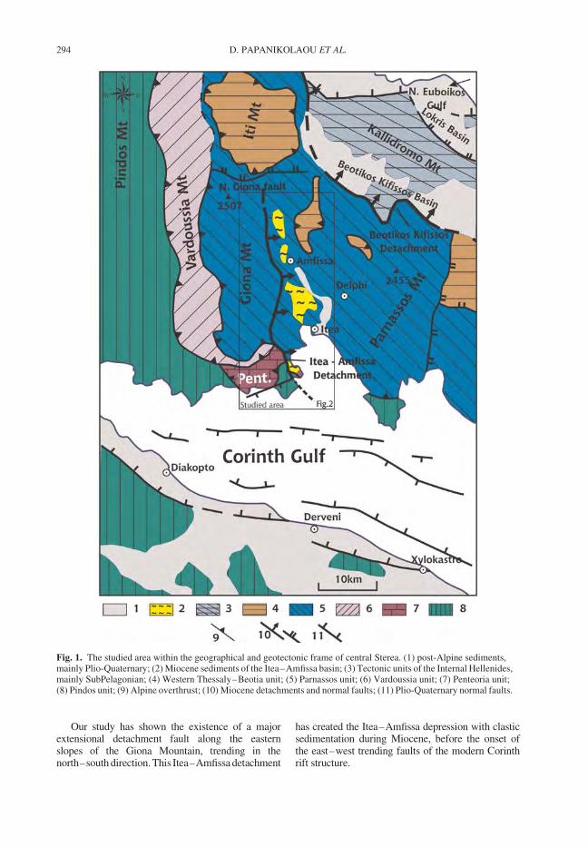
Our study has shown the existence of a majorextensional detachment fault along the easternslopes of the Giona Mountain, trending in thenorth–south direction. This Itea–Amfissa detachment
has created the Itea–Amfissa depression with clasticsedimentation during Miocene, before the onset ofthe east–west trending faults of the modern Corinthrift structure.
Fig. 1. The studied area within the geographical and geotectonic frame of central Sterea. (1) post-Alpine sediments,mainly Plio-Quaternary; (2) Miocene sediments of the Itea–Amfissa basin; (3) Tectonic units of the Internal Hellenides,mainly SubPelagonian; (4) Western Thessaly–Beotia unit; (5) Parnassos unit; (6) Vardoussia unit; (7) Penteoria unit;(8) Pindos unit; (9) Alpine overthrust; (10) Miocene detachments and normal faults; (11) Plio-Quaternary normal faults.
D. PAPANIKOLAOU ET AL.294
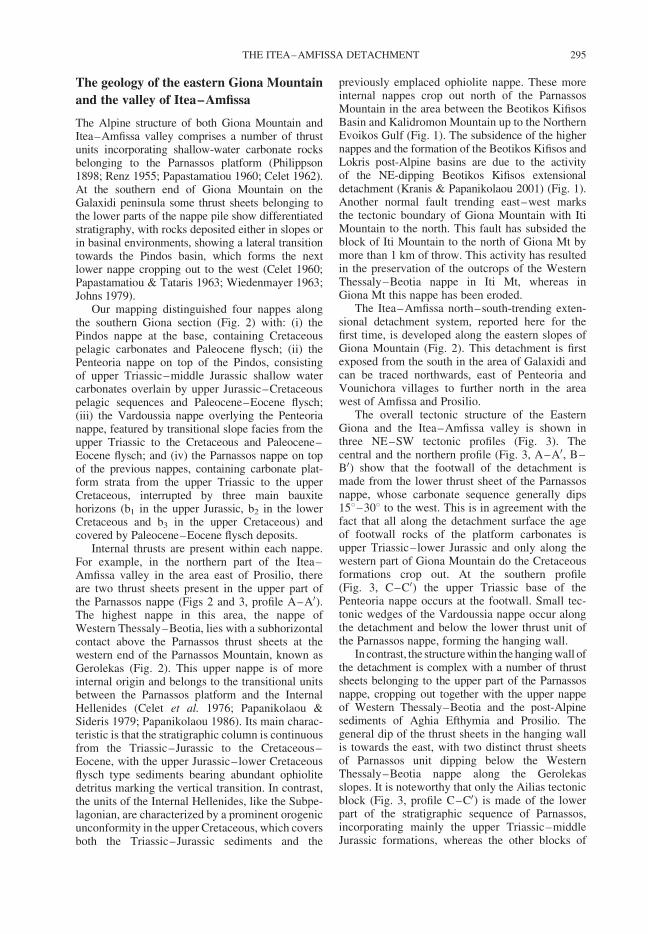
The geology of the eastern Giona Mountain
and the valley of Itea–Amfissa
The Alpine structure of both Giona Mountain andItea–Amfissa valley comprises a number of thrustunits incorporating shallow-water carbonate rocksbelonging to the Parnassos platform (Philippson1898; Renz 1955; Papastamatiou 1960; Celet 1962).At the southern end of Giona Mountain on theGalaxidi peninsula some thrust sheets belonging tothe lower parts of the nappe pile show differentiatedstratigraphy, with rocks deposited either in slopes orin basinal environments, showing a lateral transitiontowards the Pindos basin, which forms the nextlower nappe cropping out to the west (Celet 1960;Papastamatiou & Tataris 1963; Wiedenmayer 1963;Johns 1979).
Our mapping distinguished four nappes alongthe southern Giona section (Fig. 2) with: (i) thePindos nappe at the base, containing Cretaceouspelagic carbonates and Paleocene flysch; (ii) thePenteoria nappe on top of the Pindos, consistingof upper Triassic–middle Jurassic shallow watercarbonates overlain by upper Jurassic–Cretaceouspelagic sequences and Paleocene–Eocene flysch;(iii) the Vardoussia nappe overlying the Penteorianappe, featured by transitional slope facies from theupper Triassic to the Cretaceous and Paleocene–Eocene flysch; and (iv) the Parnassos nappe on topof the previous nappes, containing carbonate plat-form strata from the upper Triassic to the upperCretaceous, interrupted by three main bauxitehorizons (b1 in the upper Jurassic, b2 in the lowerCretaceous and b3 in the upper Cretaceous) andcovered by Paleocene–Eocene flysch deposits.
Internal thrusts are present within each nappe.For example, in the northern part of the Itea–Amfissa valley in the area east of Prosilio, thereare two thrust sheets present in the upper part ofthe Parnassos nappe (Figs 2 and 3, profile A–A0).The highest nappe in this area, the nappe ofWestern Thessaly–Beotia, lies with a subhorizontalcontact above the Parnassos thrust sheets at thewestern end of the Parnassos Mountain, known asGerolekas (Fig. 2). This upper nappe is of moreinternal origin and belongs to the transitional unitsbetween the Parnassos platform and the InternalHellenides (Celet et al. 1976; Papanikolaou &Sideris 1979; Papanikolaou 1986). Its main charac-teristic is that the stratigraphic column is continuousfrom the Triassic–Jurassic to the Cretaceous–Eocene, with the upper Jurassic–lower Cretaceousflysch type sediments bearing abundant ophiolitedetritus marking the vertical transition. In contrast,the units of the Internal Hellenides, like the Subpe-lagonian, are characterized by a prominent orogenicunconformity in the upper Cretaceous, which coversboth the Triassic–Jurassic sediments and the
previously emplaced ophiolite nappe. These moreinternal nappes crop out north of the ParnassosMountain in the area between the Beotikos KifisosBasin and Kalidromon Mountain up to the NorthernEvoikos Gulf (Fig. 1). The subsidence of the highernappes and the formation of the Beotikos Kifisos andLokris post-Alpine basins are due to the activityof the NE-dipping Beotikos Kifisos extensionaldetachment (Kranis & Papanikolaou 2001) (Fig. 1).Another normal fault trending east–west marksthe tectonic boundary of Giona Mountain with ItiMountain to the north. This fault has subsided theblock of Iti Mountain to the north of Giona Mt bymore than 1 km of throw. This activity has resultedin the preservation of the outcrops of the WesternThessaly–Beotia nappe in Iti Mt, whereas inGiona Mt this nappe has been eroded.
The Itea–Amfissa north–south-trending exten-sional detachment system, reported here for thefirst time, is developed along the eastern slopes ofGiona Mountain (Fig. 2). This detachment is firstexposed from the south in the area of Galaxidi andcan be traced northwards, east of Penteoria andVounichora villages to further north in the areawest of Amfissa and Prosilio.
The overall tectonic structure of the EasternGiona and the Itea–Amfissa valley is shown inthree NE–SW tectonic profiles (Fig. 3). Thecentral and the northern profile (Fig. 3, A–A0, B–B0) show that the footwall of the detachment ismade from the lower thrust sheet of the Parnassosnappe, whose carbonate sequence generally dips158–308 to the west. This is in agreement with thefact that all along the detachment surface the ageof footwall rocks of the platform carbonates isupper Triassic–lower Jurassic and only along thewestern part of Giona Mountain do the Cretaceousformations crop out. At the southern profile(Fig. 3, C–C0) the upper Triassic base of thePenteoria nappe occurs at the footwall. Small tec-tonic wedges of the Vardoussia nappe occur alongthe detachment and below the lower thrust unit ofthe Parnassos nappe, forming the hanging wall.
In contrast, the structure within the hanging wall ofthe detachment is complex with a number of thrustsheets belonging to the upper part of the Parnassosnappe, cropping out together with the upper nappeof Western Thessaly–Beotia and the post-Alpinesediments of Aghia Efthymia and Prosilio. Thegeneral dip of the thrust sheets in the hanging wallis towards the east, with two distinct thrust sheetsof Parnassos unit dipping below the WesternThessaly–Beotia nappe along the Gerolekasslopes. It is noteworthy that only the Ailias tectonicblock (Fig. 3, profile C–C0) is made of the lowerpart of the stratigraphic sequence of Parnassos,incorporating mainly the upper Triassic–middleJurassic formations, whereas the other blocks of
THE ITEA–AMFISSA DETACHMENT 295
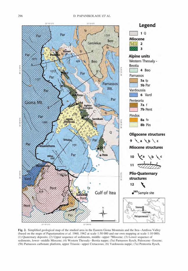
Fig. 2. Simplified geological map of the studied area in the Eastern Giona Mountain and the Itea–Amfissa Valley(based on the maps of Papastamatiou et al. 1960, 1962 at scale 1:50 000 and our own mapping at scale 1:10 000).(1) Quaternary deposits; (2) Upper sequence of sediments, middle–upper ?Miocene; (3) Lower sequence ofsediments, lower–middle Miocene; (4) Western Thessaly–Beotia nappe; (5a) Parnassos flysch, Paleocene–Eocene;(5b) Parnassos carbonate platform, upper Triassic–upper Cretaceous; (6) Vardoussia nappe; (7a) Penteoria flysch,
D. PAPANIKOLAOU ET AL.296
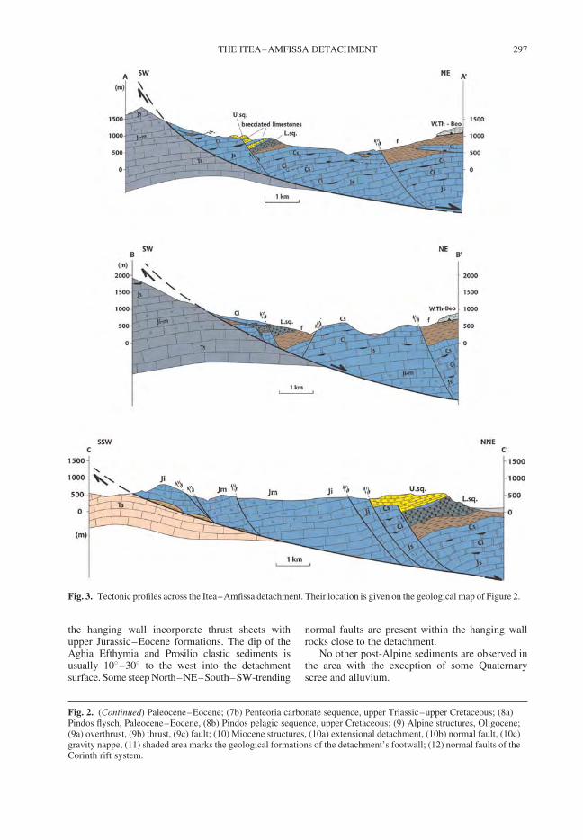
the hanging wall incorporate thrust sheets withupper Jurassic–Eocene formations. The dip of theAghia Efthymia and Prosilio clastic sediments isusually 108–308 to the west into the detachmentsurface. Some steep North–NE–South–SW-trending
normal faults are present within the hanging wallrocks close to the detachment.
No other post-Alpine sediments are observed inthe area with the exception of some Quaternaryscree and alluvium.
Fig. 3. Tectonic profiles across the Itea–Amfissa detachment. Their location is given on the geological map of Figure 2.
Fig. 2. (Continued) Paleocene–Eocene; (7b) Penteoria carbonate sequence, upper Triassic–upper Cretaceous; (8a)Pindos flysch, Paleocene–Eocene, (8b) Pindos pelagic sequence, upper Cretaceous; (9) Alpine structures, Oligocene;(9a) overthrust, (9b) thrust, (9c) fault; (10) Miocene structures, (10a) extensional detachment, (10b) normal fault, (10c)gravity nappe, (11) shaded area marks the geological formations of the detachment’s footwall; (12) normal faults of theCorinth rift system.
THE ITEA–AMFISSA DETACHMENT 297

The Itea–Amfissa sedimentary deposits:
Tectonostratigraphy and age assessment
Several hundred metres of coarse clastic sedimentsare observed at the top of the hanging wall succes-sion along the detachment. They generally consistof breccia and conglomerates alternating withsandy and clay layers including smaller pebbles.These sediments represent the remnants of theItea–Amfissa basin that was formed during theMiocene at the hanging wall of the detachment.The present day Itea–Amfissa valley has beenuplifted and incised the Miocene sedimentarybasin. Present-day alluvial deposits are observed ataltitudes from sea level to 200 m along the valley,whereas the top of the Miocene sedimentary succes-sion is observed several hundred metres higheralong the eastern slopes of Giona Mt Outcrops ofsediments are traced in Galaxidi, Aghia Efthymiaand Prosilio with progressively increasing altitudenorthwards. Thus, the southern outcrops aroundGalaxidi are observed at about 0–50 m, the outcropsat the central part around Aghia Efthymia at about350–500 m and the outcrops at the northern partof the study area around Prosilio at about 800–1300 m (Fig. 2).
Two stratigraphic sequences can de distin-guished in the sedimentary deposits of theItea–Amfissa basin. The lower sequence cropsout: (a) on the hillside north of Itea; (b) along theslopes of the cliff separating the Aghia Efthymiaplanation surface from the alluvial plane ofAmfissa in the area of villages Sernikaki, AghiosKonstantinos and Aghios Georgios; (c) in the areaof Prosilio; and (d) in narrow outcrops at the baseof the limestone cliffs in the area west of Amfissa(Fig. 2). The upper sequence extends over largeareas forming a subhorizontal relief in the planationsurfaces of Aghia Efthymia and Prosilio (Fig. 2).The main difference of the two sequences isthe lithological composition of the clasts in thepebbles and breccia of the conglomerates andthe matrix. In particular, the lower sequence com-prises mainly sandstones, pelites, ophiolites andradiolarites with minor carbonate rocks within anargillaceous matrix, whereas the upper sequencecomprises clasts mainly of dolomite and limestonewithin a sandy–carbonate matrix. The majority ofthe carbonate clasts in the upper sequence areof Parnassian origin. On the other hand, the clastsof the ophiolites and the pelagic siliceous sedimentscharacterizing the lower sequence are most likelydebris from the upper nappes of the WesternThessaly–Beotia and the more internal ophiolitesbearing nappe units. This major difference in thelithological composition of the two sequences indi-cates that during the deposition of the lowersequence the main sediment supply source was
from the upper nappes of Western Thessaly–Beotia and the Internal Hellenides, whereas duringthe deposition of the upper sequence the carbonateplatform of the Parnassos unit was the mainsupply source.
The transition from the lower to the uppersequence differs significantly from locality tolocality along the Itea–Amfissa basin. In thesouth, in the area of Aghia Efthymia–Sernikakithere is an angular unconformity between theupper and the lower sequence observed along thebase of the Aghia Efthymia cliff for more than4 km. The lower sequence dips 308–358 to theNW whereas the upper sequence dips 208–308 tothe SW. This is nicely revealed in the area ofPortes, near Aghios Nikolaos, where the conglomer-ate beds of the lower sequence are truncated bythe basal conglomerate beds of the upper sequence.The base of the unconformity is marked in themorphology by the cliff, due to the differentialerosion of the softer argillaceous lower conglomer-ate sequence and the much stiffer upper conglomer-ate sequence, which resembles to a carbonateformation (Fig. 4). The dip of the lower sequenceimmediately south of Sernikaki is similar to thedip of the basal contact of the lower sequence overits Alpine basement and to the overall dip of theAlpine formations. Thus, the lower sequenceforms a triangular outcrop between the Alpine base-ment in the south and the unconformity of the uppersequence, which in the NW–SE oriented sectionlooks subhorizontal (apparent dip because of thestrike-parallel direction; Fig. 5a). The maximumthickness of the lower sequence in the Sernikaki–Aghios Georgios area is estimated to almost 1 km.However, north of Aghios Georgios its thicknessdecreases abruptly to only a few tens of metres.Herein, it is observed below the subhorizontal
Fig. 4. The cliff of the Aghia Efthymia planation surfaceon top of the clastic sediments of the upper sequence(U.sq) seen from S–SE. The lower sequence (L.sq)forms the slopes below the cliff. At the back scene theeastern Giona slopes following the detachment plane arealso observed with outcrops of upper Triassic (Ts) andlower Jurassic (Ji) limestones.
D. PAPANIKOLAOU ET AL.298
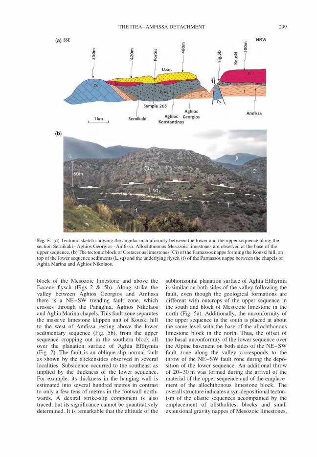
block of the Mesozoic limestone and above theEocene flysch (Figs 2 & 5b). Along strike thevalley between Aghios Georgios and Amfissathere is a NE–SW trending fault zone, whichcrosses through the Panaghia, Aghios Nikolaosand Aghia Marina chapels. This fault zone separatesthe massive limestone klippen unit of Kouski hillto the west of Amfissa resting above the lowersedimentary sequence (Fig. 5b), from the uppersequence cropping out in the southern block allover the planation surface of Aghia Efthymia(Fig. 2). The fault is an oblique-slip normal faultas shown by the slickensides observed in severallocalities. Subsidence occurred to the southeast asimplied by the thickness of the lower sequence.For example, its thickness in the hanging wall isestimated into several hundred metres in contrastto only a few tens of metres in the footwall north-wards. A dextral strike-slip component is alsotraced, but its significance cannot be quantitativelydetermined. It is remarkable that the altitude of the
subhorizontal planation surface of Aghia Efthymiais similar on both sides of the valley following thefault, even though the geological formations aredifferent with outcrops of the upper sequence inthe south and block of Mesozoic limestone in thenorth (Fig. 5a). Additionally, the unconformity ofthe upper sequence in the south is placed at aboutthe same level with the base of the allochthonouslimestone block in the north. Thus, the offset ofthe basal unconformity of the lower sequence overthe Alpine basement on both sides of the NE–SWfault zone along the valley corresponds to thethrow of the NE–SW fault zone during the depo-sition of the lower sequence. An additional throwof 20–30 m was formed during the arrival of thematerial of the upper sequence and of the emplace-ment of the allochthonous limestone block. Theoverall structure indicates a syn-depositional tecton-ism of the clastic sequences accompanied by theemplacement of olistholites, blocks and smallextensional gravity nappes of Mesozoic limestones,
Fig. 5. (a) Tectonic sketch showing the angular unconformity between the lower and the upper sequence along thesection Sernikaki–Aghios Georgios–Amfissa. Allochthonous Mesozoic limestones are observed at the base of theupper sequence, (b) The tectonic block of Cretaceous limestones (Ci) of the Parnassos nappe forming the Kouski hill, ontop of the lower sequence sediments (L.sq) and the underlying flysch (f) of the Parnassos nappe between the chapels ofAghia Marina and Aghios Nikolaos.
THE ITEA–AMFISSA DETACHMENT 299
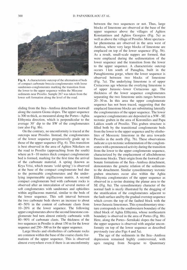
sliding from the Itea–Amfissa detachment footwallalong the eastern Giona slopes. The upper sequenceis 300 m thick, as measured along the Portes–AghiaEfthymia direction, which is perpendicular to theaverage 308 dip to the SW of the conglomerates(see also Fig. 8b).
On the contrary, no unconformity is traced at theoutcrops near Prosilio. Instead, the conglomeratesof the lower sequence progressively grade up tothose of the upper sequence (Fig. 6). This transitionis best observed in the area of Aghios Nikolaos onthe road to Prosilio (approaching from the south)where an 8–10 metres thick compact conglomeratebed is formed, marking for the first time the arrivalof the carbonate material. A spring (known asKrya Vrisi, which means ‘cold spring’) is observedat the base of the compact conglomerate bed dueto the permeable conglomerates and the under-lying impermeable argillaceous matrix. A secondcompact conglomerate bed with carbonate rocks isobserved after an intercalation of several metres ofsoft conglomerates with sandstones and ophioliteswithin argillaceous material, similar to the beds ofthe lower sequence. This soft interval betweenthe two carbonate beds shows an increase to about40–50% in the content of carbonate clasts from10–20% at the lower sequence. The followingupper conglomerates above the second limestone con-glomerate bed turn almost entirely carbonatic with80–90% of carbonate clasts. The thickness of thetwo sequences in Prosilio is about 150 m for the lowersequence and 250–300 m for the upper sequence.
Large blocks and olistholites of carbonate rocksare common within the base of the coarse clastic for-mations of the upper sequence. This is observedalmost everywhere even if there is an unconformity
between the two sequences or not. Thus, largeblocks of limestone are observed at the base of theupper sequence above the villages of AghiosKonstantinos and Aghios Georgios (Fig. 5a) aswell as above the village of Prosilio. More spectacu-lar phenomena are observed in the area west ofAmfissa, where very large blocks of limestone areemplaced on top of the lower sequence (Fig. 5b).As a result, small-scale nappes are formed, thatwere emplaced during the sedimentation of thelower sequence and the transition from the lowerto the upper sequence. A characteristic outcropoccurs 1 km south of Panaghia, built in thePanaghiorema gorge, where the lower sequence isobserved between two blocks of limestone(Fig. 7a). The underlying limestone is of upperCretaceous age whereas the overlying limestone isof upper Jurassic–lower Cretaceous age. Thethickness of the lower sequence conglomeratesseparating the two limestone units ranges between20–30 m. In this area the upper conglomeratesequence has not been traced, suggesting that theemplaced limestone blocks are substituting laterallythe conglomerates of the upper sequence. The lowersequence conglomerates are deposited in a NW–SEtectonic graben in the area of Koromilies and PapaLakkos south of Prosilio. This graben structure isfilled both by the transitional conglomerate bedsfrom the lower to the upper sequence and by olistho-lites of Mesozoic limestone in the area towardsProsilio in the north (Fig. 7b). These observationsindicate a syn-tectonic sedimentation of the conglom-erates with a pronounced activity during the transitionfrom the lower to the upper conglomerate sequence,characterized by the emplacement of allochthonouslimestone blocks. Their origin from the footwall car-bonate formations of the Itea–Amfissa detachment,demonstrates the genetic relation of the sedimentsto the detachment. Similar synsedimentary tectonicgraben structures occur also within the AghiaEfthymia conglomerates of the upper sequence asobserved in a ravine draining the planar area to theSE (Fig. 8a). The synsedimentary character of thenormal fault is nicely illustrated by the dragging ofthe stratification of the conglomerates adjacent tothe fault surface and by the gradual overstep sequencewhich covers the top of the faulted block with thelower Jurassic limestones. This synsedimentary struc-ture corresponds to the southwestern boundary of thetilted block of Aghia Efthymia, whose northeasternboundary is observed in the area of Portes (Fig. 8b).Here, along the Portes–Sernikaki slopes the base ofthe upper sequence is observed with angular uncon-formity on top of the lower sequence as describedpreviously (see also Figs 4 and 5a).
The age of the sediments in the Itea–Amfissadepression remained highly controversial, withages ranging from Neogene to Quaternary
Fig. 6. A characteristic outcrop of the alternation of bedsof compact carbonate breccia-conglomerates with loosesandstones-conglomerates marking the transition fromthe lower to the upper sequence within the Miocenesediments near Prosilio. Sample 267 was taken from thelower soft formation along the level of the road.
D. PAPANIKOLAOU ET AL.300
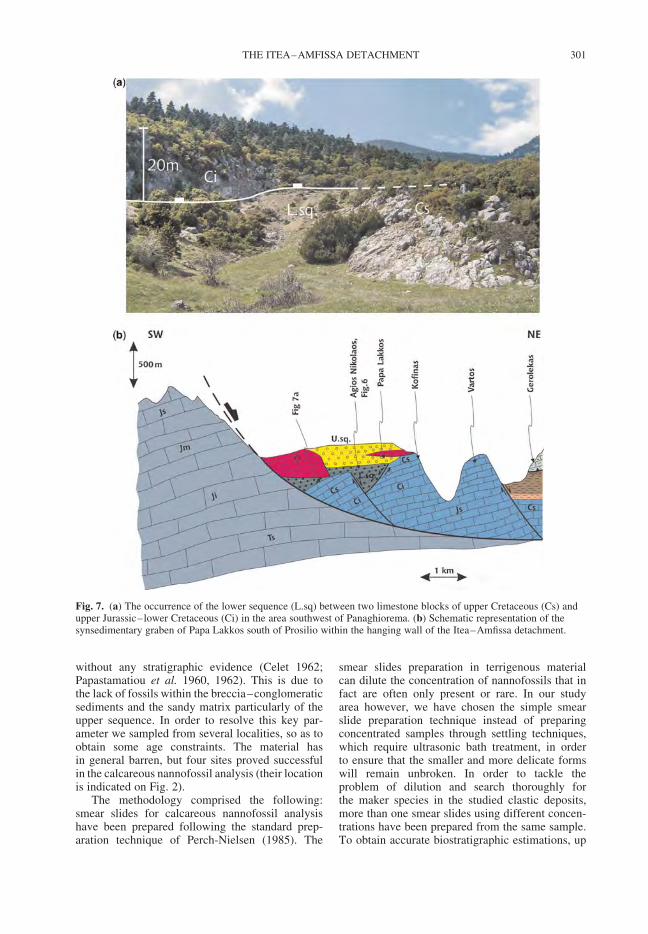
without any stratigraphic evidence (Celet 1962;Papastamatiou et al. 1960, 1962). This is due tothe lack of fossils within the breccia–conglomeraticsediments and the sandy matrix particularly of theupper sequence. In order to resolve this key par-ameter we sampled from several localities, so as toobtain some age constraints. The material hasin general barren, but four sites proved successfulin the calcareous nannofossil analysis (their locationis indicated on Fig. 2).
The methodology comprised the following:smear slides for calcareous nannofossil analysishave been prepared following the standard prep-aration technique of Perch-Nielsen (1985). The
smear slides preparation in terrigenous materialcan dilute the concentration of nannofossils that infact are often only present or rare. In our studyarea however, we have chosen the simple smearslide preparation technique instead of preparingconcentrated samples through settling techniques,which require ultrasonic bath treatment, in orderto ensure that the smaller and more delicate formswill remain unbroken. In order to tackle theproblem of dilution and search thoroughly forthe maker species in the studied clastic deposits,more than one smear slides using different concen-trations have been prepared from the same sample.To obtain accurate biostratigraphic estimations, up
Fig. 7. (a) The occurrence of the lower sequence (L.sq) between two limestone blocks of upper Cretaceous (Cs) andupper Jurassic–lower Cretaceous (Ci) in the area southwest of Panaghiorema. (b) Schematic representation of thesynsedimentary graben of Papa Lakkos south of Prosilio within the hanging wall of the Itea–Amfissa detachment.
THE ITEA–AMFISSA DETACHMENT 301
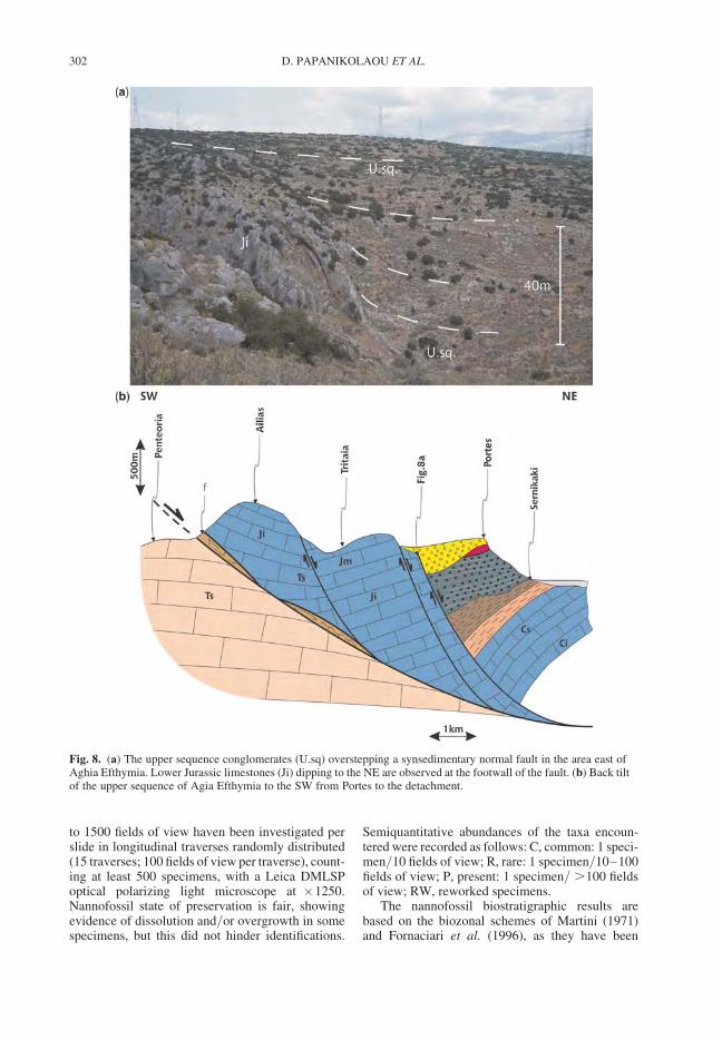
to 1500 fields of view haven been investigated perslide in longitudinal traverses randomly distributed(15 traverses; 100 fields of view per traverse), count-ing at least 500 specimens, with a Leica DMLSPoptical polarizing light microscope at �1250.Nannofossil state of preservation is fair, showingevidence of dissolution and/or overgrowth in somespecimens, but this did not hinder identifications.
Semiquantitative abundances of the taxa encoun-tered were recorded as follows: C, common: 1 speci-men/10 fields of view; R, rare: 1 specimen/10–100fields of view; P, present: 1 specimen/ .100 fieldsof view; RW, reworked specimens.
The nannofossil biostratigraphic results arebased on the biozonal schemes of Martini (1971)and Fornaciari et al. (1996), as they have been
Fig. 8. (a) The upper sequence conglomerates (U.sq) overstepping a synsedimentary normal fault in the area east ofAghia Efthymia. Lower Jurassic limestones (Ji) dipping to the NE are observed at the footwall of the fault. (b) Back tiltof the upper sequence of Agia Efthymia to the SW from Portes to the detachment.
D. PAPANIKOLAOU ET AL.302
incorporated in the magnetobiochronological fra-mework of Berggren et al. (1995) and revised byLourens et al. (2004). On this basis NN4 and NN6biozones (Martini 1971) and MNN6b (Fornaciariet al. 1996) have been recognized. Numerical agesof biozone boundaries are given according toLourens et al. (2004).
The obtained results are the following:
(a) Sample 265.3 (Fig. 2). The calcareous nannofos-sil analysis revealed the presence of common Reti-culofenestra pseudoumbilicus (apart from isolatedcoccoliths several intact coccospheres have alsobeen observed), Discoaster variabilis and Cyclicar-golithus floridanus along with the absence ofSphenolithus heteromorphus, Discoaster kugleri,Calcidiscus macintyrei, Helicosphaera stalis andany trace of Late Oligocene or Pliocene biostrati-graphic indices. Rare Cretaceous, common Eoceneand Early Miocene reworked species are alsopresent. Some small pennate and concentricdiatoms have been detected.
The definition of R. pseudoumbilicus is restrictedto reticulofenestrids .7 m, following Raffi & Rio(1979). The common and continuous presence ofthe species is concomitant with the LO of S. hetero-morphus at the top of NN5 biozone (Fornaciari et al.1996; Raffi et al. 1995; Maiorano & Monechi 1998).
Therefore, the nannofossil assemblage of thestudied sample implies the presence of NN6biozone (Martini 1971) or MNN6b (Fornaciariet al. 1996) pointing to Serravallian age, rangingbetween 13.4–11.8 ma.
(b) Sample 264.2 (Fig. 2). The calcareous nannofos-sil analysis revealed the presence of common Cycli-cargolithus abisectus, rare forms of Sphenolithuscf. Sphenolithus heteromorphus and presence ofHelicosphaera ampliaperta.
The nannofossil assemblage implies the tenta-tive assignment to NN4 biozone (Martini 1971)pointing to Burdigalian-Langhian age, rangingbetween 18–15 ma.
(c) Sample 257.1 (Fig. 2). Rare overgrown speci-mens of Coccolithus pelagicus, C. floridanus, Eric-sonia formosa, Sphenolithus heteromorphus,Sphenolithus moriformis have been detected, con-sidered as reworked species. The assemblage doesnot bear any clear in-situ nannofossil index speciespointing to an age younger than Langhian.
(d) Sample 267.1 (Fig. 2). Similar nannofossilassemblage with sample 257.1 has been detected,including rare and overgrown specimens of Cocco-lithus pelagicus, C. floridanus, Ericsonia formosa,Sphenolithus heteromorphus, Sphenolithus belem-nos, Sphenolithus moriformis, which are consideredas reworked. The assemblage does not bear any
clear in situ nannofossil index species, pointing toan age younger than Langhian.
In conclusion, the age of the Itea–Amfissa sedi-mentary deposits is Early to Middle Miocene andmore precisely late Burdigalian–Serravalian. Con-sidering that the dated specimens are only extractedfrom the stratigraphic horizons of the lowersequence a Tortonian age is probable for the uppersequence. Thus, the entire sedimentary history ofthe Itea–Amfissa basin may comprise the periodLate Burdigalian–Tortonian (c. 18–8 ma).
The Itea–Amfissa detachment
The Itea–Amfissa detachment is traced for 30 kmfrom the Corinth Gulf in the south to Prosilio andNorthern Giona Mountain in the north. It separatesthe eastern part of the Giona Mountain with altitudesbetween 1500–2200 m from the Itea–Amfissavalley with altitudes between 0–200 m. Thus, theaverage difference in topography observed acrossthe detachment in east–west profiles is about2 km. This difference in altitude is mainly observedwithin a narrow zone along the eastern slopes ofGiona, expressed by a sub-plannar slope dippingto the east with an average dip of 308. This sub-plannar slope is controlled by the detachmentsurface that passes below the hanging wall rocks,where it creates a first major break in the slopemorphology of about 1200 m topographic differ-ence. A secondary zone of steep morphologicalslope is developed within the hanging wall for-mations from the top of the hanging wall to thepresent day lower level of the Itea–Amfissavalley. This forms a further decrease of topographyof several hundred metres expressed by well-definedmorphological cliffs (Figs 4 & 9). However, thetopographic difference in the Aghia Efthymia cliffis about 350–400 m (Fig. 4) whereas in Prosilio itis about 900–1000 m (Fig. 9). This second step inthe Giona slopes is formed by erosional incision ofthe planation surface at the top of the Mioceneclastic deposits occurring in Aghia Efthymia andProsilio. Considering the difference of elevation ofabout 1400 m within 30 km distance between theProsilio, Aghia Efthymia and Galaxidi outcrops ofthe Miocene clastic formations a general southwardtilt of c. 38 of the planation surfaces on top of theclastic sediments can be inferred.
The detachment fault plane is exposed in severallocalities. The best preserved outcrop occurs at thesouthern part of the detachment in the area east ofPenteoria as shown on the detailed geological mapof the area (Fig. 10). In this area the fault plane ismarked by the existence of some tectonic lensesbetween the carbonate rocks of the Penteorianappe in the footwall and those of the Parnassos
THE ITEA–AMFISSA DETACHMENT 303
nappe in the hanging wall. The rocks within the tec-tonic wedges along the detachment belong to theEocene flysch (probably belonging to the Penteoriaunit) and to the Upper Triassic–Upper Jurassicpelagic carbonates of the Vardoussia unit. Thebest outcrop of the detachment is observed alongthe contact of the underlying Upper Triassic carbon-ates of the Penteoria unit and the overlying Eoceneflysch (Fig. 11). This planar contact can be observedfor about 500 m length and locally it has a widthof about 25–40 m. The dip of the detachment is308 to N 458 E and the slip direction as deducedfrom kinematic indicators is slightly oblique inan N 608 E direction.
The throw across the detachment cannot be accu-rately constrained because there are no outcropsof the same tectono-stratigraphic units on eitherside of the detachment. As shown in the descriptionof the geological structure of the area there areseveral thrust sheets within the Parnassos nappetherefore no correlation is feasible on eitherside of the detachment. Along the southern part ofthe detachment east of Penteoria the throw incorpor-ates the structural omission of the Jurassic andCretaceous part of the Penteoria sequence (severalhundred metres thick), the whole stratigraphiccolumn of the Vardoussia nappe (exceeding 1 kmof thickness) and unknown number of thrust sheetsof the Parnassos nappe. The minimum calculatedthrow, where no thrust sheets of the Parnassos unitare considered, is estimated at several hundred
metres, which represents the structural omissionof the Upper Triassic platform carbonates ofParnassos. Taking into account the throw inferredfrom the topography between the Jurassic for-mations on either side of the detachment, that ismore than 800 m, then the overall minimumthrow is 2500–2800 m. On the other hand alongthe northern part of the detachment around Prosiliothe minimum throw is 4400 m incorporating: (i) thethickness of the upper thrust sheets of Parnassos(more than 2200 m in thickness); (ii) the overlyingnappe of Western Thessaly–Beotia (more than400 m thick); (iii) the missing Jurassic part of theParnassos platform (about 800 m thick); and (iv)the topographic difference between the footwall car-bonates of Parnassos and the nappe of WesternThessaly–Beotia in Gerolekas at the hanging wall(about 900–1000 m).
Considering an average dip of 308 for the detach-ment the total displacement in the E–NE direction ismore than 9 km. This value is very close to thepresent width of the Itea–Amfissa Valley measuredat the 1000 m contour level between the EasternGiona and Western Parnassos slopes.
The contrast between the footwall and thehanging wall structure of the detachment is impress-ive. Thus, a rather rigid structure can be observed allalong the footwall with the lower stratigraphiclevels of the Parnassos unit (Upper Triassic–Middle Jurassic) dipping 208–308 to the west. Incontrast, the hanging wall is made of a complex
Fig. 9. The planation surface above Prosilio on top of the upper sequence (U.sq) as seen from the east and simplifiedgeological sketch. The sediments of the upper sequence are marked by the cliff formed by the erosional incision rightabove the level of Prosilio village. Below the cliff a triangular outcrop of the lower sequence (L.sq) is formed, boundedto the north by a NE–SW transverse normal fault. Behind the Prosilio planation surface the geometrical eastern slopes ofGiona Mountain (shaded in grey) delineate the Itea–Amfissa detachment up to the Reka valley. Note the gradualdecrease of the morphological expression of the detachment from left (south) to right (north) along the Giona slopes(indicated by vertical lines).
D. PAPANIKOLAOU ET AL.304
structure of small-scale blocks of Mesozoic lime-stones and early Tertiary flysch, which have slidedto the E–NE during the sedimentation of the Itea–Amfissa sedimentary deposits (Fig. 12a). The inter-fingering of the conglomerates with the olistholitesand the small gravity nappes along the hangingwall provide a characteristic view of it. This isaccentuated during the sedimentation of the upperconglomeratic formation with the carbonate rocks,which are traced both in front and above thesliding blocks.
The faults observed on the hanging wall trendeither parallel to the detachment or transverse. Inboth cases they do not penetrate the footwallrocks, but they are synchronous to the sedimentationof the lower sequence and die out during the sedi-mentation of the upper sequence. The transversefaults have a general NE–SW direction and theyform three distinct fault zones (Fig. 12b). Thesouthern fault zone passes north of Itea, themiddle passes south of Amfissa and the northernone passes north of Prosilio (Figs 2 & 12b). These
ENE–WSW trending faults have produced a syn-sedimentary tilt to the NW of the lower sequenceduring middle Miocene and at the same time theybound to the north the outcrops of the uppersequence. The faults parallel to the detachment areforming back tilted blocks within the Alpine for-mations and syn-sedimentary tectonic grabensfilled with clastic sediments similar with the lithol-ogies of the sliding limestone blocks (Fig. 12a).The most characteristic structure is observed in thearea of Aghia Efthymia, where the upper sequencedips 308 to the SW against the NW–SE trendingfault passing from the Itea harbor and the villageof Aghia Efthymia (Figs 2 & 8b). The same tilt tothe SW is observed in the sediments of the uppersequence in Prosilio against the detachmentsurface at 1300 m of altitude (Figs 2 & 7b).
The overall structure within the hanging wall ofthe Itea detachment is illustrated in two schematicprofiles; one across the hanging wall in an east–west direction and the other longitudinal in anorth–south direction (Fig. 12). These profiles
Fig. 10. Detailed geological map of the area on both sides of the detachment at southern Giona between Galaxidi andPenteoria. For location see geological map of Figure 2. (1) Lower Jurassic carbonate rocks of Parnassos nappe;(2a) Jurassic pelagic limestones of Vardoussia nappe, (2b) Upper Triassic pelagic limestones of Vardoussia nappe; (3)Upper Triassic neritic limestones of Penteoria nappe; (4) Eocene flysch of Penteoria nappe.
THE ITEA–AMFISSA DETACHMENT 305
provide the relationship between the sliding of thecarbonate units above the detachment togetherwith the sedimentation of the two sequences ofbreccia–conglomerates. The role of the parallelfaults creating the sliding blocks and the resultinghorsts and grabens in the north–south trend is illus-trated by the transverse section (Fig. 12a), whereasthe longitudinal section demonstrates the role ofthe transverse NE–SW faults that dissect thehanging wall structure in successive blocks alongstrike (Fig. 12b).
Northwards the detachment can be traced up tothe Reka Valley that has an east–west orientationand starts from the area of the Giona summit(2507 m) and ends at the Viniani depression,which occurs below Prosilio at about 7 km northof the Amfissa depression. North of the RekaValley there is no morphological expression of thedetachment but a high-angle normal fault (508–608 dip to the E–NE) separates the footwall Jurassiccarbonates dipping to the west from the hangingwall Cretaceous carbonates dipping to the east(Fig. 13). This fault has a throw exceeding1200 m, based only from the missing stratigraphichorizons between the footwall and the hanging
Fig. 12. Schematic profiles of the structure within the hanging wall of the Itea–Amfissa detachment: (a) transverse and(b) longitudinal. (1) Autochthonous blocks, (1a) Eocene flysch, (1b) Mesozoic limestones; (2) Lower Sequence ofEarly–Middle Miocene sediments; (3) Allochthonous blocks, mainly of Mesozoic limestones; (4) Upper Sequence ofMiddle–Late ?Miocene sediments.
Fig. 11. The outcrop of the detachment in the areabetween Galaxidi and Penteoria. Its location is shown inthe geological map of Figure 10. The cliff above thedetachment is made of the Vardoussia pelagic Jurassicsediments (2) found in tectonic wedge between the upperTriassic neritic limestones of the Penteoria nappe (1) inthe footwall and the lower Jurassic neritic limestones ofthe Parnassos nappe (3) in the hanging wall. The flat areawith the olive trees corresponds to the Eocene flysch (4).
D. PAPANIKOLAOU ET AL.306
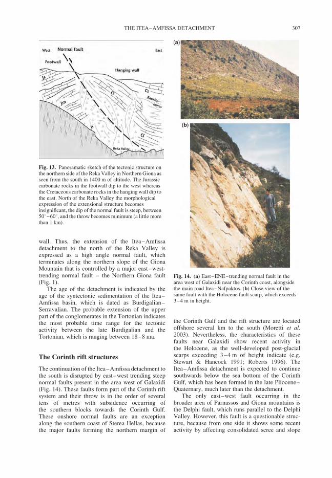
wall. Thus, the extension of the Itea–Amfissadetachment to the north of the Reka Valley isexpressed as a high angle normal fault, whichterminates along the northern slope of the GionaMountain that is controlled by a major east–west-trending normal fault – the Northern Giona fault(Fig. 1).
The age of the detachment is indicated by theage of the syntectonic sedimentation of the Itea–Amfissa basin, which is dated as Burdigalian–Serravalian. The probable extension of the upperpart of the conglomerates in the Tortonian indicatesthe most probable time range for the tectonicactivity between the late Burdigalian and theTortonian, which is ranging between 18–8 ma.
The Corinth rift structures
The continuation of the Itea–Amfissa detachment tothe south is disrupted by east–west trending steepnormal faults present in the area west of Galaxidi(Fig. 14). These faults form part of the Corinth riftsystem and their throw is in the order of severaltens of metres with subsidence occurring ofthe southern blocks towards the Corinth Gulf.These onshore normal faults are an exceptionalong the southern coast of Sterea Hellas, becausethe major faults forming the northern margin of
the Corinth Gulf and the rift structure are locatedoffshore several km to the south (Moretti et al.2003). Nevertheless, the characteristics of thesefaults near Galaxidi show recent activity inthe Holocene, as the well-developed post-glacialscarps exceeding 3–4 m of height indicate (e.g.Stewart & Hancock 1991; Roberts 1996). TheItea–Amfissa detachment is expected to continuesouthwards below the sea bottom of the CorinthGulf, which has been formed in the late Pliocene–Quaternary, much later than the detachment.
The only east–west fault occurring in thebroader area of Parnassos and Giona mountains isthe Delphi fault, which runs parallel to the DelphiValley. However, this fault is a questionable struc-ture, because from one side it shows some recentactivity by affecting consolidated scree and slope
Fig. 13. Panoramatic sketch of the tectonic structure onthe northern side of the Reka Valley in Northern Giona asseen from the south in 1400 m of altitude. The Jurassiccarbonate rocks in the footwall dip to the west whereasthe Cretaceous carbonate rocks in the hanging wall dip tothe east. North of the Reka Valley the morphologicalexpression of the extensional structure becomesinsignificant, the dip of the normal fault is steep, between508–608, and the throw becomes minimum (a little morethan 1 km).
Fig. 14. (a) East–ENE–trending normal fault in thearea west of Galaxidi near the Corinth coast, alongsidethe main road Itea–Nafpaktos. (b) Close view of thesame fault with the Holocene fault scarp, which exceeds3–4 m in height.
THE ITEA–AMFISSA DETACHMENT 307
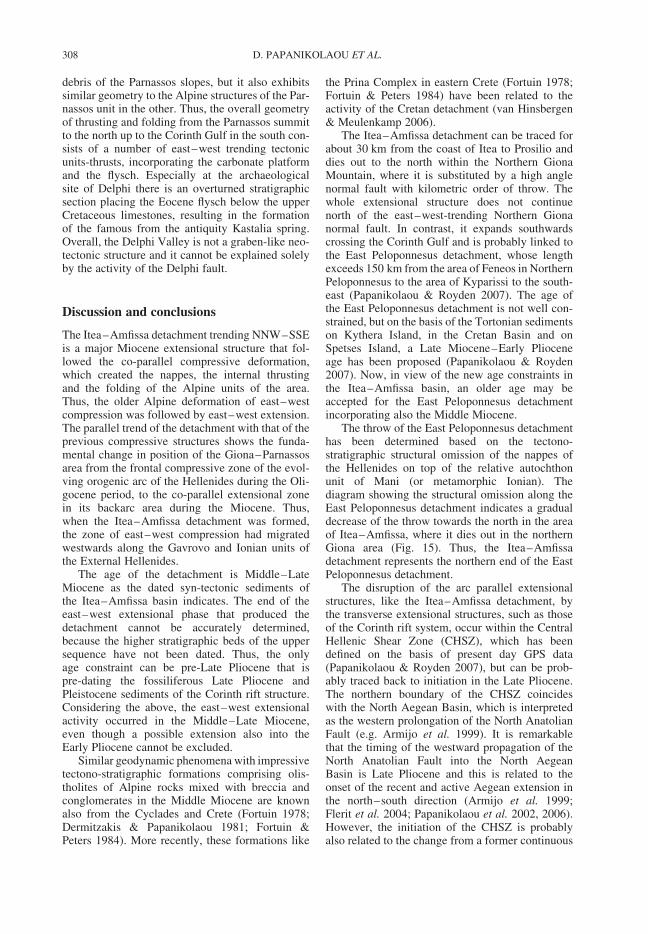
debris of the Parnassos slopes, but it also exhibitssimilar geometry to the Alpine structures of the Par-nassos unit in the other. Thus, the overall geometryof thrusting and folding from the Parnassos summitto the north up to the Corinth Gulf in the south con-sists of a number of east–west trending tectonicunits-thrusts, incorporating the carbonate platformand the flysch. Especially at the archaeologicalsite of Delphi there is an overturned stratigraphicsection placing the Eocene flysch below the upperCretaceous limestones, resulting in the formationof the famous from the antiquity Kastalia spring.Overall, the Delphi Valley is not a graben-like neo-tectonic structure and it cannot be explained solelyby the activity of the Delphi fault.
Discussion and conclusions
The Itea–Amfissa detachment trending NNW–SSEis a major Miocene extensional structure that fol-lowed the co-parallel compressive deformation,which created the nappes, the internal thrustingand the folding of the Alpine units of the area.Thus, the older Alpine deformation of east–westcompression was followed by east–west extension.The parallel trend of the detachment with that of theprevious compressive structures shows the funda-mental change in position of the Giona–Parnassosarea from the frontal compressive zone of the evol-ving orogenic arc of the Hellenides during the Oli-gocene period, to the co-parallel extensional zonein its backarc area during the Miocene. Thus,when the Itea–Amfissa detachment was formed,the zone of east–west compression had migratedwestwards along the Gavrovo and Ionian units ofthe External Hellenides.
The age of the detachment is Middle–LateMiocene as the dated syn-tectonic sediments ofthe Itea–Amfissa basin indicates. The end of theeast–west extensional phase that produced thedetachment cannot be accurately determined,because the higher stratigraphic beds of the uppersequence have not been dated. Thus, the onlyage constraint can be pre-Late Pliocene that ispre-dating the fossiliferous Late Pliocene andPleistocene sediments of the Corinth rift structure.Considering the above, the east–west extensionalactivity occurred in the Middle–Late Miocene,even though a possible extension also into theEarly Pliocene cannot be excluded.
Similar geodynamic phenomena with impressivetectono-stratigraphic formations comprising olis-tholites of Alpine rocks mixed with breccia andconglomerates in the Middle Miocene are knownalso from the Cyclades and Crete (Fortuin 1978;Dermitzakis & Papanikolaou 1981; Fortuin &Peters 1984). More recently, these formations like
the Prina Complex in eastern Crete (Fortuin 1978;Fortuin & Peters 1984) have been related to theactivity of the Cretan detachment (van Hinsbergen& Meulenkamp 2006).
The Itea–Amfissa detachment can be traced forabout 30 km from the coast of Itea to Prosilio anddies out to the north within the Northern GionaMountain, where it is substituted by a high anglenormal fault with kilometric order of throw. Thewhole extensional structure does not continuenorth of the east–west-trending Northern Gionanormal fault. In contrast, it expands southwardscrossing the Corinth Gulf and is probably linked tothe East Peloponnesus detachment, whose lengthexceeds 150 km from the area of Feneos in NorthernPeloponnesus to the area of Kyparissi to the south-east (Papanikolaou & Royden 2007). The age ofthe East Peloponnesus detachment is not well con-strained, but on the basis of the Tortonian sedimentson Kythera Island, in the Cretan Basin and onSpetses Island, a Late Miocene–Early Plioceneage has been proposed (Papanikolaou & Royden2007). Now, in view of the new age constraints inthe Itea–Amfissa basin, an older age may beaccepted for the East Peloponnesus detachmentincorporating also the Middle Miocene.
The throw of the East Peloponnesus detachmenthas been determined based on the tectono-stratigraphic structural omission of the nappes ofthe Hellenides on top of the relative autochthonunit of Mani (or metamorphic Ionian). Thediagram showing the structural omission along theEast Peloponnesus detachment indicates a gradualdecrease of the throw towards the north in the areaof Itea–Amfissa, where it dies out in the northernGiona area (Fig. 15). Thus, the Itea–Amfissadetachment represents the northern end of the EastPeloponnesus detachment.
The disruption of the arc parallel extensionalstructures, like the Itea–Amfissa detachment, bythe transverse extensional structures, such as thoseof the Corinth rift system, occur within the CentralHellenic Shear Zone (CHSZ), which has beendefined on the basis of present day GPS data(Papanikolaou & Royden 2007), but can be prob-ably traced back to initiation in the Late Pliocene.The northern boundary of the CHSZ coincideswith the North Aegean Basin, which is interpretedas the western prolongation of the North AnatolianFault (e.g. Armijo et al. 1999). It is remarkablethat the timing of the westward propagation of theNorth Anatolian Fault into the North AegeanBasin is Late Pliocene and this is related to theonset of the recent and active Aegean extension inthe north–south direction (Armijo et al. 1999;Flerit et al. 2004; Papanikolaou et al. 2002, 2006).However, the initiation of the CHSZ is probablyalso related to the change from a former continuous
D. PAPANIKOLAOU ET AL.308
Hellenic arc structure until Middle–Late Mioceneto the present day Hellenic arc and trench system,which is restricted to the Preveza area by the Kefa-lonia transform fault (Papanikolaou & Dermitzakis1981). This younger structure of the Hellenic arcdoes not extend north of the Kefalonia transformand is related to the onset of the rapid subductionof the oceanic crust of the East MediterraneanBasin that occurred between Late Miocene–EarlyPliocene.
In conclusion, the deformation of the Parnassos–Giona area of central Sterea Hellas is characterizedby three deformational phases; the first two arearc parallel structures of east–west compressionduring Oligocene and east–west extension duringMiocene, followed by the third deformational phaseof north–south extension, which has disrupted thearc since Late Pliocene time.
This is a contribution to the MEDUSA project, funded bythe NSF Continental Dynamics Program, grant EAR-0409373. The University of Athens has contributedto some of the field expenses. Constructive commentsby M. Edwards, F. Flerit and I. Papanikolaou havesignificantly improved the manuscript.
References
ARMIJO, R., MEYER, B., KING, G., RIGO, A. &PAPANASTASSIOU, D. 1996. Quaternary evolutionof the Corinth Rift and its implications for the lateCenozoic evolution of the Aegean. GeophysicalJournal International, 126, 11–53.
ARMIJO, R., MEYER, B., HUBERT, A. & BARKA, A. 1999.Westward propagation of the North Anatolian Faultinto the northern Aegean: timing and kinematics.Geology, 27, 267–270.
BERGGREN, W. A., KENT, D., SWISHER, C. C. & AUBRY,M. P. 1995. A revised Cenozoic geochronology andchronostratigraphy. In: BERGGREN, W. A., KENT, D.V., AUBRY, M. P. & HARDENBOL, J. (eds), Strati-graphic Correlation. Society for SedimentaryGeology (SEPM), Special Publication, 54, 129–212.
CELET, P. 1960. Observations sur la tectonique de laregion cotiere meridionale de massifs du Parnasse –Kiona. Bulletin de la Societe Geologique de France,7/2, 427–434.
CELET, P. 1962. Contribution a l’etude geologique duParnasse-Kiona et d’ une partie des regions meridio-nales de la Grece continentale. Annales Geologiquesdes Pays Helleniques, 13, 1–446.
CELET, P., CLEMENT, B. & FERRIERE, J. 1976. La zonebeotienne en Grece; implications paleogeographiqueset structrales. Eclogae Geologicae Helvetiae, 69,577–599.
DERMITZAKIS, M. & PAPANIKOLAOU, D. 1981. Paleo-geography and Geodynamics of the Aegean Regionduring the Neogene. VIIth International Congress onMediterranean Neogene, Athens 1979, ProceedingsIV, 245–288.
FLERIT, F., ARMIJO, R., KING, G. & MEYER, B. 2004.The mechanical interaction between the propagatingNorth Anatolian Fault and the back-arc extension inthe Aegean. Earth Planetary Science Letters, 224,347–362.
FORNACIARI, E., DI STEFANO, A., RIO, D. & NEGRI, A.1996. Middle Miocene quantitative calcareous nanno-fossil biostratigraphy in the Mediterranean region.Micropaleontology, 42, 37–64.
FORTUIN, A. R. 1978. Late Cenozoic history of easternCrete and implications for the geology and geody-namics of the southern Aegean area. Geologie enMijnbouw, 57, 451–464.
FORTUIN, A. R. & PETERS, J. M. 1984. The PrinaComplex in eastern Crete and its relationship topossible Miocene strike-slip tectonics. Journal ofStructural Geology, 6, 459–476.
Fig. 15. Diagram of the structural omission along the East Peloponnesus Detachment System based on Papanikolaou &Royden (2007). Units between the upper and lower black lines are missing across the detachment surface; missingsequences at specific localities are indicated by the vertical black bars. The Itea–Amfissa Detachment corresponds to thenorthern end of the system north of the Corinth rift structure.
THE ITEA–AMFISSA DETACHMENT 309
JOHNS, D. R. 1979. The structure and stratigraphy of theGalaxidion region, Central Greece. VI Colloquium onthe Geology of the Aegean Region, Proceedings II,715–724.
KRANIS, H. & PAPANIKOLAOU, D. 2001. Evidence fordetachment faulting on the NW Parnassos Mountainfront (Central Greece). Bulletin of the GeologicalSociety of Greece, 34, 281–287.
LOURENS, L., HILGEN, F., SHACKLETON, N. J., LASKAR,J. & WILSON, D. 2004. The Neogene Period. In:GRADSTEIN, F., OGG, J. & SMITH, A. (eds) A Geolo-gic Time Scale 2004. Cambridge University Press,409–440.
MAIORANO, P. & MONECHI, S. 1998. Revised corre-lations of Early and Middle Miocene calcareousnannofossil events and magnetostratigraphy fromDSDP Site 563 (North Atlantic Ocean). MarineMicropaleontology, 35, 235–255.
MARTINI, E. 1971. Standard Tertiary and Quaternary cal-careous nannoplankton zonation. In: FARINACCI, A.(ed.) Proceedings of the Second Planktonic Confer-ence. Roma, Technoscienza, 739–785.
MORETTI, I., SAKELLARIOU, D., LYKOUSSIS, V. &MICARELLI, L. 2003. The Gulf of Corinth: an activehalf graben? Journal of Geodynamics, 36, 323–340.
PAPANIKOLAOU, D. 1986. Late Cretaceous paleogeogra-phy of the Metamorphic Hellenides. Geological andGeophysical Research, IGME, Special issue inhonour of Professor Papastamatiou, 315–328.
PAPANIKOLAOU, D. & DERMITZAKIS, M. 1981.Major changes from the last stage of the Hellenidesto the actual Hellenic arc and trench system.International Symposium on the Hellenic Arc andTrench System (HEAT), Athens 1981, ProceedingsII, 57–73.
PAPANIKOLAOU, D. & ROYDEN, L. 2007. Disruption ofthe Hellenic Arc: Late Miocene Extensional Detach-ment Faults and Steep Pliocene-Quaternary Normalfaults – or – What happened at Corinth? Tectonics,26, TC5003, doi:10.1029/2006TC002007.
PAPANIKOLAOU, D. & SIDERIS, C. 1979. Sur lasignification des zones ultrapindique et beotienned’apres la geologie de la region de Karditsa: l’Unitede Thessalie Occidentale. Eclogae GeologicaeHelvetiae, 72, 251–261.
PAPANIKOLAOU, D., ALEXANDRI, M., NOMIKOU, P. &BALLAS, D. 2002. Morphotectonic structure of thewestern part of the North Aegean Basin based onswath bathymetry. Marine Geology, 190, 465–492.
PAPANIKOLAOU, D., ALEXANDRI, M. & NOMIKOU, P.2006. Active faulting in the North Aegean Basin.Geological Society of America Special Paper, 409,189–209.
PAPASTAMATIOU, J. 1960. La geologie de la regionMontagneuse du Parnasse – Kiona – Oeta. Bulletinof the Society of Geology France, II, Paris, 398–408.
PAPASTAMATIOU, J. & TATARIS, A. 1963. Tectonics ofthe transitional sediments from the Parnassos-Gionaunit to the Olonos-Pindos unit. Bulletin of the Geologi-cal Society of Greece, 5, 86–89.
PAPASTAMATIOU, J., VETOULIS, D., MPORNOVAS, J.,CHRISTODOULOU, G. & KATSIKATSOS, G. 1960.Geological map of Greece. scale 1:50 000. SheetAmfissa. Institute of Geology and SubsurfaceResearch, Athens.
PAPASTAMATIOU, J., TATARIS, A., KATSIKATSOS, G.,MARANGOUDAKIS, N., KALLERGIS, G. &ELEUTHERIOU, A. 1962. Geological map of Greece.Scale 1:50 000. Sheet Galaxidion. Institute of Geologyand Subsurface Research, Athens.
PERCH-NIELSEN, K. 1985. Cenozoic calcareous nanno-fossils. In: BOLLI, H. M., SAUNDERS, J. B. &PERCH-NIELSEN, K. (eds) Plankton Stratigraphy.Cambridge Earth Science Series, 427–554.
PHILIPPSON, A. 1898. La tectonique de l’Egeide. Annalesde Geographie, 7, 112–141.
RENZ, C. 1955. Stratigraphie von Griechenland. Instituteof Geology and Subsurface Research, Athens.
RAFFI, I. & RIO, D. 1979. Calcareous nannofossil biostra-tigraphy of DSDP Site 132, Leg 13 (Tyrrhenian Sea,Western Mediterranean). Rivista Italiana di Paleonto-logia e Stratigrafia, 85, 127–172.
RAFFI, I., RIO, D., D’ATRI, A., FORNACIARI, E. &ROCCHETTI, S. 1995. Quantitative distribution pat-terns and biomagnetostratigraphy of middle and lateMiocene calcareous nannofossils from equatorialIndian and Pacific oceans (Leg 115, 130, and 138).Proceedings ODP Science Results, 138, 479–502.
ROBERTS, G. P. 1996. Noncharacteristic earthquakeruptures from the Gulf of Corinth, Greece. JournalGeophysical Research, 101, 25 255–25 267.
SCHWAN, W. 1976. Strukturen, Kinematik und tekto-nische Stellung des Parnass-Ghiona-Gebirges imHelleniden-Orogen. Zeitschrift der Deutschen Geolo-gischen Gesellschaft, 127, 373–386.
STEWART, I. S. & HANCOCK, P. L. 1991. Scales of struc-tural heterogeneity within neotectonic normal faultzones in the Aegean region. Journal StructuralGeology, 13, 191–204.
VAN HINSBERGEN, D. & MEULENKAMP, J. 2006.Neogene supradetachment basin development onCrete (Greece) during exhumation of the SouthAegean core complex. Basin Research, 18, 103–124.
WIEDENMAYER, F. 1963. Sur quelques ammonites prove-nant d’un gisement a cephalopods a Penteoria (Grece).Bulletin Geological Society of Greece, 5, 28–40.
D. PAPANIKOLAOU ET AL.310
Neogene brittle detachment faulting on Kos (E Greece): implications
for a southern break-away fault of the Menderes metamorphic core
complex (western Turkey)
DOUWE J. J. VAN HINSBERGEN* & FLORA BOEKHOUT
Palaeomagnetic laboratory ‘Fort Hoofddijk’, Utrecht University, Faculty of Geosciences,
Budapestlaan 17, 3584 CD Utrecht, The Netherlands
*Corresponding author (e-mail: [email protected])
Abstract: The southern limit of the Menderes metamorphic core complex has recently beenproposed to be formed by an Oligocene–early Miocene top-to-the-north breakaway detachmentfault, the Datca–Kahle fault running across the Lycian nappes in southwestern Turkey. Provinga breakaway detachment fault as opposed to a ‘simple’ local high-angle normal fault is generallyhampered by absence of a metamorphic contrast between hanging wall and footwall. The island ofKos lies close to the inferred southern breakaway fault. It exposes Permo- Carboniferous anchi-metamorphic rocks, intruded and contact-metamorphosed at upper crustal levels by a 12 Ma oldmonzonite during or close to peak-burial conditions. Here, we show that exhumation of theserocks occurred along a top-to-the-north brittle extensional detachment fault underneath upperMesozoic and Palaeogene non-metamorphic carbonates after 12 Ma, and that any (undocumented)earlier extension did not lead to significant exhumation of the Permo-Carboniferous rocks. Kosshould thus be placed within the Cyclades–Menderes extensional province since 12 Ma. Theage of exhumation is younger than the proposed activity of the breakaway fault, the existence ofwhich we cannot corroborate. We conclude that the brittle detachment of Kos cannot be straight-forwardly correlated to any ductile-to-brittle detachments of the Menderes or eastern Cycladicmetamorphic core complexes further to the north and may represent a relatively isolated structure.
Metamorphic core complexes have since long beenrecognized to form due to exhumation along low-angle extensional detachment faults that juxtaposehigh-grade metamorphic rocks in the footwallagainst upper crustal rocks in the hanging wall(Crittenden et al. 1980; Wernicke 1981, 1995;Davis 1983, Lister et al. 1984; Lister & Davis1989; Fig. 1). Recent modelling of formation ofmetamorphic core complexes suggests that corecomplexes form in two stages: in the first stage,symmetric boudinage of the crust leads to agraben at the surface and lower crustal flow intothe extending region, followed by a second stagewhere a mid-crustal shearzone at depth links withone of the brittle graben-bounding faults in theupper crust to form an sigmoidal extensional detach-ment along which a metamorphic dome is exhumedto the surface (Tirel et al. 2008, 2009).
Due to the asymmetric structure of a meta-morphic core complex, its boundaries on eitherside are markedly different: on one side they areeasily recognizable by the existence of a ductile-to-brittle extensional detachment with a sharp meta-morphic contrast between the lower metamorphicgrade hanging wall and higher metamorphic gradefootwall. On the opposite side, the metamorphicgrade of the footwall will more gradually decrease
and eventually the detachment will lack a ductilehistory, juxtaposing only upper crustal, low-grademetamorphic rocks in footwall and hanging wallin an area between the exhumed metamorphicrocks and a break-away fault (Fig. 1). This break-away fault can be considered to be the boundaryof the metamorphic core complex (Dorsey &Becker 1995; Otton 1995; van Hinsbergen &Meulenkamp 2006).
The Menderes core complex in western Turkey(Fig. 2) is one of the largest in the world andformed as a result of c. north–south extension inthe Aegean backarc since the late Oligocene(Bozkurt & Park 1994; Hetzel et al. 1995a, b;Bozkurt & Satir 2000; Bozkurt & Oberhansli2001; Gessner et al. 2001). Multiple extensionaldetachment faults with both top-to-the-north andtop-to-the-south sense of shear have been recog-nized in the Menderes massif, and a clear structuralasymmetry on the scale of the whole massif is notevident (Hetzel et al. 1995a; Gessner et al. 2001).Recently, however, Seyitoglu et al. (2004) postu-lated that an Oligocene–lower Miocene ‘Kahle–Datca fault zone’ in the central part of the Lyciannappes of southwestern Turkey (Fig. 2) formed abreak-away fault of the Menderes metamorphiccore complex, thus suggesting that in the early
From: VAN HINSBERGEN, D. J. J., EDWARDS, M. A. & GOVERS, R. (eds) Collision and Collapse at theAfrica–Arabia–Eurasia Subduction Zone. The Geological Society, London, Special Publications, 311, 311–320.DOI: 10.1144/SP311.12 0305-8719/09/$15.00 # The Geological Society of London 2009.
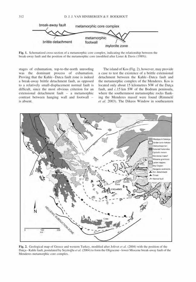
stages of exhumation, top-to-the-north unroofingwas the dominant process of exhumation.Proving that the Kahle–Datca fault zone is indeeda break-away brittle detachment fault, as opposedto a relatively small-displacement normal fault isdifficult, since the most obvious criterion for anextensional detachment fault – a metamorphiccontrast between hanging wall and footwall –is absent.
The island of Kos (Fig. 2), however, may providea case to test the existence of a brittle extensionaldetachment between the Kahle–Datca fault andthe metamorphic complex of the Menderes. Kos islocated only about 15 kilometres NW of the Datcafault, and c.15 km SW of the Bodrum peninsula,where the southernmost metamorphic rocks flank-ing the Menderes massif were found (Rimmeleet al. 2003). The Dikeos Window in southeastern
Fig. 1. Schematized cross-section of a metamorphic core complex, indicating the relationship between thebreak-away fault and the position of the metamorphic core (modified after Lister & Davis (1989)).
Fig. 2. Geological map of Greece and western Turkey, modified after Jolivet et al. (2004) with the position of theDatca–Kahle fault, postulated by Seyitoglu et al. (2004) to form the Oligocene–lower Miocene break-away fault of theMenderes metamorphic core complex.
D. J. J. VAN HINSBERGEN & F. BOEKHOUT312
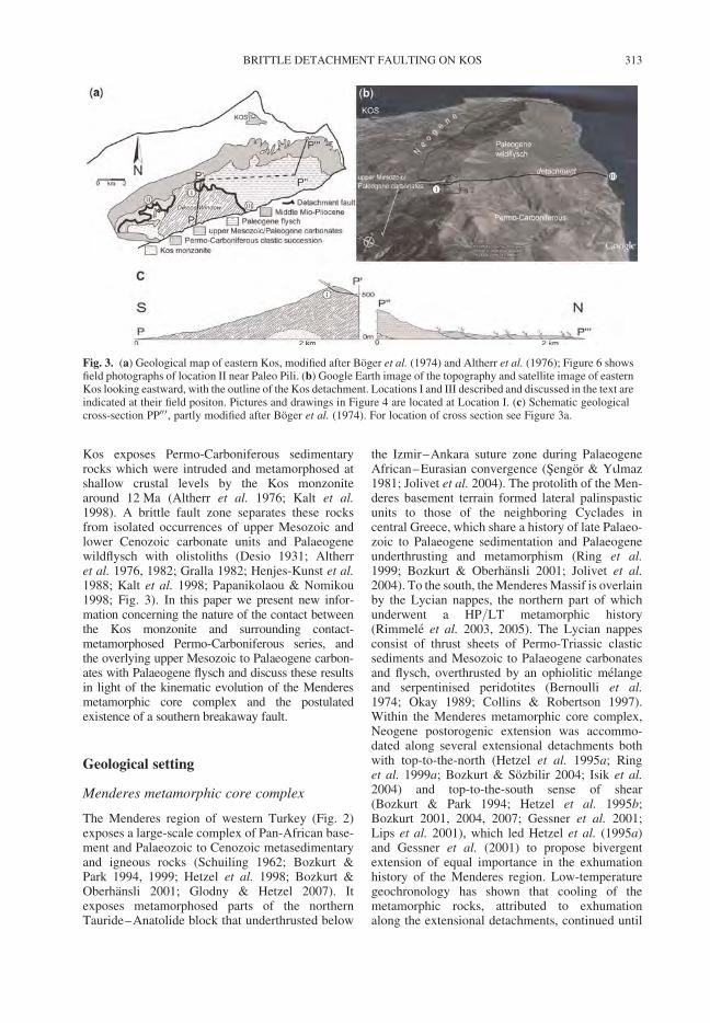
Kos exposes Permo-Carboniferous sedimentaryrocks which were intruded and metamorphosed atshallow crustal levels by the Kos monzonitearound 12 Ma (Altherr et al. 1976; Kalt et al.1998). A brittle fault zone separates these rocksfrom isolated occurrences of upper Mesozoic andlower Cenozoic carbonate units and Palaeogenewildflysch with olistoliths (Desio 1931; Altherret al. 1976, 1982; Gralla 1982; Henjes-Kunst et al.1988; Kalt et al. 1998; Papanikolaou & Nomikou1998; Fig. 3). In this paper we present new infor-mation concerning the nature of the contact betweenthe Kos monzonite and surrounding contact-metamorphosed Permo-Carboniferous series, andthe overlying upper Mesozoic to Palaeogene carbon-ates with Palaeogene flysch and discuss these resultsin light of the kinematic evolution of the Menderesmetamorphic core complex and the postulatedexistence of a southern breakaway fault.
Geological setting
Menderes metamorphic core complex
The Menderes region of western Turkey (Fig. 2)exposes a large-scale complex of Pan-African base-ment and Palaeozoic to Cenozoic metasedimentaryand igneous rocks (Schuiling 1962; Bozkurt &Park 1994, 1999; Hetzel et al. 1998; Bozkurt &Oberhansli 2001; Glodny & Hetzel 2007). Itexposes metamorphosed parts of the northernTauride–Anatolide block that underthrusted below
the Izmir–Ankara suture zone during PalaeogeneAfrican–Eurasian convergence (Sengor & Yilmaz1981; Jolivet et al. 2004). The protolith of the Men-deres basement terrain formed lateral palinspasticunits to those of the neighboring Cyclades incentral Greece, which share a history of late Palaeo-zoic to Palaeogene sedimentation and Palaeogeneunderthrusting and metamorphism (Ring et al.1999; Bozkurt & Oberhansli 2001; Jolivet et al.2004). To the south, the Menderes Massif is overlainby the Lycian nappes, the northern part of whichunderwent a HP/LT metamorphic history(Rimmele et al. 2003, 2005). The Lycian nappesconsist of thrust sheets of Permo-Triassic clasticsediments and Mesozoic to Palaeogene carbonatesand flysch, overthrusted by an ophiolitic melangeand serpentinised peridotites (Bernoulli et al.1974; Okay 1989; Collins & Robertson 1997).Within the Menderes metamorphic core complex,Neogene postorogenic extension was accommo-dated along several extensional detachments bothwith top-to-the-north (Hetzel et al. 1995a; Ringet al. 1999a; Bozkurt & Sozbilir 2004; Isik et al.2004) and top-to-the-south sense of shear(Bozkurt & Park 1994; Hetzel et al. 1995b;Bozkurt 2001, 2004, 2007; Gessner et al. 2001;Lips et al. 2001), which led Hetzel et al. (1995a)and Gessner et al. (2001) to propose bivergentextension of equal importance in the exhumationhistory of the Menderes region. Low-temperaturegeochronology has shown that cooling of themetamorphic rocks, attributed to exhumationalong the extensional detachments, continued until
Fig. 3. (a) Geological map of eastern Kos, modified after Boger et al. (1974) and Altherr et al. (1976); Figure 6 showsfield photographs of location II near Paleo Pili. (b) Google Earth image of the topography and satellite image of easternKos looking eastward, with the outline of the Kos detachment. Locations I and III described and discussed in the text areindicated at their field positon. Pictures and drawings in Figure 4 are located at Location I. (c) Schematic geologicalcross-section PP00 0, partly modified after Boger et al. (1974). For location of cross section see Figure 3a.
BRITTLE DETACHMENT FAULTING ON KOS 313
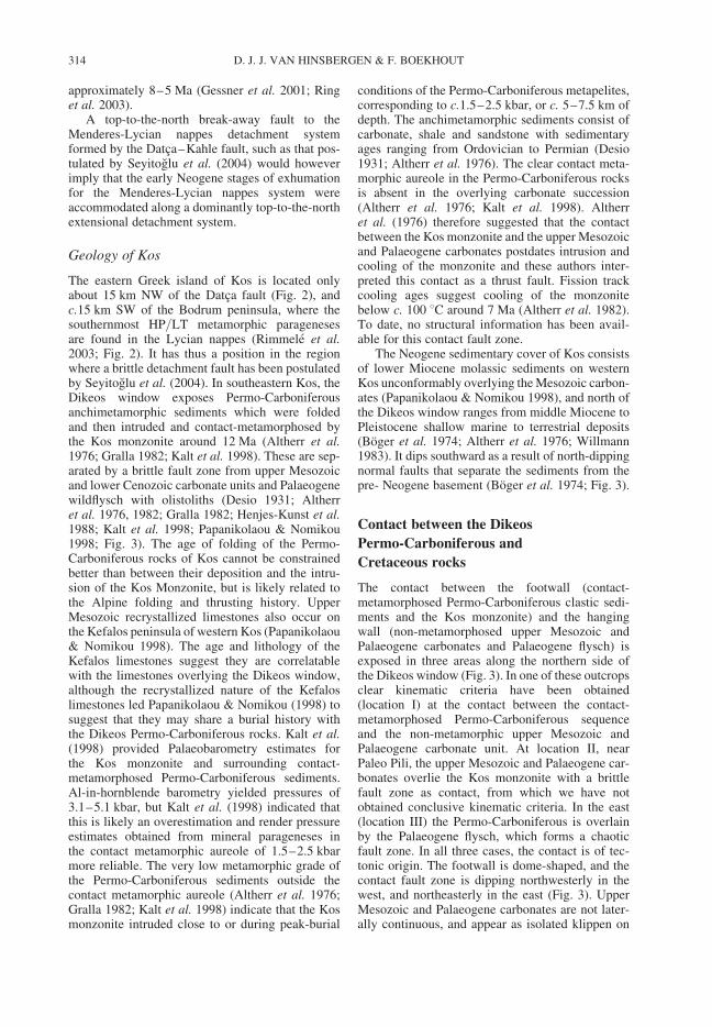
approximately 8–5 Ma (Gessner et al. 2001; Ringet al. 2003).
A top-to-the-north break-away fault to theMenderes-Lycian nappes detachment systemformed by the Datca–Kahle fault, such as that pos-tulated by Seyitoglu et al. (2004) would howeverimply that the early Neogene stages of exhumationfor the Menderes-Lycian nappes system wereaccommodated along a dominantly top-to-the-northextensional detachment system.
Geology of Kos
The eastern Greek island of Kos is located onlyabout 15 km NW of the Datca fault (Fig. 2), andc.15 km SW of the Bodrum peninsula, where thesouthernmost HP/LT metamorphic paragenesesare found in the Lycian nappes (Rimmele et al.2003; Fig. 2). It has thus a position in the regionwhere a brittle detachment fault has been postulatedby Seyitoglu et al. (2004). In southeastern Kos, theDikeos window exposes Permo-Carboniferousanchimetamorphic sediments which were foldedand then intruded and contact-metamorphosed bythe Kos monzonite around 12 Ma (Altherr et al.1976; Gralla 1982; Kalt et al. 1998). These are sep-arated by a brittle fault zone from upper Mesozoicand lower Cenozoic carbonate units and Palaeogenewildflysch with olistoliths (Desio 1931; Altherret al. 1976, 1982; Gralla 1982; Henjes-Kunst et al.1988; Kalt et al. 1998; Papanikolaou & Nomikou1998; Fig. 3). The age of folding of the Permo-Carboniferous rocks of Kos cannot be constrainedbetter than between their deposition and the intru-sion of the Kos Monzonite, but is likely related tothe Alpine folding and thrusting history. UpperMesozoic recrystallized limestones also occur onthe Kefalos peninsula of western Kos (Papanikolaou& Nomikou 1998). The age and lithology of theKefalos limestones suggest they are correlatablewith the limestones overlying the Dikeos window,although the recrystallized nature of the Kefaloslimestones led Papanikolaou & Nomikou (1998) tosuggest that they may share a burial history withthe Dikeos Permo-Carboniferous rocks. Kalt et al.(1998) provided Palaeobarometry estimates forthe Kos monzonite and surrounding contact-metamorphosed Permo-Carboniferous sediments.Al-in-hornblende barometry yielded pressures of3.1–5.1 kbar, but Kalt et al. (1998) indicated thatthis is likely an overestimation and render pressureestimates obtained from mineral parageneses inthe contact metamorphic aureole of 1.5–2.5 kbarmore reliable. The very low metamorphic grade ofthe Permo-Carboniferous sediments outside thecontact metamorphic aureole (Altherr et al. 1976;Gralla 1982; Kalt et al. 1998) indicate that the Kosmonzonite intruded close to or during peak-burial
conditions of the Permo-Carboniferous metapelites,corresponding to c.1.5–2.5 kbar, or c. 5–7.5 km ofdepth. The anchimetamorphic sediments consist ofcarbonate, shale and sandstone with sedimentaryages ranging from Ordovician to Permian (Desio1931; Altherr et al. 1976). The clear contact meta-morphic aureole in the Permo-Carboniferous rocksis absent in the overlying carbonate succession(Altherr et al. 1976; Kalt et al. 1998). Altherret al. (1976) therefore suggested that the contactbetween the Kos monzonite and the upper Mesozoicand Palaeogene carbonates postdates intrusion andcooling of the monzonite and these authors inter-preted this contact as a thrust fault. Fission trackcooling ages suggest cooling of the monzonitebelow c. 100 8C around 7 Ma (Altherr et al. 1982).To date, no structural information has been avail-able for this contact fault zone.
The Neogene sedimentary cover of Kos consistsof lower Miocene molassic sediments on westernKos unconformably overlying the Mesozoic carbon-ates (Papanikolaou & Nomikou 1998), and north ofthe Dikeos window ranges from middle Miocene toPleistocene shallow marine to terrestrial deposits(Boger et al. 1974; Altherr et al. 1976; Willmann1983). It dips southward as a result of north-dippingnormal faults that separate the sediments from thepre- Neogene basement (Boger et al. 1974; Fig. 3).
Contact between the Dikeos
Permo-Carboniferous and
Cretaceous rocks
The contact between the footwall (contact-metamorphosed Permo-Carboniferous clastic sedi-ments and the Kos monzonite) and the hangingwall (non-metamorphosed upper Mesozoic andPalaeogene carbonates and Palaeogene flysch) isexposed in three areas along the northern side ofthe Dikeos window (Fig. 3). In one of these outcropsclear kinematic criteria have been obtained(location I) at the contact between the contact-metamorphosed Permo-Carboniferous sequenceand the non-metamorphic upper Mesozoic andPalaeogene carbonate unit. At location II, nearPaleo Pili, the upper Mesozoic and Palaeogene car-bonates overlie the Kos monzonite with a brittlefault zone as contact, from which we have notobtained conclusive kinematic criteria. In the east(location III) the Permo-Carboniferous is overlainby the Palaeogene flysch, which forms a chaoticfault zone. In all three cases, the contact is of tec-tonic origin. The footwall is dome-shaped, and thecontact fault zone is dipping northwesterly in thewest, and northeasterly in the east (Fig. 3). UpperMesozoic and Palaeogene carbonates are not later-ally continuous, and appear as isolated klippen on
D. J. J. VAN HINSBERGEN & F. BOEKHOUT314
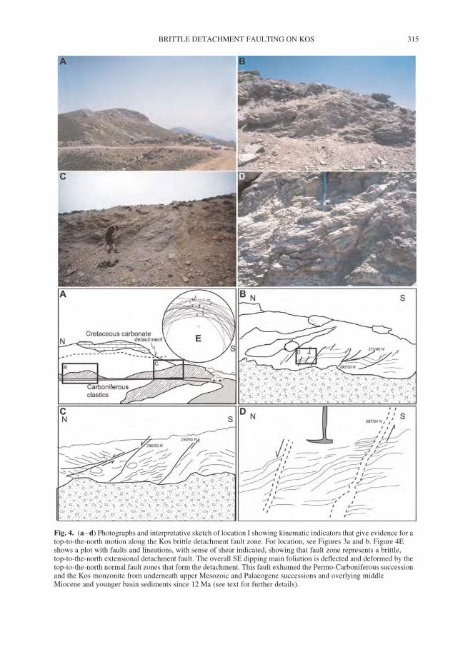
Fig. 4. (a–d) Photographs and interpretative sketch of location I showing kinematic indicators that give evidence for atop-to-the-north motion along the Kos brittle detachment fault zone. For location, see Figures 3a and b. Figure 4Eshows a plot with faults and lineations, with sense of shear indicated, showing that fault zone represents a brittle,top-to-the-north extensional detachment fault. The overall SE dipping main foliation is deflected and deformed by thetop-to-the-north normal fault zones that form the detachment. This fault exhumed the Permo-Carboniferous successionand the Kos monzonite from underneath upper Mesozoic and Palaeogene successions and overlying middleMiocene and younger basin sediments since 12 Ma (see text for further details).
BRITTLE DETACHMENT FAULTING ON KOS 315
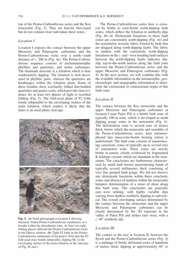
top of the Permo-Carboniferous series and the Kosmonzonite (Fig. 3). They are heavily brecciatedbut do not contain clear individual shear zones.
Location I
Location I exposes the contact between the upperMesozoic and Palaeogene carbonates and thePermo-Carboniferous rocks over a north–southdistance of c. 200 m (Fig. 4a). The Permo-Carbon-iferous sequence consists of anchimetamorphicphyllites and quartzites, and minor carbonates.The dominant structure is a foliation which is heresoutheasterly dipping. The foliation is well devel-oped in phyllitic parts, whereas the quartzites areboudinages within the foliation plane. Some ofthese boudins show isoclinally folded thin-beddedquartzites and quartz-veins, which provide clear evi-dence for at least two phases of tight to isoclinalfolding (Fig. 5). The fold-axial plane of F2 foldstrends subparallel to the enveloping surface of themain foliation, which renders it likely that thelatter is an axial plane cleavage.
The Permo-Carboniferous series here is cross-cut by brittle to semi-brittle north-dipping faultzones, which deflect the foliation to northerly dips(Fig. 4b–d). Slickenside lineations in these faultzones are consistently north-dipping (Fig. 4e) andthe asymmetric tectonic fabric formed by beds thatare dragged along north-dipping faults. The fabricin tandem with the consistenly north-dippinglineations on the c. east–west trending fault surfacesbetween the north-dipping faults indicates dip-slip, top-to-the-north motion along the fault zonebetween the Permo-Carboniferous series and theupper Mesozoic and Palaeogene carbonates (Fig.4). In the next section, we will combine this withthe available information on the metamorphic, geo-chronologic and stratigraphic information to deter-mine the extensional or contractional origin of thisfault zone.
Location II
The contact between the Kos monzonite and theupper Mesozoic and Palaeogene carbonates atlocation I near Paleo Pili is a brittle fault zone oftypically 100 m wide, which is developed as northdipping gouge zones in the monzonite (Fig. 6).The deformation zone is several tens of metresthick, below which the monzonite and xenoliths ofthe Permo-Carboniferous series, here metamor-phosed into muscovite-biotite bearing schists isundeformed. The fault zone consists of anastomos-ing cataclastic zones of typically up to several tensof centimetres wide. These zones are strictlybrittle in nature, clearly evidenced by fragmentedK-feldspar crystals which are abundant in the mon-zonite. The cataclasites are furthermore character-ized by small dark brown anastomosing bands oftypically several millimetres thick consisting ofvery fine grained fault gouge. We did not observeany slickenside lineations within these cataclasticzones and absence of markers within the monzonitehampers determination of a sense of shear alongthis fault zone. The cataclasites are generallyeast–west striking, with highly variable dipsvarying from shallow northerly dipping to subverti-cal. The overall enveloping surface determined bythe contact between the monzonite and the upperMesozoic and Palaeogene carbonates can beclearly determined by the 3D exposure in thevalley of Paleo Pili and strikes east–west, with ac. 408 northerly dip.
Location III
The contact in the east at location II, between theflysch and the Permo-Carboniferous series (Fig. 4)is a melange of brittly deformed rocks of hundredsof metres thick, dipping at approximately 408 to
Fig. 5. (a) Field photograph at location I showingintensely folded Permo-Carboniferous sandstones, in aboudin within the detachment zone. At least two tightfolding phases affected the Permo-Carboniferous rocksin the Dikeos window. (b) Tight F2 folds in the Permo-Carboniferous sandstones of location I. Note that the F2fold axial trace trends subparallel, dipping SE, to theenveloping surface of the main foliation in the outcropsof Fig. 4b and c.
D. J. J. VAN HINSBERGEN & F. BOEKHOUT316
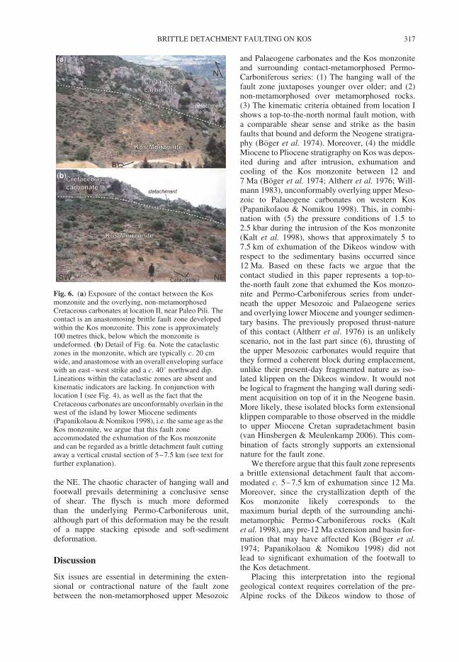
the NE. The chaotic character of hanging wall andfootwall prevails determining a conclusive senseof shear. The flysch is much more deformedthan the underlying Permo-Carboniferous unit,although part of this deformation may be the resultof a nappe stacking episode and soft-sedimentdeformation.
Discussion
Six issues are essential in determining the exten-sional or contractional nature of the fault zonebetween the non-metamorphosed upper Mesozoic
and Palaeogene carbonates and the Kos monzoniteand surrounding contact-metamorphosed Permo-Carboniferous series: (1) The hanging wall of thefault zone juxtaposes younger over older; and (2)non-metamorphosed over metamorphosed rocks.(3) The kinematic criteria obtained from location Ishows a top-to-the-north normal fault motion, witha comparable shear sense and strike as the basinfaults that bound and deform the Neogene stratigra-phy (Boger et al. 1974). Moreover, (4) the middleMiocene to Pliocene stratigraphy on Kos was depos-ited during and after intrusion, exhumation andcooling of the Kos monzonite between 12 and7 Ma (Boger et al. 1974; Altherr et al. 1976; Will-mann 1983), unconformably overlying upper Meso-zoic to Palaeogene carbonates on western Kos(Papanikolaou & Nomikou 1998). This, in combi-nation with (5) the pressure conditions of 1.5 to2.5 kbar during the intrusion of the Kos monzonite(Kalt et al. 1998), shows that approximately 5 to7.5 km of exhumation of the Dikeos window withrespect to the sedimentary basins occurred since12 Ma. Based on these facts we argue that thecontact studied in this paper represents a top-to-the-north fault zone that exhumed the Kos monzo-nite and Permo-Carboniferous series from under-neath the upper Mesozoic and Palaeogene seriesand overlying lower Miocene and younger sedimen-tary basins. The previously proposed thrust-natureof this contact (Altherr et al. 1976) is an unlikelyscenario, not in the last part since (6), thrusting ofthe upper Mesozoic carbonates would require thatthey formed a coherent block during emplacement,unlike their present-day fragmented nature as iso-lated klippen on the Dikeos window. It would notbe logical to fragment the hanging wall during sedi-ment acquisition on top of it in the Neogene basin.More likely, these isolated blocks form extensionalklippen comparable to those observed in the middleto upper Miocene Cretan supradetachment basin(van Hinsbergen & Meulenkamp 2006). This com-bination of facts strongly supports an extensionalnature for the fault zone.
We therefore argue that this fault zone representsa brittle extensional detachment fault that accom-modated c. 5–7.5 km of exhumation since 12 Ma.Moreover, since the crystallization depth of theKos monzonite likely corresponds to themaximum burial depth of the surrounding anchi-metamorphic Permo-Carboniferous rocks (Kaltet al. 1998), any pre-12 Ma extension and basin for-mation that may have affected Kos (Boger et al.1974; Papanikolaou & Nomikou 1998) did notlead to significant exhumation of the footwall tothe Kos detachment.
Placing this interpretation into the regionalgeological context requires correlation of the pre-Alpine rocks of the Dikeos window to those of
Fig. 6. (a) Exposure of the contact between the Kosmonzonite and the overlying, non-metamorphosedCretaceous carbonates at location II, near Paleo Pili. Thecontact is an anastomosing brittle fault zone developedwithin the Kos monzonite. This zone is approximately100 metres thick, below which the monzonite isundeformed. (b) Detail of Fig. 6a. Note the cataclasticzones in the monzonite, which are typically c. 20 cmwide, and anastomose with an overall enveloping surfacewith an east–west strike and a c. 408 northward dip.Lineations within the cataclastic zones are absent andkinematic indicators are lacking. In conjunction withlocation I (see Fig. 4), as well as the fact that theCretaceous carbonates are unconformably overlain in thewest of the island by lower Miocene sediments(Papanikolaou & Nomikou 1998), i.e. the same age as theKos monzonite, we argue that this fault zoneaccommodated the exhumation of the Kos monzoniteand can be regarded as a brittle detachment fault cuttingaway a vertical crustal section of 5–7.5 km (see text forfurther explanation).
BRITTLE DETACHMENT FAULTING ON KOS 317
the Kefalos peninsula, and the pre-Alpine rocksof Kos to the nappes of Greece and westernTurkey, which is not straightforward. The recrystal-lized limestones of late Cretaceous age on theKefalos peninsula are unconformably overlain bylower Miocene molassic sediments with olistoliths(Papanikolaou & Nomikou 1998). The recrystal-lized nature of the limestones led Papanikolaou &Nomikou (1998) to suggest that they may sharea burial history with the Dikeos Permo-Carboniferous rocks.
However, the lower Miocene unconformablecover of the Kefalos carbonates shows that theKefalos Cretaceous carbonates have been nearthe surface throughout the intrusion and exhumationhistory of the Kos monzonite, and it supports corre-lation to the Mesozoic rocks in the hanging wall ofthe Kos detachment. Two models can be postulatedto place the pre-Alpine rocks of Kos in their regionaltectonostratigraphic context. The main difficulty incorrelation is the old age of the Kos Permo-Carboniferous rocks, which is not known from else-where in the Aegean or western Anatolian region(Papanikolaou & Nomikou 1998).
Based on lithology, age and tectonostratigraphiccontext, they may correspond to either the tectono-stratigraphically lowest central Aegean nappeformed by the Tripolitza unit, the Basal Unit andthe Phyllite Quartzite, or to the structurally highestLycian nappes. Blondeau et al. (1975) and Papani-kolaou & Nomikou (1998) correlated the Mesozoicto Palaeogene carbonates of Kos to the Tripolitzaand Pindos nappes of western Greece based on ageand sedimentary facies. If this suggestion iscorrect, the Permo-Carboniferous of Kos could cor-relate to the HP/LT metamorphic Phyllite Quartziteunit exposed on Crete. Alternatively, the pre-Neogene rocks of Kos may belong to the Lyciannappes, which on nearby Turkish peninsulasexpose Permo-Triassic clastic sediments and Meso-zoic–Palaeogene carbonates and flysch (Bernoulliet al. 1974; Collins & Robertson, 1997). We advo-cate the latter correlation based on their non- toanchimetamorphic character and their positionamidst rocks belonging to the Lycian nappes withcomparable age and facies exposed on the Turkishpeninsulas north and south of Kos.
The intrusion of the Kos monzonite and associ-ated contact metamorphism provide a unique oppor-tunity to show that in the south of the metamorphicrocks of the Menderes metamorphic core complex,top-to-the-north extensional detachment faultinghas been active. This suggests that Kos has beena focused deformation site within the Cyclades–Menderes extensional province since 12 Ma. Thetop-to-the-north component of shear of the brittleKos detachment is in line with the scenario ofSeyitoglu et al. (2004), which postulates that the
Datca fault south of Kos is the Oligocene–lowerMiocene break-away fault of the core complex.However, the thermodynamic reconstruction ofKalt et al. (1998) shows that the Kos monzoniteintruded the Permo-Carboniferous series close topeak burial conditions, indicating that no significantexhumation occurred on Kos prior to 12 Ma.Seyitoglu et al. (2004) suggested that the Datcabreakaway fault was active during Oligocene toearly Miocene times. This can only be valid if therocks on Kos belong to the hanging wall of theOligocene–early Miocene detachment systeminferred by Seyitoglu et al. (2004). We cannot cor-roborate the existence of a Oligocene–earlyMiocene brittle detachment on Kos and this makesthe scenario of Seyitoglu et al. (2004) unlikely.Moreover, seismic profiles of Kurt et al. (1999)and Ulug et al. (2005) cannot corroborate anyon-land continuation of this fault zone and theseauthors instead suggested a much younger, lateMiocene or Pliocene age of the Datca Fault. Theexistence of a brittle detachment on Kos doesshow that brittle detachment faulting exhumedupper crustal rocks from mid upper crustal depthssouth of the Menderes and eastern Cycladic meta-morphic core complexes, but the Kos detachmentappears to be a relatively isolated structure. Ournew data indicate that there is no evidence that theDatca fault forms part of a southerly Oligocene tolower Miocene break-away fault of the Menderescore complex as suggested by Seyitoglu et al.(2004). This renders the bivergent rolling-hingescenario of Gessner et al. (2001) as a better fittingsolution for the kinematic evolution of the Menderescore complex.
Conclusions
The Menderes metamorphic core complex westernTurkey is clearly defined in the north by extensionaldetachments along which a sharp metamorphic con-trast exists between hanging wall and footwall. Thesouthern limit of the core complex is less welldefined. An Oligocene–early Miocene breakawayfault has previously been postulated in the Lyciannappes in southwestern Turkey. Showing the exist-ence of a breakaway detachment fault is difficultdue to absence of a metamorphic contrast alongthe fault for those parts where only upper crustalrocks are exhumed. The island of Kos, just northof the inferred breakaway fault, exposes Permo-Carboniferous anchimetamorphic rocks, intrudedand contact-metamorphosed by a 12 Ma old monzo-nite. Here, we show that exhumation of these rockswas accommodated along a top-to-the-north brittleextensional detachment emplacing them underneathnon-metamorphosed upper Mesozoic to Palaeogenecarbonates and Neogene basin sediments.
D. J. J. VAN HINSBERGEN & F. BOEKHOUT318
Previously published petrological constraints onthe burial history of the Permo-Carboniferous seriesof Kos has shown that the Kos monzonite intrudedclose to peak-burial conditions, showing that anypre-12 Ma extension and basin formation on Koshas not led to any detectable exhumation of thePermo-Carboniferous series. We conclude that theisland of Kos should be placed within the Cyclades–Menderes extensional province. However, the ageof exhumation is younger than the proposed activityof the breakaway of the Menderes metamorphiccore complex (Seyitoglu et al. 2004), and the biver-gent rolling-hinge scenario of Gessner et al. (2001)remains a better fitting solution. We conclude thatthe brittle detachment of Kos cannot be straight-forwardly correlated to any ductile-to-brittle deta-chments of the Menderes or eastern Cycladicmetamorphic core complexes further to the northand may represent a relatively isolated structure.
Research of DJJvH was funded by a Dutch Council forScientific Research (NWO) ‘Veni’- grant. M. Koopmanis thanked for the pleasant discussions and her help inthe field. E. Bozkurt is thanked for fruitful comments andsuggestions on an earlier version of this manuscript. Wethank K. Gessner and G. Zulauf for their reviews andM. Edwards for editorial comments.
References
ALTHERR, R., KELLER, J. & KOTT, K. 1976. Der jungter-tiare Monzonit von Kos und sein Kontakthof (Agais,Griechenland). Bulletin de la Societe Geologique deFrance, 18, 403–412.
ALTHERR, R., KREUZER, H., WENDT, I., LENZ, H.,WAGNER, G. A., KELLER, J. ET AL. 1982. A late Oli-gocene/Early Miocene high temperature belt in theAttica Cycladic crystalline complex (SE Pelagonian,Greece). Geologisches Jahrbuch, E23, 97–164.
BERNOULLI, D., DEGRACIANSKY, P. C. & MONOD, O.1974. The extension of the Lycian Nappes (SWTurkey) into the SE Aegean islands. Eclogae Geologi-cae Helveticae, 67, 39–90.
BLONDEAU, A., FLEURY, J. J. & GUERNET, C. 1975. Surl’existence dans l’ıle de Kos (Dodecanese, Grece),d’une serie netritique surmontee d’un flysch d’ageCuisien superieur ou Lutetien inferieur a sa base.Comptes Rendus Academie Science Paris, 280,817–819.
BOGER, H., GERSONDE, R. & WILLMAN, R. 1974. DasNeogen im Osten der Insel Kos (Agais, Dodekanes) –Stratigraphie und Tektonik. Neues Jahrbuch Geologieund Palaeontologie Abh., 145, 129–152.
BOZKURT, E. 2001. Late Alpine evolution of the centralMenderes Massif, western Turkey. InternationalJournal of Earth Sciences, 89, 728–744.
BOZKURT, E. 2004. Granitoid rocks of the southernMenderes Massif (southwestern Turkey): fieldevidence for Tertiary magmatism in an extensionalshear zone. International Journal of Earth Sciences,93, 52–71.
BOZKURT, E. 2007. Extensional v. contractional origin forthe southern Menderes shear zone, SW Turkey: tec-tonic and metamorphic implications. GeologicalMagazine, 144, 191–210.
BOZKURT, E. & OBERHANSLI, R. 2001. Menderes Massif(Western Turkey): structural, metamorphic and mag-matic evolution – a synthesis. International Journalof Earth Sciences, 89, 679–708.
BOZKURT, E. & PARK, R. G. 1994. Southern MenderesMassif: an incipient metamorphic core complex inwestern Anatolia, Turkey. Journal of the GeologicalSociety of London, 151, 213–216.
BOZKURT, E. 1999. The structure of the Palaeozoic schistsin the southern Menderes Massif, western Turkey: anew approach to the origin of the Main MenderesMetamorphism and its relation to the Lycian Nappes.Geodinamica Acta, 12, 25–42.
BOZKURT, E. & SATIR, M. 2000. The southern MenderesMassif (western Turkey): geochronology and exhuma-tion history. Geological Journal, 35, 285–296.
BOZKURT, E. & SOZBILIR, H. 2004. Tectonic evolution ofthe Gediz Graben: field evidence for an episodic, two-stage extension in western Turkey. Geological Maga-zine, 141, 63–79.
COLLINS, A. S. & ROBERTSON, A. H. F. 1997. Processesof Late Cretaceous to Late Miocene episodic thrust-sheet translation in the Lycian Taurides. SW Turkey.Geology, 25, 255–258.
CRITTENDEN, M. D. JR., CONEY, P. J. & DAVIS, G. H.1980. Cordilleran metamorphic core complexes.Geological Society of America Memoirs, 153, TheGeological Society of America, Colorado.
DAVIS, G. H. 1983. Shear-zone model for the originof metamorphic core complexes. Geology, 11,342–347.
DESIO, A. 1931. Le isole Italiane dell’Egio. Memoir CartaGeologia d’Italia, 24.
DORSEY, R. J. & BECKER, U. 1995. Evolution of a largeMiocene growth structure in the upper plate of theWhipple detachment fault, north-eastern WhippleMountains, California. Basin Research, 7, 151–163.
GESSNER, K., RING, U., JOHNSON, C., HETZEL, R.,PASSCHIER, C. W. & GUNGOR, T. 2001. An activebivergent rolling-hinge detachment system: centralMenderes metamorphic core complex in westernTurkey. Geology, 29, 611–614.
GLODNY, J. & HETZEL, R. 2007. Precise U-Pb ages ofsyn-extensional Miocene intrusions in the central Men-deres Massif, western Turkey. Geological Magazine,144, 235–246.
GRALLA, P. 1982. Das Praneogen der Insel Kos (Dode-kanes, Griechenland). PhD Thesis, University ofBraunschweig.
HENJES-KUNST, F., ALTHERR, R., KREUZER, H. &TAUBER HANSEN, B. 1988. Disturbed U-Th-Pb sys-tematics of young zircons and uranothorites: the caseof the Miocene Aegean granitoids (Greece). ChemicalGeology, 73, 125–145.
HETZEL, R., PASSCHIER, C. W., RING, U. & DORA, O. O.1995a. Bivergent extension in orogenic belts: theMenderes massif (southwestern Turkey). Geology,23, 455–458.
HETZEL, R., RING, U., AKAL, C. & TROESCH, M. 1995b.Miocene NNE-directed extensional unroofing in the
BRITTLE DETACHMENT FAULTING ON KOS 319
Menderes Massif, southwestern Turkey. Journal of theGeological Society of London, 152, 639–564.
HETZEL, R., ROMER, R. L., CANDAN, O. & PASSCHIER,C. W. 1998. Geology of the Bozdag area, central Men-deres massif, SW Turkey: Pan-African basement andAlpine deformation. Geologische Rundschau, 87,394–406.
ISIK, V., TEKELI, O. & SEYITOGLU, G. 2004. The40Ar/39Ar age of extensional ductile deformation andgranitoid intrusion in the northern Menderes corecomplex: implications for the initiation of extensionaltectonics in western Turkey. Journal of Asian EarthSciences, 23, 555–566.
JOLIVET, L., RIMMELE, G., OBERHANSLI, R., GOFFE, B.& CANDAN, O. 2004. Correlation of synorogenic tec-tonic and metamorphic events in the Cyclades, theLycian Nappes and the Menderes Massif. Geodynamicimplications. Bulletin de la Societe Geologique deFrance, 175, 217–238.
KALT, A., ALTHERR, R. & LUDWIG, T. 1998. Contactmetamorphism in pelitic rocks on the island of Kos(Greece, Eastern Aegan Sea): a test for theNa-in-cordierite thermometer. Journal of Petrology,39, 663–688.
KURT, H., DEMIRBAG, E. & KUSCU, I. 1999. Investi-gation of the submarine active tectonism in the Gulfof Gokova, southwest Anatolia-southeast AegeanSea, by multi-channel seismic reflection data. Tectono-physics, 305, 477–496.
LIPS, A. L. W., CASSARD, D., SOZBILIR, H. & YiLMAZ,H. 2001. Multistage exhumation of the MenderesMassif, western Anatolia (Turkey). InternationalJournal of Earth Sciences, 89, 781–792.
LISTER, G. S. & DAVIS, G. A. 1989. The origin of meta-morphic core complexes and detachment faults formedduring Tertiary continental extension in the northernColorado River region, U.S.A. Journal of StructuralGeology, 11, 65–94.
LISTER, G. S., BANGA, G. & FEENSTRA, A. 1984.Metamorphic core complexes of Cordilleran type inthe Cyclades. Aegean Sea, Greece. Geology, 12,221–225.
OKAY, A. I. 1989. Geology of the Menderes Massif andthe Lycian Nappes south of Denizli, western Taurides.Mineral Resources Exploration Bulletin, 109, 37–51.
OTTON, J. K. 1995. Western frontal fault of the CanyonRange: is it the breakaway zone of the Sevier Desertdetachment? Geology, 23, 547–550.
PAPANIKOLAOU, D. J. & NOMIKOU, P. V. 1998. ThePalaeozoic of Kos: a low grade metamorphic unit ofthe basement of the eternal Hellenides terrane.Special Publications of the Geological Society ofGreece, 3, 155–166.
RIMMELE, G., JOLIVET, L., OBERHANSLI, R. & GOFFE,B. 2003. Deformation history of the high-pressureLycian Nappes and implications for the tectonic evol-ution of SW Turkey. Tectonics, 22, 1007.
RIMMELE, G., PARRA, T., GOFFE, B., OBERHANSLI, R.,JOLIVET, L. & CANDAN, O. 2005. Exhumation paths
of high-pressure – low-temperature metamorphicrocks from the Lycian Nappes and the MenderesMassif (SW Turkey): a multi-equilibrium approach.Journal of Petrology, 46, 641–669.
RING, U., GESSNER, K., GUNGOR, T. & PASSCHIER,C. W. 1999. The Menderes Massif of western Turkeyand the Cycladic Massif in the Aegean – do theyreally correlate? Journal of the Geologic Society ofLondon, 156, 3–6.
RING, U., JOHNSON, C., HETZEL, R. & GESSNER, K.2003. Tectonic denudation of a Late Cretaceous-Tertiary collisional belt: regionally symmetriccooling patterns and their relation to extensionalfaults in the Anatolide belt of western Turkey. Geologi-cal Magazine, 140, 421–441.
SCHUILING, R. D. 1962. On petrology, age and evolutionof the Menderes Massif, W-Turkey: a rubidium/stron-tium and oxygen isotope study. Bulletin of the Institutefor Mineral Research and Exploration, Turkey, 58,703–714.
SENGOR, A. M. C. & YiLMAZ, Y. 1981. Tethyan evol-ution of Turkey: a plate-tectonic approach. Tectono-physics, 75, 181–241.
SEYITOGLU, G., ISIK, V. & CEMEN, I. 2004. CompleteTertiary exhumation history of the Menderes massif,western Turkey: an alternative working hypothesis.Terra Nova, 16, 358–364.
TIREL, C., BRUN, J.-P. & BUROV, E. 1998. Dynamicsand structural development of metamorphic corecomplexes. Journal of Geophysical Research, 113,B04403, doi: 10.1029/2005JB003694.
TIREL, C., GAUTIER, P., VAN HINSBERGEN, D. J. J. &WORTEL, M. J. R. 2009. Sequential development ofinterfering metamorphic core complexes: numericalexperiments and comparison with the Cyclades,Greece. In: VAN HINSBERGEN, D. J. J., EDWARDS,M. A. & GOVERS, R. (eds) Collision and Collapse atthe African–Arabia–Eurasia Subduction Zone. Geo-logical Society, London, Special Publications, 311,257–292.
ULUG, A., DUMAN, M., ERSOY, S., OZEL, E. & AVCI, M.2005. Late Quarternary sea-level change, sedimen-tation and neotectonics of the Gulf of Gokova:Southeastern Aegean Sea. Marine Geology, 221,381–395.
VAN HINSBERGEN, D. J. J. & MEULENKAMP, J. E.2006. Neogene supra-detachment basin developmenton Crete (Greece) during exhumation of theSouth Aegean core complex. Basin Research, 18,103–124.
WERNICKE, B. 1981. Low-angle normal faults in theBasin and Range province: Nappe tectonics in anextending orogen. Nature, 291, 645–648.
WERNICKE, B. 1995. Low-angle normal faults andseismicity: a review. Journal of Geophysical Research,100, B10, 20159–20174.
WILLMANN, R. 1983. Neogen und jungtertiare Enwick-lung der Insel Kos (Agais, Griechenland). GeologischeRundschau, 72, 815–860.
D. J. J. VAN HINSBERGEN & F. BOEKHOUT320
Magnetostratigraphy of early–middle Miocene deposits from
east–west trending Alasehir and Buyuk Menderes grabens in
western Turkey, and its tectonic implications
SEVKET SEN1* & GUROL SEYITOGLU2
1UMR 5143 du CNRS, Museum national d’Histoire naturelle, Departement Histoire de la Terre,
8 rue Buffon, 75005 Paris, France2Ankara University, Department of Geological Engineering, Tectonics Research Group,
TR-06100 Tandogan, Ankara, Turkey
*Corresponding author (e-mail: [email protected])
Abstract: In western Turkey, the Alasehir and Buyuk Menderes grabens form east–west trendingmajor tectonic structures. Their sedimentary fill is important for regional tectonic models for thelate Cenozoic evolution of the Aegean region. These deposits are divided into four units datedbetween the early Miocene and Quaternary. We studied the magnetostratigraphy of two sectionsin the Alasehir graben and one in the Buyuk Menderes, partly covering the first and second sedi-mentary units. Detailed palaeomagnetic analysis allowed us to determine ChRM component forthese rocks. The Zeytincayı river and road sections (Alasehir graben) record several polarity rever-sals, which are tentatively correlated to the interval C5Cn.3n–C5ADr (approximately between14.6–16.6 Ma) of the ATNTS2004. This correlation is also supported by palaeontology and radio-metric dating of syn-extensional intrusions. In the Eycelli section (Buyuk Menderes graben) onlythree polarity zones are recorded, and their tentative correlation with the interval of C5Bn.1r–C5Br(14.88–15.97 Ma) is in overall in agreement with the record of Eskihisar sporomorph associationin this formation. These results place the initiation of the Alasehir and Buyuk Menderes grabens inthe early Miocene. The palaeomagnetic declinations from the Alasehir graben indicate about 258anticlockwise rotation, whereas that of the Buyuk Menderes graben indicate a clockwise rotation ofabout 30–408. These contradictory vertical-axis rotations might be explained by detachment faultsin the region. In Tertiary formations of western Turkey, contradictory block rotations are commonand likely reflect thin-skinned deformation in the area rather than rigid crustal movements. There-fore, average anticlockwise rotations in western Turkey cannot be used as evidence for the modelof back-arc spreading in the Aegean region.
Western Turkey is located in the eastern part of theAegean region (Fig. 1, inset), one of the highlyextended terrains in the world, and consists of meta-morphic core complexes (Bozkurt & Park 1994;Hetzel et al. 1995; Okay & Satır 2000; Isık &Tekeli 2001). The Menderes core complex coversextensive areas in western Turkey. Recent region-wide tectonic models dealing with the exhumationof the Menderes core complex suggest that vorth–south extensional tectonics initiated in the Oligo-cene times (Ring et al. 2003; Seyitoglu et al.2004). A symmetrical core complex model hasbeen proposed that the Menderes massif isexhumed along the south dipping Lycian and northdipping Simav detachments (Ring et al. 2003).Alternatively, asymmetrical core complex for-mation is proposed along with the north dippingDatca–Kale main breakaway fault and its northerncontinuation, the Simav detachment (Seyitogluet al. 2004). Although these models have different
views on the style of Menderes massif’s initial exhu-mation, both models agree that the central Menderesmassif is further exhumed along with the northdipping Alasehir (Kuzey) and south dippingBuyuk Menderes (Guney) detachments that borderthe prominent east–west trending structures(Alasehir and Buyuk Menderes grabens) inwestern Turkey (Fig. 1).
Even if these recent region-wide models implythat the formation of east–west trending grabensrepresent an advanced stage of north–south exten-sional tectonics in western Turkey, initiation andevolution of these structures are still importantquestions to understand the relationships betweenextensional tectonics and basin formation.
The views on the initial development of east–west trending grabens can be classified intotwo groups. One group suggests that east–westtrending grabens are younger than late Mioceneand they contain trapped fragments of earlier
From: VAN HINSBERGEN, D. J. J., EDWARDS, M. A. & GOVERS, R. (eds) Collision and Collapse at theAfrica–Arabia–Eurasia Subduction Zone. The Geological Society, London, Special Publications, 311, 321–342.DOI: 10.1144/SP311.13 0305-8719/09/$15.00 # The Geological Society of London 2009.
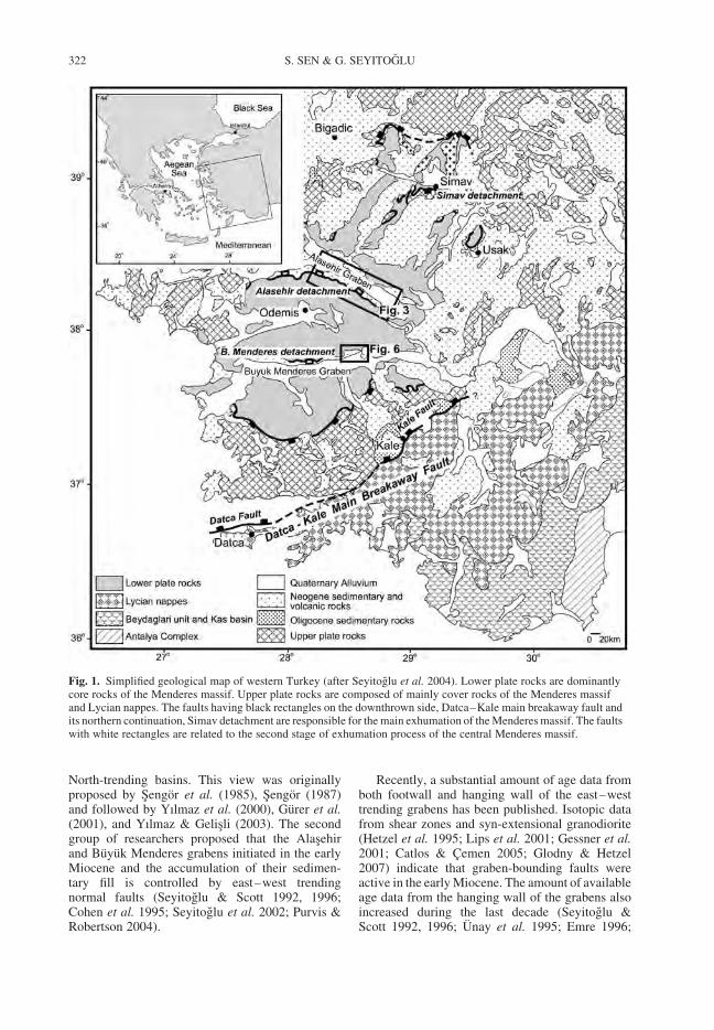
North-trending basins. This view was originallyproposed by Sengor et al. (1985), Sengor (1987)and followed by Yılmaz et al. (2000), Gurer et al.(2001), and Yılmaz & Gelisli (2003). The secondgroup of researchers proposed that the Alasehirand Buyuk Menderes grabens initiated in the earlyMiocene and the accumulation of their sedimen-tary fill is controlled by east–west trendingnormal faults (Seyitoglu & Scott 1992, 1996;Cohen et al. 1995; Seyitoglu et al. 2002; Purvis &Robertson 2004).
Recently, a substantial amount of age data fromboth footwall and hanging wall of the east–westtrending grabens has been published. Isotopic datafrom shear zones and syn-extensional granodiorite(Hetzel et al. 1995; Lips et al. 2001; Gessner et al.2001; Catlos & Cemen 2005; Glodny & Hetzel2007) indicate that graben-bounding faults wereactive in the early Miocene. The amount of availableage data from the hanging wall of the grabens alsoincreased during the last decade (Seyitoglu &Scott 1992, 1996; Unay et al. 1995; Emre 1996;
Fig. 1. Simplified geological map of western Turkey (after Seyitoglu et al. 2004). Lower plate rocks are dominantlycore rocks of the Menderes massif. Upper plate rocks are composed of mainly cover rocks of the Menderes massifand Lycian nappes. The faults having black rectangles on the downthrown side, Datca–Kale main breakaway fault andits northern continuation, Simav detachment are responsible for the main exhumation of the Menderes massif. The faultswith white rectangles are related to the second stage of exhumation process of the central Menderes massif.
S. SEN & G. SEYITOGLU322
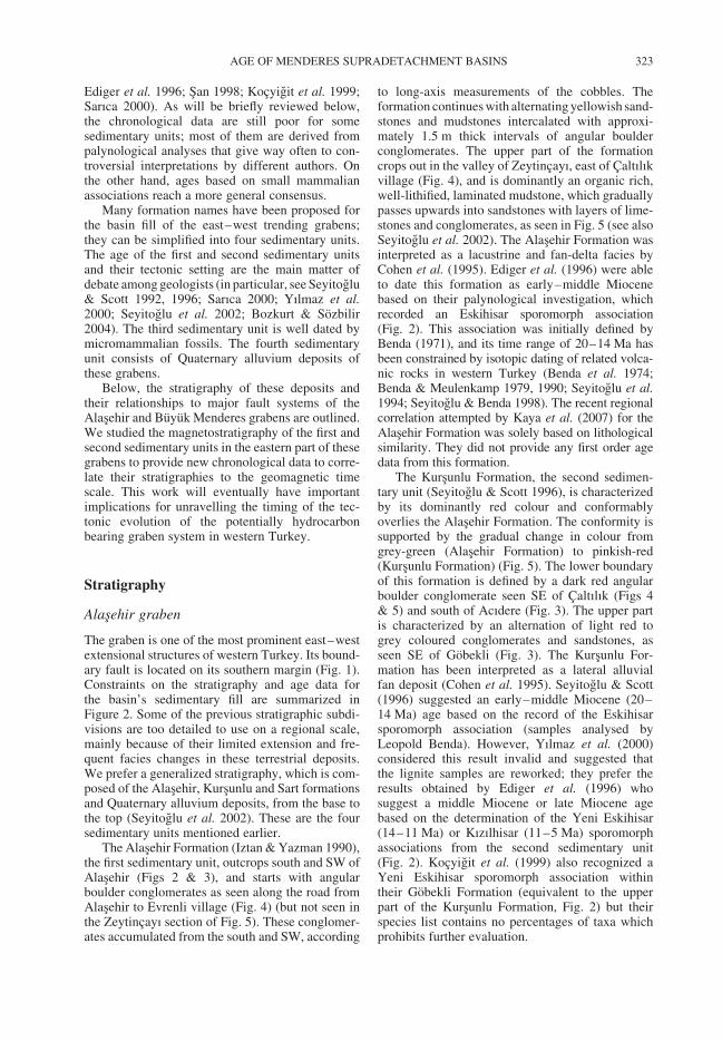
Ediger et al. 1996; San 1998; Kocyigit et al. 1999;Sarıca 2000). As will be briefly reviewed below,the chronological data are still poor for somesedimentary units; most of them are derived frompalynological analyses that give way often to con-troversial interpretations by different authors. Onthe other hand, ages based on small mammalianassociations reach a more general consensus.
Many formation names have been proposed forthe basin fill of the east–west trending grabens;they can be simplified into four sedimentary units.The age of the first and second sedimentary unitsand their tectonic setting are the main matter ofdebate among geologists (in particular, see Seyitoglu& Scott 1992, 1996; Sarıca 2000; Yılmaz et al.2000; Seyitoglu et al. 2002; Bozkurt & Sozbilir2004). The third sedimentary unit is well dated bymicromammalian fossils. The fourth sedimentaryunit consists of Quaternary alluvium deposits ofthese grabens.
Below, the stratigraphy of these deposits andtheir relationships to major fault systems of theAlasehir and Buyuk Menderes grabens are outlined.We studied the magnetostratigraphy of the first andsecond sedimentary units in the eastern part of thesegrabens to provide new chronological data to corre-late their stratigraphies to the geomagnetic timescale. This work will eventually have importantimplications for unravelling the timing of the tec-tonic evolution of the potentially hydrocarbonbearing graben system in western Turkey.
Stratigraphy
Alasehir graben
The graben is one of the most prominent east–westextensional structures of western Turkey. Its bound-ary fault is located on its southern margin (Fig. 1).Constraints on the stratigraphy and age data forthe basin’s sedimentary fill are summarized inFigure 2. Some of the previous stratigraphic subdi-visions are too detailed to use on a regional scale,mainly because of their limited extension and fre-quent facies changes in these terrestrial deposits.We prefer a generalized stratigraphy, which is com-posed of the Alasehir, Kursunlu and Sart formationsand Quaternary alluvium deposits, from the base tothe top (Seyitoglu et al. 2002). These are the foursedimentary units mentioned earlier.
The Alasehir Formation (Iztan & Yazman 1990),the first sedimentary unit, outcrops south and SW ofAlasehir (Figs 2 & 3), and starts with angularboulder conglomerates as seen along the road fromAlasehir to Evrenli village (Fig. 4) (but not seen inthe Zeytincayı section of Fig. 5). These conglomer-ates accumulated from the south and SW, according
to long-axis measurements of the cobbles. Theformation continues with alternating yellowish sand-stones and mudstones intercalated with approxi-mately 1.5 m thick intervals of angular boulderconglomerates. The upper part of the formationcrops out in the valley of Zeytincayı, east of Caltılıkvillage (Fig. 4), and is dominantly an organic rich,well-lithified, laminated mudstone, which graduallypasses upwards into sandstones with layers of lime-stones and conglomerates, as seen in Fig. 5 (see alsoSeyitoglu et al. 2002). The Alasehir Formation wasinterpreted as a lacustrine and fan-delta facies byCohen et al. (1995). Ediger et al. (1996) were ableto date this formation as early–middle Miocenebased on their palynological investigation, whichrecorded an Eskihisar sporomorph association(Fig. 2). This association was initially defined byBenda (1971), and its time range of 20–14 Ma hasbeen constrained by isotopic dating of related volca-nic rocks in western Turkey (Benda et al. 1974;Benda & Meulenkamp 1979, 1990; Seyitoglu et al.1994; Seyitoglu & Benda 1998). The recent regionalcorrelation attempted by Kaya et al. (2007) for theAlasehir Formation was solely based on lithologicalsimilarity. They did not provide any first order agedata from this formation.
The Kursunlu Formation, the second sedimen-tary unit (Seyitoglu & Scott 1996), is characterizedby its dominantly red colour and conformablyoverlies the Alasehir Formation. The conformity issupported by the gradual change in colour fromgrey-green (Alasehir Formation) to pinkish-red(Kursunlu Formation) (Fig. 5). The lower boundaryof this formation is defined by a dark red angularboulder conglomerate seen SE of Caltılık (Figs 4& 5) and south of Acıdere (Fig. 3). The upper partis characterized by an alternation of light red togrey coloured conglomerates and sandstones, asseen SE of Gobekli (Fig. 3). The Kursunlu For-mation has been interpreted as a lateral alluvialfan deposit (Cohen et al. 1995). Seyitoglu & Scott(1996) suggested an early–middle Miocene (20–14 Ma) age based on the record of the Eskihisarsporomorph association (samples analysed byLeopold Benda). However, Yılmaz et al. (2000)considered this result invalid and suggested thatthe lignite samples are reworked; they prefer theresults obtained by Ediger et al. (1996) whosuggest a middle Miocene or late Miocene agebased on the determination of the Yeni Eskihisar(14–11 Ma) or Kızılhisar (11–5 Ma) sporomorphassociations from the second sedimentary unit(Fig. 2). Kocyigit et al. (1999) also recognized aYeni Eskihisar sporomorph association withintheir Gobekli Formation (equivalent to the upperpart of the Kursunlu Formation, Fig. 2) but theirspecies list contains no percentages of taxa whichprohibits further evaluation.
AGE OF MENDERES SUPRADETACHMENT BASINS 323
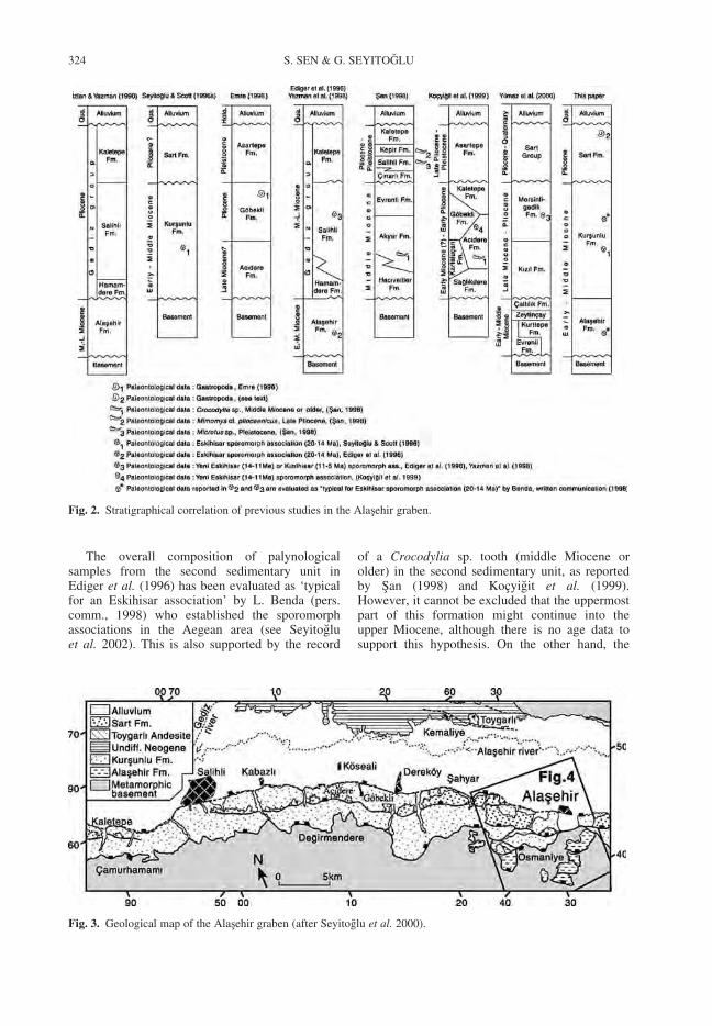
The overall composition of palynologicalsamples from the second sedimentary unit inEdiger et al. (1996) has been evaluated as ‘typicalfor an Eskihisar association’ by L. Benda (pers.comm., 1998) who established the sporomorphassociations in the Aegean area (see Seyitogluet al. 2002). This is also supported by the record
of a Crocodylia sp. tooth (middle Miocene orolder) in the second sedimentary unit, as reportedby San (1998) and Kocyigit et al. (1999).However, it cannot be excluded that the uppermostpart of this formation might continue into theupper Miocene, although there is no age data tosupport this hypothesis. On the other hand, the
Fig. 2. Stratigraphical correlation of previous studies in the Alasehir graben.
Fig. 3. Geological map of the Alasehir graben (after Seyitoglu et al. 2000).
S. SEN & G. SEYITOGLU324
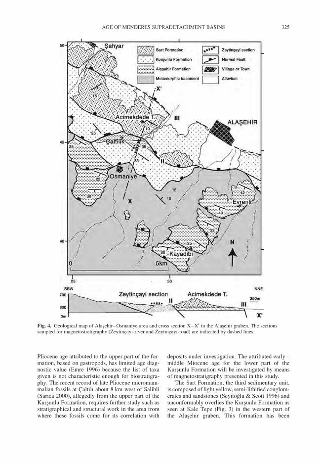
Pliocene age attributed to the upper part of the for-mation, based on gastropods, has limited age diag-nostic value (Emre 1996) because the list of taxagiven is not characteristic enough for biostratigra-phy. The recent record of late Pliocene micromam-malian fossils at Caltılı about 8 km west of Salihli(Sarıca 2000), allegedly from the upper part of theKursunlu Formation, requires further study such asstratigraphical and structural work in the area fromwhere these fossils come for its correlation with
deposits under investigation. The attributed early–middle Miocene age for the lower part of theKursunlu Formation will be investigated by meansof magnetostratigraphy presented in this study.
The Sart Formation, the third sedimentary unit,is composed of light yellow, semi-lithified conglom-erates and sandstones (Seyitoglu & Scott 1996) andunconformably overlies the Kursunlu Formation asseen at Kale Tepe (Fig. 3) in the western part ofthe Alasehir graben. This formation has been
Fig. 4. Geological map of Alasehir–Osmaniye area and cross section X–X0 in the Alasehir graben. The sectionssampled for magnetostratigraphy (Zeytincayı-river and Zeytincayı-road) are indicated by dashed lines.
AGE OF MENDERES SUPRADETACHMENT BASINS 325
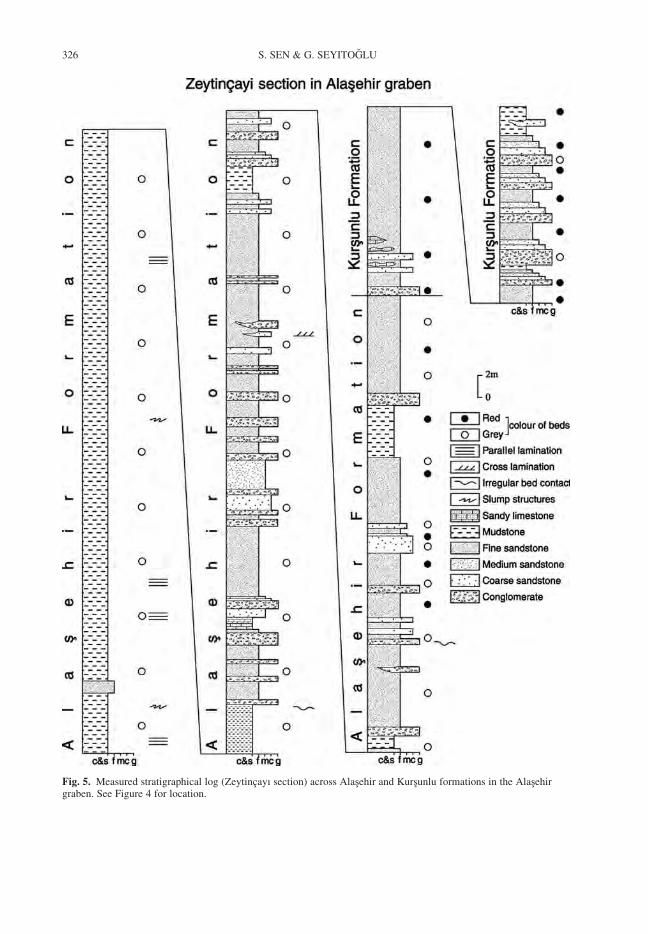
Fig. 5. Measured stratigraphical log (Zeytincayı section) across Alasehir and Kursunlu formations in the Alasehirgraben. See Figure 4 for location.
S. SEN & G. SEYITOGLU326
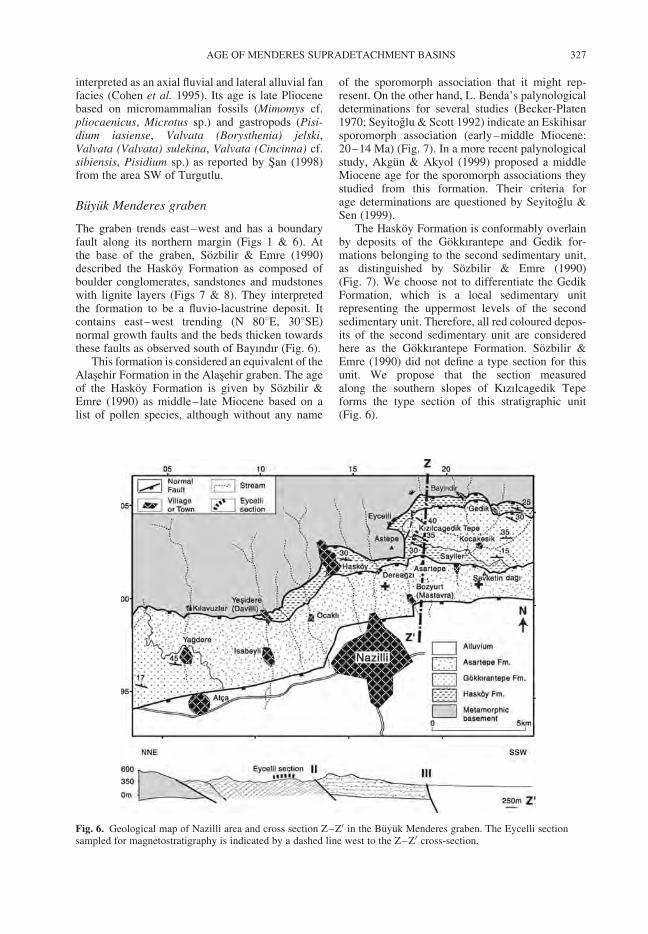
interpreted as an axial fluvial and lateral alluvial fanfacies (Cohen et al. 1995). Its age is late Pliocenebased on micromammalian fossils (Mimomys cf.pliocaenicus, Microtus sp.) and gastropods (Pisi-dium iasiense, Valvata (Borysthenia) jelski,Valvata (Valvata) sulekina, Valvata (Cincinna) cf.sibiensis, Pisidium sp.) as reported by San (1998)from the area SW of Turgutlu.
Buyuk Menderes graben
The graben trends east–west and has a boundaryfault along its northern margin (Figs 1 & 6). Atthe base of the graben, Sozbilir & Emre (1990)described the Haskoy Formation as composed ofboulder conglomerates, sandstones and mudstoneswith lignite layers (Figs 7 & 8). They interpretedthe formation to be a fluvio-lacustrine deposit. Itcontains east–west trending (N 808E, 308SE)normal growth faults and the beds thicken towardsthese faults as observed south of Bayındır (Fig. 6).
This formation is considered an equivalent of theAlasehir Formation in the Alasehir graben. The ageof the Haskoy Formation is given by Sozbilir &Emre (1990) as middle–late Miocene based on alist of pollen species, although without any name
of the sporomorph association that it might rep-resent. On the other hand, L. Benda’s palynologicaldeterminations for several studies (Becker-Platen1970; Seyitoglu & Scott 1992) indicate an Eskihisarsporomorph association (early–middle Miocene:20–14 Ma) (Fig. 7). In a more recent palynologicalstudy, Akgun & Akyol (1999) proposed a middleMiocene age for the sporomorph associations theystudied from this formation. Their criteria forage determinations are questioned by Seyitoglu &Sen (1999).
The Haskoy Formation is conformably overlainby deposits of the Gokkırantepe and Gedik for-mations belonging to the second sedimentary unit,as distinguished by Sozbilir & Emre (1990)(Fig. 7). We choose not to differentiate the GedikFormation, which is a local sedimentary unitrepresenting the uppermost levels of the secondsedimentary unit. Therefore, all red coloured depos-its of the second sedimentary unit are consideredhere as the Gokkırantepe Formation. Sozbilir &Emre (1990) did not define a type section for thisunit. We propose that the section measuredalong the southern slopes of Kızılcagedik Tepeforms the type section of this stratigraphic unit(Fig. 6).
Fig. 6. Geological map of Nazilli area and cross section Z–Z0 in the Buyuk Menderes graben. The Eycelli sectionsampled for magnetostratigraphy is indicated by a dashed line west to the Z–Z0 cross-section.
AGE OF MENDERES SUPRADETACHMENT BASINS 327
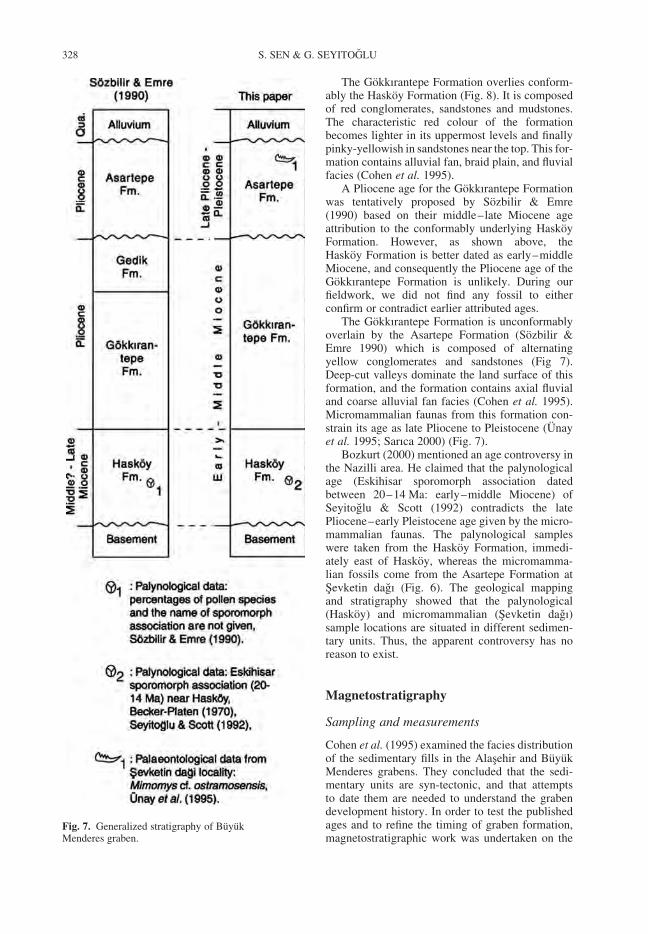
The Gokkırantepe Formation overlies conform-ably the Haskoy Formation (Fig. 8). It is composedof red conglomerates, sandstones and mudstones.The characteristic red colour of the formationbecomes lighter in its uppermost levels and finallypinky-yellowish in sandstones near the top. This for-mation contains alluvial fan, braid plain, and fluvialfacies (Cohen et al. 1995).
A Pliocene age for the Gokkırantepe Formationwas tentatively proposed by Sozbilir & Emre(1990) based on their middle–late Miocene ageattribution to the conformably underlying HaskoyFormation. However, as shown above, theHaskoy Formation is better dated as early–middleMiocene, and consequently the Pliocene age of theGokkırantepe Formation is unlikely. During ourfieldwork, we did not find any fossil to eitherconfirm or contradict earlier attributed ages.
The Gokkırantepe Formation is unconformablyoverlain by the Asartepe Formation (Sozbilir &Emre 1990) which is composed of alternatingyellow conglomerates and sandstones (Fig 7).Deep-cut valleys dominate the land surface of thisformation, and the formation contains axial fluvialand coarse alluvial fan facies (Cohen et al. 1995).Micromammalian faunas from this formation con-strain its age as late Pliocene to Pleistocene (Unayet al. 1995; Sarıca 2000) (Fig. 7).
Bozkurt (2000) mentioned an age controversy inthe Nazilli area. He claimed that the palynologicalage (Eskihisar sporomorph association datedbetween 20–14 Ma: early–middle Miocene) ofSeyitoglu & Scott (1992) contradicts the latePliocene–early Pleistocene age given by the micro-mammalian faunas. The palynological sampleswere taken from the Haskoy Formation, immedi-ately east of Haskoy, whereas the micromamma-lian fossils come from the Asartepe Formation atSevketin dagı (Fig. 6). The geological mappingand stratigraphy showed that the palynological(Haskoy) and micromammalian (Sevketin dagı)sample locations are situated in different sedimen-tary units. Thus, the apparent controversy has noreason to exist.
Magnetostratigraphy
Sampling and measurements
Cohen et al. (1995) examined the facies distributionof the sedimentary fills in the Alasehir and BuyukMenderes grabens. They concluded that the sedi-mentary units are syn-tectonic, and that attemptsto date them are needed to understand the grabendevelopment history. In order to test the publishedages and to refine the timing of graben formation,magnetostratigraphic work was undertaken on the
Fig. 7. Generalized stratigraphy of BuyukMenderes graben.
S. SEN & G. SEYITOGLU328
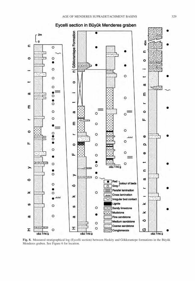
Fig. 8. Measured stratigraphical log (Eycelli section) between Haskoy and Gokkırantepe formations in the BuyukMenderes graben. See Figure 6 for location.
AGE OF MENDERES SUPRADETACHMENT BASINS 329
first and second sedimentary units in the Alasehirand Buyuk Menderes grabens (Figs 2 & 7). Forthese units, the best outcrops were found at theYılan Cukuru district (Alasehir graben) and nearEycelli village (Buyuk Menderes graben). Inaddition, the distance between these two districtsis less than 50 km, although they are situatedNorth and South, respectively, of the Bozdag horstthat separates these two grabens.
We sampled two sections (Zeytincayı-river andZeytincayı–road sections) in the Alasehir graben(Fig. 4) and two sections (Eycelli section andEycelli complementary section) in the Buyuk Men-deres graben (Fig. 6). Only compass oriented blockswere taken. We preferred this method because theZeytincayı outcrops occur in a steep canyon,where stone falls make sampling potentially danger-ous, and some parts of the section are difficult toaccess with drilling equipment. In the case of theEycelli section the sediments are generally notwell consolidated and disintegrate when in contactwith water. The sampled sections are limited at thebottom by major faults, and at their top by outcropexposures. Only sediments unweathered and suit-able for palaeomagnetic analyses were sampled;where necessary, the weathered surface wasremoved to reach fresh rock. Cores were drilled(Ø 25 mm, length 22 mm) from hand samplesusing compressed water or air as cooler at the Labor-atoire de Paleomagnetisme de l’IPG in Paris.
All palaeomagnetic measurements were madein this laboratory. Remanent magnetizations ofsamples were measured with a three axes CTFcryogenic magnetometer in a magnetically shieldedroom. For isothermal remanent magnetization(IRM), we used a Drush 1.26 Tesla electromagnet(Fig. 9). Bulk susceptibility was measured with aBartington susceptibily metre. All samples weredemagnetized by stepwise heating from roomtemperature up to 600 8C in increments of 50 8C(Figs 10 & 11).
Zeytincayı sections (Alasehir graben)
The Zeytincayı sections are situated about 3.5 kmWSW of Alasehir in the Yılan Cukuru district: onein the canyon of the Zeytincayı river and the otheralong the road to Osmaniye village (Figs 12 &13). The river section covers the upper part of theAlasehir Formation (grey-green laminated clays,mudstones and a few sandstones) and the lowerpart of the Kursunlu Formation (mainly pinkish-redclays, sandstones and conglomerates). The roadsection spans the top of the Alasehir Formationand part of the Kursunlu Formation. Both sectionsare laterally correlated using the formation bound-ary and also using a palaeosol horizon which is
situated at 160–163 m in the river section and at72–75 m in the road section.
The river section is 195 m thick and was sampledat 86 horizons (ZN1-ZN86) (Fig. 12). The averagesampling distance is 2.27 m, including a gap of10 m toward the top of the section and two 5 mgaps in its middle part. The gaps correspond tomainly coarse sediments unsuitable for palaeomag-netic analysis.
The Zeytincayı-road section is 83 m thick and 35horizons were sampled (ZR1-ZR35). The averagesampling distance is 2.37 m, with one gap of 10 m(conglomerates) between 42–52 m and another gapof 6 m between 58.5–64.5 m (lack of exposure).
Both magnetic mineralogy and susceptibilityanalyses are crucial to identify the differentcomponents of magnetization in the samples. IRMacquisition was studied in six samples from differ-ent lithologies of the Zeytincayı sections. Sampleswere magnetized (14 steps) in fields up to 1260mT, and then thermally demagnetized (11 steps)up to 600 8C. Sample ZN12-1 (Fig. 9a) is from thelaminated grey-green clays of the Alasehir For-mation. Its IRM curve is typical of magnetic carrierssuch as the magnetite. However, its demagnetiza-tion curve is more complex and indicates severalmagnetic carriers. There is a first drop in intensityat 350 8C and a second drop just before 600 8C.These unblocking temperatures are similar tothose of pyrrhotite and greigite (320 8C and360 8C) and of magnetite (580 8C), respectively.Sample ZR27-2 (Fig. 9b) is from red clays of theoverlying Kursunlu Formation. Its IRM acquisitioncurve increases progressively without reachingsaturation, and its thermal demagnetization is notcompleted at 600 8C. This sample apparentlyshows the dominance of intermediate to hard coer-civity magnetic grains, confirming the presence ofan important fraction of hematite as the magneticcarrier. These observations are kept in mind whenanalysing thermal demagnetization curves of some166 samples from both Zeytincayı sections thatwe analysed for polarity identification.
The variation of susceptibility during stepwisethermal demagnetization was measured in 84samples from both Zeytincayı sections (Fig. 10a).Only 6% of the samples display a stable suscepti-bility up to 600 8C. Ninty-four percent of samplesshow a sudden susceptibility increase between400–500 8C. The increase in susceptibility shouldbe attributed to chemical break-down (oxidation)and formation of another magnetic mineral. Thechemical break-down step is rather similar to thatof pyrite, an iron sulphide, which usually occursaround 420 8C as is actually the case as seen inFigure 10a. The susceptibility increase is strongerin samples from the Alasehir Formation thanin those from the overlying Kursunlu Formation.
S. SEN & G. SEYITOGLU330
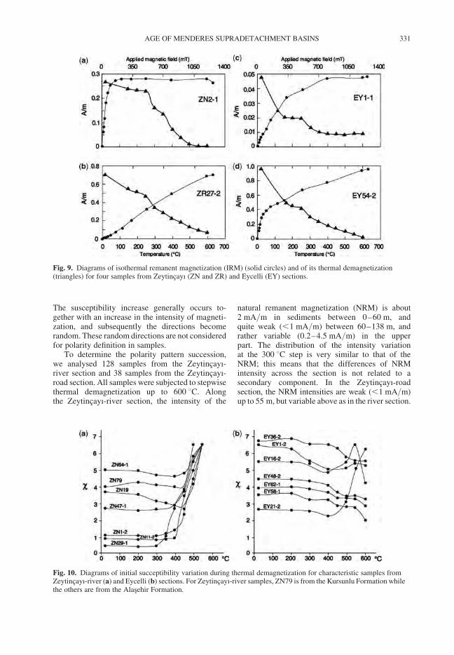
The susceptibility increase generally occurs to-gether with an increase in the intensity of magneti-zation, and subsequently the directions becomerandom. These random directions are not consideredfor polarity definition in samples.
To determine the polarity pattern succession,we analysed 128 samples from the Zeytincayı-river section and 38 samples from the Zeytincayı-road section. All samples were subjected to stepwisethermal demagnetization up to 600 8C. Alongthe Zeytincayı-river section, the intensity of the
natural remanent magnetization (NRM) is about2 mA/m in sediments between 0–60 m, andquite weak (,1 mA/m) between 60–138 m, andrather variable (0.2–4.5 mA/m) in the upperpart. The distribution of the intensity variationat the 300 8C step is very similar to that of theNRM; this means that the differences of NRMintensity across the section is not related to asecondary component. In the Zeytincayı-roadsection, the NRM intensities are weak (,1 mA/m)up to 55 m, but variable above as in the river section.
Fig. 9. Diagrams of isothermal remanent magnetization (IRM) (solid circles) and of its thermal demagnetization(triangles) for four samples from Zeytincayı (ZN and ZR) and Eycelli (EY) sections.
Fig. 10. Diagrams of initial succeptibility variation during thermal demagnetization for characteristic samples fromZeytincayı-river (a) and Eycelli (b) sections. For Zeytincayı-river samples, ZN79 is from the Kursunlu Formation whilethe others are from the Alasehir Formation.
AGE OF MENDERES SUPRADETACHMENT BASINS 331

The deposits in the Zeytincayı area are tilted (for9 measurements, the mean strike ¼ Ø 2808 anddip ¼ 338), and this helps to verify the reliabilityof the Characteristic Remanent Magnetization(ChRM) component. Before tectonic correction,many samples have random directions and eventhose with clearly defined polarities are not wellgrouped on the stereographic diagrams. On theother hand, when the directions are plotted aftertectonic correction, most samples are grouped (seebelow), and the mean normal and reversed polaritydirections are quite similar to those directionsalready recorded in early–middle Miocene depositsof Turkey (Krijgsman et al. 1996).
Typical Zijderveld diagrams of samples from therepresentative lithologies and sedimentary units areshown in Figure 11. As noted above, the increase insusceptibility around 400–500 8C coincides withthe occurrence of unstable magnetizations andrandom directions. This is particularly true forsamples from the Alasehir Formation. Therefore,in such samples the directions of the ChRM werecalculated by including the steps between removedoverprint component and the susceptibility increase.In 88% of the samples, it was possible to calculatethe direction of the ChRM magnetic vector usingprincipal component analysis (PCA). In this analy-sis, the Fisher’s (1953) statistics were appliedon line fits with at least three successive steps. For
the remaining samples, indicated with open circlesin Figures 12 & 13, line fits with only one or twosteps are considered as representative of theChRM based on their similar directions to that ofother samples from the same site or from its proxi-mity. All ChRM directions were plotted in strati-graphic order in Figures 12 & 13.
The Zeytincayı-river section is dominated byreversed polarities but includes at least five normalpolarity zones (Fig. 12). At the base, between 0–20 m, three normal polarity zones are interruptedby two reversed polarity zones. They are all welldefined by two or more successive sites, exceptthe second reversed zone that is characterized byone site only (ZN12). Between 20–93 m a longreversed zone is identified. However, three sitesbetween 75.8–77.9 m yielded intermediate orpoorly defined [i.e. maximum angular deviation(MAD) . 10] normal polarities. The behaviour ofsamples during thermal demagnetization suggeststhat a strong secondary magnetization componentcannot be removed enough to reveal their ChRM.The following sites between 93–130 m yielded asuccession of two normal polarity zones interruptedby a reversed polarity zones. One of the normalpolarity zones is defined by two sites while theother normal polarity zones is characterized byseven successive sites. In the interval between 70–130 m, the definition of the ChRM is not always
Fig. 11. Typical orthogonal projections diagrams of stepwise thermal demagnetization for selected samples fromthe Zeytincayı sections. Closed (open) circles represent the horizontal (vertical) projection. Values indicatetemperatures in 8C for demagnetizing steps.
S. SEN & G. SEYITOGLU332
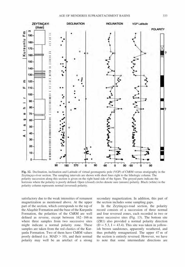
satisfactory due to the weak intensities of remanentmagnetization as mentioned above. At the upperpart of the section, which corresponds to the top ofthe Alasehir Formation and the base of the KursunluFormation, the polarities of the ChRM are welldefined as reverse, except between 162–166 mwhere three samples from two successive sitesmight indicate a normal polarity zone. Thesesamples are taken from the red clastics of the Kur-sunlu Formation. Two of them have ChRM valuespoorly defined (i.e. MAD . 10), and their normalpolarity may well be an artefact of a strong
secondary magnetization. In addition, this part ofthe section includes some sampling gaps.
In the Zeytincayı-road section, the polarityrecord consists of a succession of three normaland four reversed zones, each recorded in two ormore successive sites (Fig. 13). The bottom site(ZR1) also provided a normal polarity direction(D ¼ 5.3, I ¼ 43.4). This site was taken in yellow-ish brown sandstones, apparently weathered, andthus probably remagnetized. The upper 47 m ofthe section is entirely reversed. However, we haveto note that some intermediate directions are
Fig. 12. Declination, inclination and Latitude of virtual geomagnetic pole (VGP) of ChRM versus stratigraphy in theZeytincayı-river section. The sampling intervals are shown with short lines right to the lithologic column. Thepolarity succession along this section is given on the right hand side of the figure. The greyed parts indicate thehorizons where the polarity is poorly defined. Open (closed) circles denote sure (unsure) polarity. Black (white) in thepolarity column represents normal (reversed) polarity.
AGE OF MENDERES SUPRADETACHMENT BASINS 333
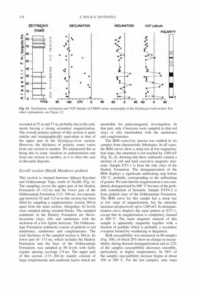
recorded at 55 m and 77 m, probably due to the sedi-ments having a strong secondary magnetization.The overall polarity pattern of this section is quitesimilar and stratigraphically equivalent to that ofthe upper part of the Zeytincayı-river section.However, the thickness of polarity zones variesfrom one section to another. We interpreted this asbeing due to some variation in sedimentation ratefrom one section to another, as it is often the casein fluviatile deposits.
Eycelli section (Buyuk Menderes graben)
This section is situated between Akkaya Kuyulariand Gokkırantepe Tepe, north of Nazilli (Fig. 6).The sampling covers the upper part of the HaskoyFormation (0–112 m) and the lower part of theGokkırantepe Formation (112–304 m). An exposuregap between 92 and 112 m in this section has beenfilled by sampling a supplementary section 200 mapart from the main section. Altogether, 62 levelswere sampled taking oriented blocks. The sampledsediments in the Haskoy Formation are fluvio-lacustrine clays, silts and sandstones with theinclusion of a few lignite horizons. The Gokkıran-tepe Formation sediments consist of pinkish to redmudstones, sandstones and conglomerates. Thetotal thickness of the sampled section is 304 m. Itslower part (0–173 m), which includes the HaskoyFormation and the base of the GokkırantepeFormation, was sampled at 58 levels with fairlyregular spacing (average 2.9 m). The upper partof this section (173–304 m) mainly consists oflarge conglomerate and sandstone layers which are
unsuitable for palaeomagnetic investigation. Inthat part, only 4 horizons were sampled in thin redclays or silts interbedded with the sandstonesand conglomerates.
The IRM coercivity spectra was studied in sixsamples from characteristic lithologies. In all cases,the IRM curves show a steep rise at low magnetiza-tion steps, but saturation is not reached by 1260 mT(Fig. 9c, d), showing that these sediments contain amixture of soft and hard coercitive magnetic min-erals. Sample EY1-1 is from the silty clays of theHaskoy Formation. The demagnetization of theIRM displays a significant unblocking step before150 8C, probably corresponding to the unblockingof goetite. We note that the magnetization is not com-pletely demagnetized by 600 8C because of the prob-able contribution of hematite. Sample EY54-2 isfrom pinkish clays of the Gokkırantepe Formation.The IRM curve for this sample has a steep riseat low steps of magnetization, but the intensityincreases progressively up to 1260 mT. Its demagne-tization curve displays the same pattern as EY1-1,except that its magnetization is completely cleanedat 600 8C. The main magnetic mineral of thissample is apparently magnetite together with afraction of goethite which is probably a secondaryoverprint formed by weathering or diagenesis.
Bulk susceptibility was measured on 60 samples(Fig. 10b), of which 20% show no change in suscep-tibility during thermal demagnetization and in 22%of the samples susceptibility decreases smoothly,particularly at higher temperatures. In 58% ofthe samples susceptibility increase begins at about450 or 500 8C. For the last samples, only steps
Fig. 13. Declination, inclination and VGP latitude of ChRM versus stratigraphy in the Zeytincayı-road section. Forother explanations, see Figure 12.
S. SEN & G. SEYITOGLU334
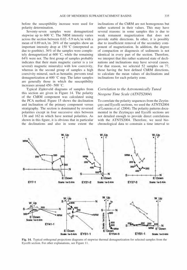
before the susceptibility increase were used forpolarity determination.
Seventy-seven samples were demagnetizedstepwise up to 600 8C. The NRM intensity variesacross the section between 0.02–5.9 mA/m with amean of 0.89 mA/m. 26% of the samples show animportant intensity drop at 150 8C (interpreted asdue to goethite). 36% of the samples were comple-tely demagnetized at 600 8C, while the remaining64% were not. The first group of samples probablyindicates that their main magnetic carrier is a (orseveral) magnetic mineral(s) with low coercivity,whereas in the second group of samples a highcoercivity mineral, such as hematite, prevents totaldemagnetization at 600 8C step. The latter samplesare generally those in which the susceptibilityincreases around 450–500 8C.
Typical Zijderveld diagrams of samples fromthis section are given in Figure 14. The polarityof the ChRM component was calculated usingthe PCA method. Figure 15 shows the declinationand inclination of the primary component versusstratigraphy. The section is dominated by reversedpolarities except in four successive sites between136 and 162 m which have normal polarities. Asshown in this figure, it is obvious that in particularthe declinations and also in some extent the
inclinations of the ChRM are not homogenous butrather scattered in their values. This may haveseveral reasons: in some samples this is due toweak remanent magnetization that does notprovide stable directions. In other, it is possiblydue to insufficient removal of the secondary com-ponent of magnetization. In addition, the degreeof compaction or diagenesis of sediments is notidentical in every part of the section. Therefore,we interpret that this rather scattered state of decli-nations and inclinations may have several causes.For that reason, we selected 52 samples on 77,those having the best defined ChRM directions,to calculate the mean values of declinations andinclinations for each polarity zone.
Correlation to the Astronomically Tuned
Neogene Time Scale (ATNTS2004)
To correlate the polarity sequences from the Zeytin-cayı and Eycelli sections, we used the ATNTS2004of Lourens et al. (2004). The polarity patterns docu-mented in the Zeytincayı and Eycelli sections arenot detailed enough to provide direct correlationswith the ATNTS2004. Therefore, we need bio-chronological data to constrain a time interval to
Fig. 14. Typical orthogonal projections diagrams of stepwise thermal demagnetization for selected samples from theEycelli section. For other explanations, see Figure 11.
AGE OF MENDERES SUPRADETACHMENT BASINS 335
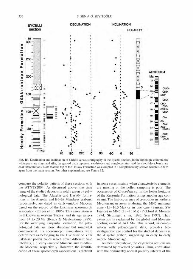
compare the polarity pattern of these sections withthe ATNTS2004. As discussed above, the timerange of the studied deposits is solely given by paly-nological data. The Alasehir and Haskoy forma-tions in the Alasehir and Buyuk Menderes grabens,respectively, are dated as early–middle Miocenebased on the record of the Eskihisar sporomorphassociation (Ediger et al. 1996). This association iswell known in western Turkey, and its age rangesfrom 14 to 20 Ma (Benda & Meulenkamp 1979).For the overlying Kursunlu Formation, the paly-nological data are more abundant but somewhatcontroversial. Its sporomorph associations weredetermined as belonging to the Eskihisar or YeniEskihisar pollen zones which cover different timeintervals, i. e. early–middle Miocene and middle–late Miocene, respectively. However, the identifi-cation of these sporomorph associations is difficult
in some cases, mainly when characteristic elementsare missing or the pollen sampling is poor. Theoccurrence of Crocodyla sp. in the lower horizonsof the Kursunlu Formation brings another age con-straint. The last occurrence of crocodiles in northernMediterranean areas is during the MN5 mammalzone (15–16.5 Ma) or in one case (Sansan, SWFrance) in MN6 (13–15 Ma) (Pickford & Morales1994; Steininger et al. 1996; Sen 1997). Theirextinction is explained by the global mid Miocenecooling event at 14.1 Ma. This record, in combi-nation with palynological data, provides bio-stratigraphic age control for the studied deposits inthe Alasehir graben, suggesting an early to earlymiddle Miocene age.
As mentioned above, the Zeytincayı sections aredominated by reversed polarities. Thus, correlationwith the dominantly normal polarity interval of the
Fig. 15. Declination and inclination of ChRM versus stratigraphy in the Eycelli section. In the lithologic column, thewhite parts are clays and silts, the greyed parts represent sandstones and conglomerates, and the short black bands arecoal intercalations. Note that the top of the Haskoy Formation was sampled in a complementary section which is 200 mapart from the main section. For other explanations, see Figure 12.
S. SEN & G. SEYITOGLU336
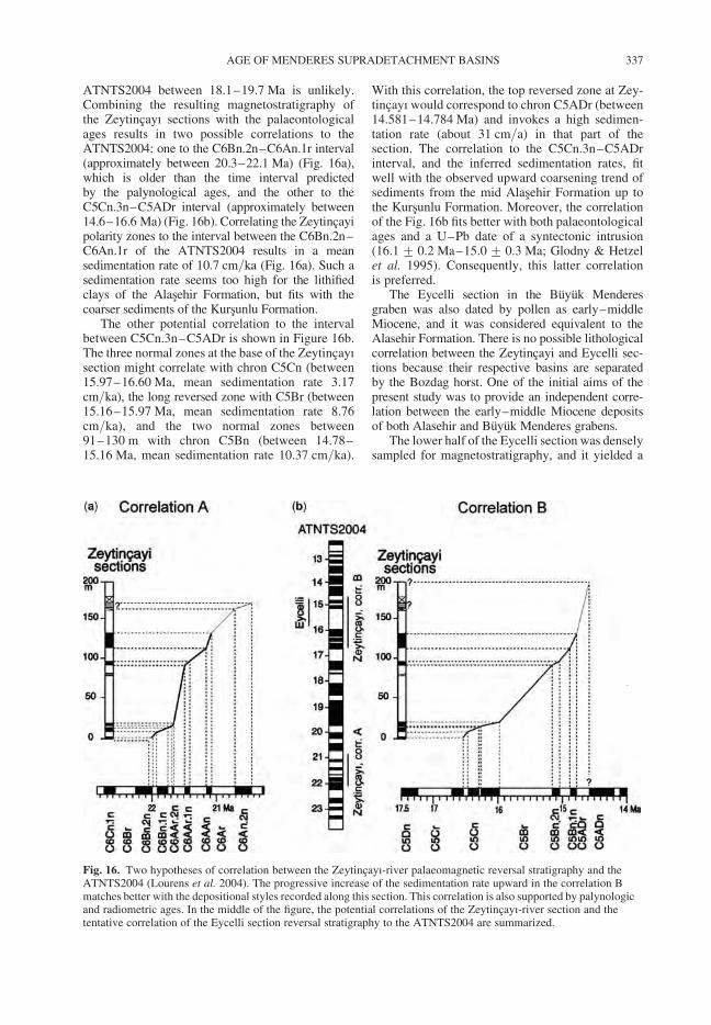
ATNTS2004 between 18.1–19.7 Ma is unlikely.Combining the resulting magnetostratigraphy ofthe Zeytincayı sections with the palaeontologicalages results in two possible correlations to theATNTS2004: one to the C6Bn.2n–C6An.1r interval(approximately between 20.3–22.1 Ma) (Fig. 16a),which is older than the time interval predictedby the palynological ages, and the other to theC5Cn.3n–C5ADr interval (approximately between14.6–16.6 Ma) (Fig. 16b). Correlating the Zeytincayipolarity zones to the interval between the C6Bn.2n–C6An.1r of the ATNTS2004 results in a meansedimentation rate of 10.7 cm/ka (Fig. 16a). Such asedimentation rate seems too high for the lithifiedclays of the Alasehir Formation, but fits with thecoarser sediments of the Kursunlu Formation.
The other potential correlation to the intervalbetween C5Cn.3n–C5ADr is shown in Figure 16b.The three normal zones at the base of the Zeytincayısection might correlate with chron C5Cn (between15.97–16.60 Ma, mean sedimentation rate 3.17cm/ka), the long reversed zone with C5Br (between15.16–15.97 Ma, mean sedimentation rate 8.76cm/ka), and the two normal zones between91–130 m with chron C5Bn (between 14.78–15.16 Ma, mean sedimentation rate 10.37 cm/ka).
With this correlation, the top reversed zone at Zey-tincayı would correspond to chron C5ADr (between14.581–14.784 Ma) and invokes a high sedimen-tation rate (about 31 cm/a) in that part of thesection. The correlation to the C5Cn.3n–C5ADrinterval, and the inferred sedimentation rates, fitwell with the observed upward coarsening trend ofsediments from the mid Alasehir Formation up tothe Kursunlu Formation. Moreover, the correlationof the Fig. 16b fits better with both palaeontologicalages and a U–Pb date of a syntectonic intrusion(16.1 + 0.2 Ma–15.0 + 0.3 Ma; Glodny & Hetzelet al. 1995). Consequently, this latter correlationis preferred.
The Eycelli section in the Buyuk Menderesgraben was also dated by pollen as early–middleMiocene, and it was considered equivalent to theAlasehir Formation. There is no possible lithologicalcorrelation between the Zeytincayi and Eycelli sec-tions because their respective basins are separatedby the Bozdag horst. One of the initial aims of thepresent study was to provide an independent corre-lation between the early–middle Miocene depositsof both Alasehir and Buyuk Menderes grabens.
The lower half of the Eycelli section was denselysampled for magnetostratigraphy, and it yielded a
Fig. 16. Two hypotheses of correlation between the Zeytincayı-river palaeomagnetic reversal stratigraphy and theATNTS2004 (Lourens et al. 2004). The progressive increase of the sedimentation rate upward in the correlation Bmatches better with the depositional styles recorded along this section. This correlation is also supported by palynologicand radiometric ages. In the middle of the figure, the potential correlations of the Zeytincayı-river section and thetentative correlation of the Eycelli section reversal stratigraphy to the ATNTS2004 are summarized.
AGE OF MENDERES SUPRADETACHMENT BASINS 337
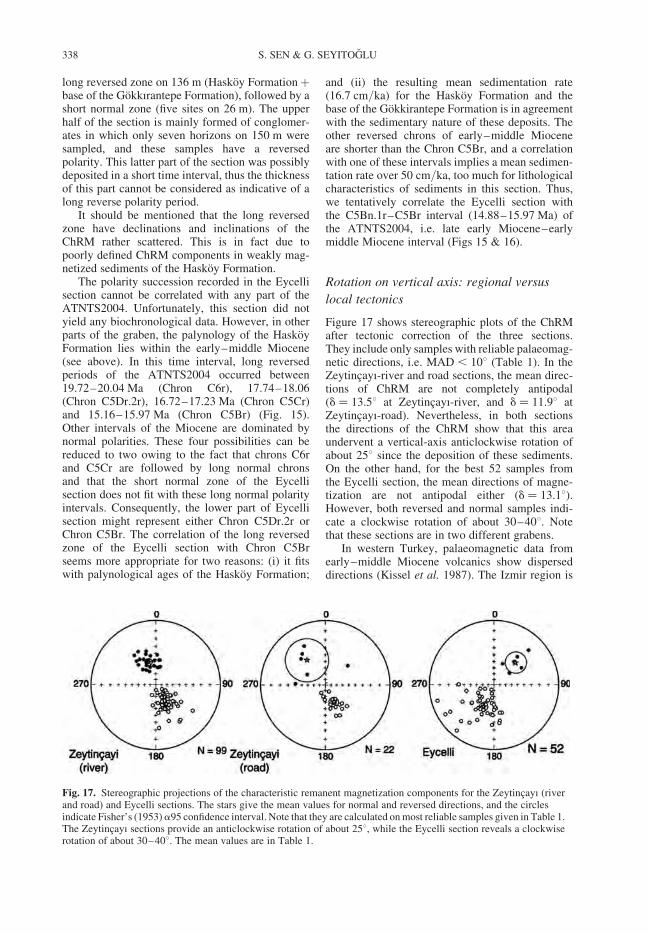
long reversed zone on 136 m (Haskoy Formationþbase of the Gokkırantepe Formation), followed by ashort normal zone (five sites on 26 m). The upperhalf of the section is mainly formed of conglomer-ates in which only seven horizons on 150 m weresampled, and these samples have a reversedpolarity. This latter part of the section was possiblydeposited in a short time interval, thus the thicknessof this part cannot be considered as indicative of along reverse polarity period.
It should be mentioned that the long reversedzone have declinations and inclinations of theChRM rather scattered. This is in fact due topoorly defined ChRM components in weakly mag-netized sediments of the Haskoy Formation.
The polarity succession recorded in the Eycellisection cannot be correlated with any part of theATNTS2004. Unfortunately, this section did notyield any biochronological data. However, in otherparts of the graben, the palynology of the HaskoyFormation lies within the early–middle Miocene(see above). In this time interval, long reversedperiods of the ATNTS2004 occurred between19.72–20.04 Ma (Chron C6r), 17.74–18.06(Chron C5Dr.2r), 16.72–17.23 Ma (Chron C5Cr)and 15.16–15.97 Ma (Chron C5Br) (Fig. 15).Other intervals of the Miocene are dominated bynormal polarities. These four possibilities can bereduced to two owing to the fact that chrons C6rand C5Cr are followed by long normal chronsand that the short normal zone of the Eycellisection does not fit with these long normal polarityintervals. Consequently, the lower part of Eycellisection might represent either Chron C5Dr.2r orChron C5Br. The correlation of the long reversedzone of the Eycelli section with Chron C5Brseems more appropriate for two reasons: (i) it fitswith palynological ages of the Haskoy Formation;
and (ii) the resulting mean sedimentation rate(16.7 cm/ka) for the Haskoy Formation and thebase of the Gokkirantepe Formation is in agreementwith the sedimentary nature of these deposits. Theother reversed chrons of early–middle Mioceneare shorter than the Chron C5Br, and a correlationwith one of these intervals implies a mean sedimen-tation rate over 50 cm/ka, too much for lithologicalcharacteristics of sediments in this section. Thus,we tentatively correlate the Eycelli section withthe C5Bn.1r–C5Br interval (14.88–15.97 Ma) ofthe ATNTS2004, i.e. late early Miocene–earlymiddle Miocene interval (Figs 15 & 16).
Rotation on vertical axis: regional versus
local tectonics
Figure 17 shows stereographic plots of the ChRMafter tectonic correction of the three sections.They include only samples with reliable palaeomag-netic directions, i.e. MAD , 108 (Table 1). In theZeytincayı-river and road sections, the mean direc-tions of ChRM are not completely antipodal(d ¼ 13.58 at Zeytincayı-river, and d ¼ 11.98 atZeytincayı-road). Nevertheless, in both sectionsthe directions of the ChRM show that this areaundervent a vertical-axis anticlockwise rotation ofabout 258 since the deposition of these sediments.On the other hand, for the best 52 samples fromthe Eycelli section, the mean directions of magne-tization are not antipodal either (d ¼ 13.18).However, both reversed and normal samples indi-cate a clockwise rotation of about 30–408. Notethat these sections are in two different grabens.
In western Turkey, palaeomagnetic data fromearly–middle Miocene volcanics show disperseddirections (Kissel et al. 1987). The Izmir region is
Fig. 17. Stereographic projections of the characteristic remanent magnetization components for the Zeytincayı (riverand road) and Eycelli sections. The stars give the mean values for normal and reversed directions, and the circlesindicate Fisher’s (1953)a95 confidence interval. Note that they are calculated on most reliable samples given in Table 1.The Zeytincayı sections provide an anticlockwise rotation of about 258, while the Eycelli section reveals a clockwiserotation of about 30–408. The mean values are in Table 1.
S. SEN & G. SEYITOGLU338
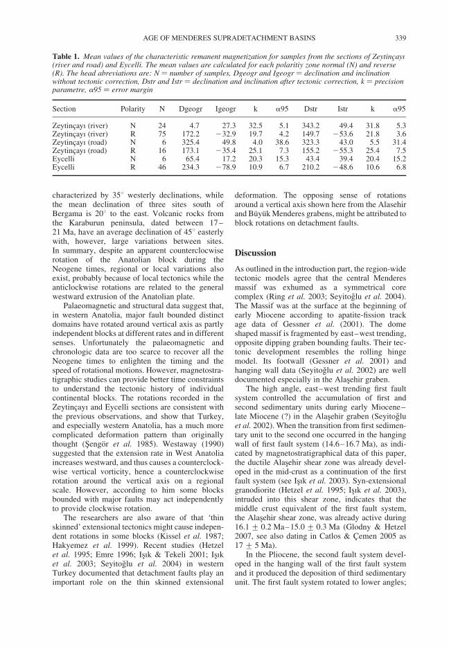
characterized by 358 westerly declinations, whilethe mean declination of three sites south ofBergama is 208 to the east. Volcanic rocks fromthe Karaburun peninsula, dated between 17–21 Ma, have an average declination of 458 easterlywith, however, large variations between sites.In summary, despite an apparent counterclocwiserotation of the Anatolian block during theNeogene times, regional or local variations alsoexist, probably because of local tectonics while theanticlockwise rotations are related to the generalwestward extrusion of the Anatolian plate.
Palaeomagnetic and structural data suggest that,in western Anatolia, major fault bounded distinctdomains have rotated around vertical axis as partlyindependent blocks at different rates and in differentsenses. Unfortunately the palaeomagnetic andchronologic data are too scarce to recover all theNeogene times to enlighten the timing and thespeed of rotational motions. However, magnetostra-tigraphic studies can provide better time constraintsto understand the tectonic history of individualcontinental blocks. The rotations recorded in theZeytincayı and Eycelli sections are consistent withthe previous observations, and show that Turkey,and especially western Anatolia, has a much morecomplicated deformation pattern than originallythought (Sengor et al. 1985). Westaway (1990)suggested that the extension rate in West Anatoliaincreases westward, and thus causes a counterclock-wise vertical vorticity, hence a counterclockwiserotation around the vertical axis on a regionalscale. However, according to him some blocksbounded with major faults may act independentlyto provide clockwise rotation.
The researchers are also aware of that ‘thinskinned’ extensional tectonics might cause indepen-dent rotations in some blocks (Kissel et al. 1987;Hakyemez et al. 1999). Recent studies (Hetzelet al. 1995; Emre 1996; Isık & Tekeli 2001; Isıket al. 2003; Seyitoglu et al. 2004) in westernTurkey documented that detachment faults play animportant role on the thin skinned extensional
deformation. The opposing sense of rotationsaround a vertical axis shown here from the Alasehirand Buyuk Menderes grabens, might be attributed toblock rotations on detachment faults.
Discussion
As outlined in the introduction part, the region-widetectonic models agree that the central Menderesmassif was exhumed as a symmetrical corecomplex (Ring et al. 2003; Seyitoglu et al. 2004).The Massif was at the surface at the beginning ofearly Miocene according to apatite-fission trackage data of Gessner et al. (2001). The domeshaped massif is fragmented by east–west trending,opposite dipping graben bounding faults. Their tec-tonic development resembles the rolling hingemodel. Its footwall (Gessner et al. 2001) andhanging wall data (Seyitoglu et al. 2002) are welldocumented especially in the Alasehir graben.
The high angle, east–west trending first faultsystem controlled the accumulation of first andsecond sedimentary units during early Miocene–late Miocene (?) in the Alasehir graben (Seyitogluet al. 2002). When the transition from first sedimen-tary unit to the second one occurred in the hangingwall of first fault system (14.6–16.7 Ma), as indi-cated by magnetostratigraphical data of this paper,the ductile Alasehir shear zone was already devel-oped in the mid-crust as a continuation of the firstfault system (see Isık et al. 2003). Syn-extensionalgranodiorite (Hetzel et al. 1995; Isık et al. 2003),intruded into this shear zone, indicates that themiddle crust equivalent of the first fault system,the Alasehir shear zone, was already active during16.1 + 0.2 Ma–15.0 + 0.3 Ma (Glodny & Hetzel2007, see also dating in Catlos & Cemen 2005 as17 + 5 Ma).
In the Pliocene, the second fault system devel-oped in the hanging wall of the first fault systemand it produced the deposition of third sedimentaryunit. The first fault system rotated to lower angles;
Table 1. Mean values of the characteristic remanent magnetization for samples from the sections of Zeytincayı(river and road) and Eycelli. The mean values are calculated for each polaritiy zone normal (N) and reverse(R). The head abreviations are: N ¼ number of samples, Dgeogr and Igeogr ¼ declination and inclinationwithout tectonic correction, Dstr and Istr ¼ declination and inclination after tectonic correction, k ¼ precisionparametre, a95 ¼ error margin
Section Polarity N Dgeogr Igeogr k a95 Dstr Istr k a95
Zeytincayı (river) N 24 4.7 27.3 32.5 5.1 343.2 49.4 31.8 5.3Zeytincayı (river) R 75 172.2 232.9 19.7 4.2 149.7 253.6 21.8 3.6Zeytincayı (road) N 6 325.4 49.8 4.0 38.6 323.3 43.0 5.5 31.4Zeytincayı (road) R 16 173.1 235.4 25.1 7.3 155.2 255.3 25.4 7.5Eycelli N 6 65.4 17.2 20.3 15.3 43.4 39.4 20.4 15.2Eycelli R 46 234.3 278.9 10.9 6.7 210.2 248.6 10.6 6.8
AGE OF MENDERES SUPRADETACHMENT BASINS 339
Seyitoglu et al. (2002) provided field evidence thatthe first fault system is also active in contrast tothe original rolling hinge model (Buck 1988;Wernicke & Axen 1988). This is also supportedby isotopic dating of Lips et al. (2001; 7+1 Ma)and Catlos & Cemen (2005; 4.5 + 1.0 Ma).Apatite fission track data of Gessner et al. (2001)indicate a rapid exhumation in the footwall ofthe first fault system following 5 Ma that is acceler-ated by the initiation of second fault system (seeSeyitoglu et al. 2002, Fig. 10).
In the Quaternary, the third fault system becomesoperational in the hanging wall of the second faultsystem and controls the accumulation of fourth sedi-mentary unit, Quaternary alluvium deposits. Theprevious fault systems further rotated and grabenbounding first fault system becomes a low anglenormal fault. In the Quaternary–present day, thehigh angle fourth fault system cut and displaces allearlier structures (see Seyitoglu et al. 2002, Fig. 10d).
The tectono-sedimentary model supported bymagnetostratigraphic and isotopic datings indicatesthat the east–west trending graben formation inwestern Turkey is similar to the rolling hingemodel until Quaternary–Recent times. However,Bozkurt & Sozbilir (2004) put forward that thehigh angle normal faults cut and displace the pre-sently low angle first fault system and that thisimplies that the rolling hinge model is not applicableto the east–west trending graben formation. Itshould be noted that our model supports the factthat high angle faults cut the low angle normalfaults as indicated by fourth fault system in theSeyitoglu et al. (2002, Fig. 10d). The existence ofQuaternary–Recent fourth fault system does notaffect the earlier (early Miocene–Quaternary)history of the rolling hinge process. All crosscutting relationships documented by Bozkurt &Sozbilir (2004) match the ‘fourth fault system’.They can not disprove the rolling hinge model inthe Alasehir graben.
Another important issue discussed in the recentliterature is the claim of Yılmaz et al. (2000) thatthe first sedimentary unit, the Alasehir Formation,was deposited in a North-trending basin and latertrapped in the younger east–west trending graben.Several lines of evidence suggest that the AlasehirFormation was a product of the east–west trendingAlasehir graben. According to the sedimentologicalwork of Cohen et al. (1995), all sedimentary depositswithin the graben are syn-tectonic, and they can beused to date the graben formation. In the seismicrefraction diagrams recorded by Turkish PetroleumCo., the Alasehir Formation forms a sedimentarywedge that becomes thicker towards the east–westtrending fault system, indicating its syntectonicdevelopment (Yılmaz & Gelisli 2003). A similarfeature was also observed in the Zeytincayı valley
where the wedge of the upper part of the AlasehirFormation thickens towards the N75W, 42NEoriented syn-sedimentary fault.
Conclusions
Palaeomagnetic analyses show that sediments fromthe Zeytincayı (Alasehir graben) and Eycelli(Buyuk Menderes graben) sections are suitable forpalaeomagnetic studies. Magnetic properties of thesediments and the behaviour of samples duringdemagnetization are different in the two areas.This might suggest that the deposits were formedin different sedimentary environments.
This study provides a chronological frame to thefirst and second sedimentary units in the Alasehirand Buyuk Menderes grabens. Correlation of therecorded polarity zones with the ATNTS2004(Fig. 16b) indicates that in the studied Zeytincayıand Eycelli sections, the transition from the firstunit to the second unit occurred at about 14.5 Main both sections. This provides an age older thanthis date to the first sedimentary units in the Alasehirand Buyuk Menderes grabens that are Alasehir andHaskoy formations, respectively. This result clearlyplaces the initiation of east–west trending grabenformation in the early Miocene and is compatiblewith recent isotopic dating (Catlos & Cemen2005; Glodny & Hetzel 2007). Consequently, theuse of younger ages attributed to the timing ofgraben formation in western Turkey is misleading(Hakyemez et al. 1999; Bozkurt 2000; Yılmazet al. 2000; Bozkurt & Sozbilir 2004).
This paper also provides two more examples tothe collection of contradictory rotations around thevertical axes in western Turkey. The local tectonicscontrolled by the thin skinned extensional defor-mation due to detachment faults might be thecause of such rotations. Therefore these rotationsmay not be meaningful evidence for the model ofback arc spreading in the Aegean region.
This paper is dedicated to the memory of Leopold Benda(13.1.1933–11.10.1998) who is the founder of lateCenozoic sporomorph chronology in the Aegean region.Nuran Sarıca helped with the sampling. All measurementshave been performed in the Laboratoire de Paleomagne-tisme et Geodynamique de l’IPG (Paris). Discussionswith colleagues from this laboratory, and mainly withM.-G. Moreau, H. Bouquerel and S. Gilder, contributedto a better understanding of palaeomagnetic results.This study was granted by CNRS (France) and the Scien-tific and Technical Research Council of Turkey-TUBITAK (YDABCAG-424/G). S. Gilder kindlyimproved the English. Pertinent comments and sugges-tions of the referees E. Bozkurt and S. Husing, and thatof the editor D. van Hinsbergen were greatly constructiveto improve previous versions of this paper. We are verygrateful to them.
S. SEN & G. SEYITOGLU340
References
AKGUN, F. & AKYOL, E. 1999. Palynostratigraphy of thecoal bearing Neogene deposits in Buyuk Menderesgraben, Western Anatolia. Geobios, 32, 367–383.
BECKER-PLATEN, J. D. 1970. Lithostratigraphisce Unter-suchungen im Kanozoikum Sudwest-Anatoliens(Turkei). Beihefte zum Geologischen Jahrbuch, 97,1–244.
BENDA, L. 1971. Grundzuge einer pollenanalytischenGliederung des turkischen Jungtertiars. Beihefte ZumGeologischen Jahrbuch, 113, 1–46.
BENDA, L. & MEULENKAMP, J. E. 1979. Biostratigraphiccorrelations in the Eastern Mediterranean Neogene. 5.Calibration of sporomorph associations, marine micro-fossils and mammal zones, marine and continentalstages and the radiometric scale. Annales Geologiquesdes Pays Helleniques, (hors ser.), 1, 61–70.
BENDA, L. & MEULENKAMP, J. E. 1990. Biostratigraphiccorrelations in the Eastern Mediterranean Neogene. 9.Sporomorph associations and event stratigraphy ofthe eastern Mediterranean. Newsletters on Stratigra-phy, 23, 1–10.
BENDA, L., INNOCENTI, F., MAZZUOLI, R., RADICATI,F. & STEFFENS, P. 1974. Stratigraphic and radiometricdata of the Neogene in Northwest Turkey. Zeitschriftder Deutschen Geologischen Gesellschaft, 125,183–93.
BOZKURT, E. 2000. Timing of extension on the BuyukMenderes graben, western Turkey, and its tectonicimplications. In: BOZKURT, E., WINCHESTER, J. A.& PIPER, J. D. A. (eds) Tectonics and magmatism inTurkey and the surrounding area. GeologicalSociety, London, Special Publications, 173, 385–403.
BOZKURT, E. & PARK, R. G. 1994. Southern Menderesmassif: an incipient metamorphic core complex inwestern Anatolia, Turkey. Journal of the GeologicalSociety, London, 151, 213–216.
BOZKURT, E. & SOZBILIR, H. 2004. Tectonic evolution ofthe Gediz Graben: field evidence for an episodic, twostage extension in western Turkey. Geological Maga-zine, 141, 63–79.
BUCK, W. R. 1988. Flexural rotation of normal faults.Tectonics, 7, 959–73.
CATLOS, E. J. & CEMEN, I. 2005. Monazite ages and theevolution of the Menderes Massif, western Turkey.International Journal of Earth Sciences, 94, 204–217.
COHEN, H. A., DART, C. J., AKYUZ, H. S. & BARKA, A.1995. Syn-rift sedimentation and structural develop-ment of the Gediz and Buyuk Menderes grabens,western Turkey. Journal of the Geological Society,London, 152, 629–638.
EDIGER, V., BATI, Z. & YAZMAN, M. 1996. Paleopaly-nology of possible hydrocarbon source rocks of theAlasehir–Turgutlu area in the Gediz graben (westernAnatolia). Turkish Association of Petroleum Geol-ogists Bulletin, 8, 94–112.
EMRE, T. 1996. Gediz grabeni’nin jeolojisi ve tektonigi[Geology and tectonics of the Gediz graben]. TurkishJournal of Earth Sciences, 5, 171–185.
FISHER, R. A. 1953. Dispersion on a sphere. Proceedingsof Royal Society, London, A217, 295–305.
GESSNER, K., RING, U., JOHNSON, C., HETZEL, R.,PASSCHIER, C. W. & GUNGOR, T. 2001. An active
bivergent rolling-hinge detachment system: centralMenderes metamorphic core complex in westernTurkey. Geology, 29, 611–614.
GLODNY, J. & HETZEL, R. 2007. Precise U–Pb agesof syn-extensional Miocene intrusions in the centralMenderes Massif, western Turkey. GeologicalMagazine, 144, 235–246.
GURER, A., GURER, O. F., PINCE, A. & ILKISIK, O. M.2001. Conductivity structure along the Gediz grabenwest Anatolia, Turkey: tectonic implications. Inter-national Geology Review, 43, 1129–1144.
HAKYEMEZ, H. Y., ERKAL, T. & GOKTAS, F. 1999.Late Quaternary evolution of the Gediz and theBuyuk Menderes grabens, western Anatolia, Turkey.Quaternary Science Reviews, 18, 549–554.
HETZEL, R., RING, U., AKAL, C. & TROESCH, M.1995. Miocene NNE-directed extensional unroofingin the Menderes massif, southwestern Turkey. Journalof the Geological Society, London, 152, 639–654.
ISIK, V. & TEKELI, O. 2001. Late orogenic crustal exten-sion in the northern Menderes massif (westernTurkey): evidence for metamorphic core complex for-mation. International Journal of Earth Sciences, 87,757–765.
ISIK, V., SEYITOGLU, G. & CEMEN, I. 2003.Ductile-brittle transition along the Alasehir shearzone and its structural relationship with the Simavdetachment, Menderes massif, western Turkey.Tectonophysics, 374, 1–18.
IZTAN, H. & YAZMAN, M. 1990. Geology and hydro-carbon potential of the Alasehir (Manisa) area,western Turkey. In: SAVASCIN, M. Y. & ERONAT,A. H. (eds) Proceedings to International Earth SciencesCongress on Aegean regions, Izmir, 1, 327–338.
KAYA, O., UNAY, E., GOKTAS, F. & SARAC, G. 2007.Early Miocene stratigraphy of central west Anatolia,Turkey: implications for the tectonic evolution of theeastern Aegean area. Geological Journal, 42, 85–109.
KISSEL, C., LAJ, C., SENGOR, A. M. C. & POISSON, A.1987. Paleomagnetic evidence for rotation in oppositesenses of adjacent blocks in northeastern Aegea andwestern Anatolia. Geophysical Research Letters, 14,907–910.
KOCYIGIT, A., YUSUFOGLU, H. & BOZKURT, E. 1999.Evidence from the Gediz graben for episodic two-stageextension in western Turkey. Journal of the GeologicalSociety, London, 156, 605–616.
KRIJGSMAN, W., DUERMEIJER, C. E., LANGEREIS, C. G.,DE BRUIJN, H., SARAC, G. & ANDRIESSEN, P. A. M.1996. Magnetic polarity stratigraphy of late Oligoceneto middle Miocene mammal-bearing continentaldeposits in central Anatolia (Turkey). Newsletters onStratigraphy, 34, 13–29.
LIPS, A. L. W., CASSARD, D., SOZBILIR, H. & YILMAZ,H. 2001. Multistage exhumation of the Menderesmassif, western Anatolia (Turkey). InternationalJournal of Earth Sciences, 89, 781–792.
LOURENS, L. J., HILGEN, F. J., LASKAR, J., SHACKLETON,N. J. & WILSON, D. 2004. Chapter 21: The NeogenePeriod. In: GRADSTEIN, F. M., OGG, J. G. & SMITH,A. G. (eds) A Geologic Time Scale 2004. CambridgeUniversity Press, Cambridge, 409–440.
OKAY, A. I. & SATIR, M. 2000. Coeval plutonism andmetamorphism in a latest Oligocene metamorphic
AGE OF MENDERES SUPRADETACHMENT BASINS 341
core complex in northwest Turkey. Geological Maga-zine, 137, 495–516.
PURVIS, M. & ROBERTSON, A. 2004. A pulsed extensionmodel for the Neogene-Recent East–West trendingAlasehir graben and the NE–SW-trending Selendiand Gordes basins, western Turkey. Tectonophysics,391, 171–201.
PICKFORD, M. & MORALES, J. 1994. Biostratigraphy andpalaeobiogeography of East Africa and the Iberianpeninsula. Palaeogeography, Palaeoclimatology,Palaeoecology, 112, 297–322.
RING, U., JOHNSON, C., HETZEL, R. & GESSNER, K. 2003.Tectonic denudation of a late Cretaceous–Tertiary colli-sional belt: regionally symmetric cooling patterns andtheir relation to extensional faults in the Anatolide beltof western Turkey. Geological Magazine, 140, 421–441.
SAN, O. 1998. Ahmetli (Manisa) guneyinde Menderesmasifi ve Tersiyer ortu kayalarinin jeolojisi [Geologyof the basement and Tertiary cover rocks of Menderesmassif in the south of Ahmetli (Manisa)]. MSc thesis,Ankara University.
SARICA, N. 2000. The Plio-Pleistocene age of BuyukMenderes and Gediz grabens and their tectonic signifi-cance on N–S extensional tectonics in west Anatolia:mammalian evidence from the continental deposits.Geological Journal, 35, 1–24.
SEN, S. 1997. Magnetostratigraphic calibration of theEuropean Neogene Mammal Chronology. Palaeogeo-graphy, Palaeoclimatology, Palaeoecology, 133,181–204.
SENGOR, A. M. C. 1987. Cross-faults and differentialstretching of hanging walls in regions of low anglenormal faulting: examples from western Turkey. In:COWARD, M. P., DEWEY, J. F. & HANCOCK, P. L.(eds) Continental Extensional Tectonics. The Geologi-cal Society, London, Special Publication, 28, 575–589.
SENGOR, A. M. C., GORUR, N. & SAROGLU, F. 1985.Strike-slip deformation basin formation and sedimen-tation: Strike-slip faulting and related basin formationin zones of tectonic escape: Turkey as a case study. In:BIDDLE, K. T. & CHRISTIE-BLICK, N. (eds) Strike-slip Faulting and Basin Formation. Society ofEconomic Paleontologists and Mineralogists, SpecialPublication, 37, 227–264.
SEYITOGLU, G. & SCOTT, B. C. 1991. Late Cenozoiccrustal extension and basin formation in west Turkey.Geological Magazine, 128, 155–166.
SEYITOGLU, G. & SCOTT, B. C. 1992. The age of theBuyuk Menderes graben (west Turkey) and its tectonicimplications. Geological Magazine, 129, 239–242.
SEYITOGLU, G. & SCOTT, B. C. 1996. The age of Alasehirgraben (west Turkey) and its tectonic implications.Geological Journal, 31, 1–11.
SEYITOGLU, G. & BENDA, L. 1998. Neogene palynologi-cal and isotopic age data from Selendi and Usak-Gurebasins, western Turkey: A contribution to the upperlimit of Eskihisar sporomorph association. Newsletterson Stratigraphy, 36, 105–115.
SEYITOGLU, G. & SEN, S. 1999. Discussion on “AkgunF. and Akyol E. 1999. Palynostratigraphy of the
coal bearing Neogene deposits in Buyuk Menderesgraben, Western Anatolia. Geobios, 32(3), 367–383”. Geobios, 32, 934.
SEYITOGLU, G., BENDA, L. & SCOTT, B. C. 1994.Neogene palynological and isotopic data from Gordesbasin, west Turkey. Newsletters on Stratigraphy, 31,133–142.
SEYITOGLU, G., CEMEN, I. & TEKELI, O. 2000. Exten-sional folding in Alasehir (Gediz) graben. Journal ofthe Geological Society, London, 157, 1097–1100.
SEYITOGLU, G., TEKELI, O., CEMEN, I., SEN, S. & ISIK,V. 2002. The role of the flexural rotation/rollinghinge model on the tectonic evolution of Alasehirgraben, western Turkey. Geological Magazine, 139,15–26.
SEYITOGLU, G., ISIK, V. & CEMEN, I. 2004. CompleteTertiary exhumation history of the Menderes massif,western Turkey: an alternative working hypothesis.Terra Nova, 16, 358–364.
SOZBILIR, H. & EMRE, T. 1990. Neogene stratigraphy andstructure of the northern rim of the Buyuk Menderesgraben. Proceedings to International Earth SciencesCongress on Aegean regions, Izmir, 314–322.
STEININGER, F. F., BERGGREN, W. A., KENT, D. V.,BERNOR, R. L., SEN, S. & AGUSTI, J. 1996. Circum-Mediterranean Neogene (Miocene and Pliocene)marine-continental chronologic correlations of Euro-pean Mammal Units. In: BERNOR, R. L., FAHLBUSCH,V. & MITTMANN, W. (eds) The Evolution of WesternEurasian Neogene Mammal Faunas. ColumbiaUniversity Press, New York, 7–46.
UNAY, E., GOKTAS, F., HAKYEMEZ, H. Y., AVSAR, M. &SAN, O. 1995. Dating of the sediments exposed at thenorthern part of the Buyuk Menderes graben (Turkey)on the basis of Arvicolidae (Rodentia, Mammalia).Geological Bulletin of Turkey, 38, 75–80.
WERNICKE, B. & AXEN, G. J. 1988. On the role of iso-stasy in the evolution of normal fault systems.Geology, 16, 848–851.
WESTAWAY, R. 1990. Block rotation in westernTurkey. 1. Observational evidence. Journal of Geophy-sical Research, 95, B12, 19857–19884.
YAZMAN, M., BATI, Z., SAYILI, A., GUVEN, A. &YILMAZ, M. 1998. An approach to the tectonostrati-graphic evolution and hydrocarbon potential of theAlasehir area in the extensional province of westernTurkey. Africa/Middle East Second InternationalGeophysical Conference & Exposition, Cairo, Egypt.Technical Program Abstracts, 351.
YILMAZ, Y., GENC, S. C., GURER, F., BOZCU, M.,YILMAZ, K., KARACIK, Z. ET AL. 2000. Whendid the western Anatolian grabens begin to develop?In: BOZKURT, E., WINCHESTER, J. A. & PIPER,J. D. A. (eds) Tectonics and magmatism in Turkeyand the surrounding area. The Geological Society,London, Special Publication, 173, 353–384.
YILMAZ, M. & GELISLI, K. 2003. Stratigraphic-structuralinterpretation and hydrocarbon potential of the Alase-hir graben, western Turkey. Petroleum Geoscience,9, 277–282.
S. SEN & G. SEYITOGLU342
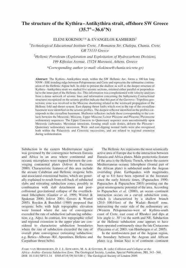
The structure of the Kythira–Antikythira strait, offshore SW Greece
(35.788888–36.688888N)
ELENI KOKINOU1* & EVANGELOS KAMBERIS2
1Technological Educational Institute Crete, 3 Romanou Str. Chalepa, Chania, Crete,
GR 73133 Greece2Hellenic Petroleum (Exploration and Exploitation of Hydrocarbons Division),
199 Kifissias Avenue, 15124 Maroussi, Athens, Greece
*Corresponding author (e-mail: [email protected])
Abstract: The Kythira–Antikythira strait, within the SW Hellenic Arc, forms a 100 km longNNW–SSE trending ridge between Peloponnesus and Crete and represents the submarine continu-ation of the Hellenic Alpine belt. In order to present the shallow as well as the deeper structure ofKythira–Antikythira strait we studied five seismic sections, oriented either parallel or perpendicu-lar to the inner part of the Hellenic Arc. This information was complemented with velocity analysesfrom a dense network of seismic lines and information concerning the bathymetry.Contractionalstructures recognized on the seismic profiles indicate that this part of the Gavrovo–Tripolitza geo-tectonic zone was involved in the Miocene shortening related to the westward propagation of theHellenic fold-and-thrust system. East-dipping thrust faults which root in the top of the crystallinebasement were identified on the seismic profiles. The deepest reflector identified on the profiles cor-responds to the crystalline basement. Shallower reflectors include those corresponding to the con-tacts between the Mesozoic/Miocene, Upper Miocene/Lower Pliocene and Pliocene/Pleistocenesedimentary sequences. The Upper Cenozoic to Quaternary sequence rests unconformably uponMesozoic carbonates. Messinian intrusions, forming small scale domes, deform the Pliocene–Quaternary sedimentary succession. West- and east-dipping normal faults were also recognisedboth within the Palaeozoic and Cenozoic successions, and are related to regional extensionduring sedimentation.
Subduction in the eastern Mediterranean regionwas governed by the convergence between Eurasiaand Africa in an area where continental andoceanic microplates were trapped between the con-verging continental plates (Jolivet & Faccenna2000). Characteristic features of this area includethe arcuate Calabrian and Hellenic orogenic beltsand associated extensional basins, which are gener-ally explained to result from roll-back of subductedslabs and retreating subduction zones, possibly incombination with slab detachment and post-collisional gravitational collapse of the overthick-ened lithosphere (Gautier et al. 1999; Wortel &Spakman 2000; Jolivet 2001; Govers & Wortel2005). Royden & Burchfiel (1989) proposed thatorogenic belts with high topographic elevationwere formed where the rate of convergenceexceeded the rate of subduction (advancing subduc-tion; e.g. Alps). In contrast, low topographic reliefand regional extension in the upper plate are con-sidered to characterize subduction boundarieswhere the rate of subduction exceeded the rate ofoverall plate convergence (retreating subduction;e.g. Betics–Alboran–Rif, Apennines, Hellenic andCarpathian thrust belts).
The Hellenic Arc represents the most seismicallyactive area of Europe due to the interaction betweenEurasia and Africa plates. Main geotectonic featureof the area is the Hellenic Trench, where the easternMediterranean oceanic lithosphere (frontal part ofthe African plate) is subducted under the Aegeanoverriding plate. Earthquakes with magnitudesof up to 8.0 have been reported in the literaturesince the early historic times, (Papazachos 1990;Papazachos & Papazachou 2003) pointing out thegreat seismogenetic potential of the area. Accordingto Papazachos et al. (2000), an ocean–continentinteraction occurs on a curved subduction zone,which is characterized by a shallow branch(20.0–100.0 km) of the Wadati–Benioff zone,intersecting the outer side of the sedimentary arc(Western Peloponnesus-west of Kythira-southcoast of Crete, east coast of Rhodes) and dips atlow angle (c. 308) to the north and NE. Subductionat the Hellenic subduction zone appears to havebeen operated continuously since the late Cretaceous(Faccenna et al. 2003; van Hinsbergen et al. 2005).
In the northwestern part of the Aegean region,the boundary between the Aegean and Africanplates (e.g. Ionian Sea) is of continent–continent
From: VAN HINSBERGEN, D. J. J., EDWARDS, M. A. & GOVERS, R. (eds) Collision and Collapse at theAfrica–Arabia–Eurasia Subduction Zone. The Geological Society, London, Special Publications, 311, 343–360.DOI: 10.1144/SP311.14 0305-8719/09/$15.00 # The Geological Society of London 2009.
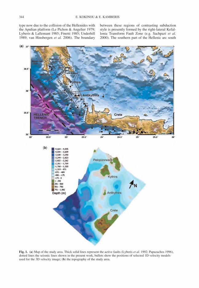
type now due to the collision of the Hellenides withthe Apulian platform (Le Pichon & Angelier 1979;Lyberis & Lallemant 1985; Finetti 1985; Underhill1989; van Hinsbergen et al. 2006). The boundary
between these regions of contrasting subductionstyle is presently formed by the right-lateral Kefal-lonia Transform Fault Zone (e.g. Sachpazi et al.2000). The southern part of the Hellenic arc south
Fig. 1. (a) Map of the study area. Thick solid lines represent the active faults (Lyberis et al. 1992; Papazachos 1996),dotted lines the seismic lines shown in the present work, bullets show the positions of selected 1D velocity modelsused for the 3D velocity image; (b) the topography of the study area.
E. KOKINOU & E. KAMBERIS344
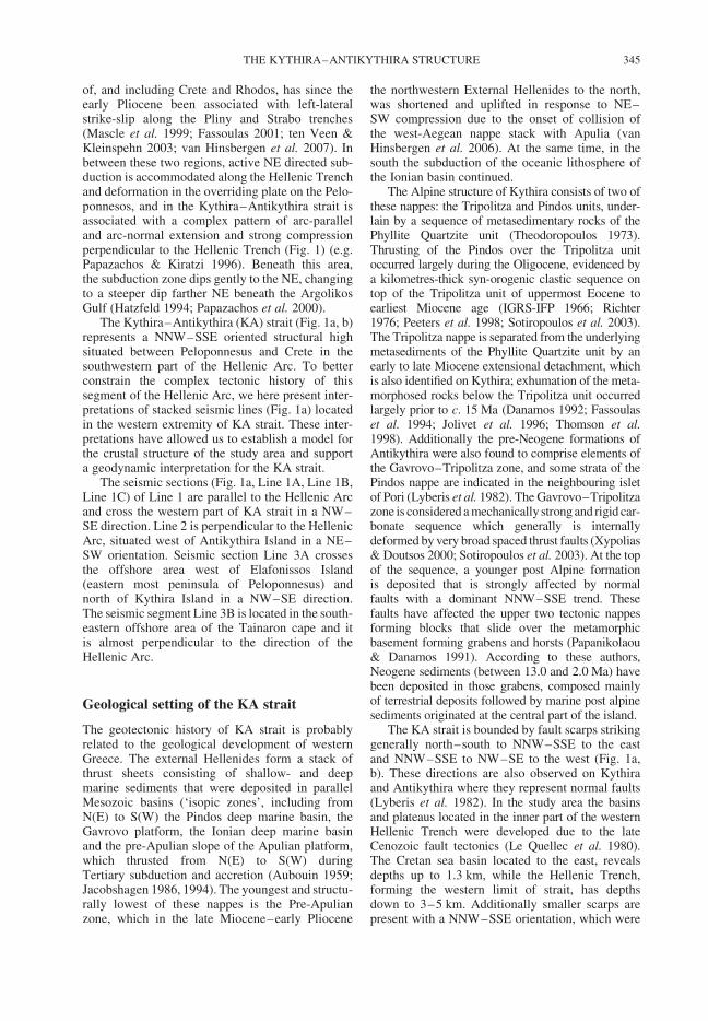
of, and including Crete and Rhodos, has since theearly Pliocene been associated with left-lateralstrike-slip along the Pliny and Strabo trenches(Mascle et al. 1999; Fassoulas 2001; ten Veen &Kleinspehn 2003; van Hinsbergen et al. 2007). Inbetween these two regions, active NE directed sub-duction is accommodated along the Hellenic Trenchand deformation in the overriding plate on the Pelo-ponnesos, and in the Kythira–Antikythira strait isassociated with a complex pattern of arc-paralleland arc-normal extension and strong compressionperpendicular to the Hellenic Trench (Fig. 1) (e.g.Papazachos & Kiratzi 1996). Beneath this area,the subduction zone dips gently to the NE, changingto a steeper dip farther NE beneath the ArgolikosGulf (Hatzfeld 1994; Papazachos et al. 2000).
The Kythira–Antikythira (KA) strait (Fig. 1a, b)represents a NNW–SSE oriented structural highsituated between Peloponnesus and Crete in thesouthwestern part of the Hellenic Arc. To betterconstrain the complex tectonic history of thissegment of the Hellenic Arc, we here present inter-pretations of stacked seismic lines (Fig. 1a) locatedin the western extremity of KA strait. These inter-pretations have allowed us to establish a model forthe crustal structure of the study area and supporta geodynamic interpretation for the KA strait.
The seismic sections (Fig. 1a, Line 1A, Line 1B,Line 1C) of Line 1 are parallel to the Hellenic Arcand cross the western part of KA strait in a NW–SE direction. Line 2 is perpendicular to the HellenicArc, situated west of Antikythira Island in a NE–SW orientation. Seismic section Line 3A crossesthe offshore area west of Elafonissos Island(eastern most peninsula of Peloponnesus) andnorth of Kythira Island in a NW–SE direction.The seismic segment Line 3B is located in the south-eastern offshore area of the Tainaron cape and itis almost perpendicular to the direction of theHellenic Arc.
Geological setting of the KA strait
The geotectonic history of KA strait is probablyrelated to the geological development of westernGreece. The external Hellenides form a stack ofthrust sheets consisting of shallow- and deepmarine sediments that were deposited in parallelMesozoic basins (‘isopic zones’, including fromN(E) to S(W) the Pindos deep marine basin, theGavrovo platform, the Ionian deep marine basinand the pre-Apulian slope of the Apulian platform,which thrusted from N(E) to S(W) duringTertiary subduction and accretion (Aubouin 1959;Jacobshagen 1986, 1994). The youngest and structu-rally lowest of these nappes is the Pre-Apulianzone, which in the late Miocene–early Pliocene
the northwestern External Hellenides to the north,was shortened and uplifted in response to NE–SW compression due to the onset of collision ofthe west-Aegean nappe stack with Apulia (vanHinsbergen et al. 2006). At the same time, in thesouth the subduction of the oceanic lithosphere ofthe Ionian basin continued.
The Alpine structure of Kythira consists of two ofthese nappes: the Tripolitza and Pindos units, under-lain by a sequence of metasedimentary rocks of thePhyllite Quartzite unit (Theodoropoulos 1973).Thrusting of the Pindos over the Tripolitza unitoccurred largely during the Oligocene, evidenced bya kilometres-thick syn-orogenic clastic sequence ontop of the Tripolitza unit of uppermost Eocene toearliest Miocene age (IGRS-IFP 1966; Richter1976; Peeters et al. 1998; Sotiropoulos et al. 2003).The Tripolitza nappe is separated from the underlyingmetasediments of the Phyllite Quartzite unit by anearly to late Miocene extensional detachment, whichis also identified on Kythira; exhumation of the meta-morphosed rocks below the Tripolitza unit occurredlargely prior to c. 15 Ma (Danamos 1992; Fassoulaset al. 1994; Jolivet et al. 1996; Thomson et al.1998). Additionally the pre-Neogene formations ofAntikythira were also found to comprise elements ofthe Gavrovo–Tripolitza zone, and some strata of thePindos nappe are indicated in the neighbouring isletof Pori (Lyberis et al. 1982). The Gavrovo–Tripolitzazone is considered a mechanically strong and rigid car-bonate sequence which generally is internallydeformed by very broad spaced thrust faults (Xypolias& Doutsos 2000; Sotiropoulos et al. 2003). At the topof the sequence, a younger post Alpine formationis deposited that is strongly affected by normalfaults with a dominant NNW–SSE trend. Thesefaults have affected the upper two tectonic nappesforming blocks that slide over the metamorphicbasement forming grabens and horsts (Papanikolaou& Danamos 1991). According to these authors,Neogene sediments (between 13.0 and 2.0 Ma) havebeen deposited in those grabens, composed mainlyof terrestrial deposits followed by marine post alpinesediments originated at the central part of the island.
The KA strait is bounded by fault scarps strikinggenerally north–south to NNW–SSE to the eastand NNW–SSE to NW–SE to the west (Fig. 1a,b). These directions are also observed on Kythiraand Antikythira where they represent normal faults(Lyberis et al. 1982). In the study area the basinsand plateaus located in the inner part of the westernHellenic Trench were developed due to the lateCenozoic fault tectonics (Le Quellec et al. 1980).The Cretan sea basin located to the east, revealsdepths up to 1.3 km, while the Hellenic Trench,forming the western limit of strait, has depthsdown to 3–5 km. Additionally smaller scarps arepresent with a NNW–SSE orientation, which were
THE KYTHIRA–ANTIKYTHIRA STRUCTURE 345
formed due to the activity of extensional faultingthat affected the area in the late Cenozoic. Lyberiset al. (1982) concluded that the KA segment of theHellenic Arc acts as a complex zone of transform-extensional motion associated with rotationsand translations between two major segments(Peloponnesus and Crete) of the external arc.Faults, parallel to the axis of the arc are well rep-resented and correspond to mainly transverse exten-sion. In addition, the presence of the en echelonnormal fault system results in a dextral componentof extensional motion parallel to KA axis.
Velocity models of the KA strait and the
western part of Crete
The presented seismic lines were acquired during astreamer reflection campaign (Hellenic PetroleumCo.,) in the KA strait many years ago. Western Geo-physical Company of America, which towed a highpressure airgun tuned array, produced the seismicsignals. The receiver group interval was 25 m andthe minimum offset was 250 m. The recordinglength and the sampling rate were 8 seconds (s)and 4 milliseconds (ms), respectively. The data pro-cessing sequence includes geometrical spreadingcorrection, deconvolution, velocity analysis, stack-ing and time variant filtering.
The interpretation of the seismic segments isbased on: (1) bathymetry data; and (2) velocityanalysis data occurred for the presented lines. Bathy-metry data (www.geomapapp.org) was processed inorder to construct a 3D image of the KA strait seafloor, which helps us to trace the main geotectonicfeatures on the seismic sections. Lack of deep bore-hole data either from deep water or the continentalplatform of Kythira and Antikythira Islandsimpedes to calibrate the seismic horizons. Therefore,1D velocity models deduced from other seismicreflection experiments in the larger study area andin the southern part of Crete were used in order tosupport our interpretations and to further constructa 3D velocity pseudosection for the study area.
Common Depth Point (CDP) velocity data isused in the present work in order to construct 2Dand 3D velocity models for the upper 15.0–20.0 km of the larger study area. The detection ofthe velocity layers is based on velocity jumps. Thedetection of the seismic units on the seismic sectionshas been done by superimposing the velocitymodels on the stacked sections. The reflection coef-ficients and the lithoseismic patterns were taken intoaccount. Additionally, onshore and offshore vel-ocity data from the southwestern part of Crete wasincluded in the database aiming at a more completeimage of the west Cretan crust. Previous velocitymodels (Makris & Stobbe 1984; Bohnhoff et al.
2001; Makris & Yegorova 2006) were also used inorder to correlate our models and to extend themto a depth of 35 km.
Root Mean Square (RMS) velocities were con-verted to interval velocities according to Dixequation. The 1D velocity models were used for theconstruction of 2D models. Representative examplesof 1D velocity distribution are shown in Figure 2a.Generally, velocity increases with depth, but vel-ocity reversals (Fig. 2a, models 5, 7, 15, 36, 47)are also observed between 2.2 and 5.5 km depth.Velocity reversals at such depths could be causedby intrusions of Messinian evaporites or compres-sive deformation. Similar velocity reversals werealso observed in the seismic line ION-7 (0.0–180.0 km) that crosses the Ionian basin from thedeep Ionian abyssal plain up to the gulf of Patras(Kokinou et al. 2003, 2005). Thereinafter, a 3Ddatabase was created using topographic data,previously available information about velocitydistribution and interval velocities for the upper20.0 km of the Cretan crust derived from reflectionexperiments. Special emphasis has been givento the upper 15.0–20.0 km of the cover thatcomprises a seismogenic layer of generally smallto moderate earthquakes.
The 3D velocity pseudosections (Fig. 2b)provide a generalized image of the onshore and off-shore KA strait and western part of Crete. As shownin Figure 2b the layer thicknesses change not only ineast–west direction but also in north–south. Wedivided the Cretan–Antikythira–Kythira crust infive units. The upper layer, showing a velocityrange between 1.5–2.2 km/s, corresponds to theseawater layer and the upper series of the post-Alpine sediments. The second layer has a velocitybetween 2.3 and 4.4 km/s and could represent thelower post-Alpine sequences and part of the upperAlpine successions. It is followed by a layershowing a velocity range of 4.5–6.0 km/s, whichis attributed to the lower successions of the Alpinesediments, mainly consisting of carbonates. Thenext layer corresponds to a velocity between 6.1and 6.5 km/s and could be the lowermost part ofthe carbonate_ succession and the Palaeozoic meta-morphosed sequence. The layer corresponding to6.6–7.9 km/s may represent the lowermost part ofthe continental crust.
The layers underneath the KA strait are almosthorizontal except for some local variations in thick-ness. The inclination of the layers towards Crete isrelated to the impressive crustal thickness under-neath Crete, as shown in previous studies for thenorthern and southern offshore part of Crete:Bohnhoff et al. (2001) concluded that the crust inthe Cretan region is continental with maximumthickness of 32.5 km beneath North and CentralCrete and thins towards the north and south to
E. KOKINOU & E. KAMBERIS346
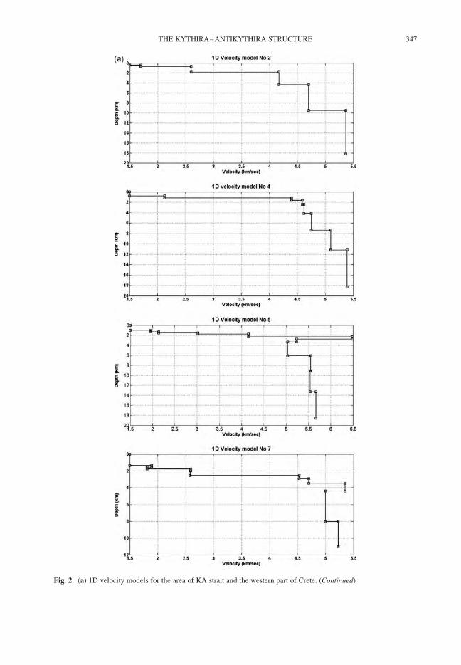
Fig. 2. (a) 1D velocity models for the area of KA strait and the western part of Crete. (Continued)
THE KYTHIRA–ANTIKYTHIRA STRUCTURE 347
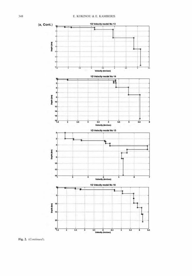
Fig. 2. (Continued).
E. KOKINOU & E. KAMBERIS348
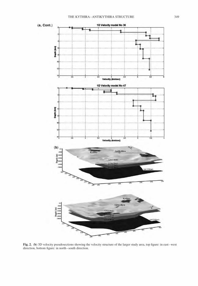
Fig. 2. (b) 3D velocity pseudosections showing the velocity structure of the larger study area, top figure: in east–westdirection, bottom figure: in north–south direction.
THE KYTHIRA–ANTIKYTHIRA STRUCTURE 349
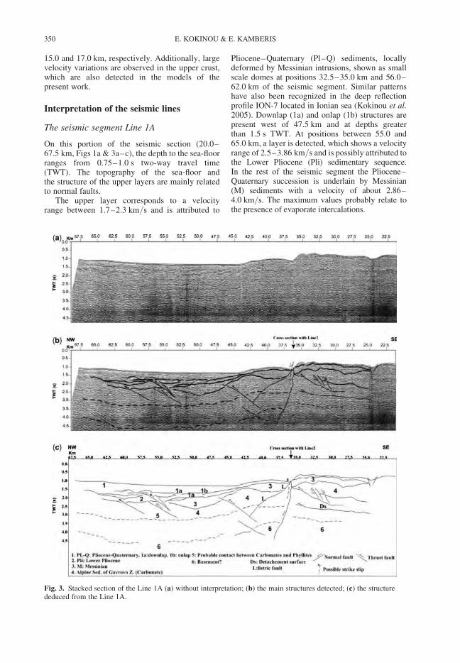
15.0 and 17.0 km, respectively. Additionally, largevelocity variations are observed in the upper crust,which are also detected in the models of thepresent work.
Interpretation of the seismic lines
The seismic segment Line 1A
On this portion of the seismic section (20.0–67.5 km, Figs 1a & 3a–c), the depth to the sea-floorranges from 0.75–1.0 s two-way travel time(TWT). The topography of the sea-floor andthe structure of the upper layers are mainly relatedto normal faults.
The upper layer corresponds to a velocityrange between 1.7–2.3 km/s and is attributed to
Pliocene–Quaternary (Pl–Q) sediments, locallydeformed by Messinian intrusions, shown as smallscale domes at positions 32.5–35.0 km and 56.0–62.0 km of the seismic segment. Similar patternshave also been recognized in the deep reflectionprofile ION-7 located in Ionian sea (Kokinou et al.2005). Downlap (1a) and onlap (1b) structures arepresent west of 47.5 km and at depths greaterthan 1.5 s TWT. At positions between 55.0 and65.0 km, a layer is detected, which shows a velocityrange of 2.5–3.86 km/s and is possibly attributed tothe Lower Pliocene (Pli) sedimentary sequence.In the rest of the seismic segment the Pliocene–Quaternary succession is underlain by Messinian(M) sediments with a velocity of about 2.86–4.0 km/s. The maximum values probably relate tothe presence of evaporate intercalations.
Fig. 3. Stacked section of the Line 1A (a) without interpretation; (b) the main structures detected; (c) the structurededuced from the Line 1A.
E. KOKINOU & E. KAMBERIS350
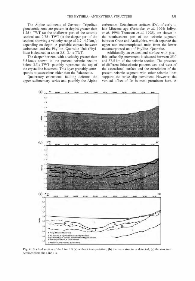
The Alpine sediments of Gavrovo–Tripolitzageotectonic zone are present at depths greater than1.25 s TWT (at the shallower part of the seismicsection) and 2.75 s TWT (at the deeper part of thesection) showing a velocity range of 3.7–4.7 km/sdepending on depth. A probable contact betweencarbonates and the Phyllite–Quartzite Unit (Phyl-lites) is detected at about 2.8–3.4 s TWT.
The deeper horizon, with a velocity greater than5.5 km/s shown in the present seismic sectionbelow 3.5 s TWT, possibly represents the top ofthe crystalline basement. This layer probably corre-sponds to successions older than the Palaeozoic.
Quaternary extensional faulting deforms theupper sedimentary series and possibly the Alpine
carbonates. Detachment surfaces (Ds), of early tolate Miocene age (Fassoulas et al. 1994; Jolivetet al. 1996; Thomson et al. 1998), are shown inthe southeastern part of the seismic segmentbetween Crete and Antikythira, which separate theupper non metamorphosed units from the lowermetamorphosed unit of Phyllite–Quartzite.
Additionally an extensional surface with poss-ible strike slip movement is situated between 35.0and 37.5 km of the seismic section. The presenceof different lithoseismic patterns east and west ofthe extensional surface and the correlation of thepresent seismic segment with other seismic linessupports the strike slip movement. However, thevertical offset of Ds is most prominent here. A
Fig. 4. Stacked section of the Line 1B (a) without interpretation; (b) the main structures detected; (c) the structurededuced from the Line 1B.
THE KYTHIRA–ANTIKYTHIRA STRUCTURE 351
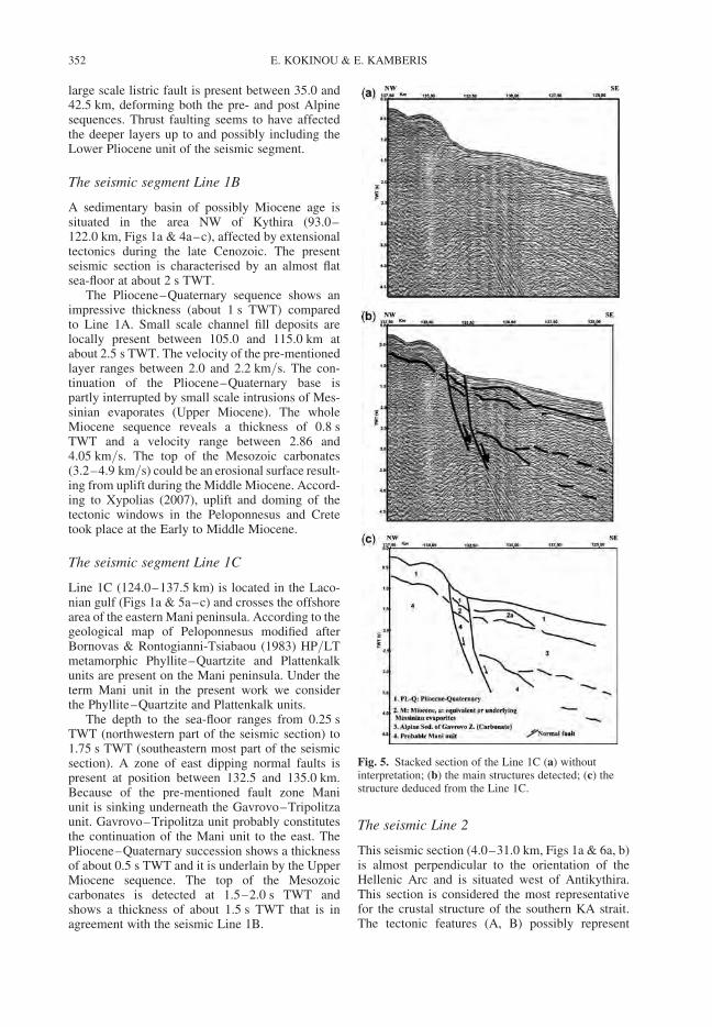
large scale listric fault is present between 35.0 and42.5 km, deforming both the pre- and post Alpinesequences. Thrust faulting seems to have affectedthe deeper layers up to and possibly including theLower Pliocene unit of the seismic segment.
The seismic segment Line 1B
A sedimentary basin of possibly Miocene age issituated in the area NW of Kythira (93.0–122.0 km, Figs 1a & 4a–c), affected by extensionaltectonics during the late Cenozoic. The presentseismic section is characterised by an almost flatsea-floor at about 2 s TWT.
The Pliocene–Quaternary sequence shows animpressive thickness (about 1 s TWT) comparedto Line 1A. Small scale channel fill deposits arelocally present between 105.0 and 115.0 km atabout 2.5 s TWT. The velocity of the pre-mentionedlayer ranges between 2.0 and 2.2 km/s. The con-tinuation of the Pliocene–Quaternary base ispartly interrupted by small scale intrusions of Mes-sinian evaporates (Upper Miocene). The wholeMiocene sequence reveals a thickness of 0.8 sTWT and a velocity range between 2.86 and4.05 km/s. The top of the Mesozoic carbonates(3.2–4.9 km/s) could be an erosional surface result-ing from uplift during the Middle Miocene. Accord-ing to Xypolias (2007), uplift and doming of thetectonic windows in the Peloponnesus and Cretetook place at the Early to Middle Miocene.
The seismic segment Line 1C
Line 1C (124.0–137.5 km) is located in the Laco-nian gulf (Figs 1a & 5a–c) and crosses the offshorearea of the eastern Mani peninsula. According to thegeological map of Peloponnesus modified afterBornovas & Rontogianni-Tsiabaou (1983) HP/LTmetamorphic Phyllite–Quartzite and Plattenkalkunits are present on the Mani peninsula. Under theterm Mani unit in the present work we considerthe Phyllite–Quartzite and Plattenkalk units.
The depth to the sea-floor ranges from 0.25 sTWT (northwestern part of the seismic section) to1.75 s TWT (southeastern most part of the seismicsection). A zone of east dipping normal faults ispresent at position between 132.5 and 135.0 km.Because of the pre-mentioned fault zone Maniunit is sinking underneath the Gavrovo–Tripolitzaunit. Gavrovo–Tripolitza unit probably constitutesthe continuation of the Mani unit to the east. ThePliocene–Quaternary succession shows a thicknessof about 0.5 s TWT and it is underlain by the UpperMiocene sequence. The top of the Mesozoiccarbonates is detected at 1.5–2.0 s TWT andshows a thickness of about 1.5 s TWT that is inagreement with the seismic Line 1B.
The seismic Line 2
This seismic section (4.0–31.0 km, Figs 1a & 6a, b)is almost perpendicular to the orientation of theHellenic Arc and is situated west of Antikythira.This section is considered the most representativefor the crustal structure of the southern KA strait.The tectonic features (A, B) possibly represent
Fig. 5. Stacked section of the Line 1C (a) withoutinterpretation; (b) the main structures detected; (c) thestructure deduced from the Line 1C.
E. KOKINOU & E. KAMBERIS352
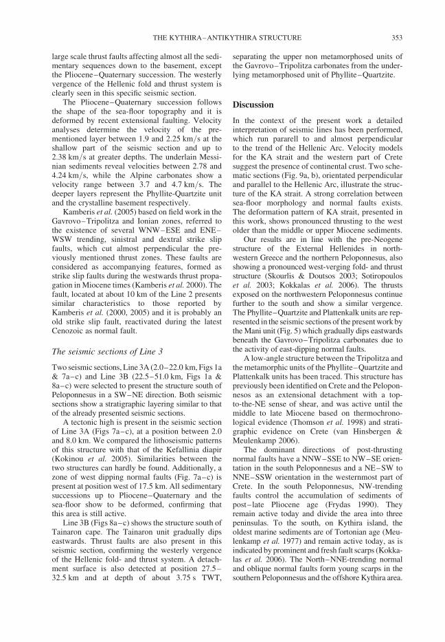
large scale thrust faults affecting almost all the sedi-mentary sequences down to the basement, exceptthe Pliocene–Quaternary succession. The westerlyvergence of the Hellenic fold and thrust system isclearly seen in this specific seismic section.
The Pliocene–Quaternary succession followsthe shape of the sea-floor topography and it isdeformed by recent extensional faulting. Velocityanalyses determine the velocity of the pre-mentioned layer between 1.9 and 2.25 km/s at theshallow part of the seismic section and up to2.38 km/s at greater depths. The underlain Messi-nian sediments reveal velocities between 2.78 and4.24 km/s, while the Alpine carbonates show avelocity range between 3.7 and 4.7 km/s. Thedeeper layers represent the Phyllite-Quartzite unitand the crystalline basement respectively.
Kamberis et al. (2005) based on field work in theGavrovo–Tripolitza and Ionian zones, referred tothe existence of several WNW–ESE and ENE–WSW trending, sinistral and dextral strike slipfaults, which cut almost perpendicular the pre-viously mentioned thrust zones. These faults areconsidered as accompanying features, formed asstrike slip faults during the westwards thrust propa-gation in Miocene times (Kamberis et al. 2000). Thefault, located at about 10 km of the Line 2 presentssimilar characteristics to those reported byKamberis et al. (2000, 2005) and it is probably anold strike slip fault, reactivated during the latestCenozoic as normal fault.
The seismic sections of Line 3
Two seismic sections, Line 3A (2.0–22.0 km, Figs 1a& 7a–c) and Line 3B (22.5–51.0 km, Figs 1a &8a–c) were selected to present the structure south ofPeloponnesus in a SW–NE direction. Both seismicsections show a stratigraphic layering similar to thatof the already presented seismic sections.
A tectonic high is present in the seismic sectionof Line 3A (Figs 7a–c), at a position between 2.0and 8.0 km. We compared the lithoseismic patternsof this structure with that of the Kefallinia diapir(Kokinou et al. 2005). Similarities between thetwo structures can hardly be found. Additionally, azone of west dipping normal faults (Fig. 7a–c) ispresent at position west of 17.5 km. All sedimentarysuccessions up to Pliocene–Quaternary and thesea-floor show to be deformed, confirming thatthis area is still active.
Line 3B (Figs 8a–c) shows the structure south ofTainaron cape. The Tainaron unit gradually dipseastwards. Thrust faults are also present in thisseismic section, confirming the westerly vergenceof the Hellenic fold- and thrust system. A detach-ment surface is also detected at position 27.5–32.5 km and at depth of about 3.75 s TWT,
separating the upper non metamorphosed units ofthe Gavrovo–Tripolitza carbonates from the under-lying metamorphosed unit of Phyllite–Quartzite.
Discussion
In the context of the present work a detailedinterpretation of seismic lines has been performed,which run pararell to and almost perpendicularto the trend of the Hellenic Arc. Velocity modelsfor the KA strait and the western part of Cretesuggest the presence of continental crust. Two sche-matic sections (Fig. 9a, b), orientated perpendicularand parallel to the Hellenic Arc, illustrate the struc-ture of the KA strait. A strong correlation betweensea-floor morphology and normal faults exists.The deformation pattern of KA strait, presented inthis work, shows pronounced thrusting to the westolder than the middle or upper Miocene sediments.
Our results are in line with the pre-Neogenestructure of the External Hellenides in north-western Greece and the northern Peloponnesus, alsoshowing a pronounced west-verging fold- and thruststructure (Skourlis & Doutsos 2003; Sotiropouloset al. 2003; Kokkalas et al. 2006). The thrustsexposed on the northwestern Peloponnesus continuefurther to the south and show a similar vergence.The Phyllite–Quartzite and Plattenkalk units are rep-resented in the seismic sections of the present work bythe Mani unit (Fig. 5) which gradually dips eastwardsbeneath the Gavrovo–Tripolitza carbonates due tothe activity of east-dipping normal faults.
A low-angle structure between the Tripolitza andthe metamorphic units of the Phyllite–Quartzite andPlattenkalk units has been traced. This structure haspreviously been identified on Crete and the Pelopon-nesos as an extensional detachment with a top-to-the-NE sense of shear, and was active until themiddle to late Miocene based on thermochrono-logical evidence (Thomson et al. 1998) and strati-graphic evidence on Crete (van Hinsbergen &Meulenkamp 2006).
The dominant directions of post-thrustingnormal faults have a NNW–SSE to NW–SE orien-tation in the south Peloponnesus and a NE–SW toNNE–SSW orientation in the westernmost part ofCrete. In the south Peloponnesus, NW-trendingfaults control the accumulation of sediments ofpost–late Pliocene age (Frydas 1990). Theyremain active today and divide the area into threepeninsulas. To the south, on Kythira island, theoldest marine sediments are of Tortonian age (Meu-lenkamp et al. 1977) and remain active today, as isindicated by prominent and fresh fault scarps (Kokka-las et al. 2006). The North–NNE-trending normaland oblique normal faults form young scarps in thesouthern Peloponnesus and the offshore Kythira area.
THE KYTHIRA–ANTIKYTHIRA STRUCTURE 353
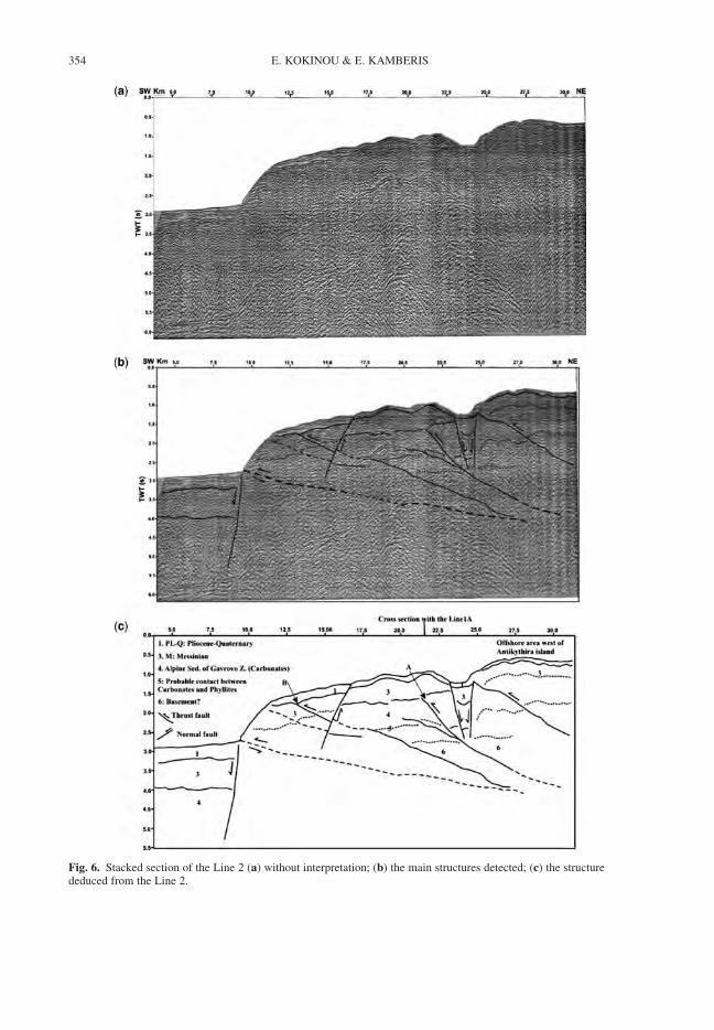
Fig. 6. Stacked section of the Line 2 (a) without interpretation; (b) the main structures detected; (c) the structurededuced from the Line 2.
E. KOKINOU & E. KAMBERIS354
Fig. 7. Stacked section of the Line 3A (a) without interpretation; (b) the main structures detected; (c) the structurededuced from the Line 3A.
THE KYTHIRA–ANTIKYTHIRA STRUCTURE 355

Fig. 8. Stacked section of the Line 3B (a) without interpretation; (b) the main structures detected; (c) the structurededuced from the Line 3B.
E. KOKINOU & E. KAMBERIS356
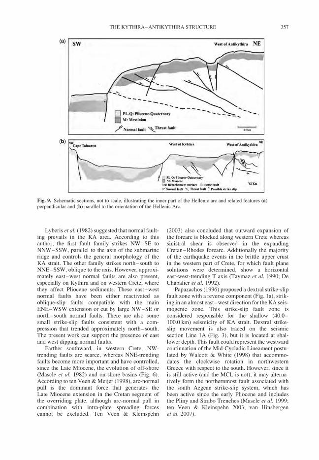
Lyberis et al. (1982) suggested that normal fault-ing prevails in the KA area. According to thisauthor, the first fault family strikes NW–SE toNNW–SSW, parallel to the axis of the submarineridge and controls the general morphology of theKA strait. The other family strikes north–south toNNE–SSW, oblique to the axis. However, approxi-mately east–west normal faults are also present,especially on Kythira and on western Crete, wherethey affect Pliocene sediments. These east–westnormal faults have been either reactivated asoblique-slip faults compatible with the mainENE–WSW extension or cut by large NW–SE ornorth–south normal faults. There are also somesmall strike-slip faults consistent with a com-pression that trended approximately north–south.The present work can support the presence of eastand west dipping normal faults.
Farther southward, in western Crete, NW-trending faults are scarce, whereas NNE-trendingfaults become more important and have controlled,since the Late Miocene, the evolution of off-shore(Mascle et al. 1982) and on-shore basins (Fig. 6).According to ten Veen & Meijer (1998), arc-normalpull is the dominant force that generates theLate Miocene extension in the Cretan segment ofthe overriding plate, although arc-normal pull incombination with intra-plate spreading forcescannot be excluded. Ten Veen & Kleinspehn
(2003) also concluded that outward expansion ofthe forearc is blocked along western Crete whereassinistral shear is observed in the expandingCretan–Rhodes forearc. Additionally the majorityof the earthquake events in the brittle upper crustin the western part of Crete, for which fault planesolutions were determined, show a horizontaleast-west-trending T axis (Taymaz et al. 1990; DeChabalier et al. 1992).
Papazachos (1996) proposed a dextral strike-slipfault zone with a reverse component (Fig. 1a), strik-ing in an almost east–west direction for the KA seis-mogenic zone. This strike-slip fault zone isconsidered responsible for the shallow (40.0–100.0 km) seismicity of KA strait. Dextral strike-slip movement is also traced on the seismicsection Line 1A (Fig. 3), but it is located at shal-lower depth. This fault could represent the westwardcontinuation of the Mid-Cycladic Lineament postu-lated by Walcott & White (1998) that accommo-dates the clockwise rotation in northwesternGreece with respect to the south. However, since itis still active (and the MCL is not), it may alterna-tively form the northernmost fault associated withthe south Aegean strike-slip system, which hasbeen active since the early Pliocene and includesthe Pliny and Strabo Trenches (Mascle et al. 1999;ten Veen & Kleinspehn 2003; van Hinsbergenet al. 2007).
Fig. 9. Schematic sections, not to scale, illustrating the inner part of the Hellenic arc and related features (a)perpendicular and (b) parallel to the orientation of the Hellenic Arc.
THE KYTHIRA–ANTIKYTHIRA STRUCTURE 357
In addition, the post-Alpine and Alpine sedimen-tary successions reveal an approximate thickness of15.0–16.0 km. Papazachos et al. (2000) used 961shallow and intermediate earthquakes for theperiod 1965–1995 to define the geometry of theHellenic Arc, by constructing three cross sectionsfor the western, central and eastern part. A veryintense shallow seismicity (h , 20.0 km) is definedin the western part of Cretan crust. Based on thisreport we traced the shallow seismogenic layer inour profiles located in the northwestern offshoreCrete and we detected this layer at an approximatedepth from 7.0–18.0 km.
The Gavrovo–Tripolitza zone constitutes a 3 kmthick shallow-water carbonate sequence of Meso-zoic age and is considered to represent the shelfsediments of the Apulian passive continentalmargin which passed gradually into the deepwatersedimentary sequence of Pindos to the east (Fleury1980). According to the present study the thicknessof the Gavrovo–Tripolitza zone (carbonate) rangesbetween 0.5 (intensively eroded) and 0.75 sTWT, namely greater than 2.1 km. A similar study(Sotiropoulos et al. 2003) in Etoloakarnania andNW Peloponnesus determined the thickness ofGavrovo–Tripolitza carbonate sequence at about0.75–1.0 s TWT.
Alves et al. (2007) presented seismic reflectionsections located in the southern Cretan margin, inorder to study the Neogene stratigraphy of thearea. Up to 1.2 s TWT of strata, accumulated sincethe Middle Miocene, in association with extensionin the South Aegean region. The seismic segmentspresented in this work show a thickness of about0.5–0.75 s TWT for the strata accumulated sincethe Messinian in the southern part of KA strait,which is in agreement with the study of Alveset al. (2007). The strata, accumulated since the Mes-sinian in the northern part of KA strait, show a thick-ness up to 1.25 s TWT.
Conclusions
The studied seismic lines are located in an activeregion which represents the transition from exten-sional backarc to the forearc. The latter showssigns of frontal accretion. Deep compressionalstructures and shallower extensional structures arepresent. Later extension is related to structures,showing a predominantly NW–SE orientation. Wesummarize the interpretation as follows:
1. Strong evidence for SW-verging andNE-dipping thrusts has been found. These arewell known from the western Peloponnesosand western Greece and relate to the emplace-ment of the Pindos zone on top of the Tripolitzazone. This occurred during the Oligocene. The
westward increase in thickness of the Alpinesediments of the upper crust is possiblyrelated to the westward migration of thethrust front of the External Hellenides. Thethrust front affects the sedimentary sequencesup to and including Messinian or LowerPliocene successions.
2. Detachment surfaces are recognized in theseismic sections situated near to Peloponnesusand Crete but no evidence for such surfaces hasbeen found for the rest of the KA strait.
3. NNE–SSW and c. E-W running faults whichintersect each other and the sediments in theKA strait have been detected. These sedimentslikely have an age of Tortonian and younger.The interfering faults structures have beenidentified earlier on the Peloponnesus. Thesestructures possibly affected the whole of thesoutheastern Aegean region and remainactive today.
4. An c. E-W running strike-slip fault is possiblyidentified. This fault has been postulatedbefore based on seismic evidence.
5. The top of the Gavrovo–Tripolitza sequence(carbonates) is represented by a very strongreflector at 1.5–3.2 s TWT, while the top ofthe crystalline basement gradually dipswestwards with depths ranging from 3.0–4.0 s TWT.
This work was supported by the project ‘Pythagoras’funded by the EPEAEK, Geophysics Department contri-bution 689. The authors express their gratitude to HellenicPetroleum Co. (EL.PE) for making the data available. Wewish to thank Dr. ten Veen and Dr. Alves for their con-structive criticism, which improved a version of this manu-script. The GMT system (Wessel & Smith 1998) was usedto plot part of the figures.
References
ALVES, T. M., LYKOUSIS, V., SAKELLARIOU, D.,ALEXANDRI, S. & NOMIKOU, P. 2007. Constrainingthe origin and evolution of confined turbidite systems:southern Cretan margin, Eastern Mediterranean Sea(34830–368N). Geo-Marine Letters, 27, 41–61.
AUBOUIN, J. 1959. Contribution a l’etude geologique de laGrece septentrionale: le confins de l’Epire et de laThessalie. Annales Geologiques des pays Helleniques,10, 1–484.
BOHNHOFF, M., MAKRIS, J., PAPANIKOLAOU, D. &STAVRAKAKIS, G. 2001. Crustal investigation of theHellenic subduction zone using wide aperture seismicdata. Tectonophysics, 343, 239–262.
BORNOVAS, I. & RONTOGIANNI-TSIABAOU, T. 1983.Geological map of Greece. Institute of Geology andMineral exploration, Athens.
DANAMOS, G. 1992. Contribution to the Geology andHydrogeology of the island of Kythira. PhD thesis,Athens.
E. KOKINOU & E. KAMBERIS358
DE CHABALIER, J. B., LYON-CAEN, H., ZOLLO, A.,DESCHAMPS, A., BERNARD, P. & HATZFELD, D.1992. A detailed analysis of microearthquakes inwestern Crete from digital three-component seismo-grams. Geophysical Journal International, 110,347–360.
FACCENNA, C., JOLIVET, L., PIROMALLO, C. &MORELLI, A. 2003. Subduction and the depth ofconvection of the Mediterranean mantle. Journal ofGeophysical Research, 108, 2099.
FASSOULAS, C. 2001. The tectonic development of aNeogene basin at the leading edge of the activeEuropean margin: the Heraklion basin, Crete, Greece.Journal of Geodynamics, 31, 49–70.
FASSOULAS, C., KILIAS, A. & MOUNTRAKIS, D. 1994.Postnappe stacking extension and exhumation of HP/LT rocks in the island of Crete, Greece. Tectonics,13, 127–138.
FINETTI, I. 1985. Structure and evolution of the centralMediterranean (Palagian and Ionian Seas). In:STANLEY, D. J. & WEZEL, F. C. (eds) Geologicalevolution of the Mediterranean Basin. Springer,New York, 215–230.
FLEURY, J. 1980. Les zones de Gavrovo - Tripolitsa et duPinde - Olonos (Grece continentale et Peloponnese duNord). Evolution d’une plateforme et d’un bassin dansleur carde alpin. Societe Geologique du Nord, SpecialPublication, 4.
FRYDAS, D. 1990. Plankton-Stratigraphie des Pliozansund unteren Pleistozans des SW-Peloponnes, Grie-chenland. Newsletters on Stratigraphy, 23, 91–108.
GAUTIER, P., BRUN, J.-P., MORICEAU, R., SOKOUTIS,D., MARTINOD, J. & JOLIVET, L. 1999. Timing, kine-matics and cause of Aegean extension: a scenariobased on a comparison with simple analogue exper-iments. Tectonophysics, 315, 31–72.
GOVERS, R. & WORTEL, M. J. R. 2005. Lithospheretearing at STEP faults: Response to edges of subduc-tion zones. Earth and Planetary Science Letters, 236,505–523.
HATZFELD, D. 1994. On the shape of the subducting slabbeneath the Peloponnese, Greece. GeophysicalResearch Letters, 21, 173–176.
IGRS-IFP 1966. Etude Geologique de l’Epire (Grecenord-occidentale). Institut Francais du Petrol, Paris.
JACOBSHAGEN, V. 1986. Geologie von Griechenland.Borntraeger, Berlin-Stuttgart.
JACOBSHAGEN, V. 1994. Orogenic evolution of the Helle-nides: new aspects. Geologische Rundschau, 83,249–256.
JOLIVET, L., GOFFE, B., MONIE, P., TRUFFERT-LUXEY,C., PATRIAT, M. & BONNEAU, M. 1996. Miocenedetachment on Crete and exhumation P-T-t paths ofhigh-pressure metamorphic rocks. Tectonics, 15,1129–1153.
JOLIVET, L. 2001. A comparison of geodetic and finitestrain pattern in the Aegean, geodynamic implications.Earth and Planetary Science Letters, 187, 95–104.
JOLIVET, L. & FACCENNA, C. 2000. Mediterraneanextension and the Africa-Eurasia collision. Tectonics,19, 1094–1106.
KAMBERIS, E., SOTIPOPOULOS, S., AXIMNIOTOU, O.,TSAILA-MONOPOLIS, S. & IOAKIM, C. 2000. LateCenozoic deformation of Gavrovo-Tripolitza zone in
NW Peloponnesos (Western Greece). AnnalsGeofisica, 43, 905–919.
KAMBERIS, E., PAVLOPOULOS, A., TSAILA-MONOPOLIS, S., SOTIROPOULOS, S. & IOAKIM, C.2005. Paleogene deep-water sedimentation and Paleo-geography of foreland basins in the NW Peloponnese(Greece). Geologica Carpathica, 56, 503–515.
KOKINOU, E., VAFIDIS, A., LOUCOGIANNAKIS, M. &LOUIS, J. 2003. Deep seismic imaging and velocityestimation in Ionian Sea. Journal of the Balkan Geo-physical Society, 6, 100–116.
KOKINOU, E., KAMPERIS, E., VAFIDIS, A., MONOPOLIS,D., ANANIADIS, G. & ZELILIDIS, A. 2005. Deepseismic reflection data from offshore western Greece:a new crustal model for the Ionian sea. Journal ofPetroleum Geology, 28, 185–202.
KOKKALAS, S., XYPOLIAS, P., KOUKOUVELAS, I. &DOUTSOS, T. 2006. Postcollisional contractional andextensional deformation in the Aegean region. Geologi-cal Society of America, Special Paper, 409, 97–123.
LE PICHON, X. & ANGELIER, J. 1979. The Hellenic Arcand trench system: a key to the neotectonic evolutionof the Eastern Mediterranean area. Tectonophysics,60, 1–42.
LE QUELLEC, P., MASCLE, J., GOT, H. & VITORI, J.1980. Seismic structure of south-western Peloponnesuscontinental margin. Bulletin of the American Associ-ation of Petroleum Geology, 64, 242–263.
LYBERIS, N. & LALLEMANT, S. 1985. La transitionsubduction-collision le long de l’arc egeen externe.Comptes Rendus de l’Academie des Sciences, II, 300,887–890.
LYBERIS, N., ANGELIER, J., BARRIER, E. &LALLEMENT, S. 1982. Active deformation of asegment of arc, the strait of Kythira, Hellenic arc,Greece. Journal of Structural Geology, 4, 299–311.
MAKRIS, J. & STOBBE, C. 1984. Physical properties andstate of the crust and upper mantle of the EasternMediterranean Sea deduced from geophysical data.Marine Geology, 55, 347–363.
MAKRIS, J. & YEGOROVA, T. 2006. A 3-D density-velocity model between the Cretan Sea and Libya.Tectonophysics, 417, 201–220.
MASCLE, J., LE QUELLEC, P., LEITE, O. & JONGSMA, D.1982. Structural sketch of the Hellenic continentalmargin between the western Peloponnesus andeastern Crete. Geology, 10, 113–116.
MASCLE, J., HUGUEN, C., BENKHELIL, J.,CHOMOT-ROOKE, N., CHAUMILLON, E., FOUCHER,J. P. ET AL. 1999. Images may show start ofEuropean-African plate collision. Eos, 80, 421–428.
MEULENKAMP, J. E., THEODOROPOULOS, P. &TSAPRALIS, V. 1977. Remarks on the Neogene ofKythira, Greece. Proceedings of the VI Colloqium onthe Geology of the Aegean region, 1, 355–362.
PAPANIKOLAOU, D. & DANAMOS, G. 1991. The roleof the geotectonic location of Kythira and Cycladesin the geodynamic evolution of the Hellenic arc.Bulletin of the Geological Society of Greece, XXV,65–79.
PAPAZACHOS, B. C. 1990. Seismicity of the Aegean andsurrounding area. Tectonophysics, 178, 287–308.
PAPAZACHOS, B. C. 1996. Large seismic faults in the Hel-lenic Arc. Analli di Geofisica, 39, 891–903.
THE KYTHIRA–ANTIKYTHIRA STRUCTURE 359
PAPAZACHOS, C. B. & KIRATZI, A. A. 1996. A detailedstudy of the active crustal deformation in the Aegeanand surrounding area. Tectonophysics, 253, 129–153.
PAPAZACHOS, B. C. & PAPAZACHOU, C. B. 2003. Earth-quakes of Greece. Ziti, Thessaloniki [in Greek].
PAPACHAZOS, B. C., KARAKOSTAS, V. G., PAPAZACHOS,C. B. & SCORDILIS, E. M. 2000. The geometry of theWadati-Bennioff zone and lithospheric kinematics inthe Hellenic arc. Tectonophysics, 319, 275–300.
PEETERS, F. J. C., HOEK, R. P., BRINKHUIS, H.,WILPSHAAR, M., DE BOER, P. L., KRIJGSMAN, W.& MEULENKAMP, J. E. 1998. Differentiating glacio-eustacy and tectonics; a case study involving dinofla-gellate cysts from the Eocene-Oligocene transition ofthe Pindos Foreland Basin (NW Greece). TerraNova, 10, 245–249.
RICHTER, D. 1976. Das Flysch-Stadium der Helleniden-Ein Uberblick. Zeitschrift der Deutschen GeologischenGesellschaft, 127, 467–483.
ROYDEN, L. H. & BURCHFIEL, B. C. 1989. Are systematicvariations in thrust belt style related to plate boundaryprocess? (The Western Alps versus the Carpathians).Tectonics, 8, 51–61.
SACHPAZI, M., HIRN, A., CLEMENT, C., HASLINGER, F.,LAIGLE, M., KISSLING, E. ET AL. 2000. Western Hel-lenic subduction and Cephalonia Transform: localearthquakes and plate transport and strain. Tectonophy-sics, 319, 301–319.
SKOURLIS, K. & DOUTSOS, T. 2003. The Pindos Fold andThrust Belt (Greece): Inversion kinematics of a passivecontinental margin. International Journal of EarthSciences, 92, 891–903.
SOTIROPOULOS, S., KAMBERIS, E., TRIANTAPHYLLOU,M. & DOUTSOS, T. 2003. Thrust sequences at thecentral part of the External Hellenides. GeologicalMagazine, 140, 661–668.
TAYMAZ, T., JACKSON, J. A. & WESTAWAY, R. 1990.Earthquake mechanisms in the Hellenic Trench nearCrete. Geophysical Journal International, 102,695–731.
TEN VEEN, J. H. & MEIJER, P. Th. 1998. LateMiocene to Recent tectonic evolution of Crete(Greece): geological observations and model analysis.Tectonophysics, 298, 191–208.
TEN VEEN, J. H. & KLEINSPEHN, K. L. 2003. Incipientcontinental collision and plate-boundary curvature:Late Pliocene-Holocene transtensional Hellenicforearc, Crete, Greece. Journal of the GeologicalSociety, London, 160, 161–181.
THEODOROPOULOS, K. D. 1973. Natural Geography ofKythira Island. Lectureship Thesis, Athens.
UNDERHILL, J. R. 1989. Late Cenozoic deformation of theHellenide foreland, western Greece. GeologicalSociety of America Bulletin, 101, 613–634.
THOMSON, S. N., STOCKHERT, B. & BRIX, M. R.1998. Thermochronology of the high-pressuremetamorphic rocks of Crete, Greece: implicationsfor the speed of tectonic processes. Geology, 26,259–262.
VAN HINSBERGEN, D. J. J. & MEULENKAMP, J. E. 2006.Neogene supradetachment basin development on Crete(Greece) during exhumation of the South Aegean corecomplex. Basin Research, 18, 103–118.
VAN HINSBERGEN, D. J. J., HAFKENSCHEID, E.,SPAKMAN, W., MEULENKAMP, J. E. & WORTEL,M. J. R. 2005. Nappe stacking resulting from subduc-tion of oceanic and continental lithosphere belowGreece. Geology, 33, 325–328.
VAN HINSBERGEN, D. J. J., VAN DER MEER, D. G.,ZACHARIASSE, W. J. & MEULENKAMP, J. E. 2006.Deformation of western Greece during Neogene clock-wise rotation and collision with Apulia. InternationalJournal of Earth Sciences, 95, 463–490.
VAN HINSBERGEN, D. J. J., KRIJGSMAN, W.,LANGEREIS, C. G., CORNEE, J. J., DUERMEIJER,C. E. & VAN VUGT, N. 2007. Discrete Plio-Pleistocenephases of tilting and counterclockwise rotation in thesoutheastern Aegean arc (Rhodos, Greece): early Plio-cene formation of the south Aegean left-lateral strike-slip system. Journal of the Geological Society, London,164, 1–12.
WALCOTT, C. R. & WHITE, S. H. 1998. Constraints on thekinematics of post-orogenic extension imposed bystretching lineations in the Aegean region. Tectono-physics, 298, 155–175.
WESSEL, P. & SMITH, W. H. F. 1998. New, improvedversion of the Generic Mapping Tools. Released EOSTrans. AGU, 79, 579.
WORTEL, M. J. R. & SPAKMAN, W. 2000. Subduction andslab detachment in the Mediterranean-Carpathianregion. Science, 290, 1910–1917.
XYPOLIAS, P. 2007. Cenozoic tectonics of theexternal Hellenides. Geophysical Research Abstracts,9, 1821.
XYPOLIAS, P. & DOUTSOS, T. 2000. Kinematics of rockflow in a crustal-scale shear zone: implication for theorogenic evolution of the southwestern Hellenides.Geological Magazine, 137, 81–96.
E. KOKINOU & E. KAMBERIS360
Index
Note: Figures are shown in italic font, tables in bold.
aa lava 220abyssal plain remnants 161accretion of nappes 109accretionary belt 161, 166, 172, 175accretionary wedge 42, 48, 49, 50, 73, 96Adria Plate 245Aegean Extensional Province 215, 217, 225Aegean–Anatolia collision tectonics 215–216,
221–228, 225–227Aeolian Island arc 195–196, 198, 200, 201
earthquakes and volcanicity 197, 205, 207African Plate 194, 196, 227, 243, 245
subduction 215Afyon–Bolkardag zone 15–31, 41age constraints, North Anatolian Fault 138–143age data, Menderes massif 322–328
see also radiometric datesage, Anatolide and Tauride ophiolites 48age, exhumation of Cyclades archipelago 281–282age, melange 48Aghia Efthymia planation surface 298, 299Alasehir Formation 323, 325, 326, 327, 330
geomagnetism 332, 333, 334, 336, 337Alasehir graben 4, 324, 325
clastic sediments 323–328geomagnetic pole 333lithological logs 326, 329magnetostratigraphy 330–334, 337, 338
Alfeo Seamount 207Alihoca ophiolite 18–19alkaline magmatism 221, 222, 227, 228Alpine–Himalayan belt 213Altinekin platform and melange 22–24Amphistegina [foraminifera] 114Ampullinopsis [gastropod] 113Amussiopecten [bivalve] 113, 117Anatolia, south–east, basin evolution 107–127Anatolia–Eurasia–Arabia triple junction 134–151Anatolian microplate 214–215, 217Anatolide carbonate platform and melange 28Anchise Seamount 200anhydrite 91Ankara Melange 40Anodontia [bivalve] 117Apennine orogenic system 3, 237–243
map 236metamorphic map 238, 239reconstruction 243–245, 246, 247–250
Apennines rotation 161, 194Apulian carbonate platform 194, 195, 345Ar/Ar dating 218, 239, 276, 282
North Anatolian Fault 3, 138, 139, 140, 141ophiolite emplacement 20, 33, 51
Ar–Ar heating results 148–150arc–continent collision 2, 73arc-type volcanic genesis 42–46Asartepe Formation 328asthenosphere slab 48asthenospheric flow 221–228
asthenospheric upwelling 173–174Astronomically Tuned Neogene Time Scale, correlation
with polarity sequences 335–338
backarc basin 44and hinterland plateaux 179
backarc extension 274, 285Aegean 217Liguro-Provencal Basin 244, 245, 247Mediterranean 160, 163, 169, 171, 178
back-arc spreading 159, 161, 165, 173Bademli melange 29Badigin Formation 72, 76, 77, 78, 96, 99Balagne nappe 241Barrovian metamorphism 53, 54, 242, 247,
249, 250basement 218, 219
Hercynian 237, 243Konya 20–22Menderes Massif 38–39
basin inversion 174–175bathymetry 200
Arabian–Eurasian collision zone 4central Mediterranean 162, 163, 164, 166Kythira–Antikythira strait 346, 352, 353
bauxite 295Bayat Formation 72, 82–84, 85, 87, 88, 94, 97Bayat, platform and basement 29–30
melange 30–31Benioff–Wadati Zone 164, 165, 166Beysehir nappes 48, 50Bingol Basin 146, 151Bingol half caldera 134, 140, 143biostratigraphy, Oligocene–Miocene 302–303
Elazig basin 116–117Kahramanmaras basin 119–120, 121–122Mus basin 113–114
Bitlis–Zagros suture 108, 110bivalve 113, 114, 117, 122black mudstone 37blueschist 19, 31, 33, 218, 224
Apennines 239, 240, 242, 247, 248Cyclades 271, 273, 275exhumation 46, 49, 51
Bolkar Dag, carbonate platform 15–20, 46deformation of 52lithological log 18
Bornova ophiolite and melange 35–38, 50boundary velocity 260, 280, 285–286, 287break-away fault 311–313, 314, 317, 318
Menderes massif 322breccias 298, 301
see also melangebrittle detachment faulting, Kos 311–318
contact details 314, 315, 316Burtu Group 73–76Buyuk Menderes graben 4, 327–328, 329,
magnetostratigraphy 334–335, 336, 337buoyancy, continental crust 9–10
Calabrian Arc uplift 197–198Calabrian slab 3Calabrian–Apennine accretion 161, 202Calabria–Peloritani Arc 239, 242–244, 247calc-alkaline magmatism 221, 224calc-alkaline volcanism 165
Tyrrhenian Sea 195, 196, 197, 199, 235, 247Cankiri Basin, Turkey
correlation 93, 94depositional environment 96–97, 103–104geodynamic development 97–103stratigraphy 69, 73–92
Cretaceous (Upper) to Palaeogene logs 74, 75,77, 78, 81
Palaeogene logs 80, 83–85, 87–89, 90, 92structure 93, 98, 99map 68, 70tectonostratigraphy 71
carbonate conglomerate 300carbonate platform
Hyblean 194, 195, 202, 207Turkey 22, 24, 26, 29, 218
Permian 15–20carbonates 39, 353, 358Carpathian Accretionary belt 174Carpathian Orogen system 170, 171–176carpholite 241, 242Central Hellenic Shear Zone 308Cesmisebil melange 24, 25, 46chert 17, 18, 20, 26, 28, 30, 35, 37, 39Cibicides [foraminifera] 114, 117, 122circulation, palaeoceanographic 126clastic sediments
Alasehir graben 323–328Cankiri Basin 79–82, 84, 86, 89–92Itea–Amfissa Basin 293–303
climate and tectonic closure 107–108, 126–127closure, Inner Tauride Ocean 53, 54, 55Clypeaster [echinoderm] 114coal 81, 86
Miocene 219collapse, summary of processes 3–4collapse, Tauride platform 38collision 15, 33, 51–53, 56, 58
continent–continent 1–2, 3, 109Eurasian–African plates 156, 157, 176Indo–Asian plates 176–177stalled 157–165summary of processes 2–3
collision and mantle response 215, 221–228collision products, Mediterranean 161compression, south Tyrrhenian Sea 196condensed succession in melange block 37conglomerate 76, 103
Alasehir graben 323, 325Buyuk Menderes graben 327, 328Iskikip Group 79, 81, 82, 85Itea–Amfissa basin 298, 300, 301, 302Kalinpelit Group 87, 90, 91
continental collision 1–2, 3, 109age of 51, 52, 56, 58stalled 157–165
continental extrusion 134convergence velocity 157–158, 228
cooling age, Kos monzonite 314, 317cooling event, mid Miocene 336cooling history, metamorphic core complexes 282–283Cordiopsis [bivalve] 113Corinth rift 294, 307–308correlation
Cankiri Basin 93, 94foreland basin sequences 123Kos and western Anatolia 317polarity sequences 335–338, 339
Crassostrea [bivalve] 122crocodile 324, 336crust, western Anatolia 217–219crustal extension 278crustal thickness 179, 236
Aegean 217–218numerical model 260, 261, 263–264, 267, 268, 284
crystalline basement 218, 237Ctendactylidae [rodent] 91Cyclades 167–168
tectonic map 166Cyclades archipelago 259
exhumation 281–284extension 269–273, 284–286geology 267–278map 270
Cyclicargolithus [nannofossil] 121Cyprus Trench 227
dating see radiometric datesDead Sea Fault 145debris flow 37, 39, 42, 48, 49, 51, 121
Late Cretaceous 38, 54deformation fabric 168–169deformation models, eastern Mediterranean 166, 169–171delamination 225, 228, 250, 285, 286density 260depositional environment
Cankiri Basin 96, 97, 99, 103Elazig basin 117Kahramanmaras basin 121, 122Mus basin 114–115
detachment fault 358Itea–Amfissa 4, 293–309Kos 311–318
detachment zones 257, 265, 271, 273, 278diabase dykes 46, 47, 58, 218Dilatilabrum [bivalve] 113, 114Dizilitaslar Formation 72, 74, 79, 80, 103dolomite 30dome 138, 140, 220, 270, 276
see also metamorphic core complexesdownwelling, mantle lithosphere (drip off ) 155, 159ductile behaviour 261, 266, 267, 271, 280dunite 35
earthquake 134, 135, 136Hellenic Arc 343, 357, 358Tyrrhenian slab 193, 198, 204, 207
earthquake hypocentres 175East Anatolian Accretionary Complex 108, 109,
125, 127, 151
INDEX362
East Anatolian Fault 134, 135, 139, 142–146East Peloponnesus detachment 308, 309echinoderm 114echinoid 114Echinolampus [echinoid] 114eclogite 237, 239, 248, 271, 273eclogitic metamorphism 241elastic behaviour 261Elazig basin 115–117, 124Elba, metamorphism 241, 242Eratosthenes seamount 217, 227erosion, Palaeogene 50Erzincan Basin 134, 151Eskisehir melange 31–33, 48Etna 201, 202, 205, 207Eucricetodon [rodent] 91Eulepidina [foraminifera] 113Eurasian greater orogenic belt 156, 157evaporite 79, 90, 346, 351exhumation
Apennines 239, 241–243, 246–249Cyclades 275, 284, 285Kirsehir Block 69Menderes core complex 4, 321–322metamorphic core complex 311–313, 318Tauride–Anatolide continent 51–52, 56
extensionAnatolia, western 221, 224Cyclades 167, 284–286Itea–Amfissa 293–294in metamorphic core complexes 257–258, 267,
270, 275, 276numerical modelling 259–263, 265
extensional detachment fault 239exhumation 311Malta Escarpment 203
facies interpretation 41–42faults, active 344flysch 15, 111, 117, 122, 124, 295, 296foraminifera 113, 114, 116, 117, 121, 122forearc basin 97, 100
Jurassic–Cretaceous 39foredeep basin, evolution of 109–222, 127foundering oceanic lithosphere 157–165, 172,
176, 178, 250
gastropod 91, 113geochemistry 73
Aegean–Anatolia 219–224Anatolides 42–46, 47Bornova melange 37North Anatolian Fault 138–143, 146–147trace elements 142volcanic arc 42, 43
geochronology, central Turkey 57geomagnetic pole 333geophysical constraints, slab retreat 175geophysical review, Tyrrhenian–Aegean slabs 3, 158,
162, 166, 170geophysics see also seismicgeotherm 262, 276, 284, 285geothermal gradient, Apennine belt 248geothermobarometry 51
Giglio 242Giona Mountain thrust sheets 295–297glaucophane 240, 241Globigerina [foraminifera] 113, 114, 116, 117Globigerinoides [foraminifera] 113, 121, 122Globoratalia [foraminifera] 121, 122Gokkırantepe Formation 328, 329, 334, 336, 338Gomphotherium landbridge 126granite pluton 39, 41, 55, 67, 73
age 53, 54granitoid intrusions 237, 269, 277
Aegean–Anatolia 218, 219, 220, 224granodiorite, western Naxos 282gravitational collapse, Tethyan crust 215gravity nappes 305greenschist 15, 270, 273–276, 280
Apennines 239–244, 247greigite 330Guvendik Formation 72, 91, 97gypsum 88, 89, 90, 91Gyroidina [foraminifera] 114, 117, 122
Hacihalil Formation 72, 79, 82, 94, 96, 103hartzburgite 46
Afyon–Bolkardag zone 20, 23, 24, 28Cankiri Basin 69Tavsanlı zone 33, 35, 37, 38
Haskoy Formation 327, 328, 329, 334, 336, 338Hatay basin 124, 125, 127heat flow 165, 236Helicosphaera [nannofossil] 121Hellenic arc 308–309, 343, 344, 345, 358
profile 357Hellenic convergent rate 217Hellenic subduction zone 165–171Hellenic Trench 214, 217, 221, 227, 228
surface displacement velocities 166hematite 330, 334, 335high field strength elements 44Hyblean carbonate platform 194, 195, 202, 207hydrodynamic suction 159, 160Hyotissa [bivalve] 113
ice-sheet, growth 108igneous provinces, Aegean–Anatolia 216imbricate thrust sheet 39Incik Formation 72, 84, 86–91, 94Indian Plate, velocity 177Indian–Arabian gateway 108Indo–Asian collision 157interfering metamorphic core complexes see
metamorphic core complexes, interferingIntra-collisional Landlocked Ocean (ICLO) subduction
159, 165, 177, 179intra-oceanic subduction 38inversion 101, 174–175inward flow 258, 280–281Ios Detachment Fault System 273Iranian Plateau 177Iskikip Group 79, 94, 96isochemical age 138, 141isotope data 322–323isotopes, carbon 108, 127isotopes, oxygen dO18 108, 126–127
INDEX 363
Isparta–Golcuk volcanic field 221, 224, 227, 228Itea–Amfissa detachment fault 4, 293, 303–309
age 307map 294profiles 306sedimentary basin 298–303
Izmir–Ankara suture zone (IASZ) 218, 219, 313Izmir–Ankara–Erzincan Suture Zone (IAESZ) 67
Kahramanmaras basin 117–122, 125, 126, 127Kalinpelit Group 86–91Kandil koy 24, 26K–Ar dating 139, 140, 282Karabalcik Formation 72, 75, 81–82, 97, 103
lithological logs 83, 85, 88,Karaguney Formation 72, 89, 91, 92Karakaya Complex 72Karliova Triple Junction 134, 137, 145, 146, 147Kavak Formation 72, 76, 77, 94, 96, 99Kilcak Formation 72, 91Kirsehir Block 69, 86, 96, 99, 100, 101, 103Kocacay Formation 72, 86, 97, 103
lithological logs 85, 87, 88, 89Konya, basement and melange 20–22, 46
map 21Kos detachment 313Kula volcanic field 221, 224Kursunlu Formation 323, 325, 326, 330
geomagnetism 333, 337kyanite 242Kythira–Antikythira structure 343–358
seismic interpretation 346, 350–353, 354–356tectonic history 345–346velocity models 346, 347–349, 351–353
lacustrine deposits 97, 115, 327, 328Miocene 219, 220
landbridge, Gomphotherium 126landlocked (ocean lithosphere) 155, 157–165, 161, 179lava flows 220lawsonite 33lherzolite 223, 237Lice basin 124, 125, 127lignite 327Ligurian Alps, nappes 237–241, 245limestone 76, 79, 86
Oligocene–Miocene 111, 113, 115, 116, 121Lipari volcano 207lithological logs
Anatolide–Tauride 14Bolkar Dag 18Cankiri Basin
Cretaceous (Upper) to Palaeogene 74, 75, 77,78, 81
Palaeogene 80, 83–85, 87–89, 90, 92Elazig basin 116Kahramanmaras basin 119–120Menderes graben 326, 329Mus basin 112
lithosphere 164, 175stretching 173, 178–179
lithosphere, oceanic 158–159
lithosphere-asthenosphere boundary 145, 146, 151lithospheric delamination 225, 228, 250lithospheric tearing 193, 200, 207, 213, 228Lycian nappes 4, 39
brittle detachment 311, 313, 314, 317deformation of 52tectonic setting 38, 48, 50, 56, 216, 218
lydite 20
magmatism, Cenozoic, Aegean–Anatolia 215–216geochemistry 219–224geochronology 225products 220
magnetite 330magnetostratigraphy, Miocene 328–339
Alasehir graben 330–334, 337, 338Buyuk Menderes graben 334–335, 336, 337
Mahmatlar Formation 72, 91, 92Malibogazi Formation 72, 76, 78, 96, 99, 103Malta Escarpment 196–197, 200, 201
deformation 202–203seismic profile 203, 204
mammalian associations 323, 325, 326, 328mantle 48, 146, 158
decompression 173, 174delamination 285, 286dynamics 158, 159–160, 178flow 159, 176upwelling 250velocity 200wedge 227xenoliths 174
mantle and collision 215, 221–228mantle and melt evolution 221–224mantle lherzolitic 223mantle peridotite 33mantle-derived He 199mantle-derived melts 39, 46marble 15, 22, 30, 31marine terraces, Messina 202–203, 205Mediterranean accelerated slab retreat 155–179
Hellenic subduction zone 165–171Pannonian–Carpathian system 171–176
Mediterranean subduction-collision 155–179melange 16–18, 20, 22–24
emplacement 49genesis 48–51ophiolitic 69–73sedimentary 16, 41, 50unmetamorphosed 38–39
melange within melange 29Menderes Margin Melange 39Menderes Massif 36, 41
deformation 52Menderes metamorphic core complex 218, 224,
311–314, 317exhumation 321–322
Mersin Melange 48, 49, 50Mersin ophiolite 53Messina Straits, deformation 203–204
seismic profile 204, 205Messinian Salinity Crisis 108meta-carbonates 15
INDEX364

meta-clastics 15, 17, 20, 22, 26, 28, 33, 37metamorphic complexes, Apennines 237–243
age 243Alpine–Corsica 241Calabria 242–243Ligurian Alps 237–241map 238, 239Peloritani Mountains 243Tuscan archipelago 241–242
metamorphic core complex 3, 168, 215, 217exhumation 311–313, 318, 321–322Menderes 218, 224, 311–314, 317
metamorphic core complexes, interfering 257,278–286
characteristics 258development 266numerical modelling 259–261, 279
metamorphic melange 24metamorphic sole 25, 35, 46–48, 58metamorphic zonation 35metamorphism, Apennine belt 235, 238
age 244geothermal gradient 248pressure-temperature path 240
metamorphism, high pressure 272, 274metamorphism, high-pressure/low-temperature 218
Apennines 235, 241–244, 247, 250Tauride–Anatolide 19–20, 41, 46, 51, 56
metasomatism 35, 44meta-volcanic 33, 37microcontinent rotation 174Microrhabdus [nannofossil] 76mid ocean ridge (MOR) 33
genesis 42–46mid ocean ridge basalt (MORB) 42–47, 100, 219,
221, 222, 224N-MORB 67, 73, 97
Mid-Cycladic Lineament 269migmatite dome 276Miocene Climate Optimum 108, 127Miogypsinidae [foraminifera] 111Moho depth 236, 257, 259, 278Moho temperature 179Moho, flatness of 258, 263, 266–267molasse 15Montecristo pluton 242monzonite, Kos 314, 316, 317Mus basin 111–115, 124Mykonos 269mylonite 312mylonite, high stain zone 168, 169
Na-alkaline volcanism 1961Nd(i) vs.87Sr/86Sr(i) 221, 222nannofossil analysis 121, 301–303Naom Formation 72, 75, 78nappe stack 243, 345
collapse 163Giona 295
Naxos metamorphic core complex 249, 269,270, 272
necking 262, 266Neotethyan Suture Zone 67–104
Neotethys 3closure 67, 69, 96, 97melange 48, 49ophiolite 71subduction 56
Nigde–Kirsehir massif 39, 56Nigde–Kisehir microcontinent 53, 54, 55nomenclature, melange 12, 15nomenclature, tectonic 10, 11–12North Anatolian Fault 133–151
age constraint 138–143evolution of 145geochemistry 138–143, 146–147, 171, 308rate of slip 133–134, 143volcanism 134, 136–143
North Anatolian Ophiolitic Melange 69–73Northern Neotethys Ocean 67numerical experiments, metamorphic core
complex 257, 259–261comparison with Cyclades 278–286exhumation 262, 263, 265, 267, 281–284experiments 261–267geometry 278–281kinematic pattern 280–284method 259–261
Nummulites [foraminifera] 91nummulitic limestone 86
obduction 38, 97ocean island basalt (OIB) 33, 45, 221, 222, 223oceanic lithosphere
landlocked 158–159production of 161
oceanic subduction 1Calabria 193, 194
olistholith 299, 300, 305olistostrome 15, 32, 45, 74, 80, 81, 241ophiolite 28–29, 237
emplacement 35–38, 45, 46, 48, 50, 53,55, 56
melange 17, 18–19, 20, 22, 35, 69–73obduction 38
ophiolite pseudostratigraphy 19Orbitoides [foraminfera] 76Orbulina [foraminifera] 121Orhaneli, platform and melange 33–35, 48
ophiolite and metamorphic sole 35, 46Oridorsalis [foraminifera] 114, 117, 122Osmankahya Formation 72, 84–86, 97, 103
palaeobathymetry, eastern Tethys gateway 121, 122–125,126, 127
palaeocurrents 97, 98palaeoenvironment see depositional environmentpalaeogeographic reconstruction
Aegean 269Apennines 236, 243–247Cankiri Basin 100, 101, 102central Mediterranean 195Tauride–Anatolide continent 52–57
palaeomagnetic data 169Cyclades 269
INDEX 365
palaeomagnetism 194Apennines 161Corsica–Sardinia 164
palaeontological data 324, 325, 328palaeosol 330palynological analyses 323, 324, 327, 328Panarea, seismic profile 205, 206Pannonian Basin 170, 172–176
inversion 174–175sedimentation and subsidence 173
Papa Lakkos synsedimentary graben 300Paragloborotalia [foraminifera] 113, 114, 116,
117, 121, 122Pararotalia [foraminifera] 114Paras dome 270, 276Parascutella [echinoid] 114Parnassos carbonate platform 295, 296Parnassos nappe 295, 299passive margin-subduction 55passive margin subsidence, Jurassic–Cretaceous 41patch reef 99Pecten [bivalve] 117pelecypoda 91Peloritani Mountains, metamorphism 239, 242,
243, 244, 247Penteoria nappe 295, 305phacoids 30phengites 33, 276piggy-back basins 101, 103pillow lava 38, 39Pindos nappe 295planation surface 293, 298, 299, 304plane strain deformation, Cyclades 277–278plastic failure 261plate boundaries
active 158eastern Mediterranean 214–215
plate model 147plate tectonics 11
and mantle 224–228Tauride–Anatolide 54–57Wilson’s stages 1–2
platform collapse 38plug, trachytic 220plumes, asthenospheric upwelling 173–174pluton 242polarity sequences, correlation 335–338, 339polymict conglomerate 19post-collision magmatism 3pressure-temperature path 275, 279–280pyroxenite dykes 48pyrrhotite 330
Quadran [nannofossil] 76
radiolarite 24, 35, 37, 69radiometric dates 217, 244
Ar/Ar 218, 239, 276, 282North Anatolian Fault 3, 138, 139, 140, 141ophiolite emplacement 20, 33, 51
K–Ar 139, 140, 282Pb–Pb 73
Rb–Sr 73, 143, 169, 276, 282, 283Sr/Sr 223U–Pb 169, 239, 276, 282, 337
rare earth elements (REE)Cankiri Basin 35, 42, 43, 44, 46, 47Cenozoic magmatism 219, 221, 222, 223
rate of convergence 157–158, 217, 228rate of roll-back 171rate of sedimentation 115, 122, 337rate of slab retreat 165, 217rate of slip, North Anatolian Fault 133–134, 143, 144rate of trench migration 160rate of uplift, Messina Straits 198Rb–Sr age 73, 143, 169, 276, 282, 283resurgent dome 220retreat velocity 286retreating slab, Mediterranean 158, 160rhyolitic plug 220ridge subduction 48rift, Corinth 294, 307–308rifted margin 49, 58rifting, Strait of Sicily 199–200rifting, Triassic 41, 42, 54Ringicardium [bivalve] 113, 114rock salt 91roll-back 1, 2, 171, 235, 250rotation 147, 169, 172
Alasehir graben 338–339Anatolia 165, 339Apennines 161Arabian plate 108Carpathians 173, 174, 175central Mediterranean 194, 198, 201, 207Corsica–Sardinia 164Greece 358
Sakarya Continent 103, 221Sakarya, basin margin 39Salina 205Sart Formation 325Schistes Lustres 241, 247sea-floor spreading 262seamount 39, 40, 42–46, 48
Tyrrhenian 200, 207, 217seismic facies 202seismic interpretation, Kythira–Antikythira 4, 346,
350–353, 354–356, 358seismic lines, Hellenic Arc 344, 345seismic profiles
Kythira–Antikythira 350–352, 354–356Tyrrhenian slab 201, 203–206
seismic tomography 228, 286central Mediterranean 162, 164, 166, 170, 175Tyrrhenian slab 193, 198, 201
seismicity 151, 175Cretan crust 358Mediterranean 158, 164, 165see also earthquake
Sestri–Voltaggio metamorphic zone 239–241shear strain 264shear zone 265, 266–267, 271, 272, 281sheeted dyke complexes 69shoshonitic volcanism 224
INDEX366
Sicilian Maghrebides 194siliclastic deposits 111, 113, 115
Cankiri Basin 79–82, 84, 86, 89–92siliclastic mass-flow deposits 117, 121, 122Sivrihisar, melange and limestone 31, 32Sivritepe Group 91slab break-off 1, 3, 48, 109, 200, 201
definition 198and granites 54mantle dynamics 41, 224, 228, 286timing 197
slab decoupling 198, 200slab detachment 101, 146, 198slab retreat 160, 162, 165, 174, 175–176slab roll-back 51, 217, 226, 228
backarc extension 178mantle dynamics 159–160, 161, 164velocity 171, 179
slab tear 172Tyrrhenian 193, 194, 198, 199, 207
soft collision 193, 194South Hellenic subduction zone 285, 287Southern Tyrrhenian Basin 194sporomorph association 323, 324, 327, 336Sr/Sr age 223stalled continental collision (landlocked) 155, 157–165STEP fault see Subduction-Transform Edge Propagatorstrain rate 264Strait of Sicily 196stretching lineation 33, 241
Anatolides 51, 56Cyclades 168, 169, 269, 272, 277
Stromboli canyon, seismic profile 206subduction 159–160, 176, 343
Apennine Trench 245, 245–247central Mediterranean 193–208oceanic lithosphere 58Tauride–Anatolide continent 50, 51–52Tyrrhenian Sea 194–198
subduction and buoyancy 9–10subduction models 175–176subduction polarity 1, 200subduction trench 54, 56subduction-collision, Mediterranean 155–179subduction-exhumation, Apennine belt 235, 236, 243,
247, 249, 250Subduction-Transform Edge Propagator (STEP) fault 193,
198, 201, 207, 227, 228Sulakyurt granitoid 69, 72, 73, 89
exhumation 91, 93, 100, 101supra-detachment basin 4supra-subduction zone, ophiolites 45, 46, 56, 97, 103suture 56, 108, 109, 110, 218, 219, 313
Neotethyan 67–104S-wave receiver function 151synconvergence model 178synsedimentary graben 300, 302
Taormina Fault, seismic evidence 207Tataronyinen [rodent] 91Tauride–Anatolide continent
Afyon–Bolkardag zone 15–31geochronology 57
map 16palaeogeographic reconstruction 52–57plate tectonics 54–57Tavsanli zone 31–38Taurides melange 38–39tectonic units 10, 12tectonic processes 41–52
Tavsanli zone 31–38, 41, 48tectonic closure and climate change 107–108, 126–127tectonic map
Alps–Apennines 238Anatolia 68Bornova zone 36Corinth Gulf 294Elazig basin 115Kahramanmaras basin 118Mediterranean 162, 194, 196, 214–215, 236Middle East 109, 110Mus basin 111Turkey 10, 11, 16Yunak 27
tectonic melange 17, 32tectonic nomenclature 10, 11–12tectonic processes, Tauride–Anatolide 41–52tectonic profile, Itea–Amfissa detachment 297tectonic shear 169tectonite 220, 241temperature field 259Tethyan thermal event 163Tethys (eastern) gateway 108, 109
basin development 109–122biostratigraphy
Elazig basin 116–117Kahramanmaras basin 119–120, 121–122Mus basin 113–114
closure 125–127Tethys, closure 177thermal conductivity 260thermal demagnetisation 330, 332, 335thermal lithosphere 260, 264thermobarometric estimates 242tholeiite 44, 58, 82thrust sheets 295–297, 304, 345thrust stack 56time constraints and collision 2Tinos, palaeomagnetism 269trace elements 142, 219, 221transfer fault zone, Strait of Sicily 196, 197transpressional deformation, Aeolian islands 207trench 214, 217trench retreat 247, 249trench-parallel tear, Sicily 198–200trench-perpendicular tear 198triple junction 111, 117, 134–151turbidites 26, 30, 39, 40, 41, 42
Oligocene–Miocene 117, 121, 122Turborotalia [foraminifera] 113, 114, 116, 117Tyrrhenian Sea Basin, heat flow 164Tyrrhenian slab tear 193–208
definitions and process 198–201deformation 201–205development of 200–201subduction dynamics 194–198
Tyrrhenian–Apennine metamorphic complexes 237–243
INDEX 367

unconformity, Cankiri Basin 93–96unconformity, Miocene 298, 299underthrusting 276–277
Arabian Plate 126U–Pb age 169, 239, 276, 282, 337Uvigerina [foraminifera] 114, 117, 122
Vardoussia nappe 295, 296, 304, 305Varto Fault 134, 135, 136, 143, 144, 151Varto horsetail 136, 137velocity analyses, Kythira–Antikythira 346, 347–349,
351, 352, 353volcanic arc, Jurassic–Cretaceous 39volcanic dome 138, 140volcanic palaeotopography 138, 139volcanic rocks, Palaeogene 51volcanic sedimentary sequence 108, 111, 113
Cankiri Basin 73–76, 78, 82–84, 94, 96volcanic-sedimentary melange 17, 18, 35volcanism 3, 162
arc-related 164, 165, 172bimodal 224fissure 136, 140, 143geochemistry 43, 44, 45
volcanism, North Anatolian Fault 134, 136–143volcanism, Tyrrhenian 195, 196, 199, 205–207, 219Voltri Massif, metamorphism 237, 239, 249
Vrancea zone, downgoing slab 175Vulcano 205, 207
seismic profile 206
Wadati–Benioff zone 343well, Sagpazar 90white mica 240Wilson cycle 1–2, 156within plate basalt (WPB) lavas 39, 44,
45, 46within plate volcanism 195, 199, 200
Yapraklı Formation 72, 74, 76, 94depositional environment 96, 97, 99, 103lithological logs 77, 78
Yaylacayi Formation 72, 73–76, 94depositional environment 96, 97, 103lithological logs 77, 78, 84
Yoncalı Formation 72, 75, 80, 82, 103lithological logs 83, 84, 85, 87, 88
Yunak, platform and melange 26–28ophiolite 28–29
Zagros belt 177Zagros suture 109
INDEX368