Embed Size (px)
Citation preview

INSIDERD I S C O V E R | L E A R N | E N G A G E
C O L L E G E O F T H E C A N Y O N S
EDITION IX • JUNE 2014
DID YOU KNOW?George Washington, Abraham Lincoln, John Adams, and Thomas Jefferson were all land surveyors before taking office as the President of the United States.
DID YOU KNOW?The Mason-Dixon Line is actually a survey line. Charles Mason, an assistant astronomer at Greenwich Observatory, and Jeremiah Dixon, an astronomer, mathematician and surveyor, were hired to survey an agreed-upon line to settle a dispute between Pennsylvania and Maryland. It took four years and cost $75,000 to run the 233-mile line. Modern surveys have shown it to be an accurate survey, within a couple of seconds of latitude.
DID YOU KNOW?Surveying is one of the oldest known professions. Egyptian land surveying dates to 3,000 B.C.
Land surveyors measure and record property boundaries and the topography of the land covered by construction and engineering projects. This measurement and the recorded data are called a “survey.” Most people associate surveyors as measuring points for new construction or street maintenance but there are dozens of fascinating job sites requiring surveying. Most people don’t know an archaeological surveyor is needed to measure points to record findings on an archaeological site. Or, that a bathymetric surveyor maps the bed of an ocean, lake or river. As you can see, a surveyor can work in areas beyond construction and engineering.
There are a wide variety of exciting jobs in the industry, in all sorts of venues. You might find yourself working at the beach, up in an aircraft, high up on a mountain like Mt. Whitney, or even at the zoo. Along the way, you might find yourself surveying high rises as they are constructed to ensure that each floor is level and the building is straight. You may be responsible for the layout of a construction site and interpretation of the plans, or you could find yourself conducting hydrographic surveys of the ocean floor to ensure appropriate depth for cargo ships entering ports. Surveyors also may work in the movie industry, surveying sets for transfer to the computer, or you may conduct aerial surveys from an airplane.
You can go anywhere! Of course, you can also work in an office doing research, or using CAD (computer-aided design) to create maps. Perhaps you will have the opportunity to work on a historic survey and do things like determine the location of the original foundation of George Washington’s house.
The land surveying program at College of the Canyons is designed to provide students with the tools and skills they need to be successful
in an entry-level surveying position. Students can obtain either an associate of science degree or a certificate of achievement in land surveying. This fall, the land survey department plans to offer the first land survey cohort. A cohort is an instructional format where a group of students will start the program at the same time with the intent of completing together. Additionally, students will learn in a team environment. Students attending school full-time have the opportunity to complete the land survey degree in two years; students attending part-tine will take longer to complete.
As a land surveyor, students can earn a competitive wage. Surveying is a career that can provide a wide variety of opportunities in terms of the working environment and the possible financial rewards. Before leaving the program, all of our students are encouraged to pursue the first step in state licensure, completion of the LSIT (Land Surveyor In Training) exam. If students are interested in continuing their education, there are four-year degree programs in Land Surveying, or a student may decide to pursue Civil Engineering as there are a few academic courses that overlap. Additionally land surveyors and civil engineers often work together. You will even find some licensed land surveyors who are also licensed civil engineers.
A Career With Limitless BoundariesLAND SURVEYING PROGRAM
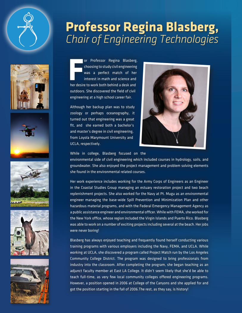
For Professor Regina Blasberg,
choosing to study civil engineering
was a perfect match of her
interest in math and science and
her desire to work both behind a desk and
outdoors. She discovered the field of civil
engineering at a high school career fair.
Although her backup plan was to study
zoology or perhaps oceanography, it
turned out that engineering was a great
fit, and she earned both a bachelor’s
and master’s degree in civil engineering,
from Loyola Marymount University and
UCLA, respectively.
While in college, Blasberg focused on the
environmental side of civil engineering which included courses in hydrology, soils, and
groundwater. She also enjoyed the project management and problem solving elements
she found in the environmental related courses.
Her work experience includes working for the Army Corps of Engineers as an Engineer
in the Coastal Studies Group managing an estuary restoration project and two beach
replenishment projects. She also worked for the Navy at Pt. Mugu as an environmental
engineer managing the base-wide Spill Prevention and Minimization Plan and other
hazardous material programs, and with the Federal Emergency Management Agency as
a public assistance engineer and environmental officer. While with FEMA, she worked for
the New York office, whose region included the Virgin Islands and Puerto Rico. Blasberg
was able to work on a number of exciting projects including several at the beach. Her jobs
were never boring!
Blasberg has always enjoyed teaching and frequently found herself conducting various
training programs with various employers including the Navy, FEMA, and UCLA. While
working at UCLA, she discovered a program called Project Match run by the Los Angeles
Community College District. The program was designed to bring professionals from
industry into the classroom. After completing the program, she began teaching as an
adjunct faculty member at East LA College. It didn’t seem likely that she’d be able to
teach full-time, as very few local community colleges offered engineering programs.
However, a position opened in 2006 at College of the Canyons and she applied for and
got the position starting in the fall of 2006.The rest, as they say, is history!
Professor Regina Blasberg, Chair of Engineering Technologies

For nearly a decade, College of the Canyons (COC) has offered
an Associate Degree and Certificate of Achievement in Land
Surveying. COC is one of six California community colleges
offering a land surveying program and one of only two located
in Southern California.
Last fall, the City of Los Angeles responded to an invitation to
participate in a spring internship fair for our Land Surveying
students. On March 8, Jim Lantry, Senior Survey Supervisor,
attended the internship fair and invited three students,
Leo Jimenez, Krita Adamek, and Rafael Paz to work for Los
Angeles in an internship capacity.
Lantry, in collaboration with the supervising surveyor Mark
Kindig, developed a mentoring program that has interns
completing a survey from start to finish. Working alongside
seasoned surveyors, the interns take field measurements,
draw survey notes and upload data to appropriate software
“NavigateLA” to be accessed by the public. Additionally,
interns worked with professional surveyors in the field and
experienced the entire process of a real survey project. This
is an invaluable experience for COC Land Surveying students.
Jimenez is nearly complete with the CTE program, and said
the experience has proved invaluable. Over the past year and
a half, he said, he has gained an excellent grasp of surveying,
and credits COC’s instructors.
“I’m really grateful,” he said. “The instructors were great, and
they’ve helped me out a lot.”
In addition to the internship with Los Angeles, Jimenez said
he has also secured a job with a surveying company. He urged
anyone considering a job in surveying to look at COC’s program.
“They make it really easy for you to understand,” he
said, and added that there continues to be a demand for
qualified surveyors.
Introduction to Land Surveying (SURV 101);
Advanced Land Surveying (SURV 102);
Advanced Applications in Surveying I (SURV 103);
Advanced Applications in Surveying II (SURV 104);
Boundary Control and Legal Principles I (SURV 105);
Boundary Control and Legal Principles II (SURV 106);
Construction Surveying (SURV 107);
Computer Aided Drafting for Surveyors (SURV 110);
Introduction to Geographic Information Systems (GIS 101);
Trigonometry (Math 102).
Engineering Technician Training Program
Manufacturing Assembler & Test Technician Training Program (MATT)
The Fast Track Institute at College of the Canyons provides
fast-paced, intensive, job preparation programs for job seekers,
mid-career professionals or recent high-school graduates to
quickly jump-start their careers. Fast Track entry-level programs
teach the job skills needed to quickly begin working. Those who
successfully complete the program are invited to a job fair. Fast
Track job fairs enjoy a 70-90 percent job placement rate!
Want to learn about what an Engineering Technician, or
Manufacturing Assembler & Test Technician does? Email your
name, active email address, phone number, and program(s)
you are interested in to [email protected] and we will put you
on the email notification list for upcoming Fast Track Training
Programs. You will be notified as soon as the dates are released
for Fast Track Orientation sessions.
College of the Canyons and City of Los Angeles Partner for Land Survey Internships
Courses Offered in COC’s Land Surveying Program
Fast Track Programs are Here!
LAND SURVEYING PROGRAM INFORMATION MEETING
Did you know, with a certificate in Land Surveying, a student is positioned
to earn a competitive salary as a surveyor? This fall, College of the
Canyons anticipates creating a Land Survey cohort allowing students to
complete the program in a team environment.
Attend an information meeting to learn what a land surveyor does, how
much a surveyor can earn, courses required to complete the program,
and the concept of a cohort, internship placement and how to get started.
Land Survey Information Meeting – JUNE 12, 6 p.m. or JUNE 14, 10 a.m.
Click here to reserve a seat (walk-ins welcome). For more information call
(661) 362-3272 or visit www.canyons.edu/survey.

COLLEGE OF THE CANYONSCareer Technical Education
26455 Rockwell Canyon Road, Santa Clarita, CA 91355 • (661) 259-7800 | Canyons.edu/Offices/CTE
Accounting | Administration of Justice | Administrative Assistant | American Sign Language Interpreting
Animation Production | Architectural Drafting | Automotive Technology | Commercial Photography
Computer Applications | Computer Networking | Culinary Arts | Customer Service | Early Childhood Education
Electronic Systems Technology | Emergency Medical Technician | Entrepreneurship and Small Business Management
Filmmaking | Fire Technology | Graphic & Multimedia Design | Hotel & Restaurant Management
Human Resources Management | Interior Design | Land Surveying | Manufacturing Technology | Marketing
Medical Laboratory Technician | Medical Office Administrative Assistant | Nursing | Paralegal Studies | Real Estate
Retail Management | Solar Energy Technician | Sound Arts | Sports Medicine | Video Game Animation
Water Systems Technology | Welding Technology | Wine Studies