Embed Size (px)
Citation preview
NSF Lake Tahoe Workshop on Collaborative Virtual Reality and Visualization (CVRV 2003), October 26–28, 2003
1
Collaborative Visualization of an Archaeological Excavation
Hrvoje Benko, Edward Ishak, and Steven Feiner Department of Computer Science, Columbia University
New York, NY 10027 {benko,ishak,feiner}@cs.columbia.edu
EXTENDED ABSTRACT
Abstract We are developing a collaborative system for offsite
visualization of an archaeological dig site through both virtual and augmented reality. Multiple users, wearing tracked, head-worn, see-through displays, can interact with the environment using tracked, instrumented gloves, a multi-user, multi-touch, projected table surface, large wall displays and tracked hand-held displays. We take advantage of our ongoing work on 3D multimodal inter-action [14,20] to allow users to combine speech with head, hand, and arm gestures to aid them in their tasks. Although the dig site can be visualized as a purely virtual environment, when users collaborate using the projected table, their see-through head-worn displays allow them to see personalized overlaid material in context with the shared, projected table surface.
1. Introduction
During the summer of 2003, our research team, con-sisting of archaeologists, conservators, range-scanning researchers, and visualization researchers, collected a rich set of multimedia data from an archaeological excavation. The dig site was on top of Monte Polizzo, a mountain in western Sicily, where a team of archaeologists [19] have been excavating an ancient Elymian acropolis built be-tween the 6th and 4th centuries BC. Over a span of ten days, we collected both 2D and 3D multimedia data, in-cluding 3D point clouds, video sequences of interesting events, panoramic images, and numerous high-resolution static images of objects and the overall site, using a 3D laser range scanner, a total station surveying system, and digital video and still cameras.
Since an excavation is naturally a destructive (and of-ten unreconstructable) process, our goal has been to cap-ture and preserve the excavation process to allow users, ranging from interested novices to experienced archae-ologists, to visualize it off-site at different points in time.
Figure 1. Two users collaborate in our system using the MERL DiamondTouch table. The virtual model of the pot is shown next to the table and the 3D terrain model is shown in the background.
We present here some preliminary results in our ef-
fort to create a collaborative 3D visualization environ-ment to aid archaeologists in their post-excavation inter-pretation and analysis. As shown in Figure 1, in our sys-tem, users collaborate in an augmented reality space, wearing tracked, head-worn displays to visualize 3D ter-rain data and embedded multimedia. They can use a tracked glove and speech to interact multimodally with the system, as well as an interactive projected table sur-face to collaborate by jointly navigating, searching, and viewing data on the table’s 2D user interface. We have embedded within the virtual representation of the physical site multimedia content, such as 3D panoramic images, videos and stills of the excavation process, 3D models of interesting finds, and ambient audio, as well as interpre-tive remarks by the archaeologists.
In the remainder of this paper, we first describe the latest techniques currently used in visualization of ar-chaeology, and review the related work that inspired the development of our system in Section 2. Next, in Section 3, we present a short application scenario as a proof of concept, followed by a description of our current imple-
NSF Lake Tahoe Workshop on Collaborative Virtual Reality and Visualization (CVRV 2003), October 26–28, 2003
2
mentation in Section 4. Then, in Section 5, we discuss the merits and limitations of our system. Finally, in Section 6, we present our conclusions and discuss possibilities for future work.
2. Related Work
Since we are developing for a specific domain, we divide our review of related work into two distinct areas: applications for data visualization in archaeology and collaboration techniques in augmented reality (AR) and virtual reality (VR).
2.1. Archaeological Visualization
Archaeologists currently use various kinds of written documentation, sketches, diagrams, and photographs to document the physical state of a dig site while it is being excavated. While there are many standards or guidelines for recording the state of the dig site during excavation, their main focus is to record and archive the data, rather than visualize it.
To visualize the data, most archaeologists currently rely on geographic information systems (GIS), such as ESRI’s ArcGIS [10] suite of software. Recently, INTRISIS [11] has extended some capabilities of stan-dard GIS systems and functions as a plug-in for ArcGIS. Additionally, standard computer-aided design (CAD) systems, such as AutoCAD [3], are often used for model-ing and reconstruction, and are both costly and time-consuming. While both GIS and CAD contain 3D visuali-zation capabilities, most of those systems tend to present layered 2D maps or coarse topographical terrain maps with embedded objects, sketches, and pictures. However, additional multimedia, such as audio, video, 3D high-resolution terrain scans, and panoramas, as well as de-tailed object models, are currently not supported.
Several research groups have explored immersive 3D visualization for archaeology. For example, the ARCHAVE project [1] was developed for use in a CAVE [8]. It consists of a human-modeled environment embed-ded with virtual icons representing various types of finds and has been used to determine patterns and trends of the objects found on site. Because of display limitations, all users see the view of a single tracked user, restricting the possibilities for collaborative work. Gaitatzes et al. [12] presents various VR setups in their system, ranging from Imersadesk™-based interactive plane to a CAVE-based environment, for visualizing temples and public buildings in ancient Grece.
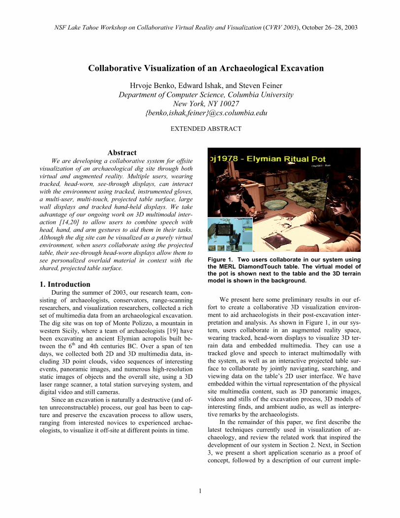
Based on our interviews with archaeologists, much of the typical post-excavation analysis, interpretation, report writing, and additional research they do could benefit from the ability to visually integrate both 2D and 3D data into an interactive 3D space in which 3D terrain informa-tion is combined with sketches, images, video, and other multimedia, shown being captured in Figure 2. Archae-
ologists envision using this space for both data interpreta-tion after they have left the field, and for field planning and preparation for the next season. In addition, remote collaboration should be possible. For example, a pottery specialist could give her interpretation of a ceramic pot in situ to colleagues in a different physical location. These possibilities all suggest the potential advantages of apply-ing AR/VR technology.
Figure 2. Research team members record exact 3D coordinates using a total station surveying instrument (upper left), capture video of an excavation using a digital camera (lower left), and scan a portion of the dig site using the Cyrax range scanner (right).
2.2. Collaborative AR/VR Systems
Since there has been much work on collaborative VR applications we focus our review on AR/VR systems that use tracked, rather than stationary, displays and those that respond to multimodal interaction. The most common, yet expensive, solution to a collaborative VR experience is to use a CAVE(-like) display system. Those systems, as well as responsive workbenches [16], allow for stereoscopic viewing, but present all users with only a single user’s correct viewpoint. This makes it impossible to provide a perspectively correct view of the environment to more than one user at the time.
Several groups have tried to address this limitation. Agrawala et al. [2] have demonstrated a two-user respon-sive workbench in which four separate frame buffers (one for each of the two users’ eyes) are time sequenced, thereby allowing up to two users to have a correct stereo-scopic view of the environment at half the regular frame rate. The IllusionHole of Kitamura et al. [15] overlays a mask with hole over a responsive workbench, giving each of a small set of users an independent stereoscopic view in the portion of the display that user sees through the hole. However, major limitations still exist with both technologies, including the limited number of users.
Efforts have been made recently towards tele-immersive collaboration environments. Raskar et al. [22] present an approach to virtually join two office spaces
NSF Lake Tahoe Workshop on Collaborative Virtual Reality and Visualization (CVRV 2003), October 26–28, 2003
3
using large wall-projected displays and computer vision techniques. Broll at al. [6] have created “The Virtual Round Table,” where multiple people can collaborate using real video feeds in a virtual environment.
AR merges the real world with superimposed virtual images, combining the advantages of both real and virtual environments. Billinghurst and Kato [4] pointed out the benefits of AR in collaborative settings and how such systems decrease the cognitive and functional load on the user. Several collaborative AR systems have used either see-through head mounted displays [4,24], tracked hand-held LCD displays [23], or both [7].
Hua et al. [13] have recently presented another effort to create a rich AR environment. They use a relatively wide field-of-view projective see-through head-worn dis-play, and wall surfaces and an interactive workbench that are covered with retroreflective material, to facilitate 3D navigation tasks in an immersive environment. In their system, multimodal-based interaction is limited to 2.5D interaction with projected surfaces and physical markers on the responsive workbench.
3. Application Scenario
In our prototype, two users wearing see-through, head-worn displays and tracked gloves can explore a por-tion of the virtual dig site. They are able to view a 3D representation of the terrain as either a textured point cloud or a textured mesh. Small archaeological finds are placed around the dig site at the exact locations of their discovery, each labeled with its name and description. Users can navigate the site through the use of a multi-touch, multi-user, interactive table surface (MERL Dia-mondTouch table) on which they can see a bird’s eye view of the entire site, select objects for further inspec-tion, view additional multimedia about the dig site, such as movies and photographs, and adjust personalized view settings in their head-worn displays.
Objects can be viewed and inspected both in 2D on the DiamondTouch table and in 3D through the head-worn display. While in the VR environment, an object can be selected by grabbing it and “throwing” it on the DiamondTouch table, or by specifying it multimodally at a distance through speech and gesture. Once an object is selected, it virtually appears next to the DiamondTouch table for 3D visualization, while additional 2D informa-tion and multimedia about that object are presented on the table. As shown in Figure 1, a high-resolution hand-held display can be used as a “magic lens” [5] to view addi-tional data and detail on a portion of the DiamondTouch table.
4. Collaborative AR Environment
The system presented here builds upon our previous multimodal interaction work [14,20]. We have tried to
facilitate as many interaction modalities and fuse them together, giving the user a choice of which one to use at certain situations. Our paper presents a working prototype and should be considered a work in progress.
4.1. Modular Approach
To facilitate collaborative visualization of archaeo-logical data, we have designed a modular head-tracked AR/VR environment, augmented with a front-projected multi-user multi-touch table and a rear-projected wall display.
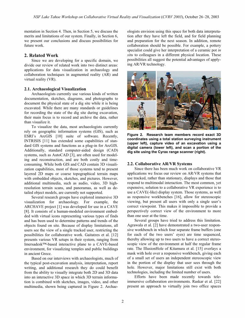
As shown in Figure 3, our system consists of a set of AR/VR visualization modules (AR/VR modules), a Dia-mondTouch multi-user table module (DT module), and a rear-projected wall display (WALL module). The AR module consists of a tracked see-through head-worn dis-play (Sony LDI-D100B), a tracked glove (Essential Real-ity P5 glove [9]), and a stereo headphones and micro-phone, supported by speech-recognition software (IBM ViaVoice 10), and an overhead six–degree-of-freedom tracking infrastructure (InterSense IS-900). The DT mod-ule consists of the MERL DiamondTouch [18] table, a projector (InFocus Proxima x350) and a hand-held dis-play (Fujitsu Stylistic LT C-500). The WALL module displays information on our rear-projected wall display. Each module is currently running on a separate dedicated PC (dual AMD Athlon MP 2.0, 1GB RAM).
Figure 3. System architecture. A separate AR/VR module is needed for each user.
All collaboration and communication is conducted via simple message passing through a publish-and-subscribe message board system. We are using the Adap-tive Agent Architecture (AAA) [17] to facilitate easy con-nection, discovery and communication management of our modules. All modules can function completely inde-pendently of each other.
To reduce the number of messages and their size, all users have direct access to the same database containing all available archaeological materials from the dig site, and only the most relevant information is communicated. For example, if an AR user selects an object, only the
NSF Lake Tahoe Workshop on Collaborative Virtual Reality and Visualization (CVRV 2003), October 26–28, 2003
4
distinct object ID will be broadcasted, allowing all other modules to retrieve all necessary information about that object directly from the database.
The number of simultaneous users depends only on the number of available AR modules and is physically capped by the throughput of the AAA and available hard-ware. Furthermore, users do not need to be co-located, since the modularity of our approach allows for remote collaboration; however, in this paper we describe only co-located collaboration that also uses our DT module.
4.2. Multimodal Interaction
We are developing hybrid interaction techniques for
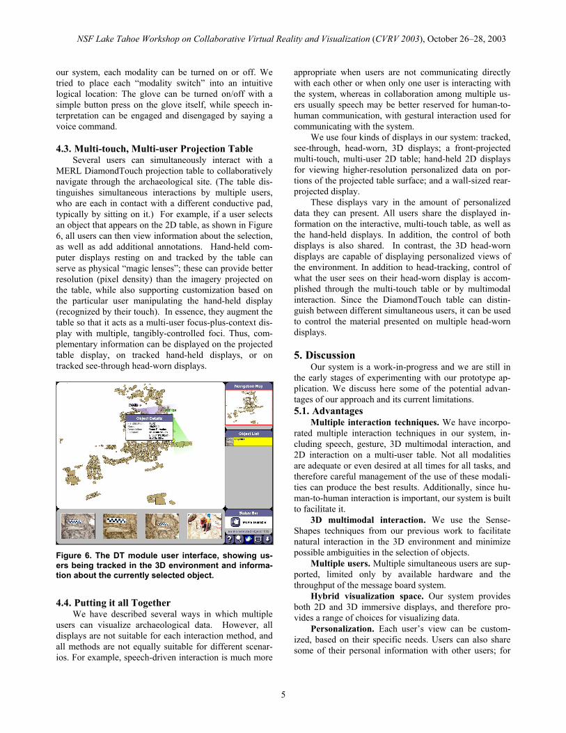
exploring our virtual and augmented environment. Users have a variety of means for interacting with the 3D envi-ronment, including combinations of gestures and speech, and four buttons attached to the glove. Since no modifica-tion of the environment is allowed, users’ interaction is primarily focused on selection and inspection of objects, terrain, and multimedia data. Object selection is the most frequently used 3D interaction technique, and we provide several ways to accomplish it. The user can walk towards an object and grab it or point at it in the distance using our SenseShapes selection tools [20], as shown in Figure 4. Selection at a distance is prone to ambiguity, especially when many similar objects are near each other, and Sens-eShapes assist in their disambiguation.
Figure 4. User’s view of a section of the site in AR. The other user, 3D terrain model, and objects in this section are visible. Objects are represented either with a 3D model or with a picture if the model is not avail-able.
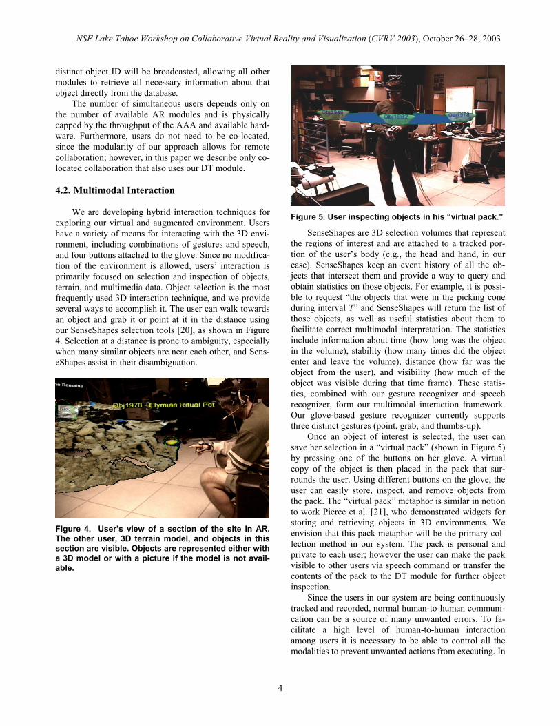
Figure 5. User inspecting objects in his “virtual pack.”
SenseShapes are 3D selection volumes that represent the regions of interest and are attached to a tracked por-tion of the user’s body (e.g., the head and hand, in our case). SenseShapes keep an event history of all the ob-jects that intersect them and provide a way to query and obtain statistics on those objects. For example, it is possi-ble to request “the objects that were in the picking cone during interval T” and SenseShapes will return the list of those objects, as well as useful statistics about them to facilitate correct multimodal interpretation. The statistics include information about time (how long was the object in the volume), stability (how many times did the object enter and leave the volume), distance (how far was the object from the user), and visibility (how much of the object was visible during that time frame). These statis-tics, combined with our gesture recognizer and speech recognizer, form our multimodal interaction framework. Our glove-based gesture recognizer currently supports three distinct gestures (point, grab, and thumbs-up).
Once an object of interest is selected, the user can save her selection in a “virtual pack” (shown in Figure 5) by pressing one of the buttons on her glove. A virtual copy of the object is then placed in the pack that sur-rounds the user. Using different buttons on the glove, the user can easily store, inspect, and remove objects from the pack. The “virtual pack” metaphor is similar in notion to work Pierce et al. [21], who demonstrated widgets for storing and retrieving objects in 3D environments. We envision that this pack metaphor will be the primary col-lection method in our system. The pack is personal and private to each user; however the user can make the pack visible to other users via speech command or transfer the contents of the pack to the DT module for further object inspection.
Since the users in our system are being continuously tracked and recorded, normal human-to-human communi-cation can be a source of many unwanted errors. To fa-cilitate a high level of human-to-human interaction among users it is necessary to be able to control all the modalities to prevent unwanted actions from executing. In
NSF Lake Tahoe Workshop on Collaborative Virtual Reality and Visualization (CVRV 2003), October 26–28, 2003
5
our system, each modality can be turned on or off. We tried to place each “modality switch” into an intuitive logical location: The glove can be turned on/off with a simple button press on the glove itself, while speech in-terpretation can be engaged and disengaged by saying a voice command. 4.3. Multi-touch, Multi-user Projection Table
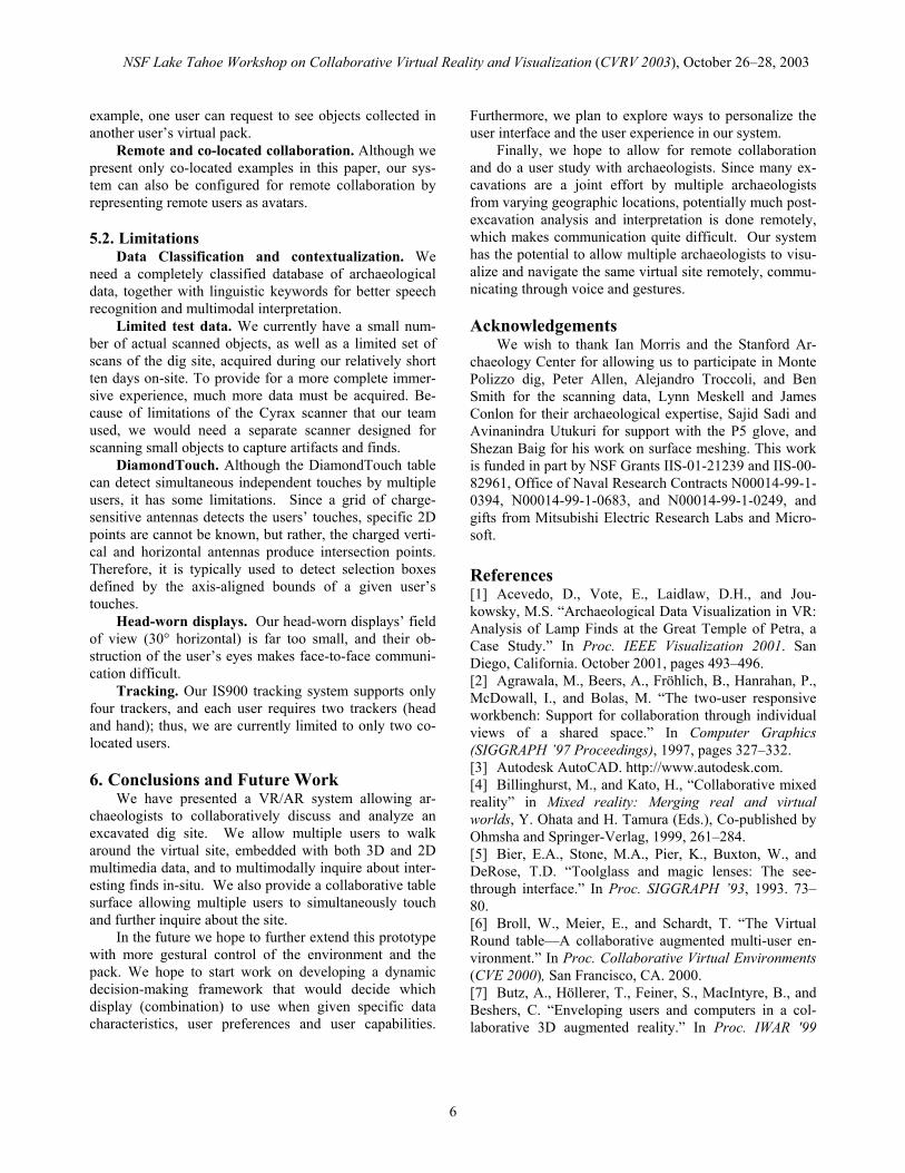
Several users can simultaneously interact with a MERL DiamondTouch projection table to collaboratively navigate through the archaeological site. (The table dis-tinguishes simultaneous interactions by multiple users, who are each in contact with a different conductive pad, typically by sitting on it.) For example, if a user selects an object that appears on the 2D table, as shown in Figure 6, all users can then view information about the selection, as well as add additional annotations. Hand-held com-puter displays resting on and tracked by the table can serve as physical “magic lenses”; these can provide better resolution (pixel density) than the imagery projected on the table, while also supporting customization based on the particular user manipulating the hand-held display (recognized by their touch). In essence, they augment the table so that it acts as a multi-user focus-plus-context dis-play with multiple, tangibly-controlled foci. Thus, com-plementary information can be displayed on the projected table display, on tracked hand-held displays, or on tracked see-through head-worn displays.
Figure 6. The DT module user interface, showing us-ers being tracked in the 3D environment and informa-tion about the currently selected object.
4.4. Putting it all Together
We have described several ways in which multiple users can visualize archaeological data. However, all displays are not suitable for each interaction method, and all methods are not equally suitable for different scenar-ios. For example, speech-driven interaction is much more
appropriate when users are not communicating directly with each other or when only one user is interacting with the system, whereas in collaboration among multiple us-ers usually speech may be better reserved for human-to-human communication, with gestural interaction used for communicating with the system.
We use four kinds of displays in our system: tracked, see-through, head-worn, 3D displays; a front-projected multi-touch, multi-user 2D table; hand-held 2D displays for viewing higher-resolution personalized data on por-tions of the projected table surface; and a wall-sized rear-projected display.
These displays vary in the amount of personalized data they can present. All users share the displayed in-formation on the interactive, multi-touch table, as well as the hand-held displays. In addition, the control of both displays is also shared. In contrast, the 3D head-worn displays are capable of displaying personalized views of the environment. In addition to head-tracking, control of what the user sees on their head-worn display is accom-plished through the multi-touch table or by multimodal interaction. Since the DiamondTouch table can distin-guish between different simultaneous users, it can be used to control the material presented on multiple head-worn displays. 5. Discussion
Our system is a work-in-progress and we are still in the early stages of experimenting with our prototype ap-plication. We discuss here some of the potential advan-tages of our approach and its current limitations. 5.1. Advantages
Multiple interaction techniques. We have incorpo-rated multiple interaction techniques in our system, in-cluding speech, gesture, 3D multimodal interaction, and 2D interaction on a multi-user table. Not all modalities are adequate or even desired at all times for all tasks, and therefore careful management of the use of these modali-ties can produce the best results. Additionally, since hu-man-to-human interaction is important, our system is built to facilitate it.
3D multimodal interaction. We use the Sense-Shapes techniques from our previous work to facilitate natural interaction in the 3D environment and minimize possible ambiguities in the selection of objects.
Multiple users. Multiple simultaneous users are sup-ported, limited only by available hardware and the throughput of the message board system.
Hybrid visualization space. Our system provides both 2D and 3D immersive displays, and therefore pro-vides a range of choices for visualizing data.
Personalization. Each user’s view can be custom-ized, based on their specific needs. Users can also share some of their personal information with other users; for
NSF Lake Tahoe Workshop on Collaborative Virtual Reality and Visualization (CVRV 2003), October 26–28, 2003
6
example, one user can request to see objects collected in another user’s virtual pack.
Remote and co-located collaboration. Although we present only co-located examples in this paper, our sys-tem can also be configured for remote collaboration by representing remote users as avatars.
5.2. Limitations
Data Classification and contextualization. We need a completely classified database of archaeological data, together with linguistic keywords for better speech recognition and multimodal interpretation.
Limited test data. We currently have a small num-ber of actual scanned objects, as well as a limited set of scans of the dig site, acquired during our relatively short ten days on-site. To provide for a more complete immer-sive experience, much more data must be acquired. Be-cause of limitations of the Cyrax scanner that our team used, we would need a separate scanner designed for scanning small objects to capture artifacts and finds.
DiamondTouch. Although the DiamondTouch table can detect simultaneous independent touches by multiple users, it has some limitations. Since a grid of charge-sensitive antennas detects the users’ touches, specific 2D points are cannot be known, but rather, the charged verti-cal and horizontal antennas produce intersection points. Therefore, it is typically used to detect selection boxes defined by the axis-aligned bounds of a given user’s touches.
Head-worn displays. Our head-worn displays’ field of view (30° horizontal) is far too small, and their ob-struction of the user’s eyes makes face-to-face communi-cation difficult.
Tracking. Our IS900 tracking system supports only four trackers, and each user requires two trackers (head and hand); thus, we are currently limited to only two co-located users.
6. Conclusions and Future Work
We have presented a VR/AR system allowing ar-chaeologists to collaboratively discuss and analyze an excavated dig site. We allow multiple users to walk around the virtual site, embedded with both 3D and 2D multimedia data, and to multimodally inquire about inter-esting finds in-situ. We also provide a collaborative table surface allowing multiple users to simultaneously touch and further inquire about the site.
In the future we hope to further extend this prototype with more gestural control of the environment and the pack. We hope to start work on developing a dynamic decision-making framework that would decide which display (combination) to use when given specific data characteristics, user preferences and user capabilities.
Furthermore, we plan to explore ways to personalize the user interface and the user experience in our system.
Finally, we hope to allow for remote collaboration and do a user study with archaeologists. Since many ex-cavations are a joint effort by multiple archaeologists from varying geographic locations, potentially much post-excavation analysis and interpretation is done remotely, which makes communication quite difficult. Our system has the potential to allow multiple archaeologists to visu-alize and navigate the same virtual site remotely, commu-nicating through voice and gestures. Acknowledgements
We wish to thank Ian Morris and the Stanford Ar-chaeology Center for allowing us to participate in Monte Polizzo dig, Peter Allen, Alejandro Troccoli, and Ben Smith for the scanning data, Lynn Meskell and James Conlon for their archaeological expertise, Sajid Sadi and Avinanindra Utukuri for support with the P5 glove, and Shezan Baig for his work on surface meshing. This work is funded in part by NSF Grants IIS-01-21239 and IIS-00-82961, Office of Naval Research Contracts N00014-99-1-0394, N00014-99-1-0683, and N00014-99-1-0249, and gifts from Mitsubishi Electric Research Labs and Micro-soft. References [1] Acevedo, D., Vote, E., Laidlaw, D.H., and Jou-kowsky, M.S. “Archaeological Data Visualization in VR: Analysis of Lamp Finds at the Great Temple of Petra, a Case Study.” In Proc. IEEE Visualization 2001. San Diego, California. October 2001, pages 493–496. [2] Agrawala, M., Beers, A., Fröhlich, B., Hanrahan, P., McDowall, I., and Bolas, M. “The two-user responsive workbench: Support for collaboration through individual views of a shared space.” In Computer Graphics (SIGGRAPH ’97 Proceedings), 1997, pages 327–332. [3] Autodesk AutoCAD. http://www.autodesk.com. [4] Billinghurst, M., and Kato, H., “Collaborative mixed reality” in Mixed reality: Merging real and virtual worlds, Y. Ohata and H. Tamura (Eds.), Co-published by Ohmsha and Springer-Verlag, 1999, 261–284. [5] Bier, E.A., Stone, M.A., Pier, K., Buxton, W., and DeRose, T.D. “Toolglass and magic lenses: The see-through interface.” In Proc. SIGGRAPH ’93, 1993. 73–80. [6] Broll, W., Meier, E., and Schardt, T. “The Virtual Round table—A collaborative augmented multi-user en-vironment.” In Proc. Collaborative Virtual Environments (CVE 2000), San Francisco, CA. 2000. [7] Butz, A., Höllerer, T., Feiner, S., MacIntyre, B., and Beshers, C. “Enveloping users and computers in a col-laborative 3D augmented reality.” In Proc. IWAR '99
NSF Lake Tahoe Workshop on Collaborative Virtual Reality and Visualization (CVRV 2003), October 26–28, 2003
7
(IEEE and ACM Int. Workshop on Augmented Reality), San Francisco, CA, October 20–21, 1999, 35–44. [8] Cruz-Neira, C., Sandin, D. J., and DeFanti, T.A. “Surround-screen projection-based virtual reality: The design and implementation of the CAVE.” In Proc. SIGGRAPH ’93. 1993. 135–142. [9] Essential Reality Inc. http://www.essentialreality.com. [10] ESRI ArcGIS. http:// www.esri.com. [11] INTRASIS, The Swedish National Heritage Board, Archaeological Excavations Department and LandFocus IS AB. http://www.raa.se/uv/intrasis/eng/index.htm. [12] Gaitarzes, A. Christopoulos, D., and Roussou, M. “Reviving the past: Cultural Heritage meets virtual real-ity.” In Proc. Conf. on Virtual Reality, Archeology, and Cultural Heritage. 2001. 103–110. [13] Hua, H., Brown, L.D., Gao, C., Ahuja, N. “A new collaborative infrastructure: SCAPE.” In Proc. IEEE Vir-tual Reality (VR ’03), 2003. [14] Kaiser, E., Olwal, A., McGee, D., Benko, H., Cor-radini, A., Li, X., Cohen, P., and Feiner, S. “Mutual dis-ambiguation of 3D multimodal interaction in augmented and virtual reality.” To appear in Proc. ICMI 2003 (Fifth Int. Conf. on Multimodal Interfaces), Vancouver, BC, November 5–7, 2003. [15] Kitamura, Y., Konishi, T., Yamamoto, S., and Ki-shino, F. “Interactive stereoscopic display for three or more users.” In Proc. SIGGRAPH ’01. 2001. 231–240. [16] Kröger, W. and Fröhlich, B., “The responsive work-bench.” IEEE Computer Graphics and Applications. 1994. 12–15. [17] Kumar, S., Cohen, P. R. and Levesque, H. J. “The Adaptive Agent Architecture: Achieving Fault-Tolerance Using Persistent Broker Teams.” In Proc. Int. Conf. on Multi-Agent Systems, July 2000, pages 159–166. [18] MERL DiamondTouch Table. http://www.merl.com/projects/DiamondTouch/ [19] Monte Polizzo, The Stanford Project, Stanford Ar-chaeology Center, Stanford, CA. http://archaeology.stanford.edu/MountPolizzo/project.htm [20] Olwal, A., Benko, H., and Feiner, S. “SenseShapes: Using statistical geometry for object selection in a multi-modal augmented reality system.” In Proc. ISMAR 2003 (IEEE and ACM Int. Symp. on Mixed and Augmented Reality), Tokyo, Japan, October 7–10, 2003, pages 300–301. [21] Pierce, J.S., Conway, M., Dantzich, M., Robertson, G. “Toolspaces and glances: storing, accessing, and re-trieving objects in 3D desktop applications.” In Proc. Symp. on Interactive 3D graphics (I3D ’99). 1999. 163–168. [22] Raskar, R., Welch, G., Cutts, M., Lake, A., Stesin, L., and Fuchs, H. “The office of the future: A unified approach to image-based modeling and spatially immer-sive displays.” In Proc. SIGGRAPH ’98. 1998. 179–188.
[23] Rekimoto, J. “Transvision: a hand-held augmented reality system for collaborative design.” In Proc. Virtual Systems and Multimedia (VSMM ’96). Gifu, Japan, 1996. [24] Szalavari, Z., Schmalstieg, D., Fuhrmann, A., and Gervautz, M. “Studierstube: an environment for collabo-ration in augmented reality.” Virtual Reality, 3(1), 37–48. 1998.


![Chess Publishing - Benko Gambit [A57-59]](https://img.pdfslide.us/doc/110x75/577cc98a1a28aba711a4052b/chess-publishing-benko-gambit-a57-59.jpg)


![[DEMO] On-Site Augmented Collaborative Architecture Visualization](https://img.pdfslide.us/doc/110x75/587f47041a28aba8108b862a/demo-on-site-augmented-collaborative-architecture-visualization.jpg)