Embed Size (px)
Citation preview
Collaborative Research: Adaptive Distributed Processing in Volcano Sensor Networks
1 Introduction
This project brings together researchers in geophysics and computer science to develop advanced distributed pro-cessing techniques for wireless sensor networks at active volcanoes. Software will be developed to process data froma large network of sensors for describing the 4D evolution of an erupting volcano in real time. Immediate feedbackon the state of the volcano will provide critical information on eruptive hazards and potential for a large-scale cri-sis. The results of this project will have significant impact on the next generation of volcano sensor networks forscientific study and hazard monitoring.
Distributed processing in the sensor network will greatly reduce radio bandwidth and power requirements, al-lowing us to drastically increase the number of sensors at a volcano. Increased sensor density in turn yields a deeperunderstanding of volcanic processes. Our team has previous experience developing and deploying wireless sensornetworks at active volcanoes (described in Section 2). Building upon our preliminary successes, we propose todevelop a range of adaptive, distributed sensor processing techniques with a specific emphasis on high-resolutionseismic and acoustic signals from an active volcano.
As part of this project, we propose to deploy and maintain a large-scale wireless sensor network consistingof 50 sensor nodes, divided into three local arrays, on an active volcano. Each node will be capable of samplingand processing seismic and acoustic data at high data rates. The core challenge that arises in this project is howto process the high volume of data across the sensor network to optimize network lifetime and data quality. Radiocommunication is power-hungry and offers limited bandwidth (less than 100 Kbps across the network). However, atypical sensor node can perform thousands of CPU cycles of computation for the same energy cost as transmitting asingle radio message. This tradeoff motivates the need for advanced processing to be performed on the sensor nodesthemselves, greatly reducing bandwidth requirements and increasing battery lifetime.
Intellectual merit: The goal of this project is to develop techniques to extract high-level information from theraw signals collected by sensors through adaptive, distributed signal processing. We intend to construct a range ofdistributed algorithms for calculating energy release, determining seismic and acoustic wave arrival times, charac-terizing and differentiating eruption earthquakes from sub-surface earthquakes, and precisely picking phase arrivalsfor discrete events.
The results of this per-sensor data analysis will enable high-resolution, rapid earthquake locations to be estimatedusing data from across the sensor network. Adaptive tomographic inversion of these signals will provide a real-time 4D “movie” of the evolving structure of the volcano’s interior. Moreover, by allowing the network to beretasked on the fly, differing computations can be introduced as needed based on the changing dynamics of thevolcano’s activity. Multiple users can also share the array during its deployment lifetime.
The focus of this project is high-level data processing for networked volcano sensor arrays,not on the systems-level issues of wireless sensor networks, such as radio communication, multihop routing, and time synchronization.Our previous work on wireless sensor networks has addressed many of these issues, and in this proposal we specifi-cally focus on the distributed data processing challenges that arise in this domain.
Broader impact: This project has substantial implications for monitoring active volcanoes and understandingthe complex geophysical processes involved. The ability to deploy large wireless sensor arrays on hazardous volca-noes also holds vast potential for real-time hazard monitoring and early warning systems. This collaboration betweenseismologists and computer scientists offers the opportunity to introduce a new technology for an important area ofgeophysical monitoring and to push the envelope for both the capabilities of wireless sensor networks and the toolsavailable for volcanic monitoring.
Moreover, the techniques developed in this project extend to other types of geophysical monitoring, includingtectonic earthquake studies, geothermal field exploration, terrestrial and glacial geodesy, and atmospheric sciences.For each discipline, additional types of sensors (e.g., GPS, tilt-meters, gas monitors, thermal sensors, anemometers,and strong-motion seismographs) can be readily integrated into the framework that will be developed in this project.
1
The educational activities of this project include developing a graduate Computer Science seminar coursearound the proposed research project; extending undergraduate courses in seismology and geophysics to incorporateemerging technology in data acquisition and networking, and involving undergraduates into the research programthrough independent study projects and assistance with our sensor network deployment. The project will supportgraduate student research at each institution where the unification of field acquisition, physical analysis and computerscience offers cross-disciplinary experience. We have organized this research so that all the participants, studentsincluded, will provide key input in the lab and in the field.
1.1 Research Team
This project brings together experts from computer science and seismology at Harvard, UNH, and UNC. Our grouphas been collaborating for the last two years in this area, and we have successfully undertaken two deployments ofwireless sensor arrays on active volcanoes in Ecuador [93, 92]. Through this project we endeavor to further thiscollaboration and leverage our previous experience.
PI Matt Welsh is an assistant professor of Computer Science at Harvard University. He is very active in thearea of wireless sensor networks, developing operating system and networking techniques for a number of appli-cations, including medical care [59, 55] and seismology (the subject of this proposal). He has also been workingon high-level programming abstractions for sensor networks. These include a programming model calledabstract
regions[90, 91], an adaptive resource-management technique calledSORA[30, 57], and a programming languagecalledRegiment[66, 67]. Prior to joining Harvard, Welsh spent one year as a visiting researcher at Intel Research,Berkeley, as a member of the TinyOS project team. There he was one of the core developers of the NesC [12]language used by TinyOS and the TOSSIM sensor network simulator [52, 83].
Co-PI Jeff Johnson is a research assistant professor in the Department of Earth Sciences at UNH. His primarytraining is in geophysics and volcanology. He is a pioneer in the use of infrasound and seismicity for modelingeruptive processes at volcanoes [18, 23, 24, 22, 19, 29, 20]. Much of his recent work is based upon seismo-acousticdata that he has collected in the field. Johnson has deployed seismic and acoustic arrays and networks at volcanoes inKamchatka, Ecuador, Antarctica, Italy, Hawaii, Guatemala, Mexico, and Chile. He has designed and built infrasonicsensors for both campaign-style and permanent deployments at many volcanoes.
Co-PI Jonathan Lees is an associate professor of Geophysics at University of North Carolina. He is a leader inthe field of tomographic techniques used to spatially image the interior structure of volcanoes [39]. Lees is one ofthe first geophysicists to develop algorithms for rapid inversion of large sparse matrices as applied to geophysicaltomography. He has worked on and applied his methods on numerous volcanoes worldwide, including Mt. St.Helens, Mt. Rainier, Kliuchevskoi Volcano (Kamchatka, Russia), Mt. Fuji, and others. He has done extensive workinvestigating geothermal systems using seismological imaging methods and is currently developing rapid real-timemonitoring systems for geothermal fields in Iceland.
2 Background and Previous Work
Earth scientists monitor volcanoes for two non-exclusive reasons: (1) to assess the level of volcanic unrest so thatcivil authorities may mitigate hazards; and (2) to understand physical processes occurring within the volcano relatedto internal structure, magma migration, and eruption mechanisms [82]. The most powerful tool used for these ends isthe seismometer, which detects ground-propagating elastic radiation from both sources internal to the volcano (e.g.,fracture induced by pressurization) and on the surface (e.g., expansion of gases during an eruption) [63]. The seis-mometer is traditionally used as part of a multi-station network (dispersed station spacing) or array (dense clusteringof sensors) in order to sample the seismic wavefield and invert for earthquake location and velocity structure of theedifice.
In recent years it is has become standard to supplement seismic networks with additional geophysical monitors,such as, for example, infrasonic sensors [9, 11, 23, 78, 89]. Low-frequency (<20 Hz) sound monitoring in theatmosphere is analogous to seismic monitoring in the ground and it provides a complete picture of the total elastic
2
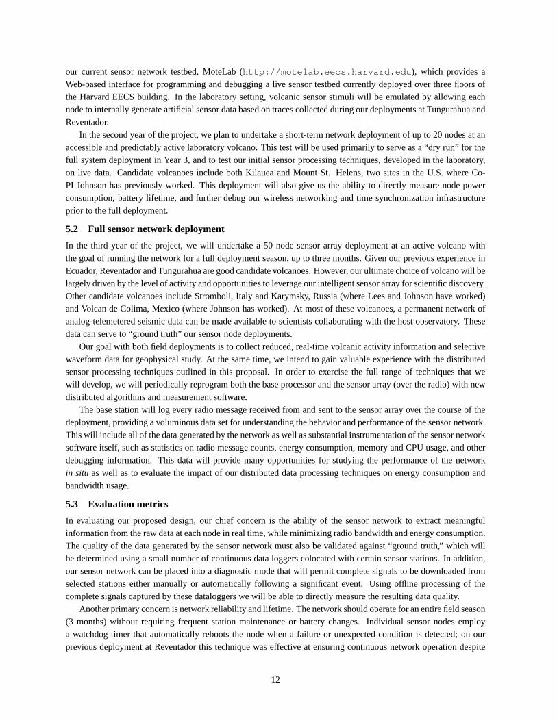
GPS receiver
Base stationat observatory
Long-distance radio modem link
Gateway node
Sensor nodes
Internet
Remote users
Figure 1:Our proposed wireless sensor network architecture.
wavefield at a volcano. Infrasound monitoring is useful for differentiating shallow and surface seismicity and forquantifying eruptive styles and intensity [22]. Although this project is focused on seismo-acoustic data acquisition,the distributed analysis techniques that will be developed will be appropriate for incorporation of additional types ofsensors (e.g., thermal, gas flux, geodetic) in the future.
For source location and tomography studies, it is desirable to record the elastic wavefield with a network ofdistributed sensor stations, with a station spacing in excess of 1 km. For wavefield analysis and back-azimuthdetermination, on the other hand, it is often preferable to deploy a dense array of sensors with a station spacing ofa few hundred meters [7]. Greater sensor density enables much improved source constraints and imaging of thevolcano interior.
Traditionally, seismic data is acquired at volcanoes either through science-driven campaign-style deploymentswhich are amenable to array-type configurations, or through permanent, continuous telemetered data acquisition.In the case of temporary deployments, stand-alone dataloggers are often used to record signals to a flash memorycard or hard drive and data must be recovered manually from each station every several weeks, involving significanttime and effort. Permanent installations at volcanoes, on the other hand, send their data to an observatory via analogor digital telemetry. The amount of data transmitted is limited by bandwidth of the hardware, hardships of sitingtelemetry links, and computational and storage limitations at the observatory. As a result, even many of the mostmost threatening and active volcanoes (e.g., Mount St. Helens [60]) maintain networks of less than ten stations.
2.1 The role of wireless sensor networks
Wireless sensor networks have the potential to greatly enhance understanding of volcanic processes by permittinglarge distributed deployments of sensor nodes in difficult-to-reach or hazardous areas. For the large-scale seismo-acoustic deployment proposed in this project, we intend to perform both network and array processing by installing adense web of sensor nodes distributed on all sides of the expected earthquake source region. Wireless communicationpermits sensor nodes to communicate with each other and to a central base station via a multihop network, allowingintelligent real-time data reduction, data archival, as well as retasking of the array after deployment.
A typical wireless sensor node, the TMote Sky from Moteiv, Inc. [64], includes a low-power microprocessor(TI MSP430) with 48 KB of program memory and 10 KB of SRAM, 1 MByte of flash memory, and a low-powerIEEE 802.15.4 radio (Chipcon CC2420) operating in the 2.4 GHz band. This platform is designed for low poweroperation, consuming just 5µA when in standby mode, and 21 mA when the CPU and radio are active. The TMoteSky runs a lean, event-driven operating system called TinyOS [13] that is widely used by the sensor networkingresearch community.
3
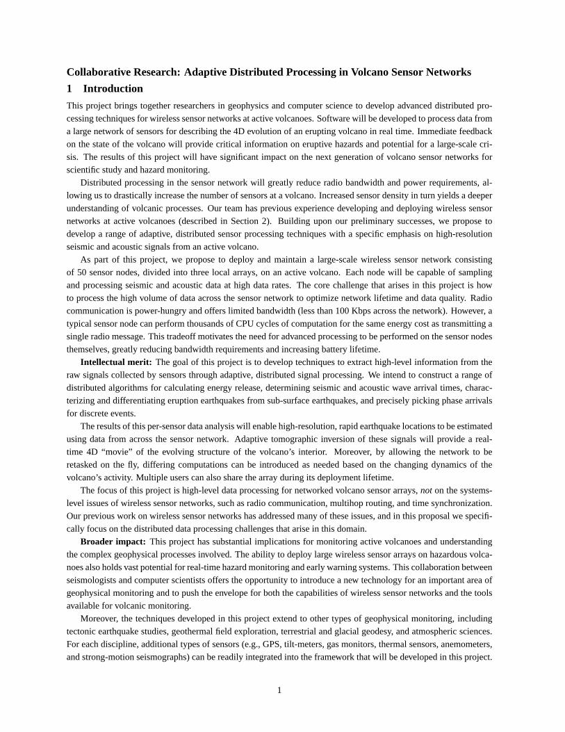
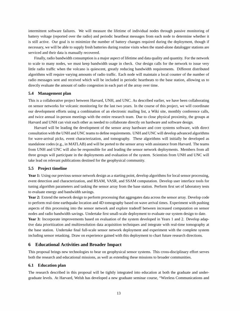
Tmote Skysensor node
Custom ADC board
Antenna connector
Sensor connectors
Weatherproof case
D cell batteries
Long-distance (<40 km) radio modem linkBase stationat observatory
Gateway node w/ GPS receiver
Sensornodes
< ~400 m
1 km
vent
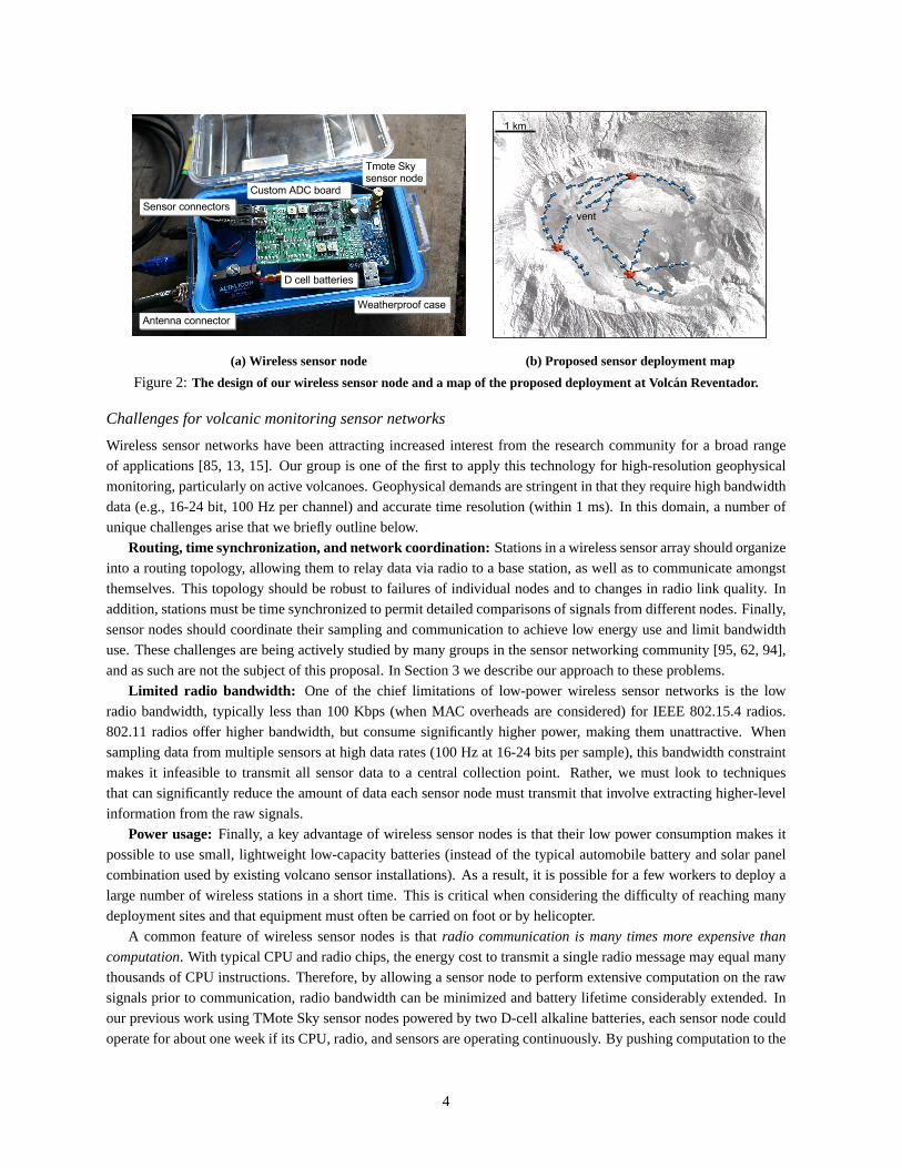
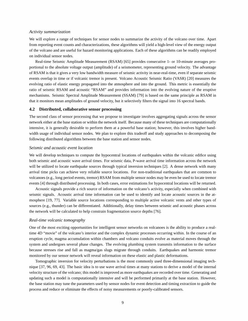
(a) Wireless sensor node (b) Proposed sensor deployment map
Figure 2:The design of our wireless sensor node and a map of the proposed deployment at Volcan Reventador.
Challenges for volcanic monitoring sensor networks
Wireless sensor networks have been attracting increased interest from the research community for a broad rangeof applications [85, 13, 15]. Our group is one of the first to apply this technology for high-resolution geophysicalmonitoring, particularly on active volcanoes. Geophysical demands are stringent in that they require high bandwidthdata (e.g., 16-24 bit, 100 Hz per channel) and accurate time resolution (within 1 ms). In this domain, a number ofunique challenges arise that we briefly outline below.
Routing, time synchronization, and network coordination: Stations in a wireless sensor array should organizeinto a routing topology, allowing them to relay data via radio to a base station, as well as to communicate amongstthemselves. This topology should be robust to failures of individual nodes and to changes in radio link quality. Inaddition, stations must be time synchronized to permit detailed comparisons of signals from different nodes. Finally,sensor nodes should coordinate their sampling and communication to achieve low energy use and limit bandwidthuse. These challenges are being actively studied by many groups in the sensor networking community [95, 62, 94],and as such are not the subject of this proposal. In Section 3 we describe our approach to these problems.
Limited radio bandwidth: One of the chief limitations of low-power wireless sensor networks is the lowradio bandwidth, typically less than 100 Kbps (when MAC overheads are considered) for IEEE 802.15.4 radios.802.11 radios offer higher bandwidth, but consume significantly higher power, making them unattractive. Whensampling data from multiple sensors at high data rates (100 Hz at 16-24 bits per sample), this bandwidth constraintmakes it infeasible to transmit all sensor data to a central collection point. Rather, we must look to techniquesthat can significantly reduce the amount of data each sensor node must transmit that involve extracting higher-levelinformation from the raw signals.
Power usage:Finally, a key advantage of wireless sensor nodes is that their low power consumption makes itpossible to use small, lightweight low-capacity batteries (instead of the typical automobile battery and solar panelcombination used by existing volcano sensor installations). As a result, it is possible for a few workers to deploy alarge number of wireless stations in a short time. This is critical when considering the difficulty of reaching manydeployment sites and that equipment must often be carried on foot or by helicopter.
A common feature of wireless sensor nodes is thatradio communication is many times more expensive than
computation. With typical CPU and radio chips, the energy cost to transmit a single radio message may equal manythousands of CPU instructions. Therefore, by allowing a sensor node to perform extensive computation on the rawsignals prior to communication, radio bandwidth can be minimized and battery lifetime considerably extended. Inour previous work using TMote Sky sensor nodes powered by two D-cell alkaline batteries, each sensor node couldoperate for about one week if its CPU, radio, and sensors are operating continuously. By pushing computation to the
4
sensor nodes and thereby reducing radio communication, it should be possible to extend battery lifetime by an orderof magnitude. This is one of the core goals of this proposal.
2.2 Previous sensor network deployments at Tungurahua and Reventador
Our team has been collaborating for the last two years on the development of wireless sensor arrays for studyingactive volcanoes. We have deployed two wireless arrays on volcanoes in Ecuador, in July 2004 and August 2005. Ourfirst deployment, at Volcan Tungurahua, demonstrated the proof-of-concept, involving three wireless sensor nodessampling continuous infrasonic time series data [93]. The sensor array transmitted continuous, real-time infrasonicsignals to a base-station laptop via a radio modem 9 km from the deployment site. The network was operated for54 hours and collected data on a dozen eruptive events during this time. This deployment helped us to optimize nodeplacement, packaging, and radio communication in a challenging environment.
In August 2005, we deployed a larger, more sophisticated network on the upper flanks of Volcan Reventador [92].This network consisted of 16 nodes, each with seismometers and microphones, distributed over a 3 km extentrunning radially from the vent. Each node sampled seismo-acoustic data at 100 Hz per channel. Due to radiobandwidth limitations, nodes were programmed to transmit selectively when a detection algorithm was triggered bysignificant seismic activity. Following a trigger, each node would upload 60 sec of sampled data from the event tothe base station over a multihop wireless network. Nodes were time-synchronized with a single GPS receiver usinga multihop time-synchronization protocol [62]. This network was deployed for 3 weeks and collected data on over200 discrete earthquakes, including both deep and explosion events and extended-duration tremor.
In this project, we propose to build upon the sensor platform that we have developed for the Reventador deploy-ment, leveraging our approaches to data collection, multihop radio communication, and time synchronization. Whilewe recognize the systems-level challenges of deploying wireless sensor networks are significant, we intend to focusin this project on the higher-level problem of efficient distributed data processing in these sensor networks.
2.3 Related work
Wireless sensor networks are being extensively studied for use in applications such as monitoring environments [88,70], and animal habitats [58, 85]. These applications typically involve low data rates, with each node sampling andtransmitting data once every few minutes. In these systems, the goal is to extend the network lifetime to severalmonths or years using small batteries, possibly in combination with energy harvesting [17, 75]. In-network process-ing of the data is typically limited to spatial or temporal aggregation, such as calculating the average or maximumsensor value over some region [56].
Another set of applications focus on collecting high-data-rate accelerometer and seismometer signals for moni-toring industrial processes and civil structures such as buildings or bridges [1, 98, 72]. These systems are closer inspirit to our goals, although to date, these systems have focused on collection and compression of signals to a centralbase station, rather than in-network processing of the data. This project will complement these efforts by develop-ing a range of techniques for adaptive, collaborative signal processing within the sensor network that is capable ofextracting higher-level information from low-level signals.
Both analog and digital wireless telemetry is commonly used on seismic networks, including volcano monitoringsystems at dozens of volcanoes worldwide. Within the U.S., this includes monitoring of potentially hazardousvolcanoes in the Cascades [71] and in Alaska [3]. The standard data processing system used by many seismicnetworks is calledEarthworm[10, 54]. The number of monitoring stations at an individual volcano is relativelysmall, typically less than 10, and the main purpose is to assess volcanic unrest and collect data for subsequentanalysis. Our approach is aimed at expanding the spatial distribution of sensors at volcanoes, and maintaining abalance of bandwidth, power and cost in a way that optimizes scientific merit and field deployment logistics. We cando this by sacrificing recovery of full waveforms on most stations for all events while retrieving relevant parametersin a broad, spatially-distributed region on the volcano. One of the primary limitation of volcano seismological studiesis simply the lack of spatial coverage on a particular volcano. This is true of heavily-monitored volcanoes like Mt.
5
St. Helens and Mt. Fuji as well as on remote locations in Ecuador.
3 System Architecture
In this section, we briefly outline the overall architecture of our proposed volcanic monitoring sensor network. Thisdesign is influenced by networks and arrays, both temporary and permanent, that have been installed by scientistsat other volcanoes. Our previous deployments on Tungurahua (2004) and Reventador (2005) have provided us withthe necessary proof-of-concept that our intended geometry will be feasible and robust.
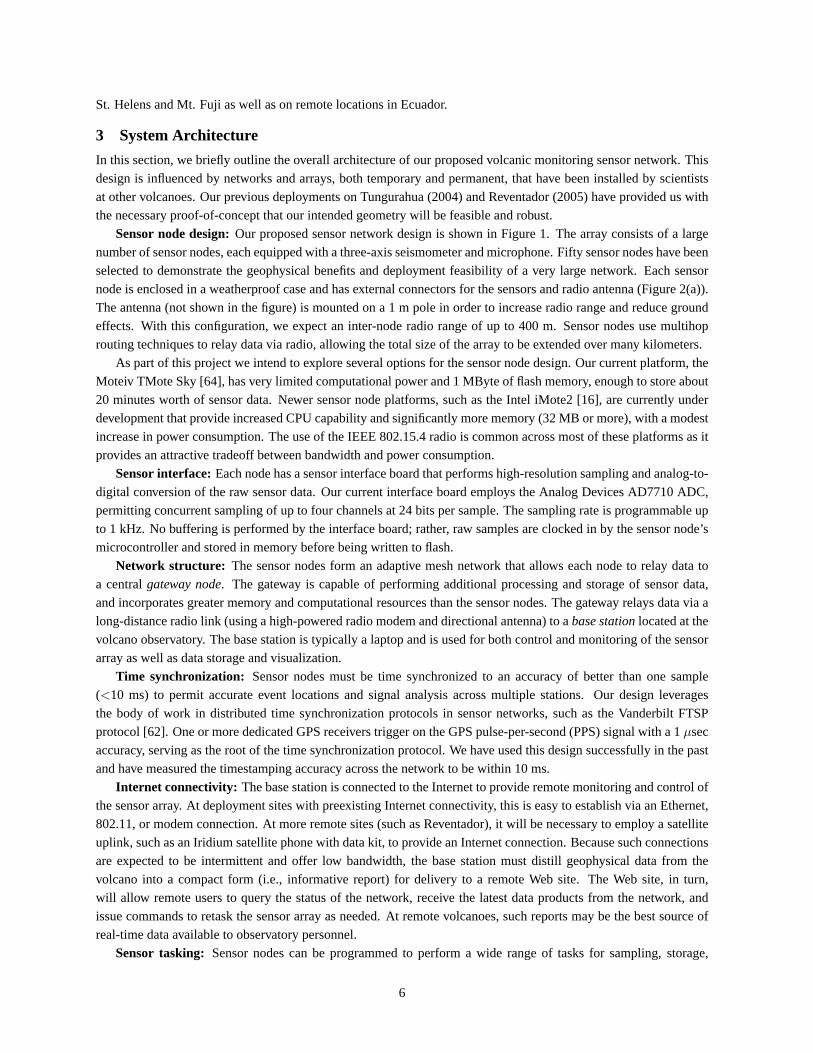
Sensor node design:Our proposed sensor network design is shown in Figure 1. The array consists of a largenumber of sensor nodes, each equipped with a three-axis seismometer and microphone. Fifty sensor nodes have beenselected to demonstrate the geophysical benefits and deployment feasibility of a very large network. Each sensornode is enclosed in a weatherproof case and has external connectors for the sensors and radio antenna (Figure 2(a)).The antenna (not shown in the figure) is mounted on a 1 m pole in order to increase radio range and reduce groundeffects. With this configuration, we expect an inter-node radio range of up to 400 m. Sensor nodes use multihoprouting techniques to relay data via radio, allowing the total size of the array to be extended over many kilometers.
As part of this project we intend to explore several options for the sensor node design. Our current platform, theMoteiv TMote Sky [64], has very limited computational power and 1 MByte of flash memory, enough to store about20 minutes worth of sensor data. Newer sensor node platforms, such as the Intel iMote2 [16], are currently underdevelopment that provide increased CPU capability and significantly more memory (32 MB or more), with a modestincrease in power consumption. The use of the IEEE 802.15.4 radio is common across most of these platforms as itprovides an attractive tradeoff between bandwidth and power consumption.
Sensor interface:Each node has a sensor interface board that performs high-resolution sampling and analog-to-digital conversion of the raw sensor data. Our current interface board employs the Analog Devices AD7710 ADC,permitting concurrent sampling of up to four channels at 24 bits per sample. The sampling rate is programmable upto 1 kHz. No buffering is performed by the interface board; rather, raw samples are clocked in by the sensor node’smicrocontroller and stored in memory before being written to flash.
Network structure: The sensor nodes form an adaptive mesh network that allows each node to relay data toa centralgateway node. The gateway is capable of performing additional processing and storage of sensor data,and incorporates greater memory and computational resources than the sensor nodes. The gateway relays data via along-distance radio link (using a high-powered radio modem and directional antenna) to abase stationlocated at thevolcano observatory. The base station is typically a laptop and is used for both control and monitoring of the sensorarray as well as data storage and visualization.
Time synchronization: Sensor nodes must be time synchronized to an accuracy of better than one sample(<10 ms) to permit accurate event locations and signal analysis across multiple stations. Our design leveragesthe body of work in distributed time synchronization protocols in sensor networks, such as the Vanderbilt FTSPprotocol [62]. One or more dedicated GPS receivers trigger on the GPS pulse-per-second (PPS) signal with a 1µsecaccuracy, serving as the root of the time synchronization protocol. We have used this design successfully in the pastand have measured the timestamping accuracy across the network to be within 10 ms.
Internet connectivity: The base station is connected to the Internet to provide remote monitoring and control ofthe sensor array. At deployment sites with preexisting Internet connectivity, this is easy to establish via an Ethernet,802.11, or modem connection. At more remote sites (such as Reventador), it will be necessary to employ a satelliteuplink, such as an Iridium satellite phone with data kit, to provide an Internet connection. Because such connectionsare expected to be intermittent and offer low bandwidth, the base station must distill geophysical data from thevolcano into a compact form (i.e., informative report) for delivery to a remote Web site. The Web site, in turn,will allow remote users to query the status of the network, receive the latest data products from the network, andissue commands to retask the sensor array as needed. At remote volcanoes, such reports may be the best source ofreal-time data available to observatory personnel.
Sensor tasking: Sensor nodes can be programmed to perform a wide range of tasks for sampling, storage,
6
Aco
ustic
arr
ival
pic
k P
olar
ity c
ompr
essi
ve
Sei
smic
P-W
ave
pick
Fi
rst v
ertic
al m
otio
n -u
p
3.94 s
Maximum overpressure
Maximum body-wave velocity
104
Pa0.
812
mm
/s
Ons
et o
n S
ept.
3
01:5
8:51
.460
(GM
T)
seismic
acoustic
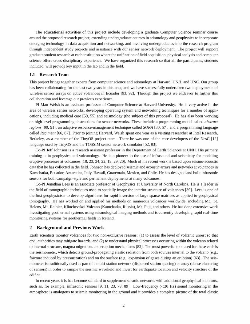
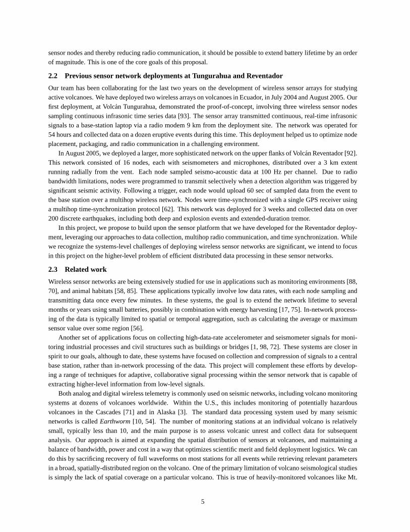
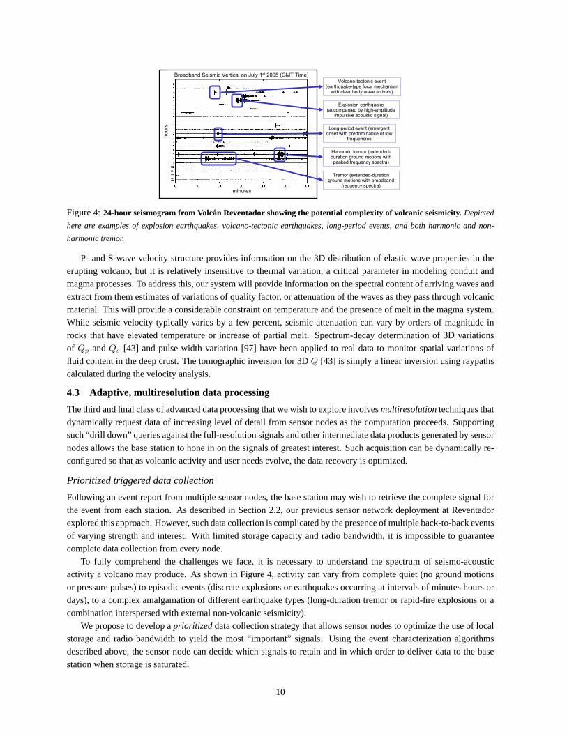
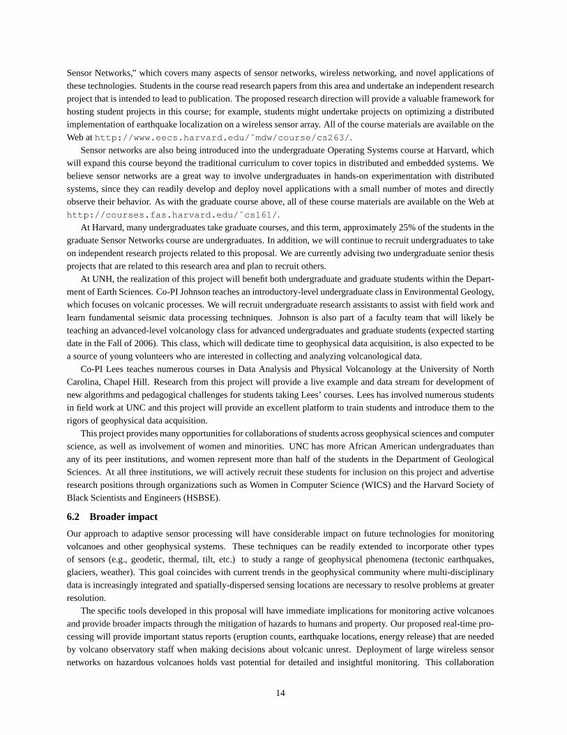
Figure 3:Example of an “explosion earthquake” corresponding to an eruptive event at Volcan Reventador (recorded 1.7
km from the vent). Other types of earthquakes include many varieties of sources internal to the volcano, which will not radiate
significant acoustic energy. Acoustic and seismic waveforms are shown alongside several parameters that can be automatically
extracted from the waveform data. For example, the arrival time at each sensor is used to locate earthquakes and perform
tomography.
processing, and communication of sensor data. Under typical operation, a sensor node will continuously sampleseismic and acoustic data and buffer data in memory or on flash. Nodes will locally process sensor data as describedin Section 4, for example, performing event detection or waveform arrival time calculations. Nodes may thencommunicate with the base station or amongst themselves to perform distributed processing. In addition, each nodereports periodic heartbeats to the base station indicating various status parameters, such as the number of samplesprocessed and information on the multihop network topology. Various techniques are employed to make each noderobust to software failures, such as a watchdog timer that will reset a node if is unable to collect data or communicatewith the network for a certain interval.
4 Research Agenda
This project provides an important opportunity for geophysicists and computer scientists to optimize the informationthat is produced by an intelligent network of sensor arrays. Our basic challenge is that the data from the distributednetwork must be reduced at each sensor node, yielding high-level data products that embody an interpretation ofthe volcano’s activity. This is a drastic difference in the current approach, which requires all time-series data tobe telemetered for subsequent reduction by human analysts. Our approach will enable orders-of-magnitude aug-mentation in the number of sensor nodes and the lifetime of the network. With enhanced sensor node distribution,geophysicists will be able to accomplish many goals that are not currently possible with traditional deployments.
In this project, we will develop three broad areas of distributed sensor processing, as described below.
Local sensor processing and data reduction:The first category involves largely independent processing and de-livery of data from individual nodes. Significant further processing at the base station is not required. Ingeneral this type of information is very low bandwidth and can be relayed from all stations without acquisitiongaps.
Distributed, collaborative sensor processing:The second category relies upon integration of processed data atmultiple nodes and subsequent automated analysis of the distributed data either within the network or at the
7
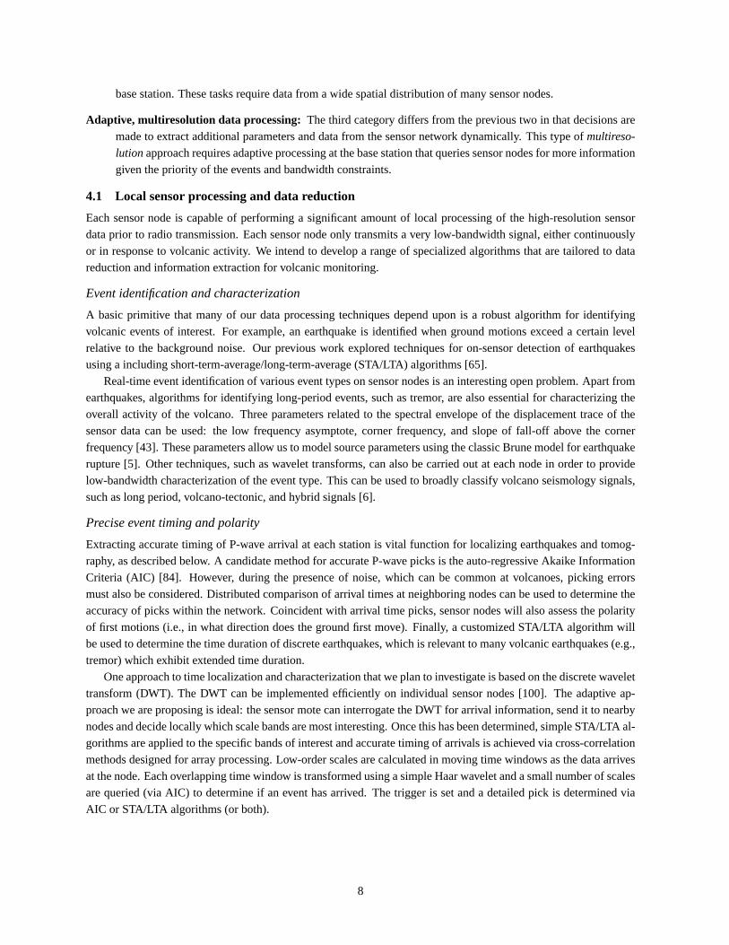
base station. These tasks require data from a wide spatial distribution of many sensor nodes.
Adaptive, multiresolution data processing: The third category differs from the previous two in that decisions aremade to extract additional parameters and data from the sensor network dynamically. This type ofmultireso-
lution approach requires adaptive processing at the base station that queries sensor nodes for more informationgiven the priority of the events and bandwidth constraints.
4.1 Local sensor processing and data reduction
Each sensor node is capable of performing a significant amount of local processing of the high-resolution sensordata prior to radio transmission. Each sensor node only transmits a very low-bandwidth signal, either continuouslyor in response to volcanic activity. We intend to develop a range of specialized algorithms that are tailored to datareduction and information extraction for volcanic monitoring.
Event identification and characterization
A basic primitive that many of our data processing techniques depend upon is a robust algorithm for identifyingvolcanic events of interest. For example, an earthquake is identified when ground motions exceed a certain levelrelative to the background noise. Our previous work explored techniques for on-sensor detection of earthquakesusing a including short-term-average/long-term-average (STA/LTA) algorithms [65].
Real-time event identification of various event types on sensor nodes is an interesting open problem. Apart fromearthquakes, algorithms for identifying long-period events, such as tremor, are also essential for characterizing theoverall activity of the volcano. Three parameters related to the spectral envelope of the displacement trace of thesensor data can be used: the low frequency asymptote, corner frequency, and slope of fall-off above the cornerfrequency [43]. These parameters allow us to model source parameters using the classic Brune model for earthquakerupture [5]. Other techniques, such as wavelet transforms, can also be carried out at each node in order to providelow-bandwidth characterization of the event type. This can be used to broadly classify volcano seismology signals,such as long period, volcano-tectonic, and hybrid signals [6].
Precise event timing and polarity
Extracting accurate timing of P-wave arrival at each station is vital function for localizing earthquakes and tomog-raphy, as described below. A candidate method for accurate P-wave picks is the auto-regressive Akaike InformationCriteria (AIC) [84]. However, during the presence of noise, which can be common at volcanoes, picking errorsmust also be considered. Distributed comparison of arrival times at neighboring nodes can be used to determine theaccuracy of picks within the network. Coincident with arrival time picks, sensor nodes will also assess the polarityof first motions (i.e., in what direction does the ground first move). Finally, a customized STA/LTA algorithm willbe used to determine the time duration of discrete earthquakes, which is relevant to many volcanic earthquakes (e.g.,tremor) which exhibit extended time duration.
One approach to time localization and characterization that we plan to investigate is based on the discrete wavelettransform (DWT). The DWT can be implemented efficiently on individual sensor nodes [100]. The adaptive ap-proach we are proposing is ideal: the sensor mote can interrogate the DWT for arrival information, send it to nearbynodes and decide locally which scale bands are most interesting. Once this has been determined, simple STA/LTA al-gorithms are applied to the specific bands of interest and accurate timing of arrivals is achieved via cross-correlationmethods designed for array processing. Low-order scales are calculated in moving time windows as the data arrivesat the node. Each overlapping time window is transformed using a simple Haar wavelet and a small number of scalesare queried (via AIC) to determine if an event has arrived. The trigger is set and a detailed pick is determined viaAIC or STA/LTA algorithms (or both).
8
Activity summarization
We will explore a range of techniques for sensor nodes to summarize the activity of the volcano over time. Apartfrom reporting event counts and characterizations, these algorithms will yield a high-level view of the energy outputof the volcano and are useful for hazard monitoring applications. Each of these algorithms can be readily employedon individual sensor nodes.
Real-time Seismic Amplitude Measurement (RSAM) [65] provides consecutive 1- or 10-minute averages pro-portional to the absolute voltage output (amplitude) of a seismometer, representing ground velocity. The advantageof RSAM is that it gives a very low bandwidth measure of seismic activity in near-real-time, even if separate seismicevents overlap in time or if volcanic tremor is present. Volcano Acoustic Seismic Ratio (VASR) [20] measures theevolving ratio of elastic energy propagated into the atmosphere and into the ground. This metric is essentially theratio of seismic RSAM and acoustic “RSAM” and provides information into the evolving nature of the eruptivemechanisms. Seismic Spectral Amplitude Measurement (SSAM) [79] is based on the same principle as RSAM inthat it monitors mean amplitudes of ground velocity, but it selectively filters the signal into 16 spectral bands.
4.2 Distributed, collaborative sensor processing
The second class of sensor processing that we propose to investigate involves aggregating signals across the sensornetwork either at the base station or within the network itself. Because many of these techniques are computationallyintensive, it is generally desirable to perform them at a powerful base station; however, this involves higher band-width usage of individual sensor nodes. We plan to explore this tradeoff and study approaches to decomposing thefollowing distributed algorithms between the base station and sensor nodes.
Seismic and acoustic event location
We will develop techniques to compute the hypocentral locations of earthquakes within the volcanic edifice usingboth seismic and acoustic wave arrival times. For seismic data, P-wave arrival time information across the networkwill be utilized to locate earthquake sources through typical inversion techniques [2]. A dense network with manyarrival time picks can achieve very reliable source locations. For non-traditional earthquakes that are common tovolcanoes (e.g., long period events, tremor) RSAM from multiple sensor nodes may be even be used to locate tremorevents [4] through distributed processing. In both cases, error estimations for hypocentral locations will be returned.
Acoustic signals provide a rich source of information on the volcano’s activity, especially when combined withseismic signals. Acoustic arrival time information can be used to identify and locate acoustic sources in the at-mosphere [19, 77]. Variable source locations corresponding to multiple active volcanic vents and other types ofsources (e.g., thunder) can be differentiated. Additionally, delay times between seismic and acoustic phases acrossthe network will be calculated to help constrain fragmentation source depths [76].
Real-time volcanic tomography
One of the most exciting opportunities for intelligent sensor networks on volcanoes is the ability to produce a real-time 4D “movie” of the volcano’s interior and the complex dynamic processes occurring within. In the course of aneruption cycle, magma accumulation within chambers and volcano conduits evolve as material moves through thesystem and undergoes several phase changes. The evolving plumbing system transmits information to the surfacebecause stresses rise and fall as magma/gas slugs migrate through conduits. Earthquakes and harmonic tremormonitored by our sensor network will reveal information on these elastic and plastic deformations.
Tomographic inversion for velocity perturbations is the most commonly used three-dimensional imaging tech-nique [37, 96, 69, 43]. The basic idea is to use wave arrival times at many stations to derive a model of the internalvelocity structure of the volcano; this model is improved as more earthquakes are recorded over time. Generating andupdating such a model is computationally intensive and will be performed primarily at the base station. However,the base station may tune the parameters used by sensor nodes for event detection and timing extraction to guide theprocess and reduce or eliminate the effects of noisy measurements or poorly-calibrated sensors.
9
minutes
hour
s
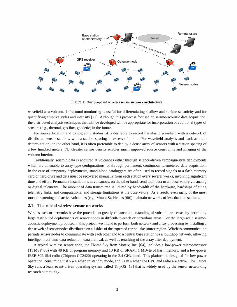
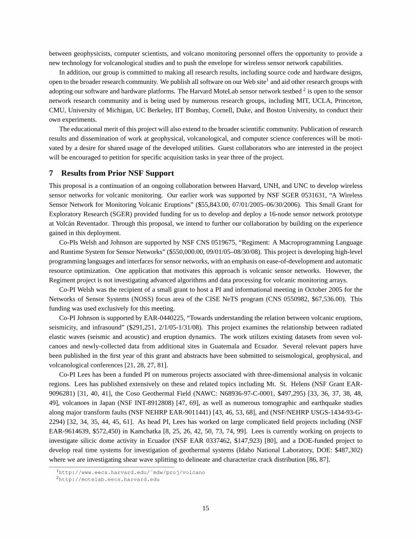
Broadband Seismic Vertical on July 1st 2005 (GMT Time)Volcano-tectonic event
(earthquake-type focal mechanism with clear body wave arrivals)
Explosion earthquake (accompanied by high-amplitude
impulsive acoustic signal)
Long-period event (emergent onset with predominance of low
frequencies
Harmonic tremor (extended-duration ground motions with peaked frequency spectra)
Tremor (extended-duration ground motions with broadband
frequency spectra)
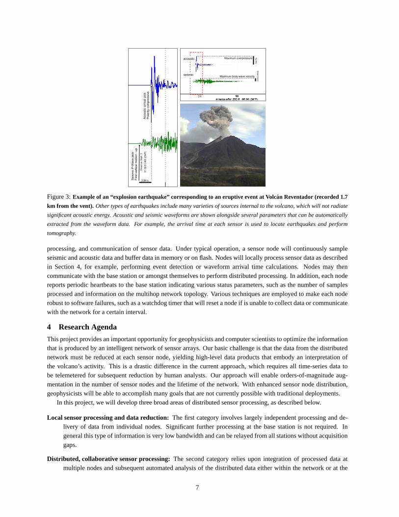
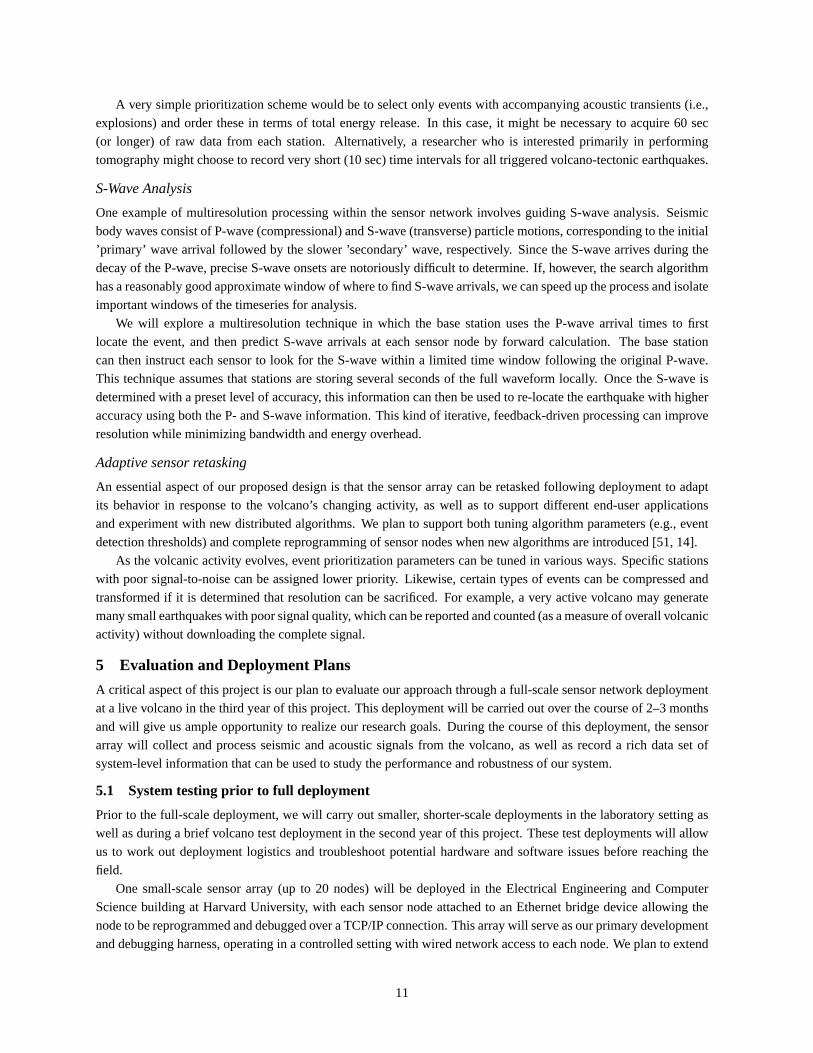
Figure 4:24-hour seismogram from Volcan Reventador showing the potential complexity of volcanic seismicity.Depicted
here are examples of explosion earthquakes, volcano-tectonic earthquakes, long-period events, and both harmonic and non-
harmonic tremor.
P- and S-wave velocity structure provides information on the 3D distribution of elastic wave properties in theerupting volcano, but it is relatively insensitive to thermal variation, a critical parameter in modeling conduit andmagma processes. To address this, our system will provide information on the spectral content of arriving waves andextract from them estimates of variations of quality factor, or attenuation of the waves as they pass through volcanicmaterial. This will provide a considerable constraint on temperature and the presence of melt in the magma system.While seismic velocity typically varies by a few percent, seismic attenuation can vary by orders of magnitude inrocks that have elevated temperature or increase of partial melt. Spectrum-decay determination of 3D variationsof Qp andQs [43] and pulse-width variation [97] have been applied to real data to monitor spatial variations offluid content in the deep crust. The tomographic inversion for 3DQ [43] is simply a linear inversion using raypathscalculated during the velocity analysis.
4.3 Adaptive, multiresolution data processing
The third and final class of advanced data processing that we wish to explore involvesmultiresolutiontechniques thatdynamically request data of increasing level of detail from sensor nodes as the computation proceeds. Supportingsuch “drill down” queries against the full-resolution signals and other intermediate data products generated by sensornodes allows the base station to hone in on the signals of greatest interest. Such acquisition can be dynamically re-configured so that as volcanic activity and user needs evolve, the data recovery is optimized.
Prioritized triggered data collection
Following an event report from multiple sensor nodes, the base station may wish to retrieve the complete signal forthe event from each station. As described in Section 2.2, our previous sensor network deployment at Reventadorexplored this approach. However, such data collection is complicated by the presence of multiple back-to-back eventsof varying strength and interest. With limited storage capacity and radio bandwidth, it is impossible to guaranteecomplete data collection from every node.
To fully comprehend the challenges we face, it is necessary to understand the spectrum of seismo-acousticactivity a volcano may produce. As shown in Figure 4, activity can vary from complete quiet (no ground motionsor pressure pulses) to episodic events (discrete explosions or earthquakes occurring at intervals of minutes hours ordays), to a complex amalgamation of different earthquake types (long-duration tremor or rapid-fire explosions or acombination interspersed with external non-volcanic seismicity).
We propose to develop aprioritizeddata collection strategy that allows sensor nodes to optimize the use of localstorage and radio bandwidth to yield the most “important” signals. Using the event characterization algorithmsdescribed above, the sensor node can decide which signals to retain and in which order to deliver data to the basestation when storage is saturated.
10
A very simple prioritization scheme would be to select only events with accompanying acoustic transients (i.e.,explosions) and order these in terms of total energy release. In this case, it might be necessary to acquire 60 sec(or longer) of raw data from each station. Alternatively, a researcher who is interested primarily in performingtomography might choose to record very short (10 sec) time intervals for all triggered volcano-tectonic earthquakes.
S-Wave Analysis
One example of multiresolution processing within the sensor network involves guiding S-wave analysis. Seismicbody waves consist of P-wave (compressional) and S-wave (transverse) particle motions, corresponding to the initial’primary’ wave arrival followed by the slower ’secondary’ wave, respectively. Since the S-wave arrives during thedecay of the P-wave, precise S-wave onsets are notoriously difficult to determine. If, however, the search algorithmhas a reasonably good approximate window of where to find S-wave arrivals, we can speed up the process and isolateimportant windows of the timeseries for analysis.
We will explore a multiresolution technique in which the base station uses the P-wave arrival times to firstlocate the event, and then predict S-wave arrivals at each sensor node by forward calculation. The base stationcan then instruct each sensor to look for the S-wave within a limited time window following the original P-wave.This technique assumes that stations are storing several seconds of the full waveform locally. Once the S-wave isdetermined with a preset level of accuracy, this information can then be used to re-locate the earthquake with higheraccuracy using both the P- and S-wave information. This kind of iterative, feedback-driven processing can improveresolution while minimizing bandwidth and energy overhead.
Adaptive sensor retasking
An essential aspect of our proposed design is that the sensor array can be retasked following deployment to adaptits behavior in response to the volcano’s changing activity, as well as to support different end-user applicationsand experiment with new distributed algorithms. We plan to support both tuning algorithm parameters (e.g., eventdetection thresholds) and complete reprogramming of sensor nodes when new algorithms are introduced [51, 14].
As the volcanic activity evolves, event prioritization parameters can be tuned in various ways. Specific stationswith poor signal-to-noise can be assigned lower priority. Likewise, certain types of events can be compressed andtransformed if it is determined that resolution can be sacrificed. For example, a very active volcano may generatemany small earthquakes with poor signal quality, which can be reported and counted (as a measure of overall volcanicactivity) without downloading the complete signal.
5 Evaluation and Deployment Plans
A critical aspect of this project is our plan to evaluate our approach through a full-scale sensor network deploymentat a live volcano in the third year of this project. This deployment will be carried out over the course of 2–3 monthsand will give us ample opportunity to realize our research goals. During the course of this deployment, the sensorarray will collect and process seismic and acoustic signals from the volcano, as well as record a rich data set ofsystem-level information that can be used to study the performance and robustness of our system.
5.1 System testing prior to full deployment
Prior to the full-scale deployment, we will carry out smaller, shorter-scale deployments in the laboratory setting aswell as during a brief volcano test deployment in the second year of this project. These test deployments will allowus to work out deployment logistics and troubleshoot potential hardware and software issues before reaching thefield.
One small-scale sensor array (up to 20 nodes) will be deployed in the Electrical Engineering and ComputerScience building at Harvard University, with each sensor node attached to an Ethernet bridge device allowing thenode to be reprogrammed and debugged over a TCP/IP connection. This array will serve as our primary developmentand debugging harness, operating in a controlled setting with wired network access to each node. We plan to extend
11
our current sensor network testbed, MoteLab (http://motelab.eecs.harvard.edu ), which provides aWeb-based interface for programming and debugging a live sensor testbed currently deployed over three floors ofthe Harvard EECS building. In the laboratory setting, volcanic sensor stimuli will be emulated by allowing eachnode to internally generate artificial sensor data based on traces collected during our deployments at Tungurahua andReventador.
In the second year of the project, we plan to undertake a short-term network deployment of up to 20 nodes at anaccessible and predictably active laboratory volcano. This test will be used primarily to serve as a “dry run” for thefull system deployment in Year 3, and to test our initial sensor processing techniques, developed in the laboratory,on live data. Candidate volcanoes include both Kilauea and Mount St. Helens, two sites in the U.S. where Co-PI Johnson has previously worked. This deployment will also give us the ability to directly measure node powerconsumption, battery lifetime, and further debug our wireless networking and time synchronization infrastructureprior to the full deployment.
5.2 Full sensor network deployment
In the third year of the project, we will undertake a 50 node sensor array deployment at an active volcano withthe goal of running the network for a full deployment season, up to three months. Given our previous experience inEcuador, Reventador and Tungurahua are good candidate volcanoes. However, our ultimate choice of volcano will belargely driven by the level of activity and opportunities to leverage our intelligent sensor array for scientific discovery.Other candidate volcanoes include Stromboli, Italy and Karymsky, Russia (where Lees and Johnson have worked)and Volcan de Colima, Mexico (where Johnson has worked). At most of these volcanoes, a permanent network ofanalog-telemetered seismic data can be made available to scientists collaborating with the host observatory. Thesedata can serve to “ground truth” our sensor node deployments.
Our goal with both field deployments is to collect reduced, real-time volcanic activity information and selectivewaveform data for geophysical study. At the same time, we intend to gain valuable experience with the distributedsensor processing techniques outlined in this proposal. In order to exercise the full range of techniques that wewill develop, we will periodically reprogram both the base processor and the sensor array (over the radio) with newdistributed algorithms and measurement software.
The base station will log every radio message received from and sent to the sensor array over the course of thedeployment, providing a voluminous data set for understanding the behavior and performance of the sensor network.This will include all of the data generated by the network as well as substantial instrumentation of the sensor networksoftware itself, such as statistics on radio message counts, energy consumption, memory and CPU usage, and otherdebugging information. This data will provide many opportunities for studying the performance of the networkin situ as well as to evaluate the impact of our distributed data processing techniques on energy consumption andbandwidth usage.
5.3 Evaluation metrics
In evaluating our proposed design, our chief concern is the ability of the sensor network to extract meaningfulinformation from the raw data at each node in real time, while minimizing radio bandwidth and energy consumption.The quality of the data generated by the sensor network must also be validated against “ground truth,” which willbe determined using a small number of continuous data loggers colocated with certain sensor stations. In addition,our sensor network can be placed into a diagnostic mode that will permit complete signals to be downloaded fromselected stations either manually or automatically following a significant event. Using offline processing of thecomplete signals captured by these dataloggers we will be able to directly measure the resulting data quality.
Another primary concern is network reliability and lifetime. The network should operate for an entire field season(3 months) without requiring frequent station maintenance or battery changes. Individual sensor nodes employa watchdog timer that automatically reboots the node when a failure or unexpected condition is detected; on ourprevious deployment at Reventador this technique was effective at ensuring continuous network operation despite
12
intermittent software failures. We will measure the lifetime of individual nodes through passive monitoring ofbattery voltage (reported over the radio) and periodic heartbeat messages from each node to determine whether itis still active. Our goal is to minimize the number of battery changes required during the deployment, though ifnecessary, we will be able to supply fresh batteries during routine visits when the stand-alone datalogger stations areserviced and their data is manually recovered.
Finally, radio bandwidth consumption is a major aspect of lifetime and data quality and quantity. For the networkto scale to many nodes, we must keep bandwidth usage in check. Our design calls for the network to issue verylittle radio traffic when the volcano is quiescent, greatly reducing bandwidth requirements. Different distributedalgorithms will require varying amounts of radio traffic. Each node will maintain a local counter of the number ofradio messages sent and received which will be included in periodic heartbeats to the base station, allowing us todirectly evaluate the amount of radio congestion in each part of the array over time.
5.4 Management plan
This is a collaborative project between Harvard, UNH, and UNC. As described earlier, we have been collaboratingon sensor networks for volcanic monitoring for the last two years. In the course of this project, we will coordinateour development efforts using a combination of an electronic mailing list, a Wiki site, monthly conference calls,and twice annual in-person meetings with the entire research team. Due to close physical proximity, the groups atHarvard and UNH can visit each other as needed to collaborate directly on hardware and software design.
Harvard will be leading the development of the sensor array hardware and core systems software, with directconsultation with the UNH and UNC teams to define requirements. UNH and UNC will develop advanced algorithmsfor wave-arrival picks, event characterization, and tomography. These algorithms will initially be developed asstandalone codes (e.g., in MATLAB) and will be ported to the sensor array with assistance from Harvard. The teamsfrom UNH and UNC will also be responsible for and leading the sensor network deployments. Members from allthree groups will participate in the deployments and evaluation of the system. Scientists from UNH and UNC willtake lead on relevant publications destined for the geophysical community.
5.5 Project timeline
Year 1: Using our previous sensor network design as a starting point, develop algorithms for local sensor processing,event detection and characterization, and RSAM, VASR, and SSAM computation. Develop user interface tools fortuning algorithm parameters and tasking the sensor array from the base station. Perform first set of laboratory teststo evaluate energy and bandwidth savings.Year 2: Extend the network design to perform processing that aggregates data across the sensor array. Develop codeto perform real-time earthquake location and 4D tomography based on wave arrival times. Experiment with pushingaspects of this processing into the sensor network and explore tradeoff between increased computation on sensornodes and radio bandwidth savings. Undertake first small-scale deployment to evaluate our system design to date.Year 3: Incorporate improvements based on evaluation of the system developed in Years 1 and 2. Develop adap-tive data prioritization and multiresolution data acquisition techniques and integrate with real-time tomography atthe base station. Undertake final full-scale sensor network deployment and experiment with the complete systemincluding sensor retasking. Draw on experience gained with this deployment to chart future research directions.
6 Educational Activities and Broader Impact
This proposal brings new technologies to bear on geophysical sensor systems. This cross-disciplinary effort servesboth the research and educational missions, as well as extending these missions to broader communities.
6.1 Education plan
The research described in this proposal will be tightly integrated into education at both the graduate and under-graduate levels. At Harvard, Welsh has developed a new graduate seminar course, “Wireless Communications and
13
Sensor Networks,” which covers many aspects of sensor networks, wireless networking, and novel applications ofthese technologies. Students in the course read research papers from this area and undertake an independent researchproject that is intended to lead to publication. The proposed research direction will provide a valuable framework forhosting student projects in this course; for example, students might undertake projects on optimizing a distributedimplementation of earthquake localization on a wireless sensor array. All of the course materials are available on theWeb athttp://www.eecs.harvard.edu/˜mdw/course/cs263/ .
Sensor networks are also being introduced into the undergraduate Operating Systems course at Harvard, whichwill expand this course beyond the traditional curriculum to cover topics in distributed and embedded systems. Webelieve sensor networks are a great way to involve undergraduates in hands-on experimentation with distributedsystems, since they can readily develop and deploy novel applications with a small number of motes and directlyobserve their behavior. As with the graduate course above, all of these course materials are available on the Web athttp://courses.fas.harvard.edu/˜cs161/ .
At Harvard, many undergraduates take graduate courses, and this term, approximately 25% of the students in thegraduate Sensor Networks course are undergraduates. In addition, we will continue to recruit undergraduates to takeon independent research projects related to this proposal. We are currently advising two undergraduate senior thesisprojects that are related to this research area and plan to recruit others.
At UNH, the realization of this project will benefit both undergraduate and graduate students within the Depart-ment of Earth Sciences. Co-PI Johnson teaches an introductory-level undergraduate class in Environmental Geology,which focuses on volcanic processes. We will recruit undergraduate research assistants to assist with field work andlearn fundamental seismic data processing techniques. Johnson is also part of a faculty team that will likely beteaching an advanced-level volcanology class for advanced undergraduates and graduate students (expected startingdate in the Fall of 2006). This class, which will dedicate time to geophysical data acquisition, is also expected to bea source of young volunteers who are interested in collecting and analyzing volcanological data.
Co-PI Lees teaches numerous courses in Data Analysis and Physical Volcanology at the University of NorthCarolina, Chapel Hill. Research from this project will provide a live example and data stream for development ofnew algorithms and pedagogical challenges for students taking Lees’ courses. Lees has involved numerous studentsin field work at UNC and this project will provide an excellent platform to train students and introduce them to therigors of geophysical data acquisition.
This project provides many opportunities for collaborations of students across geophysical sciences and computerscience, as well as involvement of women and minorities. UNC has more African American undergraduates thanany of its peer institutions, and women represent more than half of the students in the Department of GeologicalSciences. At all three institutions, we will actively recruit these students for inclusion on this project and advertiseresearch positions through organizations such as Women in Computer Science (WICS) and the Harvard Society ofBlack Scientists and Engineers (HSBSE).
6.2 Broader impact
Our approach to adaptive sensor processing will have considerable impact on future technologies for monitoringvolcanoes and other geophysical systems. These techniques can be readily extended to incorporate other typesof sensors (e.g., geodetic, thermal, tilt, etc.) to study a range of geophysical phenomena (tectonic earthquakes,glaciers, weather). This goal coincides with current trends in the geophysical community where multi-disciplinarydata is increasingly integrated and spatially-dispersed sensing locations are necessary to resolve problems at greaterresolution.
The specific tools developed in this proposal will have immediate implications for monitoring active volcanoesand provide broader impacts through the mitigation of hazards to humans and property. Our proposed real-time pro-cessing will provide important status reports (eruption counts, earthquake locations, energy release) that are neededby volcano observatory staff when making decisions about volcanic unrest. Deployment of large wireless sensornetworks on hazardous volcanoes holds vast potential for detailed and insightful monitoring. This collaboration
14
between geophysicists, computer scientists, and volcano monitoring personnel offers the opportunity to provide anew technology for volcanological studies and to push the envelope for wireless sensor network capabilities.
In addition, our group is committed to making all research results, including source code and hardware designs,open to the broader research community. We publish all software on our Web site1 and aid other research groups withadopting our software and hardware platforms. The Harvard MoteLab sensor network testbed2 is open to the sensornetwork research community and is being used by numerous research groups, including MIT, UCLA, Princeton,CMU, University of Michigan, UC Berkeley, IIT Bombay, Cornell, Duke, and Boston University, to conduct theirown experiments.
The educational merit of this project will also extend to the broader scientific community. Publication of researchresults and dissemination of work at geophysical, volcanological, and computer science conferences will be moti-vated by a desire for shared usage of the developed utilities. Guest collaborators who are interested in the projectwill be encouraged to petition for specific acquisition tasks in year three of the project.
7 Results from Prior NSF Support
This proposal is a continuation of an ongoing collaboration between Harvard, UNH, and UNC to develop wirelesssensor networks for volcanic monitoring. Our earlier work was supported by NSF SGER 0531631, “A WirelessSensor Network for Monitoring Volcanic Eruptions” ($55,843.00, 07/01/2005–06/30/2006). This Small Grant forExploratory Research (SGER) provided funding for us to develop and deploy a 16-node sensor network prototypeat Volcan Reventador. Through this proposal, we intend to further our collaboration by building on the experiencegained in this deployment.
Co-PIs Welsh and Johnson are supported by NSF CNS 0519675, “Regiment: A Macroprogramming Languageand Runtime System for Sensor Networks” ($550,000.00, 09/01/05–08/30/08). This project is developing high-levelprogramming languages and interfaces for sensor networks, with an emphasis on ease-of-development and automaticresource optimization. One application that motivates this approach is volcanic sensor networks. However, theRegiment project is not investigating advanced algorithms and data processing for volcanic monitoring arrays.
Co-PI Welsh was the recipient of a small grant to host a PI and informational meeting in October 2005 for theNetworks of Sensor Systems (NOSS) focus area of the CISE NeTS program (CNS 0550982, $67,536.00). Thisfunding was used exclusively for this meeting.
Co-PI Johnson is supported by EAR-0440225, “Towards understanding the relation between volcanic eruptions,seismicity, and infrasound” ($291,251, 2/1/05-1/31/08). This project examines the relationship between radiatedelastic waves (seismic and acoustic) and eruption dynamics. The work utilizes existing datasets from seven vol-canoes and newly-collected data from additional sites in Guatemala and Ecuador. Several relevant papers havebeen published in the first year of this grant and abstracts have been submitted to seismological, geophysical, andvolcanological conferences [21, 28, 27, 81].
Co-PI Lees has been a funded PI on numerous projects associated with three-dimensional analysis in volcanicregions. Lees has published extensively on these and related topics including Mt. St. Helens (NSF Grant EAR-9096281) [31, 40, 41], the Coso Geothermal Field (NAWC: N68936-97-C-0001, $497,295) [33, 36, 37, 38, 48,49], volcanoes in Japan (NSF INT-8912808) [47, 69], as well as numerous tomographic and earthquake studiesalong major transform faults (NSF NEHRP EAR-9011441) [43, 46, 53, 68], and (NSF/NEHRP USGS-1434-93-G-2294) [32, 34, 35, 44, 45, 61]. As head PI, Lees has worked on large complicated field projects including (NSFEAR-9614639, $572,450) in Kamchatka [8, 25, 26, 42, 50, 73, 74, 99]. Lees is currently working on projects toinvestigate silicic dome activity in Ecuador (NSF EAR 0337462, $147,923) [80], and a DOE-funded project todevelop real time systems for investigation of geothermal systems (Idaho National Laboratory, DOE: $487,302)where we are investigating shear wave splitting to delineate and characterize crack distribution [86, 87].
1http://www.eecs.harvard.edu/˜mdw/proj/volcano2http://motelab.eecs.harvard.edu
15
References
[1] R. Adler, P. Buonadonna, J. Chhabra, M. Flanigan, L. Krishnamurthy, N. Kushalnagar, L. Nachman, andM. Yarvis. Design and deployment of industrial sensor networks: Experiences from the North Sea and asemiconductor plant. InProc. the 3rd ACM Conference on Embedded Networked Sensor Systems (SenSys
2005), November 2005.
[2] K. Aki and R. Richards.Quantitative Seismology: Theory and Methods. W.H. Freeman, San Francisco, 1980.
[3] Alaska Volcano Observatory.http://www.avo.alaska.edu/ .
[4] J. Battaglia and K. Aki. Location of seismic events and eruptive fissures on the piton de la fournaise volcanousing seismic ampliutdes.J Geophys. Res., 108(B8, 10.1029/2002JB002193):2364, 2003.
[5] J. Brune. Tectonic stress and the spectra of seismic shear waves from earthquakes,.J. Geophys. Res., 75:4997–5009, 1970.
[6] B. Chouet. Long-period volcano seismicity: its source and use in eruption forecasting.Nature, 380:309–316,1996.
[7] B. Chouet, P. Dawson, G. De Luca, M. Martini, G. Milana, G. Saccorotti, and R. Scarpa. Array analyses ofseismic sources at stromboli.Acta Vulcanologica, 10(2):367–382, 1998.
[8] A. Davaille and J. Lees. Thermal modeling of subducted plates: tear and hot spot at the Kamchatka corner.Earth Planet. Sci. Letts., 226(3-4):293–304, 2004.
[9] R. Dibble, J. Kienle, P. Kyle, and K. Shibuya. Geophysical studies of erebus volcano, antarctica, from 1974december to 1982 january.New Zealand J. Geol. Geophys., 27(4):425–455, 1984.
[10] L. D. Dietz, W. Kohler, et al. A real-time P-wave picker (RTP) for a fast earthquake response system (Earth-worm). Eos (Transactions, American Geophysical Union), 74(43, Suppl.):429, 1993.
[11] M. Garces, M. Iguchi, K. Ishihara, M. Morrissey, Y. Sudo, and T. Tsutsui. Infrasonic precursors to a vulcanianeruption at sakurajima volcano, japan.Geophys. Res. Lett., 26(16):2537–2540, 1999.
[12] D. Gay, P. Levis, R. von Behren, M. Welsh, E. Brewer, and D. Culler. The nesC language: A holistic approachto networked embedded systems. InProc. Programming Language Design and Implementation (PLDI), June2003.
[13] J. Hill, R. Szewczyk, A. Woo, S. Hollar, D. E. Culler, and K. S. J. Pister. System architecture directionsfor networked sensors. InProc. the 9th International Conference on Architectural Support for Programming
Languages and Operating Systems, pages 93–104, Boston, MA, USA, Nov. 2000.
[14] J. W. Hui and D. Culler. The dynamic behavior of a data dissemination protocol for network programming atscale. InProc. 2nd ACM Conference on Embedded Networked Sensor Systems (SenSys’04), November 2004.
[15] C. Intanagonwiwat, R. Govindan, and D. Estrin. Directed diffusion: A scalable and robust communicationparadigm for sensor networks. InProc. International Conference on Mobile Computing and Networking,Aug. 2000.
[16] Intel Corporation. iMote2 Design Document.http://www.intel.com/research/downloads/
imote_overview.pdf .
[17] X. Jiang, J. Polastre, and D. Culler. Perpetual environmentally powered sensor networks. InProc. Fourth
International Conference on Information Processing in Sensor Networks: Special track on Platform Tools
and Design Methods for Network Embedded Sensors (IPSN/SPOTS), April 2005.
[18] J. Johnson. Generation and propagation of infrasonic airwaves from volcanic explosions.J. Volc. Geotherm.
Res., 121(1-2):1–14, 2003.
16
[19] J. Johnson. Source location variability and volcanic vent mapping with a small-aperture infrasound array atstromboli volcano, italy.Bull. Volcan., 67:1–14, 2005.
[20] J. Johnson and R. Aster. Relative partitioning of acoustic and seismic energy during strombolian eruptions.J.
Volc. Geotherm. Res., 148:334–354, 2005.
[21] J. Johnson and R. Aster. Volcanic acoustic efficiency of Strombolian eruptions.J. Volcanol. Geotherm. Res.,(148):334–354, 2005.
[22] J. Johnson, R. Aster, and P. Kyle. Volcanic eruptions observed with infrasound.Geophys. Res. Lett.,31(L14604):doi:10.1029/2004GL020020,, 2004.
[23] J. Johnson, R. Aster, M. Ruiz, S. Malone, P. McChesney, J. Lees, and P. Kyle. Interpretation and utility ofinfrasonic records from erupting volcanoes.J. Volc. Geotherm. Res., 121(1-2):15–63, 2003.
[24] J. Johnson, A. Harris, S. Sahetapy-Engel, R. Wolf, and W. Rose. Explosion dynamics of vertically directedpyroclastic eruptions at santiaguito, guatemala.Geophys. Res. Lett., 31(L06610), 2004.
[25] J. Johnson and J. Lees. Plugs and Chugs - Strombolian activity at Karymsky, Russia, and Sangay, Ecuador.J.
Volc. Geoth. Res., 101:67–82, 2000.
[26] J. Johnson, J. Lees, and E. Gordeev. Degassing explosions at Karymsky Volcano, Kamchatka.Geophys. Res.
Lett., 25(21):3999–4042, 1998.
[27] J. Johnson, J. Lees, and H. Yepes. Volcanoes, lightning, and a waterfall: Differentiating the menagerie ofinfrasound in the Ecuadorian jungle. Submitted to Geophys. Res. Lett., 2005.
[28] J. Johnson, M. Ruiz, J. Lees, and P. Ramon. Poor scaling between elastic energy release and eruption intensityat Tungurahua Volcano, Ecuador.Geophys. Res. Lett., (32).
[29] J. Johnson, M. Ruiz, J. Lees, and P. Ramon. Poor scaling between elastic energy release and eruption intensityat tungurahua volcano, ecuador.Geophys. Res. Lett., 32(doi:10.1029/2005GL022847):L15304, 2005.
[30] L. Kang, S. Lahaie, G. Mainland, D. C. Parkes, and M. Welsh. Using virtual markets to program globalbehavior in sensor networks. InProc. 11th ACM SIGOPS European Workshop, Leuven, Belgium, September2004.
[31] J. Lees. The magma system of Mount St. Helens: Non-linear high resolution P-wave tomography.J. Volc.
Geoth. Res., 53(1-4):103–116, 1992.
[32] J. Lees. Reshaping spectrum estimates by removing periodic noise: application to seismic spectral ratios.Geophys. Res. Lett., 22(4):513–516, 1995.
[33] J. Lees. Seismic doublets in the Coso geothermal field.Eos (Trans. AGU), page F407, 1995.
[34] J. Lees. Xmap8: Three-dimensional GIS for geology and geophysics.Seismol. Res. Lett., 66(4):33–37, 1995.
[35] J. Lees. Waveform and spatial clustering in high frequency seismograms. In H. Engl, A. Louis, and W. Run-dell, editors,Inverse Problems in Geophysical Applications, pages 109–130. Society for the Industrial Appli-cations of Mathematics, Philadelphia, 1997.
[36] J. Lees. Multiplet analysis at Coso Geothermal.Bull. Seismol. Soc. Am., 88(5):1127–1143, 1998.
[37] J. Lees. Three-Dimensional Anatomy of a Geothermal Field. In A. Glazner, J. Walker, and J. Bartley, editors,Geologic Evolution of the Central Mojave Desert and Southern Basin and Range, pages 259–276. GeologicalSociety of America, Boulder, CO, 2002.
[38] J. Lees. Scattering from a fault interface in the Coso geothermal field.J. Volc. Geoth. Res., 130(1-2):61–75,2004.
[39] J. Lees and R. Crosson. Tomographic inversion for three-dimensional velocity structure at Mount St. Helensusing earthquake data.J. Geophys. Res., 94:5716–5728, 1989.
17
[40] J. Lees and R. Crosson. Tomographic inversion for three-dimensional velocity structure at Mount St. Helensusing earthquake data.J. Geophys. Res., 94(B5):5716–5728, 1989.
[41] J. Lees and R. Crosson. Bayesian ART versus conjugate gradient methods in tomographic seismic imaging:An application at Mount St. Helens, Washington. In A. Possolo, editor,Spatial Statistics and Imaging, pages186–208. Inst. of Math. Statistics, Hayward, CA, 1991.
[42] J. Lees, E. Gordeev, and M. Ripepe. Explosions and Periodic Tremor at Karymsky Volcano, Kamchatka,Russia.Geophys. J. Int., 2004.
[43] J. Lees and G. Lindley. Three-dimensional attenuation tomography at Loma Prieta: Inverting t* for Q.J.
Geophys. Res., 99(B4):6843–6863, 1994.
[44] J. Lees and C. Nicholson. Three-dimensional tomography of the 1992 Southern California sequence: Con-straints on dynamic earthquake ruptures?Geology, 21(5):385–480, 1993.
[45] J. Lees and J. Park. Multiple-taper spectral analysis: A stand-alone C-subroutine.Computers and Geology,21(2):199–236, 1995.
[46] J. Lees and E. Shalev. On the stability of P-wave tomography at Loma Prieta: A comparison of parameteriza-tions, linear and non-linear inversions.Bull. Seismol. Soc. Am., 82(4):1821–1839, 1992.
[47] J. Lees and M. Ukawa. The South Fossa Magna, Japan, Revealed by High Resolution P and S-Wave TravelTime Tomography.Tectonophysics, 207(1992):377–396.
[48] J. Lees and H. Wu. P-wave anisotropy, stress, and crack distribution at Coso Geothermal Field, California.J.
Geophys. Res., 104(8):17955–17973, 1999.
[49] J. Lees and H. Wu. Poisson’s ratio and porosity at Coso Geothermal Area, California.J. Volc. Geoth. Res.,(95):157–173, 2000.
[50] V. Levin, J. Park, M. Brandon, J. Lees, V. Peyton, E. Gordeev, and A. Ozerov. Crust and upper mantle ofKamchatka from teleseismic receiver functions. In I. Artemieva, H. Thybo, W. Mooney, and E. Perchuc,editors,Tectonophysics, pages 233–265. Elsevier, Amsterdam, 2002.
[51] P. Levis, D. Gay, and D. Culler. Active sensor networks. InProc. Second USENIX/ACM Symposium on
Networked Systems Design and Implementation (NSDI 2005), May 2005.
[52] P. Levis, N. Lee, M. Welsh, and D. Culler. TOSSIM: Accurate and scalable simulation of entire TinyOSapplications. InProc. the First ACM Conference on Embedded Networked Sensor Systems (SenSys 2003),November 2003.
[53] N. Ligdas and J. Lees. Seismic velocity constraints in the Thessaloniki and Chalkidiki areas (Northern Greece)from a 3-D tomographic study.Tectonophysics, 228:97–121, 1993.
[54] K. W. Lin, R. C. Aster, et al. A waveform picker/locator forthe Earthworm System using a World Wide Webinterface.Seismological Research Letters, 71(2):233, 2000.
[55] K. Lorincz, D. Malan, T. R. F. Fulford-Jones, A. Nawoj, A. Clavel, V. Shnayder, G. Mainland, S. Moulton,and M. Welsh. Sensor Networks for Emergency Response: Challenges and Opportunities.IEEE Pervasive
Computing, Oct-Dec 2004.
[56] S. Madden, M. J. Franklin, J. M. Hellerstein, and W. Hong. TAG: A Tiny AGgregation Service for Ad-HocSensor Networks. InProc. the 5th OSDI, December 2002.
[57] G. Mainland, D. C. Parkes, and M. Welsh. Decentralized, adaptive resource allocation for sensor networks. InProc. 2nd USENIX/ACM Symposium on Networked Systems Design and Implementation (NSDI 2005), May2005.
18
[58] A. Mainwaring, J. Polastre, R. Szewczyk, D. Culler, and J. Anderson. Wireless sensor networks for habitatmonitoring. InACM International Workshop on Wireless Sensor Networks and Applications (WSNA’02),Atlanta, GA, USA, Sept. 2002.
[59] D. Malan, T. Fulford-Jones, M. Welsh, and S. Moulton. CodeBlue: An ad hoc sensor network infrastructurefor emergency medical care. June 2004.
[60] S. Malone, E. Endo, C. Weaver, and J. Ramey. Seismic monitoring for eruption prediction. In P. Lipman andD. Mullineaux, editors,The 1980 Eruptions of Mount St. Helens, Washington, volume 1250, pages 803–813.U.S. Geological Survey Professional Paper, 1981.
[61] M. Mann and J. Lees. Robust estimation of background noise and signal detection in climatic time series.Climate Change, 33:409–445, 1996.
[62] M. Maroti, B. Kusy, G. Simon, and A. Ledeczi. The flooding time synchronization protocol. InProc.
SenSys’04, Baltimore, MD, November 2004.
[63] S. McNutt. Seismic monitoring and eruption forecasting of volcanoes: a review of the state-of-the-art andcase histories. InMonitoring and mitigation of volcano hazards, pages 100–146. Springer-Verlag, Berline,1996.
[64] Moteiv, Inc. Telos Revision B.http://www.moteiv.com .
[65] T. Murray and E. Endo. A real-time seismic-amplitude measurement system (rsam). In Ewart and Swan-son, editors,Monitoring Volcanoes: Techniques and Strategies Used by the Staff of the Cascades Volcano
Observatory, 1980-1990, volume 1966, pages 5–10. USGS Bulletin, 1992.
[66] R. Newton, Arvind, and M. Welsh. Building up to macroprogramming: An intermediate language for sensornetworks. InProc. Fourth International Conference on Information Processing in Sensor Networks (IPSN’05),April 2005.
[67] R. Newton and M. Welsh. Region streams: Functional macroprogramming for sensor networks. InProc. First
International Workshop on Data Management for Sensor Networks (DMSN), Toronto, Canada, August 2004.
[68] C. Nicholson and J. Lees. Travel-time tomography in the northern Coachella Valley using aftershocks of the1986 ML 5.9 North Palm Springs earthquake.Geophys. Res. Lett., 19(1):1–4, 1992.
[69] S. Ohmi and J. Lees. Three-dimensional P and S-wave velocity structure below Unzen Volcano.J. Volc.
Geoth. Res., 65:1–26, 1995.
[70] E. Osterweil and D. Estrin. ESS: The Extensible Sensing System.http://www.cens.ucla.edu/
˜eoster/ess/ , April 2004.
[71] Pacific Northwest Seismograph Network.http://www.geophys.washington.edu/SEIS/PNSN/ .
[72] S. N. Pakzad, S. Kim, G. L. Fenves, S. D. Glaser, D. E. Culler, and J. W. Demmel. Multi-purpose wirelessaccelerometers for civil infrastructure monitoring. InProc. 5th International Workshop on Structural Health
Monitoring (IWSHM 2005), September 2005.
[73] J. Park, V. Levin, M. Brandon, J. Lees, V. Peyton, E. Gordeev, and A. Ozerov. A dangling slab, amplified arcvolcanism, mantle flow and seismic anisotropy in the Kamchatka Plate Corner. In S. Stein and J. Freymuller,editors,Plate Boundary Zones, pages 295–324. AGU, 2002.
[74] V. Peyton, V. Levin, J. Park, M. Brandon, J. Lees, E. Gordeev, and A. Ozerov. Mantle Flow at a Slab Edge:Seismic Anisotropy in the Kamchatka Region.Geophys. Res. Lett., 28(2):379–382, 2000.
[75] V. Raghunathan, A. Kansal, J. Hsu, J. Friedman, and M. Srivastava. Design considerations for solar energyharvesting wireless embedded systems. InProc. Fourth International Conference on Information Processing
in Sensor Networks: Special track on Platform Tools and Design Methods for Network Embedded Sensors
(IPSN/SPOTS), April 2005.
19
[76] M. Ripepe, A. Harris, and R. Carniel. Thermal, seismic and infrasonic evidences of variable degassing ratesat stromboli volcano.J. Volc. Geotherm. Res., 118(3-4):285–297, 2002.
[77] M. Ripepe and E. Marchetti. Array tracking of infrasonic sources at stromboli volcano.Geophys. Res. Lett.,29:331–334, 2002.
[78] M. Ripepe, P. Poggi, T. Braun, and E. Gordeev. Infrasonic waves and volcanic tremor at stromboli.Geophys.
Res. Lett., 23(2):181–184, 1996.
[79] J. Rogers. Frequency-domain detection of seismic signals using a dsp coprocessor board. In W. Lee, editor,Toolbox for seismic data acquisition, processing, and analysis, pages 151–172. International Association ofSeismology and Physics of the Earth’s Interior in collaboration with Seismological Society of America, ElCerrito, CA, 1989.
[80] M. Ruiz, J. Lees, and J. Johnson. Source constraints of Tungurahua explosion events.Bull. Volcanol., 2005.
[81] M. Ruiz, J. Lees, and J. Johnson. Source constraints of Tungurahua Volcano explosion events.Bull. Volcanol.,2005.
[82] R. Scarpa and R. Tilling.Monitoring and mitigation of volcano hazards. Springer-Verlag, Berlin, 1996.
[83] V. Shnayder, M. Hempstead, B. rong Chen, G. Werner-Allen, and M. Welsh. Simulating the power consump-tion of large-scale sensor network applications. InProc. Second ACM Conference on Embedded Networked
Sensor Systems (SenSys’04), Baltimore, MD, November 2004.
[84] R. Sleeman and T. van Eck. Robust automatic P-phase picking: an on-line implementation in the analysis ofbroadband seismogram recordings.Phys. Earth Plan. Int., 113:265–275, 1998.
[85] R. Szewczyk, J. Polastre, A. Mainwaring, J. Anderson, and D. Culler. Analysis of a large scale habitat mon-itoring application. InProc. the Second ACM Conference on Embedded Networked Sensor Systems (SenSys
2004), November 2004.
[86] C. Tang, J. Rial, and J. Lees. Shear-wave splitting: A diagnostic tool to monitor fluid pressure in geothermalfields. Geophys. Res. Lett., 32(21), 2005.
[87] C. Tang, J. Rial, J. Lees, and E. Thompson. InProc. Thirteenth Workshop on Geothermal Reservoir Engi-
neering, 2005.
[88] G. Tolle, J. Polastre, R. Szewczyk, N. Turner, K. Tu, P. Buonadonna, S. Burgess, D. Gay, W. Hong, T. Dawson,and D. Culler. A macroscope in the redwoods. InProc. the 3rd ACM Conference on Embedded Networked
Sensor Systems (SenSys 2005), November 2005.
[89] S. Vergniolle and G. Brandeis. Origin of sound generated by strombolian explosions.Geophys. Res. Lett.,21(18):1959–1962, 1994.
[90] M. Welsh. Exposing resource tradeoffs in region-based communication abstractions for sensor networks. InProc. the 2nd ACM Workshop on Hot Topics in Networks (HotNets-II), November 2003.
[91] M. Welsh and G. Mainland. Programming sensor networks using abstract regions. InProc. the First
USENIX/ACM Symposium on Networked Systems Design and Implementation (NSDI ’04), March 2004.
[92] M. Welsh, G. Werner-Allen, K. Lorincz, O. Marcillo, M. Ruiz, J. Johnson, and J. Lees. A wireless seis-moacoustic sensor network for monitoring activity at Volcan Reventador, Ecuador. InEos Trans. American
Geophysical Union, volume 86 ofFall Meet. Suppl., Abstract V21C-0612, San Francisco, CA, December2005.
[93] G. Werner-Allen, J. Johnson, M. Ruiz, J. Lees, and M. Welsh. Monitoring volcanic eruptions with a wirelesssensor network. InProc. Second European Workshop on Wireless Sensor Networks (EWSN’05), January 2005.
20
[94] K. Whitehouse, C. Sharp, E. Brewer, and D. Culler. Hood: A neighborhood abstraction for sensor networks.In Proc. the International Conference on Mobile Systems, Applications, and Services (MOBISYS ‘04), June2004.
[95] A. Woo, T. Tong, and D. Culler. Taming the underlying challenges of reliable multihop routing in sensor net-works. InProc. the First ACM Conference on Embedded Networked Sensor Systems (SenSys 2003), November2003.
[96] H. Wu and J. Lees. Three-dimensional P and S wave velocity structures of the Coso Geothermal Area,California, from microseismic traveltime data.Journal of Geophysical Research, 22:13,217–13,233, 1999.
[97] H. Wu and J. M. Lees. Attenuation structure of the Coso Geothermal area, California, from pulse width dataof P-wave.Bulletin of the Seismological Society of America, 86:1574–1590, 1996.
[98] N. Xu, S. Rangwala, K. Chintalapudi, D. Ganesan, A. Broad, R. Govindan, and D. Estrin. A wireless sensornetwork for structural monitoring. InProc. the Second ACM Conference on Embedded Networked Sensor
Systems (SenSys 2004), November 2004.
[99] G. Yogodzinski, J. Lees, T. Churikova, F. Dorendorf, G. Woerner, and O. Volynets. Geochemical evidence forthe melting of subducting oceanic lithosphere at plate edges.Nature, 409:500–504, 2001.
[100] H. Zhang, C. H. Thurber, et al. Automatic P-wave arrival detection and picking with multiscale waveletanalysis for single-component recordings.Bulletin of the Seismological Society of America, 93(5):1904–1912, 2003.
21