Embed Size (px)
Citation preview
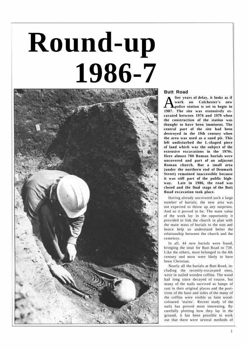
Round-up 1986-7 1 recent and current excavations in Colchester
Things They Left Behind 6 some recent finds in Colchester of Roman arms and armour.
Pottery from Across the Roman Empire 10 Colchester s trade links with Europe and the Mediterranean
Colchester's New Clock M u s e u m 12 a permanent display about the town's clockmakers
Friends of the Colchester Archaeological Trust 15
news of recent and forthcoming activities and events
Notes and News 15
Britain's Oldest Town Wall 16 a look at the wall on the eve of the new repair programme
Around the County 18 news about excavations in Essex
Young Archaeologists Club 20 a spot for our youngest readers
Laying Out Sites for the Public 21 discoveries around the town on public view
T h e Colchester Archaeologist is an annual magazine which replaces Catalogue, the newslet ter published twice yearly since 1976 by the Colchester Archaeological Trust and the Friends of the Colchester Archaeological Trust.
The Colchester Archaeologist, Issue Number 1 (1987)
Published by the Colchester Archaeological Trust Ltd, 12 Lexden Road, Colchester C 0 3 3NF
Edited and produced by Philip Crummy
Printed by Witley Press Ltd, Hunstanton, Norfolk
© 1987 Colchester Archaeological Trust Ltd
ISSN 0952-0988
THE FRIENDS OF THE
COLCHESTER ARCHAEOLOGICAL TRUST
If you would like future issues of T h e Colchester Archaeologist mailed to you direct, then why not consider jo in ing the Friends of the Colchester Archaeological Trust?
The Friends of the Colchester Archaeological Trust exists to keep interested members of the public in touch with the archaeological work in the historic town of Colchester. Member s receive T h e Colchester Archaeologist , attend an annual lecture about the previous yea r ' s work, are given conducted tours of current sites, and can take part in a regular p rogramme of visits to archaeological sites and monument s in the area. Publicat ion of The Colchester Archaeologist is helped by funds provided by the Friends.
The annual subscription rates are as follows: Adults and Institutions £2 .00 , Family membersh ip £2 .50 , Children and Students £1.00. Subscriptions should be sent to Brenda May, Honorary Treasurer, Friends of the Colchester Archaeological Trust, 5 Will iam Close, Wivenhoe , Colchester, Essex.
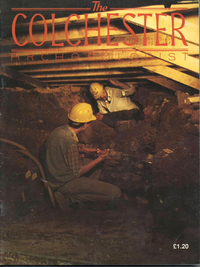
Cover: digging behind the Roman town wall on the Culver Street site in 1985
Round-up 1986-7
1
Butt Road
After years of delay, it looks as if work on Colchester's new police station is set to begin in
1987. The site was extensively excavated between 1976 and 1979 when the construction of the station was thought to have been imminent. The central part of the site had been destroyed in the 19th century when the area was used as a sand pit. This left undisturbed the L-shaped piece of land which was the subject of the extensive excavations in the 1970s. Here almost 700 Roman burials were uncovered and part of an adjacent Roman church. But a small area (under the northern end of Denmark Street) remained inaccessible because it was still part of the public highway. Late in 1986, the road was closed and the final stage of the Butt Road excavation took place.
Having already uncovered such a large number of burials, the new area was not expected to throw up any surprises. And so it proved to be. The main value of the work lay in the opportunity it provided to link the church in plan with the main mass of burials to the east and hence help us understand better the relationship between the church and the cemetery.
In all, 44 new burials were found, bringing the total for Butt Road to 739. Like the others, most belonged to the 4th century and most were likely to have been Christian.
Nearly all the burials at Butt Road, including the recently-excavated ones, were in nailed wooden coffins. The wood had long since decayed of course, but many of the nails survived as lumps of rust in their original places and the positions of the base and sides of the many of the coffins were visible as faint wood-coloured 'stains'. Recent study of the nails has proved most interesting. By carefully plotting how they lay in the ground, it has been possible to work out that there were several methods of
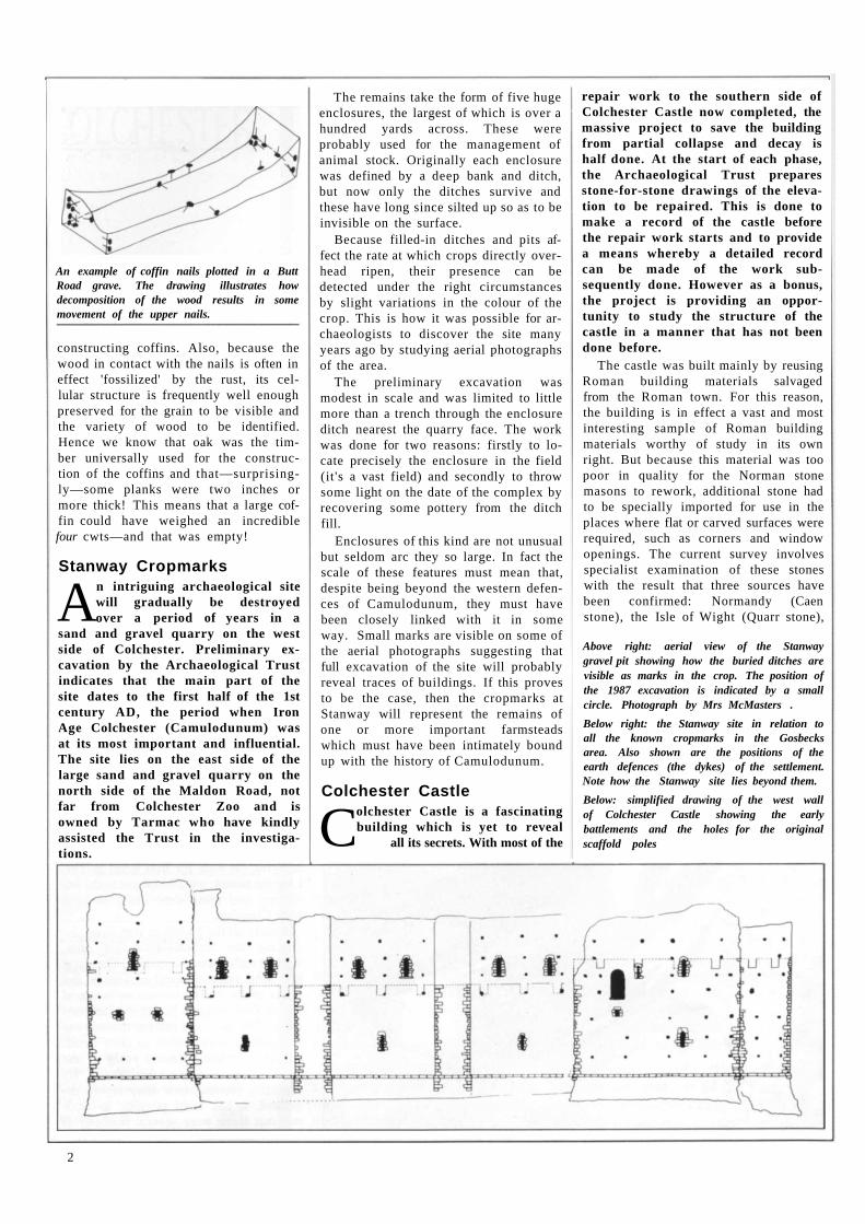
constructing coffins. Also, because the wood in contact with the nails is often in effect 'fossilized' by the rust, its cellular structure is frequently well enough preserved for the grain to be visible and the variety of wood to be identified. Hence we know that oak was the timber universally used for the construction of the coffins and that—surprisingly—some planks were two inches or more thick! This means that a large coffin could have weighed an incredible four cwts—and that was empty!
Stanway Cropmarks
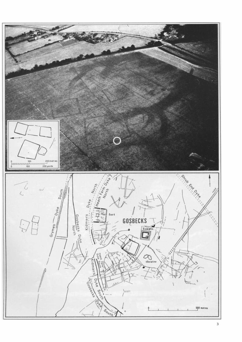
An intriguing archaeological site will gradually be destroyed over a period of years in a
sand and gravel quarry on the west side of Colchester. Preliminary excavation by the Archaeological Trust indicates that the main part of the site dates to the first half of the 1st century AD, the period when Iron Age Colchester (Camulodunum) was at its most important and influential. The site lies on the east side of the large sand and gravel quarry on the north side of the Maldon Road, not far from Colchester Zoo and is owned by Tarmac who have kindly assisted the Trust in the investigations.
The remains take the form of five huge enclosures, the largest of which is over a hundred yards across. These were probably used for the management of animal stock. Originally each enclosure was defined by a deep bank and ditch, but now only the ditches survive and these have long since silted up so as to be invisible on the surface.
Because filled-in ditches and pits affect the rate at which crops directly overhead ripen, their presence can be detected under the right circumstances by slight variations in the colour of the crop. This is how it was possible for archaeologists to discover the site many years ago by studying aerial photographs of the area.
The preliminary excavation was modest in scale and was limited to little more than a trench through the enclosure ditch nearest the quarry face. The work was done for two reasons: firstly to locate precisely the enclosure in the field (it's a vast field) and secondly to throw some light on the date of the complex by recovering some pottery from the ditch fill.
Enclosures of this kind are not unusual but seldom arc they so large. In fact the scale of these features must mean that, despite being beyond the western defences of Camulodunum, they must have been closely linked with it in some way. Small marks are visible on some of the aerial photographs suggesting that full excavation of the site will probably reveal traces of buildings. If this proves to be the case, then the cropmarks at Stanway will represent the remains of one or more important farmsteads which must have been intimately bound up with the history of Camulodunum.
Colchester Castle
Colchester Castle is a fascinating building which is yet to reveal
all its secrets. With most of the
repair work to the southern side of Colchester Castle now completed, the massive project to save the building from partial collapse and decay is half done. At the start of each phase, the Archaeological Trust prepares stone-for-stone drawings of the elevation to be repaired. This is done to make a record of the castle before the repair work starts and to provide a means whereby a detailed record can be made of the work subsequently done. However as a bonus, the project is providing an opportunity to study the structure of the castle in a manner that has not been done before.
The castle was built mainly by reusing Roman building materials salvaged from the Roman town. For this reason, the building is in effect a vast and most interesting sample of Roman building materials worthy of study in its own right. But because this material was too poor in quality for the Norman stone masons to rework, additional stone had to be specially imported for use in the places where flat or carved surfaces were required, such as corners and window openings. The current survey involves specialist examination of these stones with the result that three sources have been confirmed: Normandy (Caen stone), the Isle of Wight (Quarr stone),
Above right: aerial view of the Stanway gravel pit showing how the buried ditches are visible as marks in the crop. The position of the 1987 excavation is indicated by a small circle. Photograph by Mrs McMasters .
Below right: the Stanway site in relation to all the known cropmarks in the Gosbecks area. Also shown are the positions of the earth defences (the dykes) of the settlement. Note how the Stanway site lies beyond them.
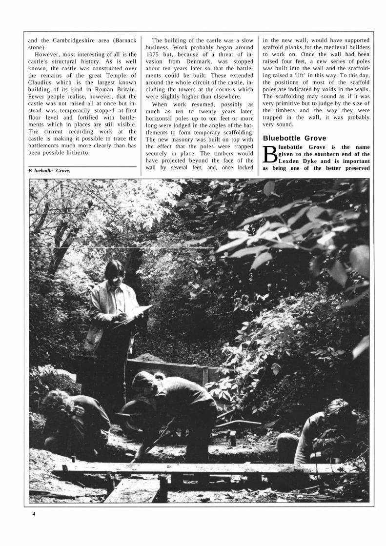
Below: simplified drawing of the west wall of Colchester Castle showing the early battlements and the holes for the original scaffold poles
2
An example of coffin nails plotted in a Butt Road grave. The drawing illustrates how decomposition of the wood results in some movement of the upper nails.
3
and the Cambridgeshire area (Barnack stone).
However, most interesting of all is the castle's structural history. As is well known, the castle was constructed over the remains of the great Temple of Claudius which is the largest known building of its kind in Roman Britain. Fewer people realise, however, that the castle was not raised all at once but instead was temporarily stopped at first floor level and fortified with battlements which in places are still visible. The current recording work at the castle is making it possible to trace the battlements much more clearly than has been possible hitherto.
The building of the castle was a slow business. Work probably began around 1075 but, because of a threat of invasion from Denmark, was stopped about ten years later so that the battlements could be built. These extended around the whole circuit of the castle, including the towers at the corners which were slightly higher than elsewhere.
When work resumed, possibly as much as ten to twenty years later, horizontal poles up to ten feet or more long were lodged in the angles of the battlements to form temporary scaffolding. The new masonry was built on top with the effect that the poles were trapped securely in place. The timbers would have projected beyond the face of the wall by several feet, and, once locked
in the new wall, would have supported scaffold planks for the medieval builders to work on. Once the wall had been raised four feet, a new series of poles was built into the wall and the scaffolding raised a 'lift' in this way. To this day, the positions of most of the scaffold poles are indicated by voids in the walls. The scaffolding may sound as if it was very primitive but to judge by the size of the timbers and the way they were trapped in the wall, it was probably very sound.
Bluebottle Grove
Bluebottle Grove is the name given to the southern end of the Lexden Dyke and is important
as being one of the better preserved
4
B luebotlle Grove.
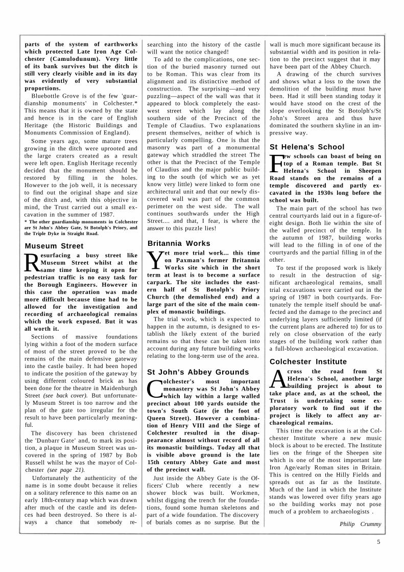
parts of the system of earthworks which protected Late Iron Age Colchester (Camulodunum). Very little of its bank survives but the ditch is still very clearly visible and in its day was evidently of very substantial proportions.
Bluebottle Grove is of the few 'guardianship monuments' in Colchester.* This means that it is owned by the state and hence is in the care of English Heritage (the Historic Buildings and Monuments Commission of England).
Some years ago, some mature trees growing in the ditch were uprooted and the large craters created as a result were left open. English Heritage recently decided that the monument should be restored by filling in the holes. However to the job well, it is necessary to find out the original shape and size of the ditch and, with this objective in mind, the Trust carried out a small excavation in the summer of 1987. * The other guardianship monuments in Colchester are St John's Abbey Gate, St Botolph's Priory, and the Triple Dyke in Straight Road.
Museum Street
Resurfacing a busy street like Museum Street whilst at the same time keeping it open for
pedestrian traffic is no easy task for the Borough Engineers. However in this case the operation was made more difficult because time had to be allowed for the investigation and recording of archaeological remains which the work exposed. But it was all worth it.
Sections of massive foundations lying within a foot of the modern surface of most of the street proved to be the remains of the main defensive gateway into the castle bailey. It had been hoped to indicate the position of the gateway by using different coloured brick as has been done for the theatre in Maidenburgh Street (see back cover). But unfortunately Museum Street is too narrow and the plan of the gate too irregular for the result to have been particularly meaningful.
The discovery has been christened the 'Dunbarr Gate' and, to mark its position, a plaque in Museum Street was uncovered in the spring of 1987 by Bob Russell whilst he was the mayor of Colchester (see page 21).
Unfortunately the authenticity of the name is in some doubt because it relies on a solitary reference to this name on an early 18th-century map which was drawn after much of the castle and its defen-ces had been destroyed. So there is al-ways a chance that somebody re-
searching into the history of the castle will want the notice changed!
To add to the complications, one section of the buried masonry turned out to be Roman. This was clear from its alignment and its distinctive method of construction. The surprising—and very puzzling—aspect of the wall was that it appeared to block completely the east-west street which lay along the southern side of the Precinct of the Temple of Claudius. Two explanations present themselves, neither of which is particularly compelling. One is that the masonry was part of a monumental gateway which straddled the street The other is that the Precinct of the Temple of Claudius and the major public building to the south (of which we as yet know very little) were linked to form one architectural unit and that our newly discovered wall was part of the common perimeter on the west side. The wall continues southwards under the High Street.... and that, I fear, is where the answer to this puzzle lies!
Britannia Works
Yet more trial work... this time on Paxman's former Britannia Works site which in the short
term at least is to become a surface carpark. The site includes the eastern half of St Botolph's Priory Church (the demolished end) and a large part of the site of the main complex of monastic buildings.
The trial work, which is expected to happen in the autumn, is designed to establish the likely extent of the buried remains so that these can be taken into account during any future building works relating to the long-term use of the area.
St John's Abbey Grounds
Colchester's most important monastery was St John's Abbey which lay within a large walled
precinct about 100 yards outside the town's South Gate (ie the foot of Queen Street). However a combination of Henry VIII and the Siege of Colchester resulted in the disappearance almost without record of all its monastic buildings. Today all that is visible above ground is the late 15th century Abbey Gate and most of the precinct wall.
Just inside the Abbey Gate is the Officers' Club where recently a new shower block was built. Workmen, whilst digging the trench for the foundations, found some human skeletons and part of a wide foundation. The discovery of burials comes as no surprise. But the
wall is much more significant because its substantial width and its position in relation to the precinct suggest that it may have been part of the Abbey Church.
A drawing of the church survives and shows what a loss to the town the demolition of the building must have been. Had it still been standing today it would have stood on the crest of the slope overlooking the St Botolph's/St John's Street area and thus have dominated the southern skyline in an impressive way.
St Helena's School
Few schools can boast of being on top of a Roman temple. But St Helena's School in Sheepen
Road stands on the remains of a temple discovered and partly ex-cavated in the 1930s long before the school was built.
The main part of the school has two central courtyards laid out in a figure-of-eight design. Both lie within the site of the walled precinct of the temple. In the autumn of 1987, building works will lead to the filling in of one of the courtyards and the partial filling in of the other.
To test if the proposed work is likely to result in the destruction of significant archaeological remains, small trial excavations were carried out in the spring of 1987 in both courtyards. Fortunately the temple itself should be unaffected and the damage to the precinct and underlying layers sufficiently limited (if the current plans are adhered to) for us to rely on close observation of the early stages of the building work rather than a full-blown archaeological excavation.
Colchester Institute
Across the road from St Helena's School, another large building project is about to
take place and, as at the school, the Trust is undertaking some exploratory work to find out if the project is likely to affect any archaeological remains.
This time the excavation is at the Colchester Institute where a new music block is about to be erected. The Institute lies on the fringe of the Sheepen site which is one of the most important late Iron Age/early Roman sites in Britain. This is centred on the Hilly Fields and spreads out as far as the Institute. Much of the land in which the Institute stands was lowered over fifty years ago so the building works may not pose much of a problem to archaeologists .
Philip Crummy
5
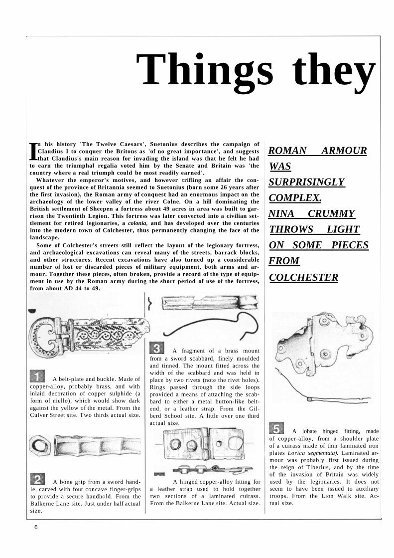
Things they
In his history 'The Twelve Caesars', Suetonius describes the campaign of Claudius I to conquer the Britons as 'of no great importance', and suggests that Claudius's main reason for invading the island was that he felt he had
to earn the triumphal regalia voted him by the Senate and Britain was 'the country where a real triumph could be most readily earned'.
Whatever the emperor's motives, and however trifling an affair the con-quest of the province of Britannia seemed to Suetonius (born some 26 years after the first invasion), the Roman army of conquest had an enormous impact on the archaeology of the lower valley of the river Colne. On a hill dominating the British settlement of Sheepen a fortress about 49 acres in area was built to gar-rison the Twentieth Legion. This fortress was later converted into a civilian set-tlement for retired legionaries, a colonia, and has developed over the centuries into the modern town of Colchester, thus permanently changing the face of the landscape.
Some of Colchester's streets still reflect the layout of the legionary fortress, and archaeological excavations can reveal many of the streets, barrack blocks, and other structures. Recent excavations have also turned up a considerable number of lost or discarded pieces of military equipment, both arms and ar-mour. Together these pieces, often broken, provide a record of the type of equip-ment in use by the Roman army during the short period of use of the fortress, from about AD 44 to 49.
copper-alloy, probably brass, and with inlaid decoration of copper sulphide (a form of niello), which would show dark against the yellow of the metal. From the Culver Street site. Two thirds actual size.
le, carved with four concave finger-grips to provide a secure handhold. From the Balkerne Lane site. Just under half actual size.
A hinged copper-alloy fitting for a leather strap used to hold together two sections of a laminated cuirass. From the Balkerne Lane site. Actual size.
ROMAN ARMOUR
WAS
SURPRISINGLY
COMPLEX.
NINA CRUMMY
THROWS LIGHT
ON SOME PIECES
FROM
COLCHESTER
of copper-alloy, from a shoulder plate of a cuirass made of thin laminated iron plates Lorica segmentata). Laminated ar-mour was probably first issued during the reign of Tiberius, and by the time of the invasion of Britain was widely used by the legionaries. It does not seem to have been issued to auxiliary troops. From the Lion Walk site. Ac-tual size.
6
A belt-plate and buckle. Made of
A bone grip from a sword hand-
A lobate hinged fitting, made
from a sword scabbard, finely moulded and tinned. The mount fitted across the width of the scabbard and was held in place by two rivets (note the rivet holes). Rings passed through the side loops provided a means of attaching the scabbard to either a metal button-like belt-end, or a leather strap. From the Gil-berd School site. A little over one third actual size.
A fragment of a brass mount
left behind....
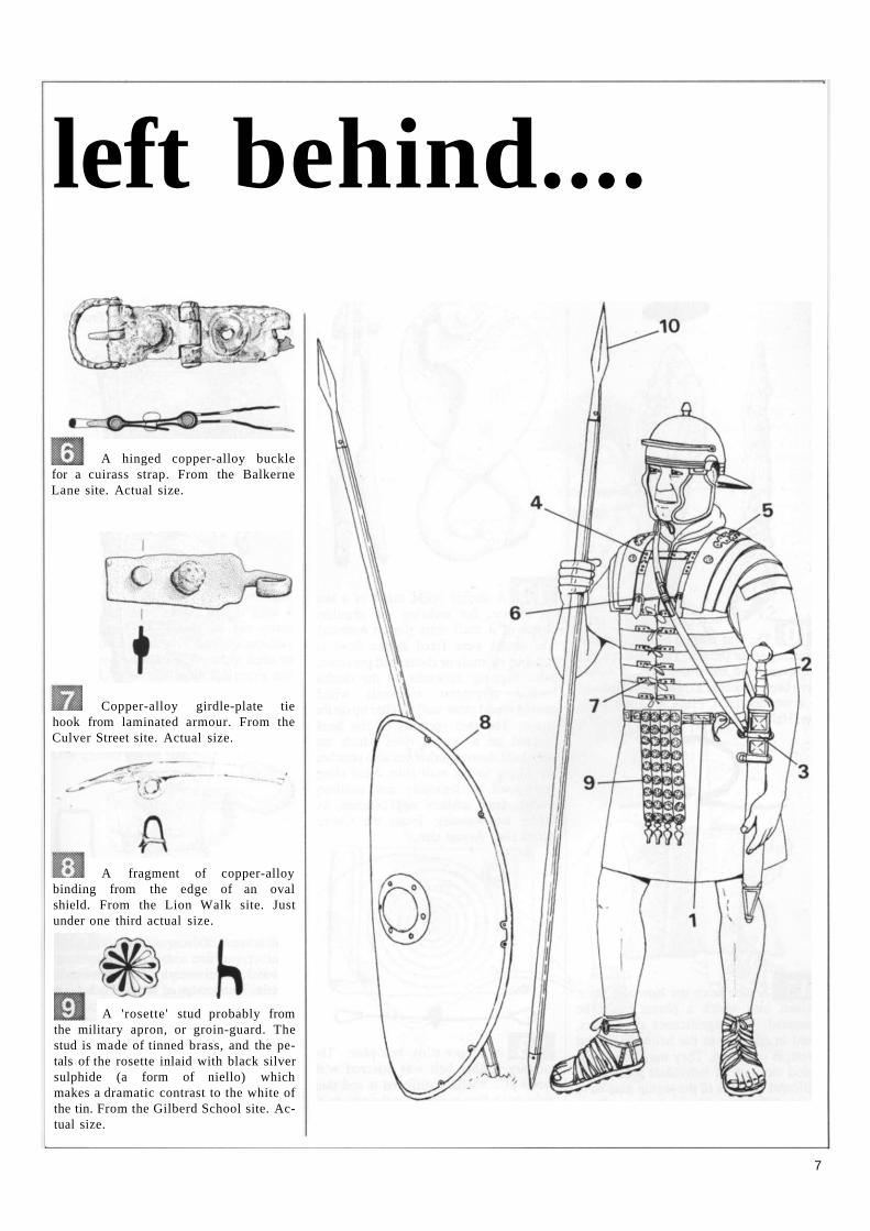
A hinged copper-alloy buckle for a cuirass strap. From the Balkerne Lane site. Actual size.
Copper-alloy girdle-plate tie hook from laminated armour. From the Culver Street site. Actual size.
A fragment of copper-alloy binding from the edge of an oval shield. From the Lion Walk site. Just under one third actual size.
A 'rosette' stud probably from the military apron, or groin-guard. The stud is made of tinned brass, and the petals of the rosette inlaid with black silver sulphide (a form of niello) which makes a dramatic contrast to the white of the tin. From the Gilberd School site. Actual size.
7
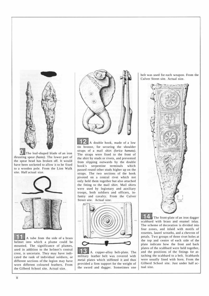
The leaf-shaped blade of an iron thrusting spear (hasta). The lower part of the spear head has broken off. It would have been socketed to allow it to be fixed to a wooden pole. From the Lion Walk site. Half actual size.
helmet into which a plume could be mounted. The significance of plumes, used in addition to the helmet's central crest, is uncertain. They may have indicated the rank of individual soldiers, or different sections of the legion may have worn different coloured feathers. From the Gilberd School site. Actual size.
tin bronze, for securing the shoulder straps of a mail shirt (lorica hamata). The straps were fixed to the front of the shirt by studs or rivets, and prevented from slipping outwards by the double hook's serpentine terminals which passed round other studs higher up on the straps. The two sections of the hook pivoted on a central rivet which not only held them together but also attached the fitting to the mail shirt. Mail shirts were used by legionary and auxiliary troops, both soldiers and officers, infantry and cavalry. From the Culver Street site. Actual size.
military leather belt was covered with metal plates which stiffened it and thus provided a firm support for the weight of the sword and dagger. Sometimes one
belt was used for each weapon. From the Culver Street site. Actual size.
j The front-plate of an iron dagger scabbard with brass and enamel inlay. The scheme of decoration is divided into four zones, and inlaid with motifs of rosettes, laurel wreaths, and a chevron of petals. Two groups of three rivet holes at the top and centre of each side of the plate indicate how the front and back plates of the scabbard were held together, and the positions of the fittings for attaching the scabbard to a belt. Scabbards were usually lined with horn. From the Gilberd School site. Just under half actual size.
8
A tube from the side of a brass
A double hook, made of a low
A. copper-alloy belt-plate. The
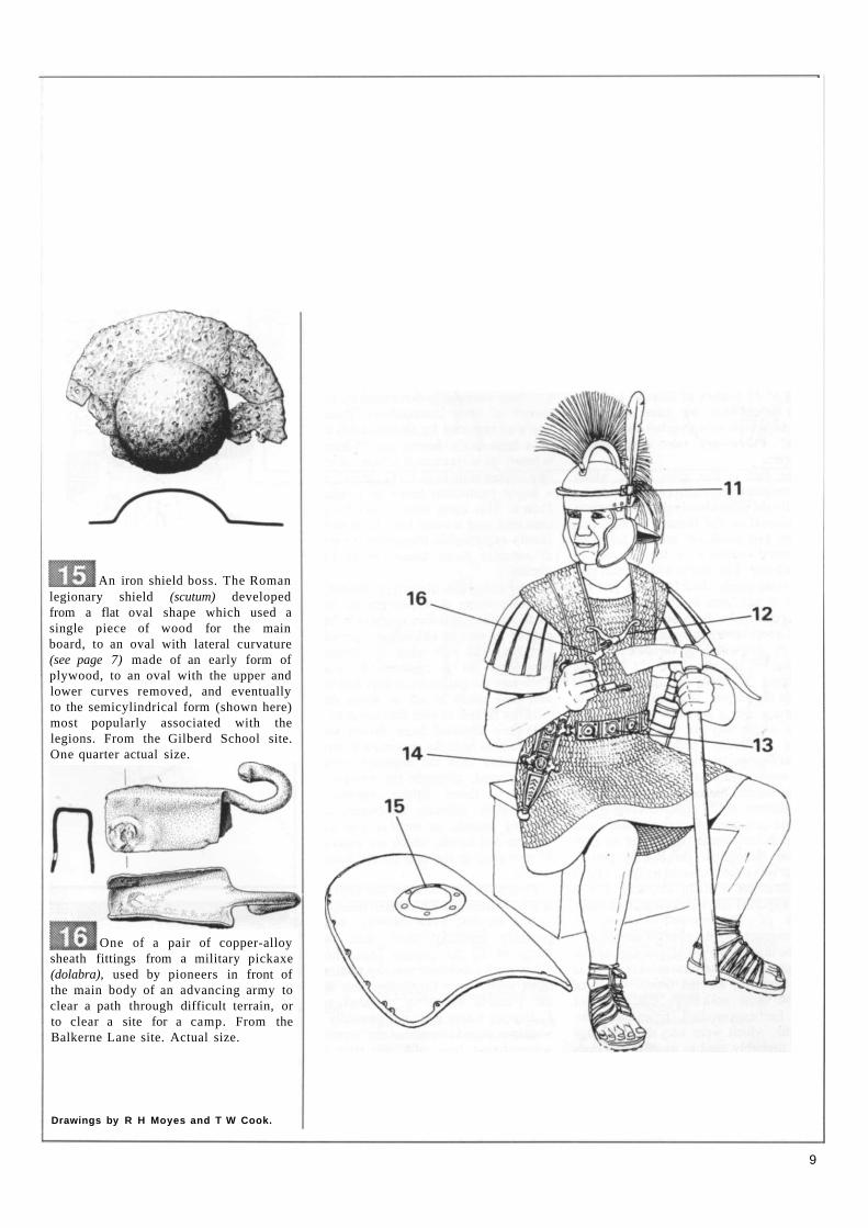
legionary shield (scutum) developed from a flat oval shape which used a single piece of wood for the main board, to an oval with lateral curvature (see page 7) made of an early form of plywood, to an oval with the upper and lower curves removed, and eventually to the semicylindrical form (shown here) most popularly associated with the legions. From the Gilberd School site. One quarter actual size.
One of a pair of copper-alloy sheath fittings from a military pickaxe (dolabra), used by pioneers in front of the main body of an advancing army to clear a path through difficult terrain, or to clear a site for a camp. From the Balkerne Lane site. Actual size.
Drawings by R H Moyes and T W Cook.
An iron shield boss. The Roman
9
ROMAN POTTERY FROM ACROSS THE
EMPIRE Robin P Symonds
During the 1970s and early 1980s the Archaeological Trust excavated a series of major
sites in Colchester which yielded a total of somewhere in the neighbourhood of 15 tonnes of Roman pottery. Why is it that we save all these sherds, which now number in the millions? There are two very simple answers.
The first is that after coins, which are comparatively rare, pottery sherds are usually the most closely datable artefacts in contexts of the Roman period. This means that potsherds are the principle preserved evidence of the chronology of each site. The reason why Roman pottery is so easily datable is not just because it has been much studied in the 20th century, but because it was made in quite a regimented manner, with styles of pots seldom widely at variance with the fashion of the day, and the fashions changing in quite similar ways all across the empire. If it were possible to bring together a selection of pots made on a single day in, say, 150 AD at many different production centres across Europe, the similarities among the pots would undoubtedly be striking.
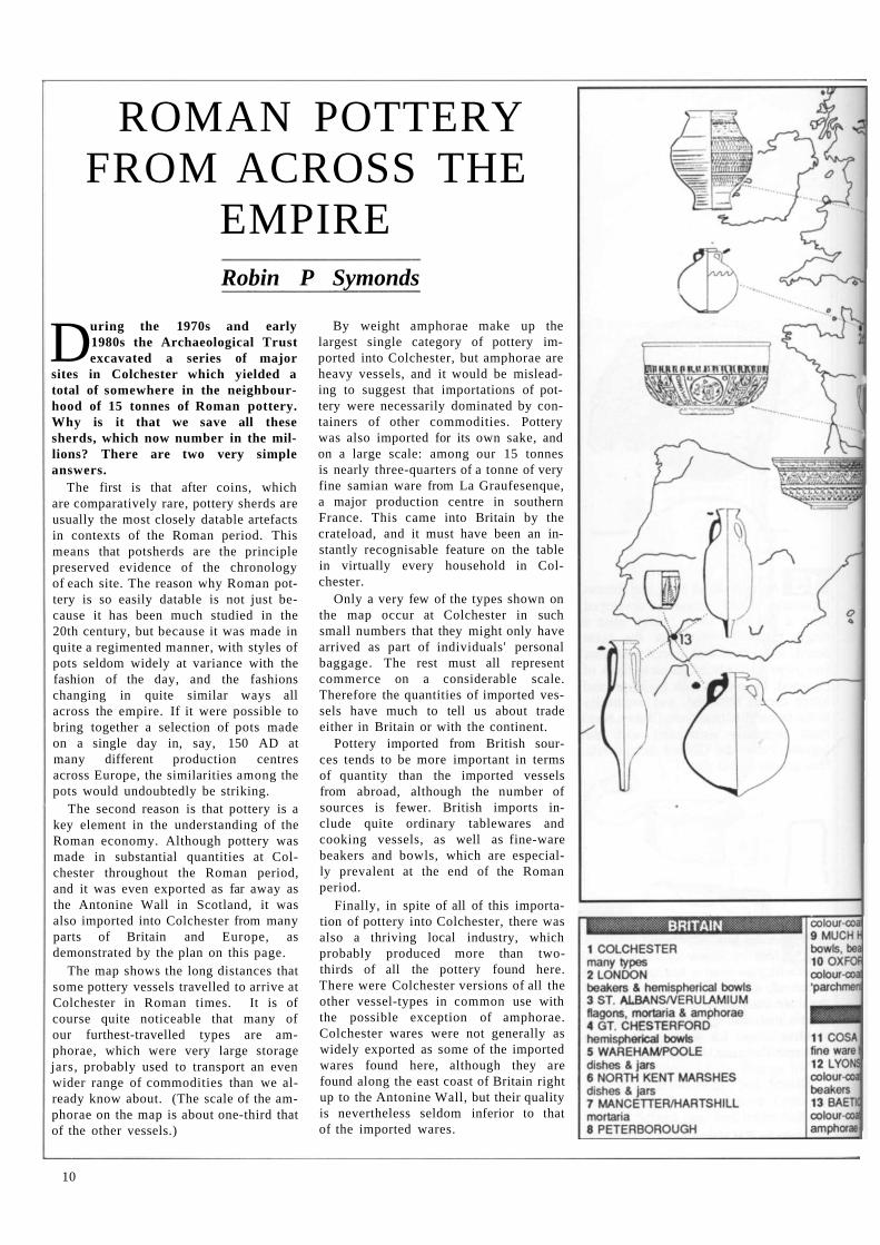
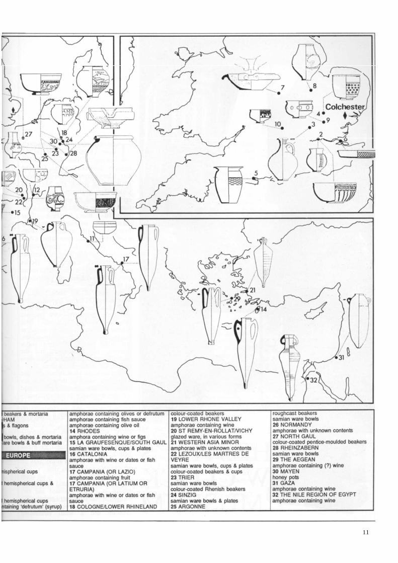
The second reason is that pottery is a key element in the understanding of the Roman economy. Although pottery was made in substantial quantities at Colchester throughout the Roman period, and it was even exported as far away as the Antonine Wall in Scotland, it was also imported into Colchester from many parts of Britain and Europe, as demonstrated by the plan on this page.
The map shows the long distances that some pottery vessels travelled to arrive at Colchester in Roman times. It is of course quite noticeable that many of our furthest-travelled types are amphorae, which were very large storage jars, probably used to transport an even wider range of commodities than we already know about. (The scale of the amphorae on the map is about one-third that of the other vessels.)
By weight amphorae make up the largest single category of pottery imported into Colchester, but amphorae are heavy vessels, and it would be misleading to suggest that importations of pottery were necessarily dominated by containers of other commodities. Pottery was also imported for its own sake, and on a large scale: among our 15 tonnes is nearly three-quarters of a tonne of very fine samian ware from La Graufesenque, a major production centre in southern France. This came into Britain by the crateload, and it must have been an instantly recognisable feature on the table in virtually every household in Colchester.
Only a very few of the types shown on the map occur at Colchester in such small numbers that they might only have arrived as part of individuals' personal baggage. The rest must all represent commerce on a considerable scale. Therefore the quantities of imported vessels have much to tell us about trade either in Britain or with the continent.
Pottery imported from British sources tends to be more important in terms of quantity than the imported vessels from abroad, although the number of sources is fewer. British imports include quite ordinary tablewares and cooking vessels, as well as fine-ware beakers and bowls, which are especially prevalent at the end of the Roman period.
Finally, in spite of all of this importation of pottery into Colchester, there was also a thriving local industry, which probably produced more than two-thirds of all the pottery found here. There were Colchester versions of all the other vessel-types in common use with the possible exception of amphorae. Colchester wares were not generally as widely exported as some of the imported wares found here, although they are found along the east coast of Britain right up to the Antonine Wall, but their quality is nevertheless seldom inferior to that of the imported wares.
10
11
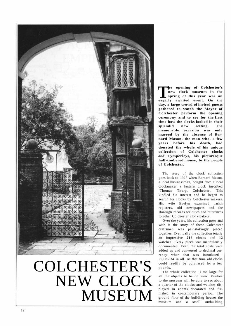
COLCHESTER'S NEW CLOCK
MUSEUM
The opening of Colchester's new clock museum in the spring of this year was an
eagerly awaited event. On the day, a large crowd of invited guests gathered to watch the Mayor of Colchester perform the opening ceremony and to see for the first time how the clocks looked in their splendid new setting. The memorable occasion was only marred by the absence of Bernard Mason, the man who, a few years before his death, had donated the whole of his unique collection of Colchester clocks and Tymperleys, his picturesque half-timbered house, to the people of Colchester.
The story of the clock collection goes back to 1927 when Bernard Mason, a local businessman, bought from a local clockmaker a lantern clock inscribed 'Thomas Thorp, Colchester'. This kindled his interest and he began to search for clocks by Colchester makers. His wife Evelyn examined parish registers, old newspapers and the Borough records for clues and references to other Colchester clockmakers.
Over the years, his collection grew and with it the story of these Colchester craftsmen was painstakingly pieced together. Eventually the collection totally an impressive 216 clocks and 12 watches. Every piece was meticulously documented. Even the total costs were added up and converted to decimal currency when that was introduced— £9,685.34 in all. At that time old clocks could readily be purchased for a few pounds.
The whole collection is too large for all the objects to be on view. Visitors to the museum will be able to sec about a quarter of the clocks and watches displayed in rooms decorated and furnished in contemporary period. The ground floor of the building houses the museum and a small outbuilding
12
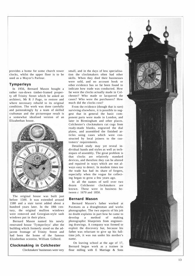
provides a home for some church tower clocks, whilst the upper floor is to be used as a Mayor's Parlour.
Tymperleys In 1956, Bernard Mason bought a
rather run-down timber-framed property off Trinity Street which he asked an architect, Mr R J Page, to restore and where necessary rebuild to its original condition. The work was done carefully and painstakingly by a team of skilled craftsman and the picturesque result is a somewhat idealised version of an Elizabethan house.
The original house was built just before 1500. It was extended around 1580 and a stair turret added about a hundred years later. In the 18th century, the original mullion windows were removed and Georgian-style sash windows put in their place.
Bernard Mason named his newly renovated house 'Tymperleys' after the building which formerly stood on the adjacent frontage of Trinity Street and had been the home of the famous Elizabethan scientist, William Gilberd.
Clockmaking in Colchester Clockmakers' businesses were very
small, and in the days of less specialisation the clockmakers often had other skills. When they died their businesses were sold, and no account book or other evidence has so far been found to indicate how trade was conducted. How far were the clocks actually made in Colchester? Who made or lacquered the cases? Who were the purchasers? How much did the clocks cost?
From the evidence (though that is rare) surviving elsewhere, it is possible to suggest that in general the basic component parts were made in London, and later in Birmingham and other places. Colchester's clockmakers cut cogs from ready-made blanks, engraved the dial plates, and assembled the finished articles using cases which were constructed by local joiners to the customers' requirements.
Detailed study may yet reveal individual hands and styles as well as techniques of assembly. The great problem is that clocks are relatively standard devices, and therefore they can be altered and repaired in ways which are not always easy to detect. In modem times too the trade has had its share of forgers, especially when the vogue for collecting began to grow a few years ago.
In all the names of well over two dozen Colchester clockmakers are known. These were in business between c 1670 and 1850.
Bernard Mason Bernard Mason's father worked at
Paxmans as a draughtsman and works photographer. The two aspects of his job no doubt explains in part how he came to develop a method of making photographic blueprints from engineering drawings. A company was formed to exploit the discovery but, because his father was reluctant to give up his full-time job, it was run under his mother's name.
On leaving school at the age of 17, Bernard began work as a trainee in flour milling with E Marriage & Sons
13
Ltd of Colchester. After his father's death, Bernard, his oldest brother, and his mother went into partnership to continue the business. However when his oldest brother was killed in action in 1917, Bernard gave up his job at Marriage's and ran the company jointly with his mother.
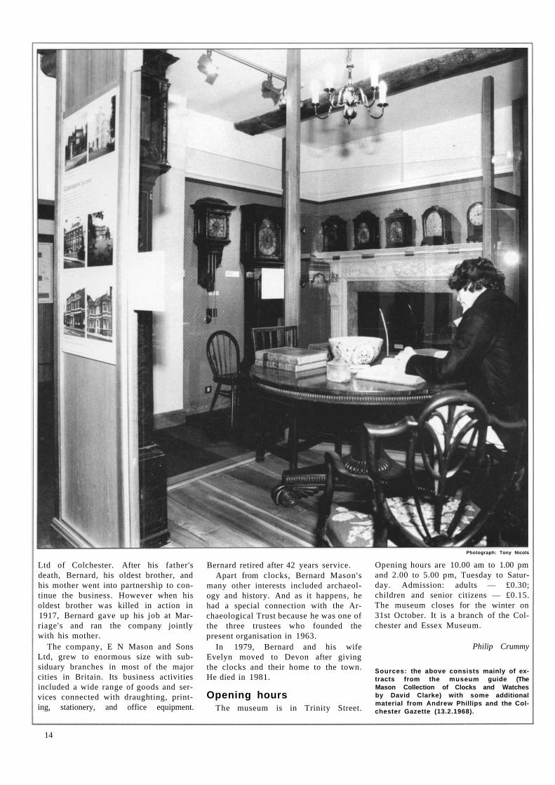
The company, E N Mason and Sons Ltd, grew to enormous size with sub-siduary branches in most of the major cities in Britain. Its business activities included a wide range of goods and ser-vices connected with draughting, print-ing, stationery, and office equipment.
Bernard retired after 42 years service. Apart from clocks, Bernard Mason's
many other interests included archaeology and history. And as it happens, he had a special connection with the Archaeological Trust because he was one of the three trustees who founded the present organisation in 1963.
In 1979, Bernard and his wife Evelyn moved to Devon after giving the clocks and their home to the town. He died in 1981.
Opening hours The museum is in Trinity Street.
Photograph: Tony Nicols
Opening hours are 10.00 am to 1.00 pm and 2.00 to 5.00 pm, Tuesday to Saturday. Admission: adults — £0.30; children and senior citizens — £0.15. The museum closes for the winter on 31st October. It is a branch of the Col-chester and Essex Museum.
Philip Crummy
Sources: the above consists mainly of extracts from the museum guide (The Mason Collection of Clocks and Watches by David Clarke) with some additional material from Andrew Phillips and the Colchester Gazette (13.2.1968).
14
HAVE A DAY OUT The Friends of CAT organise outings to local places of interest, such as historic
houses, museums, churches, excavation sites and ancient monuments. There is usually one trip (by coach) every two months from March until November.
Last year members visited the Museum of East Anglian Rural Life at Stow-market; excavations on the site of the famous ship burials at Sutton Hoo, Suffolk; the Electric Palace, the Redoubt, and the crane at Harwich; and excavations in Chelmsford. Further trips this year will take us to Paycocke's House (Cog-geshall) and Layer Marney Towers in September and a tour of interesting local churches in November while 1988's schedule will include a trip to West Stow Anglo-Saxon village.
Details of trips from Howard Brooks, 13 Greenacres, Mile End, Colchester. Why not join us for a pleasant and interesting day out?
(See inside front cover for details about how to join the Friends.) Howard Brooks
ILLUSTRATED TALKS To help members find out more about the town's past, a special series of six talks
is being held in the Public Library in Trinity Street. The first three took place in May and June of this year. In the first one, David Clarke, Curator of the Colchester and Essex Museum, set the background by dealing with The Beginnings of Archaeology in Colchester. Here he traced the story of archaeology in the town over the last two centuries. This was followed by Philip Crummy's The Success of Rescue Archaeology in Colchester where he showed that, despite the problems and pressures which inevitably occur when digging on building sites, rescue archaeology has proved over the last fifty years or so to have been a very effective means of studying the town's past. Two weeks later Nina Crummy rounded the first half of the series off with Everyday Objects in Roman Colchester with a look at a some of the best finds of metal, bone and stone from recent excavations.
In the autumn there will be the following talks (all 7.30-9.00 pm):
Thursday 1st October, 1987: Colchester in Iron Age and Roman Times (Philip Crummy)
Thursday 15th October, 1987: Pottery from Roman Colchester (Robin P Symonds)
Thursday 29th October, 1987: Colchester in Anglo-Saxon and Medieval Times (Philip Crummy).
Admission is £0.50 for members to cover the hire cost of the room and refreshments (coffee and biscuits).
THE ANNUAL ROUND-UP AND THE AGM The usual illustrated talks outlining the previous year's work will be on Saturday
30th January, 1988 as previously advertised. The lecture room in the Public Library was booked for the event but subsequently the Library changed its hire policy and can no longer provide any facilities during the day. The new venue will be announced later in the year.
The AGM (business only) will be held on Saturday 23rd January 1988 in 12 Lex-den Road at 11.00 am.
NOTES AND NEWS
Coin volume Publication of the fourth in the series
of the Colchester Archaeological Reports is planned for the autumn of 1987. The book, entitled Coins from excavations in Colchester, 1971-9, deals principally with the 3,000 coins excavated during the 1970s although some use is made of the coins found during the more recent Culver Street excavation. The volume is aimed at archaeologists and coin specialists and includes contributions on certain classes of imitation coinage made during the Roman period (Claudian copies, barbarous radiates, and Constantinian copies). Like all the volumes in the scries, the book will be available either direct from the Colchester Archaeological Trust or by mail order from Oxbow Books (10 St Cross Road, Oxford OX1 3TU).
History of Copford Over the last school year all the
children of Copford Church of England Primary School have made a study of various aspects of their village, and now the fruits of their toil are on show in Colchester's Castle Museum.
The project's results are presented in prose and verse, paintings, drawings, needlework, models, puppets, pie charts, bar charts, photographs and maps. The topics covered include the history and development of the school, what life was like for past pupils, the oldest houses in the village, village memories, and of course Copford's famous Norman church.
This colourful, lively exhibition is packed with information to suit both children and adults, and is on show in the Castle until September 6th of this year.
The Origins of Chelmsford Exhibition
It may come as a surprise to many people to learn that Chelmsford is built on important Bronze Age, Roman and later archaeological remains. For proof, you should visit the new exhibition mounted in Chelmsford by the Archaeological Section of the Essex County Council's Planning Department. The display is in Grove Road off Moul-sham Street (it is signposted) and is open 10.30 am-4.00 pm, Monday to Saturday until the end of August.
Archaeology lectures The Colchester Archaeological
Group ' s winter session of lectures for 1987/8 will include Archaeology and the Woods of SE Essex (Dr O Rackham), Benvenuto Cellini and the Jewellery of Late Medieval and Renaissance Europe (Dr H Tait) and Commercial Rabbiting in Medieval East Anglia (Dr R Bailey). There are also summer visits to places of archaeological or historical interest.
Full details from Dennis Tripp, 69
Lexden Road, Colchester C 0 3 3QE (telephone Colchester 578059).
And coming soon to the Castle Museum...
The Happiest Days of Your Life—an exhibition about schools will be on view from 28 September to 24 October 1987. And for the Christmas period there will be a display of commemorative pottery covering the reign of Queen Victoria entitled Victoria Re-collected.
15
Britain's Oldest Town
Major repair work
to Colchester's
Roman town wall
is about to begin.
But how was it built
and how old is it
really?
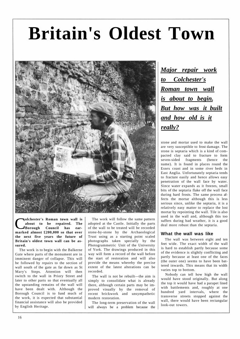
Colchester's Roman town wall is about to be repaired. The Borough Council has ear
marked almost £200,000 so that over the next five years the future of Britain's oldest town wall can be assured.
The work is to begin with the Balkerne Gate where parts of the monument are in imminent danger of collapse. This will be followed by repairs to the section of wall south of the gate as far down as St Mary's Steps. Attention will then switch to the wall in Priory Street and later to other parts so that eventually all the upstanding remains of the wall will have been dealt with. Although the Borough Council is to fund much of the work, it is expected that substantial financial assistance will also be provided by English Heritage.
The work will follow the same pattern adopted at the Castle. Initially the parts of the wall to be treated will be recorded stone-by-stone by the Archaeological Trust using as a starting point scaled photographs taken specially by the Photogrammetric Unit of the University of York. The drawings produced in this way will form a record of the wall before the start of restoration and will also provide the means whereby the precise extent of the latest alterations can be recorded.
The wall is not be rebuilt—the aim is simply to consolidate what is already there, although certain parts may be improved visually by the removal of recent brickwork and unsympathetic modern restoration.
The long-term preservation of the wall will always be a problem because the
stone and mortar used to make the wall are very susceptible to frost damage. The stone is septaria which is a kind of compacted clay said to fracture to form seven-sided fragments (hence the name). It is found in places round the Essex coast and in some river beds in East Anglia. Unfortunately septaria tends to fracture easily and hence allows easy penetration of the wall face by water. Since water expands as it freezes, small bits of the septaria flake off the wall face during hard frosts. The same process affects the mortar although this is less serious since, unlike the septaria, it is a relatively easy matter to replace the lost mortar by repointing the wall. Tile is also used in the wall and, although this too suffers during bad weather, it is a good deal more robust than the septaria.
What the wall was like The wall was between eight and ten
feet wide. The exact width of the wall is hard to establish partly because some of the evidence is slightly conflicting and partly because at least one of the faces (the outer one) seems to have been battered inwards. This means that its width varies top to bottom.
Nobody can tell how high the wall would have stood originally. But along the top it would have had a parapet lined with battlements and, roughly at one hundred yard intervals, where the transverse streets stopped against the wall, there would have been rectangular look-out towers.
16
There were six gates in the wall. The remains of two them are still visible — the Balkerne Gate and Duncan's Gate (in the Castle Park). The others stood where the line of the wall crosses Head Street, East Hill, Queen Street, and North Hill. The existence of two other gates has been suggested but these are doubtful.
The defensive qualities of the wall were enhanced by a deep ditch which was at the front of the wall and a substantial rampart which was piled up behind it.
Small arches were built into the foundations of the wall to let drains deposit waste water from inside the town into the ditch. The drains lay alongside the streets which is why, where these drain arches are known, they always line up with one side of a street. Most of the drains were wooden and modest in size although a few are known which were made entirely of tile and were large enough for a man to crawl along.
The wall was about 3,000 yards long of which about a half is still visible above ground. In its day the wall must have been a very impressive sight. The best preserved section is next to the Balkerne Gate where the outer face is still intact. Visitors sometimes think that this part of the wall has been rebuilt and that the attractive rows of tiles are comparatively modern. But this is not so: more or less everything you can see here is Roman. Elsewhere the outer face of the wall is missing so that only the core is visible. Probably the face was removed in the Anglo-Saxon and medieval periods to provide building materials. The wall round the south-eastern part of the town was in such a bad way that in the 14th and 15th centuries it had to be refaced in places and strengthened with eight external bastions, some of which still survive today.
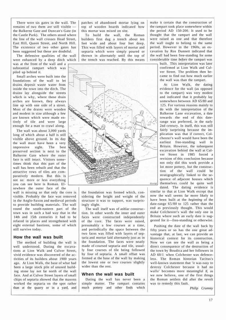
How the wall was built The method of building the wall is
well understood. During the excavations at Lion Walk and Culver Street, vivid evidence was discovered of the activities of its builders about 1900 years ago. At Lion Walk, the base of what had been a large stock pile of unused building stone lay not far north of the wall face. And at Culver Street layers of small chips of septaria showed that the masons worked the septaria on the spot rather than at the quarry or in a yard, and
patches of abandoned mortar lying on top of wooden boards indicated how this mortar was mixed on site.
To build the wall, the Roman builders first dug a trench about ten feet wide and about four feet deep. This was filled with layers of mortar and septaria which were simply poured or thrown in alternately until the top of the trench was reached. By this means
the foundation was formed which, considering the height and weight of the structure it was to support, was surprisingly slight.
The wall itself was of ashlar construction. In other words the inner and outer faces were constructed independently of the core. The faces were raised, presumably a few courses at a time, and periodically the space between the two faces was filled with layers of sep-taria and mortar laid alternately just as in the foundation. The faces were neatly made of coursed septaria and tile, usually four courses of tile being followed by four of septaria. A small offset was formed at the base of the wall by making the lowest one or two courses slightly wider than the rest.
When the wall was built Dating the wall has never been a
simple matter. The rampart contains much pottery and other finds which
make it certain that the construction of the rampart took place somewhere within the period AD 150-200. It used to be thought that the rampart and the wall were raised as one and that therefore the wall ought to belong to the same period. However in the 1960s, an excavation by Ros Dunnett indicated that the wall had been free-standing for some considerable time before the rampart was
built. This interpretation was later confirmed at Lion Walk and Culver Street. The problem then became to find out how much earlier the wall was than the rampart.
At Lion Walk, the dating evidence for the wall (as opposed to the rampart) was very modest and indicated that it probably lay somewhere between AD 65/80 and 125. For various reasons mainly to do with the interpretation of the Balkerne Lane excavation, a date towards the end of this date-range was preferred, ie the early 2nd century. In itself, this was still fairly surprising because the implication was that if correct, Colchester's wall would have been the earliest free-standing wall in Britain. However, the subsequent excavation behind the wall at Culver Street in 1985 forced a revision of this conclusion because not only did this work provide a lot more pottery, but the construction of the wall could be stratigraphically linked to the sequence of adjacent houses which themselves could be quite well dated. The dating evidence is
similar to that at Lion Walk except that now the wall seems far more likely to have been built at the beginning of the date-range 65/80 to 125 rather than the end as previously thought. This would make Colchester's wall the only one in Britain where such an early date is suggested for it—free-standing or otherwise.
Pushing the date of the wall back by fifty years or so has the one great advantage that, at last, we can provide an historical context for its construction. Now we can see the wall as being a direct consequence of the destruction of the town by Boudica and her followers in AD 60/1 when Colchester was defenceless. The Roman historian Tacitus's well-known statement that 'it was easy to destroy Colchester because it had no walls' becomes more meaningful if, as we now believe, one of the first things the Roman settlers did after the revolt was to remedy this fault.
Philip Crummy
17
Recent Discoveries
in Essex
Horse lovers of a different kind?
Since January the Archaeology Section has been carrying out excavations in Chelmsford on
two sites, Last's Garage and Godfrey's Yard, as part of a long-term programme designed to meet the increasing scale of redevelopment in the town. Both of these sites lie off Moulsham Street, which follows the line of the main London-Colchester road around which the Roman town developed.
Last's Garage, where excavations Finished in March, produced a number of unexpected discoveries. It had been supposed that the site lay within the cemetery area outside the Roman town. Instead, a small umber building was revealed, fronting onto the London-Colchester road. The building dates to the late lst-early 2nd century, and its position shows that the Roman town extended further along the main road than had previously been thought. More surprising, however, was the discovery of the skeleton of a horse, buried in a pit behind the building. The animal had been neatly laid on its side, and preliminary study of its bones suggests that it was only two or three years old and not diseased. It may represent a ritual burial after sacrifice. The sacrifice of animals, to gain the favour of the gods, was quite common in pre-Roman Celtic religion, and the practice was continued by the local British people in Roman times.
Excavation is still taking place at the Godfrey's Yard site. The most important features recorded in the areas completed so far relate to the military aspects of Roman Chelmsford's history. They include the ditch of a large enclosure dated to c AD 60-70, possibly a military camp outside a fort established in the aftermath of the
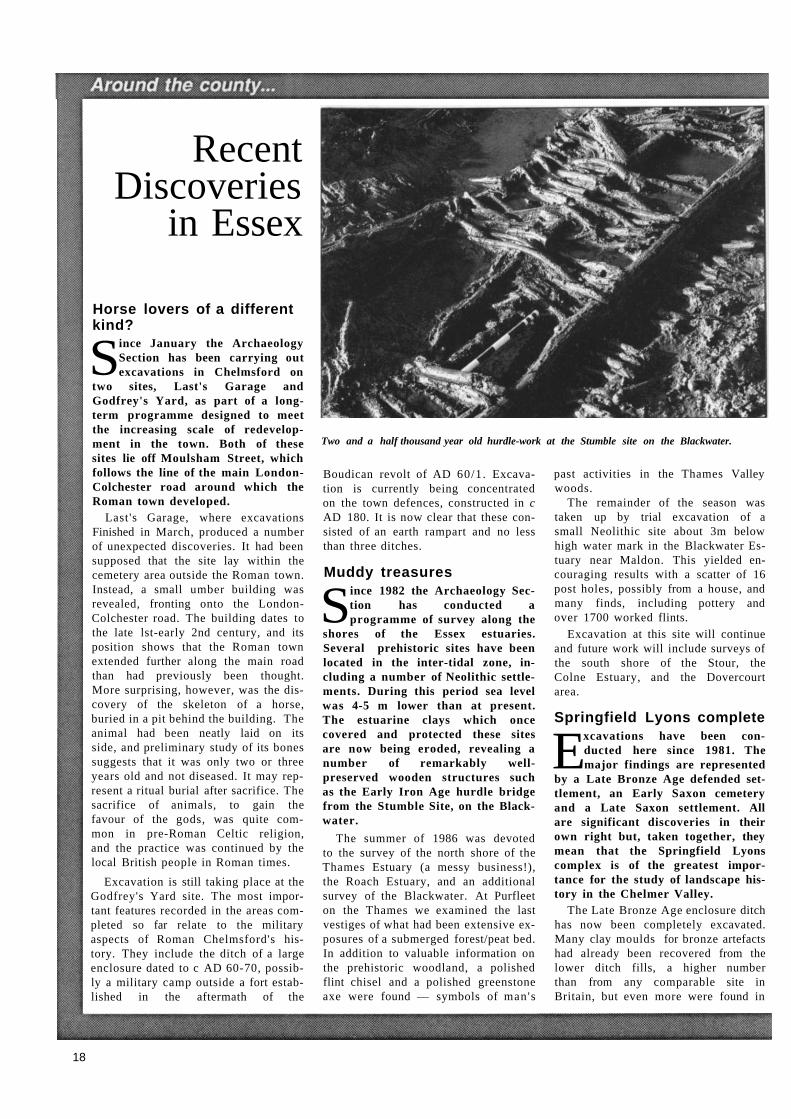
Two and a half thousand year old hurdle-work at the Stumble site on the Blackwater.
Boudican revolt of AD 60/1. Excavation is currently being concentrated on the town defences, constructed in c AD 180. It is now clear that these consisted of an earth rampart and no less than three ditches.
Muddy treasures
Since 1982 the Archaeology Section has conducted a programme of survey along the
shores of the Essex estuaries. Several prehistoric sites have been located in the inter-tidal zone, including a number of Neolithic settlements. During this period sea level was 4-5 m lower than at present. The estuarine clays which once covered and protected these sites are now being eroded, revealing a number of remarkably well-preserved wooden structures such as the Early Iron Age hurdle bridge from the Stumble Site, on the Black-water.
The summer of 1986 was devoted to the survey of the north shore of the Thames Estuary (a messy business!), the Roach Estuary, and an additional survey of the Blackwater. At Purfleet on the Thames we examined the last vestiges of what had been extensive exposures of a submerged forest/peat bed. In addition to valuable information on the prehistoric woodland, a polished flint chisel and a polished greenstone axe were found — symbols of man's
past activities in the Thames Valley woods.
The remainder of the season was taken up by trial excavation of a small Neolithic site about 3m below high water mark in the Blackwater Estuary near Maldon. This yielded encouraging results with a scatter of 16 post holes, possibly from a house, and many finds, including pottery and over 1700 worked flints.
Excavation at this site will continue and future work will include surveys of the south shore of the Stour, the Colne Estuary, and the Dovercourt area.
Springfield Lyons complete
Excavations have been conducted here since 1981. The major findings are represented
by a Late Bronze Age defended settlement, an Early Saxon cemetery and a Late Saxon settlement. All are significant discoveries in their own right but, taken together, they mean that the Springfield Lyons complex is of the greatest importance for the study of landscape history in the Chelmer Valley.
The Late Bronze Age enclosure ditch has now been completely excavated. Many clay moulds for bronze artefacts had already been recovered from the lower ditch fills, a higher number than from any comparable site in Britain, but even more were found in
18
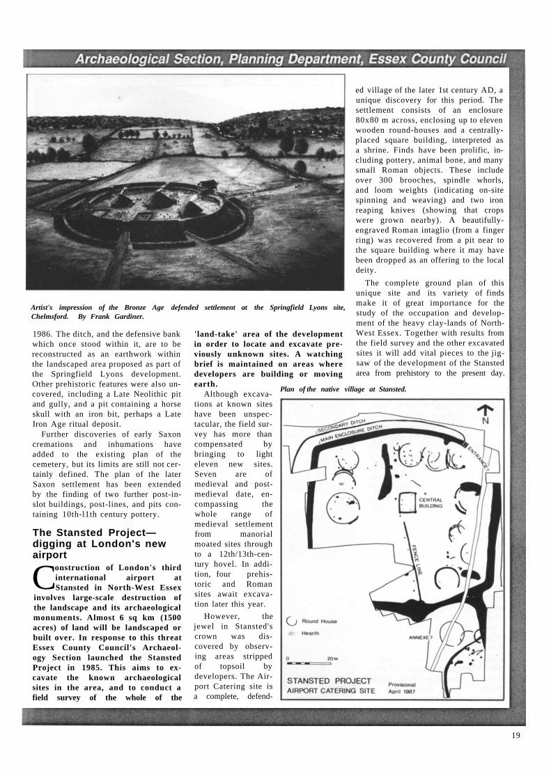
Artist's impression of the Bronze Age defended settlement at the Springfield Lyons site, Chelmsford. By Frank Gardiner.
1986. The ditch, and the defensive bank which once stood within it, are to be reconstructed as an earthwork within the landscaped area proposed as part of the Springfield Lyons development. Other prehistoric features were also uncovered, including a Late Neolithic pit and gully, and a pit containing a horse skull with an iron bit, perhaps a Late Iron Age ritual deposit.
Further discoveries of early Saxon cremations and inhumations have added to the existing plan of the cemetery, but its limits are still not cer-tainly defined. The plan of the later Saxon settlement has been extended by the finding of two further post-in-slot buildings, post-lines, and pits con-taining 10th-l1th century pottery.
The Stansted Project— digging at London's new airport
Construction of London's third international airport at Stansted in North-West Essex
involves large-scale destruction of the landscape and its archaeological monuments. Almost 6 sq km (1500 acres) of land will be landscaped or built over. In response to this threat Essex County Council's Archaeology Section launched the Stansted Project in 1985. This aims to excavate the known archaeological sites in the area, and to conduct a field survey of the whole of the
'land-take' area of the development in order to locate and excavate previously unknown sites. A watching brief is maintained on areas where developers are building or moving earth.
Although excava-tions at known sites have been unspec-tacular, the field sur-vey has more than compensated by bringing to light eleven new sites. Seven are of medieval and post-medieval date, en-compassing the whole range of medieval settlement from manorial moated sites through to a 12th/13th-cen-tury hovel. In addi-tion, four prehis-toric and Roman sites await excava-tion later this year.
However, the jewel in Stansted's crown was dis-covered by observ-ing areas stripped of topsoil by developers. The Air-port Catering site is a complete, defend-
ed village of the later 1st century AD, a unique discovery for this period. The settlement consists of an enclosure 80x80 m across, enclosing up to eleven wooden round-houses and a centrally-placed square building, interpreted as a shrine. Finds have been prolific, including pottery, animal bone, and many small Roman objects. These include over 300 brooches, spindle whorls, and loom weights (indicating on-site spinning and weaving) and two iron reaping knives (showing that crops were grown nearby). A beautifully-engraved Roman intaglio (from a finger ring) was recovered from a pit near to the square building where it may have been dropped as an offering to the local deity.
The complete ground plan of this unique site and its variety of finds make it of great importance for the study of the occupation and development of the heavy clay-lands of North-West Essex. Together with results from the field survey and the other excavated sites it will add vital pieces to the jigsaw of the development of the Stansted area from prehistory to the present day.
Plan of the native village at Stansted.
19
A R C H A E O L O G Y F O R Y O U N G P E O P L E
The Young Archaeologists Club
by Mike Corbishley
'Dare you look a skeleton in the face?
Can you cope with mud and rain, rocks and ruins in a lonely field?
Are you unafraid of the unknown lurking in the earth?'
This is how we advertise the only national archaeological club for young people over the age of 9.
The Young Archaeologists Club is growing weekly with a headquarters in York and support from the people running the Jorvik Viking Centre. Most of our members live in Britain, of course, but there are Young Ar-chaeologists in Europe, America, Australia and the Far East.
It all started back in 1971 when about seven hundred or so people gathered in London on January 23rd to voice their concern about the fate of so much archaeological evidence destroyed each year by development in every county in Britain. So Rescue, the British Archaeological Trust, was bom. Out of the strength of this ginger group, which is still gingering along, came forth Young Rescue in July 1972. Later we changed the name to Young Archaeologists Club, mainly to avoid confusion (some people actually thought we were a junior branch of lifeboats....!)
We changed our age range, too. At first we were for young people aged 9 to 16 but recently some members who were reluctant to leave us at 16 persuaded us to extend the age range to 18+ — we call them Older YACs!
We have a regular magazine for mem-bers. Young Archaeology is published four times a year. Its professional production allows us to include photos and plans from archaeologists in series like Rescue Archaeology News. There are various other series regularly published, such as Which Museum, Finds Shed, From our Foreign Cor-
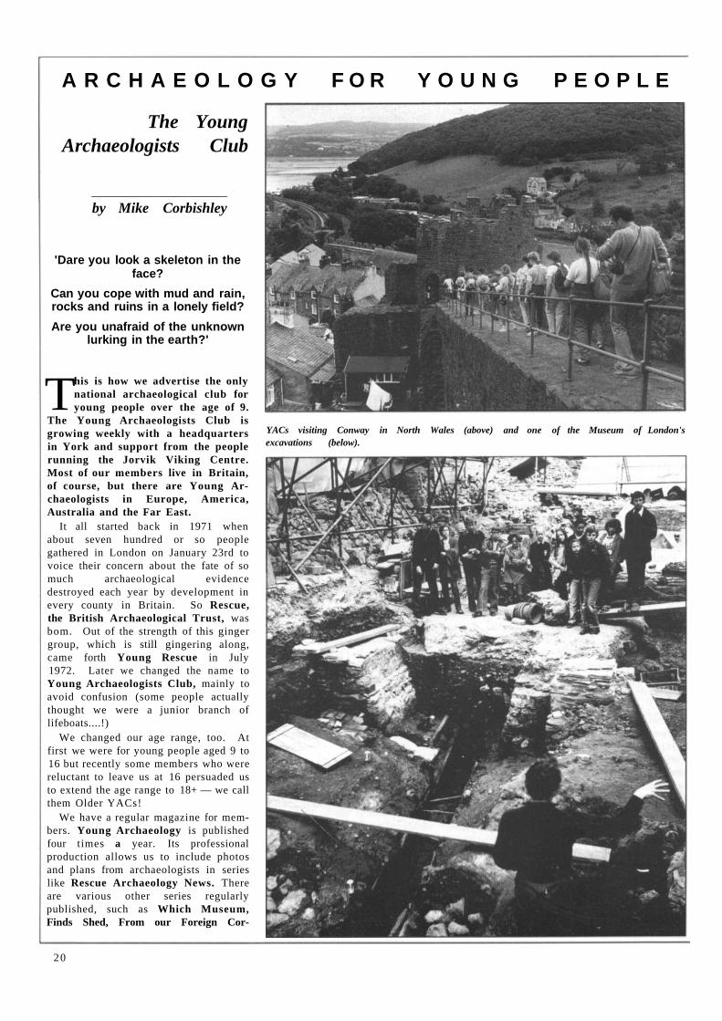
YACs visiting Conway in North Wales (above) and one of the Museum of London's excavations (below).
20
Laying Sites out for the Public
During the past 20 years or so, over 50 sites have been excavated in and around the town centre, some of them of considerable size. This work has led to the discovery and excavation of over 150 buildings as well as
streets, defences, gardens and kilns of Roman and later date. There is considerable public interest in the archaeology and history of the
town as the numbers of visitors to the excavations show. Of all the comments which visitors make, the commonest is, 'What a pity it all has to be covered over again.'
Of course, it is not usually a matter of the remains being reburied because their ultimate fate is destruction—this is why the sites are dug in the first place. The excavations were done out of necessity, mainly on building sites where very little of the original remains now survives. Unfortunately this means that it is hardly ever possible to lay out any of the remains for permanent display. However the situation is better than it seems....
respondent, Going Places, Discover In-dustrial Archaeology and DOENI— news about Northern Ireland's archaeol-ogy. Members write in too, either letters to the editors or in our series You Write. Recently we started a new series called How I became an archaeologist.
Members can keep in touch with each other through their magazine but we also have branches in various parts of the country: Colchester's branch has been active since 1973, for example. The branches carry out a whole range of ac-tivities from investigating their local ar-chaeology to visiting nearby sites and museums. Colchester's branch members have often helped with the work of the Colchester Archaeological Trust, usual-ly in the finds shed. Sometimes branches get together for outings or prac-tical work, such as experimental ar-chaeology. We shall soon have a per-manent centre in York for branches to use. This will also be a place where all visitors to Jorvik can find out about us.
We started our field study holidays in 1975 and have been running two each year ever since. We've inves-tigated archaeological remains in most parts of Britain in our time; last sum-mer one party went to the Orkneys. Those Older YACs sometimes organise holidays for themselves. Last year a group raised nearly a thousand pounds for charity by walking Hadrian's Wall.
Each year we run our own award— the Young Archaeologist of the Year and every two years we join with the na-tional British Archaeological Awards. Our competition changes from year to year. Last year members were asked to design a poster for a monument or museum — this year it 's a Best Photo competition.
Young Archaeologists Club always welcomes new members—why not come along and find out what it's all about? The annual subscription is only £2.50.
Write to: Young Archaeologists Club United House Piccadilly York YO1 1PQ Telephone 0904 646411.
For local information write to: Mike Corbishley Rose Cottage Stones Green Road Great Oakley Harwich Essex C012 5BW Telephone Wix 552
or ask about the date of the next monthly meeting at Colchester Castle Museum.
Roman theatre Colchester's Roman theatre was dis-
covered in 1981 on a Borough Council residential redevelopment site in Maidenburgh Street. A small excava-tion done with the aid of an MSC scheme led to the partial uncovering of the D-shaped outer wall of the auditorium. At short notice, the Council altered its plans so that the remains could be preserved and put on permanent display. If you visit Maidenburgh Street, you can see the curved wall and part of the adjacent pas-sage floor through the window of the building marked 'Roman Theatre'.
A few years later, when the street next to this new building was being resur-faced, the outer wall of the theatre was found to continue within only a few in-ches of the modern surface. A hasty ar-chaeological excavation followed and now the position of the wall is shown in the new street surface by different coloured bricks.
Castle defences Resurfacing work in Museum Street in
1985 led to the discovery just below the modern surface of the remains of the foundations of the medieval entrance into the Castle bailey. Although it was hard to make much sense of the remains in plan, it is clear that there had been a masonry bridge or abutment across the Castle ditch and that this led to a stone gateway. The site of the latter is
now indicated by a plaque (see page 5).
Roman town wall To build the huge service basement
under the Culver Street shopping precinct, about thirty foot of the Roman town wall had to be removed. The ex-cavation behind the wall before its destruction (see front and back covers) revealed a beautifully preserved inner face. Each stone and tile forming the wall face was numbered, drawn, and removed by the Trust so that, hopefully in the autumn of 1987, the face will be reconstructed in the east flank wall to the new tunnel.
Elsewhere in the town, two sections of the town wall were discovered within a few weeks of each other in the spring of this year. It is intended that both sec-tions will be repaired and left permanent-ly on public view.
The first is in a yard near the foot of North Hill where the Trust carried out a small exploratory excavation to find out the exact position of the buried wall. The north face turned out to be so well preserved that the owner, Mr Frank Clater, hopes to make the wall a per-manent feature of his new building. Similarly, about a hundred yards to the east, more exploratory work by the Trust led to the discovery of a further section of wall which, the developers (The Windsor Homes Group) plan to display in their new development.
21
Roman church
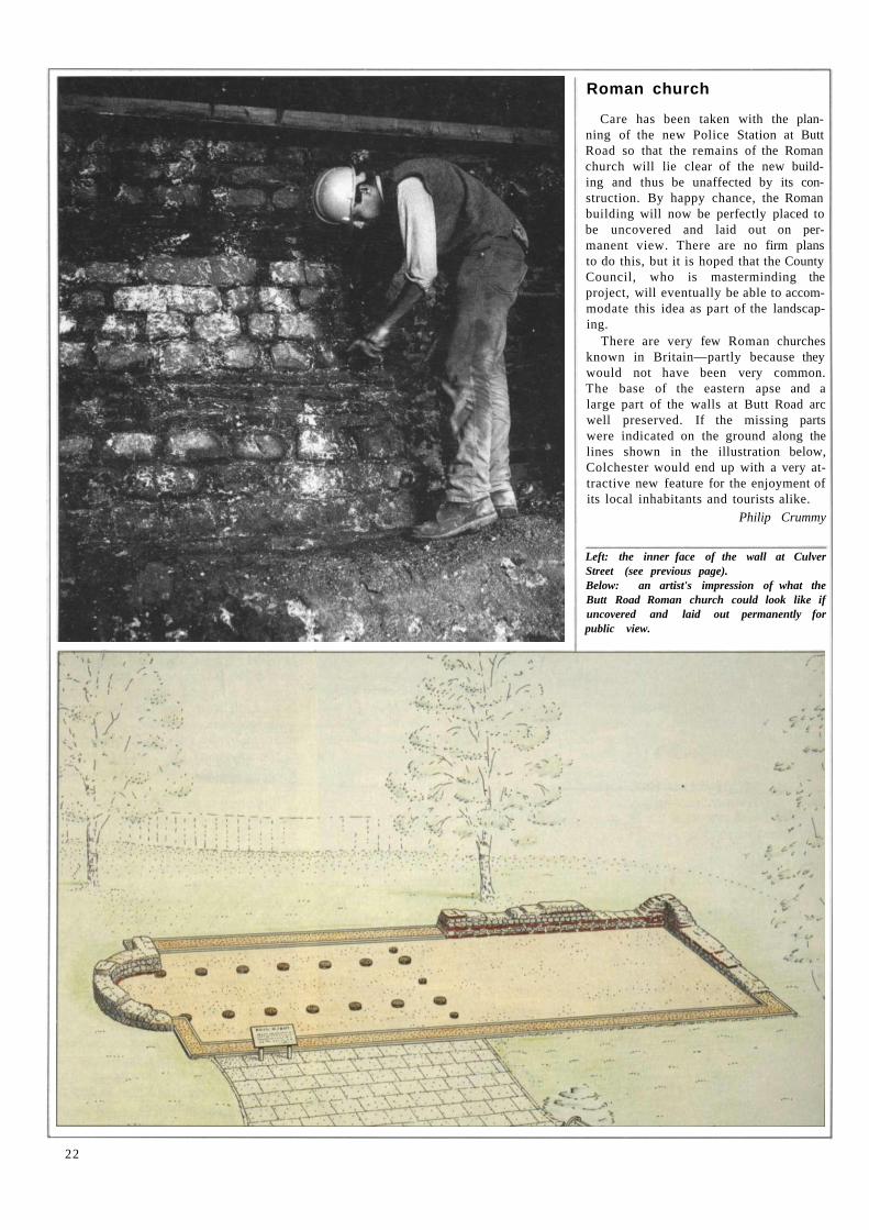
Care has been taken with the plan-ning of the new Police Station at Butt Road so that the remains of the Roman church will lie clear of the new build-ing and thus be unaffected by its con-struction. By happy chance, the Roman building will now be perfectly placed to be uncovered and laid out on per-manent view. There are no firm plans to do this, but it is hoped that the County Council, who is masterminding the project, will eventually be able to accom-modate this idea as part of the landscap-ing.
There are very few Roman churches known in Britain—partly because they would not have been very common. The base of the eastern apse and a large part of the walls at Butt Road arc well preserved. If the missing parts were indicated on the ground along the lines shown in the illustration below, Colchester would end up with a very at-tractive new feature for the enjoyment of its local inhabitants and tourists alike.
Philip Crummy
Left: the inner face of the wall at Culver Street (see previous page). Below: an artist's impression of what the Butt Road Roman church could look like if uncovered and laid out permanently for public view.
22