Embed Size (px)
Citation preview

Cover: Colchester Castle. Photograph by Alison Colchester.
The Colchester Archaeologist, Issue Number 7 (1993-4)
Published by the Colchester Archaeological Trus! Ltd, 12 Lexden Road, Colchester CQ3 3NF
Produced by Philip Crummy
Printed by Witley Press Ltd, Hunstanton. Norfolk
© 1994 Colchester Archaeological Trust Ltd
ISSN 0952-0988
Colchester Castle 1 understanding Britain's largest Norman keep
Bringing the past to life 8 a reconstruction painting of one of the largest houses in Roman Colchester
Gosbecks Archaeological Park 10 plans for a new interpretation centre and country park
Prospecting at Gosbecks 14 a probing survey of a Roman temple
Around Essex 16 news from around the county
The Friends of the Colchester Archaeological Trust 18 recent and forthcoming activities and events
Archaeology for young people 19 buildings with uniforms
Following in the steps of Celtic warriors 20 a scheme to protect Colchester's famous earthworks
In brief 21 notes and news
THE FRIENDS OF THE
COLCHESTER ARCHAEOLOGICAL TRUST
If you would like future issues of The Colchester Archaeologist posted to you direct, then why not consider jo in ing the Friends of the Colchester Archaeological Trust?
T h e Friends of the Colchester Archaeological Trust exists to keep interested members of the public in touch with the archaeological work in the historic town of Colchester. Member s receive The Colchester Archaeologist, attend an annual lecture about the previous yea r ' s work, are given conducted tours of current sites, and can take part in a p rogramme of visits to archaeological sites and monument s in the area. Publication of The Colchester Archaeologist is helped by funds provided by the Friends.
T h e annual subscription rates are as follows: Adults and Institutions £3.00, Family membersh ip £4.00, Children and Students £2.00. Subscriptions should be sent to Maureen Jones , Honorary Treasurer , Fr iends of the Colchester Archaeological Trust , 5 Ashwin Avenue, Copford, Essex C 0 6 I B S .
The castle that Eudo
built
Colchester castle is a remarkable building which is full of puzzles. Recent
work provides some insight into how and when it might have been built.
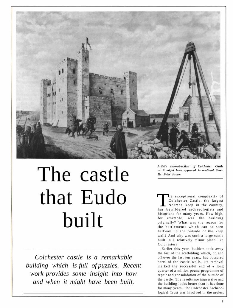
Artist's reconstruction of Colchester Castle as it might have appeared in medieval times. By Peter Froste.
The excep t iona l complexity of Colches ter Cast le , the largest N o r m a n keep in the country,
h a s bewi lde red a rchaeologis t s and historians for many years. How high, for e x a m p l e , was the bui ld ing originally? Wha t was the reason for the ba t t l emen t s which can be seen halfway up the outside of the keep wall? And why was such a large castle built in a relatively minor place like Colchester?
Earlier this year, builders took away the last of the scaffolding which, on and off over the last ten years, has obscured parts of the castle walls. Its removal marked the successful end of a long quarter of a million pound programme of repair and consolidation of the outside of the castle. The results are impressive and the building looks better than it has done for many years. The Colchester Archaeo-logical Trust was involved in the project
1

because it was contracted to prepare large-scale stone-for-stone drawings of the outer face of the castle at the start of each phase of the repair programme. A useful, although unintended, aspect of this work is that it has focused attention on some of the difficult questions relating to the castle, and as a result has led to a better understanding of it.
The survey was carried out mainly by the Trust draughtsmen, Bob Moyes and Terry Cook, with the aid of preliminary outlines and photographs supplied by English Heritage's Photogrammetric Unit based at York University. The photo-graphs were printed at 1:20 scale in such a way that there was no distortion from parallax. All quarter of a million pieces of stone and tile were outlined on the photographs, and the type of each piece of stone noted. The results were then traced off in the Trust's offices to make the finished drawings. As far as possible, earlier repairs (of which there was much evidence) were identified, dated, and shown on the finished drawings, where the new work was also marked. The survey drawings thus represent an important record of the recent repairs and a valuable tool for the future manage-ment of the building.
While this work was taking place, part
of the castle roof was removed and a new building erected in its place. The new structure was designed in such a way that it is barely visible from the ground. The part of the roof to be removed was over the site of the presumed chapel which the Trust was asked to 'excavate' (see The Colchester Archaeologist no 2). How-ever, as we shall see, excavation of the chapel was not quite as straightforward as was expected.
Eudo Dapifer The castle was built by a Norman called Eudo of Rie, the latter being a small town several miles north-east of Bayeux in Normandy. Eudo was a powerful and wealthy man who owned at least 64 manors in the eastern counties of England in addition to his holdings in Normandy. He was made king's steward or dapifer and as such ranked as an important member of the courts of William the Conqueror and his sons William II and Henry I, who succeeded him. Eudo was effectively governor of Colchester for about fifty years until his death in 1120. As well as the castle, he also built St John's Abbey, founded the leper hospital at St Mary Magdalen (see
The Colchester Archaeologist no 2), and restored St Helen's Chapel. He is also credited with building the Moot Hall — the equivalent of the town hall. Eudo died in the castle at Preaux in Normandy, but was buried in accordance with his wishes in St John's Abbey in Colchester.
Gundulph It is generally thought that the design of the castle may owe something to Gundulph, Bishop of Rochester, who was a friend of Eudo. Gundulph was said to be 'very competent and skillful at building in stone' and appears to have been the foremost castle-builder of the time. He oversaw the construction of the Tower of London and built Rochester Castle for William II. It is known that Eudo asked Gundulph for help in founding St John's Abbey (he asked him for some monks), so it would be no surprise if Eudo looked to Gundulph for assistance with the castle. The simil-arities between Colchester and the Tower, which we will see later, may reflect Gundulph's influence although this is by no means certain, particularly if, as is suggested below, the castle is earlier than normally thought.
Roman temple Perhaps the most remarkable aspect of the castle is that it was built around and over the base of a Roman temple. The Roman building had been erected during the early years of the Roman town in honour of the emperor Claudius whom the Romans, on his death if not before, had elevated to the status of a god.
The temple was a full-size classical building. It is easily the largest building of its kind known in Britain and was as large as many of the temples in Rome. Like all temples of this kind, it was raised on a rectangular platform or podium. The visual emphasis was on the front where a flight of steps lead up to the row of eight columns forming part of the facade.
The builders of Colchester Castle must have cleared away whatever survived of the superstructure of the temple to leave the podium and probably the flight of steps. The four outer walls of the castle, each ten feet thick, were then raised so that they tightly clasped the sides of the podium except on the south side where the wall was set back to clear the remains of the steps and allow a fifty-foot well to be dug within the confines of the keep.
There is a theory that the front of the Roman temple was altered in the 4th century to convert the building into a
Trust draughtsman Bob Moyes working on the scaffolding.
2

The temple is laid out. The foundation trenches are dug into the natural sand and lined with planks.
The trenches are filled with stone (septaria) and cement. The surplus earth in the centre is covered over.
William the Conqueror uses the temple platform as the base for his stone castle. It lasts 600 years.
Temple to Castle. Illustrations by Roger Mainwood. Reproduced by courtesy of the Colchester Museums.
A.D. 60/61 The temple is used by the Romans for a last stand and is burnt bv Boudicca.
1750 Charles Gray, M.P for Colchester, restores the south front, and lays out the grounds.
church and that this alteration involved the construction of an apse, which was to become the dominant feature of the south-east corner of the castle, and the formative feature of the Norman chapel.
Regardless of whether or not this really happened, it would not have been possible to make the castle any smaller and still encapsulate the temple podium; the arrangement was as compact as possible. Thus we should not imagine that the size of the castle was a reflection of the political, economic, or military importance of Colchester at this time; it was, at least to an extent, more the unavoidable consequence of a decision relating to how it was to be built.
From an engineering point of view, it was a bold decision to build the castle on the temple podium, since this might have led to disastrous cracking and subsidence of the outer walls. Whoever designed the building and oversaw its construction either had great confidence in his engineering skills or was simply very lucky.
The building must have needed at least 25,000 cubic metres of stone and mortar. There is no good natural building stone in the immediate area, there being only sand, gravel , and the London clay. However there were the remains of the Roman town which at this time provided an obvious source of easi ly-gained building materials. Many of the major Roman buildings were probably still standing: the baths, the theatre, and the Temple of Claudius among others. The town wall would have been an easy target but it was too valuable an asset to destroy.
Medieval chronicle It is impossible to tell how long it took to build the castle, but clearly the project must have taken many years. It has been estimated that, in general, keeps could be built at the rate of ten feet per year. If a rate such as this is applicable to something as large as Colchester, then it would mean that the castle would have taken about ten years to build.
An indication of when building work began is provided by the so-called 'Colchester Chronicle'. This is a brief history of Colchester , which was probably written in St John's Abbey in the 13th or early 14th centuries. In the past the chronicle has tended to be dismissed as being too fanciful to take too seriously. Yet, although the Roman part has little historical value, the section dealing with the medieval period seems to contain elements of truth.
This section reads as follows:
1145 A certain monk of St Edmund's called John, a Roman, carried the head of St Helen from Rome to the monastery of Bury St Edmunds.
1175 The castle of Colchester, with 1115 other castles of England, was almost destroyed.
1071 Colchester, after the wives of the citizens had been carried off, was burnt by Danish pirates.
1072 King William the Conqueror, on account of this, granted Colchester to Eudo Dapifer.
1076 Eudo Dapifer built the castle of Colchester on the foundation of the palace of Coel, once King, and restored the chapel of St Helen which she built herself, it is said, and gave it to St John.
1239 The said chapel was dedicated on St Katherine's day in honour of St Katherine and St Helen, by Roger, Bishop of London, in the presence of William, Abbot of St John.
1089 King William the Younger gave to [Eudo] the town of Colchester with the castle, to possess in perpetuity et cetera.
The chronicle is likely to be a com-pilation made from sources of unequal reliability. Of course none of it can be taken at face value but there is much that must be firmly based on fact. The problem is knowing what is true and what is the product of myth, error, and garbl ing during transcription and 'editing' in antiquity. For example, the second last entry is likely to be reliable since the date of 1239 fits the known dates for the bishop and abbot mentioned in it Indeed the chronicle may have been prepared to mark the dedication of St Helen's Chapel because the ceremony was a comparatively minor event in the town's history and mention of it seems out of place here. And it is moreover the subject of the entry with the latest date.
As another example, the entry under 1175 has some basis in truth since it clearly refers to the rebellion in 1173-4 which led to Henry II destroying some baronial castles although the number is wildly exaggerated and it is doubtful if Colches ter Cast le would have been affected.
In terms of the castle, the entry for 1076 is important since it is the only year given for its construction which survives from historical sources. Again the entry clearly has some basis in fact since it talks of the castle being erected on the site of a Roman building. The description of the castle as having been built on the
site of the palace of Coel is uncannily near the truth. Even the way that we are told specifically that the castle was built on the 'foundation' echoes the temple podium too much to be other than factually-based. The identification of the temple as the palace of Coel should not put us off since it is presumably what the Norman builders believed.
Nevertheless, too much weight should not be put on the accuracy of the 1076 date since, like the dates in the chronicle which can verified independently, the date is likely be wrong by a few years. Also, there is some ambiguity in what 1076 refers to. While it seems likely that the date indicates when the building was finished, 1076 could refer instead to the start of the work, or even to the completion of the castle in its early temporary form.
However, the chronicle tells us that William the Conqueror gave Colchester to Eudo the year after it was burnt by the Danes, the idea presumably being that Eudo should start building a castle there as soon as possible. It is known that in 1069 a large Danish fleet appeared off the Kentish coast and moved northwards unsuccessfully attacking in turn Dover, Sandwich, Ipswich, and Norwich as it went. Colchester was on the way and therefore may well have suffered in the manner described in the chronicle. If true, this suggests that Colchester was granted to Eudo in 1069 or 1070, and that the building of the castle began in 1070 or 1071.
Description of castle The difficulties we have today in understanding the castle stem from the fact that the upper part is missing. This is the fault of John Wheely who had acquired the castle in the late 17th century with the intention of demolishing it entirely and selling the building materials for profit. He removed the roof and stripped out all the great timbers which formed the floors. He undermined the walls with great pits, tunnelled into the temple podium to empty out the sand in the so-called vaults, forced down walls with screws, and blew others up with gun powder to bring the towers and other great masses of masonry crashing down on to the empty vaults in the hope of smashing them. How-ever in the end the castle beat him and he gave up before the job was done. In a way he did us a favour because, by emptying out the vaults, it was possible many years later for the temple podium to be discovered, and
4

the site to be identified as that of the Temple of Claudius.
The castle today is of two storeys. Confusingly the ground floor is not at ground level but is raised and roughly equivalent in level to the floor of the temple podium. Being poorly lit and unheated, the ground floor of the castle would have been used mainly as a storage area. In the south-east comer was a stone vaulted structure consisting of the substructure of the chapel (the sub-crypt) and a vaulted strong room (the so-called Lucas vault) with a narrow doorway and a small window high in the outside wall. The entrance into the castle is on the ground-floor which is unusual since, for security reasons , entrances were generally on the first floor. Although early in date, the present entrance is not original and is a replacement for an earlier one. The first floor was much better supplied with windows and contained four wall fireplaces and five latrines. It would have been divided into several compartments and have provided
Left: Colchester Castle. The existing masonry is shown black in the upper and middle plans. This consists of the outer wall, two internal walls (one restored in plan) and, in the south-east corner, the vaulted masonry structure forming the two-storey base of the chapel (the crypt and the sub-crypt) and the single-storey Lucas vault. The plan at the foot of the page is a restoration of the upper part of the castle showing the mural gallery and the possible internal layout of the chapel, based on the chapel in the Tower of London. This level corresponds to the modern roof.
Below: The two stages which show the second floor of the Tower of the London. Left is the lower half with the great hall, chamber, and floor of the chapel. Right is half-way up the second floor showing the mural gallery in the outer wall. There were no floors at this level, apart from the area over the aisles in the chapel which was continuous with the mural gallery.
living accommodation for the soldiers and the household staff. It also contained the crypt. This was a vaulted room built in stone like the sub-crypt below and was to form the base of the stone chapel above. The floor level of the second floor is at the roof level of the castle today. Had the castle been of orthodox design then the second floor would have been for the accommodation for the lord or constable of the castle and any guests. It would have conta ined a great hall, sleeping accommodation, latrines, and a private chapel. The problem is that there is hardly anything left of this part of the castle.
Temporary battlements An unusual feature of the castle is the battlements which can be seen from the outside built into the castle walls at a level corresponding to the base of the first floor. These show that the con-struction of the castle was halted and that the structure as it stood at the time was provided with battlements. There was a threat of invasion from Denmark in the mid 1080s and it is usually argued that this was the most likely reason for the temporary change of plan. However, if, as seems likely, work on building of the castle began in the early 1070s, such a context for the battlements would be too late.
A much more likely occasion is the rebel l ion of 1075 which was partly centred on East Anglia. It was to be supported by a large Danish fleet although the rebellion had been crushed by the time the ships arrived late in that year. The Danish threat seems to have led to the garrisoning of the English castles as a precaution. If, as seems likely, Colchester castle was being built as a direct consequence of a calamitous Danish raid six years earlier, then it would be no surprise if the work was abruptly stopped and the building garrisoned for the first time.
5

Problem features in the castle
Colchester Castle has much in common with the Tower of London. In fact a comparison of the plans and sections of both buildings show them to be even more similar than is generally realised. Wall thicknesses and the heights of the various floors turn out to be close in size, so much so that the Tower can be used to help work out what the missing part of Colchester Castle was like.
The three existing floors at Colchester Castle can be related neatly to the arrangement at the Tower. At the latter there is the same poorly-lit, unheated storage area at ground level. Over this is the entrance floor which includes two chambers and the chapel crypt. It has two wall fireplaces and two latrines. Above this, at second floor levels, and forming the upper half of the keep, was the royal residence consisting of a hall, a chamber, and the chapel. The hall and the chamber are of two full stages to the underside of the roof. The chapel is of two storeys, the combined height being the same as that of the hall.
In view of the similarity between the Tower and Colchester castle, it should be possible simply to add two more floors as at the Tower to obtain the original plan of Colchester Castle. However there is a problem; and this is to do with the position of the mural gallery at Colchester.
Medieval halls were generally of two storeys with centrally-placed hearths. The great height of the hall enabled the smoke from the fire to rise and escape through a hole or vent in the roof without causing the occupants much discomfort. Mural galleries in castles were passages in the thickness of the outer walls of castles. They often occur half way up halls and allow people to walk around the full circuit of the keep. The mural gallery at the Tower forms a complete circuit of the building. It is half way up the hall and emerges over the aisles in the chapel. The base of just such a mural gallery exists at Colchester castle where it can be seen clearly on the roof. The surprising thing is that the mural gallery appears to have been at the base of the great hall, not halfway up it. Wall fireplaces allowed the smoke to escape through vents in the wall and were suitable for rooms of restricted head room or rooms where the presence of a room above made a central hearth impossible as in the Tower. Yet at Colchester, we have wall fireplaces one storey below a mural gallery. It appears that we have lost a storey at Colchester. And what's more, the existence of the
wall fireplaces suggests that the builders fully intended to construct the missing floor and that there had been a sudden change of plan.
The chapel Although not common, the combination of wall fireplaces and mural galleries in the way described is not an impossible one, and indeed it occurs in the chamber in the Tower. However a more powerful indication of a missing floor at Col-chester Castle is apparent in the chapel.
Like that in the Tower of London, the chapel was to be entirely of stone and built on two solid vaulted basements, raised one on the other.
All that exists of the chapel at Colchester is the base of the outer wall and part of the stone floor. No internal features of the chapel survive but the likely posit ions of the aisles can be restored from the shape and size of the existing walls. The resulting plan is very similar to that of the chapel in the Tower. It has the same internal dimensions more or less and the same number of columns. The problem is again the mural passage which turns out to be at ground level, not first-floor level as it should be.
The floor of the chapel was of stone and formed the vaulted roof of the crypt underneath. During the recent excavation it was found that the surface of the floor had been removed and replaced in the 18th century with 'crazy paving' made almost entirely of reused Roman building materials. No stumps were found where the columns should have stood, and there were traces (as far as could be seen) of a floor which could have served the chapel. In fact all in all, there was not much evidence that the chapel had ever existed.
Change of plans Broadly there are three possible solutions to the problem of what is missing from the top of the castle.
At the very least there could have been one more storey, and the chapel could have had no aisles or columns and been simply a single-celled one-storey structure. The great hall would therefore have been on the first floor (not the second as in the Tower). It would have contained wall fireplaces despite being open to the roof and access to the chapel would have been circuitous and via the mural gallery and the two spiral s taircases in the towers . Unlike the Tower, the ground floor of Colchester castle was raised off the ground because of the underlying temple podium. Thus losing a floor and putting the entrance on
the ground floor rather than the first floor would not have reduced its defensive capabil i t ies too much. None of this would have been very satisfactory but this is the interpretation which I favour, and it is summarised on the page opposite.
The second interpretation is similar to the first except the chapel is of two storeys with aisles as more or less in the Tower. In addition to the difficult access already described, this reconstruction also means that the roof would have been awkward and very unusual in plan.
A third explanat ion sees two full storeys added on to the top of the castle so that it becomes very similar to the tower. The problems with this theory are that the mural gallery would be at the wrong height and the superstructure of the southern aisle of the chapel would be pecul iar because of its width and irregularities in plan.
Problems of scale
If the castle had been completed as initially intended, it would have provided Eudo with a huge fortified residence. The sheer scale of what was emerging may have prompted last minute changes.
Alternatively, it may simply have been an over-ambitious project which was so large that it needed more local building materials than could be supplied at the time. As we have already seen, the castle needed huge amounts of stone and tile. The volume concerned was so great that it would have been too expensive to import it from somewhere like Kent where suitable stone was available. Colchester castle may have needed twice as much material as the Tower. Therefore the vast bulk of it had to be obtained locally from the ruins of the Roman town and that was to amount to (at a guess) perhaps as much as a quarter of all the suitable material which survived.
Yet another explanation for the change of plan is to do with speed and the pressure to get the castle finished. We have already seen how the problems of 1075 may have forced a premature garrisoning of what was still a half-finished building. Even after the military difficulties subsided, the need to finish the castle may have been so great that Eudo was prepared to see his grand scheme compromised simply to make sure that he was not to be caught out again.
6

An east-west section from the centre of the chapel to the south-west tower (left).
A The castle as Eudo may have intended but never completed. It was to be four stages high with entrances at first-floor level on the north and south sides.
B In 1070 or 1071 building work begins according to the original plan. The ground floor is finished, including the Lucas vault and the sub-crypt. Then work is stopped in 1075 during a rebellion backed by a Danish fleet. Battlements are added to the tops of the walls as they stand. No doorways have yet been built so the north-west and south-west towers were heightened to overlook the sites of the two intended entrances.
C Building work resumes in 1076. The intention is still to build the castle as originally planned with four stages. The battlements are not removed but become part of the heightened outer wall. The first floor, including the chapel crypt, is completed and then there is a major rethink.
D The castle is built with one stage omitted. Rather than build a two-storey hall and chapel, only one more stage is added and the existing hall on the first floor is made into the main hall by leaving it open to the roof so that it is two stages' high. A mural gallery is incorporated in the outer wall one stage lower than originally planned. At the same time, the doorway on the north side is blocked up (still visible), and the doorway on the south side is replaced with a wider, more ornate one directly below, on the ground floor. The intended chapel possibly ends up as a single-storey structure which may not have been used as a chapel. The castle is finished by 1080.
E Wheely gives up his attempt to demolish the castle when he reaches the base of the mural gallery where the wall is much thicker and thus more robust than elsewhere.
7
Bringing \ the past
to life Peter Froste's latest reconstruction
painting is easily one of his best and shows one of the Roman houses
investigated during the Culver Street excavations in the 1980s.
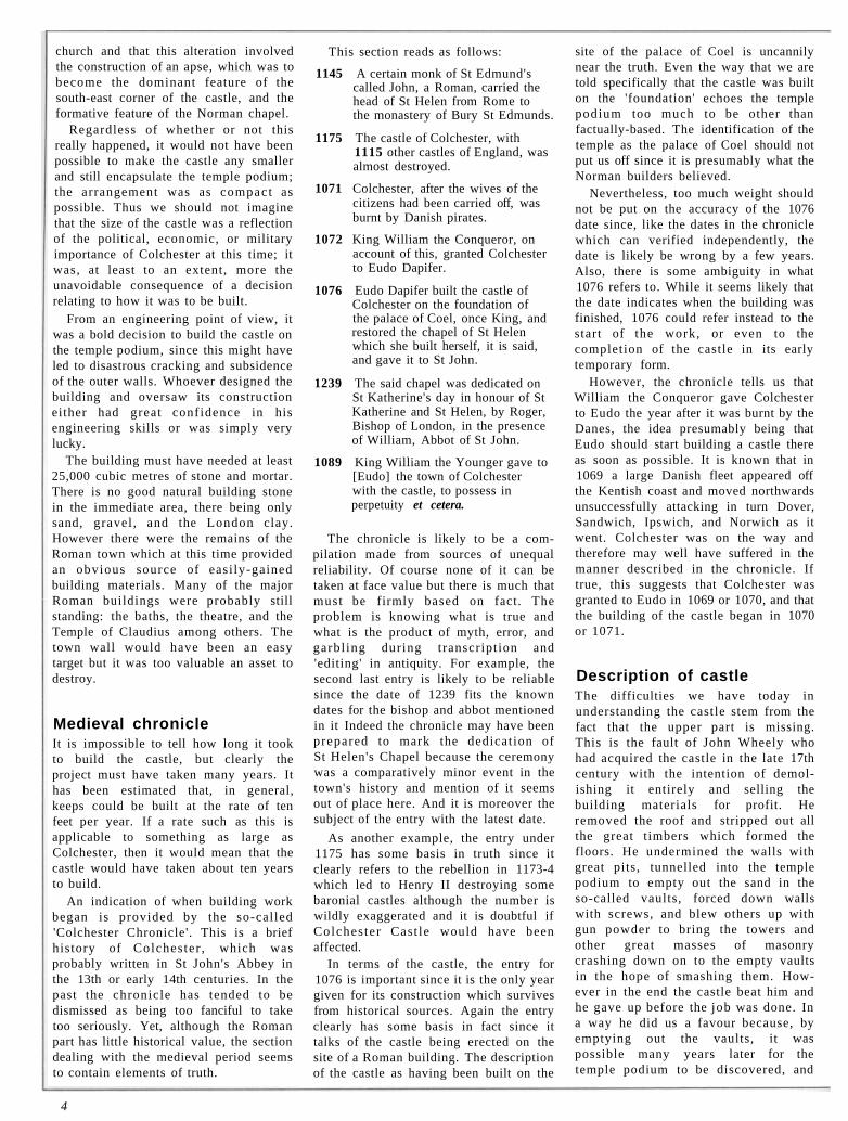
The s u b j e c t of P e t e r F r o s t e ' s painting is the largest house yet excavated in Colchester. It was
bu i l t in t he 2nd c e n t u r y a n d demol i shed a r o u n d AD 300. I t occupied the north-west quar te r of a whole insula (Insula 35). In modern houses , one r o o m often leads in to a n o t h e r , w h e r e a s in l a rge R o m a n houses rooms were generally accessed via long corr idors which passed down the s ides of the r o o m s , or smal le r corridors leading off them. Compared wi th t h e i r m o d e r n c o u n t e r p a r t s , R o m a n houses such as th i s one a t Culver Street were greedy in terms of land and could occupy quite a large space, in this case an area measuring about 40 m square .
The Culver Street building was clearly of exceptional quality. Not only was it bigger than normal, but the rooms were more spacious and the passages wider. Many of the wal ls seem to have incorporated stone and mortar (which was unusual and presumably expensive), and many of the rooms contained mosaics. The remains of three were found during the excavations, and the building could have contained twice as many as this . Finds included glass
tesserae (unusual) and a fragment of a table leg of Greek marble in the shape of a panther head (shown above). The table would have been made entirely of marble and thus been an expensive piece of furniture.
Only about half of the house could be examined during the excavations. The south-west quarter was the most
thoroughly investigated and Peter has omitted the roof over this area to reveal the internal arrangements.
The building was designed around the four sides of a square courtyard around the edge of which was a wooden drain to catch and remove the surface water shed from the overhead eaves. Rooms in the south-west corner included a kitchen containing a series of at least eleven ovens and a source of pressurised water, such as a tap, in the east wall. In the north-west comer of the kitchen was a stair leading to a semi-sunken stone-built cellar. To the north of the cellar was a major l iving-room with underfloor heating and a mosaic. A room of great interest occupied the central part of the south range. It seems to have been an axially-placed basement with a mosaic floor. This is a strange combination and suggests that it may have been an underground shrine. All this and more was discovered through excavation, and all of it has been incorporated into Peter Froste's painting.
Although reproduced here in black and white, the original is in full colour. A copy can be seen in the Castle Museum where it forms part of the latest additions to the displays on Roman Colchester.
8

The house viewed from the south-west corner.
Right: View from the north across the heated room (Room 8) showing the base of the hypocaust, the cellar (Room 9), and the kitchen (Room 10) in the centre top. On the left is the inner corridor (Passage J) and the central courtyard. The well in the top left-hand corner is recent and cuts the south-west corner of the inner corridor.
Below: The remains of the steps leading from the kitchen (Room 10) into the cellar (Room 9).
9

Once he b e c a m e e m p e r o r , C l a u d i u s n e v e r left I t a ly except on one occasion — to
come to Gosbecks. The journey took six months but he spent no more than sixteen days in Britain. Evidently he was not too taken with Gosbecks, but things are likely to change there in the near future. A plan to t u rn a large part of the site into an archaeological p a r k could eventually t u rn w h a t is now a fairly featureless farm into an archaeological in te rpre ta t ion centre combined with an attractive country park. Visitors will be offered a mix of o u t s t a n d i n g a r c h a e o l o g y , n a t u r a l history, and pleasant country walks.
David Barbour and his family have offered the Colchester Borough Council 165 acres plus a substantial lump sum as the basis of an archaeological country park in exchange for permission to build
Gosbecks Archaeological Park
A large part of the major British archaeological site at Gosbecks is to be preserved. However, this will not be a
sterile mothballing exercise for the sake of future generations. But instead it should provide Colchester with an unusual new
leisure and educational amenity.
houses on the fringe of the site. The proposal has been enthusiast ically received by archaeologists and various organisations including English Heritage who , for many years , have been concerned by the unavoidable damage caused to the site by repeated ploughing. The prospect of a park offers the chance to take two of the most important fields out of cultivation and protect the buried remains there indefinitely. Outl ine planning consent was granted in mid 1993 and discussions are now taking place on how the park might be set up and run.
History Camulodunum was the fortified stronghold of Cunobelin, the man regarded by Romans as the king of the Britons. The settlement covered about
ten square miles and was protected by a large collection of linear earthworks which, if placed end to end would exceed twelve miles in length. This is the largest known such complex in the country and must give some indication of the past importance of the place nationally.
At the heart of the complex was Gosbecks which is thought to have been the home of Cunobelin and his predecessors. They probably lived here in a group of round houses inside a large enclosure defended by a deep bank and ditch. The enclosure and the network of trackways and field systems which led from it have been located from aerial photographs in which the ditches and other features show as marks in the crops in dry years shortly before harvest. Similar combinations of enclosure and field systems have been recognised in Essex and elsewhere where they are
10

A plan of the proposed park at Gosbecks showing the cropmarks and the modern streets. The limit of the park is indicated by a thick line.
readily identif iable as farmsteads. Camulodunum was a farmstead too but on an exceptional scale and protected by a complicated dyke system. Its size and economic success would have been due in large part to a market held on the Gosbecks site. The market would have been held on a regular basis and would have involved the exchange of local and imported produce.
Claudius received the submission of a number of British kings whilst in Britain. Nobody knows where this event occurred but Gosbecks is the most likely place. Cunobelin had died shortly before the invasion and had been succeeded by at least two of his sons. One died during the initial fighting with the Roman army and the other continued to resist for some years.
After the conquest, a small fort was built at Gosbecks. It was large enough
for a cohort of soldiers (which was about 500 men). With the later construction of a theatre and temple, the site became a native sanctuary, if it was not one already. A road was built to link the site to the Roman town about two and a half miles to the north-east. The theatre and the scale of the temple complex show that large numbers of people must have regularly visited the site, presumably to attend the market which continued to be held there. The theatre was large enough to hold three to five thousand people, and the portico or double corridor which surrounded the temple was almost quarter of a mile long (see pages 14-15). Mercury was a god who oversaw commerce and traders, and the discovery about fifty years ago of a magnificent statuette of him underlines the economic role played by the site in the region.
Archaeology
The archaeological park will consist mainly of the two large fields which flank the middle part of Oliver's Lane. The sites of the theatre and temple lie on the western field while the field system and the Roman road cross both. The two fields are fairly flat, apart from a slight mound which is the only visible remains of the theatre. The field with the farmstead will not be in the park since it is part of the adjacent farm.
Plans currently being considered focus on the construction of an interpretation centre possibly located on the Maldon Road in the north-west corner of the park. Here visitors would learn about the archaeology of Gosbecks and how the site fits into the wider context of the dyke system and Camulodunum generally. The theatre and temple would be sign-posted
11
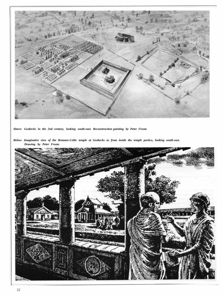
Above: Gosbecks in the 2nd century, looking south-east. Reconstruction painting by Peter Froste.
Below: Imaginative view of the Romano-Celtic temple at Gosbecks as from inside the temple portico, looking south-east. Drawing by Peter Froste.
12

David Bellamy helps pupils Sarah Dean, Gary Richer, and James Harvey from the Philip Morant School with their tree planting at Gosbecks.
and their posit ions indicated on the ground. Development of the visitor facilities would be gradual and long-term, and might include a full-size replica of one of the buildings such as the temple. Considerable emphasis is likely to be placed on schools , with the development of teaching packs and teacher-training courses geared towards the national curriculum. There is unlikely to be much archaeological excavation since a primary objective of the park is to ensure the preservation of the site, and excavat ion is a destruct ive process . However, there will probably be some small-scale work related to the displays and site interpretation.
Nature conservation Fortunately the park lies on the edge of the Roman River valley which is an important nature conservation area. Consequently, future land management of the park is likely to be geared towards creating and fostering wild-life habitats in an area which until recently was heavily-cultivated arable land. This will considerably enhance the Roman River valley as a conservation area by providing a substantial tract of new land for colonisation by wild flora and fauna. However, the area will not be allowed to return to the wild, but instead will be managed in a way which is sensitive to conservation needs whilst at the same time being able to cope with substantial numbers of human visitors.
Work on this aspect has already begun. The two fields have been ploughed for the last time. The west field is to become a wild flower meadow and has been sown with a mix of five grass species and four types of wild flower. A crop of hay is to be taken off the field once a year. It is hoped that the east field will be converted to heathland to re-introduce into the area a kind of rich wild-life habitat that once was much more common in Essex and East Anglia than it is today. The soil at present is not acidic enough to suppor t heathland and consequently the area has been sown with commercial perennial rye grass in the hope that within maybe five to ten years this will increase the acidity to a suitable level. Until this point is reached, the grass will be cut two or three times a year for silage.
Plans are also in hand to re-introduce some hedges and bring sheep in to graze the new meadows.
The creation of the wild flower meadow and the heathland is a research project which is being master-minded by Simon Newell, project officer for the
Roman River Valley Project. It is funded by the Countryside Commission with a Countryside Stewardship grant . The project is being run by Colchester Borough Council in conjunction with the Roman River Valley Conservat ion Society and the Countryside Commission.
Tree planting has also begun in the extreme north-east corner of the site where, with the aid of a sponsored walk and a Forestry Commission grant, pupils from the Philip Morant School planted 1,800 mixed deciduous native trees. This mammoth task was completed in a week with the aid of teachers from the school and encouragement from David Bellamy. The trees have been deliberately planted in an area of limited archaeological importance.
The interpretat ion centre would provide visi tors with background information on the Roman River valley and be a starting point for nature trails which would be developed in parallel with the landscaping of the park.
The future The planning of the park is still at an early stage, and few decisions have yet been taken with Councillors and their officers still considering the various options. But the opportunity is there for an exciting new amenity which is green (literally and ecologically), educational, recreational, and a show-case for Colchester's claim to be one the most important archaeological sites in the country.
13

Prospecting at Gosbecks
Modern technology offers site investigation without dirty hands. At present geophysical
survey can't beat excavation but it is a technique which will increasingly become more
important at Gosbecks where preservation is paramount.
Ways of being able to see what i s u n d e r g r o u n d w i t h o u t d igg ing have a l w a y s h a d
g rea t a p p e a l . T h e t r o u b l e wi th traditional excavation is that it is hard w o r k a n d can be very expens ive . Worse still, archaeological excavation is a de s t ruc t ive process which can resul t in severe d a m a g e to a r c h a e -ological sites and often does so. The p l a n n e d a r c h a e o l o g i c a l p a r k a t Gosbecks is a site where preservation takes a high priority, and thus it is a very suitable place for non-destructive surveys of this kind, especially since there should in due course be a need to loca te m a j o r f ea tu re s on the ground. This will be needed to allow their positions to be marked out on the ground to help visitors get their bearings.
Recently Peter Cott carried out the first of what is likely to be many of these surveys at Gosbecks. He examined the temple complex site where a 50-foot square temple sat in the corner of a 300-foot square enclosure outl ined by a massive double passage (portico) and a deep square ditch. Walking around the portico would have entailed a walk of almost quarter of a mile.
There are various techniques available for surveys of this kind. Peter uses a resistivity meter which, as its name impl ies , measures electrical ground resistance by measuring the size of a current passed between pairs of probes pushed a few inches into the ground. The measurements have been to taken methodically on a carefully measured-out
grid system. In this case, they were taken at one-metre intervals. Peter was helped in the field by his wife Jean, James Fawn and Dennis Tripp and between them they dealt with a staggering 16,800 readings.
The resistivity method can detect buried features such as brick, tile, and stone because of the differing take-up of
moisture of these materials compared with that of the surrounding soil. It is also possible to detect buried ditches when these contain humus which has retained more moisture than the soil, and these give low readings. However ditches which contain a lot of rubble such as the great ditch in the temple complex can give similar readings to that of a wall foundation. The results can vary with the seasons and, as it happens, the survey was carried out in October which is not ideal in this respect.
The plot from the raw data is shown here. It is made up of 42 squares of computer print-out pasted together to provide the overall picture.
At first sight, it looks as if the survey failed to show much. But the print-out needs to be studied carefully and it helps if you understand the way the computer program handles the shading in each of the squares which make up the whole image. Peter is working on a computer-enhanced version. The preliminary print-out of this is a great improvement on the raw data and shows the major features much more clearly. In fact, the survey has proved far more revealing than expected and shows that resistivity surveys will have a place in the future exploration and display of the site.
14

Above: The unenhanced plot of the data. The great ditch shows as black areas. The three foundations which formed the portico are detectable in places. The temple in the south-east corner of the ditch enclosure does not seem to show at all. Curiously Rex Hull also failed to find it when he dug a trench across the site in 1936. The dark areas on the right and bottom edges suggest the presence of features which do not show on aerial photographs. North is to the top. The squares are 20 m across.
Left: Aerial view of the temple complex when the features were visible as cropmarks.
KEY: A... position of foundations of the portico. B... the great ditch. C...the Romano-Celtic temple.
15

Around the County
News of recent projects in Essex from the
Archaeology Section at County Hall
A Roman fort at Boreham? A team of county archaeologists working in a gravel quarry at Great Holts Farm, Boreham, has uncovered the remains of a large Roman timber building, thought to have been a barn. The remains of the building consisted of eight large post holes, arranged in two parallel rows of four, forming a rectangle 12 x 5 m. Each post hole would have held a large wooden upright. Large numbers of roof tile fragments were found in the soil over and around the building, so it almost certainly had a tiled roof. No other building material was found, so it is likely that the walls were of timber, long since rotted away, or reused elsewhere. The lack of other finds indicative of domestic, religious or industrial use, points to an agricultural purpose, probably a barn.
The building is thought to date from late in the Roman period, and is only one of many Roman features in the quarry. A large area has been stripped of topsoil, and what has been revealed is a largely agricultural landscape, consisting of fields and trackways, some of which were visible on aerial photographs taken in 1990. The timber building fits well into this landscape.
There was also a scatter of cremations, one of which was accompanied by a copper-alloy casket, lifted as a soil-block, and now being excavated in the laboratory.
Prehistoric remains were also present, the most notable being the post holes of a timber round house of Late Bronze Age date (1000-700 BC).
The area under threat in the quarry is about 8 hectares (20 acres), of which 3.5 hectares (8.8 acres) have been examined
so far over a period of several months, with the kind co-operation of the St Albans Sand and Gravel Company Ltd. Work has been funded so far by English Heritage. The quality of the results of the current work is being assessed to see whether it is justifiable to examine the remaining 4.5 hectares (12.2 acres), where the remains of the farm settlement which form the focus of the agricultural landscape are believed to be.
World War II coastal defences Earlier this year, Essex County Council carried out a three pilot surveys of the county's World War II defences. In February and March, three selected areas of the coast were examined and as a result the number of recorded sites was more than doubled. These included a number of fascinating examples, such as a two-storey tower, standing like a leftover from a 1960's Doctor Who film, which was used as a control position for a minefield laid across the mouth of the River Crouch, a rare decoy bunker which originally housed engines for pumping kerosene onto flaming dummy buildings, and a coastal artillery emplacement which now masquerades as the Two Sugars cafe at West Mersea! Incredibly, the 4.7 inch gun which once graced the cafe was made in 1918... in Japan! Most of the finds are the pillboxes which were constructed as beach defences. After Dunkirk, in 1940, there was feverish activity to erect a 'hard crust' along Britain's south and east coast, and in Essex pillboxes were built at regularly-spaced intervals along the vulnerable stretches from Canvey Island to Harwich. These concrete fortifications are all that can be seen today, but the total defences would have been much more formidable. Linked scaffolding poles, as an anti-landing craft obstacle, were erected in the sea by teams of local builders working between the tides. Rolls of barbed wire entanglements festooned all the beaches and minefields were laid in the meadows behind the sea walls.
Behind the coast, paratroopers and airborne troops posed the main threat and to combat this, anti-glider poles with wire stretched between were erected across most likely-looking places. On the flat areas to the east of Burnham this was a distinct danger and pillboxes were added as an extra protection.
In summer, a further pilot survey was carried out, this time aimed at assessing the survival of inland defences. The area chosen , in Epping Forest District,
16

included part of the Outer London Defence Ring , the Royal Ordnance Works at Waltham Abbey, and the impor-tant fighter base at North Weald Airfield. Overall, although only four sites had previously been recorded (in Pillboxes by Henry Wills, 1985), the ECC survey discovered 24 sites, 15 of which still survived as standing monuments. The latter included some rare survivals, such as an anti-aircraft gun platform on the River Lea, and a steel Alan-Williams turret next to a decoy airfield at Nazeing. The most surprising discovery, and a very rare find indeed, was that of three retractable Pickett-Hamilton forts at North Weald airfield, two of which were actually in situ. The survey established that the Royal Ordnance sites had been comprehensively ringed with pillboxes, observation posts, and anti-aircraft gun emplacements.
These pilot studies have shown that Essex was very heavily defended during World War II. Although many of the defences have been destroyed, those that remain include rare specimens that are well worth preserving. It is possible that the pilot surveys will be continued and the next area which may be examined will include part of the main defensive line, the GHQ line, which ran from north to south through the middle of Essex.
If readers wish to know more about the survey or have information on World War II defences, they are asked to write to Above: Minefield control tower and observation point near the mouth of the River Crouch. the County Archaeologist, Essex County Council, Planning Department, County Hall, Chelmsford, Essex CM1 1LF. Below: The Two Sugars cafe at West Mersea, formerly a 4.7 inch gun battery.

The Friends of the Colchester Archaeological Trust
The Friends of CAT is a thriving o r g a n i s a t i o n wi th severa l hundred members . Most live in
Essex or southern Suffolk, but a few hail from as far afield as Denmark, Gibral tar , Canada , the USA, Africa, or the Antipodes. All members of the F r i e n d s rece ive a copy of The Colchester Archaeologist, a n d those living within a reasonable distance of Colchester have a chance to attend an annual lecture on the previous year 's work, to go on organised outings to excavation sites, ancient monuments, historic buildings and museums, and to attend events related to the work of the Trust.
Events of 1993 The AGM held in the Castle Museum's lecture hall was, as always, very well attended. Carl Crossan summarised the year's very full programme of field walking along the lines of Anglian Water's pipe-lines which cut swathes across Colchester District, and Philip Crummy described the Warrior Burial and other cremations at Stanway, and the final phase of work at St Botolph's Priory.
In March members went to the Silk Museum at Bra in t ree , where they enjoyed a very informative guided tour and weaving demonstration. Though the floor area of this enterprising working museum is tiny, it is packed with a variety of looms capable of producing different fabrics, and each is used to maximum effect, most frequently replicat ing ancient texti les so that restoration work is totally in sympathy with what survives of the original.
On a very unsympathetic, very wet and chilly Saturday in May the Fr iends visited Grimes Graves near Thetford to get a taste of Neolithic flint-mining. Nowadays it is not possible for safety reasons to crawl along the low passages which follow the bands of flint through
the chalk, but the climb down the ladder to the floor level of the mine and a squint up the passages was certainly enough for most members. The visitor centre on the site includes a small display, and a memorable exhibi t was an aerial photograph of the surrounding heathland showing the extent of the mines, clearly showing as sunken areas.
On an equally wet day in July members went to Audley End in the company of Andrew Harris . In the morning at Lexden Road, Andrew gave an illustrated talk on the excavations of the garden area at Audley End, which had revealed much about the earlier medieval monastic foundation and its conversion to a Tudor mansion. This was a very useful basis for our visit to the house itself in the afternoon, and we were pleased to be among the first to see the garden in all its restored flowering beauty.
The weather remained against us in September on our Building Materials day. In the Cast le Museum in the morning Andrew Harris described the different types of stone used in the buildings in our area, together with the distinctive techniques used over the medieval period to work them. In the afternoon we visited St Osyth Priory to see the stones in situ. Andrew was his usual eloquent self, allowing us to forget the cold and wet.
Late in November Paul Sealey treated us to 'Hands on the Iron A g e ' , an illustrated lecture and pottery handling session. Paul was , as ever, both informative and entertaining, and gave us many new ideas and views to mull over.
Current Archaeology A highlight of the year was a wine and cheese party in the Castle Museum given by Andrew and Wendy Selkirk who are the editors of Cur ren t Archaeology. It was held for members of the Friends as well as the subscribers
to the magazine who live in the Colchester area. The party was given to mark the publication of an article in Current Archaeology on Stanway, and by way of a thank you for the other articles on Colchester which have appeared in the magazine over the years.
The evening was a great success with Wendy and Andrew going to great lengths to provide excellent food and drink which was all much enjoyed and appreciated by everybody. The setting too considerably enhanced the evening and allowed many people to see the new displays for the first time.
The Trust has some spare copies of the issue with the Stanway article in it. Please contact Philip Crummy if you would like a free copy.
The year to come The AGM business meeting will be held at 12 Lexden Road on Saturday 29th January at 10.30 am. In the afternoon of the same day, in the lecture room of the Castle Museum, at 2.00 pm assuming no last-minute hitches, there will be an illustrated talk.on the field work which should have taken place by then on the development land next to the Gosbecks Archaeological Park. There will also be the usual round-up of other recent activities. In addition, Oliver Green will talk about the new displays in the Casde Museum, with particular emphasis on the current plans for Phase 3, the Saxon and medieval periods. Philip Crummy will provide the background to this by summarising the results of the Saxon and medieval excavations in the town. The talks will be followed by tea.
Next year ' s trips will include a churches out ing , a walk around Colchester, and a trip to Roman London.
Nina Crummy, 2 Hall Road, Copford, Colchester C06 1BN. Tel 210255.
18
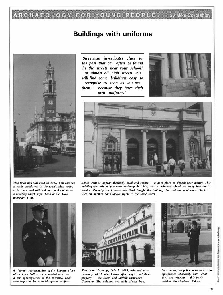
Buildings with uniforms
Streetwise investigates clues to the past that can often be found in the streets near your school! In almost all high streets you
will find some buildings easy to recognise as soon as you see
them — because they have their own uniforms!
This town hall was built in 1902. You can see it really stands out in the town's high street. It is decorated with columns and statues — a building which says 'Look at me. How important I am.'
Banks want to appear absolutely solid and secure — a good place to deposit your money. This building was originally a corn exchange in 1844, then a technical school, an art gallery and a theatre! Recently the Co-operative Bank bought the building. Look at the solid stone blocks used on another bank (above right) in the same street.
A human representative of the important face of the town hall is the commissionaire — a sort of receptionist at the entrance. Look how imposing he is in his special uniform.
This grand frontage, built in 1820, belonged to a company which also looked after people and their property — the Essex and Suffolk Insurance Company. The columns are made of cast iron.
Like banks, the police need to give an appearance of security with what they are wearing — this one's outside Buckingham Palace.
19

Following in the steps of Celtic
warriors
Colchester's famous earthworks are suffering badly. Nobody wants to see them
shut away — they are there for all to appreciate and enjoy. The Borough Council has therefore launched an initiative to ensure their long-term
preservation whilst, at the same time, encouraging public access.
'The sally of the Celtic warriors' by Peter Froste. The entrance through the dyke is temporarily blocked with felled and fallen trees. These are dragged to one side to let the menfolk rush forward whilst members of their families watch anxiously from the bank.
Two thousand-yea r -o ld ea r t h -w o r k s and la rge n u m b e r s of people don ' t mix. Two hundred
and fifty years ago, in the days of the f amous a r chaeo log i s t Wil l iam Stukeley, much of Colchester's ancient defensive system of dykes was still comparatively well preserved. But in those days , the buil t-up area of the town hardly reached out beyond the town walls. Now a suburban sprawl extends over two miles from the town centre and has all but swallowed them up .
End to end the dykes would have totalled over twelve miles in length making them the largest group of such earthworks in Britain in the decades leading up to the Roman invasion. Each dyke consisted of a V-shaped ditch up to thirteen feet deep and a bank up to ten feet high made from the upcast from the
20

ditch. The result was an earth barrier up to twenty-three feet high from ditch bottom to the top of the bank. The dykes were pr imari ly anti-chariot devices although they would have been effective to a lesser degree against cavalry and warriors on foot.
Camulodunum was at its most powerful under Cunobelin, and it was during his reign that many of the dykes were built. However, the dyke system was started in the 1st century BC, some considerable time before Cunobelin, and it was developed over a period of at least 75 years as new stretches were added. Each earthwork was sited to take advantage of natural features, particularly rivers, sloping land, and dense woodland. The last of the dykes to be built was probably Gryme's Dyke. It marked the western limit of the system and was to become the western boundary of the medieval borough. An excavation in 1977 indicated that the outermost dyke, Gryme's Dyke, was not built by Cunobelin, but post-dates him by perhaps as much as twenty years, making it early Roman in date.
The problem
Thousands of people live next to the dykes where none had lived before. The earthworks (or at least some of them) provide leafy oases in among the estates — somewhere to walk the dog, take a stroll, make a swing, ride a bike or a horse, and even occasionally somewhere to dump rubbish. The trouble is that too much human activity results in the earthworks being gradually ground down and worn away. Destroy the vegetation cover and the exposed soil on the banks will be washed away by the rain, or blown away in the wind. Every new path cut through the ground cover means that just a bit more earthwork will be eroded. Unfortunately, the process is one way and irreversible. The effect is everywhere to be seen at the bases of tree trucks, where erosion of the ground has exposed the upper part of the root systems.
Colchester Borough Counci l has launched an initiative to stop the rot. The idea is to promote local awareness of the s ignif icance of the monuments and encourage people to walk along them. On the face of it, this may seem self-defeating but if people stick to the main paths which are along the lines of the backfilled ditches, there should be no problem — quite the contrary.
Interpretation panel A display board has been erected on Gryme's Dyke, where the monument is cut by Dugard Road. The board gives information about the locations of the various dykes and the importance of the system as a whole. It also shows the routes of two walks for those wishing to mix the past with some light exercise. The short route takes in Gryme's Dyke North and the Triple Dyke. It should take about 45 minutes; the long walk takes about two hours. It involves a trip along Gryme's Dyke South down to the Roman River valley and back via Gosbecks and the sites of the Roman
theatre and temple. The board was produced by the Trust for the Colchester Borough Council Museum Service.
The first stage has taken place in what is hoped will be a long-term management programme of the earthworks. Volunteers from the BTCV (British Trust for Conservat ion Volunteers) spent a weekend working on the part of Gryme's Dyke where the display board has been erected. They cleared rubbish, pruned some of the trees, and repaired and improved the path with the aid of material donated by Tarmac. But that is not the end because BTCV plan to come back and do much more.
21

Dennis Tripp and Donald Shimmin temporarily join the building trade at St Botolph's Priory. Ancient priory explained Visitors to St Botolph's priory in Colchester should now find the ruins much easier to understand. All that survives above ground are the remains of the western half of the priory church, the remainder having been demolished without record about 400 years ago. The plan of the missing part of the church was discovered recendy through excavation (see The Colchester Archaeologist no 4, pages 1-5) and the positions of the missing walls and columns have been indicated on the ground with stone, Roman tile, and concrete. Now the visitor can appreciate the size and shape of the original church and as a result is much better placed to visualise what the building might have looked like.
Marking out the posi t ions of the missing parts of the plan presented problems. Strips of concrete or rows of paving slabs would have been no good since they would have looked too new. Equally, rubble and mortar would have been unsuitable since this might look too like the real thing, and people would think that these were the actual foundations. What was needed was something which is obviously new but which blended in with the ruins. Various experiments were tried, and in the end a form of crazy-paving technique was
chosen which involved setting pieces of real Roman tile and stone in concrete which is coloured to match the appear-ance of the ruins.
To assist the visitor further a display board will be erected just outside the south transept, facing north. And possibly in 1994, it is hoped that the surrounding area will be planted with trees and flowers and that a hedge will be set around the perimeter of the site so that, when fully grown, it will re-establish the sense of seclusion which must have been there in the days of the priory.
The St Botolph's project is being run by Colchester Borough Council with the support of English Heritage. The work on site was carried out by the Colchester Archaeological Trust as was the design of the display board.
Archaeology on a Monday night Subjects to be covered in the Colchester Archaeological Group's winter season of evening lectures include medieval gardens (Dr Christopher Thacker), the well-known West Stow Anglo-Saxon village (Dr Stanley West who excavated the site), and metal-detecting from an
archaeologist's point of view (David Gumey of the Norfolk Museums Service). For details, contact Pat Brown, 172 Lexden Road, Colchester C 0 3 48Z (telephone Colchester 575081).
Bones The two latest Trust reports both involve bones from Colchester. One of them is about human burials and religious sites of various kinds, particularly the Roman cemetery and church on the site of the police station in Butt Road. The other is devoted entirely to a study of animal bones (see The Colchester Archae-ologist no 6, pages 10-14).
Colchester Archaeological Report 9, excavat ions of Roman and later cemeteries, churches and monastic sites in Colchester 1971-88 by Nina Crummy, Philip Crummy, and Carl Crossan (ISBN 1 897719 01 9) costs £30. Colchester Archaeological Repo r t 12, Animal bones from excavations in Colchester, 1971-85 by Rosemary Luff (ISBN 1 897719 00 0) costs £20. Both are available from the Trust (plus 10 per cent to cover post and packing) or can be ordered from most bookshops.
22
brief In