Embed Size (px)
Citation preview
w.sciencedirect.com
g e o d e s y and g e o d yn am i c s 2 0 1 5 , v o l 6 n o 3 , 2 1 0e2 1 9
Available online at ww
ScienceDirect
journal homepage: www.keaipubl ishing.com/en/ journals /geog;ht tp: / /www.jgg09.com/jweb_ddcl_en/EN/volumn/home.shtml
Cognitions and questions regarding crustaldeformation and location forecasts ofstrong earthquakes
Wei Wenxina, Jiang Zaisena,*, Wu Yanqiangb
a Institute of Earthquake Science, China Earthquake Administration, Beijing 100036, Chinab First Crust Deformation Monitoring and Application Center, China Earthquake Administration, Tianjin 300180,
China
a r t i c l e i n f o
Article history:
Received 4 February 2015
Accepted 14 March 2015
Available online 29 May 2015
Keywords:
Global Positioning System (GPS)
Active fault
Focal mechanism
Elastic rebound
Earthquake preparation
Dynamic characteristics of defor-
mation field
Strain rate field
Spatial-temporal process
* Corresponding author.E-mail address: [email protected] (Jia
Peer review under responsibility of Instit
Production and Hosting by Elsevi
http://dx.doi.org/10.1016/j.geog.2015.03.006
1674-9847/© 2015, Institute of Seismology, Chi
Communications Co., Ltd. This is an open acce
a b s t r a c t
Using Global Positioning System(GPS) data to analyze the earthquake preparation char-
acteristics of the Kunlun Ms8.1 and the Wenchuan Ms8.0 earthquakes, we review the main
research developments of earthquake forecasting and the mechanisms of earthquake
preparation using crustal deformation data from recent periods, and discuss the similar-
ities and differences in the scientific approaches adopted by the Chinese and foreign
scholars. We then analyze the deformation characteristics of earthquake preparation, with
respect to slip and dip-slip faults. Our results show that, in order to understand the rela-
tionship between crustal deformation and earthquake preparation, research focus should
be expanded from fault-scale to larger scale regions. Furthermore, the dynamic deforma-
tion characteristics associated with earthquake preparation must be considered as a multi-
scale, spatial-temporal process, in order to obtain the necessary criteria for strong earth-
quake forecasts.
© 2015, Institute of Seismology, China Earthquake Administration, etc. Production and
hosting by Elsevier B.V. on behalf of KeAi Communications Co., Ltd. This is an open access
article under the CC BY-NC-ND license (http://creativecommons.org/licenses/by-nc-nd/4.0/).
1. Introduction
The application of Global Positioning System (GPS) equi-
spaced Earth observation technology is facilitating a greatly
increased ability to monitor large- and mid-scale crustal de-
formations, which further enables us to study the
ng Z.).
ute of Seismology, China
er on behalf of KeAi
na Earthquake Administr
ss article under the CC BY
development and occurrence processes of strong earthquakes
from the large-scale, and to the mesoscale and fault scale of
developing earthquakes. For over 10 years, beginning with the
establishment and operation of the Crustal Movement
Observation Network of China (CMONOC) in 1998, the China
mainland has suffered from the Kunlun Mountain Pass West
Ms8.1 earthquake in 2001 and the Wenchuan Ms8.0
Earthquake Administration.
ation, etc. Production and hosting by Elsevier B.V. on behalf of KeAi
-NC-ND license (http://creativecommons.org/licenses/by-nc-nd/4.0/).
g e o d e s y and g e o d yn am i c s 2 0 1 5 , v o l 6 n o 3 , 2 1 0e2 1 9 211
earthquake in 2008. In particular, any “premonitions” about
the impending occurrence of the Wenchuan earthquake and
the great calamity it would bring were not obvious, and were
clearly beyond the existing capabilities of seismologists. Al-
lusions to the characteristic faulting rate of the Longmen
Mountain fault zone being low, as reflected by the GPS
observation, led one observer to suggest that the GPS obser-
vation result had misled our scientific understanding. In this
paper, we analyze the characteristics of crustal deformation at
different scales and propose the processes of development
and occurrence of the Kunlun Mountain Pass West earth-
quake and the Wenchuan earthquake that were reflected by
the GPS observation. We also combine our analysis with a
review of our basic understanding of crustal deformation in
the earthquake development process over the past decades.
We discuss and extract some knowledge on the analysis of the
dynamic characteristics of the crustal deformation of devel-
oping earthquake from a multi-spatial-temporal scale and
propose some research ideas.
2. Dynamic characteristics of crustaldeformation in the development and occurrenceprocesses of violent earthquakes
(1) Characteristics of crustal deformation in the develop-
ment and occurrence processes of the KunlunMountain
Pass West Ms8.1 earthquake
On November 14, 2001, the Kunlun Mountain Pass West
Ms8.1 earthquake took place. Because this earthquake
occurred in a depopulated zone in the middle of the Qing-
haieTibet Plate, it did not result in a severe human disaster.
However, it was the largest earthquake in the past 50 years in
China mainland. The CMONOC (which includes a regional
network of 1000 stations, a basic network of 81 stations, and a
fiducial network of 26 stations) [1] was established in 1998, and
began conducting comprehensive observations over the GPS
regional network in 1999. To judge earthquake tendencies by
applying GPS observation for reference support, the
academician Ma Zongjin presented a special report for the
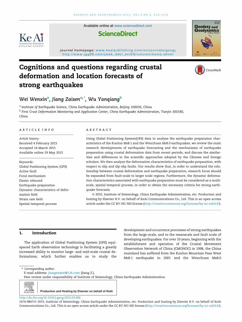
Fig. 1 e Field distribution of strai
2001 annual earthquake tendency conference, launched in
December 2000, on behalf of the CMONOC [1]. According to
Ma's report, the second shearing strain rate parameter of the
strain rate field, as computed by China mainland's GPS data
for the 1993e2000 period, shows a large-scale negative value
region inside the QinghaieTibet Plate. Most of the fracture
zone of the Kunlun Mountain Pass West Ms8.1 earthquake
that occurred on November 14, 2001 fell into the northeast
edge of the extreme value region of the large-scale negative
value region of the second shearing strain rate (Fig. 1). The
negative high value region of the second shearing strain rate
indicates a deformation rate that occurred close to the east
and west, and then revolved and sheared towards the left, or
close to the south and north, and continued to revolve and
shear toward the right in this area. This pattern accords
with that of the Kunlun Mountain Pass West Ms8.1
earthquake's East Kunlun fault zone, which was close to the
east and west, and revolved, sheared, and ruptured towards
the left. An understanding has thus been reached that
violent earthquakes may occur at the edges of high value
shearing strain rate regions, which is consistent with our
understanding of tectonic deformation. [2,3]
According to the principal strain distribution diagram of the
strain field, as calculated using GPS data, the value of the
principal stretching strain rate (i.e., the maximum principal
strain rate) that occurred in the northwest area of the Kunlun
Mountain Pass West earthquake was slightly larger than the
strain rate of the principal pressing strain rate (i.e., the mini-
mumprincipal strain rate) in thenorthandeast. Inotherwords,
this earthquake occurred in a region inwhich the surface strain
rate was slightly stretching. [4] This crustal deformation
characteristic would have been beneficial for the full release
of the strain close to the east and west, and its revolving and
rupture toward the left during the process of the violent
earthquake, This contributes to our understanding of the
phenomenon that suggests that the rupture scale of this
Ms8.0 earthquake was obviously too long (reaching a length of
426 km) and the strength of the aftershock was relatively
lower (no earthquake with a magnitude of more than 6.0).
We processed the basic network data (81 stations) of the
CMONOC, and adopted changes in the 1998e2006 base line
n rate in Midwestern China.
g e o d e s y and g e o d yn am i c s 2 0 1 5 , v o l 6 n o 3 , 2 1 0e2 1 9212
formed by all the simultaneous observation stations, based on
whether or not a change was consistent with the associated
influence of the revolving and rupture toward the left of the
violent earthquake, after the 2001 Kunlun Mountain Pass West
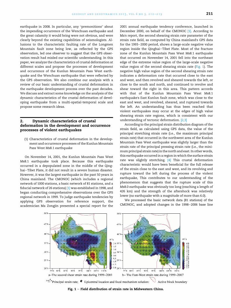
Ms8.1 earthquake. We then analyzed the Kunlun Mountain
PassWestMs8.1 earthquake and its scope of influence (see area
encircled by the bold green line in Fig. 2, which is in the Report
on Large Situation Tracking and Tendency Prediction Study of
Earthquakes in Chinese Mainland in 2007e2009 by the 2007
Annual Earthquake Tendency Conference), which shows the
large scope of the GPS station distribution of the response to
the influence of this violent earthquake process. Our analysis
also showed that obvious changes influenced by the Kunlun
Mountain Pass West earthquake occurred at many stations
inside the borders of the SichuaneYunnan Plate, while its
influence is not obvious at the JB34 station, situated at the
eastern area of the Banyan Kara Ulla Plate close to the
Longman Mountain fault zone (at a distance of about 130 km).
The base station in the crustal movement continuous
observationnetworknearest to the fracture zoneof theKunlun
MountainPassWestearthquake is theDLHAstation (Fig. 2). It is
300 kmaway from the eastern side of the fracture zone and the
perpendicular distance between it and the fracture zone in
which earthquake occurred is about 200 km. We used data
from the DLHA and the LHAS stations, and the XIAA and the
LUZH stations, which are relatively near to the fracture zone
of the 2001 Kunlun Mountain Pass West Ms8.1 earthquake, to
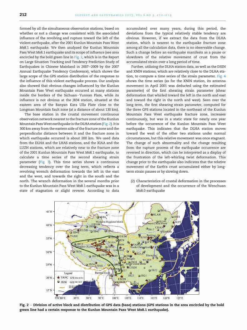
calculate a time series of the second shearing strain
parameter (Fig. 3). This time series shows a continuous
decreasing tendency over the long term, which reflects a
revolving wrench deformation towards the left in the east
and the west, and towards the right in the south and the
north. The wrench deformation in the several months prior
to the Kunlun Mountain Pass West Ms8.1 earthquake was in a
state of stagnation or slight reverse. According to data
Fig. 2 e Division of active block and distribution of GPS data (ba
green line had a certain response to the Kunlun Mountain Pass
accumulated over many years, during this period, the
deviations from the typical relatively stable tendency are
obvious. However, if we extract the data from the DLHA
station, which is nearest to the earthquake fracture zone
among all the calculation data, there is no observable change.
Such a change before an earthquake manifests as a pause or
slowdown of the relative movement of crust from the
accumulated strain over a long period of time.
Further, utilizing the DLHA station data, as well as the DXIN
and XNIN stations, which are relatively close to the DLHA sta-
tion, to compute a time series of the strain parameter. Fig. 4
shows the time series (as for the XNIN station, its antenna
movement in April 2001 was deducted using the estimated
parameter) of the first shearing strain parameter (shear
deformation that whirled toward the left in the north and east
and toward the right in the north and west). Seen over the
long term, the first shearing strain parameter, computed for
the three GPS stations located in the northeast of the Kunlun
Mountain Pass West earthquake fracture zone, increases
continuously, but was in a static state for nearly one year
before the occurrence of the Kunlun Mountain Pass West
earthquake. This indicates that the DLHA station moves
toward the west of the other two stations under normal
circumstances, but this relative movement was once stagnant.
The change of such abnormality and the change resulting
from the rupture process of the earthquake occurrence are
reversed in direction, which can be interpreted as a display of
the frustration of the left-whirling twist deformation. This
change prior to the earthquake also indicates that the relative
movement of the Earth's crust accumulated either by long-
term strain pauses or by slowing down.
(2) Characteristics of crustal deformation in the processes
of development and the occurrence of the Wenchuan
Ms8.0 earthquake
se) stations (GPS stations in the area encircled by the bold
West Ms8.1 earthquake).
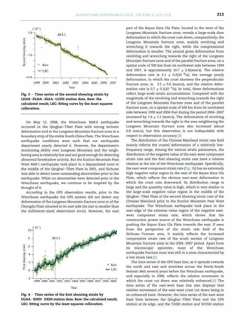
Fig. 3 e Time series of the second shearing strain by
LHASeDLHAeXIAAeLUZH station data. Raw: the
calculated result; LSC: fitting curve by the least squares
collocation.
g e o d e s y and g e o d yn am i c s 2 0 1 5 , v o l 6 n o 3 , 2 1 0e2 1 9 213
On May 12, 2008, the Wenchuan Ms8.0 earthquake
occurred in the QinghaieTibet Plate with strong tectonic
deformation and in the Longmen Mountain fracture zone in a
boundary strip of the stable South China Plate. TheWenchuan
earthquake conditions were such that our earthquake
department nearly detected it. However, the department'smonitoring ability over Longmen Mountain and the neigh-
boring area is relatively low and not good enough for detecting
abnormal foreshadow activity. But the Kunlun Mountain Pass
West Ms8.1 earthquake took place in a depopulated zone in
the middle of the QinghaieTibet Plate in 2001, and Sichuan
was able to detect some outstanding abnormities prior to the
earthquake. While no abnormities were detected prior to the
Wenchuan earthquake, we continue to be inspired by the
thought of it.
According to the GPS observation results, prior to the
Wenchuan earthquake the GPS system did not detect any
deformation of the LongmenMountain fracture zone or of the
Chengdu Plain situated at its east side (its size is smaller than
the millimeter-sized observation error). However, the east
Fig. 4 e Time series of the first shearing strain by
DLHAeXNINeDXIN station data. Raw: the calculated result;
LSC: fitting curve by the least squares collocation.
part of the Bayan Kara Ula Plate, located in the west of the
Longmen Mountain fracture zone, reveals a large-scale slow
deformation in which the crust cuts down, comparatively, the
Longmen Mountain fracture zone, mainly revolving and
wrenching it towards the right, while the compressional
deformation is smaller. The annual gross deformation from
revolving and wrenching towards the right of the Longmen
Mountain fracture zone and of the parallel fracture zone, on a
spatial scale of 500 km from its northwest side between 1999
and 2007, is approximately 10.7 ± 0.8(mm/a). The relative
deformation rate is 2.1 ± 0.2(10�8/a), the average yearly
deformation, in which the crust shortens the perpendicular
fracture zone, is �3.5 ± 0.6 (mm/a), and the relative defor-
mation rate is 0.7 ± 0.1(10�8/a). In total, these deformations
reflect large-scale strain accumulations. Compared with the
magnitude of the revolving and wrenching towards the right
of the Longmen Mountain fracture zone and of the parallel
fracture zone, on a spatial scale of 500 km from its northwest
side between 1999 and 2004 that during the period 2004e2007
increased by 1.6 ± 1.5 (mm/a). The deformation of revolving
and wrenching towards the right in the area neighboring the
Longmen Mountain fracture zone also increased (about
0.8 mm/a), but this observation is not indisputable with
respect to observation accuracy.[5]
The distribution of the Chinese Mainland strain rate field
mainly reflects the crustal deformation of a relatively low-
frequency range, Among the various strain parameters, the
distribution of the negative value of the east-west component
strain rate and the first shearing strain rate have a relative
relation at the site of the Wenchuan earthquake. Specifically,
the east-west component strain rate (Fig. 1b) has an extremely
high negative value region in the east of the Bayan Kara Ula
Plate, which reflects the obvious east-west deformation in
which the crust cuts downward. Its distribution range is
large and the quantity value is high, which is very similar to
the large-scale negative value region in the middle of the
QinghaieTibet Plate of the second shearing strain rate of the
Chinese Mainland prior to the Kunlun Mountain Pass West
earthquake. The Wenchuan earthquake took place in the
east edge of the extreme value region of the negative east-
west component strain rate, which shows that the
construction power source of the Wenchuan earthquake is
pushing the Bayan Kara Ula Plate towards the east. If seen
from the perspective of the strain rate field of the
SichuaneYunnan area, it mainly reflects the increased
compressive strain rate of the south section of Longmen
Mountain fracture zone in the 2004e2007 period. Apart from
its microscopic epicenter, most of the Wenchuan
earthquake fracture zone was still in a zone characterized by
a low strain rate.[5]
The time series of the GPS base line, as it spreads towards
the north and east and stretches across the North-South
Seismic Belt several years before the Wenchuan earthquake,
and especially in 2006, reflects the relative movement in
which the crust cut down was relatively enhanced.[5] The
time series of the east-west base line also displays that
relative movement of the east-west crust cut down being in
an enhanced state. However, the time series of the east-west
base lines between the QinghaieTibet Plate and the GPS
station at its edge, and the TASH station and WUSH station
g e o d e s y and g e o d yn am i c s 2 0 1 5 , v o l 6 n o 3 , 2 1 0e2 1 9214
in Xinjiang, show a stretching exchange that was basically
synchronous with the base line shortening of the North-
South Seismic Belt. This indicates that the change in the
enhanced shortening of the north-east and east-west base
lines, as composed by the GPS base stations, was not caused
by error influencing the scale factor in the GPS resolution,
but may reflect a change in the relatively large-scale relative
movement of the crust. This is because the enhancement of
the relative movement of this crust shortening of the North-
South Seismic Belt is fundamentally consistent with the
relative crustal movement due to long-term strain
accumulation in the North-South Seismic Belt. It reflects,
from the large-scale crustal movement that the relative
movement of regional crust was enhanced prior to the
Wenchuan earthquake. But the continuous observation data
of the GPS base stations did not obtain the crustal
deformation or the background of the long-term strain
accumulation, similar to that of the Kunlun Mountain Pass
West earthquake (as shown in Figs. 3 and 4), or the change
(or slowdown or pause), which was the reverse of the
relative movement of earthquake rupture. Although the
LUZH station, which is nearest to the Wenchuan earthquake
fracture zone, is only 300 km from the Longmen Mountain
fracture zone, the above-mentioned characteristics were not
observed. This maybe because this station is situated in the
interior area of the stable South China block.
According to the crustal deformation characteristics of the
Longmen Mountain fracture zone and its neighboring area
prior to the Wenchuan earthquake, as shown by the GPS
observation data, in addition to the low movement frequency
of the Longmen Mountain fracture zone, and the low strain
accumulation rate, some problems are worthy of consider-
ation. For example, the crustal deformation observed by the
GPS data prior to the earthquake is non-corresponding with
co-seismic crustal deformation. The elastic strain released by
an earthquake is elastic strain that has accumulated for a long
time prior to the earthquake. Therefore, generally, the defor-
mation characteristics prior to a violent earthquake and those
of co-seismic deformation when an earthquake occurs
include reverse or complementary characteristics, which are
very different from each other. Co-seismic deformation
faulting is staggered while the faulting during strain accu-
mulation prior to an earthquake is a continuous deformation,
and is also thought to convey the deformation field of a
developing earthquake.[3,6] The non-correspondence be-
tween the crustal deformation prior to the Wenchuan earth-
quake and the co-seismic displacement is mainly reflected in
this way: co-seismic displacement basically accords with the
presentation of damping in the power function with the
displacement of distance leaving the fracture zone. This is
most obvious in the neighborhood of the fracture zone in
which an earthquake occurs. The crustal deformation in the
neighborhood of the LongmenMountain fracture zone prior to
the earthquake was extremely imperceptible, and obvious
deformation occurred inside the Bayan Kara Ula Plate. The co-
seismic displacement shows that one side of the Sichuan
Basin, located in the east side of the Longmen Mountain
fracture zone, also shows deformation released upon
compressive strain, which accords with elastic resilience.
Compressive strain accumulation, however, has not been
observed prior to an earthquake. Co-seismic displacement
mainly occurs in deformation released from compressive
strain when the crust on two sides of a fracture zone
stretches. The large-scale deformation in the east of the Bayan
Kara Ula Plate, located in the northwest side of the Longmen
Mountain fracture zone, which was observed prior to the
earthquake, primarily parallels the deformation of revolving
and shearing towards the right side of the LongmenMountain
fracture zone as the principal stress. This observation likely
indicates that the crustal deformation of the Longmen
Mountain fracture zone and its neighboring area over the
most recent ten years, as observed by the GPS prior to the
Wenchuan earthquake, has been in an abnormal condition
that differs from the condition of crustal deformation accu-
mulated by long-term strain. In other words, the obviously
low strain rate of the fracture zone and its neighboring area
may be characteristic of the last phase of development of a
violent earthquake.
3. Relevant knowledge of crustaldeformation reflecting earthquake preparation
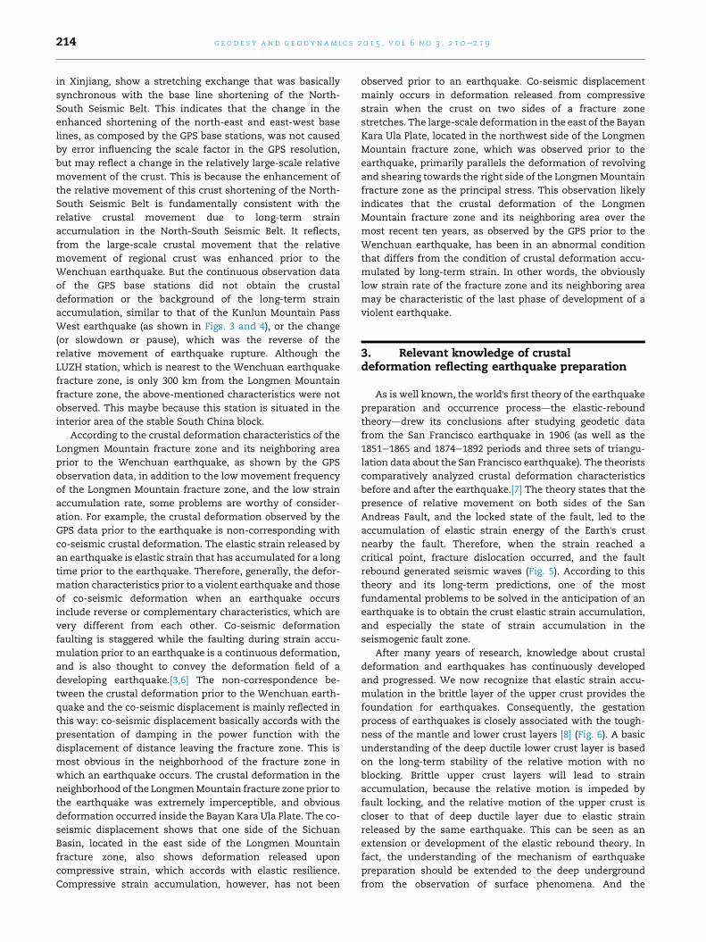
As is well known, the world's first theory of the earthquake
preparation and occurrence processdthe elastic-rebound
theoryddrew its conclusions after studying geodetic data
from the San Francisco earthquake in 1906 (as well as the
1851e1865 and 1874e1892 periods and three sets of triangu-
lation data about the San Francisco earthquake). The theorists
comparatively analyzed crustal deformation characteristics
before and after the earthquake.[7] The theory states that the
presence of relative movement on both sides of the San
Andreas Fault, and the locked state of the fault, led to the
accumulation of elastic strain energy of the Earth's crust
nearby the fault. Therefore, when the strain reached a
critical point, fracture dislocation occurred, and the fault
rebound generated seismic waves (Fig. 5). According to this
theory and its long-term predictions, one of the most
fundamental problems to be solved in the anticipation of an
earthquake is to obtain the crust elastic strain accumulation,
and especially the state of strain accumulation in the
seismogenic fault zone.
After many years of research, knowledge about crustal
deformation and earthquakes has continuously developed
and progressed. We now recognize that elastic strain accu-
mulation in the brittle layer of the upper crust provides the
foundation for earthquakes. Consequently, the gestation
process of earthquakes is closely associated with the tough-
ness of the mantle and lower crust layers [8] (Fig. 6). A basic
understanding of the deep ductile lower crust layer is based
on the long-term stability of the relative motion with no
blocking. Brittle upper crust layers will lead to strain
accumulation, because the relative motion is impeded by
fault locking, and the relative motion of the upper crust is
closer to that of deep ductile layer due to elastic strain
released by the same earthquake. This can be seen as an
extension or development of the elastic rebound theory. In
fact, the understanding of the mechanism of earthquake
preparation should be extended to the deep underground
from the observation of surface phenomena. And the
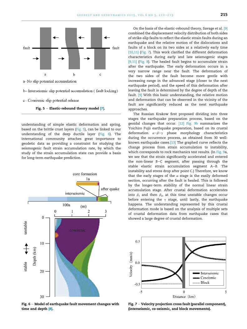
Fig. 5 e Elastic-rebound theory model [7].
g e o d e s y and g e o d yn am i c s 2 0 1 5 , v o l 6 n o 3 , 2 1 0e2 1 9 215
understanding of simple elastic deformation and spring,
based on the brittle crust layers (Fig. 5), can be linked to our
understanding of the deep ductile layer (Fig. 6). The
international community attaches great importance to
geodetic data as providing a constraint for studying the
seismogenic fault strain accumulation rate, by which the
study of the strain accumulation state can provide a basis
for long-term earthquake prediction.
Fig. 6 e Model of earthquake fault movement changes with
time and depth [8].
On the basis of the elastic-rebound theory, Savage et al. [9]
combined the displacement velocity distribution of both sides
of strike-slip faults to reflect the elastic strain faults during an
earthquake and the relative motion of the dislocations and
faults of a block on its two sides at a relatively early time
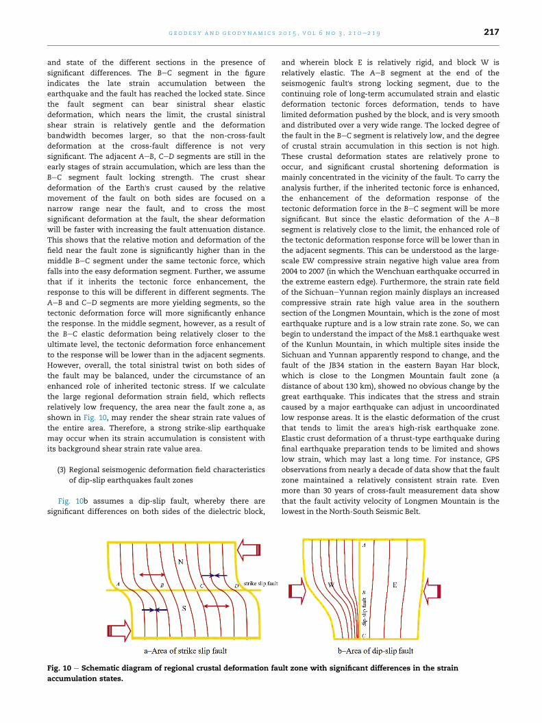
[10,11] (Fig. 7). This work clarified the different deformation
characteristics during early and late seismogenic stages
[9,11] (Fig. 8). The healed fault begins to accumulate strain
after the earthquake. The early deformation occurs in a
very narrow range near the fault. The deformation of
the two sides of the fault become more gentle with
increasing range in the advanced stage (closer to the next
earthquake period), and the speed of this deformation after
leaving the fault is determined by the degree of depth of the
fault. [9] With this basic understanding, the relative motion
and deformation that can be observed in the vicinity of the
fault are significantly reduced as the next earthquake
approaches.
The Russian Krakow first proposed dividing into three
stages the earthquake preparation process, based on the
geoidal changes that occur. [12] Fig. 9b summarizes the
Yoichiro Fujii earthquake preparation, based on its crustal
deformation aebeg phase morphology characteristics
during the occurrence process, as obtained from 30 well-
known earthquake cases.[13] The graphed curve reflects the
change process from strain accumulation to instability,
which corresponds to rock mechanics test results. (In Fig. 9a,
we see that the strain significantly accelerated and entered
the non-linear BeC segment, after passing through the
stable elastic strain accumulation segment AeB. The
instability and stress drop after point C.) Therefore, we know
that the early stages of the a stage is the easily deformed
section, occurring after the fault is healed. This is followed
by the longer-term stability of the normal linear strain
accumulation stage. After crustal deformation accelerates
into b1 and then b2, at this time unstable changes occur
before entering the g stage, until lastly, the earthquake
happens. The understanding represented by this crustal
deformation mode is based on the analysis of multiple sets
of crustal deformation data from earthquake cases that
showed a large degree of crustal deformation.
Fig. 7 e Velocity projection cross fault (parallel component),
(interseismic, co-seismic, and block movements).
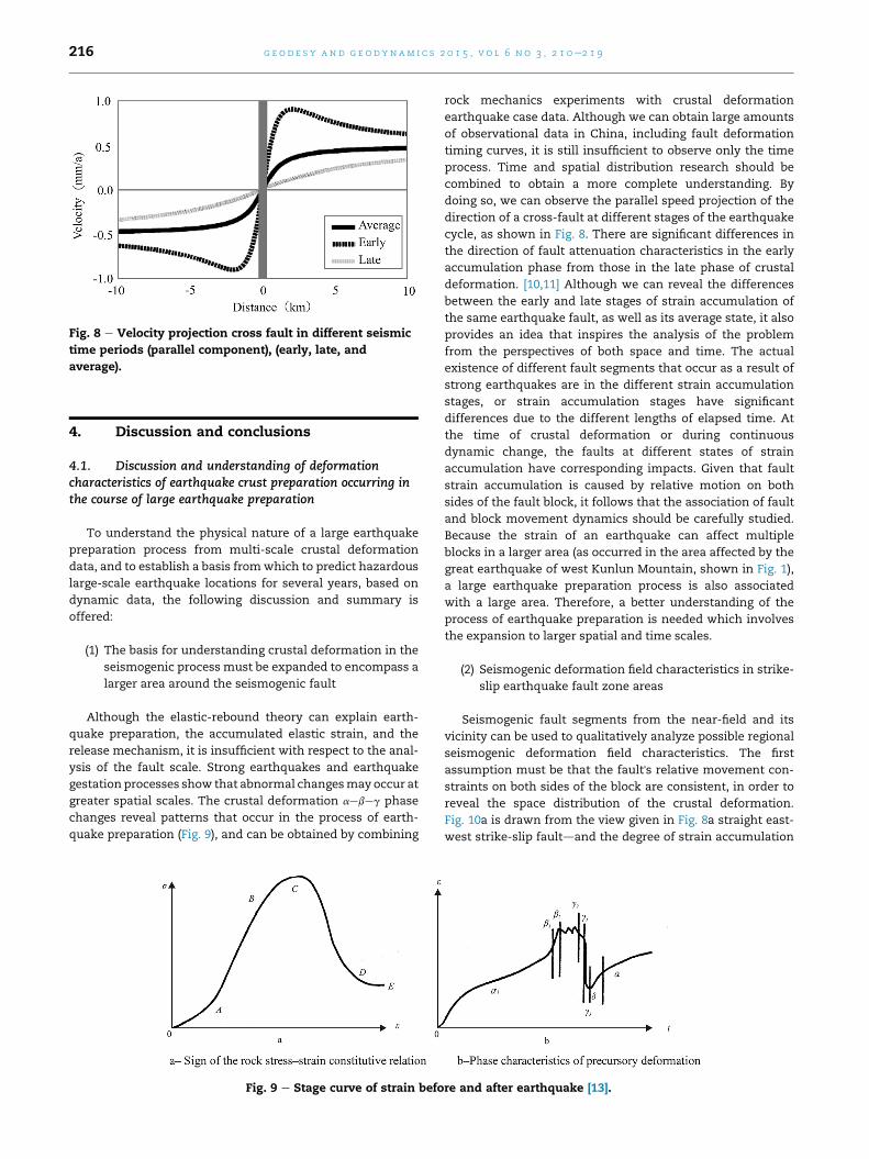
Fig. 8 e Velocity projection cross fault in different seismic
time periods (parallel component), (early, late, and
average).
g e o d e s y and g e o d yn am i c s 2 0 1 5 , v o l 6 n o 3 , 2 1 0e2 1 9216
4. Discussion and conclusions
4.1. Discussion and understanding of deformationcharacteristics of earthquake crust preparation occurring inthe course of large earthquake preparation
To understand the physical nature of a large earthquake
preparation process from multi-scale crustal deformation
data, and to establish a basis fromwhich to predict hazardous
large-scale earthquake locations for several years, based on
dynamic data, the following discussion and summary is
offered:
(1) The basis for understanding crustal deformation in the
seismogenic process must be expanded to encompass a
larger area around the seismogenic fault
Although the elastic-rebound theory can explain earth-
quake preparation, the accumulated elastic strain, and the
release mechanism, it is insufficient with respect to the anal-
ysis of the fault scale. Strong earthquakes and earthquake
gestation processes show that abnormal changesmay occur at
greater spatial scales. The crustal deformation aebeg phase
changes reveal patterns that occur in the process of earth-
quake preparation (Fig. 9), and can be obtained by combining
Fig. 9 e Stage curve of strain befo
rock mechanics experiments with crustal deformation
earthquake case data. Although we can obtain large amounts
of observational data in China, including fault deformation
timing curves, it is still insufficient to observe only the time
process. Time and spatial distribution research should be
combined to obtain a more complete understanding. By
doing so, we can observe the parallel speed projection of the
direction of a cross-fault at different stages of the earthquake
cycle, as shown in Fig. 8. There are significant differences in
the direction of fault attenuation characteristics in the early
accumulation phase from those in the late phase of crustal
deformation. [10,11] Although we can reveal the differences
between the early and late stages of strain accumulation of
the same earthquake fault, as well as its average state, it also
provides an idea that inspires the analysis of the problem
from the perspectives of both space and time. The actual
existence of different fault segments that occur as a result of
strong earthquakes are in the different strain accumulation
stages, or strain accumulation stages have significant
differences due to the different lengths of elapsed time. At
the time of crustal deformation or during continuous
dynamic change, the faults at different states of strain
accumulation have corresponding impacts. Given that fault
strain accumulation is caused by relative motion on both
sides of the fault block, it follows that the association of fault
and block movement dynamics should be carefully studied.
Because the strain of an earthquake can affect multiple
blocks in a larger area (as occurred in the area affected by the
great earthquake of west Kunlun Mountain, shown in Fig. 1),
a large earthquake preparation process is also associated
with a large area. Therefore, a better understanding of the
process of earthquake preparation is needed which involves
the expansion to larger spatial and time scales.
(2) Seismogenic deformation field characteristics in strike-
slip earthquake fault zone areas
Seismogenic fault segments from the near-field and its
vicinity can be used to qualitatively analyze possible regional
seismogenic deformation field characteristics. The first
assumption must be that the fault's relative movement con-
straints on both sides of the block are consistent, in order to
reveal the space distribution of the crustal deformation.
Fig. 10a is drawn from the view given in Fig. 8a straight east-
west strike-slip faultdand the degree of strain accumulation
re and after earthquake [13].
g e o d e s y and g e o d yn am i c s 2 0 1 5 , v o l 6 n o 3 , 2 1 0e2 1 9 217
and state of the different sections in the presence of
significant differences. The BeC segment in the figure
indicates the late strain accumulation between the
earthquake and the fault has reached the locked state. Since
the fault segment can bear sinistral shear elastic
deformation, which nears the limit, the crustal sinistral
shear strain is relatively gentle and the deformation
bandwidth becomes larger, so that the non-cross-fault
deformation at the cross-fault difference is not very
significant. The adjacent AeB, CeD segments are still in the
early stages of strain accumulation, which are less than the
BeC segment fault locking strength. The crust shear
deformation of the Earth's crust caused by the relative
movement of the fault on both sides are focused on a
narrow range near the fault, and to cross the most
significant deformation at the fault, the shear deformation
will be faster with increasing the fault attenuation distance.
This shows that the relative motion and deformation of the
field near the fault zone is significantly higher than in the
middle BeC segment under the same tectonic force, which
falls into the easy deformation segment. Further, we assume
that if it inherits the tectonic force enhancement, the
response to this will be different in different segments. The
AeB and CeD segments are more yielding segments, so the
tectonic deformation force will more significantly enhance
the response. In the middle segment, however, as a result of
the BeC elastic deformation being relatively closer to the
ultimate level, the tectonic deformation force enhancement
to the response will be lower than in the adjacent segments.
However, overall, the total sinistral twist on both sides of
the fault may be balanced, under the circumstance of an
enhanced role of inherited tectonic stress. If we calculate
the large regional deformation strain field, which reflects
relatively low frequency, the area near the fault zone a, as
shown in Fig. 10, may render the shear strain rate values of
the entire area. Therefore, a strong strike-slip earthquake
may occur when its strain accumulation is consistent with
its background shear strain rate value area.
(3) Regional seismogenic deformation field characteristics
of dip-slip earthquakes fault zones
Fig. 10b assumes a dip-slip fault, whereby there are
significant differences on both sides of the dielectric block,
Fig. 10 e Schematic diagram of regional crustal deformation fau
accumulation states.
and wherein block E is relatively rigid, and block W is
relatively elastic. The AeB segment at the end of the
seismogenic fault's strong locking segment, due to the
continuing role of long-term accumulated strain and elastic
deformation tectonic forces deformation, tends to have
limited deformation pushed by the block, and is very smooth
and distributed over a very wide range. The locked degree of
the fault in the BeC segment is relatively low, and the degree
of crustal strain accumulation in this section is not high.
These crustal deformation states are relatively prone to
occur, and significant crustal shortening deformation is
mainly concentrated in the vicinity of the fault. To carry the
analysis further, if the inherited tectonic force is enhanced,
the enhancement of the deformation response of the
tectonic deformation force in the BeC segment will be more
significant. But since the elastic deformation of the AeB
segment is relatively close to the limit, the enhanced role of
the tectonic deformation response force will be lower than in
the adjacent segments. This can be understood as the large-
scale EW compressive strain negative high value area from
2004 to 2007 (in which the Wenchuan earthquake occurred in
the extreme eastern edge). Furthermore, the strain rate field
of the SichuaneYunnan region mainly displays an increased
compressive strain rate high value area in the southern
section of the Longmen Mountain, which is the zone of most
earthquake rupture and is a low strain rate zone. So, we can
begin to understand the impact of the Ms8.1 earthquake west
of the Kunlun Mountain, in which multiple sites inside the
Sichuan and Yunnan apparently respond to change, and the
fault of the JB34 station in the eastern Bayan Har block,
which is close to the Longmen Mountain fault zone (a
distance of about 130 km), showed no obvious change by the
great earthquake. This indicates that the stress and strain
caused by a major earthquake can adjust in uncoordinated
low response areas. It is the elastic deformation of the crust
that tends to limit the area's high-risk earthquake zone.
Elastic crust deformation of a thrust-type earthquake during
final earthquake preparation tends to be limited and shows
low strain, which may last a long time. For instance, GPS
observations from nearly a decade of data show that the fault
zone maintained a relatively consistent strain rate. Even
more than 30 years of cross-fault measurement data show
that the fault activity velocity of Longmen Mountain is the
lowest in the North-South Seismic Belt.
lt zone with significant differences in the strain
g e o d e s y and g e o d yn am i c s 2 0 1 5 , v o l 6 n o 3 , 2 1 0e2 1 9218
(4) Understanding seismogenic deformation dynamics of
strong earthquakes from the multi-scale spatial and
temporal processes
The relative motion and deformation characteristics to the
west of the Ms8.1 Kunlun Mountain and Ms8.0 Wenchuan
earthquakes, as reflected by current GPS observations data,
showing high-risk of crustal deformation rates or low-risk
issues can be understood with a basic answer: seismogenic
fault segments and their vicinities in late approaching earth-
quake seismogenic crustal deformation periods reflect a
weakening trend of strain accumulation several years before
the big earthquake. This is consistent with the long-term
strain accumulation, whose relatively large-scale crustal
deformation may increase, but the crustal deformation of
certain earthquake fault zone areas may enhance uniformly.
(a) Seismogenic fault segments and their local areas, or the
relatively small-scale crustal deformation of a greater
earthquake may slow down, or remain in a low crustal
deformation state. This may involve a relatively long
and slow process. In the dip-slip fault accumulation of
the elastic strain of an extrusion, in particular, in which
this phenomenon will be more prominent, it may
involve longer time scales. Furthermore, at times much
closer to an earthquake occurrence, the range of slowed
strain accumulation of crustal deformation may
expand.
(b) Relatively large-scale crustal deformation, which is
consistent with the strain accumulation of a few years
or long-term before great earthquakes, may increase.
This will occur at a relatively large-scale, which means
the scalesmuch greater than that of the rupture zone as
shown in the situation to the west of the Kunlun
Mountain and Wenchuan earthquakes. Regarding the
general physical mechanisms of continuous deforma-
tion caused by the long-lasting effects of crust tectonic
forces, seismogenic faults are also in an enclosed
pressure environment. Hence, when the strain accu-
mulation and elastic deformation tend to be limited, or
in a critical state, if it continues to strengthen an
earthquake may occur, or it is possible to delay earth-
quakes for weakening.
(c) The crustal deformation non-uniformity of certain
areas associated with seismogenic fault segments may
be enhanced. Of the existing observation data, only the
current GPS data can observe this phenomenon in front
of the earthquake fault zone of the Wenchuan earth-
quake and Longmen Mountain. The local compressive
strain at the Longmen Mountain from 2004 to 2007 was
significantly enhanced, and most of the earthquake
rupture zone of the Wenchuan earthquake was under a
low strain state. However, from the analysis of the
physical mechanism, due to the tectonic force effect
enhancing the relatively large-scale structure, and the
different strain accumulations from the different
stages, some belong to the easily deformed sections
between the earlier stages of earthquake fault seg-
ments. The elastic deformation of a fault tended to be
limited. The enhancement of a relatively large-scale
tectonic force shows a significantly different response,
resulting in a certain region of enhanced crustal defor-
mation non-uniformity. As proposed by Zhou, the sci-
entific thinking from a system image dynamics
perspective, namely the whole space distribution of
crustal deformation of the earthquake preparation
process reflects a system evolution that has proceeded
as follows: “quasi-uniform /inhomogeneous, earth-
quakes /quasi-uniform.” [14]
Huge earthquake rupture events are more prominent, and
reflect more prominent seismogenic features. Despite the
Mar.11 2011 Ms9.0 earthquake in Japan being located in a sub-
duction zone 150 km away from land, due to its large magni-
tude, the GPS data station on land was able to observe certain
characteristics. From this huge earthquake a few years ago, the
continuous GPS observation time series shows the relative
motion of crustal shortening west and east of the area of large-
scale enhancement (the 2010, 2011 annual reports of the Na-
tional Research earthquake situation report that the westward
subduction of the Pacific Plate is being continuously enhanced,
as observed from 2006). The rupture zone near the regional
scale earthquake is observed to be slowing down, and the
subduction zone of the entire Japan Trench shows enhance-
ment, with flat, slow, segment difference variations fromnorth
to south, [15] which also supports the above perspective.
4.2. Study on dynamic processes and prediction criteriaof strong earthquakes from the large spatial and temporaltectonic forces dynamics process
The development of the capacity for crustal deformation
observation, especially the introduction of the GPS Earth
observation technology from space, has allowed the study of
the gestation of earthquakes by looking at the larger spatial
and temporal scales of crustal movement and deformation. In
the key project study of the “Eleventh Five-Year Plan,” the
National Technology Support Program of the “strong earth-
quake prediction research dynamic motion picture,” a large
regional research-based power structure has been proposed to
understand the dynamic processes of large regional tectonic
forces, to extract useful information to better predict earth-
quakes. China mainland has many seismogenic tectonic
zones where strong earthquakes may occur, and there are
thousands of other potentially strong sources. The last
earthquake predicted to lock the elastic strain accumulation
tended to lock the dangerous seismogenic tectonic zone sec-
tions where the elastic strain accumulation entered the
nonlinear deformation stage. Under the dynamic effects of
boundary action, the dynamic field of large regional changes,
and some relative local areas that are enhancing strain-
concentrated areas, there are some regions in stressestrain
mitigation areas that are under stressestrain enhancement.
Seismogenic zones with a centralized structure, especially
those in which high levels of stress and strain have already
accumulated and are tending to reach the limits of elastic
deformation, the seismic hazards of these seismogenic zones
have been further enhanced. The changes in the nonlinear
instabilities of these seismogenic zones should be captured.
Closely combining tectonic settings, according to border force
g e o d e s y and g e o d yn am i c s 2 0 1 5 , v o l 6 n o 3 , 2 1 0e2 1 9 219
analysis and the multidisciplinary field of multi-scale dy-
namics, could facilitate the determination of the stressestrain
accumulation enhancement in concentrated areas. By better
understanding the gradually locking of strong earthquake
high-risk segments in seismogenic zones, we can predict the
risk associated with the locked segments based on the short-
term dynamics information. The study of crustal movement
and deformation, based on GPS data, to determine the future
location of strong earthquakes, offers more specific criteria to
determine strong earthquake risk from the different spatial
and temporal scales of crustal movement and deformation
dynamics.
Strong earthquake prediction includes low to medium-
term (several years scale) prediction levels, and the number of
years required for predicting hazardous areas of strong
earthquake risk is also an important environmental
constraint in earthquake prediction. If we can do better in this
respect, by being able to identify dangerous strong earthquake
areas a few years in advance, a clear objective emerges to
strengthen our tracking and monitoring activities for short-
term prediction. Medium-term forecasting of strong earth-
quakes still has many scientific problems to be solved. The
basic problem in solving earthquake prediction is, first, to
make progress in correctly understanding the physical pro-
cesses occurring in earthquake preparation systems, and,
second, to be able to use certain models using a variety of
observation techniques to obtain information and parameters
that reflect the seismogenic process. To achieve a more
comprehensive and in-depth understanding, the Earth sur-
face must be linked with its deep regions for a comprehensive
study of the tectonic dynamics process.
Acknowledgements
The paper was sponsored by the National Science and
Technology Support Program (2012BAK19B01) and the Na-
tional Natural Science Fund (41274008).
r e f e r e n c e s
[1] Ma Zongjin, Chen Xinlian, Ye Shuhua, Lai Xian, Wei Ziqing,Chen Junyong, et al. GPS study of current crustal movementof China Mainland. Chinese Sci Bull 2001;46(13):1118e20.5307.
[2] Jiang Zaisen, Ma Zongjin, Zhang Xi, Wang Qi,Wang Shuangxu. Horizontal strain field and tectonicdeformation of China mainland revealed by preliminary GPSresult. Chinese J Geophys 2003;46(3):352e8 [in Chinese].
[3] Jiang Zaisen, Yang Guohua, Wang Min, Zhang Xi, Wu Yun,Fang Ying, et al. On crustal movement in China continentand its relationship with strong earthquakes. J GeodesyGeodyn 2006;26(3):1e9.
[4] Jiang Zaisen, Zhang Xi, Zhu Yiqing, Zhang Xiaoliang,Wang Shuangxu. Regional tectonic deformation backgroundbefore the Ms8. 1 earthquake in the west of the Kun lunMountains Pass. Sci China (Series D) 2003;33(Supp.):163e72.
[5] Jiang Zaisen, Fang Ying, Wu Yanqiang, Wang Min, Du Fang,Ping Jianjun. The dynamic process of regional crustalmovement and deformation before Wenchuan Ms8.0earthquake. Chinese J Geophys 2009;52(2):505e18 [inChinese].
[6] Jiang Zaisen, Yang Liming, Chen Hong. Study on the physicalfoundation and its application of new technology aboutStrong earthquake prediction. Beijing: Seismological Press;2008.
[7] Reid HF. The mechanics of the earthquake, the Californiaearthquake of April 18, 1906, report of the State InvestigationCommission, vol. 2. Washington DC: Carnegie Institution ofWashington; 1910. p. 16e28.
[8] Scholz CH. Earthquakes and friction laws. Nature1998;391:37e42.
[9] Savage JC, Burford RO. Geodetic determination of relativeplate motion in central California. Geophys Res1973a;78:832e45.
[10] Savage JC, Prescott WH. Precision of Geodolit distancemeasurements for determining fault movements. J GeophysRes 1973b;78:6001e8.
[11] Brendan J Meade, Bradford H Hager. Block models of crustalmotion in southern California constrained by GPSmeasurements. J Geophys Res 2005;110:B03403. http://dx.doi.org/10.1029/2004JB003209.
[12] Rikitake Tsuneji. Translation. In: Feng R, Zhou XH, editors.Earthquake prediction. Beijing: Seismological Press; 1978.
[13] Zhou Shuoyu. What is the nature of earthquake prediction? JSeismol 1993;1:39e43.
[14] Shuoyu Zhou, Shirong Mei, Shunying Shi. Research on thereproducibility of earthquake precursors, papers on the sixthannual meeting of the seismological society of China.Beijing: Seismological Press; 1996.
[15] Chen Guangqi, Wu Yanqiang, Jiang Zaisen, Liu Xiaoxia,Zhao Jing. Characteristics of seismogenic model of Mw9.0earthquake in Tohoku, Japan reflected by GPS data. Chinese JGeophys 2013;56(3):848e56 [in Chinese].
Jiang Zaisen, doctoral supervisor. He is aresearcher at Institute of Geology, ChinaEarthquake Administration. His researchfocuses on application of geodesy and geo-dynamics in earthquake prediction. He iscommitted to studying the relationship be-tween background and dynamic process ofmulti-scale crustal movement, stress andstrain field and large earthquake combingwith theory and technology of geodesy andresults of tectonics and geophysics, and
studying earthquake mechanism and prediction problems from
the tectonic dynamic process.Wei Wenxin, research assistant at Instituteof Earthquake Science, China EarthquakeAdministration. He has obtained hisdoctorate in Solid Earth Physics from Insti-tute of Geology, China Earthquake Admin-istration. His major research direction isstudy on characteristics of crustal defor-mation using GPS data and geodynamicsbase on the numerical simulation method.


![Viscoelastic crustal deformation by magmatic intrusion: A ...eprints.whiterose.ac.uk/123138/1/1-s2.0-S...ACCEPTED MANUSCRIPT [ 1 ] Viscoelastic crustal deformation by magmatic intrusion:](https://img.pdfslide.us/doc/110x75/60c637d41af1fc278629f583/viscoelastic-crustal-deformation-by-magmatic-intrusion-a-accepted-manuscript.jpg)