Embed Size (px)
Citation preview

Cody Johnston Project ManagerKathleen AndrewsAssistant ManagerLogan Hayner Graphic DesignerPeter Kennedy McMinn Researcher
GeoTex

• GeoTex is currently finalizing the process of determining ADA approved slopes for ramp and non-ramp areas across Texas State’s campus.
• GeoTex has remained on schedule, and will begin the routing process next week.
INTRODUCTION

• All essential buildings on Texas State’s campus will have ADA approved routes leading to them
• GeoTex strives to create easy-to-read maps to assist all persons with disabilities in navigating the campus
PURPOSE

• TASK 1: Determine/map accessible non-ramp areas
• TASK 2: Gather ramp data, determine, and add accessible ramp areas to non-ramp map.
• TASK 3: Routing process
PURPOSE

• Blanco hall to the JC Kellam building
SCOPE

• Task 1: Route map slope data• Acquired all necessary data• Created map of existing routes• Converted LiDAR data and created high resolution
slope map• Task 2: GPS data collection• Acquired GPS device from Department of
Geography• Task 3: Verify analysis and design final map• Scheduled tasks to be completed
WORK COMPLETED

Red = Steep slopeGreen = Flat areasBlue = Existing routesLavender = Buildings
• Task 1: Route map slope data• Designing final deliverable slope map.
• Task 2: GPS data collection• Collecting point data of all curb-cut and
wheelchair ramp locations.• Collecting building interior accessibility data
(automatic doors, elevators, ramps, etc.)• Task 3: Design final deliverable route map
and verify analysis• Work has been scheduled.
WORK IN PROGRESS


• Task 2: GPS data collection• Import GPS data into ArcMap and determine slope
between each curb-cut and wheelchair ramp point collected in the field.
• Task 3: Design final route map and verify analysis• Develop routes that comply with ADA standards.• Design final deliverable route map.• Upload all deliverables to project website.
FUTURE WORK


Unable to obtain a GPS device with a high enough resolution and level of accuracy to obtain precise measurements of shallow slope areas in the field.
Original DEM data had a resolution of 10 meters. This resolution is too low for any meaningful slope analysis on campus.◦ Resolved: The group acquired and formatted
LiDAR data which now has a resolution of 6 inches.
ISSUES ENCOUNTERED

Low resolution DEM
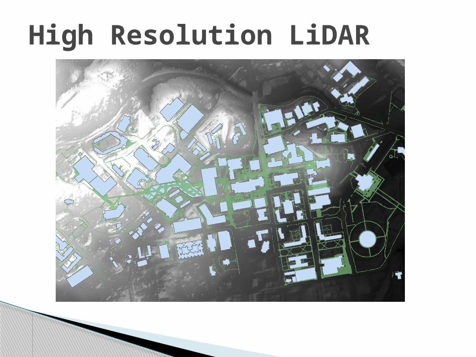
High Resolution LiDAR

Task: March 24th-30th March 31st-April 6th
April 7th-13th April 14th-20th April 21st-27th April 28th-May 4th
Progress Update
March 26th
Identification of Accessibility Gaps
Finish by: April 2nd
Formulation of Final Routes
Finish by: April 7th
Creation of Final Maps/Deliverables
Begin by: April 7th
Finish by: April 23rd
Final Presentation Preparation
Begin by: April 13th
Finish by: April 27th
Final Presentation
May 2nd
TIMETABLE The following timeline is updated from the original proposal to provide a more accurate
picture of what still needs to be accomplished and the target dates for completion.

• GeoTex will create a map of all handicap accessible routes around central campus.
• All routes will comply with the current Americans with Disabilities Act guidelines.
• Map will be made available online.
CONCLUSION