Embed Size (px)
Citation preview

COCONet PY2016-Q1 Report
1
COCONet EAR 1042906/9 Quarterly Report June 2015 - November 2015 (PY2016-Q1) SUMMARY This quarterly report covers COCONet project (EAR-1042906/EAR-1042909) activities for the time period from June 1, 2014 to November 30, 2015. COCONet is a Collaborative Research project between UNAVCO (EAR-1042906) and University Corporation for Atmospheric Research (UCAR) (EAR-1042909) awarded on September 14, 2010. The project is under the direction of M. Meghan Miller, as PI, with Co-PIs, Karl Feaux, Glen Mattioli, and Guoquan Wang. Dr. Glen Mattioli is acting as Project Director in his role as Director of Geodetic Infrastructure at UNAVCO and Dr. John Braun is the UCAR PI.
Figure 1. The current combined COCONet and TLALOCNet siting plan. Yellow dots represent the 76 completed COCONet stations (new and refurbished) and 22 completed stations from the TLALOCNet network. Red dots represent the 7 remaining, planned COCONet stations (new and refurbished) and 2 planned TLALOCNet stations. The yellow stars represent the completed, full-tide gauge locations (with 2 additional GPS sites per location). The yellow diamonds represent existing tide gauge stations where 1 GPS station will be added to constrain the motion of the pier. The existing “contributing” GPS stations (n=49), which either already or are soon to be delivering data to the COCONet archive, are shown as black dots. The four regional data centers or mirrors are shown as purple squares (Mexico - TLALOCNet, and Nicaragua, Colombia, and Barbados).

COCONet PY2016-Q1 Report
2
To date, UNAVCO engineering personnel have performed site reconnaissance at 81 locations, submitted land use permits for 81 sites, received permits for 79 sites, and currently have 76 stations installed. Key accomplishments in the last quarter were the installation of the COCONet cGPS-Met stations on Los Roques, Venezuela (CN42) and Providenciales (CN53), an island that is part of Turks and Caicos. COCONet station maintenance was also completed. A number of other planning, logistical, and data tasks were completed during the last quarter including:
• The current COCONet siting plan calls for 54 new stations, 5 new stations associated with tide gauge installations, and 24 refurbished stations, for a total of 83 new and refurbished stations, and up to 61 existing stations to be incorporated into the COCONet data archive.
• The total number of new, refurbished, or co-located stations installed to date is 76. There are 7 remaining stations to be installed as part of the COCONet siting plan.
• Maintenance work was completed at a number of stations, including: o Honduras: Receiver and met pack replacements at CN18, CN21 and ROA0. o Nicaragua: Cellular data communications installation at CN22 and router repair at
CN29. o St. Lucia: New receiver and equipment enclosure installed at CN04; antenna
repaired at CN47. o Antigua: Receiver replaced, and data communications restored at BGGY. o Montserrat: Communications overhaul along with maintenance tasks for NWBL,
GERD, TRNT, OLVN, AIRS, and RCHY (these stations were part of CALIPSO and are now being maintained through COCONet).
o Colombia: New antenna and mount installed at SAN0 on San Andres Island.
• UNAVCO currently archives 129 COCONet-designated cGPS stations. This group includes those that are new and refurbished as well as contributing stations from other networks (i.e. COCONet regional partners). The UNAVCO Data Archive Interface (DAI) now has two distinct groupings of COCONet sites: 1) COCONetCore (55), which includes all the sites that UNAVCO has installed and currently maintains; 2) COCONetRefurb (21), which includes all the existing sites operated by collaboration institutions that UNAVCO has upgraded with equipment and currently maintains; and 2) COCONetPartner (49), which includes stations that UNAVCO does not operate, but whose data have been contributed by various regional partners. We are continuingly adding stations to this group and anticipate 10 more stations from Colombia to be added by the end of the year. During this reporting period, 85.0% of all 125 stations delivered data to the DAI, including data from 96% of the COCONetCore and 88% of the COCONetRefurb stations.
• Currently, 42 COCONet stations are configured to deliver high-rate, low-latency (1 Hz, < 2 s) data streams in real-time via the Networked Transport of RTCM via Internet

COCONet PY2016-Q1 Report
3
Protocol (NTRIP). This exceeds a project goal, as outlined in the original proposal, which called for at least 10 stations to deliver high-rate, low-latency data in real-time.
• The COCONet Regional Data Centers at INETER (Nicaragua), CIMH (Barbados), and SGC (Colombia) continue to operate. The Regional Mirror Data Centers at INETER and CIMH are reporting 129 COCONet stations available for metadata queries and data downloads; the full Regional Data Center at SGC is reporting the same 129 COCONet stations plus 10 additional local stations available for metadata queries and data downloads. These 10 stations will soon be made available to the UNAVCO archive and distributed accordingly.
• Including open commitments, the COCONet expenditures are now over $5.59M through November 2015. A plan has been developed to spend the remaining funds, guided by oversight from COCONet Working Group, and focused on completing the remaining scope as per the award and supplements. In the last quarter, $212.1K was spent with $442.8K remaining in the award.
COCONet field activities this quarter are summarized in Table 1 below:
Table 1. COCONet Status: Tasks completed to date and in FY2016-Q1. Work planned for FY2016-Q2 includes: • Haiti station maintenance. • Installation of the three remaining stations in Venezuela. • Finalization of permits for two remaining Mexico stations. • Development of a plan and proposal to the NSF for a fourth and final COCONet workshop.
Cumulative Since Previous Quarter
Details From Current Quarter
Station Recons 81 All recons completed, except for two Gulf of Mexico stations.
Permits Submitted
81 Remaining: 2 Gulf of Mexico stations.
Permits Accepted
79 Remaining: 2 GPS stations in Venezuela, 2 Gulf of Mexico stations
Stations Installed New/ Refurbished
55 new 25 refurbished
2 new New: CN53, CN42
Refurbished: none last quarter
Maintenance Visits
72 15 CN18, CN21, ROA0, CN22, CN29, CN04, CN47, SAN0, BGGY, NWBL, GERD, TRNT, OLVN, AIRS, RCHY
COCONet PY2016-Q1 Report
4
OUTREACH Publications Current and former COCONet Fellows published several papers related to COCONet, including the following: Weber, J. C., H. Geirsson, J. L. Latchman, K. Shaw, P. La Femina, S. Wdowinski, M. Higgins, C. Churches, and E. Norabuena (2015), Tectonic inversion in the Caribbean-South American plate boundary: GPS Geodesy, Seismology, and Tectonics of the Mw 6.7 April 22, 1997 Tobago earthquake, Tectonics, 34, doi:10.1002/2014TC003665. (published in June 2015) Wright, V.D., Hornbach, M.J., Mchugh, C. and Mann, P. (2015) Factors Contributing to the 2005- Present, Rapid Rise in Lake Levels, Dominican Republic and Haiti (Hispaniola). Natural Resources, 6, 465-481. http://dx.doi.org/10.4236/nr.2015.68045 (came out in August 2015, but not listed in the FY2015-Q4 report) Symithe, S., E. Calais, J. B. de Chabalier, R. Robertson, and M. Higgins (2015), Current block motions and strain accumulation on active faults in the Caribbean, J. Geophys. Res. Solid Earth, 120, doi:10.1002/2014JB011779. Social Media A UNAVCO Science Snapshot was posted in September about the Symithe et al paper, “GPS Defines Caribbean Plate in Motion”, 30 September 2015 Other Outreach COCONet Fellow, Hans Lechner, will be attending the annual Fall Meeting of the American Geophysical Union, 2015. He helped to organize and is co-chairing a public affairs session on Volcanic Hazards: Translating Research and Monitoring into Improved Communication, Preparedness and Response. The session will include a presentation by his colleagues at Michigan Tech about working with emergency managers and the local community around Pacaya Volcano in Guatemala. Some of this work has been supported through a Geoscientists Without Borders grant. He has a presentation, Lechner, H.N., Waite, G.P., Escobar-Wolf, R., Lopez-Hetland, B., Elastic modeling of the Pacaya volcanic complex: a 2009-2015 campaign-GPS deformation history at the AGU meeting as well. UCAR UPDATE The UCAR/COSMIC program is participating in COCONet under support from NSF grant (EAR-1042909). UCAR/COSMIC produces continuous estimates of atmospheric precipitable
COCONet PY2016-Q1 Report
5
water vapor (PW) using a heterogeneous network of GNSS stations, including those stations that are part of COCONet. These data are produced and distributed through the Suominet (www.suominet.ucar.edu) web portal as well as with the local data management (LDM)
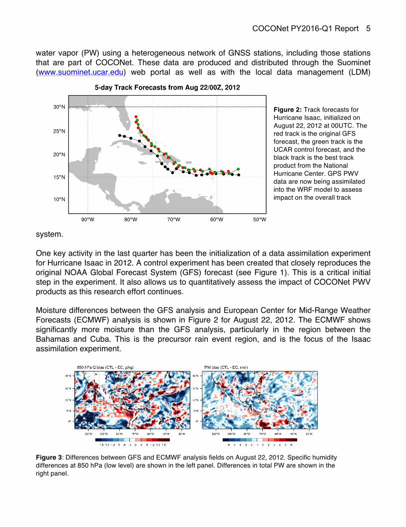
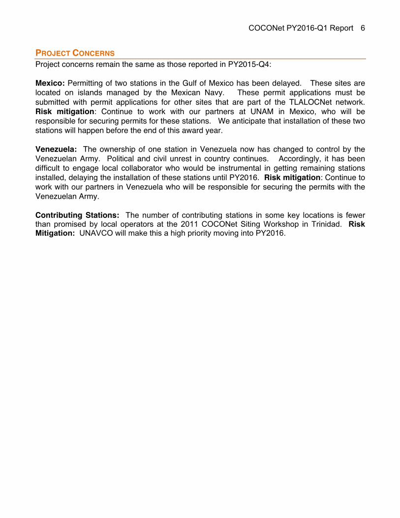
system. One key activity in the last quarter has been the initialization of a data assimilation experiment for Hurricane Isaac in 2012. A control experiment has been created that closely reproduces the original NOAA Global Forecast System (GFS) forecast (see Figure 1). This is a critical initial step in the experiment. It also allows us to quantitatively assess the impact of COCONet PWV products as this research effort continues. Moisture differences between the GFS analysis and European Center for Mid-Range Weather Forecasts (ECMWF) analysis is shown in Figure 2 for August 22, 2012. The ECMWF shows significantly more moisture than the GFS analysis, particularly in the region between the Bahamas and Cuba. This is the precursor rain event region, and is the focus of the Isaac assimilation experiment.
Figure 3: Differences between GFS and ECMWF analysis fields on August 22, 2012. Specific humidity differences at 850 hPa (low level) are shown in the left panel. Differences in total PW are shown in the right panel.
Figure 2: Track forecasts for Hurricane Isaac, initialized on August 22, 2012 at 00UTC. The red track is the original GFS forecast, the green track is the UCAR control forecast, and the black track is the best track product from the National Hurricane Center. GPS PWV data are now being assimilated into the WRF model to assess impact on the overall track forecast of the hurricane.
COCONet PY2016-Q1 Report
6
PROJECT CONCERNS Project concerns remain the same as those reported in PY2015-Q4: Mexico: Permitting of two stations in the Gulf of Mexico has been delayed. These sites are located on islands managed by the Mexican Navy. These permit applications must be submitted with permit applications for other sites that are part of the TLALOCNet network. Risk mitigation: Continue to work with our partners at UNAM in Mexico, who will be responsible for securing permits for these stations. We anticipate that installation of these two stations will happen before the end of this award year. Venezuela: The ownership of one station in Venezuela now has changed to control by the Venezuelan Army. Political and civil unrest in country continues. Accordingly, it has been difficult to engage local collaborator who would be instrumental in getting remaining stations installed, delaying the installation of these stations until PY2016. Risk mitigation: Continue to work with our partners in Venezuela who will be responsible for securing the permits with the Venezuelan Army. Contributing Stations: The number of contributing stations in some key locations is fewer than promised by local operators at the 2011 COCONet Siting Workshop in Trinidad. Risk Mitigation: UNAVCO will make this a high priority moving into PY2016.