Embed Size (px)
Citation preview
COASTLINING THE ZODIAC Astronomy books and skywatching guides offer a wide variety of charts for naked-eye observation of the skies. What works best for each person will depend on various factors such as the visual appeal of a particular format, or the ease of coordinating the map to the actual sky. These tools all have their relative advantages, but they are all misleading in one fundamental sense: they disregard the journey of the earth through the skies. The Earth in the Heavens Conventional skywatching charts are designed to show the skies from a particular latitude on earth, at certain hours, during certain seasons. They are all alike in presenting the perspective of the skies seen from earth, but they all omit the presence of the earth in the skies. In other words, they fail to indicate the annual journey taken by the earth relative to the stars. "The sky is not the atmosphere. Birds do not fly in the sky. The earth is in the sky." Patterns on the Rim The Rimsite Array shows the thirteen constellations on the path taken by the earth around the sun. This format is utterly simple: a circular projection of the three-dimensional vista of the night skies seen through the course of the year. The star-patterns shown are the naked-eye constellations, the true Stellar Zodiac, to be distinguished from the tropical (seasonal) signs of popular astrology. This model is named the Rimsite because it situates or sites the constellations on the path of the earth as if on the rim of a wheel; also, these star-patterns are sights on the rim, the earthplane. The line marked ECL is the ecliptic, the apparent path of the sun through the skies. It is actually the edge of the orbital plane of the earth. The Zodiacal star-patterns touch this line and sprawl beyond, above and below. The 13 Ecliptic constellations are distinct from the remaining 75 constellations of the celestial sphere, beyond the Ecliptic rim. The patterns of the Stellar Zodiac are irregular in shape and extent. Cruising the Coast So much for the technicalities. The rest is pure dance, beauty in motion with the planet in mind, because "coastlining" involves us directly in the way the earth moves relative to the constellations in the course of the year. Normally, being situated on the earth, we ignore its movement in the cosmos. We are like passengers on a boat who pay no attention to its motion across the waters. If there is a
coastline to observe, we may be more inclined to stay on deck and take in the passing sights. This analogy fits the actual case for the earth, the cosmic vessel on which we sail, the mother ship. The starry shoreline is irregular, as the Rimsite model shows. Moment after moment, some part of the coastline is more clearly observable as the earth glides past it. Proximity draws our attention to the details of the coast — that is, the features of the constellation we are gliding past. Further up and down the coast, the sights are less easy to observe. The entire vista changes, night by night, as we sail along it. South and UP (Standing in the Sky) The standard posture for looking at the Zodiac is to face south and look up. This puts east on your left and west on your right. (Think “LEFT and EAST make LEAST,” because this is the absolute least you have to know to orient yourself to the skies.) The angle at which you look up to see the arch of the Zodiac, the Ecliptic rim, will vary with the seasons. In summer the angle will be high, almost vertical; in winter, less steep and less straining for the neck. The angle also varies depending on the latitude of your place of observation. At the equator, the viewing angle is different from 30 north latitude or 55 degrees north latitude. You can find the latitude of your place of observation by looking at any map of the earth marked with latitude lines. Longitude lines on the earth denote measurement around the circumference. These lines follow the time zones which are longitudinal sectors of 15 degrees each. 25 X 24 (hours) = 360 degrees, the full round of the planet. In reality, the earth is not perfectly spherical but rather pear-shaped or teardrop-shaped, being flattened slighted and wider in the southern hemisphere. Sighting the Ecliptic or Earthplane By far the most disorienting factor in skywatching is the way the sky changes, hour after hour, night after night, season after season. No sooner are you at ease with spotting a prominent star or constellation, then it begins to shift away. The difficulty here vanishes when we look at the sky with a clear mental picture of the coastline in closest proximity to the earth at any moment. This is the key to confident and consistent skywatching. Using the Rimsite for this purpose eliminates the need for other charts until the Zodiac is learned. Later on, the extra-Zodiacal constellations can be learned by making directional scans off the Ecliptic and back to it. This requires additional maps. By looking south and UP you insert yourself into the sky, making a mandala with the cosmic directions. This simple act orients you in space, but you have to be oriented in time as well, in order to recognize the signatures that appear prominently in each season.
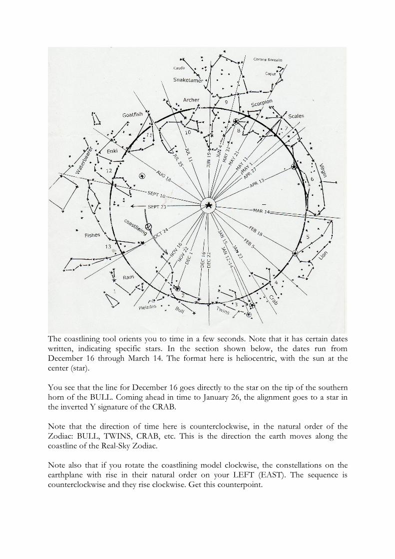
The coastlining tool orients you to time in a few seconds. Note that it has certain dates written, indicating specific stars. In the section shown below, the dates run from December 16 through March 14. The format here is heliocentric, with the sun at the center (star). You see that the line for December 16 goes directly to the star on the tip of the southern horn of the BULL. Coming ahead in time to January 26, the alignment goes to a star in the inverted Y signature of the CRAB. Note that the direction of time here is counterclockwise, in the natural order of the Zodiac: BULL, TWINS, CRAB, etc. This is the direction the earth moves along the coastline of the Real-Sky Zodiac. Note also that if you rotate the coastlining model clockwise, the constellations on the earthplane with rise in their natural order on your LEFT (EAST). The sequence is counterclockwise and they rise clockwise. Get this counterpoint.
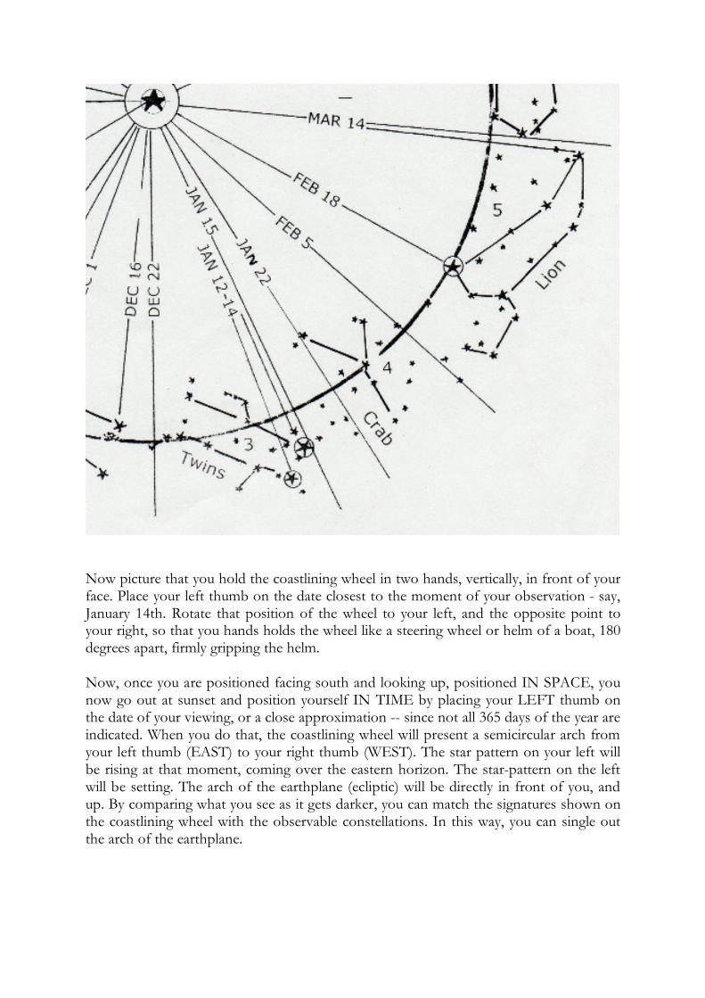
Now picture that you hold the coastlining wheel in two hands, vertically, in front of your face. Place your left thumb on the date closest to the moment of your observation - say, January 14th. Rotate that position of the wheel to your left, and the opposite point to your right, so that you hands holds the wheel like a steering wheel or helm of a boat, 180 degrees apart, firmly gripping the helm. Now, once you are positioned facing south and looking up, positioned IN SPACE, you now go out at sunset and position yourself IN TIME by placing your LEFT thumb on the date of your viewing, or a close approximation -- since not all 365 days of the year are indicated. When you do that, the coastlining wheel will present a semicircular arch from your left thumb (EAST) to your right thumb (WEST). The star pattern on your left will be rising at that moment, coming over the eastern horizon. The star-pattern on the left will be setting. The arch of the earthplane (ecliptic) will be directly in front of you, and up. By comparing what you see as it gets darker, you can match the signatures shown on the coastlining wheel with the observable constellations. In this way, you can single out the arch of the earthplane.

Ideally, you start this exercise by going out at the moment of sunset, before it is dark enough to see the sky well. But at the moment, you reckon on a remarkable fact: the star pattern rising to the earth is in closest proximity to the earth, while the sun is of course opposite, in the constellation that is setting. In other words, the earth is always coastlining the star pattern that rises at the moment of sunset. Halfway through the evening, the star pattern where the earth is coastlining will be viewed about 45 degrees off the eastern point, halfway to the meridian, the central highest point in the sky looking southward and up. At midnight, the star pattern the earth is coastlining will be directly overhead. Optimal View On any given day of the year, the earth is sliding past a region of the Zodiacal coastline. This spot is the optimal view of the entire coast. The trick is, to know how to find this spot, the area in closest proximity to the earth on the earthplane, the Ecliptic. The coastlining chart makes this easy. It gives 24 dates through the year when specific sights can be observed at maximum proximity. The chart is designed to start you off at sunset on any day. For instance, on November 22, the earth coasts past a spectacular star cluster, the Pleiades, located in the neck of the Bull. Holding the chart up in front of you with your left thumb on that spot, you will see the arch of the Ecliptic as it appears at sunset. The point of optimum view is always on the left (east) at sunset, reaches the meridian (overhead, south and up) at midnight, and sets in the west at dawn. Thus the chart rotates clockwise as night advances. With this device you can always tell where the earth is moving on its annual journey around the sun. Even if you do not watch the skies, you can track the journey in your imagination and move with the earth which is always located at the point of optimum view. The sun, our mother star, on any day is always opposite the coastlining earth. When the sun stands in the way, a constellation cannot be seen, of course. You never see the passage of the sun through the panorama of the Zodiacal constellations. You cannot observe the earth in the skies, either, but you can observe how it moves through the skies. "The sky is not the atmosphere. Birds do not fly in the sky, but in the atmosphere, the ambient. The earth is in the sky, i.e., interstellar space. Along with the moon, the mother star, and the other planets of the solar system. Coastlining is a rite of participation in Gaia’s majestic journey. It shows you how to sail with the earth in the sky. © 1999 John Lash


![Ordinance No. 19-92 Attachment - Zanesville, Ohio...2019/08/12 · o degrees [d] 30 degrees 45 degrees 60 degrees 90 degrees [e] Dnveway width [f] m feet: Residential Districts Minimum](https://img.pdfslide.us/doc/110x75/5f40e8cf15dd5c29445849f0/ordinance-no-19-92-attachment-zanesville-20190812-o-degrees-d-30.jpg)