Embed Size (px)
Citation preview

Coastal Structures Risk Communication of the Great Lakes Districts of the USof the Great Lakes Districts of the US Army Corps of Engineers
US Army Corps of EngineersBUILDING STRONG®

Introduction and Agenda
Purpose: Communicate the risk of breakwater and structure conditions to localCommunicate the risk of breakwater and structure conditions to localstakeholders and navigation system users. With a focus on structurecondition, function, and economic consequences of coastal structures
th G t L kon the Great Lakes.
Focus Topics:
1 Coastal Structure Risk Communication1. Coastal Structure Risk Communication
2. Condition Assessment of Coastal Structures
3 Harbor Infrastructure Inventory Process3. Harbor Infrastructure Inventory Process
4. Next Steps and Open Discussion
BUILDING STRONG®2

Regional Risk Communication Meetings
Lake Superior
Keweenaw Waterway
Two HarborsKnife River
Duluth-
Eagle Harbor
Grand TraverseLac La Belle
Grand Marais
Bayfield
MI
Cheboygan
ManistiqueDetour
Grand Marais
Presque IsleMarquette
Superior
H d B
Mackinac IslandMackinaw City
Inland Route
Big Bay Little Lake Whitefish PointBayfield
WI CANADAAlpenaCharlevoix
Frankfort
ManisteeManitowoc
Kewaunee
Algoma
Sturgeon Bay
Menominee
Au Sable
Hammond Bay
Harrisville
Point Lookout Port AustinTawas Bay
Arcadia
Greilickville
a d oute
Leland
Petoskey
Portage Lake
Cape Vincent
Oconto
Two Rivers
Cedar River
MI
NY
OswegoHarbor Beach
Manistee
Ludington
Muskegon
Holland
Grand Haven
Kenosha
Milwaukee
Port Washington
Sheboygan
Manitowoc
Lexington
Point Lookout Port Austin
Port SanilacPentwater
Saugatuck
White Lake
Clinton River
Port OntarioRegional Meetings#1 16 Aug 11#2 18 Jan 12#3 IN/IL#4 West MI#5 NE MI NY
PA
IL
INOH
Detroit River
South Haven
St. Joseph
Michigan City
Indiana HarborChicago River
Chicago Harbor
Waukegan
Bolles HarborNew Buffalo
Saugatuck#6 SE MI#7 East Erie#8 East Ont#9 MN
#10 UP MI
BUILDING STRONG®
IN

Great Lakes Navigation System (GLNS)
Lake SuperiorL L B ll
Eagle Harbor
Chippewa Harbor
Grand Marais
Two Harbors
60 Commercial Projects, including 45 with structures
79 Recreational Projects, including 61 with structures
MIMackinaw City
Mackinac IslandSt. James
Channels in Straits of Mackinac
Grays ReefLittle Bay de Noc (Gladstone)
Manistique DetourLes Cheneaux Island
Soo Locks (part of St. Mary’s River project)
St. Marys River
Whitefish Point Harbor
Little LakeGrand Marais
Presque Isle
Marquette
Big Bay
Grand Traverse Bay
Lac La Belleg
Keweenaw Waterway
OntonagonBlack River
SaxonAshland
Two Harbors
Knife River
Duluth-SuperiorBayfield
La PointeCornucopia
Port Wing
WI CANADA Ogdensburg
Morristown
Cape Vincent
Sackets Harbor
Port AustinPoint Lookout
Tawas BayAu Sable Harbor
Harrisville
Alpena
Hammond Bay
CheboyganInland Route
y
PetoskeyCharlevoix
Leland
GreilickvilleFrankfort
Arcadia
Portage Lake
ManisteeManitowoc
Washington Island (2 harbors)
Green Bay
Big SuamicoKewaunee
Algoma
Sturgeon Bay
Two Rivers
PensaukeeOconto
MenomineeCedar River
MINY
Port Ontario
Oswego
Clinton RiverBelle River
Pine River
Lake St. Clair
St. Clair RiverBlack River (Port Huron)
Lexington
Harbor Beach
Port SanilacSaginaw River
Ludington
Pentwater
White Lake
Muskegon
Saugatuck
Grand River
Holland
Grand Haven
South HavenWaukegan
Kenosha
Milwaukee
Port Washington
Sheboygan
Niagara River
PAIL
IN OH
CommercialRecreational
Monroe
Rouge RiverSt. Joseph
New Buffalo
Michigan City
Burns Small Boat HarborBurns Waterway HarborCalumet Harbor
Indiana Harbor
Chicago RiverChicago Harbor
Waukegan
Detroit River
Bolles Harbor
BUILDING STRONG®
IN OH
4

Great Lakes Navigation System (GLNS)
• 104+ miles of navigation structures on the Great Lakes• Structures include piers, jetties, revetments, and breakwaters • Most were built between 1860 and 1940• Most were built between 1860 and 1940• Jetties and piers were constructed perpendicular to shore to keep the
channel open for navigation• Off shore breakwaters were constructed to allow safe navigation entry to O g y
harbors and channels
BUILDING STRONG®5

Navigation structures are regularly subjected to extreme winds and waves
BUILDING STRONG®6

… and ice forces
BUILDING STRONG®7

Typical Coastal Structures
Steel Sheet RubbleSteel Sheet Pile Structures
Rubble Mound/Laid-Up Stone Structures
Typical Wood Other Crib/ Concrete Cap Structures Cross-section
Components: safety (railings, walkingwalking surface, etc.)
BUILDING STRONG®8

Structure Function/Consequences
Contain and reduce shoaling in navigation gchannel
Calumet Harbor, IL&IN
St. Joseph Harbor, MI
C
Protect navigation channel and h li Control wave climate within
navigation channel and harborshoreline infrastructure
BUILDING STRONG®9
Milwaukee Harbor, WI
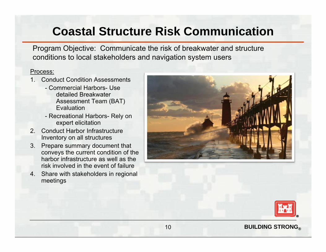
Coastal Structure Risk CommunicationP Obj ti C i t th i k f b k t d t t
Process:1 C d t C diti A t
Program Objective: Communicate the risk of breakwater and structure conditions to local stakeholders and navigation system users
1. Conduct Condition Assessments- Commercial Harbors- Use
detailed Breakwater Assessment Team (BAT) Evaluation
- Recreational Harbors- Rely on expert elicitation
2. Conduct Harbor Infrastructure Inventory on all structures
3. Prepare summary document that conveys the current condition of the harbor infrastructure as well as the risk involved in the event of failure
4 Share with stakeholders in regional4. Share with stakeholders in regional meetings
BUILDING STRONG®10

Great Lakes Structure Condition
• 50% of GL coastal structures were built before WWI
• Over 80% of all coastal structures exceed 50 years of ageOver 80% of all coastal structures exceed 50 years of age
• 45% have never undergone any significant repair effort due to funding constraints
• Over 30% of structures have timber crib core sections; recent low water levels have accelerated deterioration of the wood
BUILDING STRONG®11

A G L k i l bli h d i 2008 d A
Regional Condition AssessmentsA Great Lakes regional team was established in 2008 to conduct Asset Management-based condition assessments of all Great Lakes commercial navigation structures; the Team works with USACE Engineering Research and Development Center and collaborates with the National Coastal Asset ManagementDevelopment Center and collaborates with the National Coastal Asset Management Board.• Conditions assessment by segments: 45% of structures are rated C or worse
• 22 miles (21%) rated C – Probably inadequate22 il (21%) t d D I d t• 22 miles (21%) rated D - Inadequate
• 3 miles (3%) rated F – Failed• Cost to conduct major repair of structures: $15 – 20M per mile
BUILDING STRONG®12

Regional Condition Assessments
• Structural Index is developed from assessment of major structure components / parameters with most direct link to structure reliability and functionfunction
• The structural index value is converted to an A thru F condition level which is used to communicate risk for planning and budgeting purposes
• Collecting complete continuous overlapping still photography and video of each structure at each project. Photos are labeled and geotagged for easy reference in Google Earth.
BUILDING STRONG®13

Harbor Structure Condition Assessments
A – Failure Unlikely
Lake Superior
Keweenaw
Waterway
Two HarborsKnife River
Duluth-Superior Big Bay
Eagle Harbor
Grand TraverseLac La Belle
Whi fi h P i
Grand Marais
Bayfield
A Failure UnlikelyB – Low Risk of Failure
C – Medium Risk of FailureD – High Risk of Failure
F – Failed
MI
WI Cheboygan
ManistiqueDetour
Grand Marais
Presque IsleMarquette
p
Hammond Bay
Mackinac IslandMackinaw City
Inland RoutePetoskey
g yLittle Lake Whitefish Point Commercial
Recreational
CANADAAlpenaCharlevoix
Frankfort
ManisteeManitowoc
Kewaunee
Algoma
Sturgeon Bay
Menominee
Au Sable
Harrisville
Point Lookout Port AustinTawas Bay
Arcadia
Greilickville
Leland
Petoskey
Portage Lake
Port Ontario
Cape Vincent
Oconto
Two Rivers
MI
NY
OswegoHarbor BeachLudington
Muskegon
Holland
Grand Haven
Kenosha
Milwaukee
Port Washington
Sheboygan
Lexington
Port SanilacPentwater
Saugatuck
White Lake
Clinton River
Port Ontario
PA
IL
INOH
Detroit River
South Haven
St. Joseph
Michigan CityChicago River
Chicago Harbor
Waukegan
Bolles HarborNew Buffalo
BUILDING STRONG®
IN
14
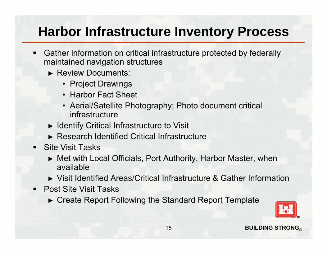
Harbor Infrastructure Inventory Process Gather information on critical infrastructure protected by federally
maintained navigation structures► Review Documents:
• Project Drawings• Harbor Fact Sheet• Aerial/Satellite Photography; Photo document critical
infrastructure► Identify Critical Infrastructure to Visit► Research Identified Critical Infrastructure
Site Visit Tasks► Met with Local Officials, Port Authority, Harbor Master, when
available► Visit Identified Areas/Critical Infrastructure & Gather Information
Post Site Visit Tasks► Create Report Following the Standard Report Template
BUILDING STRONG®15

Harbor Infrastructure Inventory Report Content HARBOR LOCATION PROJECT DESCRIPTION
Authorization, harbor type (commercial or recreational) length of(commercial or recreational), length of breakwater structures and channel
DATE OF SITE VISIT SUMMARY OF STRUCTURES
Li t ll t t d f iliti th tLists all structures and facilities that are believed to be protected by the federal navigation structures; also identify any other potential stakeholdersstakeholders
SUMMARY OF IMPACTSummarizes any potential damage that could be experienced if the federal breakwater failsfederal breakwater fails.
DESCRIPTION OF STRUCTURESAerial photo with all potential affected structures shown along with pictures
d b i f d i ti f h
BUILDING STRONG®
and a brief description of each potentially affected structure
16

High Level Display of Potential Impact Areas
Three potential impact areas were defined at 500 ft intervals Shows potential value of land and infrastructure within each
“potential impact area” based on tax assessment data“potential impact area” based on tax assessment data
BUILDING STRONG®17

Harbor Structure Condition Assessments
A – Failure Unlikely
Lake Superior
Keweenaw
Waterway
Two HarborsKnife River
Duluth-Superior Big Bay
Eagle Harbor
Grand TraverseLac La Belle
Whi fi h P i
Grand Marais
Bayfield
A Failure UnlikelyB – Low Risk of Failure
C – Medium Risk of FailureD – High Risk of Failure
F – Failed
MI
WI Cheboygan
ManistiqueDetour
Grand Marais
Presque IsleMarquette
p
Hammond Bay
Mackinac IslandMackinaw City
Inland RoutePetoskey
g yLittle Lake Whitefish Point Commercial
Recreational
CANADAAlpenaCharlevoix
Frankfort
ManisteeManitowoc
Kewaunee
Algoma
Sturgeon Bay
Menominee
Au Sable
Harrisville
Point Lookout Port AustinTawas Bay
Arcadia
Greilickville
Leland
Petoskey
Portage Lake
Port Ontario
Cape Vincent
Oconto
Two Rivers
MI
NY
OswegoHarbor BeachLudington
Muskegon
Holland
Grand Haven
Kenosha
Milwaukee
Port Washington
Sheboygan
Lexington
Port SanilacPentwater
Saugatuck
White Lake
Clinton River
Port Ontario
PA
IL
INOH
Detroit River
South Haven
St. Joseph
Michigan CityChicago River
Chicago Harbor
Waukegan
Bolles HarborNew Buffalo
BUILDING STRONG®
IN
18

Erie Harbor
A
A
BUILDING STRONG®

Erie Harbor:
A
1. Don Jon Shipbuilding & Repair, LLC
2. Erie Sand and Gravel – Carmeuse Lime
3. Captain John E Lampe Marina
4. U.S. Army Corps of Engineers –Buffalo District CDF
5.U.S. Coast Guard Station Erie
6. Presque Isle State Park
BUILDING STRONG®20

Erie Harbor: Potential Impact Areas
BUILDING STRONG®21

Barcelona Harbor
B
B
BUILDING STRONG®

Barcelona Harbor:
B
1. Barcelona Harbor Launching Ramp and Daniel Reed PierReed Pier
2. Monroe Marina
BUILDING STRONG®23

Barcelona Harbor: Potential Impact Areas
BUILDING STRONG®24

Dunkirk Harbor
D
D
BB
BUILDING STRONG®

Dunkirk Harbor:$21M estimated cost to upgrade D rated structures to an acceptable level of risk (L l B)(Level B)
D
D
1. NRG Energy
2. Bart’s Cove Marina
3. City of Dunkirk Water Filtration Plant
4 D ki k Y ht Cl b4. Dunkirk Yacht Club
5. Memorial Park
6. City Pier
7. Clarion HotelB
B
8. Chadwick Bay Marina
9. Abandoned Marina
10. Private homes and non-swimming beach
BUILDING STRONG®26

Dunkirk Harbor: Potential Impact Areas
BUILDING STRONG®27
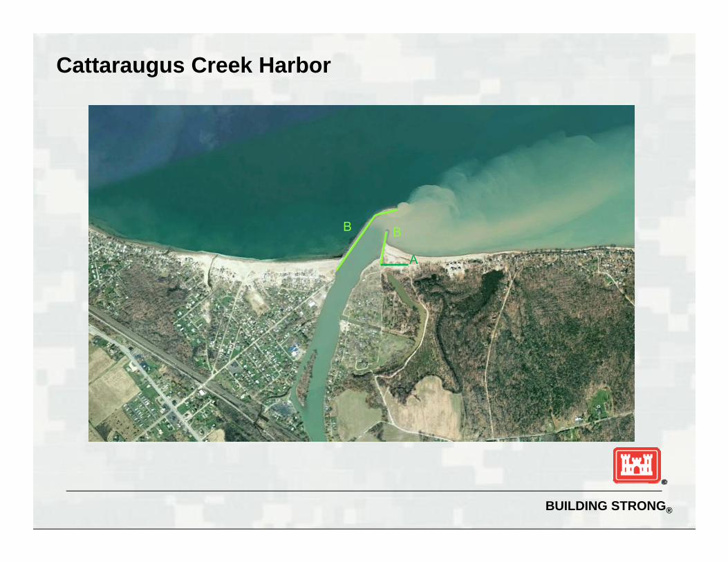
Cattaraugus Creek Harbor
BB
A
BUILDING STRONG®

Cattaraugus Creek Harbor:Cattaraugus Creek Harbor:
B
B A
1. Sunset Bay Access Site and MarinaMarina
2. Hidden Harbor Marina
BUILDING STRONG®29
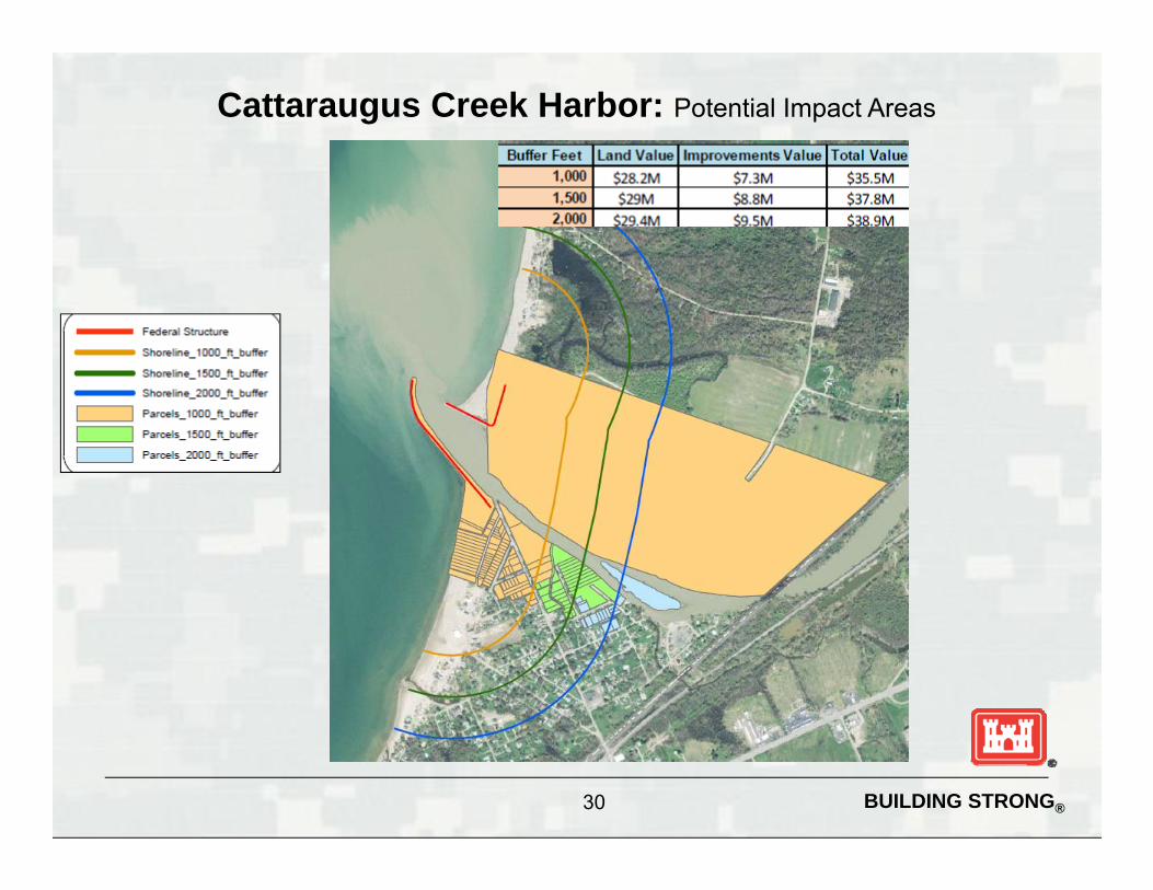
Cattaraugus Creek Harbor: Potential Impact Areas
BUILDING STRONG®30

Buffalo Harbor
F
D
B
B
B
B
C
B
D
BUILDING STRONG®

Buffalo Harbor:$61M estimated cost to upgrade D rated structures to an acceptable level of risk (Level B)
1. Port of Buffalo
2. U.S. Army Corps of Engineers Buffalo District CDF#4
A3. Holcim US
4. Vacant Grain Elevator
5. U.S. Army Corps of Engineers Buffalo District CDF#1
6. NFTA Small Boat Harbor
7. Former Freezer Queen Plant
8. Empire Liquidators
9. Vacant Outer Harbor Land and 9. V c Ou e bo d dSlips
10. U.S. Army Corps of Engineers
11. Buffalo District CDF#2
12. U.S. Coast Guard Marine Safety Office Buffalo
13. Erie Basin Marina
14. Buffalo Naval Park
15. Erie Canal Harbor and Commercial Slip
BUILDING STRONG®32
Commercial Slip

Buffalo Harbor: Potential Impact Areas
BUILDING STRONG®33

Black Rock Lock and Tonawanda Harbor
D
BUILDING STRONG®

Black Rock Lock and Tonawanda Harbor:$5M estimated cost to upgrade D rated structures to an acceptable level of risk (Level B)B)
1. Rich Marine Sales
2. Interstate 190 – New York State Department of Transportation
3. West Side Rowing Club
4. Frank Lloyd Wright’s Fontana BoathouseBoathouse
5. Buffalo Yacht Club
6. Buffalo Water Authority –Colonel Ward Pump Station
7. La Salle Park
DD
BUILDING STRONG®35

Black Rock Lock and Tonawanda Harbor: Potential Impact Areas
BUILDING STRONG®36

Wilson Harbor
B A
BUILDING STRONG®

Wilson Harbor:
B
A 1. Wilson – Tuscarora State Park Marina
2. Beccue Boat Basin/Sunset Bay Marina
i3. Moyers Marina
4. Wilson Yacht Club
5. Tuscarora Yacht Club
6. Wilson Boatyard Marina
7. Public Park
8. Wilson Wastewater Treatment Plant
BUILDING STRONG®38

Wilson Harbor: Potential Impact Areas
BUILDING STRONG®39

Olcott Harbor
A A
BUILDING STRONG®

Olcott Harbor:
A
1. Olcott Yacht Club
2. Town of Newfane Marina
3. McDonough Marine & Restaurant
4. Liberty Excursion
5. Hedley Boat Co.
BUILDING STRONG®41

Olcott Harbor: Potential Impact Areas
BUILDING STRONG®42

Oak Orchard Harbor
A
AA
BUILDING STRONG®

Oak Orchard Harbor:
A1. Oak Orchard State Marine ParkA Marine Park
2. Orleans County Marine Park
3. Lake Breeze Marina
4. Four C’s Marina
5. Orleans County Marine Park – Point Breeze
6. Private Building
7. Oak Orchard Lighthouse
B
BUILDING STRONG®44

Oak Orchard Harbor: Potential Impact Areas
BUILDING STRONG®45

What Can Be Done?
Federal FundingF di t th h th F d l B d t►Funding request through the Federal Budget process each fiscal year
• Contract structural repair• Contract structural repair• Government floating plant repair
Local Funding Local Funding►Mechanisms in place to accept local funding
T f t St t /L l E tit Transfer to State/Local Entity►Section 216 Process
BUILDING STRONG®46

Great Lakes Repair Fleet
• Three repair fleets – one in LRB and two in LRE conduct all of the most urgent repair needs on navigation structures in the five Great Lakes.
• Place stone in weakened sections of structures and CDFs conduct welding repairs on steel• Place stone in weakened sections of structures and CDFs, conduct welding repairs on steel sheeting to retain encapsulation of fill stone; repair safety ladders, signs, and railings; remove obstructions from harbor navigation channels; and are available for a wide variety of “emergency” work including debris removal, lock repair, and other unanticipated repair needsneeds.
Lake Superior: Duluth Repair Fleet
Lakes Michigan and Huron:
Lakes Erie and Ontario: Cleveland Repair Fleet
Kewaunee Repair Fleet
BUILDING STRONG®47

Water Safety
• Navigation structures at Corps harbors along Lakes Erie and Ontario present a water hazard to the public. There is an ongoing effort to install yellow “Warning” signs and red “Danger” signs on these structures to alert the public of potential hazards. To date, signs have been installed at 7 of the 28 harbors with navigation structures in the Buffalo Districthave been installed at 7 of the 28 harbors with navigation structures in the Buffalo District.
• Water safety programming and educational outreach is also done at regional events within the Districtthe District.
BUILDING STRONG®48

Questions?
BUILDING STRONG®49

Coastal Structure Risk Outreach Meetings
Purpose: Communicate the risk of breakwater and structure conditions to local stakeholders and navigation system users.
Target Audience: Stakeholders (port authorities, city/countyofficials, harbor masters, and other navigation interest groups)
ithi l t d iwithin selected region
Products: PowerPoint presentation, general overview brochure, and harbor specific infrastructure inventory summary
Potential Dates: 1st Meeting August 16, 2011 (Milwaukee,WI) plans for two addition meetings in FY11.
BUILDING STRONG®50