Embed Size (px)
Citation preview

Coastal Hazardous Waste Site
REVIEWERSChris Beaverson1, Berit Bergquist2, Bejurin Cassady2,Robert N. Dexter2, Tom Dillon1, Ken Finkelstein1, Gayle Garman1, Ron Gouguet1, Peter Knight1, and Lisa Rosman1
GRAPHICSKimberly L. Stewart2
1NOAA/HAZMAT/Coastal Resource Coordination Branch2EVS Environment Consultants
NOAANational Oceanic and Atmospheric Administration
NOSNational Ocean Service
ORCAOffice of Ocean Resources Conservation and Assessment
HAZMATHazardous Materials Response and Assessment Division7600 Sand Point Way NE Seattle, Washington 98115
Coastal Hazardous Waste Site
NOAANational Oceanic and Atmospheric Administration
NOSNational Ocean Service
ORCAOffice of Ocean Resources Conservation and Assessment
HAZMATHazardous Materials Response and Assessment Division7600 Sand Point Way NE Seattle, Washington 98115
December 1997
EDITORSGayle Garman and Lori HarrisNOAA/HAZMAT/Coastal Resource Coordination Branch
AUTHORSBerit A. Bergquist, Garrett Gray, Lisa M. Mill, Susan E. McGroddy, James E. Starkes, andRobert E. StuartEVS Environment Consultants
Contents
Introduction...........................................................................................................................iSites reviewed since 1984 ................................................................vAcronyms and abbreviations used in waste site reviews.....xviii
1 Beede Waste Oil.............................................................................................................1Plaistow, New Hampshire
2 V&M/Albaladejo Farms ....................................................................................11Vega Baja, Puerto Rico
3 Fort George G. Meade...................................................................................19Anne Arundel County, Maryland
Norfolk Naval Base...............................................................................................31Norfolk, Virginia
Salford Quarry .............................................................................................................43Lower Salford Township, Pennsylvania
4 Brunswick Wood Preserving............................................................51Brunswick, Georgia
MRI Corporation.......................................................................................................61Tampa, Florida
Terry Creek Dredge Spoil/Hercules Outfall ........71Brunswick, Georgia
4 (cont.)
Tyndall Air Force Base.................................................................................81Bay County, Florida
6 Madisonville Creosote Works........................................................91Madisonville, Louisiana
10 Oeser Company.........................................................................................................101Bellingham, Washington
PLEASE CITE AS:
Garman, Gayle, and Lori Harris, editors. 1997. Coastal Hazardous Waste
Site Reviews, December 1997. Seattle: Hazardous Materials Response and
Assessment Division, National Oceanic and Atmospheric Administration.
138 pp.

Introduction • i
Coastal Hazardous Waste Site Review / Introduction • i
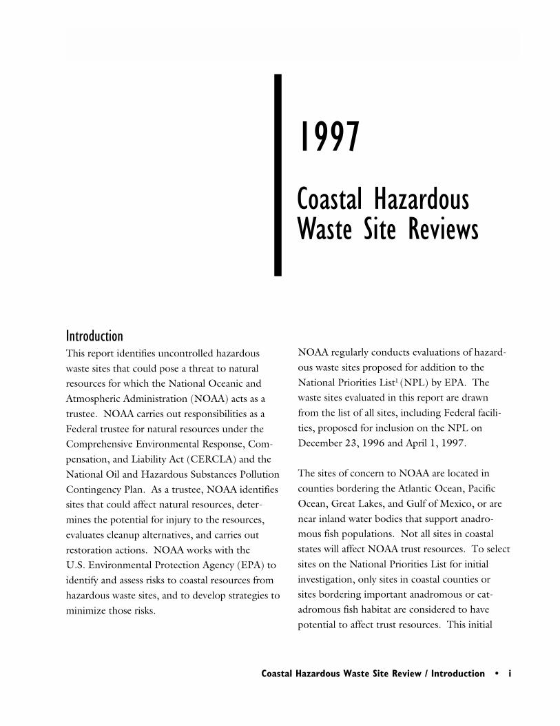
IntroductionThis report identifies uncontrolled hazardouswaste sites that could pose a threat to naturalresources for which the National Oceanic andAtmospheric Administration (NOAA) acts as atrustee. NOAA carries out responsibilities as aFederal trustee for natural resources under theComprehensive Environmental Response, Com-pensation, and Liability Act (CERCLA) and theNational Oil and Hazardous Substances PollutionContingency Plan. As a trustee, NOAA identifiessites that could affect natural resources, deter-mines the potential for injury to the resources,evaluates cleanup alternatives, and carries outrestoration actions. NOAA works with theU.S. Environmental Protection Agency (EPA) toidentify and assess risks to coastal resources fromhazardous waste sites, and to develop strategies tominimize those risks.
NOAA regularly conducts evaluations of hazard-ous waste sites proposed for addition to theNational Priorities List1 (NPL) by EPA. Thewaste sites evaluated in this report are drawnfrom the list of all sites, including Federal facili-ties, proposed for inclusion on the NPL onDecember 23, 1996 and April 1, 1997.
The sites of concern to NOAA are located incounties bordering the Atlantic Ocean, PacificOcean, Great Lakes, and Gulf of Mexico, or arenear inland water bodies that support anadro-mous fish populations. Not all sites in coastalstates will affect NOAA trust resources. To selectsites on the National Priorities List for initialinvestigation, only sites in coastal counties orsites bordering important anadromous or cat-adromous fish habitat are considered to havepotential to affect trust resources. This initial
1997Coastal HazardousWaste Site Reviews
ii • Introduction
ii • Coastal Hazardous Waste Site Review / Introduction
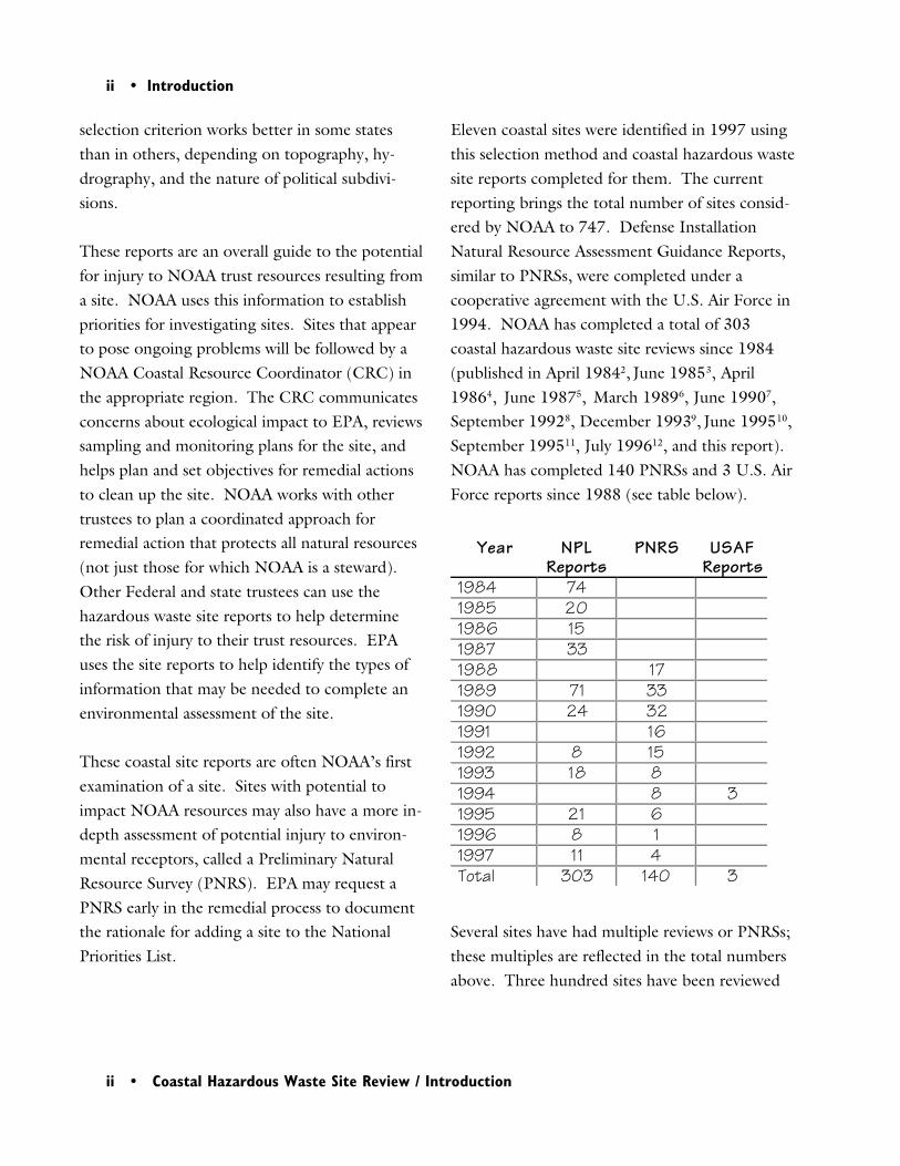
selection criterion works better in some statesthan in others, depending on topography, hy-drography, and the nature of political subdivi-sions.
These reports are an overall guide to the potentialfor injury to NOAA trust resources resulting froma site. NOAA uses this information to establishpriorities for investigating sites. Sites that appearto pose ongoing problems will be followed by aNOAA Coastal Resource Coordinator (CRC) inthe appropriate region. The CRC communicatesconcerns about ecological impact to EPA, reviewssampling and monitoring plans for the site, andhelps plan and set objectives for remedial actionsto clean up the site. NOAA works with othertrustees to plan a coordinated approach forremedial action that protects all natural resources(not just those for which NOAA is a steward).Other Federal and state trustees can use thehazardous waste site reports to help determinethe risk of injury to their trust resources. EPAuses the site reports to help identify the types ofinformation that may be needed to complete anenvironmental assessment of the site.
These coastal site reports are often NOAA’s firstexamination of a site. Sites with potential toimpact NOAA resources may also have a more in-depth assessment of potential injury to environ-mental receptors, called a Preliminary NaturalResource Survey (PNRS). EPA may request aPNRS early in the remedial process to documentthe rationale for adding a site to the NationalPriorities List.
Eleven coastal sites were identified in 1997 usingthis selection method and coastal hazardous wastesite reports completed for them. The currentreporting brings the total number of sites consid-ered by NOAA to 747. Defense InstallationNatural Resource Assessment Guidance Reports,similar to PNRSs, were completed under acooperative agreement with the U.S. Air Force in1994. NOAA has completed a total of 303coastal hazardous waste site reviews since 1984(published in April 19842, June 19853, April19864, June 19875, March 19896, June 19907,September 19928, December 19939, June 199510,September 199511, July 199612, and this report).NOAA has completed 140 PNRSs and 3 U.S. AirForce reports since 1988 (see table below).
Several sites have had multiple reviews or PNRSs;these multiples are reflected in the total numbersabove. Three hundred sites have been reviewed
Year NPLReports
PNRS USAFReports
1984 741985 201986 151987 331988 171989 71 331990 24 321991 161992 8 151993 18 81994 8 31995 21 61996 8 11997 11 4Total 303 140 3
Introduction • iii
Coastal Hazardous Waste Site Review / Introduction • iii
(three sites more than once), and 140 sites havehad PNRSs (three more than once).
The 1997 Coastal Hazardous Waste Site Reviewscontain four major sections. “Site ExposurePotential” describes activities at the site thatcaused the release of contaminants, local topogra-phy, and potential contaminant migration path-ways. “NOAA Trust Habitats and Species”describes the types of habitats and species at riskof injury from releases at the site. The life stagesof organisms using habitats near the site arediscussed, as are commercial and recreationalfisheries. “Site-Related Contamination” identi-fies contaminants of concern to NOAA, thepartitioning of the contaminants in the environ-ment, and the concentrations at which thecontaminants are found. “Summary” cogentlyrecaps this information.
Tables andScreening Values
Most of these reports contain tables of contami-nants measured at the site. These tables wereformulated to highlight contaminants thatrepresent a potential problem, and to focus ourconcerns on only a few of the many contaminantsnormally present at a waste site. Data presentedin tables were screened against standard compari-son values, depending on the source of thesample. Screening values used are ambient waterquality criteria14, soil averages15,16, and EffectsRange Low (ERL) values17. Because releases tothe environment from hazardous waste sites canspan many years, we are concerned about chronic
impacts. Therefore, we typically make compari-sons with the lower standard value (e.g., chronicvs. acute AWQC, and ERL vs. ERM). Nocriteria similar to the AWQC are available forsediment. Thus, sediment concentrations werescreened by comparison with the ERL reportedby Long et al.17 The ERL value is the sedimentconcentration corresponding to the lowest 10-percentile of biological measurements reported aseffects. As such, it represents the low end of therange of concentrations at which effects wereobserved in the studies compiled by the authors.
Soil samples were compared to selected averagesreported in Element concentrations in soils andother surficial materials of the coterminous UnitedStates (Shacklette and Boerngen 1984), exceptfor cadmium and silver which are compared toconcentrations reported in Hazardous WasteLand Treatment (EPA 1983). These values wereaveraged from a data set from soil throughoutthe entire U.S. Ideally, reference values for soilwould be calculated on a regional basis, from adata set large enough to give a value representa-tive of the area. In the absence of such data, thenational average values were used as a referencefor comparison purposes only.
All of the hazardous waste sites considered byNOAA in this review are contained in the Tableof Contents, including the name and location ofthe site and the beginning page number of thesite report. Table 1 lists all of the sites at whichNOAA has been involved that could potentiallyaffect trust resources, as of December 1997.Table 2 lists acronyms, abbreviations, and termscommonly used in these waste site reports.

iv • Introduction
iv • Coastal Hazardous Waste Site Review / Introduction
1National Oil and Hazardous Substances Pollu-tion Contingency Plan, 40 CFR Part 300.2Ocean Assessments Division. 1984. CoastalHazardous Waste Site Review April 13, 1984.NOAA/OAD, Seattle, Washington.3Pavia, R., and L. Harris, eds. 1985. CoastalHazardous Waste Site Review June 30, 1985.NOAA/OAD, Seattle, Washington4Pavia, R., and L. Harris, eds. 1986. CoastalHazardous Waste Site Review: Site Reports April1986. NOAA/OAD, Seattle, Washington.5Pavia, R., and L. Harris, eds. 1987. CoastalHazardous Waste Site Review: Site Reports June1987. NOAA/OAD, Seattle, Washington.6Pavia, R., and L. Harris, eds. 1989. CoastalHazardous Waste Site Review: Site Reports March1989. NOAA/OAD, Seattle, Washington.7Hoff, R., and L. Harris, eds. 1990. CoastalHazardous Waste Site Review: Site Reports June1990. NOAA/OAD, Seattle, Washington.8Beckvar, N., and L. Harris, eds. 1992. CoastalHazardous Waste Site Reviews September 1992.NOAA/ORCA, Seattle, Washington.9Beckvar, N., and L. Harris, eds. 1993. CoastalHazardous Waste Site Reviews December 1993.NOAA/ORCA, Seattle, Washington.10Beckvar, N., G. Garman, and L. Harris, eds.1995. Coastal Hazardous Waste Site ReviewsJune 1995. NOAA/ORCA, Seattle, Washington.11Garman, G., and L. Harris, eds. 1995. CoastalHazardous Waste Site Reviews September 1995.NOAA/ORCA, Seattle, Washington.12Garman, G., and L. Harris, eds. 1996. CoastalHazardous Waste Site Reviews July 1996.NOAA/ORCA, Seattle, Washington.
13Garman, G., and L. Harris, eds. 1997. CoastalHazardous Waste Site Reviews December 1997.NOAA/ORCA, Seattle, Washington.14U.S. EPA. 1993. Water quality criteria.Washington, DC: U.S. Environmental Protec-tion Agency, Office of Water, Health and Eco-logical Criteria Division. 294 pp.15U.S. EPA. 1983. Hazardous waste landtreatment. EPA/530/SW-83/874. Cincinnati:Municipal Environmental Research Laboratory.702 pp.16Shacklette, H.T., and J.G. Boerngen. 1984.Element concentrations in soils and other surficialmaterials of the conterminous United States. USGSProfessional Paper 1270. Washington, D.C.: U.S.Geological Survey.17Long, E.R., D.D. MacDonald, S.L. Smith, andF.D. Calder. 1995. Incidence of adverse biologi-cal effects within ranges of chemical concentra-tions in marine and estuarine sediments. Envi-ronmental Management 19(1):81-97.

Coastal Hazardous Waste Site Review / Introduction • v
Report DateState Cerclis Site Name Review PNRS
Federal Region 2 (cont.)NJ NJD000606442 Quanta ResourcesNJ NJD986589190 Raritan ArsenalNJ NJD980529713 Reich FarmsNJ NJD070415005 Renora, Inc.NJ NJD980529739 Ringwood Mines/LandfillNJ NJD073732257 Roebling Steel Co. 1984 1990NJ NJD030250484 Roosevelt Drive-In 1984NJ NJD980505754 Sayreville Landfill 1984 1990NJ NJD070565403 Scientific Chemical Processing 1984 1989NJ NJD980505762 Sharkey Landfill 1990NJ NJD002365930 Shieldalloy Corp.NJ NJD980766828 South Jersey Clothing Co. 1989NJ NJD041743220 Swope Oil & Chemical Co.NJ NJD064263817 Syncon Resins 1984 1992NJ NJD980761357 Tabernacle Drum DumpNJ NJD002005106 Universal Oil Products (Chemical Division) 1984NJ NJD980761399 Upper Deerfield Township Sanitary LandfillNJ NJD980529879 Ventron/Velsicol 1984NJ NJD002385664 Vineland Chemical Co., Inc. 1990NJ NJD054981337 Waldick Aerospace Devices, Inc. 1990NJ NJD001239185 White Chemical Corp. 1984NJ NJD980529945 Williams Property 1984 1992NJ NJD980532824 Wilson FarmNJ NJD045653854 Witco Chemical Corp. (Oakland Pit)NJ NJD980505887 Woodland Route 532 DumpNJ NJD980505879 Woodland Route 72 DumpNY NYD980780829 93rd Street SchoolNY NYD072366453 Action Anodizing, Plating, & Polishing 1989NY NYD980506232 ALCOA Aggregation SiteNY NYD002066330 American Thermostat Co.NY NYD001485226 Anchor ChemicalsNY NYD980535652 Applied Environmental Services 1985 1991NY NYD980507693 Batavia LandfillNY NYD980768675 BEC (Binghampton Equipment Co.) Trucking 1990NY NYD980768683 Bioclinical Laboratories, Inc.NY NYD980652275 Brewster Well FieldNY NY7890008975 Brookhaven National Laboratory (USDOE) 1990NY NYD980780670 Byron Barrel & DrumNY NYD981561954 C & J Disposal Leasing Co. Dump 1989NY NYD010968014 Carrol & Dubies Sewage Disposal 1989NY NYD981184229 Circuitron Corp. NY NYD002044584 Claremont PolychemicalNY NYD000511576 Clothier DisposalNY NYD980768691 Colesville Municipal LandfillNY NYD982276933 Cornwall LandfillNY NYD980528475 Cortese LandfillNY NYD980508048 Croton Point Sanitary LandfillNY NYD980780746 Endicott Village Well FieldNY NYD981560923 Forest Glen Mobile Home SubdivisionNY NYD091972554 General Motors (Central Foundry Division) 1989NY NYD002050110 Genzale Plating Co.
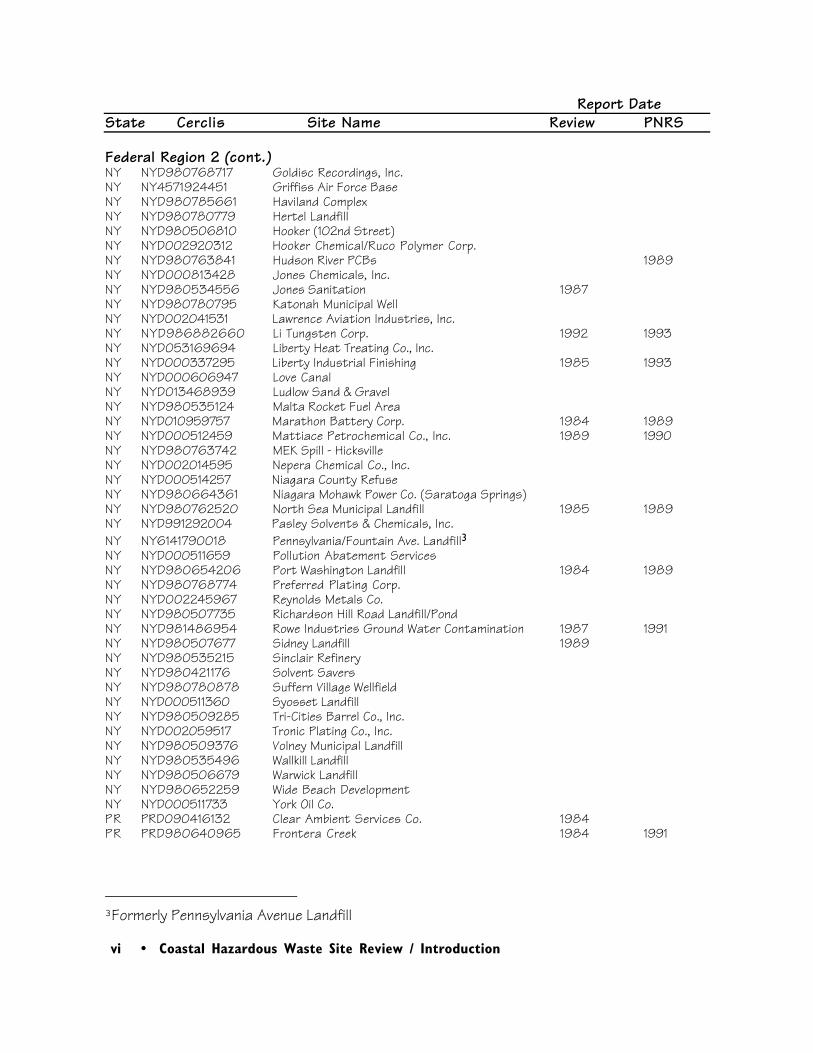
vi • Coastal Hazardous Waste Site Review / Introduction
Report DateState Cerclis Site Name Review PNRS
Federal Region 2 (cont.)NY NYD980768717 Goldisc Recordings, Inc.NY NY4571924451 Griffiss Air Force BaseNY NYD980785661 Haviland ComplexNY NYD980780779 Hertel LandfillNY NYD980506810 Hooker (102nd Street)NY NYD002920312 Hooker Chemical/Ruco Polymer Corp.NY NYD980763841 Hudson River PCBs 1989NY NYD000813428 Jones Chemicals, Inc.NY NYD980534556 Jones Sanitation 1987NY NYD980780795 Katonah Municipal WellNY NYD002041531 Lawrence Aviation Industries, Inc.NY NYD986882660 Li Tungsten Corp. 1992 1993NY NYD053169694 Liberty Heat Treating Co., Inc.NY NYD000337295 Liberty Industrial Finishing 1985 1993NY NYD000606947 Love CanalNY NYD013468939 Ludlow Sand & GravelNY NYD980535124 Malta Rocket Fuel AreaNY NYD010959757 Marathon Battery Corp. 1984 1989NY NYD000512459 Mattiace Petrochemical Co., Inc. 1989 1990NY NYD980763742 MEK Spill - HicksvilleNY NYD002014595 Nepera Chemical Co., Inc.NY NYD000514257 Niagara County RefuseNY NYD980664361 Niagara Mohawk Power Co. (Saratoga Springs)NY NYD980762520 North Sea Municipal Landfill 1985 1989NY NYD991292004 Pasley Solvents & Chemicals, Inc.NY NY6141790018 Pennsylvania/Fountain Ave. Landfill3NY NYD000511659 Pollution Abatement ServicesNY NYD980654206 Port Washington Landfill 1984 1989NY NYD980768774 Preferred Plating Corp.NY NYD002245967 Reynolds Metals Co.NY NYD980507735 Richardson Hill Road Landfill/PondNY NYD981486954 Rowe Industries Ground Water Contamination 1987 1991NY NYD980507677 Sidney Landfill 1989NY NYD980535215 Sinclair Refinery NY NYD980421176 Solvent SaversNY NYD980780878 Suffern Village Wellfield NY NYD000511360 Syosset LandfillNY NYD980509285 Tri-Cities Barrel Co., Inc.NY NYD002059517 Tronic Plating Co., Inc.NY NYD980509376 Volney Municipal LandfillNY NYD980535496 Wallkill LandfillNY NYD980506679 Warwick LandfillNY NYD980652259 Wide Beach DevelopmentNY NYD000511733 York Oil Co.PR PRD090416132 Clear Ambient Services Co. 1984PR PRD980640965 Frontera Creek 1984 1991
3Formerly Pennsylvania Avenue Landfill
Coastal Hazardous Waste Site Review / Introduction • vii
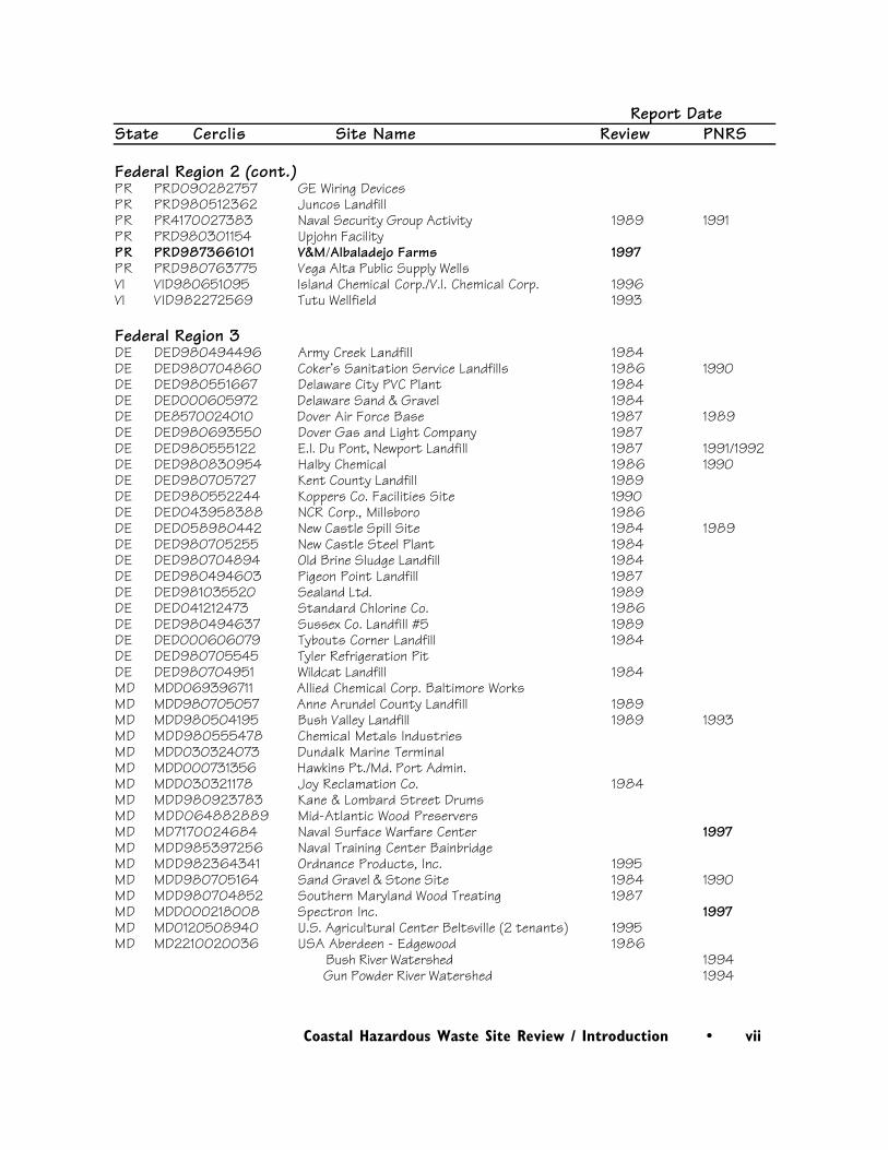
Report DateState Cerclis Site Name Review PNRS
Federal Region 2 (cont.)PR PRD090282757 GE Wiring DevicesPR PRD980512362 Juncos LandfillPR PR4170027383 Naval Security Group Activity 1989 1991PR PRD980301154 Upjohn FacilityPR PRD987366101 V&M/Albaladejo Farms 1997PR PRD980763775 Vega Alta Public Supply WellsVI VID980651095 Island Chemical Corp./V.I. Chemical Corp. 1996VI VID982272569 Tutu Wellfield 1993
Federal Region 3DE DED980494496 Army Creek Landfill 1984DE DED980704860 Coker’s Sanitation Service Landfills 1986 1990DE DED980551667 Delaware City PVC Plant 1984DE DED000605972 Delaware Sand & Gravel 1984DE DE8570024010 Dover Air Force Base 1987 1989DE DED980693550 Dover Gas and Light Company 1987DE DED980555122 E.I. Du Pont, Newport Landfill 1987 1991/1992DE DED980830954 Halby Chemical 1986 1990DE DED980705727 Kent County Landfill 1989DE DED980552244 Koppers Co. Facilities Site 1990DE DED043958388 NCR Corp., Millsboro 1986DE DED058980442 New Castle Spill Site 1984 1989DE DED980705255 New Castle Steel Plant 1984DE DED980704894 Old Brine Sludge Landfill 1984DE DED980494603 Pigeon Point Landfill 1987DE DED981035520 Sealand Ltd. 1989DE DED041212473 Standard Chlorine Co. 1986DE DED980494637 Sussex Co. Landfill #5 1989DE DED000606079 Tybouts Corner Landfill 1984DE DED980705545 Tyler Refrigeration Pit DE DED980704951 Wildcat Landfill 1984MD MDD069396711 Allied Chemical Corp. Baltimore WorksMD MDD980705057 Anne Arundel County Landfill 1989MD MDD980504195 Bush Valley Landfill 1989 1993MD MDD980555478 Chemical Metals IndustriesMD MDD030324073 Dundalk Marine TerminalMD MDD000731356 Hawkins Pt./Md. Port Admin.MD MDD030321178 Joy Reclamation Co. 1984MD MDD980923783 Kane & Lombard Street DrumsMD MDD064882889 Mid-Atlantic Wood PreserversMD MD7170024684 Naval Surface Warfare Center 1997MD MDD985397256 Naval Training Center BainbridgeMD MDD982364341 Ordnance Products, Inc. 1995MD MDD980705164 Sand Gravel & Stone Site 1984 1990MD MDD980704852 Southern Maryland Wood Treating 1987MD MDD000218008 Spectron Inc. 1997MD MD0120508940 U.S. Agricultural Center Beltsville (2 tenants) 1995MD MD2210020036 USA Aberdeen - Edgewood 1986
Bush River Watershed 1994 Gun Powder River Watershed 1994
viii • Coastal Hazardous Waste Site Review / Introduction
Report DateState Cerclis Site Name Review PNRS
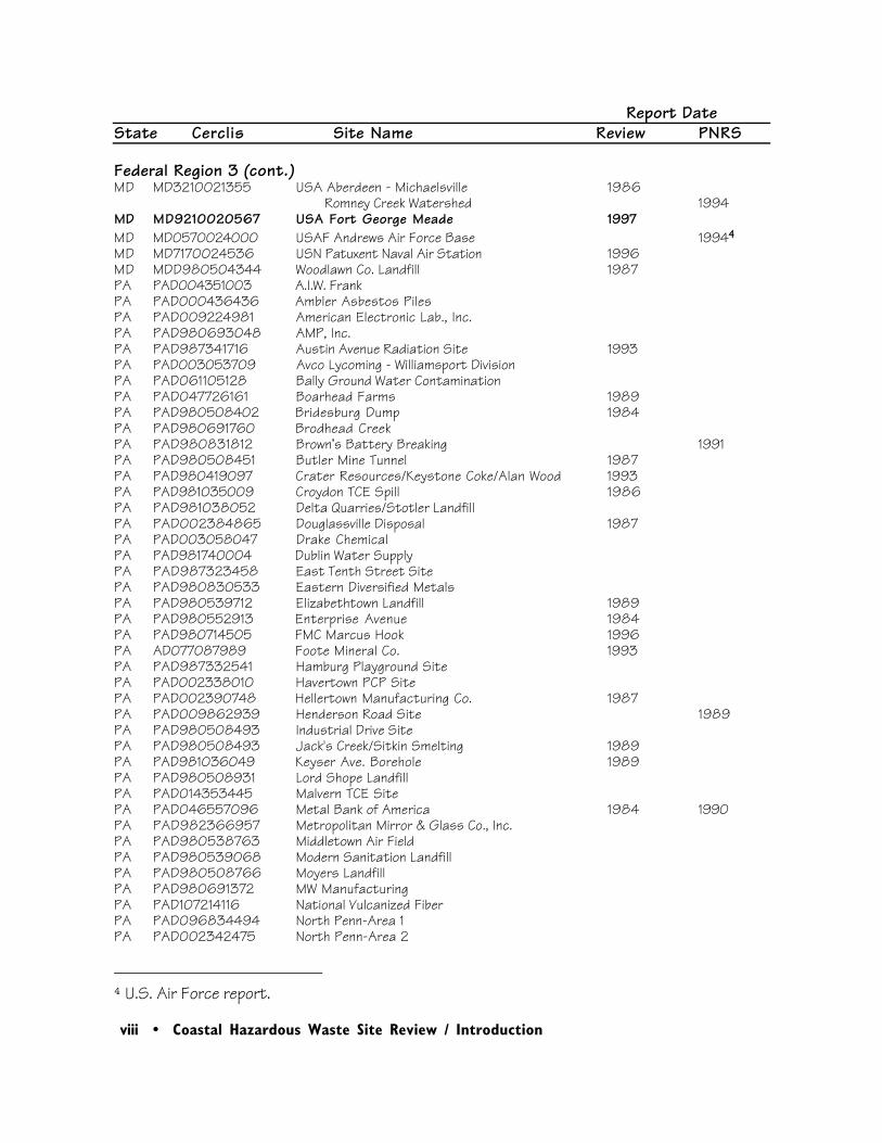
Federal Region 3 (cont.)MD MD3210021355 USA Aberdeen - Michaelsville 1986
Romney Creek Watershed 1994MD MD9210020567 USA Fort George Meade 1997MD MD0570024000 USAF Andrews Air Force Base 19944
MD MD7170024536 USN Patuxent Naval Air Station 1996MD MDD980504344 Woodlawn Co. Landfill 1987PA PAD004351003 A.I.W. FrankPA PAD000436436 Ambler Asbestos PilesPA PAD009224981 American Electronic Lab., Inc.PA PAD980693048 AMP, Inc.PA PAD987341716 Austin Avenue Radiation Site 1993PA PAD003053709 Avco Lycoming - Williamsport DivisionPA PAD061105128 Bally Ground Water ContaminationPA PAD047726161 Boarhead Farms 1989PA PAD980508402 Bridesburg Dump 1984PA PAD980691760 Brodhead CreekPA PAD980831812 Brown’s Battery Breaking 1991PA PAD980508451 Butler Mine Tunnel 1987PA PAD980419097 Crater Resources/Keystone Coke/Alan Wood 1993PA PAD981035009 Croydon TCE Spill 1986PA PAD981038052 Delta Quarries/Stotler LandfillPA PAD002384865 Douglassville Disposal 1987PA PAD003058047 Drake ChemicalPA PAD981740004 Dublin Water SupplyPA PAD987323458 East Tenth Street SitePA PAD980830533 Eastern Diversified MetalsPA PAD980539712 Elizabethtown Landfill 1989PA PAD980552913 Enterprise Avenue 1984PA PAD980714505 FMC Marcus Hook 1996PA AD077087989 Foote Mineral Co. 1993PA PAD987332541 Hamburg Playground SitePA PAD002338010 Havertown PCP SitePA PAD002390748 Hellertown Manufacturing Co. 1987PA PAD009862939 Henderson Road Site 1989PA PAD980508493 Industrial Drive SitePA PAD980508493 Jack's Creek/Sitkin Smelting 1989PA PAD981036049 Keyser Ave. Borehole 1989PA PAD980508931 Lord Shope LandfillPA PAD014353445 Malvern TCE SitePA PAD046557096 Metal Bank of America 1984 1990PA PAD982366957 Metropolitan Mirror & Glass Co., Inc.PA PAD980538763 Middletown Air FieldPA PAD980539068 Modern Sanitation LandfillPA PAD980508766 Moyers LandfillPA PAD980691372 MW ManufacturingPA PAD107214116 National Vulcanized FiberPA PAD096834494 North Penn-Area 1PA PAD002342475 North Penn-Area 2
4 U.S. Air Force report.
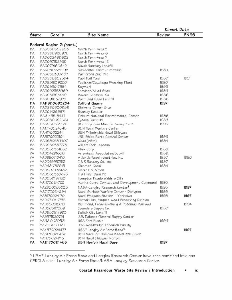
Coastal Hazardous Waste Site Review / Introduction • ix
Report DateState Cerclis Site Name Review PNRS
Federal Region 3 (cont.)PA PAD980692693 North Penn-Area 5PA PAD980926976 North Penn-Area 6PA PAD002498632 North Penn-Area 7PA PAD057152365 North Penn-Area 12PA PAD079160842 Novak Sanitary LandfillPA PAD980229298 Occidental Chem./Firestone 1989PA PAD002395887 Palmerton Zinc PilePA PAD980692594 Paoli Rail Yard 1987 1991PA PAD981939200 Publicker/Cuyahoga Wrecking Plant 1990PA PAD039017694 Raymark 1996PA PAD002353969 Recticon/Allied Steel 1989PA PAD051395499 Revere Chemical Co. 1986PA PAD091637975 Rohm and Haas Landfill 1986P A PAD980693204 Salford Quarry 1997PA PAD980830889 Shriver's Corner SitePA PAD014269971 Stanley KesslerPA PA6143515447 Tinicum National Environmental Center 1986PA PAD980692024 Tysons Dump #1 1985PA PAD980539126 UGI Corp. Gas Manufacturing Plant 1995PA PA6170024545 USN Naval Warfare CenterPA PA417002241 USN Philadelphia Naval ShipyardPA PA3170022104 USN Ships Parts Control Center 1996PA PAD980539407 Wade (ABM) 1984PA PAD980537773 William Dick LagoonsVA VAD980551683 Abex Corp. 1989VA VAD042916361 Arrowhead Associates/Scovill 1989VA VAD990710410 Atlantic Wood Industries, Inc. 1987 1990VA VAD049957913 C & R Battery Co., Inc. 1987VA VAD980712913 Chisman Creek 1984VA VAD007972482 Clarke L.A. & SonVA VAD980539878 H & H Inc.-Burn PitVA VAD988197133 Hampton Roads Welders SiteVA VA1170024722 Marine Corps Combat and Development Command 1995VA VA2800005033 NASA-Langley Research Center5 1995 1997VA VA7170024684 Naval Surface Warfare Center - Dahlgren 1993VA VA8170024170 Naval Weapons Station - Yorktown 1993 1997VA VAD071040752 Rentokil Inc., Virginia Wood Preserving DivisionVA VAD020312013 Richmond, Fredericksburg & Potomac Railroad 1994VA VAD003117389 Saunders Supply Co. 1987VA VAD980917983 Suffolk City Landfill VA VA3971520751 U.S. Defense General Supply CenterVA VA6210020321 USA Fort Eustis 1996VA VA7210020981 USA Woodbridge Research FacilityVA VA4570024477 USAF Langley Air Force Base5 1997VA VA5170022482 USN Naval Amphibious Base/Little CreekVA VA1170024813 USN Naval Shipyard NorfolkVA VA6170061463 USN Norfolk Naval Base 1997
5 USAF Langley Air Force Base and Langley Research Center have been combined into oneCERCLA site: Langley Air Force Base/NASA Langley Research Center.
x • Coastal Hazardous Waste Site Review / Introduction
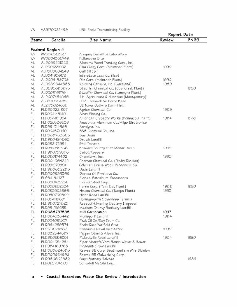
VA VA9170022488 USN Radio Transmitting FacilityReport Date
State Cerclis Site Name Review PNRS
Federal Region 4WV WV0170023691 Allegany Ballistics LaboratoryWV WVD004336749 Follansbee SiteAL ALD058221326 Alabama Wood Treating Corp., Inc.AL ALD001221902 Ciba-Geigy Corp. (McIntosh Plant) 1990AL ALD000604249 Gulf Oil Co.AL ALD041906173 Interstate Lead Co. (Ilco)AL ALD008188708 Olin Corp. (McIntosh Plant) 1990AL ALD980844385 Redwing Carriers, Inc. (Saraland) 1989AL ALD095688875 Stauffer Chemical Co. (Cold Creek Plant) 1990AL ALD008161176 Stauffer Chemical Co. (Lemoyne Plant)AL ALD007454085 T.H. Agriculture & Nutrition (Montgomery)AL AL0570024182 USAF Maxwell Air Force BaseAL AL2170024630 US Naval Outlying Barin FieldFL FLD980221857 Agrico Chemical Co. 1989FL FLD004145140 Airco Plating Co.FL FLD008161994 American Creosote Works (Pensacola Plant) 1984 1989FL FLD020536538 Anaconda Aluminum Co./Milgo ElectronicsFL FLD981014368 Anodyne, Inc.FL FLD004574190 B&B Chemical Co., Inc.FL FLD088783865 Bay DrumFL FLD980494660 Beulah LandfillFL FLD052172954 BMI-TextronFL FLD981930506 Broward County-21st Manor Dump 1992FL FLD980709356 Cabot/KoppersFL FLD080174402 Chemform, Inc. 1990FL FLD004064242 Chevron Chemical Co. (Ortho Division)FL FLD991279894 Coleman-Evans Wood Preserving Co.FL FLD980602288 Davie LandfillFL FLD000833368 Dubose Oil Products Co.FL FL984184127 Florida Petroleum ProcessorsFL FLD050432251 Florida Steel Corp.FL FLD000602334 Harris Corp. (Palm Bay Plant) 1986 1990FL FLD053502696 Helena Chemical Co. (Tampa Plant) 1993FL FLD980709802 Hipps Road LandfillFL FLD004119681 Hollingsworth Solderless Terminal FL FLD980727820 Kassouf-Kimerling Battery DisposalFL FLD981019235 Madison County Sanitary LandfillFL FLD088787585 MRI Corporation 1997FL FLD084535442 Munisport Landfill 1984FL FLD004091807 Peak Oil Co./Bay Drum Co.FL FLD984259374 Peele-Dixie Wellfield SiteFL FL9170024567 Pensacola Naval Air Station 1990FL FLD032544587 Pepper Steel & Alloys, Inc.FL FLD980556351 Pickettville Road Landfill 1984 1990FL FLD004054284 Piper Aircraft/Vero Beach Water & SewerFL FLD984169763 Pleasant Grove LandfillFL FLD000824888 Reeves SE Corp. Southeastern Wire DivisionFL FLD000824896 Reeves SE Galvanizing Corp.FL FLD980602882 Sapp Battery Salvage 1989FL FLD062794003 Schuylkill Metals Corp.
Coastal Hazardous Waste Site Review / Introduction • xi
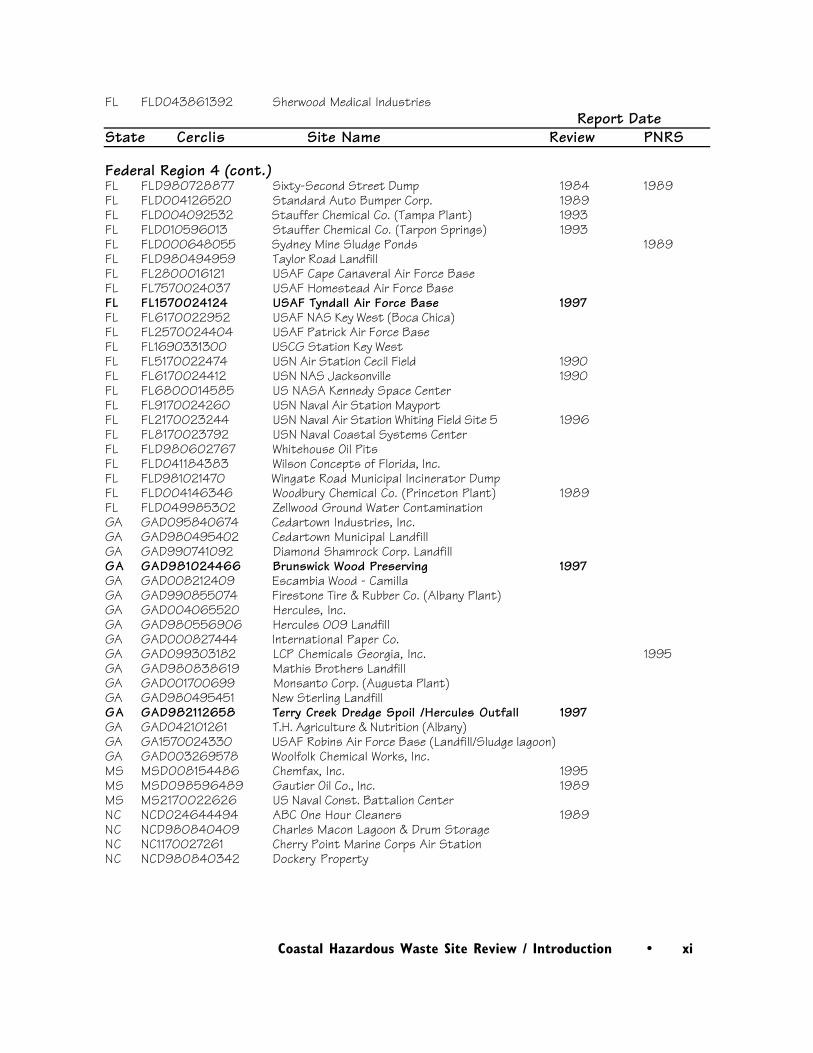
FL FLD043861392 Sherwood Medical IndustriesReport Date
State Cerclis Site Name Review PNRS
Federal Region 4 (cont.)FL FLD980728877 Sixty-Second Street Dump 1984 1989FL FLD004126520 Standard Auto Bumper Corp. 1989FL FLD004092532 Stauffer Chemical Co. (Tampa Plant) 1993FL FLD010596013 Stauffer Chemical Co. (Tarpon Springs) 1993FL FLD000648055 Sydney Mine Sludge Ponds 1989FL FLD980494959 Taylor Road LandfillFL FL2800016121 USAF Cape Canaveral Air Force BaseFL FL7570024037 USAF Homestead Air Force BaseFL FL1570024124 USAF Tyndall Air Force Base 1997FL FL6170022952 USAF NAS Key West (Boca Chica)FL FL2570024404 USAF Patrick Air Force BaseFL FL1690331300 USCG Station Key WestFL FL5170022474 USN Air Station Cecil Field 1990FL FL6170024412 USN NAS Jacksonville 1990FL FL6800014585 US NASA Kennedy Space CenterFL FL9170024260 USN Naval Air Station MayportFL FL2170023244 USN Naval Air Station Whiting Field Site 5 1996FL FL8170023792 USN Naval Coastal Systems CenterFL FLD980602767 Whitehouse Oil PitsFL FLD041184383 Wilson Concepts of Florida, Inc.FL FLD981021470 Wingate Road Municipal Incinerator DumpFL FLD004146346 Woodbury Chemical Co. (Princeton Plant) 1989FL FLD049985302 Zellwood Ground Water ContaminationGA GAD095840674 Cedartown Industries, Inc.GA GAD980495402 Cedartown Municipal LandfillGA GAD990741092 Diamond Shamrock Corp. LandfillGA GAD981024466 Brunswick Wood Preserving 1997GA GAD008212409 Escambia Wood - CamillaGA GAD990855074 Firestone Tire & Rubber Co. (Albany Plant)GA GAD004065520 Hercules, Inc.GA GAD980556906 Hercules 009 LandfillGA GAD000827444 International Paper Co.GA GAD099303182 LCP Chemicals Georgia, Inc. 1995GA GAD980838619 Mathis Brothers LandfillGA GAD001700699 Monsanto Corp. (Augusta Plant)GA GAD980495451 New Sterling LandfillGA GAD982112658 Terry Creek Dredge Spoil /Hercules Outfall 1997GA GAD042101261 T.H. Agriculture & Nutrition (Albany)GA GA1570024330 USAF Robins Air Force Base (Landfill/Sludge lagoon)GA GAD003269578 Woolfolk Chemical Works, Inc.MS MSD008154486 Chemfax, Inc. 1995MS MSD098596489 Gautier Oil Co., Inc. 1989MS MS2170022626 US Naval Const. Battalion CenterNC NCD024644494 ABC One Hour Cleaners 1989NC NCD980840409 Charles Macon Lagoon & Drum StorageNC NC1170027261 Cherry Point Marine Corps Air StationNC NCD980840342 Dockery Property
xii • Coastal Hazardous Waste Site Review / Introduction
Report DateState Cerclis Site Name Review PNRS
Federal Region 4 (cont.)NC NCD981475932 FCX , Inc. (Washington Plant) 1989NC NCD981927502 Geigy Chemical Corp. (Aberdeen Plant)NC NCD079044426 General Electric Co./Shepherd FarmNC NCD003200383 Koppers Co., Inc. (Morrisville Plant)NC NCD991278953 National Starch & Chemical Corp.NC NCD981021157 New Hanover County Airport Burn Pit 1989NC NCD986186518 Old ATC RefineryNC NCD981023260 Potter’s Septic Tank Service Pits 1989NC NC6170022580 USMC Camp Lejeune 1989SC SCD987581337 Calhoun Park/Ansonborough Homes/Scegco 1993SC SCD980558316 Carolawn, Inc.SC SCD980846034 Charleston LandfillSC SCD980711279 Geiger (C&M Oil) 1984SC SCD058753971 Helena Chemical Co. Landfill 1989SC SCD055915086 International Paper Co.SC SCD094995503 Kalama Specialty ChemicalsSC SCD980310239 Koppers Co., Inc. (Charleston Plant) 1993SC SCD991279324 Leonard Chemical Co., Inc.SC SCD980558043 Lexington County Landfill AreaSC SC0170022560 Naval Shipyard - CharlestonSC SC8170022620 Naval Weapons Station - CharlestonSC SCD037398120 Palmetto Recycling, Inc.SC SCD002601656 Para-Chem Southern, Inc.SC SC6170022762 Parris Island Marine Corps Recruit Depot 1995SC SC1890008989 US DOE Savannah River Site 1990SC SCD987572674 US DOI Charleston Harbor Site 1993SC SCD037405362 Wamchem, Inc. 1984
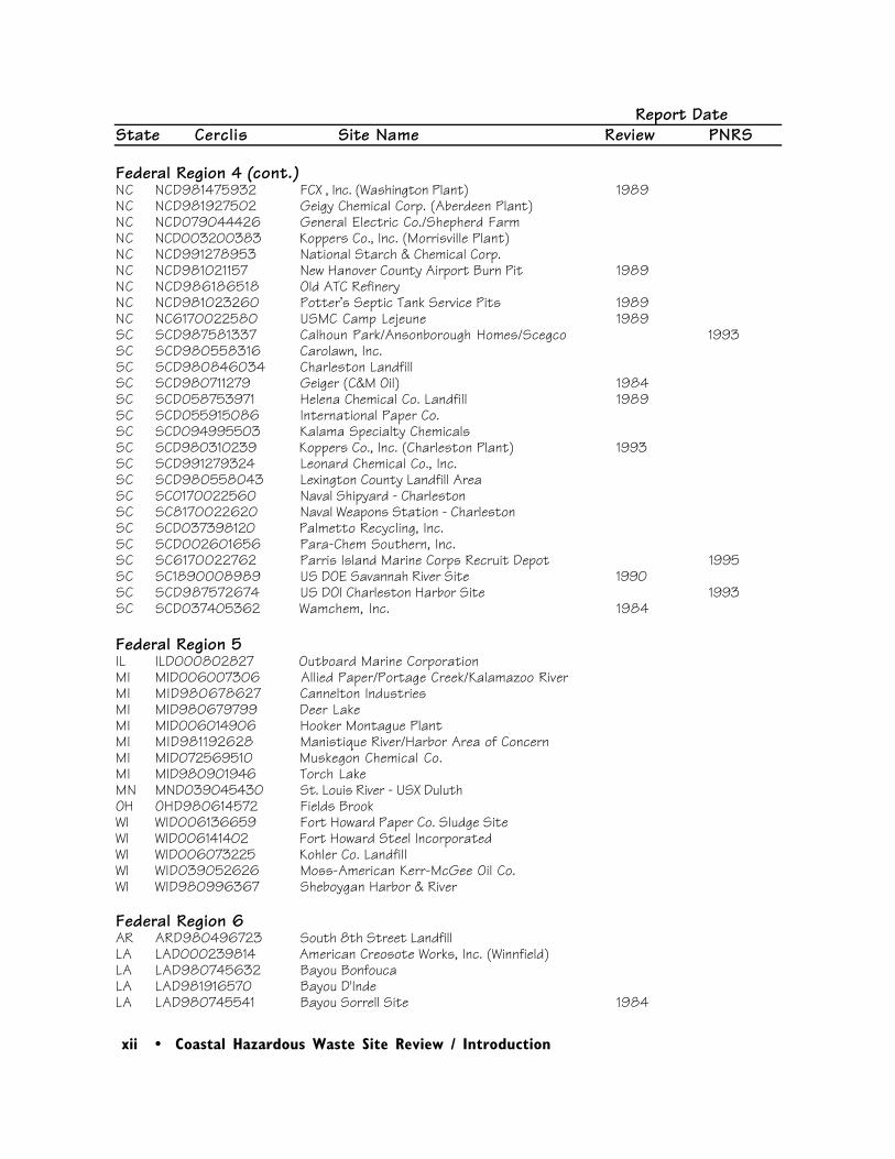
Federal Region 5IL ILD000802827 Outboard Marine CorporationMI MID006007306 Allied Paper/Portage Creek/Kalamazoo RiverMI MID980678627 Cannelton IndustriesMI MID980679799 Deer LakeMI MID006014906 Hooker Montague PlantMI MID981192628 Manistique River/Harbor Area of ConcernMI MID072569510 Muskegon Chemical Co.MI MID980901946 Torch LakeMN MND039045430 St. Louis River - USX DuluthOH OHD980614572 Fields BrookWI WID006136659 Fort Howard Paper Co. Sludge SiteWI WID006141402 Fort Howard Steel IncorporatedWI WID006073225 Kohler Co. LandfillWI WID039052626 Moss-American Kerr-McGee Oil Co.WI WID980996367 Sheboygan Harbor & River
Federal Region 6 AR ARD980496723 South 8th Street LandfillLA LAD000239814 American Creosote Works, Inc. (Winnfield)LA LAD980745632 Bayou BonfoucaLA LAD981916570 Bayou D'IndeLA LAD980745541 Bayou Sorrell Site 1984
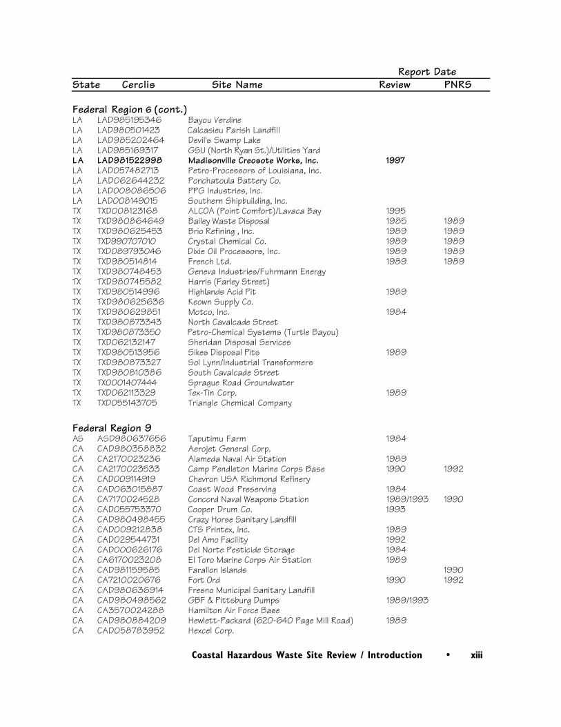
Coastal Hazardous Waste Site Review / Introduction • xiii
Report DateState Cerclis Site Name Review PNRS
Federal Region 6 (cont.)LA LAD985195346 Bayou VerdineLA LAD980501423 Calcasieu Parish LandfillLA LAD985202464 Devil's Swamp LakeLA LAD985169317 GSU (North Ryan St.)/Utilities YardLA LAD981522998 Madisonville Creosote Works, Inc. 1997LA LAD057482713 Petro-Processors of Louisiana, Inc.LA LAD062644232 Ponchatoula Battery Co.LA LAD008086506 PPG Industries, Inc.LA LAD008149015 Southern Shipbuilding, Inc.TX TXD008123168 ALCOA (Point Comfort)/Lavaca Bay 1995TX TXD980864649 Bailey Waste Disposal 1985 1989TX TXD980625453 Brio Refining , Inc. 1989 1989TX TXD990707010 Crystal Chemical Co. 1989 1989TX TXD089793046 Dixie Oil Processors, Inc. 1989 1989TX TXD980514814 French Ltd. 1989 1989TX TXD980748453 Geneva Industries/Fuhrmann Energy TX TXD980745582 Harris (Farley Street)TX TXD980514996 Highlands Acid Pit 1989TX TXD980625636 Keown Supply Co.TX TXD980629851 Motco, Inc. 1984TX TXD980873343 North Cavalcade StreetTX TXD980873350 Petro-Chemical Systems (Turtle Bayou)TX TXD062132147 Sheridan Disposal ServicesTX TXD980513956 Sikes Disposal Pits 1989TX TXD980873327 Sol Lynn/Industrial TransformersTX TXD980810386 South Cavalcade StreetTX TX0001407444 Sprague Road GroundwaterTX TXD062113329 Tex-Tin Corp. 1989TX TXD055143705 Triangle Chemical Company
Federal Region 9AS ASD980637656 Taputimu Farm 1984CA CAD980358832 Aerojet General Corp.CA CA2170023236 Alameda Naval Air Station 1989CA CA2170023533 Camp Pendleton Marine Corps Base 1990 1992CA CAD009114919 Chevron USA Richmond RefineryCA CAD063015887 Coast Wood Preserving 1984CA CA7170024528 Concord Naval Weapons Station 1989/1993 1990CA CAD055753370 Cooper Drum Co. 1993CA CAD980498455 Crazy Horse Sanitary LandfillCA CAD009212838 CTS Printex, Inc. 1989CA CAD029544731 Del Amo Facility 1992CA CAD000626176 Del Norte Pesticide Storage 1984CA CA6170023208 El Toro Marine Corps Air Station 1989CA CAD981159585 Farallon Islands 1990CA CA7210020676 Fort Ord 1990 1992CA CAD980636914 Fresno Municipal Sanitary LandfillCA CAD980498562 GBF & Pittsburg Dumps 1989/1993CA CA3570024288 Hamilton Air Force BaseCA CAD980884209 Hewlett-Packard (620-640 Page Mill Road) 1989CA CAD058783952 Hexcel Corp.
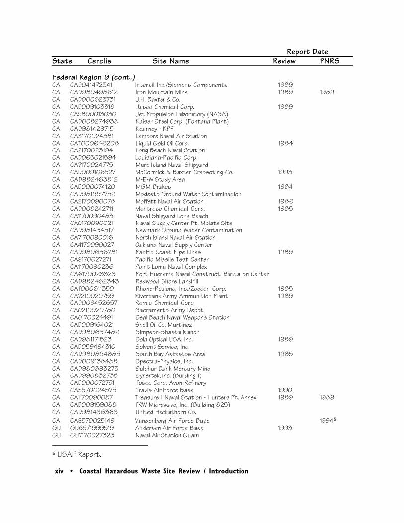
xiv • Coastal Hazardous Waste Site Review / Introduction
Report DateState Cerclis Site Name Review PNRS
Federal Region 9 (cont.)CA CAD041472341 Intersil Inc./Siemens Components 1989CA CAD980498612 Iron Mountain Mine 1989 1989CA CAD000625731 J.H. Baxter & Co.CA CAD009103318 Jasco Chemical Corp. 1989CA CA9800013030 Jet Propulsion Laboratory (NASA)CA CAD008274938 Kaiser Steel Corp. (Fontana Plant)CA CAD981429715 Kearney - KPFCA CA3170024381 Lemoore Naval Air StationCA CAT000646208 Liquid Gold Oil Corp. 1984CA CA2170023194 Long Beach Naval StationCA CAD065021594 Louisiana-Pacific Corp.CA CA7170024775 Mare Island Naval ShipyardCA CAD009106527 McCormick & Baxter Creosoting Co. 1993CA CAD982463812 M-E-W Study AreaCA CAD000074120 MGM Brakes 1984CA CAD981997752 Modesto Ground Water ContaminationCA CA2170090078 Moffett Naval Air Station 1986CA CAD008242711 Montrose Chemical Corp. 1985CA CA1170090483 Naval Shipyard Long BeachCA CA0170090021 Naval Supply Center Pt. Molate SiteCA CAD981434517 Newmark Ground Water ContaminationCA CA7170090016 North Island Naval Air StationCA CA4170090027 Oakland Naval Supply CenterCA CAD980636781 Pacific Coast Pipe Lines 1989CA CA9170027271 Pacific Missile Test CenterCA CA1170090236 Point Loma Naval ComplexCA CA6170023323 Port Hueneme Naval Construct. Battalion CenterCA CAD982462343 Redwood Shore LandfillCA CAT000611350 Rhone-Poulenc, Inc./Zoecon Corp. 1985CA CA7210020759 Riverbank Army Ammunition Plant 1989CA CAD009452657 Romic Chemical CorpCA CA0210020780 Sacramento Army DepotCA CA0170024491 Seal Beach Naval Weapons StationCA CAD009164021 Shell Oil Co. Martinez CA CAD980637482 Simpson-Shasta RanchCA CAD981171523 Sola Optical USA, Inc. 1989CA CAD059494310 Solvent Service, Inc.CA CAD980894885 South Bay Asbestos Area 1985CA CAD009138488 Spectra-Physics, Inc.CA CAD980893275 Sulphur Bank Mercury MineCA CAD990832735 Synertek, Inc. (Building 1)CA CAD000072751 Tosco Corp. Avon RefineryCA CA5570024575 Travis Air Force Base 1990CA CA1170090087 Treasure I. Naval Station - Hunters Pt. Annex 1989 1989CA CAD009159088 TRW Microwave, Inc. (Building 825)CA CAD981436363 United Heckathorn Co.CA CA9570025149 Vandenberg Air Force Base 19946 GU GU6571999519 Andersen Air Force Base 1993GU GU7170027323 Naval Air Station Guam
6 USAF Report.
Coastal Hazardous Waste Site Review / Introduction • xv
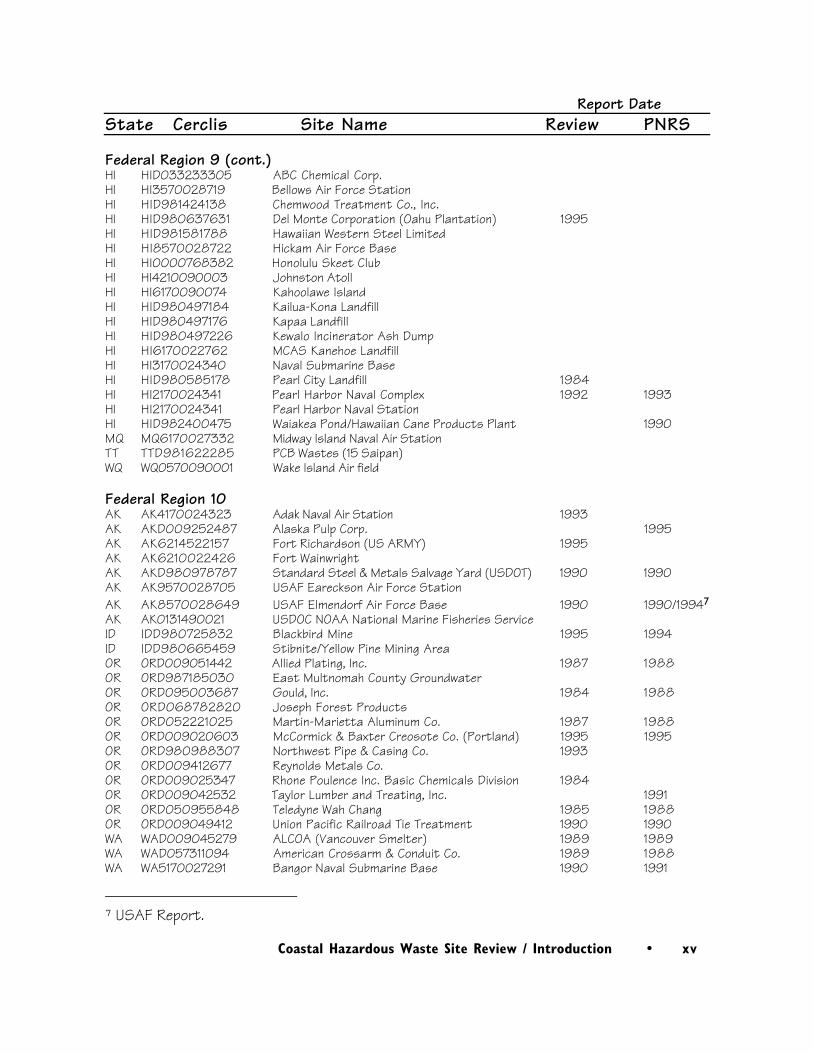
Report DateState Cerclis Site Name Review PNRS
Federal Region 9 (cont.)HI HID033233305 ABC Chemical Corp.HI HI3570028719 Bellows Air Force StationHI HID981424138 Chemwood Treatment Co., Inc.HI HID980637631 Del Monte Corporation (Oahu Plantation) 1995HI HID981581788 Hawaiian Western Steel LimitedHI HI8570028722 Hickam Air Force BaseHI HI0000768382 Honolulu Skeet ClubHI HI4210090003 Johnston AtollHI HI6170090074 Kahoolawe IslandHI HID980497184 Kailua-Kona LandfillHI HID980497176 Kapaa LandfillHI HID980497226 Kewalo Incinerator Ash DumpHI HI6170022762 MCAS Kanehoe LandfillHI HI3170024340 Naval Submarine BaseHI HID980585178 Pearl City Landfill 1984HI HI2170024341 Pearl Harbor Naval Complex 1992 1993HI HI2170024341 Pearl Harbor Naval StationHI HID982400475 Waiakea Pond/Hawaiian Cane Products Plant 1990MQ MQ6170027332 Midway Island Naval Air StationTT TTD981622285 PCB Wastes (15 Saipan)WQ WQ0570090001 Wake Island Air field
Federal Region 10AK AK4170024323 Adak Naval Air Station 1993AK AKD009252487 Alaska Pulp Corp. 1995AK AK6214522157 Fort Richardson (US ARMY) 1995AK AK6210022426 Fort WainwrightAK AKD980978787 Standard Steel & Metals Salvage Yard (USDOT) 1990 1990AK AK9570028705 USAF Eareckson Air Force StationAK AK8570028649 USAF Elmendorf Air Force Base 1990 1990/19947
AK AK0131490021 USDOC NOAA National Marine Fisheries ServiceID IDD980725832 Blackbird Mine 1995 1994ID IDD980665459 Stibnite/Yellow Pine Mining AreaOR ORD009051442 Allied Plating, Inc. 1987 1988OR ORD987185030 East Multnomah County GroundwaterOR ORD095003687 Gould, Inc. 1984 1988OR ORD068782820 Joseph Forest ProductsOR ORD052221025 Martin-Marietta Aluminum Co. 1987 1988OR ORD009020603 McCormick & Baxter Creosote Co. (Portland) 1995 1995OR ORD980988307 Northwest Pipe & Casing Co. 1993OR ORD009412677 Reynolds Metals Co.OR ORD009025347 Rhone Poulence Inc. Basic Chemicals Division 1984OR ORD009042532 Taylor Lumber and Treating, Inc. 1991OR ORD050955848 Teledyne Wah Chang 1985 1988OR ORD009049412 Union Pacific Railroad Tie Treatment 1990 1990WA WAD009045279 ALCOA (Vancouver Smelter) 1989 1989WA WAD057311094 American Crossarm & Conduit Co. 1989 1988WA WA5170027291 Bangor Naval Submarine Base 1990 1991
7 USAF Report.
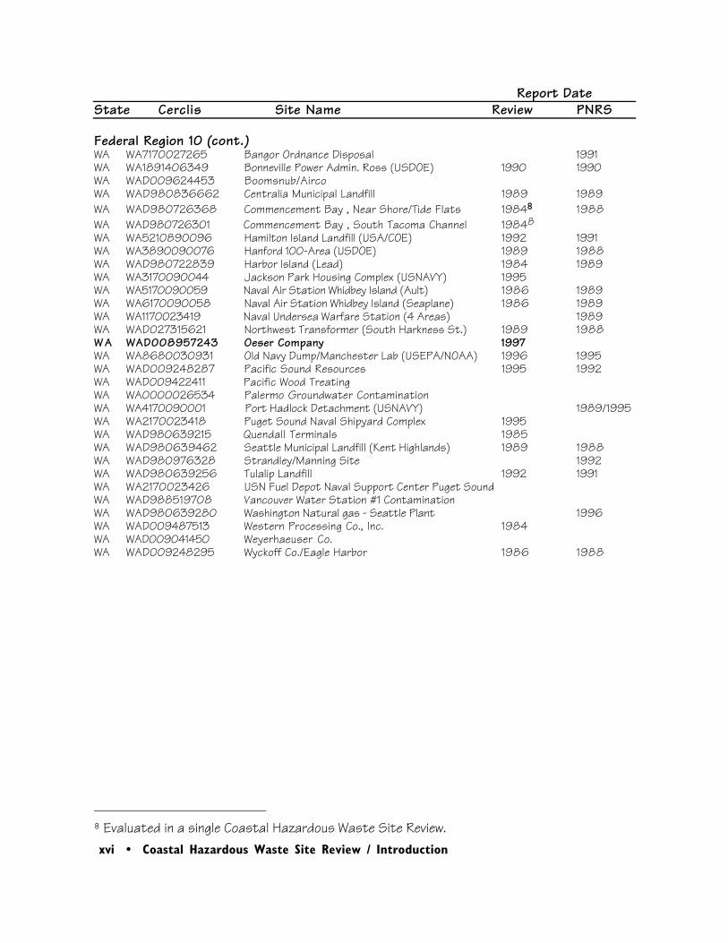
xvi • Coastal Hazardous Waste Site Review / Introduction
Report DateState Cerclis Site Name Review PNRS
Federal Region 10 (cont.)WA WA7170027265 Bangor Ordnance Disposal 1991WA WA1891406349 Bonneville Power Admin. Ross (USDOE) 1990 1990WA WAD009624453 Boomsnub/AircoWA WAD980836662 Centralia Municipal Landfill 1989 1989WA WAD980726368 Commencement Bay , Near Shore/Tide Flats 19848 1988WA WAD980726301 Commencement Bay , South Tacoma Channel 19848WA WA5210890096 Hamilton Island Landfill (USA/COE) 1992 1991WA WA3890090076 Hanford 100-Area (USDOE) 1989 1988WA WAD980722839 Harbor Island (Lead) 1984 1989WA WA3170090044 Jackson Park Housing Complex (USNAVY) 1995WA WA5170090059 Naval Air Station Whidbey Island (Ault) 1986 1989WA WA6170090058 Naval Air Station Whidbey Island (Seaplane) 1986 1989WA WA1170023419 Naval Undersea Warfare Station (4 Areas) 1989WA WAD027315621 Northwest Transformer (South Harkness St.) 1989 1988W A WAD008957243 Oeser Company 1997WA WA8680030931 Old Navy Dump/Manchester Lab (USEPA/NOAA) 1996 1995WA WAD009248287 Pacific Sound Resources 1995 1992WA WAD009422411 Pacific Wood TreatingWA WA0000026534 Palermo Groundwater ContaminationWA WA4170090001 Port Hadlock Detachment (USNAVY) 1989/1995WA WA2170023418 Puget Sound Naval Shipyard Complex 1995WA WAD980639215 Quendall Terminals 1985WA WAD980639462 Seattle Municipal Landfill (Kent Highlands) 1989 1988WA WAD980976328 Strandley/Manning Site 1992WA WAD980639256 Tulalip Landfill 1992 1991WA WA2170023426 USN Fuel Depot Naval Support Center Puget SoundWA WAD988519708 Vancouver Water Station #1 ContaminationWA WAD980639280 Washington Natural gas - Seattle Plant 1996WA WAD009487513 Western Processing Co., Inc. 1984WA WAD009041450 Weyerhaeuser Co.WA WAD009248295 Wyckoff Co./Eagle Harbor 1986 1988
8 Evaluated in a single Coastal Hazardous Waste Site Review.

Coastal Hazardous Waste Site Review / Introduction • xvii
Table 2. Acronyms and abbreviations used in Coastal Hazardous Waste Site Reviews
AST above-ground storage tankAWQC Ambient water quality criteria for the protection of aquatic lifebgs below ground surfaceBHC benzene hexachlorideBNA base, neutral, and acid-extractable organic compoundsBOD biological oxygen demandCERCLA Comprehensive Environmental Response, Compensation, and Liability Act of 1980CERCLIS Comprehensive Environmental Response, Compensation, and Liability
Information Systemcfs cubic feet per secondcm centimeterCOC contaminant of concernCOD chemical oxygen demandCOE U.S. Army Corps of EngineersCRC Coastal Resource CoordinatorDDD dichlorodiphenyldichloroethaneDDE dichlorodiphenyldichloroethyleneDDT dichlorodiphenyltrichloroethaneDNT dinitrotolueneDOD U.S. Department of DefenseDOI U.S. Department of the InteriorEPA U.S. Environmental Protection AgencyERL effects range - lowERM effects range - medianETAG Ecological and Technical Assessment Groupha hectareHMX cyclotetramethylene tetranitramineHRS Hazard Ranking SystemIRM Immediate Removal Measurekg kilogramkm kilometerL literLNAPL light, non-aqueous phase liquidLOEL lowest observed effects levelm meterm3/second cubic meter per secondµg/g micrograms per gram (ppm)µg/kg micrograms per kilogram (ppb)µg/L micrograms per liter (ppb)µR/hr microroentgens per hourmg milligrammg/kg milligrams per kilogram (ppm)mg/L milligrams per liter (ppm)mR/hr milliroentgens per hourNAPL non-aqueous phase liquidNFA no further actionNOAA National Oceanic and Atmospheric AdministrationNPDES National Pollutant Discharge Elimination SystemNPL National Priorities ListOU operable unitPAH polynuclear aromatic hydrocarbonPA/SI Preliminary Assessment/Site InvestigationPCB polychlorinated biphenyl

xviii • Coastal Hazardous Waste Site Review / Introduction
PCE perchloroethylene (aka tetrachloroethylene)Table 2 (cont.)
PCP pentachlorophenolPNRS Preliminary Natural Resource Surveyppb parts per billionppm parts per millionppt parts per thousandPRP Potentially Responsible PartyPVC polyvinyl chlorideRCRA Resource Conservation and Recovery ActRD/RA Remedial Design/Remedial ActionRDX cycloniteRI/FS Remedial Investigation/Feasibility StudyROD Record of DecisionSARA Superfund Amendments and Reauthorization Act of 1986SVOC semi-volatile organic compoundTCA 1,1,1-trichloroethaneTCE trichloroethyleneTCL Target Compound ListTNT trinitrotolueneTPH total petroleum hydrocarbonsTSS total suspended solidsUSFWS U.S. Fish and Wildlife ServiceUSGS U.S. Geological SurveyUST underground storage tankVOC volatile organic compound< less than> greater than

Coastal Hazardous Waste Site Review / Introduction • xix
PLEASE CITE AS:
Garman, Gayle, and Lori Harris, editors. 1997. Coastal Hazardous Waste Site Reviews,December 1997. Seattle: Hazardous Materials Response and Assessment Division, National Oceanic and Atmospheric Administration. 130 pp.

xx • Coastal Hazardous Waste Site Review / Introduction

Region 1 • 1
Coastal Hazardous Waste Site Review / Beede Waste Oil • 1
1Beede Waste Oil
Site Exposure Potential
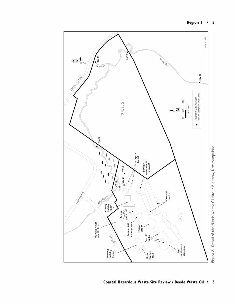
The Beede Waste Oil site comprises two parcelsof land on about 16 ha in Plaistow, New Hamp-shire (Figure 1). Kelly Brook flows through thesite for about 0.6 km and then flows into theLittle River approximately 1.5 km downstreamfrom Parcel 1 (Figure 2). From the confluencewith Kelly Brook, the Little River flows about 7km before entering the Merrimack River, whichenters the Atlantic Ocean approximately 35 kmdownstream.
The site was a waste oil recycling and virgin fueloil storage and distribution facility from 1926until 1994. Parcel 1 was used for petroleum andwaste storage and handling, and Parcel 2 was
Plaistow, New HampshireCERCLIS #NHD018958140
used primarily for commercial sand and graveloperations (Figure 2). There are numerouslocalized areas on the site where wastes werestored or disposed. The most contaminated areasinclude a former surface lagoon where waste oilswere deposited, surface-water runoff pits wherereleases of petroleum products were documented,and two interceptor trenches (SH&A 1995;Figure 2). By 1978, 86 aboveground storagetanks (ASTs) with a total capacity of 4.9 millionliters were in use; 38 of these tanks are docu-mented to have contained waste oil, sludge, orwater contaminated with PCBs and trace ele-ments. There are numerous piles of contami-nated soil and debris, with an estimated total

2 • Region 1
2 • Coastal Hazardous Waste Site Review / Beede Waste Oil
volume of 15,000 m3, at the site. Althoughmost of the contaminated soils are located onParcel 1, PCB-contaminated soils are stockpiledon Parcel 2, also (SH&A 1995). In 1992, theNew Hampshire Department of EnvironmentalServices began maintaining oil-absorbent boomsin Kelly Brook because free product oil wasobserved discharging into the brook east of theolder site building. Free product oil samplesanalyzed from groundwater at the site containcombinations of lubricating oil, kerosene, weath-
ered gasoline, light fuel oil, Fuel Oil No. 2, anddiesel oil (SH&A 1995).
Groundwater and seeps of waste oils appear to bethe primary pathways for migration of contami-nants from the site to Kelly Brook. The availablesite documents did not discuss any drainageditches on-site that lead to Kelly Brook, althoughthis is a possible migration pathway. The topog-raphy of Parcel 1 is relatively flat but the north-eastern portion slopes towards Kelly Brook. The
NewburyportPlaistow
A t l a n t i cO c e a n
New Hampshire
Massachusetts
495
95
N
Beede Waste Oil site
0 2.5 5
kilometers
Mer
rima
ckR i
v e r
Figure 1. Location of Beede Waste Oil site in Plaistow, New Hampshire.
Prepared from USGS Boston, MA; NH; CT; RI; ME 1;250,000 scale map 1956, revised 1970
NY
RICT
NH �
MA
VT
At l an t i c Ocean
LittleR
iver
K e lly
Brook
Region 1 • 3
Coastal Hazardous Waste Site Review / Beede Waste Oil • 3
N
Surf
ace
wate
r ru
noff
pit
no.
1
Form
er A
STst
orag
e ar
ea
Form
er
lago
on
Form
er40
,000
-ga
llon
UST
Inte
rcep
tor
tren
ch
Surf
ace
wate
r run
off
pit
no. 2
Kell
y B rook
SW-3 SW
-2
SW-5
SW-6 SW
-7
SW-8
SW-4
Was
te o
ilta
nks
Fuel
oil
tank
sDr
umst
orag
ear
ea
Exis
ting
build
ing
(new
er)
AST
co
ntai
nmen
tst
ruct
ure
Old Co
unty
Road
Fran
Aven
ue
Kelly
Road
Figu
re 2
. De
tail
of t
he B
eede
Was
te O
il si
te in
Pla
isto
w, N
ew H
amps
hire
.
0
2
5
5
0
met
ers
KellyBroo
k
UnnamedCreek
Sed
imen
t an
d su
rfac
e w
ater
sam
plin
g lo
cati
ons
SH
&A 19
95
PARC
EL 2
PARC
EL 1
Exis
ting
bu
ildin
g (o
lder
)
4 • Region 1
4 • Coastal Hazardous Waste Site Review / Beede Waste Oil
topography of Parcel 2 varies as a result of sandand gravel mining operations (SH&A 1995).The overburden geology in the region is charac-terized as primarily marine sand containing a fewbeds of silt and clayey silt with some surficialdeposits of glacial sand and gravel, and till.Bedrock has been encountered at 20 to 23 mbelow the ground surface (bgs). Groundwater istypically found at depths ranging from approxi-mately 1 to 7m bgs; aquifer thicknesses at thesite range from approximately 15 to more than25 m. Groundwater beneath Parcel 1 generallyflows east and northeast. The principal zone ofdischarge for overburden groundwater flowingfrom the site is Kelly Brook. The average volu-metric discharge of groundwater from the site toKelly Brook is an estimated 240 m3/day, orapproximately 4% of the average stream flow(SH&A 1995).
NOAA Trust Habitats and Species
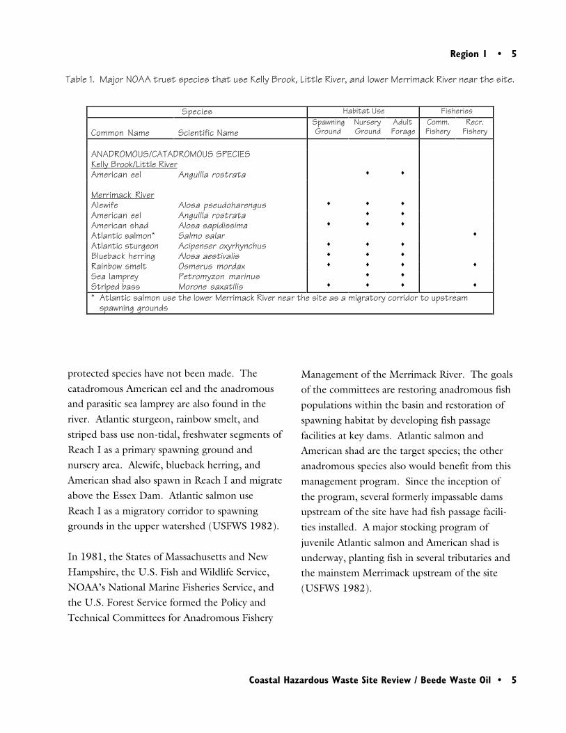
riffle stretches of the stream with finer sands inpool environments. The Little River is a moder-ate-sized, short stream originating in BayberryPond, approximately 3 km upstream of theconfluence of Kelly Brook, and discharging to theMerrimack River approximately 7 km down-stream of the confluence. The Little River islower gradient with a primarily warm-water fishassemblage. Substrates are likely composed ofsands with finer sediments in ponded areas(Ingham personal communication 1997).
Kelly Brook and the Little River have populationsof catadromous American eel throughout bothstreams. Anadromous species do not use thesestreams.
The Little River discharges into Reach I of thelower Merrimack River. Reach I is the lower 50km of the river from the Essex Dam, in Lawrence,Massachusetts, to the mouth. The river in thisreach is large, generally between 200 and 400 mwide with pools of 7 m or deeper. Sedimentsrange from large rubble to silts with 65% of thebottom substrate classified as sand and gravel, and14% as fine silts (USFWS 1982). The confluenceof the Little and Merrimack rivers is near thetransition between freshwater riverine and tidalestuarine habitat (Ingham pers. commun. 1997).
The Merrimack River has runs of seven anadro-mous species: Atlantic sturgeon, Atlantic salmon,American shad, alewife, blueback herring, rain-bow smelt, and striped bass. In addition, theriver is within the known distribution of theshortnose sturgeon, but verified collections of this
The primary habitats of concern to NOAA aresurface water, stream channel bottom, andassociated riparian zones of Kelly Brook, theLittle River, and the Merrimack River. Anadro-mous and catadromous fish species that use thethree streams are the resources of concern toNOAA (Table 1).
Kelly Brook is a small, spring-fed stream thatflows from its headwaters for approximately 7 kmto the Little River. The stream is high-gradient,cold-water with typical riffle-pool habitats formost of its length. Gravel substrates dominate
Region 1 • 5
Coastal Hazardous Waste Site Review / Beede Waste Oil • 5
Table 1. Major NOAA trust species that use Kelly Brook, Little River, and lower Merrimack River near the site.
protected species have not been made. Thecatadromous American eel and the anadromousand parasitic sea lamprey are also found in theriver. Atlantic sturgeon, rainbow smelt, andstriped bass use non-tidal, freshwater segments ofReach I as a primary spawning ground andnursery area. Alewife, blueback herring, andAmerican shad also spawn in Reach I and migrateabove the Essex Dam. Atlantic salmon useReach I as a migratory corridor to spawninggrounds in the upper watershed (USFWS 1982).
In 1981, the States of Massachusetts and NewHampshire, the U.S. Fish and Wildlife Service,NOAA’s National Marine Fisheries Service, andthe U.S. Forest Service formed the Policy andTechnical Committees for Anadromous Fishery
Management of the Merrimack River. The goalsof the committees are restoring anadromous fishpopulations within the basin and restoration ofspawning habitat by developing fish passagefacilities at key dams. Atlantic salmon andAmerican shad are the target species; the otheranadromous species also would benefit from thismanagement program. Since the inception ofthe program, several formerly impassable damsupstream of the site have had fish passage facili-ties installed. A major stocking program ofjuvenile Atlantic salmon and American shad isunderway, planting fish in several tributaries andthe mainstem Merrimack upstream of the site(USFWS 1982).
Species Habitat Use Fisheries
Common Name Scientific NameSpawningGround
NurseryGround
AdultForage
Comm.Fishery
Recr.Fishery
ANADROMOUS/CATADROMOUS SPECIESKelly Brook/Little RiverAmerican eel Anguilla rostrata ♦ ♦
Merrimack RiverAlewife Alosa pseudoharengus ♦ ♦ ♦
American eel Anguilla rostrata ♦ ♦
American shad Alosa sapidissima ♦ ♦ ♦
Atlantic salmon* Salmo salar ♦
Atlantic sturgeon Acipenser oxyrhynchus ♦ ♦ ♦
Blueback herring Alosa aestivalis ♦ ♦ ♦
Rainbow smelt Osmerus mordax ♦ ♦ ♦ ♦
Sea lamprey Petromyzon marinus ♦ ♦
Striped bass Morone saxatilis ♦ ♦ ♦ ♦
* Atlantic salmon use the lower Merrimack River near the site as a migratory corridor to upstreamspawning grounds
6 • Region 1
6 • Coastal Hazardous Waste Site Review / Beede Waste Oil
There are no plans to stock the Little River withanadromous fish because of its small size. How-ever, the New Hampshire Department of Fishand Game stocks and manages the river forrecreational taking of brook trout, a non-NOAAtrust species. Kelly Brook also contains a self-sustaining population of brook trout (Inghampers. commun. 1997).
The habitat type and the presence of a recre-ational brook trout fishery in the Little Riverindicate that blueback herring and alewife couldinhabit the river, although they have not beenobserved there. These species could use theLittle River in the future if restoration activitieson the Merrimack River enhance their overallpopulations in the watershed.
Site-Related Contamination
concentrations, although their presence on- andoff-site indicates that contaminants have migratedfrom the site. VOCs can facilitate environmentaltransport of other, less soluble organic contami-nants, such as PCBs, but this is undocumented atthe site. Petroleum hydrocarbons may pose a riskto trust resources but screening guidelines arenot available for these compounds.
Soil and groundwater data indicate potentialsources of contaminants to Kelly Brook andNOAA trust resources. VOCs and TPH in ornear the water table were highest in soils near theformer lagoon and Surface Water Runoff Pit No.2 (up to 440 mg/kg total non-chlorinatedaromatic VOCs, up to 210 mg/kg total chlori-nated VOCs, and up to 35,000 mg/kg TPH)(SH&A 1995). Maximum concentrations oftrace elements and PCBs detected in soils arepresented in Table 2. Limited data were availablefor trace elements in soils. During the Site andWaste Characterization, total PCBs were detectedin 10 of 14 soil samples at concentrations of 0.4to 1.4 mg/kg. In earlier studies, total PCBswere typically detected in soils at concentrationsof approximately 5 mg/kg or less, although PCBconcentrations as high as 1500 mg/kg werereported (U.S. EPA 1994, as cited in SH&A;NHDES 1995, as cited in SH&A 1995).
A light, non-aqueous phase liquid (LNAPL)floating on the groundwater at ten monitoringwells affects an estimated 0.4 to 0.8 ha. PCBshave been detected in all LNAPL samples, atconcentrations of 11 to 80 mg/kg. LNAPLthicknesses typically range from 0.3 to 1.5 m,with the greatest thicknesses found at the former
Data on site-related contamination for this reportwere obtained from the Site and Waste Charac-terization (SH&A 1995), which reported resultsfrom sampling conducted as part of the character-ization in 1995, and briefly reviewed results fromprevious investigations. Based on the Site andWaste Characterization, PCBs and trace elementsare the primary contaminants of concern toNOAA. VOCs and petroleum hydrocarbonsreported as total petroleum hydrocarbon (TPH)were detected at elevated concentrations in soiland groundwater on-site, and in surface waterand sediment of Kelly Brook. However, VOCsare of limited concern to NOAA at their detected

Region 1 • 7
Coastal Hazardous Waste Site Review / Beede Waste Oil • 7
Table 2. Maximum concentrations of contaminants of concern to NOAA detected in soil and groundwater atthe Beede Waste Oil site compared to NOAA screening guidelines.
lagoon and near the interceptor trenches (SH&A1995).
Total non-chlorinated aromatic VOCs and totalchlorinated VOCs were detected in groundwaterat concentrations up to 4.4 and 7.2 mg/L,respectively (SH&A 1995). Table 2 presentsmaximum concentrations of trace elementsdetected in groundwater. Elevated concentra-tions of trace elements were correlated with thepresence of LNAPL. PCBs were not analyzed ingroundwater during the Site and Waste Charac-terization. During a previous investigationconducted by Haley and Aldrich in 1994,samples analyzed for PCBs were all non-detect,but detection limits were not reported(SH&A 1995).
In general, the highest concentrations of con-taminants in surface water and sediment werefound in samples collected from between theinterceptor trench and Kelly Brook (colocatedsamples SW-2 and SS-2; see Figure 2). This areawas flooded in April 1990. VOCs were detectedin surface water at 9 µg/L in sample SW-2 and at10 µg/L in Kelly Brook. The highest concentra-tions of petroleum hydrocarbons were detectedin samples SW-2 and SS-2 (88 mg/L in surfacewater and 1600 mg/kg in sediment). Petroleumhydrocarbons were not detected within KellyBrook in 1995, although discharges of freeproduct into the brook had been observed in1992.
Soilmg/kg
Avg. U.S.amg/kg
Groundwaterµg/L
FreshwaterChronic AWQCb
µg/LTrace ElementsArsenic N/A 5.2 90d 190Cadmium N/A 0.06c 27d 1.1Lead 189e 16 2,600d 3.2
Organic CompoundsAroclor 1242 1.0d NA NDf NAAroclor 1260 0.4d NA NDf NATotal PCBs 1,500e NA NDf 0.014
N/A: Not analyzedNA: Not availablea: Shacklette and Boerngen (1984)b: U.S. EPA 1993c: Lindsay (1979; cadmium represents average concentrations in the earth’s crust)d: SH&A (1995)e: NHDES (1995); U.S. EPA (1994)f: Haley and Aldrich 1994; detection limit not reported.

8 • Region 1
8 • Coastal Hazardous Waste Site Review / Beede Waste Oil
Table 3 presents maximum concentrations oftrace elements and PCBs detected in surfacewater and sediment. Trace elements were notdetected in sediment during the Site and WasteCharacterization, but both the specific traceelements analyzed and the detection limits wereunclear. Concentrations of arsenic and leadexceeded their respective ERLs in sedimentsamples collected from a location in the flood-plain of Kelly Brook during a previous study(NHDES 1995, as cited in SH&A 1995). Dur-ing the Site and Waste Characterization, the onlysamples in which PCBs were detected were SW-2(15 µg/L) and SS-2 (2.2 mg/kg). In previousstudies, PCBs were detected at concentrations ofup to 25 mg/kg in sediment and 3300 µg/L insurface water; elevated concentrations were found
primarily in the floodplain of Kelly Brook. Con-taminants were not detected at concentrations ofconcern in Kelly Brook at SW-8; however, sam-pling has not been conducted in depositionalareas downstream of SW-8.
Summary
For nearly 70 years, the Beede Waste Oil site wasused to store and handle petroleum products andwaste oils. Kelly Brook flows through the site tothe Little River which discharges to theMerrimack River. Catadromous American eel isthe only NOAA trust resource observed in Kelly
Table 3. Maximum concentrations of contaminants of concern to NOAA detected in Kelly Brook andassociated floodplain during investigations at the Beede Waste Oil site compared to NOAAscreening guidelines.
Surface Waterµg/L
Freshwater ChronicAWQCa
µg/LSediment
mg/kgERLb
mg/kgTrace ElementsArsenic NDc 190 51d 8.2Cadmium 1c 1.1 1.7d 1.2Lead NDc 3.2 130d 46.7
Organic CompoundsAroclor 1260 15c NA 2.2c NATotal PCBs 3,300e 0.014 25e 0.0227
NA: Not available.ND: Not detected; detection limits not available.a: U.S. EPA 1993b: Effects range-low (Long et al. 1995)c: SH&A 1995d: NHDES 1995e: Detected during a previous investigation, not identified but reported in SH&A 1995.
Region 1 • 9
Coastal Hazardous Waste Site Review / Beede Waste Oil • 9
Brook and the Little River. However, alewifeand blueback herring may use the Little River inthe future if anadromous fish restoration activitieson the Merrimack River succeed at enhancingtheir populations in the watershed. Oily freeproduct has been observed discharging into KellyBrook from the site; and LNAPL floating on thegroundwater contained elevated concentrationsof PCBs. Very high concentrations of PCBs havebeen detected in Kelly Brook surface water.
References
Haley and Aldrich. 1994. (As cited in SH&A1995). Underground storage tank program,Phase II environmental site assessment, BeedeWaste Oil Site, Seven Kelly Road, Plaistow, NewHampshire.
Ingham, B., Biologist, New Hampshire Depart-ment of Fish and Game, Concord, personalcommunication, May 5, 1997.
Lindsay, W.L. 1979. Chemical Equilibria in Soils.New York: Wiley and Sons. 449 pp.
Long, E.R., D.D. MacDonald, S.L. Smith, andF.D. Calder. 1995. Incidence of adverse biologi-cal effects within ranges of chemical concentra-tions in marine and estuarine sediments. Envi-ronmental Management 19(1): 81-97.
New Hampshire Department of EnvironmentalServices (NHDES) 1995. (As cited in SH&A1995). Site Inspection Report for Beede WasteOil, Plaistow, New Hampshire.
Sanborn, Head & Associates (SH&A). 1995.Site and waste characterization, Beede WasteOil/Cash Energy Site, Plaistow, New Hampshire.Concord: The State of New Hampshire, Depart-ment of Environmental Services, Water Supplyand Pollution Control Division, GroundwaterProtection Bureau. 113 pp. + appendices.
Shacklette, H.T. and J.G. Boerngen. 1984.Element concentrations in soils and other surficialmaterials of the conterminous United States. USGSProfessional Paper 1270. Washington, D.C.: U.S.Geological Survey.
U.S. EPA. 1983. Hazardous waste land treat-ment. EPA/530/SW-83/874. Cincinnati:Municipal Environmental Research Laboratory.702 pp.
U.S. EPA. 1993. Water quality criteria. Wash-ington, DC: U.S. Environmental ProtectionAgency, Office of Water, Health and EcologicalCriteria Division. 294 pp.
U.S. EPA. 1994. (As cited in SH&A 1995).Beede Waste Oil - PCB Testing Results. Memo-randum from Peter Philbrook and Dick Siscanawto Dorothy Girten dated November 23, 1994.
10 • Region 1
10 • Coastal Hazardous Waste Site Review / Beede Waste Oil
U.S. Fish and Wildlife Service. 1982. Specialreport, anadromous fish: Water and land resourcesof the Merrimack River Basin. Laconia, NewHampshire: The Policy and Technical Commit-tees for Anadromous Fishery Management of theMerrimack River.
Region 2 • 11
Coastal Hazardous Waste Site Review / V&M/Albaladejo Farms • 11
2V&M/Albaladejo Farms
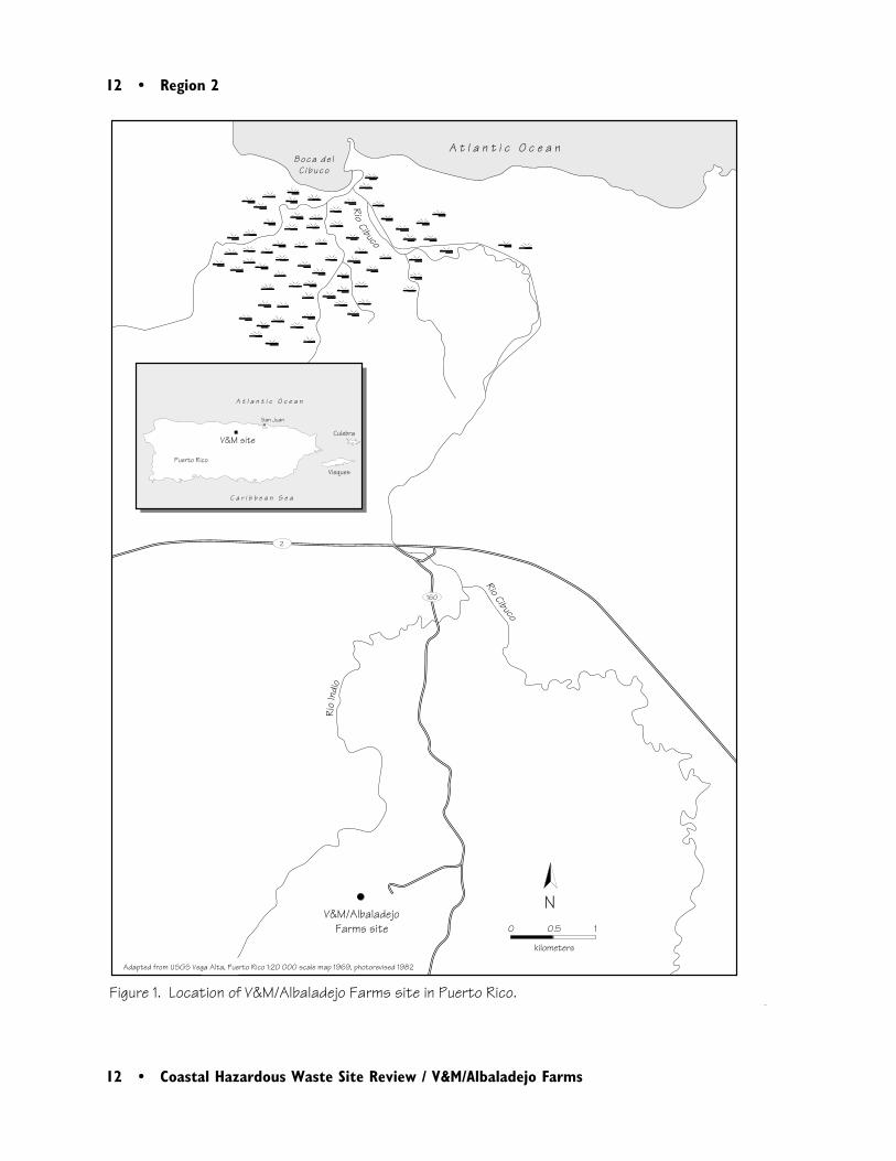
Site Exposure Potential
The V&M/Albaladejo Farms site is in theAlmirante Norte Ward of the municipality ofVega Baja, Puerto Rico, 1.6 km west of Route160. The site consists of four zones (Zones 1through 4), four burned areas (Burned Areas Ithrough IV), and two suspected burned areas(Figures 1 and 2). The Río Indio flows northapproximately 650 m northwest of the site (CDM1996). About 5 km north of the site, the RíoIndio joins the Río Cibuco, which discharges tothe Atlantic Ocean about 14 river km north ofthe site (USGS 1982a & b). The area covered bythe site includes two farms located in the lime-stone uplands characterized by landforms typical
Vega Baja, Puerto RicoCERCLIS #PRD987366101
of karst terrain, including heavily vegetated, steephills surrounded by small valleys, sinkholes,subsurface channels, and caves (CDM 1996).
Zone 1 (280 m2) cuts directly into the hillside atthe end of a vehicular path and is littered withscrap, wire, and ash. Portions of the site have soilstained green, and surface contamination isestimated to vary in depth from 0.3 to 1 mbelow the surface (CDM 1996).
Zone 2 covers an area of 186 m2 and is north ofZone 1. A hand-dug pit is coated with metalshavings and is surrounded by scrap metal. Asteep, vehicular path from the site provides a
12 • Region 2
12 • Coastal Hazardous Waste Site Review / V&M/Albaladejo Farms
0 0.5 1
kilometers
N
RioCibuco
Rio
Indi
o
160
2
Rio Cibuco
V&M/Albaladejo Farms site
Figure 1. Location of V&M/Albaladejo Farms site in Puerto Rico.
A t l a n t i c O c e a nBoc a de l
C i buc o
Adapted from USGS Vega Alta, Puerto Rico 1:20 000 scale map 1969, photorevised 1982
V&M site
A t l a n t i c O c e a n
C a r i b b e a n S e a
Puerto Rico
Vieques
Culebra
San Juan

Region 2 • 13
Coastal Hazardous Waste Site Review / V&M/Albaladejo Farms • 13
Figu
re 2
. De
tail
of t
he V
&M/A
lbal
adej
o Fa
rms
site
.
NNo
t to
sca
le
Sus
pect
ed b
urne
d ar
ea
Burn
ed A
rea
IIIZo
ne 2
Burn
ed A
rea
I
Burn
ed A
rea
IVZo
ne 1
Zone
1A
Burn
ed A
rea
IIZo
ne 4
Sus
pect
ed b
urne
d ar
ea
Dirt
road
Dirt
road
Pave
d ro
ad
Zone
3
Entr
ance
Ka
rst
Hil
lKa
r st
Hi l
l
Ka
r st
Hi l
l
Ka
r st
Hil
l
Ka
rst
Hil
lK
ars
t H
ill
Fie
ld
Fi e
l d
Ada
pted
from
uns
cale
d, h
and-
draw
n m
ap in
CDM
1996
Sin
khol
e
14 • Region 2
14 • Coastal Hazardous Waste Site Review / V&M/Albaladejo Farms
direct route for surface water runoff to flowtowards sinkholes located approximately 180 meast of the site (CDM 1996).
Zone 3 is heavily vegetated and is located withina large sinkhole that occupies the center of thesite, and reportedly consists of two burn areas.Two smaller sinkholes are located within the largesinkhole. The areal extent of soil contaminationat Zone 3 is unknown (CDM 1996).
Zone 4 is located east of Zone 1 across a heavilyvegetated ridge. Scrap and wire remnants coverthis cleared area of approximately 370 m2. Thehillside east of Zone 4 is believed to have beentilled in the past, possibly introducing contamina-tion deeper into the soil (CDM 1996).
The V&M site was used for dumping plastic-coated electric cables, electrical equipment, andcar batteries. The wastes were burned to recovercopper, aluminum, and lead. It is believed thatopen burning without containment was usedduring the burning and recovery process. It isnot known when the burning activity began oneither the V&M or the Albaladejo farm proper-ties. Beginning in 1985, trucks that were alleg-edly working for the Puerto Rico TelephoneCompany and the Puerto Rico Electric andPower Authority were observed carrying wastesonto the site. Burning reportedly ceased in 1986when the V&M farm was purchased by its currentowner, but continued into 1988 on theAlbaladejo farm. The total quantity of wastedisposal at the site is unknown (CDM 1996).
Groundwater movement is believed to be theprimary mechanism of contaminant transportfrom the site. The Aymamon and Aguada For-mations together form one of the primary sourcesof groundwater within the region, comprising theupper, unconfined aquifer system. On a regionalscale, groundwater in the Aymamon-AguadaFormation flows northward towards the AtlanticOcean. Local groundwater flow direction nearthe site may be to the north-northwest, possiblydischarging to the Río Indio (CDM 1996).
Direct infiltration of precipitation on outcropareas and surface runoff into sinkholes is theprimary source of recharge to the water tableaquifer. The bedrock/soil interface is probablypart of a highly irregular, well-developed karst.This implies that recharge, be it percolationthrough soil or into sinkholes, follows a complexpath of least resistance influenced by joints,bedding planes, and open or sediment-filledsolution channels. Hydraulic conductivity esti-mates of the upper aquifer range from about 150m/day to more than 450 m/day.
NOAA Trust Habitats and Species
Habitats of concern to NOAA are surface waterand bottom substrates of the Río Indio, the RíoCibuco, and their tributaries. Riparian zones,estuaries, and wetlands associated with these

Region 2 • 15
Coastal Hazardous Waste Site Review / V&M/Albaladejo Farms • 15
rivers, including mangrove swamps located at themouth of the Río Cibuco, also are NOAA trusthabitats potentially threatened by the transportof contaminants from the site.
Most of the native fish and shrimp species inPuerto Rico are compulsory migrators, eithercatadromous or amphidromous, and thus NOAAtrust species (Oland 1997; Yoshioka 1997; Table1). The term amphidromous refers to predomi-nantly freshwater species in which the life cycleincludes a larval phase in marine or estuarinewater. These fish and shrimp mature and repro-duce in freshwater, releasing either eggs or larvaewhich are carried downstream. These species areiteroparous (they do not die after spawning) andcan spawn several times during their life cycle.For shrimp, the first-stage larvae are non-feedingand must reach waters containing salinities ofapproximately 15 ppt in order to molt to afeeding-stage larvae (Oland 1997).
The gobies and most of the shrimp species arecapable of passing large obstacles (high water-falls, and dams with surface water overflow) intheir migrations upstream; they are found in theheadwaters, up to the point where flow becomesintermittent (Oland 1997).
The mountain mullet is a popular native gamefish that can sustain swimming speeds similar totrout, is very active, and is sensitive to distur-bance. High dams and reservoirs have eliminatedthe mullet from many upland streams. The fatsleeper and spiny-cheeked sleeper are usuallyrestricted to the lower portions of the river near
the estuary. Larval sirajo gobies, known as setí,are collected during their upstream migrationand eaten as a local delicacy. The catadromousAmerican eel is occasionally taken by fishermenand likely used as bait (Oland 1997).
Bigmouth sleepers and the river goby are foundin most rivers as well as some reservoirs. Bothare believed to pass part of their life cycle in salt-water, but may be capable of completing theirlife cycles in freshwater. Although both speciesare taken as a food fish, little is known about thelife history of the river goby (Oland 1997).
Shrimp are diverse and abundant, and are oftenthe predominant predators, herbivores, anddetritivores found in these streams. Shrimp ofthe genus Macrobrachium provide a popularfishery for both food and bait. Macrobrachiumcan grow quite large; for example, the big clawriver shrimp is over 50 cm long with claws.Shrimp of the genus Atya are also large, and arecommonly fished throughout the Caribbean(Oland 1997).
No information was found regarding dams orbarriers on either Río Indio or Río Cibuco thatmight prevent migration of NOAA trust re-sources along the river near the site.
An extensive wetland system exists at the mouthof Río Cibuco. This wetland system includesextensive estuarine mangrove forests and herba-ceous wetlands. It is listed by the Puerto RicoDepartment of Natural and EnvironmentalResources as a Critical Coastal Wildlife Area(Oland 1997).

16 • Region 2
16 • Coastal Hazardous Waste Site Review / V&M/Albaladejo Farms
Habitat Use Fisheries
Common Name Scientific Name Spawning
Nursery/JuvenileRearing
AdultForage Comm. Recr.
AMPHIDROMOUS/CATADROMOUS FISHES
American eel Anguilla rostrata ♦ ♦ ♦
Big-mouthsleeper1
Gobiomorus dormitor ♦ ♦ ♦ ♦ ♦
Fat sleeper Dormitator maculatus ♦ ♦ ♦
Mountain mullet Agonostomus monticola ♦ ♦ ♦ ♦
River goby1 Awaous tajasica ♦ ♦ ♦ ♦ ♦
Sirajo goby Sicydium plumieri ♦ ♦ ♦ ♦
Spiny-cheeksleeper
Eleotris pisonis ♦ ♦ ♦
CRUSTACEANSBig Claw River
shrimpMacrobrachium carcinus ♦ ♦ ♦ ♦ ♦
Cascade Riverprawn
Macrobrachiumheterochirus
♦ ♦ ♦ ♦ ♦
Cinnamon Rivershrimp
Macrobrachiumacanthurus
♦ ♦ ♦ ♦ ♦
Shrimp2 Atya innocous ♦ ♦ ♦ ♦ ♦
Shrimp2 Atya lanipes ♦ ♦ ♦ ♦ ♦
Shrimp2 Atya scabra ♦ ♦ ♦ ♦ ♦
Shrimp2 Jonga serrei ♦ ♦ ♦
Shrimp2 Macrobrachiumcrenulatum
♦ ♦ ♦ ♦ ♦
Shrimp2 Macrobrachiumfaustinum
♦ ♦ ♦ ♦ ♦
Shrimp2 Micratya poeyi ♦ ♦ ♦
Shrimp2 Potimirrim americana ♦ ♦ ♦
Shrimp2 Potimirrim glabra ♦ ♦ ♦
Shrimp2 Potimirrim mexicana ♦ ♦ ♦
Shrimp2 Xiphocaris elongata ♦ ♦ ♦
1: There are some reports of populations located in reservoirs; may not be an obligate migrator.2: No common name provided by USFWS or found in Common and Scientific Names of Aquatic Invertebrates ofthe United States and Canada published by the American Fisheries Society.
Table 1. Target species of commercial and recreational interest likely to be found in Río Indio, Río Cibuco,and the estuary. (This table is not a complete listing of NOAA trust resources found in lower RíoCibuco and the estuary.)
Region 2 • 17
Coastal Hazardous Waste Site Review / V&M/Albaladejo Farms • 17
Site-Related Contamination
Aluminum, antimony, arsenic, cadmium, chro-mium, copper, lead, manganese, mercury, sele-nium, and silver were reported in soils from thesite at concentrations exceeding their meanconcentrations in soils of the earth’s crust (U.S.EPA 1983). Groundwater, surface water, andsediment samples have not yet been collected atthe site or from off-site areas near the site. Thesedata will be collected following completion of aplanned removal of the most contaminated soils(Kwan 1997).
Surface soil samples collected during the 1989site investigation were reported to have elevatedconcentrations of copper (403,000 mg/kg),antimony (633 mg/kg), and dioxins (110 ng/kg
TCDD TEQ). Mercury, silver, toluene, fluoran-thene, pyrene, and 4,4’-DDD were also reportedin soil samples. Soil samples collected from burnareas during November 1994 had the followingaverage trace element concentrations: aluminum(24,356 mg/kg), antimony (1,363 mg/kg),cadmium (329 mg/kg), copper (57,697 mg/kg), lead (16,410 mg/kg), and silver (20 mg/kg;CDM 1996). Table 2 presents results of a soilstudy conducted in 1994.
In a study conducted by the U.S. EnvironmentalProtection Agency in March 1996, more than230 soil samples were collected along grids setout in Zones 1, 2, and 4 and analyzed for copperand lead. The maximum reported copper con-centration was 214,000 mg/kg, while that forlead was 116,000 mg/kg (CDM 1996).
Table 2. Maximum concentrations of trace elements detected in soils at the V&M/Albaladejo Farms Site in1994 (CDM 1996) compared to their mean concentrations in U.S. soils (Lindsay 1979; Shackletteand Boerngen 1984).
Trace Element
MaximumConcentration,
mg/kgFrequency of
Detection Location
Mean Conc. in U.S.Soilsa, mg/kg
Antimony 2,600 16/16 Zone 2 0.5Arsenic 250 16/16 Zone 4 5.2Cadmium 40 16/16 Zone 2 0.06bChromium 170 16/16 Zone 2 37Copper 240,000 16/16 Zone 1 17Lead 68,000 16/16 Zone 4 16Manganese 2,100 16/16 Zone 2 330Mercury 0.36 14/16 Zone 4 0.06Selenium 8.2 14/16 Zone 4 0.3Silver 20 15/16 Zone 2 0.05ba: Shacklette and Boerngen (1984)b: Lindsay (1979; cadmium and silver represent average concentrations in the earth’s crust)
18 • Region 2
18 • Coastal Hazardous Waste Site Review / V&M/Albaladejo Farms
Shacklette, H.T. and J.G. Boerngen. 1984.Element concentrations in soils and other surficialmaterials of the conterminous United States.USGS Professional Paper 1270. Washington,D.C.: U.S. Geological Survey.
U.S. Environmental Protection Agency (EPA).1983. Hazardous waste land treatment. EPA/530/SW-83/874. SW-874. Cincinnati: Mu-nicipal Environmental Research Laboratory. 702pp.
U.S. Geological Survey (USGS). 1982a.Manatí Quadrangle, Puerto Rico. 7.5 minuteseries (topographic). Reston, Virginia: U.S.Government Printing Office.
U.S. Geological Survey (USGS). 1982b. VegaAlta Quadrangle, Puerto Rico. 7.5 minute series(topographic). Reston, Virginia: U.S. Govern-ment Printing Office.
Williams, A.B., L.G. Abele, D.L. Felder, H.H.Hobbs, Jr., R.B. Manning, P.A. McLaughlin,and I. Pérez Fartante. 1988. Common andscientific names of aquatic invertebrates from theUnited States and Canada: Decapod crustaceans.American Fisheries Society Special Publication17. American Fisheries Society, Bethesda,Maryland. 77 pp.
Yoshioka, B., Field supervisor, Caribbean FieldOffice, U.S. Fish and Wildlife Service, Boqueron,Puerto Rico, personal communication, January 6,1997.
Summary
Studies at the V&M site indicate that site soils arecontaminated with trace elements, particularlyantimony, arsenic, cadmium, silver, copper, andlead. No investigations examined contaminationin on-site groundwater or in surface water andsediments of Río Indio, 650 m northwest of thesite (and the nearest identified habitat that couldsupport NOAA trust resources). Groundwatermigration is the primary mechanism for potentialtransport of contaminants off-site to NOAA trustresources, although no studies have yet beenconducted to verify this.
References
CDM Federal Programs Corporation. 1996.Draft work plan: remedial investigation/feasibil-ity study, V&M/Albaladejo Farms site, VegaBaja, Puerto Rico. New York: U.S. Environ-mental Protection Agency, Region 2.
Kwan, Caroline, Remedial Project Manager, EPARegion 2, New York, personal communication,July 11, 1997.
Lindsay, W.L. 1979. Chemical Equilibria in Soils.New York: John Wiley & Sons. 449 pp.
Oland, J.P., Field supervisor, Caribbean FieldOffice, U.S. Fish and Wildlife Service, Boqueron,Puerto Rico, personal communication, January 7,1997.

Region 3 • 19
Coastal Hazardous Waste Site Review / Fort Meade • 19
3Fort George G. Meade
Site Exposure Potential
Fort George G. Meade occupies approximately5,500 ha in Anne Arundel County, Maryland,between Baltimore and Washington, D.C. (Fig-ure 1). The Patuxent River, which drains thearea, flows along the southern border of thefacility. A tributary stream, the Little PatuxentRiver, flows through the facility and receivesrunoff from several waste sites (Figure 2). ThePatuxent River enters the Chesapeake Bay ap-proximately 100 km from Fort Meade.
In 1917 Congress authorized Fort Meade as atraining facility. In 1988, the U.S. Army BaseRealignment and Closure Act (BRAC) mandatedthe closure and/or realignment of approximately
Anne Arundel County, MarylandCERCLIS #MD9210020567
3,600 ha encompassing the southernmost two-thirds of the installation (Figure 2). In 1991 theU.S. Army transferred 3,300 ha of the BRACparcel to the Department of the Interior’s Patux-ent Wildlife Research Center for use as a wildliferefuge (ICF Kaiser 1997).
Table 1 lists waste sites that have been evaluatedat Fort Meade, along with information about thedates of use and types of waste disposed at eachsite (ICF Kaiser 1997). The sites include sixlandfills, the Helicopter Hangar Area, the De-fense Reutilization and Management Office(DRMO) Salvage Yard, the Fire Training Area,and the Ordnance Demolition Area. Materials

20 • Region 3
20 • Coastal Hazardous Waste Site Review / Fort Meade
Figure 1. Location of Fort George G. Meade in Anne Arundel County, Maryland.
Washington,D.C.
Maryland
Virginia
Ch
es
ap
ea
ke
Ba
y
PatuxentRiver
Occoquan River
0 5 10 15
kilometers
N
Site boundary
Washington, D.C. border
Prepared from Delorme Atlas & Gazetteer, Virginia, 1989, and AAA Road Atlas, 1989.
P o t o m a c R i v e r
VA
MDPA
DE
95
301
495
95
95
270
295
Little Patuxent
River
Fort George G. Meade
Region 3 • 21
Coastal Hazardous Waste Site Review / Fort Meade • 21
Figu
re 2
. De
tail
of w
aste
sit
es a
t Fo
rt G
eorg
e G
. Mea
de.��
��
�
����
����
������
0
10
00
20
00
met
ers
N
DRM
O S
alva
geYa
rd
Inac
tive
Land
fill
No.
4In
acti
veLa
ndfil
lN
o. 3
Ord
nanc
eDe
mol
itio
nA
rea
Inac
tive
Land
fill
No.
2
Inac
tive
Land
fill
No.
1
Fire
Trai
ning
Are
a
Hel
icop
ter
Han
gar
Are
a
Act
ive
Sani
tary
La
ndfil
l
Clea
n Fi
llDu
mp
Lake
Alle
n
Baltim
ore-W
ashin
gton
Parkway
Little
Patuxent
Rive
r
Patu
xent
Rive
r
Sout
hR
oad
Telegraph RoadB
RA
C
PA
RC
EL
Fort
Mea
de
Ca
nto
nm
ent
Are
a
Prep
ared
from
ICF
Kais
er 19
97
295
175
198
198
MidwayBranch
Fort
Mea
de re
serv
atio
n bo
unda
ry
Was
te s
ite
�
Dam
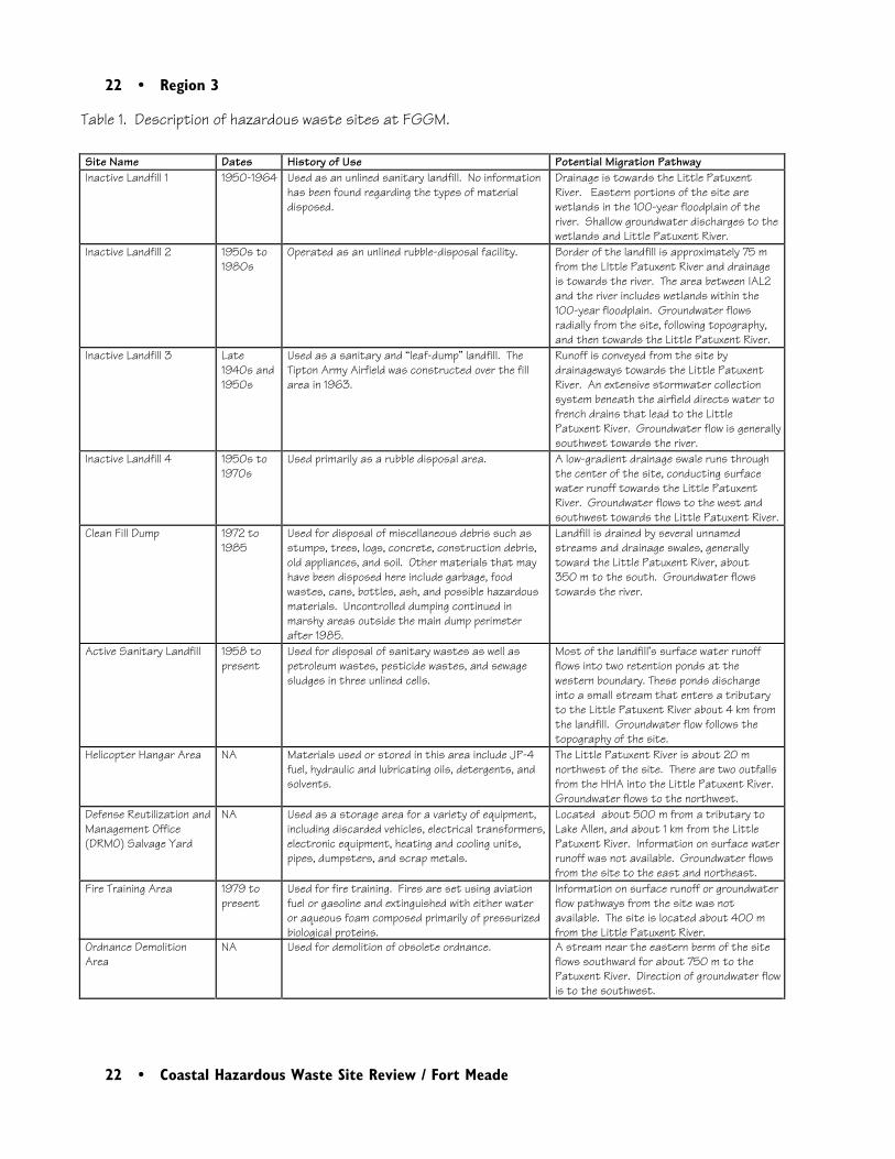
22 • Region 3
22 • Coastal Hazardous Waste Site Review / Fort Meade
Table 1. Description of hazardous waste sites at FGGM.
Site Name Dates History of Use Potential Migration PathwayInactive Landfill 1 1950-1964 Used as an unlined sanitary landfill. No information
has been found regarding the types of materialdisposed.
Drainage is towards the Little PatuxentRiver. Eastern portions of the site arewetlands in the 100-year floodplain of theriver. Shallow groundwater discharges to thewetlands and Little Patuxent River.
Inactive Landfill 2 1950s to1980s
Operated as an unlined rubble-disposal facility. Border of the landfill is approximately 75 mfrom the LIttle Patuxent River and drainageis towards the river. The area between IAL2and the river includes wetlands within the100-year floodplain. Groundwater flowsradially from the site, following topography,and then towards the Little Patuxent River.
Inactive Landfill 3 Late1940s and1950s
Used as a sanitary and “leaf-dump” landfill. TheTipton Army Airfield was constructed over the fillarea in 1963.
Runoff is conveyed from the site bydrainageways towards the Little PatuxentRiver. An extensive stormwater collectionsystem beneath the airfield directs water tofrench drains that lead to the LittlePatuxent River. Groundwater flow is generallysouthwest towards the river.
Inactive Landfill 4 1950s to1970s
Used primarily as a rubble disposal area. A low-gradient drainage swale runs throughthe center of the site, conducting surfacewater runoff towards the Little PatuxentRiver. Groundwater flows to the west andsouthwest towards the Little Patuxent River.
Clean Fill Dump 1972 to1985
Used for disposal of miscellaneous debris such asstumps, trees, logs, concrete, construction debris,old appliances, and soil. Other materials that mayhave been disposed here include garbage, foodwastes, cans, bottles, ash, and possible hazardousmaterials. Uncontrolled dumping continued inmarshy areas outside the main dump perimeterafter 1985.
Landfill is drained by several unnamedstreams and drainage swales, generallytoward the Little Patuxent River, about 350 m to the south. Groundwater flowstowards the river.
Active Sanitary Landfill 1958 topresent
Used for disposal of sanitary wastes as well aspetroleum wastes, pesticide wastes, and sewagesludges in three unlined cells.
Most of the landfill’s surface water runoffflows into two retention ponds at thewestern boundary. These ponds dischargeinto a small stream that enters a tributaryto the Little Patuxent River about 4 km fromthe landfill. Groundwater flow follows thetopography of the site.
Helicopter Hangar Area NA Materials used or stored in this area include JP-4fuel, hydraulic and lubricating oils, detergents, andsolvents.
The Little Patuxent River is about 20 mnorthwest of the site. There are two outfallsfrom the HHA into the Little Patuxent River. Groundwater flows to the northwest.
Defense Reutilization andManagement Office(DRMO) Salvage Yard
NA Used as a storage area for a variety of equipment,including discarded vehicles, electrical transformers,electronic equipment, heating and cooling units,pipes, dumpsters, and scrap metals.
Located about 500 m from a tributary toLake Allen, and about 1 km from the LittlePatuxent River. Information on surface waterrunoff was not available. Groundwater flowsfrom the site to the east and northeast.
Fire Training Area 1979 topresent
Used for fire training. Fires are set using aviationfuel or gasoline and extinguished with either wateror aqueous foam composed primarily of pressurizedbiological proteins.
Information on surface runoff or groundwaterflow pathways from the site was notavailable. The site is located about 400 mfrom the Little Patuxent River.
Ordnance DemolitionArea
NA Used for demolition of obsolete ordnance. A stream near the eastern berm of the siteflows southward for about 750 m to thePatuxent River. Direction of groundwater flowis to the southwest.
Region 3 • 23
Coastal Hazardous Waste Site Review / Fort Meade • 23
used or disposed at these sites included municipaland domestic waste, pesticides, electrical trans-formers, solvents, PCBs, inert material, and wasteoils and lubricants.
Surface water and groundwater are potentialpathways for contaminant migration from thesite. The Little Patuxent River flows southeastacross Fort Meade along a broad, flat river valleywith extensive wetlands. In general, much of theterrain at Fort Meade is low-lying. Approximatelyhalf of the BRAC parcel has been identified aswetlands, including portions of Inactive Landfill 1(IAL1), Inactive Landfill 2 (IAL2), and the CleanFill Dump. The Little Patuxent River flows nearthe borders of the Helicopter Hangar Area,IAL1, IAL2, and the Clean Fill Dump. Severalunnamed tributaries also flow across Fort Meade.Table 1 describes surface water pathways for eachof the identified waste sites.
There are groundwater aquifers at Fort Meadewithin several geologic formations consisting ofunconsolidated sands, clays, and silts. There arethree distinct aquifers at the site (the upperPatapsco, the lower Patapsco, and the Patuxent)separated by confining layers. Because theunderlying formations dip towards the east andare progressively exposed, the surficial depositsvary. The regional groundwater flow is to thesoutheast, but local flow in the surficial depositsgenerally mirrors the topography. Soils withinthe BRAC parcel are primarily loamy and clayeyunderlain by an unstable clay of low permeability.Groundwater studies at the site indicate that the
shallow sands aquifer is probably discharging tothe Little Patuxent River (ICF Kaiser 1997).
NOAA Trust Habitats and Species
The primary habitats of concern to NOAA aresurface water, stream bottom, and associatedriparian zones of the Little Patuxent River, itstributaries, and the Patuxent River. Anadromousand catadromous fish species that use the streamsare the resources of concern to NOAA (EAEngineering 1992; Table 2).
The Little Patuxent River is a medium-sized,warmwater stream with a warmwater resident fishpopulation dominated by river chub, shiners, andsunfish. The stream is typically 15 to 23 m wideand 0.6 to 2.5 m deep as it traverses Fort Meade.Slow-flowing runs dominate this portion of thestream with smaller areas of riffle/pool habitat.Sediments range from cobble to silty sands.Extensive hardwood wetlands are located alongthe river on the Fort Meade property. Overcupoak stands dominate in areas submerged for mostof the year, while red maple, sweetgum, and redash are prevalent in areas that are seasonallyflooded (EA Engineering 1992).
Several anadromous species use the Little Patux-ent River during their spawning runs in thespring, including white perch, hickory shad,alewife, and blueback herring. Before 1991, the
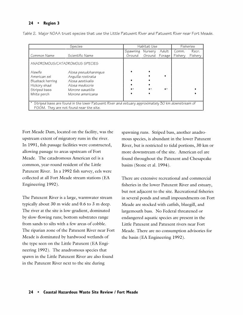
24 • Region 3
24 • Coastal Hazardous Waste Site Review / Fort Meade
Fort Meade Dam, located on the facility, was theupstream extent of migratory runs in the river.In 1991, fish passage facilities were constructed,allowing passage to areas upstream of FortMeade. The catadromous American eel is acommon, year-round resident of the LittlePatuxent River. In a 1992 fish survey, eels werecollected at all Fort Meade stream stations (EAEngineering 1992).
The Patuxent River is a large, warmwater streamtypically about 30 m wide and 0.6 to 3 m deep.The river at the site is low-gradient, dominatedby slow-flowing runs; bottom substrates rangefrom sands to silts with a few areas of cobble.The riparian zone of the Patuxent River near FortMeade is dominated by hardwood wetlands ofthe type seen on the Little Patuxent (EA Engi-neering 1992). The anadromous species thatspawn in the Little Patuxent River are also foundin the Patuxent River next to the site during
Table 2. Major NOAA trust species that use the Little Patuxent River and Patuxent River near Fort Meade.
Species Habitat Use Fisheries
Common Name Scientific NameSpawningGround
NurseryGround
AdultForage
Comm.Fishery
Recr.Fishery
ANADROMOUS/CATADROMOUS SPECIES
Alewife Alosa pseudoharengus ♦ ♦
American eel Anguilla rostrata ♦ ♦
Blueback herring Alosa aestivalis ♦ ♦
Hickory shad Alosa mediocris ♦ ♦
Striped bass Morone saxatilis ♦∗ ♦∗ ♦∗ ♦
White perch Morone americana ♦ ♦ ♦
* Striped bass are found in the lower Patuxent River and estuary approximately 30 km downstream ofFGGM. They are not found near the site.
spawning runs. Striped bass, another anadro-mous species, is abundant in the lower PatuxentRiver, but is restricted to tidal portions, 30 km ormore downstream of the site. American eel arefound throughout the Patuxent and Chesapeakebasins (Stone et al. 1994).
There are extensive recreational and commercialfisheries in the lower Patuxent River and estuary,but not adjacent to the site. Recreational fisheriesin several ponds and small impoundments on FortMeade are stocked with catfish, bluegill, andlargemouth bass. No Federal threatened orendangered aquatic species are present in theLittle Patuxent and Patuxent rivers near FortMeade. There are no consumption advisories forthe basin (EA Engineering 1992).
Region 3 • 25
Coastal Hazardous Waste Site Review / Fort Meade • 25
Site-Related Contamination
This report summarizes results from the mostrecent sampling conducted at each of the hazard-ous waste sites at Fort Meade. At IAL1, IAL2,IAL3, and the Clean Fill Dump, the most recentsampling was conducted in 1996 as part of aremedial investigation for those areas (ICF Kaiser1997). A 1995 site inspection contained themost recent results for the Helicopter HangarArea, the DRMO Salvage Yard, the Fire TrainingArea, and the Ordnance Demolition Area (ArthurD. Little 1995). The most recent sampling at theActive Sanitary Landfill was conducted in 1993for the remedial investigation (Arthur D. Little1994). For IAL4, the most recent samplingresults were presented in a 1992 site inspectionstudy (EA Engineering 1992).
Table 3 presents the maximum concentrations ofcontaminants detected in groundwater and soilsthroughout Fort Meade during the investiga-tions, along with the areas where the maximumconcentrations were detected.
The highest concentrations of trace elements ingroundwater were in samples collected from theHelicopter Hangar Area, the Active SanitaryLandfill, and the Clean Fill Dump. Groundwaterseep samples collected from the Active SanitaryLandfill contained elevated concentrations of anumber of trace elements. Soils containing thehighest concentrations of trace elements werecollected from IAL3 and the Clean Fill Dump.In general, soil and groundwater samples ex-
ceeded screening guidelines for trace elements atFort Meade areas so infrequently and sporadicallythat gradients of contamination were not appar-ent.
Pesticides were most frequently detected in soilsand groundwater at the landfill areas. Explosivecompounds were detected in groundwater butnot in soils at the Ordnance Demolition Area andat IAL3. PCBs are the primary contaminants ofconcern at the DRMO Salvage Yard. Aroclor1260 was detected in five of six soil samplescollected at the salvage yard in 1993 at concen-trations ranging from 0.27 to 4 mg/kg (ArthurD. Little 1995). During a previous investigationin 1991, total PCBs were detected at a maximumconcentration of 93 mg/kg in the southernmostarea of the DRMO Salvage Yard, an area that wasnot sampled in 1993 (Arthur D. Little 1995).PCBs were not detected in groundwater at thesalvage yard, but detection limits were not avail-able.
Surface water and sediment samples have beencollected from drainages and tributaries associ-ated with the following areas: IAL1, IAL2, IAL3,IAL4, the Active Sanitary Landfill, the Clean FillDump, the Helicopter Hangar Area, and the FireTraining Area (EA Engineering 1992; Arthur D.Little 1994; ICF Kaiser 1997). In addition,during the 1996 RI (ICF Kaiser 1997), sedimentand surface water samples were collected from theLittle Patuxent River along a stretch from theHelicopter Hangar Area to the Clean Fill Dump.Maximum concentrations of contaminants insurface water and sediment detected during thosestudies are shown in Table 4, along with the areas
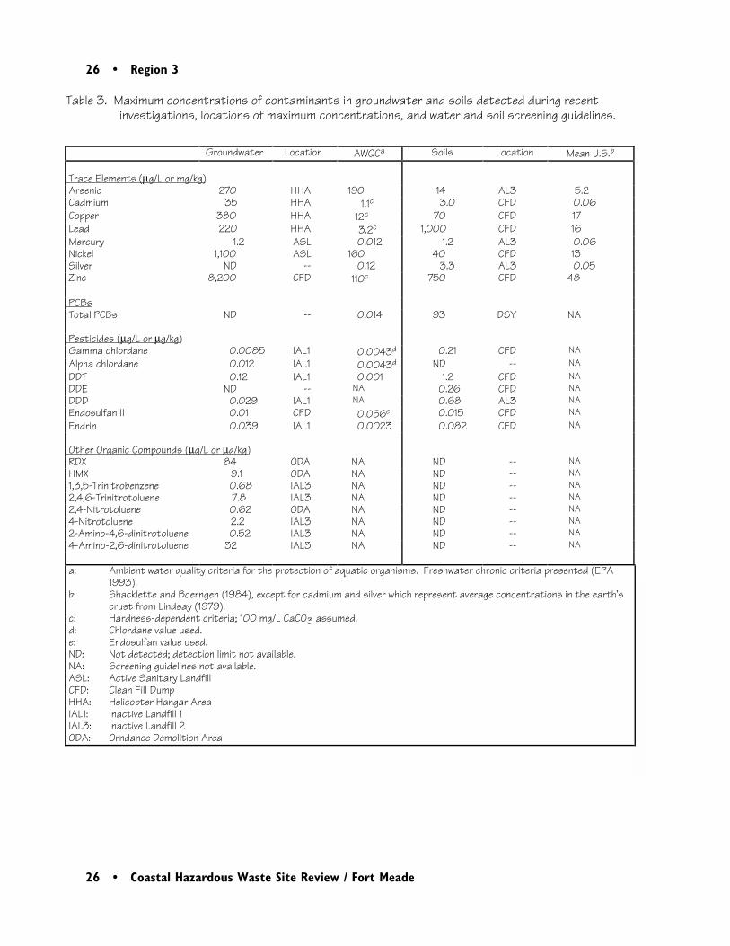
26 • Region 3
26 • Coastal Hazardous Waste Site Review / Fort Meade
Table 3. Maximum concentrations of contaminants in groundwater and soils detected during recentinvestigations, locations of maximum concentrations, and water and soil screening guidelines.
Groundwater Location AWQCa Soils Location Mean U.S.b
Trace Elements (µg/L or mg/kg) Arsenic 270 HHA 190 14 IAL3 5.2 Cadmium 35 HHA 1.1c 3.0 CFD 0.06 Copper 380 HHA 12c 70 CFD 17 Lead 220 HHA 3.2c 1,000 CFD 16 Mercury 1.2 ASL 0.012 1.2 IAL3 0.06 Nickel 1,100 ASL 160 40 CFD 13 Silver ND -- 0.12 3.3 IAL3 0.05 Zinc 8,200 CFD 110c 750 CFD 48
PCBs Total PCBs ND -- 0.014 93 DSY NA
Pesticides (µg/L or µg/kg) Gamma chlordane 0.0085 IAL1 0.0043d 0.21 CFD NA Alpha chlordane 0.012 IAL1 0.0043d ND -- NA DDT 0.12 IAL1 0.001 1.2 CFD NA DDE ND -- NA 0.26 CFD NA DDD 0.029 IAL1 NA 0.68 IAL3 NA Endosulfan II 0.01 CFD 0.056e 0.015 CFD NA Endrin 0.039 IAL1 0.0023 0.082 CFD NA
Other Organic Compounds (µg/L or µg/kg) RDX 84 ODA NA ND -- NA HMX 9.1 ODA NA ND -- NA 1,3,5-Trinitrobenzene 0.68 IAL3 NA ND -- NA 2,4,6-Trinitrotoluene 7.8 IAL3 NA ND -- NA 2,4-Nitrotoluene 0.62 ODA NA ND -- NA 4-Nitrotoluene 2.2 IAL3 NA ND -- NA 2-Amino-4,6-dinitrotoluene 0.52 IAL3 NA ND -- NA 4-Amino-2,6-dinitrotoluene 32 IAL3 NA ND -- NA
a: Ambient water quality criteria for the protection of aquatic organisms. Freshwater chronic criteria presented (EPA1993).
b: Shacklette and Boerngen (1984), except for cadmium and silver which represent average concentrations in the earth’scrust from Lindsay (1979).
c: Hardness-dependent criteria; 100 mg/L CaCO3 assumed. d: Chlordane value used. e: Endosulfan value used. ND: Not detected; detection limit not available. NA: Screening guidelines not available. ASL: Active Sanitary Landfill CFD: Clean Fill Dump HHA: Helicopter Hangar Area IAL1: Inactive Landfill 1 IAL3: Inactive Landfill 2 ODA: Orndance Demolition Area
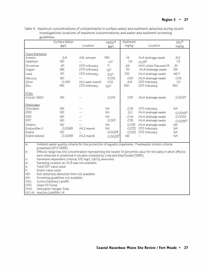
Region 3 • 27
Coastal Hazardous Waste Site Review / Fort Meade • 27
Table 4. Maximum concentrations of contaminants in surface water and sediment detected during recentinvestigations; locations of maximum concentrations; and water and sediment screeningguidelines.
Surface Waterµg/L Location
AWQCaµg/L
Sedimentmg/kg Location
ERLbmg/kg
Trace Elements Arsenic 2.6 ASL stream 190 14 AL4 drainage swale 8.2 Cadmium ND -- 1.1c 1.8 IAL3d 1.2 Chromium 47 CFD tributary 11 24 HHA Little Patuxent R. 81 Copper 36 CFD tributary 12c 70 IAL4 drainage swale 34 Lead 37 CFD tributary 3.2c 170 IAL4 drainage swale 46.7 Mercury ND -- 0.012 0.51 IAL4 drainage swale 0.15 Silver 0.149 IAL1 east marsh 0.12 4.8 CFD tributary 1.0 Zinc 145 CFD tributary 110c 180 CFD tributary 150
PCBs Aroclor 1260 ND -- 0.014 0.51 IAL4 drainage swale 0.0027
Pesticides Chlordane ND -- NA 0.15 CFD tributary NA DDD ND -- NA 2.0 IAL4 drainage swale 0.0016e DDE ND -- NA 0.14 IAL4 drainage swale 0.0022 DDT ND -- 0.001 0.15 IAL4 drainage swale 0.0016e Dieldrin ND -- NA 0.015 IAL4 drainage swale NA Endosulfan II 0.0065 IAL2 marsh NA 0.072 CFD tributary NA Endrin ND -- 0.0023 0.022 CFD tributary NA Endrin ketone 0.0093 IAL2 marsh 0.0023f ND -- NA
a: Ambient water quality criteria for the protection of aquatic organisms. Freshwater chronic criteria presented (EPA 1993).
b: Effects range-low; the concentration representing the lowest 10 percentile value for the data in which effectswere observed or predicted in studies compiled by Long and MacDonald (1995).
c: Hardness-dependent criteria; 100 mg/L CaCO3 assumed. d: Sampling location at IAL3 was not available. e: Total DDT value used. f: Endrin value used. ND: Not detected; detection limit not available. NA: Screening guidelines not available. ASL: Active Sanitary Landfill CFD: Clean Fill Dump HHA: Helicopter Hangar Area IAL1-4: Inactive Landfills 1-4
28 • Region 3
28 • Coastal Hazardous Waste Site Review / Fort Meade
where the maximum concentrations were de-tected.
For trace elements in surface water, most of theAWQC exceedances were detected in a tributarynear the Clean Fill Dump. Concentrations oftrace elements in surface water of the LittlePatuxent River did not exceed AWQCs. Forsediment, the highest concentrations of traceelements were primarily found in a drainage swaleat IAL4 and in a tributary near the Clean FillDump. In the Little Patuxent River, concentra-tions of arsenic (12 mg/kg) and silver (3.4 mg/kg) exceeded their respective ERLconcentrations.
Pesticide screening guidelines for surface waterand sediment were occasionally exceeded indrainages or tributaries but, overall, pesticideswere infrequently detected. Pesticides thatexceeded their sediment screening guidelines inthe Little Patuxent River were DDD(0.012 mg/kg) and DDE (0.0079 mg/kg).Sediment samples collected from IAL4 and CFDcontained the highest concentrations of pesticidesrelative to ERL concentrations. Gradients ofcontamination were not apparent. PAHs werenot detected at concentrations above screeningguidelines in surface water or sediment. Concen-trations of PCBs in sediment infrequently ex-ceeded the screening guidelines.
Summary
Several waste sites at Fort Meade have drainagepathways leading directly to the Little PatuxentRiver. Concentrations of a variety of contami-nants in streams and wetlands associated withwaste sites have been found to exceed screeningguidelines, although exceedances were infrequentand sporadic. The Little Patuxent River andPatuxent River near the site are used by severalanadromous fish, including white perch, hickoryshad, alewife, and blueback herring. Thesespecies may be exposed to contamination fromwaste sites at Fort Meade.
References
Arthur D. Little, Inc. 1994. Draft RemedialInvestigation Addendum, Fort Meade FeasibilityStudy and Remedial Investigation/Site Inspec-tion. Aberdeen Proving Ground, Maryland:U.S. Army Environmental Center.
Arthur D. Little, Inc. 1995. Final Site Inspec-tion Addendum, Fort Meade Feasibility Studyand Remedial Investigation/Site Inspection.Aberdeen Proving Ground, Maryland: U.S.Army Environmental Center.
Region 3 • 29
Coastal Hazardous Waste Site Review / Fort Meade • 29
EA Engineering, Science, and Technology, Inc.1992. Final Fort George G. Meade Base ClosureParcel Site Inspection Study. Aberdeen ProvingGround, Maryland: U.S. Army Corps of Engi-neers, Toxic and Hazardous Materials Agency.
ICF Kaiser Engineers, Inc. 1997. RemedialInvestigation Report, Inactive Landfills 1, 2, 3and Clean Fill Dump, Fort George G. MeadeRemedial Investigation/Feasibility Study. Balti-more: U.S. Army Corps of Engineers.
Lindsay, W.L. 1979. Chemical Equilibria inSoils. New York: John Wiley & Sons. 449 pp.
Long, E.R., D.D. MacDonald, S.L. Smith, andF.D. Calder. 1995. Incidence of adverse biologi-cal effects within ranges of chemical concentra-tions in marine and estuarine sediments. Envi-ronmental Management 19(1): 81-97.
Shacklette, H.T. and J.G. Boerngen. 1984.Element concentrations in soils and other surficialmaterials of the conterminous United States.USGS Professional Paper 1270. Washington,D.C.: U.S. Geological Survey.
Stone, S.L., T.A. Lowry, J.D. Field, C.D. Will-iams, D.M. Nelson, S.H. Jury, M.E. Monaco,and L. Andreasen. 1994. Distribution andabundance of fishes and invertebrates in mid-Atlantic estuaries. ELMR Rept. No. 12. SilverSpring, Maryland: NOAA/NOS StrategicEnvironmental Assessments Division. 280 pp.
U.S. Environmental Protection Agency (EPA).1993. Water quality criteria. Washington, D.C.:U.S. Environmental Protection Agency, Office ofWater, Health and Ecological Criteria Division.294 pp.
30 • Region 3
30 • Coastal Hazardous Waste Site Review / Fort Meade
Region 3 • 31
Coastal Hazardous Waste Site Review / Norfolk Naval Base • 31
3Norfolk Naval Base
Site Exposure Potential
Norfolk Naval Base, part of the Sewells PointNaval Complex, occupies approximately 1900 hadirectly northwest of Norfolk, Virginia (Figure1). Mason Creek borders the area along thebase’s eastern boundary; the junction of theElizabeth and James rivers (Hampton Roads)borders the site on the west; and the remnants ofBousch Creek and a network of ditches drain thecentral portion of the facility (Figure 2).Willoughby Bay forms the northern border of thesite and enters Chesapeake Bay approximately 1.5km northeast of Norfolk Naval Base.
Norfolk Naval Base began operating in 1917 as asupport base for World War I activities. The base
Norfolk, VirginiaCERCLIS #VA6170061463
provides fleet support for the U.S. Atlantic fleet,shore facilities and support for U.S. militaryvessels and aircraft, and service and maintenancefor ships and aircraft. Many hazardous substanceshave been used, generated, and discarded at theproperty. These substances include variouschlorinated organic solvents, sludges from metalplating processes, parts cleaning and paint strip-ping wastes, acids, heavy metals, and pesticides(Baker Environmental, Inc. 1994).
Under the Department of Defense InstallationRestoration Program, 22 sites on the base wereidentified as potentially contaminated. Data wereavailable for four source areas: the Camp Allen

32 • Region 3
32 • Coastal Hazardous Waste Site Review / Norfolk Naval Base
0
1
2
3
kilo
met
ers
J a me s
R i ve r
Hampton
Roads
N
Bridge
TunnelHampto
n Roads
Prep
ared
from
Del
orm
e M
appi
ng C
o. V
irgin
ia A
t las
and
Gaz
e tt e
e r 19
89
Elizabe
thRi
ver
Na
ns
em
on
d
River
NE
WP
OR
TN
EW
S
NO
RF
OL
K
PO
RT
SM
OU
TH
Ch
es
ap
ea
ke
Ba
y
Nor
folk
Nav
al B
ase
Figu
re 1.
Loc
atio
n of
Nor
folk
Nava
l Bas
e in
Nor
folk,
Virg
inia
.
Wil
lou
gh
by
Ba
y
Virg
inia
NC
MD
PA
DE
460
64
Mas
onCr
eek

Region 3 • 33
Coastal Hazardous Waste Site Review / Norfolk Naval Base • 33
0
5
00
10
00
met
ers
NW
illoug
hby
Spi
t
Q A
rea
Drum
Sto
rage
Yard
CD L
andf
ill
Cam
p A
llen
Land
fill A
rea
Wil
lou
gh
by
Ba
y
Ch
es
ap
ea
ke
Ba
yH
am
pt
on
Ro
ad
s
Eli
za
be
th
Riv
er
Build
ing
LP-2
0 si
te
Mason Cree k
Prep
ared
from
US
GS
Nor
folk
Nort
h, VA
1:24
00
0 s
cale
map
196
5, p
hoto
revis
ed 19
86
; CH
2M H
ill Fe
dera
l Gro
up, L
td. 1
996
564
64
Bay
Aven
ue
337
Figu
re 2
. De
tail
of N
orfo
lk Na
val B
ase
Norf
olk
Nava
lBas
epr
oper
tybo
unda
ry
34 • Region 3
34 • Coastal Hazardous Waste Site Review / Norfolk Naval Base
Landfill, the Q Area Drum Storage Yard(QADSY), the CD Landfill, and the Building LP-20 site. Table 1 lists the dates of use, types ofwastes disposed, and remediation activities forthese sites. The limited information available forthe remaining sites indicated that cleanup wascompleted on five sites, while ten areas weredetermined to require no cleanup action (CH2MHILL Federal Group, Ltd. 1996).
Surface water runoff and groundwater migrationare the potential pathways for contaminanttransport from site areas to NOAA resources andassociated habitats. Norfolk Naval Base is locatedon a nearly level plain, with surface elevationsranging from sea level to about 5 m above sealevel at the central portion of the facility. Theprincipal surface drainage feature at the site is thenetwork of drainage ditches rerouting and replac-ing the Bousch Creek system that once coveredmost of the base. The outfalls from this drainagesystem end in Mason Creek, the Elizabeth River,and Willoughby Bay. No diagrams of this drain-age system were found in any of the reviewedreports, although Table 1 lists the specific surfacewater pathways that were identified for eachsource area.
Groundwater at the base is present at 2 to 2.5 mbgs in the unconfined Columbia aquifer, whichconsists of thin, discontinuous layers of heteroge-neous sand and shell lenses. The underlyingYorktown aquifer is confined by beds of silt andclay, which may be breached or absent in local-ized areas of the site due to erosion by meander-ing streams and rivers. Area groundwater is
tidally influenced. In the central and northernportions of the base, groundwater flows generallyeast and northeast. On the east side of the base,groundwater appears to flow west and northwesttoward the main drainage culvert. In the south-western quarter of the base, groundwater flowssouth and southeast, again toward surface drain-age features (Baker Environmental, Inc. 1995a).
NOAA Trust Habitats and Species
Habitats of primary concern to NOAA are surfacewaters and associated bottom substrates of thelower Elizabeth River and Hampton Roads, anestuarine area where the Elizabeth, James, andNansemond rivers meet Chesapeake Bay.Anadromous fish, estuarine fish, and invertebratesuse the estuary and are the resources of concernto NOAA (Table 2). Estuarine waters of this arearange from extensive shallow flats generally lessthan 3 m deep to trenches up to 30 m deep(USGS 1964, 1965). Salinities range from 15 to20 ppt and sediments range from silts to sands(Majumdar et al. 1987).
The estuary provides nursery and adult habitat formany estuarine and marine fish. Estuarineresidents include bay anchovy, oyster toadfish,sheepshead minnow, killifishes, silversides, pipe-fish, gobies and hogchoker. These species spendall life stages within the estuary; several are highlyabundant. Species such as bluefish, mullet,pinfish, butterfish, and the sciaenids (croaker,
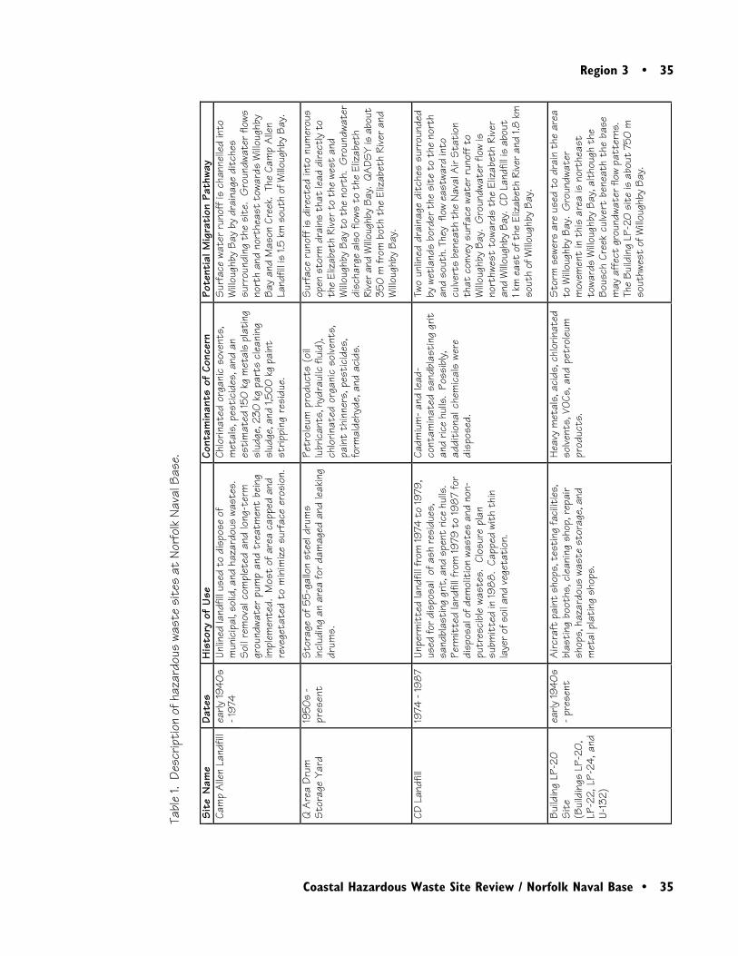
Region 3 • 35
Coastal Hazardous Waste Site Review / Norfolk Naval Base • 35
Sit
e N
ame
Date
sH
isto
ry o
f U
seCo
ntam
inan
ts o
f Co
ncer
nPo
tent
ial M
igra
tion
Pat
hway
Cam
p A
llen
Land
fill
early
1940
s- 1
974
Unlin
ed la
ndfil
l use
d to
dis
pose
of
mun
icip
al, s
olid
, and
haz
ardo
us w
aste
s.
Soi
l rem
oval
com
plet
ed a
nd lo
ng-t
erm
grou
ndwa
ter
pum
p an
d tr
eatm
ent
bein
gim
plem
ente
d. M
ost
of a
rea
capp
ed a
ndre
vege
tate
d to
min
imiz
e su
rfac
e er
osio
n.
Chlo
rinat
ed o
rgan
ic s
oven
ts,
met
als,
pes
tici
des,
and
an
esti
mat
ed 15
0 k
g m
etal
s pl
atin
gsl
udge
, 230
kg
part
s cl
eani
ngsl
udge
, and
1,50
0 kg
pai
ntst
rippi
ng r
esid
ue.
Sur
face
wat
er r
unof
f is
chan
nelle
d in
toW
illoug
hby
Bay
by d
rain
age
ditc
hes
surr
ound
ing
the
site
. G
roun
dwat
er fl
ows
nort
h an
d no
rthe
ast
towa
rds
Willo
ughb
yBa
y an
d M
ason
Cre
ek.
The
Cam
p A
llen
Land
fill i
s 1.5
km
sou
th o
f Willo
ughb
y Ba
y.
Q A
rea
Drum
Sto
rage
Yar
d19
50s
-pr
e se n
tS
tora
ge o
f 55-
gallo
n st
eel d
rum
sin
clud
ing
an a
rea
for
dam
aged
and
leak
ing
drum
s.
Petr
oleu
m p
rodu
c ts
(oil
lubr
ican
ts, h
ydra
ulic
flui
d),
c hlo
rinat
ed o
rgan
ic s
olve
nts,
pain
t th
inne
rs, p
esti
c ide
s,fo
rmal
dehy
de, a
nd a
c ids
.
Sur
fac e
run
off i
s di
rec t
ed in
to n
umer
ous
open
sto
rm d
rain
s th
at le
ad d
irect
ly t
oth
e El
izab
eth
Rive
r to
the
west
and
Willo
ughb
y Ba
y to
the
nor
th.
Gro
undw
ater
disc
harg
e al
so fl
ows
to t
he E
lizab
eth
Rive
r and
Willo
ughb
y Ba
y. Q
ADS
Y is
abo
ut35
0 m
from
bot
h th
e El
izab
eth
Rive
r an
dW
illoug
hby
Bay.
CD L
andf
ill19
74 -
198
7Un
perm
itte
d la
ndfil
l fro
m 19
74 t
o 19
79,
used
for d
ispo
sal
of a
sh re
sidu
es,
sand
blas
ting
grit
, and
spe
nt ri
ce h
ulls
. Pe
rmit
ted
land
fill f
rom
1979
to
198
7 fo
rdi
spos
al o
f dem
olit
ion
wast
es a
nd n
on-
putr
esc i
ble
wast
es.
Clos
ure
plan
subm
itte
d in
198
8.
Capp
ed w
ith
thin
laye
r of s
oil a
nd v
eget
atio
n.
Cadm
ium
- and
lead
-c o
ntam
inat
ed s
andb
last
ing
grit
and
rice
hulls
. Po
ssib
ly,
addi
tion
al c
hem
ical
s we
redi
spos
ed.
Two
unlin
ed d
rain
age
ditc
hes
surr
ound
edby
wet
land
s bo
rder
the
sit
e to
the
nor
than
d so
uth.
The
y fl
ow e
astw
ard
into
culve
rts
bene
ath
the
Nava
l Air
Sta
tion
that
con
vey
surf
ace
wate
r ru
noff
to
Willo
ughb
y Ba
y. G
roun
dwat
er fl
ow is
nort
hwes
t to
ward
s th
e El
izab
eth
Rive
ran
d W
illoug
hby
Bay.
CD
Land
fill i
s ab
out
1 k
m e
ast
of t
he E
lizab
eth
Rive
r and
1.8
km
sout
h of
Willo
ughb
y Ba
y.
Build
ing
LP-2
0Si
te(B
uild
ings
LP-
20,
LP-2
2, L
P-24
, and
U-13
2)
early
1940
s-
pres
ent
Airc
raft
pai
nt s
hops
, tes
ting
faci
litie
s,bl
asti
ng b
ooth
s, c
lean
ing
shop
, rep
air
shop
s, h
azar
dous
was
te s
tora
ge, a
ndm
etal
pla
ting
sho
ps.
Hea
vy m
etal
s, a
cids
, chl
orin
ated
solve
nts,
VOC
s, a
nd p
etro
leum
prod
ucts
.
Sto
rm s
ewer
s ar
e us
ed t
o dr
ain
the
area
to W
illoug
hby
Bay.
Gro
undw
ater
mov
emen
t in
thi
s ar
ea is
nor
thea
stto
ward
s W
illoug
hby
Bay,
alt
houg
h th
eBo
usch
Cre
ek c
ulve
rt b
enea
th t
he b
ase
may
aff
ect
grou
ndwa
ter f
low
patt
erns
. Th
e Bu
ildin
g LP
-20
sit
e is
abo
ut 7
50 m
sout
hwes
t of
Willo
ughb
y Ba
y.
Tabl
e 1.
Des
crip
tion
of h
azar
dous
was
te s
ites
at
Norf
olk
Nava
l Bas
e.
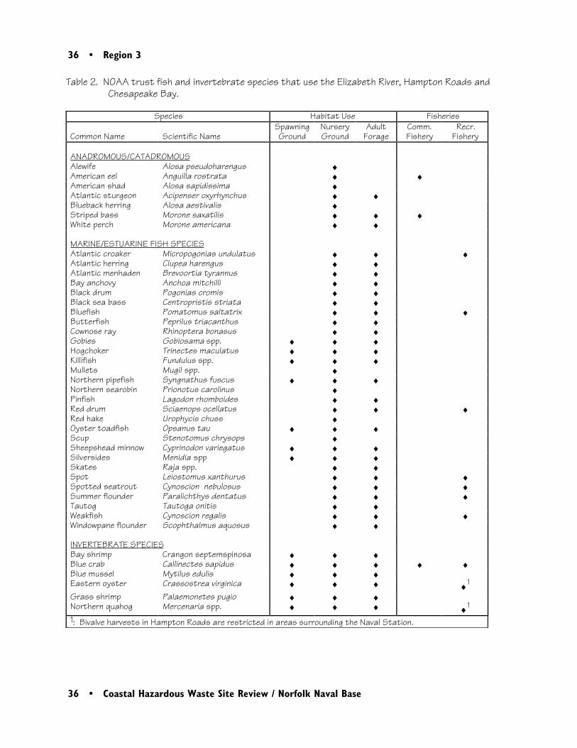
36 • Region 3
36 • Coastal Hazardous Waste Site Review / Norfolk Naval Base
Table 2. NOAA trust fish and invertebrate species that use the Elizabeth River, Hampton Roads andChesapeake Bay.
Species Habitat Use Fisheries
Common Name Scientific NameSpawningGround
NurseryGround
AdultForage
Comm.Fishery
Recr.Fishery
ANADROMOUS/CATADROMOUSAlewife Alosa pseudoharengus ♦American eel Anguilla rostrata ♦ ♦American shad Alosa sapidissima ♦Atlantic sturgeon Acipenser oxyrhynchus ♦ ♦Blueback herring Alosa aestivalis ♦Striped bass Morone saxatilis ♦ ♦ ♦White perch Morone americana ♦ ♦
MARINE/ESTUARINE FISH SPECIESAtlantic croaker Micropogonias undulatus ♦ ♦ ♦Atlantic herring Clupea harengus ♦ ♦Atlantic menhaden Brevoortia tyrannus ♦ ♦Bay anchovy Anchoa mitchilli ♦ ♦Black drum Pogonias cromis ♦ ♦Black sea bass Centropristis striata ♦ ♦Bluefish Pomatomus saltatrix ♦ ♦ ♦Butterfish Peprilus triacanthus ♦ ♦Cownose ray Rhinoptera bonasus ♦ ♦Gobies Gobiosama spp. ♦ ♦ ♦Hogchoker Trinectes maculatus ♦ ♦ ♦Killifish Fundulus spp. ♦ ♦ ♦Mullets Mugil spp. ♦Northern pipefish Syngnathus fuscus ♦ ♦ ♦Northern searobin Prionotus carolinus ♦Pinfish Lagodon rhomboides ♦ ♦Red drum Sciaenops ocellatus ♦ ♦ ♦Red hake Urophycis chuss ♦Oyster toadfish Opsanus tau ♦ ♦ ♦Scup Stenotomus chrysops ♦Sheepshead minnow Cyprinodon variegatus ♦ ♦ ♦Silversides Menidia spp ♦ ♦ ♦Skates Raja spp. ♦ ♦Spot Leiostomus xanthurus ♦ ♦ ♦Spotted seatrout Cynoscion nebulosus ♦ ♦ ♦Summer flounder Paralichthys dentatus ♦ ♦ ♦Tautog Tautoga onitis ♦ ♦Weakfish Cynoscion regalis ♦ ♦ ♦Windowpane flounder Scophthalmus aquosus ♦ ♦
INVERTEBRATE SPECIESBay shrimp Crangon septemspinosa ♦ ♦ ♦Blue crab Callinectes sapidus ♦ ♦ ♦ ♦ ♦Blue mussel Mytilus edulis ♦ ♦ ♦Eastern oyster Crassostrea virginica ♦ ♦ ♦ ♦1
Grass shrimp Palaemonetes pugio ♦ ♦ ♦Northern quahog Mercenaria spp. ♦ ♦ ♦ ♦1
1: Bivalve harvests in Hampton Roads are restricted in areas surrounding the Naval Station.

Region 3 • 37
Coastal Hazardous Waste Site Review / Norfolk Naval Base • 37
weakfish, seatrout, spot, drum) are coastal spawn-ers; eggs and larval stages drift offshore and laterjuvenile stages migrate into the estuary. Becausemany of these species are long-lived, juveniles mayspend several years in the estuary. Adults ofseveral of the species also use the estuary season-ally. Bluefish, spot, and Atlantic croaker areparticularly abundant in the area (Stone et al.1994).
Several anadromous fish use the estuary as amigratory corridor, juvenile nursery, and adulthabitat. Juvenile and adult white perch areabundant in the estuary. The adults spawn infreshwater upstream of the base, and both juve-niles and adults reside in the estuary. Stripedbass, particularly juvenile stages, are common inthe estuary. Adults may spend time in the area aswell, but many move seaward. American shad,blueback herring, and alewife spawn in the fresh-water upstream of the base. Juveniles use theestuary as a nursery but usually migrate seaward asadults. Atlantic sturgeon are considered rare nearthe base and in Chesapeake Bay. The catadro-mous American eel is found throughout theChesapeake basin, and juvenile life stages arepresent near the site (Stone et al. 1994).
Several invertebrates use the estuary, includingblue crab, grass shrimp, eastern oyster, andnorthern quahog. Juvenile and adult blue crabare abundant; mating and larval stages are alsoseen in the estuary, although females usuallymigrate to coastal waters to brood and releaseeggs. Grass shrimp, oyster, and quahog spend alllife stages in the estuary (Stone et al. 1994).
There are substantial commercial and recreationalfisheries in the Hampton Roads portion ofChesapeake Bay. Popular recreational catchesinclude bluefish, croaker, spot, weakfish, floun-der, blue crab, oyster, and quahog (Majumdar etal. 1987). The total landings for 1996 for theElizabeth River were over 100,000 kg. The bulkof the commercial harvest is for blue crab, butAmerican eel and striped bass also support sub-stantial commercial fisheries (O’Reilly 1997).Bivalves are harvested in other areas of HamptonRoads, but are restricted surrounding the basebecause of industrial runoff (Wright 1997).
Site-Related Contamination
Data collected during several site investigationsindicate that soils, groundwater, surface water,and sediments at the Norfolk Naval Base arecontaminated in varying degrees with traceelements, pesticides, and organic compounds,including PAHs, VOCs, and SVOCs. Separateinvestigations were conducted for each sourcearea. The most recent data used to determinemaximum contaminant concentrations for eacharea came from remedial investigations in 1990-1993 for the QADSY (Environmental Science &Engineering, Inc. 1994), in 1992-1993 for theCamp Allen Landfill (Baker Environmental, Inc.1994), in 1993-1994 for the CD Landfill (BakerEnvironmental, Inc. 1995a), and 1994-1995 forthe Building LP-20 site (Baker Environmental,Inc. 1995b). Table 3 summarizes maximum
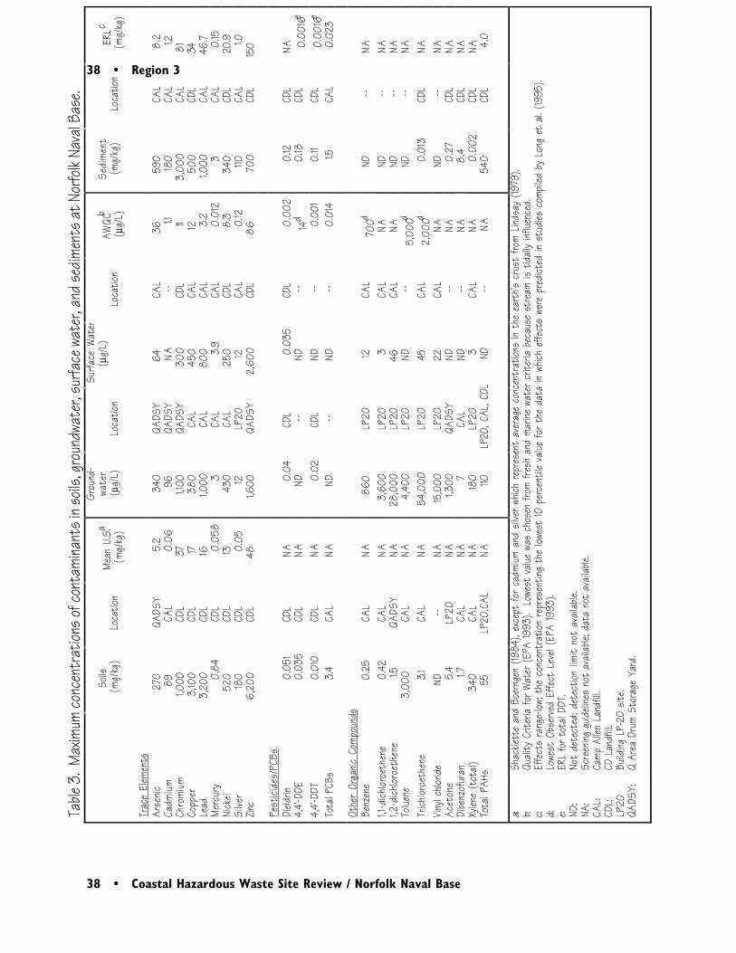
38 • Region 3
38 • Coastal Hazardous Waste Site Review / Norfolk Naval Base
Table
3. M
axim
um co
ncen
trat
ions o
f con
tami
nant
s in s
oils,
grou
ndwa
ter,
surfa
ce w
ater
, and
sedim
ents
at N
orfo
lk Na
val B
ase.
Soils
(mg/
kg)
Loca
tion
Mean
U.S
.a(m
g/kg
)
Grou
nd-
wate
r
(µg/
L)Lo
catio
n
Surfa
ce W
ater
(µ
g/L)
Loca
tion
AWQC
b
(µg/
L)Se
dim
ent
(mg/
kg)
Loca
tion
ERLc
(mg/
kg)
Trac
e El
emen
tsAr
senic
270
QADS
Y5.
234
0QA
DSY
64CA
L36
590
CAL
8.2
Cadm
ium
89CA
L0.
0696
QADS
YNA
--1.1
180
CAL
1.2Ch
romi
um1,0
00CD
L37
1,100
QADS
Y30
0CD
L11
3,00
0CA
L81
Copp
er3,
100
CDL
1738
0CA
L45
0CA
L12
500
CDL
34Le
ad3,
200
CDL
161,0
00CA
L80
0CA
L3.
21,0
00CA
L46
.7M
ercu
ry0.
84CD
L0.
058
3CA
L3.
9CA
L0.
012
3CA
L0.
15Ni
ckel
520
CDL
1343
0CA
L25
0CD
L8.
334
0CD
L20
.9Si
lver
180
CDL
0.05
12LP
2012
CAL
0.12
110CA
L1.0
Zinc
6,20
0CD
L48
1,600
QADS
Y2,
600
CDL
8670
0CD
L15
0
Pest
icide
s/PC
BsDi
eldrin
0.05
1CD
LNA
0.04
CDL
0.03
5CD
L0.
002
0.12
CDL
NA4,
4’-DD
E0.
035
CDL
NAND
--ND
--14
d0.
18CD
L0.
0016e
4,4’-
DDT
0.01
0CD
LNA
0.02
CDL
ND--
0.00
10.
11CD
L0.
0016e
Tota
l PCB
s3.
4CA
LNA
ND--
ND--
0.01
41.5
CAL
0.02
3
Othe
r Or
ganic
Com
poun
dsBe
nze n
e0.
25CA
LNA
860
LP20
12CA
L70
0dND
--NA
1,1-d
ic hlor
oet h
e ne
0.42
CAL
NA3,
600
LP20
3CA
LNA
ND--
NA1,2
-dic h
loroe
t he n
e1.5
QADS
YNA
28,0
00LP
2046
CAL
NAND
--NA
Tolue
ne3,
000
CAL
NA4,
400
LP20
ND--
5,00
0dND
--NA
Tric h
loroe
t he n
e3.1
CAL
NA54
,000
LP20
45CA
L2,
000d
0.01
3CD
LNA
Vinyl
c hlor
ideND
--NA
15,0
00LP
2022
CAL
NAND
--NA
Ace t
one
5.4
LP20
NA1,3
00QA
DSY
ND--
NA0.
27CD
LNA
Dibe
nzof
uran
1.7CA
LNA
7CA
LND
--NA
8.4
CDL
NAX y
le ne
(tot
al)34
0CA
LNA
180
LP20
3CA
LNA
0.00
2CD
LNA
Tota
l PAH
s55
LP20
,CAL
NA110
LP20
, CAL
, CDL
ND--
NA54
0CD
L4.
0
a: b: c: d: e: ND:
NA:
CAL:
CDL:
LP20
QADS
Y:
Shac
klett
e an
d Bo
e rng
en (1
984)
, exc
e pt
for
c adm
ium a
nd s
ilve r
whic
h re
pre s
e nt
ave r
age
c onc
e ntr
ation
s in
the
e art
h’s c
rust
from
Lind
say
(1979
).Qu
ality
Crit
eria
for W
ater
(EPA
1993
). L
owes
t va
lue w
as c
hose
n fro
m fre
sh a
nd m
arine
wat
er c
riter
ia be
c aus
e st
ream
is t
idally
influ
enc e
d.Ef
fec t
s ra
nge -
low; t
he c
onc e
ntra
tion
repr
e se n
ting
the
lowes
t 10
pe r
c ent
ile v
alue
for
the
data
in w
hich
e ffe
c ts
were
pre
dicte
d in
stud
ie s c
ompil
e d b
y Lo
ng e
t al.
(199
5).
Lowe
st O
bse r
ved
Effe
c t L
e ve l
(EPA
1993
).ER
L fo
r tot
al DD
T.No
t de
tec t
e d; d
e te c
tion
limit
not
avail
able .
Scre
ening
guid
eline
s no
t av
ailab
le; d
ata
not
avail
able.
Camp
Alle
n La
ndfill
.CD
Lan
dfill.
Build
ing L
P-20
site
.Q
Area
Dru
m St
orag
e Ya
rd.
Region 3 • 39
Coastal Hazardous Waste Site Review / Norfolk Naval Base • 39
greater than ten times the AWQC, and concen-trations of DDT and DDE in sediments exceededthe ERL guidelines. PCBs were found at el-evated concentrations in soil and sedimentsamples taken from the Camp Allen Landfill area.Values for total PCBs represent the sum ofAroclors 1242, 1254, and 1260. The maximumconcentration of total PCBs in sediment ex-ceeded the ERL guideline; there is no screeningguideline for total PCBs in soils.
A variety of other organic compounds weredetected in all media. Total PAH results repre-sent the sum of acenaphthene, anthracene,benz(a)anthracene, benzo(b) and/or(k)fluoranthene, chrysene, fluoranthene, fluo-rene, naphthalene, phenanthrene, and pyrene.The highest concentrations of PAHs in soils werefound at the Building LP-20 site and the CampAllen Landfill. Maximum concentrations ofother organic compounds in soils were from theCamp Allen Landfill, the QADSY, and theBuilding LP-20 site. There are no screeningguidelines for any of the organic compoundsdetected in soils. Elevated concentrations oforganic compounds were detected in groundwa-ter samples from the Building LP-20 site, theQADSY, and the Camp Allen Landfill. Feworganic compounds were detected in surfacewaters; those detected were found at the CampAllen Landfill. Existing LOEL concentrations fororganic compounds other than pesticides andPCBs were not exceeded in surface water, butwere exceeded in groundwater by more than tentimes for one contaminant, trichloroethene.Total PAH concentrations exceeding ERLguidelines were found in sediments from the CD
concentrations of contaminants, as well as thesource area where each contaminant was found inthe greatest concentration, along with applicablescreening guidelines.
Not all media were analyzed in all of the remedialinvestigations. No surface water samples weretaken in the QADSY investigation, and no surfacewater or sediment samples were collected at theBuilding LP-20 site. All surface water andsediment data reported in Table 3 were collectedfrom the Bousch Creek drainage system near theCamp Allen Landfill.
The highest concentrations of trace elements insoils were from the CD Landfill, except forarsenic and cadmium, which were found at thehighest concentrations at the QADSY and CampAllen Landfill, respectively. In groundwater, thehighest concentrations were found at theQADSY, Camp Allen Landfill, and the BuildingLP-20 site. Maximum concentrations in surfacewater and sediments were detected at the CampAllen Landfill and the CD Landfill. Maximumon-site concentrations of trace elements weregreater than all screening guidelines for soils,surface water, and sediments. Groundwaterconcentrations were greater than ten times theAWQC for all reported inorganic substancesexcept arsenic.
Maximum concentrations of pesticides in allmedia were found at the CD Landfill. Dieldrinconcentrations exceeded AWQC guidelines bymore than ten times in groundwater and surfacewater. DDT concentrations in groundwater were
40 • Region 3
40 • Coastal Hazardous Waste Site Review / Norfolk Naval Base
Landfill source area. All other PAH compoundsdetected in sediments were also from the CDLandfill, although no screening guidelines existfor these constituents.
Summary
Baker Environmental, Inc. 1995a. Draft finalremedial investigation, CD Landfill, Naval Base,Norfolk, Virginia. Norfolk: Department of theNavy, Atlantic Division, Naval Facilities Engi-neering Command.
Baker Environmental, Inc. 1995b. Draft finalremedial investigation report and baseline riskassessment, Building LP-20 site, Naval Base,Norfolk, Virginia. Norfolk,: Department of theNavy, Atlantic Division, Naval Facilities Engi-neering Command.
CH2M HILL Federal Group, Ltd. 1996. Draftfinal work plan and sampling and analysis plan,post remediation ecological monitoring, CampAllen Landfill. Norfolk: Department of theNavy, Atlantic Division, Naval Facilities Engi-neering Command.
Environmental Science & Engineering, Inc.1994. Final remedial investigation report, Q AreaDrum Storage Yard, Norfolk Naval Base, Norfolk,Virginia. Norfolk: Atlantic Division, NavalFacilities Engineering Command.
Lindsay, W.L. 1979. Chemical Equilibria inSoils. New York: John Wiley & Sons. 449 pp.
Long, E.R., D.D. MacDonald, S.L. Smith, andF.D. Calder. 1995. Incidence of adverse biologi-cal effects within ranges of chemical concentra-tions in marine and estuarine sediments. Envi-ronmental Management 19(1): 81-97.
Elevated concentrations of trace elements, PAHs,chlorinated solvents, pesticides, and PCBs havebeen detected in soils, groundwater, surfacewater, and sediments to varying degrees at Nor-folk Naval Base. Several of these contaminantswere detected at concentrations that far exceedtheir screening guidelines. NOAA trust habitatsbordering the site include the lower ElizabethRiver and Hampton Roads, both of which sup-port many anadromous fish, estuarine fish, andinvertebrate species. The resources of concernuse the waterways as migratory corridors, juvenilenurseries, and adult habitats.
References
Baker Environmental, Inc. 1994. Draft finalremedial investigation report, Camp Allen Land-fill, Norfolk Naval Base. Washington, D.C.:Department of the Navy, Chesapeake Division,Naval Facilities Engineering Command.

Region 3 • 41
Coastal Hazardous Waste Site Review / Norfolk Naval Base • 41
Majumdar, S.K., L.W. Hall, Jr., H.M. Austin.1987. Contaminant problems and managementof living Chesapeake Bay resources. Easton,Pennsylvania: Pennsylvania Academy of Science.573 pp.
O’Reilly, R., Virginia Marine Resources Com-mission, Newport News, Virginia, personalcommunication, August 7, 1997.
Shacklette, H.T. and J.G. Boerngen. 1984.Element concentrations in soils and other surficialmaterials of the conterminous United States.USGS Professional Paper 1270. Washington,D.C.: U.S. Geological Survey.
Stone, S.L., T.A. Lowrey, J.D. Field, C.D.Williams, D.M. Nelson, S.H. Jury, M.E. Mo-naco, and L. Andreasen. 1994. Distribution andabundance of fishes and invertebrates in Mid-Atlantic estuaries. ELMR Rept. No. 12. SilverSpring, Maryland: NOAA/NOS Strategic Envi-ronmental Assessments Division. 280 pp.
U.S. Environmental Protection Agency (EPA).1993. Water quality criteria. Washington,D.C.: U.S. Environmental Protection Agency,Office of Water, Health and Ecological CriteriaDivision. 294 pp.
U.S. Geological Survey (USGS). 1964. New-port News South Quadrangle, Virginia, 7.5minute series (topographic-Bathymetric).
U.S. Geological Survey (USGS). 1965. NorfolkNorth Quadrangle, Virginia, 7.5 minute series(topographic-Bathymetric).
Wright, M., Virginia Department of Health,Division of Shellfish Sanitation, Newport News,Virginia, personal communication, August 7,1997.
42 • Region 3
42 • Coastal Hazardous Waste Site Review / Norfolk Naval Base
Region 3 • 43
Coastal Hazardous Waste Site Review / Salford Quarry • 43
3Salford Quarry
Site Exposure Potential
The Salford Quarry site covers about 1.2 ha inLower Salford Township, Montgomery County,Pennsylvania (Figure 1). The quarry is excavatedinto the side of a hill about 100 m east of theWest Branch Skippack Creek, which joins themainstem Skippack Creek about 1 km down-stream (Figure 2). Perkiomen Creek receivesflow from Skippack Creek approximately 13 kmdownstream from the site and then flows anadditional 4 km to the Schuylkill River (Figure2). The Schuylkill River extends another 45 kmto tidal portions of the lower Delaware River,which flows into the Atlantic Ocean approxi-mately 160 km farther downstream.
Lower Salford Township, PennsylvaniaCERCLIS #PAD980693204
The site was a shale quarry in the early 1900s. Inthe 1950s, the quarry was used to dispose of twoto five truckloads per day of industrial, commer-cial, and residential wastes from the Ludwig &Son waste disposal business. In 1963, AmericanOlean Tile (AOT) purchased the quarry tolandfill waste from its Lansdale, Pennsylvaniaplant, and began accumulating waste sludges on-site in two 10,000-gallon fuel oil storage tanks(ENVIRON 1990). In 1973, AOT startedbringing most of their lead-containing slurries tothe quarry. During this time, an undeterminedamount of fly ash cinders from a coal-fired powerplant also were disposed at the site (Brown et al.1992). AOT stopped using the quarry for waste
44 • Region 3
44 • Coastal Hazardous Waste Site Review / Salford Quarry
Figure available in hard copy
Region 3 • 45
Coastal Hazardous Waste Site Review / Salford Quarry • 45
Figure available in hard copy
46 • Region 3
46 • Coastal Hazardous Waste Site Review / Salford Quarry
disposal in about 1980, and reported that about6,500 tons of waste had been discarded at the site(Brown et al. 1992). In 1982, a clay cap wasinstalled to reduce infiltration.
Wastes brought to the site include glaze wash-upsludge, settling pond sediment, and fired andunfired scrap tiles. These wastes contain traceelements and boron oxides (ENVIRON 1990;Brown et al. 1992).
Groundwater is the primary pathway of contami-nant transport from the site to NOAA resourcesand associated habitats. Soils around the quarryare generally 0.6 to 1.8 m deep. Soils are under-lain by the Brunswick Formation, which consistsof shale, siltstone, and mudstone. TheLockatong Formation underlies the BrunswickFormation, and has a similar lithology and struc-ture. The two formations are hydraulicallyconnected, but groundwater within the twoformations is restricted to secondary openingssuch as joints and fractures. As a result, water-bearing properties may vary greatly across theformations. At the site, hydraulic gradients of0.01 to 0.03 (vertical/horizontal) to the south-west (Brown et al. 1992) indicate that groundwa-ter flows toward the West Branch of SkippackCreek. Groundwater migration in the Brunswickand Lockatong formations is estimated at 0.003to 0.55 m/day.
There is no surface water pathway from the site tothe West Branch Skippack Creek. A small,standing-water body observed 30 m east of theWest Branch may actually be a partially dried-upstream channel (Figure 2; ENVIRON 1990).
NOAA Trust Habitats and Species
The primary habitats of concern to NOAA arethe surface waters, bottom substrates, andassociated riparian zones of the Skippack Creekdrainage and Schuylkill River. The SkippackCreek drainage is composed of the West Branchof Skippack Creek, the mainstem SkippackCreek, and Perkiomen Creek.
The West Branch of Skippack Creek is a smallstream, averaging about 4.6 m wide and less than1.5 m deep. The mainstem is a considerablywider stream, generally between 17 and 20 mwide and between 0.5 and 2 m deep. Bothstreams have moderate gradients with typicalriffle-pool habitats. Gravel substrates dominatethe riffles with finer sands and silts in poolenvironments. The streams have both warm andcoldwater resident fish assemblages; the main-stem is fairly diverse with trout, largemouth bass,smallmouth bass, and panfish populations.Perkiomen Creek near the confluence withSkippack Creek is a lower-gradient warmwaterstream approximately 30 m wide and 2.5 m deep(Kaufmann 1997a).
The only NOAA trust resource now in theSkippack Creek drainage is American eel. Eelhave been documented in Perkiomen and themainstem Skippack Creek. They have not beendocumented in the West Branch, but do haveaccess to the smaller stream. There are no otherNOAA trust resources found in the two streamsbecause of impassable dams below the confluence
Region 3 • 47
Coastal Hazardous Waste Site Review / Salford Quarry • 47
of Skippack Creek and the Schuylkill River(Kaufmann 1997a).
The Schuylkill River near the Skippack Creekdrainage is a large, low-gradient stream, generallyabout 100 m wide and 1 to 2 m deep. Substratesare predominantly gravel and cobble in riffles,and finer sands and silts in pool environments.Although its upper portions are classified as ascenic river, the Schuylkill receives considerableamounts of agricultural runoff and wastewater,and is generally considered to have low waterquality. There are heavy aquatic plant bedsthroughout the river, with the dominant speciesbeing the non-indigenous and nuisance Eurasianmilfoil (Kaufmann 1992; Arnold 1993;Kaufmann 1997b).
Four dams on the Schuylkill River downstream ofthe Skippack Creek drainage prevent anadromousfish from migrating into this reach of the river.The Norristown, Plymouth, Flatrock, andFairmount dams are respectively located 10, 16,24, and 36 km downstream of Skippack Creekdrainage. A fish passage has been added to theFairmount Dam. Fish passage construction onthe remaining three dams has been delayed bylegal and financial complexities, but is planned tobegin by the year 2000. Dam restoration wouldallow alewife and blueback herring to use theSkippack Creek drainage to spawn. Americanshad also would increase their range, but prob-ably would not migrate beyond the SchuylkillRiver because of their preference for large streams(Kaufmann 1997a).
A fish consumption advisory is now in effect forthe Schuylkill River because of high concentra-tions of PCBs, chlordane, and DDT. Thisadvisory does not affect the Skippack Creekdrainage, and the mainstem of Skippack Creek ismanaged as a recreational trout fishery.
Site-Related Contamination
The Remedial Investigation Site Operations Planpresents results from sampling conducted byNUS in 1983 and by ENVIRON in 1989(ENVIRON 1990). These data are compared toNOAA screening guidelines in Table 1. Re-ported sample analyses indicate that boron andother inorganic substances are the contaminantsof concern to NOAA.
In 1983, the highest measured boron concentra-tion in groundwater was 374,000 µg/L (NUS1986, as cited in ENVIRON 1990). In 1989,the maximum boron concentration in groundwa-ter was 241,000 µg/L. A groundwater plumecontaminated with boron extends from thequarry approximately 1.2 km southwest from thesite and may be 120 to 300 m wide (Figure 2;Brown et al. 1992). The extent of this plume isconsistent with the probable range of hydrauliccharacteristics at the site area (Brown et al.1992). No other inorganic substances weredetected in groundwater at concentrationsgreater than ten times their respective AWQCs.
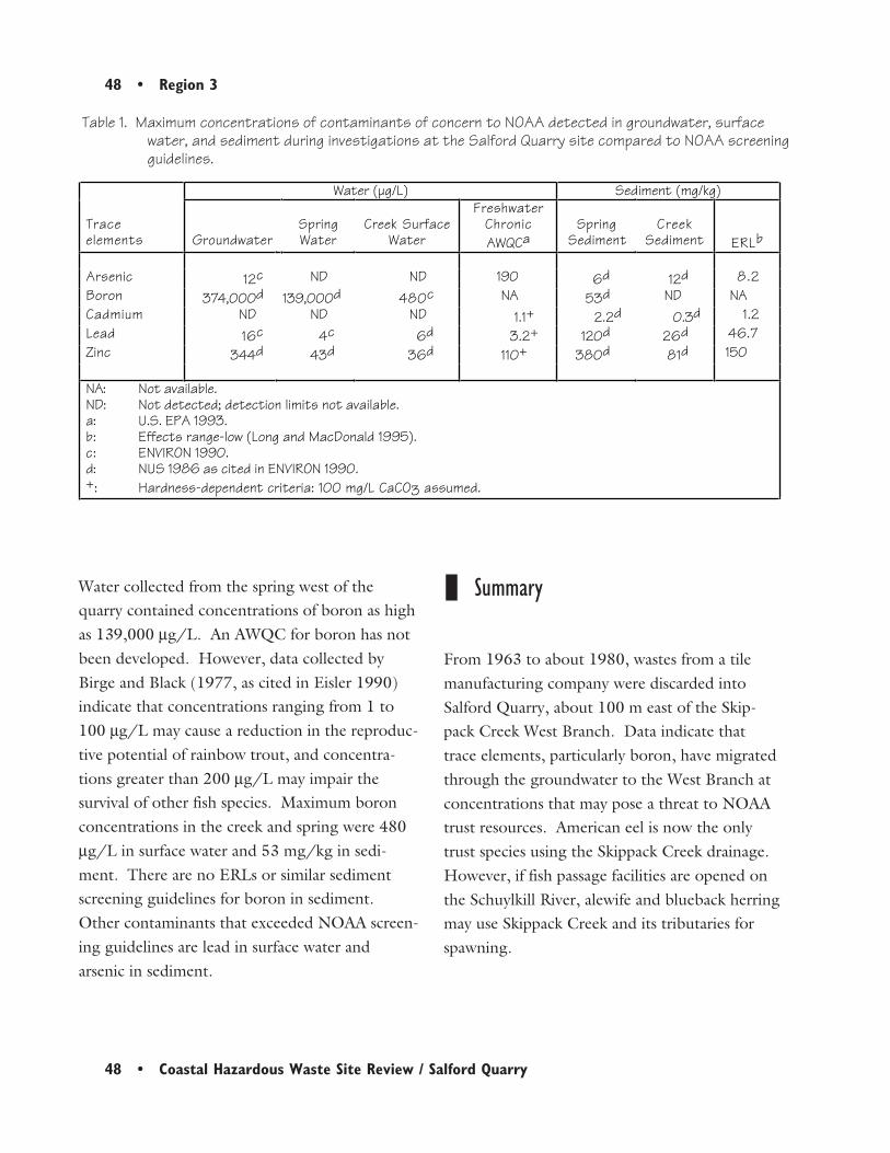
48 • Region 3
48 • Coastal Hazardous Waste Site Review / Salford Quarry
Water collected from the spring west of thequarry contained concentrations of boron as highas 139,000 µg/L. An AWQC for boron has notbeen developed. However, data collected byBirge and Black (1977, as cited in Eisler 1990)indicate that concentrations ranging from 1 to100 µg/L may cause a reduction in the reproduc-tive potential of rainbow trout, and concentra-tions greater than 200 µg/L may impair thesurvival of other fish species. Maximum boronconcentrations in the creek and spring were 480µg/L in surface water and 53 mg/kg in sedi-ment. There are no ERLs or similar sedimentscreening guidelines for boron in sediment.Other contaminants that exceeded NOAA screen-ing guidelines are lead in surface water andarsenic in sediment.
Table 1. Maximum concentrations of contaminants of concern to NOAA detected in groundwater, surfacewater, and sediment during investigations at the Salford Quarry site compared to NOAA screeningguidelines.
Summary
From 1963 to about 1980, wastes from a tilemanufacturing company were discarded intoSalford Quarry, about 100 m east of the Skip-pack Creek West Branch. Data indicate thattrace elements, particularly boron, have migratedthrough the groundwater to the West Branch atconcentrations that may pose a threat to NOAAtrust resources. American eel is now the onlytrust species using the Skippack Creek drainage.However, if fish passage facilities are opened onthe Schuylkill River, alewife and blueback herringmay use Skippack Creek and its tributaries forspawning.
Water (µg/L) Sediment (mg/kg)
Traceelements Groundwater
SpringWater
Creek SurfaceWater
FreshwaterChronicAWQCa
SpringSediment
CreekSediment ERLb
Arsenic 12c ND ND 190 6d 12d 8.2Boron 374,000d 139,000d 480c NA 53d ND NACadmium ND ND ND 1.1+ 2.2d 0.3d 1.2Lead 16c 4c 6d 3.2+ 120d 26d 46.7Zinc 344d 43d 36d 110+ 380d 81d 150
NA: Not available.ND: Not detected; detection limits not available.a: U.S. EPA 1993.b: Effects range-low (Long and MacDonald 1995).c: ENVIRON 1990.d: NUS 1986 as cited in ENVIRON 1990.+: Hardness-dependent criteria: 100 mg/L CaCO3 assumed.
Region 3 • 49
Coastal Hazardous Waste Site Review / Salford Quarry • 49
References
Arnold, D., fisheries biologist, Pennsylvania FishCommission, Revere, Pennsylvania, personalcommunication, May 4, 1993.
Birge, W.J. and J.A. Black. 1977. Sensitivity ofvertebrate embryos to boron compounds. U.S. EPAReport 560/1-76-008. 66 pp. Cincinnati: U.S.Environmental Protection Agency.
Brown, K.W., J.B. Robertson, E. Meyer, L.R.Shull, and D.I. Rubin. 1992. Expert report forSalford Quarry site, Lower Salford Township,Pennsylvania. Washington, D.C.: U.S. Depart-ment of Justice, Environmental EnforcementSection. 87 pp.
Eisler, R. 1990. Boron hazards to fish, wildlife,and invertebrates: A synoptic review. BiologicalReport 85(1.20). Washington, D.C.: U.S. Fishand Wildlife Service.
ENVIRON Corporation. 1990. Remedialinvestigation site operations plan and RI/FSwork plans, Salford Quarry site, MontgomeryCounty, Pennsylvania. Philadelphia: U.S. EPARegion III. 100 pp.
Kaufmann, M., area fisheries manager, Pennsylva-nia Fish Commission, Revere, Pennsylvania,personal communication, March 13, 1992.
Kaufmann, M., area fisheries manager, Pennsylva-nia Fish Commission, Revere, Pennsylvania,personal communication, May 21, 1997a.
Kaufmann, M., area fisheries manager, Pennsylva-nia Fish Commission, Revere, Pennsylvania,personal communication, July 9, 1997b.
Long, E.R., D.D. MacDonald, S.L. Smith, andF.D. Calder. 1995. Incidence of adverse biologi-cal effects within ranges of chemical concentra-tions in marine and estuarine sediments. Envi-ronmental Management 19(1): 81-97.
NUS Corporation. 1986. Site inspection ofSalford Quarry. Philadelphia: U.S. Environmen-tal Protection Agency, Hazardous Site ControlDivision).
U.S. EPA. 1993. Water quality criteria. Wash-ington, DC: U.S. Environmental ProtectionAgency, Office of Water, Health and EcologicalCriteria Division. 294 pp.
50 • Region 3
50 • Coastal Hazardous Waste Site Review / Salford Quarry

Region 4 • 51
Coastal Hazardous Waste Site Review / Escambia-Brunswick Wood • 51
4Brunswick WoodPreserving
Site Exposure Potential
The Brunswick Wood Treaters facility coversapproximately 20 ha, 5 km northwest ofBrunswick, in Glynn County, Georgia (Figure 1).Burnett Creek flows along the western boundaryof the site and then continues southwest for 5.5km before discharging into Cowpen Creek(Figure 2). Cowpen Creek continues 0.75 km tojoin the Turtle River, which joins the BrunswickRiver 16 km downstream. The Brunswick Riveris the major tributary to St. Simons Sound on theAtlantic Ocean. Tidal influence extends intoBurnett Creek. Approximately 11 km of wetlandsborder Burnett Creek, and 27 km of wetlands arepresent from Cowpen Creek to St. SimonsSound.
Brunswick, GeorgiaCERCLIS #GAD981024466
The Brunswick facility was opened in 1958,under the name Escambia Treating Company, topreserve roundwood for utility poles and marinepilings. Logs were originally treated with creo-sote and PCP dissolved in diesel oil. Woodtreatment with chromated copper arsenate (CCA)was added sometime between 1968 and 1970(Woodall 1991). In 1986, the property was soldto Brunswick Treating Company, which contin-ued the wood treating operations until the facilitywas closed in March 1991 (Black & VeatchSpecial Projects Corp. 1996).
Escambia-Brunswick Wood has a documentedhistory of waste releases and spills. Large
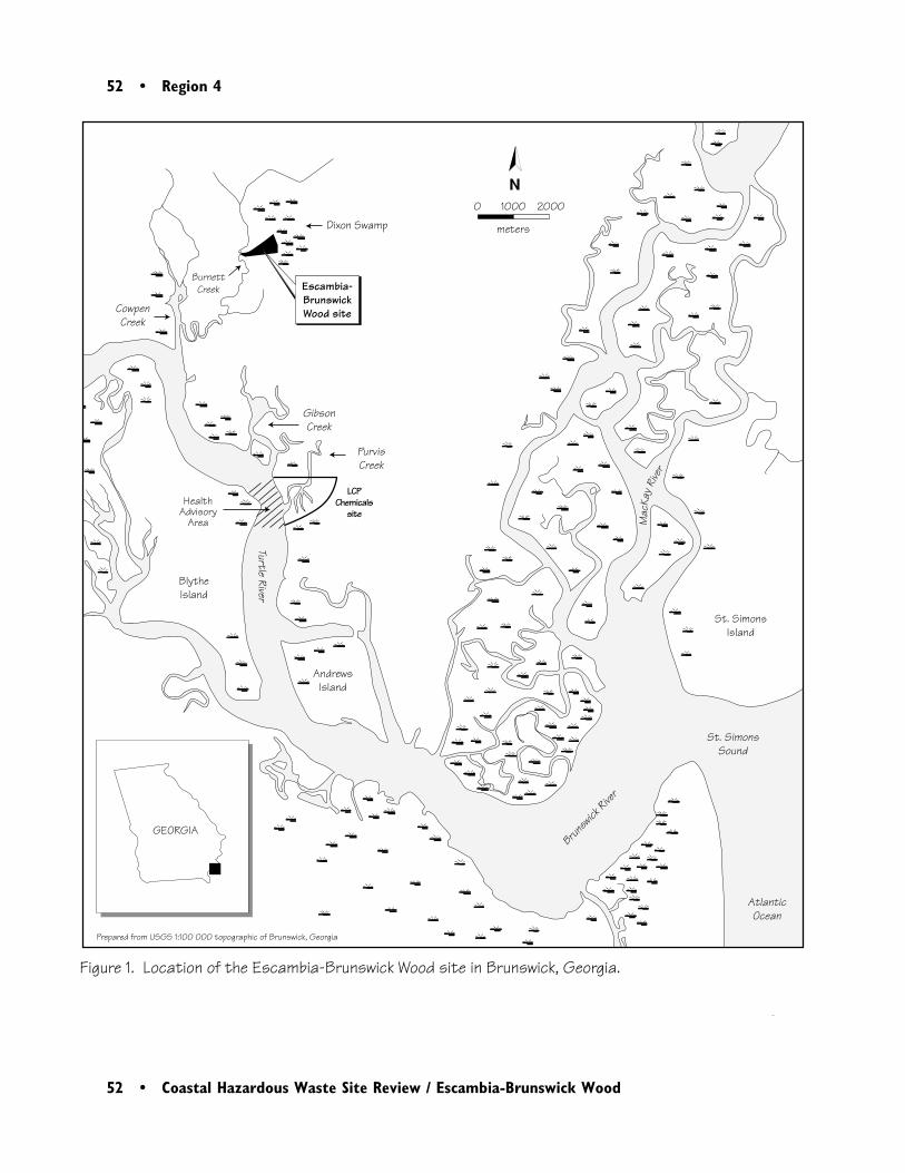
52 • Region 4
52 • Coastal Hazardous Waste Site Review / Escambia-Brunswick Wood
GEORGIA
HealthAdvisory
Area
Brunsw
ick Rive
r
Turtle River
St. SimonsSound
AtlanticOcean
CowpenCreek
BurnettCreek
Dixon Swamp
BlytheIsland
St. SimonsIsland
PurvisCreek
GibsonCreek
AndrewsIsland
Prepared from USGS 1:100 000 topographic of Brunswick, Georgia
Escambia-BrunswickWood site
N
Figure 1. Location of the Escambia-Brunswick Wood site in Brunswick, Georgia.
0 1000 2000
meters
Mac
Kay R
iver
LCP Chemicals
site

Region 4 • 53
Coastal Hazardous Waste Site Review / Escambia-Brunswick Wood • 53
Burn
ettC
ree
k
Old
Jesu
pRo
ad
���
��Es
cam
bia-
Brun
swic
k W
ood
prop
erty
bou
ndar
y
Cont
amin
ated
soi
l
Drai
nage
dit
ch o
r sto
rmwa
ter d
rain
Dire
ctio
n of
sur
face
wat
er fl
ow
Railr
oad
Wet
land
Are
a dr
aine
d by
sub
surf
ace
stor
m s
ewer
scal
e is
app
roxim
ate
Figu
re 2
. Det
ail o
f Esc
ambi
a-Br
unsw
ick
Woo
d si
te in
Bru
nswi
ck, G
eorg
ia.
CCA
Trea
tmen
tA
rea
Dixo
nS
wam
p
Dixo
nS
wam
p
PCP/
Creo
sote
Trea
tmen
t A
rea
Prep
ared
from
Woo
dall
1991
and
Bla
ck &
Vea
tch
Spe
cial
Pro
ject
s. C
orp.
1996
CSX R
ailro
ad
Lago
on
Lago
on
N0
50
10
0
met
ers
Per
ryLa
neR
oad
���
���

54 • Region 4
54 • Coastal Hazardous Waste Site Review / Escambia-Brunswick Wood
amounts of diesel oil were released to BurnettCreek on two separate occasions in 1969; onespilling 1100 to 1500 L and the other spilling3800 to 7600 L. Other incidents include a 2300to 3000-L spill of PCP solution, of which ap-proximately 100 to 200 L reached Burnett Creek.In 1989, more than 76,000 L of PCP solutionwas released to a storm sewer leading directly intoBurnett Creek.
Following a fire in 1991, EPA began investigat-ing contamination at the site. Several soil sampleswere found to have extremely high levels of PAHsand dioxins. In response, EPA excavated con-taminated soil from the southern portion of thesite down to groundwater for on-site contain-ment. A groundwater pump and treating systemwas also installed. The Georgia EnvironmentalProtection Division is removing the excavated soil(Farrier 1997).
Surface-water runoff and groundwater are thepotential pathways of contaminant transport toNOAA trust resources and associated habitats.The general topography at the site drains to thewest. A storm sewer system and a drainageditch, both of which empty directly into BurnettCreek, collect contaminated runoff from thewestern portion of the site. Runoff from thenorthern portion of the site also enters BurnettCreek through a drainage ditch. Runoff from thesouthern and eastern portions of the site iscollected and discharged to Dixon Swamp, whichalso drains to Burnett Creek (Figure 2).
Surface soils at the Brunswick Wood facility arepoorly-drained to moderately-permeable sandand sandy loam. The unconfined surficial aquiferis composed of very-fine to fine sands, gravel,thin limestone, and thin clay beds, and extendsto about 58 m deep. Recharge comes fromdirect infiltration of precipitation. There is aslight groundwater gradient to the west, which isaltered intermittently by tidal influences andwithdrawals from nearby wells.
The Brunswick Wood Treaters site lies within the100-year floodplain.
NOAA Trust Habitats and Species
The primary habitats of concern to NOAA aresurface water, bottom substrates, riparian zones,and wetlands associated with Burnett Creek,lower Cowpen Creek, and the Turtle River.Estuarine fish, invertebrate species, and anadro-mous fish are the resources of concern to NOAA(Table 1).
Burnett Creek is a small, tidally influenced, low-gradient stream with widely fluctuating salinitiesranging from freshwater to about 20 ppt, de-pending upon the season and the amount ofrunoff discharging to the stream. Its width variesfrom less than 10 m near the site to 100 m nearits confluence with Cowpen Creek. Depths aregenerally less than 1 m throughout the stream.Lower Cowpen Creek and the Turtle River alsoare low-gradient estuarine streams with salinitiesgenerally ranging from 15 to 20 ppt. Lower

Region 4 • 55
Coastal Hazardous Waste Site Review / Escambia-Brunswick Wood • 55
Species Habitat Use Fisheries
Common Name Scientific NameSpawningGround
NurseryGround
AdultForage
Comm.Fishery
Recr.Fishery
ANADROMOUS/CATADROMOUS SPECIESAmerican eel Anguilla rostrata ♦ ♦American shad Alosa sapidissima ♦ ♦Atlantic sturgeon Acipenser oxyrhynchus ♦ ♦Blueback herring Alosa aestivalis ♦ ♦
MARINE/ESTUARINE SPECIESAtlantic croaker Micropogonias undulatus ♦ ♦Atlantic menhaden Brevoortia tyrannus ♦Bay anchovy Anchoa mitchilli ♦ ♦ ♦Black drum Pogonias cromis ♦ ♦ ♦Bluefish Pomatomus saltatrix ♦Ladyfish Elops saurus ♦Mummichog Fundulus heteroclitus ♦ ♦ ♦Pinfish Lagodon rhomboides ♦ ♦Red drum Sciaenops ocellatus ♦ ♦Sheepshead Archosargus
probatocephalus♦ ♦ ♦
Sheepshead minnow Cyprinodon variegatus ♦ ♦ ♦Silversides Menidia spp. ♦ ♦Southern flounder Paralichthys lethostigma ♦ ♦ ♦Southern kingfish Menticirrhus americanus ♦Spanish mackerel Scomberomorus maculatus ♦Spot Leiostomus xanthurus ♦ ♦ ♦Spotted sea trout Cynoscion nebulosus ♦ ♦ ♦Striped mullet Mugil cephalus ♦ ♦ ♦Summer flounder Paralichthys dentatus ♦Weakfish Cynoscion regalis ♦
INVERTEBRATE SPECIESBlue crab Callinectes sapidus ♦ ♦ ♦ ♦Brown shrimp Penaeus aztecus ♦ ♦ ♦ ♦Eastern oyster Crassostrea virginica ♦ ♦ ♦Grass shrimp Palaemonetes pugio ♦ ♦ ♦ ♦ ♦Pink shrimp Penaeus duorum ♦ ♦ ♦ ♦White shrimp Penaeus setiferus ♦ ♦ ♦ ♦
Table 1. NOAA trust species using habitats associated with Burnett Creek, Cowpen Creek, and the TurtleRiver near the Escambia Brunswick Wood site.
Cowpen Creek is generally 100 to 150 m wideand 1 to 5 m deep. The Turtle River is 600 m to1 km wide and 1 to 11 m deep (USGS 1993).The extensive tidal marsh wetlands along the
banks of all three streams are largely composed ofsaltmarsh cord grass (Spartina alterniflora) andsalt hay grass (S. patens). Sediments range fromhigh organic silts to sands (Weston 1991).

56 • Region 4
56 • Coastal Hazardous Waste Site Review / Escambia-Brunswick Wood
A fish survey conducted in 1991 found killifishand blue crab in Burnett Creek (Weston 1991).Sheepshead minnow, Atlantic silversides, andstriped mullet are periodically found both in lowsalinities and tidal freshwaters within the estuaryand in Burnett Creek . Anadromous species havenot been found in Burnett Creek (Nelson et al.1991).
Lower Cowpen Creek and the Turtle Riverprovide deeper, larger, more marine-influencedhabitats for numerous estuarine fish and inverte-brates. Estuarine fish that commonly use thesetwo waterways for juvenile rearing and adultresidence include Atlantic menhaden, spotted seatrout, weakfish, Atlantic croaker, southern king-fish, black drum, spot, sheepshead, pinfish, andsouthern flounder. Anadromous species that usethe Turtle River as a migratory corridor andjuvenile nursery include Atlantic sturgeon, blue-back herring, and American shad. The catadro-mous American eel is found throughout the basinand uses lower-salinity portions of the TurtleRiver as a nursery. Invertebrates found in LowerCowpen Creek and the Turtle River includeAmerican oyster, hard clam, brown shrimp, grassshrimp, and blue crab (Nelson et al. 1991).
Five aquatic species that may occur near the siteare listed as threatened or endangered under theFederal Endangered Species Act. The endan-gered West Indian manatee (not a NOAA trustspecies) frequently forages in the Turtle Riverduring the spring and fall. Four species of seaturtle—loggerhead, Kemp’s Ridley, leatherback,and green—have been regularly sighted in St.Simons Sound, but sightings in the Turtle River
have not been confirmed. On the other hand,Atlantic bottlenose dolphin are commonlysighted in the Turtle River. Though not threat-ened or endangered, dolphins are afforded certainprotections under the Federal Marine MammalProtection Act (DOI 1995; NOAA 1995).
Bait shrimp and blue crab are commerciallyharvested from Burnett Creek below the High-way 341 bridge, approximately 1 km south of thesite. Both finfish and shellfish are recreationallyharvested for local consumption on all parts ofthe stream. There are also commercial andrecreational fisheries in the Turtle River (Weston1991).
A Georgia Department of Natural Resourceshealth advisory cautions against consumption ofrecreationally captured seafood for Purvis Creek,Gibson Creek, and the Turtle River extendingapproximately 800 m upstream and downstreamof the mouth of Purvis Creek. Commercialfisheries are prohibited in this area. The adviso-ries and closures posted in the area are the resultof mercury and PCB contamination associatedwith the LCP Chemicals National Priorities Listsite (Weston 1991). In addition, the harvest ofbivalves is restricted in the Turtle River estuarybecause of contamination from urban runofforiginating in the city of Brunswick (NOAA1995).
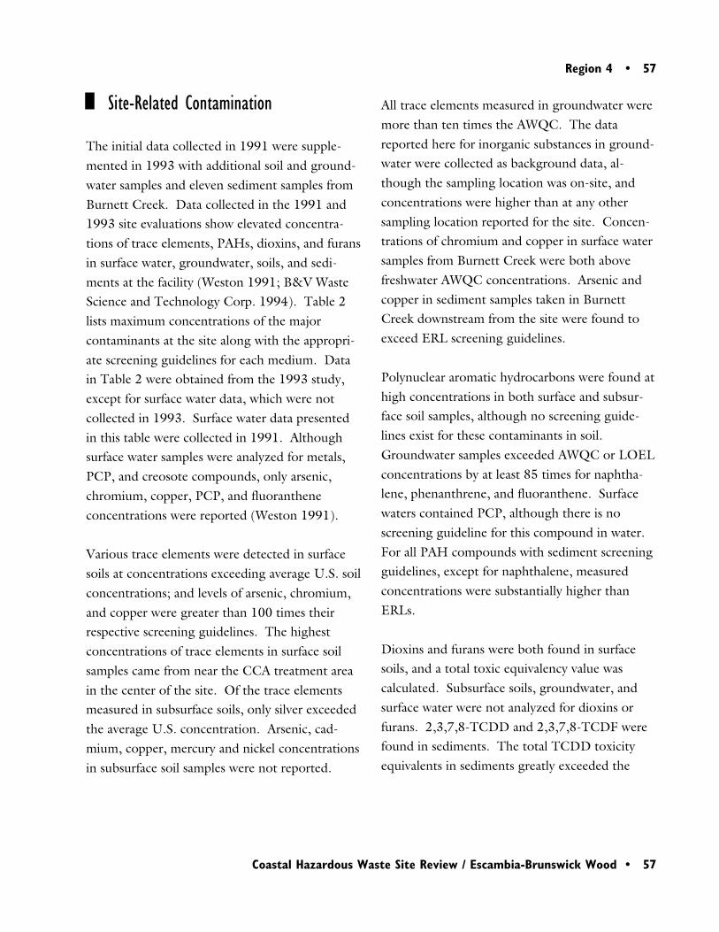
Region 4 • 57
Coastal Hazardous Waste Site Review / Escambia-Brunswick Wood • 57
Site-Related Contamination
The initial data collected in 1991 were supple-mented in 1993 with additional soil and ground-water samples and eleven sediment samples fromBurnett Creek. Data collected in the 1991 and1993 site evaluations show elevated concentra-tions of trace elements, PAHs, dioxins, and furansin surface water, groundwater, soils, and sedi-ments at the facility (Weston 1991; B&V WasteScience and Technology Corp. 1994). Table 2lists maximum concentrations of the majorcontaminants at the site along with the appropri-ate screening guidelines for each medium. Datain Table 2 were obtained from the 1993 study,except for surface water data, which were notcollected in 1993. Surface water data presentedin this table were collected in 1991. Althoughsurface water samples were analyzed for metals,PCP, and creosote compounds, only arsenic,chromium, copper, PCP, and fluorantheneconcentrations were reported (Weston 1991).
Various trace elements were detected in surfacesoils at concentrations exceeding average U.S. soilconcentrations; and levels of arsenic, chromium,and copper were greater than 100 times theirrespective screening guidelines. The highestconcentrations of trace elements in surface soilsamples came from near the CCA treatment areain the center of the site. Of the trace elementsmeasured in subsurface soils, only silver exceededthe average U.S. concentration. Arsenic, cad-mium, copper, mercury and nickel concentrationsin subsurface soil samples were not reported.
All trace elements measured in groundwater weremore than ten times the AWQC. The datareported here for inorganic substances in ground-water were collected as background data, al-though the sampling location was on-site, andconcentrations were higher than at any othersampling location reported for the site. Concen-trations of chromium and copper in surface watersamples from Burnett Creek were both abovefreshwater AWQC concentrations. Arsenic andcopper in sediment samples taken in BurnettCreek downstream from the site were found toexceed ERL screening guidelines.
Polynuclear aromatic hydrocarbons were found athigh concentrations in both surface and subsur-face soil samples, although no screening guide-lines exist for these contaminants in soil.Groundwater samples exceeded AWQC or LOELconcentrations by at least 85 times for naphtha-lene, phenanthrene, and fluoranthene. Surfacewaters contained PCP, although there is noscreening guideline for this compound in water.For all PAH compounds with sediment screeningguidelines, except for naphthalene, measuredconcentrations were substantially higher thanERLs.
Dioxins and furans were both found in surfacesoils, and a total toxic equivalency value wascalculated. Subsurface soils, groundwater, andsurface water were not analyzed for dioxins orfurans. 2,3,7,8-TCDD and 2,3,7,8-TCDF werefound in sediments. The total TCDD toxicityequivalents in sediments greatly exceeded the
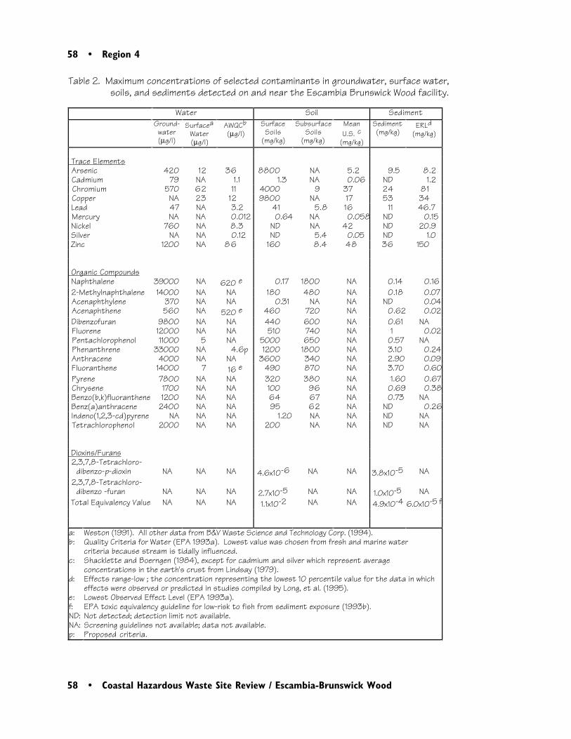
58 • Region 4
58 • Coastal Hazardous Waste Site Review / Escambia-Brunswick Wood
Table 2. Maximum concentrations of selected contaminants in groundwater, surface water,soils, and sediments detected on and near the Escambia Brunswick Wood facility.
Water Soil SedimentGround-
water(µg/l)
SurfaceaWater(µg/l)
AWQCb(µg/l)
Surface Soils
(mg/kg)
SubsurfaceSoils
(mg/kg)
MeanU.S. c
(mg/kg)
Sediment(mg/kg)
ERLd(mg/kg)
Trace Elements Arsenic 420 12 36 8800 NA 5.2 9.5 8.2 Cadmium 79 NA 1.1 1.3 NA 0.06 ND 1.2 Chromium 570 62 11 4000 9 37 24 81 Copper NA 23 12 9800 NA 17 53 34 Lead 47 NA 3.2 41 5.8 16 11 46.7 Mercury NA NA 0.012 0.64 NA 0.058 ND 0.15 Nickel 760 NA 8.3 ND NA 42 ND 20.9 Silver NA NA 0.12 ND 5.4 0.05 ND 1.0 Zinc 1200 NA 8 6 160 8.4 48 36 150
Organic Compounds Naphthalene 39000 NA 620 e 0.17 1800 NA 0.14 0.16 2-Methylnaphthalene 14000 NA NA 180 480 NA 0.18 0.07 Acenaphthylene 370 NA NA 0.31 NA NA ND 0.04 Acenaphthene 560 NA 520 e 460 720 NA 0.62 0.02 Dibenzofuran 9800 NA NA 440 600 NA 0.61 NA Fluorene 12000 NA NA 510 740 NA 1 0.02 Pentachlorophenol 11000 5 NA 5000 650 NA 0.57 NA Phenanthrene 33000 NA 4.6p 1200 1800 NA 3.10 0.24 Anthracene 4000 NA NA 3600 340 NA 2.90 0.09 Fluoranthene 14000 7 16 e 490 870 NA 3.70 0.60 Pyrene 7800 NA NA 320 380 NA 1.60 0.67 Chrysene 1700 NA NA 100 96 NA 0.69 0.38 Benzo(b,k)fluoranthene 1200 NA NA 64 67 NA 0.73 NA Benz(a)anthracene 2400 NA NA 95 62 NA ND 0.26 Indeno(1,2,3-cd)pyrene NA NA NA 1.20 NA NA ND NA Tetrachlorophenol 2000 NA NA 200 NA NA ND NA
Dioxins/Furans 2,3,7,8-Tetrachloro-
dibenzo-p-dioxin NA NA NA 4.6x10⁻⁶ NA NA 3.8x10⁻⁵ NA 2,3,7,8-Tetrachloro-
dibenzo -furan NA NA NA 2.7x10⁻⁵ NA NA 1.0x10⁻⁵ NA Total Equivalency Value NA NA NA 1.1x10⁻² NA NA 4.9x10⁻⁴ 6.0x10⁻⁵ f
a:b:
c:
d:
e:f:ND:NA:p:
Weston (1991). All other data from B&V Waste Science and Technology Corp. (1994).Quality Criteria for Water (EPA 1993a). Lowest value was chosen from fresh and marine water criteria because stream is tidally influenced.Shacklette and Boerngen (1984), except for cadmium and silver which represent average concentrations in the earth's crust from Lindsay (1979).Effects range-low ; the concentration representing the lowest 10 percentile value for the data in which effects were observed or predicted in studies compiled by Long, et al. (1995).Lowest Observed Effect Level (EPA 1993a).EPA toxic equivalency guideline for low-risk to fish from sediment exposure (1993b).Not detected; detection limit not available.Screening guidelines not available; data not available.Proposed criteria.
Region 4 • 59
Coastal Hazardous Waste Site Review / Escambia-Brunswick Wood • 59
may be present near the site include four speciesof sea turtle.
References
EPA toxic equivalency guideline for risk to fishfrom sediment exposure (EPA 1993b).
Remedial Investigation data were provided toNOAA in August 1997, before release of the RIreport. These new data indicate maximumconcentrations of all trace elements exceedingrespective sediment ERLs, except nickel andsilver. These data also indicate higher sedimentconcentrations of 2,3,7,8-TCDD equivalents(1.2 µg/kg), individual PAHs (1600 mg/kg),and PCP (2900 mg/kg) than previous studies(which are shown in Table 2). The RI dataindicate maximum concentrations of PCP(78 µg/L), arsenic (96 µg/L) and zinc (160 µg/L) above their chronic AWQCs (Farrier 1997).
Summary
Results from site investigations indicate thatprevious activities at the Brunswick Wood Treat-ers site have contaminated soil, groundwater,surface water, and sediments with trace elements,PAHs, dioxins, and furans. Surface runoff andgroundwater discharge flow directly into BurnettCreek adjacent to the site. Primary habitats ofconcern to NOAA include surface water, bottomsubstrates, wetlands and riparian areas of BurnettCreek, Cowpen Creek, and the Turtle River.These water bodies support estuarine, anadro-mous, and catadromous fish species, and numer-ous invertebrates. Federally listed threatened orendangered species of concern to NOAA that
B&V Waste Science and Technology Corp.1994. Draft expanded site inspection: EscambiaBrunswick Wood, Brunswick, Glynn County,Georgia. Atlanta: U.S. Environmental ProtectionAgency, Region 4, Waste Management Division.44 pp.
Black & Veatch Special Projects Corp. 1996.HRS documentation record for Brunswick WoodPreserving. Atlanta: U.S. Environmental Protec-tion Agency, Region 4.
DOI. 1995. Preliminary natural resource survey,Terry Creek Dredge Spoil Site, Glynn County,Brunswick, GA. Washington, DC: U.S. Depart-ment of the Interior, Office of EnvironmentalPolicy and Compliance.
Farrier, B., Remedial Project Manager, U.S.Environmental Protection Agency, Atlanta,personal communication, August 5, 1997.
Long, E. R., D. D. MacDonald, S. L. Smith, andF. D. Calder. 1995. Incidence of adverse bio-logical effects within ranges of chemical concen-trations in marine and estuarine sediments.Environmental Management 19:81-97.

60 • Region 4
60 • Coastal Hazardous Waste Site Review / Escambia-Brunswick Wood
Nelson, D.M., E.A. Irlandi, L.R. Settle, M.E.Monaco, and L.C. Coston-Clements. 1991.Distribution and abundance of fishes and inverte-brates in southeast estuaries. ELMR Rept. No.19. Rockville, Maryland: NOAA/NOAA Strate-gic Environmental Assessments Division. 177pp.
NOAA. 1995. Preliminary natural resourcesurvey, LCP Chemicals, Inc. Findings of fact.Seattle: Hazardous Materials Response andAssessment Division, National Oceanic andAtmospheric Administration.
U.S. Environmental Protection Agency (EPA).1993a. Water quality criteria. Washington,D.C.: U.S. Environmental Protection Agency,Office of Water, Health and Ecological CriteriaDivision. 294 pp.
U.S. Environmental Protection Agency (EPA).1993b. Interim report on data and methods forassessment of 2,3,7,8-tetrachlorodibenzo-p-dioxinrisks to aquatic life and associated wildlife. Wash-ington, D.C.: U.S. Environmental ProtectionAgency, Office of Research and Development.
USGS. 1993. Brunswick West, Georgia. 7.5minute series quadrangle. Reston, Virginia: U.S.Government Printing Office.
Weston. 1991. Final report, preliminary assess-ment, Brunswick Wood Preserving site, Brunswick,Georgia. Atlanta: U.S. Environmental ProtectionAgency, Region 4.
Woodall, S. 1991. RCRA facility assessment:Escambia Treating Company, Inc., Brunswickfacility. Atlanta: Georgia Department of NaturalResources, Environmental Protection Division,Hazardous Waste Management Program. 47 pp.
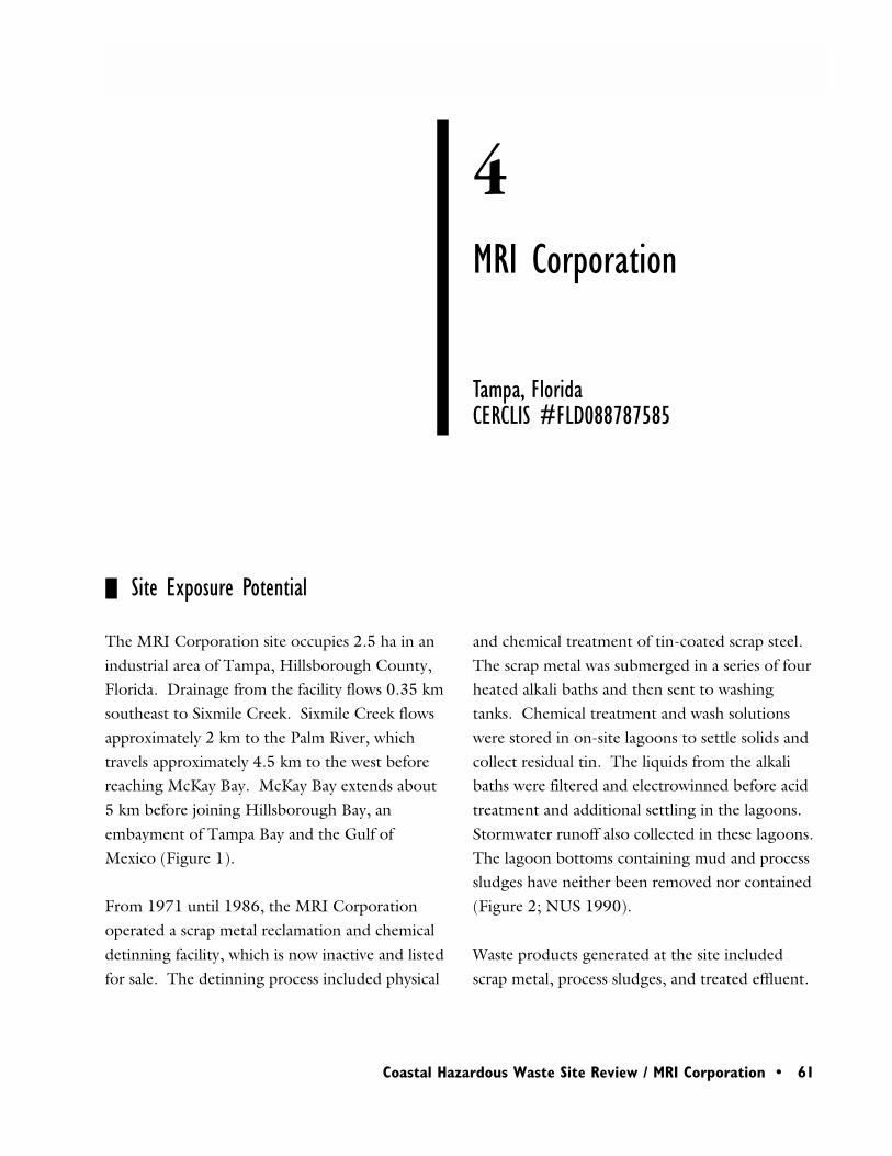
Region 4 • 61
Coastal Hazardous Waste Site Review / MRI Corporation • 61
4MRI Corporation
Site Exposure Potential
The MRI Corporation site occupies 2.5 ha in anindustrial area of Tampa, Hillsborough County,Florida. Drainage from the facility flows 0.35 kmsoutheast to Sixmile Creek. Sixmile Creek flowsapproximately 2 km to the Palm River, whichtravels approximately 4.5 km to the west beforereaching McKay Bay. McKay Bay extends about5 km before joining Hillsborough Bay, anembayment of Tampa Bay and the Gulf ofMexico (Figure 1).
From 1971 until 1986, the MRI Corporationoperated a scrap metal reclamation and chemicaldetinning facility, which is now inactive and listedfor sale. The detinning process included physical
Tampa, FloridaCERCLIS #FLD088787585
and chemical treatment of tin-coated scrap steel.The scrap metal was submerged in a series of fourheated alkali baths and then sent to washingtanks. Chemical treatment and wash solutionswere stored in on-site lagoons to settle solids andcollect residual tin. The liquids from the alkalibaths were filtered and electrowinned before acidtreatment and additional settling in the lagoons.Stormwater runoff also collected in these lagoons.The lagoon bottoms containing mud and processsludges have neither been removed nor contained(Figure 2; NUS 1990).
Waste products generated at the site includedscrap metal, process sludges, and treated effluent.
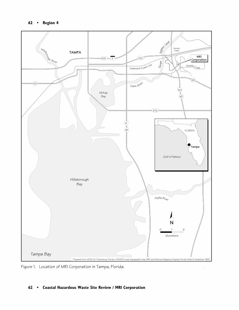
62 • Region 4
62 • Coastal Hazardous Waste Site Review / MRI Corporation
TAMPASixmileCreek
HillsboroughBay
Palm River
Alafia River
McKayBay
Tampa Bay
0 1 2 kilometers
Seaboard Coast Line
Tam
paBy
pa
ssCan
al
MRICorporation
Figure 1. Location of MRI Corporation in Tampa, Florida.
N
Hillsborough River
676
41
301
45
43
4400 574
6060
FLORIDA
�
Gulf of Mexico
Tampa
Prepared from USGS St. Petersburg, Florida, 1:100000 scale topographic map 1981 and Delorme Mapping Company Florida Atlas & Gazetteer 1989
Sixmile Cr eek
Region 4 • 63
Coastal Hazardous Waste Site Review / MRI Corporation • 63
Figure 2. Detail of MRI Corporation site.
N0 50 100
meters
Scale is approximate
Sludgeponds
NPDESOutfall ditch
Structure
Drainage
Railroad
Sixmile
Creek301
43
Stannum Street
Adapted from EPA 1996, NUS Corporation 1990, and Delorme Mapping Company, Florida Atlas & Gazetteer 1989
64 • Region 4
64 • Coastal Hazardous Waste Site Review / MRI Corporation
The scrap metal was compressed into 180-kgbales for off-site reuse. Process sludges werefiltered, accumulated on-site, and sold for metalreclamation. Approximately 91,000 kg/year ofprocess sludges were reclaimed and sold out ofstate. In 1974, waste sludge sampling detectedcopper, iron, lead, mercury, nickel, sodium, tin,zinc, oil, and grease (NUS 1990).
Wastewater, treated with chlorine to oxidizecyanides, was discharged to an on-site drainageditch. Discharges to the ditch at rates of up to19,000 L/week were allowed under a NPDESpermit (NUS 1990). However, this facility had adocumented history of NPDES violations. Dur-ing 1984, for example, effluent monitoringindicated that zinc and mercury exceeded permitlimits during January; oil and grease and bothtotal and free cyanide exceeded permit limitsduring February; and total cyanide and cadmiumpermit limits were exceeded during March (NUS1990).
Surface-water transport and groundwater dis-charge are the potential pathways of contaminantmigration from the site to NOAA trust resourcesand associated habitats. Surface runoff from thesite reportedly flows into Sixmile Creek, but nodetailed information was available on surfaceflow. Groundwater at the site migrates to thesouthwest. The two principal aquifers in the areaare the surficial and the Upper Floridan aquifers,which are hydraulically connected near the site.Site groundwater is encountered 2.4 m bgs.
NOAA Trust Habitats and Species
Habitats of primary concern to NOAA areestuarine surface waters and associated bottomsubstrates of the lower Palm River and McKayBay, a shallow embayment within the Tampa Bayestuary. Many estuarine fish and invertebratesuse the embayment and are the resources ofconcern to NOAA (Table 1).
McKay Bay is generally less than 8 m deep andsalinities generally range from 22 to 25 ppt,fluctuating throughout the year depending uponrainfall, saltwater intrusion, and runoff (Estevez1989). Silty sands dominate bottom substrates(Dial and Deis 1986).
The Palm River has low water quality; between1980 and 1983, annual average dissolved oxygenvaried from 1.8 to 3.2 mg/L. In addition,coliform counts, nutrient concentrations, andbiological oxygen demand all were elevated.Water-quality conditions tend to worsen towardMcKay Bay, where urbanization is greater andmore point sources are present (Wolfe 1990).
The lower Palm River and McKay Bay providenursery and adult habitat for numerous fish andinvertebrate species (Kunneke and Palik 1984;Nelson et al. 1992). Most of the estuarinespecies spawn offshore or in coastal waters. Tidalcurrents carry the larvae inshore to estuarinewater. Juveniles remain in protected estuariesuntil sexual maturity (Kunneke and Palik 1984).For example, snook and red drum juveniles are
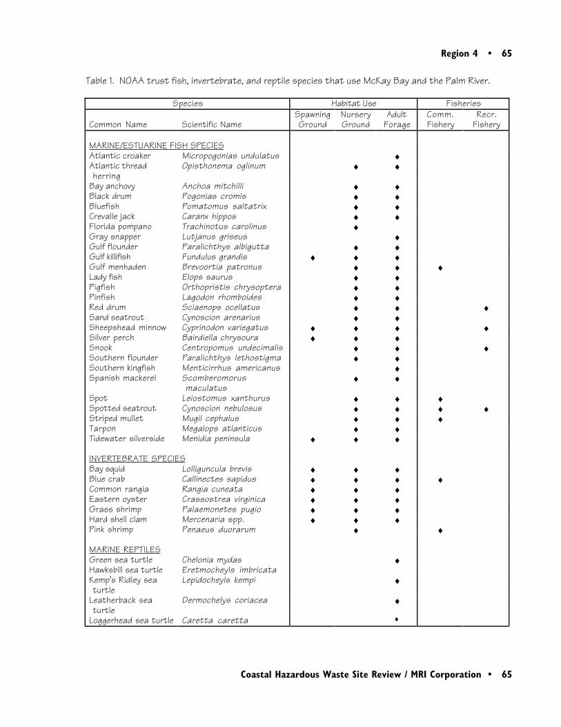
Region 4 • 65
Coastal Hazardous Waste Site Review / MRI Corporation • 65
Table 1. NOAA trust fish, invertebrate, and reptile species that use McKay Bay and the Palm River.
Species Habitat Use Fisheries
Common Name Scientific NameSpawningGround
NurseryGround
AdultForage
Comm.Fishery
Recr.Fishery
MARINE/ESTUARINE FISH SPECIESAtlantic croaker Micropogonias undulatus ♦Atlantic threadherring
Opisthonema oglinum ♦ ♦
Bay anchovy Anchoa mitchilli ♦ ♦Black drum Pogonias cromis ♦ ♦Bluefish Pomatomus saltatrix ♦ ♦Crevalle jack Caranx hippos ♦ ♦Florida pompano Trachinotus carolinus ♦Gray snapper Lutjanus griseus ♦Gulf flounder Paralichthys albigutta ♦ ♦Gulf killifish Fundulus grandis ♦ ♦ ♦Gulf menhaden Brevoortia patronus ♦ ♦ ♦Lady fish Elops saurus ♦ ♦Pigfish Orthopristis chrysoptera ♦ ♦Pinfish Lagodon rhomboides ♦ ♦Red drum Sciaenops ocellatus ♦ ♦ ♦Sand seatrout Cynoscion arenarius ♦ ♦Sheepshead minnow Cyprinodon variegatus ♦ ♦ ♦ ♦Silver perch Bairdiella chrysoura ♦ ♦ ♦Snook Centropomus undecimalis ♦ ♦ ♦Southern flounder Paralichthys lethostigma ♦ ♦Southern kingfish Menticirrhus americanus ♦Spanish mackerel Scomberomorus
maculatus♦ ♦
Spot Leiostomus xanthurus ♦ ♦ ♦Spotted seatrout Cynoscion nebulosus ♦ ♦ ♦ ♦Striped mullet Mugil cephalus ♦ ♦ ♦Tarpon Megalops atlanticus ♦ ♦Tidewater silverside Menidia peninsula ♦ ♦ ♦
INVERTEBRATE SPECIESBay squid Lolliguncula brevis ♦ ♦ ♦Blue crab Callinectes sapidus ♦ ♦ ♦ ♦Common rangia Rangia cuneata ♦ ♦ ♦Eastern oyster Crassostrea virginica ♦ ♦ ♦Grass shrimp Palaemonetes pugio ♦ ♦ ♦Hard shell clam Mercenaria spp. ♦ ♦ ♦Pink shrimp Penaeus duorarum ♦ ♦
MARINE REPTILESGreen sea turtle Chelonia mydas ♦Hawksbill sea turtle Eretmocheyls imbricataKemp’s Ridley seaturtle
Lepidocheyls kempi ♦
Leatherback seaturtle
Dermochelys coriacea ♦
Loggerhead sea turtle Caretta caretta ♦

66 • Region 4
66 • Coastal Hazardous Waste Site Review / MRI Corporation
commonly found in brackish streams and canalsand tidal freshwater streams, and may be found inthe lower Palm River (Gilmore et al. 1983; Petersand McMichael 1987).
Highly abundant finfish species in the Tampa BayEstuary include Gulf menhaden, sheepsheadminnow, tidewater silversides, striped mullet, reddrum, bay anchovy, spot, and pinfish (Nelson etal. 1992).
Blue crab are abundant in the estuary. Bothjuveniles and adults use the estuary, and matingmay occur in tidal portions of the Palm River.After mating, the females return to full seawaterto brood eggs while the males usually remain inlow-salinity waters. Crab larvae are released in fullseawater zones, such as upper Tampa Bay, and aretransported by currents to McKay Bay and other,lower -salinity portions of the estuary. The larvaesettle and metamorphose to juveniles in the low-salinity estuary (Nelson et al. 1992).
Grass shrimp are abundant and spend their entirelife cycle in the estuary. The bivalves rangia, hardshell clam, and oyster are also commonly found inthe estuary (Nelson et al. 1992).
Commercial and recreational fishing activitiesconcentrate in the outer estuaries of Tampa Bayand Old Tampa Bay. Commercial and recre-ational fisheries are not extensive in either McKayBay or the lower Palm River. However, bluecrab, Gulf menhaden, mullet, pink shrimp, spot,and spotted seatrout are commercially harvestedin nearby Hillsborough Bay.
Recreational anglers occasionally fish availablespecies in McKay Bay. Species typically soughtare red drum, sheepshead, snook, and spottedseatrout. There are no restrictions on thesefisheries other than general regulations regardingtake limit and minimum size. Periodically, bluecrab are also harvested from McKay Bay(McMichael 1992).
The surface waters of Hillsborough and Tampabays provide habitat for several threatened andendangered species. A non-NOAA trust species,the federally endangered West Indian manatee(Trichechus manatus) uses these bays as seasonalhabitat. Several federally protected species ofturtles also are found in the area. These includethe threatened green and loggerhead sea turtles,along with the endangered hawksbill, Kemp’sRidley, and leatherback sea turtles (McMichael1992).
Site-Related Contamination
1990 and 1992 site inspections documentedelevated concentrations of trace elements in soil,groundwater, and sediment at the site (NUS1990; EPA 1992). Surface-water samples werenot collected in either of these site inspections.Consequently, groundwater concentrations arecompared to EPA Ambient Water Quality Crite-ria (Table 2).

Region 4 • 67
Coastal Hazardous Waste Site Review / MRI Corporation • 67
Table 2. Maximum concentrations of selected contaminants detected at the MRI Corporation site.
Maximum concentrations of the major contami-nants are listed in Table 2 along with the appro-priate screening guidelines for each medium.Data reported here for soil and sediment are fromthe 1992 inspection. None of the samples fromthe 1990 or 1992 investigations were analyzedfor tin.
During the 1990 site inspection, soil and sedi-ment samples were analyzed for VOCs, pesticides,PCBs, and PAHs. In 1990, Aroclor 1254 wasdetected in one surface soil sample at a concentra-tion of 1.4 mg/kg. In addition, dieldrin wasdetected in one groundwater sample at a concen-tration of 0.028 µg/L, which exceeds the AWQCfor this compound.
Summary
Limited site investigations indicate that previousactivities at the MRI site caused trace elementcontamination of site soils, groundwater, andsediments. Surface water has not been sampled.Surface runoff and groundwater are potentialtransport pathways from the site to SixmileCreek, which flows into the Palm River. Habitatsof primary concern to NOAA are estuarinesurface waters and associated bottom substratesof the lower Palm River and McKay Bay. Thesehabitats support numerous estuarine fish andinvertebrate species, as well as threatened andendangered sea turtles.
Soil (mg/kg) Water (µg/L) Sediment (mg/kg)
Inorganic Substance
SurfaceSoils
Sub-Surface
Soils
Mean U.S. a
Ground-water
AWQCb(µg/L)
On-siteSediment
ERLc
Chromium 71 38 37 930 11 41 81 Copper 370 90 17 NA 12 69 34 Lead 8700 3800 16 340 3.2 1700 46.7 Mercury 2 ND 0.06 1.4 0.012 2.6 .15 Nickel 80 20 13 160 8.3 21 209 Zinc 1800 590 48 750 8 6 500 150 Cyanide 1.5 1.5 NA 52,000 5.2 0.84 NA
a:b:
c:
NDNA
Shacklette and Boerngen (1984) Ambient Water Quality Criteria for Water (U.S. EPA 1993); data presented are lowest chronic marine or freshwater criteria. Effects range-low; the concentration representing the lowest 10-percentile value for the data in which effects were observed or predicted in studies compiled by Long et al. (1995).Not detected; detection limit not available.Screening guidelines not available.
68 • Region 4
68 • Coastal Hazardous Waste Site Review / MRI Corporation
Nelson, D.M., M.E. Monaco, C.D. Williams,T.E. Czapla, M.E. Pattillo, L. Coston-Clements,L.R. Settle, and E.A. Irlandi. 1992. Distributionand abundance of fishes and invertebrates in Gulfof Mexico estuaries. Volume I: Data summaries.Rockville, Maryland: NOAA/NOS StrategicEnvironmental Assessments Division. 273 pp.
NUS Corporation. 1990. Screening Site Inspec-tion Report, Phase II, MRI Corporation, Tampa,Hillsborough County, Florida. Atlanta: WasteProtection Division, U.S. EPA.
Peters, K.M. and R.H. McMichael, Jr. 1987.Early life history of the red drum, Sciaenopsocellatus (Pisces: Sciaenidae), in Tampa Bay,Florida. Estuaries 10:92-107.
Shacklette, H. T. and J. G. Boerngen. 1984.Element concentrations in soils and other surficialmaterials of the conterminous United States. U.S.Geological Survey Professional Paper 1270.Washington, D.C.: U.S. Government PrintingOffice.
U.S. Environmental Protection Agency (EPA).1992. Supplemental Site Inspection Report -MRI Corporation, Tampa, Hillsborough County,Florida. Atlanta: EPA Region 4.
U.S. Environmental Protection Agency (EPA).1993. Water quality criteria. Washington, D.C.:U.S. Environmental Protection Agency, Office ofWater, Health and Ecological Criteria Division.294 pp.
References
Dial, R.S., D.R. Deis. 1986. Mitigation optionsfor fish and wildlife resources affected by port andother water-dependent developments in Tampa Bay,Florida. U.S. Fish and Wildlife Service BiologicalReport 86(6). Washington, D.C.: U.S. Fish andWildlife Service. 150 pp.
Estevez, E.D., ed. 1989. Tampa and SarasotaBays: issues, resources, and management. NOAAEstuary-of-the-Month Seminar Series No. 11. StPetersburg, Florida: Estuarine Programs Office,National Oceanic and Atmospheric Administra-tion.
Gilmore, G.R., C.J. Donohoe, and D.W., Cooke.1983. Observations on the distribution andbiology of east-central Florida populations of thecommon snook, Centropomus undecimalis(Bloch). Florida Scientist 46:313-336.
Kunneke, J.T. and T.F. Palik. 1984. Tampa Bayenvironmental atlas. U.S. Fish and WildlifeService Biological Report 85(15). Washington,D.C.: U.S. Fish and Wildlife Service. 73 pp.
Long, E. R., D. D. MacDonald, S. L. Smith, andF. D. Calder. 1995. Incidence of adverse bio-logical effects within ranges of chemical concen-trations in marine and estuarine sediments.Environmental Management 19: 81-97.
McMichael, R. Fisheries Biologist, FloridaDepartment of Fish and Wildlife, Tallahassee,personal communication, September 21, 1992.
Region 4 • 69
Coastal Hazardous Waste Site Review / MRI Corporation • 69
Wolfe, S.H., and R.D. Drew, eds. 1990. Anecological characterization of the Tampa Baywatershed. U.S. Fish and Wildlife ServiceBiological Report 90(20). Washington, D.C.:U.S. Fish and Wildlife Service. 334 pp.
70 • Region 4
70 • Coastal Hazardous Waste Site Review / MRI Corporation
Region 4 • 71
Coastal Hazardous Waste Site Review / Terry Creek/Hercules Outfall • 71
4Terry Creek Dredge Spoil/Hercules Outfall
Site Exposure Potential
The Terry Creek Dredge Spoil Areas/HerculesOutfall site is located on coastal estuarine marsh-lands approximately 1 km northeast of downtownBrunswick, Glynn County, Georgia. The site isbordered by Dupree Creek, Terry Creek, and theBack River (Figure 1). Dupree Creek flows southalong the western edge of the site into TerryCreek, which continues approximately 2 km eastuntil it merges with the Back River. The BackRiver then flows 3 km southeast and enters St.Simons Sound approximately 5 km from the site.St. Simons Sound joins the Atlantic Ocean about5 km farther downstream.
Brunswick, GeorgiaCERCLIS #GAD982112658
From 1948 to 1981, the principal product ofHercules, Inc. (formerly Hercules Powder Plant),located on Dupree Creek, was the pesticidetoxaphene. From 1966 to 1972, Herculesdischarged 100-140 kg of toxaphene daily toDupree Creek via a wastewater outfall (Figure 2).In 1972, installation of a wastewater treatmentsystem reduced toxaphene discharges to less than0.5 kg per day. By 1975, Hercules had obtainedan NPDES permit for its Dupree Creek outfallthat restricted discharge to a daily maximum ofabout 0.5 kg of toxaphene, and a monthly aver-age of about 0.2 kg toxaphene per day. Subse-quent permit renewals gradually reduced permit-ted discharges. The current permit allowance is
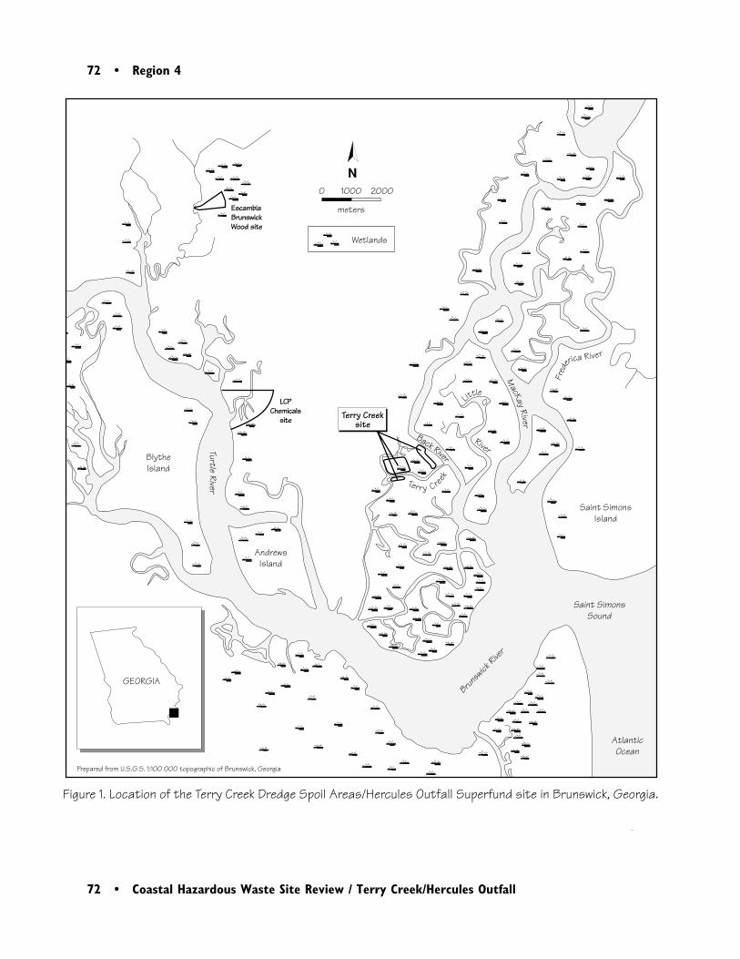
72 • Region 4
72 • Coastal Hazardous Waste Site Review / Terry Creek/Hercules Outfall
GEORGIA
Back River
Terry Creeksite
River
Little
Fred
erica River
Wetlands
EscambiaBrunswickWood site
LCP Chemicals
site
Brunsw
ick Rive
r
Turtle River
Saint SimonsSound
AtlanticOcean
BlytheIsland
Saint SimonsIsland
AndrewsIsland
Prepared from U.S.G.S. 1:100 000 topographic of Brunswick, Georgia
Terry Creek
N
Figure 1. Location of the Terry Creek Dredge Spoil Areas/Hercules Outfall Superfund site in Brunswick, Georgia.
0 1000 2000
meters
MacKay
River

Region 4 • 73
Coastal Hazardous Waste Site Review / Terry Creek/Hercules Outfall • 73
Figu
re 2
. De
tail
of T
erry
Cre
ek D
redg
e S
poil
Are
as/H
ercu
les
Outf
all s
ite.
N0
10
0
200
m
eter
s
Sou
rce:
Bla
ck &
Vea
tch
Spe
cial
Pro
ject
s Co
rp. 1
997
Ba c k
Ri v e r
Boat
Doc
ks
Dred
ge s
poil
area
2
Her
cule
s Do
ck
Her
cule
s 0
01 N
PDES
Disc
harg
e
Dred
ge s
poil
area
3
Dred
ge s
poil
area
1
Te
rr
yC
re
e
k
Torr
asCa
usew
ayA
rea
of s
uspe
cted
tox
aphe
ne
cont
amin
atio
n
2nd-
gene
rati
on d
ike
1st-
gene
rati
on d
ike
Disc
harg
e we
ir
Wet
land
s
Catw
alk
Dupree Creek
74 • Region 4
74 • Coastal Hazardous Waste Site Review / Terry Creek/Hercules Outfall
an average of about 0.025 kg per day. Therewere six documented violations of the NPDESpermit between 1988 and 1993 (Black & VeatchSpecial Projects Corp. 1997).
The U.S. Army Corps of Engineers (USACE)began dredging Terry Creek in 1938. Threetracts of land were set aside to accommodate thedredge spoils; these areas are identified asDredge Spoil Area 1 (29 ha), Area 2 (23 ha), andArea 3 (3 ha; Figure 2). In 1972, Hercules,EPA, and the Georgia Environmental ProtectionDivision agreed to restrict future disposal ofdredge spoils to Area 1 following a spill of anunknown quantity of toxaphene into DupreeCreek from a barge at the Hercules dock. WhileArea 1 continues to receive dredge spoils, Areas 2and 3 have been converted to residential prop-erty. Maintenance dredging of Terry Creekoccurred in 1940, 1942, 1946, 1972, 1978,1982, 1986, 1987, and 1988 (Black & VeatchSpecial Projects Corp. 1997).
Surface runoff, direct discharge to surface waters,and tidal transport are the contaminant pathwaysof primary concern to NOAA. When dredgedsediments and water are placed into Dredge SpoilArea 1, solids settle out, and the excess waterdrains into Dupree Creek via three weirs on thenorth and west sides. Although the dredge spoilsare contained by a two-generation, 7-m highdike, the second-generation dike was constructedusing contaminated dredge material. Aerialphotos of the impoundment show many com-plete and partial breaches of the dike, and con-taminated water and sediments flowing into
Dupree and Terry creeks (Bionetics 1991). Tidalcurrents have carried toxaphene upstream 1.2 kmto the origin of Dupree Creek (U.S. EPA1997a). There is an unmapped pipeline thatextends from inside the southwest corner of thedike to Terry Creek (Taylor 1995).
Areas 2 and 3 have no features restricting surfacerunoff and associated contaminants from enter-ing the waterways. Runoff from Dredge SpoilAreas 2 and 3 flows northeast and north to theBack River and Terry Creek, respectively (U.S.EPA 1997a).
NOAA Trust Habitats and Species
The habitats of concern to NOAA are surfacewater, bottom substrates, wetlands, and riparianzones associated with Dupree Creek, TerryCreek, the Back River, and St. Simons Sound.Estuarine fish, anadromous fish, and invertebratespecies are the primary resources of interest toNOAA (Table 1).
Dupree and Terry Creeks are low-gradient, tidalstreams of intermediate salinities (15-30 ppt).Both streams are typically 50 to 70 m wide andless than 1 m deep. Near the site the lower BackRiver is between 200 and 500 m wide and up to9 m deep, with salinities generally ranging from20 to 30 ppt. Sediments range from organicallyenriched silts to fine sands. Vast salt marshwetlands are next to all three tidal streams. Thewetlands near the site are dominated by smooth
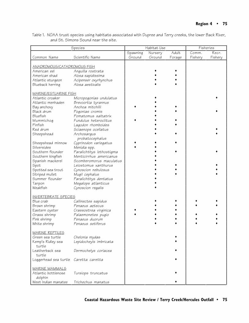
Region 4 • 75
Coastal Hazardous Waste Site Review / Terry Creek/Hercules Outfall • 75
Table 1. NOAA trust species using habitats associated with Dupree and Terry creeks, the lower Back River,and St. Simons Sound near the site.
Species Habitat Use Fisheries
Common Name Scientific NameSpawningGround
NurseryGround
AdultForage
Comm.Fishery
Recr.Fishery
ANADROMOUS/CATADROMOUS FISHAmerican eel Anguilla rostrata ♦ ♦American shad Alosa sapidissima ♦ ♦Atlantic sturgeon Acipenser oxyrhynchus ♦ ♦Blueback herring Alosa aestivalis ♦ ♦
MARINE/ESTUARINE FISHAtlantic croaker Micropogonias undulatus ♦ ♦Atlantic menhaden Brevoortia tyrannus ♦Bay anchovy Anchoa mitchilli ♦ ♦ ♦Black drum Pogonias cromis ♦ ♦ ♦Bluefish Pomatomus saltatrix ♦Mummichog Fundulus heteroclitus ♦ ♦ ♦Pinfish Lagodon rhomboides ♦ ♦Red drum Sciaenops ocellatus ♦ ♦Sheepshead Archosargus
probatocephalus♦ ♦ ♦
Sheepshead minnow Cyprinodon variegatus ♦ ♦ ♦Silversides Menidia spp. ♦ ♦Southern flounder Paralichthys lethostigma ♦ ♦ ♦Southern kingfish Menticirrhus americanus ♦Spanish mackerel Scomberomorus maculatus ♦Spot Leiostomus xanthurus ♦ ♦ ♦Spotted sea trout Cynoscion nebulosus ♦ ♦ ♦Striped mullet Mugil cephalus ♦ ♦ ♦Summer flounder Paralichthys dentatus ♦Tarpon Megalops atlanticus ♦Weakfish Cynoscion regalis ♦
INVERTEBRATE SPECIESBlue crab Callinectes sapidus ♦ ♦ ♦ ♦Brown shrimp Penaeus aztecus ♦ ♦ ♦ ♦Eastern oyster Crassostrea virginica ♦ ♦ ♦Grass shrimp Palaemonetes pugio ♦ ♦ ♦ ♦ ♦Pink shrimp Penaeus duorum ♦ ♦ ♦ ♦White shrimp Penaeus setiferus ♦ ♦ ♦ ♦
MARINE REPTILESGreen sea turtle Chelonia mydas ♦Kemp’s Ridley sea
turtleLepidocheyls imbricata ♦
Leatherback seaturtle
Dermochelys coriacea ♦
Loggerhead sea turtle Caretta caretta ♦
MARINE MAMMALSAtlantic bottlenose
dolphinTursiops truncatus ♦
West Indian manatee Trichechus manatus ♦
76 • Region 4
76 • Coastal Hazardous Waste Site Review / Terry Creek/Hercules Outfall
cordgrass (Spartina alterniflora) and needlerush(Juncus roemerianus; U.S. DOI 1995). St.Simons Sound is a small, shallow (generally lessthan 20 m) coastal embayment that empties intothe Atlantic Ocean (USGS 1993).
A variety of estuarine, anadromous, and catadro-mous fish species and several invertebrates useDupree and Terry creeks, the lower Back River,and St. Simons Sound.
Species of fish known to use the Terry Creek siteand associated salt marsh habitats include Atlanticcroaker, red drum, spotted sea trout, tarpon,striped mullet, Atlantic menhaden, killifish, andAmerican eel. Most of these species use the saltmarsh and tidal stream habitats as a nursery.Invertebrates include American oyster, panaeidshrimp, and blue crab (U.S. DOI 1995).
Compared to the tidal streams, the lower BackRiver and St. Simons Sound provide deeper,larger, more saline habitats for numerous estua-rine fish and invertebrates. Common estuarinefish that use the area for juvenile rearing and adultresidence include Atlantic menhaden, spotted seatrout, weakfish, Atlantic croaker, southern king-fish, black drum, spot, sheepshead, pinfish, andsouthern flounder. Anadromous species that usethe Back River as a migratory corridor and juve-nile nursery include Atlantic sturgeon, bluebackherring, and American shad. The catadromousAmerican eel is found throughout the basin usinglower-salinity portions of the river as a nursery.Invertebrates found in the area include American
oyster, hard clam, brown shrimp, white shrimp,grass shrimp, and blue crab (Nelson et al. 1991).
Five aquatic species that may occur near the siteare listed as threatened or endangered under theFederal Endangered Species Act. The endan-gered West Indian manatee, which is not aNOAA trust resource, has been observed feedingon smooth cordgrass near Terry Creek. Fourspecies of sea turtle—loggerhead, Kemp’s Ridley,leatherback, and green—have been regularlyobserved in St. Simons Sound, but sightings inthe Back River have not been confirmed. Inaddition, the Atlantic bottlenose dolphin hasbeen reported near the site. Dolphins are notlisted as threatened or endangered, but areprotected under the Federal Marine MammalProtection Act (DOI 1995).
Commercial crab pots have been observed inboth Dupree and Terry creeks (U.S. DOI 1995).There are commercial fisheries for blue crab andbait shrimp, and recreational fisheries for severalfinfish and crab throughout the estuary. Bivalveharvest is closed in the estuary, prompted bypotential contamination from industrial dis-charges and urban non-point source contamina-tion from Brunswick (NOAA 1995).
Site-Related Contamination
Field data collected since late 1995 indicate thatsoils, surface water, sediments, and biota near theHercules outfall and the dredge spoil areas
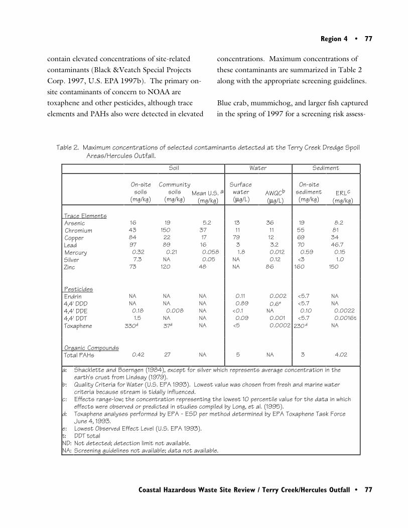
Region 4 • 77
Coastal Hazardous Waste Site Review / Terry Creek/Hercules Outfall • 77
contain elevated concentrations of site-relatedcontaminants (Black &Veatch Special ProjectsCorp. 1997, U.S. EPA 1997b). The primary on-site contaminants of concern to NOAA aretoxaphene and other pesticides, although traceelements and PAHs also were detected in elevated
concentrations. Maximum concentrations ofthese contaminants are summarized in Table 2along with the appropriate screening guidelines.
Blue crab, mummichog, and larger fish capturedin the spring of 1997 for a screening risk assess-
Table 2. Maximum concentrations of selected contaminants detected at the Terry Creek Dredge SpoilAreas/Hercules Outfall.
Soil Water Sediment
On-sitesoils
(mg/kg)
Communitysoils
(mg/kg)Mean U.S. a
(mg/kg)
Surfacewater(µg/L)
AWQCb(µg/L)
On-sitesediment(mg/kg)
ERLc(mg/kg)
Trace Elements Arsenic 16 19 5.2 13 36 19 8.2 Chromium 43 150 37 11 11 55 81 Copper 84 22 17 79 12 69 34 Lead 97 89 16 3 3.2 70 46.7 Mercury 0.32 0.21 0.058 1.8 0.012 0.59 0.15 Silver 7.3 NA 0.05 NA 0.12 <3 1.0 Zinc 73 120 48 NA 86 160 150
Pesticides Endrin NA NA NA 0.11 0.002 <5.7 NA 4,4' DDD NA NA NA 0.89 0.6e <5.7 NA 4,4' DDE 0.18 0.008 NA <0.1 NA 0.10 0.0022 4,4' DDT 1.5 NA NA 0.09 0.001 <5.7 0.0016t Toxaphene 330d 37d NA <5 0.0002 230d NA
Organic Compounds Total PAHs 0.42 27 NA 5 NA 3 4.02 a:
b:
c:
d:
e:t:ND:NA:
Shacklette and Boerngen (1984), except for silver which represents average concentration in theearth's crust from Lindsay (1979).Quality Criteria for Water (U.S. EPA 1993). Lowest value was chosen from fresh and marine water criteria because stream is tidally influenced.Effects range-low; the concentration representing the lowest 10 percentile value for the data in which effects were observed or predicted in studies compiled by Long, et al. (1995).Toxaphene analyses performed by EPA - ESD per method determined by EPA Toxaphene Task Force June 4, 1993.Lowest Observed Effect Level (U.S. EPA 1993).DDT totalNot detected; detection limit not available.Screening guidelines not available; data not available.

78 • Region 4
78 • Coastal Hazardous Waste Site Review / Terry Creek/Hercules Outfall
ERL guidelines in sediment samples taken fromTerry Creek and the Hercules outfall area.Sediment samples from wetlands to the east ofArea 1 contained arsenic, copper, lead, andmercury concentrations at least twice the ERLguideline (Long et al. 1995).
Toxaphene and 4,4’-DDE were detected in bothon-site and community soils, with the highestconcentrations in on-site soils. Screening guide-lines are not available for these pesticides in soil.Toxaphene was not detected in groundwater orsurface water samples. Detection limits fortoxaphene in surface water were not stated in the1995-96 investigation, but a 1987 study reporteda detection limit of 0.3 µg/L, far exceeding theAWQC chronic guidelines of 0.0002 µg/L(Costello 1987). On-site sediments containedconcentrations of 4, 4’-DDE over 45 times theERL. Toxaphene was measured at 29 mg/kg inon-site sediments and 31 mg/kg in wetlandsediments from the upper reaches of DupreeCreek. A screening guideline for toxaphene insediment was not available. In a 1995 study,toxaphene was measured at concentrations of 19and 27 mg/kg in tissues from two fish samplescollected in Terry Creek (Parsons and Auwarter1997). Concentrations above 0.4 to 0.6 mg/kgwet weight may be hazardous to fish (Eisler andJacknow 1985).
Concentrations of PAHs, including acenaph-thene, fluorene, phenanthrene, anthracene,fluoranthene, pyrene, benzo(a)anthracene,chrysene, benzo(b and/or k) fluoranthene,benzo(a)pyrene, indeno(1,2,3-c,d)pyrene, and
ment also show evidence of contamination.Maximum toxaphene concentrations (27 ppm)were found in forage fish collected near theHercules outfall. In larger fish, contaminants thatappear to be toxaphene were found in all samples,with fish from Dupree Creek most affected atconcentrations of 3.9 ppm (U.S. EPA 1997b).
All “on-site” soil samples were collected fromwithin the boundaries of Areas 1, 2, and 3 (Figure2). Additional soil samples were collected fromnearby areas (some residential) and labeled as“community” soils. These samples were mainlycollected to the west and northwest of Area 1 onthe opposite side of Dupree Creek and northwestof Area 2. Groundwater samples were collectedfrom three wells in Area 3. Surface water andsediment samples were retrieved from the BackRiver, Terry Creek, and Dupree Creek, andwetland sediment samples were collected near thebanks of these waterways (Black & Veatch 1997).
The trace elements arsenic, lead, mercury, andzinc in on-site soils, and in soils from the commu-nity surrounding the site, were found to exceedaverage U.S. soil concentrations. Copper andsilver were also detected at elevated concentra-tions in on-site soils, while chromium exceededthe mean U.S. soil concentration in communitysoil samples. However, mercury was the onlyinorganic substance detected in groundwatersamples at concentrations exceeding the AWQCby a factor greater than 10. In surface water,copper exceeded its AWQC in Terry Creek, as didmercury in Dupree Creek. Arsenic, copper, lead,mercury, and zinc concentrations all exceeded
Region 4 • 79
Coastal Hazardous Waste Site Review / Terry Creek/Hercules Outfall • 79
benzo(g,h,i)perylene, were detected in both on-site and community soils, but screening guide-lines for PAHs in soils have not been developed.No organic compounds were detected in ground-water samples. PAHs were detected in surfacewater, but an AWQC guideline for total PAHshas not been developed. Total PAHs were alsomeasured in sediment samples, but did notexceed the ERL.
Summary
Bionetics Corporation. 1991. Site analysis, TerryCreek Dredge Spoil Area, Brunswick GA. LasVegas: U.S. Environmental Protection Agency,Environmental Monitoring Systems Laboratory,Office of Research and Development. 16 pp.
Costello, J. O. 1987. Screening site inspectionreport, Terry Creek Dredge Spoil Area. Atlanta:Georgia Environmental Protection Division.
DOI. 1995. Preliminary natural resource survey,Terry Creek Dredge Spoil Site, Glynn County,Brunswick, GA. Washington, D.C.: U.S. De-partment of the Interior, Office of EnvironmentalPolicy and Compliance.
Eisler, R. and J. Jacknow. 1985. Toxaphenehazards to fish, wildlife, and invertebrates: asynoptic review. U.S. Fish and Wildlife ServiceBiological Report 85(1.4). 26 pp.
Lindsay, W. L. 1979. Chemical Equilibria inSoils. New York: John Wiley & Sons. 449 pp.
Long, E. R., D. D. MacDonald, S. L. Smith, andF. D. Calder. 1995. Incidence of adverse bio-logical effects within ranges of chemical concen-trations in marine and estuarine sediments.Environmental Management 19: 81-97.
Nelson, D.M., E.A. Irlandi, L.R. Settle, M.E.Monaco, and L.C. Coston-Clements. 1991.Distribution and abundance of fishes and inverte-brates in southeast estuaries. ELMR Rept. No. 19.Rockville, Maryland: NOAA/NOA StrategicEnvironmental Assessments Division. 177 pp.
Terry Creek, Dupree Creek, the lower BackRiver, and St. Simons Sound provide importantnursery and adult forage habitat for numeroustrust species in the area of the Terry CreekDredge Spoil Areas/Hercules Outfall site. Soils,surface water, sediments, and fish are contami-nated to varying degrees with trace elements,pesticides, and PAHs. Surface water and sedi-ments contain contaminants at concentrationsthat pose a threat to NOAA trust resources.
References
Black & Veatch Special Projects Corp. 1997.Final expanded site inspection, Hercules TerryCreek Dredge Spoil Area, Brunswick, GlynnCounty, GA. Atlanta: U.S. EnvironmentalProtection Agency, Waste Management Division,Region 4. 68 pp.
80 • Region 4
80 • Coastal Hazardous Waste Site Review / Terry Creek/Hercules Outfall
NOAA. 1995. Preliminary natural resourcesurvey, LCP Chemicals, Inc. Findings of Fact.Seattle: Coastal Resources Coordination Branch,Hazardous Materials Response and AssessmentDivision.
Parsons, M. and A. Auwarter. 1997. Character-ization and spatial distribution of contaminantsin surface water, sediments and fish within thetidal reaches surrounding Brunswick, Georgia.Athens, Georgia: U.S. Environmental ProtectionAgency, Region IV, Science and EcosystemSupport Division.
Shacklette, H. T., and J. G. Boerngen. 1984.Element concentrations in soils and other surficialmaterials of the conterminous United States. U.S.Geological Survey Professional Paper 1270.Washington, D.C.: U.S. Government PrintingOffice.
Taylor, W. R. 1995. Terry Creek Dredge Spoilsite Preliminary Natural Resource Survey. At-lanta: U.S. Environmental Protection Agency,Chief of State Program Section.
U.S. Environmental Protection Agency (EPA).1993. Water quality criteria. Washington, D.C.:U.S. Environmental Protection Agency, Office ofWater, Health and Ecological Criteria Division.294 pp.
U.S. Environmental Protection Agency (EPA).1997a. Terry Creek Dredge Spoil Areas/Her-cules Outfall, Brunswick, GA. Washington, D.C.:U.S. Environmental Protection Agency, State,Tribal, and Site Identification Center, NationalPriorities List. 1 p.
U.S. Environmental Protection Agency (EPA).1997b. Terry Creek ecological screening evalua-tion, Brunswick GA. Athens, GA: U.S. Environ-mental Protection Agency, Science and Ecosys-tem Support Division, Ecological AssessmentBranch. 14 pp. + appendices.
USGS. 1993. Brunswick East, Georgia. 7.5minute series quadrangle. Reston, Virginia: U.S.Government Printing Office.
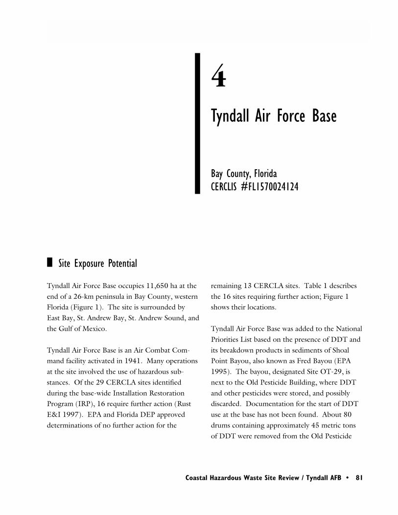
Region 4 • 81
Coastal Hazardous Waste Site Review / Tyndall AFB • 81
4Tyndall Air Force Base
Site Exposure Potential
Bay County, FloridaCERCLIS #FL1570024124
remaining 13 CERCLA sites. Table 1 describesthe 16 sites requiring further action; Figure 1shows their locations.
Tyndall Air Force Base was added to the NationalPriorities List based on the presence of DDT andits breakdown products in sediments of ShoalPoint Bayou, also known as Fred Bayou (EPA1995). The bayou, designated Site OT-29, isnext to the Old Pesticide Building, where DDTand other pesticides were stored, and possiblydiscarded. Documentation for the start of DDTuse at the base has not been found. About 80drums containing approximately 45 metric tonsof DDT were removed from the Old Pesticide
Tyndall Air Force Base occupies 11,650 ha at theend of a 26-km peninsula in Bay County, westernFlorida (Figure 1). The site is surrounded byEast Bay, St. Andrew Bay, St. Andrew Sound, andthe Gulf of Mexico.
Tyndall Air Force Base is an Air Combat Com-mand facility activated in 1941. Many operationsat the site involved the use of hazardous sub-stances. Of the 29 CERCLA sites identifiedduring the base-wide Installation RestorationProgram (IRP), 16 require further action (RustE&I 1997). EPA and Florida DEP approveddeterminations of no further action for the
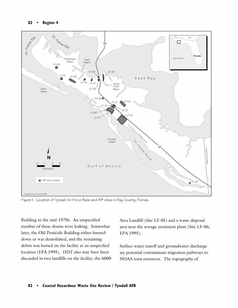
82 • Region 4
82 • Coastal Hazardous Waste Site Review / Tyndall AFB
Figure 1. Location of Tyndall Air Force Base and IRP sites in Bay County, Florida.
0 1 2 3
kilometers
N
Prepared from Rust E&I 1997
Tyndall AFB boundary
E a s t B a y
G u l f o f M e x i c o
IRP site location
S t . An d r e w
S o u n d
Crooked Island
Shell Island
98
98
LF-09
LF-10 LF-03
LF-02
LF-05
SS-26FT-17
OT-27
OT-21
OT-24
LF-12
LF-07
LF-06
OT-04
LF-01
OT-25 OT-29
Shoal PointBayou
PearlBayou
FreshwaterBayou
Florida
AL GA
Gulf of Mexico
St.
Andr
ewBay
St. Andrew Bay
Building in the mid-1970s. An unspecifiednumber of these drums were leaking. Somewhatlater, the Old Pesticide Building either burneddown or was demolished, and the remainingdebris was buried on the facility at an unspecfiedlocation (EPA 1995). DDT also may have beendiscarded in two landfills on the facility; the 6000
Area Landfill (Site LF-05) and a waste disposalarea near the sewage treatment plant (Site LF-06;EPA 1995).
Surface water runoff and groundwater dischargeare potential contaminant migration pathways toNOAA trust resources. The topography of
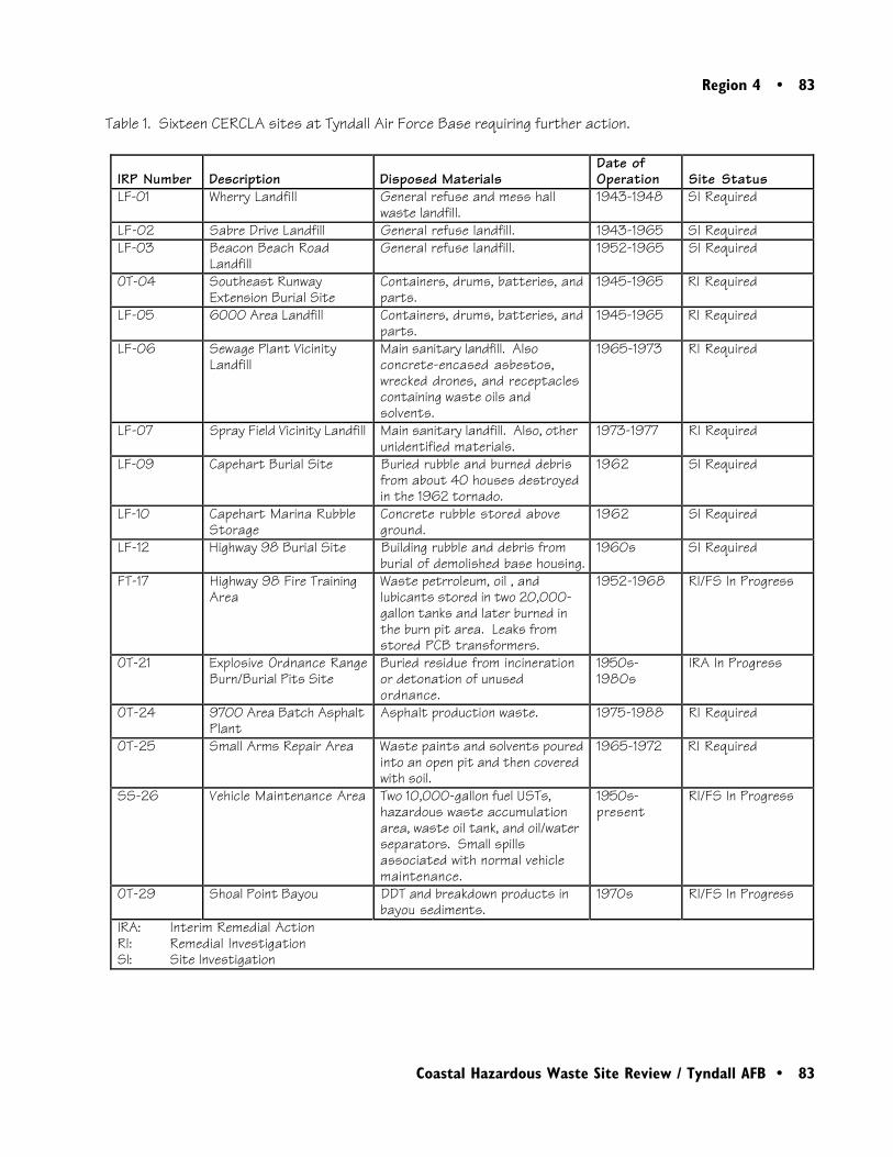
Region 4 • 83
Coastal Hazardous Waste Site Review / Tyndall AFB • 83
IRP Number Description Disposed Materials Date ofOperation Site Status
LF-01 Wherry Landfill General refuse and mess hallwaste landfill.
1943-1948 SI Required
LF-02 Sabre Drive Landfill General refuse landfill. 1943-1965 SI RequiredLF-03 Beacon Beach Road
LandfillGeneral refuse landfill. 1952-1965 SI Required
OT-04 Southeast RunwayExtension Burial Site
Containers, drums, batteries, andparts.
1945-1965 RI Required
LF-05 6000 Area Landfill Containers, drums, batteries, andparts.
1945-1965 RI Required
LF-06 Sewage Plant VicinityLandfill
Main sanitary landfill. Alsoconcrete-encased asbestos,wrecked drones, and receptaclescontaining waste oils andsolvents.
1965-1973 RI Required
LF-07 Spray Field Vicinity Landfill Main sanitary landfill. Also, otherunidentified materials.
1973-1977 RI Required
LF-09 Capehart Burial Site Buried rubble and burned debrisfrom about 40 houses destroyedin the 1962 tornado.
1962 SI Required
LF-10 Capehart Marina RubbleStorage
Concrete rubble stored aboveground.
1962 SI Required
LF-12 Highway 98 Burial Site Building rubble and debris fromburial of demolished base housing.
1960s SI Required
FT-17 Highway 98 Fire TrainingArea
Waste petrroleum, oil , andlubicants stored in two 20,000-gallon tanks and later burned inthe burn pit area. Leaks fromstored PCB transformers.
1952-1968 RI/FS In Progress
OT-21 Explosive Ordnance RangeBurn/Burial Pits Site
Buried residue from incinerationor detonation of unusedordnance.
1950s-1980s
IRA In Progress
OT-24 9700 Area Batch AsphaltPlant
Asphalt production waste. 1975-1988 RI Required
OT-25 Small Arms Repair Area Waste paints and solvents pouredinto an open pit and then coveredwith soil.
1965-1972 RI Required
SS-26 Vehicle Maintenance Area Two 10,000-gallon fuel USTs,hazardous waste accumulationarea, waste oil tank, and oil/waterseparators. Small spillsassociated with normal vehiclemaintenance.
1950s-present
RI/FS In Progress
OT-29 Shoal Point Bayou DDT and breakdown products inbayou sediments.
1970s RI/FS In Progress
IRA: Interim Remedial ActionRI: Remedial InvestigationSI: Site Investigation
Table 1. Sixteen CERCLA sites at Tyndall Air Force Base requiring further action.
84 • Region 4
84 • Coastal Hazardous Waste Site Review / Tyndall AFB
Tyndall Air Force Base is relatively flat with amaximum elevation of approximately 9 m. Nodetailed information on surface water flow fromeach of the sites was available. In general, runofffrom areas on the north side of U.S. Highway 98flows into East Bay and St. Andrew Bay, andrunoff from the south and west sides of U.S.Highway 98 flows into St. Andrew Sound, St.Andrew Bay, and the Gulf of Mexico (CH2MHill 1981).
The surficial aquifer near the base is composed ofhighly transmissive, well-sorted, fine- to medium-grained sands, extending to 34 m deep, whereclayey-sand strata are encountered (Rust E&I1997). No information was available regardingthe continuity of this unit. Groundwater depthstypically range from 0.3 to 0.9 m bgs. The watertable is relatively flat throughout Tyndall AirForce Base, but fluctuates up to 1.5 m in re-sponse to seasonal rainfall and tidal cycles. Agroundwater divide beneath Highway 98 sepa-rates areal flows to the northeast and southwest,but shallow groundwater flows toward nearbybayous, streams, and ditches. The surficialaquifer is the principal concern with regard tocontaminant transport because it is both highlypermeable and shallow (Rust E&I 1997).
NOAA Trust Resources and Habitats
Andrew Bay, and St. Andrew Sound are next tothe base. Of particular concern are several tidalbayous and associated wetlands that receivedrainage from the base. The Gulf of Mexico liesbeyond St. Andrew Bay and St. Andrew Sound.The many estuarine fish and invertebrates thatuse the embayments and nearshore Gulf are theresources of concern to NOAA. Table 2 liststhose species most abundant in the area.
East Bay and St. Andrew Bay are protected,shallow embayments generally less than 15 mdeep with moderate salinities of 20 to 30 ppt.Shoal Point Bayou, Pearl Bayou, and FreshwaterBayou, which drain from Tyndall Air Force Baseinto East Bay, range from less than 1 m deep to4 m deep, with highly variable salinities depend-ing upon precipitation and runoff. St. AndrewSound is predominantly shallow, with a maxi-mum depth of 10 m, and more marine salinitiesof 32-35 ppt (USGS 1982a; USGS 1982b;Schafer 1997).
Sediments in the estuary range from fine sands tosilts. Quartz sand sediments predominate nextto the beach and dune areas of St. AndrewSound and lower St. Andrew Bay. Sandy silts tosilts predominate in East Bay, particularly inShoal Point Bayou (Rust E&I 1993; Schafer1997). There are large salt-marsh wetlands,dominated by Spartina spp., along the East Bayshore of the base (CH2M Hill 1981).
Over 120 species of finfish and invertebrates havebeen reported in the St. Andrew Bay estuary nearthe base (Geraghty & Miller, 1991). Table 2
The primary habitats of concern to NOAA aresurface water and bottom substrates of the St.Andrew Bay estuary, of which East Bay, St.
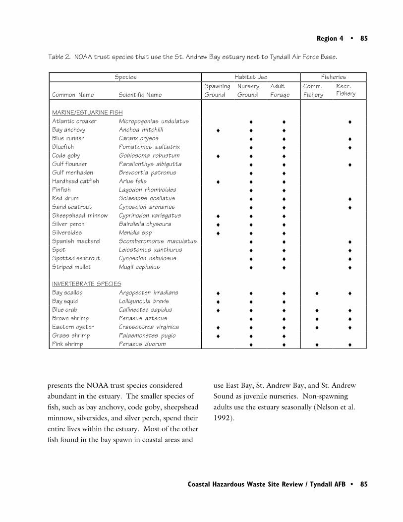
Region 4 • 85
Coastal Hazardous Waste Site Review / Tyndall AFB • 85
Table 2. NOAA trust species that use the St. Andrew Bay estuary next to Tyndall Air Force Base.
presents the NOAA trust species consideredabundant in the estuary. The smaller species offish, such as bay anchovy, code goby, sheepsheadminnow, silversides, and silver perch, spend theirentire lives within the estuary. Most of the otherfish found in the bay spawn in coastal areas and
use East Bay, St. Andrew Bay, and St. AndrewSound as juvenile nurseries. Non-spawningadults use the estuary seasonally (Nelson et al.1992).
Species Habitat Use Fisheries
Common Name Scientific NameSpawningGround
NurseryGround
AdultForage
Comm.Fishery
Recr.Fishery
MARINE/ESTUARINE FISHAtlantic croaker Micropogonias undulatus ♦ ♦ ♦Bay anchovy Anchoa mitchilli ♦ ♦ ♦Blue runner Caranx crysos ♦ ♦ ♦Bluefish Pomatomus saltatrix ♦ ♦ ♦Code goby Gobiosoma robustum ♦ ♦ ♦Gulf flounder Paralichthys albigutta ♦ ♦ ♦Gulf menhaden Brevoortia patronus ♦ ♦Hardhead catfish Arius felis ♦ ♦ ♦Pinfish Lagodon rhomboides ♦ ♦Red drum Sciaenops ocellatus ♦ ♦ ♦Sand seatrout Cynoscion arenarius ♦ ♦ ♦Sheepshead minnow Cyprinodon variegatus ♦ ♦ ♦Silver perch Bairdiella chysoura ♦ ♦ ♦Silversides Menidia spp ♦ ♦ ♦Spanish mackerel Scomberomorus maculatus ♦ ♦ ♦Spot Leiostomus xanthurus ♦ ♦ ♦Spotted seatrout Cynoscion nebulosus ♦ ♦ ♦Striped mullet Mugil cephalus ♦ ♦ ♦
INVERTEBRATE SPECIESBay scallop Argopecten irradians ♦ ♦ ♦ ♦ ♦Bay squid Lolliguncula brevis ♦ ♦ ♦Blue crab Callinectes sapidus ♦ ♦ ♦ ♦ ♦Brown shrimp Penaeus aztecus ♦ ♦ ♦ ♦Eastern oyster Crassostrea virginica ♦ ♦ ♦ ♦ ♦Grass shrimp Palaemonetes pugio ♦ ♦ ♦Pink shrimp Penaeus duorum ♦ ♦ ♦ ♦
86 • Region 4
86 • Coastal Hazardous Waste Site Review / Tyndall AFB
Both adult and juvenile blue crab are highlyabundant in the St. Andrew Bay estuary. Crabmate in low-salinity areas, such as the bayous ofEast Bay. After mating, the males remain in low-salinity waters, while the females migrate toundiluted seawater zones to brood eggs. Larvaeare released in areas of undiluted marine salinities.The planktonic larvae are subsequently trans-ported back into the estuary, where they settle tothe bottom and metamorphose.
Grass shrimp, an abundant nearshore species,spend their entire life within the estuary, in saltmarshes and oyster reef habitats. Brown and pinkshrimp are also abundant, particularly the juvenilestages. Adults use the estuary seasonally. Al-though not as abundant, eastern oyster and bayscallop also use the estuary (Nelson et al. 1992).
There are two federally threatened or endangeredsea turtles near the base. The federally threatenedAtlantic loggerhead sea turtle (Caretta caretta)and the endangered green sea turtle (Cheloniamydas) use the coastal waters of St. Andrews Bayand St. Andrew Sound seasonally (CH2M Hill1981).
There are both commercial and recreationalfisheries for finfish, blue crab, oyster, and scallopin East Bay, St. Andrew Bay, and St. AndrewSound (Schafer 1997). In 1993, Tyndall AirForce Base posted a catch-and-release advisory forShoal Point Bayou (EPA 1995). East Bay, alongthe northeast boundary of Tyndall Air Force Base,is classified by the State of Florida as Class IIwater, designated for shellfish propagation and
harvesting. The waters at the northwest end ofthe base are a designated Aquatic Preserve. Therest of the estuary around the base is designatedClass III waters for recreation and propagation offish and wildlife (Geraghty and Miller 1991).
Site-Related Contamination
Site OT-29, Shoal Point Bayou, is the only activeCERCLA site for which data were available forcomparison with NOAA screening guidelines.At Site OT-29, elevated concentrations of DDTand its breakdown products have been measuredin sediment and surface water. DDT contamina-tion in Shoal Point Bayou was first observed in1985 during area-wide sediment samplingconducted by the U.S. Fish and Wildlife Service(EPA 1995). One sediment sample compositedfrom five cores taken along the centerline ofShoal Point Bayou contained substantially higherconcentrations of DDT (4400 µg/kg) and itsbreakdown products, DDE and DDD, than didany of the other 36 sediment samples collectedthroughout the St. Andrew Bay estuarine com-plex.
In 1990, the U.S. Fish and Wildlife Servicecollected an additional 28 sediment samples fromShoal Point Bayou to follow up on the 1985sediment sampling (Brim 1990). DDT and/orits breakdown products were detected in 54% ofthe samples at a detection limit of 97 µg/kg,considerably higher than the ERL of 1.58 µg/
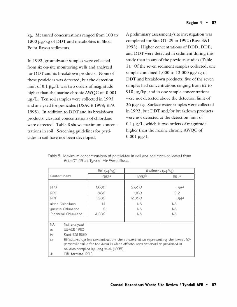
Region 4 • 87
Coastal Hazardous Waste Site Review / Tyndall AFB • 87
Soil (µg/kg) Sediment (µg/kg)Contaminant 1993a 1992b ERLc
DDD 1,600 2,600 1.58d
DDE 860 1,100 2.2DDT 1,200 12,000 1.58d
alpha Chlordane 14 NA NAgamma Chlordane 9.1 NA NATechnical Chlordane 4,200 NA NA
NA: Not analyzeda: USACE 1993b: Rust E&I 1993c: Effects-range low concentration; the concentration representing the lowest 10-
percentile value for the data in which effects were observed or predicted in studies compiled by Long et al. (1995).
d: ERL for total DDT.
kg. Measured concentrations ranged from 100 to1300 µg/kg of DDT and metabolites in ShoalPoint Bayou sediments.
In 1992, groundwater samples were collectedfrom six on-site monitoring wells and analyzedfor DDT and its breakdown products. None ofthese pesticides was detected, but the detectionlimit of 0.1 µg/L was two orders of magnitudehigher than the marine chronic AWQC of 0.001µg/L. Ten soil samples were collected in 1993and analyzed for pesticides (USACE 1993; EPA1995). In addition to DDT and its breakdownproducts, elevated concentrations of chlordanewere detected. Table 3 shows maximum concen-trations in soil. Screening guidelines for pesti-cides in soil have not been developed.
A preliminary assessment/site investigation wascompleted for Site OT-29 in 1992 (Rust E&I1993). Higher concentrations of DDD, DDE,and DDT were detected in sediment during thisstudy than in any of the previous studies (Table3). Of the seven sediment samples collected, onesample contained 1,000 to 12,000 µg/kg ofDDT and breakdown products; five of the sevensamples had concentrations ranging from 62 to910 µg/kg; and in one sample concentrationswere not detected above the detection limit of26 µg/kg. Surface water samples were collectedin 1992, but DDT and/or breakdown productswere not detected at the detection limit of0.1 µg/L, which is two orders of magnitudehigher than the marine chronic AWQC of0.001 µg/L.
Table 3. Maximum concentrations of pesticides in soil and sediment collected fromSite OT-29 at Tyndall Air Force Base.
88 • Region 4
88 • Coastal Hazardous Waste Site Review / Tyndall AFB
Summary
There are many potential hazardous waste areas atTyndall Air Force Base although data from onlyOT-29, Shoal Point Bayou, were available forscreening against NOAA guidelines. Very highconcentrations of DDT and its breakdown prod-ucts were detected in soil and sediment from theShoal Point Bayou area. Concentrations in bayousediment, four orders of magnitude higher thanscreening guidelines, threaten the many NOAAtrust species that use the estuary surroundingTyndall Air Force Base.
References
Long, E.R., D.D. MacDonald, S.L. Smith, andF.D. Calder. 1995. Incidence of adverse biologi-cal effects within ranges of chemical concentra-tions in marine and estuarine sediments. Envi-ronmental Management 19(1): 81-97.
Nelson, D.M., M.E. Monaco, C.D. Williams,T.E. Czapla, M.E. Pattillo, L. Coston-Clements,L.R. Settle, and E.A. Irlandi. 1992. Distributionand abundance of fishes and invertebrates in Gulfof Mexico estuaries. Volume I: Data summaries.Rockville, Maryland: NOAA/NOS StrategicEnvironmental Assessments Division. 273 pp.
Rust Environment & Infrastructure (Rust E&I).1993. Final Preliminary Assessment/Site Investi-gation report, Shoal Point Bayou: Site 29, TyndallAir Force Base, Florida. Omaha: U.S. ArmyCorps of Engineers. 43 pp.
Rust Environment & Infrastructure (Rust E&I).1997. Management Action Plan, Tyndall AirForce Base, Florida. Brooks Air Force Base,Texas: Air Force Center for EnvironmentalExcellence, Environmental Restoration Division.
Schafer, R., Fisheries Biologist, National MarineFisheries Service, Panama City, Florida, personalcommunication, July 22, 1997.
U.S. Army Corps of Engineers (USACE). 1993.Test results from soil samples collected at ShoalPoint Bayou on March 11, 1993 and analyzed bythe Missouri River Division Laboratory. Omaha:U.S. Army Corps of Engineers.
Brim, M. 1990. Environmental contaminantsevaluation; sediment DDT concentrations in FredBayou, St. Andrew Bay, Tyndall Air Force Base,Bay County, Florida. Panama City, Florida:U.S. Fish and Wildlife Service. 10 pp.
CH2M Hill. 1981. Installation RestorationProgram Records Search for Tyndall Air ForceBase, Florida. Tyndall Air Force Base, Florida:Air Force Engineering and Services Center,Directorate of Environmental Planning.
Geraghty and Miller, Inc. 1991. Final RemedialInvestigation report for Sites OT-4, LF-5, and OT-25, Tyndall Air Force Base, Florida. Omaha:U.S. Army Corps of Engineers.
Region 4 • 89
Coastal Hazardous Waste Site Review / Tyndall AFB • 89
U.S. Environmental Protection Agency (EPA).1993. Water quality criteria. Washington, DC:U.S. Environmental Protection Agency, Office ofWater, Health and Ecological Criteria Division.294 pp.
U.S. Environmental Protection Agency (EPA).1995. HRS Documentation Record, Tyndall AirForce Base. Atlanta: U.S. EPA, Region IV.43 pp.
U.S. Geological Survey (USGS) 1982a.7.5 minute series orthophoto map (topographic/bathymetric). Long Point, Florida.
U.S. Geological Survey (USGS) 1982b.7.5 minute series orthophoto map (topographic/bathymetric). Beacon Beach, Florida.

90 • Region 4
90 • Coastal Hazardous Waste Site Review / Tyndall AFB
Region 6 • 91
Coastal Hazardous Waste Site Review / Madisonville Creosote Works • 91
6Madisonville CreosoteWorks
Site Exposure Potential
The Madisonville Creosote Works site coversapproximately 12 ha in a predominantly wooded,rural area in St Tammany Parish about3 km west of Madisonville, Louisiana. Thefacility is 2 km north of Lake Pontchartrain, acoastal tidal water body (Figure 1). Drainagefrom the site enters an unnamed, intermittentstream that empties into the Black River andfarther downgradient into a series of large,perennial wetlands. This wetland is contiguouswith Lake Pontchartrain, a shallow estuary whichflows into Mississippi Sound approximately 90km from the site. Mississippi Sound is anembayment of the Gulf of Mexico.
Madisonville, LouisianaCERCLIS #LAD981522998
The Madisonville Creosote Works facility wasopened in 1956; wood products were treatedwith creosote at the facility until operationsceased in 1984. From the 1960s to 1984,creosote sludge and wastewater were concen-trated by sprinkler evaporation. Residual processwaste liquids were stored in two process waterditches and two evaporation ponds (Figure 2).Waste creosote and wastewater drained from theprocess water ditches into Evaporation PondNo.1. Solids settled in Pond No.1 and wateroverflowed through a depression in the dike toEvaporation Pond No. 2. The Rainwater Pondprovided backup containment of overflow fromEvaporation Pond No. 2. The Fish Pond was
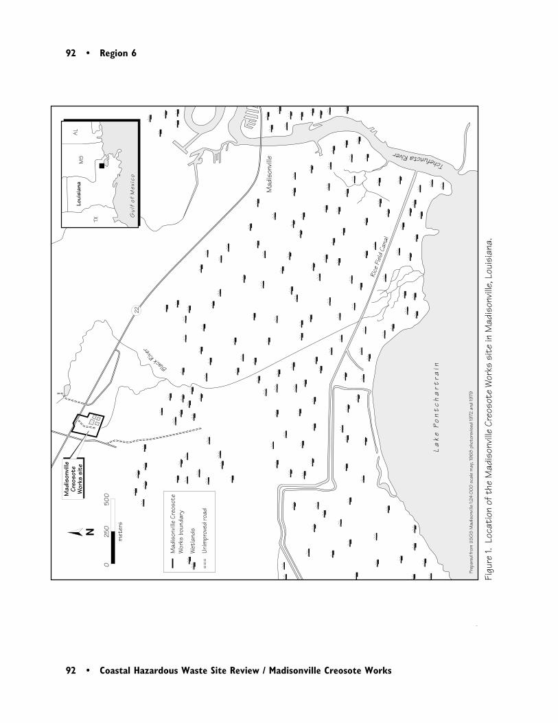
92 • Region 6
92 • Coastal Hazardous Waste Site Review / Madisonville Creosote Works
Mad
ison
ville
La
ke
Po
nt
ch
art
rain
Mad
ison
ville
Creo
sote
W
orks
sit
e
Figu
re 1.
Loc
atio
n of
the
Mad
ison
ville
Cre
osot
e W
orks
sit
e in
Mad
ison
ville
, Lou
isia
na.
Loui
sian
aM
SA
L
TX
Gul
f of
Mex
ico
Prep
ared
from
US
GS
Mad
ison
ville
1:24
00
0 s
cale
map
, 196
8 p
hoto
revis
ed 19
72 a
nd 19
79
Black
River
22
Mad
ison
ville
Cre
osot
eW
orks
bou
ndar
y
Wet
land
s
Unim
prov
ed ro
ad
TchefunctaRiver
N0
25
0
50
0
m
eter
s
Rice
Fiel
d Ca
nal
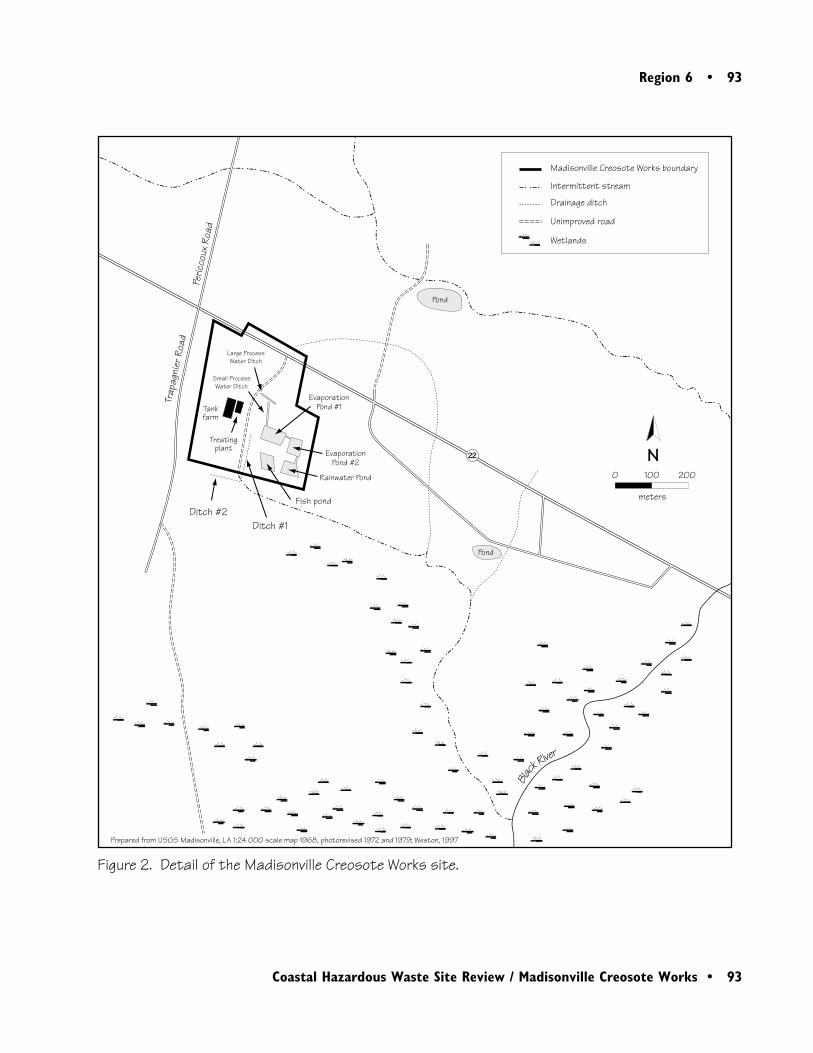
Region 6 • 93
Coastal Hazardous Waste Site Review / Madisonville Creosote Works • 93
Figure 2. Detail of the Madisonville Creosote Works site.
N
Unimproved road
Wetlands
Intermittent stream
Drainage ditch
Madisonville Creosote Works boundary
0 100 200
meters
Black
River
22
EvaporationPond #1
Large ProcessWater Ditch
Small ProcessWater Ditch
Rainwater Pond
EvaporationPond #2
Treatingplant
Tankfarm
Fish pondDitch #2
Ditch #1
Trap
agni
erRo
adPe
ricco
uxRo
ad
Prepared from USGS Madisonville, LA 1:24 000 scale map 1968, photorevised 1972 and 1979; Weston, 1997
Pond
Pond
94 • Region 6
94 • Coastal Hazardous Waste Site Review / Madisonville Creosote Works
intended for expansion of the evaporation ponds.Approximately 15 aboveground storage tanks(ASTs) that were used to store creosote andwastewater remain on-site. During a site inspec-tion in 1995, eleven of these tanks still containedliquids.
The four surface impoundments and the processditches were closed as hazardous waste manage-ment units in 1986. Closure activities includedthe removal and off-site incineration of contami-nated sludge and soil. The units were thenbackfilled with a 0.6-m clay layer and vegetated.Post-closure sampling indicated the presence ofresidual creosote contamination in soils collectedfrom these areas (Weston 1996).
Creosote contamination has been measured at thesite in soils, sediments, and groundwater. Pri-mary source contamination is in the form ofliquid creosote or creosote sludge. Chemically,creosote consists primarily of PAHs. Past releasesof PAHs from site source areas to site soil andgroundwater and off-site ditches has been visuallyobserved and confirmed by laboratory analysis.Secondary source contamination is in the form ofcontaminated soil (dried creosote particles in thesoil or soil saturated with liquid creosote), pooleddense nonaqueous phase liquids (DNAPL) insubsurface soil, and dissolved contamination ingroundwater.
Groundwater discharge, DNAPL migration, andsurface water runoff are the potential pathways ofcontaminant transport from the site to NOAA
trust resources and associated habitats. A drain-age ditch immediately west of the former evapo-ration ponds (Ditch #1) drains surface water tothe south where it joins a second drainage ditch(Ditch #2) to form an intermittent stream thatflows from the northwest to the southeastapproximately 1.2 km before its confluence withthe Black River (Figure 2). After the confluence,the Black River crosses a large, perennial wetlandbeginning approximately 1.1 km southeast of thesite and intersects the Rice Field Canal beforecontinuing to Lake Pontchartrain (Figure 1).
The Madisonville Creosote Works is located onthe Pleistocene prairie terrace in poorly drained,gently sloping, loamy soils. There are threeaquifers below the site: the Shallow Aquifer, theUpper Ponchatoula Aquifer, and the LowerPonchatoula Aquifer, all of which are thought tobe hydraulically connected. A groundwaterinvestigation at the site showed that creosotecontamination was greatest at the center of thesite. The groundwater in the upper alluvialdeposits was shown to mound and flow radiallyfrom the center of the facility (Weston 1997).
NOAA Trust Habitats and Species
The primary habitats of concern to NOAA are thedownstream surface waters, riparian wetlands, andbottom substrates of the Black River and LakePontchartrain. Numerous fish and invertebratespecies use the estuary and are the NOAA trustresources of concern (Table 1).
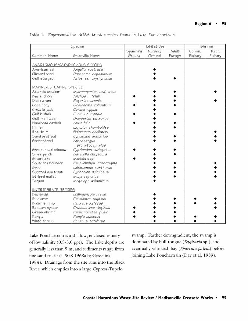
Region 6 • 95
Coastal Hazardous Waste Site Review / Madisonville Creosote Works • 95
Lake Ponchartrain is a shallow, enclosed estuaryof low salinity (0.5-5.0 ppt). The Lake depths aregenerally less than 5 m, and sediments range fromfine sand to silt (USGS 1968a,b; Gosselink1984). Drainage from the site runs into the BlackRiver, which empties into a large Cypress-Tupelo
swamp. Farther downgradient, the swamp isdominated by bull-tongue (Sagitaria sp.), andeventually saltmarsh hay (Spartina patens) beforejoining Lake Ponchartrain (Day et al. 1989).
Table 1. Representative NOAA trust species found in Lake Pontchartrain.
Species Habitat Use Fisheries
Common Name Scientific NameSpawningGround
NurseryGround
AdultForage
Comm.Fishery
Recr.Fishery
ANADROMOUS/CATADROMOUS SPECIESAmerican eel Anguilla rostrata �
Gizzard shad Dorosoma cepedianum �
Gulf sturgeon Acipenser oxyrhynchus � �
MARINE/ESTUARINE SPECIESAtlantic croaker Micropogonias undulatus � � �
Bay anchovy Anchoa mitchilli � � �
Black drum Pogonias cromis � � �
Code goby Gobiosoma robustum � � �
Crevalle jack Caranx hippos �
Gulf killifish Fundulus grandis � � �
Gulf menhaden Brevoortia patronus �
Hardhead catfish Arius felis � � �
Pinfish Lagodon rhomboides � �
Red drum Sciaenops ocellatus � �
Sand seatrout Cynoscion arenarius � � �
Sheepshead Archosargusprobatocephalus
� � �
Sheepshead minnow Cyprinodon variegatus � � �
Silver perch Bairdiella chrysoura � �
Silversides Menidia spp. � �
Southern flounder Paralichthys lethostigma � � �
Spot Leiostomus xanthurus � � �
Spotted sea trout Cynoscion nebulosus � � �
Striped mullet Mugil cephalus � � �
Tarpon Megalops atlanticus �
INVERTEBRATE SPECIESBay squid Lollinguncula brevis �
Blue crab Callinectes sapidus � � � �
Brown shrimp Penaeus aztecus � � � �
Eastern oyster Crassostrea virginica � � � �
Grass shrimp Palaemonetes pugio � � �
Rangia Rangia cuneata � � � � �
White shrimp Penaeus setiferus � � � �
96 • Region 6
96 • Coastal Hazardous Waste Site Review / Madisonville Creosote Works
The estuary is used by numerous fish for adulthabitat, juvenile nurseries, and spawning; andas a migratory corridor to several rivers withinthe watershed. Small estuarine fish such asbay anchovy, code goby, Gulf killifish, silver-sides, and sheepshead minnow spend theirentire lives within the estuary (Table 1). Largerspecies are present in the estuary primarilyduring estuarine-dependent juvenile life stages.Adults of these species are present in theestuary seasonally. Like most of the marinespecies listed in Table 1, tarpon and crevallejack spawn along the coast, but the juvenilesrequire estuarine environments for survival(Nelson et al. 1992).
Lake Pontchartrain is a migratory corridor forthe anadromous Gulf sturgeon and gizzardshad. Both species migrate up the TchefunctaRiver, located approximately 5 km east of thesite. The catadromous American eel alsomigrates to most larger streams that drain intothe estuary. Anadromous species are notexpected to use the Black River around the sitebecause of its small size (Rogilio 1997).
Blue crab are abundant in Lake Pontchartrain.Juvenile stages of brown shrimp and whiteshrimp are abundant in the estuary on a sea-sonal basis. After mating, the females return tofull seawater zones to brood eggs while themales often remain in low-salinity waters.Larvae are released by females offshore, andare subsequently transported back into theestuary where they settle to the bottom.
Grass shrimp spend their entire lives within theestuary and are commonly found in saltmarshand oyster reef habitats. Juvenile stages ofbrown shrimp and white shrimp are abundant inthe estuary on a seasonal basis. Of the bivalvespecies, rangia are most abundant, followed byeastern oyster. All life stages of these bivalvesare found within the estuary (Nelson et al.1992).
Several species are commercially harvested inLake Pontchartrain; the largest fisheries are forbrown shrimp, white shrimp, and blue crab.Substantial recreational fisheries are alsopresent in the estuary; the most commonlyharvested species include seatrout, croaker,red drum, blue crab, and rangia (Burdon 1997).
S i te -Re la ted Contaminat ion
Data collected in a series of site investigationsshow elevated concentrations of trace ele-ments and organic compounds (PAHs andpesticides) in groundwater and surface soilscollected at the site (LDEQ 1993; E&E 1996)and in surface water and sediment samplescollected from off-site areas (ESE 1991; E&E1995, E&E 1996). Creosote contamination intwo off-site areas was investigated during a1991 remedial investigation (RI; ESE 1991).Soils collected from the drainage ditch locatednorth of the facility and the intermittent streamsoutheast of the facility were reported to be
Region 6 • 97
Coastal Hazardous Waste Site Review / Madisonville Creosote Works • 97
contaminated with creosote (Figure 2). The RIidentified creosote contamination in 90 m of thedrainage ditch and in 700 m of the unnamedintermittent stream south of the site. A subse-quent remedial action resulted in the removal anddisposal of substrates from 290 m of the intermit-tent stream. The remaining contamination hasnot been removed. Maximum concentrations ofthe major contaminants at the site are listed inTable 2 along with the appropriate screeningguidelines.
Lead concentrations in both groundwater andsurface water, and mercury in surface water,exceeded chronic AWQCs (Table 2). Concen-trations of arsenic, barium, lead, and mercury insite soils exceeded mean U.S. concentrations.Lead and mercury in sediment from the drain-age ditch exceeded the ER-L values for thesetrace elements. However, concentrations oftrace elements in sediment and surface waterof the Black River near the site (Weston 1997)did not exceed screening values.
PAH concentrations measured in on-sitegroundwater, surface water, soils, and sedi-ments were high compared to the screeningconcentrations for these media (Table 2).However, the available data suggest that PAHcontamination is now limited to the site and off-site drainage ditches. The concentrations ofPAHs reported in surface water and sedimentscollected from the Black River in the vicinity ofthe site (Weston 1997) did not exceed screen-ing values for these compounds.
Some limited exceedances of screening criteriawere observed for pesticides in surface waterand sediments in the drainage ditch. Themaximum surface water concentration of endrinexceeded the AWQC and the sediment concen-trations of 4,4'-DDE in the drainage ditch ex-ceeded the ER-L concentration. However,pesticides were not detected in either the wateror sediments of the Black River.
S u m m a r y
A series of site investigations indicate that soiland groundwater collected at the MadisonvilleCreosote site, and the sediments and surfacewaters in drainage ditches near the site, arecontaminated with trace elements, PAHs, andpesticides. Surface runoff, DNAPL migration,and groundwater discharge are the potentialpathways of contaminant transport from the siteto NOAA trust resources and associated habi-tats. The primary habitats of concern to NOAAare estuarine surface waters, riparian wetlands,and bottom substrates of Black River and LakePontchartrain.

98 • Region 6
98 • Coastal Hazardous Waste Site Review / Madisonville Creosote Works
Table 2. Maximum concentrations of contaminants of concern at the Madisonville Creosote Works site.
Water Soil SedimentGround-watera (µg/L)
SurfaceWatera,b
(µg/L)AWQCc(µg/L)
Surface Soilsa
(mg/kg)
MeanU.S. d
(mg/kg)Sedimenta,b
(mg/kg)ERLe
(mg/kg)
TRACE ELEMENTS Arsenic NA 12.3 36 14.3 5 6.5 8.2 Barium 202 650 NA 774 440 376 NA Lead 30.7 54 8.5 273 16 181 46.7 Mercury NA 0.24 0.012 7.0 0.058 0.490 0.150
ORGANIC COMPOUNDS
PAHs
Naphthalene 30500 ND 620 f 85.0 NA 4990 0.16 2-Methylnaphthalene 7200 ND NA 8.5 NA 21900 0.07 Acenaphthylene 440 ND NA 180 NA 37.3 0.04 Acenaphthene 8200 5.3 520 f 1260 NA 30900 0.02 Fluorene 6470 ND NA 1450 NA 5300 0.02 Phenanthrene 14800 32.9 4.6p 2360 NA 14500 0.24 Anthracene 1710 2.00 NA 1180 NA 16300 0.09 Fluoranthene 8200 40.1 16 f 2190 NA 3010 0.60 Pyrene 5000 31.1 NA 2120 NA 3940 0.67 Chrysene 1610 13.1 NA 1570 NA 2760 0.38 Benz(a)anthracene 1680 1.00 NA 412 NA 834 0.26 Benzo(b)fluoranthene 1240 2.00 NA 350 NA 295 NA Benzo(k)fluoranthene 1400 10.1 NA 33 NA 470 NA Benz(a)pyrene 594 1.00 NA 393 NA 242 0.43 Benzo(g,h,i)perylene 220 ND NA 57 NA 24 NA Indeno(1,2,3-cd)pyrene 250 ND NA 69 NA 31 NA Dibenz(a,h)anthracene 80 ND NA 27 NA 10 0.063
Pesticides
alpha-Chlordane NA ND 0.0043 ND NA 0.038 NA 4,4'-DDE NA ND 0.014f 0.83 NA 0.058 0.0022 4,4'-DDT NA ND 0.001 0.0073 NA 0.091 0.0016t Endrin NA 0.10 0.0023 ND NA 0.0082 NA
a:b:c:
d:e:
f:ND:NA:p: t:
Maximum concentrations cited in Weston (1997).Surface water and sediment concentrations reported for off-site drainage ditches.Ambient Water Quality Criteria (U.S. EPA 1993). Lowest value was chosen from fresh- and marine-water criteria because river is estuarine. Shacklette and Boerngen (1984).Effects range-low; the concentration representing the lowest 10-percentile value for the data inwhich effects were observed or predicted in studies compiled by Long et al. (1995).Lowest Observed Effect Level (U.S. EPA 1993).Not detected; detection limit not available.Screening guidelines not available; data not available.Proposed criterion.DDT total.

Region 6 • 99
Coastal Hazardous Waste Site Review / Madisonville Creosote Works • 99
References
Burdon, J., Fisheries Biologist, LouisianaDepartment of Wildlife and Fisheries, BatonRouge, personal communication, July 28, 1997.
Day, J.W. Jr., C.A.S. Hall, W.M. Kemp, and A.Yanez-Arancibia. 1989. Estuarine Ecology.New York: Wiley Interscience Publications.
Environmental Science & Engineering, Inc.(ESE). 1991. Remedial Investigation of Off-Site Contamination Near Madisonville WoodProcessing, Inc. Baton Rouge: LouisianaDepartment of Environmental Quality, Inactiveand Abandoned Sites Division.
Ecology and Environment (E&E). 1995. Inte-grated Site Inspection for Madisonville Creo-sote Works, Madisonville, St. Tammany Parish,Louisiana. Dallas: Emergency ResponseBranch, EPA Region 6.
Ecology and Environment (E&E). 1996. Engi-neering Evaluation/Cost Analysis Work Plan forMadisonville Creosote Site, Madisonville, St.Tammany Parish, Louisiana. Dallas: EPARegion 6.
Gosselink, J.G. 1984. The ecology of deltamarshes of coastal Louisiana: A communityprofile. FWS/OBS-84/09. Vicksburg: U.S. Fishand Wildlife Service.
Louisiana Department of Environmental Quality(LDEQ). 1993. RCRA Groundwater CME,Madisonville Wood Preserving. LAD#008171191. Baton Rouge: Louisiana Depart-ment of Environmental Quality, GroundwaterProtection Division.
Long, E. R., D. D. MacDonald, S. L. Smith, andF. D. Calder. 1995. Incidence of adversebiological effects within ranges of chemicalconcentrations in marine and estuarine sedi-ments. Environmental Management 19:81-97.
Nelson, D.M., M.E. Monaco, C.D. Williams, T.E.Czapla, M.E. Pattillo, L. Coston-Clements, L.R.Settle, and E.A. Irlandi. 1992. Distribution andabundance of fishes and invertebrates in Gulf ofMexico estuaries. Volume I: Data Summaries.Rockville, Maryland: NOAA/NOS StrategicEnvironmental Assessments Division. 273 p.
Roy F. Weston, Inc. 1996. Final Report:Madisoville Creosote, Madisonville, St. TammanyParish, LA, November 1996. Edison, New Jersey:U.S. Environmental Protection Agency, Environ-mental Response Team Center.
Roy F. Weston, Inc. 1997. Draft Final BaselineHuman Health and Ecological Screening RiskAssessment, Madisonville Creosote Works,Madisonville, St. Tammany Parish, Louisiana.Dallas: U.S. Environmental Protection Agency,Region 6.
100 • Region 6
100 • Coastal Hazardous Waste Site Review / Madisonville Creosote Works
Rogilio, H., Fisheries Biologist, Louisiana De-partment of Wildlife and Fisheries, Baton Rouge,personal communication, July 28, 1997.
Shacklette, H. T. and J. G. Boerngen. 1984.Element concentrations in soils and othersurficial materials of the conterminous UnitedStates. U.S. Geological Survey ProfessionalPaper 1270. Washington, D.C.: U.S. Govern-ment Printing Office.
U.S. Environmental Protection Agency (EPA).1993. Water quality criteria. Washington,D.C.: U.S. Environmental Protection Agency,Office of Water, Health and Ecological CriteriaDivision. 294 pp.
U.S. Geological Survey (USGS). 1968a. 7.5minute series topographic map. Covington,SW, LA. Washington, D.C.: U.S. Departmentof the Interior.
U.S. Geological Survey (USGS). 1968b. 7.5minute series topographic map. Madisonville,FL. Washington, D.C.: U.S. Department of theInterior.
Region 10 • 101
Coastal Hazardous Waste Site Review / Oeser Company • 101
10Oeser Company
Site Exposure Potential
The Oeser Company (Oeser) site is a 9-ha woodtreating facility operating in Bellingham, What-com County, Washington (Figure 1). Surround-ing land use is mixed residential and industrial.The topography is generally flat with a gentleslope toward the southeast, except due south ofthe site, where the terrain drops steeply forapproximately 12 m to a ravine and LittleSqualicum Creek. Approximately 500 m down-stream, Little Squalicum Creek enters BellinghamBay.
The Oeser Company has had a wood-preservingoperation at this location since 1948. From 1948to 1973, Oeser treated utility poles with creosote
Bellingham, WashingtonCERCLIS #WAD008957243
to retard deterioration of the wood. Oeser beganusing a pentachorophenol (PCP) in oil treatmentin the 1960s, and PCP is the only preservativenow used. The wood treatment processes gener-ate process wastewater and a waste sludge mate-rial. Until 1986 waste sludge was accumulatedon-site and then transported to an approvedlandfill. The quantity of sludge generated, thefrequency of removal, and the method of on-sitestorage are not known (URS Consultants Inc.1994).
Until 1973, wastewater from both the PCP andcreosote processes was discharged to gravelpercolation beds. From 1973 until 1991, process
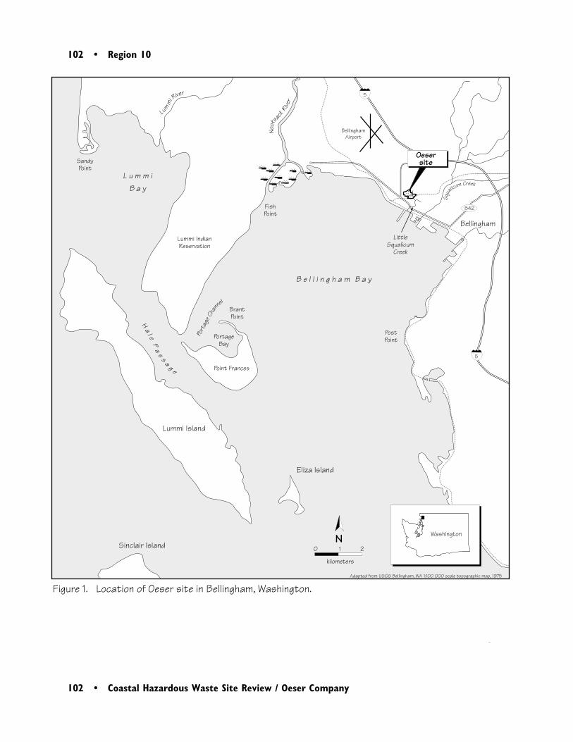
102 • Region 10
102 • Coastal Hazardous Waste Site Review / Oeser Company
Figure 1. Location of Oeser site in Bellingham, Washington.
Bellingham
BellinghamAirport
542
WashingtonN0 1 2
kilometers
Adapted from USGS Bellingham, WA 1:100 000 scale topographic map, 1975
Oesersite
Squa
licum Creek
5
5
B e l l i n g h a m B a y
L u m m iB a y
Lum
mi
River
Nook
sack
River
Eliza Island
Lummi Island
Sinclair Island
LittleSqualicum
Creek
Sandy Point
PortageBay
FishPoint
PostPoint
BrantPoint
Point Frances
Lummi IndianReservation
Ha
l eP
as
s a g e
Port
age C
hann
el

Region 10 • 103
Coastal Hazardous Waste Site Review / Oeser Company • 103
wastewater was discharged to an oil/waterseparator, and subsequently to a storm sewerunder an NPDES permit (Figure 2). Since 1991,a zero-discharge wastewater treatment system hasbeen in use (URS Consultants Inc. 1994).
Two spills of PCP preservative have been re-ported at the site, one in 1971 and another in1975. In 1971, 190 L or more of the PCP andoil preservative spilled into Little SqualicumCreek. In 1975, the sump pump for an oil/waterseparator failed, causing overflow of PCP-oil to adrain field and, ultimately, to Little SqualicumCreek. An estimated 110 L of PCP-oil enteredthe creek from this spill (Ecology and Environ-ment Inc. 1996).
The primary contaminant transport pathways arethe storm sewer system, surface water runoff, andgroundwater migration. Precipitation that doesnot infiltrate on-site flows overland to the southor southeast toward Little Squalicum Creek.Excess surface-water runoff is collected by on-sitestorm drains and subsequently discharged via theOeser Outfall into Little Squalicum Creek (Figure2; Ecology and Environment Inc. 1996).
Site geology is predominantly alluvial deposits ofglacial outwash sands and gravels (URS Consult-ants Inc. 1994). Groundwater is present inseveral shallow zones and in a deeper, unconfinedaquifer. Shallow groundwater is encountered 1.5to 5 m below ground surface (bgs). This shallowgroundwater is situated within deposits consistingof stratified sand and gravel, silt, and clay, whichextend to approximately 8 m bgs. The deeper
aquifer is encountered 7 to 12 m bgs. Ground-water in this deeper aquifer flows in a southwest-erly direction in the northern portion of the site,and south-southwest to south in the southernportion of the site (Ecology and EnvironmentInc. 1996). Groundwater seeps have beenobserved downgradient from the site near thebanks of Little Squalicum Creek.
NOAA Trust Habitats and Species
Habitats of primary concern to NOAA are thesurface waters and bottom substrates of LittleSqualicum Creek and Bellingham Bay. NOAAtrust species of concern include anadromous fishthat use Little Squalicum Creek and marinespecies found in Bellingham Bay (Table 1).
Little Squalicum Creek is located in an abun-dantly vegetated ravine surrounded by industrialand residential properties. Seasonal palustrinescrub-shrub wetlands are found along 0.8 km ofthe creek, upgradient from the site. The creekranges from approximately 0.9 to 2.5 m wide.Near the site, the creek is generally less than0.3 m deep, with a continuous flow ranging fromless than 1 cubic foot per second (cfs) to 10 cfs(Ecology and Environment Inc. 1996).
There are no wetlands on the shore of Belling-ham Bay near the mouth of Little SqualicumCreek. However, there are a variety of shorelinehabitats in other parts of the Bay, including
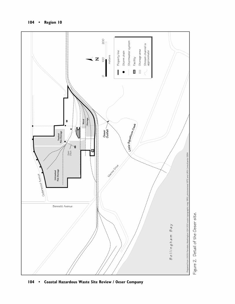
104 • Region 10
104 • Coastal Hazardous Waste Site Review / Oeser Company
Figu
re 2
. De
tail
of t
he O
eser
sit
e.
����
�
0
10
0
20
0
m
eter
s
Untr
eate
dPo
le S
tora
geTr
eate
dPo
le S
tora
ge
Woo
d St
orag
e
Ceda
rwoo
dAv
enue
Bennett Avenue
Marine
Driv
e
Oese
rO
utfa
ll
Open
Ditc
h
N
Prep
ared
from
US
GS
Fer
ndal
e, W
ashi
ngto
n 1:2
4 0
00
sca
le t
opog
raph
ic m
ap 19
52, p
hoto
revis
ed 19
72 a
nd U
RS C
onsu
ltan
ts 19
94
�
Prop
erty
line
Sto
rm d
rain
Sto
rmwa
ter s
yste
m
Faci
lity
Sto
rage
are
a
Str
eam
cha
nnel
is
appr
oxim
ate
Be
l li n
gh
am
Ba
y
Litt
leSq
ualic
umCr
eek
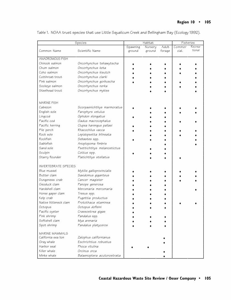
Region 10 • 105
Coastal Hazardous Waste Site Review / Oeser Company • 105
Table 1. NOAA trust species that use Little Squalicum Creek and Bellingham Bay (Ecology 1992).
Species Habitat Fisheries
Common Name Scientific NameSpawningground
Nurseryground
Adultforage
Commercial.
Recrea-tional
ANADROMOUS FISHChinook salmon Oncorhynchus tshawytscha ♦ ♦ ♦ ♦ ♦Chum salmon Oncorhynchus keta ♦ ♦ ♦ ♦ ♦Coho salmon Oncorhynchus kisutch ♦ ♦ ♦ ♦ ♦Cutthroat trout Oncorhynchus clarki ♦ ♦ ♦ ♦Pink salmon Oncorhynchus gorbuscha ♦ ♦ ♦ ♦ ♦Sockeye salmon Oncorhynchus nerka ♦ ♦ ♦ ♦Steelhead trout Oncorhynchus mykiss ♦ ♦ ♦
MARINE FISHCabezon Scorpaenichthys marmoratus ♦ ♦ ♦ ♦ ♦English sole Parophyrs vetulus ♦ ♦ ♦ ♦Lingcod Ophidon elongatus ♦ ♦ ♦Pacific cod Gadus macrocephalus ♦ ♦ ♦ ♦Pacific herring Clupea harengus pallasi ♦ ♦ ♦Pile perch Rhacochilus vacca ♦ ♦ ♦ ♦ ♦Rock sole Lepidopsetta bilineata ♦ ♦ ♦ ♦Rockfish Sebastes spp. ♦ ♦ ♦ ♦Sablefish Anoplopoma fimbris ♦ ♦Sand sole Psettichthys melanostictus ♦ ♦Sculpin Cottus spp. ♦ ♦ ♦Starry flounder Platichthys stellatus ♦ ♦ ♦
INVERTEBRATE SPECIESBlue mussel Mytilis galloprovincialis ♦ ♦ ♦ ♦ ♦Butter clam Saxidomus giganteus ♦ ♦ ♦ ♦ ♦Dungeness crab Cancer magister ♦ ♦ ♦ ♦ ♦Geoduck clam Panope generosa ♦ ♦ ♦Hardshell clam Mercenaria mercenaria ♦ ♦ ♦ ♦Horse gaper clam Tresus spp. ♦ ♦ ♦Kelp crab Pugettia productus ♦ ♦ ♦Native littleneck clam Protothaca staminea ♦ ♦ ♦ ♦ ♦Octopus Octopus dofleini ♦ ♦ ♦Pacific oyster Crassostrea gigas ♦Pink shrimp Pandalus spp. ♦ ♦ ♦Softshell clam Mya arenaria ♦ ♦ ♦Spot shrimp Pandalus platyceros ♦ ♦ ♦
MARINE MAMMALSCalifornia sea lion Zalophus californianus ♦Gray whale Eschrichtius robustus ♦Harbor seal Phoca vitulina ♦ ♦Killer whale Orcinus orca ♦Minke whale Balaenoptera acutorostrata ♦
106 • Region 10
106 • Coastal Hazardous Waste Site Review / Oeser Company
extensive wetlands surrounding the mouth of theNooksack River, less than 5 km northwest of thesite (Figure 1). The shoreline at the mouth ofthe Nooksack River consists of fine-grained sandswith exposed tidal flats in the eastern channel.From this point south-southeast to the town ofBellingham, the shoreline is primarily a wave-cutplatform, with some interspersed areas of gravel/cobble/riprap, exposed rocky shorelines, andseawalls. The mid-to-lower eastern portion of thebay consists primarily of exposed rocky shorelinesor seawalls. From the mouth of the NooksackRiver south-southwest along the Lummi IndianReservation, the shoreline is primarily gravel/cobble/riprap with sand/gravel beaches locatedalong the southeastern portion of the reservationand along the inner shoreline of Point Frances,just off the southern tip of the Lummi Reserva-tion. Tidal flats are located at the very southerntip of the reservation, as well as surroundingBrant Point at the northern tip of Point Frances(Ecology 1992).
Coho and chum salmon have been observed inLittle Squalicum Creek (Chapman 1997). Juve-nile salmonids in Little Squalicum Creek probablyuse favorable areas in the lower reaches as nurseryhabitat before migrating to more open marineenvironments (Steel 1997).
Bellingham Bay also supports numerous NOAAtrust resources, including chinook, chum, pink,coho, and sockeye salmon. Juvenile salmonidsfrom the Nooksack River may use habitats alongBellingham Bay, including areas near Little
Squalicum Creek, for nursery habitat (Steel1997).
Bellingham Bay supports a variety of marinespecies common to Puget Sound. Commondemersal residents include English and rock sole;several rockfish, sculpin, and sea perch species;and Pacific cod and lingcod. Pelagic residentsinclude Pacific herring and sablefish. Most ofthese species spawn within the bay or nearbyareas of Puget Sound and use the bay as a nurs-ery.
The complex habitats within Bellingham Bay alsosupport numerous shellfisheries (Table 1).Dungeness crab are harvested from most of thebay, as well as from areas surrounding the bay.Hardshell clams are harvested from Portage Bay,Portage Channel, offshore along the entireeastern side of Point Frances, from a small areasouth-southeast of Point Frances in Hale Passage,and along the eastern edge of Lummi Island(Chapman 1997).
There are marine mammals in Bellingham Bay(Table 1). The Washington State Coastal Sensi-tive Areas Map for Bellingham shows a harborseal haulout offshore of Brant Point on PointFrances. Two nearby areas have designatedmarine mammal sightings, east and southwest ofBrant Point, respectively. Species observed forthese two areas were not identified, but areprobably harbor seals or California sea lions.Cetaceans that migrate through the area includeminke whale and gray whale (Ecology 1992).
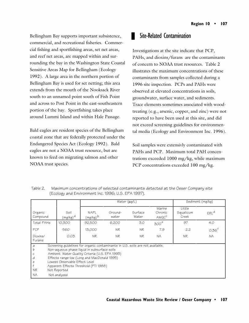
Region 10 • 107
Coastal Hazardous Waste Site Review / Oeser Company • 107
Site-Related Contamination
Investigations at the site indicate that PCP,PAHs, and dioxins/furans are the contaminantsof concern to NOAA trust resources. Table 2illustrates the maximum concentrations of thesecontaminants from samples collected during a1996 site inspection. PCPs and PAHs wereobserved at elevated concentrations in soils,groundwater, surface water, and sediments.Trace elements sometimes associated with wood-treating (e.g., arsenic, copper, and zinc) were notreported to have been used at this site, and didnot exceed screening guidelines for environmen-tal media (Ecology and Environment Inc. 1996).
Soil samples were extensivly contaminated withPAHs and PCP. Maximum total PAH concen-trations exceeded 1000 mg/kg, while maximumPCP concentrations exceeded 100 mg/kg.
Bellingham Bay supports important subsistence,commercial, and recreational fisheries. Commer-cial fishing and sportfishing areas, set net areas,and reef net areas, are mapped within and sur-rounding the bay in the Washington State CoastalSensitive Areas Map for Bellingham (Ecology1992). A large area in the northern portion ofBellingham Bay is used for set netting; this areaextends from the mouth of the Nooksack Riversouth to an unnamed point south of Fish Pointand across to Post Point in the east-southeasternportion of the bay. Sportfishing takes placearound Lummi Island and within Hale Passage.
Bald eagles are resident species of the Bellinghamcoastal zone that are federally protected under theEndangered Species Act (Ecology 1992). Baldeagles are not a NOAA trust resource, but areknown to feed on migrating salmon and otherNOAA trust species.
Table 2. Maximum concentrations of selected contaminants detected at the Oeser Company site(Ecology and Environment Inc. 1996; U.S. EPA 1997).
Water (µg/L) Sediment (mg/kg)
OrganicCompound
Soil(mg/kg)a
NAPL(mg/kg)b
Ground-water
SurfaceWater
MarineChronicAWQCc
LittleSqualicum
CreekERLd
Total PAHs 10,300 92,500 6,200 3.0 300e 97 4.0
PCP 560 13,000 NR NR 7.9 2.2 0.36f
Dioxins/Furans
0.03 NR NR NR NA NR NA
a Screening guidelines for organic contaminants in U.S. soils are not available.b Non-aqueous phase liquid in subsurface soilsc Ambient Water Quality Criteria (U.S. EPA 1993)d Effects range-low (Long and MacDonald 1995)e Lowest Observable Effect Levelf Apparent Effects Threshold (PTI 1988)NR Not Reported NA Not analyzed
108 • Region 10
108 • Coastal Hazardous Waste Site Review / Oeser Company
Preliminary data indicate widespread contamina-tion, with highest concentrations in subsurfacesoils south of the treated pole storage area.
PAHs and PCP were detected in both shallowand deep groundwater beneath the site. PAHsand PCP were observed in nine of thirteen wellsin shallow groundwater and in all five wellsscreened in the deeper aquifer. Maximumconcentrations of PAHs and PCP each exceeded10,000 µg/L in the shallow groundwater.Maximum floating NAPL thickness was 2 feet(EPA 1997)
Sediment and surface-water samples collectedfrom Little Squalicum Creek confirmed thepresence of PAHs and PCP. Six sedimentsamples were collected in Little Squalicum Creekdownstream of the site; one sample was collectedupstream. Downstream sediment stations were75 to 150 m apart, extending from the stormdrain outfall to the mouth of the creek. TotalPAHs were observed at all six downgradientsediment samples, ranging from 0.55 to97 mg/kg. PCP concentrations ranged from0.039 to 2.2 mg/kg. The highest concentrationof PCP was detected in a sediment samplecollected near the Oeser outfall. Three surface-water samples were collected downstream fromthe site at locations corresponding to the threesediment stations farthest downstream. PAHconcentrations ranged from 0.031 µg/L to3.04 µg/L total PAH. PCP concentrations insurface water were not reported. The highestPAH concentrations in surface water were at acreek station located near a groundwater seep.
Summary
High concentrations of PAHs and PCP werefound in soil and groundwater at the Oeser siteand in sediments of Little Squalicum Creek.PAHs were found in water samples from LittleSqualicum Creek, but PCP was not reported.Adult coho and chum salmon have been ob-served in Little Squalicum Creek. Juvenilesalmon likely use the area for nursery habitat.Numerous additional trust resources use nearbyareas of Bellingham Bay. Additional informationis needed regarding the extent of contaminationin Little Squalicum Creek to determine the threatposed to salmon and to better characterizecontaminant sources, and potential contaminantpathways, to other trust resources found inBellingham Bay.
References
Chapman, A., fisheries biologist, Lummi IndianReservation, Bellingham, Washington, personalcommunication, April 25, 1997.
Ecology. 1992. Washington State Sensitive AreasMapping Project: San Juan Islands Booklet.Publication No. 92-27. Olympia: WashingtonState Department of Ecology.
Region 10 • 109
Coastal Hazardous Waste Site Review / Oeser Company • 109
Ecology and Environment, Inc. 1996. SiteInspection Report for the Oeser Company.Seattle: U.S. Environmental Protection Agency,Region 10. 70pp.
Long, E.R., D.D. MacDonald, S.L. Smith, andF.D. Calder. 1995. Incidence of adverse biologi-cal effects within ranges of chemical concentra-tions in marine and estuarine sediments. Environ-mental Management 19(1): 81-97.
PTI. 1988. The briefing report to the EPAScience Advisory Board: the Apparent EffectsThreshold approach. Seattle: U.S. EnvironmentalProtection Agency, Office of Puget Sound, PugetSound Estuary Program.
Steel, E., biologist, Bellingham Technical Col-lege, Bellingham, Washington, personal commu-nication, May 2, 1997.
URS Consultants, Inc. 1994. Site InspectionPrioritization Report. Seattle: U.S. Environmen-tal Protection Agency, Region 10. 40 pp.
U.S. Environmental Protection Agency (EPA).1993. Quality criteria for water. Washington,D.C.: Office of Water, Health and EcologicalCriteria Division. 294pp.
U.S. Environmental Protection Agency (EPA).1997. Action Memorandum: Request for aRemoval Action and Exemption from the TwoMillion dollar Statutory Limit at the OeserCompany Site, Bellingham, Whatcom County,WA. Beth F. Sheldrake, OSC, to Chuck Clarke,Regional Administrator, U.S. EPA Region 10.