Embed Size (px)
Citation preview

Journal of Geospatial Engineering, Vol. 3, No. 2 (December 2001), pp. 109-126. Copyright The Hong Kong Institution of Engineering Surveyors
Coastal GIS: Functionality Versus Applications Thomas Q ZENG1*, Qiming ZHOU2, Peter COWELL1 and Haijun HUANG3
1 Coastal Studies Unit, Division of Geography, School of Geosciences, Faculty of Science, University of Sydney, Sydney 2006, Australia, e-mail: [email protected]
2Department of Geography, Hong Kong Baptist University,
Kowloon Tong Kowloon, Hong Kong, e-mail: [email protected]
3Institute of Oceanology, Chinese Academy of Sciences, Qingdao 266071, P. R China, e-mail: [email protected]
Abstract Despite the high appraisals of the potential of GIS application in the coastal/marine environment, the development of coastal GIS is still relatively slow. This is due to: i) the complexity of coastal/marine systems in the 3D environment, ii) lack of data, and iii) lack of communication between coastal experts and GIS professionals. As the result of these, the commercial GIS vendors have been hesitating to invest in developing coastal GIS. This paper addresses functionalities (both existing and potential) versus different coastal applications with an example of fisheries. A concept of levels of applications has been proposed with the identification of the three levels of applications and their corresponding requirements on GIS functions. The paper also provides potential GIS users with some examples of the GIS applications in coastal zone.
1 Introduction Sustainable development in the coastal zone is vital to our society (Cicin-Sain 1993), given that many cities around the world are concentrated in the fringe of the coastline. The economic and comfort advantages of living in the coastal environment (e.g. the sea breeze and view) result in high population density (Zeng et al. 1998). The coastal zone contains 50 – 70% of the world population, and it is estimated that 78% of gross national product (GNP) worldwide is derived from activities that are directly or indirectly connected with coastal zones (IPCC, 1997). Human well-being is largely dependent upon the availability of environmental goods and services provided by marine and coastal systems.
GIS has proven to be indispensable for Coastal Zone Management (CZM) (Damoiseaux 1995). The role of GIS in CZM has been highly appraised by, e.g. Ellis (1972), Ader (1982), Fairfield (1987), Davis and Davis (1988), Townend (1990), Welch et al., (1992), Riddel (1992), Ricketts (1992), Jones (1995), Mumby et al., 1995; Bartlett (1990, 1994), Deakin and Miment (1994) and Nath, et al., (2000). The reasons for using GIS in CZM have been well documented by Wright and Barllett (2000).
In recent years, the demands on applying GIS to CZM have been increasing. However, among the boarder spectrum of GIS applications in coastal zone, few have discussed coastal GIS in generic terms. There is growing realisation that the use of GIS should go beyond simple data display, reporting and management, so that it is necessary to gain a better understanding on more advanced forms of analysis and modelling (Raper and Maguire 1992, Walford 1999). This paper, therefore, attempts to categorise the current GIS applications in CZM followed by an example of fisheries industry. Then, it discusses some GIS functions in a generic sense and outlines GIS functionalities versus applications at different levels. Further needs in developing Coastal GIS are also discussed.
* Thomas Q. Zeng is currently with New South Wales Fisheries, PO Box 21 Cronulla NSW 2230, Australia. Phone: 61 2 9527 8411 Fax: 61 2 9527 8529, e-mail: [email protected]

Zeng, T.Q, Zhou, Q., Cowell, P. and Huang, H.
110
2 Brief Review of Current Applications The development of Coastal GIS began in the early 1970’s (Ellis 1972), and its progress has been accelerated in the last decade. Many researchers have theoretically investigated different aspects of Coastal GIS, including data structure (Li, 1999; Lucas, 1999; Sherin, 1999), data model, data standardisation and analysis methods (Ricketts, 1992). There are numerous interest groups in coastal zone (Figure 1), each of which has its own focus on particular aspects of coastal environment. Examples of these include shipping and harbour facilities, sand and mineral mining, military manoeuvres, recreation, fisheries and conservation.
Figure 1. Overlapping biophysical, economic, institutional and organisational boundaries
in coastal area

Coastal GIS: Functionality versus Applications
111
2.1 Categories of Coastal Applications
Current GIS applications in the coastal zone are diversified and case-based studies, mainly focusing on vector-based applications. These applications can be categorised as (a) coastal mapping, (b) environmental monitoring, (c) coastal process modelling, (d) navigation and port facilities management, (e) coastal environmental/hazard assessment, (f) coastal management/strategic planning, and (g) coastal ecological modelling.
Coastal mapping
This type of applications is mainly focused on thematic mapping in the coastal zone, such as mapping chlorophyll concentration using TM data (Chen et al. 1996), coastal wetland mapping using historical data (Schauser, et al., 1992; Van Der Veen et al. 1997), sea grass/mangrove mapping (Williams and Watford 1997, Watford and Williams 1998), and marine seabed mapping (Jeffries-Harris and Selwood, 1991; Lauro et al. 1999). One example of such application is the mapping of critical events related to phytoplankton blooms in Western Europe and North America (WGHABD, 2001).
These applications commonly utilise remotely sensed data, such as satellite images, airphotos and sonar survey, combined with ground truth and other existing vector data layers. The GIS functions used in this type of application are typically the clustering (or classification), image processing, raster-vector conversion and overlay functions.
Environmental monitoring
Environmental monitoring is one of the routine tasks in CZM, which include monitoring water quality and habitat/biodiversity, and beach watch. Examples include: i) monitoring sea turtle movement (Maktav et al. 2000), ii) tracking lobster along the East Coast of Australia (Steve and Craig, personal communication), iii) monitoring oil spill (Gaarrett and Jeffress, 1993, , iv) real-time bay/beach watch (Hecht 1991; Patterson and Dawson, 1991b), and v) analysing animal movements in the marine environment (Hooge et al. 2000).
Environmental monitoring also involves tagging samples, presenting the result of sampling over geographical space, and/or monitoring pattern changes in time. Linking spatial data and non-spatial data is the key function for this exercise.
Coastal processes modelling
Modelling of physical environment change in the coastal zone includes the simulation of effects of sea-level rise (Ruth and Pieper 1994, Grossman and Eberhardt 1992, Zeng and Cowell 1998, 1999, Hennecke 2000), the assessment of human intervention of shoreline change (Huang et al. 1999), the use of historical data to predict future coastline change (Sims et al. 1995) and the study of beach morphodynamics (Humphries and Ligdas, 1997). Currently, most models adopt a ‘loose-couple approach’, as described by (Sui 1998), which adds customer-built programs to a commercial GIS package and uses GIS for data management and display. The integrated GIS modelling is expected to grow rapidly in the coming years.
Navigation and port facilities management
This type of applications has evolved from traditional use of nautical maps to channel monitoring on a routine basis, maintenance and route planning. For example, New South Wales Waterway used GIS for waterway resource management. They also used GIS, along with the Global Positioning System (GPS), for planning and monitoring the water sports events at real time in the 2000 Olympics Games (ESRI, 2000). The GIS functions required include integrated GPS tracking system with network analysis and relevant query functions.
Coastal environment/hazard assessment
There are two subcategories of the applications of this kind, namely, short-term and long-term tasks. The former is exemplified with monitoring and predicting oil spilt (Belore, 1990), while the

Zeng, T.Q, Zhou, Q., Cowell, P. and Huang, H.
112
latter is demonstrated by coastal hazard/vulnerability assessment due to climate change (Lee et al. 1992, Sims, et al., 1995; Deniels et al. 1996, Hickey et al. 1997, Zeng and Cowell 1999, Hennecke et al. 2000, Esnard et al. 2001), assessing the impact of thermal water outlet from a power plant (Chen et al. 2001) as well as the evaluation of potential risk area by septic tanks (Swart 1995) and coastal wetland assessment (Downs et al. 1993).
This type of application is characterised by model integration, linking other coastal model or multi-models with GIS for simulating/predicting different scenarios.
Coastal management/strategic planning
Similar to coastal environment/hazard assessment, this application also involves assessing sustainability of the environment, and social and economic viability. Some of the examples are:
a) Fisheries management: including planning, site selection for aquaculture (NSW Fisheries 1999, Nath et al. 2000), conservation, recreational fishing and fish closure that shows the restricted fishing area gazetted and regulated by the Government,
b) Marine park planning that uses multicriteria analysis to investigate the interaction between different factors and constrains, and provides solutions to conflict situations, and
c) Aquaculture Industrial Development Plan (see below).
Coastal ecological modeling
This is one of the most challenging application types. Examples are the identification of bio-regions using neural network analysis (Ortiz 1994), prediction of the stream habitats and fish diversity (Meixler and Bain 2000), and tracking spatial/temporal habitat changes by applying the multi-dimensional spatial analysis (Parham and Fitzsimons 2000). This type of applications is focused on integrating ecological models with GIS for the research of ecological system behaviour.
In summary, to extend Jones’s work (1995), all the categories of GIS applications in coastal zone can be categorised into three levels listed below (Table 1).
a) Level 1: as data management and mapping tools, b) Level 2: as basic data analysis (query) and mapping tools, and c) Level 3: as decision-supporting tools (modelling / simulation).
Table 1. Categories of GIS applications in coastal zone.
Category A B C D E F G
Level 1 Yes Yes Yes Yes Yes Yes Yes
Level 2 No No Yes Yes Yes Yes Yes
Level 3 No No Yes No Yes Yes Yes
Most current implementations of Coastal GIS are still at Level 1 and Level 2. It is expected that Level 3 implementations will rapidly increase in the near future as the continuing improvement in GIS functions and more user-friendly interface become available in the market.
2.2 A Case Studies of Fisheries GIS
To demonstrate these three levels of application, an example of GIS application in Fisheries is outlined here. For more detailed information about the application project please see Zeng et al. (1999).
The objective of the fisheries is to ensure the appropriate use of fisheries resources and conservation of coastal environment. The role of the Fisheries GIS is to provide management and decision-support tools for coastal environment and resource management. To achieve the cooperative goal, all components of fisheries, including routine operation, fishery management and aquaculture planning, conservation and research, have to collaborate, share datasets and contribute value-added datasets for further development (Figure 2). Based on the business case, the level of

Coastal GIS: Functionality versus Applications
113
each component has been defined and the appropriate GIS functions were selected as shown in Table 2. The Fisheries GIS structure and its usage are illustrated in Figure 3.
Table 2. GIS Functions versus level of applications for Fisheries
Level Fishery Management Operation
Aquaculture Planning
Fishery / Habitat Conservation
Fishery Research
1 RDBMS Display/ Mapping
RDBMS Display/ Mapping
RDBMS Display/ Mapping
RDBMS Display/ Mapping
2 Query Overlay Regional analysis
Query Overlay Regional analysis
Query Overlay Regional analysis
Query Overlay Regional analysis
3 Random sampling Multi-variable analysis Fuzzy set analysis Rule-based model (RBM)
Multi-variable analysis Fuzzy set analysis Rule-based model
Multi-variable analysis Fuzzy set analysis Rule-based model Random simulation
Synergy
Conservation
Aquaculture
Research
CommercialCatch
RecreationalFishing
GIS
A Common Data Architecture
Conservation
ResearchCommercialCatch
RecreationalFishing
Aquaculture
Fisheries Services
FisheriesServices
Fragmented
1+1+1+1+1+1 >> 6
Figure 2. Integrated approach of Fisheries GIS
This system supports different divisions for various operation purposes, which are listed below.
Conservation a) Seagrass and mangrove mapping (Figure 4) using image processing techniques in raster-
based GIS. b) Environmental assessment for habitats using multicriteria analysis and decision trees. c) Aquatic reserves and recreational fishing (Figure 5) (as above). d) River surveying.

Zeng, T.Q, Zhou, Q., Cowell, P. and Huang, H.
114
Figure 3. Functions and applications of Fisheries GIS.
Aquaculture a) Aquatic lease management/mapping (Figure 6) using GPS survey, RDBMS construction
and automatic mapping. b) Aquatic site selections (Figure 7) using methods of fuzzy set analysis (Zadeh 1965,
Kaufman 1975, Zinmemmen 1991), exemplified by Zhou and Charnpratheep (1996), and Zeng and Zhou (2001). The fuzzy analysis module is designed for the purpose of planning, strategic assessment and optimal site selection.
c) Strategies planning (Figure 8).

Coastal GIS: Functionality versus Applications
115
NHalophila australisMixed Z. capricorni &H. australisPosidoniaaustralisZostera capricorni
0.3 0 0.3
Kilometres
Figure 4. Seagrass mapping using remotely sensed data.
Fisheries management a) Fishery Administrative Districts Boundary (Figure 9). This data layers can be linked to the
other RDBMS for utilities and resources analysis. b) Threatened species studies (Figure 10) c) Fish closures . The restricted fishing areas are gazetted and regulated by the Government. d) Commercial fishing zone. e) Environmental Impact Assessment (EIA) and Economic-Social Impact Assessment
(ESIA).
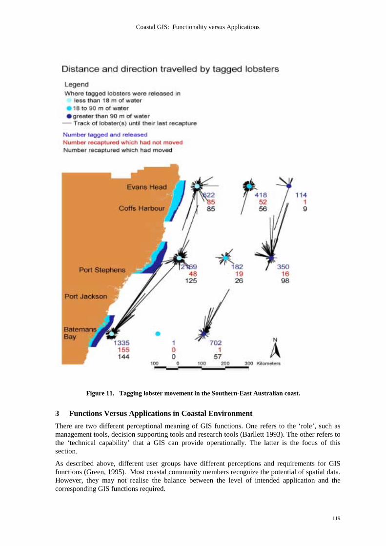
Research a) Lobster tagging (Figure 11). b) Estuaries fisheries assessment.
Recreation fishing survey a) Mapping survey results.
All different aspects of fisheries need to be integrated and share the data that are collected by different divisions and individual projects. With integrated approach to Fisheries management,

Zeng, T.Q, Zhou, Q., Cowell, P. and Huang, H.
116
GIS application have greatly enhanced the effectiveness and efficiency of operations of the organisation.
Figure 5. Aquatic reserves and recreational fishing map.
Figure 6. Aquatic lease plan - automatically generated from a GIS coverage and RDBMS.

Coastal GIS: Functionality versus Applications
117
#
#
100 0 100 200 300 400 500 600 Meters
N
EW
S
Insert A
F(x) = 0.5 * {1-sin[(pi()/15 -5)*(15-x/15+5)]}
Most suitable
Least suitable
FZ-Water depthFZ-Pollution
FZ-Vegetation
#
#
100 0 100 200 300 400 500 600 Meters
N
EW
S
Insert A
F(x) = 0.5 * {1-sin[(pi()/15 -5)*(15-x/15+5)]}
Most suitable
Least suitable
FZ-Water depthFZ-Pollution
FZ-Vegetation
Figure 7. Aquaculture site selection using Fuzzy GIS Modeling.
2
1
3
Cstwwgdalandmangrovesandwaterbody
Aidp11_2.shpApprovedEIS neededPotential
5 0 5 10 Kilometers
N
EW
S
Figure 8. Aquaculture industry development planning.

Zeng, T.Q, Zhou, Q., Cowell, P. and Huang, H.
118
Figure 9. Fishery administrative district boundaries – linked to RDBMS for resource planning.
Figure 10. Threatened species distribution
Coastal GIS: Functionality versus Applications
119
Figure 11. Tagging lobster movement in the Southern-East Australian coast.
3 Functions Versus Applications in Coastal Environment There are two different perceptional meaning of GIS functions. One refers to the ‘role’, such as management tools, decision supporting tools and research tools (Barllett 1993). The other refers to the ‘technical capability’ that a GIS can provide operationally. The latter is the focus of this section.
As described above, different user groups have different perceptions and requirements for GIS functions (Green, 1995). Most coastal community members recognize the potential of spatial data. However, they may not realise the balance between the level of intended application and the corresponding GIS functions required.

Zeng, T.Q, Zhou, Q., Cowell, P. and Huang, H.
120
Leve
l of In
tegra
tion
Complexity
Boole
an lo
gicDy
nami
c seg
menta
tion
Regio
nal a
nalys
isGr
id mo
dellin
gCe
llar a
utoma
tion
Rule-
base
d mod
elRa
ndom
simu
lation
Fuzz
y set
analy
sis
Neur
al ne
twor
k ana
lysis
Marko
vian t
heor
y
Chao
s the
ory
Leve
l of In
tegra
tion
Complexity
Boole
an lo
gicDy
nami
c seg
menta
tion
Regio
nal a
nalys
isGr
id mo
dellin
gCe
llar a
utoma
tion
Rule-
base
d mod
elRa
ndom
simu
lation
Fuzz
y set
analy
sis
Neur
al ne
twor
k ana
lysis
Marko
vian t
heor
y
Chao
s the
ory
Applications Level1
Level 2
Level 2/3
Level 3
Level 3
Level 3
Level3
Level 3
Level 3
Level 3
Navigation y y y Fisheries y n y y y y y ? ? ? Conservation y n y y y y y ? ? ? Coastal mapping
y n y y y y y ? ? ?
Environment assessment
y y y y y y y y
Strategy planning
y y y y y y y y
Sand Mining / Dragging
y n y y
Environment Monitoring
y y y y y y y ? ? ?
Coastal protection
y y y y y y y ? ? ?
Hazard assessment
y y y y y y y y ? ?
Figure 12. Coastal application and corresponding integration of GIS functionalities.
There has been a common syndrome of imbalance between functionality and application. Some users do not have adequate GIS functionality for their intended application, while the others do not realise that they purchased the surpass GIS capability that they probably will never need. This ‘under value’ or ‘over sell’ of GIS could be harmful for the implementation of GIS in CZM.
To success in a GIS application, besides available resource and time, one should attempt to keep the balance between the level of application and the required functionalities. The general requirements of GIS functionality for coastal applications are determined by the characteristics of coastal issues. It is therefore necessary to examine the characteristics of coastal issues, prior to discuss the GIS functionality.
3.1 Common Characteristics of Coastal Issues
Coastal issues have some characteristics in common:

Coastal GIS: Functionality versus Applications
121
a) Zonalisation: Traditionally, different interest groups have investigated coastal area from different prospective and classified the area into zones (Figure 1), such as the habitat zone, surf dynamic zone, navigation zone, aquaculture zone and fisheries management zone. Therefore, it is obvious that classification and zonal analysis functions are essential in Coastal GIS.
b) Multiple variables: The coastal system has a hierarchy structure that is composed of many subsystems interacting with each other. A particular user group tends to have its focus on a portion of coastal system or subsystems with multiple variables interacting upon it. Therefore, multivariable analysis or multi-criteria analysis functions are important components for Coastal GIS.
c) Dynamic: Coastal system and its subsystems are dynamically interacting over space and time. Coastal GIS should be structured in the way that the data and models of dynamic processes (if defined) can be accommodated and operational. The ability of model integration is a crucial criterion for coastal GIS and it is one of the most challenging tasks in the development of coastal GIS.
d) Uncertainties: It is well recognised that coastal processes are fraught with uncertainties (Cowell and Thom, 1994; Zeng, et al., 1997) and most coastal decisions were made under uncertainty (Funtowicz and Ravets, 1995; Otter and Capobianco, 2000), thus the precaution principle should be adopted. Therefore, coastal GIS should be able to cope with the uncertainty.
GIS application in coastal zone can benefit from the methods of assessment of error propagation (Heuvelink, 1993, Lanter and Veregin, 1992) and techniques of handling uncertainties that are routinely used in the fields of Artificial Intelligence (AI) (Zadeh, 1976; Kauffmann, 1975; Zenmmerman; 1991, Kasabov, 1996, Openshaw and Openshaw, 1997).
3.2 Functions Versus Applications
From the above discussion, it can be ascertained that the relationship between the functionalities and application levels of Coastal GIS should be investigated for each project. From GIS application point of view, the level of application should be firstly defined and then the appropriate GIS functions be selected. Based on the review of current GIS applications in coastal zone, a summery of GIS functionalities (existing and potential) versus the level of applications is given in Figure 9. With a higher application level, the required functions aggregate, from simple analysis to multiple-criteria analysis functions, then integrated model of ‘close-couple’ and ‘loops-couple’.
Currently, the majority of GIS applications in coastal zone have reached Level 1 and Level 2. Their needs for Level 3 development will continues to grow, when new models of particular scientific fields become available from different user groups and improvement of user interface becomes available from commercial vendors (Figure 12).
4 Discussions In the past two decades, integrated coastal zone management (ICZM) (Cicin-Sain and Knecht, 1998; Post and Lunding, 1996) has been put into practice and become widely accepted approach for coastal zone management. The ICZM aims to ensure that the decision is made with thoughtful consideration of all user groups and sustainability of the coastal environment. GIS, as a decision-support tool, will play more important role in the processes of ICZM. Therefore GIS training has been given a high priority in CZM education.
The development of Coastal GIS not only provides a powerful tool for coastal management, but also has an impact on the practice of coastal management, and on the police and management planning. Coastal GIS applications and technology development are inherently interacting. The needs call for better GIS functions. Therefore, the development of coastal GIS should be aligned with the principle of ICZM.
In general, there are four fundamental characteristics for a coastal GIS:

Zeng, T.Q, Zhou, Q., Cowell, P. and Huang, H.
122
Integrated approach of four aspects, including:
a) integration of different level of application, b) integration of vector and raster (data and functions), c) integration of knowledge of different expertise, and d) integration of different scales in time and space.
Because of the nature of integration, GIS applications should consider long-term integration. This includes the vertical integration that involves different application (and potential) levels, and horizontal integration that involves other interest groups. Therefore, issues must be addressed from database design, data sharing to tool-making (analysis functions) and experience sharing.
Zonal focused:
Most case studies have shown that the interested objects are polygon features or zones (e.g. aquatic reservation zone, fish closure zone, fisheries management zone, coastal hazard zone, fish habitat zone and coastal development zone). New methods for zonal analysis (e.g. Zeng, et al., 1997) can be implemented into Coastal GIS.
Multicriteria analysis:
a) multi-factors controls
Since coastal system has a complex hierarchical structure with multi-forcing exerting on each of subsystem, no mater which aspect of the system to be investigated, multi-variable analysis is a essential methods in the coastal environment.
b) multidiscipline approach for decision
Other than the multi-factors, there are multiple interest groups of coastal community, therefore, good solutions to any coastal issues can only be derived from multidiscipline approach.
Equipped with uncertainty handling tools:
Fuzzy set analysis, probability, random simulation and Neural Network. Further development of Coastal GIS is challenged by true 3D GIS functions (similar to those having been used in 2D environment) and the presentation / display of the results of 3D GIS modelling. Finally, it is the hope of the authors that this paper will be an integrated part of the development of Coastal GIS.
5 Conclusions Coastal GIS development involves many aspects ranging from data model, system architecture to analysis methods. Coastal GIS development and application are challenge tasks facing both users and developers.
From the users’ point of view, Coastal GIS applications should consider the following important points:
First, it should be developed according to the proposed applications, in terms of budget and ongoing budget, time frame, data structure, file systems structure, GIS functions required and the expected outcome from the analysis to support your objectives and how to handle the ongoing expansion.
Second, the level of application needs to be defined to match your objectives. Based on this, one can seek among the available and new GIS functions suitable for the required tasks.
Third, many coastal data are commonly needed by different fields of coastal management, therefore, when developing a GIS database, it should begin with ‘a bigger pictures’ in mind - considering the re-usage and sharing of datasets standardising the data and ensuring the data consistency and integrity.
Coastal GIS: Functionality versus Applications
123
From the development point of view, the major challenge is the Level 3 applications, where more integrated modelling functions are needed. The primarily issue is selection of coastal models to be integrated into GIS. As the coastal models themselves are diversified and continuously improving and new models are developing, more user-friendly interface is needed, such as module-builder in graphic form (e.g. Grid Modeller (ESRI, 1994)) that are routinely used in computer simulation.
Acknowledgement The authors wish to thank to Rob William and Bruce Pease for reviewing the manuscript, and Mr Greg West, Francis Dorman, Jim Craig and Ms Natalie Taffs for their help in preparing the figures. Administrative support from Division of Geography, School of Geosciences, University of Sydney and NSW Fisheries are greatly acknowledged. T hanks are also due to NSFC for funding of the Project No. 49806003
References Ader, R. A., 1982. A geographic information system for addressing issues in the coastal zone.
Computers, Environment and Urban Systems, 7: 233-243. Bartlett, D. J., 1990. Spatial data structure and coastal information systems. Proceedings of
EGIS’90 – the First European Conference on GIS, 30-39. Bartlett, D. J., 1993. The design and application of GIS for the coastal zone: an annotated
bibliography. The Commission on Coastal Systems of the IGU. Bartlett, D. J., 1994. GIS and the coastal zone: past, present and future. AGI Publication 3/94. Belore, R. C. 1990. Au automated oil spill impact assessment system using a microcomputer
based GIS. GIS for the (1990’s, Proceedings of National Conference, Ottawa, 1990, 87-102. Chen, C. Q., Si, P. and Mao, Q. W.. 2001, Assessing impact of discharging cooling water from a
Nuclear Power Plant in Daya Bay, South China Sea. (Personal Communication). Chen, C. Q., Si, P., Zeng, T. Q. and Mao, Q. W., 1996. The use of thematic mapper (TM) data
for the determination of Chlorophyll concentration in coastal water: a case study. Proceedings of Annual National Remote Sensing Conference, Canberra. June 20-23, 1996. 218-232.
Cicin-Sain, B., 1993. Sustainable development and integrated coastal management. Ocean and Coastal Management, 21(1-3): 11-43.
Cicin-Sain, B. and Knecht, R., 1998. Integrated coastal and ocean management: Concepts and national practice. Paris: IOC-UNESCO Publishing. 471pp.
Cowell, P.J. and Thom, B.G., 1994. Morphodynamics of coastal evolution. In: Carter, R.W.G. and Woodroffe, C.D. (eds.), Coastal Evolution, Cambridge University Press, 33-86.
Damoiseaux, M. A., 1995. From maps and atlases to GIS for coastal management. CoastalGIS’95, 129-42.
Davis, B. E. and Davis, P. E., 1988. Marine GIS: Concepts and considerations. GIS/LIS’88 - Proceedings of the AGI Conference, San Antonio, ACSM/ASPRS, 159-168.
Deakin, R. and Miment, R. P., 1994. Strategic-planning and decision support: The use of GIS in the coastal environment. Proceedings of AGI’94, 13.3.1-13.3.5.
Deniels, R. C., While, T. W. and Chapman, K. K., 1993. Sea level rise: destruction of threatened and endangered species habitats in Southern Carolina, Environmental management, 17(3): 373-395.
Downs, L. L., Nicholls, D., Gordon, D. and Hautzenroder, J., 1993. Wetland assessment and management using a GIS approach. Proceedings of Coastal Zone’93, ASCE, NY, 1741-1755.
Ellis, R. H., 1972. Coastal zone management system: a combination of tools. In Marine Technology Society (ed.): Tools for Coastal Zone Management, Washington, D.C.: Marine Technology Society. 184-212.
Esnard, A-M, Brower, D. and Borts, B., 2001. Coastal hazards and built environment on barrier island: a retrospective view of Nags Head in the late 1990s. Journal of Coastal Management, 28: 53-72.
ESRI (Environmental System Research Institute), 1994. GRID user’s guide, ESRI, Redland.

Zeng, T.Q, Zhou, Q., Cowell, P. and Huang, H.
124
ESRI, 2000. GIS Strikes gold at summer Olympics. Arc News Winter 2000-2001, ESRI, Redland, p24.
Fairfield, F. M., 1987. Marine planning with Geographic Information Systems. Proceedings of Coastal Zone’87, 1023-1030.
Gaarrett, M. and Jeffress, G. A., 1993. Managing oil spills: Texas incorporates near real time environment data. Geographical Information Systems, 3(1): 29-36.
Green, D. R., 1995. User-access to information: a priority for estuary information systems. CoastGIS’95, 35-50.
Grossman, W. D. and Eberhardt, S. 1992. Geographical Information Systems and Dynamic Modelling. Annuals of Regional Science 26: 53-66.
Hecht, L. G., 1991. Monitoring the Chesapeake Bay in real time. GIS World, 4(9): 88-93. Heikoff, J. M., 1980. Marine and shoreland resources management. Michigan: Ann Arbor Science
Publishers, 214pp. Hennecke, W., 2000. GIS-based modelling of potential sea-level rise impacts on coastal re-
entrants and adjacent. PhD Thesis, School of Geosciences, Faculty of Science, University of Sydney, 2000. 223pp.
Hennecke, W., Catharina, G., Cowell, P. J. and Thom, B., 2000. GIS_based modelling of se-level rise impacts for coastal management in southeastern Australia. Proceedings of MSIA Mapping Sciences Institute of Australian) National Conference 2000, 179-88.
Heuvelink, G. B. M., 1993. Error Propagation in Quantitative Spatial Modelling, KNAG, University of Utrecht Publication No 163, 160pp.
Hickey, R. J., Bush, D. M. and Boulay, R. S., 1997. GIS supports coastal risk assessment. GIS World, June Issue, 54-58.
Hooge, P. N., Eichenlaub, Q. M. and Solomon, E. K., 2000. Using GIS to Analyze Animal Movements in the Marine Environment. (Personnel Communication).
Huang, H. J., Short, A., Zeng, T. Q. and Hanslow, D., 1999. Impact of river training walls on adjacent beaches, Ballina, New South Wales, Australia, Chinese Journal of Oceanology and Limnology, 17(1): 411-418.
Humphries, L.P. and Ligdas, C.N., 1997. A GIS application for the study of beach morphodynamics. Proceedings of Coast GIS’97, University of Aberdeen, Aberdeen, 381-92.
IPCC (Inter-Government Panel of Climate Change), 1997. Climate change 1995 : The science of climate change. New York: Cambridge University Press, 572pp.
Jeffries-Harris, T. and Selwood, J., 1991. Management of marine sand and gravel- a seabed information system, Land Management System, 9(2): 6-8.
Jones, A. R., 1995. GIS in coastal management: a progress review. CoastGIS’95-Proceedings of International Symposium on GIS and Computer Mapping for Coastal Zone Management. University College, Cork, Ireland, 3-5 February, 1995, 163-178.
Kasabov, N. K., 1996. Foundations of neural networks, fuzzy systems, and knowledge engineering. Cambridge, Mass.: MIT Press, 550pp.
Kauffmann, A., 1975. Introduction to the Theory of Subsets, Academic Press, New York. Lanter, D. P., and Veregin, H., 1992. A research paradigm for propagating error in layer-based
GIS. Photogrammetric Engineering and Remote Sensing, 58: 825-33. Lauro, M. D., Giunta, G. and Montella, R., 1999. Marine GIS development: mapping the Bay of
Naples. Sea Technology, 40(6): 53-61. Lee, J. K., Park, R. A. and Mausel, P. W., 1992. Application of geoprocessing and simulation
modelling to estimate impacts of sea level rise on the Northeast Coast of Florida. Photogrammetric Engineering & Remote Sensing, 8(11): 1579-1586.
Li, D. 1999. Data models for marine and coastal Georaphical Information Systems. In: Wright, D. J. and Bartlett, D. J. (eds.), Marine and coastal geographical information systems. London: Taylor & Francis, 25-36.
Lucas, M. 2000. Representation of variability in marine environmental data. In: Wright, D. J. and Bartlett, D. J. (eds.), Marine and coastal geographical information systems. London: Taylor & Francis, 53-74.

Coastal GIS: Functionality versus Applications
125
Maktav, D. S., Yalin, D. and Aslan, E. 2000. Monitoring loggerhead Sea Turtle (Caretta caretta) Nests in Turkey Using GIS. Coastal management, 28,123-32.
Meixler, M. S. and Bain, M. B., 2000. Use of GIS to predict stream habitats and fish diversity. Proceedings of 130th Annual Meeting of American Fisheries Society, Missouri, Aug. 20-24, 2000.
Mumby, P. J., Raines, P. S., Gray, D. A. and Gibson, J. P., 1995. Geographical information system: A tool for integrated coastal Zone management in Belize. Coastal Management, 23, 111-21.
Nath, S. S., Bolte, J. P., Ross, L. G., and Aquilar-Manjarrez, J., 2000. Applications of geographical information systems (GIS) for spatial decision support in aquaculture. Aquacultural Engineering, 23: 233-278.
NSW Fisheries, 1999. NSW North Coast Sustainable Aquaculture StrategyLand Based Aquaculture. http://www.fisheries.nsw.gov.au/aquaculture/pdf.
Openshaw, S. and Openshaw, C. 1997. Artificial Intelligence in Geography. Chichester: John Wiley & Sons.
Ortiz, E., 1994. On the development of a representative network of marine and estuarine protected areas for New South Wales. Report to Ocean Rescue 2000, NSW Fisheries, Sydney, 35pp.
Otter, H. S. and Capobianco, M., 2000. Uncertainty in integrated coastal zone management. Journal of Coastal Conservation, 6: 23-32.
Parham, J. E. and Fitzsimons, J. M., 2000. Multi-dimensional GIS: A powerful tool for managing stream fishes (Abstract). Proceedings of 130th Annal Meeting of American Fisheries Society, Missouri, Aug. 20-24, 2000. p.142
Patterson, S. and Dawson, R., 1991. A park service barrier island GIS: assessment and forecast of impacts from dredging and oil transport. Resource Technology 90, Proceeding of Second International Symposium on advance technology in natural resource management, Washington DC, 1990, 376-386.
Post, J. and Lunding, C., 1996. Guidelines for integrated coastal zone management. Environmentally Sustainable Development Studies and Monograph Series No.9, Washington, D.C.: The World Bank.
Raper, D. and Maguire, J., 1992. Design models and functionality in GIS. Computers and Geosciences, 18: 387-94.
Ricketts, P. J., 1992. Current approaches in GIS for coastal management. Marine Pollution Bulletin, 25: 82-87.
Riddel, K. J., 1992. Geographical information and GIS: Keys to coastal zone management. GIS Europe, 15: 22-25.
Ruth, M. and Pieper, F., 1994. Modeling spatial dynamics of sea-level rise in a coastal area, System Dynamics Review, 10(4): 375-389.
Schauser, U. H, Boedeker, D., Matusek, S and Klug, H., 1992. The use of GIS for Wadden Sea conservation. In: Amelan, D., Dankers, N., Smit, C., and Scholl, M., (eds.), Proceedings of the 7th International Wadden Sea Symposium, 20: 281-283.
Sims, P.C., Waever, R.E. and Redfearn, H.M., 1995. Assessing coastline change: A GIS model for Dawich Warrant, Devon, UK. Proceedings of Coast GIS’95 3-5 February, 1995, Cork, Ireland. 289-301.
Stwart, M. C., 1995. The identification of potential problem areas caused by septic tanks along the southern and south-eastern south African coast. CoastalGIS’95 – Proceedings of International Symposium on GIS and Computer Mapping for Coastal Zone Management, 3-5 February, 1995, Cork, Ireland, 331-71.
Townend, I. H., 1990. The application of GIS to coastal zone management. Proceedings of EGIS’90 – First European Conference on Geographical Information Systems, 1096-1107.
Van Der Veen, A., Grootjans, A. P., De Jong, J. and Rozema, J., 1997. Reconstruction of an interrupted primary beach succession using a Geographical Information System. Journal of Coastal Conservation, 3: 71-78.

Zeng, T.Q, Zhou, Q., Cowell, P. and Huang, H.
126
Walford, F. and Williams, R., 1998. Inventory of estuariine vegetation in Botany Bay, with special reference to change in the distribution of seagrass. Fishcare Project No. 97/003741. NSW Fisheries Final Report Series No.11, 51.pp.
Walford, N., 1999. Making more of maps: Geography and Geographical Information Systems. Geography, 84(363):129-38.
Welch, R., Remillard, M., and Alberts,J., 1992. Integration of GPS, remote sensing, and GIS techniques for coastal resource management. Photographmmetric Engineering and Remote Sensing, 58: 1571-1578.
Williams, R. and Watford, F., 1997. Change in the distribution of mangrove and saltmarsh in Berowra and Marramarra Creek, 1941-1992. Contract report to Hornsby Shire Council, by NSW Fisheries, Australia. 21.pp.
WGHABD (The international Working Group on Harmful Algal Bloom Dynamics), 2001. Mapping harmful events related to Phytoplakton blooms in Western Europe and North America , http://www.ifremer.fr/envlit/documentation/dossiers/ciem/aciem-c1.htm
Wright, D. J. and Bartlett, D. J., 2000. Marine and coastal geographical information systems. London: Taylor & Francis, 320.pp.
Zadeh, L. A., 1965. Fuzzy sets, Information and Control, 8: 338-353. Zeng, T. Q., Cowell, P. J. Thom, B. and Zeng, Z. X., 1997. Modeling coastal hazard due to climate
change under uncertainty. Tropical Geomorphology, 18(1): 36-53. Zeng, T. Q., Cowell, P. J., and Zhou, Q., 1997. The Usher’s Approach (UshA) for the realisation
of Fuzzy Clustering Theory for zonal analysis in raster-based GIS. Proceedings of GeoComputation’97 & SIRC’97, 26-29 August 1997, the University of Otago, New Zealand, 15-22.
Zeng, T. Q. and Cowell, P. J., 1998. A GIS-based modeling of coastal hazard due to the climate change. Proceedings of International Conference on Modeling Environment Systems with GIS, 26-29 June 1998, Hong Kong. 201-209.
Zeng, T. Q. and Cowell, P. J., 1999. Assessing uncertainty in modelling coastal recession due to sea level rise. In: Lowell, K. and Jaton, A. (eds.) Spatial Accuracy Assessment: Land Information Uncertainty in Natural Resources, Michigan: Ann Arbor Press, 79-88.
Zeng, T. Q., Workman, T., Ogburn, D. and Cowell, P. J., 1999. The development of Aqauculture GIS (ACGIS), (Abstract), Annual Conference of Australian Geographic Society, Sydney. 29 Sept.- 1st October 1999.
Zeng, T. Q. and Zhou, Q., 2001. Optimal spatial decision making using GIS: a prototype of real estate geographical information system (REGIS) International Journal of Geographical Information Science, 15(4): 307-321.
Zhou, Q. and Charnpratheep, P., 1996. Fuzzy expert system and GIS for solid waste disposal siting in regional planning, Geographical Information Sciences, 2(1-2): 37-50.
Zimmermann, H. J., 1991. Fuzzy Set Theory-and Its Applications (2nd Edition), Massachusetts: Kluwer Academic Publishers.


![Understanding and the functionality of GIS Richard Knight, Biodiversity and Conservation Biology, University of the Western Cape Email: knight.rich[at]gmail.com](https://img.pdfslide.us/doc/110x75/56649eac5503460f94bb265f/understanding-and-the-functionality-of-gis-richard-knight-biodiversity-and.jpg)


![GIS versus CAD versus DBMS: What Are the … versus CAD versus DBMS: What Are the Differences? David]. Cowen Department of Geography and SBS Lab, University of South Carolina, Columbia,](https://img.pdfslide.us/doc/110x75/5acaa54a7f8b9acb7c8e59e5/gis-versus-cad-versus-dbms-what-are-the-versus-cad-versus-dbms-what-are-the.jpg)