Embed Size (px)
Citation preview
Colorado Department ofPublicHealth and Environment
September 21,2011
David Lucas, Chief Division ofRefuge Planning U.S. Fish and Wildlife Service Mountain-Prairie Region P.O. Box 25486, DFC Denver, CO 80225-0486
RE: Service's requests for additional infonnation regarding residual risk at Rocky Flats National Wildlife Refuge
Dear Mr. Lucas,
The Colorado Department of Public Health and Environment (CDPHE) and Region 8 of the U.S. Environmental Protection Agency (EPA) are responding to your letter of September 1, 2011 requesting assistance in better understanding site conditions as they affect the safety ofrefuge workers and visitors. Our responses to your specific questions are on pages attached to this correspondence.
Please let us know ifyou have additional questions or need further information.
Sincerely,
CDPHE C~n~~
. ucc: Steve Berendzen, USFWS
Dan Miller, AGO Lorraine Ross, EPA Simon Lipstein, DOE
Responses to U.S. Fish and Wildlife Service's letter ofSeptember 1, 2011
Response to item # 1 - Provide a qualitative summary ofrisk to Wildlife Refuge Worker (WRW) and Wildlife Refuge Visitor (WRV) within the lands transferred to the Refuge.
• Major Rocky Flats Site documents demonstrate and declare that the risks to the WRW and WRV are within or below the acceptable CERCLA risk range ( 1 o-4
- Io-6
risk of excess cancer incidence) and that radiation doses are below State standards. These documents include:
• 1) RCRA Facility Investigation - Remedial Investigation/Corrective Measures Study
- Feasibility Study Report for the Rocky Flats Environmental Technology Site,
June 2006 (RI/FS Report) [document available on-line at:
http://www.lm.doe.gov/Rocky Flats/Regulations.aspx#RIFS ] 2) Corrective Action Decision/Record ofDecision for Rocky Flats Plant Peripheral
Operable Unit and the Central Operable Unit (CADIROD) [document available on-line at: http://www.lm.doe.gov/Rocky _ Flats/Regulations.aspx].
3) Notice ofpartial deletion ofthe Rocky Flats Plant from the National Priorities List (72 ed. Reg. 29276, May 25, 2007)
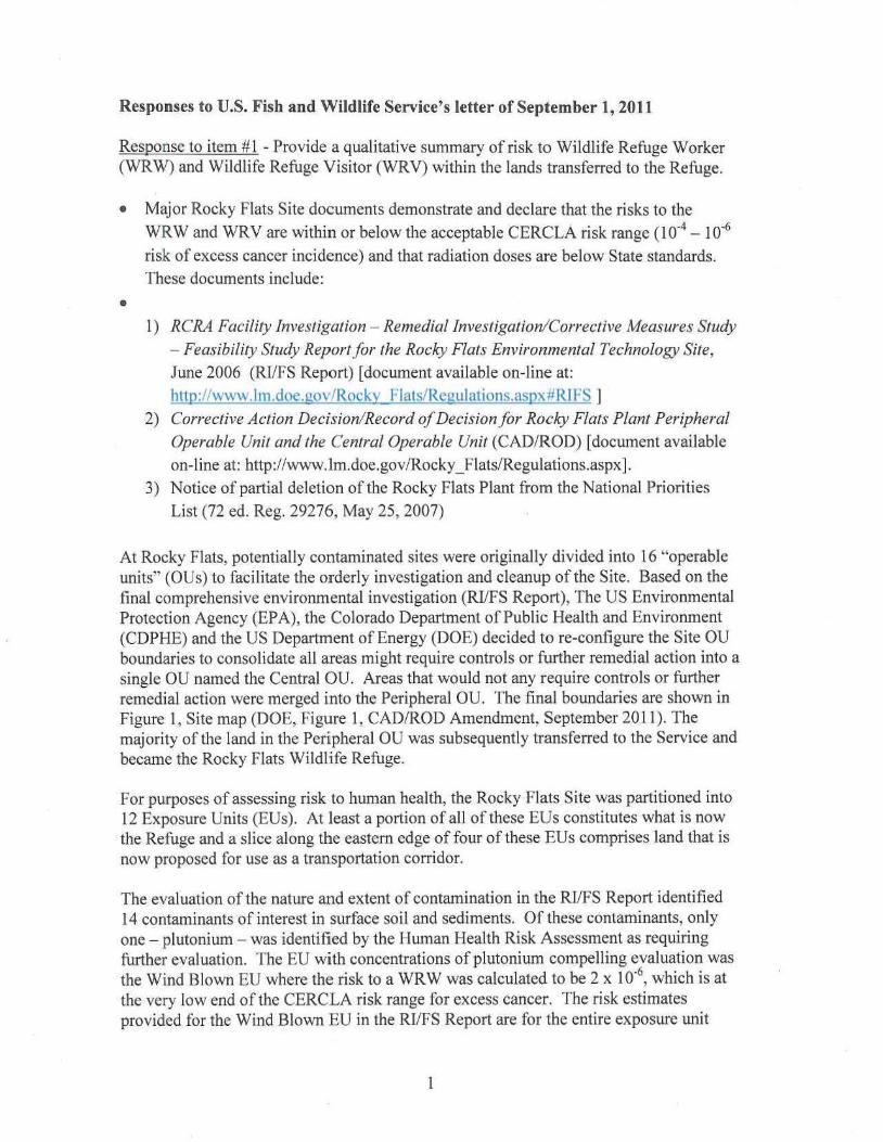
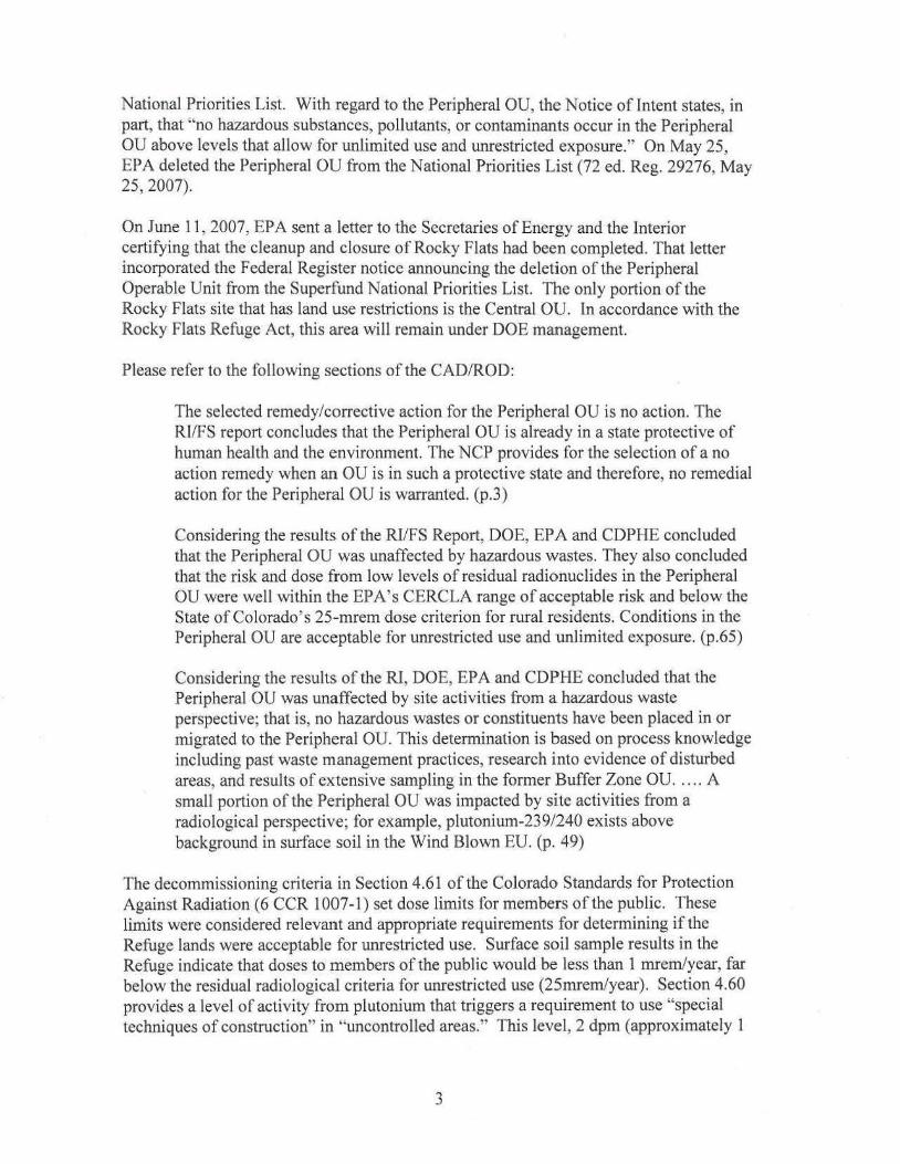
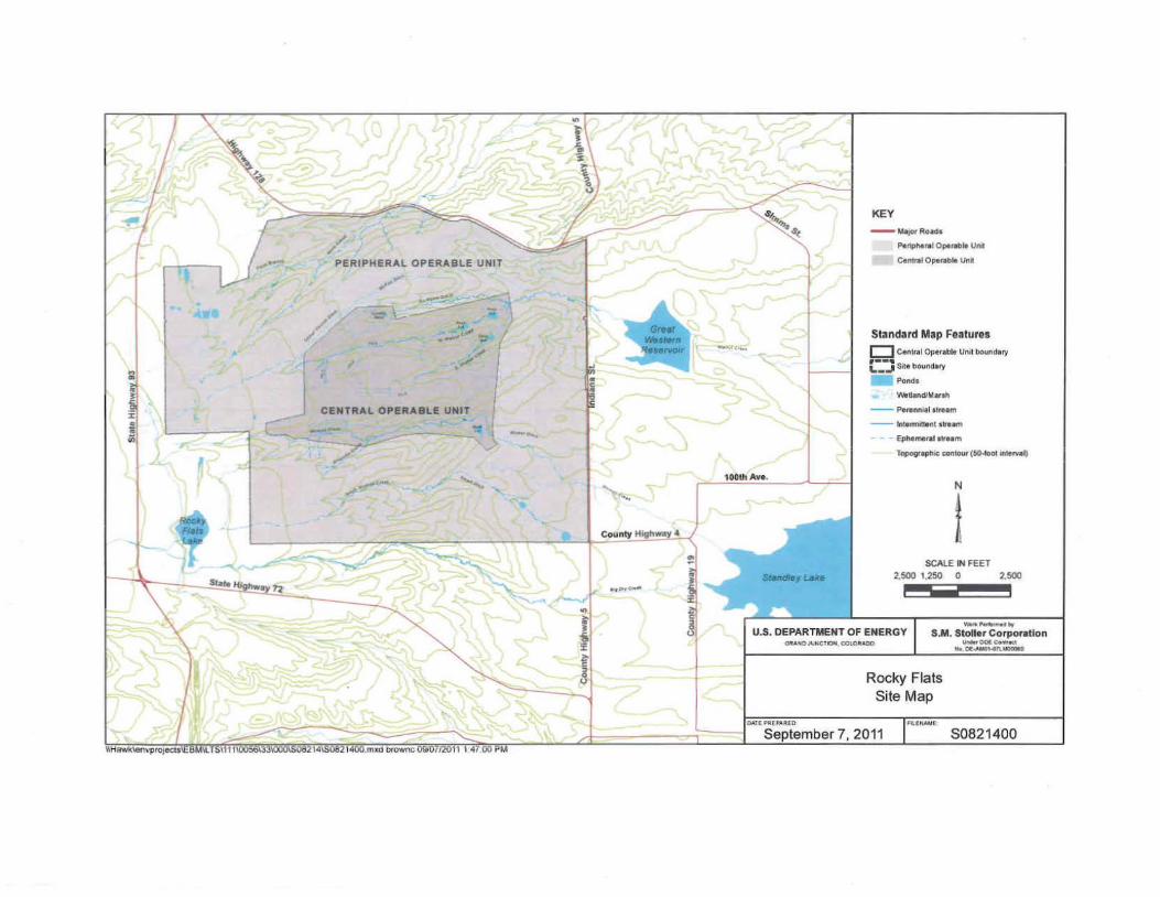
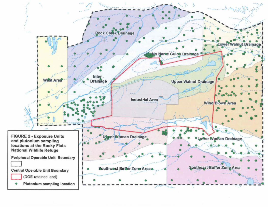
At Rocky Flats, potentially contaminated sites were originally divided into 16 "operable units" (OUs) to facilitate the orderly investigation and cleanup oftbe Site. Based on the final comprehensive environmental investigation (RI/FS Report), The US Environmental Protection Agency (EPA), the Colorado Department ofPublic Health and Environment (CDPHE) and the US Department of Energy (DOE) decided to re-configure the Site OU boundaries to consolidate all areas might require controls or further remedial action into a single OU named the Central OU. Areas that would not any require controls or further remedial action were merged into the Peripheral OU. The final boW1daries are shown in Figure 1, Site map (DOE, Figure I, CAD/ROD Amendment, September 2011). The majority of the land in the Peripheral OU was subsequently transferred to the Service and became the Rocky Flats Wildlife Refuge.
For purposes ofassessing risk to human health, the Rocky Flats Site was partitioned into 12 Exposure Units (EUs). At least a portion of all of these EUs constitutes what is now tbe Refuge and a slice along the eastern edge of four of these EUs comprises land that is now proposed for use as a transportation corridor.
The evaluation of the nature and extent ofcontamination in the RI/FS Report identified 14 contaminants of interest in surface soil and sediments. Of these contaminants, only one- plutonium - was identified by the Human Health Risk Assessment as requiring further evaluation. The EU with concentrations ofplutonium compelling evaluation was the Wind Blown EU where the risk to a WRW was calculated to be 2 x 10"6, which is at the very low end of the CERCLA risk range for excess cancer. The risk estimates provided for the Wind Blown EU in the RI/FS Report are for the entire exposure W1it
1
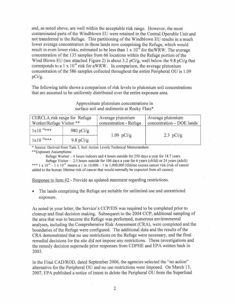
and, as noted above, are well within the acceptable risk range. However, the most contaminated parts of the Windblown EU were retained in the Central Operable Unit and not transferred to the Refuge. This partitioning of the Windblown EU results in a much lower average concentration in those lands now comprising the Refuge, which would result in even lower risks, estimated to be less than 1 x 1 o-6 for the WR W. The average concentration of the 135 samples from 66 locations within the Refuge portion of the Wind Blown EU (see attached Figure 2) is about 3.2 pCi/g, well below the 9.8 pCi/g that corresponds to a 1 x 10⁻⁶ risk for aWRW. In comparison, the average plutonium concentration of the 586 samp~es collected throughout the entire Peripheral OU is 1.09 pCi/g.
The following table shows a comparison ofrisk levels to plutonium soil concentrations that are assumed to be uniformly distributed over the entire exposure area.
Approximate plutonium concentrations in surface soil and sediments at Rocky Flats*
CERCLA risk range for Refuge Average plutonium Average plutonium Worker/Refuge Visitor** concentration - Refuge concentration- DOE lands
lxlO -4*** 980 pCi/g 1.09 pCi/g 2.3 pCi/g
lxlO "6*** 9.8 pCi/g
*Source: Denved !Tom Task 3, Soli Act1on Levels Techn1cal Memorandum **Exposure Assumptions:
Refuge Worker - 4 hours indoors and 4 hours outside for 250 days a year for 18.7 years Refuge Visitor- 2.5 hours outside for 100 days a year for 6 years (child) or 24 years (adult)
*** I x Io-1 - I x 1 0-<i means a I in 1 0,000 - I in 1,000,000 I ifctime excess cancer risk (risk ofcancer
added to the human lifetime risk ofcancer that would normally be expected from all causes)
Response to item #2 -Provide an updated statement regarding restrictions.
• The lands comprising the Refuge are suitable for unlimited use and unrestricted
exposure.
As noted in your letter, the Service' s CCP/EIS was required to be completed prior to cleanup and final decision making. Subsequent to the 2004 CCP, additional sampling of the area that was to become the Refuge was performed, numerous environmental analyses, including the Comprehensive Risk Assessment (CRA), were completed and the boundaries of the Refuge were conftgured. The additional data and the results of the CRA demonstrated that no use restrictions on the Refuge were necessary, and the final remedial decisions for the site did not impose any restrictions. These investigations and the remedy decision supersede prior responses from CDPHE and EPA written back in 2003.
In the Final CAD/ROD, dated September 2006, the agencies selected the "no action" alternative for the Peripheral OU and no use restrictions were imposed. On March 13, 2007, EPA published a notice of intent to delete the Peripheral OU from the Superfund
2
National Priorities List. With regard to the Peripheral OU, the Notice of Intent states, in part, that "no hazardous substances, pollutants, or contaminants occur in the Peripheral OU above levels that allow for unlimited use and unrestricted exposure." On May 25, EPA deleted the Peripheral OU from the National Priorities List (72 ed. Reg. 29276, May 25, 2007).
On June 11 , 2007, EPA sent a letter to the Secretaries ofEnergy and the Interior certifying that the cleanup and closure of Rocky Flats had been completed. That letter incorporated the Federal Register notice announcing the deletion of the Peripheral Operable Unit from the Superfund National Priorities List. The only portion of the Rocky Flats site that has land use restrictions is the Central OU. In accordance with the Rocky Flats Refuge Act, this area will remain under DOE management.
Please refer to the following sections of the CAD/ROD:
The selected remedy/corrective action for the Peripheral OU is no action. The RI/FS report concludes that the Peripheral OU is already in a state protective of human health and the environment. The NCP provides for the selection of a no action remedy when an OU is in such a protective state and therefore, no remedial action for the Peripheral OU is warranted. (p.3)
Considering the results of the Rl/FS Report, DOE, EPA and CDPHE concluded that the Peripheral OU was unaffected by hazardous wastes. They also concluded that the risk and dose from low levels ofresidual radionuclides in the Peripheral OU were well within the EPA's CERCLA range of acceptable risk and below the State of Colorado's 25-mrem dose criterion for rural residents. Conditions in the Peripheral OU are acceptable for unrestricted use and unlimited exposure. (p.65)
Considering the results of the Rl, DOE, EPA and CDPHE concluded that the Peripheral OU was unaffected by site activities from a hazardous waste perspective; that is, no hazardous wastes or constituents have been placed in or migrated to the Peripheral OU. This determination is based on process knowledge including past waste management practices, research into evidence of disturbed areas, and results of extensive sampling in the former Buffer Zone OU. . .. . A small portion of the Peripheral OU was impacted by site activities from a radiological perspective; for example, plutonium-239/240 exists above background in surface soil in the Wind Blown EU. (p. 49)
The decommissioning criteria in Section 4.61 of the Colorado Standards for Protection Against Radiation (6 CCR 1007-1) set dose limits for members of the public. These limits were considered relevant and appropriate requirements for determining if the Refuge lands were acceptable for unrestricted use. Sw·face soil sample results in the Refuge indicate that doses to members of the public would be less than 1 mrem/year, far below the residual radiologicaJ criteria for unrestricted use (25mrem/year). Section 4.60 provides a level of activity from plutonium that triggers a requirement to use "special techniques ofconstruction" in "uncontrolled areas." This level, 2 dpm (approximately 1
3
pCi/g), was set back in 1973 and was designed to keep radiation exposure as low as reasonably achievable. These requirements have been determined to not apply to refuge lands because the land is under federal jurisdiction and therefore is not "uncontrolled." The requirements would, however, apply to land that is transferred out of federal jurisdiction.
In cases where§§ 4.60 and 4.61 apply, the Colorado Department ofPublic Health and Environment would evaluate appropriate construction controls, which would likely consist ofdust suppression. Since dust suppression is not considered a restriction, applying this control would not limit use of the property proposed for transfer. The declaration that the refuge is available for unrestricted use would not be violated by the application of Part 4 of the Colorado Radiation Control Regulations.
There are a number of state and federal environmental requirements that may apply to the proposed construction, such as a storrnwater permit, dredge and fill permit, air permit, etc. None of these are considered "restrictions" on land use, though a regulatory agency may impose conditions that must be met to perform the work, but are applied to mitigate environmental (including human health) impacts.
Response to item #3 - Provide information on 1) how disposal of lands associated with transportation was handled in Site documents, and 2) how exposures to construction workers and trail users would differ from those calculated for the WRW and WRY.
1) The CAD/ROD contemplated a future land transfer at the eastern edge of the site, as per provisions of the Refuge Act:
The Refuge Act prohjbits the United States from transferring any rights, tide, or interest in land within the boundaries of Rocky Flats, except for the purpose of transportation improvements on the eastern edge of the site that is bordered by Indiana Street. (p. 37)
2) The CRA developed a site conceptual model which identified multiple exposure pathways, which were analyzed as part of the human health risk assessment. Pathways for the WRV include inhalation and ingestion of surface soil and sediment, direct contact with surface soil and sediment, and external irradiation from surface soil and sediment. Hiking was one ofthe WRY activities that was evaluated, so exposure to "trail users" is included in that receptor scenario.
Risk to a construction worker was not directly calculated in the RI/FS Report. Because the exposure pathways and assumptions are similar to those used for a WRW, the risks should be somewhat similar to the risks calculated for a WRW. Differences include the potential for greater rates ofinhalation and ingestion of soil by the construction worker. Those differences are likely offset by the much greater exposure duration for the WR W (18.7 years versus a few months for a construction worker). Due to the very short exposure duration, the very low levels ofresidual plutonium in the strip ofland proposed
4
for transfer and the calculated low radiation dose (see response to item #1), the risk to a construction worker would be at or below the low end of the CERCLA risk range.
Air emissions from the Rocky Flats Site do not present health or environmental concerns in ambient air. This key factor in one of the potential exposure pathways is addressed in the "Air Contamination" section of the CAD/ROD, quoted below (p. 29):
Air Contamination-- Monitoring programs and other studies were conducted during both the production era and cleanup phase at Rocky Flats. These data show that contaminant emissions and resulting ambient airborne concentrations during both the weapons production era and cleanup phase were always compliant with all regulatory requirements. in fact, compliance monitoring at the facility fence line showed maximum airborne radionuclide concentrations ofno more than three per cent of the limiting standard during the entire cleanup phase. With completion of all accelerated actions -and the attendant removal of all historical air emissions sources except for wind erosion of the minor, remnant contamination in surface soils, future air emissions from the site will be less than those in the past.
The CAD/ROD acknowledges that resuspension ofresidual radioactive contaminants attached to surface soil particles remains a potential source of ongoing air emissions. However, sources ofradionud ide contamination were removed during cleanup - former processing and waste storage buildings were decommissioned, decontaminated, and demolished and contaminated soils were removed) and the Site is now much less susceptible to air emissions. The CAD/ROD states (p. 30):
Air modeling conducted for radionuclide parameters predict that, even for scenarios involving a fire in the historic 903 Pad area, emissions will be much lower than the EPA's ten millirem benchmark level for an airborne exposure pathway."
5
.// ·
PERIPHERAL OPERABLE UNIT
~.."'
~ ..-:,~
~
- I -.....
J
-~
~ ~~
•
I~ : , / ..
""--.....
cii. ' . . /
) - ~ ' _ .,. ,.___ - 'wI -'-'-' l .i# 100111 Ave.
KEY - MaJOf Ro•d•
Penpl>otlll Operoble Un•
Cen11111 Operoble Unit
Standard Map Features c:J Cen11111Oporoi>M Unll boundary ·--· I..-...I Sote boundary
Ponds
V\lolland/M orlh
- Pere.nniel stre1m
- lntermattent stte•m
- Ephemeral stre•m
TopographiC c:onto<Jr (SO..OOI•\terval)
N
I SCALE IN FEET
2.500 1,250 0 2,500
U.S. DEPARTMENT OF ENERGY Waf... ......,.,.._,
S.M. Stoller Corporation GRA"'OJ'-'NC1'10l1. C:OI.ORAOO UnMr001Collll'tc.1
,_, ot:~a.IO'I..TI.MOOOIO
O.Uf PI!U'MlEO
Rocky Flats Site Map
Fl.tNNAI
September 7. 2011 $0821400
• • •
• • •
_,,.. __ ..
I,
• • __ ..
W6 tAre,. , , ..
' • I. -···
-- /! '
'.
• • ••• • •••• •gock Creek!>ralnage
•+· •
• •
. ./~· ----· -\f
-, I. \ I _.:>J ••,' __ __•_.. - rl • ·,c...
,' • •
,.. . . . /• LP'/ ,.....
.-7 '"-r---"" '2
A/ ' .r...... --- -- . .
Upper Walnut Drainage f ~~ lnte~ -, .
··II! Drain ge
+ .r' ,,-; ,. •• •-t.. .. .. .• • •• • •••.. . .: . ........ ,
Industrial Area -h
I ~ -1 ••.•' .\•
•'
--- . - '! D ~· I ••~ •• •( !•-• ·l. ' • • 0 1 __.-#~-, I -~~~, ~ -- - .-1!!!!~-·---r;~:.::-:-L_---=-==-:-:-~· .:.:~-:-~;;?~-P·.,-- -_,-.---.e•
,k:· - ...,-r-.....____ . - , ,, •-·-- ~
U~l - UIIIGII LIIGIIIaye • ~- ""
, , I ' ' 'I I
I
I• ,' ;
I
FIGURE 2 - Exposure Units and plutonium sampling locations at the Rocky Flats National Wildlife Refuge
Peripheral Operable Unit Boundary ,---·- --.. , I L_-'
Central Operable Unit Boundary-·LJ (DOE-retained land)
• Plutonium sampling location
--~~..,v,
~- e\. I \ .,; , , ·~ Ill r~~.. ,. ..... ---- , .. ;-, ...·r ~-~~ ,.,, ....~l·· ·
, • J '"~~'' , I .
~-'-----~~-·\'· ,' ''."~ -,
·:- , ___J' .
., ~• . I• - • ' 1• -_..-_-- ·-----' • • t! .. . • ·,
\ 'I \ ' • '.l_ I
~ • ...... .. •• I e ', ~· .... .... . ~.,_ow~Walnut Drainaae. . ..
/ • ~~ante Gul~ Qrai~g_!.!;P -~~· · ·e'·~ ,, ~·~~~.. - ~--- ,' . '
/~~-/ /'\.·• · ---- ~ \ \ ~, ~1---,' ___,.. ! ·'.. ~
•
~
f7/ ' ,· ·"" , ,- I -~ A /_
__._.) - . • .I •• - • ••
I •• •••• I
~l-·..... ~~~-.- --.-- , . . . . -...',j' Wind/ Blown Area i • • .. •• ••
lI
•• - ••' . ~..:J-~~ 1 '\i~-- '-.~ I ..... \l "'I '-.~ 1 • d ) • . • • . \ ) ~- --~-... / .. ..,..,.... ' v' ....., • · ·~fter florftan Drainage'. ~ .., . ~ • ~- -:::::>-,~ .• --· - • ~" • • , ·-.. ..:~•----· • •
-\:' •- -,---:, -:....._ ',. __ ... '~
I _r... • -e\,~_1' . ·---' • ·4
I--------·~..· • __ .., ..... _, • • ~ ··~... , ,I •
&outhwest BuMer Zone Area.. . -·• \OUthevt Burrer Zon, Area •T_,'____________ .• •
-
• • ' • . • - - - - - - - - - - - - - - - r-~ · ',T ~-~-------------