Embed Size (px)
Citation preview
Page 1 of 12
CMA Reference No: F-2017-0437 Document No: 3 Council No: PP169/2017-1 File No.: STP/02-0007 Date: 7 August 2018
Planning Panels Victoria GPO Box 2392 Melbourne Vic 3001 [email protected] [email protected]
Dear Sir/Madam,
Panel Ref: Apollo Bay Tourism Resort Panel (PP169/2017-1)
CMA Reference Number: F-2017-0437
Section: S 52
Location Street: 275 Barham Road
Apollo Bay, Victoria 3233
Cadastral: Lot 2, PS515118, Parish of Krambruk
I write in response to your referral dated 5 July 2018, received at the Corangamite Catchment Management Authority on 5 July 2018 regarding notification of an amended planning permit application for the Apollo Bay Tourism Resort.
Corangamite CMA has assessed this application in accordance with its functions as the Floodplain Management Authority for the Corangamite Waterway Management District pursuant to Sections 201 to 212 of the Water Act 1989.
The Floodplain Management functions of the Authority relevant to this matter are described in Section 202 of the Water Act 1989, Clauses (1)(a), (d) and (f):
a) To find out how far floodwaters are likely to extend and how high they are likely to rise
b) to control developments that have occurred or that may be proposed for land adjoining waterways
c) to provide advice about flooding and controls on development to local councils, the Secretary to the Department and the community.
Below is the Authority’s understanding of the application:
The applicant(s), Oceans United Investments Group Pty Ltd
Proposed Development Description: Use and development of the land as residential hotel and leisure and recreation
on the abovementioned proposed development location
The Authority’s assessment indicates that the property is covered by the following Zones and Overlays in the Colac Otway Planning Scheme;
Zone(s): Rural Activity Zone (RAZ)
Overlay(s): Erosion Management Overlay - Schedule 1 (EMO1)
Environmental Significance Overlay - Schedule 3 (ESO3)
Page 2 of 12
Significant Landscape Overlay - Schedule 3 (SLO3)
Bushfire Management Overlay (Bmo Or Wmo) (WMO)
Summary and Conditions The Authority has previously responded to the Planning Panel notification for this development on 19 March 2018 (our ref: F-2017-0437-02). The background and details of the Authority’s assessment of this application are in Attachment A and form part of the Authority’s response.
The Corangamite CMA understands that the amended application has scaled back the development to 180 hotel rooms and 82 villas and associated buildings on the property.
The Corangamite CMA completed a preliminary flood assessment based on a HecRas hydraulic model that indicates that Barham River Road will be impassable for all flood events with an average flood frequency of 10% AEP and greater. The distance to high ground in Apollo Bay is some 3.2 kms through the Barham River floodplain. In the absence of additional flood modelling carried out by the applicant, the alternative access/ egress routes proposed in the the Emergency Management Plan dated 20 June 2018 submitted are considered not viable. Further flood modelling is therefore required by the applicant to demonstrate that alternative safe evacuation routes from the Resort that were proposed in the Emergency Management Plan are viable.
In light of this assessment and pursuant to Section 56 of the Planning and Environment Act 1987, the Authority would recommend that commencement of any development, of the scale proposed at this site, should be conditional (i.e. not to commence) on the applicant being able to demonstrate to the satisfaction of the Responsible Authority and Corangamite CMA that safe, flood free egress up to and including the 1% AEP riverine flooding event from the site can be achieved in accordance with best practice floodplain management requirements. Please note that access to the site may be likely to be cut off for at least one day. The duration of road access being cut may change once a detailed hydraulic assessment has been carried out.
Given the above information, Corangamite CMA has identified a possible egress route from the site to consider from the south east corner of the property via Telfords Access to Conns Lane to the airstrip or Ocean Park Drive. Some access through private property is required to get to the airstrip land (as is proposed in Route 2). Figure 4 shows the potential access route as a red line. This is an option that may be worthy of consideration by the applicant of this development.
Should you have any queries, please do not hesitate to contact myself or Tony Jones, on (03) 5232 9100 or [email protected]. To assist the CMA in handling any enquiries please quote F-2017-0437 in your correspondence with us.
Yours sincerely,
Dr Geoff Taylor Floodplain Statutory Manager Cc: Mr Braydon King, Contract Planner - Colac Otway Shire, inq@[email protected]

Page 3 of 12
Attachment A
Decision guidelines The following describes how Corangamite CMA assesses proposed developments in flood-prone areas. This assessment is based on the current best available information to the Authority and has been made considering the State Planning Policy Framework which contains strategic issues of State importance which must be considered when decisions are made.
Clause 65 of the planning scheme general provisions extends the consideration of flood issues to all planning permit applications regardless of whether the site is affected by a flood zone or overlay. Clause 65 requires that for the approval of an application or plan, the council must consider, among other things, the degree of flood risk associated with the location of the land and the use, development or management of the land so as to minimise flood risk.
In addition to clause 65, the flood zone and overlays contain their own decision guidelines that the council must consider when assessing an application. The Floodway Overlay (FO – clause 44.03), Land Subject to Inundation Overlay (LSIO – clause 44.04), and Special Building Overlay (SBO – clause 44.05) contain more detailed decision guidelines.
Guidance on making an application for a planning permit where flooding is a consideration and an explanation of how such an application will be assessed (in effect an explanation of how the decision guidelines are applied) is provided in the Victorian Planning Provision (VPP) Practice Note “Applying for a Planning Permit under the Flood Provisions”. A second practice note (“Applying the Flood Provisions in Planning Schemes” provides guidance about applying the flood provisions in planning schemes.
A copy of the Practice Notes can be downloaded from the former Department of Transport, Planning and Local Infrastructure website (www.dtpli.vic.gov.au) by following the links to Planning > Planning publications > Practice and Advisory Notes > Planning Practice Notes (or by clicking the links below).
- Planning Practice Note 11: Applying for a Planning Permit under the Flood Provisions, August 2015
- Planning Practice Note 12: Applying the Flood Provisions in Planning Schemes, June 2015
- Planning Practice Note 53: Managing coastal hazards and the coastal impacts of climate change, August 2015
In assessing the suitability of any new development, Corangamite CMA considers the following:
o The safety of future occupants. o Avoiding any adverse flood related impacts on other properties. o The protection of waterways and other environmental assets. o Minimising potential property damage. o Ensuring there is no increased burden on community and emergency services.
Developments are assessed against five core requirements:
Buildings or works:
1. Buildings or works must not affect floodwater flow capacity. 2. Buildings or works must not reduce floodwater storage capacity. 3. Buildings meet minimum floor level height (above flood level) relevant to development location
(freeboard). 4. Buildings or works must not occur where the depth and flow of floodwaters would create a hazard 5. Buildings or works must not occur in circumstances where the depth and flow of floodwater affecting
access to the property is hazardous.

Page 4 of 12
Property and Flood Information Land Level information
Survey data available to the Authority indicates that the property ranges in elevation from 12.0 metres AHD4
to 141.0 metres AHD.
Please note that a licensed surveyor should be engaged to establish a suitable datum at the site to verify levels applicable to the development.
Property Flood Information and impact during 1% flood (under current climatic conditions)
Flood levels for the 1% Annual Exceedance Probability (AEP3) flood event (under current climatic conditions) have been modelled for this area. The estimated 1% flood level for the location described above range from 12.4 to 15.0 metres AHD which was obtained from an internal flood investigation completed in March 2018. The HecRas hydraulic model was used with 18 cross section at an average distance of 180 metres. Please note this in-house hydraulic assessment is only preliminary in nature and a detailed 1D-2D hydraulic assessment is required by a suitably qualified and experienced riverine flood engineer/consultant to better assess the characteristics of the Barham River floodplain and its interaction with the floodplain and Barham River Road.
1% AEP Flood Event
The 1% AEP flood event means that a flood of that magnitude (or greater) has a 1% chance of occurring in any given year. It is also known as the 100 year Average Recurrence Interval (ARI5) flood; however a flood of this size or greater may occur more frequently than this, and can happen more than once in any year. The Victorian Government has determined that the 1% AEP flood is the appropriate standard to regulate and protect new developments through the planning and building systems. The impacts of floods rarer than the 1% AEP flood (i.e. less than 1% AEP) are not regulated through the planning and building systems.
Figure 1. Subject property (green outline) showing 1% AEP flood extent (blue shaded area) and egress route to Apollo Bay (red arrow line).

Page 5 of 12
These safety criteria have been used for assessing land use and development on this site, however during flood events the state emergency service do not recommend entering flood waters of any depth or velocity. For further information please see http://www.ses.vic.gov.au/
Flood Hazard
According to Attorney-General’s Departments Australian Emergency Management handbook Series (EMA Handbook 7), in recent years, a high proportion of flood related deaths in Australia have occurred on flooded roads. Fatalities also result from people being swept away while crossing rivers, stormwater channels, overland flow paths or other flooded areas. In assessing access routes between a site and safe ground it has been shown that people trying to evacuate from flooded land will do so by vehicle in most circumstances, and therefore development decisions should assume this to be the default method. For those who do decide to seek a pedestrian route, walking through flood water is also not considered to be an acceptable means of evacuation. For some, walking is likely to be physically difficult or even impossible and can be the cause of significant mental or physical exhaustion.
Analysis of flood hazard is used to determine if it is safe for people and vehicles leaving a property during a flood event. Inappropriate development is likely to increase the burden on emergency services and personnel if an emergency evacuation is required due to illness, injury, inadequate preparation or loss of essential services. It should be noted that the relative evacuation time does not decrease the flood hazard.
Developments should not occur where the depth and flow of floodwater on a property and affecting the access to the property is hazardous.
Minimum floor levels provide protection for a property and its contents, but separate provisions are needed to protect people moving about or attempting to enter or leave a property so that they are not at risk from deep or fast-flowing water.
Safety is assessed against Australian Rainfall and Runoff Revision Project 10 Safety Criteria.
Safety is defined in terms of the depth and velocity of water over the area in question during a 1% AEP flood event as follows:
1. Depth must be no greater than or equal to 0.3 metres; and
2. Velocity must be no greater than or equal to 3.0 m/s; and
3. The product of depth multiplied by velocity must be no greater than or equal to 0.3 m2 per second.
Hazard Assessment for this property In the event of a 1% AEP flood under current climatic conditions it is likely that part of the property would be subject to inundation from the Barham River (Figure 1).
Flood depth over the property Ranges between 0.0 and 1.1 metres (predominantly flood free)
Flood depth over the building envelopes Not expected to be flood prone
Flood depth affecting access to the property Up to 1.1 metres
Estimated flood velocity affecting access to the property
Average 0.9 metres/sec
The current 1% AEP flood mapping available to the Authority identifies that the primary access to the property is likely to become inundated by floodwaters of significant depth. Based on the information available currently the main and only current access along Barham River Road will be cut by floodwaters of significant depth. The egress along Barham River Road is affected by floodwaters for a length of over 3km. This is shown in Figure 2 which shows the alignment of the Barham River Road through the floodplain within the Barham River floodplain. Figure 3 shows Barham River road in longitudinal section from Conns Lane to the property and has two road sections with a flood depth greater than 0.5 metres, one 350 metres long and the other 200 metres long.

Page 6 of 12
This road is likely to be impassable for all flood events with a flood frequency of 10% and higher and may be impassable for up to 24 hours. It is a normal requirement for such a large tourist development attracting many overseas visitors staying on the property to have a flood free access to and from the property.
Figure 2. Subject property (green outline) showing flood extent (shaded blue) and egress route along Barham River Road (red arrow line). Maximum flood depth over the road occurs within the orange circle, between 150 and 400 metres distance from Conns Lane.
Figure 3. The flood depth along Barham River Road from Conns Lane to the property.
Page 7 of 12
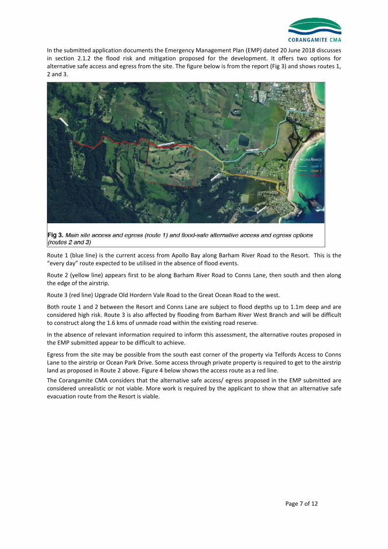
In the submitted application documents the Emergency Management Plan (EMP) dated 20 June 2018 discusses in section 2.1.2 the flood risk and mitigation proposed for the development. It offers two options for alternative safe access and egress from the site. The figure below is from the report (Fig 3) and shows routes 1, 2 and 3.
Route 1 (blue line) is the current access from Apollo Bay along Barham River Road to the Resort. This is the “every day” route expected to be utilised in the absence of flood events.
Route 2 (yellow line) appears first to be along Barham River Road to Conns Lane, then south and then along the edge of the airstrip.
Route 3 (red line) Upgrade Old Hordern Vale Road to the Great Ocean Road to the west.
Both route 1 and 2 between the Resort and Conns Lane are subject to flood depths up to 1.1m deep and are considered high risk. Route 3 is also affected by flooding from Barham River West Branch and will be difficult to construct along the 1.6 kms of unmade road within the existing road reserve.
In the absence of relevant information required to inform this assessment, the alternative routes proposed in the EMP submitted appear to be difficult to achieve.
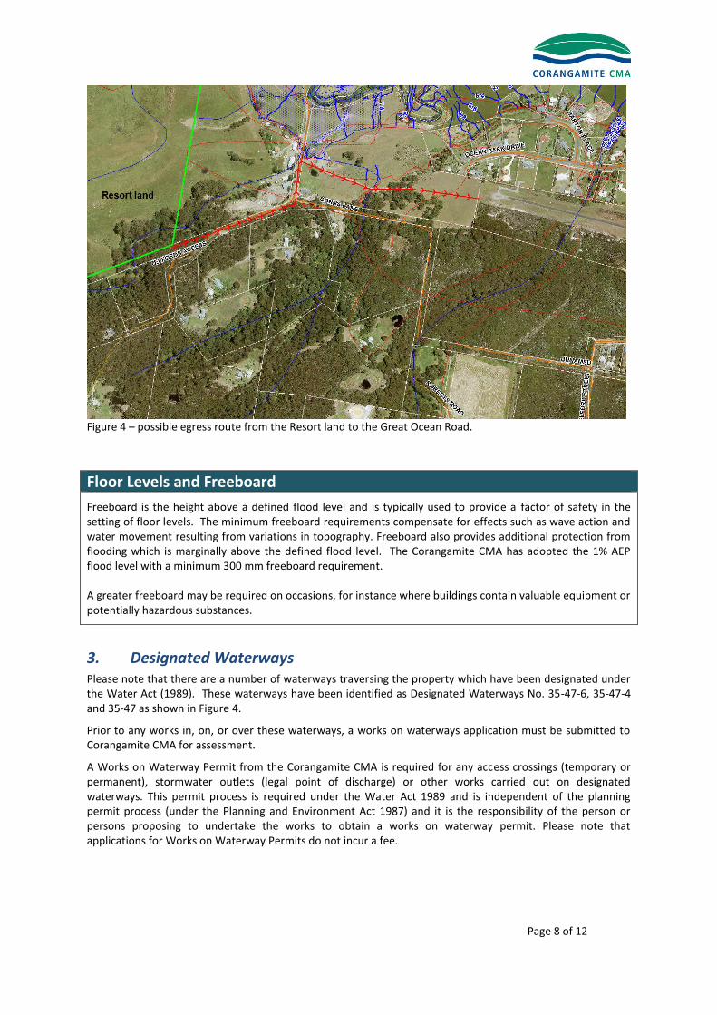
Egress from the site may be possible from the south east corner of the property via Telfords Access to Conns Lane to the airstrip or Ocean Park Drive. Some access through private property is required to get to the airstrip land as proposed in Route 2 above. Figure 4 below shows the access route as a red line.
The Corangamite CMA considers that the alternative safe access/ egress proposed in the EMP submitted are considered unrealistic or not viable. More work is required by the applicant to show that an alternative safe evacuation route from the Resort is viable.
Page 8 of 12
Figure 4 – possible egress route from the Resort land to the Great Ocean Road.
Floor Levels and Freeboard
Freeboard is the height above a defined flood level and is typically used to provide a factor of safety in the setting of floor levels. The minimum freeboard requirements compensate for effects such as wave action and water movement resulting from variations in topography. Freeboard also provides additional protection from flooding which is marginally above the defined flood level. The Corangamite CMA has adopted the 1% AEP flood level with a minimum 300 mm freeboard requirement. A greater freeboard may be required on occasions, for instance where buildings contain valuable equipment or potentially hazardous substances.
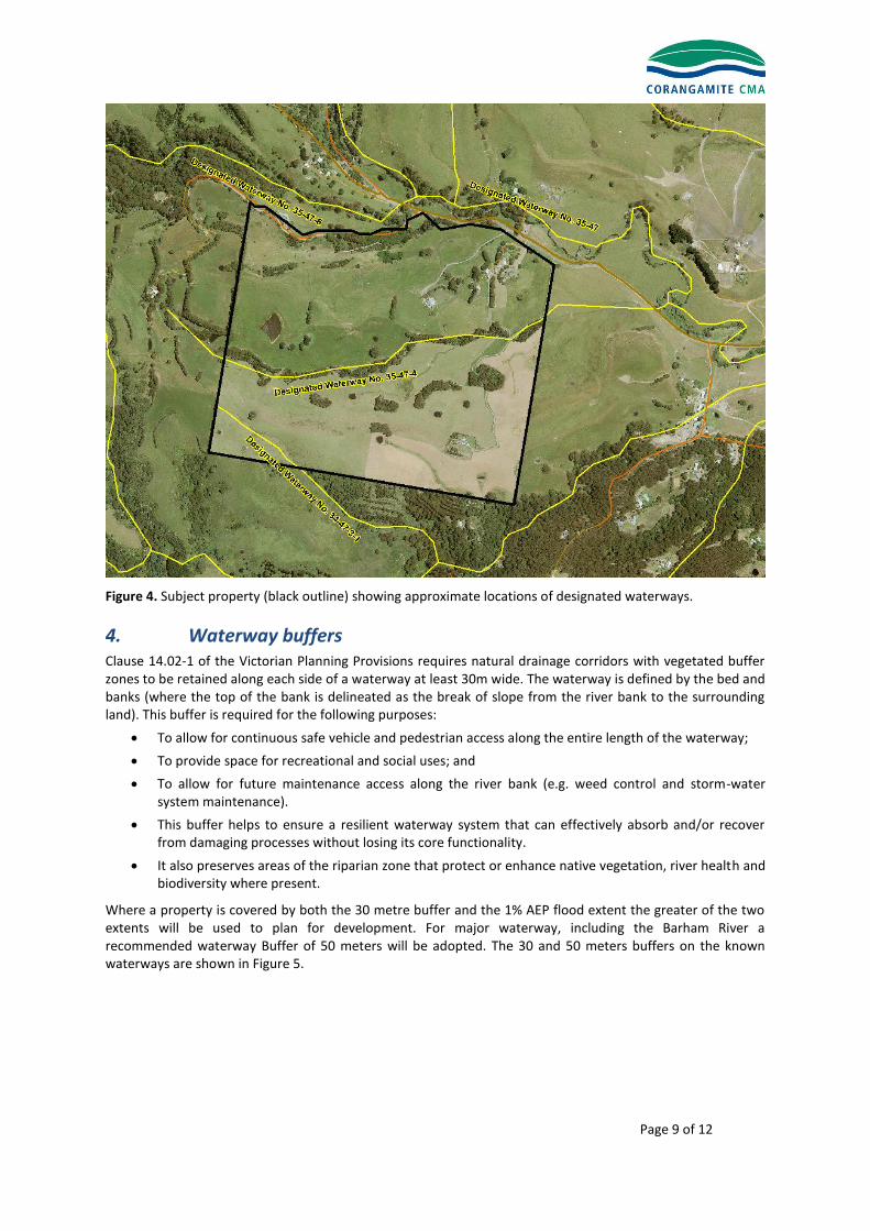
3. Designated Waterways Please note that there are a number of waterways traversing the property which have been designated under the Water Act (1989). These waterways have been identified as Designated Waterways No. 35-47-6, 35-47-4 and 35-47 as shown in Figure 4.
Prior to any works in, on, or over these waterways, a works on waterways application must be submitted to Corangamite CMA for assessment.
A Works on Waterway Permit from the Corangamite CMA is required for any access crossings (temporary or permanent), stormwater outlets (legal point of discharge) or other works carried out on designated waterways. This permit process is required under the Water Act 1989 and is independent of the planning permit process (under the Planning and Environment Act 1987) and it is the responsibility of the person or persons proposing to undertake the works to obtain a works on waterway permit. Please note that applications for Works on Waterway Permits do not incur a fee.
Page 9 of 12
Figure 4. Subject property (black outline) showing approximate locations of designated waterways.
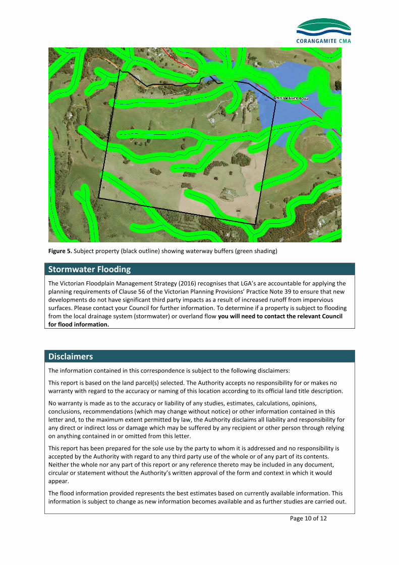
4. Waterway buffers Clause 14.02-1 of the Victorian Planning Provisions requires natural drainage corridors with vegetated buffer zones to be retained along each side of a waterway at least 30m wide. The waterway is defined by the bed and banks (where the top of the bank is delineated as the break of slope from the river bank to the surrounding land). This buffer is required for the following purposes:
To allow for continuous safe vehicle and pedestrian access along the entire length of the waterway;
To provide space for recreational and social uses; and
To allow for future maintenance access along the river bank (e.g. weed control and storm-water system maintenance).
This buffer helps to ensure a resilient waterway system that can effectively absorb and/or recover from damaging processes without losing its core functionality.
It also preserves areas of the riparian zone that protect or enhance native vegetation, river health and biodiversity where present.
Where a property is covered by both the 30 metre buffer and the 1% AEP flood extent the greater of the two extents will be used to plan for development. For major waterway, including the Barham River a recommended waterway Buffer of 50 meters will be adopted. The 30 and 50 meters buffers on the known waterways are shown in Figure 5.
Page 10 of 12
Figure 5. Subject property (black outline) showing waterway buffers (green shading)
Stormwater Flooding
The Victorian Floodplain Management Strategy (2016) recognises that LGA’s are accountable for applying the planning requirements of Clause 56 of the Victorian Planning Provisions’ Practice Note 39 to ensure that new developments do not have significant third party impacts as a result of increased runoff from impervious surfaces. Please contact your Council for further information. To determine if a property is subject to flooding from the local drainage system (stormwater) or overland flow you will need to contact the relevant Council for flood information.
Disclaimers
The information contained in this correspondence is subject to the following disclaimers:
This report is based on the land parcel(s) selected. The Authority accepts no responsibility for or makes no warranty with regard to the accuracy or naming of this location according to its official land title description.
No warranty is made as to the accuracy or liability of any studies, estimates, calculations, opinions, conclusions, recommendations (which may change without notice) or other information contained in this letter and, to the maximum extent permitted by law, the Authority disclaims all liability and responsibility for any direct or indirect loss or damage which may be suffered by any recipient or other person through relying on anything contained in or omitted from this letter.
This report has been prepared for the sole use by the party to whom it is addressed and no responsibility is accepted by the Authority with regard to any third party use of the whole or of any part of its contents. Neither the whole nor any part of this report or any reference thereto may be included in any document, circular or statement without the Authority’s written approval of the form and context in which it would appear.
The flood information provided represents the best estimates based on currently available information. This information is subject to change as new information becomes available and as further studies are carried out.

Page 11 of 12
Definitions and Acronyms
Annual Exceedance Probability (AEP) The likelihood of the occurrence of a flood of a given or larger size occurring in any one year, usually expressed as a percentage. For example, if a peak flood flow of 500 m3/s has an AEP of 5%, it means that there is a 5% (one-in-20) chance of a flow of 500 m3/s or larger occurring in any one year (see also average recurrence interval, flood risk, likelihood of occurrence, probability). Please note that the 1% probability flood is not the probable maximum flood (PMF). There is always a possibility that a flood larger in height and extent than the 1% probability flood may occur in the future. Australian Height Datum (AHD) The adopted national height datum that generally relates to height above mean sea level. Elevation is in metres. Average Recurrence Interval (ARI) A statistical estimate of the average number of years between floods of a given size or larger than a selected event. For example, floods with a flow as great as or greater than the 20-year ARI (5% AEP) flood event will occur, on average, once every 20 years. ARI is another way of expressing the likelihood of occurrence of a flood event (see also Annual Exceedance Probability). Catchment The area of land draining to a particular site. It is related to a specific location and includes the catchment of the main waterway as well as any tributary streams. Coastal flooding (inundation) Flooding of low-lying areas by ocean waters, caused by higher than normal sea level, due to tidal or storm-driven coastal events, including storm surges in lower coastal waterways. Design flood event (DFE) In order to identify the areas that the planning and building systems should protect new development from the risk of flood, it is necessary to decide which level of flood risk should be used. This risk is known as the design flood event.
Flash flooding Flooding that is sudden and unexpected, often caused by sudden local or nearby heavy rainfall. It is generally not possible to issue detailed flood warnings for flash flooding. However, generalised warnings may be possible. It is often defined as flooding that peaks within six hours of the causative rain. Flood A natural phenomenon that occurs when water covers land that is normally dry. It may result from coastal or catchment flooding, or a combination of both (see also catchment flooding and coastal flooding).
Flood hazard Potential loss of life, injury and economic loss caused by future flood events. The degree of hazard varies with the severity of flooding and is affected by flood behaviour (extent, depth, velocity, isolation, rate of rise of floodwaters, duration), topography and emergency management.
Flood level Height of flood water in metres Australian Height Datum (AHD). Can be considered synonymous with flood height and flood water surface elevation.
Flood-prone land Land susceptible to flooding by the largest probable flood event. Flood-prone land is synonymous with the floodplain. Floodplain management plans should encompass all flood-prone land rather than being restricted to areas affected by defined flood events.

Page 12 of 12
Flood risk The potential risk of flooding to people, their social setting, and their built and natural environment. The degree of risk varies with circumstances across the full range of floods. Flood risk is divided into three types – existing, future and residual. Existing flood risk refers to the risk a community is exposed to as a result of its location on the floodplain. Future flood risk refers to the risk that new development within a community is exposed to as a result of developing on the floodplain. Residual flood risk refers to the risk a community is exposed to after treatment measures have been implemented. For example: a town protected by a levee, the residual flood risk is the consequences of the levee being overtopped by floods larger than the design flood; for an area where flood risk is managed by land-use planning controls, the residual flood risk is the risk associated with the consequences of floods larger than the DFE on the community.
Freeboard The height above the DFE or design flood used, in consideration of local and design factors, to provide reasonable certainty that the risk exposure selected in deciding on a particular DFE or design flood is actually provided. It is a factor of safety typically used in relation to the setting of floor levels, levee crest heights and so on. Freeboard compensates for a range of factors, including wave action, localised hydraulic behaviour and levee settlement, all of which increase water levels or reduce the level of protection provided by levees. Freeboard should not be relied upon to provide protection for flood events larger than the relevant design flood event. Freeboard is included in the flood planning controls applied to developments by LGAs.
LiDAR (Light Detection And Ranging) An optical remote sensing technology which measures the height of the ground surface using pulses from a laser. LiDAR can be used to create a topographical map of the land and highly detailed and accurate models of the land surface. Local Government Authority (LGA) Synonymous with Council or Shire Local overland flooding Inundation by local runoff on its way to a waterway, rather than overbank flow from a stream, river, estuary, lake or dam. Can be considered synonymous with stormwater flooding.
Planning Scheme zones and overlays Planning Schemes set out the planning rules – the state and local policies, zones, overlays and provisions about specific land uses that inform planning decisions. Land use zones specify what type of development is allowed in an area (e.g. urban (residential, commercial, industrial), rural, environmental protection). Overlays specify extra conditions for developments that are allowed in a zone. For example, flooding overlays specify that developments must not affect flood flow and storage capacity of a site, must adhere to freeboard requirements, and not compromise site safety and access.
Riverine flooding Inundation of normally dry land when water overflows the natural or artificial banks of a stream, river, estuary, lake or dam. Riverine flooding generally excludes watercourses constructed with pipes or artificial channels considered as stormwater channels.
Runoff The amount of rainfall that drains into the surface drainage network to become stream flow; also known as rainfall excess.
Storm surge The increases in coastal water levels above the predicted tide level resulting from a range of location dependent factors such as wind and waves, together with any other factors that increase tidal water level.
Stormwater flooding The inundation by local runoff caused by heavier than usual rainfall. It can be caused by local runoff exceeding the capacity of an urban stormwater drainage systems, flow overland on the way to waterways or by the backwater effects of mainstream flooding causing urban stormwater drainage systems to overflow (see also local overland flooding).