Embed Size (px)
Citation preview
:r';
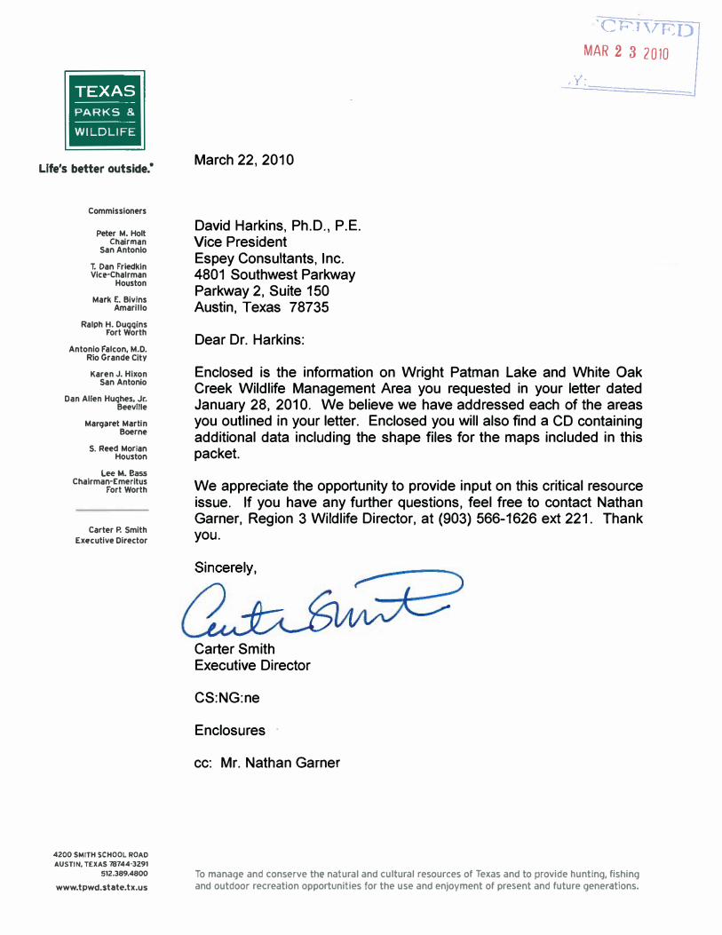
TEXAS PARKS &
WILDLIFE
Life's better outside:
Commissioners
Peter M. Holt Chairman
San Antonio
T. Dan Frtedkin Vic.'Chalrman
Houston
Mark E. Bivins Amarillo
Ralph H. Ouqgins Fort Worth
Antonio Falcon, M.D. Rio Grande Citv
Karen J. Hixon San Antonio
Dan Allen Hughes. Jr. Beeville
ManjJluet Martin Boerne
S. Reed Morian Houston
Lee M. Bass Chairman-Emeritus
Fort Worth
Carter P. Smith Executive Director
4200 SMITH SCHOOL ROAD AUSTIN, TEXAS 78744-3291
512.389.4800 www.tpwd.state.tx.us
March 22, 2010
David Harkins, Ph.D., P.E. Vice President Espey Consultants, Inc. 4801 Southwest Parkway Parkway 2, Suite 150 Austin, Texas 78735
Dear Dr. Harkins:
'CF'lVRDMAR 2 3 2010
Enclosed is the information on Wright Patman Lake and White Oak Creek Wildlife Management Area you requested in your letter dated January 28, 2010. We believe we have addressed each of the areas you outlined in your letter. Enclosed you will also find a CD containing additional data including the shape files for the maps included in this packet.
We appreciate the opportunity to provide input on this critical resource issue. If you have any further questions, feel free to contact Nathan Garner, Region 3 Wildlife Director, at (903) 566-1626 ext 221. Thank you.
Carter Smith Executive Director
CS:NG:ne
Enclosures
cc: Mr. Nathan Garner
To manage and conserve the natural and cultural resources of Texas and to provide hunting, fishing and outdoor recreation opportunities for the use and enjoyment of present and future generatIons.
Endangered Species Potentially Impacted by Raising Wright
Federally Listed Species
Impacts of Raising the Elevation of Wright Patman Lake above 230 Feet
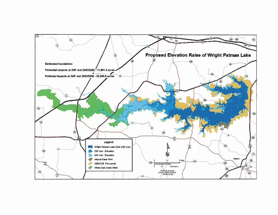
Texas Parks and Wildlife has been asked to provide infonnation and data regarding the impacts of raising the pool elevation level of Wright Patman Lake to a maximum of 240 feet on White Oak Creek Wildlife Management Area (WOC WMA), Altanta State Park and the surrounding United States Anny Corps of Engineers (USACE) land. In a letter from Luke Baker, Area Biologist of WOC WMA, dated August 17, 2009, he stated "while 230' could be a tolerable maximum elevation a more accurate analysis of increased flood severity must be completed before a detennination can be made." Any level above a 230 feet elevation would certainly have direct impacts on the natural resources and TPWD management capabilities.
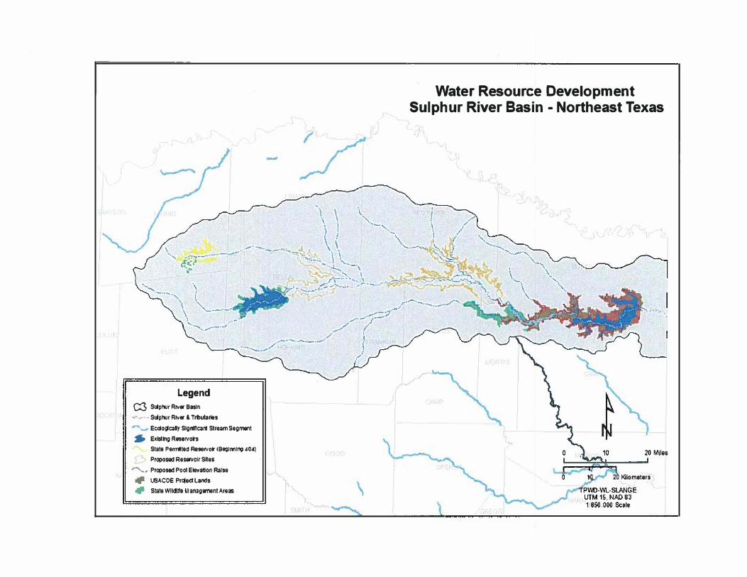
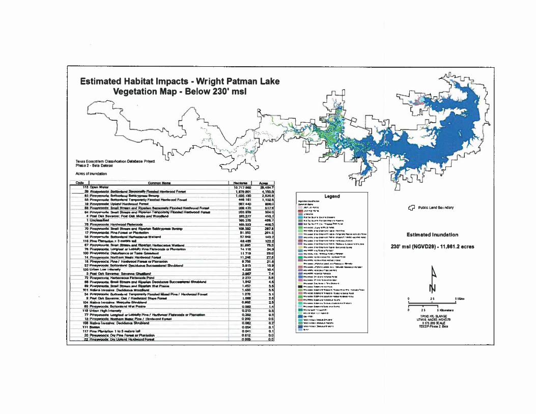
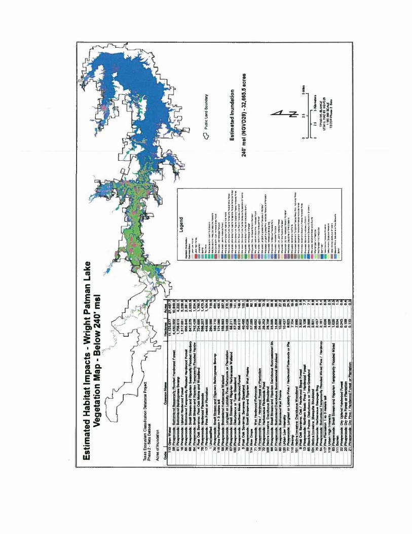
Wright Patman Lake is located on the Sulphur River near Maud, Texas. The 25,777 acres of WOC WMA is situated just west of the lake, contiguous with other USACE lands. These lands comprise one of the largest, highest rated, intact tracts of mature bottomland hardwood habitat remaining in East Texas. This large extensive tract of bottomland hardwood forest creates a critical corridor of high quality habitat for resident and migratory wildlife species. The mature bottomland hardwood forests along this portion of the Sulphur River and its associated tributaries also provide habitat to over 500 species of vertebrate animals and 1,150 plant species. These forests support over 50% of the neo-tropical migratory bird species in the United States for a portion of their life cycle. It is one of three highest rated habitats for black bear in East Texas, with the eastern most portion of this forest lying within the range of the federally listed Louisiana Black Bear. Elevating the level of Wright Patman Lake will result in fragmenting this large tract, negatively impacting the wildlife species dependent on this habitat. GIS analyses of these lands indicate that over 32,000 acres of prime bottomland habitat will be inundated at the 240' elevation. Current management practices on WOC WMA at the existing lake level provide a premium habitat for a variety of game and nongame species. As the lake level is increased, a proportionate loss in public hunting opportunities and other outdoor recreation activities that are vigorously pursued in this area will result.
and Threatened the Elevation of Patman Reservoir
There are a number of federally listed endangered and threatened species that have been recorded as occurring, or potentially occurring within Bowie, Cass, Morris and Titus Counties, Texas, that may be adversely impacted by raising the pool elevation at Wright Patman Reservoir in northeast Texas. These species include: American Peregrine Falcon (Fa/co peregrinus anatum), Arctic Peregrine Falcon (Fa/co peregrinus tundrius), Bald Eagle (Haliaeetus /eucocepha/us), Piping plover (Charadrius me/odus), Louisiana black bear (Ursus americanus /uteo/us), and Red Wolf (Canis rufos).
The American and Arctic Peregrine Falcon are both currently federally de-listed, but remain on the state's list as a threatened species, and for monitoring purposes. Both subspecies are low-altitude migrants through these counties and would utilize a wide range of habitats
during their migration. They have been recorded as making stopovers at leading landscape edges such as lake shores. Though there would remain a lake shore edge regardless of the elevation of the reservoir, the adjacent bottomland hardwood forest and shallow wetland habitats would decline with the proposed change in elevation resulting in loss of quantity and quality of these habitats, and subsequent losses in prey available to these birds.
The Bald Eagle popUlation in eastern Texas has been steadily increasing since use of DDT was outlawed. The Bald Eagle is currently federally de-listed, but remains on the state's list as a threatened species, and for federally required monitoring the first 5 years following delisting. This part of the state has both migratory and nesting bald eagles that utilize the habitats at Wright Patman Reservoir and White Oak Creek Wildlife Management Area ( WOC-WMA). Bald Eagles utilize dominant canopy trees in mature forests nearby wetland habitats and reservoirs, and there could be significant loss of these potential nest trees through inundation of adjacent bottomland hardwood and other types of forests. In addition, availability and richness of prey items for Bald Eagles is greater in bottomland hardwood forests with their associated shallow wetlands than in open, deep water areas.
The Piping Plover is currently federally and state listed as a threatened species. This species is a wintering migrant along the Texas Gulf Coast and has been recorded in this part of northeast Texas. This species utilizes shallow mud flats in this part of its range. The upper end of Wright Patman Reservoir and some larger sloughs along feeder creeks like White Oak Creek contain significant mud flat habitats that would be lost by raising the elevation of the reservoir. The amount of habitat lost would vary from year to year based upon flooding, or lack thereof during dry years.
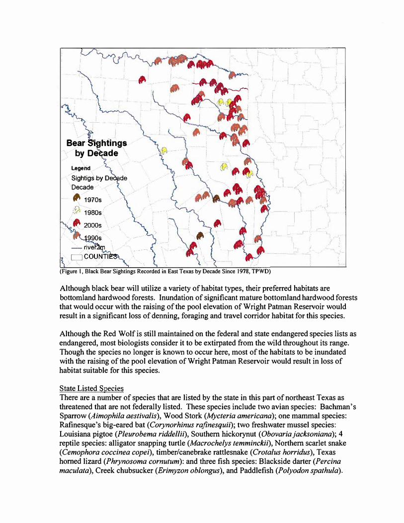
American Black bear (Ursus americanus) and Louisiana black bear are on the boundary of their species and sub-species ranges within this area, both subspecies are considered as federally threatened within Cass County due to similarity of appearance, and all black bear are protected throughout Texas as a state-threatened species including Bowie, Morris and Titus Counties. The bottomland hardwood forest within this section of the Sulphur River watershed is ranked among the highest quality black bear habitat in East Texas. The Texas Parks and Wildlife Department has been recording black bear sightings since 1978. Figure I shows that there have been numerous black bear sightings verified in northeast Texas, including the Sulphur River Basin, over the past few decades. A large number of those sightings occurred within the past decade, including at least one fairly recent sighting within WOC WMA.
:)'),
··1
I ..
r
I
, -
Species
Bear htings by De ade
\ gerid
Sightigsby D Decade ,. 70S
1980s
, .
(Figure I, Black Bear Sightings Recorded in East Texas by Decade Since 1978, TPWD)
i.. _
Although black bear will utilize a variety of habitat types, their preferred habitats are bottomland hardwood forests. Inundation of significant mature bottomland hardwood forests that would occur with the raising of the pool elevation of Wright Patman Reservoir would result in a significant loss of denning, foraging and travel corridor habitat for this species.
Although the Red Wolf is still maintained on the federal and state endangered species lists as endangered, most biologists consider it to be extirpated from the wild throughout its range. Though the species no longer is known to occur here, most of the habitats to be inundated with the raising of the pool elevation of Wright Patman Reservoir would result in loss of habitat suitable for this species.
State Listed There are a number of species that are listed by the state in this part of northeast Texas as threatened that are not federally listed. These species include two avian species: Bachman's Sparrow (Aimophila aestivalis), Wood Stork (Mycteria americana); one mammal species: Rafinesque's big-eared bat (Corynorhinus rafinesquii); two freshwater mussel species: Louisiana pigtoe (Pleurobema riddellii), Southern hickorynut (Obovariajacksoniana); 4 reptile species: alligator snapping turtle (Macrochelys temminckii), Northern scarlet snake (Cemophora coccinea copei), timber/canebrake rattlesnake (Crotalus horridus), Texas homed lizard (Phrynosoma cornutum): and three fish species: Blackside darter (Percina maculata), Creek chubsucker (Erimyzon ob/ongus), and Paddlefish (Polyodon spathula).
Though there are relatively few acres of upland forest types that will be inundated by raising the pool elevation of Wright Patman Reservoir, there are some. One species that occupies pine savannah forests that could potentially be impacted on those habitat types is Bachman's Sparrow. Two species that occupy upland sites with sandy soils regardless of overstory forest type that could occur on some of the upland sites are Northern scarlet snake and Texas homed lizard. Though there are somewhat more acres available for these species than in pine savannah forests, there are relatively few acres of these types to be inundated. However, the sites that are to be inundated are of generally high quality with mature vegetative communities that are fairly intact. More exact information on the vegetative communities and acreages to be inundated can be found in the appendix of this document.
There are significant habitats available for Wood Stork within the upper reaches of Wright Patman Reservoir, and within the bottomland hardwood forests and associated sloughs of the reservoir and WOC WMA. Though the Wood Stork is only listed as state threatened in Texas, its status is much more drastic in areas of the eastern Gulf Coast states. Wood Storks are often seen during summer months in the upper end of the reservoir and wetland areas upstream of the reservoir and on WOC WMA. Though there are no breeding records available for this area, there are areas of suitable habitat currently available for that activity now and in the future. This bird species needs shallow wetlands for foraging. There could be significant loss of shallow wetlands that will be converted to unsuitable deeper water habitats with the proposed raising of the pool elevation of the reservoir.
Rafinesque's big-eared bat is considered by all states within its range across the southeastern United States to be in decline, and Texas certainly is no exception. This species preferred habitat across its range is mature bottomland hardwood and various other types of mature floodplain forests. Though this species will roost in abandoned man-made structures, it prefers natural caves (further east) and mature trees with natural cavities and hollows. These mature trees are a product of older, later-successional forests. So, this species has lost significant habitat across its range to inundation associated with reservoir construction, to short rotation forest management, and conversion of some drier bottoms and mesic sites to commercial pine plantations. Since most of the forests to be inundated by the raising of the pool at the reservoir are either mid- or later-successional or older forests, and the management strategy for those forests is largely aimed at producing naturally functioning bottomland hardwood forests, all of this habitat to be lost could potentially be habitat for this speCIes.
There are significant gaps in knowledge concerning mollusk species within most areas of the state, and northeast Texas is no exception. There are a dozen or so species that are currently under study for potential listing in Texas, many of these occurring in northeast Texas. Two currently state listed threatened species that may occur within the area to be inundated with the raising of the pool elevation of Wright Patman Reservoir include Louisiana pigtoe and Southern hickorynut. There is potential loss of habitat for these species within the proposed project area; further study would be needed to ascertain the exact impacts.
The alligator snapping turtle occurs throughout the Pineywoods of East Texas, and within many portions of the Post Oak Woodlands and Prairies of East Texas. Though this species could likely survive an inundation through raising the pool elevation of Wright Patman Reservoir, it is uncertain how this will actually affect population numbers. Much literature profiles this species as occupying deep water, but "deep" is a relative tenn. Ricky Maxey, Wildlife Diversity Biologist with TPWD, has captured these turtles in fairly shallow creeks many miles from any deep water reservoirs. Shallow water habitats that intersect, or are nearby deeper habitats will support these turtles. Mr. Maxey observed one such resident alligator snapping turtle in about 3.5 feet depth ( this was "deep" compared to the majority of this stream) of water in late summer, and it was very healthy. These shallow water habitats are generally rich in both numbers of species and quantity of prey available for foraging that may not be replicated in deeper water habitats. Therefore, considering food availability as a factor, though the species may survive the habitat loss to inundation, its populations could be reduced as a result of that inundation.
Though the timber/canebrake rattlesnake will occupy a variety of habitat types, its preferred habitat type is bottomland hardwood forest. All of the habitats to be inundated by the raising of the pool elevation of Wright Patman Reservoir are suitable habitat for this species. Therefore, all habitat lost in this inundation will be habitat lost for this species.
There are three fish species that are currently listed as threatened by Texas Parks and Wildlife Department that could occur within the Sulphur River and its tributaries above Wright Patman Reservoir and along White Oak Creek.
The blackside darter has been documented to occur within streams of the Red River Basin. The Sulphur River is a tributary of the Red River, and flows into the Red River in Arkansas approximately 20 miles east, southeast of the Wright Patman Reservoir Dam. This species prefers clear, gravelly streams, quiet pools and pools with riffles. Any feeder streams within the areas to be inundated by the proposed raising of the pool elevation of Wright Patman Reservoir that currently meet these requirements would no longer be suitable habitat for this species.
The creek chubsucker has been noted as occurring in tributaries of the Red River Basin in small rivers and creeks of various types; particularly in upstream creeks and headwater streams. The species seldom occurs within impoundments. Young of this species are known to use headwater rivulets or marshes. This species spawns in river mouths or pools, riffles, lake outlets and upstream creeks. These types of shallow water habitats would be converted to deep-water habitats within the areas to be inundated with the proposed raising of the pool elevation of Wright Patman Reservoir.
The paddlefish is in peril throughout its range in Texas, and is not doing well. This species prefers large, free-flowing rivers. It migrates to spawn in fast, shallow water over gravel bars. It has been noted to frequent impoundments with access to spawning sites. Its larvae may drift from reservoir to reservoir. Basically all of the shallow streams upstream of Wright Patman Reservoir, including White Oak Creek, where these conditions might be met could be made unsuitable if inundated and made into deepwater habitats.
http://www.twdb.state.tx.usIRWPG/rpgm rpts/lnstreamFiows SulphurRiver.pdf
Inland Fisheries
During the late 1990's and extending into the early 2000's a significant effort was made by the Texas Water Development Board and others to evaluate instream flow needs of the Sulphur River upstream of Wright Patman reservoir in response to several potential reservoir projects identified in the regional water planning process. George Parkhouse I ( North), George Parkhouse II (South) and Marvin Nichols I and II. Although TPWD was not directly involved in the conduct of these studies, River Studies staff was consulted during the study design phase and reviewed drafts of reports prepared by the TWDB and their contractors. The downstream most proposed project was Marvin Nichols Reservoir; both iterations of this project would be upstream of Wright-Patman and the proposed Marvin Nichols Dam would be on the Sulphur River near the 240 foot elevation - close to the U.S. Hwy 271 Bridge near Talco. I would suggest that Espey Consulting refer to the completed study (Osting, Mathews and Austin 2004) which can be found at the following link:
This study provides a comprehensive evaluation of the fish communities of the Sulphur River immediately upstream of Wright-Patman Reservoir. Study site two in this report is located in the area that would be inundated by an increase in the elevation of Wright-Patman. It is worth noting, however, that the elevation of Wright-Patman is frequently near 240 ft amsl; during the studies mentioned above we observed difficulty calibrating hydraulic models due to backwater effects from Wright Patman.
White Oak Creek WMA
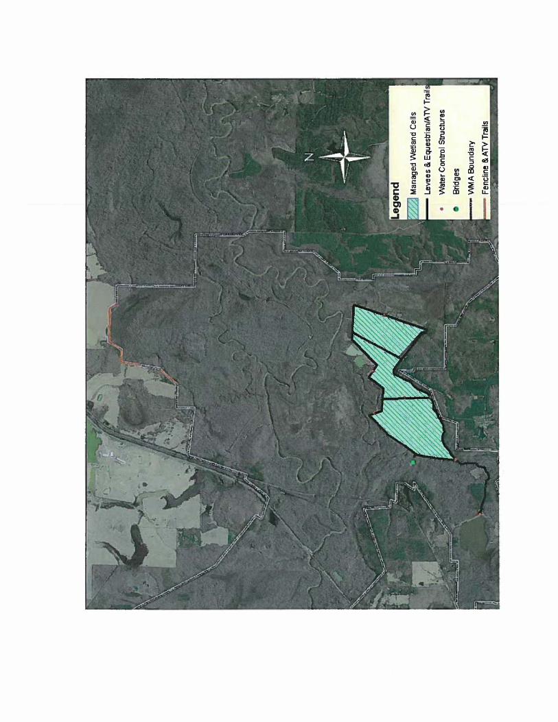
The following is a list of infrastructure that would be affected by permanently increasing Lake Wright Patman water levels. (See map in appendix)
230' No infrastructure should be affected.
235' Two water control structures Three managed wetland units (480 acres) I concrete bridge
240' In addition to everything under 235'
8 water control structures 1 high water bridge 7.32 miles of levees 10 miles of equestrian trails 11.5 miles of A TV trails
1.5 miles of boundary line 3,596.2 acres of public hunting land
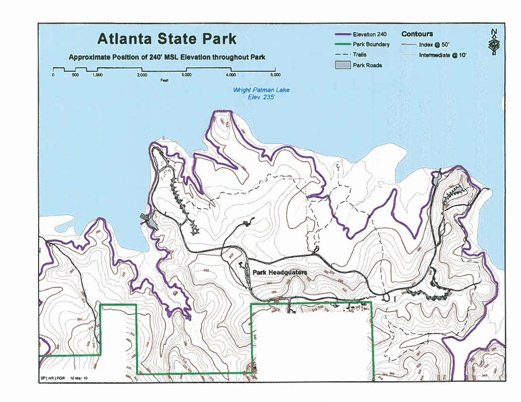
Atlanta State Park
Impacts to Atlanta State Park would include the loss of approximately 2,421 feet of trails and parts of both boat ramps. See maps in appendix for detailed information.
Contributors of data and information to this document were:
Luke Baker, Area Biologist, White Oak Creek WMA, TPWD
Kevin R. Herriman, Project Leader, Northeast Texas Ecosystem Project, TPWD
Stephen Lange, GIS Specialist, Regions 3 and 4, TPWD
Ricky W. Maxey, Wildlife Diversity Biologist, Wildlife District 6 - East Texas Pineywoods, TPWD
Doyle Mosier, Director, River Studies Program, TPWD
Kody Waters, Park Superintendent, Atlanta State Park

Appendix
5.
Index to Digital Data
Maps
I. Water Resource Development, Sulphur River Basin - Northeast Texas
2. Proposed Elevation Raise of Wright Patman Lake
3. Estimated Habitat Impacts - Wright Patman Lake, Vegetation Map - Below 230' msl
4. Estimated Habitat Impacts - Wright Patman Lake, Vegetation Map - Below 240' msl
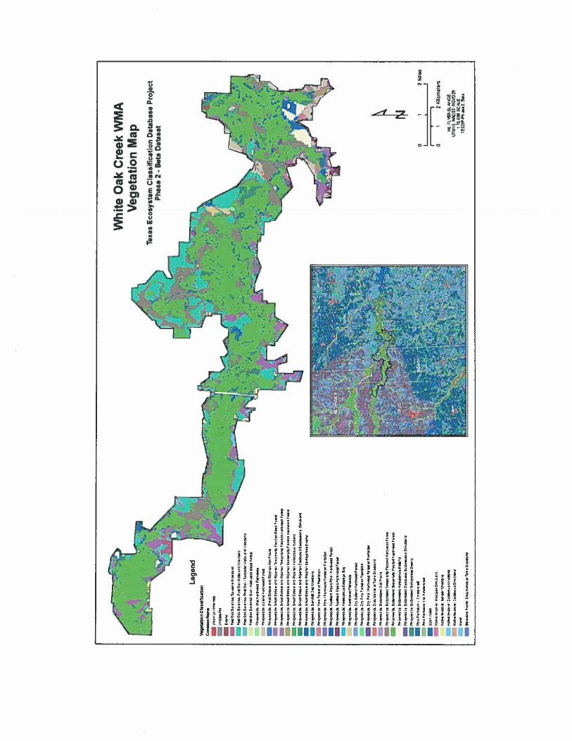
White Oak Creek WMA, Vegetation Map
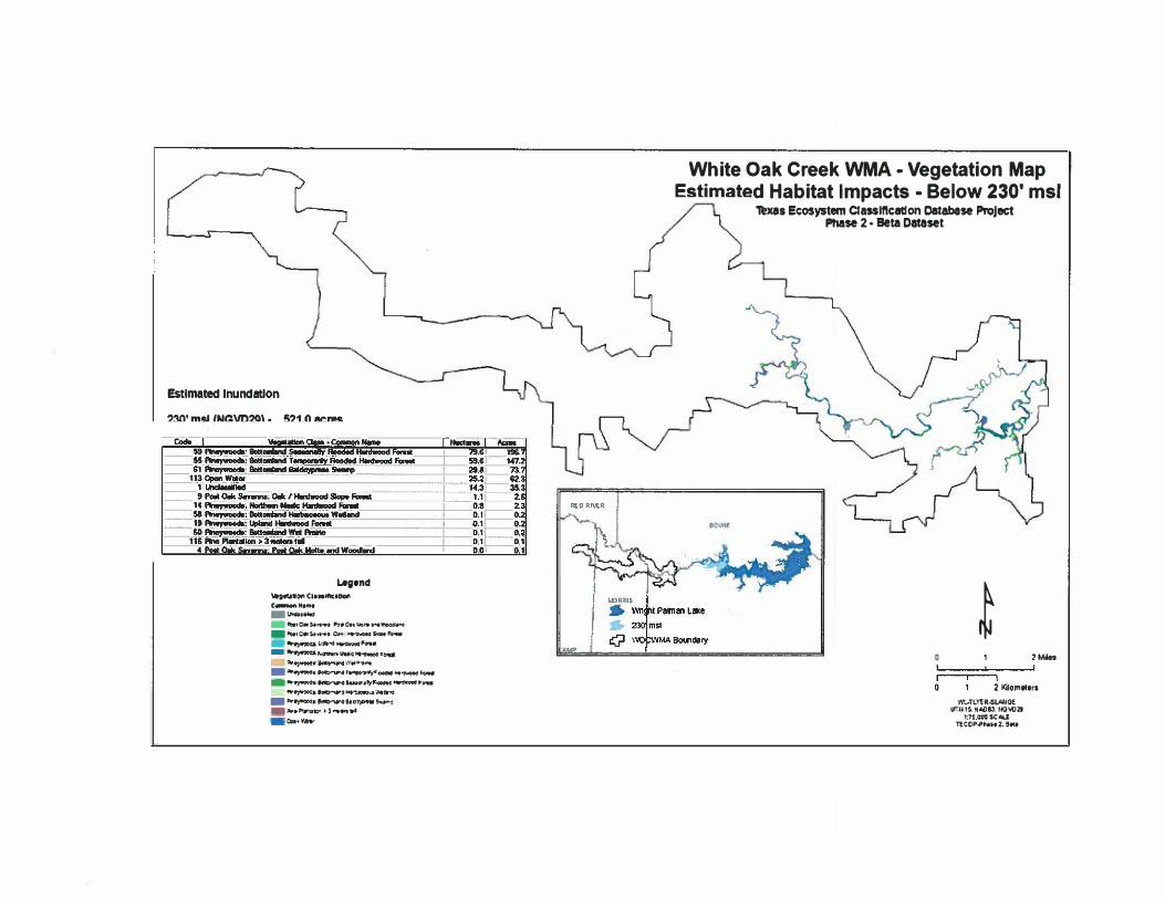
6. White Oak Creek WMA - Vegetation Map, Estimated Habitat Impacts - Below 230' msl
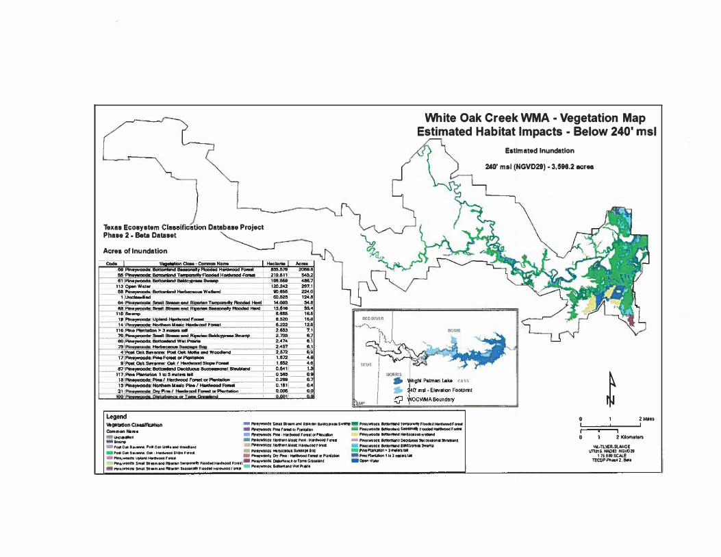
7. White Oak Creek WMA - Vegetation Map, Estimated Habitat Impacts - Below 240' msl
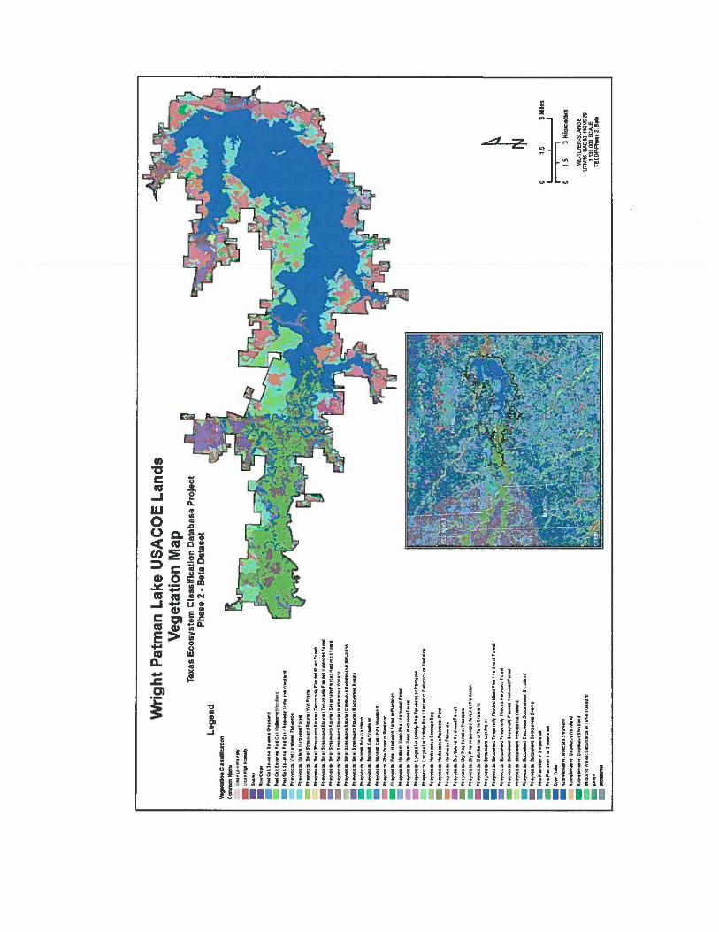
8. Wright Patman Lake USACOE Lands, Vegetation Map
9. Lake Wright Patman USACOE Lands - Vegetation Map, Estimated Habitat Impacts
Below 230' msl
10. Lake Wright Patman USACOE Lands - Vegetation Map, Estimated Habitat Impacts
Below 240' msl
II. Lake Wright Patman Adjacent Private Lands - Vegetation Map, Estimated Habitat
Impacts - Below 240' msl
12. White Oak Creek WMA, Infrastructure Impacts
13. White Oak Creek WMA, Wetlands
14. Atlanta State Park, Topography Map
15. Atlanta State Park, Infrastructure Impacts
Other Documents
I. Texas Ecological Systems Phase 2 Interpretive Guide
2. Texas Ecological Systems Phase 2 Interpretive Guide Appendix I
Data Folders
I. White Oak Creek WMA
2. Texas Ecological Systems Classification - Vegetation Clips

Map Data Disclaimer - Information
Maps compiled by: Stephen D. Lange, Regional GIS Specialist, TPWD-Tyler, TX.
Date: 03/10/20 I0
These maps were compiled using geographic information systems software. While care has been taken to preserve the quality of the data; transformation, geographic, mathematical, format and structure errors may have been introduced to the data. TPWD makes no representations or warranties regarding the accuracy or the completeness of the information depicted on these maps or its suitability to any particular use. The requestor must be aware of data conditions and ultimately bear responsibility for the appropriate use of the information with respect to possible errors, original map scale, collection methodology, currency of data, and other conditions specific to certain data. Unless noted all maps are UTM Zone 15, NAD 1983, NGVD29.
Question should be directed to:
Stephen D. Lange
Regional GIS Specialist (TWIMS) Wildlife Regions III & IV 11942 FM 848 Tyler, TX 75707 Office: 903/566-1626 x208 Cell: 903/279-5145 Fax: 903/566-3273
/
-.-.-....".., . ":';
" :--" --£;:,- "--.., J..":--.,
'\ \ ;
"
'------.
.....-......
-
'\ \\ \) ,\ ! \ I,. -" . .
': , \ ..-. -.-...
...., ... .
. ) '-._.".
... . . \' \
' ..........._ ........,
\-/.;0-:'::» ·-.. '
. .--.... .. ...
,. .........
. .....
.
._.-- ..
...... /
.. -
. -
.. .,..
/' ' '
-' '-
-' ' -'
-' -
'' /
LegendC3 S poor RIVet Basin
.............. StAphur River & Trbutaries
"-' Eooogicaly SlgQflcart stream SeglT'llll'lt
Existing Reservors
State Perrrtted ReselVOIr (Beginning 404) Proposed Reservoir Sites
... Proposed Pool Elevation Raise
• USACOE Prcjed Lands
.. stale Wllcllf8l.lanagernentAreas \
Water Resource Development Sulphur River Basin - Northeast Texas
,"=". ' ..
20 Miles
Kilometers
(NGVD29):
,. .,
Estimated Inundation:
Potlentlallmpacts at 230' mal 11,961.2 acre. ,---------,
Pollontallmpaets al240' mIl (NGVD29) - 32,665.5 aeros
III Wright Patman Lake (224'.228' mSI)... 230' mal - Elevation .. 240' ms!- Elevation t .. Atlanta State Park "4' USACOE Fee !.ands " , White Oak Creek WMA
"""""" ""- tt.cIiiiW"1 "113 --opi"-We1er -- - --
1,878.11101 1SO.a' 2,1520.111 1,102.6,
,....... siNMo---.;;rp'ii""F' trFbiid.d H T - H 4��9:-! :. _9.!*��_,,! ____
408.' 7lI Pi... '*"-d 185.323
.U", "' ...
... 207.' 20U
. ___ 022> L
. • 11.71t
: =,'��:!=--:;;::----------- . .-'" �LG! jrt� ________ +_ $.e1$ . . ".
, Punci
: ' --.ID" H.; '''''
" .4fiII urn
naM--
"l& .. .• .... .B:! 21.8 IS.' , .. 7.'
. a., ••• .. .. .. .. ..
l;Ulban�-:n":t - W-�'---------------+--&!!!JfIO!09IL
111 _ _ . Pln.W!M�':..QIy PlNJOIMl..!!!!:'I"1ItIon.
., .,
.012 •• 1 •
. ..... -,. ......
. ..
... ....
1_ -
.... . ... ,
Estimated Habitat Impacts - Wright Patman Lake Vegetation Map - Below 230' msl
Te BS Ecosystem Classification Oet8beSi PrOJect Phese2· Beta Oeteset
Acres ollnunclatlon Act.
10,717.l1l8I) 28,484. �IJI�:!,"'.!,.J�ottonlend [Iaaded Hllntllrlllld "- ..
.1 Pi"! BottIIIIIendBeldcypr.-""" 1,mo.l«)55 Pi_""-- ndTeIIpOIWIIyFlDoded ........1IIId F_ ......1811. Pineywaodll: up.nd FQr.,ooI 3117.440 1108. .. Pi... inIiil ___ """ 2084jQ -- 1I17. .. PiIMJ'WCDdll; SIMI. ..., RipIriIwI rw..I 203.878--- n:
:! ___ �I1 UIIC.....6td 181:1.318
70 Pi_,..aod&: SmIII n 17 PI...,wooft: PI FOIIMI GfPlentlnlon
'''''58 Pi...,........., nd W.I'-d 116 PI... 1DdcIn_" 3 .. .n Pi." s...Irs.- .... _w _
Ine78 Pi LongIMI Of LobICIIIy PI_F..1wOO:Is ar PlarolatiDn 100 PI II; DlMurbencecwT_ o.-IencI
--,:! __ Suc___IShnAMnd
, ...,. 01.. sa.....: se._ Gr.IIIInd 2.72 Pi...,.aod& 2.7nIII-Pi ' 8nWI au- CIIlCII o.cicI UOII8 8uceMIiGMl etJ\IbIand . , KGlit PI SnaIl 9tNsn .... w.Pram.
.......: 0ecIduIIw wOCldiOncl54 Pi,..,...,...s.: BonanoIII... T......,..;IyFloaded Mi..t Pi..., .............. F_
a A... s........: OM I H Slape FonoiI 1.1I8IS --'D4'N.tiv. .....a.Y.: ..t..-ShubIaNI -
,,.,---�,.• 77 Pln...,aodll: I.arVfeIIII' crLDblollyPIne' tfDnIwaCId n.w•• Dl'PIonIetlDn
13 NDnMm MIllie Pi_ I .......GOd I'cnIIItOS N._lrw,..,.: o.ckIuouI ShrWlMld
_ _ _ 117 Pi... ,..., 1I1;1S ....... leII
U1S 0.$.....
.....
.... .,0.041 .,
................ -.-
_ ......."
Legend
....... ••r.. .......... ,. ....... ...,..._..._......,........... .. __...... _ ...........,........,=-_......,... r....· .... .. ....._.......... ...... •___... R......- ...-..-... .., ........... .----,- .............,... .......,--...." .........-.... .......,- L""......'_.;..-:I ....,-......... "" ...'.................._.,.,............. .....""".... ..-"... --...-, ...... ..........-.,..
................ ...........'''''......... ,.... ..-....-.."'-,
-...-. ..- ...,--.....-....................,.............- ....."......"..........,,,.. ......._ ....--_."..............-.................................... _ ....-..-..... .... ..-_. ._..._..............- --,-,-..........-................,......... ..........,._... ......"._.._ ....
..-,._......_....,........-.,_. ..,._.,_...."'......,-.-.....""........., ...........,.....,
... .......... - ...... _. ...M......' "-,....... _..M......'-....""'...•"'ftt......,-....._·, ......
Q Public Land 6o:::ndary
Estimated Inundation
230' mol (NGVD29) .11,981.2 ocro•
t 25 UAilt•
25 51<10__ iP\\tl·WlAilN4Qf
UTM15 HAD8J NGVOI 175 000 OCALE
TEtDP-Pb... 2 at"
'j"1 /I t!. I I "
! ::i a;- d. Z ·
· J _
·
I'll...I CI'll
sI'll E0...
_0..,DIN ·C :tt:1:.2, CII
111m - , g Q.Q.I'II E:::E
_c J! .2
._ -.cJ!I'll CII:I:DI al 1;;E :;IIIW
.B !v"
\)
I .," .
. J1111
• c ;
J i i-lI .. c [" I.!;.E
... N$ 0 • " e>• · . - .S '" ;; !!. w ;; ·
Eio
.d Z -
0
. !
0.2
1l•2'
c( ... • m
.aQ. s_m m o·cl!l,lII:!'II omGI:::E .,0I!:! I: 3s
oGl,lII:-!'IIJ!!
!S
J:ol
Cl
i6'
l2gwig4"...= I
i!5 "[: ...
0uw•mxt!
.. "'-'I!" .. •
Estimated Inundation
230' mol (NGVD29)· 521.0 acres
Legend'OI'ICI ... IIIc'1IotI
- .. _u.u._ _ ,C"'k""" .... 0 ............ -.. _....,0.<"..... c.. ...__ _ . "...,. . _ r.ru'=IiI_·_
...... _ .,_T""'""' _ .. _Fo-.OI -... -=-.I)"- "' .....
I¥f)'O'ml!; _= ..-o-....... ao..,. _ t)'W<I'>\!"' !f s..,..: _ "'" PIr"1O"· • 3 ........ _ee.,.,._
.ro,
White Oak Creek WMA • Vegetation Map Estimated Habitat Impacts· Below 230' msl
xa. Ecosystem Cla .. lftcatlon Database PrQJoct
_m • EleVallcn Footpl1l1
Phase 2· Beta Dataset
t 2MiIn
2 Kilomtt.rs wt..-TL\1'R.sl""IGE
WillS, NIiil$l lI01ID2I 1:7 .OOO seAl.!
nCtlPoPhtt2. eN
Clanific,"tion
Legend
_ ....... _ ,.,.. • _PtllI P\lIfIIaIIOII l
I
White Oak Creek WMA - Vegetation Map Estimated Habitat Impacts - Below 240' msl
Texas Ecosystem Database Project Phase 2 • Beta Dataset
Acres of Inundation
• EI....ation Footpri'll
...-gIItattonCIQllfk:llkln - I'*If)'WOOCII: SlNI SIr.m"" R"",... aa""'",.Bs,..,.._PlIM/WOIoCI. T F_dHant_F_
Carnl'lon...... _ Ptllr_or I..lDn _Plntr_ SInInIIIt'IOOdtcI f_ _ _ PlnltH.ctt.oodFor.ll"'P"''' Plfttr__HtItIICIIO....W""'"
.l"WIt)'WOOar llOmtrnUttt l"i'I'jH fOtlIl _ I'IrIll'WlliICIlllOllOtrWl'DtClO.lO\ll""CII..on."'Mllina 0....._POll on uoa...... _...G _F"IIIt'/WOOalNOlfltrnw.tt H.fltlljl)O(lfOtlIl _""",_, 8"'DI'tW
I>0Il 0...,..._o"", , ...._s..... ,...'" _l'IIIt)'YIOOCI"HlllllaetMSI..,a",el)) ......nl3ll . .....,.....n:u,IW __f.... _PIft9rwoodl OryPftlr F_.p!lnlnon _Pinll'IanIiIbonlIGllI'III.w.taII
PIrI. $..... lIIIm_ ......T.........,. '_odH_OOCI foc.ll-PIn,,wwds: o..tIanctarT_Cr.n:&llnd _Optn W36tr.PWOlfW"n: $mit ".m""'''I111"" 'U_Ifr'_ H_ rOtl. - PIn "" andWItI'f*lt
Estimated Inundation
240' mal (NGV029) -3,588.2 aer..
o 2 MIIu
o 2 lOomltll$
.....:n.'oER.SUliGE UTU15. HI\OIJ HG\r1l2S1
l1UOOSCALE TECl)P-PII... 2. 8411,
<tz
-.c01'I: 3:
. ... . ... ... ...
. .......
_
. ...
. .... ,
.... -
. -
Lake Wright Patman USACOE Lands· Vegetation Map Estimated Habitat Impacts· Below 230' msl
Estimated Inundation
230' mIl (NGVD29) • 11,502.5 acres
Texas Ecosystem Cla.liftcation Database Project Phase 2 • Beta Dataset
Acres of Inundation
...... -.-.... ..... ...
. ........
"""
- .. .." ..., ......,......,_ ......"...........,_.................... ................,...... _.. _ ................ " .... _........... -................. .., ..... ....... " .. ,
. ....-.. _," ........... ,. '_ ...., .. .... ....._ . .............. " .......... _ ..,.. . .......... " .................... " ..................... ..
a""'._........ __ h ... ="._. . ---_ .._.. """" .... _ ............. ..
_.......... ........ _.... _................. ".... ............ ............... '0'1""'"'' ... ·bOO"'· .... ...
.......... "-, ...... _ ................ ,, ..... ... .......... " .. ,.......... .. .._.............
.....-:11:)').......""". ..... _..._.. "" .........'... 1iIII; ..._. ...._ ......._ ...
......... _ .......... .. -...................... ,._.... ." .. ,- ...
. ............... _ .. _........ ,
. ....... _ .......... , ...,........ , .,... _............... , ......... ,...,
_._..... -... .. _............ w .." ... " _ ... , ...'" .......•", .. _.l ...n' _ .. ...- .. ,_ ... -_ .•. .... -. --....... .. __, .._ "'..... 'n..
-, --.......... ,
1I0000RlS
G USACOE BctsIdary .. INri",,! PaImIIn \.alae
230·mstS....tioo Foctpmt
"'.. TP'/IO·'M,.·SL.A/IGE
UTM16 HACaJ,IIGV02I 1135,000 SCH.£
recOP.phM 2 8Q
.....
lOa«
--
_ .
... .
_ . .....
:--
:::::::==::'-.:=::: . .
.
....
....
.......
.
. ........
..
, ,
Lake Wright Patman USACOE Lands· Vegetation Map Estimated Habitat Impacts· Below 240' msl
Eltlmlttcllnundatlon
24(1' mIIINGVD29I·26,20S1.2Icrel
Tex•• ECOIystem CI...lflcetlon o.tlblH ProjectPh••• 2 • a.tII DatlMtAcre, of Inundation
flawvocr.GI"
----. --... .. .--.- --
Legend
- ...............--................... _..........__ .._.........---......__ .... __.__..............
_ .......... __........_.........._. ..... . __.........._, ..__...... ........... __............ -...-.-.... --. ........- -.. .-- ... -. ..... ..--.. -
... __
...
.
.............._ ......-.......-.....-
.. -......_-_.. . -. ......... "'..... . . .. . .
. ..._.... _
_
. . . ..._ _.. _ . ... -....._-. __.._ ..-
. ........ _....-..,_.._-_. . . __..,..........-............-.-......_
--_.--......
-
-
-
-
-
,. _
"
........ _
. ..
...
.
-
_
.... -..
,,--•.__._-,....._-... -............._--..
..... ..._......__.. --_._ _.....
.. .. .._.,_.-_.._ .. ,-..-_ ... .
-_ .. .._.......
:IIIIII- .."'.--.-. --_..._....-.-
=,
o• .. t
H S r.>'MI.wL...sLloHG!
\lTU1S, " M tfGlo(I201:1Ss.,oOO SC.&U
T!eOP.$l ...2,,*
Ill•
... I I '"-Plne,M:iOdc 112., Pi"Q"I'RII .. Jln,.&C--. ..... ,.... T-""r
.... 0.11.." .... : 0Dk I Honfwood Slape F'_ 2.610 II. ••• 4.1
f!OPi W P _ __ 110_
• •
J...!!l. 1. _ --+--0.581
1.':"
--6.
..
eo.s. , CaMIon.N ... ___ '_Ii.,;t' ... I .:!=--:..==..!. :: , ••
_ __ 3:I. _p.!! 77.; 77.
"-'.P!_:�-:-Jo.si�end_Aipe W te.:
�c.vp.----:- hi.8I_endA _ ::� 48.;
4.PcIIII 44!L --- T Qr hie-FlIIIwlxllbOr""""""" 15.217-37.:
34.'
!=:==.!..eeIc ===--w........ ::, 71 "' :W .. HlI"'CICId"'"-chl 4.417 10.,
e.1
__ '8 1! .. !. !_ CICId _ cr .1. _3.' T1' PI : or PIMII 2.t SS-'" - --· s....- aildAiP!f!i,.T M,
1.1 54,eLL_J..:. .T ritr�l!.;�LPiMl'HlI.�. J..,I
0.1 __ I 0.1
___ f O. 57 Pi -;eorD*rKI t
. ..
I- -··-·--
I
- -
.. - ... ...... , ..... .... -.-. ..
Lake Wright Patman Adjacent Private Lands - Vegetation Ma Estimated Habitat Impacts - Below 240' msl
EstimaMdlnundation
240' msIINGVD29, .. 2863.9acres
Texas Ecosystem Classifieation Database Project Phase 2 ..Beta Dataset Acrw ofInundation
Impacts Adjacent to White oak Creek WMA .. 163.3 acre.
CcIIrINIn,..... HecaI_ AcIM T........,IIIyFloCldecl HGfdwoDd ro-t 25.093
58Pineywaoda: .
s--II,FkI:Id"'HeodwoocIFcnoIt 11.103 71
. .81 Plneywooda: IkIItaNImd sw...., 8.188 22.
___l.ur.: - -- _ ..
-- 4,$:47 12 l' Pi...,....,.,.. Upland F.. 2.711 •.
113 ap.n Wew 2.553 e. IH I'IoodMI HDod
-- �:-�, 1:�:.::====:=:=wellMd 2.0481.111
4.11."'2 3,100 1N' "
l1 =-=-s."......: CIM_ I!..IIIIW. _
2S 5MiioH1
• 2; _flllt.., TPW:l-'M,·SLAIlGE
Un.US, [,j,llltl NGVD291m_SCALE
TECOP-Ph•• 2 BtU
D, f" O.$2!.'"
:6 o PUblIC: I.5ld BoII1d
Impacts Adjacentto Wright Pabaan U8ACOE Lands .. 2700.3 acres
::::! " :AM F_01' PtMtDtion M.2G8 88
1IS _ _"e Pi...PIeoItoItion.3_.... Sl.2ID
'IPaelO.tSn_:S._ 31.1. ___ .._ 30"_,..'1Unc..-IiM 28.842
:::l00jP\lllltWOOdl: DIIIurt.nceorT_Gl8lllli1ld 20.1$1
o.t; Sow_: Poll 0... Mol• ..., WOCIdIMId 18.8111 IllllPi :S-.st_IInCIAlpln.roDecIdl-. 1 13.•10
108 Nlltlwelll'tnive: OtcidulJu8S1Nub1l1nd 10.840 :ze
:: : to PI : W.. PnII.s. 3.238 _\a.dI"-'d p,.lrIIt: Dillbtlence." T_ GIMoIIIrod 2..,. 7.
j: ;=�":=,"- . :::HanMaod I'IatWaDliIorPI 1. fiiiiiiild ilia 0-:-e13
104 Na"".III't..,« ....... Slwblend 0.40'7O-,-
120 Urben I........" 0.S4&" Pi_ 1"'3 '" 0_304
OIS:!: 0 llf'i :DtyPiN/HordwoCIdI'ooMlOtPlMetiQro 0.110tOI .....Iiw...........,O_w_ O.QIIO Q
0eGkIu0uII SWc.-on.t ISfInIlIIand 0.028 0.1
_ ....._ ... ---"'.._-......-_ .. :-
"-
_ ...,.. ... ..
.. ....... -_,.. ....... _,._..._... ....,......u_ ..._
...-.....-...-....... _ ...,.........._ ..........,......".,._.."' ...._ ..._....._ ..........,....._._-._ .....___. ...._rc_....... .__,_
_ ...._ ..._ ......."""--
_ ..._ ••• _.........-=-..... ..-....
. ........
=::=::::=:;=.•'" ...-....--.... _ ........ .-.....,_ ...... -.... ... . ...,.... .,...,.....,...... ..................,....._ ...._, ...,..............._..._.-...-" .......-.... ......--.,...........-' -.. -,,--.....-, .. ..... ......-,,,. ...... _...... ---, .. - -...._........ ..... _. _......
..
_
...
--.. -... .. .
.......--..- ............,.."'.., ....,"'-......-,............. .."',..:.:" .... -_-.:,......,-..._....
_ .... .-._ ....._....... ......-._..........._......-..--. _ .....-..---._,.,... .... .............. _......... , .,.. , ..... _...
........, ,.... ,
.. -.. ......, -..
.. ......-.. . ....., .............,,
®
/
!
\
1
"
Tra'
IQw.tJands
@- ,
........ --Z
'M.11 .aNtOf
KJomttWS
White Oak Creek WMA
Legond
....,... Equestrian
ELEVAllON 240'msl
'""'-.,.. 230' msl
o Control Structures
,., ... Levee
c:::> WOCWMABoundary
o ,_
o
VfI.\15.ltODtJ G'IOa
\'.... ' .OU
r-t.......I"""" I
Feet
' ( /)\\ '- fJ , ..../ /1
. -. - + - Elevation 240 ContoursAtlanta State Park - Park Boundary - Index @ 50' Approximate Position of 240' MSL Elevation throughout Park - - . Trails Intermediate@10'
D Park Roads o 500 1,000 2,000 3.000 4,000 5,000
Wright Patman Lake Elev.235'
I
SP I NR: I PGR 10 Mar. 10
O .... -====1·5 .O ........ 3 •. 000 • m
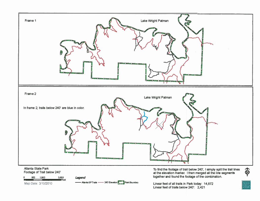
'T'
Frame 1
Frame 2
In frame 2, trails below 240' are blue in color.
Atlanta State Park Footage of Trail below 240'
Legend-- AtlantaSPTrailB -- 240' 8tM1tionClPskBoUndaryMap Date: 3/10(2010
Lake Wright Patman
Lake Wright Patman
To find the footage of trail belON 240', I simply split the trail lines at the elevation marker. I then merged all the line segrnen1s together and found the footage of the combination.
Unear feet of all trails in Park today: 14,872Unear feet of trails below 240': 2,421