Embed Size (px)
DESCRIPTION
cp
Citation preview

Cloud Physics: RGCastro. CCChica. JConti
Cloud Nucleus, Growth & Distribution

Cloud Physics
is the study of the physical processes that lead to the formation,
growth and precipitation of clouds. Clouds consist of
microscopic droplets of liquid water (warm clouds), tiny crystals
of ice (cold clouds), or both (mixed phase clouds). (Wikipedia)

What are CLOUDS?
are thick masses of suspended water or ice crystals depending
on the height of the cloud and the temperatures of the
atmosphere.
Clouds are made of tiny drops of water or ice crystals that settle
on dust particles in the atmosphere.
Common Misconceptions about Clouds
– Clouds form by boiling vapors traveling into the air.
– Clouds are made of cold, heat, fog, or snow.
– Clouds are water vapor.
– Empty clouds are refilled by the sea (water stays as a liquid through the
entire process).

What are CLOUDS? Clouds are important in that they can form precipitation and
bring rain to crops and plants. They also shade the earth,
affecting the temperature and keeping sunlight from directly
hitting plants.
All weather producing clouds form in the atmosphere.
A series of processes have to happen in order for these water
droplets or ice crystals to form into clouds in the atmosphere,
and different types of clouds form from different processes.

Cloud COMPOSITION
In 1672, the German
physicist Otto von
Guericke put forward the
idea that clouds were made
of tiny suspended bubbles
when he called the small
particles he produced in a
crude cloud chamber
bullulae, or bubbles. The
bubble misconception
persisted for two centuries.

Cloud COMPOSITION
In 1846, it was found that
fog particles did not burst
on impact, as bubbles
would. And around 1884,
cloud droplets were
collected and studied
under a microscope,
finally settling the matter.
Clouds consist of water
droplets.

Cloud COMPOSITION When clouds become very cold, the water vapor condenses to
form tiny six-sided crystals of ice.
Some clouds contain both water droplets and ice crystals.
Water droplets do not freeze instantly when the temperature
drops below freezing but supercool to varying extents first.
Supercooled liquid water is water at a temperature below
freezing but still in the liquid state.

How do Clouds FORM? Clouds form when moist, warm rising air cools and expands in
the atmosphere. The water vapor in the air condenses to form
tiny water droplets which are the basis of clouds.
Clouds form when air rises and becomes saturated in response
to adiabatic cooling (process of reducing heat through a change
in air pressure caused by volume expansion).

Vapor Pressure
The pressure of the vapor phase of a substance when it is in
equilibrium with the solid or liquid phase of the substance.
(University Physics, Sears & Zemanky)

Relative Humidity
Partial pressure of the water vapor in the air divided by the
vapor pressure of water at that same temp. expressed as
percentage.
The air is supersaturated when the humidity is 100 %.

How Raindrop Grows?
Growth in Warm Clouds
Most clouds formed in the Tropics,
and many in the middle latitudes,
are warm clouds.
Those clouds have temperatures
greater than 0ºC throughout. The
Collision-coalescence process
generates precipitation. This process
depends on the differing fall speeds
of different-sized droplets. It begins
with large collector drops which
have high terminal velocities.

How Raindrop Grows? Collision
Collector drops collide with smaller
drops.
Collisions typically occur between a
collector and fairly large cloud drops.
Smaller drops are pushed aside.
Collision is more effective for the
droplets that are not very much
smaller than the collect droplet.

Bergeron process • The Wegener–Bergeron–Findeisen process (after Alfred
Wegener, Tor Bergeron and Władysław. Findeisen), (or "cold-
rain process") is a process of ice crystal growth that occurs in
mixed phase clouds (containing a mixture of supercooled water
and ice) in regions where the ambient vapor pressure falls
between the saturation vapor pressure over water and the lower
saturation vapor pressure over ice.

How Raindrop Grows? Coalescence
When collisions occur, drops either bounce apart or
coalesce into one larger drop.
Coalescence efficiency is very high indicating that most
collisions result in coalescence.
Collision and coalescence together form the primary
mechanism for precipitation.

What causes clouds to form?
Surface heating - This happens when the ground is heated by
the sun which heats the air in contact with it causing it to rise.
The rising columns are often called thermals. Surface heating
tends to produce cumulus clouds.

What causes clouds to form?
Air Being Forced to Rise:
In a low pressure system, wind moves in towards the center from all
directions because air moves from high to low pressure. When this air
meets in the center, there is nowhere for the air to go but up.
Air is also forced to rise when it is traveling over land that slopes upward.
The air cools as it rises, and eventually clouds will form.
Finally, weather fronts produce clouds by causing air to rise when the
lighter warm air flows over the heavier cold air.
All of the cloud types are formed by these processes, especially
altocumulus, altostratus, cirrocumulus,
stratocumulus, or stratus clouds.

What causes clouds to form?
Topography or orographic forcing - The topography - or shape
and features of the area - can cause clouds to be formed. When
air is forced to rise over a barrier of mountains or hills it cools
as it rises. Layered clouds are often produced this way.

What causes clouds to form?
Frontal - Clouds are formed when a mass of warm air rises up
over a mass of cold, dense air over large areas along fronts. A
'front' is the boundary between warm, moist air and cooler,
drier air.

What causes clouds to form?
• Warm fronts produce clouds when warm air replaces cold air
by sliding above it. Many different cloud types can be created in
this way: altocumulus, altostratus,
cirrocumulus, cirrostratus, cirrus, cumulonimbus (and
associated mammatus clouds), nimbostratus, stratus,
and stratocumulus.

What causes clouds to form?
• Cold fronts occur when heavy cold air displaces lighter warm
air, pushing it upward. Cumulus clouds are the most common
cloud types that are produced by cold fronts. They often grow
into cumulonimbus clouds, which produce thunderstorms.
Cold fronts can also produce nimbostratus, stratocumulus,
and stratus clouds.

What causes clouds to form? Convergence - Streams of air flowing from different directions
are forced to rise where they flow together, or converge. This
can cause cumulus cloud and showery conditions.
Turbulence - A sudden change in wind speed with height
creating turbulent eddies in the air.

Cloud Condensation NUCLEI Cloud condensation nuclei or CCNs (also known as cloud
seeds) are small particles typically 0.2 µm, or 1/100th the size of
a cloud droplet on which water vapour condenses (Wikipedia)
The particles may be composed of dust or clay, soot or black
carbon, sea salt from ocean wave spray, soot from factory
smokestacks or internal combustion engines, sulfate from
volcanic activity, phytoplankton or the oxidation of sulfur
dioxide and secondary organic matter formed by the oxidation
of VOCs.
CTR Wilson demonstrated that clouds could still form in
cleaned out air, but only with extreme supersaturation
corresponding to a relative humidity of 400 %.

Cloud Condensation NUCLEI

Types of Clouds
Source: Cloud Formation by Melissa White &
National Weather Service Weather Forecast Office

To better communicate and understand the many cloud forms in
the sky, meteorologists identify clouds based on five basic cloud
characteristics:
1. The altitude at which they occur
2. Color
3. Density
4. Shape
5. Degree of cover.
From this information, we can identify three basic cloud types and
seven other common cloud types.
Identifying Clouds

• One form of classification is based on appearance or form. Using
these characteristics you can identify the three basic cloud types:
stratus, cirrus, and cumulus
Cloud Type by Form

Stratus Clouds
Stratus clouds are thin, sheet-like clouds. They are layered with some rippling, and
cover large portions of the sky. They are frequently gray and thick. Stratus clouds
are formed when air is forced up slowly.

Cirrus Clouds
• Cirrus clouds are thin, white clouds
with a feathery appearance.
• They are the highest of all clouds
forming at heights of 30,000 feet or
more above the earth's surface.
• Cirrus clouds are formed by ice
crystals.
• They generally occur in fair weather
and point in the direction of air
movement at their elevation. Cirrus
clouds are usually the first sign of an
approaching storm.

Sun Pillar
Cirrus Cloud Phenomenon
Sometimes, when the sun is just below the horizon, aligned ice crystals reflect light from their
crystal faces. We see the cumulative effect of millions of reflections of this sunlight as a sun pillar.

Cumulus Clouds:
• Cumulus clouds are flat-based,
billowing clouds with vertical
doming. Often the top of cumulus
clouds have a "cauliflower-like"
appearance. Cumulus clouds are
most prominent during the
summer months.
• Cumulus or fluffy clouds form
when air is forced up rapidly and
therefore rises higher.

Clouds can also be classified
based on their altitude
There are three categories
of cloud heights:
High Clouds = Cirrus
Middle Clouds = Alto
Low Clouds = Stratus
(NASA-NOAA Cloud
Chart)
Cloud Type by Altitude

High clouds: 7-18km
Cold: less than 25oC & made up of ice crystals
Cirrostratus: high, wispy
clouds. They give the sky a
milky white appearance.
Cirro
Cirrocumulus: delicate clouds
appearing in bands or ripples across the
sky. They are one of the least common
of the cloud types.
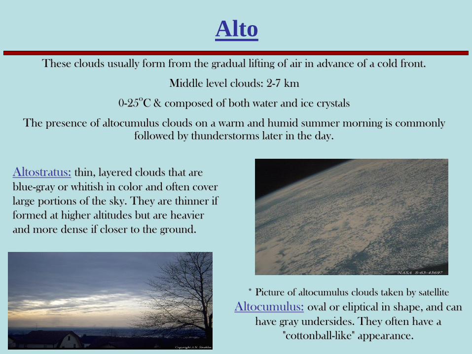
Altostratus: thin, layered clouds that are
blue-gray or whitish in color and often cover
large portions of the sky. They are thinner if
formed at higher altitudes but are heavier
and more dense if closer to the ground.
* Picture of altocumulus clouds taken by satellite
Altocumulus: oval or eliptical in shape, and can
have gray undersides. They often have a
"cottonball-like" appearance.
Alto
These clouds usually form from the gradual lifting of air in advance of a cold front.
Middle level clouds: 2-7 km
0-25oC & composed of both water and ice crystals
The presence of altocumulus clouds on a warm and humid summer morning is commonly followed by thunderstorms later in the day.

Stratus: Dense, uniform dark gray layers.
Stratocumulus: groups of dense, puffy
clouds that cover the sky in dark heavy
masses, long and gray. The often form in
bands across the sky.
Low level clouds: 0 - 4 km
Greater than 5oC & composed of water
Strato

Fog : Clouds at ground level
Radiation fog: forms at night when cold ground cools the air above it (in valleys)
Advection fog: forms when warm, moist air moves over colder surface and cools (in coastal areas)
Fog

In this fog, off the coast of Oregon, a cold ocean current cools the air to the air’s dew
point temperature. This cooling of the air created the fog. This is called:
Advection Fog

Warm Water
Cold Air
Evaporation
Condensation
For the development of this fog, warm water is evaporating into cool air.
The cool air becomes saturated (its relative humidity becomes 100%) and
condensation creates the fog. This is called:
Radiation Fog

Cloud Type by Rain
• Nimbus: any cloud that rains
Cumulonimbus: taller, towering versions
of cumulus clouds. Their height can be
from two to five miles. These clouds
often form thunderstorms.
Nimbostratus: low, flat clouds that are often
associated with steady precipitation and
occur in thick, continuous layers and are
often dark gray in color.

Cumulonimbus Clouds
As seen from Apollo 8

Weird Cloud Types

Wall Clouds A localized lowering from the rain-free base of a strong thunderstorm. The lowering denotes a
storm's updraft where rapidly rising air causes lower pressure just below the main updraft,
which enhances condensation and cloud formation just under the primary cloud base.
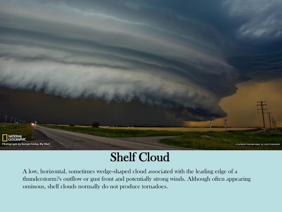
Shelf Cloud A low, horizontal, sometimes wedge-shaped cloud associated with the leading edge of a
thunderstorm?s outflow or gust front and potentially strong winds. Although often appearing
ominous, shelf clouds normally do not produce tornadoes.

Fractus Low, ragged stratiform or cumuliform cloud elements that normally are unattached to larger
thunderstorm or cold frontal cloud bases. Also known as scud, fractus clouds can look
ominous, but by themselves are not dangerous.

Mammatus Clouds Drooping underside (pouch-like appearance) of a cumulonimbus cloud in its latter stage of
development. Mammatus most often are seen hanging from the anvil of a severe
thunderstorm, but do not produce severe weather. They can accompany non-severe storms as
well.

Contrail Narrow, elongated cloud formed as jet aircraft exhaust condenses in cold air at high altitudes,
indicative of upper level humidity and wind drift.

Hole-Punch Clouds: Also known as a fallstreak hole, this type of cloud is usually formed when the water
temperature in the cloud is below freezing but the water has not frozen. When sections of the
water starts to freeze, the surrounding water vapor will also freeze and begin to descend. This
leaves a rounded hole in the cloud.

Lenticular Clouds Are stationary lens-shaped clouds that form in the troposphere, normally in perpendicular
alignment to the wind direction. Because of their shape, they have been offered as an
explanation for some Unidentified Flying Object (UFO) sightings.

Undulatus Asperatus The name translates approximately as "roughened or agitated waves. The clouds are most
closely related to undulatus clouds. Although they appear dark and storm-like, they tend to
dissipate without a storm forming

Cloud SEEDING • Cloud seeding, a form of weather modification, is the attempt to change the amount or type of precipitation that falls from clouds, by dispersing substances into the air that serve as cloud condensation or ice nuclei, which alter the microphysical processes within the cloud.
• The most common chemicals used for cloud seeding include silver iodide, potassium iodide and dry ice (solid carbon dioxide). (Wikipedia)
Types of cloud seeding
• There are two basic types of cloud seeding – cold and warm: – Cold cloud seeding (glaciogenic seeding) involves adding
particles such as silver iodide crystals or dry ice pellets to the supercooled (ie below freezing point) water already present in clouds to promote the formation of ice crystals. The ice crystals grow, fall and melt to below the freezing level to become raindrops.
– Warm cloud seeding (hygroscopic seeding) involves adding salt particles (sodium, magnesium and calcium chlorides), which attract water into or just below the base of suitable clouds to enhance the growth of cloud droplets by coalescence.

Types of cloud seeding

Cloud SEEDING • Under ideal conditions,
seeding may enhance precipitation by about 10%.
• Cloud seeding is increasingly being used for both water supply enhancement and weather damage reduction. It is also used for hail suppression to reduce damage to crops and urban areas.

History: Cloud Seeding
• Cloudseeding got its start in 1946 when Dr. Vincent J. Schaefer, working at the General Electric Laboratory in New York, was involved with research to create artificial clouds in a chilled chamber. During one experiment, Schaefer thought the chamber was too warm and placed dry ice inside to cool it. Water vapor in the chamber formed a cloud around the dry ice. The ice crystals in the dry ice had provided a nucleus around which droplets of water could form inside the chamber.