Embed Size (px)
Citation preview
1
CLIMBS AND EXPEDITIONSCLIMBS AND EXPEDITIONSCLIMBS AND EXPEDITIONSCLIMBS AND EXPEDITIONSWest West West West Kunlun, Kunlun, Kunlun, Kunlun, Hengduan Mountains, Alaska, Hengduan Mountains, Alaska, Hengduan Mountains, Alaska, Hengduan Mountains, Alaska, Karakoram and BhutanKarakoram and BhutanKarakoram and BhutanKarakoram and Bhutan
First Ascent of First Ascent of First Ascent of First Ascent of Selik Selik Selik Selik Gulam Gulam Gulam Gulam Muztag in West Muztag in West Muztag in West Muztag in West Kunlun Kunlun Kunlun Kunlun Hiroshi Hiroshi Hiroshi Hiroshi OnishiOnishiOnishiOnishi
Icy Mountain with Rock Ridges Glittering in Golden ColorIcy Mountain with Rock Ridges Glittering in Golden ColorIcy Mountain with Rock Ridges Glittering in Golden ColorIcy Mountain with Rock Ridges Glittering in Golden Color
The local people of the Xinjiang Uygur Autonomous Region give the above name to the
peak formerly named Kashitashi. The mountain is located at a distance of two caravan
days from Lush village near Hotan, south of the Taklamakan Desert, and some 75km
north of Qong Muztag (6962m), which Waseda University Alpine Club unveiled and first
ascended in 2000 (as described in the inaugural issue of the Japanese Alpine News
Vol.1). Selik Gulam Muztag had also long remained untouched until Fukuoka Alpine
Club attempted to climb it in 1987.
Our climbing club, which consists of high school teachers in Nagano Prefecture, decided
on this least known but tempting peak for our climbing target, and organized and sent a
powerful team of 13 members in 2000. But as the local weather conditions were
unfavorable, the expedition did not go as planned. We had to retreat from a point at
6400m.
In 2001 the challenge was again taken up. The members were limited to four and
climbing tactics were reconsidered in all respects. In the absence of high porters to
support us, each member will be required to carry luggage above the snow line. Gears
and supplies were kept to the minimum accordingly, and the location of advance camps
had to be selected according to members’ abilities.
On July 24 we left Japan and on the 27th arrived via Hotan at Lush, the remotest village
in the mountain area. Although one day was lost due to a rise in the level of the Lush
River, our caravan afterwards made good progress. BC was established at 3800m on the
31st. The porters from Lush village, who had become well acquainted with us during
three previous expeditions, were very cooperative. Thanks to their devoted support we
were able to set up ABC (Advance Base Camp) at 4500m and thereafter C1 at 5170m on
August 3.
Substantial climbing started from C1. We moved up from here with heavy packs on our
shoulders. We opened a new climbing route and continued upwards. On August 9, C2
was set up at 5920m and on the 11th C3 at 6200m, one after another beyond a spur of
6250m on the north ridge. Fixed ropes were placed up to the snow dome at 6400m, the
highest point that the previous party reached in 2000. Now we got ready to tackle the
summit.
2
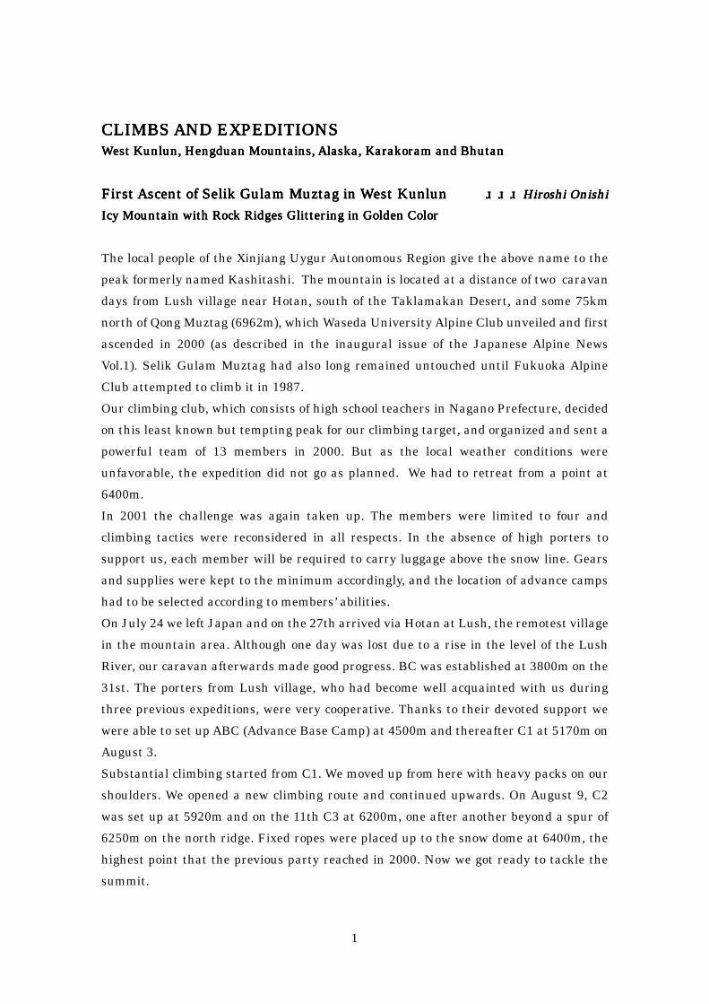
At 6:30am on August 12 all the four team members of departed from C3 when it was still
dark. The route to the snow dome along the ridge and its traverse had been guarded by
hard ice. We stood on the dome at 8:00am. The weather was unstable. We continued to
go up the ridge toward the summit bypassing the left side of the black rock peak ahead of
the dome. Beyond the rock peak the snow conditions changed. A wide snow ridge with
many small crevasses wound up toward the summit dome. It took us three hours to open
the route on the dome, negotiating a steep slope. The final pushes along a knife-edged
ridge led to the summit poking out of the snow. We shook hands with each other on the
top at 3:07pm. As though Heaven blessed us, the mist around us began to fade away and
the blue sky appeared. Above the clouds lying underneath, the pure white West Peak
(6650m), one of the twin peaks, came into view and we could also enjoy an impressive
panorama of the mountains in the vicinity. It was indeed a most breathtaking moment.
3
Granite Rock Tower in Shangri-la, West Sichuan Granite Rock Tower in Shangri-la, West Sichuan Granite Rock Tower in Shangri-la, West Sichuan Granite Rock Tower in Shangri-la, West Sichuan Naoki OhuchiNaoki OhuchiNaoki OhuchiNaoki Ohuchi
Seeking an Alluring Climb in Hidden ParadiseSeeking an Alluring Climb in Hidden ParadiseSeeking an Alluring Climb in Hidden ParadiseSeeking an Alluring Climb in Hidden Paradise
In early January of 2002 Reuters reported an issue on Shangri-la from Beijing, China..
“The State Council approved a proposal by Yunnan provincial government last month to
officially give the name (Shangri-la) to Zhongdian County”, an official from the Ministry
of Civil Affairs in Beijing told Reuters. However, the decision would be unlikely to end
decades of hype among a handful of pristine locales in the Hengduan Mountains in the
sub-Himalayan region where Yunnan and Sichuan provinces border Tibet, all of which
have laid claim to the title as a means to entice tourists.
Sichuan province has its own Shangri-la, in particular Daocheng County in West
Sichuan is taking advantage of the use of the name “Shangri-la” for the Konga Snow
Mountains, a scenic spot, in order to attract as many visitors as possible. As well as
Daocheng there are several places in West Sichuan, formerly West Kham (East Tibet),
that fulfill the conditions of Shangri-la. One of them is Zhopu Pasture and the
surrounding area. It has alluring rock and snow peaks, a lake of turquoise blue,
primeval forests with rich wild life, and a historic monastery. These peaks are in the
Jarjinjabo mountain massif north of Batang.
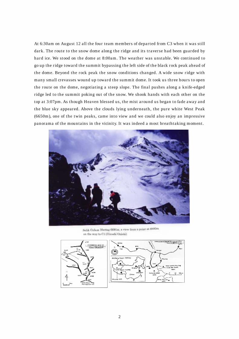
The granite rock tower of 5382m that no one had yet touched tempted us to visit the
borderland to climb in the summer of 2001. We flew from Japan to Chengdu on July 23,
arriving at Zhopu Pasture where we established BC at 4050m on the 25th, and
succeeded in completing the first ascent of the tower on the 31st. On August 2 we
returned to Japan via Chengdu.
Leader: Naoki Ohuchi (56), Members: Eiji Daigo (29), Ms. Yuriko Kowaka (55), Taizo
Yoshida (22)
Climbing itinerary:
July 26 – Set up an advance camp (4700m) at the foot of the tower.
July 27 – Climbed about 100m in three pitches and placed fixed ropes.
July 28 to 29 – Unable to climb due to rain.
July 30 – Climbed 10 pitches and bivouacked.
July 31 – Completed climbing with three pitches from bivouacking point and
descended.
Climbing Notes:
4
1) Heavy rainfall forced us to employ more aid climbing than expected.
2) Crack system applied to 70 percent of total climbing route.
3) Climbing grade – Free: Max 5.10A and Aid: AI
4) Climbing distance – about 480m.
5) Vertical height of climbing route – about 320m

5
From Japan Alps toFrom Japan Alps toFrom Japan Alps toFrom Japan Alps to DenaliDenaliDenaliDenali in in in in Alaska Alaska Alaska Alaska Masatoshi Masatoshi Masatoshi Masatoshi KuriakiKuriakiKuriakiKuriaki
A Young ClimberA Young ClimberA Young ClimberA Young Climber’’’’s Commitment to Winter Soloings Commitment to Winter Soloings Commitment to Winter Soloings Commitment to Winter Soloing
I stood alone on the top of Mt. McKinley (6194m) in winter on March 8, 1998. It was the
24th day after I started climbing via the West Buttress. The temperature was as low as
minus 37℃ and the weather was getting worse with strong gusts and prevailing clouds
that did not allow me to stay on the summit more than one minute. I was deeply moved
to tears, but the tears were soon frozen because of the bitterly cold winds.
I was 25 years old when I accomplished the 4th winter solo climb of the highest peak of
the North American Continent in Alaska Range. World famous Naomi Uemura
succeeded in the first solo ascent in winter of Mt. McKinley in 1984 but it is believed that
he met with an accident during the descent and was subsequently presumed dead. Two
American climbers made the 2nd and 3rd winter solo ascents, Vern Tejas in 1988 and
Dave Staehell in 1989, one after another.
A movie that I watched after finishing junior high school impressed me profoundly. A
scene of beautiful evening clouds over the Japan Alps touched my heart.
I practiced and studied climbing intensively in the mountains of Japan for several years.
Severe conditions such as heavy snowfalls, unstable weather and the steep topography
in winter of the Japan Alps made suitable training fields for young climbers planning to
target the greater range of the world. Although the peaks are more or less 3000m above
sea level and there are no existing glaciers, young climbers can avail themselves of the
Japan Alps in preparation for their future challenges overseas.
In the summer vacation of my postgraduate course I climbed Mt. McKinley under the
6
midnight sun in 1995. The fascinating profiles of Mt. Foraker (5304m) and Mt. Hunter
(4442m), which I espied before me, enchanted me a great deal. In April to June of the
following year I attempted solo climbs of both these peaks but was unsuccessful. These
attempts gave me a keen interest in winter climbs and it was not long before I started
preparations to go to Mt. McKinley in winter. I analyzed meteorological observation data,
which was collected by The Japanese Alpine Club for a decade (see Japanese Alpine
News Vol.1, October 2001). In order to acclimatize myself to high altitudes and to
increase my endurance in low temperatures too, I trained myself in the Nepalese
Himalayas where I solo climbed four 6000m peaks in succession. For the purpose of
experiencing extremely low temperatures, I made use of a deep freezer (minus 55℃)
belonging to a fishery company, where I was able to test gear and clothes for
improvement if necessary.
In February 1997 I attempted the West Buttress of Mt. McKinley but gave up due to bad
weather, after two nights of the coldest bivouac in a snow cave at 4938m. I had to give up
a further push as there was no sign of blizzard ceasing. The highest point I reached was
5242m. However, this failure taught me many things, furnishing me with invaluable
information.
To devote myself to my mountain Odyssey to Denali I quit the university. Meanwhile
with my parents’ consent, I returned to Mt. McKinley. On February 13, 1998 I
established BC at 2195m on the Kahiltna Glacier and resumed an assault. Eight
advance camps were set up so that I could carry all 100kg of gear and supplies by myself.
At C4 (3353m) a blizzard forced me to lose four days. The upper three camps (C5=3700m,
C6=4328m, C7=5243m) were snow caves for protection against the wind. I took 24 days
to reach the summit after BC had been set up. The final leg to the destination from C7
took six hours sixteen minutes.
After returning from the mountain I continued on a solo journey to traverse Alaska for
about 1400km on foot pulling a bicycle trailer. I left Anchorage on the Pacific side on
April 3 for Prudhoe Bay facing the Arctic Ocean. Travelling at 4km per hour in spring to
early summer really gave me peace of mind and I arrived at my goal on July 6.
My Odyssey is still on-going. On April 3 1999 and also on March 31 2001 I completed a
winter-cum-spring solo climb of Mt. Foraker. The former was via Sultana Ridge (The
second solo ascent throughout the year) and the latter was via Southeast Ridge (the first
solo ascent throughout the year). My current target is the winter solo climb of both Mt.
Foraker and Mt. Hunter, and in January 2002 the fourth challenge to Mt. Foraker
commences.
7
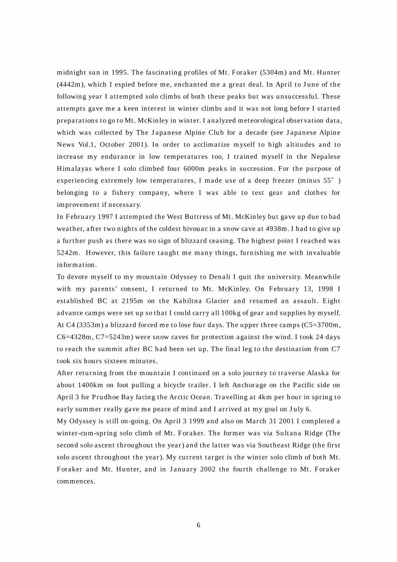
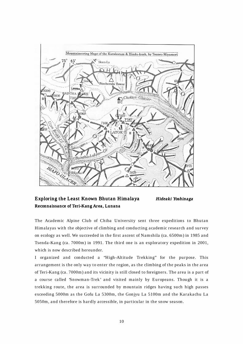
Yamanoi & Yamanoi & Yamanoi & Yamanoi & Kurtyka OpenedKurtyka OpenedKurtyka OpenedKurtyka Opened New Route in New Route in New Route in New Route in KarakoramKarakoramKarakoramKarakoram Tamotsu NakamuraTamotsu NakamuraTamotsu NakamuraTamotsu Nakamura
South Face of Central Peak of South Face of Central Peak of South Face of Central Peak of South Face of Central Peak of Biacherahi TowerBiacherahi TowerBiacherahi TowerBiacherahi Tower
“What do you think about the North Face of Latok? Let us climb it together in August
when there is less danger of falling stones as it is getting colder.” One day after coming
back from K2 in 2000, Yasushi Yamanoi received this message from Wojciech Kurtyka.
Thus a pair of outstanding climbers met again in Karakoram at the end of July 2001
with a bold objective to scale the North Face of Latok I (7145m) from Choktoi Glacier.
Sheer ice exceeding 1000m high and a 600m head wall were ever threatening. Yamanoi
felt that it would be a supreme climb if a direct route were developed, though viable
cracks had so far not been found on the wall.
On the 20th of July 2001 Yasushi and his wife Taeko joined Kurtyka at Islamabad
Airport and after five days they set up BC in rain and wind at 4500m on Choktoi Glacier.
On the morning of the following day sunshine returned and brilliant peaks surrounding
8
the glacier emerged one after another from behind clouds which were now gradually
disappearing. Coming into view to the left was the pure white North Face of Latok; in
front were Ogre II resembling Jannu and the beautiful pyramid of Baintha Brak; and to
the right Biacherahi Tower which in shape resembles Paine. It seemed to be a landscape
pictute, which is typical of Karakoram.
The following is a translation of the text written by Yasushi Yamanoi.
“With binoculars we carefully searched for possible climbing routes on the mountains in
the vicinity. However luck was not with us. Our first objective, the North Face of Latok I
was exposed to the danger of avalanches. On the other hand, to the right, Biacherahi
Tower, which soared into the sky like a multistory building, attracted our attention and
interest. Therefore as an alternative we had no hesitation in deciding to climb it first.”
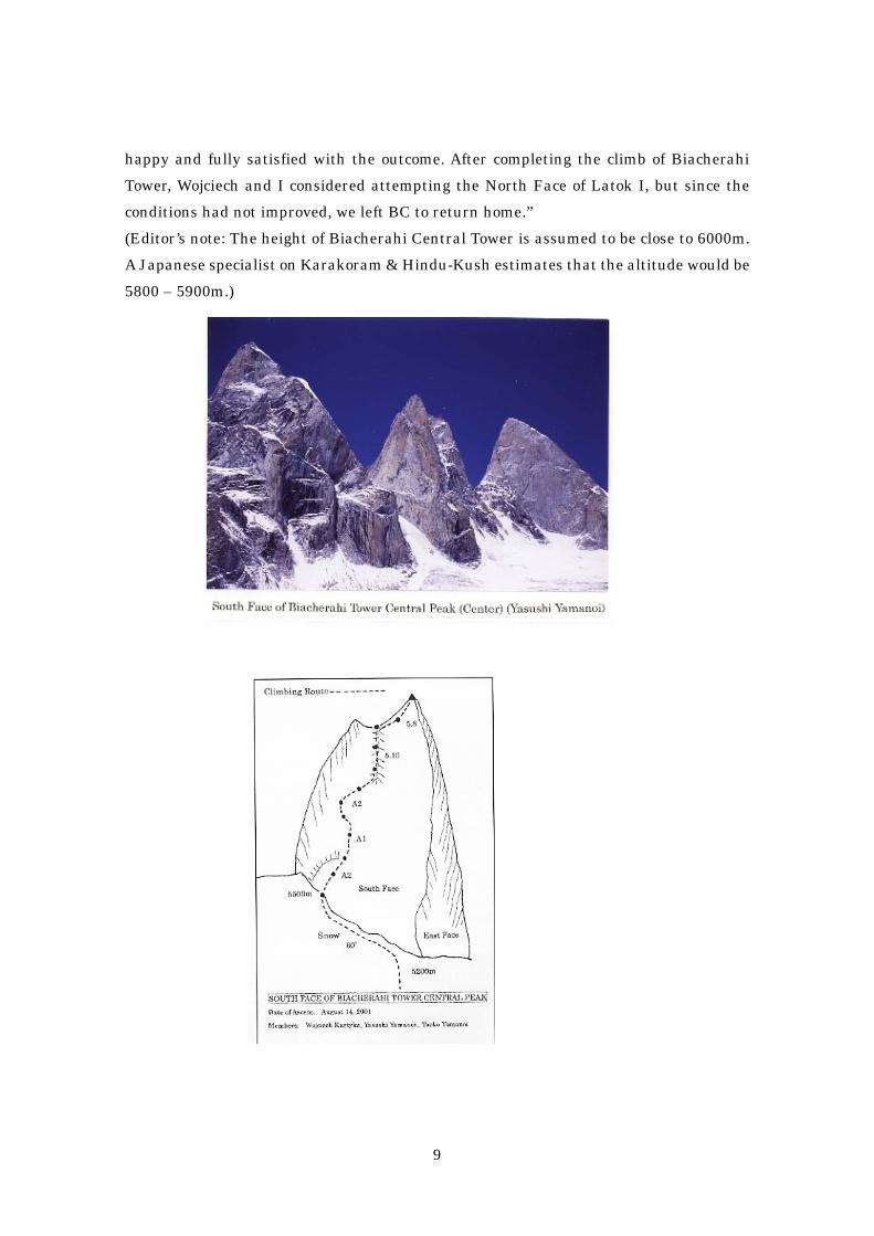
“ An approach to South Ridge was rather hard. Frightening crevasses on the glacier set
malicious traps, which at any time could cause us to fall into a bottomless pit. A steep
couloir that led to a point where we could start climbing was subjected to frequent
falling rocks too. In selecting the first pitch we went for different opinions. I insisted on a
bit more difficult but beautiful line that would put us in a more exposed position while
Wojciech wanted to choose a route of diedre that was a weakness of the wall.”
“On the first day I led the pitches up weathered gray rocks and returned to BC after
having fixed a rope en route. The second assault was the beginning of substantial
climbing. Every pitch was so hard that the top leading each pitch got nervous, and the
second belaying the top had to be at a standstill for many hours and paid out a rope some
times looking at crystals of granite rocks.”
“We broke through a fragile rock flake of nearly 300kg. We climbed a crack more than
100m long that stood in our way. To our regret, however, because snowstorms came back
again, we returned to BC. In this bad weather a Norwegian party was on the north ridge
of Latok in spite of the slimmest possibility of successfully completing the climb and
reaching the summit.. The ridge remains as one of the problems to be solved for many
alpine climbers. I much appreciate their intensity and energetic power.”
“The third assault enabled us to succeed in reaching the summit. Wojciech overcame the
not so hard but dangerous diedre of a climbing grade 5.10 with the utmost care for
unstable rocks and stones. On the last day of climbing, which was August 14, it was
about to snow. Taeko led the final pitch to climb a crack and reached a gentle ridge, 30m
ahead of which there was the sharp-pointed summit. Ten minutes later all three of us
gathered atop Central Peak of Biacherahi. It took six days to complete the climb. In the
first half Aid over A2 was needed. Knife blades and PR were applied very often.”
“It was not a crucial ascent, as Wojciech said ‘A Japanese-Polish Picnic’, but we felt
9
happy and fully satisfied with the outcome. After completing the climb of Biacherahi
Tower, Wojciech and I considered attempting the North Face of Latok I, but since the
conditions had not improved, we left BC to return home.”
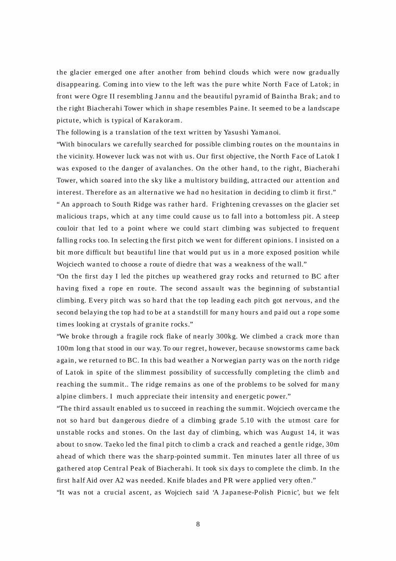
(Editor’s note: The height of Biacherahi Central Tower is assumed to be close to 6000m.
A Japanese specialist on Karakoram & Hindu-Kush estimates that the altitude would be
5800 – 5900m.)
10
Exploring the Least Known Bhutan Exploring the Least Known Bhutan Exploring the Least Known Bhutan Exploring the Least Known Bhutan HimalayaHimalayaHimalayaHimalaya Hideaki Hideaki Hideaki Hideaki YoshinagaYoshinagaYoshinagaYoshinaga
Reconnaissance of Teri-Kang Area, Reconnaissance of Teri-Kang Area, Reconnaissance of Teri-Kang Area, Reconnaissance of Teri-Kang Area, LunanaLunanaLunanaLunana
The Academic Alpine Club of Chiba University sent three expeditions to Bhutan
Himalayas with the objective of climbing and conducting academic research and survey
on ecology as well. We succeeded in the first ascent of Namshila (ca. 6500m) in 1985 and
Tsenda-Kang (ca. 7000m) in 1991. The third one is an exploratory expedition in 2001,
which is now described hereunder.
I organized and conducted a “High-Altitude Trekking” for the purpose. This
arrangement is the only way to enter the region, as the climbing of the peaks in the area
of Teri-Kang (ca. 7000m) and its vicinity is still closed to foreigners. The area is a part of
a course called ‘Snowman-Trek’ and visited mainly by Europeans. Though it is a
trekking route, the area is surrounded by mountain ridges having such high passes
exceeding 5000m as the Gofu La 5300m, the Gonjyu La 5100m and the Karakachu La
5050m, and therefore is hardly accessible, in particular in the snow season.
11
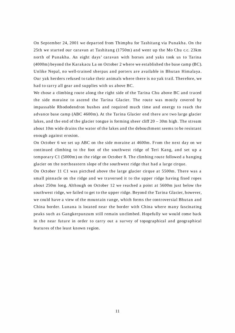
On September 24, 2001 we departed from Thimphu for Tashitang via Punakha. On the
25th we started our caravan at Tashitang (1750m) and went up the Mo Chu c.c. 23km
north of Punakha. An eight days’ caravan with horses and yaks took us to Tarina
(4000m) beyond the Karakacu La on October 2 where we established the base camp (BC).
Unlike Nepal, no well-trained sherpas and porters are available in Bhutan Himalaya.
Our yak herders refused to take their animals where there is no yak trail. Therefore, we
had to carry all gear and supplies with us above BC.
We chose a climbing route along the right side of the Tarina Chu above BC and traced
the side moraine to ascend the Tarina Glacier. The route was mostly covered by
impassable Rhododendron bushes and required much time and energy to reach the
advance base camp (ABC 4600m). At the Tarina Glacier end there are two large glacier
lakes, and the end of the glacier tongue is forming sheer cliff 20 – 30m high. The stream
about 10m wide drains the water of the lakes and the debouchment seems to be resistant
enough against erosion.
On October 6 we set up ABC on the side moraine at 4600m. From the next day on we
continued climbing to the foot of the southwest ridge of Teri Kang, and set up a
temporary C1 (5000m) on the ridge on October 8. The climbing route followed a hanging
glacier on the northeastern slope of the southwest ridge that had a large cirque.
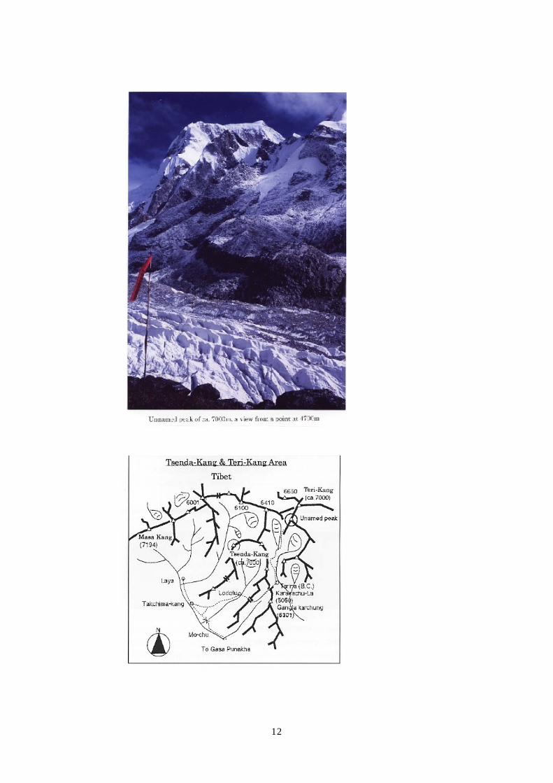
On October 11 C1 was pictched above the large glacier cirque at 5500m. There was a
small pinnacle on the ridge and we traversed it to the upper ridge having fixed ropes
about 250m long. Although on October 12 we reached a point at 5600m just below the
southwest ridge, we failed to get to the upper ridge. Beyond the Tarina Glacier, however,
we could have a view of the mountain range, which forms the controversial Bhutan and
China border. Lunana is located near the border with China where many fascinating
peaks such as Gangkerpunzum still remain unclimbed. Hopefully we would come back
in the near future in order to carry out a survey of topographical and geographical
features of the least known region.
12