Embed Size (px)
Citation preview

54 CHAPTER 3
A HUMAN PERSPECTIVE Nineteenth-century fishermen along thePeruvian coast called the event El Niño—the Spanish name for theinfant Jesus—because the event occurred near Christmastime. Everytwo to seven years, the waters off the Peruvian coast became warmerthan usual, resulting in poor fishing. Eventually, 20th-century scientistsstudying worldwide climate changes confirmed the truth of this folkknowledge. They discovered that El Niño brought about changes inglobal weather patterns that disrupted not only fishing, but also othereconomic activities. Droughts and floods in Asia, Africa, and NorthAmerica seemed to be related to El Niño. Scientists recognized thatweather and climate conditions are not isolated but are connected partsof the global climate system.
Factors Affecting ClimateFour major factors influence the climate of aregion: wind and ocean currents, latitude, eleva-tion, and topography.
WIND CURRENTS Wind and ocean currents helpdistribute the sun’s heat from one part of theworld to another through convection, the transferof heat in the atmosphere by upward motion ofthe air. As sunlight heats the atmosphere, the airexpands, creating a zone of low air pressure.Cooler dense air in a nearby high-pressure zonerushes into the low-pressure area, causing wind.
Global wind patterns are caused by the samekind of circulation on a larger scale. The hot airflows toward the poles, and the cold air movestoward the equator. The winds would blow instraight lines, but since the earth rotates they areturned at an angle. In the Northern Hemisphere,they turn to the right. In the Southern Hemi-sphere, they turn to the left. This bending of thewinds is called the Coriolis effect.
The map to the right shows that the wind pat-terns are mirror images of each other in theNorthern and Southern Hemispheres. Winds areidentified by the direction from which they blow;a north wind blows from the north to the south.
Climate Main Ideas• Climate reflects the seasonal
patterns of weather for a
location over a long period
of time.
• Global climatic changes may
be natural or human-made.
Places & Termsconvection
El Niño
greenhouse effect
Global Wind Currents
SKILLBUILDER: Interpreting MapsMOVEMENT From which direction do the wind currents blow
near the equator in the Southern Hemisphere?
LOCATION Between which latitudes do the westerlies blow?
0°0°
30°N
30°S
30°N
30°S
60°S
60°N
60°S
60°N
90°SSouth Pole
North Pole90°N
POLAR EASTERLIES
POLAR EASTERLIES
WESTERLIES
WESTERLIES
NORTHEASTERLY TRADE WINDS
SOUTHEASTERLY TRADE WINDS
Tropic of Cancer
Equator
Tropic of Capricorn
Climate 55
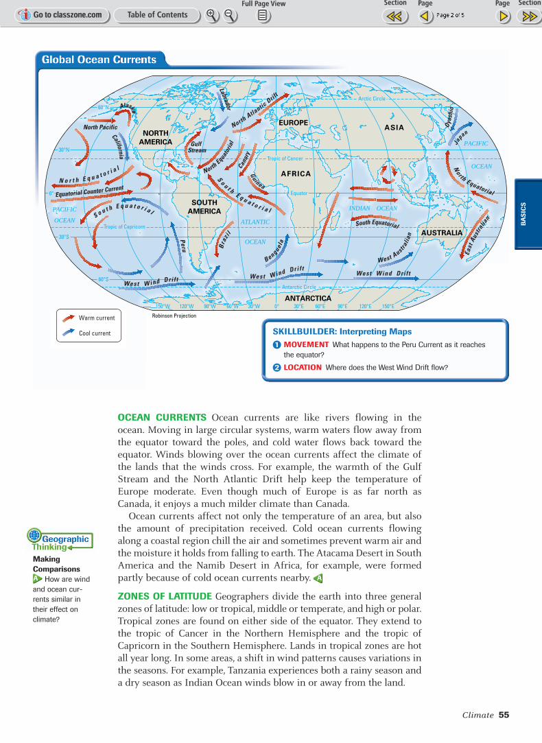
OCEAN CURRENTS Ocean currents are like rivers flowing in theocean. Moving in large circular systems, warm waters flow away fromthe equator toward the poles, and cold water flows back toward theequator. Winds blowing over the ocean currents affect the climate ofthe lands that the winds cross. For example, the warmth of the GulfStream and the North Atlantic Drift help keep the temperature ofEurope moderate. Even though much of Europe is as far north asCanada, it enjoys a much milder climate than Canada.
Ocean currents affect not only the temperature of an area, but alsothe amount of precipitation received. Cold ocean currents flowingalong a coastal region chill the air and sometimes prevent warm air andthe moisture it holds from falling to earth. The Atacama Desert in SouthAmerica and the Namib Desert in Africa, for example, were formedpartly because of cold ocean currents nearby.
ZONES OF LATITUDE Geographers divide the earth into three generalzones of latitude: low or tropical, middle or temperate, and high or polar.Tropical zones are found on either side of the equator. They extend tothe tropic of Cancer in the Northern Hemisphere and the tropic ofCapricorn in the Southern Hemisphere. Lands in tropical zones are hotall year long. In some areas, a shift in wind patterns causes variations inthe seasons. For example, Tanzania experiences both a rainy season anda dry season as Indian Ocean winds blow in or away from the land.
MakingComparisons
How are wind
and ocean cur-
rents similar in
their effect on
climate?
GulfStream
North Pacific
California
NorthEqua
toria
l
Canar
y
NorthAtla
nticDrif
t
Bra
zil
Alaska
N o r t h E q u a t o r i a l
East
Aust
ralia
nS o u t h E q u a t o r i a l
S o u t hE q u a t o r i a l
North Equatorial
South Equatorial
Equatorial Counter Current
West Australia
n
Guinea
Peru
Benguela
Oyas
hio
Japan
West W i nd Dri f t West Wind Dri f tWest Wind Dri f t
Labrador
ATLANTIC
OCEAN
INDIAN OCEANPACIFIC
OCEAN
PACIFIC
OCEAN
ASIA
AUSTRALIA
ANTARCTICA
AFRICA
SOUTH
AMERICA
EUROPE
NORTH
AMERICA
0° 30°E30°W60°W90°W120°W150°W
60°S
60°N
30°S
0°
30°N
60°E 90°E 120°E 150°E
Antarctic Circle
Equator
Tropic of Cancer
Arctic Circle
Tropic of Capricorn
Warm current
Cool current
Robinson Projection
SKILLBUILDER: Interpreting MapsMOVEMENT What happens to the Peru Current as it reaches
the equator?
LOCATION Where does the West Wind Drift flow?
BA
SIC
S
56 CHAPTER 3
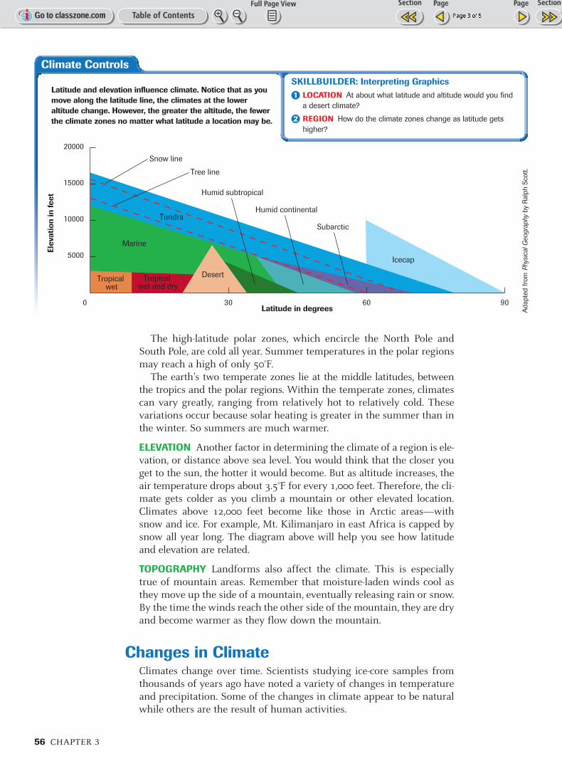
The high-latitude polar zones, which encircle the North Pole andSouth Pole, are cold all year. Summer temperatures in the polar regionsmay reach a high of only 50°F.
The earth’s two temperate zones lie at the middle latitudes, betweenthe tropics and the polar regions. Within the temperate zones, climatescan vary greatly, ranging from relatively hot to relatively cold. Thesevariations occur because solar heating is greater in the summer than inthe winter. So summers are much warmer.
ELEVATION Another factor in determining the climate of a region is ele-vation, or distance above sea level. You would think that the closer youget to the sun, the hotter it would become. But as altitude increases, theair temperature drops about 3.5°F for every 1,000 feet. Therefore, the cli-mate gets colder as you climb a mountain or other elevated location.Climates above 12,000 feet become like those in Arctic areas—withsnow and ice. For example, Mt. Kilimanjaro in east Africa is capped bysnow all year long. The diagram above will help you see how latitudeand elevation are related.
TOPOGRAPHY Landforms also affect the climate. This is especiallytrue of mountain areas. Remember that moisture-laden winds cool asthey move up the side of a mountain, eventually releasing rain or snow.By the time the winds reach the other side of the mountain, they are dryand become warmer as they flow down the mountain.
Changes in ClimateClimates change over time. Scientists studying ice-core samples fromthousands of years ago have noted a variety of changes in temperatureand precipitation. Some of the changes in climate appear to be naturalwhile others are the result of human activities.
Climate Controls
0 30 60 90
5000
10000
15000
20000
Elev
atio
n in
feet
Latitude in degrees
Subarctic
Icecap
Tropical wet
Tropical wet and dry
Desert
Humid subtropical
Marine
Humid continentalTundra
Snow line
Tree line
SKILLBUILDER: Interpreting GraphicsLOCATION At about what latitude and altitude would you find
a desert climate?
REGION How do the climate zones change as latitude gets
higher?
Latitude and elevation influence climate. Notice that as youmove along the latitude line, the climates at the loweraltitude change. However, the greater the altitude, the fewerthe climate zones no matter what latitude a location may be.
Adapte
d f
rom
Phy
sica
l Geo
grap
hyby
Ralp
h S
cott
.
El Niño and La Niña
El Niño
La Niña
Climate 57
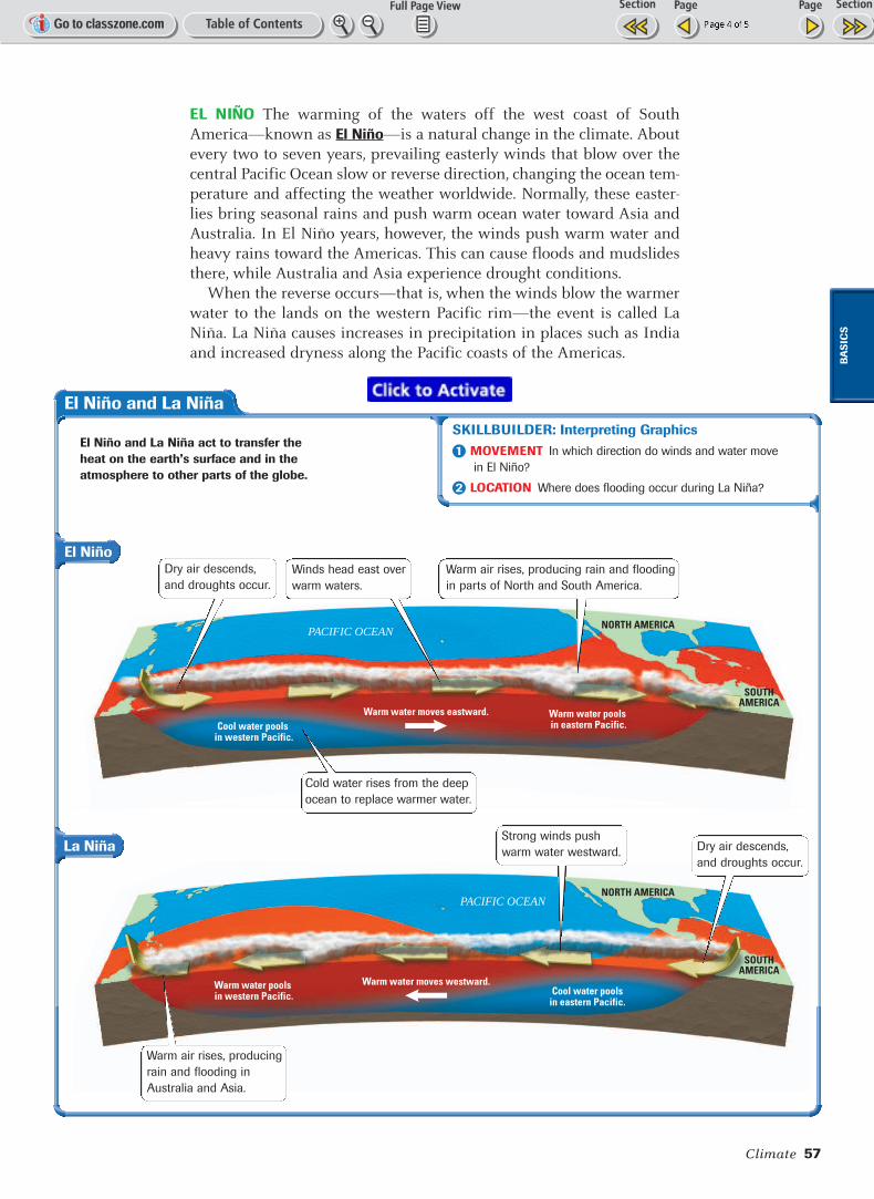
EL NIÑO The warming of the waters off the west coast of SouthAmerica—known as El Niño—is a natural change in the climate. Aboutevery two to seven years, prevailing easterly winds that blow over thecentral Pacific Ocean slow or reverse direction, changing the ocean tem-perature and affecting the weather worldwide. Normally, these easter-lies bring seasonal rains and push warm ocean water toward Asia andAustralia. In El Niño years, however, the winds push warm water andheavy rains toward the Americas. This can cause floods and mudslidesthere, while Australia and Asia experience drought conditions.
When the reverse occurs—that is, when the winds blow the warmerwater to the lands on the western Pacific rim—the event is called LaNiña. La Niña causes increases in precipitation in places such as Indiaand increased dryness along the Pacific coasts of the Americas.
BA
SIC
S
SKILLBUILDER: Interpreting GraphicsMOVEMENT In which direction do winds and water move
in El Niño?
LOCATION Where does flooding occur during La Niña?
Warm water pools in eastern Pacific.Cool water pools
in western Pacific.
NORTH AMERICA
SOUTHAMERICA
Warm water moves eastward.
PACIFIC OCEAN
Cool water poolsin eastern Pacific.
Warm water pools in western Pacific.
NORTH AMERICA
SOUTHAMERICA
Warm water moves westward.
PACIFIC OCEAN
El Niño and La Niña act to transfer theheat on the earth’s surface and in theatmosphere to other parts of the globe.
Strong winds push
warm water westward. Dry air descends,
and droughts occur.
Dry air descends,
and droughts occur.
Warm air rises, producing
rain and flooding in
Australia and Asia.
Cold water rises from the deep
ocean to replace warmer water.
Winds head east over
warm waters.
Warm air rises, producing rain and flooding
in parts of North and South America.

58 CHAPTER 3
GLOBAL WARMING Although con-troversy exists over the causes of glob-al warming, scientists agree that airtemperatures are increasing. Since thelate 1800s, the temperature of theearth has increased by one degree.However, estimates for the next cen-tury suggest that the increase will bealmost 3.5 degrees.
Some scientists believe that thiswarming is part of the earth’s naturalwarming and cooling cycles. For exam-ple, 18,000 to 20,000 years ago, theearth was in the last of several ice ages,when vast glaciers advanced over hugeportions of the land mass.
Other scientists argue that globaltemperature increases are caused bythe greenhouse effect. The layer ofgases released by the burning of coaland petroleum traps some solar ener-gy, causing higher temperatures inthe same way that a greenhouse trapssolar energy.
As more and more nations becomeindustrialized, the amount of green-house gases will also increase.Scientists predict that, if global warm-
ing continues, ice caps will melt, flooding some coastal areas, coveringislands, and changing the global climate. In the next section, you willlearn about world climate regions.
Background
The air tempera-
ture in the period
between about
1500 and 1850
was so much
cooler than today
that it is known as
a “Little Ice Age.”
Places & TermsExplain the meaning of
each of the following
terms.
• convection
• El Niño
• greenhouse effect
Taking Notes MOVEMENT Review the notes
you took for this section.
• What are four factors that affect
climate?
• What are examples of forces that
produce climate changes?
Climate
Main Ideas a. What role do wind and
ocean currents play in
climate?
b. How do latitude and
altitude affect climate?
c. How do El Niño and La
Niña affect climate?
Geographic ThinkingDrawing ConclusionsWhich of the factors affecting
climate has the greatest
impact on the climate in your
region? Think about:
• the four factors affecting
climate
• the climate where you live
SEEING PATTERNS Review the information and diagram about El Niño and La Niña on page 57.
Use the Internet to find more information on these events. Create a multimedia presentationexplaining one of the events and how it affects the world-wide weather conditions.
STOP
Someheatescapes
HeattrappedCO2 and
other gases
H E AT T R A P P I N G L AY E R
Greenhouse Effect
SKILLBUILDER: Interpreting GraphicsHUMAN–ENVIRONMENT INTERACTION Which elements
in the illustration add heat to the environment?
MOVEMENT What might happen if more motor vehicles are
added to the picture?
RESEARCH LINKSCLASSZONE .COM